roads and infrastructure improvements garnock … · thank you for taking an interest in the new...
TRANSCRIPT
Physical Environment North Ayrshire Council 17 September 2015
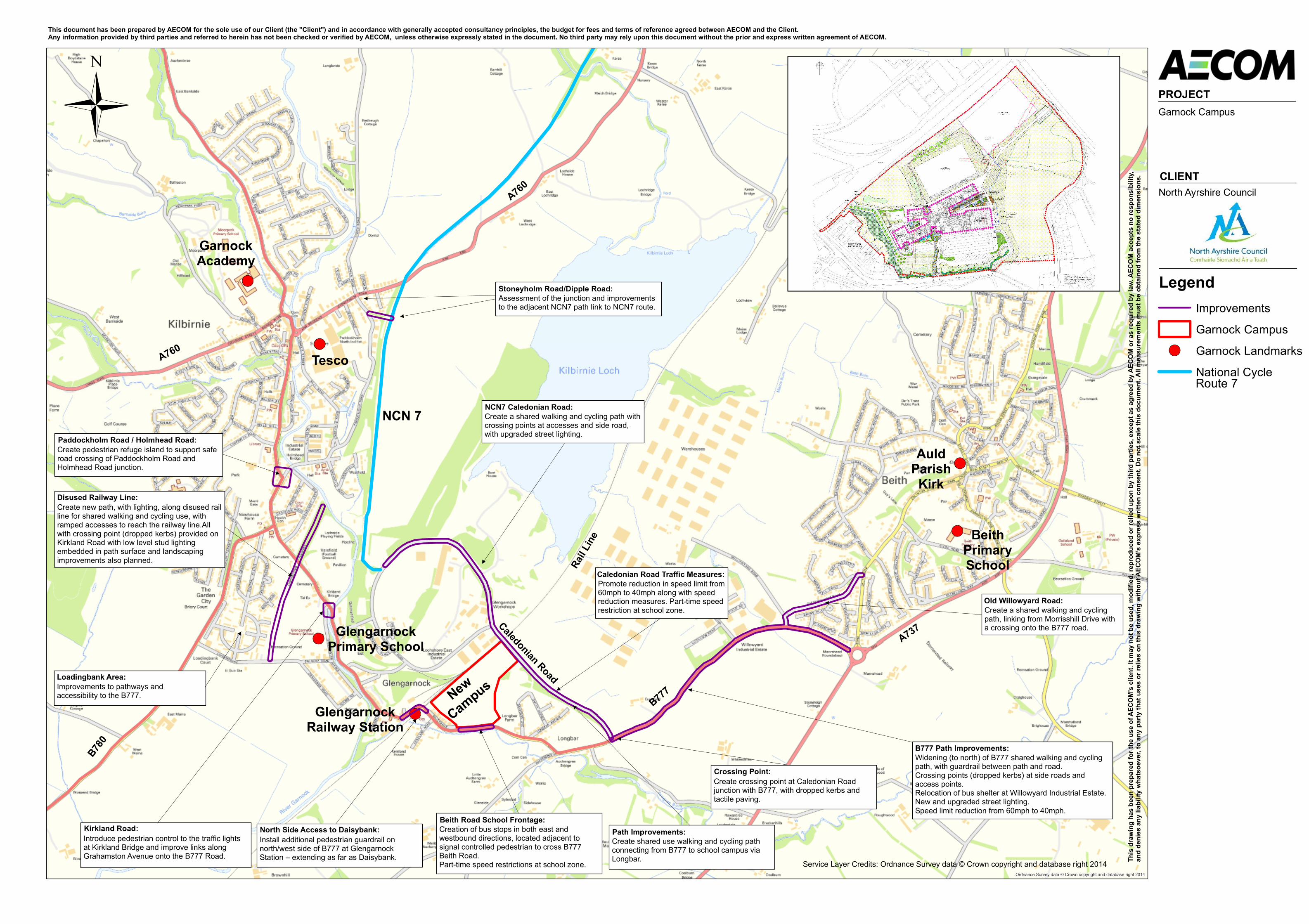
Garnock Campus – Roads and Infrastructure Improvements Thank you for taking an interest in the new Garnock Campus and the proposals for roads and infrastructure improvements set out on the adjacent plan. The campus project is currently on site and is planned to open in January 2017, with construction works estimated to be completed by December 2016. It is intended that all of the proposed improvements to roads and infrastructure will be in place by this date. The plan represents a range of activities which will be carried out as a direct consequence of the new Garnock Campus and a number of activities which, while not a planning requirement for the new campus, will support it in some way. The plan includes some narrative on each proposal to provide you with an overview of the action being taken. Other Activities in Support of the New Campus Project officers and colleagues from several Council services are involved in a number of Roads Paths and Transport Activities linked to the Garnock Campus, namely:
Walking Routes Education, Road Safety and Project Officers assessing appropriate walking and cycling routes to the campus;
School Travel Plan Every school has a Travel Plan in place and this includes in-school pupil surveys and key
information to assist our learners on their journey to school. The Warnock campus Travel Plan will be developed ahead of the campus opening;
Smarter Choices Smarter Places Funding has been secured from the Smarter Choices Smarter Places fund for a range of behaviour change activities in relation to the Garnock Campus. This is part of the Council’s Travel Smart project and will promote active and sustainable travel to and from the Campus. A key activity is the recent appointment of an I Bike Officer for the Garnock Campus through Sustrans’ I Bike Programme. This Officer will work within the Schools across the School Cluster to promote active and sustainable transport. Other activities include: active and sustainable travel promotion; delivery of training; production of maps; marketing; organised events; and community engagement;
Sustrans Community Links Fund Part of the Sustrans National Cycle Network route 7 (NCN7) runs through Kilbirnie, Glengarnock and Longbar. External funding has been secured from the Sustrans Community Links Fund for Kilbirnie, which will support some of the improvements in and around the new campus. This funding will deliver a range of infrastructure improvements including: new paths; path upgrades; bridge improvements; improved signage; improved or new lighting; and cycle counters. This much welcomed funding will be supported through the Council’s Strategic Planning and Infrastructure Services Access Path Network Programme, the Garnock campus project fund and Strathclyde Partnership for Transport (SPT) funding support from their Capital Programme;
Lighting Improvements The Council is also committed to a programme of street lighting improvements to achieve LED quality street lighting across the whole of North Ayrshire. It is intended that the main routes to the new campus will be completed prior to its opening in January 2017;
Strathclyde Partnership for Transport Officers from the Council are also working closely with SPT to promote improvements and expansion of the current public transport services in and around the new campus.
For any enquiries please contact: [email protected]
Ordnance Survey data © Crown copyright and database right 2014
This document has been prepared by AECOM for the sole use of our Client (the "Client") and in accordance with generally accepted consultancy principles, the budget for fees and terms of reference agreed between AECOM and the Client. Any information provided by third parties and referred to herein has not been checked or verified by AECOM, unless otherwise expressly stated in the document. No third party may rely upon this document without the prior and express written agreement of AECOM.
PROJECT
CLIENT
This
draw
ing ha
s bee
n prep
ared f
or th
e use
of AE
COM’
s clie
nt. It
may n
ot be
used
, mod
ified,
repro
duce
d or r
elied
upon
by th
ird pa
rties
, exc
ept a
s agr
eed b
y AEC
OM or
as re
quire
d by l
aw. A
ECOM
acce
pts no
resp
onsib
ility,
and d
enies
any l
iabilit
y wha
tsoev
er, to
any p
arty t
hat u
ses o
r reli
es on
this
draw
ing w
ithou
t AEC
OM’s
expr
ess w
ritten
cons
ent. D
o not
scale
this
docu
ment.
All m
easu
remen
ts mu
st be
obtai
ned f
rom
the st
ated d
imen
sions
.
LegendImprovementsGarnock CampusGarnock LandmarksNational Cycle
Garnock Campus
North Ayrshire Council
Service Layer Credits: Ordnance Survey data © Crown copyright and database right 2014
GlengarnockRailway Station
Tesco
NCN 7
NewCampus
Old Willowyard Road:Create a shared walking and cyclingpath, linking from Morrisshill Drive witha crossing onto the B777 road.
B777 Path Improvements:Widening (to north) of B777 shared walking and cyclingpath, with guardrail between path and road.Crossing points (dropped kerbs) at side roads andaccess points.Relocation of bus shelter at Willowyard Industrial Estate.New and upgraded street lighting.Speed limit reduction from 60mph to 40mph.
Crossing Point:Create crossing point at Caledonian Roadjunction with B777, with dropped kerbs andtactile paving.
Path Improvements:Create shared use walking and cycling pathconnecting from B777 to school campus viaLongbar.
Caledonian Road Traffic MeasuresPromote reduction in speed limit from60mph to 40mph along with speedreduction measures. Part-time speedrestriction at school zone.
Beith Road School FrontageCreation of bus stops in both east andwestbound directions, located adjacent tosignal controlled pedestrian to cross B777Beith Road.Part-time speed restrictions at school zone.
North Side Access to DaisybankInstall additional pedestrian guardrail onnorth/west side of B777 at GlengarnockStation – extending as far as Daisybank.
NCN7 Caledonian RoadCreate a shared walking and cycling path withcrossing points at accesses and side road,with upgraded street lighting.
Kirkland RoadIntroduce pedestrian control to the traffic lightsat Kirkland Bridge and improve links alongGrahamston Avenue onto the B777 Road.
Disused Railway LineCreate new path, with lighting, along disused railline for shared walking and cycling use, withramped accesses to reach the railway line.Allwith crossing point (dropped kerbs) provided onKirkland Road with low level stud lightingembedded in path surface and landscapingimprovements also planned.
Paddockholm Road / Holmhead RoadCreate pedestrian refuge island to support saferoad crossing of Paddockholm Road andHolmhead Road junction.
Stoneyholm Road/Dipple RoadAssessment of the junction and improvementsto the adjacent NCN7 path link to NCN7 route.
Loadingbank AreaImprovements to pathways andaccessibility to the B777.
Stoneyholm Road/Dipple Road:
NCN7 Caledonian Road:
Old Willowyard Road:
Caledonian Road Traffic Measures:
B777 Path Improvements:
Crossing Point:
Path Improvements:Beith Road School Frontage:
North Side Access to Daisybank:Kirkland Road:
Loadingbank Area:
Disused Railway Line:
Paddockholm Road / Holmhead Road:
BeithPrimarySchool
AuldParishKirk
Caledonian Road
B777
A760
A737
B780
A760
Route 7
Rail L
ine
GarnockAcademy
GlengarnockPrimary School