programme for the sustainable management of natural resources
TRANSCRIPT
in association with
ELABORATED BY SIMO HUBERT IN THE FRAMEWORK OF A SHORT-TIME MISSION FOR GFA/DFS CONSULTANTS
PROGRAMME FOR THE SUSTAINABLE MANAGEMENT OF NATURAL RESOURCES CAMEROON – SOUTH WEST
PROVINCE (PSMNR-SWP)
November 2007
C.I.E.F.E
I.C.E.F.S
CENTRE INTERNATIONAL D’ETUDES FORESTIERES ET ENVIRONNEMENTALES
INTERNATIONAL CENTRE FOR ENVIRONMENTAL AND FORESTRY STUDIES
MANAGEMENT INVENTORY PROTOCOL
FOR NGUTI COUNCIL FOREST
GFA/DFS/CIEFE / KfW – CMR: PSMNR / National STE for forest inventory 2
TABLE OF CONTENTS INTRODUCTION ............................................................................................................................................................ 3 1. BRIEF DESCRIPTION OF THE AREA .............................................................................................................. 3
1.1. LOCATION................................................................................................................................................................ 3 1.2.ECOLOGICAL FACTORS ............................................................................................................................................. 3
1.2.1.Soils.................................................................................................................................................................. 3 1.2.2.Topography...................................................................................................................................................... 4 1.2.2.Topography...................................................................................................................................................... 5 1.2.3.Hydrography.................................................................................................................................................... 5 1.2.4.Vegetation........................................................................................................................................................ 5 1.2.5.Climate............................................................................................................................................................. 5
1.3. SOCIO- ECONOMIC ENVIRONMENT ........................................................................................................................... 6 1.4. HISTORY OF FOREST EXPLOITATION......................................................................................................................... 6
2. METHODOLOGY OF MANAGEMENT INVENTORY ...................................................................................... 7 2.1 OBJECTIVES OF MANAGEMENT INVENTORY .............................................................................................................. 7 2.2GENERAL PROCESS OF THE MANAGEMENT INVENTORY.............................................................................................. 7 2.2 SAMPLING DESIGN .................................................................................................................................................... 8 2.3 TRANSECT OPENING................................................................................................................................................ 10
2.3.1. Data and observations recorded during transect opening .......................................................................... 12 2.3.2. Equipment of the transect opening team..................................................................................................... 12
2.4. ENUMERATION....................................................................................................................................................... 13 2.4.1. Detailed description of the data to be recorded during the enumeration ................................................... 14 2.4.2. Equipment for the enumeration team.......................................................................................................... 16
ANNEX 1: TRANSECT DESCRIPTION FORM ....................................................................................................... 18 ANNEX 2: VEGETATION TYPES (“STRATES”) .................................................................................................... 20 ANNEX 3: CONVENTIONAL SIGNS FOR TOPOGRAPHIC AND HYDROGRAPHIC DATA ........................ 22 ANNEX 4: ENUMERATION FIELD FORM.............................................................................................................. 24 ANNEX 5: TRANSVERSAL SLOPE CORRECTION TABLE FOR 10 M............................................................. 26 ANNEX 6: LIST OF SPECIES PER GROUP ............................................................................................................. 27 ANNEX 7: PARTICULAR CASES OF DIAMETER MEASUREMENT ................................................................. 33 ANNEX 8: MANUFACTURE AND USE OF THE GRADUATED BOARD TO MEASURE TREES WITH HIGH BUTTRESSES .................................................................................................................................................... 36 ANNEX 9: DEFINITION OF DBH CLASSES........................................................................................................... 38 ANNEX 10: QUALITY QUOTATION FOR THE BOLE OF A TREE ..................................................................... 39
GFA/DFS/CIEFE / KfW – CMR: PSMNR / National STE for forest inventory 3
INTRODUCTION PSMNR-SWP is supporting under its result 3, the elaboration of forest management plan for a council forest in a pilot scheme. No council forest had been foreseen in the indicative zoning plan of 2001, phase V in SWP. Up to now no council forest has been created in SWP. This is due mainly to missing knowledge, and missing financial, organizational and technical capacities of the councils. Nevertheless council forests represent a promising form of sustainable forest management with the potential to enhance development in enclaved rural areas. With the progressing implementation of decentralization the option of a council forest represents for a council and the villages around the concerned council forest area a big opportunity to create a sustainable source of revenue for investment in development issues and to take over the main stake in the management of their own forest heritage. Council forests form part of the permanent forest estate and as such have to be gazetted and a forest management plan has to elaborated. In September 2007 the technical note for the gazettement of Nguti Council Forest has been sent to the Ministry. On November 22nd 2007 the public notice for the gazettement of Nguti Council Forest has been signed by the Minister. Meanwhile the gazettement process is continuing, other technical studies are undertaken for the elaboration of the management plan. In this framework CIEFFE has been commissioned by the programme consultants to draw up an inventory management protocol for this council forest.
1. BRIEF DESCRIPTION OF THE AREA
1.1. Location
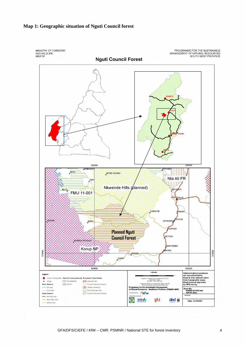
The proposed council forest of Nguti is situated in Nguti Sub-division, Kupe-Manenguba Division, South-West Province of Cameroon. (cf. map1).
On its western part, the proposed Nguti Council forest will have a common boundary with the Korup National park, along the Bake river. In its northern part it will have a common boundary with proposed Nkwende hill protection forest. The surface area of the proposed Nguti Council forest is about 12,083 ha.
1.2.Ecological factors
1.2.1.Soils
The area is covered by ferralitic soils composed of:
- Red ferralitic soils - Yellow ferralitic soils on acidic rock - Yellow ferralitic soils on sediment. Essentially, red ferralitic soils are found on basalt
and make up the Nguti region. These reds soils are chemically less fertile than those found on recent volcanic rock.
GFA/DFS/CIEFE / KfW – CMR: PSMNR / National STE for forest inventory 4
Map 1: Geographic situation of Nguti Council forest
Planned Nguti Council Forest
GFA/DFS/CIEFE / KfW – CMR: PSMNR / National STE for forest inventory 5
1.2.2.Topography
The topography of the area is in its whole extension flat to undulating land. The highest point is a hill with 428 m altitude at the northern border of the proposed forest area.
1.2.3.Hydrography
The hydrographic net of the forest area is composed of the Bake River and its affluents. Bake River originates from Nkwende Hills and flows in a southerly direction and starts marking the boundary of the proposed council forest to the south of Osirayib village.
Downstream, Bakebe River joins Bake River near Ayong village, and Bake River continues flowing in a north-westerly direction. The proposed council forest is therefore enclosed by Bake River and some of its affluent.
1.2.4.Vegetation
The forest is part of the Atlantic Biafran Forest as described by Letouzey and as such moist lowland evergreen forest, rich in Cesalpinaceae. It is typically a tropical lowland rainforest.
Lejoly (1996) proposes to nominate the zone Atlantic lower-Guinean domain to stress the influence of the Atlantic Ocean.
Most of the forest is dense forest on firm land. Only on the banks of the river Bake in some places small swampy areas can be found.
Frequently occurring species in the forest include; Azobe (Lophira alata), Ekop Naga (Brachystegia spp), Dabema (Pipadeniastrum africanum), Tali (Erythrophleum ivorensis), Okan (Cycldiscus gabonensis), Framire (Terminalia ivorensis). Others occurring species are Bilinga (Nauclea diderrichii), Ilomba (Pycnanthus angolensis), Niove (Staudia stipitata), Padouk (Pterocarpus soyauxii), Moabi (Baillonella toxisperma), Movingui (Distemonanthus benthamianus), Doussie (Afzelia spp), Aiele (Canarium schweinfurthii).
1.2.5.Climate
The Nguti council forest is under the equatorial climate of the northern coastal region with:
• an average annual rainfall of about 4,000 millimetres • monthly distribution with maximum from June to October and minimum from
December to February; a long raining season of more than 8 months and a short dry season of about 4 months.
The annual maximum average temperature is 30.2°C and the annual minimum average temperature is 23.7°C.
The mean annual relative humidity is 83%, the mean daily maximum being 98% and the minimum 66%.
GFA/DFS/CIEFE / KfW – CMR: PSMNR / National STE for forest inventory 6
1.3. Socio- economic environment
The Nguti Council Area is made up of 54 villages. However, four villages are directly concerned by the proposed council forest ( Baro, Osirayip, Sikam,and Ayong) together have a population of about 1,000 inhabitants.
The villages of Baro, Sikam and Ayong are part of the Upper Balong tribe, whereas Osirayib belongs to the Ejagham tribe.
Strangers have settled in Sikam village in the quarter Mokwalibe coming from Itoki in Konye council, belonging to the Bakundu tribe. In Qyong strangers from northwest province are settling.
Social infrastructure development is generally poor in the area. The level of scholarisation in this area is low and this has negative impact on the local village organisation. This not withstanding, the inhabitants still exhibit a strong inclination to their traditional institutions. The traditional councils are at the centre of all development initiatives in the villages. This commitment was especially apparent in Bro, Osirayip and Sikam villages.
Three of the villages (except Osirayib) have primary schools but still under-staffed and under-equipped. The nearest secondary schools are found in Nguti.
For medical attention all these villages depend on the Manyemen and Nguti institutions. The Ayong Health centre remains under-staffed and lacks basic equipment.
None of the villages has pipe-borne water. All villages depend on Manyemen and Nguti markets to sell their forestry and agricultural products. Baro and Osirayip are linked to the Kumba-Nguti road by an abandoned logging road which is only useable seasonably by specially prepared Toyota Hilux 4WD vehicles up to Osirayip.
Baro has not been reached with the vehicle in the last two years as the bridges of the logging road are broken.
Ayong and Sikam are linked to the Kumba-Nguti road also by an abandoned logging road, which is also in very bad condition and only seasonably useable by specially prepared Toyota Hilux vehicles.
A market to farm road had been constructed between Baro qnd Sikam some twenty years ago but has been abandoned.
1.4. History of forest exploitation Forest license N° 1669 of a surface area of 26 800 ha was granted to the company CTL. The license covered a big part of the proposed Nguti Council Forest. Timber exploitation took place from around 1987 to 1991. The exploitation is said to have been very selective and not quite systematic. Some earlier exploitation is said to have taken place in the 1970s by a company named ATC.
GFA/DFS/CIEFE / KfW – CMR: PSMNR / National STE for forest inventory 7
2. METHODOLOGY OF MANAGEMENT INVENTORY
2.1 Objectives of management inventory
The main objective of the management inventory consists in the collection of all dendrological and dendrometrical data required for the determination of management parameters in particular possibility and rotation. The specific objectives are:
1. to provide an accurate quantitative and qualitative estimation of first-rotation harvest per species and to make projections for second and third cutting cycles;
2. to refine the stratification obtained from remote sensing; 3. Collect a minimum of environmental data to detect the presence of fragile ecological
areas or those with a high biological value.
Two other inventories will be realized at a later stage with a specific protocol:
a) inventory of Non-timber forest products b) inventory of wildlife, especially large mammals
2.2 General process of the management inventory
Technically, the management inventory can be divided in the following phases:
a) elaboration of a forest stratification map b) elaboration of the sampling plan; c) opening of transects; d) enumeration of trees. e) data treatment and analysis f) writing of the inventory report
The control of the inventory activities in the field constitutes a subsidiary activity for which a separate protocol will be elaborated.
The sampling plan has to be approved by MINFOF before starting the inventory in the field.
This protocol refers to field activities c) opening of transects and d) enumeration of trees and is based on the following norms:
-Normes d’inventaries d’aménagement et de préinvestissement, ONADEF, 1991
- Dossier de fiches techniques, MINEF, 2001
GFA/DFS/CIEFE / KfW – CMR: PSMNR / National STE for forest inventory 8
2.2 Sampling design
The sampling will be a systematic sampling at 1 degree with sampling plots positioned contiguously on transects which are equidistant and parallel.
The sampling lines shall be as far as possible perpendicular to the general orientation of the river network so that the variability of vegetation types is best represented in the sampling The departure points of transects of enumeration shall be on accessible points situated on a road. If not possible a baseline transect is realized from which all enumeration transects branch off..
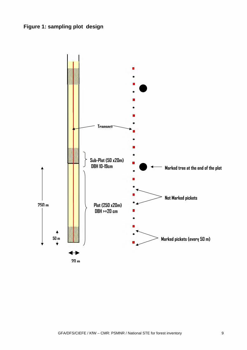
The plot as the basic unit of sampling is situated longitudinally on the enumeration transect ; its surface is 0.5 ha with the dimensions of 250 m x 20 m (see Figure 1 below).
The sampling intensity depends on the variability of a required parameter in the whole population and the decision which is taken concerning the precision or error of the estimation of this parameter. The required parameter in our case is the volume of the group of the principal exploited species1. The Cameroonian norms argue that due to already realized inventories in the past a number of 500 plots2 shall be sufficient to obtain a precision of 10% for the volume of the main exploited species on the probability threshold of 95%.Accordingly, the sampling intensity in our case shall be:
250 ha/12.083 ha = 2,07%
The corresponding equidistance (E) of the transects will be:
E=12.083 ha x 20m /250 ha = 967 m
For practical reasons an equidistance of 1000 m is chosen, which will slightly reduce the sampling intensity.
The sampling plan gives a result of 116 km of enumeration transects and 11 km of baseline transects.
All trees with a minimum diameter of 20 cm DBH are enumerated on the plot (250x20 m).
On a sub-plot , on the first 50 m of each plot, also trees with a diameters between 10 cm -19cm are enumerated3. The surface area of this sub-plot is 50 x20 m = 0.1ha. The sampling intensity for this diameter class is 0.4%.
With an average of 2 000 meters per day of opening of transect the inventory will take about 64 days of field work.
2 This number of plots is corresponding to a coefficient of variability (CV) of 110-120% 3 The document « Guide d’élaboration des plans d’aménagement » states that the in the first 50 m of each plot trees with a DBH from 10-19cm shall be enumerated instead only in the fires 5 m of the plot as mentioned in the norms.
GFA/DFS/CIEFE / KfW – CMR: PSMNR / National STE for forest inventory 9
Figure 1: sampling plot design
20 m
250 m
50 m
Sub-Plot (50 x20m) DBH 10-19cm
Transect
Marked pickets (every 50 m)
Not Marked pickets Plot (250 x20m) DBH >=20 cm
Marked tree at the end of the plot

GFA/DFS/CIEFE / KfW – CMR: PSMNR / National STE for forest inventory 10
2.3 Transect opening
The transect opening is an operation which materializes the sampling plan in the field. It can be divided in two phases, the opening of the transect itself and the materialization of horizontal distances on the transect (cf. figure 2)
The team leader of the transect opening team need to have the following information, when starting the field work:
• The topographic map at 1/50 000 with the sampling plan, • The departure points of the transects, by a GPS point or by the indication of the
distance on the baseline transect from which the enumeration transect branches off. • Fixed azimuth of the transect. • Length of the transect in meters.
The transect opening is realised by a team composed of 7 persons:
• 1 compass holder • 1 team leader/chain man • 4 cutlass men • 1 chaining assistant
1 phase: Opening of the transect itself:
. At the beginning of the transect, the compass man is placing his compass at the exact place where the picket of the starting point is positioned. The compass is placed on a special manufactured support. The compass man assures that the compass is immobile and perfectly level horizontally. The compass holder indicates the direction of the transect to the head cutlass man in front of him who makes the summary breakthrough in the forest on a defined azimuth. The head cutlass man holds a special marked picket at which the compass man is sighting at. All subsequent sightings are realized in the same manner.
A second cutlass man is following the first, clearing the sighting direction for the compass man and cutting pickets which the head cutlass man is positioning at the exact place where the sighting has been concluded.
The two others following cutlass men clear the transect in order to ensure a good visibility for the the chainman.
GFA/DFS/CIEFE / KfW – CMR: PSMNR / National STE for forest inventory 11
Figure 2: progressing of the transect opening team
2nd phase: materialization of horizontal distances on the transect
The chaining assistant and the chainman are following the transect opening team in front of them.
The chainman is directing the chaining assistant 25 m in front of him to align a picket every 25 m on the transect.. The distance of 25 m is measured with a steel cable.
On every second picket, that means every 50 m, is marked with red paint the number of the transect, the cumulative distance on the transect and the number of the plot. All these are written with the red paint (example: T2; 1200m; Pl.5)
At the beginning of each new plot (each 250m), the number of the transect, the cumulative distance on the transect and the number of the plot is marked with red paint on the trunk of the nearest tree.
Head cutlass man
3 cutlass men, clearing the transect
Compass man
chaining assistant
Cutlass man cutting pickets
chain man/teamleader
starting picket
Transect
GFA/DFS/CIEFE / KfW – CMR: PSMNR / National STE for forest inventory 12
At the end of the transect a last picket is positioned on which is marked the number of the transect, the cumulative distance, and the word “END”.
2.3.1. Data and observations recorded during transect opening The teamleader/chainman is filling in the transect description field form (Annex 1). In
particular he records the following data:
• Slope correction:
The team leader measures the slope in % from one picket to another (25 m) with a clinometer. The chaining aid for this reason is equipped with a picket on which the height of the eyes of the teamleader is marked with red colour. The teamleader is sights this mark with the clinometer and measures the slope in %. He identifies in the slope correction table the corresponding distance to add. He notes the slope correction on the transect description form and it is materialized in the field by the chaining assistant moving the picket in view to obtain the real horizontal distance of 25 m. The additional distance is measured with a 10 m tape.
• GPS Points:
The team leader records the GPS points at the beginning of the track, at the end and on the intermediate points, at least once every kilometre. The coordinates are noted on the transect description form. These points allow the real position of the transects to be located on the map.
• Vegetation type (“strate”)
He also notes the vegetation type (“strate”) crossed by the transect.. A list of the different vegetation types is found in annex 2.
• Topographical features
He indicates on the form the important topographical features (rivers, rocks, transversal slopes) and the forest exploitation signs (roads, skidding tracks) (See Annex 3, list of conventional signs of topographic and hydrographic data).
2.3.2. Equipment of the transect opening team - 1 compass TOPOCHAIX “Broussarde 235” - 1 clinometers SUUNTO - 1 GPS - A 25m steel cable (3mm) - A 10 m tape - A small tin of red paint - transect description field forms - Pencils and erasers - A board of support for fieldforms - Cutlasses and files
GFA/DFS/CIEFE / KfW – CMR: PSMNR / National STE for forest inventory 13
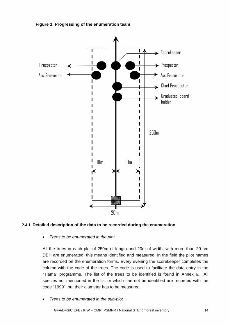
2.4. Enumeration
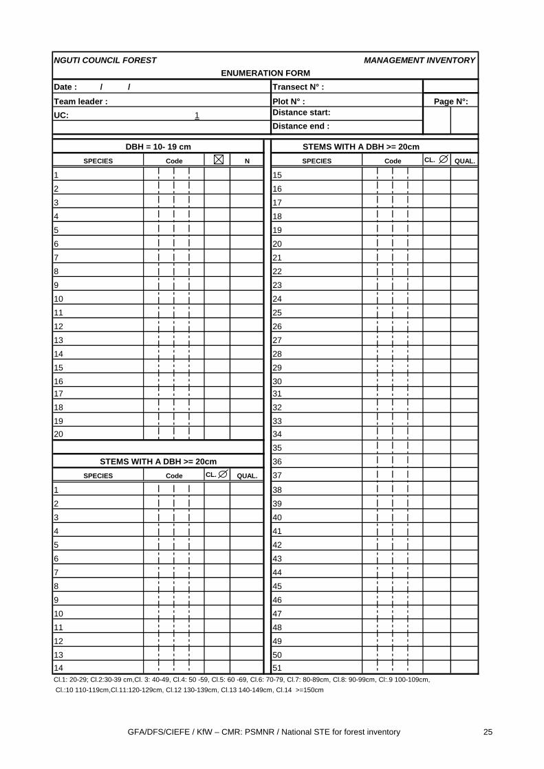
The objective of the enumeration is to identify and to measure the trees situated in the plots of 250m length and 20m width. The data is recorded on the field form for enumeration (cf.Annex 4)
The enumeration is realized by a team of 7 persons:
- 1 chief prospector, confirmed forest botanist and teamleader - 2 prospectors/forest botanists - 2 assistant prospectors - 1 tally man - 1 graduated board holder (helps to measure trees with butresses).
The chief prospector progresses on the transect together with the tally man while the two prospectors move forward on a strip of 10m width on both sides of the transect. The prospectors approach each tree situated in their strip and identify it, measure its DBH and mark it with tree cuts from the cutlass. They announce aloud the tree, its diameter class and if applicable the quality quotation for the bole of the tree. The scorekeeper repeats the announcements aloud to ensure that the prospectors got the right information. If he does not repeat the announcement, the explorers have to announce again the tree with the mention “Repeated “. The assistant prospectors (recruited locally for their good knowledge of the forest and local names) support the work of prospectors. The progress of the enumeration team is illustrated in figure 3.
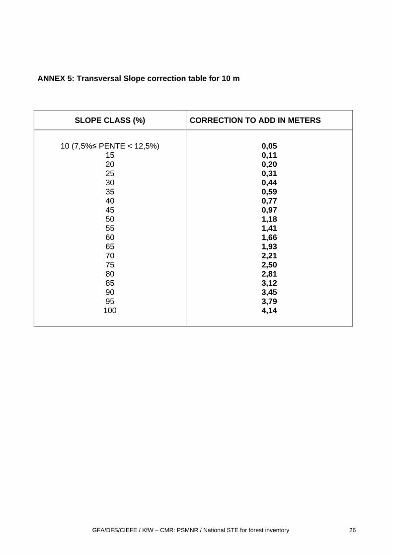
The team leader verifies the work of the team; supports the prospectors in difficult cases of identification, ensures the respect of the 10m distance in cases of trees situated on the border of the plot and verifies that no tree has been forgotten. In the case of transversal slopes he measures the slope with a clinometer and applies the slope correction out of the corresponding table. (See Annex 5) in order to guarantee a horizontal distance of 10 m of each side of the transect and an identic surface area of 0.5 ha for the plot
The graduated board holder helps to measure trees with buttresses applying the graduated board against the trunk so that the prospectors can sight the diameter class.
On request of the prospectors, the 10 m tape is used to verify the of trees at the border of the plot. This distance is measured between the centre of the tree at felling height and the central axe of the transect. The two assistant prospectors are supporting the prospectors with these measurements.
GFA/DFS/CIEFE / KfW – CMR: PSMNR / National STE for forest inventory 14
Figure 3: Progressing of the enumeration team
2.4.1. Detailed description of the data to be recorded during the enumeration
• Trees to be enumerated in the plot
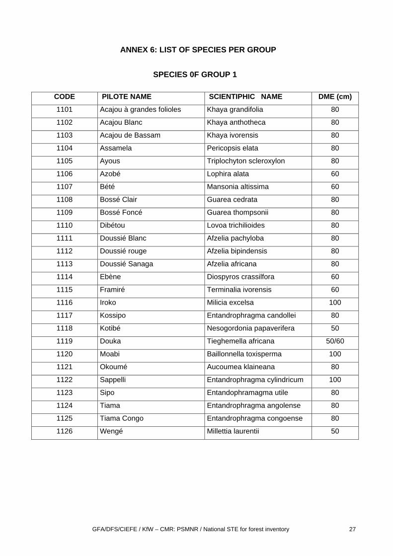
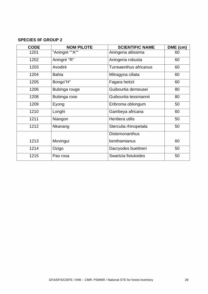
All the trees in each plot of 250m of length and 20m of width, with more than 20 cm DBH are enumerated, this means identified and measured. In the field the pilot names are recorded on the enumeration forms. Every evening the scorekeeper completes the column with the code of the trees. The code is used to facilitate the data entry in the “Tiama” programme. The list of the trees to be identified is found in Annex 6. All species not mentioned in the list or which can not be identified are recorded with the code “1999”, but their diameter has to be measured.
• Trees to be enumerated in the sub-plot
10m 10m
20m
250m
Scorekeeper
Prospector
Chief Prospector
Graduated board holder
Prospector
Ass. Prospector Ass. Prospector
GFA/DFS/CIEFE / KfW – CMR: PSMNR / National STE for forest inventory 15
In the sub-plots, in the first 50 m of each plot, additionally all trees between 10 and 19 cm DBH are identified and measured.
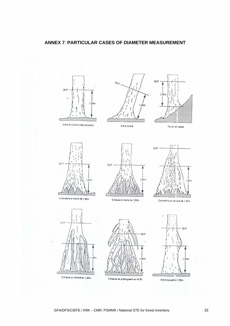
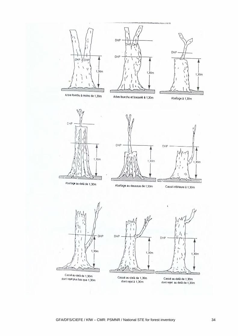
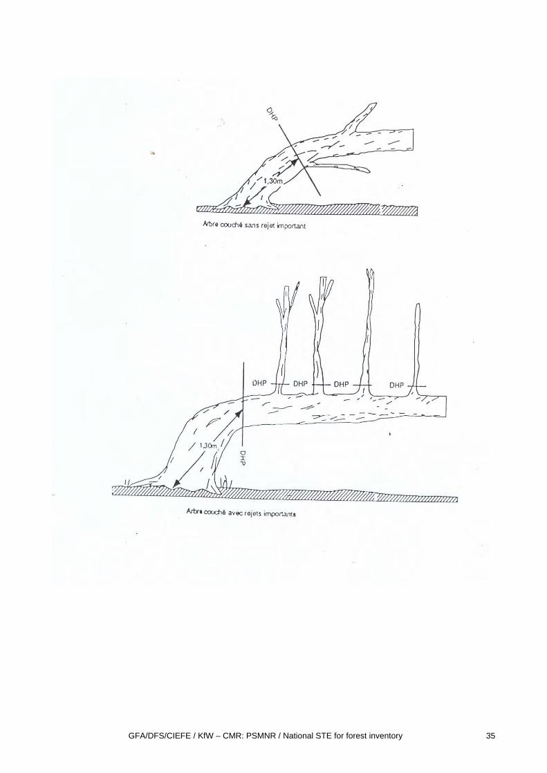
• Diameter measurement
The trees are measured with diameter tapes at 1,30m at Diameter Breast Height, (DBH) or above buttresses. The particular cases of diameter measurement are illustrated in Annex 7 ..
In the case of trees with high buttresses, the diameter is measured with the graduated board, a graduated rule from which diameter classes can be read from a distance of 10 m. (cf. annex 8).
• Diameter classes
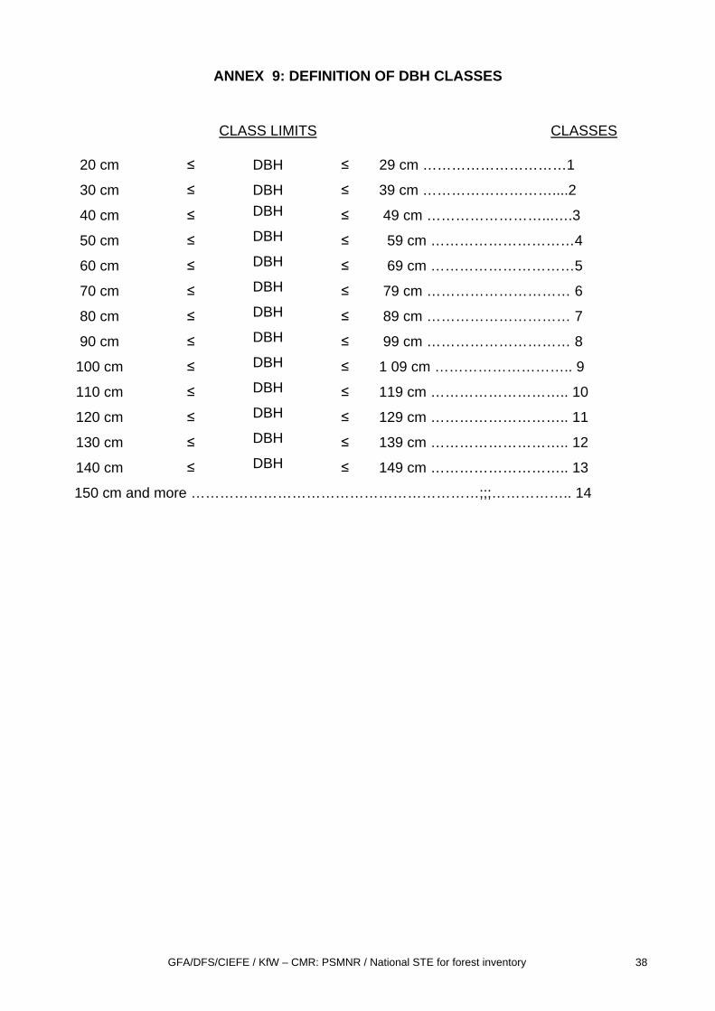
The trees are recorded with their diameter class of 10 cm steps. The first class recorded on the whole plot are the trees with 20-29 cm DBH, This diameter class is called class 1, the trees from 30-39 cm DBH are class 2 and so on. Trees with a DBH of 150 cm and more are recorded as class 14 (cf. annex 9).
• Recording of trees in the enumeration form
All trees above 20 cm DBH are recorded separately on one line of the enumeration form, with their pilot name, their diameter class and their quality quotation if applicable.
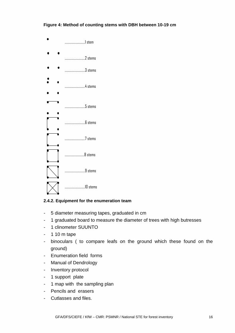
The trees (10cm<=DBH<=19cm) recorded in the sub-plot of 50x50m are called “gaulis” .They are not recorded tree by tree, but the individuals of each species are “counted” and reported on one line of the enumeration form under the chapter “gaulis”.
The method of counting is illustrated in figure 4.
• Quality Quotation
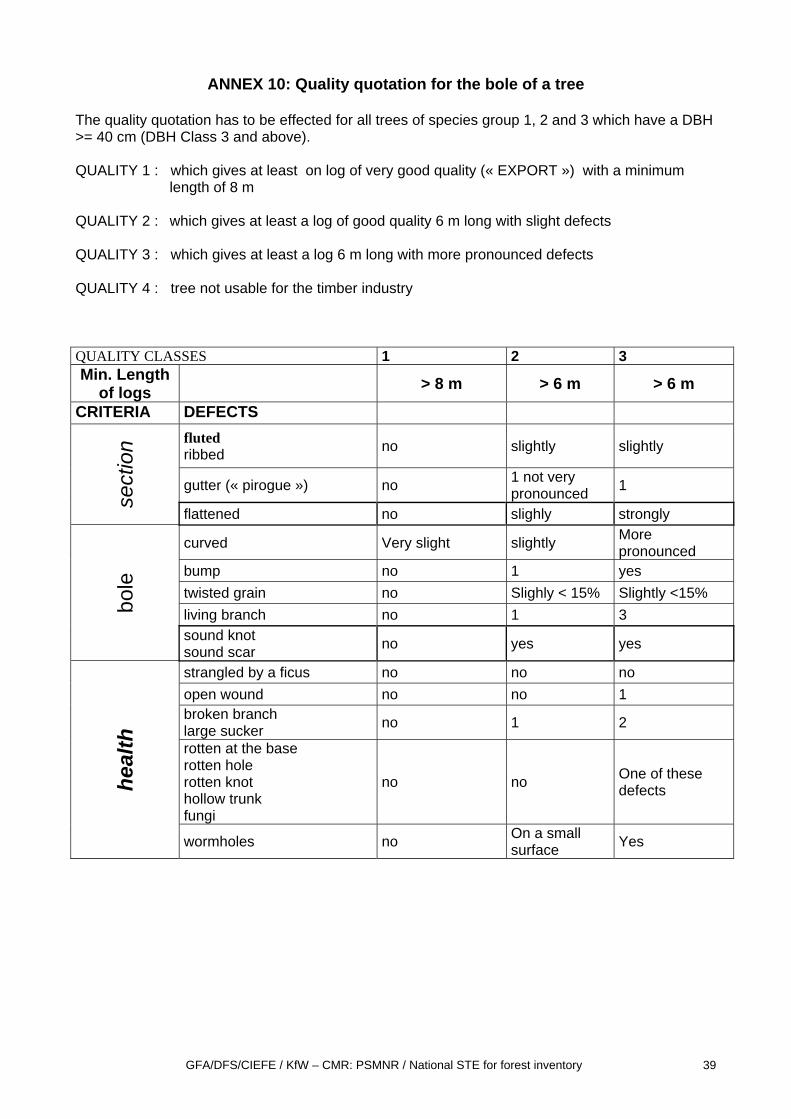
The bole quality of trees with an DBH >= 40 cm (diameter class 3) and belonging to the species group 1, 2 and 3 (cf. annex 6) has to be quoted. 4 different quality classes are differentiated. The norms for the quality quotation are found in annex 10.
GFA/DFS/CIEFE / KfW – CMR: PSMNR / National STE for forest inventory 16
Figure 4: Method of counting stems with DBH between 10-19 cm
2.4.2. Equipment for the enumeration team
- 5 diameter measuring tapes, graduated in cm - 1 graduated board to measure the diameter of trees with high butresses - 1 clinometer SUUNTO - 1 10 m tape - binoculars ( to compare leafs on the ground which these found on the
ground) - Enumeration field forms - Manual of Dendrology - Inventory protocol - 1 support plate - 1 map with the sampling plan - Pencils and erasers - Cutlasses and files.
……………………….1 stem
……………………….2 stems
……………………….3 stems
……………………….4 stems
……………………….5 stems
……………………….6 stems
……………………….7 stems
………………………8 stems
……………………….9 stems
……………………….10 stems
GFA/DFS/CIEFE / KfW – CMR: PSMNR / National STE for forest inventory 17
Literature MINEF,1997. Guide d’élaboration des plans d’aménagement des forêts de production du domaine forestier permanent de la République du Cameroun, 24 p. avec annexes. MINEF, 2001. Arrêté N° 0222 fixant les procédures d’élaboration, d’approbation, de suivi et de contrôle de la mise en œuvre des plans d’aménagement des forêts de production du domaine forestier permanent MINEF, 2001. Dossier des fichest technique. Procédures d’élaboration, d’approbation, de suivi et de contrôle de la mise en œuvre des plans d’aménagement des forêts de production du domaine forestier permanent. NGUTI COUNCIL/PSMNR-SWP, 2007. Preliminary technical note for the gazettement of Nguti council forest, 12p. ONADEF, 1991. Normes d’inventaire d’aménagement et de pré-investissement, 32 p avec annexes.
ANNEXES

ANNEX 1: Transect Description form
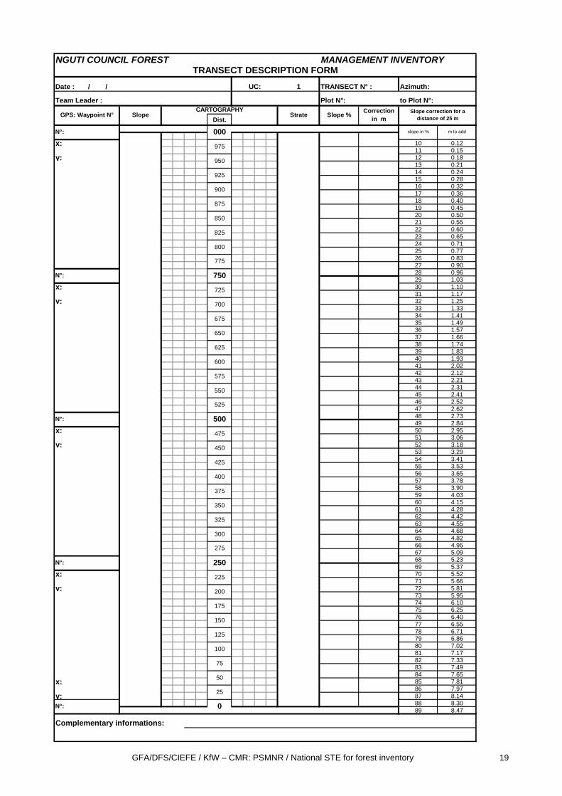
GFA/DFS/CIEFE / KfW – CMR: PSMNR / National STE for forest inventory 19
NGUTI COUNCIL FOREST MANAGEMENT INVENTORY
Date : / / 1 TRANSECT N° : Azimuth:
Team Leader : Plot N°: to Plot N°:
Dist.
x: 10 0.1211 0.15
y: 12 0.1813 0.2114 0.2415 0.2816 0.3217 0.3618 0.4019 0.4520 0.5021 0.5522 0.6023 0.6524 0.7125 0.7726 0.8327 0.9028 0.9629 1.03
x: 30 1.1031 1.17
y: 32 1.2533 1.3334 1.4135 1.4936 1.5737 1.6638 1.7439 1.8340 1.9341 2.0242 2.1243 2.2144 2.3145 2.4146 2.5247 2.6248 2.7349 2.84
x: 50 2.9551 3.06
y: 52 3.1853 3.2954 3.4155 3.5356 3.6557 3.7858 3.9059 4.0360 4.1561 4.2862 4.4263 4.5564 4.6865 4.8266 4.9567 5.0968 5.2369 5.37
x: 70 5.5271 5.66
y: 72 5.8173 5.9574 6.1075 6.2576 6.4077 6.5578 6.7179 6.8680 7.0281 7.1782 7.3383 7.4984 7.65
x: 85 7.8186 7.97
y: 87 8.1488 8.3089 8.47
Complementary informations:
Slope Strate
975
950
925
Correction in m
300
275
250
225
25
0
200
175
150
125
100
75
50
350
325
500
475
450
425
400
375
600
575
550
525
700
675
650
625
775
750
725
m to addslope in %
800
900
875
850
825
TRANSECT DESCRIPTION FORM
N°:
CARTOGRAPHYSlope %
UC:
000
Slope correction for a distance of 25 mGPS: Waypoint N°
N°:
N°:
N°:
N°:
GFA/DFS/CIEFE / KfW – CMR: PSMNR / National STE for forest inventory 20
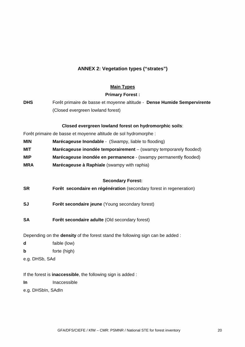
ANNEX 2: Vegetation types (“strates”)
Main Types Primary Forest :
DHS Forêt primaire de basse et moyenne altitude - Dense Humide Sempervirente (Closed evergreen lowland forest)
Closed evergreen lowland forest on hydromorphic soils:
Forêt primaire de basse et moyenne altitude de sol hydromorphe :
MIN Marécageuse Inondable - (Swampy, liable to flooding)
MIT Marécageuse inondée temporairement – (swampy temporarely flooded)
MIP Marécageuse inondée en permanence - (swampy permanently flooded)
MRA Marécageuse à Raphiale (swampy with raphia)
Secondary Forest: SR Forêt secondaire en régénération (secondary forest in regeneration)
SJ Forêt secondaire jeune (Young secondary forest)
SA Forêt secondaire adulte (Old secondary forest)
Depending on the density of the forest stand the following sign can be added :
d faible (low)
b forte (high)
e.g. DHSb, SAd
If the forest is inaccessible, the following sign is added :
In Inaccessible
e.g. DHSbIn, SAdIn
GFA/DFS/CIEFE / KfW – CMR: PSMNR / National STE for forest inventory 21
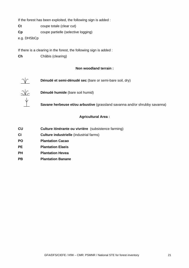
If the forest has been exploited, the following sign is added :
Ct coupe totale (clear cut)
Cp coupe partielle (selective logging)
e.g. DHSbCp
If there is a clearing in the forest, the following sign is added :
Ch Châbis (clearing)
Non woodland terrain :
Dénudé et semi-dénudé sec (bare or semi-bare soil, dry)
Dénudé humide (bare soil humid)
Savane herbeuse et/ou arbustive (grassland savanna and/or shrubby savanna)
Agricultural Area :
CU Culture itinérante ou vivrière (subsistence farming)
CI Culture industrielle (industrial farms)
PO Plantation Cacao PE Plantation Elaeis PH Plantation Hevea PB Plantation Banane
GFA/DFS/CIEFE / KfW – CMR: PSMNR / National STE for forest inventory 22
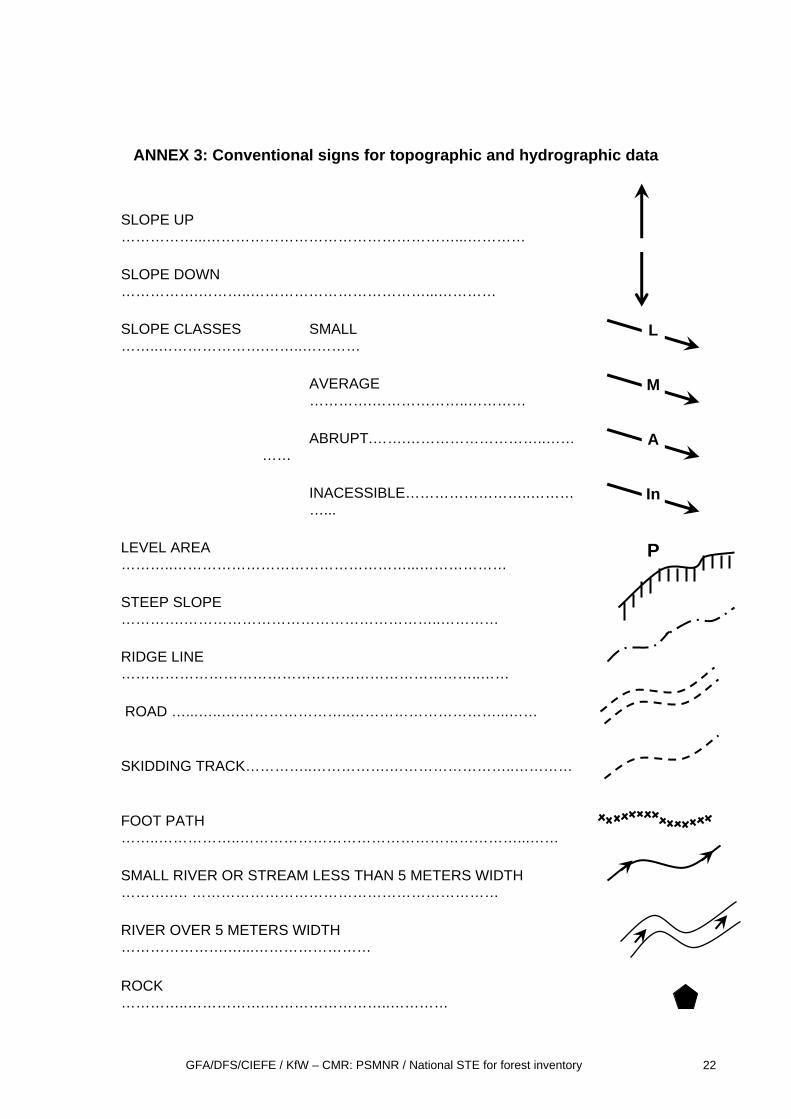
ANNEX 3: Conventional signs for topographic and hydrographic data
SLOPE UP ……………...……………………………………………...…………
SLOPE DOWN …………….………..………………………………...…………
SLOPE CLASSES SMALL ……..………………….……..…………
AVERAGE ………….………………..…………
ABRUPT.…….………………………..…………
INACESSIBLE……………………..…………...
LEVEL AREA ………..…………………………………………...………………
STEEP SLOPE ………….……………………………………………..…………
RIDGE LINE ………………………………………………………………..……
ROAD …...…..….…………………..…………………………...……
SKIDDING TRACK…………..…………….……………………..…………
FOOT PATH ……..……………..…………………………………………………...……
SMALL RIVER OR STREAM LESS THAN 5 METERS WIDTH ……….…. ………………………………………………………
RIVER OVER 5 METERS WIDTH ………………….…...……………………
L
M
A
In
P
ROCK …………..…………….……………………..…………

GFA/DFS/CIEFE / KfW – CMR: PSMNR / National STE for forest inventory 23

GFA/DFS/CIEFE / KfW – CMR: PSMNR / National STE for forest inventory 24
ANNEX 4: Enumeration field form
GFA/DFS/CIEFE / KfW – CMR: PSMNR / National STE for forest inventory 25
NGUTI COUNCIL FOREST
Date : / / Transect N° :
Team leader : Plot N° :UC: 1 Distance start:
Distance end :
SPECIES N SPECIES CL. QUAL.
1 152 163 174 185 196 207 218 229 2310 2411 2512 2613 2714 2815 2916 3017 3118 3219 3320 34
3536
SPECIES CL. QUAL. 37
1 382 393 404 415 426 437 448 459 4610 4711 4812 4913 5014 51Cl.1: 20-29; Cl.2:30-39 cm,Cl. 3: 40-49, Cl.4: 50 -59, Cl.5: 60 -69, Cl.6: 70-79, Cl.7: 80-89cm, Cl.8: 90-99cm, Cl:.9 100-109cm, Cl.:10 110-119cm,Cl.11:120-129cm, Cl.12 130-139cm, Cl.13 140-149cm, Cl.14 >=150cm
MANAGEMENT INVENTORYENUMERATION FORM
Page N°:
DBH = 10- 19 cm
Code
Code Code
STEMS WITH A DBH >= 20cm
STEMS WITH A DBH >= 20cm
GFA/DFS/CIEFE / KfW – CMR: PSMNR / National STE for forest inventory 26
ANNEX 5: Transversal Slope correction table for 10 m
SLOPE CLASS (%) CORRECTION TO ADD IN METERS
10 (7,5%≤ PENTE < 12,5%) 15 20 25 30 35 40 45 50 55 60 65 70 75 80 85 90 95
100
0,05 0,11 0,20 0,31 0,44 0,59 0,77 0,97 1,18 1,41 1,66 1,93 2,21 2,50 2,81 3,12 3,45 3,79 4,14
GFA/DFS/CIEFE / KfW – CMR: PSMNR / National STE for forest inventory 27
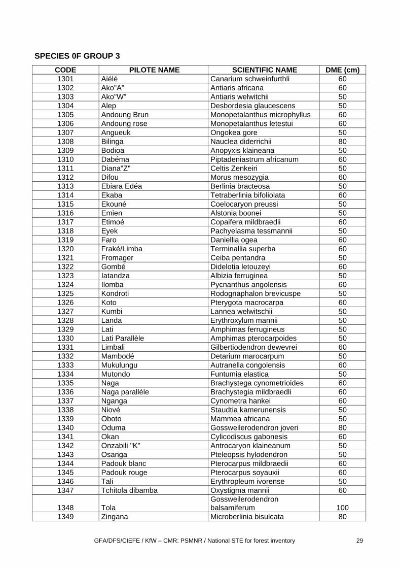
ANNEX 6: LIST OF SPECIES PER GROUP
SPECIES 0F GROUP 1
CODE PILOTE NAME SCIENTIPHIC NAME DME (cm)
1101 Acajou à grandes folioles Khaya grandifolia 80
1102 Acajou Blanc Khaya anthotheca 80
1103 Acajou de Bassam Khaya ivorensis 80
1104 Assamela Pericopsis elata 80
1105 Ayous Triplochyton scleroxylon 80
1106 Azobé Lophira alata 60
1107 Bété Mansonia altissima 60
1108 Bossé Clair Guarea cedrata 80
1109 Bossé Foncé Guarea thompsonii 80
1110 Dibétou Lovoa trichilioides 80
1111 Doussié Blanc Afzelia pachyloba 80
1112 Doussié rouge Afzelia bipindensis 80
1113 Doussié Sanaga Afzelia africana 80
1114 Ebène Diospyros crassilfora 60
1115 Framiré Terminalia ivorensis 60
1116 Iroko Milicia excelsa 100
1117 Kossipo Entandrophragma candollei 80
1118 Kotibé Nesogordonia papaverifera 50
1119 Douka Tieghemella africana 50/60
1120 Moabi Baillonnella toxisperma 100
1121 Okoumé Aucoumea klaineana 80
1122 Sappelli Entandrophragma cylindricum 100
1123 Sipo Entandophramagma utile 80
1124 Tiama Entandrophragma angolense 80
1125 Tiama Congo Entandrophragma congoense 80
1126 Wengé Millettia laurentii 50
GFA/DFS/CIEFE / KfW – CMR: PSMNR / National STE for forest inventory 28
SPECIES 0F GROUP 2
CODE NOM PILOTE SCIENTIFIC NAME DME (cm) 1201 "Aningré ""A"" Aningeria altissima 60
1202 Aningré "R" Aningeria robusta 60
1203 Avodiré Turreaenthus africanus 60
1204 Bahia Mitragyna ciliata 60
1205 Bongo"H" Fagara heitzii 60
1206 Bubinga rouge Guibourtia demeusei 80
1208 Bubinga rose Guibourtia tessmannii 80
1209 Eyong Eribroma oblongum 50
1210 Longhi Gambeya africana 60
1211 Niangon Heritiera utilis 50
1212 Nkanang Sterculia rhinopetala 50
1213 Movingui
Distemonanthus
benthamianus 60
1214 Ozigo Dacryodes buettneri 50
1215 Pao rosa Swartzia fistuloides 50
GFA/DFS/CIEFE / KfW – CMR: PSMNR / National STE for forest inventory 29
SPECIES 0F GROUP 3
CODE PILOTE NAME SCIENTIFIC NAME DME (cm) 1301 Aiélé Canarium schweinfurthli 60 1302 Ako"A" Antiaris africana 60 1303 Ako"W" Antiaris welwitchii 50 1304 Alep Desbordesia glaucescens 50 1305 Andoung Brun Monopetalanthus microphyllus 60 1306 Andoung rose Monopetalanthus letestui 60 1307 Angueuk Ongokea gore 50 1308 Bilinga Nauclea diderrichii 80 1309 Bodioa Anopyxis klaineana 50 1310 Dabéma Piptadeniastrum africanum 60 1311 Diana"Z" Celtis Zenkeiri 50 1312 Difou Morus mesozygia 60 1313 Ebiara Edéa Berlinia bracteosa 50 1314 Ekaba Tetraberlinia bifoliolata 60 1315 Ekouné Coelocaryon preussi 50 1316 Emien Alstonia boonei 50 1317 Etimoé Copaifera mildbraedii 60 1318 Eyek Pachyelasma tessmannii 50 1319 Faro Daniellia ogea 60 1320 Fraké/Limba Terminallia superba 60 1321 Fromager Ceiba pentandra 50 1322 Gombé Didelotia letouzeyi 60 1323 Iatandza Albizia ferruginea 50 1324 Ilomba Pycnanthus angolensis 60 1325 Kondroti Rodognaphalon brevicuspe 50 1326 Koto Pterygota macrocarpa 60 1327 Kumbi Lannea welwitschii 50 1328 Landa Erythroxylum mannii 50 1329 Lati Amphimas ferrugineus 50 1330 Lati Parallèle Amphimas pterocarpoides 50 1331 Limbali Gilbertiodendron dewevrei 60 1332 Mambodé Detarium marocarpum 50 1333 Mukulungu Autranella congolensis 60 1334 Mutondo Funtumia elastica 50 1335 Naga Brachystega cynometrioides 60 1336 Naga parallèle Brachystegia mildbraedli 60 1337 Nganga Cynometra hankei 60 1338 Niové Staudtia kamerunensis 50 1339 Oboto Mammea africana 50 1340 Oduma Gossweilerodendron joveri 80 1341 Okan Cylicodiscus gabonesis 60 1342 Onzabili "K" Antrocaryon klaineanum 50 1343 Osanga Pteleopsis hylodendron 50 1344 Padouk blanc Pterocarpus mildbraedii 60 1345 Padouk rouge Pterocarpus soyauxii 60 1346 Tali Erythropleum ivorense 50 1347 Tchitola dibamba Oxystigma mannii 60
1348 Tola Gossweilerodendron balsamiferum 100
1349 Zingana Microberlinia bisulcata 80
GFA/DFS/CIEFE / KfW – CMR: PSMNR / National STE for forest inventory 30
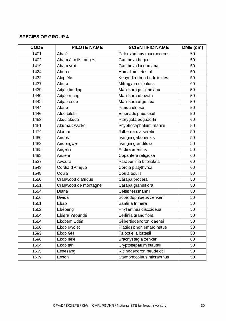
SPECIES OF GROUP 4
CODE PILOTE NAME SCIENTIFIC NAME DME (cm) 1401 Abalé Petersianthus macrocarpus 50 1402 Abam à poils rouges Gambeya beguei 50 1419 Abam vrai Gambeya lacourtiana 50 1424 Abena Homalium letestul 50 1432 Abip élé Keayodendron bridelioides 50 1437 Abura Mitragyna stipulosa 60 1439 Adjap londjap Manilkara pelligriniana 50 1440 Adjap mang Manilkara obovata 50 1442 Adjap osoé Manilkara argentea 50 1444 Afane Panda oleosa 50 1446 Afoe bilobi Erismadelphus exul 50 1458 Akodiakédé Pterygota beguaertii 60 1461 Akurna/Ossoko Scyphocephalium mannii 50 1474 Alumbi Julbernardia seretii 50 1480 Andok Irvingia gabonensis 50 1482 Andongwe Irvingia grandifolia 50 1485 Angelin Andira anermis 50 1493 Anzem Coparifera religiosa 60 1527 Awoura Paraberlinia bifoliolata 60 1548 Cordia d'Afrique Cordia platythyrsa 60 1549 Coula Coula edulis 50 1550 Crabwood d'afrique Carapa procera 50 1551 Crabwood de montagne Carapa grandiflora 50 1554 Diana Celtis tessmannii 50 1556 Divida Scorodophloeus zenken 50 1561 Ebap Santiria trimera 50 1562 Ebébeng Phyllanthus discoideus 50 1564 Ebiara Yaoundé Berlinia grandiflora 50 1584 Ekobem Edéa Gilbertiodendron klaenei 50 1590 Ekop ewolet Plagiosiphon emarginatus 50 1593 Ekop GH Talbotiella batesii 50 1596 Ekop léké Brachystegia zenkeri 60 1604 Ekop tani Cryptosepalum staudtii 50 1635 Essesang Ricinodendron heudelotii 50 1639 Esson Stemonocoleus micranthus 50
GFA/DFS/CIEFE / KfW – CMR: PSMNR / National STE for forest inventory 31
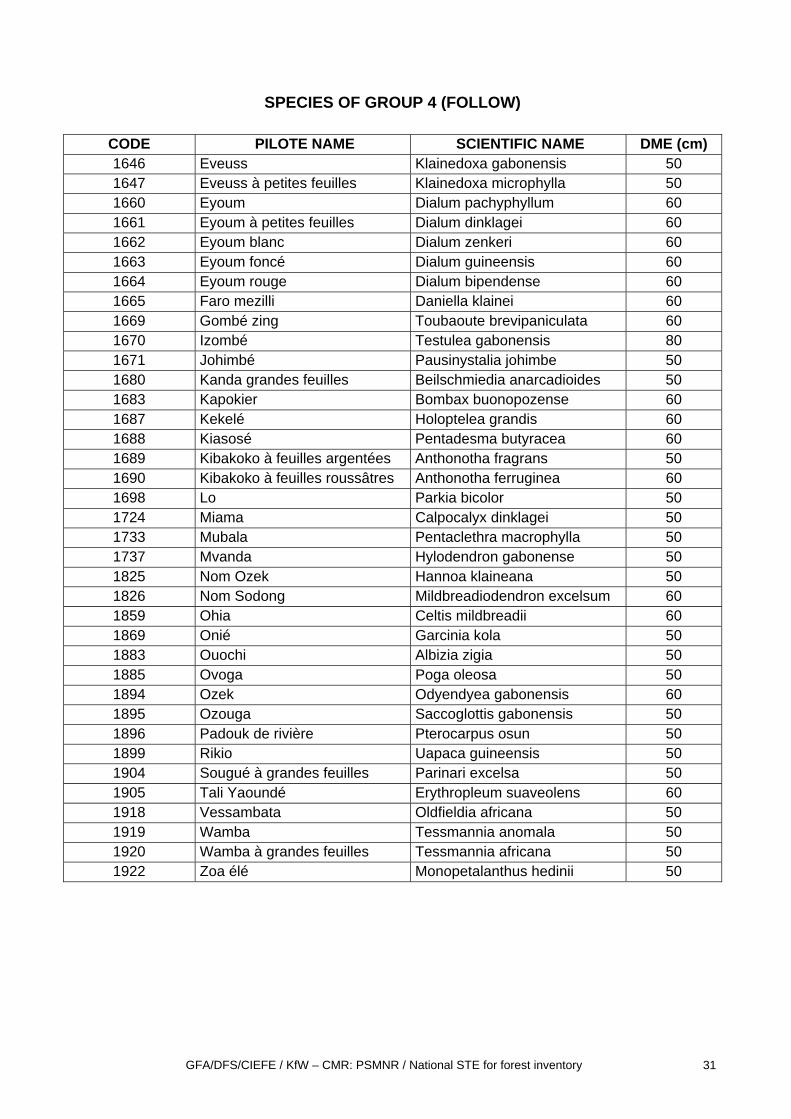
SPECIES OF GROUP 4 (FOLLOW)
CODE PILOTE NAME SCIENTIFIC NAME DME (cm) 1646 Eveuss Klainedoxa gabonensis 50 1647 Eveuss à petites feuilles Klainedoxa microphylla 50 1660 Eyoum Dialum pachyphyllum 60 1661 Eyoum à petites feuilles Dialum dinklagei 60 1662 Eyoum blanc Dialum zenkeri 60 1663 Eyoum foncé Dialum guineensis 60 1664 Eyoum rouge Dialum bipendense 60 1665 Faro mezilli Daniella klainei 60 1669 Gombé zing Toubaoute brevipaniculata 60 1670 Izombé Testulea gabonensis 80 1671 Johimbé Pausinystalia johimbe 50 1680 Kanda grandes feuilles Beilschmiedia anarcadioides 50 1683 Kapokier Bombax buonopozense 60 1687 Kekelé Holoptelea grandis 60 1688 Kiasosé Pentadesma butyracea 60 1689 Kibakoko à feuilles argentées Anthonotha fragrans 50 1690 Kibakoko à feuilles roussâtres Anthonotha ferruginea 60 1698 Lo Parkia bicolor 50 1724 Miama Calpocalyx dinklagei 50 1733 Mubala Pentaclethra macrophylla 50 1737 Mvanda Hylodendron gabonense 50 1825 Nom Ozek Hannoa klaineana 50 1826 Nom Sodong Mildbreadiodendron excelsum 60 1859 Ohia Celtis mildbreadii 60 1869 Onié Garcinia kola 50 1883 Ouochi Albizia zigia 50 1885 Ovoga Poga oleosa 50 1894 Ozek Odyendyea gabonensis 60 1895 Ozouga Saccoglottis gabonensis 50 1896 Padouk de rivière Pterocarpus osun 50 1899 Rikio Uapaca guineensis 50 1904 Sougué à grandes feuilles Parinari excelsa 50 1905 Tali Yaoundé Erythropleum suaveolens 60 1918 Vessambata Oldfieldia africana 50 1919 Wamba Tessmannia anomala 50 1920 Wamba à grandes feuilles Tessmannia africana 50 1922 Zoa élé Monopetalanthus hedinii 50
GFA/DFS/CIEFE / KfW – CMR: PSMNR / National STE for forest inventory 32
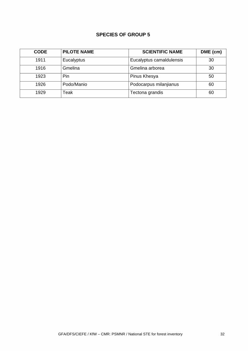
SPECIES OF GROUP 5
CODE PILOTE NAME SCIENTIFIC NAME DME (cm)
1911 Eucalyptus Eucalyptus camaldulensis 30
1916 Gmelina Gmelina arborea 30
1923 Pin Pinus Khesya 50
1926 Podo/Manio Podocarpus milanjianus 60
1929 Teak Tectona grandis 60
GFA/DFS/CIEFE / KfW – CMR: PSMNR / National STE for forest inventory 33
ANNEX 7: PARTICULAR CASES OF DIAMETER MEASUREMENT
GFA/DFS/CIEFE / KfW – CMR: PSMNR / National STE for forest inventory 34
GFA/DFS/CIEFE / KfW – CMR: PSMNR / National STE for forest inventory 35
GFA/DFS/CIEFE / KfW – CMR: PSMNR / National STE for forest inventory 36
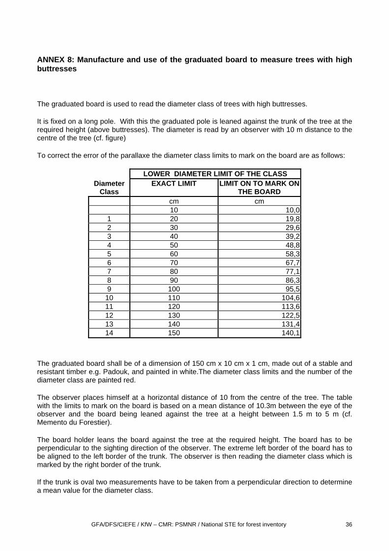
ANNEX 8: Manufacture and use of the graduated board to measure trees with high buttresses
The graduated board is used to read the diameter class of trees with high buttresses.
It is fixed on a long pole. With this the graduated pole is leaned against the trunk of the tree at the required height (above buttresses). The diameter is read by an observer with 10 m distance to the centre of the tree (cf. figure)
To correct the error of the parallaxe the diameter class limits to mark on the board are as follows:
LOWER DIAMETER LIMIT OF THE CLASS Diameter
Class EXACT LIMIT LIMIT ON TO MARK ON
THE BOARD cm cm 10 10,0
1 20 19,8 2 30 29,6 3 40 39,2 4 50 48,8 5 60 58,3 6 70 67,7 7 80 77,1 8 90 86,3 9 100 95,5
10 110 104,6 11 120 113,6 12 130 122,5 13 140 131,4 14 150 140,1
The graduated board shall be of a dimension of 150 cm x 10 cm x 1 cm, made out of a stable and resistant timber e.g. Padouk, and painted in white.The diameter class limits and the number of the diameter class are painted red.
The observer places himself at a horizontal distance of 10 from the centre of the tree. The table with the limits to mark on the board is based on a mean distance of 10.3m between the eye of the observer and the board being leaned against the tree at a height between 1.5 m to 5 m (cf. Memento du Forestier).
The board holder leans the board against the tree at the required height. The board has to be perpendicular to the sighting direction of the observer. The extreme left border of the board has to be aligned to the left border of the trunk. The observer is then reading the diameter class which is marked by the right border of the trunk.
If the trunk is oval two measurements have to be taken from a perpendicular direction to determine a mean value for the diameter class.
GFA/DFS/CIEFE / KfW – CMR: PSMNR / National STE for forest inventory 37
If there is a slope between the observer and the tree, some distance has to be add according to the slope correction table of 10 m in annex 5.
Mean Distance 10,3 meters
Figure: How to use the graduated board
79
11 13
531
Reading point
GFA/DFS/CIEFE / KfW – CMR: PSMNR / National STE for forest inventory 38
ANNEX 9: DEFINITION OF DBH CLASSES
CLASS LIMITS CLASSES
20 cm ≤ DBH ≤ 29 cm …………………………1
30 cm ≤ DBH ≤ 39 cm ………………………....2
40 cm ≤ DBH ≤ 49 cm ……………………...….3
50 cm ≤ DBH ≤ 59 cm …………………………4
60 cm ≤ DBH ≤ 69 cm …………………………5
70 cm ≤ DBH ≤ 79 cm ………………………… 6
80 cm ≤ DBH ≤ 89 cm ………………………… 7
90 cm ≤ DBH ≤ 99 cm ………………………… 8
100 cm ≤ DBH ≤ 1 09 cm ……………………….. 9
110 cm ≤ DBH ≤ 119 cm ……………………….. 10
120 cm ≤ DBH ≤ 129 cm ……………………….. 11
130 cm ≤ DBH ≤ 139 cm ……………………….. 12
140 cm ≤ DBH ≤ 149 cm ……………………….. 13
150 cm and more ……………………………………………………;;;…………….. 14
GFA/DFS/CIEFE / KfW – CMR: PSMNR / National STE for forest inventory 39
ANNEX 10: Quality quotation for the bole of a tree
The quality quotation has to be effected for all trees of species group 1, 2 and 3 which have a DBH >= 40 cm (DBH Class 3 and above). QUALITY 1 : which gives at least on log of very good quality (« EXPORT ») with a minimum length of 8 m QUALITY 2 : which gives at least a log of good quality 6 m long with slight defects QUALITY 3 : which gives at least a log 6 m long with more pronounced defects QUALITY 4 : tree not usable for the timber industry QUALITY CLASSES 1 2 3 Min. Length
of logs > 8 m > 6 m > 6 m
CRITERIA DEFECTS fluted ribbed no slightly slightly
gutter (« pirogue ») no 1 not very pronounced 1
sect
ion
flattened no slighly strongly
curved Very slight slightly More pronounced
bump no 1 yes twisted grain no Slighly < 15% Slightly <15% living branch no 1 3 bo
le
sound knot sound scar no yes yes
strangled by a ficus no no no open wound no no 1 broken branch large sucker no 1 2
rotten at the base rotten hole rotten knot hollow trunk fungi
no no One of these defects he
alth
wormholes no On a small surface Yes