east abaco coastal conservation area · a proposal to protect a network of mangrove wetlands in the...
TRANSCRIPT
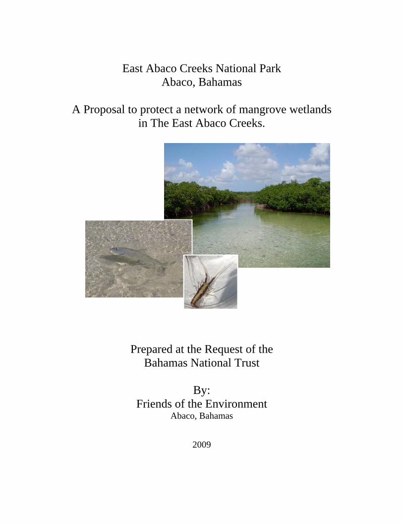
East Abaco Creeks National Park
Abaco, Bahamas
A Proposal to protect a network of mangrove wetlands in The East Abaco Creeks.
Prepared at the Request of the Bahamas National Trust
By:
Friends of the Environment Abaco, Bahamas
2009

ii
Patterson, O. and K. Williams. (2009) Friends of the Environment. East Abaco Creeks National Park: A Proposal to protect a network of mangrove wetlands in the East Abaco Creeks. February 17, 2009. This document can not be cited without the authors’ permission. Contact: Olivia Patterson, Friends of the Environment, Marsh Harbour, Abaco. 242-367-2721, [email protected]

iii
Table of Contents Executive Summary……………………………………………………………………….1
Introduction……………………………………………………………………………….3
Location…………………………………………………………………………...3
Boundaries and Buffer Zones……………………………………………………..4
Importance of Mangrove Ecosystems...…………………………………………..7
The Blue Hole System of East Abaco Wetlands………………………………...10
Proposal Development….………………………………………………………………..12
Community Consultation………………………………………………………...12
Private Land Owners……………………………………………………………..15
Creek Usage……………………………………………………………………...15
The Bahamas National Parks System…………………………………………………... 20
Justification for Proposed Area..…………………………………………………………20
Existing Threats……..…………………………………………………………...20
Park Management………………………………………………………………………..22
Financial Sustainability…………………………………………………………..22
Enforcement……………………………………………………………………...23
Education and Awareness………………………………………………………..24
Zoning……………………………………………………………………………24
Conclusion……………………………………………………………………………….26
References……………………………………………………………………………….28
Appendix………………………………………………………………………………...29

iv
Table of Figures Figure 1. A Google Earth satellite image showing Snake Cay Creeks, Bight of Old Robinson and Cherokee Sound. Figure 2. Google Earth satellite image of Snake Cay Creeks and proposed boundary guidelines. Figure 3. A Google Earth satellite image showing the Bight of Old Robinson and Cherokee Sound and their proposed boundary guidelines. Figure 4. A Google Earth satellite image showing Cherokee Sound and proposed boundary guidelines. Figure 5. Juvenile Crawfish observed in Snake Cay Creek during a study on larval recruitment.
Figure 6. Google Earth image showing the density of blue holes in The Creeks. Figure 7. Cave adapted sponges found in a Snake Cay Creek blue hole. Figure 8. A chart showing the home town representations of survey respondents (n=84). Figure 9. A chart showing the variety of occupations represented by survey respondents (n=84). Figure 10. A chart displaying activities that take place in The Creeks (n=84). Figure 11. Bar chart showing how survey respondents value the economic contribution of The Creeks (n=84). Figure 12. A pie chart illustrating the opinions of those surveyed as to which user groups should or should not pay user fees were The Creeks to be declared a National Park (n=84). Table 1. List of Community meetings held in Abaco to discuss the East Abaco Creeks national park proposal.

1
Executive Summary In the interest of long-term conservation planning for Abaco, Friends of the Environment
and The Bahamas National Trust are proposing protection of coastal crown and treasury
lands and cays from the area just south of the Snake Cay dock to the southern side of
Cherokee Sound (Figure 1) on the east side of Great Abaco Island. Working from past
experience in protected areas proposals, as well as with the advice of protected area
managers and researchers, this proposal was developed with the community in mind and
has evolved with significant community input.
This network of wetlands in East Abaco contains extremely important nursery habitat,
providing a source of marine fauna to coral reefs. Damages to these areas likely will
result in extreme reductions of fish and crawfish populations on the reef. These wetlands
have been a source of food and enjoyment for Bahamians since nearby communities were
settled. The current reality is that areas where Bahamians can pursue these cultural
activities are rapidly disappearing. This proposal aims to protect the juvenile nursery
habitat while still allowing heritage fishing activities to take place. In addition, the
proposal supports enterprising individuals who undertake more ecologically-friendly
occupations, such as bonefishing and eco-tours, which can provide economic returns
without causing environmental damage. Ecotourism is a fast growing market and one that
Abaco has all of the natural amenities available to capture. In effect, this proposal is a
framework providing for a balance between culture, economics and conservation.
The main concern for the area is damaging development activities, such as dredging,
large scale commercial building, and pollution, hence the need for the area’s protection
and the choice of National Park as the vehicle for conservation. It is believed that the
current fisheries usage could be improved through management, as enforcement of
existing regulations are minimal. Additionally, the conservation and protection of
mangrove and seagrass habitats, which are extremely valuable for their juvenile nursery
function, will supplement the marine life that support recreational and ecotourism
activities, e.g., by supporting recruitment of fauna to the adjacent Pelican Cays Land and
Sea Park and other reefs.

2
Designating these wetlands under protection will help The Bahamas fulfill commitments
made to The Convention on Biological Diversity and the RAMSAR Treaty, and would be
a big step towards attaining the Caribbean Challenge goal of protecting 20% of Bahamian
marine and coastal resources by the year 2020. This network will improve the Marine
Protected Area system locally, and nationally, by conserving mangrove and seagrass
habitat, ecosystems which are largely underrepresented in Bahamian protected areas,
despite their vast importance to our country.
The Bahamas is coming on stream with the rest of the world in regards to conservation
and environmental management. We are in a unique position, as a young country, to be
able to learn from our neighbors’ successes - and mistakes - and to set an example for
other nations. The Bahamas is growing quickly and it is of great concern that we properly
manage and maintain our natural resources. This proposal is a proactive step towards
planning for the future of The Bahamas.

3
Introduction
This proposal is part of an effort by the Bahamas National Trust (BNT) and
Friends of the Environment (FRIENDS) to increase awareness and protection of the
Bahamian environment. All information following in this proposal has been collected by
FRIENDS on behalf of the BNT in anticipation of an official Bahamas National Trust
proposal being submitted to the Bahamian Government.
Location
The proposed protected area, located on the east side of Great Abaco, would include three
wetland systems that are connected through an underground network of blue holes. As
the purpose of the protected area is habitat conservation, only the wetland areas
themselves, with a buffer zone on the mainland, will be included; not the land in between
the systems. The wetland systems are: Snake Cay Creek (also known as Angel Cays),
Bight of Old Robinson and Cherokee Sound. The northern boundary of the network
begins approximately 7 miles south of Marsh Harbour (just south of Snake Cay Dock) to
Wilson City; a boundary across the mouth of the Bight of Old Robinson; and a boundary
across the mouth of Cherokee Sound ending approximately 18 miles south of Marsh
Harbour. The proposed area is hereafter called “The Creeks”.
Figure 1. A Google Earth satellite image showing Snake Cay Creeks, Bight of Old Robinson and Cherokee Sound.
The Bight of Old Robinson

4
Boundaries and Buffer Zones The Network in general:
Biodiversity conservation and ease of understanding were both taken into consideration
when designing the boundaries for the protected area. Where the protected area abuts the
mainland (to the west) the boundary is identified as 100 feet landward from the high tide
line. To the east (along the outer cays) the boundary is the high tide line. In addition, it is
suggested that a buffer zone be implemented to mitigate the impacts of encroaching
development. All crown or treasury owned cays are included. The community has been
consulted regarding boundaries throughout the development of this proposal.
Friends of the Environment is willing to assist with logistics if the Department of Lands
and Surveys requires any ground-truthing.
Snake Cay Creeks: For the Snake Cay Creeks, the northern boundary shall be the
northern tip of Deep Sea Cay across to the point at Rouse’s Hole and following the
coastline west. The southern boundary shall be where crown land ends before Spencer’s
Bight (note that this is estimated on Figure 2). The area shall include Suckingfish Creek
and the spit of land to the east of said creek; and the Nurse Cays which are east of that
spit. The western boundary shall be a minimum of 100 feet landward of the high tide line
to include the logging road which runs parallel to the Snake Cay wetlands (this may be
lesser or greater than 100ft from the wetland in some areas).The eastern boundary will be
drawn along the high tide line of the outer cays (e.g. Deep Sea, Iron Cay).

5
Figure 2. Google Earth satellite image of Snake Cay Creeks and proposed boundary guidelines. Bight of Old Robinson: The boundary line will be drawn across the mouth of the Bight
from Point A (unable to find common name on available maps) to Tom Curry’s Point
(from 26°21.331’N, 77°0.239’W to 26°20.063’N, 77°0.032’W).
Spencer’s Bight

6
Figure 3. A Google Earth satellite image showing the Bight of Old Robinson and proposed boundary guidelines.
Cherokee Sound: The boundary line will be drawn across the mouth of the Cherokee
Sound from Cherokee Point, across the reef line (which is exposed at low tide) to Duck
Cay and from Duck Cay to Rocky Point, which is on the mainland and just south of
Casuarina Point. Duck Cay is a private island, so only the seabed surrounding the cay
would be included in the park. It should be noted that boundaries may need to be adjusted
to reflect the true edge of the wetland as some of it is obscured by clouds on the Google
Earth image (Figure 4).
Bridges Cay
Tom Curry’s Point
Point A
The Bight of Old
Robinson

7
Figure 4. A Google Earth satellite image showing Cherokee Sound and proposed boundary guidelines. Importance of Mangrove Ecosystems
• Biodiversity. Mangroves are a transition zone between terrestrial and marine
habitats, and thus are integral to both areas. Mangrove roots provide shelter and
habitat for juvenile fish, juvenile spiny lobster, mollusks, and other organisms.
Mangrove trees themselves provide roosting and nesting habitat for many shore
birds, as well as the White Crowned Pigeon. Seagrass and Laurencia algae beds
can be found within the wetlands and at the creek mouths. These “beds” are
critical elements in the life cycle of marine organisms such as Nassau Grouper
and Spiny Lobster. Algae such as Laurencia are known to send out chemical cues
Rocky Point
Duck Cay
Casuarina Point
Cherokee Point

8
which attract the juveniles towards the wetland and in some cases may initiate
metamorphosis (e.g. Queen Conch).
• Nursery Habitat. Compared to coral reefs, mangroves have a much lower
number of large predators, and thus provide a safe haven for juveniles to mature.
Without the protection of mangrove systems, many fishes will be less likely to
survive to the point where they can venture out to reefs to reproduce. The health
of wetlands is critical to the health of other marine ecosystems. Studies in
Mexico, Belize and other areas of the Caribbean demonstrate that there is a higher
biomass of fish on reefs when that habitat is connected to mangroves (Mumby et
al., 2004). The biomass of bluestriped grunts may be up to 25 times greater in
areas with mangroves (Mumby et al., 2004). Adult striped parrotfish (Scarus
guacamaia) were found in greater densities on reefs adjacent to mangroves, than
on reefs with no mangroves nearby (Mumby et al., 2004). The proximity of Sandy
Cay Reef in the Pelican Cays Land and Sea Park to The Creeks strongly suggests
that there may be a link between the two. However, the movement of fish from
The Creeks to Sandy Cay Reef has not been researched directly.
• Ecosystem Services. The Bahamas archipelago covers nearly 100,000 square
miles and is comprised of numerous islands, cays and rocks. Many of these
islands have coral reefs off of their shores and mangroves along the coast. The
Bahamas, due to its geography, is subject to many hurricanes and tropical storms.
Our coral reefs are the first defense against the bulk of the wave energy and storm
surge that The Bahamas experiences. Mangroves are our second defense. Without
this natural protection, The Bahamas would find that the repercussions from
hurricanes and winter storms would be much greater, as was the case in South
East Asia in the great tsunami of 2004. Mangroves also act as filters, collecting
debris and silt from run-off. This limits erosion of the coastline, and minimizes
siltation of adjacent seagrass beds.
• Local and National Economy. It has been noted that 80% of the marine life we
eat spends some portion of time amongst the mangroves and seagrass beds
(BREEF). Species of specific importance to The Bahamas include snappers,

9
groupers, Queen Conch, and crawfish (Spiny Lobster). Snapper and Nassau
Grouper are the most common scale fish caught in The Bahamas (BREEF, 1998)
and are an important food resource for Bahamians. Approximately 95% of the
profit derived from total fishery exports can be contributed to crawfish. In 2007,
95% of crawfish landed in The Bahamas were exported, amounting to over $86
million in sales (Bahamas Department of Marine Resources).
Figure 5. Juvenile Crawfish observed in Snake Cay Creek during a study on larval recruitment. Mangrove wetlands and associated seagrass flats are also highly valuable to the economy
because they are the primary habitat for bonefish. These wetlands, in particular, are one
of the top bonefishing destinations in all of the Abacos. The current rate for a day’s
bonefish charter is between $300 and $500 and some bonefishermen work more than 200
days a year. This means that a single bonefisherman can earn $60,000 to $100,000 a year,
or more! This is a direct benefit from Abaco’s wetlands which becomes filtered through
the economy in the form of fuel purchases, food and other goods and services.

10
The Blue Hole System of East Abaco Wetlands Bahamian blue holes have the highest biodiversity of any underwater caves in the world
(Anchialine Caves Website, 2008). Blue holes are windows into the geology of our
islands and often connect multiple habitats. The blue holes of Snake Cay Creeks and the
Bight of Old Robinson are all part of the same fault fracture (Kakuk, pers.comm.). This
slump fault or bank margin fracture would have occurred when the sea level was much
lower and the exposed land at the edge of the continental shelf shifted. The blue holes at
Cherokee Sound appear to be part of a “cross fracture” as they are running perpendicular
to the blue holes in the other two wetlands. These blue holes are hydraulically connected,
so what affects one could affect another (Kakuk, pers. comm.). Pollution is a particular
concern in these cases, as well as silt from dredging.
There is a dense arrangement of blue holes in The Bight of Old Robinson and Cherokee
Sound. Andros Island is probably the only location in The Bahamas with a greater
density of blue holes than these two wetlands (Kakuk, pers. comm.).

11
Figure 6. Google Earth image showing the density of blue holes in The Creeks. Each yellow pin represents the location of a blue hole. Blue holes provide habitat to many organisms including fish, crawfish, and filter feeders
such as sponges. Blue hole cave walls and entrances are literally carpeted with filter-
feeding organisms that take advantage of the high movement of water through the area.
Filter feeding species are particularly vulnerable to siltation. Species of sponges
identified in blue holes of the East Abaco Creeks can also be found out on the reefs, yet
the sponges in the blue holes have become particularly adapted to their environment and
conditions. As such, these unique assemblages warrant specific protection.
Figure 7. Cave adapted sponges found in a Snake Cay Creek blue hole.
12
Widely promoted by the Ministry of Tourism as a part of the Bahamian tourist
experience, blue holes support a somewhat elite industry of cave diving and research,
both of which take place in Abaco. The blue holes near Snake Cay are known to be used
by cave divers of a range of experience levels (Kakuk, pers. comm.). Additionally, Snake
Cay Creek blue holes have attracted attention from National Geographic Expeditions, and
may be included in an upcoming article in the National Geographic magazine.
In addition to their value for tourism, blue holes also hold potential for building the
economy through bio-prospecting. The potential chemical and genetic resources are have
barely been explored. New species are being found frequently. Any one of those new
species could possibly hold the cure for a serious illness. Bio-prospecting could
potentially support the management of the proposed park, yet strict management
guidelines for extraction would have to be developed and enforced if that were a
possibility. Also, local cave diving experts and the community should be consulted.
Proposal Development Community Consultation When a development was proposed for the area north of the Snake Cay Creeks, concern
about protection of The Creeks heightened and Friends of the Environment felt the timing
was right to start a conversation with the community about their future. Local interest has
been generated due to the historic use, enjoyment and understanding of the area’s
importance to fishing stocks.
Table 1. List of Community meetings held in Abaco to discuss the East Abaco Creeks national park proposal. (see Appendix “Community” for details of all meetings). Date Time Location Attendance Meeting Type
13 Aug 2008 7:00 p.m. FRIENDS Education Center, Marsh Harbour
93 (81 signed in)
Presentation and open forum
28 Oct 2008 7:30 p.m. Community Center, Cherokee Sound
75-80 (33 signed in)
Presentation and open forum

13
9 Dec 2008 7:00 p.m. Community Center, Cherokee Sound
19 Presentation and open forum
10 Dec 2008 7:00 p.m. FRIENDS Education Center, Marsh Harbour
50 Presentation and open forum
7 Jan 2009 12 noon FRIENDS Education Center, Marsh Harbour
0 Stakeholder discussion group
12 Jan 2009 7:00 p.m. Fire House, Casuarina Point
14 (13 signed in)
Presentation and open forum
14 Jan 2009 12 noon FRIENDS Education Center, Marsh Harbour
5 Stakeholder discussion group
20 Jan 2009 6:30 p.m. Pete’s Pub, Little Harbour
15 Presentation and open forum
21 Jan 2009 12 noon FRIENDS Education Center, Marsh Harbour
8 Stakeholder discussion group
28 Jan 2009 7:00 p.m. FRIENDS Education Center, Marsh Harbour
6 (4 signed in)
Presentation and open forum
Friends of the Environment organized a meeting in August 2008 to assess the
community’s interest in protecting the Snake Cay wetlands. All 93 of the community
members who attended were in favor of some sort of protection. From that meeting a
dedicated, diverse group of local residents volunteered to help to draft this proposal,
select the proposed protected area and take part in the management
This group suggested the inclusion of the Bight of Old Robinson to the conservation area.
The Bight was one of the areas seriously considered by the Department of Marine
Resources for a Marine Protected area, although another location was eventually
proposed. This mangrove wetland is recognized by conservationists, scientists, locals and
visitors as a place of special importance.
The town of Cherokee had asked for protection of their wetlands during a meeting with
the Bahamas National Trust in 2006. With the creation of this proposal to protect areas
that are connected to Cherokee Sound, it was only natural to consult the Cherokee
14
community. A meeting was held in Cherokee Sound in October 2008 to assess their
interest in having Cherokee Sound become part of the proposed protected area. While
only 33 people wrote their names on the sign-in sheet, attendance was estimated at 75-80
people. An article in The Abaconian by a Cherokee resident noted the meeting as “one of
the largest gatherings of Cherokee residents to turn out for a public meeting” (see
Appendix “NEWS” for all newspaper coverage). All in attendance, save one, voted to
include Cherokee Sound in the park proposal and indicated interest in assisting with
management. That one person later clarified that he is not against protecting the area, but
that he does not think it should be a national park.
With the completion of the first proposal draft a second round of meetings was held in
Marsh Harbour and Cherokee Sound for consultation with the respective communities
(December 9 & 10, 2008).
At the end of the year it was felt that further consultation with the community was
needed, so meetings were arranged for Cherokee Sound, Marsh Harbour, Casuarina Point
and Little Harbour. Both communities of Casuarina Point and Little Harbour were in
favour of the proposal. Concerns were raised about enforcement, the proposed Bahamas
Electricity Corporation power plant and fuel transfer site, and ways to ensure that existing
waterways and dockage can be maintained once the park is established.
It was suggested that some people may not have felt comfortable standing up to speak at
a community meeting, so a series of informal stakeholder discussion meetings was held.
In addition, some community members were unable to attend the evening meetings so
this provided another opportunity for the community to talk about the proposal and to
raise general environmental concerns.

15
Private Land Owners During the development of this proposal, FRIENDS and BNT investigated privately
owned lands within the proposed network area. The following is a list of known privately
owned cays and land within the proposed network:
Iron Cay (Snake Cay Creeks)
John Doctor’s Cay (Snake Cay Creeks)
Buccaroon Bay (Snake Cay Creeks)
Noah Bethel Cays (Cherokee Sound)
Della Cays (Cherokee Sound)
Duck Cay (Cherokee Sound)
Abaco Club on Winding Bay (Cherokee Sound)
The western rim of The Bight of Old Robinson
Tom Curry Point
An attempt was made to contact private owners through letters, phone calls, emails and
media publicity. The intent of the proposal was presented and an offer was made to meet
in person or on the telephone to discuss any concerns.
Creek Usage A survey was created to assess usage of the proposed area. The survey gathered data on
demographics, activities taking place in The Creeks, willingness to pay, as well as
economic valuation of The Creeks (see Appendix “SURVEY” for a copy of the survey
and a report of all responses). The survey was distributed in paper format and an online
version was also made. A link to the online version was sent to FRIENDS’ email list (774
persons); a link was also placed on FRIENDS’ blog and website. The BNT forwarded the
web link for the survey to their Abaco members (approximately 100 people).
A total of 84 persons replied to the survey, with the average age of respondents being
47.5 years; 52% of which were males. Seventy percent (70%) of respondents were from
Abaco, the majority of which were from Cherokee Sound. Others replying to the survey

16
were from The Bahamas but outside of Abaco, The United States of America, Canada
and The United Kingdom. Some of the U.S. residents identified themselves as second
home owners, which is why they were classified. It is possible that more second home
owners replied to the survey than were identified.
Home Towns of Survey Respondents
Abaco
Bahamas
Second Home Owners(from US)US other
UK
Canada
Figure 8. A chart showing the home town representations of survey respondents (n=84). The respondents represented a wide range of occupations, the most prevalent being
Construction, Sales, and Retired persons. Occupations were grouped based on the United
States Department of Labor’s Standard Occupational Classification (2001).

17
Occupations of Survey RespondentsManagementOffice/ComputersRetiredHomemakerSelf-employed StudentLegal fieldNature GuideEducationArts, Media, SportsHealthcareService IndustrySalesNot notedScientistMaintenance, RepairFishing or FarmingConstruction and Heavy EquipmentNon-profit organizationUnemployedTransportation
Figure 9. A chart showing the variety of occupations represented by survey respondents (n=84). One third of respondents (33.3%) have visited all three wetlands in the past year, though
Cherokee Sound was the most frequented wetland of all (64% of respondents have been
to Cherokee Sound in the last year). On average, Cherokee Sound is visited twice as
often as the other two wetlands by those answering the survey. The Creeks are used in a
variety of ways; most popular activities among those answering the survey were boating,
fishing (scale fish, conch, crawfish, and turtle) and snorkeling. Twenty-three people
chose “Other” and listed an array of answers to fill that category, some of which include:
exploring/site-seeing, orchid viewing, research, tours and blue hole exploration.

18
East Abaco Creek Usage
Bonefishing
Snorkeling
Fishing (scale fish, conch,crawfish, turtle)Camping
Boating
Kayaking
Birdwatching
Other
Figure 10. A chart displaying activities that take place in The Creeks (n=84). For this question respondents were allowed to choose multiple answers. Survey respondents were asked “How much money do you think The Creeks contribute
to Abaco’s economy each year?” 40% felt that the wetlands contribute greater than
$50,000 per year. Twenty-nine percent (29%) of the group responding believed the
wetlands to contribute between $10,000 and $25,000 per year.
Value Placed on East Abaco Creeks
05
10152025303540
0-10,000 10,000 - 25,000 25,000 - 50,000 50,000 +
Dollar Value ($)
Num
ber o
f Res
pond
e
Figure 11. Bar chart showing how survey respondents value the economic contribution of The Creeks (n=84).

19
Based on the value of bonefishing charters and tours it is likely that the proposed area
contributes significantly to Abaco’s economy. If this survey were repeated we would
change the answer options to include higher ranges of money.
A range of local stakeholders and visitors were surveyed to determine the general opinion
on which user groups should pay user fees if that program were to be implemented. The
majority of respondents suggested “everyone” should pay fees, while “Tourists and
Businesses” and “No one” were also popularly suggested. None of the respondents
suggested that “locals only” pay user fees. It is recommended that user fees be re-visited
during community consultation for the management plan. After the survey was
distributed it was noted that perhaps another user group should have been added to
include second home owners.
Who should pay user fees?
Tourists OnlyBusinesses OnlyEveryoneNo oneTourists & BusinessesLocals & Tourists
Figure 12. A pie chart illustrating the opinions of those surveyed as to which user groups should or should not pay user fees were The Creeks to be declared a National Park (n=84).

20
The Bahamas National Parks System
The Bahamas National Trust has the mandate and authority to build and manage
the National Park System of The Bahamas. Created in 1959 by an Act of Parliament, the
Bahamas National Trust Act defines the leading role of the organization by stating, the
Bahamas National Trust “shall be established for the purpose of promoting the permanent
preservation, for the benefit and enjoyment of the Bahamas, of lands and tenements
(including buildings) and submarine areas, for the preservation (so far as practicable) of
their natural aspect, features and animal, plant and marine life”.
The Bahamas National Trust has earned a national and international reputation of
excellence. The Trust has an outstanding track record in conservation and resource
management. It has set conservation examples and provided protected area models for
similar organizations around the world, the Exuma Cays Land and Sea Park being a
notable example.
The Bahamas National Trust currently manages 25 national parks throughout the
country, covering over 700,000 acres of land. The Trust prides itself in working co-
operatively with groups around the country to accurately and effectively establish the
needs of our environment in order to best manage our national resources. The Trust aims
to maintain, rehabilitate and perpetuate the inherent integrity and biodiversity values of
our ecosystems.
Justification for Proposed Area Existing Threats Development – Development is a necessary component of Abaco’s future growth.
Unfortunately, Abaco currently lacks a proper island zoning plan and there is a potential
for mistakes in the placement of new developments, businesses and industries. Currently,
the island is facing many problems from poor planning. Like many coastal areas in
Abaco, this area is at risk from small and large-scale development. Also, irresponsible
use of the area and pollution could contribute to habitat loss, habitat fragmentation and
loss of biodiversity. Proper measures need to be taken to ensure there is enough green

21
space left for residents to enjoy, that the water table is protected, and to make sure that
our island is developed in a sustainable manner in keeping with our environment.
Illegal Juvenile fishing –These wetlands are primarily a nursery ground and thus the
majority of species found there are in the juvenile stage. Anecdotal reports of juvenile
conch and turtle fishing have been made to various agencies by local community
members. If the area were protected it would be more closely monitored to ensure that the
current Department of Marine Resources regulations were being followed to safeguard
juveniles, so they can grow and repopulate the area. The area is known to be used by
fishing guides and recreational fishermen who could assist with monitoring.
Commercial Fishing – It has been reported at community meetings that there are several
persons who are engaging in “commercial” fishing within the creeks. There are several
main concerns associated with this:
- use of nets for hauling which is damaging to the habitat (in some cases,
netting is done at creek mouths and bottlenecks)
- the catch of bonefish for re-sale (for bait, etc.)
- harvesting of small juvenile conch in large numbers
- By-catch – because of the gross fishing means (e.g., large nets) many
unwanted fish are collected simultaneously. These organisms are often killed
in the process. For example, one can often observe piles of small fish along
shorelines that fisherman discard because of their lack of monetary value.
Stakeholders have commented that they believe commercial fishing (harvesting) in The
Creeks is causing the largest amount of damage currently – more than any other listed
threat.
Invasive species – The recent lionfish invasion is impacting all areas of Abaco, creeks
included. In The Bahamas, lionfish are non-discriminate, taking advantage of all
available habitat including patch reefs and artificial structures (e.g., docks, crawfish
traps). Lionfish are not known to have a common predator in The Atlantic, aside from
man, thus there are no natural controls on their population (exception: see Maljkovic´ and

22
Van Leeuwen, 2008). Lionfish feed on small fish, shrimp and crabs which could have a
devastating effect on the health of the marine environment and the economy. Again,
protection of the area would mean increasing attention as to the importance of the area.
Volunteer projects could be organized to assist in controlling the lionfish population
within the protected areas, as long as they are in accordance with Bahamas fishing
regulations.
Future Plans/Park Management Once the protected area is established a management plan will be created by the Bahamas
National Trust in consultation with Friends of the Environment and with local
stakeholder communities. Decisions concerning the management plan as well as any
potential future changes to the management plan will not be made without first consulting
stakeholder communities. The management plan will include:
• Park Sustainability
Income generation strategies and uses for revenues generated. Some current
suggestions include:
o User Fees (individuals)
o Impact fees (businesses)/eco-tourism operator licenses
• Enforcement strategies
o BNT presence in park
o Community watch
• Education and Awareness
• Zoning
Park Sustainability The goal of revenue generation through activities in the Protected Area is to create a self-
sustaining park. Those conducting business in The Creeks: eco-tours or bonefishing
charters for example, could pay an environmental impact fee. Visitors to the park could
also pay a “user fee”. User fees could be voluntary or enforced.

23
Funds generated will be used to properly manage the park, enforce park regulations and
to add and maintain amenities that will benefit the community, like boat ramps and
visitors’ centers. This will make the Park sustainable over the long-term without
requiring additional support from the Government.
Enforcement Part of the management plan should focus on a partnership with The Department of
Marine Resources to establish a protocol for the public to report infractions in The Creeks
as well as other Bahamas National Trust marine parks. Even though the Bahamas
National Trust and the Department of Marine Resources may not have adequate man-
power to patrol all marine park areas, there are many locals who spend a lot of time in
those creeks. If provided with a method for reporting, they could supply a lot of
information on lawbreakers. There are locals who are motivated to do this, but they have
been discouraged in the past because of the lack of action and accountability.
Park Warden headquarters could be located at Snake Cay Creeks to support enforcement
strategies.
Benefits of the location include:
Deep water access for boats
Launching ramp
Sheltered creek area for storing a warden’s boat
Close proximity to Marsh Harbour (government offices, groceries, medical
assistance)
Road access to Great Abaco Highway (10 minutes to Marsh Harbour, 40 minutes
to Abaco National Park)
Direct access to Pelican Cays Land and Sea Park (less than 10 minutes)

24
Education and Awareness Once the park is established, a round of community meetings will be organized to explain
the boundaries of the new park and to discuss regulations. These meetings will also open
the discussion on a park management plan. In order to develop the management plan
meetings will be held in communities adjacent to and directly affected by the park and
will include but are not limited to: Cherokee Sound, Casuarina Point, Little Harbour and
Marsh Harbour. These community meetings will be accompanied by a series of targeted,
discussion-based, stakeholder meetings. Stakeholder groups that will be approached will
include, but will not be limited to: bonefishermen, tour operators, business owners,
community recreation groups, scientists and cave divers. Special effort will be made to
include individuals that participated in the proposal development process.
In addition, FRIENDS and BNT will offer presentations at Abaco schools that inform
about all Bahamas National Trust Parks in Abaco, their boundaries, and regulations. The
wetlands outlined in this proposal provide excellent living examples of Bahamian
ecosystems and could function as field trip destinations, a way to visually reinforce
lessons taught in the classroom. FRIENDS has already established a working relationship
with 25 Abaco schools and offers presentations and field trips to coral reef, mangrove
and pine forest eco-systems. In the Fall 2008 term alone FRIENDS involved 1,306 Abaco
students in environmental education. Teaching youths is one of the best long term
investments that we can make in conservation for our country’s future.
Signage will be placed at boat ramps and common park entrance areas.
Zoning Zoning would be discussed during the development of the management plan. The zoning
concept has already been used successfully in marine protected areas around the world
(Great Barrier Reef MPA, Australia; Florida Keys National Marine Sanctuary, USA;
Cape Peninsula MPA, South Africa; St. Lucia Soufriere, Virgin Islands). By
incorporating zoning into the management plan we could mitigate impacts on the area by

25
addressing existing threats and the need to balance the dynamic between recreation and
conservation.
Potential zoning categories:
No take
Subsistence fishing only (eg. Line fishing)
Catch and Release (for creek interior, to allow bonefishing to continue)
Recreational Zone
No development/dredging
Seasonal zoning (based on times of year species most vulnerable)
Some interest was expressed at the December 9th, 2008 community meeting in Cherokee
for making a portion of Cherokee Sound “no-take”, as well as for investigating special
protection for blue holes. At a stakeholder discussion meeting on January 21st, 2009 it
was suggested that sensitive areas (e.g. those contributing most to nursery function)
within the creeks could be identified and given a higher level of protection. FRIENDS
and BNT recommended that topic be discussed during development of the management
plan. There was also some discussion of conch replenishment in Snake Cay Creeks.
Fishermen at the stakeholder meeting felt as though if conchs were placed in the creeks,
and left alone, they would be given a chance to reproduce and could help to repopulate
the area. Also, it was mentioned that sale of farmed conch could help to fund park
management. FRIENDS and BNT suggested that be discussed during development of the
management plan and in consultation with scientists and the community.
Special emphasis shall be placed on mitigating activities with a large impact on
mangrove wetlands. These activities would include but are not limited to: dredging,
filling, dock building, mangrove removal, aquaculture, breakwaters, and groins. Because
the proposed area abuts existing settlements, there are some existing waterways that may
require some periodic maintenance due to natural shifting of sand or storm impacts. It is
recommended that in those cases the permit applications be reviewed and set with
stipulations, e.g., the use of silting screens to reduce the impact on surrounding areas.

26
Conclusion
This proposal represents a new concept for marine protected areas on Abaco.
Similar examples have proven successful elsewhere in the world and research has shown
that community support is vital in the success of protected areas. When communities
have participated in proposal development they tend to have greater respect for the
declaration. There is a sense of ownership which aids in community enforcement of
protected areas.
On the whole, there is widespread community support for protecting The Creeks,
but we emphasize that fishing and recreational use of the area are important parts of
Abaco culture, so the community is less favourable to seeing it closed to all forms of
fishing. However, extractive use cannot be sustained in some of these areas at the present
level, and further management is required. At this point, the community is amenable to
conserving the habitat and allowing fishing with existing regulations stipulated by The
Department of Marine Resources. The presence of a park warden and the structure of a
park management plan will help to enforce that legislation within The Creeks. Individuals
have expressed the opinion that there should be a catch limit or restriction in order to
allow some threatened species to replenish. This is something that should be seriously
revisited during the management planning phase, at which time the community may be
more open to the idea.
The proposed area was chosen because it contains sensitive habitats which are
representative of their eco-systems. In addition, the three wetlands are interconnected
biologically, hydrologically and geologically by a network of blue holes and underground
caves. This is the largest wetland system on the eastern side of Abaco; hence it is the
acting nursery for much of our sea life. Protecting these wetlands from habitat alteration
is of utmost importance.
This proposal supports the Program of Work on Protected Areas and will help
The Bahamas to appropriately fulfill international commitments to The Conservation of
Biological Diversity and The RAMSAR Convention.
Due to past occurrences, the Abaco community has come to realize that it can no
longer stand idly by; that action has to be taken now in order to keep these wetlands as
they are. In the past, the value of mangroves and associated habitats was not fully known,

27
and they have been mistreated. There is much that we are doing now to alleviate the
effects of our past actions. We now have a chance to take a step that is proactive, instead
of reactive, in conserving for our future.

28
References Anchialine Caves and Cave Fauna of the World. Website by Thomas M. Iliffe, Texas A&M University. <http://www.tamug.edu/cavebiology/index2.html> November 27, 2008. Bahamas Department of Marine Resources. 2007. Total Fishery Product and Resource Exports.
Boettcher, Anne A, and Nancy M. Targett. 1998. Role of chemical inducers in larval metamorphosis of queen conch, Strombus gigas Linnaeus: relationship to other marine invertebrate systems. The Biological Bulletin.
Kakuk, Brian. Bahamas Caves Research Foundation. Personal communication. November 14, 2008. Maljkovic´ A. and T. E. Van Leeuwen. 2008. Predation on the invasive red lionfish, Pterois volitans (Pisces: Scorpaenidae), by native groupers in the Bahamas. Coral Reefs 27:501 Mumby, P.J.; Edwards, A.J.; Arias-Gonza´ lez, J.E.; Lindeman, K.C.; Blackwell, P.G.; Gall, A; Gorczynska, M.I.; Harborne, A.R.; Pescod, C.L.; Renken, H.; Wabnitz, C.C.C.; and Llewellyn, G. 2004. Mangroves enhance the biomass of coral reef fish communities
in the Caribbean. Nature. 427: 533-536. United States Department of Labor, Bureau of Labour and Statistics. http://www.bls.gov/soc/soc_majo.htm. October 16, 2001 Broad, K. and J. Sanchirico. Local Perspectives on Marine Reserve Creation in the Bahamas. 2008. Ocean and Coastal Management. (in press doi:10.1016/j.ocecoaman.2008.07.006) Special thanks to the following for the use of their photos: Brian Kakuk Thomas Bethel and Lory Kenyon Kristin Williams

29
Appendices (A) LETTERS: Letters of Support from community, students and scientists (B) COMMUNITY: Announcements and flyers, sign-in sheets and comments from meetings (C) Comments and Map drawings from attendees of Marsh Harbour Community Meeting (13 AUG 08). (D) NEWS: Newspaper Articles and advertisements (E) SURVEY: East Abaco Creeks Survey and Survey Report (F) BNT Selection Criteria