big creek restoration and access m pa123.g.akamai.net/7/123/11558/abc123/forestservic... · the big...
TRANSCRIPT

— DRAFT Decision Notice — Page 1 of 28
DRAFT DECISION NOTICE BIG CREEK RESTORATION AND ACCESS MANAGEMENT PLAN
U.S. FOREST SERVICE PAYETTE NATIONAL FOREST KRASSEL RANGER DISTRICT
IDAHO AND VALLEY COUNTY, IDAHO
DECISION I have decided to implement Alternative C (now called the Selected Alternative) to maintain or improve watershed conditions and designate a Minimum Road System for administrative needs, access to outstanding rights, and for general public needs in the Big Creek area. We will implement a range of restoration activities, including route decommissioning/rehabilitation, route designation and improvements, stream crossing improvements, and educational/interpretive improvements. All unauthorized routes will either be authorized by adding them to the travel atlas or decommissioned; routes greater than one vehicle length to dispersed camping will be managed or decommissioned, a rock source will be developed, and Federal Roads and Trails Act (FRTA) easements may be granted on specific roads that meet the criteria and where another entity (e.g. Valley County) has requested an easement. Current and/or future access to outstanding private rights is considered. This alternative includes a forest plan amendment to waive the application of the road construction standard to the Trail Open to All Vehicles (TOV).
The project area is located principally in the Big Creek, Smith Creek, Government Creek, and Logan Creek drainages on the Payette National Forest, approximately 7 miles north and east of the community of Yellow Pine in Valley County, Idaho (see Figure 1). The northern extent of the project area is located in Idaho County (see Figure 1). Of the 36,206-acre project area, most of the project area (36,196 acres) is located in Management Area 13: Big Creek/Stibnite, while a small section (10 acres) extends into Management Area 12: South Fork Salmon River. The legal description of the project area is T20N, R9E, sections 2-4 and 10; T21N, R9E, Sections 23, 26, 27, and 31-35; Boise Meridian.
The project was analyzed in an Environmental Assessment (EA) document that includes a Finding of No Significant Impact, which is incorporated here by reference (see Big Creek Restoration and Access Management Plan (BCRAMP) EA, September 2016) and is summarized as needed within this Decision Notice.
Specifically, this decision will implement the following actions (hereafter referred to as the Selected Alternative, Figure 2).

— DRAFT Decision Notice — Page 2 of 28
Figure 1. Project Vicinity Map

— DRAFT Decision Notice — Page 3 of 28
Figure 2. Map of Selected Alternative

— DRAFT Decision Notice — Page 4 of 28
Routes
Of the 80 miles of routes and roads in the project area, 22.43 miles of existing FRTA easements to Valley County and 0.08 miles of National Forest System (NFS) Maintenance Level 3 (ML3) road in the Big Creek campground will remain unchanged. All roads will be designated or decommissioned as required for a minimum road system decision. There will be 9.14 miles of NFS Maintenance Level 2 administrative and private access only (ML2AP) road open for administrative and private access only, 0.45 miles of NFS Maintenance Level 2 (ML2) road open to public access, 3.94 miles of Maintenance Level 1 (ML1) Road, 10.23 miles dually designated as TOV and NFS ML1 Road, and 0.74 miles TOV. Of the existing unauthorized routes, 10.08 miles will be decommissioned and obliterated and 7.25 miles will be decommissioned and rehabilitated. An additional 15.51 miles of existing road (mostly NFS Road Level 2) will be placed in a FRTA easement to public road agencies (in addition to the 22.43 miles of existing FRTA easement). The existing 2.35 miles authorized as a temporary road under a Plan of Operations will continue to be authorized until the Plan of Operations is terminated and changes to the segments of temporary road identified for decommission/rehabilitation or decommission/obliteration proposed in the Selected Alternative would not be implemented until the temporary road was no longer authorized. Details of these categories of roads and trails were described above.
Motor Vehicle Access to Dispersed Camping
Under the Selected Alternative, the Forest Service will install new tent symbols or remove them and restore routes greater than one vehicle length to dispersed camping sites as needed based upon the following set of criteria:
• In order to restore sites to more acceptable conditions and lessen resource impacts, sites may be reduced in size, converted to walk-in sites, relocated, or closed. Specifically, sites within Riparian Conservation Areas that are effecting large woody debris recruitment, stream shade, sediment delivery to streams, or resulting in increased potential for harassment of spawning Chinook salmon will be closed or relocated further away from stream channels.
• The access route will not exceed 300 feet (with a travel way width of 14-16 feet) measured from the designated road to an established vehicle parking area (i.e. the greatest distance or reach of a vehicle within the parking area).
• The access route will not exceed a gradient of 12%. • The access route will not show excessive rutting or surface erosion. Treatments to control
and correct erosion damage may be applied (i.e. diversions, gravel, etc.) where they would be effective, if it is deemed desirable for the site is to remain open to vehicle access.

— DRAFT Decision Notice — Page 5 of 28
• The vehicular access route and parking area will not be closer than 150 feet to flowing water or pond/lake, unless impacts to Riparian Conservation Area and Endangered Species Act listed fish can be mitigated.
• The parking and turn-around area will not exceed 800 square feet and would be defined/controlled by natural or management located barriers or markers as needed to limit vehicle encroachment and site expansion.
• Sites with a condition rating of 4 or greater will have restoration actions taken on them to bring them back to a better condition rating before dispersed recreational use would be authorized.
• Dispersed sites and access routes will be routinely visited and monitored by recreation program employees who work in the area.
Rock Source
Use of mineral material borrow source to accomplish project activities and other needed administrative actions will be authorized. This alternative will allow for excavations and processing of material on an as-needed basis, which are connected actions to this project. A portion of Route 503408500 is proposed to be added as NFS Road (NFS ML2AP) and will be used for needed access to the borrow source for this project and potentially other projects. This rock source will be managed according to the existing pit development and reclamation plan.
Forest Plan Amendment
This alternative will require a Forest Plan Amendment to be implemented. This amendment will allow the conversion of some existing unauthorized routes to TOV. The trails will be open to all vehicles, be maintained as either a Trail Class 2, 3, or 4 (to be determined by on the ground conditions), and have a tread width of 72-120” based upon which trail class is suitable for each trail, as defined in Forest Service Handbook 2309.18 – Trails Management Handbook, Chapter 20, Section 23.23. The Forest Plan Standard1309 reads:
Road Construction or reconstruction may only occur where needed:
a) To provide access related to reserved or outstanding rights, or b) To respond to statute or treaty, or c) To support aquatic, terrestrial, and watershed restoration activities, or d) To address immediate response situations where, if action is not taken, unacceptable impacts to
hydrologic, aquatic, riparian, or terrestrial resources, or health and safety, would result.
Designating a trail is not technically in conflict with standard 1309; however, because the effects of designation of TOV can be traveled by full-sized motor vehicles, effects could be similar to effects from roads. A project-specific Forest Plan Amendment is added to the Selected
— DRAFT Decision Notice — Page 6 of 28
Alternative to clarify that the standard in MPC 3.2 and the Management Area 13 standard 1309 will be waived for these routes and only for this project.
Road construction and reconstruction may only occur where needed as stated in the standard in MPC 3.2 and MA Standard 1309, except for the routes where motorized use is specifically designated for those routes and segments that are unauthorized in Alternative A and proposed as a TOV in the Selected Alternative.
The proposed language of the Forest Plan Amendment to select this Alternative is: This standard does not apply to the 10.97 miles of unauthorized routes being designated as TOV in the Big Creek Restoration and Access Management Plan as shown in Figure 2.
Purpose and Need
Within the project area there is a need to identify the minimum road system needed for safe and efficient travel, and for administration, utilization, and protection of National Forest System (NFS) lands consistent with the Forest Service Travel Rule. We also need to concurrently maintain or improve watershed conditions, maintain or improve public access, and provide for a transportation system that allows for management of the national forest, including access to private land or reserved or outstanding rights.
The purpose of this project is to determine the appropriate transportation system by considering the needs for public access, private access, access to outstanding rights, and maintaining or improving water quality and fish habitat while retaining a safe and efficient transportation system currently and into the future. The primary objectives identified for the project are:
• Determine the Minimum Road System needed for management of the project area as provided for in 36 Code of Federal Regulations (CFR) 212 subparts A and B.
• Actively restore key watershed condition indicators, while maintaining or improving access on existing roads and trails, through aquatics organism passage (AOP) improvements, road/trail improvements, or the decommissioning of routes.
• Improve or properly maintain access for Forest visitors, private landowners, administrative use, and access to existing legal rights.
• Amend the Forest Plan, if necessary, to implement the selected alternative.
In the mid-1990s, active travel management within the project area increased. In 2005, the “Travel Management; Designated Routes and Areas for Motor Vehicle Use Final Rule” (2005 Travel Rule) directed the Forest Service to conduct travel planning with two of the main components being what the Minimum Road System should be (Subpart A) and what routes are open for public use (Subpart B). Given the concern from some members of the public regarding travel management decisions and management direction emphasizing watershed restoration from the 2003 Forest Plan (also referred to as the Land and Resource Management Plan (LRMP)), the Payette National Forest determined that effective travel planning should address access needs
— DRAFT Decision Notice — Page 7 of 28
and resource issues within this area.
There are currently 37.85 miles of unauthorized routes in the project area. These routes are not designated for general public motorized use or shown as open on the Motor Vehicle Use Map (MVUM), and are not a part of the current National Forest Transportation Atlas. These routes were generally built by private entities to access mine sites, patented or unpatented claims, and/or private property. The Payette National Forest periodically receives Notices of Intent and, more recently, Plans of Operation to utilize some of these routes to access and conduct work on mining claims.
Since these routes exist on the landscape and the Forest periodically receives requests for use of some routes for access to valid existing rights, there is a need to determine which should be part of the Minimum Road System to provide access to private landowners, for administrative use, and access to existing legal rights.
Although the remote nature of the area reduces the chances of high levels of visitor use compared to areas closer to population centers, recreation is a primary use in the Big Creek Area and motor vehicle access to the area has been identified as a need for the project. Motorized and non-motorized recreational interest in the area is present, with the Big Creek area serving as a destination unto itself, as well as a primary gateway into the vast Frank Church – River of No Return Wilderness and adjacent roadless areas. Motorized recreation, in a variety of forms, also facilitates access to a multitude of recreational opportunities, including trail heads, hunting, fishing, historic sites, scenic vistas, lakes, berry picking, alpine meadows, and other experiences. Currently, motorized use is designated on 38.52 miles of County and/or NFS roads and 4.9 miles of all-terrain vehicle (ATV) trail (trails open to vehicles 50 inches or less in width are identified on the MVUM) within the project area.
Most of the routes in the project area were constructed to facilitate access to Edwardsburg or to facilitate mineral exploration and development in the area. In some cases, the mining claims were patented and parcels of private ownership resulted. Over the years, routes have received varying degrees of use and maintenance. Some of the routes open to the public receive annual maintenance, while in most cases brush and trees have encroached on the unauthorized routes and a general lack of maintenance has made a few of these routes impassible. Closure and long-term storage actions that are customary today as a part of best management practices for restoration after a project, were never implemented historically. Culverts and water-bars have not been properly maintained; dips at fords were not installed, allowing roads to capture stream flow; along with other systemic problems of unmaintained and improperly closed and abandoned roads. Noxious weeds are sometimes found along both designated and unauthorized routes of motorized travel. Within the project area, the list of known noxious weed occurrences include spotted knapweed and Canada thistle.
The project area also provides important habitat for Chinook salmon, steelhead, bull trout, and westslope cutthroat trout; of which the first three are listed as threatened species under the
— DRAFT Decision Notice — Page 8 of 28
Endangered Species Act (ESA), and the latter is a Forest Service Sensitive species. Streams or portions of streams within the project area are designated critical habitat for the three threatened fish species and are, therefore, considered essential to the conservation of the species. These streams also provide spawning and rearing habitat for westslope cutthroat trout which contribute to a popular sport fishery in the Big Creek area and the Middle Fork Salmon River. Because of the importance of the project area to aquatic resources, the majority of the project area is managed under management prescription category (MPC) for active restoration of aquatic, terrestrial, and hydrological resources (MPC 3.2) as identified in the 2003 Forest Plan.
SUMMARY OF ALTERNATIVES CONSIDERED Within the project area there are 9.75 miles of roads on private or state lands which are not considered part of the proposed action and do not change throughout all alternatives, but serve as important connectors to the road network. These roads are shown on maps and there are no actions proposed under any alternative for any changes to these roads.
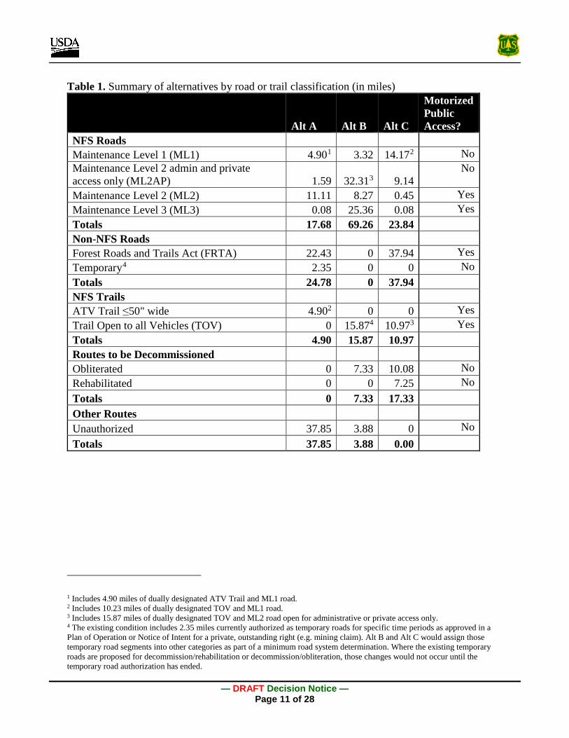
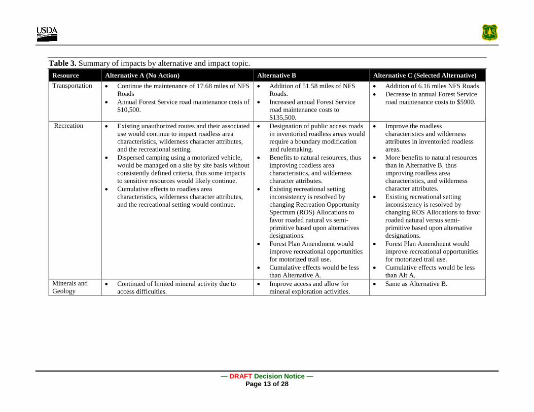
Three alternatives were considered and analyzed in detail. Table 1 summarizes by road or trail classification, Table 2 shows the outcome of each alternative, and Table 3 summarizes the environmental consequences of each alternative. Table 4 in Appendix A identifies the project design features, mitigation measures, and monitoring requirements of the Selected Alternative (Alternative C).
Treatments currently existing or proposed on Forest Service roads and unauthorized routes on Forest Service lands are described in detail in the EA under the categories listed and briefly defined in bullets below. “Unauthorized” is not an actual road or trail classification, nor is it a treatment prescription and is not described below; however, miles of unauthorized routes are accounted for in the summary table (Table 1).
• National Forest System Road Classifications
o Maintenance Level 1 (ML1) - Assigned to intermittent service roads during the time they are closed to vehicular traffic. Basic custodial maintenance is performed to keep damage to adjacent resources to an acceptable level and to perpetuate the road to facilitate future management activities.
o Maintenance Level 2, Open (ML2) - Assigned to roads open for public or permitted use by high clearance vehicles. Passenger car traffic is not a consideration.
o Maintenance Level 2 for administrative and private access only (ML2AP) - Assigned to roads open for permitted use by high clearance vehicles. Passenger car traffic is not a consideration.

— DRAFT Decision Notice — Page 9 of 28
o Maintenance Level 3 (ML3) - Assigned to roads open and maintained for travel by a prudent driver in a standard passenger car. User comfort and convenience are not considered priorities.
• National Forest System Trail Classifications
o TOV - Motorized trails that are maintained at a minimum trail tread width of 72 – 120 inches and meet Trail Class 2,3, or 4 standards for four-wheel drive vehicles greater than (>) 50 inches in as defined in Forest Service Handbook 2309.18 – Trails Management Handbook, Chapter 20, Section 23.23.
o ATV Trails - This is a term used specifically in this project. It is the same as the “trails open to vehicles 50 inches or less in width” as described in the Motor Vehicle Use Map, consistent with 36 CFR 212.51 and FSM 7716.11.
• Non-National Forest System Road Classifications
o FRTA Easement - Public road easement(s) that may be issued to local agencies under the FRTA of October 13, 1964. FRTA roads are still forest roads, but they are not NFS Roads as the USDA Forest Service has authorized the operation and maintenance of them to another local agency as per an Operation and Maintenance Plan.
o Temporary Road - A road or trail necessary for emergency operations or authorized by contract, permit, lease, or other written authorization that is not a forest road or trail and that is not included in a forest transportation atlas.
• Decommission Treatments
o Decommission/Obliteration (DECOM) - Road decommissioning technique used to eliminate the functional characteristics of a travelway and re-establish the natural resource production capability. The intent is to make the corridor unusable as a road or a trail and stabilize it against soil loss, which can involve re-contouring and restoring natural slopes.
o Decommission/Rehabilitation (DREHAB) - Those routes being decommissioned where the rehabilitation treatment is used instead of an obliteration treatment because the future use of the road may be needed but there are no near-term plans for the road, typically in association with an outstanding private right. The intent is to stabilize the road but recontouring is minimal
Three Alternatives were considered in detail in the EA:
Alternative A (No Action): Continuation of Existing Conditions - Under this alternative, the existing travel management plan both for public motor vehicle use and routes for administrative use would continue. Motor vehicle use of the unauthorized routes would likely continue,

— DRAFT Decision Notice — Page 10 of 28
resulting in continued impacts to Forest resources. Restoration activities would be undertaken on a case-by-case basis as provided for in the 2003 Revised Forest Plan. No new public access routes would be authorized as part of this planning effort, though administrative access may be considered in future plans of operation submitted for access to valid mineral claims and road use permits issued for access to existing private property. Implementation of this alternative falls within the decision authority of the District Ranger or Forest Supervisor.
Alternative B - This alternative would implement a range of restoration activities, including route decommissioning/rehabilitation, route designation and improvements, stream crossing improvement, and educational/interpretive improvements. Most unauthorized routes would either be authorized by adding them to the travel atlas or decommissioned. Current and/or future access to outstanding private rights is considered. This alternative includes a Forest Plan Amendment regarding the application of the road construction standard to routes converting from unauthorized to TOV and/or NFS roads. Implementation of some aspects of this alternative falls outside the decision authority of the Forest Supervisor and would require additional administrative actions.
Alternative C: Selected Alternative - Alternative C (see Figure 2) is very similar to Alternative B, except that all unauthorized routes will be either authorized and added to the NFS or decommissioned, routes greater than one vehicle length to dispersed camping will be managed or decommissioned, a rock source will be developed, and FRTA easements will be granted on identified roads that meet the criteria and where the County has requested an easement. This alternative includes a Forest Plan Amendment regarding the application of the road standard to the TOV. Implementation of this alternative falls within the decision authority of the Forest Supervisor.
SUMMARY OF ENVIRONMENTAL CONSEQUENCES Comprehensive specialist reports were prepared to analyze potentially impacted resources in detail, including geospatial and numerical data, high quality science and relationship to the Forest LRMP, laws and policies, and regulations. The Environmental Consequences section of the EA discloses direct, indirect, and cumulative impacts of the impact topics considered in detail. Resources that were not impacted and, therefore, not further analyzed include: timber, air quality, prime farmlands, range lands, floodplains and wetlands, irretrievable or irreversible commitment of resources, potential or unusual expenditures of energy, and conflicts with other plans, policies, or jurisdictions. A brief summary of those conclusions is presented in Table 3. The analysis supported a Finding of No Significant Impact and the rationale for that finding was included in the EA.
— DRAFT Decision Notice — Page 11 of 28
Table 1. Summary of alternatives by road or trail classification (in miles)
Alt A Alt B Alt C
Motorized Public Access?
NFS Roads Maintenance Level 1 (ML1) 4.901 3.32 14.172 No Maintenance Level 2 admin and private access only (ML2AP) 1.59 32.313 9.14
No
Maintenance Level 2 (ML2) 11.11 8.27 0.45 Yes Maintenance Level 3 (ML3) 0.08 25.36 0.08 Yes Totals 17.68 69.26 23.84 Non-NFS Roads Forest Roads and Trails Act (FRTA) 22.43 0 37.94 Yes Temporary4 2.35 0 0 No Totals 24.78 0 37.94 NFS Trails ATV Trail ≤50" wide 4.902 0 0 Yes Trail Open to all Vehicles (TOV) 0 15.874 10.973 Yes Totals 4.90 15.87 10.97 Routes to be Decommissioned Obliterated 0 7.33 10.08 No Rehabilitated 0 0 7.25 No Totals 0 7.33 17.33 Other Routes Unauthorized 37.85 3.88 0 No Totals 37.85 3.88 0.00
1 Includes 4.90 miles of dually designated ATV Trail and ML1 road. 2 Includes 10.23 miles of dually designated TOV and ML1 road. 3 Includes 15.87 miles of dually designated TOV and ML2 road open for administrative or private access only. 4 The existing condition includes 2.35 miles currently authorized as temporary roads for specific time periods as approved in a Plan of Operation or Notice of Intent for a private, outstanding right (e.g. mining claim). Alt B and Alt C would assign those temporary road segments into other categories as part of a minimum road system determination. Where the existing temporary roads are proposed for decommission/rehabilitation or decommission/obliteration, those changes would not occur until the temporary road authorization has ended.

— DRAFT Decision Notice — Page 12 of 28
Table 2. Summary of alternatives by outcome and project objective Alt A:
No Action Alt B Alt C:
Selected Alternative
Summary by Outcome Open to public motorized access (trail or road)
38.52 miles 49.50 miles 49.44 miles
Decommissioned 0 miles 7.33 miles 17.33 miles Closed to public motorized access 41.79 5 miles 23.64 miles 13.08 miles Forest Service road annual and deferred maintenance costs
$10,540 $135,523 $5900
Sediment delivered from roads in tons/year and as percent decrease
175 tons per year; 0% decrease
86 to 107 tons per year; 39-51% decrease
78 to 105 tons per year; 40-55% decrease
Number of fords 73 37 24 Acres of road/motorized trail disturbance within 150 feet of stream channels
55.3 acres 51.8 acres 51 acres
Open road density in elk habitat 0.93 mi/mi2 0.64 mi/mi2 0.62 mi/mi2 Summary by Objective Determine the Minimum Road System needed for management of the project area as provided for in 36 CFR 212 subparts A and B.
This objective is not met.
This objective is mostly met and some unauthorized routes would remain.
This objective is fully met and no unauthorized routes would remain.
Actively restore key watershed condition indicators, while maintaining or improving access on existing roads and trails, through AOP improvements, road/trail improvements, or the decommissioning of routes.
This objective is not met, and restoration activities would continue on a case-by-case basis.
This objective is partially met and some restoration opportunities would not be realized.
This objective is fully met within the scope of this project.
Improve or properly maintain access for Forest visitors, private landowners, administrative use and access to existing legal rights.
This objective is not met.
This objective is fully met.
This objective is fully met.
Amend the Forest Plan, if necessary, to implement the Selected Alternative.
This objective is not applicable to this alternative.
This objective is met and the Forest Plan would be amended.
This objective is met and the Forest Plan would be amended.
5 Most of the routes closed to public access under Alt A are unauthorized routes.
— DRAFT Decision Notice — Page 13 of 28
Table 3. Summary of impacts by alternative and impact topic. Resource Alternative A (No Action) Alternative B Alternative C (Selected Alternative) Transportation • Continue the maintenance of 17.68 miles of NFS
Roads • Annual Forest Service road maintenance costs of
$10,500.
• Addition of 51.58 miles of NFS Roads.
• Increased annual Forest Service road maintenance costs to $135,500.
• Addition of 6.16 miles NFS Roads. • Decrease in annual Forest Service
road maintenance costs to $5900.
Recreation • Existing unauthorized routes and their associated use would continue to impact roadless area characteristics, wilderness character attributes, and the recreational setting.
• Dispersed camping using a motorized vehicle, would be managed on a site by site basis without consistently defined criteria, thus some impacts to sensitive resources would likely continue.
• Cumulative effects to roadless area characteristics, wilderness character attributes, and the recreational setting would continue.
• Designation of public access roads in inventoried roadless areas would require a boundary modification and rulemaking.
• Benefits to natural resources, thus improving roadless area characteristics, and wilderness character attributes.
• Existing recreational setting inconsistency is resolved by changing Recreation Opportunity Spectrum (ROS) Allocations to favor roaded natural vs semi-primitive based upon alternatives designations.
• Forest Plan Amendment would improve recreational opportunities for motorized trail use.
• Cumulative effects would be less than Alternative A.
• Improve the roadless characteristics and wilderness attributes in inventoried roadless areas.
• More benefits to natural resources than in Alternative B, thus improving roadless area characteristics, and wilderness character attributes.
• Existing recreational setting inconsistency is resolved by changing ROS Allocations to favor roaded natural versus semi-primitive based upon alternative designations.
• Forest Plan Amendment would improve recreational opportunities for motorized trail use.
• Cumulative effects would be less than Alt A.
Minerals and Geology
• Continued of limited mineral activity due to access difficulties.
• Improve access and allow for mineral exploration activities.
• Same as Alternative B.

— DRAFT Decision Notice — Page 14 of 28
Resource Alternative A (No Action) Alternative B Alternative C (Selected Alternative) Soils and Watershed
• Continuation of sediment delivered from roads. • Continued slope instability and erosion. • Cumulative effects to water quality from mine
exploration projects include increased use of roads, transport of fuel and supplies, exploratory drilling and required storm damage risk reduction road treatments.
• Road restoration treatments result in soil disturbances that can temporarily increase sediment production, but in the short to long-term, reduces chronic sediment delivery to streams and the risk of landslides.
• Reduction in sediment delivered from roads.
• No impact from Forest Plan Amendment.
• Cumulative effects as described in Alternative A.
• Road restoration treatments result in soil disturbances that can temporarily increase sediment production, but in the short to long-term, reduces chronic sediment delivery to streams and the risk of landslides.
• Greatest reduction in sediment delivered from roads.
• Greatest reduction in landslide potential due to increase in drain points and improved road engineering.
• No impact from Forest Plan Amendment.
• Cumulative effects as described in Alternative A.
Fisheries • Continued direct effects from turbidity plumes from fording on unauthorized and closed routes. Continued potential direct effects to Endangered Species Act listed fish from fording at fish bearing crossing on unauthorized or closed routes, and fords on the Smith Creek ATV trail.
• Continued impacts to fish habitat.
• Temporary adverse effects to all three listed species and impacts to westslope cutthroat trout from turbidity and sediment generated during installation of stream crossing structures at fords, and any fish relocations if channel dewatering is necessary.
• Long-term benefits to fish and fish habitat
• Temporary adverse effects to all three listed species and impacts to westslope cutthroat trout from turbidity and sediment generated during installation of stream crossing structures at fords, and any fish relocations if channel dewatering is necessary.
• Long-term benefits to fish and fish habitat, more than Alternative B.

— DRAFT Decision Notice — Page 15 of 28
Resource Alternative A (No Action) Alternative B Alternative C (Selected Alternative) Wildlife • Continuation of impacts to three-toed
woodpecker, boreal owl, fisher, flammulated owl, northern goshawk, pileated woodpecker, great gray owl wolverine, Rocky Mountain bighorn, and bald eagle due to loss of snags and coarse woody debris and human disturbance associated with motorized use of unauthorized routes.
• Continuation of impacts to Canada lynx due to road densities and related human-caused mortality, disturbance/displacement, and effects to prey.
• Continuation of impacts to gray wolf due to human-caused mortality, disturbance/ displacement, and effects to prey.
• Continuation of impacts to Columbia spotted frog due to water quality impacts of fording.
• Continuation of impacts to Rocky Mountain elk primarily due to road density.
• Short-term disturbance to some species due to project implementation, some impacts may be mitigated.
• Long-term habitat improvement, reduced loss of snags and coarse woody debris and less disturbance to species analyzed.
• May affect, but is not likely to adversely affect, Canada lynx.
• May impact individuals or habitat for gray wolf, but would not likely contribute to a trend towards federal listing or cause a loss of viability to the population or species.
• May impact individuals or habitat, but would not likely contribute to a trend towards federal listing or cause a loss of viability to the population or species for the Columbia spotted frog.
• Isolated disturbance impacts to elk from large machinery during project implementation; these temporary impacts would be more than offset by the long-term improvements.
• Potential for unintentional take of individuals of migratory birds.
• Same as Alternative B.

— DRAFT Decision Notice — Page 16 of 28
Resource Alternative A (No Action) Alternative B Alternative C (Selected Alternative) Botanical Resources
• Continued risk of habitat degradation and destruction from vehicles that crush and trample plants, disturb rare plant habitat, and potentially introduce invasive species.
• Unauthorized route use degrades rare plant habitat by producing sediment, alterations to natural water regimes and nutrient inputs.
• Benefits to rare plant habitat by removing weed corridors and sediment sources.
• May impact individuals of Pinus albicualis (whitebark pine) and Helodium blandowii (Blandow’s helodium) but is not likely to contribute to a trend towards Federal listing or a loss of viability.
• Individual whitebark pine trees in or adjacent to road beds could be impacted by removal or trimming depending on the maintenance, closure, or decommissioning needed.
• More benefits than Alternative B to rare plant habitat by removing weed corridors and sediment sources.
• May impact individuals of Pinus albicualis (whitebark pine) and Helodium blandowii (Blandow’s helodium) but is not likely to contribute to a trend towards Federal listing or a loss of viability.
• Individual whitebark pine trees in or adjacent to road beds could be impacted by removal or trimming depending on the maintenance, closure, or decommissioning needed.
Heritage Resources
• Historic Properties within the area of potential effect would continue to deteriorate as they naturally do.
• No direct or indirect unmitigated effects on cultural resources.
• Same as Alternative B.
Socioeconomics • No measurable impacts. • No impacts to Tribal incomes, minor benefits to
access for subsistence harvest. • No cumulative effects.
• Negligible direct positive effects associated with road related work and increased trip duration.
• No impacts to Tribal incomes, increased accessibility for subsistence use but increased competition for harvest of fish and game.
• Potential cumulative benefits for local contractors and businesses.
• Same as Alternative B.

— DRAFT Decision Notice — Page 17 of 28
PUBLIC INVOLVEMENT This action was originally listed as a proposal on the Payette National Forest Schedule of Proposed Actions and updated periodically during the analysis. Public scoping for this project began on August 21, 2014. Scoping was announced via legal notice in The Idaho Statesman and direct mailing to 174 individuals and organizations, as well as through postings on the project website. During the 30-day scoping period, comment letters were received from 12 individuals or organizations and those letters contained 73 unique comments. Those comments and the Forest Service response to comments can be found in the project record and on the project website.
This project was open for public review and comment May 3 – June 2, 2016 with the EA document, invitation to comment letter, legal notice affidavits, and response to scoping comments published to the project website. Availability was announced in a legal notice published on May 3 in the Idaho Statesman, the newspaper of record for decisions made by the Forest Supervisor. Direct mailings were made to 194 addresses via US Postal Service, including the names on the forest base mailing list who have requested hardcopy mailings, individuals or organizations who submitted scoping comments in 2014, local outfitters operating in the project area, county and state agencies, as well as all private property owners in the Big Creek area as shown on the records of Valley County Tax Assessor. Additionally, email notification was made via GovDelivery to 255 subscribers to this specific project. Finally, the proposed action was presented to the Big Creek – Yellow Pine Collaborative at a regular monthly meeting in January 2016 and a reminder of what is in the document, how to access the document, and how to comment was provided at the April 2016 meeting as well. Comments were accepted via email, webform submission on the project website, fax, or hardcopy. All comments were published in full to the public reading room on the project website. A total of 14 pieces of correspondence were received during the comment period, plus one letter was received after the close of public comments. Those comments and the Forest Service response to comments can be found in the project record and on the project website.
A revised EA and this draft Decision Notice were prepared following the public comment period and were made available to the public for objection as per the requirements of 36 CFR 218 during fall 2016. [Note: Any objections will be resolved prior to finalizing this Decision Notice.]
Three federally-recognized Native American tribes have expressed interest in activities proposed in this area: Nez Perce, Shoshone-Paiute, and Shoshone-Bannock tribes. The Payette National Forest has established both staff-to-staff relationships with resource management departments with these tribes and formal government-to-government consultations to have early and often communication regarding proposed actions on the forest and potential effects to sensitive tribal resources or traditional cultural properties. Consultation with these three Tribes is ongoing, and will be completed prior to finalizing this Decision Notice.
— DRAFT Decision Notice — Page 18 of 28
A complete list of individuals, Federal, State, tribal, and local agencies consulted during the development of this EA is included in the project record.
RATIONALE FOR THE DECISION In making my decision on this project, I evaluated the purpose and need for the project, the effects disclosed in the EA, and comments received from interested and affected members of the public (including the Big Creek – Yellow Pine Collaborative), in staff-to staff and government-to-government consultation with Tribes, as well as agency and public comments submitted during scoping and the 30 day notice and comment period. Minor clarifications and corrections were made to the September 2016 EA, but the Selected Alternative remains essentially as presented in the May 2016 EA as the proposed action (Alternative C).
I have selected Alternative C because it serves as a very strong balance between needed restoration in sensitive environments (ESA-listed fish habitat, Riparian Conservation Areas, inventoried roadless areas, etc.) while providing additional motorized road or trail opportunities in areas where that use can be accommodated. My Decision protects the wild nature of the Big Creek Area by removing motorized route intrusions into Idaho Roadless Areas, and provides long term management direction for all known unauthorized routes in the project area. This project makes a minimum road system determination to provide for public access as well as current and future private land, mineral access and other administrative uses. Finally, this decision responds to the Valley County request for FRTA easements and is responsive to the unresolved issues of the 2008 Payette National Forest Travel Plan Record of Decision for McCall and Krassel Districts and the 2010 Big Creek/Yellow Pine Travel Plan Decision Notice and Appeal Resolution direction from the Forest Supervisor to the District Ranger.
The environmental analysis, as well as consultations with the State Historic Preservation Officer, US Fish and Wildlife Service (USFWS), and NOAA Fisheries confirms that implementation of the Selected Alternative would have no significant impacts. This determination is supported in the Finding of No Significant Impact section of the September 2016 EA.
FINDINGS REQUIRED BY OTHER LAWS AND REGULATIONS The National Forest Management Act requires that projects and activities be consistent with the governing Forest Plan (16 USC 1604 (i)). The interdisciplinary team initially evaluated existing resource conditions within the project area for transportation, minerals, recreation, water resources, fisheries, wildlife, rare plants, and cultural resources in relation to the desired conditions for these resources established in the Forest Plan. The Purpose and Need and resulting Proposed Action were developed in response to this evaluation. Based on the evidence in the project record, I have determined that the actions to be implemented under my decision are consistent with the goals, objectives, standards, and guidelines in the 2003 Payette National

— DRAFT Decision Notice — Page 19 of 28
Forest LRMP with the exception of a Forest Plan Amendment for standard 1309 described in Appendix B of this Decision. Although this standard would be amended, the desired future condition for MPC 3.2 would be achieved through the implementation of this project because the existing unauthorized routes, which currently are not maintained, would be maintained to meet the standards of a TOV, or in some cases where dually designated, the road standards for a NFS ML 1 or ML2AP road. In either case, the sediment originating from the routes is expected to be reduced and thus aquatic systems, including habitat for federally listed fish species, would be restored.
The ESA creates an affirmative obligation “…that all Federal departments and agencies shall seek to conserve endangered and threatened (and proposed) species” of fish, wildlife, and plants.” The USFWS provides the Forest with a list of threatened, endangered, proposed, and candidate species to consider in project planning6. A biological assessment was completed to evaluate the impacts of the selected alternative on lynx, a listed threatened species. It was determined that the selected alternative may affect, but is not likely to adversely affect Canada lynx and wolverine, and no effect to northern Idaho ground squirrel. There is potential for temporary negative effects to listed fish (steelhead, chinook, and bull trout) and critical habitat during renovation of fords, road maintenance, and road decommissioning due to spikes in sediment delivery and potential needs to relocate fish for channel dewatering. The temporary negative effects would be followed by short- to long-term decreases in sediment, improvements in Riparian Conservation Areas, and reduced effects from fords through occupied fish habitat. Temporary negative effects and long-term benefits to bull trout are not expected to significantly affect population viability. [Note: Section 7 consultation with the regulatory agencies is underway and this Decision will be updated with the outcome of that consultation prior to signing.]
The National Historic Preservation Act (NHPA) requires federal agencies to consider the effects of their activities and programs on historic properties. Federal activities and programs are defined as “undertakings” by the 36 CFR 800 regulations implementing NHPA, Section 106. Historic properties are significant cultural resources that are included in or eligible for inclusion in the National Register of Historic Places. The Forest Archeologist determined that of the five eligible sites within the project area, three are mining complexes and project activities would not alter their National Register characteristics. Two of the eligible Historic Properties in the project area are historic travel routes that originally connected Warren, Idaho to the Big Creek and Thunder Mountain areas. If the Heritage Mitigation Measures are followed, there would be no Adverse Effect to these properties. The Forest Archaeologist has received a concurrence of No Effect determination from the State Historic Preservation Office, dated June 29, 2016, PY2014-2761.
6 http://www.fws.gov/endangered

— DRAFT Decision Notice — Page 20 of 28
Executive Order 13175 (65 FR 67249-67252, 2000) requires regular and meaningful consultation between federal and tribal government officials on federal policies that have tribal implications. Consultation is not a single event; it is a process that leads to a decision. Consultation can be either a formal process of negotiation, cooperation, and policy-level decision making between tribal governments and the federal government, or a more informal process involving staff-to-staff discussions. The Nez Perce Tribe, Shoshone- Paiute Tribes of Duck Valley, and the Shoshone-Bannock Tribes of Fort Hall were consulted on this project and project design features, mitigation measures, and other revisions were made in response to issues raised by Tribes. [Note: Tribal consultation is ongoing and will be concluded prior to signing this Decision Notice.]
IMPLEMENTATION DATE Project implementation may generally begin immediately following the conclusion of the objection period, and subsequent resolution of objections if any, and signing of this Decision Notice pursuant to 36 CFR 218.12. If no objections are filed during the objection period, this Decision Notice may be signed five business days following the end of the objection filing period and the permit may be issued immediately following. Implementation of individual actions identified in the selected alternative are subject to the timing restrictions described in Appendix A and the sequencing of road and trail work described in a separate implementation strategy in the project record.
CONTACT For additional information concerning this decision, contact: Anthony Botello, Krassel District Ranger, at 208-630-0600.
Keith Lannom Date Forest Supervisor
In accordance with Federal civil rights law and U.S. Department of Agriculture (USDA) civil rights regulations and policies, the USDA, its Agencies, offices, and employees, and institutions participating in or administering USDA programs are prohibited from discriminating based on race, color, national origin, religion, sex, gender identity (including gender expression), sexual orientation, disability, age, marital status, family/parental status, income derived from a public assistance program, political beliefs, or reprisal or retaliation for prior civil rights activity, in any program or activity conducted or funded by USDA (not all bases apply to all programs). Remedies and complaint filing deadlines vary by program or incident. Persons with disabilities who require alternative means of communication for program information (e.g., Braille, large print, audiotape, American Sign Language, etc.) should contact the responsible Agency or USDA’s TARGET Center at (202) 720-2600 (voice and TTY) or contact USDA through the Federal Relay Service at (800) 877-8339. Additionally, program information may be made available in

— DRAFT Decision Notice — Page 21 of 28
languages other than English. To file a program discrimination complaint, complete the USDA Program Discrimination Complaint Form, AD-3027, found online at http://www.ascr.usda.gov/complaint_filing_cust.html and at any USDA office or write a letter addressed to USDA and provide in the letter all of the information requested in the form. To request a copy of the complaint form, call (866) 632-9992. Submit your completed form or letter to USDA by: (1) mail: U.S. Department of Agriculture Office of the Assistant Secretary for Civil Rights 1400 Independence Avenue, SW Washington, D.C. 20250-9410; (2) fax: (202) 690-7442; or (3) email: [email protected]. USDA is an equal opportunity provider, employer, and lender
— DRAFT Decision Notice — Page 22 of 28
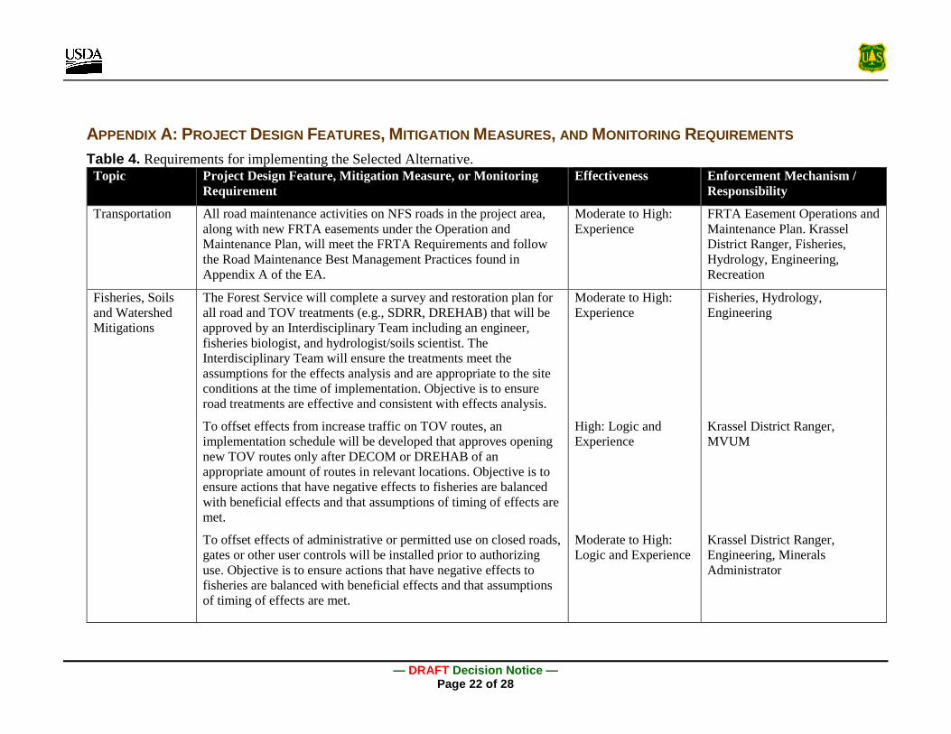
APPENDIX A: PROJECT DESIGN FEATURES, MITIGATION MEASURES, AND MONITORING REQUIREMENTS Table 4. Requirements for implementing the Selected Alternative.
Topic Project Design Feature, Mitigation Measure, or Monitoring Requirement
Effectiveness Enforcement Mechanism / Responsibility
Transportation All road maintenance activities on NFS roads in the project area, along with new FRTA easements under the Operation and Maintenance Plan, will meet the FRTA Requirements and follow the Road Maintenance Best Management Practices found in Appendix A of the EA.
Moderate to High: Experience
FRTA Easement Operations and Maintenance Plan. Krassel District Ranger, Fisheries, Hydrology, Engineering, Recreation
Fisheries, Soils and Watershed Mitigations
The Forest Service will complete a survey and restoration plan for all road and TOV treatments (e.g., SDRR, DREHAB) that will be approved by an Interdisciplinary Team including an engineer, fisheries biologist, and hydrologist/soils scientist. The Interdisciplinary Team will ensure the treatments meet the assumptions for the effects analysis and are appropriate to the site conditions at the time of implementation. Objective is to ensure road treatments are effective and consistent with effects analysis.
Moderate to High: Experience
Fisheries, Hydrology, Engineering
To offset effects from increase traffic on TOV routes, an implementation schedule will be developed that approves opening new TOV routes only after DECOM or DREHAB of an appropriate amount of routes in relevant locations. Objective is to ensure actions that have negative effects to fisheries are balanced with beneficial effects and that assumptions of timing of effects are met.
High: Logic and Experience
Krassel District Ranger, MVUM
To offset effects of administrative or permitted use on closed roads, gates or other user controls will be installed prior to authorizing use. Objective is to ensure actions that have negative effects to fisheries are balanced with beneficial effects and that assumptions of timing of effects are met.
Moderate to High: Logic and Experience
Krassel District Ranger, Engineering, Minerals Administrator

— DRAFT Decision Notice — Page 23 of 28
Topic Project Design Feature, Mitigation Measure, or Monitoring Requirement
Effectiveness Enforcement Mechanism / Responsibility
Fisheries, Soils and Watershed Mitigations
Gravel aggregate or other surface material will be applied to roads where stream crossing structures are installed. The type and extent (i.e., distance from crossing) of surfacing will be determined by the Forest Service. Objective is to reduce erosion and sediment delivery at crossings.
Moderate to High: Burroughs and King (1989)
Fisheries, Hydrology, Engineering, Recreation
Road surface drainage improvements and elimination of fords will occur prior adding the route to the MVUM. Objective is to ensure actions that have negative effects to fisheries are balanced with beneficial effects and that assumptions of timing of effects are met.
High: Logic and Experience
Krassel District Ranger, MVUM
To offset effects to RCAs, DECOM (i.e., obliteration) in RCAs will occur prior to FRTA road widening in RCAs. Objective is to ensure actions that have negative effects to fisheries are balanced with beneficial effects and that assumptions of timing of effects are met.
High: Logic and Experience
Krassel District Ranger, Engineering
Drafting locations for road work will require Forest Service fisheries biologist approval, and intake will have NMFS approved surface area dimensions and be screened with a mesh size of no larger than 3/32”. Objective is to minimize effects to juvenile fish.
High: Experience, NMFS guidelines for screens
Fisheries
Deficiencies in maintenance identified in monitoring will be corrected annually (see monitoring section below). Objective is to ensure long-term reductions in sediment delivery from roads are maintained.
High: Logic and Experience
Engineering, Recreation, Minerals Administrator, Hydrology, Fisheries

— DRAFT Decision Notice — Page 24 of 28
Topic Project Design Feature, Mitigation Measure, or Monitoring Requirement
Effectiveness Enforcement Mechanism / Responsibility
Fisheries, Soils and Watershed Mitigations
FRTA easements will be conditioned to require the requirements in Appendix A of the EA and follow Best Management Practices for road maintenance that are consistent with mitigations for the road management Federal Action in the Ongoing Action BA (Faurot and Burns 2007) (See Fisheries Specialist Report for complete list). The conditions will also require consultation with the Forest Service prior to conducting work at perennial stream crossings. Objective is to minimize sediment delivery from road maintenance activities while insuring actions are taken that reduce erosion from roads.
Moderate to High: Experience, Faurot and Burns (2007)
Engineering, Fisheries
All road maintenance, storm damage risk reduction, long-term closer (i.e., DREHAB/ML1), obliteration (DEC/OBLIT), and TOV trail maintenance, will adhere to the mitigations from the road management, and watershed and fish habitat improvements Federal Actions in the Payette National Forest Ongoing Action Biological Assessment (Faurot and Burns 2007) (See Fisheries Specialist Report for complete list). Because they are open to full-size vehicles, maintenance of TOV trails will adhere to road management mitigations. Objective is to minimize sediment delivery from road maintenance activities while insuring actions are taken that reduce erosion from roads.
Moderate to High: Experience, Faurot and Burns (2007)
Recreation Engineering, Minerals Administrator Fisheries
On all open and closed system routes, motorized trails, and FRTA routes, stream crossing structures (e.g., bridge or culvert) will be installed at all crossings within 600 feet of fish bearing streams (as identified by Forest Service fisheries biologist). The stream crossing structure will allow for aquatic organism passage on fish bearing streams. Fish distribution surveys will be completed to determine distance of fords from fish bearing streams. Objective is to eliminate direct effects to fish from fording occupied habitat.
Moderate to High: Scaife and Hoefer (2011); Taylor et al. (1999), Experience
Recreation, Engineering, Minerals Administrator, Fisheries

— DRAFT Decision Notice — Page 25 of 28
Topic Project Design Feature, Mitigation Measure, or Monitoring Requirement
Effectiveness Enforcement Mechanism / Responsibility
Fisheries, Soils, and Watershed Mitigations
Installation of bridges or other structures within 600 feet of fish bearing streams (as identified by Forest Service fisheries biologist) will adhere to mitigations in the Idaho Steam Crossing Restoration Programmatic (Scaife and Hoefer 2011) and associated Biological Opinions (See Fisheries Specialist Report for complete list). Objective is to minimize temporary effects from construction, and ensure structure provides fish passage.
Moderate to High: Scaife and Hoefer (2011)
Recreation, Engineering, Minerals Administrator, Fisheries
Treatment of crossings (e.g., culvert installation/replacement, ford improvement) on perennial streams further than 600 feet from fish bearing streams (as identified by a Forest Service Fisheries Biologist), intermittent channels, and road cross drains will adhere to the mitigations for road management in the Payette National Forest Ongoing Action BA (Faurot and Burns 2007) (See Fisheries Specialist Report for complete list). Objective is to minimize sediment delivery from road maintenance activities while insuring actions are taken that reduce erosion from roads.
Moderate to High: Experience, Faurot and Burns (2007), Burroughs and King (1989)
Recreation Engineering, Minerals Administrator Fisheries
Road restoration treatments proposed on roads that contribute slope instability at known landslide locations or intersect high to moderate LSP areas will be evaluated by a Forest Service Soil Scientist to ensure treatments would result in the avoidance and prevention of landslides.
Moderate to High: Sidle et al. (1985), Wemple et al. (1996)
Soil, Hydrology
Fisheries Monitoring
Traffic counters will be used to measure and report on annual motorized use on TOV routes. Objective is to validate assumptions in effects analysis about minimal increases in use.
Moderate to High: Experience
Recreation
Monitoring and reporting of storm damage risk reduction and routine maintenance of Trail Open to All Vehicle routes and ML2AP routes occur every 3 years for up to 15 years. The monitoring and reporting will be used to assess the effectiveness and condition of sediment reduction treatments. Objective is to validate assumptions in effects analysis about long-term effectiveness and maintenance of road improvements.
Moderate to High: Logic and Experience
Recreation, Engineering, Minerals Administrator, Hydrology, Fisheries

— DRAFT Decision Notice — Page 26 of 28
Topic Project Design Feature, Mitigation Measure, or Monitoring Requirement
Effectiveness Enforcement Mechanism / Responsibility
Fisheries Monitoring
Monitor free matrix at established substrate sites annually during implementation and for five years following completion of all decommission/obliteration, then evaluate need for continued monitoring. Objective is to validate predicted maintenance or improvements (i.e., reductions) in sediment deposition.
Moderate to High: Experience
Fisheries
Monitor stream temperature in Smith Creek for 5 years following any widening activities on the FRTA route, then evaluate need for continued monitoring. Objective is to validate predicted lack of effect on temperature.
Moderate: Logic and Experience
Fisheries
Wildlife The District Wildlife Biologist would be notified of any occupied nests or dens encountered during implementation that may be associated with listed, sensitive, or management indicator species. If necessary to maintain key features of nesting/denning habitat or to avoid disruption of nesting/denning activities, proposed activities and/or timing may be modified.
Moderate to High: Logic and Experience
Wildlife
To the extent practicable, trees found to contain nesting cavities or nests would not be disturbed or cut. No trees with active nests would be cut. If necessary to maintain key features of nesting/denning habitat or to avoid disruption of nesting/denning activities, prescribed activities would be modified.
Moderate to High: Logic and Experience
Wildlife, Engineering
Potential water sources will be surveyed for Columbia spotted frog egg masses and other amphibians after ice melt and avoid disturbing any water sources with identified egg masses or other amphibian species.
High: Patla and Keinath (2005)
Wildlife, Fisheries, Engineering
No new snow grooming and/or plowing is authorized to avoid additional impacts to lynx.
High: Logic and Experience
Wildlife, Engineering, FRTA Operations and Maintenance Plan

— DRAFT Decision Notice — Page 27 of 28
Topic Project Design Feature, Mitigation Measure, or Monitoring Requirement
Effectiveness Enforcement Mechanism / Responsibility
Botanical Resources
Avoid removing or trimming dead and live whitebark pine whenever possible during road maintenance, decommissioning, obliteration, and restoration.
Moderate to High: Experience
Botany, Engineering
Avoid populations of Bladow’s helodium Moderate to High: Experience
Botany, Engineering
Noxious Weeds Forest Service will monitor noxious weeds on open public roads and new construction areas and treat on an as needed basis as part of the Payette National Forest weed program.
Moderate: Experience Range
Forest Service will require appropriate weed management treatments of administrative routes not open to the public as terms and conditions on road use permits, special uses, easements, plans of operations or other administrative authorizations.
Moderate:
Experience
Terms and Conditions to administrative authorizations
Heritage Resources
North Fork Smith Creek Road (PY-1367) – Road work will be restricted from Fawn Meadows to the junction of the lower McCrae mine road at the 1930 established running surface and prism (Long, ND). These measurements 12-foot running prism with 2 foot ditches. Brush can be cleared to an effective visibility width. No ground disturbing road work will be conducted outside of the historic 1930 established width. The purpose of this requirement is to maintain the historic character of the road.
High:
Experience
Language would be written into FRTA easement requirements
Government Creek Wagon Road – This historic wagon road will be blocked where the modern Elk Summit to Edwardsburg road bisect it to block OHV access. Point areas where localized sedimentation is being delivered into Government Creek will be treated by hand to stop sedimentation. No heavy equipment will be used to conduct work to protect the historic character of the wagon road and provide interpretive opportunities.
Moderate to High:
Experience
Coordination with rehabilitation crew and heritage staff

— DRAFT Decision Notice — Page 28 of 28
APPENDIX B: PROJECT-SPECIFIC FOREST PLAN AMENDMENT This Forest Plan Amendment is undertaken in full compliance with 36 CFR 219.13 regarding plan amendments and administrative changes under the 2012 Planning Rule. As required in the 2012 National Forest Land Management Planning Rule implementing the National Forest Management Act (36 CFR 219.15):
• Projects and activities authorized after approval of a plan, plan amendment, or plan revision must be consistent with the plan.
• When a proposed project or activity would not be consistent with the applicable plan components, the responsible official shall take one of the following steps, subject to valid existing rights: modify the proposed project or activity to make it consistent with the applicable plan components, reject the proposal or terminate the project or activity, amend the plan so that the project or activity will be consistent with the plan as amended, or amend the plan contemporaneously with the approval of the project or activity so that the project or activity will be consistent with the plan as amended. This amendment may be limited to apply only to the project or activity.
Designating a trail is not technically in conflict with standard 1309; however, because the effects of designation of TOV in the proposed action would be similar to effects of the use as a road, a project-specific Forest Plan Amendment is added to Alternative B and C to clarify that the standard in MPC 3.2 and the Management Area 13 standard 1309 would not apply to the project. The amendment for each standard would read as follows (amendment in bold):
Road Construction or reconstruction may only occur where needed:
a) To provide access related to reserved or outstanding rights, or b) To respond to statute or treaty, or c) To support aquatic, terrestrial, and watershed restoration activities, or d) To address immediate response situations where, if action is not taken, unacceptable
impacts to hydrologic, aquatic, riparian, or terrestrial resources, or health and safety, would result.
This standard does not apply to the 10.97 miles of unauthorized routes being designated as TOV in the Big Creek Restoration and Access Management Plan as shown in Figure 2.