the restoration of jimmycomelately creek
TRANSCRIPT

The Restoration of Jimmycomelately Creek
JimmycomelatelyJimmycomelately
The “Undevelopment” of Jimmycomelately Creek & Estuary
The History of the Jimmy Development of south Sequim Bay began in the late 18th century with logging, roads and development, railroad construction, dredging, wetland drainage, fill and diking. JCL Creek itself was relocated, chan-nelized and straightened, and constricted by roads and fill to facilitate farming and the settlement of the community known as “Blyn.” In the late 1800’s, wetlands were filled and converted for a mill and a log yard that was in operation until the late 1990’s. In addition, native vegetation was removed, and non-native vegetation became estab-lished on the fill and dikes.
Who was Jimmy? Historians dispute the identity of the Creek’s name. The Creek may be a namesake for a watchmaker named Jimmy Whittier who was an early settler in a cabin nearby. The term “Jimmycomelately” was generally used by Indians and early settlers to refer to newcomers who were ill-prepared for pioneer living on the Olympic Peninsula.
JCL Creek just upstream of the restoration area
The Jimmycomelately (JCL) watershed comprises an area of 15.4 square miles, with JCL being the major tributary flowing into Sequim Bay. In the early 1990’s, the Jamestown S’Klallam Tribe (Tribe), the Clallam Conservation District, Clallam County and others began to address the problems associated with declining fish populations and increased flooding on the south Sequim Bay Estuary and Jimmycomelately Creek. Since that time extensive partnerships have devel-oped, grant funding has been sought and received, restoration plans have been written and implementation is currently underway.
Project goals established by the partners include:
♦ Restore the river and estuarine habitat of JCL Creek and South Sequim Bay for fish and wildlife habitat in perpetuity;
♦ Reduce flood hazards to homes, roads and utilities;
♦ Monitor and evaluate the project as a model restoration program;
♦ Keep the community involved.
To accomplish these goals, technical experts recommended the realignment of JCL Creek into one of its historic sinuous channels, reconnecting the link between the creek and the tidal actions of the estuary, and restoring estuary habitat.
Actions include removal of fill and roads,
the construction of a new Highway 101 bridge, native re-vegetation, and land acquisition required to accomplish the restoration goals.
Also included in the project are future low-impact public access and small-scale educational activities.

The Jimmycomelately Creek — Lower Sequim Bay Estuary Restoration Project
Page 2 J immycomela te ly
Summer Chum Salmon Jimmycomelately Creek and Sequim Bay have long been important to the Jamestown S’Klallam People as a major traditional hunting, fishing, shellfishing and gathering area for thousands of years. In the old days, every creek entering the bay held at least one salmon trap, including those at JCL, where S’Klallams fished for “dog” or chum salmon.
One of the most important and urgent reasons for attempt-ing to restore JCL and its estuary is that the creek has a run of summer chum salmon, an ESA-listed species, which is now nearly extinct. Only seven chum returned to JCL to spawn in 1999.
Spawning escapement has varied dramatically in JCL with a mean estimated annual spawning escapement of 311 over the period from 1974 to 2002. During that same period, the estimated mean harvest w as 49 summer chum, and has been effectively zero since 1993. This year, approximately 460 summer chum returned to the Jimmycomelately.
The life history of summer chum is unique among the five species of Pacific Salmon, as they are among the earliest fish to return to their natal streams to spawn. Hood Canal/Strait of Juan de Fuca Summer chum are genetically distinct, and reproduce in the lowest reaches of streams in the eastern Strait of Juan de Fuca and Hood Canal.
J immycomela te ly Summer Chum
0200400600800
100012001400
1973 1978 1983 1988 1993 1998 2003
HarvestEscapement
Escapement is:
The number of adult fish who have survived all fisheries and returned to make up a spawning population; the
portion of the run that returns to natural or artificial
spawning areas.
“The Washington Harbor people fish for dog salmon in a creek near Blyn.
The chief owns the trap at the mouth of the creek.”
Gunther, 1927; Klallam Ethnography
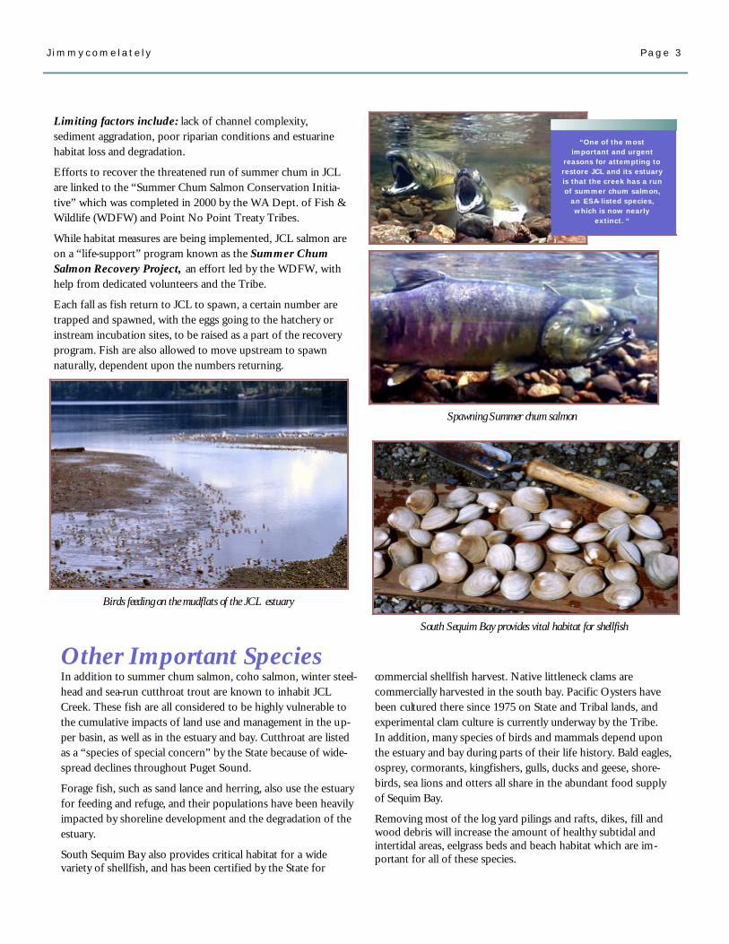
South Sequim Bay provides vital habitat for shellfish
Spawning Summer chum salmon
Birds feeding on the mudflats of the JCL estuary
Limiting factors include: lack of channel complexity, sediment aggradation, poor riparian conditions and estuarine habitat loss and degradation.
Efforts to recover the threatened run of summer chum in JCL are linked to the “Summer Chum Salmon Conservation Initia-tive” which was completed in 2000 by the WA Dept. of Fish & Wildlife (WDFW) and Point No Point Treaty Tribes.
While habitat measures are being implemented, JCL salmon are on a “life-support” program known as the Summer Chum Salmon Recovery Project, an effort led by the WDFW, with help from dedicated volunteers and the Tribe.
Each fall as fish return to JCL to spawn, a certain number are trapped and spawned, with the eggs going to the hatchery or instream incubation sites, to be raised as a part of the recovery program. Fish are also allowed to move upstream to spawn naturally, dependent upon the numbers returning.
Page 3 J immycomela te ly
commercial shellfish harvest. Native littleneck clams are commercially harvested in the south bay. Pacific Oysters have been cultured there since 1975 on State and Tribal lands, and experimental clam culture is currently underway by the Tribe. In addition, many species of birds and mammals depend upon the estuary and bay during parts of their life history. Bald eagles, osprey, cormorants, kingfishers, gulls, ducks and geese, shore-birds, sea lions and otters all share in the abundant food supply of Sequim Bay.
Removing most of the log yard pilings and rafts, dikes, fill and wood debris will increase the amount of healthy subtidal and intertidal areas, eelgrass beds and beach habitat which are im-portant for all of these species.
“One of the most important and urgent
reasons for attempting to restore JCL and its estuary is that the creek has a run of summer chum salmon,
an ESA-listed species, which is now nearly
extinct. “
Other Important Species In addition to summer chum salmon, coho salmon, winter steel-head and sea-run cutthroat trout are known to inhabit JCL Creek. These fish are all considered to be highly vulnerable to the cumulative impacts of land use and management in the up-per basin, as well as in the estuary and bay. Cutthroat are listed as a “species of special concern” by the State because of wide-spread declines throughout Puget Sound.
Forage fish, such as sand lance and herring, also use the estuary for feeding and refuge, and their populations have been heavily impacted by shoreline development and the degradation of the estuary.
South Sequim Bay also provides critical habitat for a wide variety of shellfish, and has been certified by the State for

“Several landowners have actively cooperated
throughout . . . Their willingness to allow
creek realignment on, or near their property was a key component to the
project’s success.”
Page 4 J immycomela te ly
Fish & Flooding A century of activities along South Sequim Bay came to a head in the late 1990’s when the summer chum were listed as threatened, and flooding sporadically closed Highway 101, cutting off access to the entire North Olympic Penin-sula. Within the JCL project area, wetland fill, native plant removal, agriculture and resi-dential development have resulted in a loss of wetlands and river habitat.
The dysfunctional condition of the creek and the bay:
♦ Places property owners and local, state and tribal infrastructure at a recur-ring risk of flood damage, and
♦ Limits the ability of the area to provide feeding, rearing and breeding habitats for fish and wildlife species.
If successful, this restoration project will reduce flooding. It will also provide measurable benefits to fish including sum-mer chum, coho, winter steel-head and sea-run cutthroat, and habitat for shorebirds, waterfowl, shellfish and the community.
Jimmycomelately Creek — Lower Sequim Bay Estuary Restoration Project Planning
Project Planning Following a series of meetings between Blyn residents and a technical review group of biologists and planners, resto-ration plans were developed for the creek and estuary. These are described in detail in four documents by Shreffler covering the technical studies, partnerships and monitoring: ◊ “A Preliminary Plan for
Restoring Jimmycome-lately Creek and the Lower Sequim Bay Estuary, Phase I Report” (2000);
◊ “Phase I Monitoring Plan: Jimmycomelately Creek Realignment” (2001);
◊ “A Conceptual Plan for Restoring the Lower Sequim Bay Estuary” (2003), and
◊ “Channel Design for Realignment of the Jimmycomelately Creek Channel” (2003).
Historical maps and photos, and soil tests were used to determine the actual route of the new channel. Technical experts also concluded that the new JCL channel should be realigned into the existing lower Sequim Bay tidal channel, enabling movement of sediment from the creek into the tidal action of the estuary. Eventually a channel
was designed incorporating a floodplain to accommodate overflows, and large woody debris. In addition, a restora-tion design was developed for Dean Creek to the west, which also flows through the estuary.
Re-vegetation Plan In 2001, the Clallam Conserva-tion District developed a JCL re-vegetation plan to address the establishment of native vegetation along the realigned stream co urse. The plan focuses on the removal of non-native species, primarily Himalayan blackberry, Canada thistle and Reed canary grass, along with the establishment of native grasses and forbs for surface erosion. Wetland species will be planted after channel construction, and woody vegetation during the winter and spring following construction. Monitoring will be performed to ensure co m-pliance with the Plan, and will dictate whether future supple-mental plantings, and/or protective devices are needed.
Property Acquisition Property acquisition from willing landowners began in 1999 by the Tribe, WDFW and WSDOT. Several land-owners have actively cooper-ated throughout the planning
and implementation process. Their willingness to allow creek realignment on, or near their property was a key component to the project’s success. Monitoring Monitoring is taking place during all phases of the channel realignment and estuary restoration. A phase 1 monitoring plan is in place. An updated long-term monitoring effort will focus on: ♦ Ecological processes:
hydrology, sediment transport and deposition;
♦ Habitat condition & functions: channel mor-phology and topography, water quality, LWD, soils and flood conveyance;
♦ Biological responses: riparian and wetland vegetation establishment, invasive vegetation removal, salmonid use and upland bird use.
Permitting has been a huge and complex part of both the creek and estuary restoration, which had to be anticipated and completed before any ac-tual restoration could proceed.
The anticipated results are: a net gain of approximately 19.61 acres of marsh, mudflat, and intertidal habitat; removal of 158,863 yd3 fill; 2,700 linear feet gain of creek channel; 1,000 feet of tidal channel gain; 8.99 acres of upland gain; improved hydrology and sedi-ment and nutrient transport; fish access to tidal channels and marshes and the upper watershed; improved aesthet-ics; reduced flooding of road-way and properties, and improved water quality.
1997 Flooding on Old Blyn Highway
Salmon blocked access to creek

Page 5 J immycomela te ly
IN PROCESS: Aerial of newly completed channel upstream of Highway 101—March, 2003
BEFORE aerial showing existing conditions in 1999 AFTER (virtual) aerial showing re-aligned & restored channel & estuary (Goal: 2005)

Page 6 J immycomela te ly
Phase 1: Channel Realignment 2002-2003 (Completed 2003)
Channel construction began July 2002, with the Clallam Conservation District, Jamestown S’Klallam Tribe and U.S. Fish & Wildlife Service leading the effort. The new stream channel, within an area roughly 1,700 feet long and 350 feet wide, is located west of the current channel, and will be approximately 3,490 feet long. It is designed to meander naturally in a stable manner both in the freshwater and inter-tidal areas. Over time, the LWD placed there will form habi-tat, and increasingly control the channel form and process.
Phase 2: Estuary Restoration / Fill Removal 2003-04
Estuary restoration is dependent on property and easement purchase and funding. A tiered list of priorities based on ecological considerations includes:
♦ Remove log deck road, Old Blyn Hwy., log yard pier & wetland fill, (Pier and fill removed in 2003);
♦ Restore log yard to 1870 shoreline, remove log yard
pilings; ♦ Restore Dean Creek and RV park area, remove sediment
accumulation at the old creek mouth, acquire/restore private properties within project area, and provide public access and interpretation along the Olympic Discovery Trail.
Phase 3: Bridge Replacement 2004
A new bridge over the realigned channel will replace the ex-isting culverts which were not large enough to accommodate flows in the old channel. The design of the new bridge will accommodate flood flows, allow sediment transport to the bay, and improve fish and wildlife passage. Phase 4: Diversion of Existing Creek Flow 2004
The stream flow will be diverted into the new channel after bridge completion and estuary restoration. It is timed to avoid impacting smolts leaving the system or summer chum adults returning to spawn. Any fish in the existing channel below the diversion point will be trapped and removed before the flow is cut off. An earthen plug will close the old channel, and be planted according to the Conservation District’s re-vegetation plan.
Project implementation consists of four major phases as follows:
The sequencing of these activities does not necessarily coincide with ecological priorities, and instead depends upon nearby landowners who need to have access to their properties, and their willingness to sell or participate.
Excavation of the log yard pier and fill

2003 Jimmycomelately Status Report2003 Jimmycomelately Status Report2003 Jimmycomelately Status Report
Creek Realignment and Riparian Planting The realignment of the creek started in 2002, and the excavation and shaping of the main channel and floodplain were completed in August of 2003. This included digging the channel, and the place-ment of large amounts of spawning gravel along the stream corridor, as well as large woody debris throughout the system. Riparian planting and seeding has also o c-curred along much of the stream channel. Estuary Restoration and Re-vegetation After acquisition, the log yard restoration b egan in 2003. The log yard pier, along with 30,000 cubic yards of fill from the estuary were removed in 2003. Native wetland plants will be planted in the estuary this fall. Bridge Replacement The bridge has been designed, funding procured and construction is scheduled for January through June, 2004. The Summer Chum Recovery Project In 2003, over 86,753 summer chum eggs were co llected for the recovery project by the WA Dept. of Fish & Wildlife and the North Olympic Salmon Coalition community volunteers. Eleven volunteers participated on a regular basis this year, and another thirty have generously helped since the program was started.
Page 7 J immycomela te ly
Newly cut channel with spawning gravel, LWD and plantings
Native seeding and trees (in blue protectors) re-vegetate freshly cut banks
Cheri Scalf and NOSC volunteers perform Recovery Project
activities
This “undevelopment” project involves the removal of 19,000
dump truck loads of fill and sediment; removal of a bridge,
roads, pilings and a pier; building demolition and relocation of
utility corridors.

Partnerships & Friends
The “Undevelopment” of Jimmycomelately Creek & Estuary
Budget Summary (Estimated Costs) Estuary / Riparian Acquisition: $2,645,000 Estuary / Salt Marsh Restoration: $1,200,000 Restoration Planning / Monitoring: $ 262,500 Channel Relocation / Restoration: $ 450,000 Bridge Design & Construction: $1,400,000 Total: $5,957,500 Plus Inkind
◊ WSDOT: Hwy. 101 bridge design, land acquisition;
◊ USFWS: Technical assistance.
Financial assistance has come from:
◊ NOAA/NWIFC—Pacific Coast Salmon Recovery Program
◊ USFWS– North American Wetlands Conservation Act & National Coastal Conservation Grant
◊ US EPA —Wetland Protection Program, CWA Sections 106 & 319, Brownfields, and GIS Grants
◊ US BIA—Watershed Projects; Jobs- in-the-Woods
◊ USDA—Farm Service Agency
From the beginning, the Jimmycome-lately Restoration has been a story of innovation, surprising alliances, and cooperative partnerships.
The JCL Restoration Team includes:
◊ Jamestown S’Klallam Tribe: Property owner, project design and coordination;
◊ Clallam County: Permitting, roads and infrastructure;
◊ WA Dept. of Fish & Wildlife: Land acquisition, technical assistance;
◊ Clallam Conservation District: Channel relocation & vegetation plan;
◊ Environmental & Engineering Consultants: Shreffler Environ-mental, Sam Gibboney Engineering, & ESA, Inc.
◊ US EPA: Wetlands & estuary technical assistance;
The complex scientific, legal, financial and engineering challenges of the JCL project have been enormous. However, the commitment of the property owners, technical experts and agency partners has enabled it to progress steadily toward success.
THANK YOU!
Conservation Reserve Enhancement Program
◊ WA DNR—Washington Aquatic Lands Enhancement Account
◊ WA Dept. of Ecology—Washington Centennial Clean Water Fund
◊ WA IAC—Washington State Wildlife & Recreation Fund
◊ WA SRFB—Washington State Salmon Recovery Fund
◊ WSU Cooperative Extension
Other cooperators include:
Audubon Society (National and North Olympic Chapter), Battelle NW, local landowners, North Olympic Salmon Coalition, NTI, Pacific Coast Joint Ven-ture, Streamkeepers, US Army Corps of Engineers, US Forest Service, and the WA Environmental Council.
For more information contact: Sam Gibboney, JCL Project Coordinator or Byron Rot, Habitat Program Manager at the Jamestown S’Klallam Tribe, (360) 683-1109.
We would like to express our THANKS to Randy Johnson, WDFW for his technical
and photographic support.
Written by Linda Newberry
Produced by the Jamestown S’Klallam Tribe
2003