catalpa creek watershed planning, restoration, and
TRANSCRIPT
Catalpa Creek Watershed Planning, Restoration, and Protection Project
John Ramirez-Avila Mississippi State University
Department of Civil and Environmental Engineering Email: [email protected]
Tel: 662.325.9885
Timothy J. Schauwecker Mississippi State University
Department of Landscape Architecture Email: [email protected]
Tel: 662.325.7895
Joby M. Prince Czarnecki Mississippi State University
Geosystems Research Institute Email: [email protected]
Tel: 662.325.5972
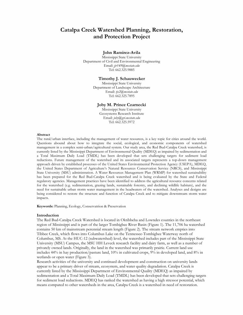
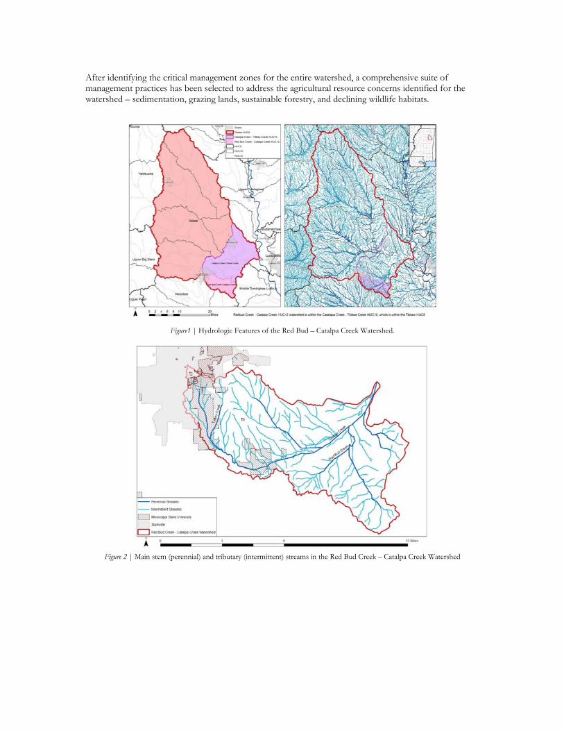
Abstract The rural/urban interface, including the management of water resources, is a key topic for cities around the world. Questions abound about how to integrate the social, ecological, and economic components of watershed management in a complex semi-urban/agricultural system. Our study area, the Red Bud-Catalpa Creek watershed, is currently listed by the Mississippi Department of Environmental Quality (MDEQ) as impaired by sedimentation and a Total Maximum Daily Load (TMDL) has been developed that sets challenging targets for sediment load reductions. Future management of the watershed and its associated targets represents a top-down management approach driven by established processes of the United States Environmental Protection Agency (USEPA), MDEQ, the United States Department of Agriculture’s Natural Resources Conservation Service (NRCS), and Mississippi State University (MSU) administration. A Water Resources Management Plan (WRMP) for watershed sustainability has been prepared for the Red Bud-Catalpa Creek watershed and is being evaluated by the State and Federal regulatory agencies. Management practices have been identified to address the agricultural resource concerns related for the watershed (e.g. sedimentation, grazing lands, sustainable forestry, and declining wildlife habitats), and the need for sustainable urban storm water management in the headwaters of the watershed. Analyses and designs are being considered to restore the structure and function of Catalpa Creek and to mitigate downstream storm water impacts. Keywords: Planning, Ecology, Conservatrion & Preservation Introduction The Red Bud-Catalpa Creek Watershed is located in Oktibbeha and Lowndes counties in the northeast region of Mississippi and is part of the larger Tombigbee River Basin (Figure 1). The 11,706 ha watershed contains 50 km of mainstream perennial stream length (Figure 2). The stream network empties into Tibbee Creek, which flows into Columbus Lake on the Tennessee-Tombigbee Waterway north of Columbus, MS. At the HUC-12 (subwatershed) level, the watershed includes part of the Mississippi State University (MSU) Campus, the MSU HH Leveck research facility and dairy farm, as well as a number of privately owned lands. Originally, the land in the watershed was primarily prairie. Current land use includes 44% in hay production/pasture land, 10% in cultivated crops, 9% in developed land, and 8% in wetlands or open water (Figure 3). Research activities of the university and continued development and construction on university lands appear to be a primary driver of stream, ecosystem, and water quality degradation. Catalpa Creek is currently listed by the Mississippi Department of Environmental Quality (MDEQ) as impaired by sedimentation and a Total Maximum Daily Load (TMDL) has been developed that sets challenging targets for sediment load reductions. MDEQ has ranked the watershed as having a high stressor potential, which means compared to other watersheds in the area, Catalpa Creek is a watershed in need of restoration.
After identifying the critical management zones for the entire watershed, a comprehensive suite of management practices has been selected to address the agricultural resource concerns identified for the watershed – sedimentation, grazing lands, sustainable forestry, and declining wildlife habitats.
Figure1 | Hydrologic Features of the Red Bud – Catalpa Creek Watershed.
Figure 2 | Main stem (perennial) and tributary (intermittent) streams in the Red Bud Creek – Catalpa Creek Watershed
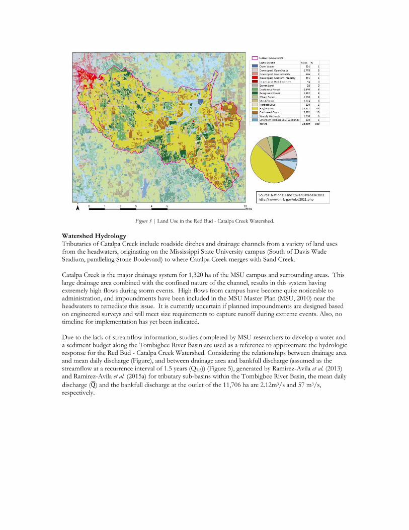
Figure 3 | Land Use in the Red Bud - Catalpa Creek Watershed.
Watershed Hydrology Tributaries of Catalpa Creek include roadside ditches and drainage channels from a variety of land uses from the headwaters, originating on the Mississippi State University campus (South of Davis Wade Stadium, paralleling Stone Boulevard) to where Catalpa Creek merges with Sand Creek. Catalpa Creek is the major drainage system for 1,320 ha of the MSU campus and surrounding areas. This large drainage area combined with the confined nature of the channel, results in this system having extremely high flows during storm events. High flows from campus have become quite noticeable to administration, and impoundments have been included in the MSU Master Plan (MSU, 2010) near the headwaters to remediate this issue. It is currently uncertain if planned impoundments are designed based on engineered surveys and will meet size requirements to capture runoff during extreme events. Also, no timeline for implementation has yet been indicated. Due to the lack of streamflow information, studies completed by MSU researchers to develop a water and a sediment budget along the Tombigbee River Basin are used as a reference to approximate the hydrologic response for the Red Bud - Catalpa Creek Watershed. Considering the relationships between drainage area and mean daily discharge (Figure), and between drainage area and bankfull discharge (assumed as the streamflow at a recurrence interval of 1.5 years (Q1.5)) (Figure 5), generated by Ramirez-Avila et al. (2013) and Ramirez-Avila et al. (2015a) for tributary sub-basins within the Tombigbee River Basin, the mean daily discharge (Q) and the bankfull discharge at the outlet of the 11,706 ha are 2.12m3/s and 57 m3/s, respectively.
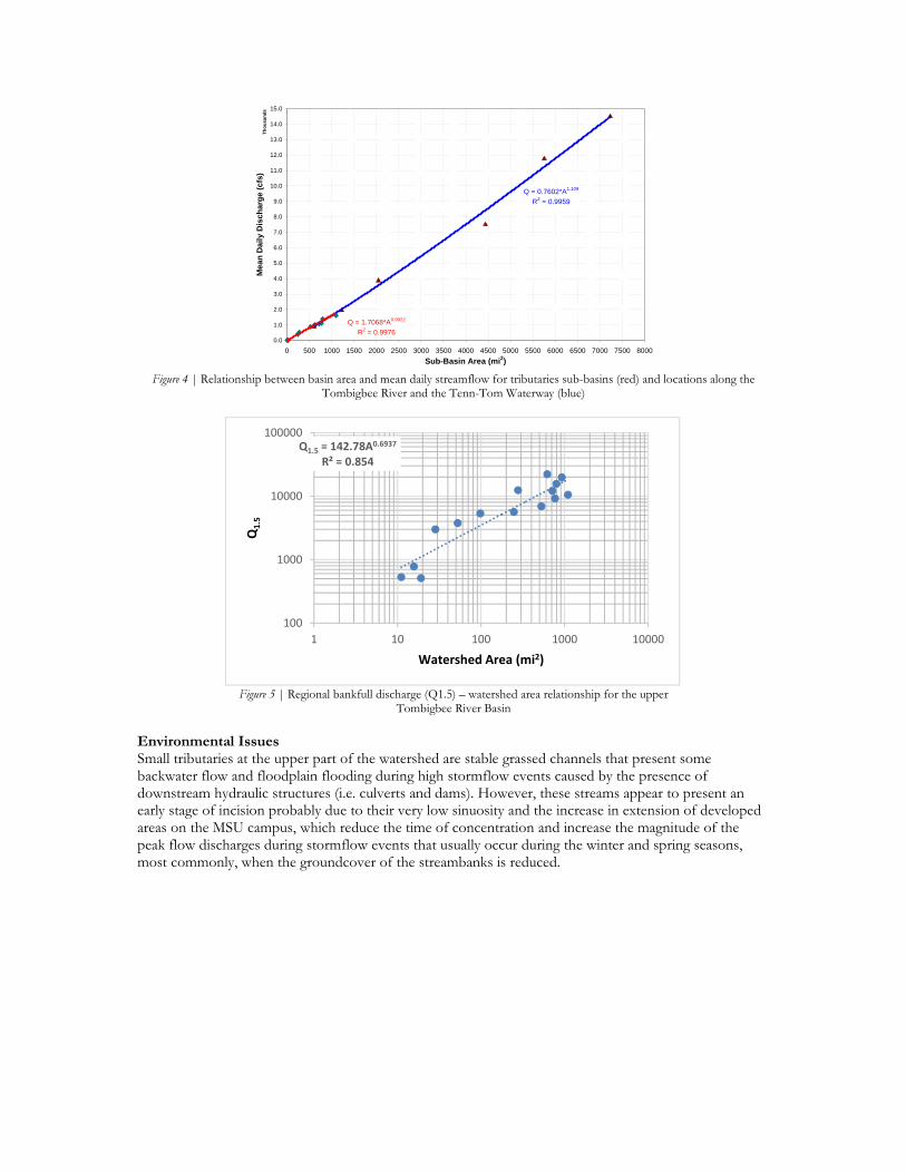
Figure 4 | Relationship between basin area and mean daily streamflow for tributaries sub-basins (red) and locations along the
Tombigbee River and the Tenn-Tom Waterway (blue)
Figure 5 | Regional bankfull discharge (Q1.5) – watershed area relationship for the upper
Tombigbee River Basin
Environmental Issues Small tributaries at the upper part of the watershed are stable grassed channels that present some backwater flow and floodplain flooding during high stormflow events caused by the presence of downstream hydraulic structures (i.e. culverts and dams). However, these streams appear to present an early stage of incision probably due to their very low sinuosity and the increase in extension of developed areas on the MSU campus, which reduce the time of concentration and increase the magnitude of the peak flow discharges during stormflow events that usually occur during the winter and spring seasons, most commonly, when the groundcover of the streambanks is reduced.
Q = 0.7602*A1.109
R2 = 0.9959
Q = 1.7068*A0.9922
R2 = 0.99760.0
1.0
2.0
3.0
4.0
5.0
6.0
7.0
8.0
9.0
10.0
11.0
12.0
13.0
14.0
15.0
0 500 1000 1500 2000 2500 3000 3500 4000 4500 5000 5500 6000 6500 7000 7500 8000
Th
ou
san
ds
Sub-Basin Area (mi2)
Mean
Dail
y D
isch
arg
e (c
fs)
Q1.5 = 142.78A0.6937
R² = 0.854
100
1000
10000
100000
1 10 100 1000 10000
Q1.5
Watershed Area (mi2)
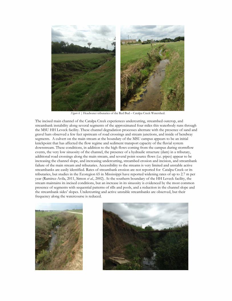
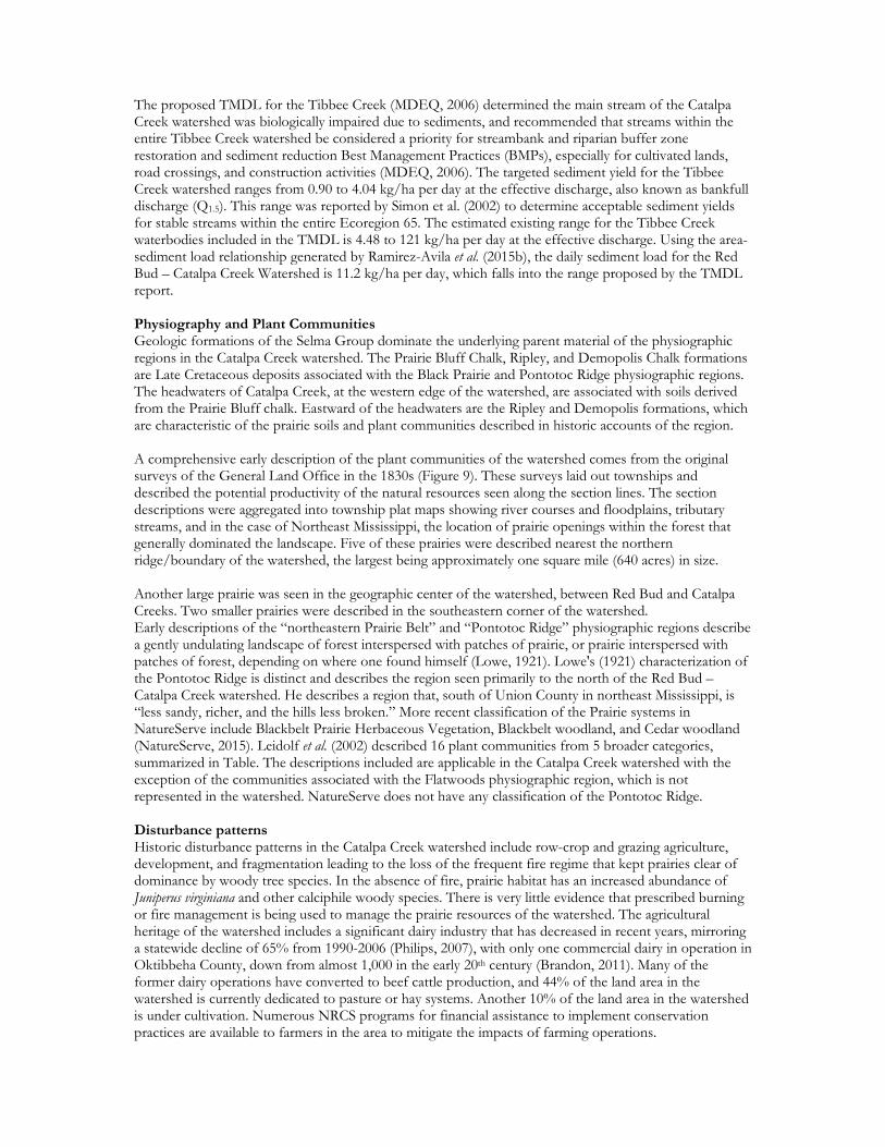
Figure 6 | Headwater tributaries of the Red Bud – Catalpa Creek Watershed.
The incised main channel of the Catalpa Creek experiences undercutting, streambed outcrop, and streambank instability along several segments of the approximated four miles this waterbody runs through the MSU HH Leveck facility. These channel degradation processes alternate with the presence of sand and gravel bars observed a few feet upstream of road crossings and stream junctions, and inside of bendway segments. A culvert on the main stream at the boundary of the MSU campus appears to be an initial knickpoint that has affected the flow regime and sediment transport capacity of the fluvial system downstream. These conditions, in addition to the high flows coming from the campus during stormflow events, the very low sinuosity of the channel, the presence of a hydraulic structure (dam) in a tributary, additional road crossings along the main stream, and several point source flows (i.e. pipes) appear to be increasing the channel slope, and increasing undercutting, streambed erosion and incision, and streambank failure of the main stream and tributaries. Accessibility to the streams is very limited and unstable active streambanks are easily identified. Rates of streambank erosion are not reported for Catalpa Creek or its tributaries, but studies in the Ecoregion 65 in Mississippi have reported widening rates of up to 2.7 m per year (Ramirez-Avila, 2011, Simon et al., 2002). At the southern boundary of the HH Leveck facility, the stream maintains its incised conditions, but an increase in its sinuosity is evidenced by the most common presence of segments with sequential patterns of rills and pools, and a reduction in the channel slope and the streambank sides’ slopes. Undercutting and active unstable streambanks are observed, but their frequency along the watercourse is reduced.

Figure 7 | Evidence of low sinuosity, active unstable streambanks, undercutting and streambed erosion/outcrop along the
main stream and below a hydraulic structure in a tributary of the Red Bud – Catalpa Creek Watershed.
Figure 8 | Sand and gravel bars formation along internal sides of bendways, upstream of streams junction and stream segments with abundant vegetation along the main stream of the Red Bud – Catalpa Creek Watershed (left). Riffles and pool segment in a
meandering section along the Red Bud – Catalpa Creek Watershed (right).
The proposed TMDL for the Tibbee Creek (MDEQ, 2006) determined the main stream of the Catalpa Creek watershed was biologically impaired due to sediments, and recommended that streams within the entire Tibbee Creek watershed be considered a priority for streambank and riparian buffer zone restoration and sediment reduction Best Management Practices (BMPs), especially for cultivated lands, road crossings, and construction activities (MDEQ, 2006). The targeted sediment yield for the Tibbee Creek watershed ranges from 0.90 to 4.04 kg/ha per day at the effective discharge, also known as bankfull discharge (Q1.5). This range was reported by Simon et al. (2002) to determine acceptable sediment yields for stable streams within the entire Ecoregion 65. The estimated existing range for the Tibbee Creek waterbodies included in the TMDL is 4.48 to 121 kg/ha per day at the effective discharge. Using the area-sediment load relationship generated by Ramirez-Avila et al. (2015b), the daily sediment load for the Red Bud – Catalpa Creek Watershed is 11.2 kg/ha per day, which falls into the range proposed by the TMDL report. Physiography and Plant Communities Geologic formations of the Selma Group dominate the underlying parent material of the physiographic regions in the Catalpa Creek watershed. The Prairie Bluff Chalk, Ripley, and Demopolis Chalk formations are Late Cretaceous deposits associated with the Black Prairie and Pontotoc Ridge physiographic regions. The headwaters of Catalpa Creek, at the western edge of the watershed, are associated with soils derived from the Prairie Bluff chalk. Eastward of the headwaters are the Ripley and Demopolis formations, which are characteristic of the prairie soils and plant communities described in historic accounts of the region. A comprehensive early description of the plant communities of the watershed comes from the original surveys of the General Land Office in the 1830s (Figure 9). These surveys laid out townships and described the potential productivity of the natural resources seen along the section lines. The section descriptions were aggregated into township plat maps showing river courses and floodplains, tributary streams, and in the case of Northeast Mississippi, the location of prairie openings within the forest that generally dominated the landscape. Five of these prairies were described nearest the northern ridge/boundary of the watershed, the largest being approximately one square mile (640 acres) in size. Another large prairie was seen in the geographic center of the watershed, between Red Bud and Catalpa Creeks. Two smaller prairies were described in the southeastern corner of the watershed. Early descriptions of the “northeastern Prairie Belt” and “Pontotoc Ridge” physiographic regions describe a gently undulating landscape of forest interspersed with patches of prairie, or prairie interspersed with patches of forest, depending on where one found himself (Lowe, 1921). Lowe's (1921) characterization of the Pontotoc Ridge is distinct and describes the region seen primarily to the north of the Red Bud – Catalpa Creek watershed. He describes a region that, south of Union County in northeast Mississippi, is “less sandy, richer, and the hills less broken.” More recent classification of the Prairie systems in NatureServe include Blackbelt Prairie Herbaceous Vegetation, Blackbelt woodland, and Cedar woodland (NatureServe, 2015). Leidolf et al. (2002) described 16 plant communities from 5 broader categories, summarized in Table. The descriptions included are applicable in the Catalpa Creek watershed with the exception of the communities associated with the Flatwoods physiographic region, which is not represented in the watershed. NatureServe does not have any classification of the Pontotoc Ridge. Disturbance patterns Historic disturbance patterns in the Catalpa Creek watershed include row-crop and grazing agriculture, development, and fragmentation leading to the loss of the frequent fire regime that kept prairies clear of dominance by woody tree species. In the absence of fire, prairie habitat has an increased abundance of Juniperus virginiana and other calciphile woody species. There is very little evidence that prescribed burning or fire management is being used to manage the prairie resources of the watershed. The agricultural heritage of the watershed includes a significant dairy industry that has decreased in recent years, mirroring a statewide decline of 65% from 1990-2006 (Philips, 2007), with only one commercial dairy in operation in Oktibbeha County, down from almost 1,000 in the early 20th century (Brandon, 2011). Many of the former dairy operations have converted to beef cattle production, and 44% of the land area in the watershed is currently dedicated to pasture or hay systems. Another 10% of the land area in the watershed is under cultivation. Numerous NRCS programs for financial assistance to implement conservation practices are available to farmers in the area to mitigate the impacts of farming operations.

Figure 9 | 1832 General Land Office (GLO) plat maps associated with the Catalpa Creek Watershed. The watershed boundary is shown in blue. Also seen are oundaries of the historic floodplain, tributary streams, and prairies.
Table I | Classification of representative plant communities found in Oktibbeha County, Mississippi by Leidolf et al. (2002). Habitat Category Community Type Bottomland Forest Bottomland Hardwood Forest
Swamp Forest Upland Forest and Prairie Mesophytic Upland Hardwood Forest
Xeric Upland Hardwood Forest Pine Forest and Pine/Mixed Hardwood ForestPrairie Prairie Cedar Woodland Chalk Outcrops
Aquatic Communities Rivers/Creeks Canals/Drainage Ditches Lakes/Ponds/Impoundments
Seepage Areas Human-influenced Communities Cultivated Fields
Grass/Forb Meadows Roadsides Urban Areas
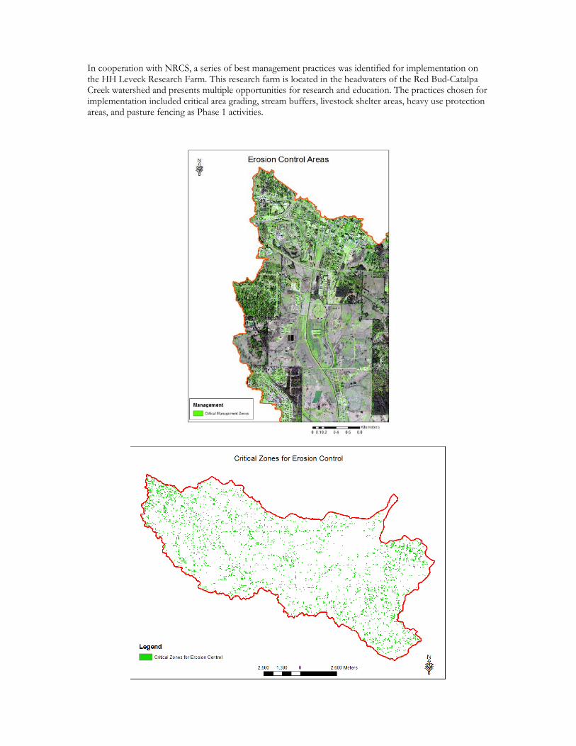
Invasive Species and Their Impact on Plant Community Development in the Watershed The Early Detection and Distribution Mapping System (EDDMapS, ND) indicates that Oktibbeha County has the third highest number of reported invasive species in the state of Mississippi, with 217 reported invasive species. Of the “10 Worst Invasive Weeds” listed by the Mississippi State University Extension Service, four upland invasive species are of particular concern: Triadica sebifera (Chinese Tallow tree), Lonicera japonica (Japanese honeysuckle), Ligustrum sinense (Chinese privet), and Sorghum halapense (johnsongrass). All of these are present on the Leveck facility. Chinese privet and johnsongrass are abundant in the streams in the headwaters of Catalpa Creek (Chinese tallowtree and Japanese honeysuckle are also present, but not abundant). The impact of privet and johnsongrass is primarily that of replacement of native species in the riparian zone, but on a positive note they are of value to the managers of facility for erosion avoidance on the banks of the channelized reaches of the stream on the facility and the dairy farm. Care will have to be taken to manage the invasive species while at the same time not exposing the banks of the channel to further erosion. The wetland invasive species are of primary concern in the lower reaches of the watershed as Catalpa Creek approaches its confluence with Tibbee Creek in Lowndes County. Lythrum salicaria (purple loosestrife), Alternanthera philoxeroides (Alligator weed), and Eichornia crassipes (water hyacinth) are all present in Lowndes and Oktibbeha counties (EDDMapS, ND). Best Management Practices for the Management of Water Resources Because lands under pastures/hay are the most predominant land use/land cover condition within the Catalpa Creek watershed, annual soil erosion rates appear to be predominantly low (smaller than 11.2 Mg/ha), while soil erosion rates higher than 33.6 Mg/ha were mostly observed from developed areas and cultivated crops. Critical management zones for erosion control were determined by identifying areas with annual soil losses higher than the soil loss tolerance for the corresponding map unit. From the 11,700 ha in the watershed, approximately 7.6% of the area (890 ha) was included within the critical management zones for erosion control. Around 265 ha correspond to areas under cultivated crops, 175 ha to areas under pastures/hay, 131 ha to shrub/scrub lands, and other 133 ha to developed areas and unpaved roads. A total of 1,100 ha along the northern headwaters, out of the entire watershed area, especially those areas including the MSU Campus and the research farm, are part of the critical management zones with most important contribution of nutrients (both, P and N) and highest rates of reduction needed to achieve the proposed targets. The most critical area is mostly urban (MSU Campus), as the other sub watersheds have very mixed land uses, but with a predominance of pasture/hay systems. Stream processes have been well identified along different segments on the upper four miles of the main stream of the Catalpa Creek and some of its tributaries. Active eroding streambanks, streambed scouring and streambank undercutting processes are importantly increasing the load of sediments carried by the stream. The presence of sand and gravel bars observed a few feet upstream of road crossings and stream junctions, and inside of bend way segments are consequences of the erosion activity observed along the segments upstream. As previously discussed into the Water Management Plan, Right at the boundary of the university’s research farm, the stream maintains its incised conditions, but an increase in its sinuosity is evidenced by the most common presence of segments with sequential patterns of rills and pools, and a reduction in the channel slope and the streambank sides’ slopes. A preliminary assessment completed by undergraduate students of the Civil and Environmental Engineering Department have shown that sediment concentrations and turbidity along the main channel are importantly high, while pH and dissolved oxygen are lower than downstream locations. Further downstream sediment concentrations and turbidity decreased, but then an increasing trend was observed along the transects at 3.1 km and 4.0 km downstream, where actively eroding streambanks were more frequently observed.
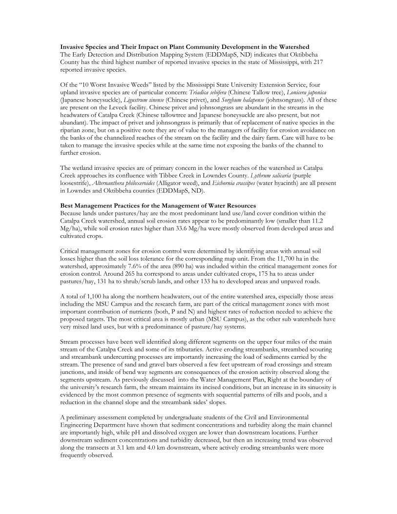
In cooperation with NRCS, a series of best management practices was identified for implementation on the HH Leveck Research Farm. This research farm is located in the headwaters of the Red Bud-Catalpa Creek watershed and presents multiple opportunities for research and education. The practices chosen for implementation included critical area grading, stream buffers, livestock shelter areas, heavy use protection areas, and pasture fencing as Phase 1 activities.
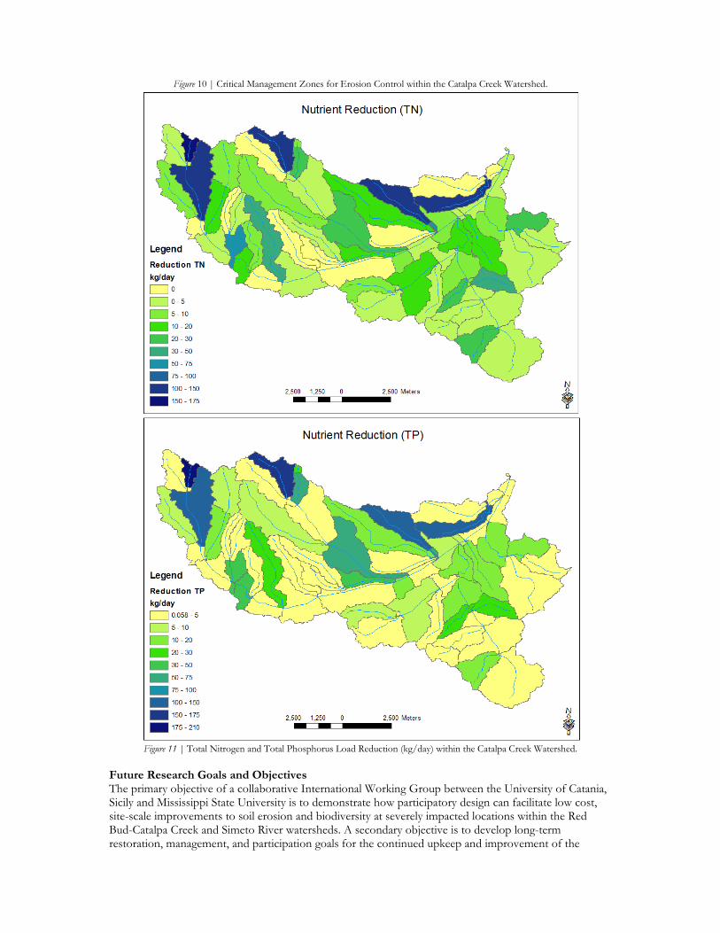
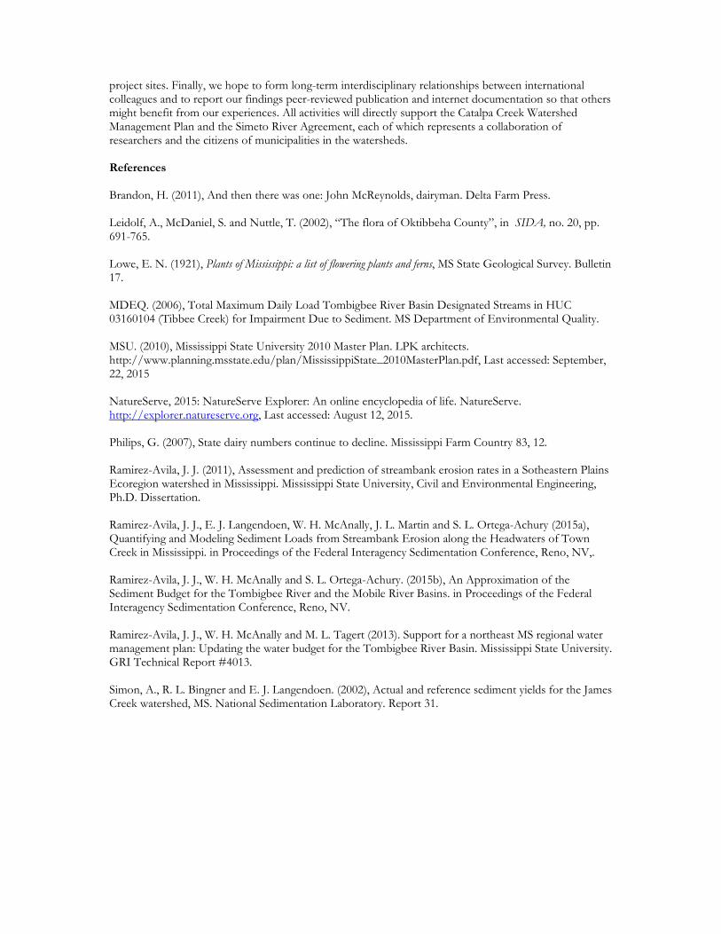
Figure 10 | Critical Management Zones for Erosion Control within the Catalpa Creek Watershed.
Figure 11 | Total Nitrogen and Total Phosphorus Load Reduction (kg/day) within the Catalpa Creek Watershed.
Future Research Goals and Objectives The primary objective of a collaborative International Working Group between the University of Catania, Sicily and Mississippi State University is to demonstrate how participatory design can facilitate low cost, site-scale improvements to soil erosion and biodiversity at severely impacted locations within the Red Bud-Catalpa Creek and Simeto River watersheds. A secondary objective is to develop long-term restoration, management, and participation goals for the continued upkeep and improvement of the
project sites. Finally, we hope to form long-term interdisciplinary relationships between international colleagues and to report our findings peer-reviewed publication and internet documentation so that others might benefit from our experiences. All activities will directly support the Catalpa Creek Watershed Management Plan and the Simeto River Agreement, each of which represents a collaboration of researchers and the citizens of municipalities in the watersheds. References Brandon, H. (2011), And then there was one: John McReynolds, dairyman. Delta Farm Press. Leidolf, A., McDaniel, S. and Nuttle, T. (2002), “The flora of Oktibbeha County”, in SIDA, no. 20, pp. 691-765. Lowe, E. N. (1921), Plants of Mississippi: a list of flowering plants and ferns, MS State Geological Survey. Bulletin 17. MDEQ. (2006), Total Maximum Daily Load Tombigbee River Basin Designated Streams in HUC 03160104 (Tibbee Creek) for Impairment Due to Sediment. MS Department of Environmental Quality. MSU. (2010), Mississippi State University 2010 Master Plan. LPK architects. http://www.planning.msstate.edu/plan/MississippiState_2010MasterPlan.pdf, Last accessed: September, 22, 2015 NatureServe, 2015: NatureServe Explorer: An online encyclopedia of life. NatureServe. http://explorer.natureserve.org, Last accessed: August 12, 2015. Philips, G. (2007), State dairy numbers continue to decline. Mississippi Farm Country 83, 12. Ramirez-Avila, J. J. (2011), Assessment and prediction of streambank erosion rates in a Sotheastern Plains Ecoregion watershed in Mississippi. Mississippi State University, Civil and Environmental Engineering, Ph.D. Dissertation. Ramirez-Avila, J. J., E. J. Langendoen, W. H. McAnally, J. L. Martin and S. L. Ortega-Achury (2015a), Quantifying and Modeling Sediment Loads from Streambank Erosion along the Headwaters of Town Creek in Mississippi. in Proceedings of the Federal Interagency Sedimentation Conference, Reno, NV,. Ramirez-Avila, J. J., W. H. McAnally and S. L. Ortega-Achury. (2015b), An Approximation of the Sediment Budget for the Tombigbee River and the Mobile River Basins. in Proceedings of the Federal Interagency Sedimentation Conference, Reno, NV. Ramirez-Avila, J. J., W. H. McAnally and M. L. Tagert (2013). Support for a northeast MS regional water management plan: Updating the water budget for the Tombigbee River Basin. Mississippi State University. GRI Technical Report #4013. Simon, A., R. L. Bingner and E. J. Langendoen. (2002), Actual and reference sediment yields for the James Creek watershed, MS. National Sedimentation Laboratory. Report 31.