watershed restoration action strategy (wras) state water...
TRANSCRIPT

Updated 5/2004 Watershed Restoration Action Strategy (WRAS)
State Water Plan Subbasin 02F Neshaminy Creek Watershed
Bucks and Montgomery Counties Introduction Subbasin 02F, which consists mainly of the Neshaminy Creek and its tributaries, drains 232 square miles of west central and southern Bucks County and a portion of adjacent Montgomery County. A small portion of the Delaware River drainage adjacent to the confluence of Neshaminy Creek between the villages of Croyden to Cornwells Heights is also included in the subbasin. Neshaminy Creek flows in a southeasterly direction for about 50 miles to its confluence with the Delaware River north of the City of Philadelphia. A total of 428 streams flow for 418 miles through the subbasin; however, the majority of the streams in the subbasin are small unnamed tributaries, only 17 of the streams have official names. The subbasin has three Mill Creeks and two Pine Creeks. Major tributaries are the North Branch, West Branch, and Little Neshaminy Creek. The subbasin is part of HUC Area 2040201, Neshaminy Creek, a Category I, FY99/2000 Priority watershed under the Unified Watershed Assessment. Geology/Soils Most of the subbasin lies within the Northern Piedmont Ecoregion (64). The upper two-thirds of the watershed is in the Triassic Lowlands (64a) subsection, which is comprised of gray arkose sandstone, red and brown sandstone, shale, and conglomerate of the Stockton Formation. The topography is flat to gently sloping (0 to 8 percent). Soils in this section are sandy and highly erodible. The Stockton Formation is the best source for water supply wells in the subbasin; however, yields vary greatly and some of the aquifer is under artesian pressure. Water is moderately hard and mineralized. Interspersed through 64a is the Diabase and Conglomerate Uplands (64b), consisting mostly of gray or black argillite of the Lockatong Formation (Trap Rock) and diabase, which are quarried as building stone and aggregates. This area consists of a series of parallel northeast-southwest trending hills and ridges formed by diabase dikes and sheets that protrude through sedimentary rocks and rise above the Triassic Lowlands. The streams in this area flow through parallel, low relief valleys between low ridges. The Lockatong Formation is a tightly cemented rock that has low water well yields unless fractures are encountered. The highly erosion-resistant diabase rock of 64b forms a boulder-strewn terrain that is not conducive to farming. Much of this diabase portion of the subbasin is wooded or used for residential development. The argillite beds are homogeneous with local thinner bedded black shale. This section of the subbasin has primarily Group C and D soils which have low permeability and high runoff potential. Detention ponds are more feasible stormwater management practices rather than infiltration type systems in the Trap Rock areas. Part of the lower portion of the watershed is within the Piedmont Uplands (64c), which is characterized by rounded hills and low ridges consisting mainly of gneiss and schist. A ridge along which the Neshaminy Creek makes a sharp 90-degree bend to the west marks the transition between the Piedmont Uplands and the Triassic Lowlands. The lower edge of the uplands is traversed by a narrow band of quartzite of the Chickies Formation, part of the Piedmont Lowlands (64d). The clay soils derived from these rocks have slow infiltration rates and a high potential for runoff. The very lower portion of the basin adjacent to the Delaware River is in the Middle Atlantic Coastal Plain, Delaware River Terraces and Uplands (63a) consisting of unconsolidated sand and gravel. A relatively steep gradient known as the Fall Line marks the transition between the hillier Piedmont and the flat, sandy Coastal Plain. In this subbasin, the Fall Line is marked by a sharp 200-foot rise near the intersection of US Route 1 and Bristol Road near the Neshaminy Mall. The creek makes an abrupt 90-degree turn to the east as it flows from the Piedmont Lowlands into the coastal plain. Virtually none of the coastal plain remains in its natural state in this subbasin; the plain was either filled in or drained and converted into urban and suburban development.
1

Most of the subbasin contains clay soils formed from noncarbonate sedimentary rocks. These soils have high runoff potential due to slow infiltration rates and an impervious layer near the surface. The majority of streams in the subbasin exhibit extreme flow variability during the year. Streams are very flashy in nature and experience high runoff during rainfall and retain little rain for groundwater recharge and storage. Large commercial, industrial and housing development further limits rainfall infiltration. The coastal plain area along the Delaware River contains soils formed from unconsolidated water sorted materials, with substrata of sand, silt, and gravel. These soils have moderate to high infiltration rates. Groundwater is normally replenished by precipitation; however, groundwater in the coastal plain is also replenished by infiltration from the Delaware River. Land Use The basin includes 26 municipalities in Bucks County, 13 of which are boroughs, and 7 in Montgomery County, including two boroughs. The largest borough is Doylestown, the Bucks County seat. The location of the lower ¼ subbasin adjacent to the City of Philadelphia and major interstate highways such as the Pennsylvania Turnpike (I-476) and I-95 has encouraged development of high intensity residential villages and boroughs and large commercial and industrial tracts. Villages and boroughs have merged over the years and now little or no open space exists between them. Many houses in the older developments of the lower subbasin are very close to streams that have little natural riparian cover. This situation presents a high potential for flooding. The population of the subbasin was 256,000 in 1990 and is projected to increase significantly to 368,000 by 2040.
Acres of Land Cover by Type for Subbasin 02F
Land use Category Number of Acres Land use Category Number of Acres
Water Bodies 1727.5 Mixed Forest 10,924.9
Low Intensity Development 27,607.9 Deciduous Forest 40,714.0
High Intensity Development 7,817.4 Woody Wetland 928.5
Hay/Pasture 13,288.2 Emergent Wetland 568.2
Croplands 42,569.2 Quarry 232.2
Coniferous Forest 1,918.1 Transitional/Abandoned Land 448.3
Total Acres 148,744.7
The portion of the subbasin North and west of the Boroughs of Newtown and Doylestown is still rural or semi-rural and has the majority of the remaining farmland. Agriculture lands are being rapidly converting to residential and commercial developments. Scattered forested tracts remain in the upper half of the subbasin. Small woodlots are located in public parks and private lands. The headwaters of the West Branch and the Little Neshaminy Creek are the most highly developed sections of the upper subbasin. The area surrounding the Borough of Doylestown is becoming more developed into small, often upscale residential communities and commercial parks. Large estates with scattered small woodlots are located near the main stem east of Doylestown. Residential and commercial development is also expanding into the still largely rural North Branch watershed north and west of Doylestown. Lake Luxembourg, Lake Galena, Pine Run Dam, and Churchville Reservoir are part of the Neshaminy Basin
2
Flood Control System built in the 1970’s and funded through the Natural Resources Conservation Service (NRCS) under the Public Law (PL) 566 Program. Flood control is the primary purpose of the reservoirs, with recreation and water supply as secondary uses. Six other smaller impoundments are located in the subbasin. Lake Luxembourg watershed contains some of the last actively farmed land in lower Bucks County. Water Supplies: Most of the public water in the subbasin is supplied by wells. The Point Pleasant Diversion brings water from the Delaware River outside the subbasin into the Neshaminy Creek watershed, increasing the discharge of the North Branch Neshaminy Creek. Water from the Delaware River flows from a pumping station at Point Pleasant through a combined transmission main into Bradshaw Reservoir, then into the North Branch at PA Route 413 and then into Lake Galena. The Forest Park Water Treatment Plant draws water for municipal treatment from the North Branch two miles downstream of Lake Galena. This diversion and interbasin transfer increases the overall amount of water available for use in the Neshaminy Creek subbasin. Natural Resources: Local and county public parks: These parks are important because they provide valuable open space amid the rapidly expanding residential and commercial areas of the watershed. They also provide riparian buffers that protect the creek banks and help reduce flooding, stormwater runoff and erosion. • Peace Valley County Park surrounds the 365-acre Lake Galena on the North Branch Neshaminy Creek. The
Park encompasses 1,524 acres of mixed forest and open fields. The Peace Valley Nature Center, an environmental education center and outdoor classroom of the Central Bucks School District, is located on 20 acres of the northeast section of the lake and 300 acres of surrounding parkland.
• The 174-acre Lake Luxembourg impounds about 99% of the Core Creek basin and is the focal point of Core Creek Park, owned by the Bucks County Parks Department. The park, which is located between the boroughs of Langhorne and Newtown, is one of the most widely used in the county. The water and land based recreation (boating, fishing, trails, picnicking, recreational courts and areas, camping) attracts more than one million visitors each year. Core Creek Park provides valuable open space amid a rapidly expanding residential area.
• Lake Galena impounds 365 acres of the North Branch Neshaminy Creek. The lake is supplemented by water from the Delaware River Point Pleasant Diversion Project to provide cooling water for the PECO Energy owned Limerick Nuclear Power Generating Station and augmenting public drinking water supplies. The water supply intake is downstream of the dam at the confluence of Pine Creek and North Branch Neshaminy Creek.
• Dark Hollow Park, southeast of Doylestown, which follows the Neshaminy Creek corridor for several miles. • Churchville Park near Ironworks and Mill Creeks, Northampton Township, Bucks County. • Playwicki Park on a bend in the Neshaminy Creek in Middletown Township, Bucks County, west of
Langhorne. • Kemper Park, along the Little Neshaminy Creek in Warminster Township, Bucks County • Windlestrae Park on Little Neshaminy Creek, Montgomery Township, Montgomery County Two state parks are located in the watershed: • Neshaminy State Park, a 330-acre park on the Delaware River with a boat ramp/access to the Delaware
River, a swimming pool and many other recreational opportunities. • Tyler State Park, a 1,711-acre park near Newtown Borough, which has environmental education facilities in
addition to other recreational opportunities. Fisheries: Watson Creek, Buckingham Township, Bucks County, a tributary to Mill Creek at Rushland, supports a wild brown trout population.
3
DEP Chapter 93 Exceptional Value (EV) and High-Quality (HQ) Stream Listings: • No EV or HQ streams. Water Quality Impairment A variety of nonpoint and point source pollution sources affect the subbasin consistent with the variety of land uses. The conversion of farmland to residential development has lead to siltation problems from land construction and impairment by stream flow variability and stormwater runoff. Construction activities associated with rapid urbanization are major sources of high sediment loads. Soils are highly erodible, and disturbed areas contribute high sediment loads during storm events. In some cases, however, conversion from agriculture to suburban land use will likely reduce the siltation rates once construction is completed because raw soil is no longer exposed through regular plowing and planting. Erosion and stormwater runoff continue to carry sediments and nutrients to streams and lakes, especially Lakes Galena and Luxembourg. Stormwater: Stormwater runoff is a severe problem especially in the highly urbanized lower subbasin. In September 1999 after the record rainfall from Hurricane Floyd, floodwaters reached the 100-year flood level at the USGS gauge at Langhorne, PA, causing millions of dollars of damage to hundreds of homes and businesses. In summer 2000, a localized storm that dropped 8 inches of rain in 3 hours over the lower Bucks County Townships of Upper and Lower Southampton brought Mill Creek (at Langhorne Terrace) over its banks, washing out roads, businesses and homes. Dozens of families were forced from their homes for more than a month and many businesses lost days or weeks of operation. Damages to roads, bridges and utilities disrupted services and access in many areas for several days. PHEMA is in the process of purchasing homes for removal and reestablishment of riparian buffers in the most severely affected areas. Streams in the subbasin often become turbid after minor rainstorms and may remain so for days after the storms. Stormwater impacts can be expected to increase due to the high amount of new development in the watershed. Groundwater Major sources of groundwater pollution in the subbasin include malfunctioning septic systems and spray irrigation sites, leaking storage tanks and pipes, and spills resulting from improper chemical handling, storage, and disposal practices at industrial facilities and landfills. Petroleum compounds and solvents account for most of the contamination, while elevated levels of metals, inorganics, pesticides, and PCBs may be present in groundwater. MtBE is of particular concern in the subbasin. In addition to their impact on drinking water supplies, groundwater contaminants can migrate to surface waters and threaten aquatic life. Groundwater depletion is also a problem due to withdrawals through water wells that serve the numerous new housing, commercial, and industrial developments. Groundwater withdrawn for home or commercial use is not always returned to the groundwater but instead enters the surface stream flow as discharges from sewage plants or runoff from paved roads and driveways. Runoff is rapid during storm events; rainwater has little time to infiltrate and replenish the groundwater system. Many of the agricultural lands of the 1960’s are now housing or commercial developments with lush fertilized lawns. Point Source Discharges The watershed has a number of point source discharges, including 15 municipal sewage facilities that discharge into the main stem Neshaminy Creek, Little Neshaminy Creek and its unnamed tributaries, and Lahaska Creek. During low summer flow periods, these discharges may comprise the majority of flow to the receiving stream. Stream degradation associated with excess nutrients, phosphates, nitrates, sludge, fecal coliform bacteria, copper, chlorine, and bacteria from sewage treatment plants have been reported in Neshaminy Creek, Little Neshaminy Creek, West and North Branch Neshaminy Creeks, and Cooks Run. These discharges have significantly limited the diversity of aquatic life in several of these waterways.
4
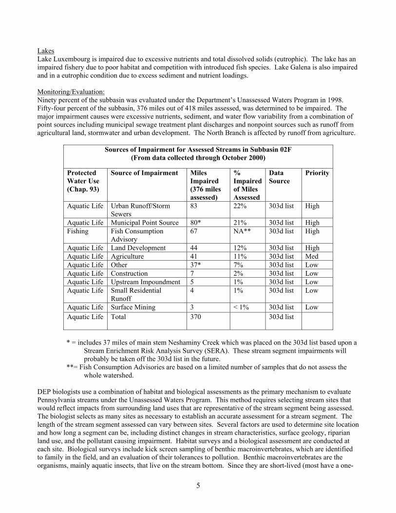
Lakes Lake Luxembourg is impaired due to excessive nutrients and total dissolved solids (eutrophic). The lake has an impaired fishery due to poor habitat and competition with introduced fish species. Lake Galena is also impaired and in a eutrophic condition due to excess sediment and nutrient loadings. Monitoring/Evaluation: Ninety percent of the subbasin was evaluated under the Department’s Unassessed Waters Program in 1998. Fifty-four percent of the subbasin, 376 miles out of 418 miles assessed, was determined to be impaired. The major impairment causes were excessive nutrients, sediment, and water flow variability from a combination of point sources including municipal sewage treatment plant discharges and nonpoint sources such as runoff from agricultural land, stormwater and urban development. The North Branch is affected by runoff from agriculture.
Sources of Impairment for Assessed Streams in Subbasin 02F (From data collected through October 2000)
Protected Water Use (Chap. 93)
Source of Impairment Miles Impaired (376 miles assessed)
% Impaired of Miles Assessed
Data Source
Priority
Aquatic Life Urban Runoff/Storm Sewers
83 22% 303d list High
Aquatic Life Municipal Point Source 80* 21% 303d list High Fishing Fish Consumption
Advisory 67 NA** 303d list High
Aquatic Life Land Development 44 12% 303d list High Aquatic Life Agriculture 41 11% 303d list Med Aquatic Life Other 37* 7% 303d list Low Aquatic Life Construction 7 2% 303d list Low Aquatic Life Upstream Impoundment 5 1% 303d list Low Aquatic Life Small Residential
Runoff 4 1% 303d list Low
Aquatic Life Surface Mining 3 < 1% 303d list Low Aquatic Life Total 370 303d list
* = includes 37 miles of main stem Neshaminy Creek which was placed on the 303d list based upon a
Stream Enrichment Risk Analysis Survey (SERA). These stream segment impairments will probably be taken off the 303d list in the future.
**= Fish Consumption Advisories are based on a limited number of samples that do not assess the whole watershed.
DEP biologists use a combination of habitat and biological assessments as the primary mechanism to evaluate Pennsylvania streams under the Unassessed Waters Program. This method requires selecting stream sites that would reflect impacts from surrounding land uses that are representative of the stream segment being assessed. The biologist selects as many sites as necessary to establish an accurate assessment for a stream segment. The length of the stream segment assessed can vary between sites. Several factors are used to determine site location and how long a segment can be, including distinct changes in stream characteristics, surface geology, riparian land use, and the pollutant causing impairment. Habitat surveys and a biological assessment are conducted at each site. Biological surveys include kick screen sampling of benthic macroinvertebrates, which are identified to family in the field, and an evaluation of their tolerances to pollution. Benthic macroinvertebrates are the organisms, mainly aquatic insects, that live on the stream bottom. Since they are short-lived (most have a one-
5
year life cycle) and relatively immobile, they reflect the chemical and physical characteristics of a stream and chronic pollution sources or stresses. Habitat assessments evaluate how deeply the stream substrate is embedded, degree of streambank erosion, condition of riparian vegetation, and amount of sedimentation. Urbanization and paving can have a severe effect on stream aquatic life. Studies by the Maryland Department of Natural Resources showed that a reduction in stream aquatic species diversity may begin with as little as 2% impervious cover. Maryland streams with above 15% impervious cover were rated fair to poor for aquatic species. When the impervious cover reached 25%, species diversity was significantly reduced. Riparian vegetation removal and paving affect both stream water temperature and habitat for aquatic species. Organisms most affected include many species of reptiles and amphibians, brook trout, and stoneflies. Stormwater runoff from paved areas can also wash out oil, grease, and other pollutants into streams. The paved areas also restrict replenishment of groundwater and contribute to flash flooding during storm events and extreme fluctuations in stream water levels. Extreme flow fluctuations cause difficulties in the attachment of bottom dwelling organisms to the stream substrate and cause a scouring of the substrate. Retention of riparian vegetation in unnamed headwater tributaries, known as first order streams, which may comprise as much as 50% of the streams in a watershed, can be especially critical to the protection of organisms in the downstream watershed. The latest PA Department of Environmental Protection 303d and 305b lists includes unnamed tributaries, not just the named tributaries as in previous lists. This listing may help highlight the importance of protection of unnamed tributaries. The causes of impairment of many streams in the Neshaminy Creek watershed are indicated as water flow variability or flow alterations due to urbanization and new development. Most of the upper and middle main stem Neshaminy Creek and several tributaries such as Mill Creek at Langhorne Terrace are unimpaired. These streams or their tributaries have retained a relatively high percentage of their riparian vegetation. Nonresidential development, which includes office, industrial, and commercial development, is booming in the subbasin. This type of development has a high potential for impact on surface and groundwater resources due to the massive site grading, removal of vegetation, and large areas of paving for parking lots. Local land use planning should encourage these developments to maintain open space, reduce unnecessary paving, improve land use standards, and better fit of the design to the landscape contours. Impairment Causes/Sources Urban Runoff / Storm Sewers The Neshaminy Creek watershed has experienced large increases in population growth since 1945. Residential, commercial and industrial land development in the watershed the numerous roads, parking lots, buildings, and driveways have substantially increased impervious areas. Stormwater associated with development impacts both the quantity and quality of water entering streams. Many developed areas have impervious surfaces directly linked to streams through piping without stormwater controls. Other developed areas have stormwater controls that were created to attenuate peak discharges to predevelopment levels. These controls may help limit downstream flooding, but do little to protect aquatic life and habitat. Little Neshaminy Creek and Neshaminy Creek have approved Act 167 Stormwater Management Plans; however, these plans have provided little benefit for aquatic life. The plans do not require stormwater management for areas that were previously developed and do not protect channels from smaller bank-full storm events that shape aquatic habitat. Many pollutants are deposited or placed on impervious areas and urban/suburban landscapes (lawns, golf courses, athletic fields). These pollutants include animal feces, oil, fertilizers, pesticides, anti-freeze solution, and solids. These pollutants discharge directly to the stream in developed areas that lack stormwater pollution controls. (Little Neshaminy Creek and Neshaminy Creek’s Stormwater Management Plan have water quality objectives for new development. Some municipalities will fall under the federal stormwater regulations (Phase
6
II). Stormwater management practices such as infiltration areas, vegetated detention basins, and retention ponds. Increasing the frequency of bank-full storm events and overall storm flows causes bank destabilization, increased sediment load, increased scour, increased substrate embeddedness, and increased sediment deposition. Channels can widen or deepen causing a loss or alteration of aquatic habitat. All of these stormwater impacts adversely affect aquatic life. Hydrologic modifications associated with stormwater are important causes of aquatic use impairment in the watersheds. Factors Contributing to Increased Stormwater Runoff: o Lack of land use county planning at the municipal level. o Lack of implementation and enforcement of Act 167 for stormwater planning at the local level. Increased
development throughout Bucks County has led to little infiltration and increased impervious areas. o Increased storm water runoff from new development and lack of a comprehensive storm water management
plan. o Lower Bucks County was developed in the 1950’s. Most road crossing bridges and structures and their
stormwater systems are undersized and cannot accommodate significant storm events. o Neshaminy Creek outlets to a tidal river (Delaware). When a storm occurs during high tide, the backwater
from the Delaware River can be significant and causes additional flooding along Neshaminy Creek. When this occurs, sediment deposits an increase in sedimentation is observed at the outlet of the Neshaminy Creek into the Delaware River.
o Development in floodplain areas. o Loss of riparian buffers and wetlands. Municipal Point Sources Municipal wastewater treatment plants serving concentrated population centers within the watershed discharge treated effluent containing significant amounts of nutrients. Little Neshaminy Creek, Park Creek and Cooks Run are on the 303d list for nutrient enrichment from municipal point source discharges, such as sewage treatment plants. While municipal point sources are regulated under the state administered federal NPDES program, large treatment facilities on small watersheds overwhelm the streams capacity to assimilate treated effluent. Wastewater treatment facilities in the Neshaminy Creek watershed have discharge limits for phosphorous; however, instream phosphorous concentrations are well above expected ambient concentrations. Nutrients can adversely impact stream aquatic life. Increasing nutrients associated with treated sewage effluents can cause excessive algal growth, alter periphyton community composition, and cause large daily dissolved oxygen swings with low dissolved oxygen during periods when photosynthesis is not occurring. Low oxygen associated with high algal standing crop and changes in algal communities will alter macroinvertebrate and fish populations. Land Development Farmland and forested areas continue to be developed into residential, commercial and industrial land uses in the upper portions of the subbasin. During development, large soil piles can be exposed to water and wind erosion resulting in accelerated stream sedimentation. Developers are required to follow approved erosion and sedimentation control plans to minimize erosion and subsequent sediment releases to streams. Impairments on the 303d list suggest that best management practices included in erosion and sediment control plans do not adequately protect aquatic life. Sedimentation adversely impacts aquatic life and habitat. Settled sands, silts, and clays reduce macroinvertebrate habitat by filling interstitial areas between larger streambed substrates. This loss of macroinvertebrate habitat can cause a reduction in productivity and community diversity. Suspended silts and clays can reduce light needed by periphyton, interfere with foraging success of sight and filter feeders, and
7
interfere with oxygen transfer by clogging gills. Additionally, storm event scour suspended sands and silts, reducing the diversity of periphyton and macroinvertebrate communities. Agriculture Agriculture impairments impact the West Branch of Neshaminy Creek and the northern portion of the main stem Neshaminy Creek. Crop and animal production can adversely impact aquatic life. Erosion of topsoil and runoff of applied manure or chemical fertilizers contribute to stream sedimentation and nutrient loading. Barnyard runoff of manure and livestock in or adjacent to streams can also contribute to nutrient loading and sedimentation through bank destabilization. Agricultural best management practices are voluntary and little regulation exists for reducing pollutant loads from agricultural areas. Lake Luxembourg: A Clean Lakes Phase 1 Diagnostic/Feasibility Study of the Lake Luxembourg watershed conducted in 1990-93 resulted in the development of a lake and watershed restoration plan. Excess sediments and nutrients from agricultural sources adversely affect the lake. Over 90% of sediment and nutrient loadings to the lake are from surface runoff. The reservoir reached its 100-year sediment capacity in just 9 years. The lake is hypereutrophic, with very high lake Trophic Status Indices (TSIs) (ranging from 70 to 79). Algal blooms are a frequent occurrence. Lake light penetration (transparency) is low due to suspended silt and clay particles. The low transparency inhibits the growth of aquatic macrophytes in the lake. The summer oxygen depleted (anoxic) zone or thermocline begin at relatively shallow 4 meters depth. Total phosphorus (TP) concentrations ranged from 0.16-0.2 mg/l during normal conditions and much higher (0.72mg/l) during storm events. Water from a nearby well had low TP, but was very high in nitrogen, up to 30 mg/l. Nitrates varied with seasons, with the highest N values occurring in winter and spring. The lake is phosphorus limited due to a high nitrogen/ phosphorus ratio. The fishery is impaired due a lack of cover and nursery areas for desirable fish and an overabundance of introduced gizzard shad and white perch. Lake Galena: A Clean Lakes Phase I Diagnostic/Feasibility Study was completed for the Lake Galena watershed in 1995. The lake is eutrophic to hypereutrophic, with TSIs ranging from a high 57 to 66. Ammonia levels were seasonally variable, but usually elevated in the lake’s outflow. Total phosphorus levels were moderate to high in both the North Branch and the lake. PA water quality standards for fecal coliform bacteria were exceeded 80% of the time in water samples from North Branch Neshaminy Creek. The study concluded that human and animal wastes were being transported to the lake from the surrounding watershed in quantities that are a cause for concern. Fecal coliform/streptococcus bacteria ratios indicated that most of the bacterial contamination was from human or from mixed sources, depending on the tributary and time of year. Resident Canada geese populations accounted for a significant portion of the bacterial contamination. Nitrogen concentrations were high in the lake, presumably due to runoff from agriculture. High nitrates have also been documented in groundwater of the surrounding Core Creek watershed. Agricultural lands also contributed suspended sediments. Suspended sediment values are higher in the tributaries than in the lake. The fishery was impaired, with game fish generally in poor condition. The lake suffers from an overabundance of white perch and gizzard shad, unintentionally introduced species. The Point Pleasant Diversion, which brings in water from the Delaware River drainage, was regarded to have little impact on the water quality of the lake. Natural Resources Conservation Service (NRCS) PL-566 Flood Control Study: Eight flood control dams were constructed along the Neshaminy Creek through the PL-566 program since congressional approval in 1967. Construction of the two remaining authorized dams was put on hold in 1989. The severe flooding that occurred in the watershed in 1996 led to the formation of the Neshaminy Creek Steering Committee and Technical Team to scientifically study additional flood control strategies for the watershed. In 1997, NRCS and the Technical Team began an updated watershed study for the lower Neshaminy Creek from Route 611 down to the Delaware River. The flooding which occurred during Hurricane Floyd in September 1999 further demonstrated the need for better stormwater controls. Four alternative flood control programs were selected for further study and public input: no action, nonstructural solutions, a dry dam in Dark
8
Hollow Park, and a combination of dry dam and nonstructural solutions. A draft work plan was presented at public meetings in July 2000. The nonstructural alternative, in which buildings and businesses within the 100-year floodplain would be removed, elevated or flood-proofed depending on potential flood elevation, was determined to be the most cost-effective means of reducing flood damage. Landowner participation in the nonstructural alternatives is voluntary. Participation rates for such measures are normally in the 60 to 75% range. DCNR Rivers Conservation Plans Doylestown Township Doylestown Township conducted a study of the Neshaminy Creek in their township and nearby areas of the upper-middle watershed. Preservation of open space and protection of water quality, wildlife habitat and the scenic beauty of the area was determined to be of utmost concern for residents. Results of a visual analysis of the study area indicated that Neshaminy Creek from Chalfont Borough to Forest Park has been altered from its natural state due to residential, commercial and road development and poor land management. Inadequate sedimentation and erosion controls during construction have resulted in siltation and scouring of streambanks. Runoff from bridges has also impacted creek aesthetics. Stream corridors of other portions of the study area are variously affected by some urban, commercial and office development but generally retain much of their riparian buffers. Recommendations included better implementation of stormwater management plans to control erosion, stabilization of streambanks, and development a continuous recreational greenway park adjacent to Neshaminy Creek. Rivers Conservation Plan for Upper and Middle Neshaminy Creek Watershed The Delaware Riverkeeper Network completed a comprehensive plan for protection and restoration of the upper and middle Neshaminy Creek watershed (2002). U.S. Geological Survey’s Bucks County Hydrogeologic and Groundwater Study: The study concluded that the county groundwater system was largely interconnected. Upper and central Bucks County municipalities are mutually dependent upon aquifers, streams and wetlands. Land use management, especially cooperation between municipalities, was identified as one of the most important elements in protection of water resources. Several goals were identified for groundwater protection: • Ensure availability of groundwater as a main source of water supply • Potability without treatment systems • Permanence of stream flow • Recharge areas need delineation and special protection • Protect and enhance recharge, minimize impervious areas Future Threats to Water Quality and Quantity: Increased development and paving has a high potential to decrease infiltration to groundwater and cause groundwater depletion. Expansion of impervious payment could also lead to additional reductions in the diversity of aquatic life. The supplemental NRCS PL-566 study indicated that future land use changes and stormwater management practices might slightly reduce future flood peaks. Developers, however, must comply with recently revised local stormwater ordinances adopted under the PA ACT 167 plans for the watershed for this decrease to occur. Acquisition and removal of buildings in the 100-year flood plain and restoration of riparian buffers should also help reduce flooding potential. Groundwater wells are a primary drinking water source for many areas in the Neshaminy Creek watershed. The Delaware River Basin Commission has established numerical groundwater withdrawal limits to help control groundwater depletion.
9

Watershed Restoration or Protection Projects Pennsylvania Growing Greener Grants: • Heritage Conservancy (FY 2003)
o $60,000 for Phase 3 of the stream bank assessment and restoration on an unnamed tributary to the Little Neshaminy Creek;
o $8,000 to organize the Neshaminy Creek Watershed Alliance. • $23,319 (FY2002) to Hatfield Township to create infiltration BMP's to maintain existing and create new stream buffers, develop an education and community outreach program, and remove invasive plants and plant native species. • $8,000 (FY2002) to Plumstead Township for implementation of the Pine Run restoration plan: Phase I to
identify multiple nonpoint sources of pollution to a detention basin within the Fox Hunt development and potential BMPs. Phase II to develop an educational brochure for landowners.
• $60,000 (FY2001) to Bucks County Conservation District for an assessment of Warrington Lake and Neshaminy Creek.
• $30,000 (FY2001) to Horsham Township for installation of riparian buffers at Kohler Park. • $6,530 (FY2000) to North Branch Neshaminy Creek Watershed Association for organization of their group. • $10,965 (FY1999) to Horsham Township to pursue a community educational outreach program that
includes videotape, participation by other townships and educators, and the design and construction of an educational sign at the site of the Kohler Park streambank restoration (WRAP project) on Park Creek. The sign will educate the public about the value of the streambank restoration project in protecting water quality and habitat.
• $112,535 (FY1999) to the American Littoral Society to develop a comprehensive watershed assessment followed by a water quality-focused restoration plan for the Little Neshaminy Creek. The goals of the restoration plan will be to attain designated stream uses and water quality standards, prevent future stream degradation, and to serve as a model for other urban watersheds.
U.S. Environmental Protection Agency (EPA) Clean Water Act Section 319 Projects: • $33,000 (FY 2004) to American Littoral Society for restoration of the Little Neshaminy. • $85,220 (FY 2004) to Bucks County Conservation District to continue implementing the restoration plan for
Lake Luxembourg. • $23,195 (FY2002) to Doylestown Township Environmental Advisory Council for restoration of Neshaminy Creek at Bridge Point Park. • $100,140 (FY1999) to the Bucks County Conservation District (CD) to address additional reductions of
nutrient and sediment into Core Creek and Lake Luxembourg, as part of the continuing effort of Phase II Clean Lakes Project.
• $40,600 (FY1999) to the Delaware Riverkeeper to conduct an assessment and develop a restoration and protection plan for the Pine Run watershed. The purpose of this study is to update the 1985 assessment completed by the Neshaminy Water Resources Authority. Considerable suburban development has occurred in the upper portion of the watershed since the original plan was written.
• $116,000 (FY1998) to Bucks County CD and F.X. Browne for implementation of the Lake Galena Watershed Management Plan developed as a Clean Lakes Study. Agricultural BMPs, roadway and construction erosion controls, stormwater and septic system management, homeowner improvements, and goose controls will be implemented.
• $145,225 in FY1995, $154,275 in 1996, $8,300 in 1997 to Bucks County Conservation District (CD) to implement recommendations of the Lake Luxembourg Phase II Clean Lakes study to control excess sediments and nutrients in Core Creek watershed.
• Funding of a nutrient management technician in the Bucks County CD office, started in 1993 Pennsylvania Watershed Restoration Assistance Program (WRAP): • $15,000 (FY1999) to Horsham Township, Montgomery County, for a riparian buffer restoration project in
Kohler Park adjacent to Park Creek. Streambank erosion will be reduced and native vegetation will be reestablished.
10
Natural Resources Conservation Service (NRCS): • Environmental Quality Incentive Program (EQIP) agricultural best management projects to reduce erosion
and sedimentation nutrient enrichment in the Neshaminy Creek watershed were begun in 1997 • Public Law (PL-566) study of flood control measures needed in Neshaminy Creek watershed. Department of Conservation and Natural Resources (DCNR) Rivers Conservation Grants: • $62,500 (2000) to the Delaware Riverkeeper Network to prepare a comprehensive rivers conservation plan
for the upper and middle Neshaminy Creek. • $43,000 (1997) to Doylestown Township to develop a greenway along Neshaminy Creek and its tributaries
for recreation and flood protection, to establish river conservation environmental education programs, and to develop a new river conservation zoning ordinance and clean up the streams in the watershed.
• $17,000 (1995) to Doylestown Township to develop a comprehensive multiple municipal conservation plan for Neshaminy Creek watershed. An additional $4,000 was awarded to Doylestown Township in 1996 to complete their rivers conservation plan.
• $80,000 to the Heritage Conservancy through the DCNR Community Conservation Partnership Program to develop a Rivers Conservation Plan for the lower 18 miles of the Neshaminy Creek watershed in Hulmeville, Pendell, Langhorne, and Langhorne Manor Boroughs, Lower Southampton, Middletown, and Northampton, and Upper Southampton Townships. The entire watersheds of Mill Creek at Langhorne Terrace, Chubb Run, Turkey Run and Core Creek were included. The project addressed the need to improve municipal land use practices.
DEP Coastal Nonpoint Source Pollution Grants: • $39,289 (FY2002) to Lower Southampton Township for plantings and construction of an infiltration trench
at the Sweetwater Farms detention basin. Stormwater Management: • Pennsylvania Act 167: Approved plans: Neshaminy Creek and Little Neshaminy Creek • PENNVEST: $542,500 loan (1999) to Middletown Township to construct stormwater detention basins,
streambank stabilization facilities, and storm sewers to reduce basement flooding and soil erosion. Citizen/Conservation Groups • Neshaminy Watershed Association • North Branch Neshaminy Creek Watershed Association, a new association formed in 2000. • The Delaware Riverkeeper Network has a website http://www.delawareriverkeeper.org/ that contains fact
sheets and information on water quality and other pertinent issues in the Neshaminy Creek basin. One of the goals of the Riverkeeper is to encourage local residents to actively protect their streams. They encourage residents to get involved with municipal land use decision-making and assist with local stream protection projects. They coordinate volunteer monitoring at one site on the main stem Neshaminy Creek and 2 on the North Branch.
• The Heritage Conservancy is a nonprofit organization located in Bucks County, PA, dedicated to the preservation of our natural and historical heritage. They have received grants form DEP and DCNR for their preservation and conservation activities. They assist local conservation groups in southeastern Pennsylvania in assessment of streams conditions and with other conservation projects. More information is available on their website at http://www.heritageconservancy.org/.
Public Participation/Outreach: Watershed Notebooks DEP’s website has a watershed notebook for each of its 104 State Water Plan watersheds. Each notebook provides a brief description of the watershed with supporting data and information on agency and citizen group activities. Each notebook is organized to allow networking by watershed groups and others by providing access to send and post information about projects and activities underway in the watershed. The notebooks also link to the Department’s Watershed Idea Exchange, an open forum to discuss watershed issues. The website is www.dep.state.pa.us. Choose Subjects/Water Management/Watershed Conservation/Watershed and Nonpoint Source Management/Watershed Notebooks.
11

Funding Needs The total dollars needed for addressing all nonpoint source problems in the watershed is undetermined. Stream assessments have been conducted and TMDLs will be developed for impaired waters in the subbasin. Watershed restoration plans developed for impaired waters will help determine what Best Management Practices (BMPs) are necessary to reduce pollution sources and provide estimates of restoration needs. Funding sources available to support the development of site-specific implementation plans and remediation projects that address the sources of water quality impairment include the EPA Clean Water Act Section 319 grant program and the Pennsylvania Growing Greener program which target reductions in nonpoint source pollution. Pennsylvania has generally placed more emphasis on funding projects slated for implementation on water bodies where TMDLs have been completed or where water quality impairments have been documented. Funding needs for restoration activities in the Core Creek watershed were estimated to be $1,492,520 in the 1993 Clean Lakes Study. Dredging and installation of agricultural best management practices (BMPs) comprised most of the budget. Implementation has begun using EPA 319 funds; the Bucks County Conservation District coordinates these projects. Funding needs for the Lake Galena watershed identified in the 1995 Clean Lakes study focused on implementation of agricultural BMPs. Needs for agriculture conservation practices were estimated to be $768,915. Total Maximum Daily Loads (TMDLs) TMDLs identify the amount of a pollutant that a stream or lake can assimilate without violating its water quality standards. TMDLs are calculated to include a margin of safety to protect against a mathematical or data error. TMDLs are set for each pollutant causing impairment. Summary of TMDL for Neshaminy Creek Nutrients from municipal sources have been listed as the cause of impairment for a number of stream segments within the Neshaminy Creek watershed. The original 303(d) listings of most of these streams (ca. 1996) were based on a 1988 survey, which was done to determine if nutrient loadings were impacting specific streams. In this case, nutrients from municipal treatment facilities were documented as causing organic enrichment problems in many streams within the watershed. As a result of this and water quality modeling studies conducted by USEPA Region 3 in 1982, all of the treatment facilities had nutrient limits included in their NPDES permits. Nutrient limits are applied April 1 through October 31. The TMDL provides calculations of the stream’s total capacity to accept phosphorus and sediments. Algae growth in the water bodies is fueled by excess nutrients in the water column. Phosphorus is the nutrient limiting productivity in Neshaminy Creek and its tributaries; therefore, the TMDL addresses phosphorus to remedy the nutrient impairments. Additionally, sediment loads delivered by stormwater runoff and streambank erosion are impairing the streams in the Neshaminy Creek watershed and are addressed in the TMDL. The TMDL can be accessed through the DEP Website (http://www.dep.state.pa.us) by typing “TMDL” in the direct link field, and clicking GO. Choose ‘Neshaminy Creek’ from the pull-down menu with the heading ‘Select By TMDL Name’. At extreme low flows, the streamflow in Neshaminy Creek and its tributaries is predominantly made up of discharge effluents; therefore, the phosphorus pollution at the critical low flow period in the Neshaminy Creek watershed comes from the point source dischargers. Sediments carried to the stream in overland flow in wet weather periods are, in part, responsible for the siltation impairment in these water bodies. Streambank erosion caused primarily by increased flow volume and altered timing is also a major contributor of sediment to these streams.
12
Many changes have taken place in the watershed over the past 20 years. Within the past 10 years, municipal treatment plants have been upgraded to provide tertiary treatment, and the closing of some facilities and transference of waste flows to regional treatment facilities has occurred. There has also been a tremendous amount of growth. The amount of developed land, for example, has increased by about 20 percent in the watershed over the last decade. This represents drastic changes to the landscape and has a great effect on precipitation-driven runoff patterns. One significant problem in the watershed related to these changes is an increase in sedimentation problems due to increased stream bank erosion. With the increase in development comes an increase in the amount of impervious surface (pavement) that causes the water to run off the landscape at a much faster rate with greater force. This causes the stream banks to erode and deposit sediment in the stream channel. This sediment covers the stream bottom and reduces the habitat for aquatic organisms. For these reasons, many of the TMDLs developed for subareas of the Neshaminy Creek watershed are focused on sediment control. Nutrients from upland (i.e., nonpoint) sources have also been identified as problems in some stream reaches within the Neshaminy Creek watershed. These problems are primarily addressed in combination with point sources in the TMDL report.
Little Neshaminy Creek Total Maximum Daily Loads or TMDLs were developed for the Little Neshaminy Creek watershed to address the impairments noted on Pennsylvania’s 1996, 1998, and 2002 Clean Water Act Section 303(d) Lists (see Table A1 in section A1.0). The 1996 303(d) List reported 15.7 miles of the Little Neshaminy and 6.2 miles of Park Creek to be impaired by nutrients and DO/BOD. The 1998 303(d) List added 5.5 miles to the Little Neshaminy as being impaired by water/flow variability and siltation, and the 2002 303 (d) List added still more impaired segments. The 2002 list reports a total of 37.9 miles of Little Neshaminy Creek (plus several unnamed tributaries) and 9.3 miles of Park Creek (and its two unnamed tributaries) to be impaired by nutrients and DO/BOD from municipal point sources, and by siltation and water/flow variability as a result of urban runoff/storm sewers. Stream segments of Little Neshaminy Creek and its tributaries are impacted by siltation as a result of “new land development” in the watershed. New land development is defined here as disturbed land at construction sites/new development. Siltation presently observed in Little Neshaminy is believed to be the result of years of sediment build-up in the channel bottom that started in the early 1990’s. This sediment originated from disturbed and unprotected soils at construction sites and increased channel bank erosion during periods of intense storm events. Sediment reductions in the TMDLs are allocated to developed land uses and stream bank erosion in the watershed. Implementation of best urban best management practices (BMPs) in the affected areas to increase infiltration and sediment control measures should achieve the loading reduction goals established in the TMDLs. Substantial reductions in the amount of sediment reaching the streams can be made through the installation of drainage controls such as detention ponds, sediment ponds, infiltration pits, dikes and ditches. These BMPs range in efficiency from 20% to 70% for sediment reduction. The implementation of such BMPs will likely occur in the watershed as a result of DEP’s new Comprehensive Stormwater Management Policy. This new policy will require affected communities to implement BMPs to address stormwater control that will “reduce pollutant loadings to streams, recharge groundwater tables, enhance stream base flow during times of drought and reduce the threat of flooding and stream bank erosion resulting from storm events.” The Phase II program for NPDES discharges from small construction sites, additional industrial activities, and for the 700 municipalities subject to the requirements for separate storm sewer systems (MS4) has been developed. All of the municipalities located within the Little Neshaminy Creek watershed will be affected by this policy. Summary of TMDL for Lake Luxembourg: Sedimentation and excess nutrient loads cause impairment of Lake Luxembourg. Lake Luxembourg reached its 100-year sediment capacity in just nine years after filling. Agricultural practices and rapid urbanization combined with highly erodible soils contribute to high sediment loads to the lake during storm events. Reduced
13
water depth, turbidity, and excess algae growths have interfered with the quality of aquatic and lakeside recreation, water supply and flood control uses of the lake. Since Pennsylvania does not have water quality criteria for nutrients or sediment, Carlson’s Trophic Status Index (TSI) was used as the indicator of lake water quality to determine the necessary phosphorus (P) reduction targets for the TMDL. The relationship between the in-lake P concentration and TSI was used to estimate load reductions that will meet water quality objectives. Suspended solids reduction targets were set based on the life design of the lake and its sediment-filling rate. Estimated loadings were computed for each land use in the watershed, based on accepted land use runoff coefficients. Additional information for pollutant loadings was obtained by monitoring some of the lake inlets during dry and storm events. The non-controllable load was estimated by using an all forest scenario to estimate what the natural conditions would be without the influence of man. A 20% change in P loading above the estimated natural condition was used to allow for a man-induced condition. Annual load reductions were computed and targets were set for 13 land use types in order to meet the P and sediment TMDLs. The highest load reductions for P were necessary in the commercial, row crops and nurseries land use categories. The highest load reductions for sediment were needed in the residential land use category; however, row crops, pasture/grass, nurseries, park, institutional, and commercial land uses were also targeted for reductions. Remediation activities to reduce nutrient and sediment contributions as recommended in the 1994 Phase I Clean Lakes study are currently being implemented. The projects listed in the table below are agricultural best management practices (BMPs) designed to reduce sediment runoff and address a significant portion of the work needed to meet the objectives for agricultural land uses. Much more needs to be done to meet stream use criteria, especially in the developed areas of the watershed. Runoff from residential and commercial areas needs to be addressed along with agricultural land use categories targeted for load reductions. To support this effort, the public must be educated on ways to control nutrient and sediment runoff at their homes and businesses. Additional funding is needed for the completion of agricultural BMPs, water quality sampling, public education, and documentation of load reduction. These studies will help determine if the assumptions for phosphorus loading in the TMDL are correct and would measure the performance efficiency of the various BMPs.
Completed Restoration Projects in Lake Luxembourg Watershed as of 2000
Practice Installed/Task Completed
Number Installed
Approximate Cost
Animal Waste Facilities 1 $2,790 Barnyard Runoff Controls 1 $11,240 Diversions 7,875 ft. $12,980 Other Practices 5 $12,450 Sediment Basins 9 $112,705 Terraces 22,935 ft. $31,990 Underground Outlets 3 $8,000 Grass Waterways 40,190 ft. $103,150 Total $297,000
Additional information and loadings calculations can be found in the Final TMDL on the Department’s website at http://www.dep.state.pa.us/, choose directLink, TMDL, Lake Luxembourg. Restoration Needs The assessment of the subbasin has been completed. Impaired waters have been placed on the 303d list. The watershed assessment underway in Little Neshaminy Creek watershed will provide management plans and
14
prioritize restoration needs. The Act 67 stormwater plans should also be used to guide stormwater management. Restoration efforts have begun in several areas of the subbasin through grant to the Delaware Riverkeeper, several townships, and the conservation districts. The highest restoration needs in this subbasin are the restoration of riparian buffers, streambank stabilization, and stormwater runoff controls. Restoration efforts should be directed towards these impaired stream and lake areas: • Neshaminy Creek: 4.51 miles of lower main stem and 52.23 miles of unnamed tributaries: stormwater and
agricultural best management practices (BMPs) • West Branch Neshaminy Creek: 7.77 miles of main stem and 24.03 miles of unnamed tributaries:
agricultural BMPs and better controls on land development • North Branch Neshaminy Creek: 3.32 miles main stem and Pine Run at Chalfont, including Lake Galena:
agricultural BMPs, repair of leaky septic systems, Canada goose controls, better controls on stream flow variability and stormwater runoff, riparian restoration and stabilization
• Cooks Run, entire basin: stormwater management BMPs • Mill Creek at Tradesville, entire basin; better controls on residential development and surface mining • Little Neshaminy Creek and its tributary Park Creek, entire basin: stormwater management
• Core Creek: entire basin including Lake Luxembourg, agricultural BMPs and better controls on stream flow variability
Stream buffers: The Heritage Conservancy conducted an analysis of stream 1,200 miles in Southeastern Pennsylvania in 2000. They developed a computerized map of riparian buffer hot spots to help local conservation groups and municipalities target areas for riparian buffer restoration. The project was funded under a grant through the DEP Coastal Zone management and Stream ReLeaf programs. The Neshaminy Creek watershed was one of 4 watersheds studied. The method used was a helicopter fly-over and recording the streambanks with a sky-cam and GPS unit. ARC View GIS maps were produced that show the areas needing buffers. Topographic maps and aerial photos were printed and given to leading river conservation associations. Workshops were also held to explain the results of the study. Maps can be clipped and overlaid on tax parcel maps to determine which landowners to contact about riparian buffer restoration. The maps can be used as a tool to prioritize restoration activities and to track future gains and losses. A total of 409 miles were assessed in Neshaminy Creek watershed. The study showed that 39.3 miles were lacking buffers on one side, 47.4 miles lacking on 2 sides, for a total of 86.7 miles or 21.2 percent of assessed miles without buffers. Data is available through PASDA, the Pennsylvania Spatial Data Access website at http://www.pasda.psu.edu/. Stormwater: Better stormwater management planning and installation of BMPs to control runoff and increase infiltration should help reduce impairment from urban runoff; however, the high amount of paving in many portions of the subbasin may impede full restoration of water quality and aquatic habitat. Stormwater management actions should concentrate on the following: • Implementation and enforcement of Act 167 to develop a comprehensive stormwater management plan for
the subbasin. • Adoption and implementation of an intergovernmental cooperation agreement for a county land use plan. • Prohibit future floodplain development. • Preservation of and reinstitution of riparian buffers and wetland areas. Implementation of BMPs for agricultural sources in the impaired areas should reduce nutrients and sediment loadings. Recommended agricultural BMPs include animal waste storage facilities, barnyard runoff controls, diversions, sediment basins, terraces, underground outlets, and grass waterways. Streambank stabilization and fencing should reduce phosphorus and sediment loads in the affected areas. Streambank fencing will keep livestock out of the streams and allow restoration of riparian zones to trap sediment and phosphorus, thus
15
keeping these pollutants from reaching the stream. A reduction coefficient of 75% for nutrients and sediment is reasonable to expect with these BMPs. The 75% reduction in loading from BMP implementation is derived from empirical data from previous studies of BMP effectiveness reported in the literature and used by the Susquehanna River Basin Commission in their efforts to model pollutant reductions that may result from various load reduction strategies. Pine Run NPS Pollution Assessment and Restoration Plan, completed by the Delaware Riverkeeper in 2002 This plan provides an example of the difficulty of controlling stormwater runoff in an urban/suburban region with largely ineffective stormwater runoff controls. The Pine Run watershed is representative of similar small watersheds throughout the Delaware River basin that have undergone a rapid transformation to suburban residential and commercial land use, with a corresponding loss of agricultural lands. The impact of urbanization on water quality is significant, and comprises a major component of water quality degradation in Pine Run watershed and the entire Neshaminy Creek subbasin, resulting in the inclusion of over half of the watershed in the PA DEP Section 303(d) list as an impacted stream. The Pine Run watershed, a small, 11.5 square mile, tributary of the Neshaminy Creek, has been the location of stormwater planning for over thirty-five years. As part of the development of a Comprehensive Stormwater Management Plan in 1965 under PL 566, Pine Run was the site of a large, multi-purpose impoundment built to help to reduce the impact of flooding on downstream communities. Prior to the dam construction in the early 1970’s, Pine Run watershed was largely in agricultural land use, with little residential or commercial activity, except for the existing communities of New Britain Borough and Chalfont Borough. During the subsequent two decades, the watershed reflected the regional trend in central Bucks County of suburbanization, with new developments occupying what had previously been farm fields and woodlands. The earliest development occurred in Doylestown Township and the lands immediately adjacent to the reservoir, especially on the southeast side of the valley near the county seat of Doylestown Borough and the juncture of Routes 202 and 611. None of this development included detention basins, in part because it was assumed that the large Pine Run Reservoir would provide all the flood mitigation necessary for downstream protection. All discharges from the relatively older developments run off directly and immediately to the Pine Run reservoir. Below the reservoir, communities such as the two Boroughs, a system of storm sewers facilitates stormwater runoff directly into the lower reaches of the Pine Run. Newer developments built during the past twenty years incorporated detention structures in site designs intended to control the peak rate of runoff from limited areas. The location and pattern of the basins reflected the evolving approach to the issue of stormwater management within Pine Run, and in many ways throughout the entire Neshaminy Creek Watershed. Pine Run Reservoir is highly eutrophic and has been so since initial impoundment. Water released from the reservoir is depleted of oxygen during late summer months. The reservoir serves as a nutrient trap and sediment sink for Pine Run, initially reflecting mostly runoff from cultivated lands and currently nutrient discharges from the maintained lawns that replaced the fields. The critical nonpoint source pollutant produced in the watershed is phosphorus, attributable to both cultivation and lawn fertilization in the growing residential areas, and conveyed on sediment particles into the reservoir and waterways. Nutrient enrichment is apparent by the growth of rooted aquatic plants, water turbidity, and floating algae mats during the summer, which produce the odor of decaying vegetation during late summer. Some limited sport fishing occurs in the lake, but no contact recreation is provided or encouraged. In 1985, the Neshaminy Water Resources Authority (NWRA) through Cahill consultants performed an assessment of nonpoint source pollution in Pine Run based on land use conditions at that time. The watershed was dominated by agricultural land use (64%), and the estimated annual application of phosphorus to the active cropland (2,800 acres) in the watershed was 73,000 pounds per year. An estimated 20% of that mass load found its way to the reservoir each year, most of it attached to colloidal soil particles during stormwater runoff. This was far more than necessary to create the severe enrichment conditions observed in the impoundment, and did not include the additional load provided by septic systems, livestock and vegetation. As the lake became eutrophic, some of the nutrient load found its way further downstream. Measurements of total phosphorus were
16
made below the existing dam during the mid-1970’s, but more recent sampling has been limited, especially during storm runoff events. Stormwater management policies that reduced nutrient application were recommended in the Neshaminy Creek Stormwater Management Plan, drafted in 1989 and issued in 1992, but little if any effort has been made to implement these model ordinances. That plan recommended a number of stormwater quantity and quality controls for application by local municipalities, although to date, the water quality measures have not been implemented in any significant way. Initially, several of the municipalities believed that the purpose of the impoundment was to mitigate stormwater impacts, especially any increase in flow rate, and additional measures were considered unnecessary. Current municipal governments are much more aware and interested in stormwater management measures. The 2002 assessment and restoration plan focused on what can be done within the total watershed to mitigate the continuing load of pollutants conveyed with each rainfall into the reservoir. The plan began by developing a detailed GIS database of current watershed conditions. A nonpoint source loading model was developed using current and probable future land use conditions, assuming that the current vacant parcels are developed according to current zoning. The goal was to determine how much water quality benefit, or reduction in nonpoint source loads, might be achieved if appropriate stormwater BMPs were installed. The net reduction was determined to be a substantial benefit, around 10% to 20% for most pollutants, demonstrating that the long-term goal for water quality management must focus on existing sources and transport by runoff. The pollutant reduction efficiencies of various BMPs were also evaluated. The plan concluded that even if all of the existing detention basins were successfully reconstructed, the net benefit would not be sufficient to restore water quality in the reservoir. In evaluating the cost benefits of structural measures, the plan concluded that the net benefit of BMPs would not be enough to restore water quality if considered in the context of the overall NPS loading. The plan determined that to restore water quality, additional nonstructural measures should be imposed by local government or implemented by the residents of the watershed, including formulation of new land development criteria, with strategies such as fertilizer reduction in existing residential and remaining cultivated parcels. They also concluded that adopting a better stormwater management ordinance is one such measure to reduce new development impacts, but these efforts would be insufficient without changing current land development practices. The plan suggested land management strategies to prevent further nonpoint source loadings from both new and existing development. The plan did not attempt to design a solution for the existing uncontrolled runoff from the older communities immediately adjacent to the reservoir, because efforts to add new stormwater structures there would be difficult because few large open parcels remain. The possibility of retrofitting the existing newer detention basins to accomplish some degree of infiltration has also proven quite difficult, from both a political and physical perspective. Most of the detention basins built by private developers under criteria imposed by local government are now owned primarily by community associations of residents. In many cases, the local development would rather have the basins removed than modified, considering them to be eyesores in their pleasant suburban settings. The basins that are in single private owner situations, such as commercial sites, are reluctant to allow outsiders to modify their current detention basins without significant compensation and insurance liability coverage. The existing detention basin sites were determined to be highly disturbed, with the remaining basin bottom and surrounding soils highly compacted and not suitable for infiltration. If the retrofitting of detention basins strategy were to succeed, the role of township government must be much greater, and the local developments would need to be pressured to implement such measures, perhaps under the evolving Phase II Stormwater regulations. To restore water quality in Pine Run, local governments must become involved in a strategy of nonpoint source pollution reduction, especially phosphorus, implemented through local land use regulations. This can be accomplished by revising local stormwater ordinances to require groundwater recharge and water quality measures, by retrofitting existing stormwater structures to facilitate infiltration and increase pollutant reduction
17
and removal, and possibly by building new stormwater management measures throughout the drainage that prevents NPS transport by infiltrating runoff. As guidance, the plan contains a Model Stormwater Ordinance that also includes some elements that might normally be contained in the Subdivision and Land Development Ordinance (SLDO), but should be integrated with each municipal set of regulations. An example of a Phosphorus Control Ordinance is also included, derived from a New Jersey municipality that surrounds a small lake. In addition to adopting new regulatory ordinances, each municipality must educate township residences as to the role that each home site plays in the degradation of Pine Run, specifically in the use and application of fertilizers, pesticides, herbicides and the discharge of waste materials, including grass clippings, to the nearby stream or channel. The plan recommended that a poster of the Pine Run watershed and surrounding land use be developed to make municipalities aware of where each residence is in relation to the watershed drainage and reservoir. The poster could contain examples of BMPs derived from other watersheds and discuss both structural and non-structural measures that might help restore the water quality of the Pine Run watershed. All these steps will be necessary to accomplish significant reduction in phosphorus loading to the reservoir. References/Sources of information • State Water Plan, Subbasin 2, Central Delaware River. Department of Environmental Protection, July 1983 • USGS Topographic Maps • 319 project proposals and summaries • DEP: Watershed Notebooks, Unified Assessment Document, and information from databases. • Map of Draft Level III and IV Ecoregions of Pennsylvania and the Blue Ridge Mountains, Ridge and
Valley, and Central Appalachians of EPA Regions III • Final Report, Phase I Clean Lakes Diagnostic Feasibility Study Lake Luxembourg, Bucks County, PA.
Coastal Environmental Services, Inc., 1994. • Final Report, Phase I Clean Lakes Diagnostic Feasibility Study of Lake Galena, Bucks County, PA, 1995.
F. X. Browne, Inc. • Delaware Riverkeeper web site information and fact sheets. • From the Mountains to the Sea: The State of Maryland’s Freshwater Streams. Maryland Department of
Natural Resources and U. S. Environmental Protection Agency. EPA Publication EPA/903/R-99/023. 1999.
• Final TMDL for Lake Luxembourg Watershed. DEP Bureau of Watershed Conservation. 1999. • Environmental Futures Planning, Assessment of Indicators for SWP 02E and 02F. Department of
Environmental Protection, Southeast Regional Office. 2001.
18
Streams in Subbasin 02F: 303d/305b Listings
Stream Stream Code
Drainage basin (square miles)
Miles Attained
Miles Impaired
Impairment Causes/ Sources/ Comments
Delaware River 58.84 miles main stem
PCB’s from unknown source
2-Neshaminy Creek
02484 232 1.36 of main stem; and All of 94 UNTs
36.8 of main stem; & 26.49 of 7 UNTs
Siltation from land development; Siltation, nutrients & water/flow variability from urban runoff/ storm sewers & municipal point sources; Siltation & flow alterations from surface mining; Excessive algal growth & siltation from agriculture
3-West Branch Neshaminy Creek
02868 25.0 3.6 of 3 UNTs
7.77 of main stem; & 24.03 of 29 UNTs
Excessive algal growth from AG and municipal Pt sources; Water/flow variability from Land development
3-North Branch Neshaminy Creek
02789 31.6 7.59 of main stem; All of 106 UNTs
3.32 of main stem
Water/flow variability from upstream impoundment
4-Pine Run at Chalfont & 20 UNTs
02790 11.7 1.22 of main stem & 5.9 of 9 UNTs
18.78 Siltation & excessive algal growth from land development and upstream impoundment
3-Cooks Run & 4 UNTs
02776 3.32 3.16 Nutrients from Municipal point sources & urban runoff/storm sewers
3-Mill Creek at Tradesville
02741 4.88 8.7 main stem & 3 UNTs
Flow alterations, siltation from small residential development & Surface mining; Nutrients from Municipal point source;
3-Little Neshaminy Creek
02638 43.0 12.65 miles of 19 UNTs
15.78 of main stem & 22.24 of 3 UNTs; 15.78 of main stem; 34.98 of 42 UNTs
Water/flow variability & siltation from urban runoff/storm sewers; Fish consumption advisory for PCB
19
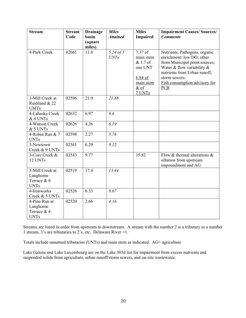
Stream Stream Code
Drainage basin (square
Miles Attained
Miles Impaired
Impairment Causes/ Sources/ Comments
miles) 4-Park Creek 02661 11.8 5.24 of 5
UNTs 7.37 of main stem & 1.7 of one UNT 6.84 of main stem & of 7 UNTs
Nutrients, Pathogens, organic enrichment/ low DO; other from Municipal point sources; Water & flow variability & nutrients from Urban runoff, storm sewers; Fish consumption advisory for PCB
3-Mill Creek at Rushland & 22 UMTs
02596 21.9 21.88
4-Lahaska Creek & 4 UNTs
02632 6.97 9.6
4-Watson Creek & 5 UNTs
02626 4.26 6.19
4-Robin Run & 7 UNTs
02598 2.27 5.76
3-Newtown Creek & 9 UNTs
02561 6.29 9.12
3-Core Creek & 12 UNTs
02543 9.77 15.82 Flow & thermal alterations & siltation from upstream impoundment and AG
3-Mill Creek at Langhorne Terrace & 8 UNTs
02519 17.4 13.44
4-Ironworks Creek & 5 UNTs
02526 6.33 9.67
4-Pine Run at Langhorne Terrace & 4 UNTs
02520 2.66 4.16
Streams are listed in order from upstream to downstream. A stream with the number 2 is a tributary to a number 1 stream, 3’s are tributaries to 2’s, etc. Delaware River =1. Totals include unnamed tributaries (UNTs) and main stem as indicated. AG= agriculture Lake Galena and Lake Luxembourg are on the Lake 303d list for impairment from excess nutrients and suspended solids from agriculture, urban runoff/storm sewers, and on-site wastewater.
20