the heart of neolithic orkney - microsoft azure
TRANSCRIPT


The Heart of Neolithic Orkney
World Heritage Site Research Agenda

Edited by
Jane Downes, Sally M Foster and C R Wickham-Jones
with Jude Callister
The Heart of Neolithic Orkney
World Heritage Site Research Agenda
Historic Scotland 2005

Published by Historic Scotland
ISBN 1 904966 04 7 © Individual authorsEdinburgh 2005
Project grant-aided by Historic Scotland,Orkney Islands Council and OrkneyHeritage Society, with support fromOrkney College UHI
As advisers to the World Heritage Committee, ICOMOS has
drawn up guidelines for the management of World Heritage
Sites and for research programmes to promote and co-ordinate
research in the area. In Orkney this important task has been
carried out with the contribution of a number of partners. It has
been a collaborative venture involving many experts who have
generously given freely of their time. I know that Historic
Scotland has been delighted to support the Orkney College
UHI in organising and co-ordinating the production of this
Research Agenda for Scotland’s first archaeological World
Heritage Site, The Heart of Neolithic Orkney.
We very much hope that this Research Agenda will prove a
model for Site managers throughout the world, as well as others
dealing with the challenges and opportunities of their local
archaeological inheritance elsewhere in Scotland.
Patricia Ferguson
Minister for Tourism, Culture and Sport
5
Dedicated to Daphne Home Lorimer,
prime mover in the setting up of
Orkney Archaeological Trust
and Chairman of the Trust
1996-2004
6
13 Foreword
15 List of contributors
17 Acknowledgements
Part 1: Agenda setting
20 Background20 Description and status of the Heart of Neolithic Orkney World Heritage Site
Jane Downes21 The context and purpose of the Research Agenda
Jane Downes23 Formulating the Agenda – the Archaeological and Historical Research Co-
ordination Committee Jane Downes
24 Structure of the Heart of Neolithic Orkney Research AgendaJane Downes and C R Wickham-Jones
25 Management of the World Heritage Site 25 Boundaries of the Site and its buffer zones
Jane Downes and Sally M Foster29 Setting of the WHS
Jane Downes and Sally M Foster30 The Management Plan
Jane Downes31 Management issues and threats
Sally M Foster and Management and Interpretation GroupProtect and maintainPresent and interpretAccess
33 Management and research Sally M Foster and Management and Interpretation Group
35 Defining the spatial and temporal research context of the World Heritage Site
35 Researching the landscapeDave Cowley, Jane Downes, Mark Edmonds and Landscape Group
37 Period-based research and temporalityColin Richards and Temporality and Period-based Research Group
Contents
7
Part 2: Resource assessment
40 History of prehistoric researchNick Card
46 Assessment of the prehistoric periodsNick Card
46 Pre-Neolithic OrkneyThe pre-Neolithic World Heritage Site and Inner Buffer Zones
47 Neolithic OrkneyThe Neolithic World Heritage Site and Inner Buffer Zones
56 Bronze Age OrkneyThe Bronze Age World Heritage Site and Inner Buffer Zones
61 Iron Age OrkneyThe Iron Age World Heritage Site and Inner Buffer Zones
66 Assessment of the historic period Sarah Jane Grieve with Julie Gibson
66 Orkney Viking period (c800-1065)The Viking period World Heritage Site and Inner Buffer Zones
69 Orkney late Norse period (1065–1231)The late Norse period World Heritage Site and Inner Buffer Zones
71 Late medieval Orkney (1231-1615)The late medieval World Heritage Site and Inner Buffer Zones
74 Post-medieval Orkney (1615–1840)The post-medieval World Heritage Site and Inner Buffer Zones
77 Modern Orkney (1840–1945) The modern period World Heritage Site and Inner Buffer Zones
Part 3: Research themes
80 Artefacts, monuments and cultural identitySiân Jones, Colin Richards and Artefacts, Monuments and Cultural Identity Group
81 The materialisation of memory and identity83 The social construction and constitution of monuments: questions of architecture,
place, the human body and materiality84 The past in the present: the rôle of monuments in the production of contemporary
narratives, memories and cultural practices86 Representing monuments: the place of archaeological materials in folklore,
literature, map-making, art and other forms of visual depiction
87 The formation and utlilisation of the landscapeIngrid Mainland, Ian A Simpson, Richard Tipping, Palaeoenvironment and EconomyGroup, and Formation Processes and Dating group
89 Climate change and Holocene environments 92 Biogeography: migration, colonisation and extinction93 Agricultural landscapes, diet and subsistence95 Exchange circulation, status, identity and ritual activity
8
Part 4: Techniques96 Introduction
96 Dating Patrick Ashmore and David Sanderson
96 Background96 Radiocarbon/AMS Dating97 Luminescence dating97 Palaeomagnetic dating97 Tephra98 Cosmogenic nuclides98 Radiogenic chronometers
98 GeophysicsJohn Gater
98 Background99 The World Heritage Site and Inner Buffer Zones - summary of results100 Development100 Prospecting100 Database
100 Field SurveyGraeme Wilson
101 Underwater explorationIan Oxley with Bobby Forbes
101 Background102 Archaeological investigation of submerged environments in Orkney102 Standards102 Collecting known information103 Assessing archaeological potential103 Evaluation techniques103 Excavation 103 Underwater methodologies
104 Aerial surveyKenneth Brophy
105 Geographical information systemsAngus Mackintosh
106 ExcavationJane Downes and C R Wickham-Jones
107 Soil and sediment analyses Ian A Simpson
107 Background107 Field survey107 Thin-section micromorphology and associated techniques 108 Biomarkers109 Modelling
9
109 Artefact analysisAndrew Jones and C R Wickham-Jones
109 Backgound110 Ceramics
Ceramics and community identitiesCeramic technology and settlement histories
111 Stone toolsFlaked stone toolsProvenance and exchangeSocial context
112 Bone tools112 Haematite and ochre
112 Experimental archaeologyC R Wickham-Jones
113 Skeletal studies: human origins, diet and lifestyleC R Wickham-Jones
113 Ecofactual analysisC R Wickham-Jones
114 Palaeoenvironmental studiesC R Wickham-Jones
115 Historical and cartographic sourcesSarah Jane Grieve
115 Historical sources117 Cartographic sources
117 Qualitative interviewing and participant observationSiân Jones and Angela McClanahan
118 Museum-based studiesAnne Brundle
Part 5: Research strategy120 Introduction
120 Sustainable research Sally M Foster
121 Research rationaleJane Downes and C R Wickham-Jones
122 Sample research
122 Sample research topics: artefacts, monuments and culturalidentitySiân Jones, Colin Richards, Artefacts, Monuments and Cultural Identity Group, andTemporality and Period-Based Research Group
122 Archival assessment and synthesis122 Architectural life histories123 The creation of the monuments123 The life histories of artefacts123 Review and strategy for detailed physical and chemical studies of artefacts
10
123 Residue analysis123 Period-specific research on social identity123 Typological reviews124 Experimental archaeology124 Landscape survey124 Boundaries124 Astroarchaeological meanings124 Visitor surveys125 Contemporary experience125 The rôle of archaeology in education in Orkney125 Local history125 Literary research125 Folkloric research125 Visual representations and the perception of landscape125 Place-name research
126 Sample research topics: the formation and utilisation of thelandscape
Ingrid Mainland, Ian A Simpson, Richard Tipping, Palaeoenvironment and EconomyGroup, and Formation Processes and Dating group
126 Soil formation126 Modelling of landscape changes over time126 Monument formation processes126 Agricultural and social landscape formation processes126 A comprehensive programme of dating126 Existing bioarchaeological data127 Further excavation127 Modelling climatic change127 Initial post-glacial colonisation of Orkney 127 Use of plants, especially cultivated plants, in prehistoric Orkney127 Non-economic values and activities apparent in bioarchaeological evidence
128 Sample projectsAll Discussion Groups
128 Background128 Artefacts, monuments and cultural identity
Site specificWHS specificZone specificOrkney specific
130 The formation and utilisation of the landscapeSite specificWHS specificZone specificOrkney specific
131 Cross-themeWHS specificZone specificOrkney specific
131 Prioritisation of research Julie Gibson
11
133 Communication and disseminationC R Wickham-Jones
134 Logistics and fundingC R Wickham-Jones and Jane Downes
136 ManagementJane Downes and C R Wickham-Jones
137 Concluding comments
Part 6: Appendices
138 Appendix 1: Select investigations at the monuments in theWHSNick Card
138 Skara Brae139 Stones of Stenness140 Ring of Brodgar141 Maeshowe
143 Appendix 2: ResourcesNick Card
145 Appendix 3: Current student research relating to thearchaeology of OrkneyNick Card
146 Appendix 4: Table of archaeological fieldwork undertaken inOrkney 1945-2003Nick Card
147 Part 7: Extended bibliographyNick Card
12
13
Foreword
The Orkney World Heritage Site is indeedone of the glories of prehistory, not just ofScottish or of British prehistory, but ofworld prehistory. There can be few placesmore numinous than the walkway betweenthe Loch of Harray and the Loch ofStenness, with the Stones of Stenness onone side, with the Ring of Brodgar inprospect, and with the most perfect ofNeolithic tombs, Maeshowe, only a fewhundred metres away. It is always apleasure to celebrate these remarkablemonuments and their numerouscounterparts elsewhere in the OrkneyIslands.
This splendid volume is, however, verymuch more than a simple celebration. Itsets out to use the impetus offered by thestatus of ‘World Heritage Site’ in a veryactive way. Of course it considers fully thevarious problems offered by themanagement of what we now increasinglyrealise to be a priceless heritage. But itdoes more than that. It seeks ways ofunderstanding more fully just what thatheritage is, and of promoting the widerdissemination of that understanding.
For the archaeologist, Neolithic Orkney isone of the wonders of the ancient world. Itis quite exceptional anywhere, and withoutparallel in Europe, to be able to visit thewell preserved settlement sites, like SkaraBrae and the Knap of Howar, and thenwonderful funerary monuments, likeMidhowe or Quoyness or Isbister, andthen to go on to view these in a landscapein which the great central monuments,including the Ring of Brodgar, becomeincreasingly intelligible to us in theircontemporary setting. For the pace ofdiscovery is considerable. Today, throughthe revelations of the settlement at
Barnhouse, we understand very muchmore than we did 30 years ago when I wasexcavating at Quanterness andinvestigating the Ring of Brodgar andMaeshowe.
And as this admirable Agenda so clearlyindicates, our understanding of the WorldHeritage Site is enriched and amplified byour increased knowledge of the OrkneyIslands as a whole at that period. Thediscovery and excavation of newsettlement sites, and their thoughtfulintegration into a more ambitious notion ofthe Neolithic landscape holds the promiseof a much more comprehensive andcoherent view of Neolithic Orkney. Thereis a potential for further research herewhich is very well outlined in this report. Itis admirably open-ended and invites boththe intelligent amplification of what wealready know and the acquisition of newknowledge.
The report has a second great merit. Itrecognises fully that although it is the greatmonuments of the so-called ‘Neolithic’period that first attract us to the WorldHeritage Site, that Site and its landscape,like any land that has been lived andworked and loved for 6,000 years, is apalimpsest. That is to say it is an overlay: arecord of the life and work of more than a100 generations of Orcadians. It carries thetraces of the first visitors to Orkney in theMesolithic period. It has burials andsettlements of the still (to us) ratherobscure Bronze Age life of Orkney whichsucceeded the great floruit of the Neolithicperiod. With the brochs of the Iron Ageand then the Pictish settlements we have anew period of abundant evidence which issoon succeeded by the Norse settlementsand their Scottish successors. There are
available in a very systematic way but alsothe theoretical perspectives which may bedeveloped to inform such research, itoffers an encouraging exemplar. Themesof cultural identity and of socialconstruction are developed here in anadmirably pragmatic way. For sometimesin theoretical archaeology the theory is at arather abstract level which does not quiteengage with the practicalities of day-to-dayarchaeological research. Here the theoryhas been brought to bear upon the richavailable data for early Orkney with thepromise of generating further relevantdata, and hence new conclusions andperhaps even new theory. This is cutting-edge research. I predict that it will be usedquite widely, far beyond Orkney, as amodel of how such issues should betackled. The archaeology of Orkney is aresearch field of quite exceptional richness,by international as well as nationalstandards. It is well served by thisrefreshing appraisal.
Colin Renfrew
Patron, Orkney Archaeological Trust
14
ample indications of these phases withinthe World Heritage Area itself. But again itis to the Orkney Islands as a whole thatone has to look to obtain a fully diachronicview, and to discern the full richness ofwhat the great Orcadian poet GeorgeMackay Brown described as the tapestry ofthe past of Orkney.
This remarkable book is more than simplya ‘research agenda’, generously grant-aidedby Historic Scotland, the Orkney IslandsCouncil and Orkney Heritage Society, withsupport from Orkney College UHI. In thefirst place it is an up-to-date review of thestate not only of the World Heritage Siteitself but of archaeology and of the historicheritage in Orkney today. To realise socomprehensively the vision that the trueheritage encompasses the whole of Orkneyis already an important contribution. Anymanagement plan has to be concerned notonly with the physical integrity of the greatsites in guardianship but with theremarkable totality of the historic resourcewhich Orkney offers. By considering notonly the research techniques which are
15
Orkney WHS Archaeological andHistorical Research Co-ordinationCommittee members
Jane Downes, Orkney College UHI (Chair)Jude Callister (Assistant to the AHRCC)Anne Brundle, The Orkney MuseumSteve Callaghan, Orkney Islands CouncilNick Card, Orkney Archaeological TrustDave Cowley, RCAHMSMark Edmonds, University of SheffieldSally M Foster, Historic ScotlandJulie Gibson, Orkney Archaeological TrustDonna Heddle, Orkney College UHISiân Jones, University of Manchester Ingrid Mainland, University of BradfordTom Muir, The Orkney MuseumColin Renfrew, University of CambridgeColin Richards, University of ManchesterNiall Sharples, University of CardiffIan Simpson, University of Stirling
Symposium discussion groupmembers(group leader in bold)
LandscapeDave CowleyLaura CampbellAdrian ChallandsMark EdmondsJohn GaterRaymond LambRod McCullaghAngus MackintoshIan Oxley
Artefacts, monuments and culturalidentitySiân JonesAnne BrundleDonna HeddleTim IngoldAndrew JonesAngela McClanahanTom MuirFrank Zabriskie
Palaeoenvironment and economyIngrid MainlandJames BarrettRobert CraigieKeith DobneyKevin EdwardsDaphne LorimerRichard Tipping
Temporality and period-based researchColin RichardsKenny BrophyMartin CarruthersJane DownesSarah Jane GrieveColin RenfrewNiall SharplesCaroline Wickham-Jones
Formation processes and datingIan SimpsonPatrick AshmoreDavid SandersonGraeme Wilson
Management and interpretationSally M FosterDave BatchelorSteve CallaghanNick CardAmanda ChadburnSteve DockrillJulie Gibson
List of contributors
16
Contact list
Patrick Ashmore, Historic Scotland [email protected] Barrett, York University [email protected] Batchelor, English Heritage [email protected] Brophy, University of Glasgow [email protected] Brundle, Orkney Museums [email protected] Callaghan, Orkney Islands Council [email protected] Callister, Hoy, Orkney [email protected] Campbell, Scottish Natural Heritage [email protected] Card, Orkney Archaeological Trust [email protected] Carruthers, Manchester University [email protected] Amanda Chadburn, English Heritage [email protected] Challands, Helspton, Cambs [email protected] Dave Cowley, RCAHMS [email protected] Craigie, University of Sheffield [email protected] Dobney, University of Durham [email protected] Dockrill, University of Bradford [email protected] Downes, Orkney College UHI [email protected] Edmonds, University of Sheffield [email protected] Edwards, University of Aberdeen [email protected] M Foster, Historic Scotland [email protected] Gater, GSB Prospection [email protected] Gibson, Orkney Archaeological Trust [email protected] Grieve, Orkney College UHI [email protected] Heddle, Orkney College UHI [email protected] Ingold, Aberdeen University [email protected] Jones, University of Southampton [email protected]ân Jones, Manchester University [email protected] Lamb, North Highland College UHI [email protected] Lorimer, Orphir, Orkney [email protected] Mackintosh, University of Manchester [email protected] Mainland, Bradford University [email protected] McClanahan, University of Manchester [email protected] McCullagh, Historic Scotland [email protected] Muir, Orkney Museums [email protected] Oxley, English Heritage [email protected] Renfrew, University of Cambridge [email protected] Richards, University of Manchester [email protected] Sanderson, Scottish Universities Research and Reactor Centre [email protected] Sharples, University of Cardiff [email protected] Simpson, University of Stirling [email protected] Tipping, University of Stirling [email protected] Wickham-Jones, St Ola, Orkney [email protected] Wilson, EASE [email protected] Zabriskie, Birsay, Orkney [email protected]
Acknowledgements
17
The editors wish to thank the following people for their helpful comments on variousdrafts of the Research Agenda, and for their interest in the proceedings: Colleen Batey,Ian Baxter, Mary Baxter, Richard Bradley, David Breeze, Barbara Crawford, MerrynDineley, Bobby Forbes, Jim Hansom, Richard Jones, Fidelity Lancaster, WilliamLancaster, Anna Mukherjee, Melanie Pomeroy-Kellinger, Anna Ritchie, Graham Ritchie,Alan Saville and Richard Tipping. In addition we would like to thank all those who tookpart in the Symposium and discussions since then. This volume pulls together the workand ideas of many and we are grateful to everyone who has played a part.
The editors are grateful to Kate Towsey, Liz Gilmore and Jennifer Thoms for theexcellent work on the proof-reading and copy-editing. We would also like to thank allthose who have helped in the search for suitable illustrations; photos are accreditedindividually in the captions.
Funding and support for the Symposium was received with thanks from HistoricScotland, Orkney Islands Council and Orkney College.

18
Acronyms
19
AD After ChristAHRCC Archaeological and Historical Research Co-
ordination CommitteeAMS Accelerator mass spectrometryBC Before ChristBP Before present14C (dating) radiocarbonDNA Deoxyribonucleic acid EM Electromagnetic conductivityEMEC European Marine Energy CentreFOAT Friends of Orkney Archaeological TrustGIS Geographical information systemsGPR Ground penetrating radarHLA Historic Landuse AssessmentHS Historic ScotlandIBZ Inner Buffer ZoneICOMOS International Committee on Monuments and
SitesIFA Institute of Field ArchaeologistsOAT Orkney Archaeological TrustOBZ Outer Buffer ZoneOIC Orkney Islands CouncilOSL (dating) Optical stimulated luminescencePIC Property in CareLCA Landscape Character AssessmentNMRS National Monuments Record of ScotlandNMS National Museums of ScotlandRCAHMS Royal Commission on the Ancient and
Historical Monuments of ScotlandSNH Scottish Natural HeritageSMR Sites and Monuments RecordTL Thermoluminescence UK United KingdomUNESCO United Nations Educational, Scientific and
Cultural OrganisationWH World HeritageWHA World Heritage AreaWHS World Heritage SiteWHAGP World Heritage Area Geophysics
ProgrammeWWI World War OneWWII World War TwoZVI Zones of visual influence
00
Background
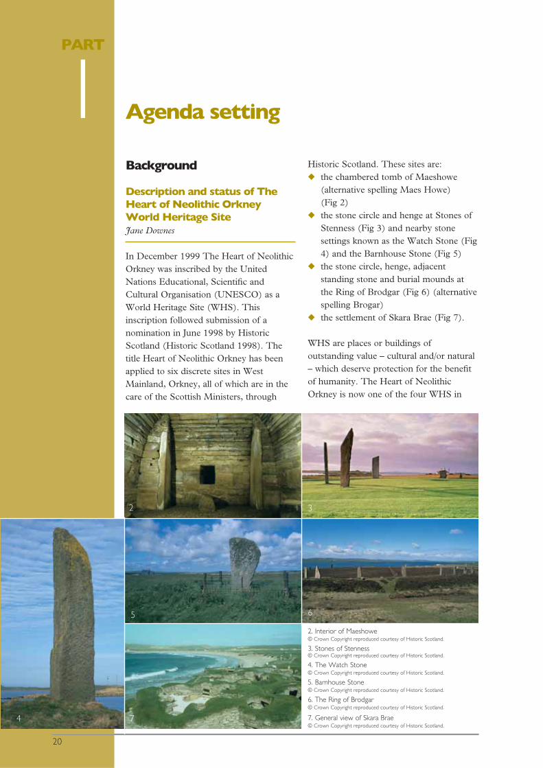
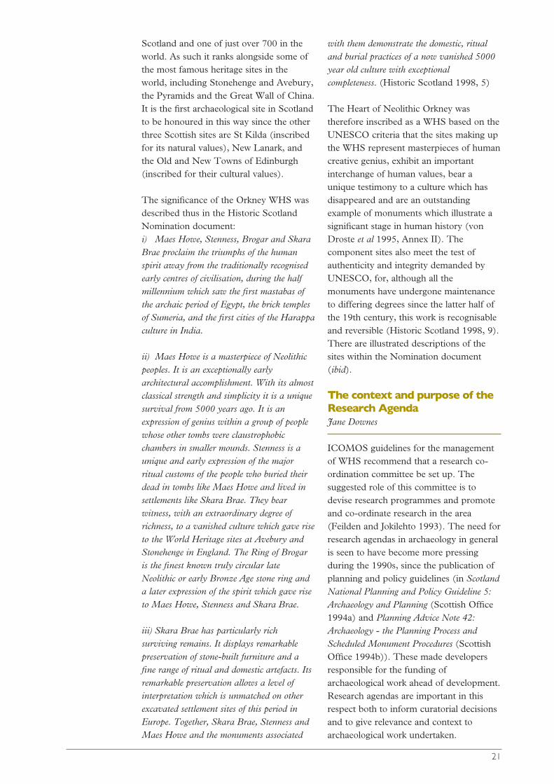
Description and status of TheHeart of Neolithic OrkneyWorld Heritage SiteJane Downes
In December 1999 The Heart of NeolithicOrkney was inscribed by the UnitedNations Educational, Scientific andCultural Organisation (UNESCO) as aWorld Heritage Site (WHS). Thisinscription followed submission of anomination in June 1998 by HistoricScotland (Historic Scotland 1998). Thetitle Heart of Neolithic Orkney has beenapplied to six discrete sites in WestMainland, Orkney, all of which are in thecare of the Scottish Ministers, through
Historic Scotland. These sites are: ◆ the chambered tomb of Maeshowe
(alternative spelling Maes Howe) (Fig 2)
◆ the stone circle and henge at Stones ofStenness (Fig 3) and nearby stonesettings known as the Watch Stone (Fig4) and the Barnhouse Stone (Fig 5)
◆ the stone circle, henge, adjacentstanding stone and burial mounds atthe Ring of Brodgar (Fig 6) (alternativespelling Brogar)
◆ the settlement of Skara Brae (Fig 7).
WHS are places or buildings ofoutstanding value – cultural and/or natural– which deserve protection for the benefitof humanity. The Heart of NeolithicOrkney is now one of the four WHS in
PART
1
2. Interior of Maeshowe © Crown Copyright reproduced courtesy of Historic Scotland.
3. Stones of Stenness © Crown Copyright reproduced courtesy of Historic Scotland.
4. The Watch Stone © Crown Copyright reproduced courtesy of Historic Scotland.
5. Barnhouse Stone © Crown Copyright reproduced courtesy of Historic Scotland.
6. The Ring of Brodgar © Crown Copyright reproduced courtesy of Historic Scotland.
7. General view of Skara Brae © Crown Copyright reproduced courtesy of Historic Scotland.
2
7
65
4
3
Agenda setting
20
21
Scotland and one of just over 700 in theworld. As such it ranks alongside some ofthe most famous heritage sites in theworld, including Stonehenge and Avebury,the Pyramids and the Great Wall of China.It is the first archaeological site in Scotlandto be honoured in this way since the otherthree Scottish sites are St Kilda (inscribedfor its natural values), New Lanark, andthe Old and New Towns of Edinburgh(inscribed for their cultural values).
The significance of the Orkney WHS wasdescribed thus in the Historic ScotlandNomination document:i) Maes Howe, Stenness, Brogar and SkaraBrae proclaim the triumphs of the humanspirit away from the traditionally recognisedearly centres of civilisation, during the halfmillennium which saw the first mastabas ofthe archaic period of Egypt, the brick templesof Sumeria, and the first cities of the Harappaculture in India.
ii) Maes Howe is a masterpiece of Neolithicpeoples. It is an exceptionally earlyarchitectural accomplishment. With its almostclassical strength and simplicity it is a uniquesurvival from 5000 years ago. It is anexpression of genius within a group of peoplewhose other tombs were claustrophobicchambers in smaller mounds. Stenness is aunique and early expression of the majorritual customs of the people who buried theirdead in tombs like Maes Howe and lived insettlements like Skara Brae. They bearwitness, with an extraordinary degree ofrichness, to a vanished culture which gave riseto the World Heritage sites at Avebury andStonehenge in England. The Ring of Brogaris the finest known truly circular lateNeolithic or early Bronze Age stone ring anda later expression of the spirit which gave riseto Maes Howe, Stenness and Skara Brae.
iii) Skara Brae has particularly richsurviving remains. It displays remarkablepreservation of stone-built furniture and afine range of ritual and domestic artefacts. Itsremarkable preservation allows a level ofinterpretation which is unmatched on otherexcavated settlement sites of this period inEurope. Together, Skara Brae, Stenness andMaes Howe and the monuments associated
with them demonstrate the domestic, ritualand burial practices of a now vanished 5000year old culture with exceptionalcompleteness. (Historic Scotland 1998, 5)
The Heart of Neolithic Orkney wastherefore inscribed as a WHS based on theUNESCO criteria that the sites making upthe WHS represent masterpieces of humancreative genius, exhibit an importantinterchange of human values, bear aunique testimony to a culture which hasdisappeared and are an outstandingexample of monuments which illustrate asignificant stage in human history (vonDroste et al 1995, Annex II). Thecomponent sites also meet the test ofauthenticity and integrity demanded byUNESCO, for, although all themonuments have undergone maintenanceto differing degrees since the latter half ofthe 19th century, this work is recognisableand reversible (Historic Scotland 1998, 9).There are illustrated descriptions of thesites within the Nomination document(ibid).
The context and purpose of theResearch AgendaJane Downes
ICOMOS guidelines for the managementof WHS recommend that a research co-ordination committee be set up. Thesuggested role of this committee is todevise research programmes and promoteand co-ordinate research in the area(Feilden and Jokilehto 1993). The need forresearch agendas in archaeology in generalis seen to have become more pressingduring the 1990s, since the publication ofplanning and policy guidelines (in ScotlandNational Planning and Policy Guideline 5:Archaeology and Planning (Scottish Office1994a) and Planning Advice Note 42:Archaeology - the Planning Process andScheduled Monument Procedures (ScottishOffice 1994b)). These made developersresponsible for the funding ofarchaeological work ahead of development.Research agendas are important in thisrespect both to inform curatorial decisionsand to give relevance and context toarchaeological work undertaken.
In 1996 Adrian Olivier producedFrameworks for Our Past, a survey ofEnglish Heritage research frameworks andan exploration of the definition, purposeand future of research frameworks. Thisdocument was part of an English Heritageinitiative concerning the facilitation ofregional research frameworks. It included areconsideration of strategy in the light ofwhat had been achieved since theproduction of their national researchstrategy: Exploring our Past; Strategies forthe Archaeology of England (EnglishHeritage 1991). This has been followed upby the production of a research agenda forthe Archaeology Division of EnglishHeritage, now published, together with animplementation plan, as Exploring our Past(English Heritage 2003). In 1997 HistoricScotland published State-funded ‘Rescue’Archaeology in Scotland. As a contributionto discussions on future directions ofScottish archaeology this attempted toidentify, on a period by period basis, gapsin knowledge. There have been movestowards developing a research agenda forWales, the first stage of which was aconference held in September 2001(Geary 2001). In England, some regionalresearch frameworks have recently beendeveloped or are in the process of beingdeveloped - for example for East Anglia,East Anglia Research and Archaeology: AFramework for the Eastern Counties (Brownand Glazebrook (eds) 2000) and for theEast Midlands, The East MidlandsArchaeological Research Framework Project(http://www.le.ac.uk/ar/east midlandsresearch framework.htm, visited Dec2003). Research agendas may also be usedto look at specific themes in more detail. In1999 the Prehistoric Society published aresearch framework for the Palaeolithicand Mesolithic of Britain (PrehistoricSociety 1999) and a research agendacovering the Iron Age across Britain hasbeen published (Haselgrove et al 2001).
Stonehenge and Avebury were inscribed in1986 as a single UNESCO WHS knownas the Stonehenge, Avebury andAssociated Sites WHS. This is perhaps themost comparable WHS to the Orkneyexample, except that the designated area is
much larger, comprising some 2000 ha.Avebury and Stonehenge each have theirown management plans (English Heritage1998; 2000). A research agenda has beenpublished for Avebury by the AveburyArchaeological and Historical ResearchGroup, publication funded by EnglishHeritage (AAHRG 2001). EnglishHeritage has commissioned BournemouthUniversity Department of ConservationSciences to develop a research frameworkfor Stonehenge(http://apollo5.bournemouth.ac.uk/consci/stonehenge/, visited Dec 2003).
Olivier defines a research framework as apiece of work which incorporates aresource assessment - defined as ‘astatement of the current state of knowledgeand a description of the archaeologicalresource’, an agenda - defined as ‘a list ofthe gaps in that knowledge, of work whichcould be done, and of the potential for theresource to answer questions’ and astrategy - defined as ‘a statement settingout priorities and methods’ (Olivier 1996,5).
The overall aims of the Orkney WHSResearch Agenda are to lead to animproved understanding of the WHS andits setting by:◆ defining the scope of research around
the WHS;◆ outlining the potential of the area to
answer research questions;◆ identifying gaps in knowledge;◆ encouraging inter-disciplinary research
into a broad spectrum of topics withinthe WHS and its wider context;
◆ encouraging research which willcontribute to enhanced management,preservation, conservation andinterpretation;
◆ encouraging research with widermethodological and/or theoreticalapplications.
In seeking to address these aims it wasdecided to adopt a different structure tothe majority of the research documentsmentioned above. In particular, the period-by-period approach to the definition of theresearch themes has been eschewed in
22
favour of a more thematic approach. Thisavoids the problems of repetition commonto many who seek to provide a multi-period view, it makes for a clearerdiscussion of the main issues ofarchaeological research and takes accountof the main trends of archaeologicalthought and research today. The structureof the document is set out in more detailbelow (p 24).
Formulating the Agenda - theArchaeological and HistoricalResearch Co-ordinationCommittee Jane Downes
In 2001 an Archaeological and HistoricalResearch Co-ordination Committee(AHRCC) for the Orkney WHS wasestablished by Jane Downes of OrkneyCollege, UHI Millennium Institute(UHIMI) with encouragement andfunding from Historic Scotland and fromOrkney Islands Council. The Committee’smembership is drawn from OrkneyCollege, Orkney Archaeological Trust,Orkney Heritage (incorporating themuseum service), Orkney Islands Council,Historic Scotland, the Royal Commissionon the Ancient and Historical Monumentsof Scotland (RCAHMS) and theUniversities of Sheffield, Manchester,Bradford, Cambridge, Cardiff and Stirling.
The aims of the AHRCC are to promote,stimulate and co-ordinate research into allperiods and relevant aspects of the WorldHeritage Area (WHA - see definitionbelow). Rather than the AHRCC devisingresearch programmes (Feilden andJokilehto 1993), its job has been to workwith a wider group to draw up thisResearch Agenda, which takes fullcognisance of national and internationalcuratorial and research considerations andwill help ensure that methods of researchare sustainable and compatible with theprotection of WHS values.
The principal mechanism for theformulation of the Research Agenda was asymposium which was held in April 2001.The majority of the Committee attended
the symposium, as did a number of otherdelegates from government agencies,universities and independent specialists(see list of contributors). The symposiumwas seen as key to facilitating theidentification of the research issues.Discussion and workshops were structuredaround a number of pre-set researchstrands into which participants were placedaccording to their area of expertise. Thesestrands were: Landscape; Artefacts,Monuments and Cultural Identity;Temporality and Period-based Study;Formation Processes and Dating;Palaeoenvironment and Economy; andManagement and Interpretation. A memberof the AHRCC led each discussion groupand wrote up the outcome of thediscussions in consultation with themembers of the discussion group. Theemerging document was circulated forcomment among the Committee, to thosewho attended the symposium and otherswho had expressed interest in theformulation of the Agenda.
Jane Downes (Chair AHRRC), CarolineWickham-Jones and Sally Foster edited thetexts, while Jude Callister (Assistant toChair) circulated further drafts and co-ordinated responses. Further texts weresolicited from various authors for theresource assessment, appendices of theResearch Agenda and the techniquessection of the strategy.
The process of producing this ResearchAgenda has already served to stimulateresearch in the WHS (eg the PhDstudentship of Angie McClanahan oncontemporary perceptions of thearchaeology, Manchester University,funded by Historic Scotland, see belowPart 5; the PhD studentship on soilanalysis at Stirling University fundedjointly by Stirling University and HistoricScotland, see Part 3; and large scalegeophysical survey in the Brodgar andStones of Stenness area by GSBProspection for OAT, funded by HistoricScotland and Orkney Islands Council, Part5). The work of the Committee willcontinue, both in the implementation ofthe strategy and in the periodic reviews of
23
this document so that the Agenda andstrategy retain relevance and currency. Inthis way, information gained from researchwill be relayed back into future researchand management strategies as well aspresented to the public at everyopportunity through a variety of media asappropriate.
Structure of The Heart ofNeolithic Orkney ResearchAgenda Jane Downes and C R Wickham-Jones
The Research Agenda presents andconsiders the WHS in its broaderarchaeological, historical and culturalcontext. It includes the research strategywhich presents ways by which researchaims might be achieved. Together thesetwo provide a research framework, whichis not intended to determine a programmeof action, but rather to highlight issues andproblems that could usefully be addressed.
In the process of pulling together theresearch strands, significant overlapsbecame apparent with the result that thestrands were merged into just two broadthemes: ◆ Artefacts, Monuments and Cultural
Identity◆ The Formation and Utilisation of the
LandscapeThese themes are discussed in detail below(Part 3).
Although this might, at first glance, appearto be minimalist, this approach has led tothe identification of central research issueswhich cross both temporal and spatialboundaries, so that a flexible and non-prescriptive agenda can be produced. Aperiod-by-period approach was felt to havethe potential of being repetitive andconfusing for discussion of research thataimed to cover the broad scope weintended. Period-based information has,however, a valid place in the resourceassessment (Part 2). The resourceassessment describes the history ofresearch in the Orkney WHS, which isinstructive in explaining how the
monuments and interpretations wereshaped by the interest of individuals andby various strategies in excavation andpresentation. This is followed by asummary account of the current state ofknowledge which is structuredchronologically following the basis formost previous research. In this way thegaps in knowledge of the WHS can behighlighted. There are admittedly tensionsbetween the static nature of the ‘timeslices’ outlined in the resource assessmentand the more dynamic nature of theresearch themes discussed in Part 3, but itis not difficult to move between the twoapproaches and this reflects the currenttrends of archaeological thought.
Each of the two general research themes issub-divided into more specific fields fromwhich sample research topics have beenidentified. These topics are by no meansexhaustive. Specific research projects,extracted from the research themes, andwith an indication of how these might beprioritised, have been incorporated in thestrategy.
An extended bibliography has beenincluded in the document. This comprisesa substantial amount of sources in additionto those referred to in the text. Appendix 1lists, by individual site, select investigationsundertaken within the WHS. In Appendix2 the nature and location ofsources/materials pertaining to Orkney’sarchaeology and history are described (egmuseums, databases etc). Appendix 3comprises a list of current postgraduatestudent research relating to thearchaeology of Orkney. Between theresource assessment, the extendedbibliography and the appendices, theResearch Agenda will serve as an audit anda resource in itself for would-beresearchers. Appendix 4 provides anexhaustive list of archaeological fieldwork(survey, geophysical survey, excavation)undertaken in Orkney since 1945, withbibliographic references where a site ispublished, location of finds, etc.
24
Management of the WHS
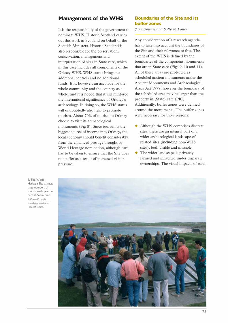
It is the responsibility of the government tonominate WHS. Historic Scotland carriesout this work in Scotland on behalf of theScottish Ministers. Historic Scotland isalso responsible for the preservation,conservation, management andinterpretation of sites in State care, whichin this case includes all components of theOrkney WHS. WHS status brings noadditional controls and no additionalfunds. It is, however, an accolade for thewhole community and the country as awhole, and it is hoped that it will reinforcethe international significance of Orkney’sarchaeology. In doing so, the WHS statuswill undoubtedly also help to promotetourism. About 70% of tourists to Orkneychoose to visit its archaeologicalmonuments (Fig 8). Since tourism is thebiggest source of income into Orkney, thelocal economy should benefit considerablyfrom the enhanced prestige brought byWorld Heritage nomination, although carehas to be taken to ensure that the Site doesnot suffer as a result of increased visitorpressure.
Boundaries of the Site and itsbuffer zonesJane Downes and Sally M Foster
Any consideration of a research agendahas to take into account the boundaries ofthe Site and their relevance to this. Theextent of the WHS is defined by theboundaries of the component monumentsthat are in State care (Figs 9, 10 and 11).All of these areas are protected asscheduled ancient monuments under theAncient Monuments and ArchaeologicalAreas Act 1979; however the boundary ofthe scheduled area may be larger than theproperty in (State) care (PIC).Additionally, buffer zones were definedaround the monuments. The buffer zoneswere necessary for three reasons:
◆ Although the WHS comprises discretesites, these are an integral part of awider archaeological landscape ofrelated sites (including non-WHSsites), both visible and invisible.
◆ The wider landscape is privatelyfarmed and inhabited under disparateownerships. The visual impacts of rural
25
8. The WorldHeritage Site attractslarge numbers oftourists each year, ashere at Skara Brae © Crown Copyright
reproduced courtesy of
Historic Scotland.

development, together with theenvironmental and visual impacts oftourism, could impact adversely onWorld Heritage values and thus needsome form of management or control.
◆ The Orkney landscape is open andtreeless with wide vistas and views toand from the monuments.Inappropriately or badly siteddevelopment within the broad areacould erode the World Heritage valuesof the sites, particularly cumulativelyand over time.
The WHS comprises two, geographicallyseparate areas (Fig 9). Each of these areas
has its own tier of two buffer zones: ◆ an Inner Buffer Zone (IBZ) drawn
fairly tightly around the principal sitesthemselves;
◆ a larger, more general Outer BufferZone (OBZ).
The intention of this layered approach wasto protect both the immediate settings ofthe sites and areas of high archaeologicalvalue, as well as their wider landscapesetting. Following advice from ICOMOS-UK, the boundaries of existing statutorydesignations were used to define theboundaries of these two levels of bufferzone. Built heritage, nature conservation
26
PAPA WESTRAY
WESTRAY
EDAY
GAIRSAY
SHAPINSAY
BURRAY
SOUTHRONALDSAY
FLOTTA
John O' Groats
STROMA
Thurso
Kirkwall
ROUSAY
A
ND
SANDAY
STRONSAY
Bay of Skaill
NORTH RONALDSAY
ScrabsterC A I T H N E S S
Skara
S C O T L A N D
M
LA
5
0 Scale:- 4cm to 10 km
0
5
km
mls
PROPERTYMAPS
NSA BOUNDARY
I
N
H O Y
Brae
Stromness
9. Map of Orkneyshowing the locationof the WorldHeritage Siteproperty maps (Figs10 and 11) andextent of theNational Scenic Area(NSA) © Crown Copyright
reproduced courtesy of
Historic Scotland.

27
10. Map showing location of the Ring of Brodgar, Maeshowe, Stones ofStenness, Watch Stone and Barnhouse Stone components of theWorld Heritage Site, as well as sites in the vicinity (for wider contextsee Fig 9) © Crown Copyright reproduced courtesy of Historic Scotland.
11. Map showing location of Skara Brae component of the WorldHeritage Site (for wider context see Fig 9) © Crown Copyright reproduced courtesy of Historic Scotland.
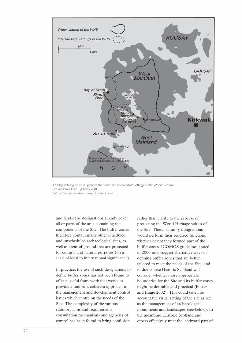
and landscape designations already coverall or parts of the area containing thecomponents of the Site. The buffer zonestherefore contain many other scheduledand unscheduled archaeological sites, aswell as areas of ground that are protectedfor cultural and natural purposes (on ascale of local to international significance).
In practice, the use of such designations todefine buffer zones has not been found tooffer a useful framework that works toprovide a uniform, coherent approach tothe management and development controlissues which centre on the needs of theSite. The complexity of the variousstatutory aims and requirements,consultation mechanisms and agencies ofcontrol has been found to bring confusion
rather than clarity to the process ofprotecting the World Heritage values ofthe Site. These statutory designationswould perform their required functionswhether or not they formed part of thebuffer zones. ICOMOS guidelines issuedin 2000 now suggest alternative ways ofdefining buffer zones that are bettertailored to meet the needs of the Site, andin due course Historic Scotland willconsider whether more appropriateboundaries for the Site and its buffer zonesmight be desirable and practical (Fosterand Linge 2002). This could take intoaccount the visual setting of the site as wellas the management of archaeologicalmonuments and landscapes (see below). Inthe meantime, Historic Scotland andothers effectively treat the landward part of
28
Stones ofStenness
Ring ofBrodgar
Skara Brae
West Mainland
West Mainland
Loch ofStenness
Mountain ridge of Hoy forming detached boundary of wider setting
Loch ofHarray
Maeshowe
12. Map defining on visual grounds the wider and intermediate settings of the World HeritageSite (redrawn from Tyldesley 2001 © Crown Copyright reproduced courtesy of Historic Scotland.
the IBZ as the Site, in the Brodgar area atleast, in the sense that this is the focus ofattention.
Setting of the WHS Jane Downes and Sally M Foster
In 2000 Scottish Natural Heritage (SNH)and Historic Scotland became partners in alandscape capacity project that focussedon the setting of the WHS. Building onLandscape Character Assessment (LCA)and Historic Landuse Assessment (HLA),the aim of the project was to provideguidance on if, how and where newdevelopment could best be accommodatedin the area (Tyldesley 2001). The studyassessed both landscape and visual aspects.In doing so it also explored how the twoprocesses of LCA (undertaken by SNH:Land Use Consultants 1998) and the HLA(undertaken by Historic Scotland and theRCAHMS: Dyson Bruce et al 1999) mightbe integrated. One significant outcome ofthe project, of particular relevance here,was the definition of a hierarchical tier ofsettings for the WHS which has apredominantly visual relevance (Fig 12).These settings were largely created on thebasis of visual envelopes (everything thatcan be seen from specific view points, keymonuments in this instance) and Zones ofVisual Influence (ZVI), areas which arevisually sensitive to different scales ofchange.
29
Three types of setting were identified forthe WHS: ◆ Immediate - where very small changes
could markedly affect the intimateexperience, ambience and enjoyment ofthe Site. This should be regarded as aflexible and changing area;
◆ Intermediate - where visible changesabout the same size as a human figure(or larger) could affect the character,and people's perception and enjoyment,of the Site;
◆ Wider - where large scale builtdevelopments in the wider settingand/or approaches could affect people'simage, perception and enjoyment of theSite.
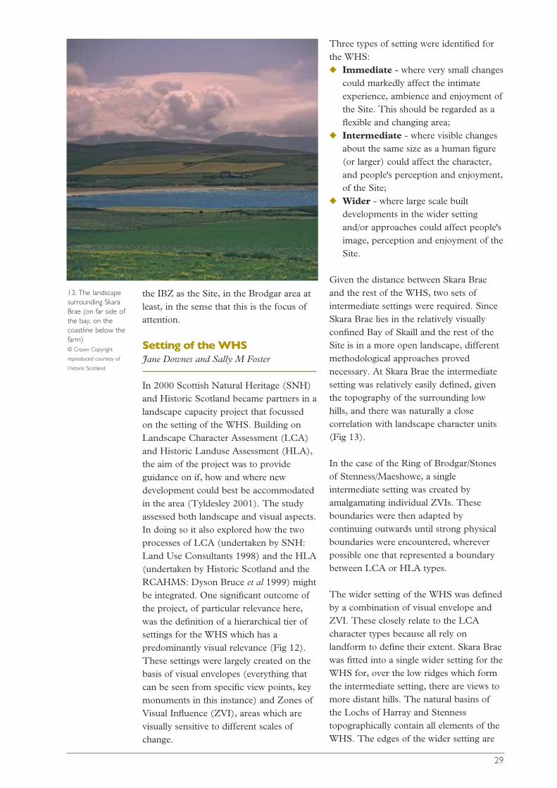
Given the distance between Skara Braeand the rest of the WHS, two sets ofintermediate settings were required. SinceSkara Brae lies in the relatively visuallyconfined Bay of Skaill and the rest of theSite is in a more open landscape, differentmethodological approaches provednecessary. At Skara Brae the intermediatesetting was relatively easily defined, giventhe topography of the surrounding lowhills, and there was naturally a closecorrelation with landscape character units(Fig 13).
In the case of the Ring of Brodgar/Stonesof Stenness/Maeshowe, a singleintermediate setting was created byamalgamating individual ZVIs. Theseboundaries were then adapted bycontinuing outwards until strong physicalboundaries were encountered, whereverpossible one that represented a boundarybetween LCA or HLA types.
The wider setting of the WHS was definedby a combination of visual envelope andZVI. These closely relate to the LCAcharacter types because all rely onlandform to define their extent. Skara Braewas fitted into a single wider setting for theWHS for, over the low ridges which formthe intermediate setting, there are views tomore distant hills. The natural basins ofthe Lochs of Harray and Stennesstopographically contain all elements of theWHS. The edges of the wider setting are
13. The landscapesurrounding SkaraBrae (on far side ofthe bay, on thecoastline below thefarm) © Crown Copyright
reproduced courtesy of
Historic Scotland.
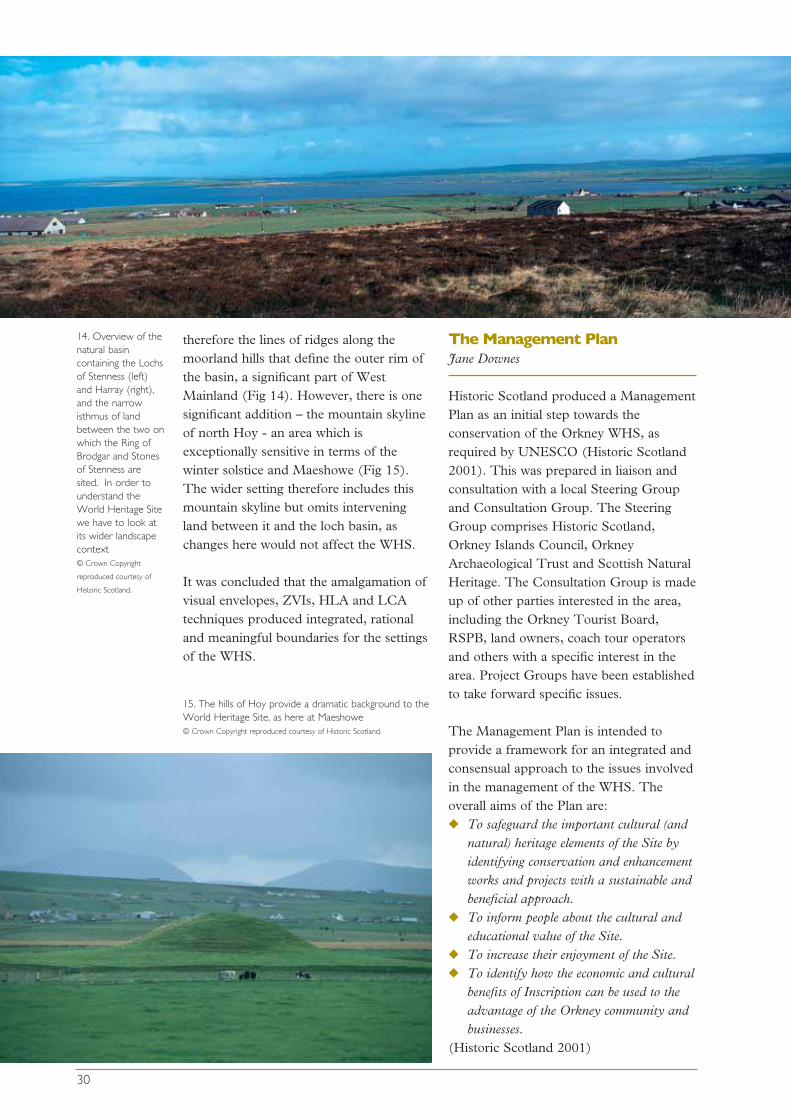
therefore the lines of ridges along themoorland hills that define the outer rim ofthe basin, a significant part of WestMainland (Fig 14). However, there is onesignificant addition – the mountain skylineof north Hoy - an area which isexceptionally sensitive in terms of thewinter solstice and Maeshowe (Fig 15).The wider setting therefore includes thismountain skyline but omits interveningland between it and the loch basin, aschanges here would not affect the WHS.
It was concluded that the amalgamation ofvisual envelopes, ZVIs, HLA and LCAtechniques produced integrated, rationaland meaningful boundaries for the settingsof the WHS.
The Management PlanJane Downes
Historic Scotland produced a ManagementPlan as an initial step towards theconservation of the Orkney WHS, asrequired by UNESCO (Historic Scotland2001). This was prepared in liaison andconsultation with a local Steering Groupand Consultation Group. The SteeringGroup comprises Historic Scotland,Orkney Islands Council, OrkneyArchaeological Trust and Scottish NaturalHeritage. The Consultation Group is madeup of other parties interested in the area,including the Orkney Tourist Board,RSPB, land owners, coach tour operatorsand others with a specific interest in thearea. Project Groups have been establishedto take forward specific issues.
The Management Plan is intended toprovide a framework for an integrated andconsensual approach to the issues involvedin the management of the WHS. Theoverall aims of the Plan are:◆ To safeguard the important cultural (and
natural) heritage elements of the Site byidentifying conservation and enhancementworks and projects with a sustainable andbeneficial approach.
◆ To inform people about the cultural andeducational value of the Site.
◆ To increase their enjoyment of the Site.◆ To identify how the economic and cultural
benefits of Inscription can be used to theadvantage of the Orkney community andbusinesses.
(Historic Scotland 2001)
30
14. Overview of thenatural basincontaining the Lochsof Stenness (left)and Harray (right),and the narrowisthmus of landbetween the two onwhich the Ring ofBrodgar and Stonesof Stenness aresited. In order tounderstand theWorld Heritage Sitewe have to look atits wider landscapecontext © Crown Copyright
reproduced courtesy of
Historic Scotland.
15. The hills of Hoy provide a dramatic background to theWorld Heritage Site, as here at Maeshowe © Crown Copyright reproduced courtesy of Historic Scotland.
Encouraging the formation of a researchcommittee is one of the cited objectives inthe Management Plan and many of thespecific aims of the Management Plan arerelevant to the work of the AHRCC. Therelevant aims are:
3: increase people’s recognition, understandingand enjoyment of the Site and theirunderstanding and enjoyment of Orkney andthe rest of Scotland’s past.
4: ensure that management of the Site isguided and informed by appropriateknowledge of development of the Site and itssurroundings through time.
9: policies be directed towards positivemeasures for the enhancement of the Site andits Buffer Zones so that they benefit incharacter, appearance and setting, whilecontinuing to support the economy of Orkneyand the social well- being of those living there.
10: encourage appropriate and sympatheticland uses in the Buffer Zones in order toprotect monuments from degradation andfrom potentially damaging works that do notrequire planning permission, and to protectand enhance their setting.
11: policies should recognise that culturalheritage is more than the visible upstandingstructures in the Site and Buffer Zones.
12: establish an accurate picture of thecondition and vulnerability of all monumentsin the Site and Inner Buffer Zones.
13: all activities on the Site and all activitiesaffecting the natural heritage in the vicinity ofthe Site should be based on principles ofenvironmental sustainability.
14: every effort should be made to integrateand enhance the interests of the cultural andnatural heritage, balancing the respectiveneeds of each other.
15: policies for development on the Site andadjacent to it should reflect the internationalimportance and the sensitivity of the Site andits setting.
16: ensure that the policies for development onthe Site and adjacent to it should lead tobenefits for the economy of local people and ofOrkney as a whole.
17: help develop sustainable tourism byencouraging dispersal of visitors to more of thevarious visitor attractions in Orkney, and byevening out the concentrations of numbers atparticular times and locations.
18: ensure that policies relating to visitors tothe Site emphasise quality tourism andencourage longer stays and higher spending inOrkney.
19: ensure that there are good facilities forpeople with disabilities by including provisionfor their needs in all schemes for enhancementat the Site (ibid).
Management issues and threatsSally M Foster and Interpretation andManagement Group
Management of the WHS has manydifferent facets of which the main ones canbe broadly summarised as: ◆ protecting the resource and
maintaining it in its optimumcondition;
◆ effectively and sympatheticallypresenting and interpreting the Site;
◆ facilitating visitor access in the mostappropriate and safe manner;
◆ research to increase understanding ofthe resource and its management.
The first of these can equally be applied tothose monuments in the wider landscape,beyond the formal boundaries of the Site,which are in private ownership and forwhich, unlike the Site, no formal publicaccess exists. Here the land is used almostexclusively for agricultural purposes(although the possibility of underwaterarchaeology in the lochs and sea cannot beexcluded). The question of how researchfits into management strategies is discussedin the next section.
Protect and maintainPut simply, protecting the Orkney WHSand maintaining it in its optimum
31
condition means avoiding grounddisturbance or disturbance of the fabric ofthe monuments and attempting topostpone natural decay processes.Disturbance can be caused by humans,animals – cattle, sheep and rabbits – or theroots of inappropriate vegetation. Naturaldecay processes include decay of stone – aparticular concern if these are carved - andcoastal erosion. Any human interventionsinto the ground or fabric of the Site andprotected monuments in the widerlandscape require prior consent from theScottish Ministers (scheduled monumentconsent) and can be controlled in thismanner.
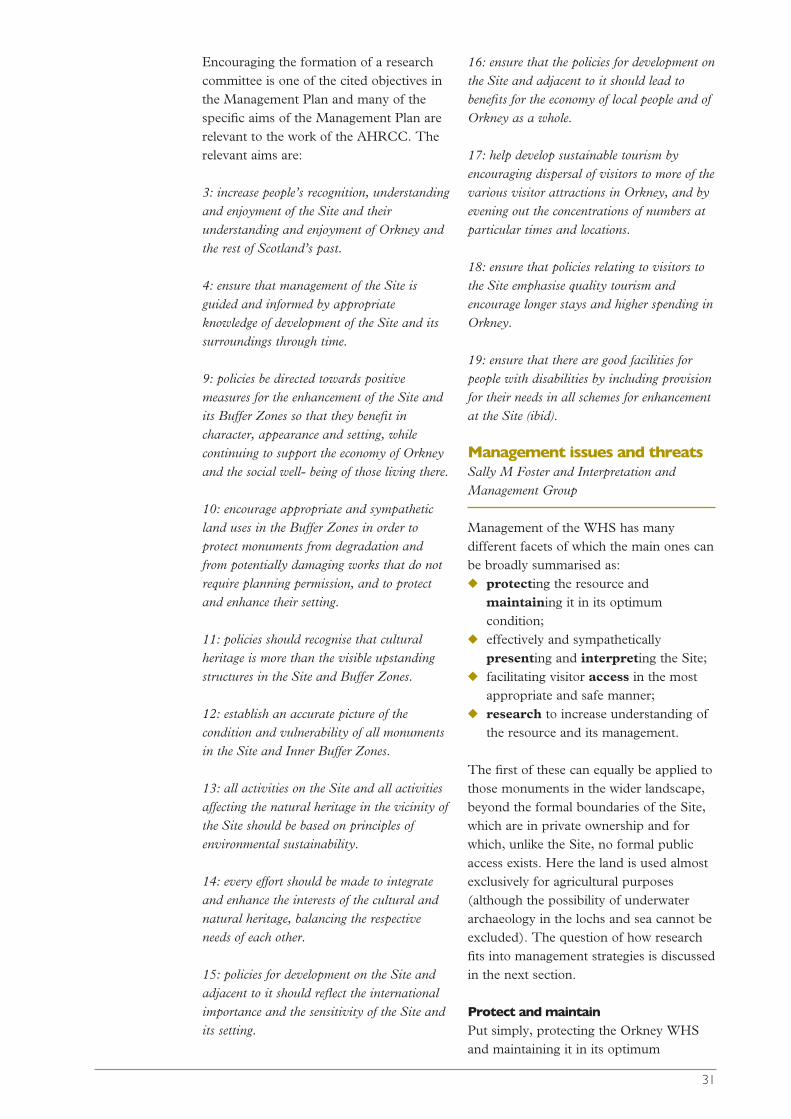
More difficult to prevent is the irreversibleground erosion caused by the largenumber of visitors (Fig 16), a problemexacerbated when conditions are wet. Thisis a serious problem at the Ring of Brodgardespite Historic Scotland’s repeated andregular efforts to manage visitormovements in a variety of different ways.Unlike the surrounding area where erosionby animals and ploughing is causingattrition of both the visible and sub-surfacearchaeology, the only agricultural use ofany part of the Site is limited grazing by
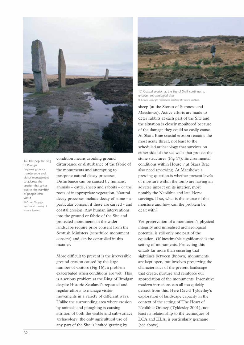
sheep (at the Stones of Stenness andMaeshowe). Active efforts are made todeter rabbits at each part of the Site andthe situation is closely monitored becauseof the damage they could so easily cause.At Skara Brae coastal erosion remains themost acute threat, not least to thescheduled archaeology that survives oneither side of the sea walls that protect thestone structures (Fig 17). Environmentalconditions within House 7 at Skara Braealso need reviewing. At Maeshowe apressing question is whether present levelsof moisture within the tomb are having anadverse impact on its interior, mostnotably the Neolithic and late Norsecarvings. If so, what is the source of thismoisture and how can the problem bedealt with?
Yet preservation of a monument’s physicalintegrity and unrealised archaeologicalpotential is still only one part of theequation. Of inestimable significance is thesetting of monuments. Protecting thisentails far more than ensuring thatsightlines between (known) monumentsare kept open, but involves preserving thecharacteristics of the present landscapethat create, nurture and reinforce ourappreciation of the monuments. Insensitivemodern intrusions can all too quicklydetract from this. Here David Tyldesley’sexploration of landscape capacity in thecontext of the setting of The Heart ofNeolithic Orkney (Tyldesley 2001), notleast its relationship to the techniques ofLCA and HLA, is particularly germane(see above).
32
16. The popular Ring of Brodgar requires groundsmaintenance andvisitor managementto address theerosion that arisesdue to the numberof people who visit it © Crown Copyright
reproduced courtesy of
Historic Scotland.
17. Coastal erosion at the Bay of Skaill continues touncover archaeological sites © Crown Copyright reproduced courtesy of Historic Scotland.
Much of the immediate and intermediatesetting of the WHS is an archaeologicallandscape of high value in its own right. Inthe present context it is significant thatHistoric Scotland and others effectivelytreat the IBZ at the Brodgar area as theSite in the sense that this is the focus ofattention. The WHS is best managed in aholistic sense that embraces the widercultural and natural landscape, anapproach that is more in accord with theOrcadian perception of what is significant(Foster and Linge 2002). Notably, mostefforts to improve visitor access andinterpretation will impact on land beyondthe boundary of the Site proper. HistoricScotland’s responsibilities do not stop atthe boundaries of the WHS. It has aresponsibility to ensure that scheduledancient monuments in private ownershipare protected and seeks to encourage and,where possible, facilitate their improvedmanagement.
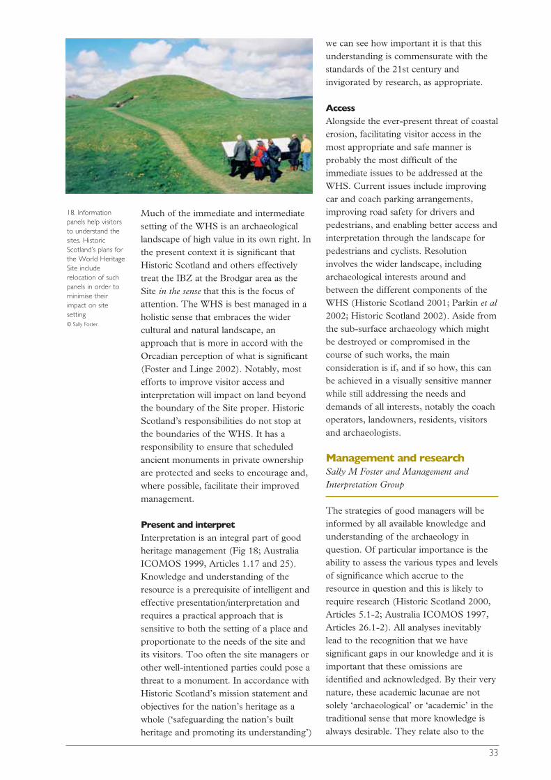
Present and interpretInterpretation is an integral part of goodheritage management (Fig 18; AustraliaICOMOS 1999, Articles 1.17 and 25).Knowledge and understanding of theresource is a prerequisite of intelligent andeffective presentation/interpretation andrequires a practical approach that issensitive to both the setting of a place andproportionate to the needs of the site andits visitors. Too often the site managers orother well-intentioned parties could pose athreat to a monument. In accordance withHistoric Scotland’s mission statement andobjectives for the nation’s heritage as awhole (‘safeguarding the nation’s builtheritage and promoting its understanding’)
we can see how important it is that thisunderstanding is commensurate with thestandards of the 21st century andinvigorated by research, as appropriate.
AccessAlongside the ever-present threat of coastalerosion, facilitating visitor access in themost appropriate and safe manner isprobably the most difficult of theimmediate issues to be addressed at theWHS. Current issues include improvingcar and coach parking arrangements,improving road safety for drivers andpedestrians, and enabling better access andinterpretation through the landscape forpedestrians and cyclists. Resolutioninvolves the wider landscape, includingarchaeological interests around andbetween the different components of theWHS (Historic Scotland 2001; Parkin et al2002; Historic Scotland 2002). Aside fromthe sub-surface archaeology which mightbe destroyed or compromised in thecourse of such works, the mainconsideration is if, and if so how, this canbe achieved in a visually sensitive mannerwhile still addressing the needs anddemands of all interests, notably the coachoperators, landowners, residents, visitorsand archaeologists.
Management and research Sally M Foster and Management andInterpretation Group
The strategies of good managers will beinformed by all available knowledge andunderstanding of the archaeology inquestion. Of particular importance is theability to assess the various types and levelsof significance which accrue to theresource in question and this is likely torequire research (Historic Scotland 2000,Articles 5.1-2; Australia ICOMOS 1997,Articles 26.1-2). All analyses inevitablylead to the recognition that we havesignificant gaps in our knowledge and it isimportant that these omissions areidentified and acknowledged. By their verynature, these academic lacunae are notsolely ‘archaeological’ or ‘academic’ in thetraditional sense that more knowledge isalways desirable. They relate also to the
33
18. Informationpanels help visitorsto understand thesites. HistoricScotland’s plans forthe World HeritageSite includerelocation of suchpanels in order tominimise theirimpact on sitesetting © Sally Foster.
management of the monuments and ourunderstanding of the interplay of past andpresent perceptions of the landscape. Suchunderstanding has to take on board thegeneral theory and practice of heritagemanagement and how and if this applies tothe specifics of the resource in question.For instance:◆ What is the relationship between what
now survives/is visible and what wasonce here?
◆ What factors have influenced this andour ability to recover such information?
◆ What is the present condition andvulnerability of monuments?
◆ How does the modern visitor engagewith what is here now and with whatwas happening here in the past?
◆ If we understand the behaviour ofdifferent categories of visitors at, andtowards, the monuments, can weprotect the monuments better?
◆ How can we discover and understandwhat visitors do, and do not perceive?Can this knowledge be used to informinterpretation strategies (cf Ucko 2000,72)?
We can conclude that good sitemanagement requires ongoing, focussedresearch. The nub of the matter is howmuch destruction of the resource isacceptable to achieve this? Put anotherway: how much of the Site is a criticalasset that should be conserved at all costs;how much is a constant asset that might besubject to change providing that the overallcharacter of the resource, notably itsappearance, is maintained; and how muchis tradable, might be destroyed in returnfor other benefits? What is the‘environmental threshold’ beyond whichsuch an activity becomes unsustainable?(See English Heritage 1997, 3, 7-8 forhelpful definitions of historicenvironmental capital.) Can we define andachieve a form of research that isnecessary, satisfying and sustainable? Part5 (pp 120-21) suggests some parameters.But before reaching that point we mustexplore further where the tensions reside.
In a highly stimulating and eminentlyquotable interview Bill Lipe, an American
archaeologist, discusses the threat toknowledge that preservation can pose(Lipe 2001). While his topic wasarchaeology on state-managed land inAmerica, his arguments have widerresonance. In summary, while excavationis destructive, judicious excavation isessential to realise a site’s potentialinformation and hence to increase its valueto the public. Excavation will always be themain archaeological research tool.Through research we can makeconnections between ‘them and us’, thepeople of the past and present, betweenthe practice of archaeology and the widerpublic. The more we know about a site,the greater its perceived value. Research,by feeding interpretation, keeps the reasonfor stewardship alive and provides theintellectual context for interpretation. Ineffect, not to allow the destructive processof excavation is to cut off archaeology’slifeline, to fail to fulfil archaeology’s socialrôle. We cannot always postpone thefuture waiting for better techniques (howelse do we develop them?) and to onlyever excavate threatened sites trivialisesarchaeology’s contribution to society. If theresearch stagnates, so does ourunderstanding of ourselves. Lipe arguesthat implementation of this is a two wayprocess: the managing authority needs toput a higher value on knowledge; andresearchers need to fit their interests withinthe constraints of what responsiblemanagement entails.
While Historic Scotland has never made apolicy statement about research strategiesat its PIC, it has indicated how it sees itsArchaeology Programme funds beingdeployed (Barclay (ed) 1997, 27; presentlybeing reviewed by Patrick Ashmore,responsible for Archaeology Programme).As such, it has to be recognised thatfunding excavations for research purposes,whatever their scale, whether on PIC ornot, is for the moment an exceptionalactivity. However, Historic Scotland hassince at least 1930 carried out research onits properties where improvedunderstanding of the monument isessential and where there can be positivebenefits for the visiting public (see for
34
instance Barclay 1990). In recent yearsthese have been treated as a widely-advertised spectacle and have included ahigh educational component.
What does this mean for the OrkneyWHS? There are a range of scenarios inwhich intervention may be consideredappropriate:◆ For its own sake, to understand better
the history of a monument, itsrelationship to the surroundingenvironment and other sites.
◆ For its own sake, to understand betterthe conservation needs of a monument.
◆ As a consequence of conservationneeds. What if, for instance, themodern roof of Maeshowe needed tobe replaced?
◆ As a consequence of ‘development’,unavoidable intervention necessitatedby the requirement to provide facilitiesfor the public and/or address health andsafety issues (revised access, car parks,walkways, etc).
It is essential to maximise the potentialeach opportunity presents for researchacross the inter-disciplinary spectrum ofarchaeology-heritage management andbeyond. In addition, opportunities toinvolve the public are required. This hasbeen rather neatly expressed by ToreArtelius of Göteborg University, Sweden(pers comm) as the ‘four kronor principle’(for which read four pounds). In otherwords, using each unit of currency spentto explicitly benefit science, education,cultural resource and the public.
It should also be remembered that HistoricScotland as the state archaeological bodyhas a vested interest in the research anddevelopment of improved tools for allaspects of site management, whether it betechniques of excavation or tools forconservation or interpretation. Model casestudies can be a successful way of achievingsuch ends. The stated commitment of thegovernment of looking into the possibility ofproviding training opportunities at UKWHS for those involved in conservationwork overseas should also be noted (DCMS2002, Article 4.41).
Defining the spatial andtemporal research contextof the WHS
The title of the WHS - The Heart ofNeolithic Orkney - is very much site andperiod specific and a concern of theResearch Agenda (or of those producingthe Research Agenda) is to set anyresearch into a meaningful and coherentframework. This involves exploration ofthe temporal and spatial boundaries of theindividual components of the WHS and anidentification of the intellectual frameworksthat could be employed.
Researching the landscapeDave Cowley, Jane Downes, Mark Edmondsand Landscape Group
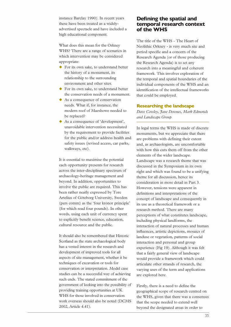
In legal terms the WHS is made of discretemonuments, but we appreciate that thereare problems with defining their extentand, as archaeologists, are uncomfortablewith how this cuts them off from the otherelements of the wider landscape.Landscape was a research theme that wasdiscussed in the Symposium in its ownright and which was found to be a unifyingtheme for all discussion, hence itsconsideration in more detail in Part 3.However, tensions were apparent indefinitions and interpretations of theconcept of landscape and consequently inits use as a theoretical framework or aresearch method. There are manyperceptions of what constitutes landscape,including physical landforms, theinteraction of natural processes and humaninfluences, artistic depictions, mosaics oflanduse or vegetation, patterns of socialinteraction and personal and groupexperience (Fig 19). Although it was feltthat a fairly general view of landscapewould provide a framework which couldarticulate other strands of research, thevarying uses of the term and applicationsare explored here.
Firstly, there is a need to define thegeographical scope of research centred onthe WHS, given that there was a consensusthat the scope needed to extend wellbeyond the designated areas in order to
35
place the WHS in context. This wouldallow, for example, consideration of localvariation in settlement or landuse patternsin both space and time and inclusion of themaritime and marine margins. WHS statusobviously acknowledges the internationalimportance of the monuments and placesresearch firmly in the international context.Furthermore, the location of Orkney on abroad Atlantic European canvas is clearlyfundamental to many avenues of research.However, the archaeological and historiclandscape is perhaps best studied at amore local level. A nested approach withvarying scales and inputs can therefore besuggested.
Suggested geographical frameworks arelisted below, in order of increasingresolution of study:◆ Orkney in the World (Fig 1) - The
size and shape of Orkney’s place in theworld changes through time andcircumstance - it is therefore notpossible to describe a single boundaryto Orkney’s world context.
◆ Orkney (Fig 9) - Orkney contains adiversity of landscape types andmonuments appropriate to generalresearch issues such as survival andrecovery patterns, landscapedevelopment and monumentdistribution. Research centred on theWHS can be set in an Orcadian contextand can add to knowledge of sitesoutside the WHS; conversely, researchinto areas outside of the WHS can helpour understanding of the WHS.
◆ Zones of Visual Impact (see above)(Fig 12) - In these smaller areas issuessuch as local variation within the region(eg of settlements, artefacts) can be
examined in order to build up a detailedlandscape history and characterisation.In these cases a greater resource input isrealistic.
◆ Individual components of the WHS(Figs 10-11) - It is appropriate to theirdesignation that these small areas bestudied in the greatest detail within thelimits of what can be defined assustainable research (see above). Muchbasic recording and research remains tobe done, for example to establishdetailed topographic and geophysicalsurveys of all the sites.
Secondly, methods need to be establishedfor the identification of the archaeological orhistoric landscape by measuring or mapping.Throughout the process of developing theResearch Agenda, the need to understandthe development of the Orcadian landscapewas identified as a priority. Our currentunderstanding of the contemporarylandscape is a key to this, as the patterns ofearlier landscapes are articulated throughthe present. Unfortunately, the nature of thearchaeological resource hinders deeperunderstanding of landscape development.Most records focus on unitary monumentsand are essentially a product of 19th- andearlier 20th-century patterns of fieldwork -there is a clear need for systematic andextensive survey to redress this imbalance.
The development and character of theOrcadian archaeological or historiclandscape is poorly understood, thoughthere is now a body of data relating to thecontemporary landscape (Land UseConsultants 1998; Dyson Bruce et al 1999).Evaluation and exploration is necessary toenhance the treatment of archaeological andhistoric landscapes. The establishment of abaseline of consistent data is seen as apriority for the WHS and buffer zones and,wherever possible, data should be assembledin a systematic fashion that is GIScompatible to allow the ready integrationwith other data. The production of maps aspart of this process can be very eloquent inillustrating how the landscape hasdeveloped, for example in illustrating sea-level fluctuation or landuse change.
36
19. The Stones ofStenness and theRing of Brodgar havealways offereddifferent experiencesto their visitors Add.15511 f3 Frederick
Herm 1772, by permission
of the British Library.
Thirdly, landscape is not merely a passivereceptor and reflector of human activities,a series of sites and traces which can bemeasured and mapped; it is constructedsocially and historically through practice.Landscape is also experiential; from it weextract our sustenance, within it weexperience the seasons and the passage oftime. There we find our families, friends,rulers and vassals; within it our ancestorsare buried, and we gaze upon it. It is solarge that changes in its character extendbeyond our vision and occur either so fastor so slowly they seem unimaginable.
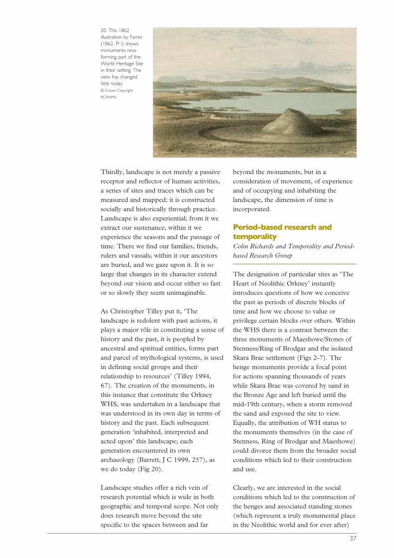
As Christopher Tilley put it, ‘Thelandscape is redolent with past actions, itplays a major rôle in constituting a sense ofhistory and the past, it is peopled byancestral and spiritual entities, forms partand parcel of mythological systems, is usedin defining social groups and theirrelationship to resources’ (Tilley 1994,67). The creation of the monuments, inthis instance that constitute the OrkneyWHS, was undertaken in a landscape thatwas understood in its own day in terms ofhistory and the past. Each subsequentgeneration ‘inhabited, interpreted andacted upon’ this landscape; eachgeneration encountered its ownarchaeology (Barrett, J C 1999, 257), aswe do today (Fig 20).
Landscape studies offer a rich vein ofresearch potential which is wide in bothgeographic and temporal scope. Not onlydoes research move beyond the sitespecific to the spaces between and far
beyond the monuments, but in aconsideration of movement, of experienceand of occupying and inhabiting thelandscape, the dimension of time isincorporated.
Period-based research andtemporalityColin Richards and Temporality and Period-based Research Group
The designation of particular sites as ‘TheHeart of Neolithic Orkney’ instantlyintroduces questions of how we conceivethe past as periods of discrete blocks oftime and how we choose to value orprivilege certain blocks over others. Withinthe WHS there is a contrast between thethree monuments of Maeshowe/Stones ofStenness/Ring of Brodgar and the isolatedSkara Brae settlement (Figs 2-7). Thehenge monuments provide a focal pointfor actions spanning thousands of yearswhile Skara Brae was covered by sand inthe Bronze Age and left buried until themid-19th century, when a storm removedthe sand and exposed the site to view.Equally, the attribution of WH status tothe monuments themselves (in the case ofStenness, Ring of Brodgar and Maeshowe)could divorce them from the broader socialconditions which led to their constructionand use.
Clearly, we are interested in the socialconditions which led to the construction ofthe henges and associated standing stones(which represent a truly monumental placein the Neolithic world and for ever after)
37
20. This 1862illustration by Farrer(1862, Pl I) showsmonuments nowforming part of theWorld Heritage Sitein their setting. Theview has changedlittle today © Crown Copyright:
RCAHMS.

and their relationship to contemporarysettlement and our attention should thusmove far beyond the individualcomponents of the WHS. Nevertheless,these monuments do deserve specialattention because they were built indifferent ways to convey very specificmeanings on a scale never seen before inOrkney. They are achievements of a veryhigh order (and hence their selection asWHS).
On the whole, period-based researchcontinues to define the archaeologicalprofession in Britain today. Period-basedcourses remain popular in archaeologydegrees in British universities and thearchaeological literature is subdivided andcharacterised by period-based research.Indeed, the designation ‘The Heart ofNeolithic Orkney’ for the Orcadian WHSbrings such definition into sharp focus.However, there are a number ofconsequences inherent in such anapproach and these are magnified by thedifferent discursive strategies which havearisen within different archaeologicalperiods. This situation gives rise to apartial breakdown of communicationbetween researchers operating in different‘blocks’ of time, eg Palaeolithic, Neolithic,Medieval, etc. Research questions andpriorities differ between periods because oftheoretical differences in approach. Thiscan have the effect of creating entirelydifferent forms of archaeology in adjacentand overlapping blocks of time (eg IronAge/Roman periods in England, ScottishIron Age/Later Iron Age). Furthermore,
arbitrary disciplinary vogues occur whereresearch projects into particular periods orparts of Scotland attract greater attentionand more financial support than others.Some periods leave none or fewupstanding remains and this has heavilybiased our understanding of the past. InOrkney, examples of this are the contrastbetween the prominence of the Neolithictombs and stone circles, and the Iron Agebrochs, and the invisibility of Mesolithicand Bronze Age settlement.
It is clear that in the buffer zones thatsurround the designated monuments lie anumber of sites of different constructiondate. On the basis of such constructiondates these sites can be attributed aspecific archaeological period. However,the problem arises of when was their ‘real’time? Some sites and monumentsrepresent ‘construction’ over enormousperiods of time and right up to the presentthey have been used in a variety of ways.Indeed, in many cases, sites andmonuments designated, for instance, asNeolithic or Bronze Age have had specialmeaning and significance throughout theirhistories (and for many continue to havesuch effect today, Fig 21). This realisationshould provide an effective critique againstideas of purity and authenticity as appliedto archaeological sites. Moreover, itproduces a real and valid problem for theinterpretation and presentation ofarchaeological sites because questions ariseabout what is actually being displayed andthe validity of the interpretation offered.
Another point involves a perceivedparadox in the archaeological research ofthe WHS. The designation of such statusto this part of Mainland Orkney is basedentirely on the presence of four well-preserved sites or monuments (plus tworelated standing stones). Yet, theirunderstanding in terms of conception andconstruction lies elsewhere, in the othercontexts of life that provided the socialconditions under which these monuments(Ring of Brodgar, Stones of Stenness andMaeshowe) could be built. The inclusionof Skara Brae in the WHS represents anadditional context, as it is a settlement site,
38
21. The Neolithicsite of Maeshowe isalso world-renowned for itscollection of Norserunes (carvedaround 3800 yearsafter the tomb wasconstructed) © Crown Copyright
reproduced courtesy of
Historic Scotland.

whose presence in the WHS is based on itshigh level of preservation (Fig 22).Qualities of preservation and the‘spectacular’ are of obvious importance(not least in the presentation of the past tothe public) but do not necessarily form acoherent basis for research.
We suggest research into the WHSrequires a shift away from a site-orientatedstudy to one more concerned with socialpractices and frameworks ofunderstanding. We have to consider howpeople engaged with their world and thephysical experiences which provided boththe conditions under which ‘knowledge’has been produced and the socialrelationships that allowed such materialexpressions as Maeshowe, etc. to be built.
Preceding experiences must be taken intoaccount - it is very unlikely that the WHSmonuments were set in a virgin landscape.There must be a history of Mesolithic orearlier Neolithic inhabitation that helped tomake these places what they became andwe must therefore consider whether theseareas in West Mainland Orkney had anyspecial significance before the monumentswere constructed. Clearly an argumentcould be provided for a consideration of‘place’ and ‘memory’ in terms of the
situation of the monuments at a particularpoint in the Neolithic world. To recognisethe basis for the ‘special’ nature of theWHS as simply the monumentsthemselves, denies the likely significanceattached to the area by, for example, theMesolithic inhabitants of Orkney.
Together these points and issues highlightthe problems of research strategies thatfocus on archaeological objects as definedby their date or period of creation. Suchstrategies would remain falsely fossilised atsome arbitrary point in time, totallydivorced from the present and we wish toavoid this. Instead we would like to re-establish social practices and ‘peoplethrough the past’ as a central tenet ofenquiry and to suggest some researchthemes which may counter some of theproblems discussed above.
The Agenda that we have produced is anattempt to cross period-based boundariesand spread research priorities across timeand space. Site specific and period specificresearch can be set within the broadresearch themes that have been identifiedand are detailed in Part 3.
39
22. Peering intoHouse 7: Skara Braeprovides a uniqueglimpse of domesticlife 5000 years ago © Crown Copyright
reproduced courtesy of
Historic Scotland.

History of prehistoricresearch Nick Card
Ever since Jo Ben’s (1529) account ofsome of the antiquities of Orkney and their‘excavation’, the dramatic nature of theStones of Stenness and the Ring ofBrodgar, together with associated standingstones and mounds, have attracted theattention of visitors who portrayed andinvestigated them in various ways.Antiquarian and archaeologicalinvestigations were undertaken to varyingstandards, as described below (Fig 23).This work both informed and wasinformed by investigations that wereundertaken elsewhere in Orkney. Thehistory of research in the WHS and thewider Orkney context traces the
development of thought and interpretationrelated to the WHS, and demonstrates thepivotal rôle that Orkney sites have played,and continue to play, in widerarchaeological theory.
Until the mid-19th century most of thiswork amounted to little more than ratherfanciful descriptions, interpretations andaccounts of unscientific investigations(Wallace 1700; Pococke 1760; Low 1879;Gordon 1792; Barry 1805; Neill 1805;Hibbert 1823; Wood, W 1826). Withinthis period, however, two importantstudies should be noted. In 1772 SirJoseph Banks, on his way to Iceland,stopped off in Orkney. Although hisinvestigations of mounds at Skaill Bay(Lysaght 1974) were little better than theaverage antiquarian, his surveys of boththe Skaill Bay area, and the Rings ofBrodgar (‘Circle of Loda’) and Stenness,exhibit an eye for detail (Fig 24). This wasmainly due to the work of Frederick HermWalden, a naval architect and surveyorwho accompanied Banks. Shortly afterBanks in 1789, the expedition of Sir John
PART
2
6
Resource assessment
23. A romantic, early 19th-century view of the WatchStone and the Odin Stone by Elizabeth, Marchioness ofStafford. Many antiquarian views of the World HeritageSite exist and they can be an important source ofinformation about the monuments Crown Copyright: RCAHMS.
40
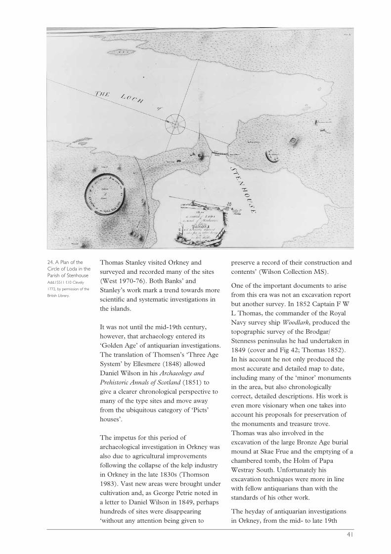
41
Thomas Stanley visited Orkney andsurveyed and recorded many of the sites(West 1970-76). Both Banks’ andStanley’s work mark a trend towards morescientific and systematic investigations inthe islands.
It was not until the mid-19th century,however, that archaeology entered its‘Golden Age’ of antiquarian investigations.The translation of Thomsen’s ‘Three AgeSystem’ by Ellesmere (1848) allowedDaniel Wilson in his Archaeology andPrehistoric Annals of Scotland (1851) togive a clearer chronological perspective tomany of the type sites and move awayfrom the ubiquitous category of ‘Picts’houses’.
The impetus for this period ofarchaeological investigation in Orkney wasalso due to agricultural improvementsfollowing the collapse of the kelp industryin Orkney in the late 1830s (Thomson1983). Vast new areas were brought undercultivation and, as George Petrie noted ina letter to Daniel Wilson in 1849, perhapshundreds of sites were disappearing‘without any attention being given to
preserve a record of their construction andcontents’ (Wilson Collection MS).
One of the important documents to arisefrom this era was not an excavation reportbut another survey. In 1852 Captain F WL Thomas, the commander of the RoyalNavy survey ship Woodlark, produced thetopographic survey of the Brodgar/Stenness peninsulas he had undertaken in1849 (cover and Fig 42; Thomas 1852).In his account he not only produced themost accurate and detailed map to date,including many of the ‘minor’ monumentsin the area, but also chronologicallycorrect, detailed descriptions. His work iseven more visionary when one takes intoaccount his proposals for preservation ofthe monuments and treasure trove.Thomas was also involved in theexcavation of the large Bronze Age burialmound at Skae Frue and the emptying of achambered tomb, the Holm of PapaWestray South. Unfortunately hisexcavation techniques were more in linewith fellow antiquarians than with thestandards of his other work.
The heyday of antiquarian investigationsin Orkney, from the mid- to late 19th
24. A Plan of theCircle of Loda in theParish of Stenhouse Add.15511 f.10 Clevely
1772, by permission of the
British Library.
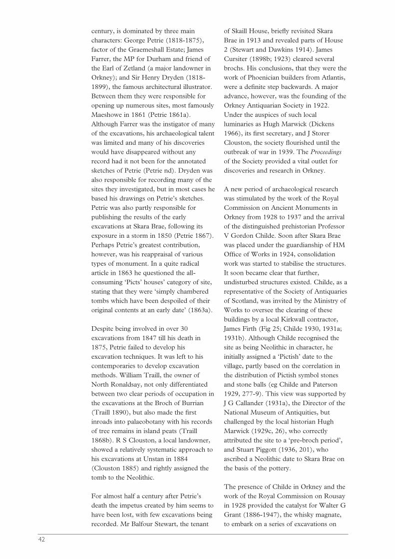
century, is dominated by three maincharacters: George Petrie (1818-1875),factor of the Graemeshall Estate; JamesFarrer, the MP for Durham and friend ofthe Earl of Zetland (a major landowner inOrkney); and Sir Henry Dryden (1818-1899), the famous architectural illustrator.Between them they were responsible foropening up numerous sites, most famouslyMaeshowe in 1861 (Petrie 1861a).Although Farrer was the instigator of manyof the excavations, his archaeological talentwas limited and many of his discoverieswould have disappeared without anyrecord had it not been for the annotatedsketches of Petrie (Petrie nd). Dryden wasalso responsible for recording many of thesites they investigated, but in most cases hebased his drawings on Petrie’s sketches.Petrie was also partly responsible forpublishing the results of the earlyexcavations at Skara Brae, following itsexposure in a storm in 1850 (Petrie 1867).Perhaps Petrie’s greatest contribution,however, was his reappraisal of varioustypes of monument. In a quite radicalarticle in 1863 he questioned the all-consuming ‘Picts’ houses’ category of site,stating that they were ‘simply chamberedtombs which have been despoiled of theiroriginal contents at an early date’ (1863a).
Despite being involved in over 30excavations from 1847 till his death in1875, Petrie failed to develop hisexcavation techniques. It was left to hiscontemporaries to develop excavationmethods. William Traill, the owner ofNorth Ronaldsay, not only differentiatedbetween two clear periods of occupation inthe excavations at the Broch of Burrian(Traill 1890), but also made the firstinroads into palaeobotany with his recordsof tree remains in island peats (Traill1868b). R S Clouston, a local landowner,showed a relatively systematic approach tohis excavations at Unstan in 1884(Clouston 1885) and rightly assigned thetomb to the Neolithic.
For almost half a century after Petrie’sdeath the impetus created by him seems tohave been lost, with few excavations beingrecorded. Mr Balfour Stewart, the tenant
of Skaill House, briefly revisited SkaraBrae in 1913 and revealed parts of House2 (Stewart and Dawkins 1914). JamesCursiter (1898b; 1923) cleared severalbrochs. His conclusions, that they were thework of Phoenician builders from Atlantis,were a definite step backwards. A majoradvance, however, was the founding of theOrkney Antiquarian Society in 1922.Under the auspices of such localluminaries as Hugh Marwick (Dickens1966), its first secretary, and J StorerClouston, the society flourished until theoutbreak of war in 1939. The Proceedingsof the Society provided a vital outlet fordiscoveries and research in Orkney.
A new period of archaeological researchwas stimulated by the work of the RoyalCommission on Ancient Monuments inOrkney from 1928 to 1937 and the arrivalof the distinguished prehistorian ProfessorV Gordon Childe. Soon after Skara Braewas placed under the guardianship of HMOffice of Works in 1924, consolidationwork was started to stabilise the structures.It soon became clear that further,undisturbed structures existed. Childe, as arepresentative of the Society of Antiquariesof Scotland, was invited by the Ministry ofWorks to oversee the clearing of thesebuildings by a local Kirkwall contractor,James Firth (Fig 25; Childe 1930, 1931a;1931b). Although Childe recognised thesite as being Neolithic in character, heinitially assigned a ‘Pictish’ date to thevillage, partly based on the correlation inthe distribution of Pictish symbol stonesand stone balls (eg Childe and Paterson1929, 277-9). This view was supported byJ G Callander (1931a), the Director of theNational Museum of Antiquities, butchallenged by the local historian HughMarwick (1929c, 26), who correctlyattributed the site to a ‘pre-broch period’,and Stuart Piggott (1936, 201), whoascribed a Neolithic date to Skara Brae onthe basis of the pottery.
The presence of Childe in Orkney and thework of the Royal Commission on Rousayin 1928 provided the catalyst for Walter GGrant (1886-1947), the whisky magnate,to embark on a series of excavations on
42

Rousay, his home island (Reynolds andRitchie 1985). Initially this was incollaboration with J G Callander. Togetherthey excavated ten chambered tombs andthe broch of Midhowe on Rousay(Callander and Grant 1934a; 1934b; 1935;1936; 1937). Although their techniqueswere still quite basic they did record theposition of artefacts and human bone.After Callander’s death in 1937, Walter GGrant continued his work. In general theselatter excavations were never publishedand records for these sites relied on thedrawings of Grant’s draughtsman, DavidWilson. The exception to this was Grant’scollaboration with Childe in thesupervision of the excavation of theNeolithic settlement at Rinyo in 1938(Childe and Grant 1939). The excavationwas interrupted by the war, but thediscovery of Beaker potterystratigraphically later than Grooved Ware,similar to that found by Childe at SkaraBrae, helped Childe review his chronologyfor Skara Brae.
Childe’s investigations at Skara Brae alsoprovided the impetus for the excavation ofthe Knap of Howar on Papa Westray. In1929 the landowner, William Traill ofHolland, aided by his friend WilliamKirkness (Traill and Kirkness 1937),revealed the nature and extent of the site.
Initially it was attributed to the Iron Ageand it would be another 40 years before itwas correctly assigned to the Neolithic(Ritchie, A 1983a).
C S T Calder, an architect with the RoyalCommission, was also active during thisperiod, excavating several chamberedtombs and other sites on Eday and theCalf of Eday (Calder 1937; 1938; 1939).Calder also produced the firstcomprehensive account of the DwarfieStane on Hoy (Calder and McDonald1936).
Many of these inter-war excavations werepublished and a move to a more systematicapproach to excavation was being made byrefined techniques and the addition ofphotographs, scale plans and sectiondrawings. But the overriding objective atmany sites was to provide a monument forpublic display; archaeological research wasstill of secondary interest. At the brochs ofMidhowe and Gurness, their centres werestill just basically cleared, althoughoutbuildings and ditches were alsoinvestigated. At Skara Brae much of the‘mundane’ material from Childe’sexcavations, such as undecorated potteryand animal bone (now regarded as ofinterest), was dumped without properexamination. Other excavations were never
43
25. Work at SkaraBrae under thedirection of GordonChilde (bottom left) Thomas Kent, © Orkney
Archives.

published. The Brough of Birsay wasprepared for public display throughout the1930s, mainly under the supervision of DrJ S Richardson. The only surviving recordof this work is the diary of the siteforeman, Mr J Henderson.
Despite such shortcomings, the results ofthese excavations provided crucialelements of forthcoming syntheses ofScottish and European archaeology. TheOrkney material was incorporated byChilde into his pioneering works, ThePrehistory of Scotland (1935) and Scotlandbefore the Scots (1946), and latterly StuartPiggott’s Neolithic Cultures of the BritishIsles (1954).
The immediate post-war years started wellfor archaeology with the publication of theInventory volume for Orkney by the RoyalCommission on Ancient Monuments(RCAHMS 1946), the first systematicrecord of Orcadian archaeology. However,apart from Childe’s work at the chamberedtombs of Maeshowe (1956) and Quoyness(1952), and the publication of Henshall’sdefinitive work The Chambered Tombs ofScotland (1963), archaeologicalinvestigations were very limited. Childe’sexcavations at Maeshowe are notable as alandmark in Orcadian palaeoenviron-mental studies. For the first time, sampleswere recovered from a site and studied forpollen and microfossil evidence. Theresults were used to recreate the Neolithiclandscape. This work was a forerunner forfuture environmental studies in the islands(eg Moar 1969; Davidson et al 1976;Keatinge and Dickson 1979).
The present era of archaeological work inOrkney can be seen to start in the early1970s. Initially this was intrinsically linkedto the development of the ‘NewArchaeology’. The catalyst for the ‘NewArchaeology’ was radiocarbon (14C)dating. In conjunction with tree-ringcalibration this allowed absolute dates tobe obtained for sites. Many basicassumptions that had dominated the studyof prehistory, in particular diffusionistconcepts, were finally laid to rest. Dating,in conjunction with a new battery of
analytical and statistical techniques,allowed new questions to be asked of thematerial remains concerning the economy,environment and society that producedthese monuments. This approach wasepitomised by the work of Professor ColinRenfrew. Throughout the early 1970sRenfrew brought this new battery oftechniques to bear on Orcadianarchaeology with his excavations atQuanterness, Ring of Brodgar andMaeshowe (Renfrew 1979). His resultspaved the way for many new ideas andtheories relating to Orcadian prehistoryand beyond. An aspect of this project wasthe pioneering work on burnt mounds byJohn Hedges with his excavations at Liddleand Beaquoy (Hedges, J W 1975).
In 1972-3 Skara Brae was revisited by DrD V Clarke (Clarke 1976a; 1976b). Hismain objectives were to obtainenvironmental and dating material.Samples obtained allowed an absolute dateto be gained. As a result of coastal erosion,Clarke, D V (1977b) carried out furtherwork at Skara Brae in 1977 which allowedthe settlement to be placed in its landscapecontext. In 1978 Clarke went on toinvestigate the Links of Noltland onWestray, another Neolithic settlement site,originally discovered by Petrie. Theseexcavations are as yet unpublished.
Neolithic studies were further advanced byexcavations conducted by Drs Grahamand Anna Ritchie in the early 1970s.Excavations at the Knap of Howar byAnna Ritchie in 1973-74 (1983a) showedthat the structures were early Neolithic notIron Age. Meanwhile Graham Ritchie’sexcavations in 1973-74 at the Stones ofStenness (1976) finally provided importantevidence for its date and its relationship toGrooved Ware.
1978 is marked in the history of Orcadianarchaeology with the appointment of thefirst Orkney or County Archaeologist, DrRaymond Lamb, by the Orkney HeritageSociety. His most important contributionto the study of archaeology in the islandswas the creation of the Sites andMonuments Record (SMR) for Orkney.
44
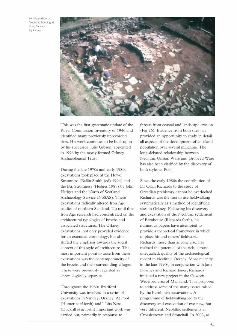
This was the first systematic update of theRoyal Commission Inventory of 1946 andidentified many previously unrecordedsites. His work continues to be built uponby his successor, Julie Gibson, appointedin 1996 by the newly formed OrkneyArchaeological Trust.
During the late 1970s and early 1980sexcavations took place at the Howe,Stromness (Ballin Smith (ed) 1994) andthe Bu, Stromness (Hedges 1987) by JohnHedges and the North of ScotlandArchaeology Service (NoSAS). Theseexcavations radically altered Iron Agestudies of northern Scotland. Up until thenIron Age research had concentrated on thearchitectural typologies of brochs andassociated structures. The Orkneyexcavations, not only provided evidencefor an extended chronology, but alsoshifted the emphasis towards the socialcontext of this style of architecture. Themost important point to arise from theseexcavations was the contemporaneity ofthe brochs and their surrounding villages.These were previously regarded aschronologically separate.
Throughout the 1980s BradfordUniversity was involved in a series ofexcavations in Sanday, Orkney. At Pool(Hunter et al forth) and Tofts Ness(Dockrill et al forth) important work wascarried out, primarily in response to
threats from coastal and landscape erosion(Fig 26). Evidence from both sites hasprovided an opportunity to study in detailall aspects of the development of an islandpopulation over several millennia. Thelong-debated relationship betweenNeolithic Unstan Ware and Grooved Warehas also been clarified by the discovery ofboth styles at Pool.
Since the early 1980s the contribution ofDr Colin Richards to the study ofOrcadian prehistory cannot be overlooked.Richards was the first to use fieldwalkingsystematically as a method of identifyingsites in Orkney. Following his discoveryand excavation of the Neolithic settlementof Barnhouse (Richards forth), hisnumerous papers have attempted toprovide a theoretical framework in whichto place his and others’ fieldwork.Richards, more than anyone else, hasrealised the potential of the rich, almostunequalled, quality of the archaeologicalrecord in Neolithic Orkney. More recentlyin the late 1990s, in conjunction with JaneDownes and Richard Jones, Richardsinitiated a new project in the Cuween-Wideford area of Mainland. This proposedto address some of the many issues raisedby the Barnhouse excavations. Aprogramme of fieldwalking led to thediscovery and excavation of two new, butvery different, Neolithic settlements atCrossiecrown and Stonehall. In 2003, as
45
26. Excavation ofNeolithic building atPool, Sanday © J R Hunter.
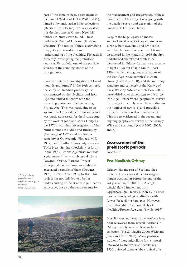
part of the same project, a settlement atthe base of Wideford Hill (HY41 SW47),hinted at by antiquarian lithic collections(Rendall 1931; 1934b), was also located.For the first time in Orkney Neolithictimber structures were found. Theseunderlie a ‘Knap of Howar-style’ stonestructure. The results of these excavationsmay yet again transform ourunderstanding of the Neolithic. Richards ispresently investigating the prehistoricquarry at Vestrafiold, one of the possiblesources of the standing stones of theBrodgar area.
Since the extensive investigations of burialmounds and ‘tumuli’ in the 19th century,the study of Orcadian prehistory hasconcentrated on the Neolithic and IronAge and tended to ignore both thepreceding period and the interveningBronze Age. This was partly due to anapparent lack of evidence. This imbalancewas partly addressed, for the Bronze Age,by the work of John and Melia Hedges inthe 1970s, with their investigations of theburnt mounds at Liddle and Buckquoy(Hedges, J W 1975) and the barrowcemetery at Quoyscottie (Hedges, M E1977), and Bradford University’s work atTofts Ness, Sanday (Dockrill et al forth).In the 1990s Bronze Age burial moundsagain entered the research agenda. JaneDownes’ ‘Orkney Barrows Project’surveyed all known burial mounds andexcavated a sample of them (Downes1995; 1997a; 1997c; 1999; forth). Thisproject has not only led to a betterunderstanding of the Bronze Age funerarylandscape, but also the requirements for
the management and preservation of thesemonuments. This project is ongoing withthe detailed survey and excavation of theKnowes of Trotty in Harray.
Despite the huge legacy of knownarchaeological sites, Orkney continues tosurprise both academic and lay peoplewith the plethora of new sites still beingdiscovered in the islands. In 1998 the firstundisturbed chambered tomb to bediscovered in Orkney for many years cameto light at Crantit (Ballin Smith 1998;1999), while the ongoing excavations ofthe Iron Age ‘ritual complex’ at MineHowe (Card et al 2000), and the mortuarystructure and cemetery at the Knowe ofSkea, Westray (Moore and Wilson 2003),have added other dimensions to life in theIron Age. Furthermore, geophysical surveyis proving immensely valuable in adding tothe number of new sites and providingfurther information about known sites.This is best evidenced in the recent andongoing geophysical survey of the OrkneyWHS and surrounds (GSB 2002; 2003aand b).
Assessment of theprehistoric periodsNick Card
Pre-Neolithic Orkney
Orkney, like the rest of Scotland, haspresented no clear evidence to suggesthuman occupation before the end of thelast glaciation, c10,000 BP. A singlebifacial flaked implement fromUpperborough, Harray (Anon 1914) doeshave certain typological affinities withLower Palaeolithic handaxes. However,this is thought to be more likely ofNeolithic/Bronze Age date (Saville 1997).
Mesolithic-type, flaked stone artefacts havebeen recovered from several locations inOrkney, mainly as a result of surfacecollection (Fig 27; Saville 2000; Wickham-Jones and Firth 2000). Many post-warstudies of these microlithic forms, mostlyinformed by the work of Lacaille (eg1935), viewed them as ‘the survival of a
46
27. Fieldwalkingprovides muchuseful archaeologicalevidence © C R Wickham-Jones.
lingering, degenerate, Upper Palaeolithictradition...’ (Livens 1956, 443). This wascontrary to Lacaille who saw no reason notto attribute these forms to Mesolithicactivity in Orkney (1954, 169-70). Livens’view however is still current amongst someauthors. Anna Ritchie stating, mostrecently, that ‘… flintwork that looksMesolithic can turn up on Neolithic sites… where it is more likely to indicate thesurvival of old-fashioned ideas in toolkitsthan pre-Neolithic activity’ (Ritchie, A1995, 20). Renfrew (2000, 5), althoughnot denying the possibility of sporadicMesolithic visits to Orkney, contests theidea of permanent Mesolithic settlement inOrkney.
Recent reviews of the material by Saville(1996; 2000), ‘… leaves no doubt of theexistence of a fully Mesolithic presence onOrkney’ (1996, 220). This view is sharedby Wickham-Jones, on the basis of thelithic artefactual evidence (1994, 74) andfieldwork (Wickham-Jones and Firth2000). Despite the lack of whollydiagnostic implements, the flint assemblagefrom below the chambered tomb at thePoint of Cott, Westray has also recentlybeen assigned to the Mesolithic (Findlay1997), as have new finds from LongHowe, near Mine Howe.
Environmental evidence for Mesolithicactivity is also scant. Bunting (1996a, 23)has interpreted an interruption ofwoodland in a pollen column from theWest Mainland, as evidence for possibleMesolithic activity, c6,500 BC. On Hoy(Blackford et al 1996) a similar decline inwoodland was also detected around 6,400BC. As with the Mainland evidence thiswas associated with concentrations ofcharcoal, which have been interpreted aspossible evidence for people in Orkney inthe Mesolithic.
The pre-Neolithic World Heritage Siteand Inner Buffer ZonesAlthough no Mesolithic sites have beendetected within the IBZ, many of the flintscited by Saville (1996; 2000) as ‘typicalmicroliths’, have been attributed to the
Stenness and Sandwick areas. Saville’s(2000, 95) re-examination of the lithicsfrom the 1970s excavations at Skara Brae(Clarke, D V 1976a; 1976b) also identifiedtwo pieces of ‘Mesolithic character’. Savilleconsiders that these may represent residualMesolithic pieces and may ‘hint of a pre-existing Mesolithic site being disturbed bythe Neolithic village’ (Saville 2000, 95).
Neolithic Orkney
Present 14C dating suggests that theNeolithic in Orkney spans about 1500years from the mid-4th millennium toc2000 BC. This is usually divided into twogeneral phases, an early and a late, eachcharacterised by differing styles ofdecorated pottery and architecture. Thereis overlap between the two phases and thetransition period is generally considered tohave occurred around 3000 BC (Renfrew1979, 199-212; Davidson and Henshall1989, 85-98; Hunter 2000; Hunter andMacSween 1991; and see Ashmore2000a). The earlier phase seemscharacterised by Unstan Ware, the laterphase by Grooved Ware. This phasing isalso generally reflected in the architectureof chambered tombs. In simplistic terms,Orkney-Cromarty cairns (both tripartiteand stalled cairns) are assigned to the earlyphase, while Maeshowe-type tombs arelater (Davidson and Henshall 1989, 19-51). Statistical analysis by David Fraser(1983) appeared to support a possibletypological division between the Orkney-Cromarty cairns and the Maeshowe group.This simplistic scheme is, however,complicated by some tombs exhibitingfeatures from both styles of architecture.Further doubts have been cast on thissimple typological sequence by Ashmore(2000a) and the important results ofexcavations at the Point of Cott (Barber1997).
The architectural division is also mirroredin the domestic sphere. The organisationof space within the early Neolithic housesof the Knap of Howar (Fig 28; Ritchie, A1983a), Howe (Ballin Smith (ed) 1994,10-13) and Stonehall is mirrored in
47
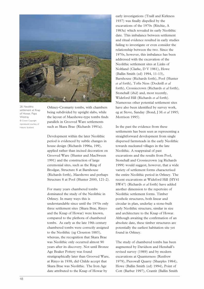
Orkney-Cromarty tombs, with chambersbeing subdivided by upright slabs, whilethe layout of Maeshowe-type tombs findsparallels in Grooved Ware settlementssuch as Skara Brae (Richards 1991a).
Development within the later Neolithicperiod is evidenced by subtle changes inhouse design (Richards 1996a, 199),applied rather than incised decoration onGrooved Ware (Hunter and MacSween1991) and the construction of largeceremonial sites, such as the Ring ofBrodgar, Structure 8 at Barnhouse(Richards forth), Maeshowe and perhapsStructure 8 at Pool (Hunter 2000, 121-2).
For many years chambered tombsdominated the study of the Neolithic inOrkney. In many ways this isunderstandable since until the 1970s onlythree settlement sites (Skara Brae, Rinyoand the Knap of Howar) were known,compared to the plethora of chamberedtombs. As early as the late 19th centurychambered tombs were correctly assignedto the Neolithic (eg Clouston 1885),whereas, the recognition that Skara Braewas Neolithic only occurred almost 90years after its discovery. Not until BronzeAge Beaker Pottery was foundstratigraphically later than Grooved Ware,at Rinyo in 1938, did Childe accept thatSkara Brae was Neolithic. The Iron Agedate attributed to the Knap of Howar by
early investigations (Traill and Kirkness1937) was finally dispelled by theexcavations of the 1970s (Ritchie, A1983a) which revealed its early Neolithicdate. This imbalance between settlementand ritual evidence resulted in early studiesfailing to investigate or even consider therelationship between the two. Since the1970s, however, this imbalance has beenaddressed with the excavation of theNeolithic settlement sites at Links ofNoltland (Clarke, D V 1981), Howe(Ballin Smith (ed) 1994, 11-13),Barnhouse (Richards forth), Pool (Hunteret al forth), Tofts Ness (Dockrill et alforth), Crossiecrown (Richards et al forth),Stonehall (ibid) and, most recently,Wideford Hill (Richards et al forth).Numerous other potential settlement siteshave also been identified by survey work,eg at Stove, Sanday (Bond, J M et al 1995;Morrison 1995).
In the past the evidence from thesesettlements has been seen as representing astraightforward development from singledispersed farmsteads in the early Neolithictowards nucleated villages in the lateNeolithic. A reappraisal of pastexcavations and the results from Pool,Stonehall and Crossiecrown (eg Richards1999) would suggest, however, that a widevariety of settlement forms characterisedthe entire Neolithic period in Orkney. Therecent excavations at Wideford Hill (HY41SW47) (Richards et al forth) have addedanother dimension to the repertoire ofNeolithic settlement forms. Timberposthole structures, both linear andcircular in plan, underlay a stone-builtearly Neolithic structure, similar in sizeand architecture to the Knap of Howar.Although awaiting the confirmation of anabsolute date, these timber structures arepotentially the earliest habitation site yetfound in Orkney.
The study of chambered tombs has beenaugmented by Davidson and Henshall’srevised survey (1989) and by modernexcavations at Quanterness (Renfrew1979), Pierowall Quarry (Sharples 1984),Howe (Ballin Smith (ed) 1994), Point ofCott (Barber 1997), Crantit (Ballin Smith
48
28. Neolithicsettlement at Knapof Howar, PapaWestray © Crown Copyright
reproduced courtesy of
Historic Scotland.

1998; 1999) and Bookan (Card forth).Results from these excavations have notonly shed light on possible funerarypractices, be that excarnation (Renfrew1979; Hedges, J W 1983b) or inhumation(Barber 1997), but also on contemporarysocial organisation.
Cist burials are so characteristic of theBronze Age in Orkney that in the past theyhave been automatically assigned to thisperiod. The results of the excavation of thelarge, rock-cut chamber and cist at SandFiold (Dalland 1999) implies that thistradition in Orkney perhaps had its originsin the Neolithic.
Until recently, megalithic ‘art’ wasrecognised at only a handful of sites inOrkney (Fig 29). Apart from some incisedmotifs noted by Childe at Skara Brae(Childe 1931a, 150-52; Shepherd 2000),these appeared to be limited to mainlypecked motifs in a few chambered tombs(Davidson and Henshall 1989, 81-3). Thefinest example of this is the magnificent,spirally decorated, carved stone discoveredduring quarrying work at Pierowall,Westray in 1981 (Sharples 1984). Recentwork has shown the wider use ofmegalithic art both in domestic andfunerary contexts. Pecked motifs have nowbeen noted at the settlement sites of Pool(Hunter 2000, 121) and Crossiecrown(Richards pers comm), while incisedmotifs have been found at both thesettlement site of Barnhouse and severalchambered tombs (Ashmore 1986; Bradleyet al 2001; Ballin Smith pers comm). Pickdressing of stone has also been recentlynoted at several sites in Orkney (Phillipsand Bradley 2000). The recognition thatmany aspects of Orcadian megalithic artare paralleled in the Boyne Valley inIreland would seem to emphasise thepossibility of direct contact between thetwo regions in the Neolithic.
The integration of all of this new materialhas revolutionised the study of theNeolithic (see Ritchie, A (ed) 2000).Many basic questions regarding theNeolithic of Orkney have been addressedand partially answered. For instance,stratigraphical evidence from Pool hassuggested the relationship betweenGrooved Ware and Unstan Ware to bemainly chronological, rather than cultural(Hunter and MacSween 1991).
Environmental and economic evidence hasalso been greatly enhanced. A detailedpicture of the Neolithic environment isbeing created and the impact of farmingrealised. The conventional picture of alandscape devoid of trees during theNeolithic and later prehistory (eg Tipping1994, 24) is also being questioned (egLimbrey, in Buteux 1997, 10-11). Thediversity of the Neolithic economy is nowclearer. In the past the Neolithic economyin Orkney was seen as being based onpastoralism. Modern excavations haveemphasised the range of environmentsexploited in the Neolithic (Clarke, D Vand Sharples 1985, 72-8). Recentexcavations at the Links of Noltland, SkaraBrae, Tofts Ness, Pool and Knap ofHowar have provided evidence for cerealproduction including wheat and barley.Evidence from Pool (Hunter 2000, 122-3)also hints at intensification in agriculturalproduction in the later Neolithic. This maybe related to evidence from Tofts Ness(Simpson and Dockrill 1996; Simpson etal forth) where, from the late Neolithic,manure and turf were added to the soils tomaintain crop yield and minimise erosion.The exceptional quality and quantities ofthe bone assemblages from settlement sitesin Orkney have not only demonstrated thewide diversity of both domestic and wildanimals being exploited, but also theimportance of this resource for the
49
29. Example ofOrcadian megalithicart: Neolithic incisedstone found atBrodgar Farm Thomas Kent, © Orkney
Archive.
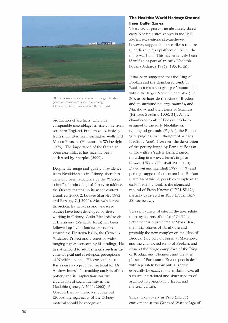
production of artefacts. The onlycomparable assemblages in size come fromsouthern England, but almost exclusivelyfrom ritual sites like Durrington Walls andMount Pleasant (Harcourt, in Wainwright1979). The importance of the Orcadianbone assemblages has recently beenaddressed by Sharples (2000).
Despite the range and quality of evidencefrom Neolithic sites in Orkney, there hasgenerally been reluctance by the ‘Wessexschool’ of archaeological theory to addressthe Orkney material in its wider context(Renfrew 2000, 2; but see Sharples 1992and Barclay, G J 2000). Meanwhile newtheoretical frameworks and landscapestudies have been developed by thoseworking in Orkney. Colin Richards’ workat Barnhouse (Richards forth) has beenfollowed up by his landscape studiesaround the Finstown basin, the Cuween-Wideford Project and a series of wide-ranging papers concerning his findings. Hehas attempted to address issues such as thecosmological and ideological perceptionsof Neolithic people. His excavations atBarnhouse also provided material for DrAndrew Jones’s far reaching analysis of thepottery and its implications for theelucidation of social identity in theNeolithic (Jones, A 2000; 2002). AsGordon Barclay, however, points out(2000), the regionality of the Orkneymaterial should be recognised.
The Neolithic World Heritage Site andInner Buffer ZonesThere are at present no absolutely datedearly Neolithic sites known in the IBZ.Recent excavations at Maeshowe,however, suggest that an earlier structureunderlies the clay platform on which thetomb was built. This has tentatively beenidentified as part of an early Neolithichouse (Richards 1996a, 195; forth).
It has been suggested that the Ring ofBookan and the chambered tomb ofBookan form a sub-group of monumentswithin the larger Neolithic complex (Fig30), as perhaps do the Ring of Brodgarand its surrounding large mounds, andMaeshowe and the Stones of Stenness(Historic Scotland 1998, 34). As thechambered tomb of Bookan has beenassigned to the early Neolithic ontypological grounds (Fig 31), the Bookan‘grouping’ has been thought of as earlyNeolithic (ibid). However, the descriptionof the pottery found by Petrie at Bookantomb, with its ‘rudely formed raisedmoulding in a waved form’, impliesGrooved Ware (Henshall 1985, 108;Davidson and Henshall 1989, 77-8) andperhaps suggests that the tomb at Bookanis late Neolithic. A possible example of anearly Neolithic tomb is the elongatedmound of Fresh Knowe (HY21 SE12),partially excavated in 1853 (Petrie 1857,58; see below).
The rich variety of sites in the area relateto many aspects of the late Neolithic.Settlement is represented at Skara Brae,the initial phases of Barnhouse andprobably the new complex on the Ness ofBrodgar (see below); burial at Maeshoweand the chambered tomb of Bookan; andritual at the henge complexes of the Ringof Brodgar and Stenness, and the laterphases of Barnhouse. Each aspect is dealtwith separately below but, as shownespecially by excavations at Barnhouse, allsites are interrelated and share aspects ofarchitecture, orientation, layout andmaterial culture.
Since its discovery in 1850 (Fig 32),excavations at the Grooved Ware village of
50
30. The Bookan skyline from near the Ring of Brodgar(some of the mounds relate to quarrying) © Crown Copyright reproduced courtesy of Historic Scotland.
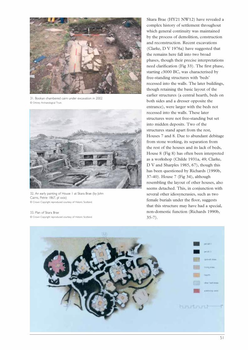
Skara Brae (HY21 NW12) have revealed acomplex history of settlement throughoutwhich general continuity was maintainedby the process of demolition, constructionand reconstruction. Recent excavations(Clarke, D V 1976a) have suggested thatthe remains here fall into two broadphases, though their precise interpretationsneed clarification (Fig 33). The first phase,starting c3000 BC, was characterised byfree-standing structures with ‘beds’recessed into the walls. The later buildings,though retaining the basic layout of theearlier structures (a central hearth, beds onboth sides and a dresser opposite theentrance), were larger with the beds notrecessed into the walls. These laterstructures were not free-standing but setinto midden deposits. Two of thestructures stand apart from the rest,Houses 7 and 8. Due to abundant debitagefrom stone working, its separation fromthe rest of the houses and its lack of beds,House 8 (Fig 8) has often been interpretedas a workshop (Childe 1931a, 49; Clarke,D V and Sharples 1985, 67), though thishas been questioned by Richards (1990b,37-40). House 7 (Fig 34), althoughresembling the layout of other houses, alsoseems detached. This, in conjunction withseveral other idiosyncrasies, such as twofemale burials under the floor, suggeststhat this structure may have had a special,non-domestic function (Richards 1990b,35-7).
51
31. Bookan chambered cairn under excavation in 2002 © Orkney Archaeological Trust.
32. An early painting of House 1 at Skara Brae (by JohnCairns, Petrie 1867, pl xxix) © Crown Copyright reproduced courtesy of Historic Scotland.
33. Plan of Skara Brae © Crown Copyright reproduced courtesy of Historic Scotland.
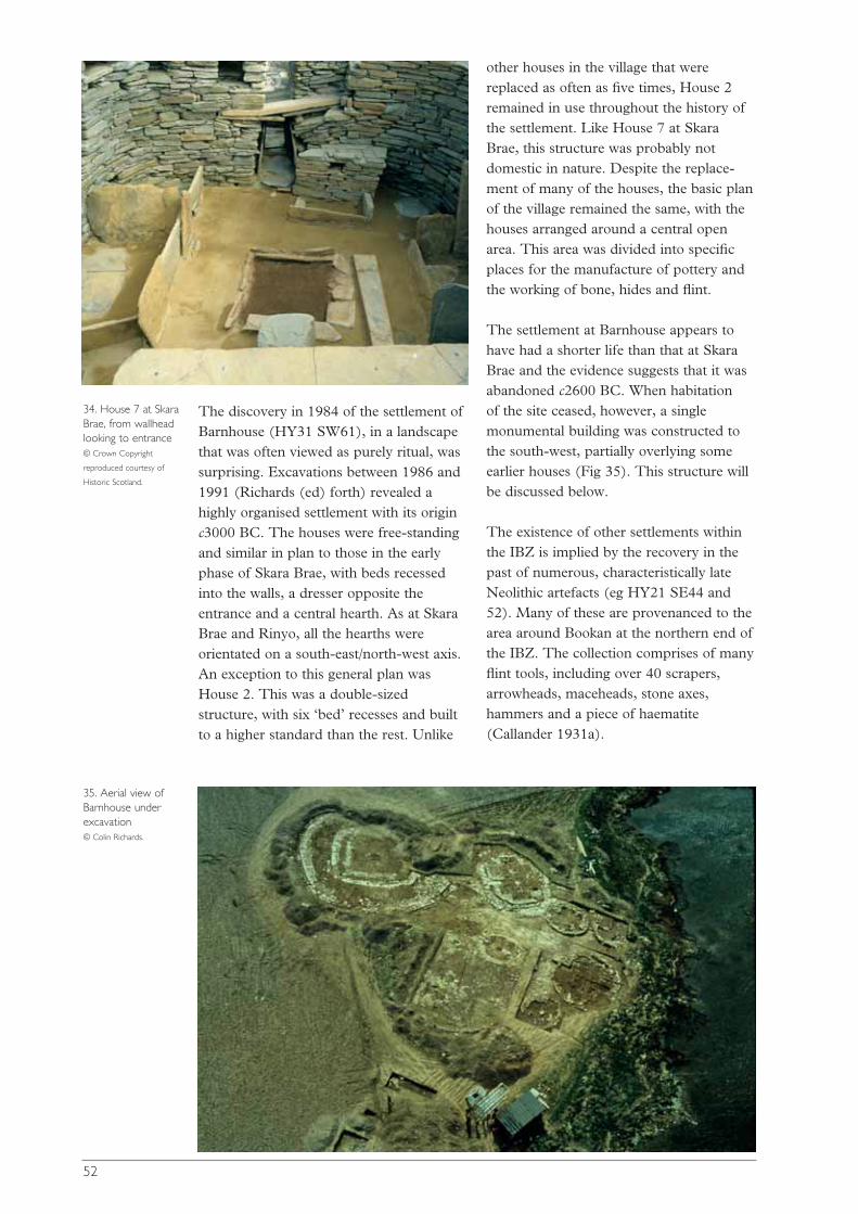
The discovery in 1984 of the settlement ofBarnhouse (HY31 SW61), in a landscapethat was often viewed as purely ritual, wassurprising. Excavations between 1986 and1991 (Richards (ed) forth) revealed ahighly organised settlement with its originc3000 BC. The houses were free-standingand similar in plan to those in the earlyphase of Skara Brae, with beds recessedinto the walls, a dresser opposite theentrance and a central hearth. As at SkaraBrae and Rinyo, all the hearths wereorientated on a south-east/north-west axis.An exception to this general plan wasHouse 2. This was a double-sizedstructure, with six ‘bed’ recesses and builtto a higher standard than the rest. Unlike
other houses in the village that werereplaced as often as five times, House 2remained in use throughout the history ofthe settlement. Like House 7 at SkaraBrae, this structure was probably notdomestic in nature. Despite the replace-ment of many of the houses, the basic planof the village remained the same, with thehouses arranged around a central openarea. This area was divided into specificplaces for the manufacture of pottery andthe working of bone, hides and flint.
The settlement at Barnhouse appears tohave had a shorter life than that at SkaraBrae and the evidence suggests that it wasabandoned c2600 BC. When habitation of the site ceased, however, a singlemonumental building was constructed tothe south-west, partially overlying someearlier houses (Fig 35). This structure willbe discussed below.
The existence of other settlements withinthe IBZ is implied by the recovery in thepast of numerous, characteristically lateNeolithic artefacts (eg HY21 SE44 and52). Many of these are provenanced to thearea around Bookan at the northern end ofthe IBZ. The collection comprises of manyflint tools, including over 40 scrapers,arrowheads, maceheads, stone axes,hammers and a piece of haematite(Callander 1931a).
52
34. House 7 at SkaraBrae, from wallheadlooking to entrance © Crown Copyright
reproduced courtesy of
Historic Scotland.
35. Aerial view ofBarnhouse underexcavation © Colin Richards.
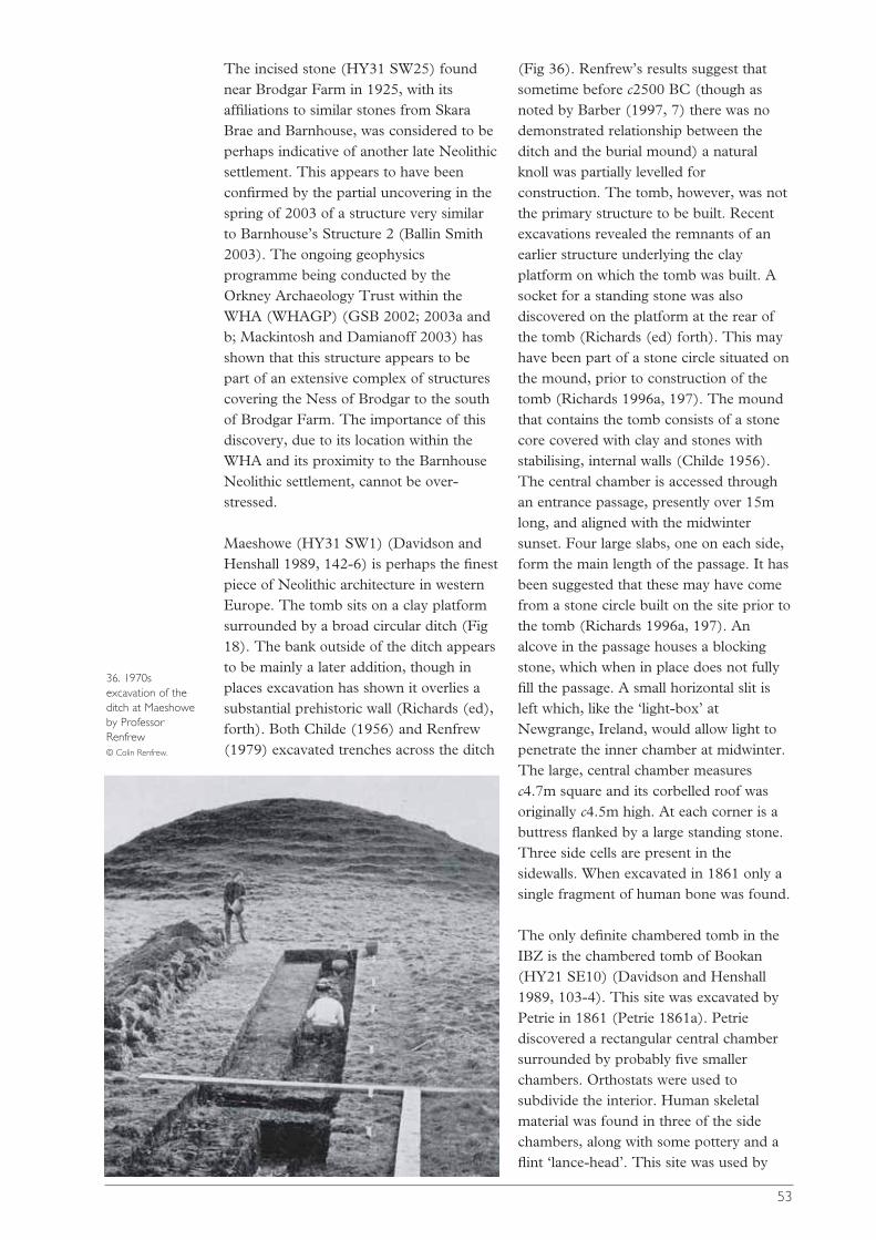
The incised stone (HY31 SW25) foundnear Brodgar Farm in 1925, with itsaffiliations to similar stones from SkaraBrae and Barnhouse, was considered to beperhaps indicative of another late Neolithicsettlement. This appears to have beenconfirmed by the partial uncovering in thespring of 2003 of a structure very similarto Barnhouse’s Structure 2 (Ballin Smith2003). The ongoing geophysicsprogramme being conducted by theOrkney Archaeology Trust within theWHA (WHAGP) (GSB 2002; 2003a andb; Mackintosh and Damianoff 2003) hasshown that this structure appears to bepart of an extensive complex of structurescovering the Ness of Brodgar to the southof Brodgar Farm. The importance of thisdiscovery, due to its location within theWHA and its proximity to the BarnhouseNeolithic settlement, cannot be over-stressed.
Maeshowe (HY31 SW1) (Davidson andHenshall 1989, 142-6) is perhaps the finestpiece of Neolithic architecture in westernEurope. The tomb sits on a clay platformsurrounded by a broad circular ditch (Fig18). The bank outside of the ditch appearsto be mainly a later addition, though inplaces excavation has shown it overlies asubstantial prehistoric wall (Richards (ed),forth). Both Childe (1956) and Renfrew(1979) excavated trenches across the ditch
(Fig 36). Renfrew’s results suggest thatsometime before c2500 BC (though asnoted by Barber (1997, 7) there was nodemonstrated relationship between theditch and the burial mound) a naturalknoll was partially levelled forconstruction. The tomb, however, was notthe primary structure to be built. Recentexcavations revealed the remnants of anearlier structure underlying the clayplatform on which the tomb was built. Asocket for a standing stone was alsodiscovered on the platform at the rear ofthe tomb (Richards (ed) forth). This mayhave been part of a stone circle situated onthe mound, prior to construction of thetomb (Richards 1996a, 197). The moundthat contains the tomb consists of a stonecore covered with clay and stones withstabilising, internal walls (Childe 1956).The central chamber is accessed throughan entrance passage, presently over 15mlong, and aligned with the midwintersunset. Four large slabs, one on each side,form the main length of the passage. It hasbeen suggested that these may have comefrom a stone circle built on the site prior tothe tomb (Richards 1996a, 197). Analcove in the passage houses a blockingstone, which when in place does not fullyfill the passage. A small horizontal slit isleft which, like the ‘light-box’ atNewgrange, Ireland, would allow light topenetrate the inner chamber at midwinter.The large, central chamber measuresc4.7m square and its corbelled roof wasoriginally c4.5m high. At each corner is abuttress flanked by a large standing stone.Three side cells are present in thesidewalls. When excavated in 1861 only asingle fragment of human bone was found.
The only definite chambered tomb in theIBZ is the chambered tomb of Bookan(HY21 SE10) (Davidson and Henshall1989, 103-4). This site was excavated byPetrie in 1861 (Petrie 1861a). Petriediscovered a rectangular central chambersurrounded by probably five smallerchambers. Orthostats were used tosubdivide the interior. Human skeletalmaterial was found in three of the sidechambers, along with some pottery and aflint ‘lance-head’. This site was used by
53
36. 1970sexcavation of theditch at Maeshoweby ProfessorRenfrew © Colin Renfrew.
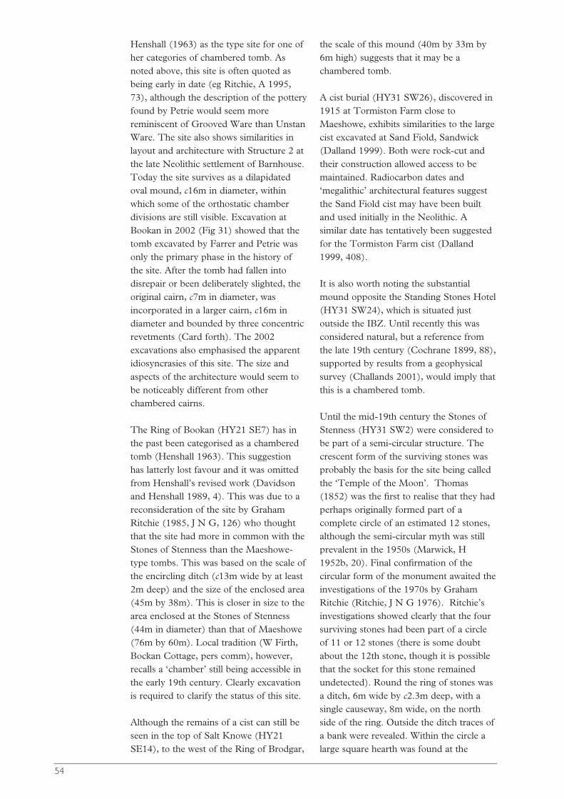
Henshall (1963) as the type site for one ofher categories of chambered tomb. Asnoted above, this site is often quoted asbeing early in date (eg Ritchie, A 1995,73), although the description of the potteryfound by Petrie would seem morereminiscent of Grooved Ware than UnstanWare. The site also shows similarities inlayout and architecture with Structure 2 atthe late Neolithic settlement of Barnhouse.Today the site survives as a dilapidatedoval mound, c16m in diameter, withinwhich some of the orthostatic chamberdivisions are still visible. Excavation atBookan in 2002 (Fig 31) showed that thetomb excavated by Farrer and Petrie wasonly the primary phase in the history ofthe site. After the tomb had fallen intodisrepair or been deliberately slighted, theoriginal cairn, c7m in diameter, wasincorporated in a larger cairn, c16m indiameter and bounded by three concentricrevetments (Card forth). The 2002excavations also emphasised the apparentidiosyncrasies of this site. The size andaspects of the architecture would seem tobe noticeably different from otherchambered cairns.
The Ring of Bookan (HY21 SE7) has inthe past been categorised as a chamberedtomb (Henshall 1963). This suggestionhas latterly lost favour and it was omittedfrom Henshall’s revised work (Davidsonand Henshall 1989, 4). This was due to areconsideration of the site by GrahamRitchie (1985, J N G, 126) who thoughtthat the site had more in common with theStones of Stenness than the Maeshowe-type tombs. This was based on the scale ofthe encircling ditch (c13m wide by at least2m deep) and the size of the enclosed area(45m by 38m). This is closer in size to thearea enclosed at the Stones of Stenness(44m in diameter) than that of Maeshowe(76m by 60m). Local tradition (W Firth,Bockan Cottage, pers comm), however,recalls a ‘chamber’ still being accessible inthe early 19th century. Clearly excavationis required to clarify the status of this site.
Although the remains of a cist can still beseen in the top of Salt Knowe (HY21SE14), to the west of the Ring of Brodgar,
the scale of this mound (40m by 33m by6m high) suggests that it may be achambered tomb.
A cist burial (HY31 SW26), discovered in1915 at Tormiston Farm close toMaeshowe, exhibits similarities to the largecist excavated at Sand Fiold, Sandwick(Dalland 1999). Both were rock-cut andtheir construction allowed access to bemaintained. Radiocarbon dates and‘megalithic’ architectural features suggestthe Sand Fiold cist may have been builtand used initially in the Neolithic. Asimilar date has tentatively been suggestedfor the Tormiston Farm cist (Dalland1999, 408).
It is also worth noting the substantialmound opposite the Standing Stones Hotel(HY31 SW24), which is situated justoutside the IBZ. Until recently this wasconsidered natural, but a reference fromthe late 19th century (Cochrane 1899, 88),supported by results from a geophysicalsurvey (Challands 2001), would imply thatthis is a chambered tomb.
Until the mid-19th century the Stones ofStenness (HY31 SW2) were considered tobe part of a semi-circular structure. Thecrescent form of the surviving stones wasprobably the basis for the site being calledthe ‘Temple of the Moon’. Thomas(1852) was the first to realise that they hadperhaps originally formed part of acomplete circle of an estimated 12 stones,although the semi-circular myth was stillprevalent in the 1950s (Marwick, H1952b, 20). Final confirmation of thecircular form of the monument awaited theinvestigations of the 1970s by GrahamRitchie (Ritchie, J N G 1976). Ritchie’sinvestigations showed clearly that the foursurviving stones had been part of a circleof 11 or 12 stones (there is some doubtabout the 12th stone, though it is possiblethat the socket for this stone remainedundetected). Round the ring of stones wasa ditch, 6m wide by c2.3m deep, with asingle causeway, 8m wide, on the northside of the ring. Outside the ditch traces ofa bank were revealed. Within the circle alarge square hearth was found at the
54
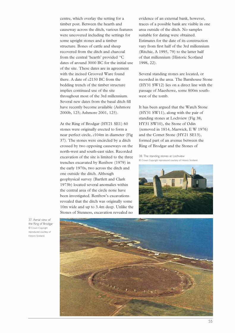
centre, which overlay the setting for atimber post. Between the hearth andcauseway across the ditch, various featureswere uncovered including the settings forsome upright stones and a timberstructure. Bones of cattle and sheeprecovered from the ditch and charcoalfrom the central ‘hearth’ provided 14Cdates of around 3000 BC for the initial useof the site. These dates are in agreementwith the incised Grooved Ware foundthere. A date of c2150 BC from thebedding trench of the timber structureimplies continued use of the sitethroughout most of the 3rd millennium.Several new dates from the basal ditch fillhave recently become available (Ashmore2000b, 125; Ashmore 2001, 125).
At the Ring of Brodgar (HY21 SE1) 60stones were originally erected to form anear perfect circle, c104m in diameter (Fig37). The stones were encircled by a ditchcrossed by two opposing causeways on thenorth-west and south-east sides. Recordedexcavation of the site is limited to the threetrenches excavated by Renfrew (1979) inthe early 1970s, two across the ditch andone outside the ditch. Althoughgeophysical survey (Bartlett and Clark1973b) located several anomalies withinthe central area of the circle none havebeen investigated. Renfrew’s excavationsrevealed that the ditch was originally some10m wide and up to 3.4m deep. Unlike theStones of Stenness, excavation revealed no
evidence of an external bank, however,traces of a possible bank are visible in onearea outside of the ditch. No samplessuitable for dating were obtained.Estimates for the date of its constructionvary from first half of the 3rd millennium(Ritchie, A 1995, 79) to the latter half of that millennium (Historic Scotland1998, 22).
Several standing stones are located, orrecorded in the area. The Barnhouse Stone(HY31 SW12) lies on a direct line with thepassage of Maeshowe, some 800m south-west of the tomb.
It has been argued that the Watch Stone(HY31 SW11), along with the pair ofstanding stones at Lochview (Fig 38,HY31 SW10), the Stone of Odin(removed in 1814, Marwick, E W 1976)and the Comet Stone (HY21 SE13),formed part of an avenue between theRing of Brodgar and the Stones of
55
37. Aerial view ofthe Ring of Brodgar © Crown Copyright
reproduced courtesy of
Historic Scotland.
38. The standing stones at Lochview © Crown Copyright reproduced courtesy of Historic Scotland.

Stenness (eg Ritchie, A 1995, 82).Alternatively, the discovery of sockets fortwin stones at the Watch Stone(discovered during roadworks in 1929)and the Stone of Odin (Richards (ed)forth), suggests that the pairing of stonesmight indicate a series of portals or‘symbolic doorways’ linking the twohenges (Richards 1996a, 199). Thisapparent physical link between the twostone circles, paralleled at Stonehenge andAvebury, may help to explain thefunctioning of the Brodgar ceremonialcomplex (Parker Pearson 2000, 212-13).
As noted above, when habitation ceased atBarnhouse, a single large structure,Structure 8, was built (Fig 35; Richards(ed) forth). Although reflecting somefeatures of late Neolithic houses, like acentral hearth and a dresser opposite thedoor, the scale of the structure wasmonumental. The internal floor areameasured c7m by 8m. It was surroundedby a clay platform bounded by an outerwall, elements paralleled at Maeshowe,while the elaborate entrance arrangement,including a passage some 3m long andflanked by upright stones with a hearth atits threshold, mirrors aspects of the Stonesof Stenness. The interconnection betweenthese monumental sites is furtheremphasised by the alignment of the twoentrances to the Barnhouse ‘hall’. Theouter entrance, through the surroundingouter wall, faces Maeshowe. The innerdoorway was aligned on the midsummersunset, the opposite to that of Maeshowe,which points towards the midwintersunset.
Bronze Age Orkney
The Bronze Age in Orkney has beencharacterised as an impoverished periodsandwiched between the apparentsplendour of the Neolithic and Iron Ages.Despite the plethora of burial evidence incists and round barrows, the lack ofsettlement evidence and ‘exotic’ items hasled to the view that this was ‘a dull time’(Ritchie, A 1995, 95) in the prehistory ofOrkney. The apparent demise of Orkneyhas been linked to climatic deterioration,
overuse of soils in the late Neolithic and aninability to compete in a changing societywhere access to resources was paramount,all leading to a growing isolation.Alternatively Clarke, D V et al (1985, 92)have suggested that the existing powerbase in late Neolithic Orkney preventedthe adoption of new ideas, such as Beakersand metalwork, in order to maintain theirauthority. This led to a growing atrophy inOrcadian society. Recent research isaddressing this imbalance and leading to agreater understanding of Orkney in theBronze Age.
The early Bronze Age is traditionallylinked to the introduction of Beakerpottery. Although sherds of Beakers havebeen found at the settlement sites of Rinyo(Childe and Grant, W G 1939; 1947) andLinks of Noltland (Clarke, D V andSharples 1985), and inside the chambersof Calf of Eday Long (Calder 1937) andKnowe of Yarso (Callander and Grant, WG 1935), these limited discoveries wereviewed as epitomizing the growingisolation of Orkney in the early BronzeAge. (There is some doubt over the Beakerfrom a cist in Birsay (HY22 NE1) (Clarke,D V et al 1985, 92).) Recent discoveries,however, have produced Beaker potteryfrom around the tombs at Howe (BallinSmith (ed) 1994, 24), Holm of PapaWestray North (Ritchie, A forth), at thesettlement site of Crossiecrown andpossibly Tofts Ness (Dockrill et al forth).Traditional views of the transition fromlate Neolithic to Early Bronze Age mayalso need to be reappraised once theevidence from Crossiecrown (Downes andRichards 2000, 165-7) and Links ofNoltland (Clarke and Sharples 1985) isfully evaluated.
Burnt mounds, defined here as thosefrequently crescentic-shaped deposits ofburnt stone and fuel ash, are foundcommonly throughout Orkney. A rapidlydisappearing feature of the Orkneylandscape, they have (following Hedges, JW 1975) been widely accepted as‘middens associated with dwelling andcooking facilities’ (Hedges, J W 1975, 82)and dated to the middle and late Bronze
56
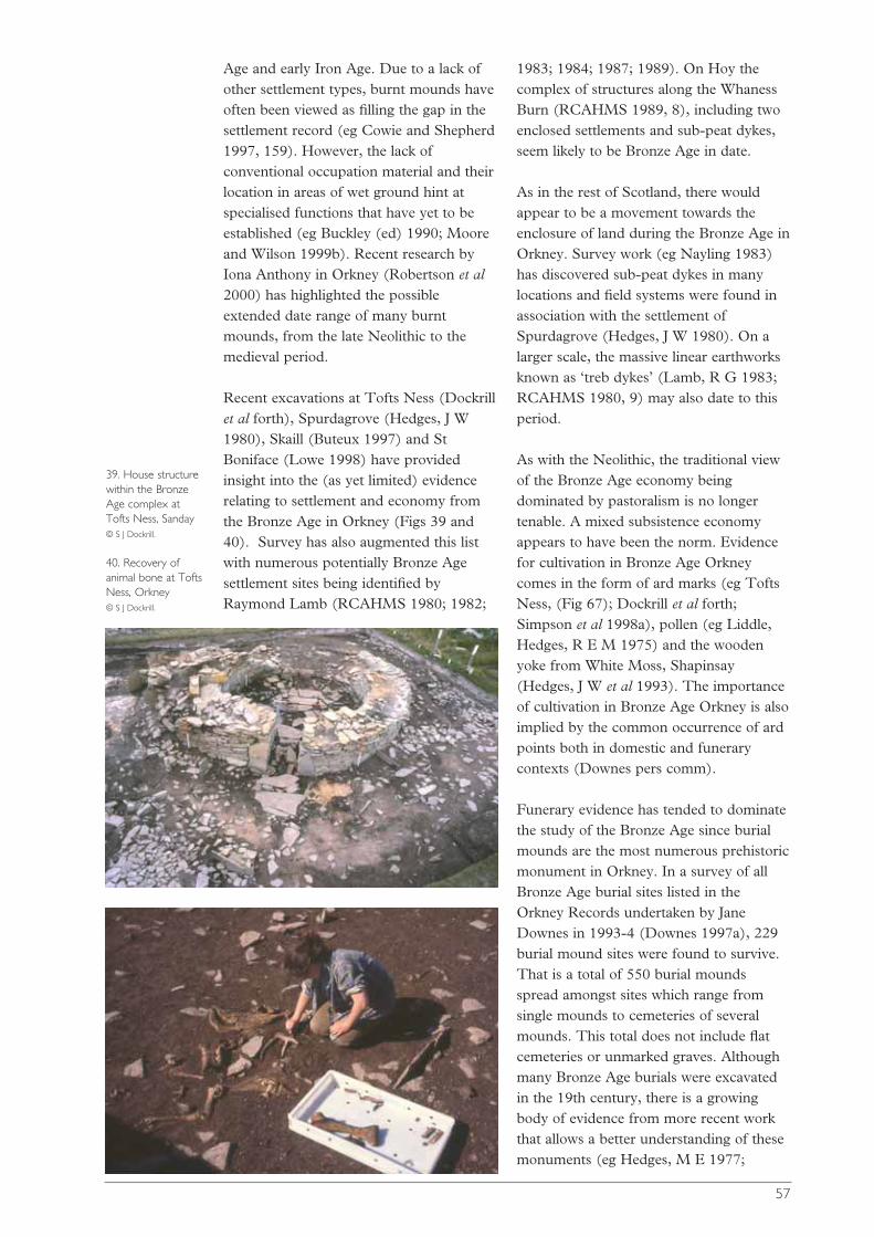
Age and early Iron Age. Due to a lack ofother settlement types, burnt mounds haveoften been viewed as filling the gap in thesettlement record (eg Cowie and Shepherd1997, 159). However, the lack ofconventional occupation material and theirlocation in areas of wet ground hint atspecialised functions that have yet to beestablished (eg Buckley (ed) 1990; Mooreand Wilson 1999b). Recent research byIona Anthony in Orkney (Robertson et al2000) has highlighted the possibleextended date range of many burntmounds, from the late Neolithic to themedieval period.
Recent excavations at Tofts Ness (Dockrillet al forth), Spurdagrove (Hedges, J W1980), Skaill (Buteux 1997) and StBoniface (Lowe 1998) have providedinsight into the (as yet limited) evidencerelating to settlement and economy fromthe Bronze Age in Orkney (Figs 39 and40). Survey has also augmented this listwith numerous potentially Bronze Agesettlement sites being identified byRaymond Lamb (RCAHMS 1980; 1982;
1983; 1984; 1987; 1989). On Hoy thecomplex of structures along the WhanessBurn (RCAHMS 1989, 8), including twoenclosed settlements and sub-peat dykes,seem likely to be Bronze Age in date.
As in the rest of Scotland, there wouldappear to be a movement towards theenclosure of land during the Bronze Age inOrkney. Survey work (eg Nayling 1983)has discovered sub-peat dykes in manylocations and field systems were found inassociation with the settlement ofSpurdagrove (Hedges, J W 1980). On alarger scale, the massive linear earthworksknown as ‘treb dykes’ (Lamb, R G 1983;RCAHMS 1980, 9) may also date to thisperiod.
As with the Neolithic, the traditional viewof the Bronze Age economy beingdominated by pastoralism is no longertenable. A mixed subsistence economyappears to have been the norm. Evidencefor cultivation in Bronze Age Orkneycomes in the form of ard marks (eg ToftsNess, (Fig 67); Dockrill et al forth;Simpson et al 1998a), pollen (eg Liddle,Hedges, R E M 1975) and the woodenyoke from White Moss, Shapinsay(Hedges, J W et al 1993). The importanceof cultivation in Bronze Age Orkney is alsoimplied by the common occurrence of ardpoints both in domestic and funerarycontexts (Downes pers comm).
Funerary evidence has tended to dominatethe study of the Bronze Age since burialmounds are the most numerous prehistoricmonument in Orkney. In a survey of allBronze Age burial sites listed in theOrkney Records undertaken by JaneDownes in 1993-4 (Downes 1997a), 229burial mound sites were found to survive.That is a total of 550 burial moundsspread amongst sites which range fromsingle mounds to cemeteries of severalmounds. This total does not include flatcemeteries or unmarked graves. Althoughmany Bronze Age burials were excavatedin the 19th century, there is a growingbody of evidence from more recent workthat allows a better understanding of thesemonuments (eg Hedges, M E 1977;
57
39. House structurewithin the BronzeAge complex atTofts Ness, Sanday © S J Dockrill.
40. Recovery ofanimal bone at ToftsNess, Orkney © S J Dockrill.
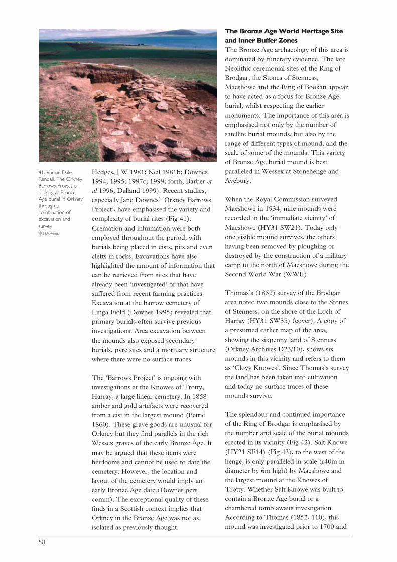
Hedges, J W 1981; Neil 1981b; Downes1994; 1995; 1997c; 1999; forth; Barber etal 1996; Dalland 1999). Recent studies,especially Jane Downes’ ‘Orkney BarrowsProject’, have emphasised the variety andcomplexity of burial rites (Fig 41).Cremation and inhumation were bothemployed throughout the period, withburials being placed in cists, pits and evenclefts in rocks. Excavations have alsohighlighted the amount of information thatcan be retrieved from sites that havealready been ‘investigated’ or that havesuffered from recent farming practices.Excavation at the barrow cemetery ofLinga Fiold (Downes 1995) revealed thatprimary burials often survive previousinvestigations. Area excavation betweenthe mounds also exposed secondaryburials, pyre sites and a mortuary structurewhere there were no surface traces.
The ‘Barrows Project’ is ongoing withinvestigations at the Knowes of Trotty,Harray, a large linear cemetery. In 1858amber and gold artefacts were recoveredfrom a cist in the largest mound (Petrie1860). These grave goods are unusual forOrkney but they find parallels in the richWessex graves of the early Bronze Age. Itmay be argued that these items wereheirlooms and cannot be used to date thecemetery. However, the location andlayout of the cemetery would imply anearly Bronze Age date (Downes perscomm). The exceptional quality of thesefinds in a Scottish context implies thatOrkney in the Bronze Age was not asisolated as previously thought.
The Bronze Age World Heritage Siteand Inner Buffer Zones The Bronze Age archaeology of this area isdominated by funerary evidence. The lateNeolithic ceremonial sites of the Ring ofBrodgar, the Stones of Stenness,Maeshowe and the Ring of Bookan appearto have acted as a focus for Bronze Ageburial, whilst respecting the earliermonuments. The importance of this area isemphasised not only by the number ofsatellite burial mounds, but also by therange of different types of mound, and thescale of some of the mounds. This varietyof Bronze Age burial mound is bestparalleled in Wessex at Stonehenge andAvebury.
When the Royal Commission surveyedMaeshowe in 1934, nine mounds wererecorded in the ‘immediate vicinity’ ofMaeshowe (HY31 SW21). Today onlyone visible mound survives, the othershaving been removed by ploughing ordestroyed by the construction of a militarycamp to the north of Maeshowe during theSecond World War (WWII).
Thomas’s (1852) survey of the Brodgararea noted two mounds close to the Stonesof Stenness, on the shore of the Loch ofHarray (HY31 SW35) (cover). A copy ofa presumed earlier map of the area,showing the sixpenny land of Stenness(Orkney Archives D23/10), shows sixmounds in this vicinity and refers to themas ‘Clovy Knowes’. Since Thomas’s surveythe land has been taken into cultivationand today no surface traces of thesemounds survive.
The splendour and continued importanceof the Ring of Brodgar is emphasised bythe number and scale of the burial moundserected in its vicinity (Fig 42). Salt Knowe(HY21 SE14) (Fig 43), to the west of thehenge, is only paralleled in scale (c40m indiameter by 6m high) by Maeshowe andthe largest mound at the Knowes ofTrotty. Whether Salt Knowe was built tocontain a Bronze Age burial or achambered tomb awaits investigation.According to Thomas (1852, 110), thismound was investigated prior to 1700 and
58
41. Varme Dale,Rendall. The OrkneyBarrows Project islooking at BronzeAge burial in Orkneythrough acombination ofexcavation andsurvey © J Downes.

nine silver fibulae were found. S Grieg(1940) speculates that this was Vikingring-money. It seems possible that these‘fibulae’ came from the cist-like structurestill visible on the top of the mound.
The two large mounds to the east of thecircle, Fresh Knowe (38m by 26m by5.7m high) and Plumcake Knowe (22m indiameter by 3m high), were bothinvestigated by Farrer and Petrie (Petrie1857). Two short cists were found inPlumcake Knowe, one containing a steatiteurn ‘one-third part filled with pieces ofcalcined bones’, the other ‘an urn of bakedclay … five inches in diameter and fiveinches deep’ (Petrie 1857, 60). Theexcavations at Fresh Knowe by Farrer andPetrie concentrated on the north end ofthis ‘elliptical’ mound. Despite ‘a veryconsiderable cut or trench made across it… it did not lead to any discovery’ (Petrie1857, 58). Petrie notes only that it wascarefully constructed. The unusual
elongated form of this mound suggeststhat it covers a chambered tomb ratherthan a Bronze Age burial.
The hollow centre of the South Mound(18m in diameter by 1.8m high) (HY21SE15), close to the southern lip of theditch at the Ring of Brodgar, bears witnessto investigations in the past. No records ofthese excavations survive. To the south ofthe henge at least nine smaller barrowssurvive (HY21 SE16), ranging from 4.5mto 12.8m in diameter and up to 1.1m high.Some have obviously been investigated but no finds have been reported. Therecent geophysical survey (GSB 2002) ofthe area has clarified the extent of thesemounds and located a series of associatedfeatures.
To the north of the Ring of Brodgar, closeto the present shore of the Loch ofStenness, is the best preserved of only fourrecorded disc-barrows in Orkney (HY21SE3). Although the outer bank on thesouth-west side has been cut through by acart track in the past, the central barrow(15m in diameter by 0.8m high) and itsencircling ditch and bank (overall diameterc30m) are still well defined. There are norecords of any excavations at this site.Recent geophysical survey (GSB 2003b)of this site suggests that the central moundis revetted. Two hundred metres to thenorth of the disc-barrow lies a small
59
42. Detail of Brodgararea in 1849 (seealso cover; Thomas1852) © Crown Copyright
reproduced courtesy of
Historic Scotland.
43. Salt Knowe© Crown Copyright
reproduced courtesy of
Historic Scotland.

mound (HY21 SE19). When recorded bythe Royal Commission (RCAHMS 1946,264) it was ‘outlined at the base by asetting of stones’. Today there is noevidence of this setting and the moundsurvives only as a low mound, c8m indiameter by 0.3m high.
The remaining burial mounds in theBrodgar area may be seen to clusteraround the Ring of Bookan. There arepresently three mounds (HY21 SE9)appearing to form a grouping at the top ofthe hill at Wasbister, south of the Ring ofBookan. The mound closest to the quarryis probably the result of quarrying activity.Both of the other mounds exhibit evidenceof being investigated in the past. Noreports survive of these excavations.Skae Frue (HY21 SE8) is a large mound(24m in diameter by 2.4m high) that liesc100m downslope to the south-west of theRing of Bookan (Fig 44). Excavations inthe mid-19th century (Thomas 1852, 22-5) revealed three cists ‘placed at the
cardinal points of the compass’, containingthe inhumations of two adults and a child.Until 30 years ago a group of sevenbarrows (HY21 SE4) existed about 250mto the west of the Ring of Bookan. Themounds varied from 4m to 10m indiameter. A cremation in a cist wasrecorded from one of them (Callander1936). Since the Ordnance Survey visit in1966 ploughing has levelled the mounds.
Within the IBZ around Skara Brae atumulus (HY21 NW16) was documentedon the 2nd edition Ordnance Survey mapof 1903, about 100m in front of SkaillHouse. The Royal Commission in 1928recorded this as being a mound 23ft indiameter, dug into on the west side for aconsiderable depth (RCAHMS 1946, 268,no. 719). Today this possible burialmound only survives as a slight mound ontop of a probable natural knoll close to theSkara Brae Visitor Centre. This mound ispossibly an outlier of the extensive barrowcemetery surveyed by Low, Banks andWalden in the late 18th century in theLinks of Skaill (HY21 NW15) (Lysaght1972).
Apart from the upstanding barrows,numerous unmarked cists and burials havebeen recovered from the IBZ.Unfortunately only a few have beenrecorded. Of most note was the presumedBronze Age cist cemetery discovered closeto Brodgar Farm in 1925 (Marwick, H1925b). Six cists were uncovered inassociation with a slab bearing eight bandsof incised decoration (Fig 29). Three ofthe cists held uncremated bone. This site,however, may need to be reassessed inlight of the recent discovery of a presumedNeolithic complex in the vicinity. Duringrecent building work at the house ofLochview a deposit of undisturbedcremated bone was found adjacent to asherd of Bronze Age pottery (HY31SW72). There were no surface features toindicate the presence of a grave (Card1998a, 71). Local knowledge would alsoseem to indicate the past presence ofnumerous flat cist burials around theBookan area. While breaking in the landfor cultivation in the late 1960s and early
60
44. Skae Frue fromBookan © Crown Copyright
reproduced courtesy of
Historic Scotland.
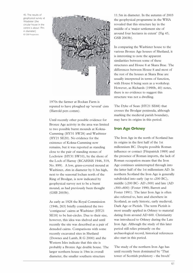
1970s the farmer at Bockan Farm isreputed to have ploughed up ‘several’ cists(Harrold pers comm).
Until recently other possible evidence forBronze Age activity in the area was limitedto two possible burnt mounds at Kokna-Cumming (HY31 SW28) and Wasbister(HY21 SE20). No evidence for theexistence of Kokna-Cumming nowremains, but it was reported as standingclose to the pair of standing stones ofLochview (HY31 SW10), by the shore ofthe Loch of Harray (RCAHMS 1946, 319,No. 899). A low, grass-covered mound atWasbister, c6m in diameter by 0.3m high,next to the seasonal lochan north of theRing of Brodgar, is now indicated bygeophysical survey not to be a burntmound, as had previously been thought(GSB 2003b).
As early as 1928 the Royal Commission(1946, 263) briefly considered the two‘contiguous’ cairns at Wasbister (HY21SE18) to be hut-circles. Due to their size,however, this idea was shelved and untilrecently the site was described as a pair ofdenuded cairns. Comparisons with somerecently excavated sites in Shetland(Downes and Lamb, R G 2000) and theWestern Isles indicate that this site isprobably a Bronze Age double house. Thelarger northern house is 19m in overalldiameter, the smaller southern structure
11.5m in diameter. In the autumn of 2003the geophysical programme in the WHArevealed that this structure lay in themiddle of a ‘major settlement site ofaround four hectares in extent’ (Fig 45,GSB 2003b).
In comparing the Wasbister house to thevarious Bronze Age houses of Shetland, itis interesting to note the apparentsimilarities between some of thesestructures and House 8 at Skara Brae. Thedifferences between House 8 and most ofthe rest of the houses at Skara Brae areusually interpreted in terms of function,with House 8 being seen as a workshop.However, as Richards (1990b, 40) notes,there is no evidence to suggest thisstructure was not a dwelling.
The Dyke of Sean (HY21 SE68) thatcrosses the Brodgar peninsula, althoughmarking the medieval parish boundary,may have its origins in this period.
Iron Age Orkney
The Iron Age in the north of Scotland hasits origins in the first half of the 1stmillennium BC. Despite possible Romaninfluence or contact (Fitzpatrick 1989) andthe presence of Roman imports, the lack ofRoman occupation means that the IronAge continues uninterrupted through intothe latter half of the 1st millennium AD. Innorthern Scotland the Iron Age is generallysubdivided into early (up to c200 BC),middle (c200 BC- AD c300) and late (ADc300-c800) (Foster 1990; Barrett andFoster 1991). The later Iron Age is oftenalso referred to, here and elsewhere inScotland, as early historic, early medieval,Dark Age or Pictish. The term Pictish ismost usually applied in Orkney to materialdating from around AD 600. Christianitywas introduced to Orkney during the LateIron Age. Although the study of this laterperiod still relies primarily on thearchaeological record, historical referencesalso start in this period.
The study of the northern Iron Age hasuntil recently been dominated by ‘Thattower of Scottish prehistory - the broch’
61
45. The results ofgeophysical survey atWasbister (thecircular house in thecentre is about 19min diameter) © GSB Prospection.
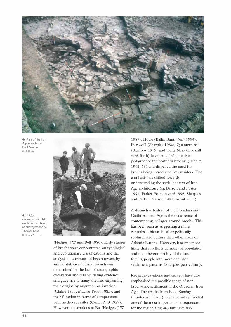
(Hedges, J W and Bell 1980). Early studiesof brochs were concentrated on typologicaland evolutionary classifications and theanalysis of attributes of broch towers bysimple statistics. This approach wasdetermined by the lack of stratigraphicexcavation and reliable dating evidenceand gave rise to many theories explainingtheir origins by migration or invasion(Childe 1935; Mackie 1965; 1983), andtheir function in terms of comparisonswith medieval castles (Curle, A O 1927).However, excavations at Bu (Hedges, J W
1987), Howe (Ballin Smith (ed) 1994),Pierowall (Sharples 1984), Quanterness(Renfrew 1979) and Tofts Ness (Dockrillet al, forth) have provided a ‘nativepedigree for the northern brochs’ (Hingley1992, 13) and dispelled the need forbrochs being introduced by outsiders. Theemphasis has shifted towardsunderstanding the social context of IronAge architecture (eg Barrett and Foster1991; Parker Pearson et al 1996; Sharplesand Parker Pearson 1997; Armit 2003).
A distinctive feature of the Orcadian andCaithness Iron Age is the occurrence ofcontemporary villages around brochs. Thishas been seen as suggesting a morecentralised hierarchical or politicallysophisticated culture than other areas ofAtlantic Europe. However, it seems morelikely that it reflects densities of populationand the inherent fertility of the landforcing people into more compactsettlement patterns (Sharples pers comm).
Recent excavations and surveys have alsoemphasised the possible range of non-broch-type settlement in the Orcadian IronAge. The results from Pool, Sanday(Hunter et al forth) have not only providedone of the most important site sequencesfor the region (Fig 46) but have also
62
46. Part of the IronAge complex atPool, Sanday © J R Hunter.
47. 1920sexcavations at Daleearth house, Harray,as photographed byThomas Kent © Orkney Archives.
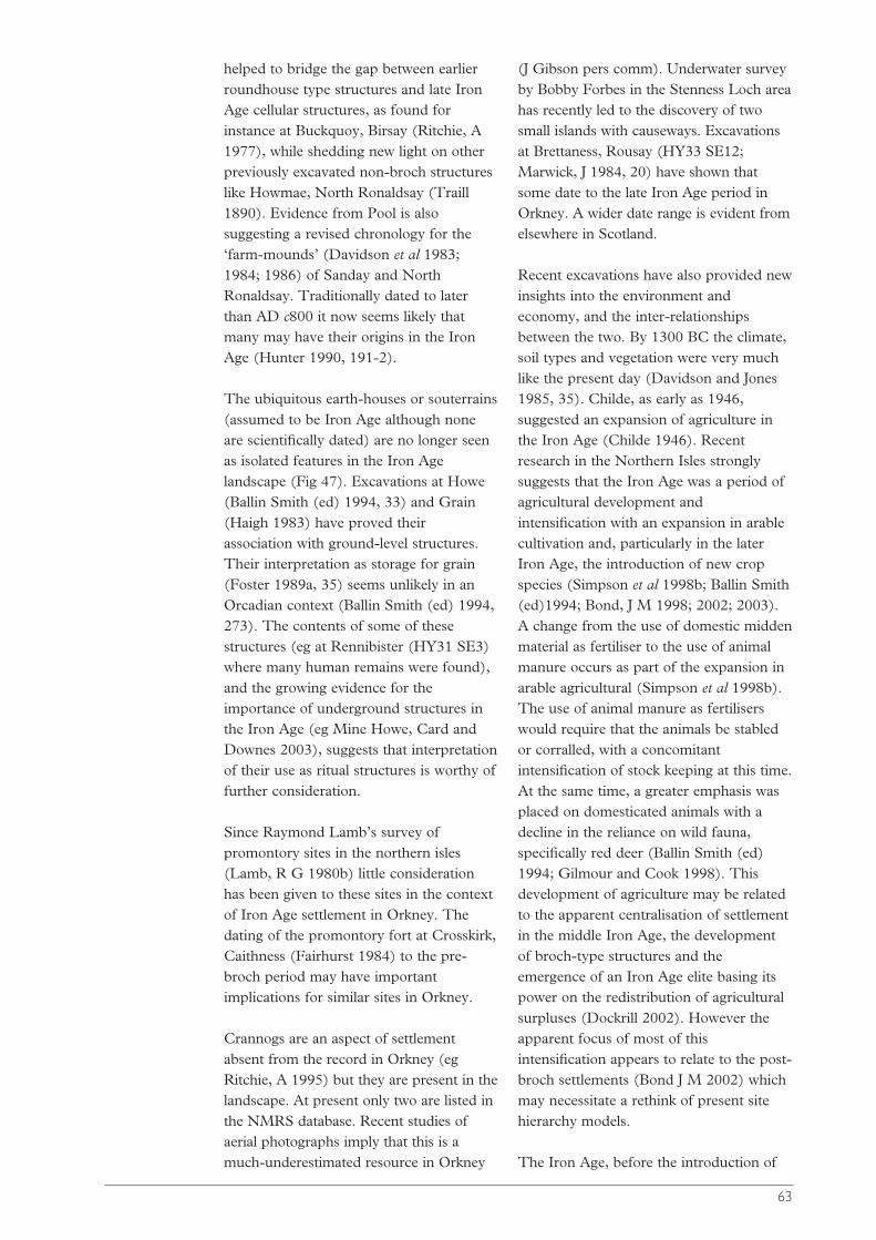
helped to bridge the gap between earlierroundhouse type structures and late IronAge cellular structures, as found forinstance at Buckquoy, Birsay (Ritchie, A1977), while shedding new light on otherpreviously excavated non-broch structureslike Howmae, North Ronaldsay (Traill1890). Evidence from Pool is alsosuggesting a revised chronology for the‘farm-mounds’ (Davidson et al 1983;1984; 1986) of Sanday and NorthRonaldsay. Traditionally dated to laterthan AD c800 it now seems likely thatmany may have their origins in the IronAge (Hunter 1990, 191-2).
The ubiquitous earth-houses or souterrains(assumed to be Iron Age although noneare scientifically dated) are no longer seenas isolated features in the Iron Agelandscape (Fig 47). Excavations at Howe(Ballin Smith (ed) 1994, 33) and Grain(Haigh 1983) have proved theirassociation with ground-level structures.Their interpretation as storage for grain(Foster 1989a, 35) seems unlikely in anOrcadian context (Ballin Smith (ed) 1994,273). The contents of some of thesestructures (eg at Rennibister (HY31 SE3)where many human remains were found),and the growing evidence for theimportance of underground structures inthe Iron Age (eg Mine Howe, Card andDownes 2003), suggests that interpretationof their use as ritual structures is worthy offurther consideration.
Since Raymond Lamb’s survey ofpromontory sites in the northern isles(Lamb, R G 1980b) little considerationhas been given to these sites in the contextof Iron Age settlement in Orkney. Thedating of the promontory fort at Crosskirk,Caithness (Fairhurst 1984) to the pre-broch period may have importantimplications for similar sites in Orkney.
Crannogs are an aspect of settlementabsent from the record in Orkney (egRitchie, A 1995) but they are present in thelandscape. At present only two are listed inthe NMRS database. Recent studies ofaerial photographs imply that this is amuch-underestimated resource in Orkney
(J Gibson pers comm). Underwater surveyby Bobby Forbes in the Stenness Loch areahas recently led to the discovery of twosmall islands with causeways. Excavationsat Brettaness, Rousay (HY33 SE12;Marwick, J 1984, 20) have shown thatsome date to the late Iron Age period inOrkney. A wider date range is evident fromelsewhere in Scotland.
Recent excavations have also provided newinsights into the environment andeconomy, and the inter-relationshipsbetween the two. By 1300 BC the climate,soil types and vegetation were very muchlike the present day (Davidson and Jones1985, 35). Childe, as early as 1946,suggested an expansion of agriculture inthe Iron Age (Childe 1946). Recentresearch in the Northern Isles stronglysuggests that the Iron Age was a period ofagricultural development andintensification with an expansion in arablecultivation and, particularly in the laterIron Age, the introduction of new cropspecies (Simpson et al 1998b; Ballin Smith(ed)1994; Bond, J M 1998; 2002; 2003).A change from the use of domestic middenmaterial as fertiliser to the use of animalmanure occurs as part of the expansion inarable agricultural (Simpson et al 1998b).The use of animal manure as fertiliserswould require that the animals be stabledor corralled, with a concomitantintensification of stock keeping at this time.At the same time, a greater emphasis wasplaced on domesticated animals with adecline in the reliance on wild fauna,specifically red deer (Ballin Smith (ed)1994; Gilmour and Cook 1998). Thisdevelopment of agriculture may be relatedto the apparent centralisation of settlementin the middle Iron Age, the developmentof broch-type structures and theemergence of an Iron Age elite basing itspower on the redistribution of agriculturalsurpluses (Dockrill 2002). However theapparent focus of most of thisintensification appears to relate to the post-broch settlements (Bond J M 2002) whichmay necessitate a rethink of present sitehierarchy models.
The Iron Age, before the introduction of
63
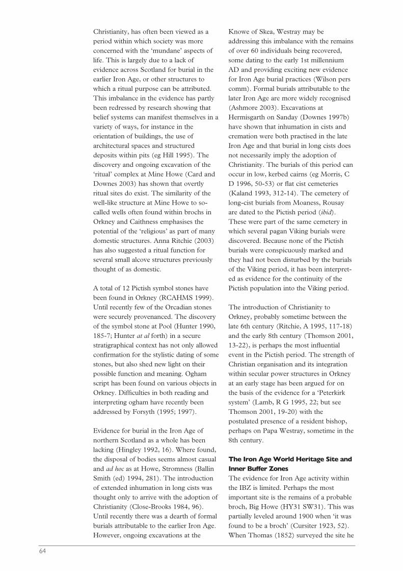
Christianity, has often been viewed as aperiod within which society was moreconcerned with the ‘mundane’ aspects oflife. This is largely due to a lack ofevidence across Scotland for burial in theearlier Iron Age, or other structures towhich a ritual purpose can be attributed.This imbalance in the evidence has partlybeen redressed by research showing thatbelief systems can manifest themselves in avariety of ways, for instance in theorientation of buildings, the use ofarchitectural spaces and structureddeposits within pits (eg Hill 1995). Thediscovery and ongoing excavation of the‘ritual’ complex at Mine Howe (Card andDownes 2003) has shown that overtlyritual sites do exist. The similarity of thewell-like structure at Mine Howe to so-called wells often found within brochs inOrkney and Caithness emphasises thepotential of the ‘religious’ as part of manydomestic structures. Anna Ritchie (2003)has also suggested a ritual function forseveral small alcove structures previouslythought of as domestic.
A total of 12 Pictish symbol stones havebeen found in Orkney (RCAHMS 1999).Until recently few of the Orcadian stoneswere securely provenanced. The discoveryof the symbol stone at Pool (Hunter 1990,185-7; Hunter at al forth) in a securestratigraphical context has not only allowedconfirmation for the stylistic dating of somestones, but also shed new light on theirpossible function and meaning. Oghamscript has been found on various objects inOrkney. Difficulties in both reading andinterpreting ogham have recently beenaddressed by Forsyth (1995; 1997).
Evidence for burial in the Iron Age ofnorthern Scotland as a whole has beenlacking (Hingley 1992, 16). Where found,the disposal of bodies seems almost casualand ad hoc as at Howe, Stromness (BallinSmith (ed) 1994, 281). The introductionof extended inhumation in long cists wasthought only to arrive with the adoption ofChristianity (Close-Brooks 1984, 96).Until recently there was a dearth of formalburials attributable to the earlier Iron Age.However, ongoing excavations at the
Knowe of Skea, Westray may beaddressing this imbalance with the remainsof over 60 individuals being recovered,some dating to the early 1st millenniumAD and providing exciting new evidencefor Iron Age burial practices (Wilson perscomm). Formal burials attributable to thelater Iron Age are more widely recognised(Ashmore 2003). Excavations atHermisgarth on Sanday (Downes 1997b)have shown that inhumation in cists andcremation were both practised in the lateIron Age and that burial in long cists doesnot necessarily imply the adoption ofChristianity. The burials of this period canoccur in low, kerbed cairns (eg Morris, CD 1996, 50-53) or flat cist cemeteries(Kaland 1993, 312-14). The cemetery oflong-cist burials from Moaness, Rousayare dated to the Pictish period (ibid).These were part of the same cemetery inwhich several pagan Viking burials werediscovered. Because none of the Pictishburials were conspicuously marked andthey had not been disturbed by the burialsof the Viking period, it has been interpret-ed as evidence for the continuity of thePictish population into the Viking period.
The introduction of Christianity toOrkney, probably sometime between thelate 6th century (Ritchie, A 1995, 117-18)and the early 8th century (Thomson 2001,13-22), is perhaps the most influentialevent in the Pictish period. The strength ofChristian organisation and its integrationwithin secular power structures in Orkneyat an early stage has been argued for onthe basis of the evidence for a ‘Peterkirksystem’ (Lamb, R G 1995, 22; but seeThomson 2001, 19-20) with thepostulated presence of a resident bishop,perhaps on Papa Westray, sometime in the8th century.
The Iron Age World Heritage Site andInner Buffer ZonesThe evidence for Iron Age activity withinthe IBZ is limited. Perhaps the mostimportant site is the remains of a probablebroch, Big Howe (HY31 SW31). This waspartially leveled around 1900 when ‘it wasfound to be a broch’ (Cursiter 1923, 52).When Thomas (1852) surveyed the site he
64
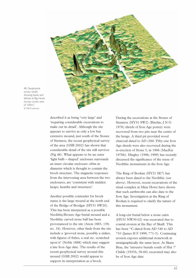
65
48. Geophysicalsurvey resultsshowing banks andditches at Big Howe(survey covers areaof 100m2)© GSB Prospection.
described it as being ‘very large’ and‘requiring considerable excavations tomake out its detail’. Although the siteappears to survive as only a low butextensive mound, just south of the Stonesof Stenness, the recent geophysical surveyof the area (GSB 2002) has shown thatconsiderable detail of the site still survives(Fig 48). What appears to be an outer‘light bulb – shaped’ enclosure surroundsan inner circular enclosure c40m indiameter which is thought to contain thebroch structure. The magnetic responsesfrom the intervening area between the twoenclosures, are ‘consistent with middenheaps, hearths and structures’.
Another possible contender for brochstatus is the large mound at the north endof the Bridge of Brodgar (HY31 SW20).This has been interpreted as a possibleNeolithic/Bronze Age burial mound and aNeolithic carved stone ball has beenprovenanced to the site (Anon 1885, 139,no. 18). However, other finds from the siteinclude a ‘grooved stone, possibly a sinker,with figures of fishes, a seal etc. scratchedupon it’ (Noble 1888) which may suggesta late Iron Age date. The results of therecent geophysical survey around thismound (GSB 2002) would appear tosupport its interpretation as a broch.
During the excavations at the Stones ofStenness (HY31 SW2) (Ritchie, J N G1976) sherds of Iron Age pottery wererecovered from two pits near the centre ofthe henge. A third pit provided woodcharcoal dated to AD c560. Fifty-one IronAge sherds were also recovered during there-erection of Stone 5, in 1906 (MacKie1976b). Hingley (1996; 1999) has recentlydiscussed the significance of the reuse ofNeolithic monuments in the Iron Age.
The Ring of Bookan (HY21 SE7) hasalways been dated to the Neolithic (seeabove). However, recent excavations of theritual complex at Mine Howe have shownthat such earthworks can also date to theIron Age. Investigation at the Ring ofBookan is required to clarify the nature ofthis monument.
A long-cist burial below a stone cairn(HY31 NW30.02) was excavated due tocoastal erosion at the Bay of Skaill. Thishas been 14C-dated from AD 540 to AD710 (James H F 1999, 771-5). Continuingerosion exposes additional stonework atstratigraphically the same layer. At SkaraBrae, the ‘intrusive burials south of Hut 7’Childe (1931b, 58-60) excavated may alsobe of Iron Age date.
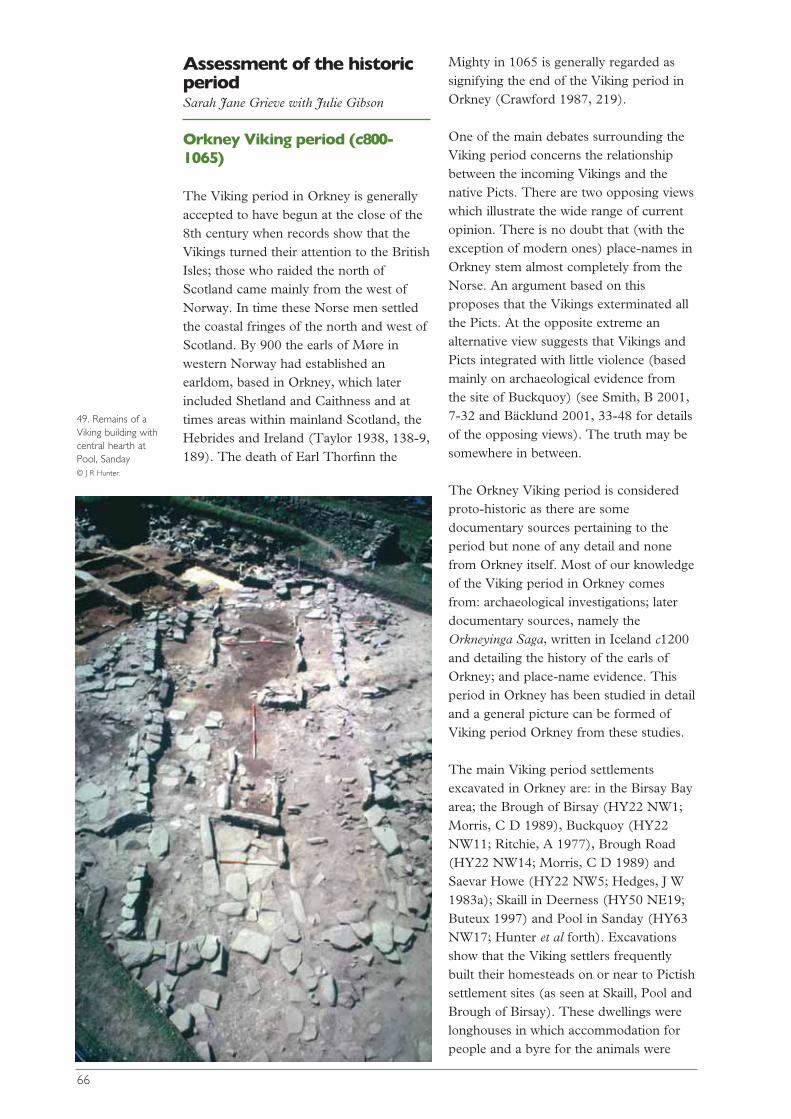
Assessment of the historicperiod Sarah Jane Grieve with Julie Gibson
Orkney Viking period (c800-1065)
The Viking period in Orkney is generallyaccepted to have begun at the close of the8th century when records show that theVikings turned their attention to the BritishIsles; those who raided the north ofScotland came mainly from the west ofNorway. In time these Norse men settledthe coastal fringes of the north and west ofScotland. By 900 the earls of Møre inwestern Norway had established anearldom, based in Orkney, which laterincluded Shetland and Caithness and attimes areas within mainland Scotland, theHebrides and Ireland (Taylor 1938, 138-9,189). The death of Earl Thorfinn the
Mighty in 1065 is generally regarded assignifying the end of the Viking period inOrkney (Crawford 1987, 219).
One of the main debates surrounding theViking period concerns the relationshipbetween the incoming Vikings and thenative Picts. There are two opposing viewswhich illustrate the wide range of currentopinion. There is no doubt that (with theexception of modern ones) place-names inOrkney stem almost completely from theNorse. An argument based on thisproposes that the Vikings exterminated allthe Picts. At the opposite extreme analternative view suggests that Vikings andPicts integrated with little violence (basedmainly on archaeological evidence fromthe site of Buckquoy) (see Smith, B 2001,7-32 and Bäcklund 2001, 33-48 for detailsof the opposing views). The truth may besomewhere in between.
The Orkney Viking period is consideredproto-historic as there are somedocumentary sources pertaining to theperiod but none of any detail and nonefrom Orkney itself. Most of our knowledgeof the Viking period in Orkney comesfrom: archaeological investigations; laterdocumentary sources, namely theOrkneyinga Saga, written in Iceland c1200and detailing the history of the earls ofOrkney; and place-name evidence. Thisperiod in Orkney has been studied in detailand a general picture can be formed ofViking period Orkney from these studies.
The main Viking period settlementsexcavated in Orkney are: in the Birsay Bayarea; the Brough of Birsay (HY22 NW1;Morris, C D 1989), Buckquoy (HY22NW11; Ritchie, A 1977), Brough Road(HY22 NW14; Morris, C D 1989) andSaevar Howe (HY22 NW5; Hedges, J W1983a); Skaill in Deerness (HY50 NE19;Buteux 1997) and Pool in Sanday (HY63NW17; Hunter et al forth). Excavationsshow that the Viking settlers frequentlybuilt their homesteads on or near to Pictishsettlement sites (as seen at Skaill, Pool andBrough of Birsay). These dwellings werelonghouses in which accommodation forpeople and a byre for the animals were
66
49. Remains of aViking building withcentral hearth atPool, Sanday © J R Hunter.

integrated under one roof (Fig 49). Theearly houses were built in the main ofstone and turf, roughly rectangular withthe longer walls bowed. The livingaccommodation surrounded a long centralhearth with the byre at the lower end ofthe building. At each of the sites therewere also other smaller buildingsassociated with the dwelling house. It islikely that the house would haveaccommodated a single-family unit. Theearliest Viking houses have been dated tothe 9th century. The majority of Vikingsettlements have been recognised on sitesclose to the shore and as a result manysites, such as those in the Bay at Birsay,have been subject to coastal erosion andare thus incomplete. These coastalfarmsteads were ideally situated to exploitthe maximum number of resources whilenot encroaching on the best farmland, andare often to be found near good baysallowing ease of access andcommunication.
Birsay Bay is the main area of Vikingsettlement investigated in Orkney (Morris,C D 1989; 1996). It is probably not acoincidence that a large amount ofarchaeological material has beendiscovered in this area for it was the largestearldom estate and the seat of the firstNorse bishopric in Orkney. The bay atBirsay was a Pictish settlement focus priorto the arrival of the Vikings (Ritchie, A1977, 192; 1988, 5) and it was located onthe route from Norway to the Irish Sea.The first documented reference to Birsayis in the Orkneyinga Saga where it statesthat Thorfinn ‘lived usually in Birsay, andhad Christ’s Kirk built there’ (Taylor1938, 189). At the end of the Vikingperiod the earldom of Orkney was a well-established power (Crawford 1987, 63).The achievements of Thorfinn the Mightyreveal the developments which had takenplace within Orkney society in the 250years since the first Vikings settled. Histour of Scandinavia, Germany and Romeand the papal approval of a bishop forOrkney, provide indications of the wealthand power he had created. That he ‘turnedhis mind to the government of his land andpeople, and to the making of laws’ (Taylor
1938, 189), further suggests he wasattempting to develop governmentalstructures and, if correct, places him ‘wellin the forefront of 11th-century politicaldevelopment’ (Crawford 1987, 80).
Skaill Bay in Sandwick, the location of partof the WHS, was evidently a focus ofViking activity and settlement. The place-name ‘Skaill’ comes from the Norse nameskali which refers to a feasting hall for amilitary retinue (Thomson 2001).Furthermore, reference to the subdivisionof Svein Asleifarson’s great drinking hallby his sons in Orkneyinga Saga, chapter108, is made by the 13th-century writersto symbolise the end of the period ofVikings in Orkney (Pálsson and Edwards1981, 15). The name is thus likely to be asignifier of Viking activity. The originalskali settlement in the bay at Skaill has notbeen identified, but there are otherindications of a Viking presence here. Oneubiquitous aspect of Viking society is thehoarding of precious metals in the ground,sometimes beneath settlements or perhapsrelated to prominent landscape features.There have been six hoards found inOrkney and three single finds. The hoardsmay have been deliberately placed in theground to be recovered later and theycould indicate a period of unrest orwarfare when it was thought safer to hideportable wealth. From Skaill came a hoard(HY21 NW14) that is the largest Vikinghoard yet to be discovered in Scotland. Itwas found in the 19th century in a rabbitburrow at the Castle of Snusgar (HY21NW21), a large mound at the north end ofthe Bay of Skaill. It has been suggestedthat this hoard may represent ‘the capitalof the local chieftain who lived in thisprime settlement location, buried by him… before setting out to increase his wealthon an expedition from which he neverreturned’ (Graham-Campbell and Batey1998, 246). Ongoing work by DavidGriffith of Oxford University at the Castleof Snusgar may shed light on this (Griffith2003).
In recent years the increase inenvironmental analysis has allowed manynew discoveries to be made concerning the
67

economy and environment of theScandinavian people living in Orkney.From samples taken from the Birsay(Morris, C D 1989; 1996) and Pool(Hunter et al forth) excavations it has beenpossible to gain a better understanding ofthe resources exploited by these firstScandinavian settlers. It appears that thesesettlers had a mixed economy combiningpastoral and arable farming, while alsoexploiting the seasonal wild resources of avariety of fish, shellfish and birds (Morris,C D 1989, 271). The livestock remainsfrom the sites in Birsay reveal that cattlewere predominant but there were alsosheep, goat, pig, horse, fowl and domesticdog and cat present (Morris, C D 1989,10). The animals were being slaughteredon site and at a young age that suggeststhat the majority of the animals were usedfor meat rather than for dairying or as awool resource. At Saevar Howe and Poolcereals have also been found, the mostpredominant being six-row barley andcultivated oats. The discovery of smallquerns suggests that there was flourproduction on site while the Viking Agehorizontal mill at the Earls Bu, Orphirsuggests larger scale milling (Graham-Campbell and Batey 1998, 192-4). Theintroduction of flax in this period at mostof the sites suggests that it was a cropbrought in by the Scandinavians (Bondand Hunter 1987). Fish and marineresources were important in this periodand the evidence from Birsay shows thatgadids were the predominant fish speciesand limpets the most common shellfish(Morris, C D 1989, 8-9). Many varyingspecies of wild bird were also beingexploited.
Orkney has the largest number of pagangraves from any region within Scandin-avian Scotland. There are a variety offorms of burial, including boat burials,such as Scar (HY64 NE7; Owen andDalland 1999), large numbers ofinhumations within cemeteries, egWestness (HY32 NE7; Kaland 1993) and, more unusually, cremations. Themost common form of pagan burial inOrkney was inhumation. Analysis of themany varied grave-goods found associated
with the burials has provided an estimateddate range from the middle of the 9th tothe middle of the 10th century, with mostburials centring around late 9th to early10th (Graham-Campbell and Batey 1998,154). The largest group of Viking gravesyet discovered in Britain lay behindPierowall, in Westray (HY44 NW13 andHY45 SW5). Raymond Lamb argues thattheir presence, read together with theOrkneyinga Saga designation of Pierowallas ‘thorp’, suggests the presence of amercantile settlement (Lamb, R G 1993a,82).
There is some archaeological evidence fortwo small chapels in use in Orkney by themid-10th century, at Newark in Deerness(HY50 SE3) and at the Brough ofDeerness (HY50 NE14; Barrett et al2000b, 13-14). In addition to thearchaeological evidence there is onedocumentary source which, if believed, isevidence for a Christian community withinOrkney in the mid-9th century. Thesource is the Vita Findani, which describesSt Findan being captured by Vikings inIreland, escaping his captors in Orkneyand being taken to a bishop who spoke hislanguage (Thomson 1986, 279-80). Thisreference has been thought to relate to amonastic establishment in Papa Westraybut the identification is by no meansconclusive (Lowe 1998, 8-9). The mostexplicit piece of documentary evidence forChristianity in Orkney in this periodcomes again from the Orkneyinga Saga. In995 Olaf Tryggvesson met with EarlSigurd and said ‘It is my will that thouhave thyself baptized and all those underthee, else thou shalt die on the spot and Ishall bear fire and flame through all theIsles’ (Taylor 1938, 149). This date istaken to be the official conversion of theNorse in Orkney to Christianity and, alongwith the evidence outlined above, it seemslikely that by the close of the 10th centurythere were several Christian foundationswithin the Islands.
It is important to realise the position ofOrkney as a real power within the north ofScotland in the Viking Age and to beaware of the profound effect the Norse
68

settlement had on the Islands. This powercan be illustrated in the far-reachinginternational connections between Orkney,Scandinavia and western Europe. Thispower would fade by the 13th century butthe legacy of the Vikings continues eventoday.
The Viking period World Heritage Siteand Inner Buffer ZonesThere are at present no known Vikingsettlement sites in the IBZs, yet evidence isthere for Viking period activity,represented by three burials and onedeposit of silver rings. The silver ringswere found ‘in one of these hillocks nearthe circle of high stones’ (Wallace 1700,58) at some time earlier than 1700(Graham-Campbell 1995, 95-6). Thomas(1852, 110) suggests they may have beenfound in Salt Knowe (HY21 SE14). Thefind consisted of nine silver plainpenannular arm-rings, of the ring-moneytype, which have been dated within the 9thand 10th centuries (Graham-Campbell1995, 95-6). Two burials discovered in1930 during excavations at Skara Brae(HY21 NW12) were proposed by Childe(1931a, 58-9) as pre-Christian, possiblyViking, although they could equally beIron Age in date (p 65). From the mounderoding to the west of Skara Brae, a 19th-century discovery of a burial (HY21NW13) accompanied by a bone comb,comb case and other goods, has beendated typologically to the 9th century orlater (Morris, C D et al 1985).
Orkney late Norse Period (1065-1231)
This period sees the further growth of theearldom as a power in the north. Thispower was at its peak during the rule ofEarl Rognvald Kolsson, when thedevelopment of the medieval institutions ofurbanisation and centralisation began totake place. The 12th century has beenregarded as Orkney’s Renaissance periodand this is reflected in the quality of thebuildings erected, as best exemplified by StMagnus Cathedral (HY41 SW10) inKirkwall (Crawford (ed) 1988, 11).However, the period also saw the declineof the earldom and the end of the line ofNorse earls. By 1240 the earldom hadbeen much reduced and had lost itsposition of power in the north. The lastearl of Orkney was murdered, his sondrowned, and many of his relatives(consisting of many of the powerful chiefsin Orkney) drowned in a boat accident(Thomson 2001, 132-3). These events lefta convenient blank in the power-base ofOrkney and as a result the kings ofScotland and Norway were able to assertmore influence upon the islands.
The Orkneyinga Saga portrays ahierarchical society in Orkney with the earlin control but reliant on a group of good-men for support. These men were oftengiven earldom estates and in returnsupported the earl and possibly performedadministrative functions within theearldom. There is no mention in theOrkneyinga Saga of farmers or tenants andonly in 1492, the date of the earliest extantrental for Orkney, is it possible to get aclear understanding of the layout of theland in Orkney.
Archaeological evidence has muchimproved knowledge of the types ofsettlement within Orkney in the LateNorse period. The excavations at Skaill inDeerness (HY50 NE19; Buteux 1997) andat Tuquoy in Westray (HY44 SE5; Owen1993) have both revealed relatively highstatus sites with large dwellings, most likelyof a hall-house type construction, dating tothe 12th century. Owen (ibid) suggests
69
50. The RoundChurch, Orphir, partof a lordly estatecomplex © Crown Copyright
reproduced courtesy of
Historic Scotland.
that Tuquoy may also be compared withthe more grandiose 12th-century Bishops’Palace in Kirkwall (HY41 SW12) andpossibly the Wirk, Rousay (HY33 SE17).Tuquoy, Westray and Skaill, Deerness,both provide evidence of rich farm estateswith large houses, outbuildings andassociated churches, as does the Earls Buin Orphir (Fig 50). The combination ofresidence, farm and church can also beseen in Wyre, in an agglomeration offortified residence - Cobbie Roo’s Castle,farm and church (HY42 NW4, 5). Theexcavations of a late Norse settlement atWestness in Rousay (HY32 NE17)revealed a pair of rectangular stonebuildings which were built close together,gable end on to the sea and linked by apaved area or kloss. It seems that the onebuilding was a dwelling and the seconddivided into two byres (Kaland 1993, 308-12). Nearby, and apparently of a similardate, was a naust (HY32 NE32) consistingof a large stone boathouse with a clearedlanding area running ashore from asheltered bay. This settlement may havebeen the predecessor to the Wirk,mentioned above. The farm moundsituated at Beach View in Birsay (HY22NW19) revealed a late Norse structurewhich had been modified and in-filled withmidden, along with a possible separatebyre and a building with a corn drying kilndating to the 12th or 13th century. This is extremely important in that it is theearliest corn kiln in Orkney (Graham-Campbell and Batey 1998, 190-91). Thebuildings outlined above exemplify theincreasing wealth of the local chiefs andthe range of functions performed at theirhomesteads.
The growth and development of the townof Kirkwall is also evident during thisperiod. Kirkwall held one of the earls’residences as early as 1046 (Taylor 1938,183). In c1136 St Magnus’s relics weretranslated from Birsay to the market townof Kirkwall (Taylor 1938, 221), followedin 1137 by the foundation of St MagnusCathedral. Consequently the bishop’s seatmoved from the rural centre of Birsay tothe developing town. The deliberate moveto Kirkwall by Earl Rognvald established
the town as the secular and ecclesiasticalcentre of Orkney, and it is from this periodonwards that Kirkwall becomes the focusof activity. Both the earls and the bishops(Lamb, R G 1993a, 46) would haveencouraged the development of themarket. The refinement and collection oftaxes based on the land may also havebeen started soon after the move toKirkwall (Thomson 2001, 219), inconjunction with the re-organisation of thechurch. Saint Magnus and the cathedralindicate the status of Orkney in the 12thcentury and suggest a sentiment ofnational identity. The fact that the earl andthe bishop both went on crusade in c1150also indicates the power of both secularand ecclesiastical government (Taylor1938, 281).
The position and the influence of thechurch changed significantly within thisperiod. In 1065 the first bishop’s seat waserected in Birsay and the ‘magnificentchurch’ (Taylor, 1938, 189) was eitherlocated on the Brough of Birsay or underthe present parish church in Birsay (HY22NW8). There were already small privatechapels in use in the islands andthroughout the 11th and 12th centuriesthese chapels appear to have increasedgreatly in number. It is possible that therewas some form of pre-parochial system inplace, although there has been littleresearch into this area (Lamb, R G 1997,16). It is probable that, after the cathedralhad been consecrated, the church wasreorganised and centralised and theparochial system put in place. The churchlands increased greatly in this period,through endowments and also probablythrough the establishment of tithepayments (Thomson 2001, 252).
Defining the exact location and status anddate of churches and of the very manychapels is not easy and will rely largely onarchaeological evidence. For instance,recent accidental discovery of a medievalcemetery at and below parts of SkaillHouse, Sandwick, with burials 14C-dated tobetween the 11th and 14th centuries(HY21 NW40; James 1999), reinforcesClouston’s suggestion (Clouston 1918a) of
70
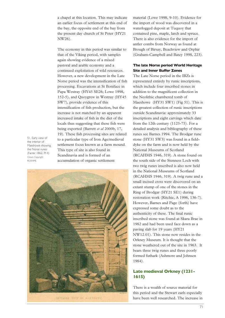
a chapel at this location. This may indicatean earlier focus of settlement at this end ofthe bay, the opposite end of the bay fromthe present day church of St Peter (HY21NW26).
The economy in this period was similar tothat of the Viking period, with samplesagain showing evidence of a mixedpastoral and arable economy and acontinued exploitation of wild resources.However, a new development in the LateNorse period was the intensification of fishprocessing. Excavations at St Boniface inPapa Westray (HY45 SE26; Lowe 1998,152-5), and Quoygrew in Westray (HY45SW7), provide evidence of thisintensification of fish production, but theincrease is not matched by an apparentincreased intake of fish in the diet of thelocals thus suggesting that these fish werebeing exported (Barrett et al 2000b, 17,19). These fish processing sites are relatedto a particular type of Iron Age/medievalsettlement focus known as a farm mound.This type of site is also found inScandinavia and is formed of anaccumulation of organic settlement
material (Lowe 1998, 9-10). Evidence forthe import of wood was discovered in awaterlogged deposit at Tuquoy thatcontained pine, maple, larch and spruce.There is also evidence for the import ofantler combs from Norway as found atBrough of Birsay, Beachview and Orphir(Graham-Campbell and Batey 1998, 223).
The late Norse period World HeritageSite and Inner Buffer ZonesThe Late Norse period in the IBZs isrepresented entirely by runic inscriptions,which include four inscribed stones inaddition to the magnificent collection inthe Neolithic chambered tomb ofMaeshowe (HY31 SW1) (Fig 51). This isthe greatest collection of runic inscriptionsoutside Scandinavia: approximately 33inscriptions and eight carvings which datefrom the 12th century (1125-75). For adetailed analysis and bibliography of theserunes see Barnes 1994. The Brodgar runestone (HY31 SW3) was found in a field-dyke on the farm and is now held by theNational Museums of Scotland(RCAHMS 1946, 319). A stone found onthe south side of the Stenness Loch withtwo twig runes inscribed is also now heldin the National Museums of Scotland(RCAHMS 1946, 319). A twig rune and asmall incised cross were discovered on anextant stump of one of the stones in theRing of Brodgar (HY21 SE1) duringrestoration work (Ritchie, A 1996, 136-7).However, Barnes and Page (forth) haveexpressed some doubt as to theauthenticity of these. The final runicinscribed stone was found at Skara Brae in1982 and had been used face down as apaving slab for 19 years (HY21NW12.01). This stone now resides in theOrkney Museum. It is thought that thestone weathered out of the site in 1963. Itbears three twig runes and three poorlyformed futhark (Ashmore and Johnsen1984).
Late medieval Orkney (1231-1615)
There is a wealth of source material forthis period and the Stewart earls especiallyhave been well researched. The increase in
71
51. Early view of the interior ofMaeshowe showingthe Norse runes (Farrer 1862, Pl II) Crown Copyright:
RCAHMS.
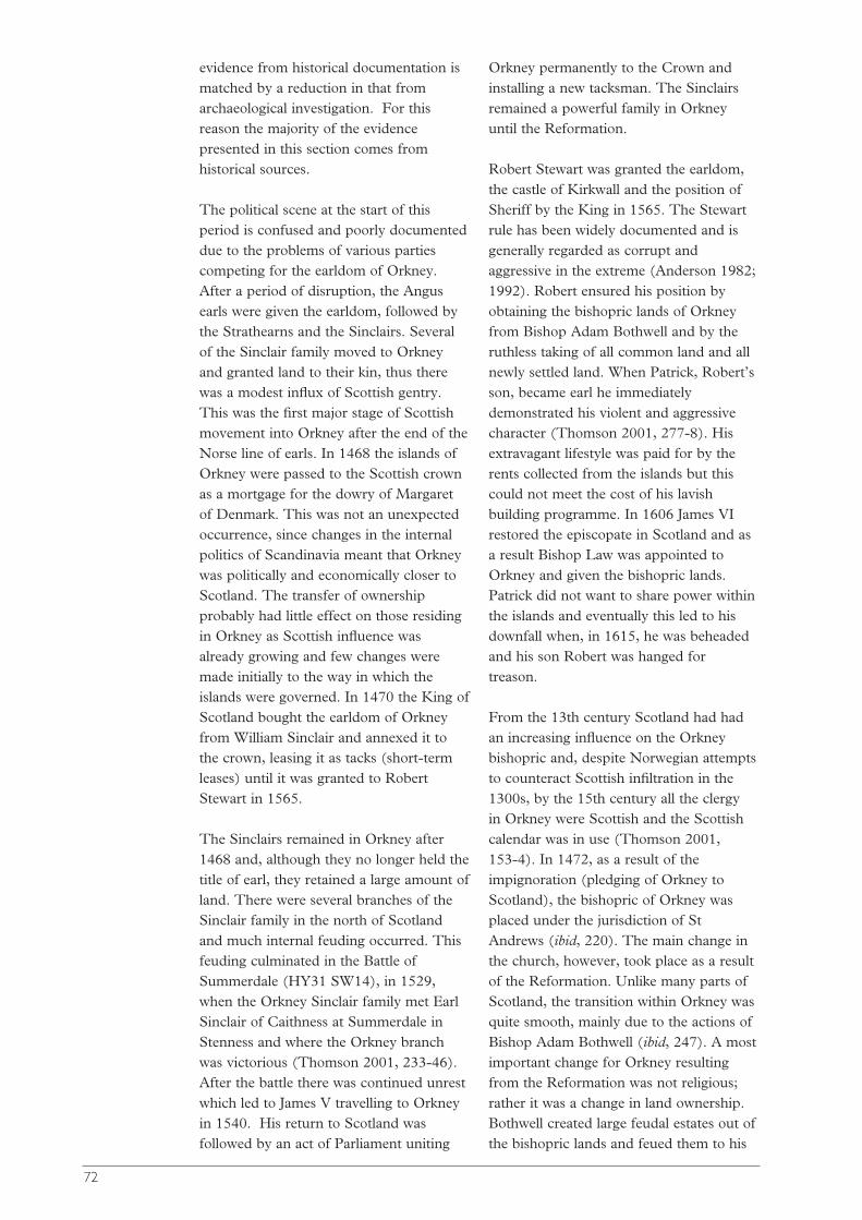
evidence from historical documentation ismatched by a reduction in that fromarchaeological investigation. For thisreason the majority of the evidencepresented in this section comes fromhistorical sources.
The political scene at the start of thisperiod is confused and poorly documenteddue to the problems of various partiescompeting for the earldom of Orkney.After a period of disruption, the Angusearls were given the earldom, followed bythe Strathearns and the Sinclairs. Severalof the Sinclair family moved to Orkneyand granted land to their kin, thus therewas a modest influx of Scottish gentry.This was the first major stage of Scottishmovement into Orkney after the end of theNorse line of earls. In 1468 the islands ofOrkney were passed to the Scottish crownas a mortgage for the dowry of Margaretof Denmark. This was not an unexpectedoccurrence, since changes in the internalpolitics of Scandinavia meant that Orkneywas politically and economically closer toScotland. The transfer of ownershipprobably had little effect on those residingin Orkney as Scottish influence wasalready growing and few changes weremade initially to the way in which theislands were governed. In 1470 the King ofScotland bought the earldom of Orkneyfrom William Sinclair and annexed it tothe crown, leasing it as tacks (short-termleases) until it was granted to RobertStewart in 1565.
The Sinclairs remained in Orkney after1468 and, although they no longer held thetitle of earl, they retained a large amount ofland. There were several branches of theSinclair family in the north of Scotlandand much internal feuding occurred. Thisfeuding culminated in the Battle ofSummerdale (HY31 SW14), in 1529,when the Orkney Sinclair family met EarlSinclair of Caithness at Summerdale inStenness and where the Orkney branchwas victorious (Thomson 2001, 233-46).After the battle there was continued unrestwhich led to James V travelling to Orkneyin 1540. His return to Scotland wasfollowed by an act of Parliament uniting
Orkney permanently to the Crown andinstalling a new tacksman. The Sinclairsremained a powerful family in Orkneyuntil the Reformation.
Robert Stewart was granted the earldom,the castle of Kirkwall and the position ofSheriff by the King in 1565. The Stewartrule has been widely documented and isgenerally regarded as corrupt andaggressive in the extreme (Anderson 1982;1992). Robert ensured his position byobtaining the bishopric lands of Orkneyfrom Bishop Adam Bothwell and by theruthless taking of all common land and allnewly settled land. When Patrick, Robert’sson, became earl he immediatelydemonstrated his violent and aggressivecharacter (Thomson 2001, 277-8). Hisextravagant lifestyle was paid for by therents collected from the islands but thiscould not meet the cost of his lavishbuilding programme. In 1606 James VIrestored the episcopate in Scotland and asa result Bishop Law was appointed toOrkney and given the bishopric lands.Patrick did not want to share power withinthe islands and eventually this led to hisdownfall when, in 1615, he was beheadedand his son Robert was hanged fortreason.
From the 13th century Scotland had hadan increasing influence on the Orkneybishopric and, despite Norwegian attemptsto counteract Scottish infiltration in the1300s, by the 15th century all the clergy in Orkney were Scottish and the Scottishcalendar was in use (Thomson 2001, 153-4). In 1472, as a result of theimpignoration (pledging of Orkney toScotland), the bishopric of Orkney wasplaced under the jurisdiction of StAndrews (ibid, 220). The main change inthe church, however, took place as a resultof the Reformation. Unlike many parts ofScotland, the transition within Orkney wasquite smooth, mainly due to the actions ofBishop Adam Bothwell (ibid, 247). A mostimportant change for Orkney resultingfrom the Reformation was not religious;rather it was a change in land ownership.Bothwell created large feudal estates out ofthe bishopric lands and feued them to his
72

family, which was the first instance oflarge-scale feuing in Orkney. This resultedin the introduction of alien gentry whoovershadowed the local gentry in terms ofestate size and, as a result, the power basechanged dramatically. In the years 1614and 1615 Bishop Law created a furtherfourteen feus from the bishopric lands andthese were also given to Lowland Scottishgentry (ibid, 304). It was Bishop Law whohelped to bring about the downfall ofPatrick Stewart, and a part of this actionresulted in the abolition of Norse law inOrkney. Bishop Law also reorganised theearldom and bishopric land in Orkney,reassigning and consolidating hithertointerspersed strips of earldom andbishopric land into more coherent blockswithin the parish system. One parish thatwas changed to hold only bishopric landand udal land was Sandwick (ibid, 298).This made the collection of taxes mucheasier for the king and for the bishop.
There was a Europe-wide deterioration inclimatic conditions after 1300, resulting ina decline in farming and a decrease inpopulation (Thomson 2001, 169). Thesituation in Orkney was worsened byplague in 1349. In the 1492 Rental muchof Orkney’s land was tenantless anduncultivated, reflecting the seriousness ofthe decline. After the low point of the1460s the economy slowly began torecover, although any profits from the landwere exacted in taxes. The tradingconnections with the north had beendepleted considerably, due to the growthof power of the Hanseatic League inNorway and the movement of the Crownto Denmark (ibid, 190-91). However,grain was still exported and timberimported. The Stewart earls, in their turn,placed severe restriction on trade and ferrytraffic (Anderson 1982, 142), ensuring anydues or fines went to the earldom,including the right to shipwrecked cargo.
This period saw the reduction in politicalpower of the earldom of Orkney from thatof a semi-independent and highlyinfluential part of the Scandinaviankingdom to that of the administration of aperipheral and poverty-stricken Scottish
island group. While a degree of islandidentity was maintained, as can be seenwith the Sinclairs’ swift adoption intoOrkney society, the increasing political andtrade connections with Scotland eventuallyaffected all aspects of Orkney life. Thechange of language from Norn - a form ofScandinavian language spoken in Orkneyat the start of this period - to the stableand complete adoption of Scots by end ofthe 18th century (see Barnes 1998) marksthe progress of Scottification which hadstarted with the Sinclairs. The economicdeterioration was in part due to misrulebut also to climatic deterioration andchanging external political circumstances.The population was able to continue topay their rents and skat (land tax) eventhrough the rule of the Stewart earls, buteven this was to change in the followingdecade.
The late medieval World Heritage Siteand Inner Buffer ZonesThree sites which may belong to thisperiod are to be found within the StennessIBZ: an earthwork which may be a parishboundary marker; the church; and a highstatus dwelling.
The Dyke of Sean (HY21 SE68), anearthwork which may be medieval (LambR G pers comm) extends from the shoreof the Loch of Stenness to near themodern shoreline of the Loch of Harray. Italmost coincides with the modern parishboundary between Stenness and Sandwick.The location of the parish boundary issurprising in that the natural boundary atthe Bridge of Brodgar would seem a morenatural division. There is no informationconcerning the Dyke of Sean itself,although there is an interesting traditionthat may be connected to it. The traditionconcerns a ‘Lady of Brodgar’ who (inaddition to moving into the church justbefore her death, presumably to establishher right to burial there) donated lands,including the lands of Brodgar, to thechurch of Stenness on the condition thatshe be buried in the Stenness church.Peter Leith (1937) discusses thecorrelation between the tradition andhistorical documentation and suggests that
73
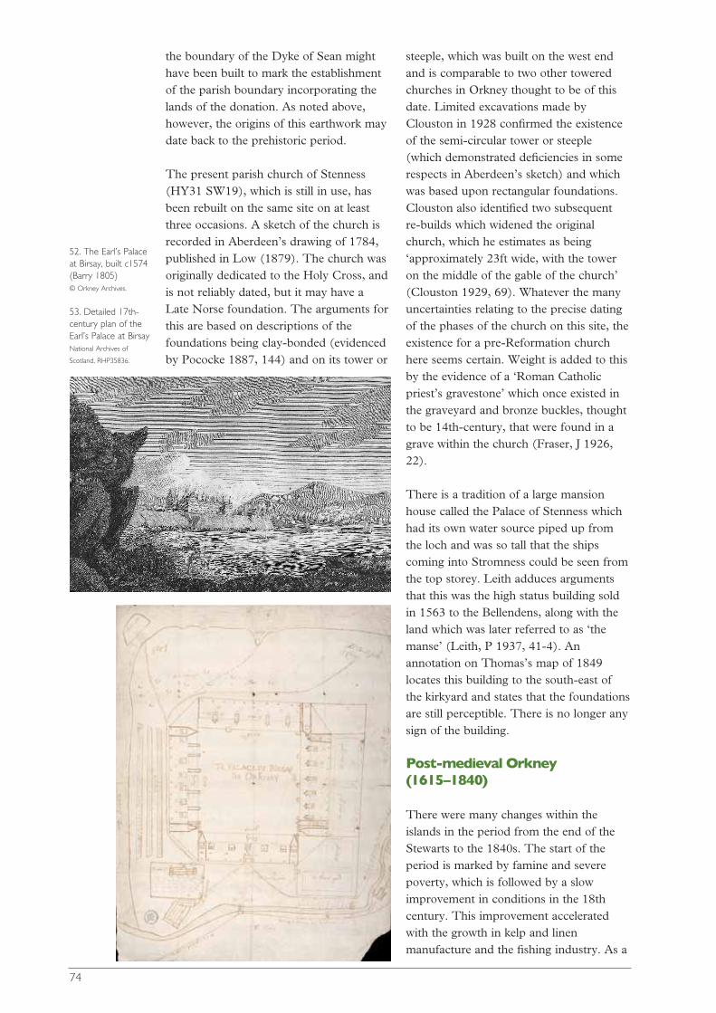
the boundary of the Dyke of Sean mighthave been built to mark the establishmentof the parish boundary incorporating thelands of the donation. As noted above,however, the origins of this earthwork maydate back to the prehistoric period.
The present parish church of Stenness(HY31 SW19), which is still in use, hasbeen rebuilt on the same site on at leastthree occasions. A sketch of the church isrecorded in Aberdeen’s drawing of 1784,published in Low (1879). The church wasoriginally dedicated to the Holy Cross, andis not reliably dated, but it may have aLate Norse foundation. The arguments forthis are based on descriptions of thefoundations being clay-bonded (evidencedby Pococke 1887, 144) and on its tower or
steeple, which was built on the west endand is comparable to two other toweredchurches in Orkney thought to be of thisdate. Limited excavations made byClouston in 1928 confirmed the existenceof the semi-circular tower or steeple(which demonstrated deficiencies in somerespects in Aberdeen’s sketch) and whichwas based upon rectangular foundations.Clouston also identified two subsequentre-builds which widened the originalchurch, which he estimates as being‘approximately 23ft wide, with the toweron the middle of the gable of the church’(Clouston 1929, 69). Whatever the manyuncertainties relating to the precise datingof the phases of the church on this site, theexistence for a pre-Reformation churchhere seems certain. Weight is added to thisby the evidence of a ‘Roman Catholicpriest’s gravestone’ which once existed inthe graveyard and bronze buckles, thoughtto be 14th-century, that were found in agrave within the church (Fraser, J 1926,22).
There is a tradition of a large mansionhouse called the Palace of Stenness whichhad its own water source piped up fromthe loch and was so tall that the shipscoming into Stromness could be seen fromthe top storey. Leith adduces argumentsthat this was the high status building soldin 1563 to the Bellendens, along with theland which was later referred to as ‘themanse’ (Leith, P 1937, 41-4). Anannotation on Thomas’s map of 1849locates this building to the south-east ofthe kirkyard and states that the foundationsare still perceptible. There is no longer anysign of the building.
Post-medieval Orkney(1615–1840)
There were many changes within theislands in the period from the end of theStewarts to the 1840s. The start of theperiod is marked by famine and severepoverty, which is followed by a slowimprovement in conditions in the 18thcentury. This improvement acceleratedwith the growth in kelp and linenmanufacture and the fishing industry. As a
74
52. The Earl’s Palaceat Birsay, built c1574 (Barry 1805) © Orkney Archives.
53. Detailed 17th-century plan of theEarl’s Palace at Birsay National Archives of
Scotland, RHP35836.

result of this growth the lairds and thetenants became wealthier. During the 18thcentury there were a few attempts atagricultural improvement, although themajority of investment was made in kelpand linen production. This period ofeconomic success dwindled in the 1830swith the kelp and linen industries indecline and as a result many landownerswere faced with large debts.
The Stewart earls were the last earls to tryto create a power base from their lands inOrkney (Figs 52 and 53; Thomson 2001,395). All earls and tacksmen after theStewarts held substantial estates elsewhereand were thus less interested in improvingOrkney’s condition; their main concernwas to collect rent. This createdresentment within the islands as well aspoverty; there was little connectionbetween those exacting the taxes and thosepaying them (Thomson 2001, 395).
The first decades of the 17th century wereparticularly difficult for the workingpopulation of Orkney. Extremely poorweather conditions, combined with hightaxation, led to the exhaustion of both theland and the people. The situation wasfurther compounded by the continued useof the medieval agricultural system ofrunrig. This system involved the divisionof each township into equal rigs (strips) ofland that limited the crops that could begrown and the yields obtained. Between3,000 and 4,000 people are estimated tohave died in the islands as a result of theclimatic deterioration in the 1620s and1630s, with land also going out of
cultivation and the number of beggarsincreasing dramatically. In 1629, after adecade of famine, plague came to Orkneyand, as a precautionary measure to preventthe spread of the disease, all trade wasstopped. Further famine in the early 1630sbrought the islands to a standstill and yettaxes were still demanded, and sent, to theCrown. Famine returned at the close of thecentury when again many people died andland again ceased to be cultivated(Thomson 2001, 307-9). Due to thesecircumstances, the land systems in Orkneychanged very little, with land going out ofuse rather than being brought into use.
Conditions improved dramatically for thepopulation from the 1720s with thedevelopment of the kelp (Thomson 1983)and linen industries, which provided extraincome for the tenants. The deep-seafishing industry also developed in the1700s, along with the Hudson’s BayCompany and the whaling ships, both ofwhich required labourers to work innorthern climes. New technologicaladvances enabled longer trips at sea andthus increased the demand for labourabroad, so there was a shortage of malelabour in the islands during parts of theyear. The linen and kelp industriesprovided work for the women of theislands, and so both men and womenbecame slightly more prosperous.Extensive archaeological evidence for thekelp industry remains in the form ofshallow, stone-lined pits along the coast ofOrkney (Fig 54) while, in contrast, thelinen industry is archaeologically almostinvisible.
However, the 1830s saw the collapse of thelinen and kelp industries in Orkney as bothproducts could be obtained more cheaplyelsewhere. Kelp continued to be producedbut never reached the same prices again.Straw plaiting was begun in Orkney in theearly 1800s but it too was in decline by the1830s. The Hudson’s Bay Companymerged with the North West Company in1821 and no longer employed as manyOrcadians. There were several bad fishingyears in the 1830s as well, which affectedthe cod fishing and lobster exports. Orkney
75
54. Kelp making nearStromness Thomas Kent, © Orkney
Archives.

was again in a low economic period andmany of the lairds who had investedheavily in kelp and linen were faced withlarge debts. As a result of the end of the18th-century boom there was a largeunemployed labour force in the islands.The lairds needed money and thiscombined with a large available labourforce and the growth of communicationsto bring about the start of the farmingrevolution of the 19th century.
From the 17th century the lairds hadincreasing power and wealth which theyexpressed in the erection of small mansionhouses. These were either newly built orrenovated older properties; examplesinclude Breckness House, Stromness(HY20 NW5); the Hall of Tankerness(HY50 NW81); Langskaill in Gairsay(HY42 SW8); and Skaill House inSandwick (HY21 NW17). Skaill Houseprovides a good example of the way inwhich a small mansion house and estategrew and developed in this period (Fig55). The oldest surviving part of SkaillHouse was built by 1628; the central wingwas then built by George Graham whoenlarged the mansion house at Skaillbetween 1615 and 1643. In 1670 thehouse was modernised and a walled gardenwas constructed in the 18th century.William Watt (1787-1810) of Skaill Houseextended the estate and modernised thehome farm, as well as experimenting withkelp production, sea fishing and quarrying.William Graham Watt (1810-1866)abolished run-rig on the estate andenclosed the commons. There was a flaxmill and a dovecote on the estate (Irving1997). Several of these lairds’ propertieswere laid waste when they were burned as
a punishment for Jacobean sympathiesafter the 1745 uprising, including Trenabyin Westray and Sound in Shapinsay;others survived, and those lairds who camethrough the Jacobite repercussions saw anincrease in wealth due to the increase inlocal industry. They thrived from kelp andlinen profits in the early 19th century.
The small lairds and the ministers werebent on improving physical and moralconditions within the islands. As a resultsome attempts were made at agriculturalimprovements by the lairds, such as theintroduction of new crops (potatoes), theenclosure of some areas and someexpansion into the commons. In Birsaythere was an early attempt at ‘planking’c1748, a system where the land wasdivided into equal value units. By the late1700s much of Orkney’s farmland hadbeen divided into ‘planks’ ofapproximately one Scots acre. However,several farmers often shared these planksand they were further divided up into rigs,so the run-rig system continued to beused, although to a lesser extent(Thomson 2001, 333-5). Many of theministers encouraged education and wereoften found teaching and helping the poor.During the 18th century many churcheswere rebuilt, some with laird’s aisles,reflecting the close relationship betweenchurch and secular authority. Asmentioned above, the decline in the localindustries in the later 19th century affectedthe lairds badly and put many into majordebt and, as a result, the estate landbecame the focus of attention.
The post-medieval World HeritageSite and Inner Buffer ZonesThe Stenness area was not one of the partsof Orkney where early improvements wereattempted and so would have beentenanted out and farmed using the run-rigsystem. Captain Thomas’s map of 1849(cover; Thomas 1852) gives an overviewof farms, field systems and types of landcover in relationship to the majormonuments of the Brodgar area. Thiscartographic evidence has recently beenaugmented by the results of the WHAGP.This survey has revealed surviving
76
55. Skaill House,Sandwick © Crown copyright,
Historic Scotland.
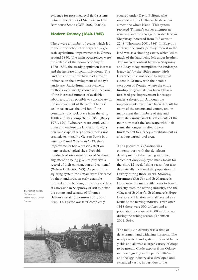
evidence for post-medieval field systemsbetween the Stones of Stenness and theBarnhouse Stone (GSB 2002; 2003b).
Modern Orkney (1840-1945)
There were a number of events which ledto the introduction of widespread large-scale agricultural improvements in Orkneyaround 1840. The main occurrences werethe collapse of the boom economy of1770-1830, the steady population increaseand the increase in communications. Thelandlords of this time have had a majorinfluence on the development of today’slandscape. Agricultural improvementmethods were widely known and, becauseof the increased number of availablelabourers, it was possible to concentrate onthe improvement of the land. The firstaction taken was the division of thecommons; this took place from the early1800s and was complete by 1860 (Bailey1971, 120). Labourers were employed todrain and enclose the land and slowly anew landscape of large square fields wascreated. As noted by George Petrie in aletter to Daniel Wilson in 1849, theseimprovements had a drastic effect onmany archaeological sites. Probablyhundreds of sites were removed ‘withoutany attention being given to preserve arecord of their construction and contents’(Wilson Collection MS). As part of thissquaring system the cottars were relocatedby their landlords; an early exampleresulted in the building of the estate villageat Shoreside in Shapinsay c1780 to housethe cottars and tenants of ThomasBalfour’s estate (Thomson 2001, 339,386). This estate was later completely
squared under David Balfour, whoimposed a grid of 10-acre fields acrossalmost the whole island. This systemreplaced Thomas’s earlier attempts atsquaring and the acreage of arable land inShapinsay increased from 748 acres to2248 (Thomson 2001, 386). In Eday, bycontrast, the laird’s primary interest in theland was as a shooting estate, which led tomuch of the land being left under heather.The marked contrast between Shapinsayand Eday today exemplifies the landscapelegacy left by the 19th-century lairds.Clearances did not occur to any greatextent in Orkney, with the notableexception of Rousay, where the entiretunship of Quandale has been left as afossilised pre-Improvement landscapeunder a sheep-run. Although theimprovements must have been difficult formany of the tenants and cottars, and inmany areas the numbers of tiny andultimately unsustainable settlements of thepoor now mark the landscape with theirruins, the long-term effects werefundamental to Orkney’s establishment asa leading agricultural area.
The agricultural expansion wascontemporary with the significantdevelopment of the herring industry,which not only employed many locals forthe short 12-week fishing season but alsodramatically increased the population ofOrkney during those weeks. Stronsay,Stromness (Fig 56) and St Margaret’sHope were the main settlements to benefitdirectly from the herring industry, and thevillages of St Mary’s, St Margaret’s Hope,Burray and Herston were all created as aresult of the herring industry. Even after1918 there were 300 drifters and apopulation increase of 4,000 in Stronsayduring the fishing season (Thomson 2001, 369).
The mid-19th century was a time ofdevelopment and widening horizons. Thenewly created land system produced betteryields and allowed a larger variety of cropsto be grown. Cattle exports from Orkneyincreased greatly in the period 1846-75and the egg industry also developed andexpanded vastly, in part due to the
77
56. Fishing station,Stromness Thomas Kent, © Orkney
Archives.
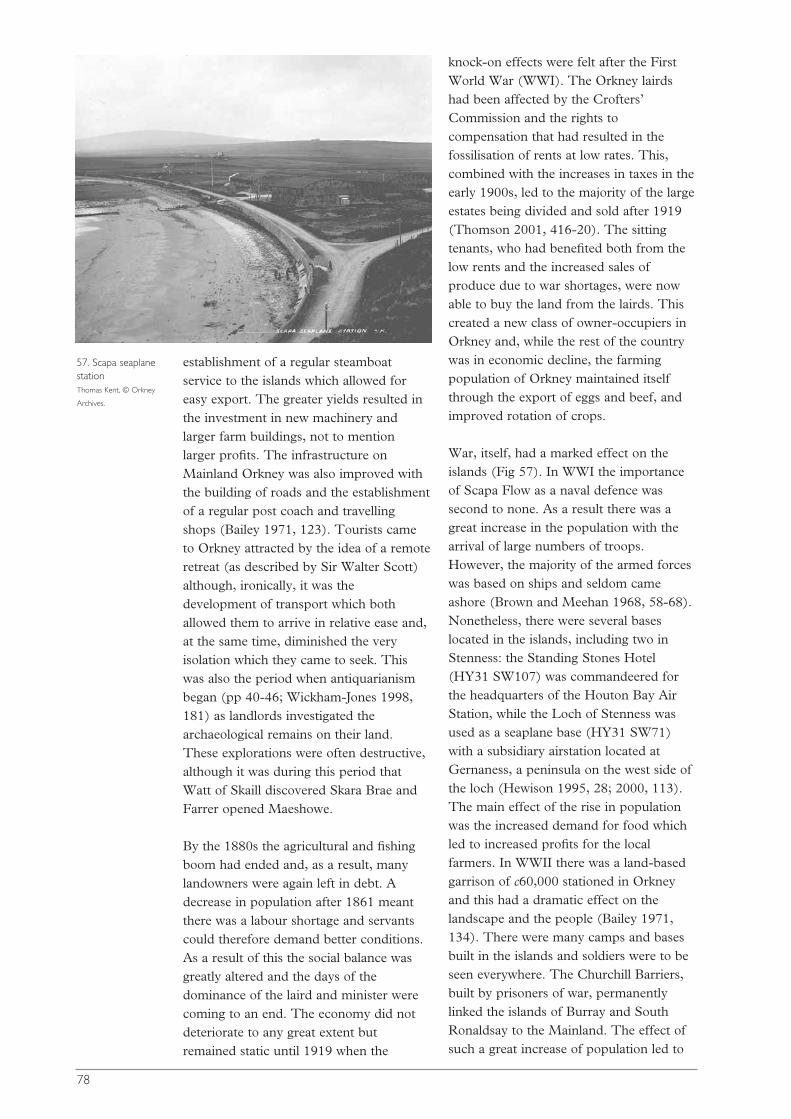
establishment of a regular steamboatservice to the islands which allowed foreasy export. The greater yields resulted inthe investment in new machinery andlarger farm buildings, not to mentionlarger profits. The infrastructure onMainland Orkney was also improved withthe building of roads and the establishmentof a regular post coach and travellingshops (Bailey 1971, 123). Tourists cameto Orkney attracted by the idea of a remoteretreat (as described by Sir Walter Scott)although, ironically, it was thedevelopment of transport which bothallowed them to arrive in relative ease and,at the same time, diminished the veryisolation which they came to seek. Thiswas also the period when antiquarianismbegan (pp 40-46; Wickham-Jones 1998,181) as landlords investigated thearchaeological remains on their land.These explorations were often destructive,although it was during this period thatWatt of Skaill discovered Skara Brae andFarrer opened Maeshowe.
By the 1880s the agricultural and fishingboom had ended and, as a result, manylandowners were again left in debt. Adecrease in population after 1861 meantthere was a labour shortage and servantscould therefore demand better conditions.As a result of this the social balance wasgreatly altered and the days of thedominance of the laird and minister werecoming to an end. The economy did notdeteriorate to any great extent butremained static until 1919 when the
knock-on effects were felt after the FirstWorld War (WWI). The Orkney lairdshad been affected by the Crofters’Commission and the rights tocompensation that had resulted in thefossilisation of rents at low rates. This,combined with the increases in taxes in theearly 1900s, led to the majority of the largeestates being divided and sold after 1919(Thomson 2001, 416-20). The sittingtenants, who had benefited both from thelow rents and the increased sales ofproduce due to war shortages, were nowable to buy the land from the lairds. Thiscreated a new class of owner-occupiers inOrkney and, while the rest of the countrywas in economic decline, the farmingpopulation of Orkney maintained itselfthrough the export of eggs and beef, andimproved rotation of crops.
War, itself, had a marked effect on theislands (Fig 57). In WWI the importanceof Scapa Flow as a naval defence wassecond to none. As a result there was agreat increase in the population with thearrival of large numbers of troops.However, the majority of the armed forceswas based on ships and seldom cameashore (Brown and Meehan 1968, 58-68).Nonetheless, there were several baseslocated in the islands, including two inStenness: the Standing Stones Hotel(HY31 SW107) was commandeered forthe headquarters of the Houton Bay AirStation, while the Loch of Stenness wasused as a seaplane base (HY31 SW71)with a subsidiary airstation located atGernaness, a peninsula on the west side ofthe loch (Hewison 1995, 28; 2000, 113).The main effect of the rise in populationwas the increased demand for food whichled to increased profits for the localfarmers. In WWII there was a land-basedgarrison of c60,000 stationed in Orkneyand this had a dramatic effect on thelandscape and the people (Bailey 1971,134). There were many camps and basesbuilt in the islands and soldiers were to beseen everywhere. The Churchill Barriers,built by prisoners of war, permanentlylinked the islands of Burray and SouthRonaldsay to the Mainland. The effect ofsuch a great increase of population led to
78
57. Scapa seaplanestation Thomas Kent, © Orkney
Archives.
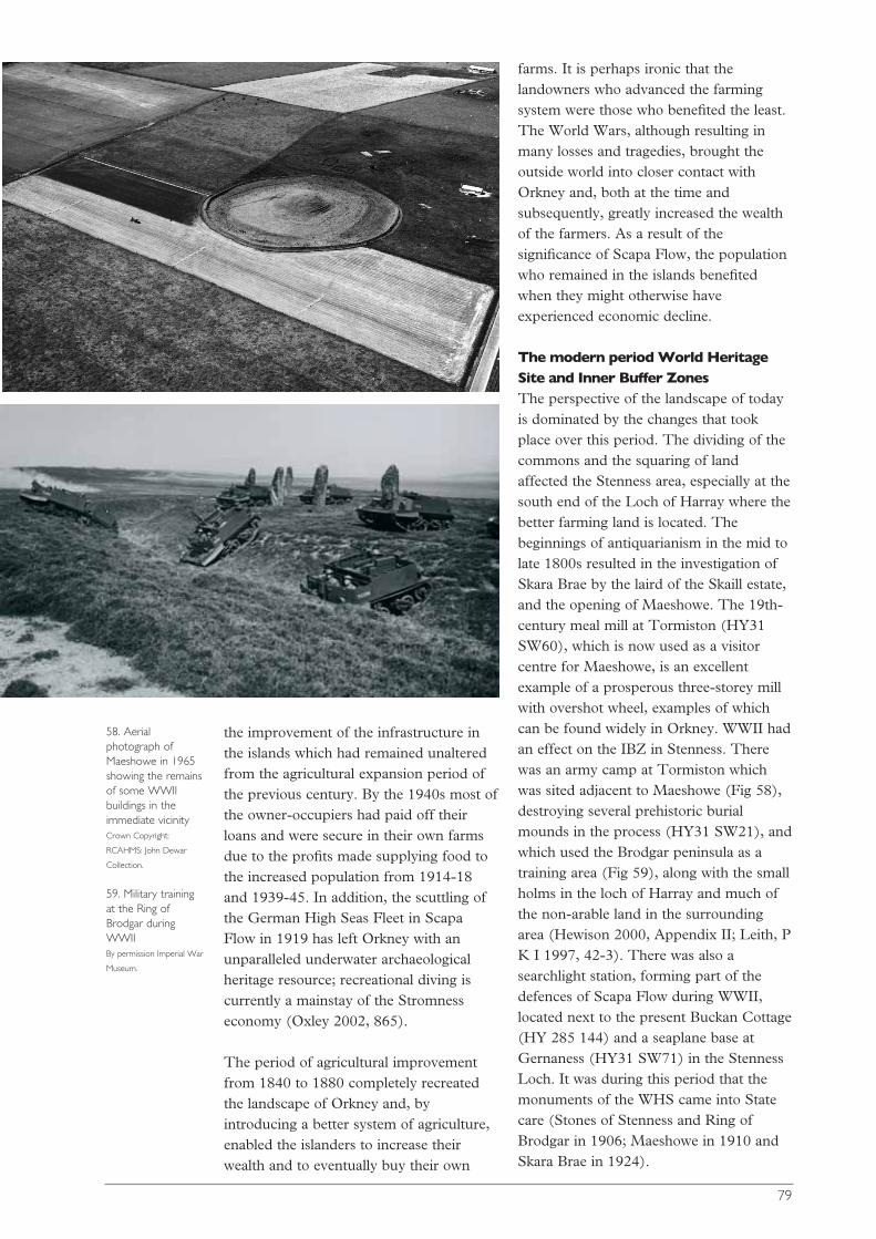
the improvement of the infrastructure inthe islands which had remained unalteredfrom the agricultural expansion period ofthe previous century. By the 1940s most ofthe owner-occupiers had paid off theirloans and were secure in their own farmsdue to the profits made supplying food tothe increased population from 1914-18and 1939-45. In addition, the scuttling ofthe German High Seas Fleet in ScapaFlow in 1919 has left Orkney with anunparalleled underwater archaeologicalheritage resource; recreational diving iscurrently a mainstay of the Stromnesseconomy (Oxley 2002, 865).
The period of agricultural improvementfrom 1840 to 1880 completely recreatedthe landscape of Orkney and, byintroducing a better system of agriculture,enabled the islanders to increase theirwealth and to eventually buy their own
farms. It is perhaps ironic that thelandowners who advanced the farmingsystem were those who benefited the least.The World Wars, although resulting inmany losses and tragedies, brought theoutside world into closer contact withOrkney and, both at the time andsubsequently, greatly increased the wealthof the farmers. As a result of thesignificance of Scapa Flow, the populationwho remained in the islands benefitedwhen they might otherwise haveexperienced economic decline.
The modern period World HeritageSite and Inner Buffer ZonesThe perspective of the landscape of todayis dominated by the changes that tookplace over this period. The dividing of thecommons and the squaring of landaffected the Stenness area, especially at thesouth end of the Loch of Harray where thebetter farming land is located. Thebeginnings of antiquarianism in the mid tolate 1800s resulted in the investigation ofSkara Brae by the laird of the Skaill estate,and the opening of Maeshowe. The 19th-century meal mill at Tormiston (HY31SW60), which is now used as a visitorcentre for Maeshowe, is an excellentexample of a prosperous three-storey millwith overshot wheel, examples of whichcan be found widely in Orkney. WWII hadan effect on the IBZ in Stenness. Therewas an army camp at Tormiston whichwas sited adjacent to Maeshowe (Fig 58),destroying several prehistoric burialmounds in the process (HY31 SW21), andwhich used the Brodgar peninsula as atraining area (Fig 59), along with the smallholms in the loch of Harray and much ofthe non-arable land in the surroundingarea (Hewison 2000, Appendix II; Leith, PK I 1997, 42-3). There was also asearchlight station, forming part of thedefences of Scapa Flow during WWII,located next to the present Buckan Cottage(HY 285 144) and a seaplane base atGernaness (HY31 SW71) in the StennessLoch. It was during this period that themonuments of the WHS came into Statecare (Stones of Stenness and Ring ofBrodgar in 1906; Maeshowe in 1910 andSkara Brae in 1924).
79
58. Aerialphotograph ofMaeshowe in 1965showing the remainsof some WWIIbuildings in theimmediate vicinity Crown Copyright:
RCAHMS: John Dewar
Collection.
59. Military trainingat the Ring ofBrodgar duringWWII By permission Imperial War
Museum.

00
Artefacts, monuments andcultural identitySiân Jones, Colin Richards and Artefacts,Monuments and Cultural Identity Group
Identity, as an expression of humanbehaviour, is central to the status andintegrity of The Heart of Neolithic OrkneyWHS and this is articulated through theartefacts, of which one element comprisesthe monuments. For this reason ‘Artefacts,Monuments and Cultural Identity’ is seenas an overarching theme of centralimportance to this document. Theimportance of artefacts and identity isclearly evident in the nominationdocument (Historic Scotland 1998), whichsees the shared artefact types andarchitectural features of this group ofmonuments as the product of a singlecoherent cultural tradition associated with
a single people. For the most part thisinterpretation is based on long-standingartefact and architectural typologies. Forinstance, it is argued that ‘…the layout ofthe early houses at Skara Brae isreminiscent of the chamber plan atMaeshowe’ and ‘Barnhouse settlement inthe buffer zone near Stenness andMaeshowe contains similar carving, andwas built by people who used the samekind of pottery and other artefacts as thoseat the earliest excavated village at SkaraBrae’ (ibid, 7). This might suggest that weknow a great deal about these areas, or atleast that our framework of knowledge iswell established and all that is required isthe identification of further empiricalresearch areas, but it is not so.
As in all areas of archaeological enquirythe study of artefacts and cultural identityis far from static so that this researchagenda cannot merely advocate theongoing collection and taxonomicclassification of artefacts within establishedtypologies. Indeed, the problems createdby a simple taxonomic approach, whichtreats objects as isolated categories andextracts them from their physical contexts,life histories and relationships with eachother, need to be explored and overcome.All new projects require the criticalexamination of existing categories and theassumptions associated with them, egculture and identity, ritual and domestic,Grooved Ware and Unstan Ware pottery(Fig 60).
PART
3 Research themes
60. Grooved Ware pottery fromStenness © Crown Copyright reproduced courtesy of
Historic Scotland.
80
81
The static objectification of artefacts andmonuments can best be avoided byadopting a biographical, or cognitive,approach. Objects, like people, have sociallives, they relate to other objects and theserelationships change as they move throughboth time and space. Any study shouldinclude research on these relationships: onmanufacture, durability, refashioning overtime and ultimate deposition; and on thesocial practices in which they areembedded (see Appadurai 1986; Ingold2000; Jones, A 1997; Jones, S 1997;Mackenzie 1991).
The landscape within which the artefactsand monuments of the WHS existprovides not only an essential framingdevice within which to study their complexlife histories but it may also be one of themain driving forces behind their creation.In this respect, the experiential landscapeis of equal importance to the physical. Thenatural world of the past - terrestrial,celestial and maritime - was observed andexperienced in many different ways andfor many different reasons, just like theworld of today: the eye of the farmer mayperceive a fertile agricultural landscapewhere the eye of the tourist perceives apicturesque photograph to show theneighbours. It is important to recognisethis and take account of the ways in whichlandscape change through time has beenarticulated, recorded and interpreted, forthis has played an important rôle inestablishing and perpetuating the culturalidentities of the societies with whom weare concerned.
To do this involves the conception oflandscape as a tapestry or woven fabric(see Ingold 2000) into which artefacts,monuments, people and resources areinterwoven. Importantly, this tapestry isnever static as human (and natural)activity ensures that components areconstantly reworked or ‘darned’ over time.
Taking these overarching arguments as astarting point, four specific themes ofresearch (below) have been identifiedwhich draw together information on thenature of the materials, their changing
place in society both past and present, andtheir potential for adding to presentknowledge of the WHS. The remit for theresearch covers both the WHS and relatedsites as well as artefacts in their broaderspatial and temporal contexts. In this wayspecific research projects can be placedwithin broader regional and comparativeframeworks in order to provide the WHSwith meaning in the wider world. Thesethemes crosscut many of the traditionalspecialisations into which the study of thepast has been divided, such as artefactanalysis, oral history, or monumenttypology. Such divisions are increasinglyfound to pose problems for theconstruction of archaeologicalinterpretation. At this point it is importantto remember that, as with the definition oflandscape, there is no universalarchaeological ‘truth’: new studies and newwork on old studies will constantly comeup with individual interpretations. This is afactor that must be taken into account inthe presentation and management of theWHS (discussed above, Part 1).
The materialisation of memoryand identity
This theme focuses on the artefacts andmonuments associated with the WHS andits buffer zones, it considers theirbiographies and their subsequent rôles inthe production of memory and identity inthe past. Although the temptation is tostress the Neolithic, this research themeencompasses the entire social lives of theseartefacts and monuments (ie across allperiods, in order to examine the ways inwhich they are reconceptualised, reusedand refashioned).
This research theme can be dividedbetween artefacts and monuments. Itconsiders their production as well as theirlife-histories. Artefacts are traditionallyregarded as the portable elements of lifeand this theme is interested in circulationand movement, as well as deposition, inorder to explore their rôle in the creationof relationships and identities.Monuments, on the other hand, are lessmobile, though they can be changed in

structure and design. As such, it is thedurability of the monuments, their variousarchitectural forms and their changingrôles, that are of concern in order toconsider their place in the creation ofmemory, tradition and identity.
Extensive research has been carried out onOrcadian monuments and artefactsthroughout the 20th century (eg Renfrew1979; Childe 1930; MacSween 1992), butvery little of this has focused specificallyon the social lives of artefacts andmonuments and their rôle in theproduction of memory and identity. Anumber of studies of this kind haveemerged over the last few years (seeHingley 1999; Jones, A 2002; Richards1993a; 1996a; 2004), but for the most partit concentrates almost entirely on theNeolithic which, as we have seen, does notfully explain the WHS as we see it todayand it is very uneven in the facets covered.In artefact studies, this kind of researchoften involves the application of specialisedtechniques such as petrological analysis
and residue analysis, which have beencarried out on assemblages from some sitesbut not others.
Currently, within the WHS this theme ofresearch has centred on the late Neolithicperiod and has been restricted to ceramicanalysis and social practices within theBarnhouse village. This study, thoughlimited, gives a good idea of the potentialawaiting, should research like this beexpanded to cover other artefact types,more sites and different periods. AtBarnhouse, aspects of production can belinked with particular households. Forinstance, the procurement of materials forinclusion within the ceramics of individualhouseholds can be shown to have takenplace from separate locations within thelandscape and this ties in to the basicresidential structure of the village.Interestingly, this contrasts with thedecoration of the vessels as individualdecorative schemes tend towards an overallvillage or communal identity (Jones, A2002; Richards 2004).
82
61. Artist’sreconstruction of aceremony at theStones of Stenness.This was just onephase in themonument’s use Drawing by Alan Brady,
© Crown Copyright
reproduced courtesy of
Historic Scotland.
Given the wealth of archaeologicalevidence in Orkney, which comprises bothhabitations and monuments rangingchronologically from the Neolithic to thepresent day, there is a place for periodspecific research, but it would be of morevalue as part of a larger programme ofresearch designed to examine the changingnature of social identity. One importanttheme, for example, would consider theways in which material culture has beenused in different ways and in differentcontexts in order to create a variety ofidentities and, indeed, how these identitieshave articulated together to form groups(Fig 61). In this way, the changing natureof social identities in the past can beconsidered. For instance, one startingpoint is provided by the presence of abroch, Big Howe, adjacent to the Stones ofStenness. This immediately raisesquestions of social identity relating to thebuilders and later users of Big Howe, andtheir own use of the past around them.
This perspective, transcending periodboundaries, enables an exploration of theways in which sites, monuments andlandscapes are reconceptualised, reusedand refashioned in the dynamic productionof identities and cosmologies.
The social construction andconstitution of monuments:questions of architecture, place,the human body and materiality
This research theme moves on from theabove to focus attention onto the peoplewho used and experienced these artefactsand monuments. It looks at the social useand human experience of monuments, butit also places more emphasis onto theactions and context of construction. Itaims to get away from the old idea thatconstruction comprises simply amechanism by which to erect a monument.It suggests that we should regard it moreas an ongoing ‘project’ and one which,importantly, never quite leads to the finalform that we recognise today. A goodexample of this lies in John Barrett’s workat Avebury (1994). Consequently, thistheme draws in people, places and things
beyond the WHS monuments. Theinclusion of monumental constructionintroduces an understanding of ‘landscape’that must appreciate the full significance ofthe ways in which the people in the pastengaged with the physical world that theyinhabited. In particular, the engagement ofthe people with the resources is importantfor these comprised materials encounteredin different places, at different times andunder different social conditions that werebrought together to create the ‘monument’.Only through a close understanding oftheir world could people create thearchitecture and material components ofthe monuments. For the archaeologist, thisappreciation demands a more critical viewof the nature of the monuments (andindeed of all areas of architecture) in termsof how they were constructed, whatmaterials were employed and the on-goingsocial significance of the act ofconstruction.
Regardless of the intentions of thebuilders, once architecture comes intobeing its social meanings are open to re-interpretation and negotiation throughsocial practice and human experience.Here the rôle of architecture, as a plannedphysical entity that embodies both culturalconcepts of order and a mechanism ofcontrol, becomes important because thus itcan restrict and control human movementso that the human experience becomesstructured in specific ways. Herein lies aprofound conceptual difference betweenthose monuments that are built to be usedand viewed on completion and those thatare used and viewed during a prolongedperiod of construction. At Maeshowe, forinstance, we see a concern with the finalform of the site and with the humanexperience of that form. It appears that anenclosing ditch was central to the design ofMaeshowe, but what we see is in fact thecareful sculpting of natural features so thata cut ‘ditch’ is only present on the western,southern and eastern portions of itssupposed circuit. In other words, the finalappearance of the site was of moreimportance than the act of cutting the‘ditch’. Equally, there is a dramaticcontrast between ‘inside’ and ‘outside’ at
83
Maeshowe, revealed by the impressivemasonry of the interior when contrastedwith the unprepossessing exterior mound(Figs 2 and 15). These architecturaldevices indicate a monument that was builtwith great attention to the visual imageryof the site. In this light the different natureof the monuments sited within the WHSand its buffer zones requires carefulconsideration and we can see that theconcept of ‘monument’ as applied to theWHS may be extremely problematic.
Studies like this drastically alter ourunderstanding of the ways in which peopleengaged with the various monumentsduring the Neolithic, but it appears thatsuch distinctions blur through prehistory.Once the monuments were constructed,later generations would engage everdifferently with the ever changingarchitecture of the landscape. The mainpoint to draw here is the fluidity of humanexperience within the monumentallandscape of the Stenness-Brodgarpromontories. As monuments came intobeing and were altered, standing stoneswere erected and demolished, cist graveswere dug and covered over, and burialmounds were constructed, so thelandscape and people’s lives within itchanged. This is important for memoryand landscape: some buildings andmonuments were actually built from thematerials of others, while others were builtfrom specific materials only available indistant places. The choice of material wasobviously of vital significance and somewere chosen and brought over longdistances with considerable effort. Todaywe, the managers and researchers of thisplace, perceive this striking area as apalimpsest of sites to be revealed througharchaeological activity, but, to thegenerations inhabiting Orkney in the 2ndand 3rd millennia BC, this was a place ofaddition and change, of memories andremembering. This is a theme that hasrepercussions for today and it is discussedin more detail in the next theme.
As these different understandings of ‘place’and past come into existence so the humanengagement with the landscape, as
articulated through social practices, mustbe changed accordingly. Here architecturalrepresentation provides a focus of furtherstudy in order to look more deeply at theuse and later lives of the monuments. Thismust include approaches to bodilyexperience: how was the form of amonument designed to control its use?How could this be manipulated andaltered? In order to be successful inproviding insight to any built monument, aclear and detailed knowledge ofarchitecture is necessary. Artefact studiesare also important here for they have a rôleto play as evidence of the ways in whichpeople have moved through and treated alandscape or site. Of course, this work isnot restricted to individual sites butshould, in the long run, embrace the entirelandscape. Rather than limiting suchstudies of human experience to singlechronological periods (eg Richards1993b), a more rewarding line of enquirywould involve comparing and contrastingpeople’s encounters with the builtenvironment over longer periods of time.
Without doubt this small part of MainlandOrkney took on huge significance at leastduring the 3rd millennium BC, as well as,perhaps, at later times. This directsattention to the earlier occupation of thisarea and how the landscape was conceivedat the time when construction began. Whatmade these places so special that they weretransformed through a process ofspectacular monumentalization? Why wasthis location chosen? How were they usedbefore the construction of the physicalremains that we see today? These must bekey questions for any full understanding ofthe WHS. Under this scrutiny it is clearthat our knowledge of the early Neolithic isas thin as that of later prehistoric periodsin this region.
The past in the present: the rôleof monuments in the productionof contemporary narratives,memories and cultural practices
This theme shifts the focus of attention tomore recent times, to look at the rôle of theWHS in Orkney today. The relationship
84
between archaeological heritage anddiscourses of authenticity, identity andplace in modern societies has become animportant field of research. Empirical andhistoriographical studies have providednew insights into the relationship betweenarchaeology and national identity inparticular countries (Díaz-Andreu andChampion (eds) 1996; James, S 1999;Kohl and Fawcett (eds) 1995; Meskell(ed) 1998). However, understandings ofhow specific archaeological remains areinvolved in modern societies in a moregeneral way, for example in theconstruction of multiple identities and inthe reinforcement of interests, havereceived less attention (although seeBender 1998; Herzfeld 1991). This is,nevertheless, an important theme thatinvolves both archaeological enquiry andheritage management. Such issues areparticularly pertinent in relation to theWHS given its importance to the localcommunities and the ways in which theassignation of a heritage status like this cantransform the ways in which peopleexperience and engage with themonuments. Existing research relatingdirectly or indirectly to the WHS consistsof heritage management, tourist andconsumer surveys usually involvingquestionnaires or focus groups (seeHistoric Scotland 2001 for discussion ofthe results). To date this research hasprovided very basic quantitative data thatoften focuses on the visitor to the islandsrather than on the local resident. Recentsurveys have, for instance, been concernedwith the proportion of tourists that areattracted to Orkney for its archaeologicalheritage, and the relative attractions ofMaeshowe, Skara Brae, Stones of Stennessand Ring of Brodgar. However, there isconsiderable scope for more detailedanthropological and sociological researchinto the relationship betweenarchaeological materials, practice andknowledge on the one hand and thenarratives, memories and cultural practicesof both locals and visitors on the other.
This information is important and bothinterview-based and ethnographic researchcan provide a more fine-grained
understanding of people’s engagementwith the WHS, and related sites andinstitutions (including museums). Atpresent little research of this type has beencarried out in Orkney (but seeMcClanahan 2004). Ethnographic workhas taken place in Orkney (eg Forsythe1980), but few of the studies focus on thearchaeological monuments and their placein contemporary society. Existing studiesconcerning archaeological remains andarchaeological practice have been small inscale though their results show greatpromise, such as the interview studyconcerning local attitudes towards theexcavations at Stonehall and Crossiecrown(Jones and McClanahan 2000). In thisrespect, it is, of course, important toinclude the preconceptions andexpectations of those outwith Orkney who,while not tourists per se, have played amajor rôle in the designation andmanagement of The Heart of NeolithicOrkney as a WHS.
This theme is important for there are largegaps in our knowledge both as to the waysin which archaeological monuments figurein people’s personal narratives andmemories and as to how they areembedded in people’s daily practices andperceptions of landscape. Research such asthis is vital if we are to understand the rôleplayed by the archaeological monumentsin the construction of identities, whetherpersonal, local, regional or national. In thisrespect the work initiated by McClanahanis of particular interest.
Another key area of research related to thistheme lies not just in the monumentsthemselves but in the work done on them.Whether it be research, management orpresentation of the archaeological heritage,the work undertaken by the variousinstitutions impacts upon the localcommunity, but we have, as yet, a veryhazy idea as to the nature of this impact.Research on this would contribute to anunderstanding of local values and interestsand fulfil UNESCO’s expectation thatdevelopment be guided by policies thatrespect the cultural life of the community.More specifically, it would provide a body
85
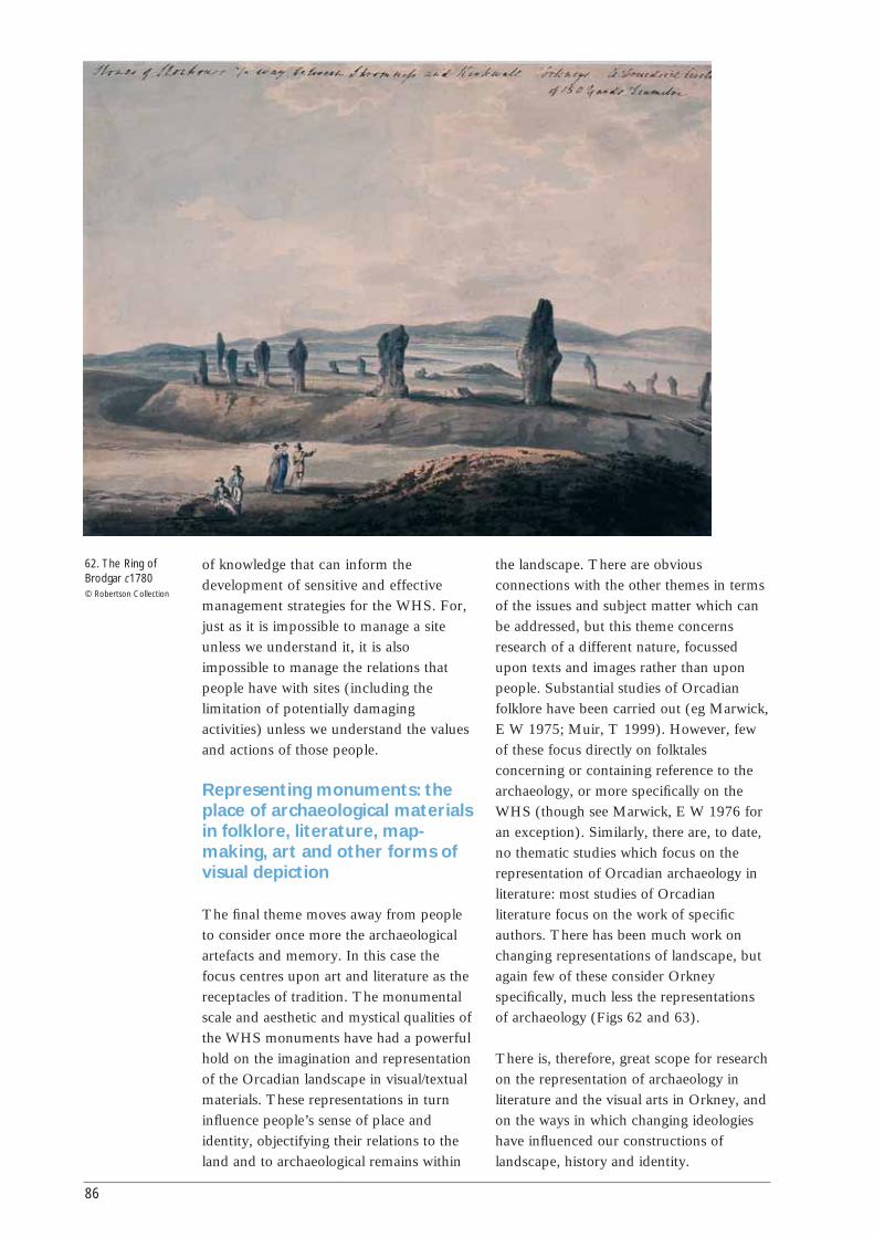
of knowledge that can inform thedevelopment of sensitive and effectivemanagement strategies for the WHS. For,just as it is impossible to manage a siteunless we understand it, it is alsoimpossible to manage the relations thatpeople have with sites (including thelimitation of potentially damagingactivities) unless we understand the valuesand actions of those people.
Representing monuments: theplace of archaeological materialsin folklore, literature, map-making, art and other forms ofvisual depiction
The final theme moves away from peopleto consider once more the archaeologicalartefacts and memory. In this case thefocus centres upon art and literature as thereceptacles of tradition. The monumentalscale and aesthetic and mystical qualities ofthe WHS monuments have had a powerfulhold on the imagination and representationof the Orcadian landscape in visual/textualmaterials. These representations in turninfluence people’s sense of place andidentity, objectifying their relations to theland and to archaeological remains within
the landscape. There are obviousconnections with the other themes in termsof the issues and subject matter which canbe addressed, but this theme concernsresearch of a different nature, focussedupon texts and images rather than uponpeople. Substantial studies of Orcadianfolklore have been carried out (eg Marwick,E W 1975; Muir, T 1999). However, fewof these focus directly on folktalesconcerning or containing reference to thearchaeology, or more specifically on theWHS (though see Marwick, E W 1976 foran exception). Similarly, there are, to date,no thematic studies which focus on therepresentation of Orcadian archaeology inliterature: most studies of Orcadianliterature focus on the work of specificauthors. There has been much work onchanging representations of landscape, butagain few of these consider Orkneyspecifically, much less the representationsof archaeology (Figs 62 and 63).
There is, therefore, great scope for researchon the representation of archaeology inliterature and the visual arts in Orkney, andon the ways in which changing ideologieshave influenced our constructions oflandscape, history and identity.
86
62. The Ring ofBrodgar c1780 © Robertson Collection

The formation andutilisation of the landscapeIngrid Mainland, Ian A Simpson, RichardTipping, Palaeoenvironment and EconomyGroup, and Formation Processes and DatingGroup
During the last glaciation Orkney mayhave been part of a peninsula thatstretched from Caithness to Shetland(Lambeck 1993; 1995). It is not entirelyclear whether it was ice-covered at c20000-18000 BC or whether the glacial deposits,common for instance in the Finstown-Eviearea, reflect an earlier glacial period. Sincethe onset of rapid deglaciation around13000 BC, Orkney has been graduallyinundated by the sea. This process mayhave been halted or reversed during theLoch Lomond re-advance, which endedaround 9600 BC, and since then it hasoperated unevenly. It is, however,important to recognise that the islandswere, in the late Devensian, hills on alarger landmass. Current orthodoxy is thatOrkney was separated from the Scottishland mass between about 9500 and 7000BC (Verhart 1995). Thereafter acontinuing combination of erosion andinundation has led to the island patternseen today.
From the end of the last glaciation there wasa gap of at least 1500 years before humansfirst become detectable as potent forces inthe landscape of Scotland. A general lack ofevidence has meant that Orkney was thoughtto have been entered by and affected byhumans even later, but this may well reflectthe biases of modern scholarship (and this isnow an important research issue).
The people who inhabited the world of theWHS did not live in isolation and thephysical world around them was not itselfstatic. The relationship between the two iscomplex and dynamic, but it is essential tounderstand it if we are to interpret fully thehistory of the WHS through the ages. Thesecond overarching theme for research in theWHS thus comprises research into thatphysical world and its application in terms ofhuman activity. These studies are of human-landscape interaction but the key is to focuson the dynamism of that relationship. TheWHS occupies a multi-period agriculturallandscape, emphasising the need to focus onlong-term changes in land organisation andland management as well as on thetransformations of monuments and sites,from the pre-monument site through topresent-day conservation management
87
63. Ring of Brodgar,Painting by StephenSeymour Clancy(2000) © Crown Copyright
reproduced courtesy of
Historic Scotland.
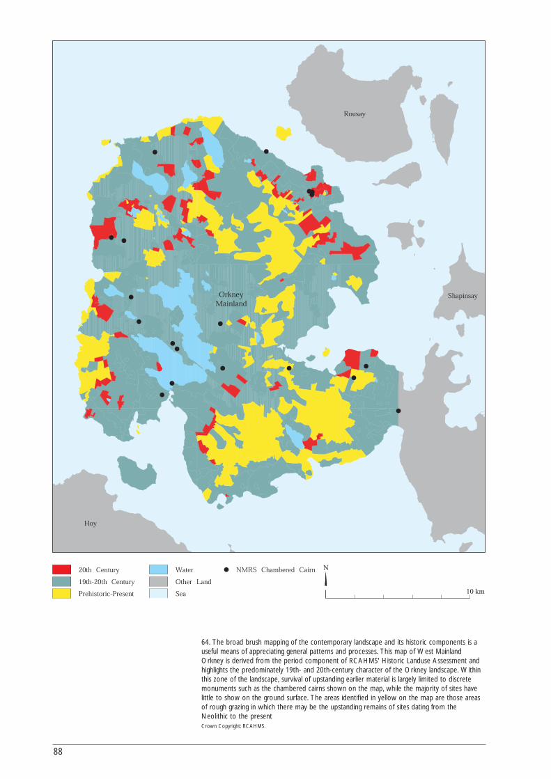
88
20th Century
19th-20th Century Other Land
SeaPrehistoric-Present
N
10 km
Water NMRS Chambered Cairn
OrkneyMainland
Hoy
Rousay
Shapinsay
64. The broad brush mapping of the contemporary landscape and its historic components is auseful means of appreciating general patterns and processes. This map of West MainlandOrkney is derived from the period component of RCAHMS' Historic Landuse Assessment andhighlights the predominately 19th- and 20th-century character of the Orkney landscape. Withinthis zone of the landscape, survival of upstanding earlier material is largely limited to discretemonuments such as the chambered cairns shown on the map, while the majority of sites havelittle to show on the ground surface. The areas identified in yellow on the map are those areasof rough grazing in which there may be the upstanding remains of sites dating from theNeolithic to the present Crown Copyright: RCAHMS.
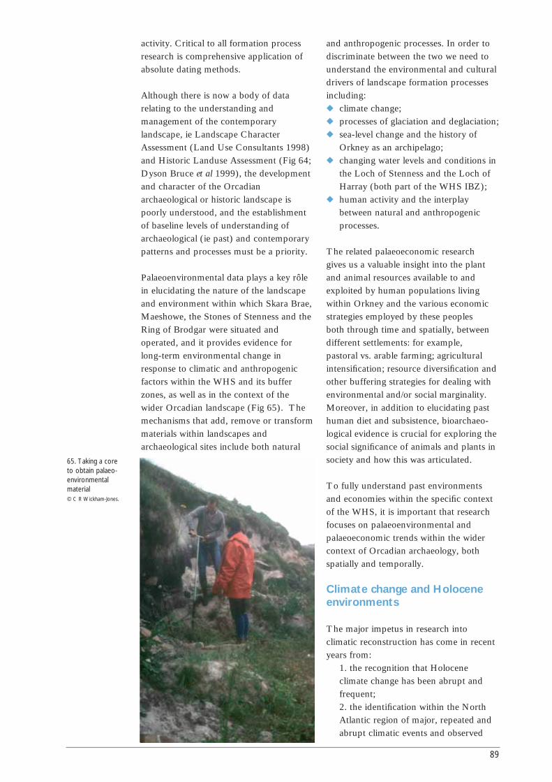
activity. Critical to all formation processresearch is comprehensive application ofabsolute dating methods.
Although there is now a body of datarelating to the understanding andmanagement of the contemporarylandscape, ie Landscape CharacterAssessment (Land Use Consultants 1998)and Historic Landuse Assessment (Fig 64;Dyson Bruce et al 1999), the developmentand character of the Orcadianarchaeological or historic landscape ispoorly understood, and the establishmentof baseline levels of understanding ofarchaeological (ie past) and contemporarypatterns and processes must be a priority.
Palaeoenvironmental data plays a key rôlein elucidating the nature of the landscapeand environment within which Skara Brae,Maeshowe, the Stones of Stenness and theRing of Brodgar were situated andoperated, and it provides evidence forlong-term environmental change inresponse to climatic and anthropogenicfactors within the WHS and its bufferzones, as well as in the context of thewider Orcadian landscape (Fig 65). Themechanisms that add, remove or transformmaterials within landscapes andarchaeological sites include both natural
and anthropogenic processes. In order todiscriminate between the two we need tounderstand the environmental and culturaldrivers of landscape formation processesincluding:◆ climate change;◆ processes of glaciation and deglaciation;◆ sea-level change and the history of
Orkney as an archipelago;◆ changing water levels and conditions in
the Loch of Stenness and the Loch ofHarray (both part of the WHS IBZ);
◆ human activity and the interplaybetween natural and anthropogenicprocesses.
The related palaeoeconomic research gives us a valuable insight into the plantand animal resources available to andexploited by human populations livingwithin Orkney and the various economicstrategies employed by these peoples both through time and spatially, betweendifferent settlements: for example, pastoral vs. arable farming; agriculturalintensification; resource diversification andother buffering strategies for dealing withenvironmental and/or social marginality.Moreover, in addition to elucidating pasthuman diet and subsistence, bioarchaeo-logical evidence is crucial for exploring thesocial significance of animals and plants insociety and how this was articulated.
To fully understand past environmentsand economies within the specific contextof the WHS, it is important that researchfocuses on palaeoenvironmental andpalaeoeconomic trends within the widercontext of Orcadian archaeology, bothspatially and temporally.
Climate change and Holoceneenvironments
The major impetus in research intoclimatic reconstruction has come in recentyears from:
1. the recognition that Holoceneclimate change has been abrupt andfrequent;2. the identification within the NorthAtlantic region of major, repeated andabrupt climatic events and observed
89
65. Taking a core to obtain palaeo-environmentalmaterial © C R Wickham-Jones.
terrestrial environmental repercussions;3. the suggestion that these eventsproduced impacts on resourceavailability, access and the viability ofhuman coastal and other communities;4. a concern to quantify the cyclicityand rates of climate change in order topredict likely events to be faced in thenear future;5. the need to define past climates thatmight serve as analogues for the future.
In Scotland research has beenconcentrated in the Western Isles wherethe scale of past impacts on previoushuman communities is now betterunderstood. Recently, however, theresearch interests of many archaeologistshave diverged from those of the palaeo-climatologists towards an exploration ofinternal, societal-induced change, withhostility to arguments that appearedovertly environmentally determinist. Theselinkages are, however, useful and need tobe re-established.
The most exciting data-set relating toclimate change comes from North Atlanticocean sediments, where Bond, G et al(1997) suggested that severe disruptions toocean circulation have occurredthroughout the Holocene at regularintervals of around 1500 years. Thesemajor impacts occurred at c11100, 10300,9400, 8100, 5900, 4200, 2800 and 1400cal BP, though other workers have foundmore frequent oscillations in NorthAtlantic circulation patterns (Bianchi andMcCave 1999; Chapman and Shackleton2000). These fluctuations are likely to haveimpacted directly on sea temperature.Bond, G et al (1997) suggest that sea-surface temperatures may have droppedby around 2˚C during each event. EarlyHolocene (11100-8100 cal BP) eventsmay have differed from later Holoceneevents (Stager and Mayewski 1997), andthe event at c8200-8000 (8100) cal BP isknown to be exceptionally severe, around6±2˚C in central Greenland (Alley et al1997). Other effects that have beenmodelled but not demonstrated includemarked changes in the amount andintensity of precipitation as well asincreased storminess.
Some of these events, but not all, areidentified in Greenland ice core studies(O’Brien et al 1995), but what effect didthey have in Orkney? Some have beenrecorded in marine sediments aroundOrkney (Klitgaard-Kristensen et al 1998;Kroon et al 2000) and certainly the biggestimpact, at c8100 cal BP, is known to have disturbed vegetation and lakeenvironments elsewhere in Europe (vonGraffenstein 1998). Very recently, themajority of these events have beenidentified within the terrestrial lakesediment record across northern Scotland (Tisdall 2000), but more detailed correlative records are needed to quantify the impact at a local, Orcadian, level.
We are only just beginning to understandthe scale of these events, but Bond, G etal’s (1997) dates coincide with manypreviously recorded episodes of significantstress on human populations in northernScotland. The most recently observeddiscontinuities relevant to the WHSprogramme from western Scotland arethose suggested by Mithen (2000) atc8200 cal BP and Schulting (1998) andRichards and Hedges (1999) at c5900 calBP. These changes may well have led toresource crises, mediated through abruptshifts in coastal, nearshore and/or marineresources driven directly by North Atlanticocean change. The impacts need notalways have been disadvantageous tohuman communities: the major climaticdeterioration at c4200 cal BP appears tohave coincided with colonisation of uplandareas (Tipping 1994), perhaps throughreductions in woodland cover andexpansion of montane grazed grasslandsand heath (Davies et al forth).
We do not know whether each mid-Holocene climatic event generated ahuman response, though it has beensuggested that this was likely given theirprobable scale (Rahmstorf 1995). Ourunderstanding of the broad-scale impactson human populations are, at present,limited because they can only be inferredthrough correlation between differentregions and from different parts of the
90
climate system. It is likely, however, thatexternally applied forces, such as a climaticshift, act as prompts in the teaching andrehearsal of adaptive strategies, so thatfrequent stresses lead to the reinforcementof new strategies. This is an importantconnection between people and climate inwhich ideas of ‘social memory’ play a vitalrôle (McIntosh et al 2000).
Climate change involves the complexinteraction of many processes and inOrkney the nature and relative isolation ofthe archipelago may have magnified itseffects. Changing precipitation, airtemperature and marine conditions allworked together to determine bothresource availability and human access.Travel by sea and access to marineresources were both vulnerable tochanging storm frequency and intensity.Abrupt climate change is likely to havedriven the rates of sea-level change in thepast, much as it does today.
With regard to vegetation, earlierpalaeoenvironmental research in Orkneyhas established broad-scale post-glacialvegetation sequences for the area. By thelate Neolithic (late 4th/3rd millenniumBC) the scrub birch-hazel woodland,which had developed in the 9th/8thmillennium BC, had given way to a largelygrass and heathland vegetation,comparable to present day Orkney(Davidson and Jones, R L 1985; Keatingeand Dickson 1979). Recent research,though broadly confirming these trends,has emphasised a greater degree of localvariation in vegetation cover (Bunting1994) as well as indicating that Orcadianwoodland may have been more speciesrich than previously envisaged (Dickson2000).
On- and off- site palynological and otherpalaeoenvironmental analyses allowinvaluable insight into long-term processesof vegetation change and landscapedevelopment at both a regional and localscale. Moreover, in the absence of detailedarchaeological evidence, off-sitepalaeoenvironmental data currentlyprovides the only means to quantify and
date the presence and impact of the firsthuman inhabitants of Orkney (Edwardsand Whittington 1997). Anthropogenicmodification of the environment, includingthe kinds of grazing and arable practicesdiscussed above, is more likely to bedetected at the local rather than theregional scale, particularly if sample sitesare located in proximity to knownsettlements or structures and are carefullyplaced across the landscape. A key priorityfor future palaeoenvironmental researchwithin Orkney must, therefore, beincreased sampling both on- and off-site,including buried soils as well as peat andloch sediments. In this way thereconstruction of local vegetationdevelopment can be integrated with theexcavation of settlement sites and theinterpretation of off-site structures, such asfield systems and boundaries.
A further issue is the identification of sea-level change, a critical element inunderstanding landscape development anduse. Palaeoenvironmental analysis of inter-tidal peat deposits is an important sourceof evidence for marine inundation, as wasdemonstrated by Keatinge and Dickson(1979) at the Bay of Skaill. At least 15further inter-tidal peat deposits are knownin Orkney; analyses of these would allowinsight into both the timing and impact ofsea-level change at various locationsthroughout the island group. Sedimentsfrom the Stenness and Harray lochs mayalso prove informative. In all cases,research should attempt to make full use ofthe wide range of palaeoenvironmentalproxies; although there has been some useof molluscan evidence (eg Evans 1977),other sources such as insects, diatoms,ostracods or even avian and mammalianevidence have been under-utilised. In thisrespect the application of research ondiatoms to the development of a curve forsea-level change in Shetland (Dawson andSmith 1997) is exciting and bears greatpotential for development in Orkney.
Chronologically the data on climate changeand the development of the Orkneylandscape is still poor. The record ofvegetation change in the few Orkney
91
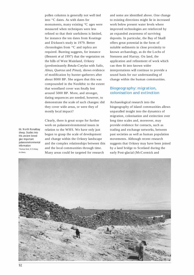
pollen columns is generally not well tiedinto 14C dates. As with dates formonuments, many existing 14C ages weremeasured when techniques were lessrefined so that their usefulness is limited,for instance the ten dates from Keatingeand Dickson's study in 1979. Betterchronologies from 14C and tephra arerequired. Bunting suggests, for instance(Bennett et al 1997) that the vegetation onthe hills of West Mainland, Orkney(predominantly Betula-Corylus with Salix,Alnus, Quercus and Pinus), shows evidenceof modification by hunter-gatherers afterabout 8000 BP. She argues that this wascompounded in the Neolithic to the extentthat woodland cover was finally lostaround 5000 BP. More, and stronger,dating sequences are needed, however, todemonstrate the scale of such changes: didthey cover wide areas, or were they ofmostly local impact?
Clearly, there is great scope for furtherwork on palaeoenvironmental issues inrelation to the WHS. We have only justbegun to grasp the scale of developmentand change within the Orkney landscapeand the complex relationships between thisand the local communities through time.Many areas could be targeted for research
and some are identified above. One changeto existing directions might lie in increasedwork below present water levels whereimproved technologies are reinforced byan expanded awareness of survivingdeposits. In particular, the Bay of Skailloffers great potential in the form ofsuitable sediments in close proximity toknown archaeology, as do the Lochs ofStenness and Harray. On land, theapplication and refinement of work whichcan then fit into known widerinterpretations will continue to provide asound basis for our understanding ofchange within the human communities.
Biogeography: migration,colonisation and extinction
Archaeological research into thebiogeography of island communities allowsunparalled insight into the dynamics ofmigration, colonisation and extinction overlong time scales and, moreover, mayprovide evidence for contacts, such astrading and exchange networks, betweenpast societies as well as human populationmovements. Although recent researchsuggests that Orkney may have been joinedby a land bridge to Scotland during theearly Post-glacial (McCormick and
92
66. North Ronaldsaysheep. Studies intothis ancient breedgive importantpalaeoenvironmentalinformation Thomas Kent, © Orkney
Archives.

Buckland 1997), the extent to which thecolonisation of Orkney by its Holocenefauna was achieved naturally or representsdeliberate or accidental introduction byhumans remains unclear. Clutton-Brock(1979), for example, suggests that red deerare unlikely to have reached Orkneynaturally and hence must reflect humanintroduction, while McCormick andBuckland (1997) indicate that this speciesmay have been able cross over the landbridge prior to inundation. Interesting alsoin this context is the presence of pinemartens at Pierowall Quarry, Westray(McCormick in Sharples 1984).
A further dimension is provided by themarine resources which are abundant inthe archaeological middens. The history ofthe marine species is of interest in its ownright, but it can also shed important lightnot only on diet and exploitation and, byinference, aspects of technology, but alsoon the predominant conditions andcurrents of the Orkney waters. As there aremarine resources from a number ofmiddens of differing dates, there isinformation to be gathered onenvironmental changes within theOrcadian seas from some 5000 years agoto the present.
It is generally accepted, however, thatthere was no indigenous domesticationwithin Orkney and that the cattle, sheepand pig present on early farming sitesreflect a ‘Neolithic package’ of introducedspecies (Fig 66). Noddle (1983) suggesteda Scandinavian origin for the cattle andsheep on metrical grounds. Little furtherwork has been undertaken to evaluatemore fully the origins of the domestic, orindeed the wild, fauna represented on earlyOrcadian sites, despite the considerablepotential of such research to assess theorigins of the first farmers themselves,particularly given recent developments inbiochemical analyses within archaeology(DNA, isotopes, trace elements, etc).Haynes et al (2001) have, for example,recently demonstrated how DNA analysisof the Orkney vole could potentially beused to explore human migration andcolonisation as well as contacts between
communities within island groups. Humanand/or animal migration and colonisationis of interest in later periods also, the mostobvious being the settlement of Orkney inthe 1st millennium AD by peoples andperhaps also livestock of Scandinavianorigin.
Of equal importance is the question ofspecies extinction in Orkney, particularlyfor the larger mammals such as red deerand fox, but also for species with highlyspecific habitat requirements, such asbirds. Long-term trends in local orregional extinction will provide usefulinsight, of interest to conservationbiologists as well as archaeologists, intohuman and climatic impact on islandecosystems, including factors such aspopulation pressure, intensification offarming, anthropogenic or climaticallyinduced reduction of preferred habitat andchanging attitudes to animals.
Agricultural landscapes, diet andsubsistence
Archaeobotanical and archaeozoologicalanalyses at settlement sites in Orkney haveestablished the palaeoeconomic basis forOrcadian society from the Neolithiconwards, indicating reliance on a mixtureof arable and pastoral subsistence farmingaugmented by (unusually frequentinstances of) utilisation of a variety of wildresources (eg Clarke, D V and Sharples1985; Ritchie, A 1983a; Davidson andJones, R L 1985; Ballin Smith (ed) 1994;Rackham et al 1996). Nevertheless, itcould be argued that, with a fewexceptions (Barrett, J H 1995; Bond, J M1995; Guttmann 2001), such research hasin general done little more than establishthe range of species cultivated or exploited.Moreover, it tends to emphasis continuitywith the present or the recent past (egRenfrew 2000; Rackham et al 1996) ratherthan attempt to explore how subsistencefarming, social relationships with animalsand other palaeoeconomic activities mayhave varied through time or betweencontemporary sites in response to social oreconomic forces either in Orkney orfurther afield.
93
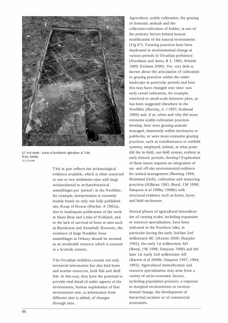
This in part reflects the archaeologicalevidence available, which is often restrictedto one or two settlement sites with largearchaeofaunal or archaeobotanicalassemblages per ‘period’; in the Neolithic,for example, interpretation is currentlymainly based on only one fully publishedsite, Knap of Howar (Ritchie, A 1983a),due to inadequate publication of the workat Skara Brae and Links of Noltland, andto the lack of survival of bone at sites suchas Barnhouse and Stonehall. However, theexistence of large Neolithic boneassemblages in Orkney should be stressedas an invaluable resource which is unusualin a Scottish context.
The Orcadian middens contain not onlyterrestrial information but also bird boneand marine resources, both fish and shellfish. In this way, they have the potential toprovide vital detail of wider aspects of theenvironment, human exploitation of thatenvironment and, as information fromdifferent sites is added, of changesthrough time.
Agriculture, arable cultivation, the grazingof domestic animals and thecollection/cultivation of fodder, is one ofthe primary factors behind humanmodification of the natural environment(Fig 67). Farming practices have beenimplicated in environmental change atvarious periods in Orcadian prehistory(Davidson and Jones, R L 1985; Whittle1989; Dickson 2000). Yet, very little isknown about the articulation of cultivationor grazing practices within the widerlandscape in particular periods and howthis may have changed over time: wasearly cereal cultivation, for example,restricted to small-scale intensive plots, ashas been suggested elsewhere in theNeolithic (Barclay, G J 1997; Halstead1989) and, if so, when and why did moreextensive arable cultivation practicesdevelop; how were grazing animalsmanaged, intensively within enclosures orpaddocks, or were more extensive grazingpractices, such as transhumance or outfieldsystems, employed; indeed, at what pointdid the in-field, out-field system, evident inearly historic periods, develop? Explorationof these issues requires an integration ofon- and off-site environmental evidencefor animal management (Bunting 1994;Mainland forth), cultivation and manuringpractices (Hillman 1981; Bond, J M 1998;Simpson et al 1998a; 1998b) withstructural evidence such as barns, byresand field enclosures.
Several phases of agricultural intensificat-ion of varying scales, including expansionor resource specialisation, have beenindicated in the Northern Isles, inparticular during the early 3rd/late 2ndmillennium BC (Hunter 2000; Sharples1992), the early 1st millennium AD(Bond, J M 1998; Simpson 1998) and thelater 1st /early 2nd millennium AD(Barrett et al 2000b; Simpson 1997; 1994;1993). Agricultural intensification andresource specialisation may arise from avariety of socio-economic factors,including population pressure, a responseto marginal environments or environ-mental change, the development ofhierarchal societies or of commercialeconomies.
94
67. Ard marks - traces of prehistoric agriculture at ToftsNess, Sanday © S J Dockrill.
Further research is needed to address howrepresentative the economic trendsidentified in particular time periods are forOrkney in general, as well as within awider archaeological context, and,moreover, to evaluate more fully whatresource specialisation reflects withinenvironments, like that of Orkney, whichare marginal for arable agriculture (see, forexample, the contrasting explanationsgiven for high level of livestock infantmortality in the Northern and WesternIsles by Halstead (1998), McCormick(1998) and Bigelow (1992)).
Insight into human diet has traditionallybeen gained through archaeozoological andarchaeobotanical evidence. Recentdevelopments in archaeologicalbiochemistry, specifically isotopic analysisof human skeletal material and lipidanalyses of ceramics and other artefacts,are, however, providing new and oftenmore detailed insights into human dietarybehaviour in the past (Dudd et al 1999;Richards and Hedges 1999). Barrett et al(2001) have recently used isotopic analysisto explore changing diet during the Vikingcolonisation of Orkney. Further suchresearch within Orcadian archaeology,particularly if integrated with moreconventional bioarchaeological sources, islikely to allow invaluable new evidence forpast foodways, as well as more specificquestions, such as the varying utilisation ofdietary resources by different segments ofpast societies (eg Hastorf 1996).
Exchange circulation, status,identity and ritual activity
There is a growing recognition withinarchaeology that bioarchaeological datadoes not merely reflect human diet andsubsistence or past environmentalconditions, but that archaeobotanical andarchaeozoological assemblages will oftenhave been structured in response to avariety of non-economic values oractivities, including social status andidentity, ritual activities and socially-embedded exchange of animal and plantresources (Crabtree 1991; Marshall 1994;Grant, A 1991; Hill 1995; Campbell, E
2000). It is argued that insight into suchprocesses can potentially be achievedthrough the identification of structuredspatial patterning in animal or plantassemblages in terms of the representationof particular species, age groups or bodyparts within specific deposit types, areas ofa settlement or between sites of differingfunction, as well as through associationsbetween biological and artefactualevidence. Hill (1995), Grant, A (1991)and Campbell, E (2000) havedemonstrated how such detailedtaphonomic and contextual analyses canbe used to elucidate ritual and symbolicattitudes to animals within the British IronAge. Similar approaches to environmentalevidence have been used to explore kinshiprelations (Zeder and Arter 1996), genderrelations (Hastorf 1996), social status andethnic identity (Crabtree 1991) in variousarchaeological contexts.
Very little attempt has been made toaddress such issues within Orcadianarchaeology. In the Neolithic,environmental data has typically been usedto infer palaeoeconomic activities, and inparticular subsistence farming strategies,(Clarke, D V and Sharples 1985) unlessderived from funerary and monumentalcontexts where ritual interpretationsprevail (eg Renfrew 1979). Notableexceptions are Sharples (2000) and Jones,A (1998) who both explore the symbolicrôle of animals in Neolithic society througha consideration of faunal evidence fromsettlement and funerary contexts. In laterprehistoric and early historic periods,where archaeological evidence is mainlyderived from settlement sites, thereconstruction of subsistence farmingpractices is again emphasised (eg BallinSmith (ed) 1994; Rackham et al 1996).Sharples (2000) and Jones, A (1998) havedemonstrated the viability of non-economic analyses of bioarchaeologicaldata within the context of Orcadianarchaeology; arguably further researchaddressing such issues is required.
95
00
Introduction
This section is designed to provide a briefguide to the range of techniques relevantto archaeological and historical research inthe Orkney WHS. Space allows for only acursory introduction to individualtechniques and information will quickly goout of date as new techniques aredeveloped and existing ones refined. Inorder to keep up to date readers shouldrefer to the Institute of FieldArchaeologists who provide excellent up-to-date information on professionalstandards and health and safety issues forall archaeological work. Their standardshave been carefully developed to provideguidelines for professional archaeologistsand any work related to the WHS shouldbe undertaken according to theirrequirements. In addition to theirStandards and Policy Statements, the IFAproduce a series of technical papersoutlining new developments (seewww.archaeologists.net for information,visited Dec 2003). Alternatively, readersmight contact the specialist below directly.
DatingPatrick Ashmore and David Sanderson
Background
This section assumes a basic knowledge ofthe dating techniques most commonlyapplied to archaeology, or underdevelopment. Dating information providedfor the period of the WHS monuments isambiguous for a number of reasons.Radiocarbon dates suffer from a plateau inthe calibration curve between about 3400and 3100 BC, the dating of variousdifferent types of samples from tombs andsettlements, and the large errors associated
with many of the available 14C ages, manyof which were obtained several years ago.Tephra layers have been exploited toprovide dates only at a fewpalaeoenvironmental sites. The results ofthermoluminescence (TL) dating are fewand can be difficult to interpret because ofthe errors involved. Optically stimulatedluminescence (OSL) dating has not beenused until very recently; nor haspalaeomagnetic dating.
Radiocarbon/AMS dating
Increasing opportunities exist for obtaininglarger numbers of 14C dates on a widervariety of materials than hitherto possible,partly as a result of recent investment inthe UK laboratory resource by the researchcouncils, and partly as a result of the useof smaller, more precise samples. This canbenefit both our understanding of thearchaeological communities and ourinterpretation of the world in which theylived. A range of stable isotopeinvestigations can be added to thegeneration of systematic data sets fromhuman and animal remains associated withrelevant archaeological monuments, inorder to provide information on aspectssuch as diet and economy, as well as onthe context of the monuments. In thisrespect, the increasing use of specificbiomolecules for dating and dietary studiesis very relevant. At a wider level, highresolution dating should be applied,wherever possible, to reconstructions ofsedimentary and vegetational records.Another field of study involves the AMSdating of residues, eg on sherds of pottery.While the precise relationship between thearchaeology and the date may (and onlymay) be more direct here, this technique isstill being refined.
PART
4
96
Techniques
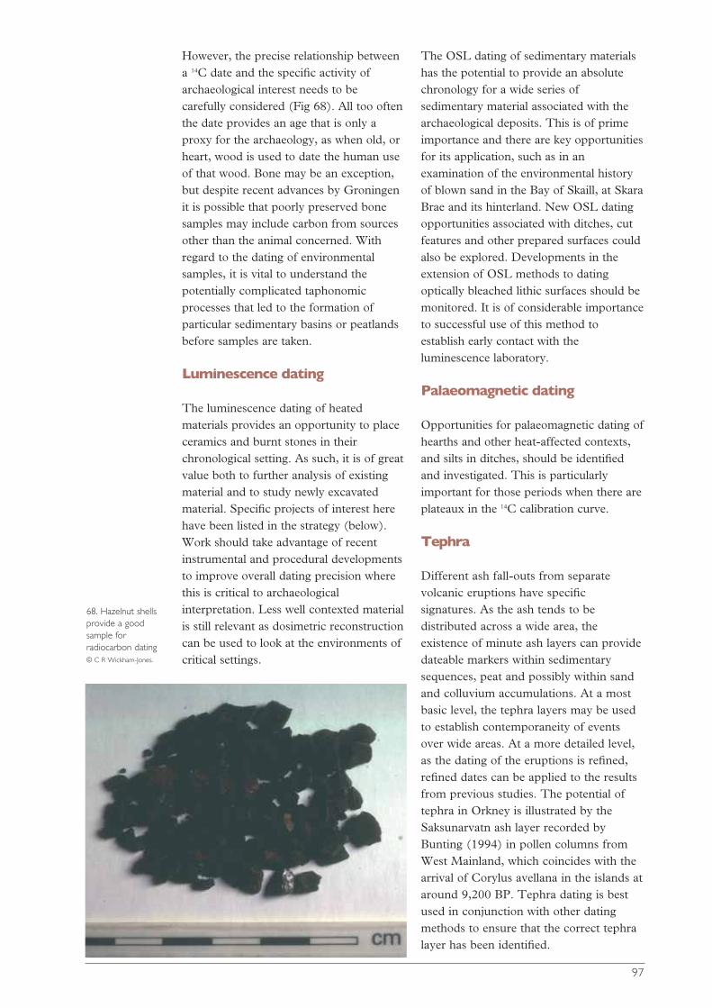
97
However, the precise relationship betweena 14C date and the specific activity ofarchaeological interest needs to becarefully considered (Fig 68). All too oftenthe date provides an age that is only aproxy for the archaeology, as when old, orheart, wood is used to date the human useof that wood. Bone may be an exception,but despite recent advances by Groningenit is possible that poorly preserved bonesamples may include carbon from sourcesother than the animal concerned. Withregard to the dating of environmentalsamples, it is vital to understand thepotentially complicated taphonomicprocesses that led to the formation ofparticular sedimentary basins or peatlandsbefore samples are taken.
Luminescence dating
The luminescence dating of heatedmaterials provides an opportunity to placeceramics and burnt stones in theirchronological setting. As such, it is of greatvalue both to further analysis of existingmaterial and to study newly excavatedmaterial. Specific projects of interest herehave been listed in the strategy (below).Work should take advantage of recentinstrumental and procedural developmentsto improve overall dating precision wherethis is critical to archaeologicalinterpretation. Less well contexted materialis still relevant as dosimetric reconstructioncan be used to look at the environments ofcritical settings.
The OSL dating of sedimentary materialshas the potential to provide an absolutechronology for a wide series ofsedimentary material associated with thearchaeological deposits. This is of primeimportance and there are key opportunitiesfor its application, such as in anexamination of the environmental historyof blown sand in the Bay of Skaill, at SkaraBrae and its hinterland. New OSL datingopportunities associated with ditches, cutfeatures and other prepared surfaces couldalso be explored. Developments in theextension of OSL methods to datingoptically bleached lithic surfaces should bemonitored. It is of considerable importanceto successful use of this method toestablish early contact with theluminescence laboratory.
Palaeomagnetic dating
Opportunities for palaeomagnetic dating ofhearths and other heat-affected contexts,and silts in ditches, should be identifiedand investigated. This is particularlyimportant for those periods when there areplateaux in the 14C calibration curve.
Tephra
Different ash fall-outs from separatevolcanic eruptions have specificsignatures. As the ash tends to bedistributed across a wide area, theexistence of minute ash layers can providedateable markers within sedimentarysequences, peat and possibly within sandand colluvium accumulations. At a mostbasic level, the tephra layers may be usedto establish contemporaneity of eventsover wide areas. At a more detailed level,as the dating of the eruptions is refined,refined dates can be applied to the resultsfrom previous studies. The potential oftephra in Orkney is illustrated by theSaksunarvatn ash layer recorded byBunting (1994) in pollen columns fromWest Mainland, which coincides with thearrival of Corylus avellana in the islands ataround 9,200 BP. Tephra dating is bestused in conjunction with other datingmethods to ensure that the correct tephralayer has been identified.
68. Hazelnut shellsprovide a goodsample forradiocarbon dating © C R Wickham-Jones.
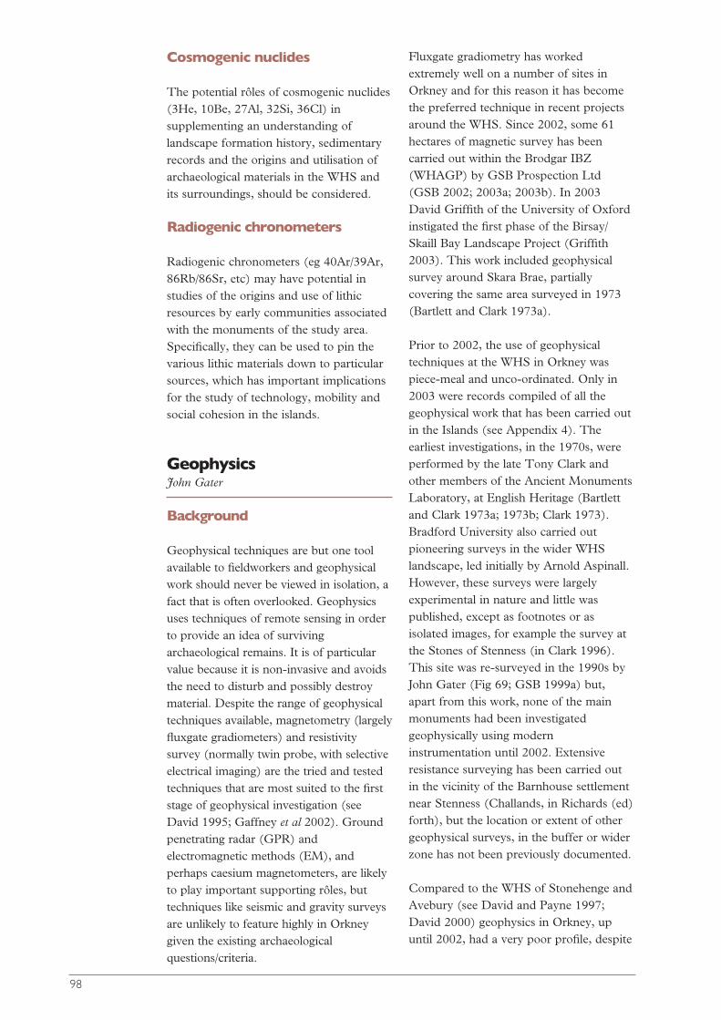
Cosmogenic nuclides
The potential rôles of cosmogenic nuclides(3He, 10Be, 27Al, 32Si, 36Cl) insupplementing an understanding oflandscape formation history, sedimentaryrecords and the origins and utilisation ofarchaeological materials in the WHS andits surroundings, should be considered.
Radiogenic chronometers
Radiogenic chronometers (eg 40Ar/39Ar,86Rb/86Sr, etc) may have potential instudies of the origins and use of lithicresources by early communities associatedwith the monuments of the study area.Specifically, they can be used to pin thevarious lithic materials down to particularsources, which has important implicationsfor the study of technology, mobility andsocial cohesion in the islands.
GeophysicsJohn Gater
Background
Geophysical techniques are but one toolavailable to fieldworkers and geophysicalwork should never be viewed in isolation, afact that is often overlooked. Geophysicsuses techniques of remote sensing in orderto provide an idea of survivingarchaeological remains. It is of particularvalue because it is non-invasive and avoidsthe need to disturb and possibly destroymaterial. Despite the range of geophysicaltechniques available, magnetometry (largelyfluxgate gradiometers) and resistivitysurvey (normally twin probe, with selectiveelectrical imaging) are the tried and testedtechniques that are most suited to the firststage of geophysical investigation (seeDavid 1995; Gaffney et al 2002). Groundpenetrating radar (GPR) andelectromagnetic methods (EM), andperhaps caesium magnetometers, are likelyto play important supporting rôles, buttechniques like seismic and gravity surveysare unlikely to feature highly in Orkneygiven the existing archaeologicalquestions/criteria.
Fluxgate gradiometry has workedextremely well on a number of sites inOrkney and for this reason it has becomethe preferred technique in recent projectsaround the WHS. Since 2002, some 61hectares of magnetic survey has beencarried out within the Brodgar IBZ(WHAGP) by GSB Prospection Ltd(GSB 2002; 2003a; 2003b). In 2003David Griffith of the University of Oxfordinstigated the first phase of the Birsay/Skaill Bay Landscape Project (Griffith2003). This work included geophysicalsurvey around Skara Brae, partiallycovering the same area surveyed in 1973(Bartlett and Clark 1973a).
Prior to 2002, the use of geophysicaltechniques at the WHS in Orkney waspiece-meal and unco-ordinated. Only in2003 were records compiled of all thegeophysical work that has been carried outin the Islands (see Appendix 4). Theearliest investigations, in the 1970s, wereperformed by the late Tony Clark andother members of the Ancient MonumentsLaboratory, at English Heritage (Bartlettand Clark 1973a; 1973b; Clark 1973).Bradford University also carried outpioneering surveys in the wider WHSlandscape, led initially by Arnold Aspinall.However, these surveys were largelyexperimental in nature and little waspublished, except as footnotes or asisolated images, for example the survey atthe Stones of Stenness (in Clark 1996).This site was re-surveyed in the 1990s byJohn Gater (Fig 69; GSB 1999a) but,apart from this work, none of the mainmonuments had been investigatedgeophysically using moderninstrumentation until 2002. Extensiveresistance surveying has been carried outin the vicinity of the Barnhouse settlementnear Stenness (Challands, in Richards (ed)forth), but the location or extent of othergeophysical surveys, in the buffer or widerzone has not been previously documented.
Compared to the WHS of Stonehenge andAvebury (see David and Payne 1997;David 2000) geophysics in Orkney, upuntil 2002, had a very poor profile, despite
98
the largely favourable geological andpedological conditions. It is worth noting,however, that the majority of geophysicalsurvey work at the English WHS sites hasonly been carried out in the past decade orso; Stonehenge itself was surveyed for thefirst time in 1993-4 (Payne 1994).
Perhaps of greater interest, though, is thefact that most of the geophysical work atStonehenge and Avebury has beendevelopment-led: for example, in advanceof the upgrading of the A303 trunk roadand prior to the construction of a newvisitor centre. Most of the surveys werecarried out prior to the establishment, byEnglish Heritage, of local researchagendas. By contrast, following theResearch Agenda meeting in April 2001, amajor geophysical project (the WHAGP)has been instigated by the OrkneyArchaeological Trust (funded by HistoricScotland and Orkney Islands Council) andthis has already dramatically increased theamount of geophysical work on theOrkney WHS.
In discussing the potential of geophysicaltechniques at the Stonehenge WHS, Davidand Payne (1997, 107) stated: ‘Ourassumption is that the entire surveyablearea should be covered in as much detailand by as many compatible and relevanttechniques as possible…but it is necessaryto be more selective.’ While compromisesmust also be true for the Orkney WHS,there is no reason why total coverageshould not be an ultimate goal. In fact thenew project already goes a long waytowards realising this aim.
The World Heritage Site andInner Buffer Zones - summary ofresults
◆ Ring of Brodgar Both the interior ofthe monument and the numerousmounds in the immediate vicinity havebeen surveyed magnetically (though thesteep slopes and overgrown vegetationprecluded survey on the largermounds), and the work has beenextended across the fields to the northof the Ring of Brodgar (GSB 2002).Perhaps the most exciting result is thediscovery of an extensive settlementcomplex surrounding the pair ofBronze Age houses (HY21 SE18),north of the Dyke of Sean (Fig 45;GSB 2003b).
◆ Stones of Stenness Apart from aspectacular complex of igneous dykescrossing the landscape, magnetic surveyhas provided more information on thepossible extent of the settlement atBarnhouse, mapped the site of the BigHowe Broch (Fig 48) and discoveredanother dense concentration ofarchaeological activity, indicative ofprehistoric settlement, on the Ness ofBrodgar (GSB 2002; 2003a).
◆ Maeshowe The area north ofMaeshowe is badly affected by 20th-century war activity, though a numberof archaeological features have beenmapped (GSB 2003a; 2003b). Thearea south, west and east of themonument needs investigation.
◆ Skara Brae At Skaill Bay the Castle ofSnusgar has been surveyed and, inaddition, a trial area adjacent to Skara
99
69. The results ofgeophysical survey atthe Stones ofStenness (the ditchof the henge – thedark annular feature– is about 55m inexternal diameter) © GSB Prospection.
Brae PIC was covered (Griffith 2003).Although an igneous dyke dominatedthe results, some potentiallyarchaeological anomalies were located.
The landscape surrounding themonuments of the WHS containsnumerous ‘mounds’ of potentialarchaeological interest that would clearlybenefit from geophysical investigation. Therecent results at the mound opposite theStanding Stones Hotel are a testament tothis (Challands 2001). It would be arelatively easy to establish the origin ofthese mounds, whether man-made ornatural, and also assign a tentative function(eg burial, occupation, burnt mound orbroch) that would help our understandingof the archaeological landscape.
Development
All proposed developments with the widerWHS zone should be preceded bygeophysical investigation, or at least astudy to assess the suitability of techniquesin individual cases. This principle appliesregardless of the scale of the project: theerection of display boards and rabbit-prooffences, for example, can have a markedeffect on geophysical investigations. This isseen as a prerequisite to any grounddisturbance.
Prospecting
Geophysical techniques have been widelyemployed in helping to locate newarchaeological sites using a combination ofmagnetic scanning, magnetic susceptibilitysampling and detailed sample surveyblocks. These strategies were largelyformulated to investigate development-threatened sites, but they could be adaptedto carry out exploratory surveys in thesame way that fieldwalking exercises arecarried out.
Database
Following the Research Agendasymposium, a compilation has been madeof all fieldwork, including geophysical
survey, carried out within Orkney since1945 (Appendix 4). This will now serve asa database of surveys in Orkney as awhole.
Field SurveyGraeme Wilson
Many of the monuments within the WHSexhibit complex relationships with eachother, as indicated, for example, bysimilarities in design and art work seen atSkara Brae and at Maeshowe. Even now,the major monuments remain visible,although there is much still to bediscovered about their wider context.Where, today, these monuments inhabit alandscape divided by modern roads andfields, they were once surrounded andlinked by numerous settlements, burialsites, field systems and boundaries. Tracesof past landscapes have already beenrecognised in and around the WHS, butundoubtedly many more await discovery.New investigation of the wider hinterland,using field survey, offers the potential tolocate and map previously unrecognisedsites, thereby enhancing our understandingand appreciation of this rich landscape.
Optimum results are obtained from fieldsurvey when a concentrated programme ofwork is carried out. This might consist of arapid programme of walk-over surveywithin a designated area, immediatelyfollowed by topographical survey to mapthe findings. More localised and intensivesurvey, for example post-ploughing orartefact scatter collection, could follow onfrom this. Coastal survey is instrumental tolocate sites which are being uncovered bythe sea.
Field survey techniques are rapid and cost-efficient and they produce results quickly.Walk-over survey (Fig 27) is a good firststage of work, comprising a methodicalvisual examination of every parcel of landwithin a designated area. Probable findingsinclude structural remains and earthworks,concentrations of artefacts, buildingmaterials and midden deposits; they may
100
also include evidence of past land use inthe form of cultivation marks or soils. Theresults of an initial walkover and coastalsurvey are best presented at a scale of1:25,000. At this scale the locations of allmonuments, findspots, artefactconcentrations, etc, within the study areacan be shown in relation to one another.Smaller scale mapping may also be usefulin order to illustrate the outlines of sitestogether with larger landscape features,such as field systems. Both levels of surveyare suitable for inclusion on a GIS system(see below).
More detailed topographical survey canthen take place, at a level of detailsufficient to generate plans at smaller,more useful scales, appropriate to theneeds of the survey. The survey ofindividual monuments should be carriedout using a grid, with measurements atregular distances. The results should bedigitised, so that they can be used in avariety of formats, including contourplans, 3D models of landscape andinteractive presentations. A digital archivehas other advantages in that it can bereused and re-manipulated as the projectrequirements change.
In addition to conventional mapping andsite description work, survey should alsoinclude provision for comprehensivephotographic recording. The examinationof the wider hinterland and the location ofnew sites will provide new foci of interestwithin the landscape and the connectionswithin it can then be better appreciated. Avisual record will greatly enhance theexploration of intra-site relations and theplace of sites within the surroundingnatural landscape.
Although much of the WHA lies awayfrom the sea, coastal and lochside surveyhas an important rôle to play with regardto the investigation of the wider landscape.Work already undertaken near to SkaraBrae and around the mouth of the Loch ofStenness has revealed a number of hithertounknown prehistoric sites. The importanceof the uncultivated coastal edge, asopposed to the farmed hinterland, for site
survival is demonstrated (eg Moore andWilson 1998).
Survey work related to the WHS shouldaim to be as inclusive as possible and notrelated to one specific period. While thereis much to be understood about themonuments in their original setting, it isequally important to appreciate theinfluence of both earlier activity and laterexperience and use. The remains of allperiods should be recorded in order toprovide a comprehensive history of landuse. Close analysis and interpretation ofthe results will be needed to decode thepalimpsest of landscape features andunravel individual strands of evidence.This may be most effectively carried out using a programme of GIS and intandem with a dedicated series of 14C dates.
Field survey should be regarded as a firststep or baseline from which further workcan develop. The results will be mostuseful if they are integrated with otherstrands of work such as excavation,geophysical survey and historical research.GIS is a useful way to do this. Field surveyis also an essential tool for the monitoringof sites and the landscape within whichthey are sited, and thus it is a vital part ofsite management.
Underwater explorationIan Oxley with Bobby Forbes
Background
Most, but not all, land-basedarchaeological techniques can be adaptedfor use underwater, though they may takea bit longer and thus be more expensive.This includes both an initial appraisal andmore detailed work. A wide variety ofroutine evaluation methods are availableand these include geophysical and otherremote techniques. More detailedtechniques include intrusive investigationmethods such as coring and excavation.Recent interest in underwater archaeologymeans that the techniques are rapidlydeveloping.
101
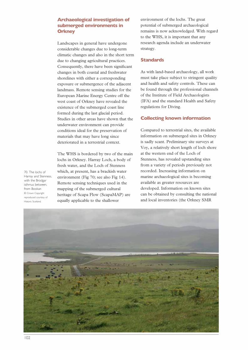
Archaeological investigation ofsubmerged environments inOrkney
Landscapes in general have undergoneconsiderable changes due to long-termclimatic changes and also in the short termdue to changing agricultural practices.Consequently, there have been significantchanges in both coastal and freshwatershorelines with either a correspondingexposure or submergence of the adjacentlandmass. Remote sensing studies for theEuropean Marine Energy Centre off thewest coast of Orkney have revealed theexistence of the submerged coast lineformed during the last glacial period.Studies in other areas have shown that theunderwater environment can provideconditions ideal for the preservation ofmaterials that may have long sincedeteriorated in a terrestrial context.
The WHS is bordered by two of the mainlochs in Orkney. Harray Loch, a body offresh water, and the Loch of Stennesswhich, at present, has a brackish waterenvironment (Fig 70; see also Fig 14).Remote sensing techniques used in themapping of the submerged culturalheritage of Scapa Flow (ScapaMAP) areequally applicable to the shallower
environment of the lochs. The greatpotential of submerged archaeologicalremains is now acknowledged. With regardto the WHS, it is important that anyresearch agenda include an underwaterstrategy.
Standards
As with land-based archaeology, all workmust take place subject to stringent qualityand health and safety controls. These canbe found through the professional channelsof the Institute of Field Archaeologists(IFA) and the standard Health and Safetyregulations for Diving.
Collecting known information
Compared to terrestrial sites, the availableinformation on submerged sites in Orkneyis sadly scant. Preliminary site surveys atVoy, a relatively short length of loch shoreat the western end of the Loch ofStenness, has revealed upstanding sitesfrom a variety of periods previously notrecorded. Increasing information onmarine archaeological sites is becomingavailable as greater resources aredeveloped. Information on known sites can be obtained by consulting the nationaland local inventories (the Orkney SMR
102
70. The lochs ofHarray and Stenness,with the Brodgaristhmus between,from Bookan © Crown Copyright
reproduced courtesy of
Historic Scotland.
and the National Monuments Record ofScotland (NMRS)), though there areinconsistencies in these records.Information may also be available fromlocal maritime interest groups andOrkney’s museum service (The NauticalArchaeology Society; Dive Boat OperatorsGroup, Orkney; and Orkney Heritage).Information held locally in private or semi-official hands should not be forgotten
Information on the location of areas ofseabed protected under the Protection ofWrecks Act (1973) can be obtained fromHistoric Scotland. The presence orabsence of these designated historic wrecksites does not necessarily mean that othersites do not exist which require (or merit)attention. It is important to considercircumstantial evidence which mayindicate whether such remains are presentand whether they might be affected by anydevelopment proposals.
Assessing archaeologicalpotential
There are a number of strategies that canbe employed in order to assess thearchaeological potential of an area underwater. Inferences can be made fromhistorical evidence and reference to thepresence of sites and features on land inadjacent areas. Some idea of the area’spast can generally be gained fromevaluating known evidence of maritimeactivity and occupation prior to rises in sealevel (Firth et al 1997). The concept of a‘maritime cultural landscape’ encouragestaking a broad view of sources ofinformation which may indicate thepresence of sites, for example early mapsand charts, place-names and folklore(Hunter 1994).
The possible presence of submerged landsurfaces has to be considered and the useof predictive survey in areas of potentiallygood preservation should be assessed.Certain combinations of chemical, physicaland biological characteristics are known toindicate the good preservation ofarchaeological material (Oxley 1995). Inmany places information on known sites is
poor and there is a high potential forpreviously undiscovered sites. In thesecases assessment of potential is vital, bothas a research tool and as a part of themanagement process. There are, as yet, noformal guidelines for assessing marinearchaeological potential.
Evaluation techniques
The importance or significance of sitesmust be assessed before any intrusive(archaeological or geotechnical)evaluations are permitted because suchactivities may unwittingly damagearchaeological deposits. Visual evaluation,or seabed inspection of identified features,is often the only effective way to estimatearchaeological importance. Intrusivemethods which involve the disturbance ofthe archaeological context may benecessary to evaluate the date, nature,extent, condition and preservation of thearchaeological evidence, but they shouldonly be undertaken after the developmentof an acceptable project design.
Excavation
Excavation is the most damaging form ofintrusive investigation. Although it is avalid technique on land, trial trenching bydivers is usually time-consuming andexpensive. Specific small-scale excavationsmay be necessary (and more practical) totest deposits. There are many differenttechniques for underwater excavation, andmost are similar to land excavation, butthey employ different tools and takeadvantage of the unique properties of theunderwater environment. Techniques ofunderwater excavation are described invarious texts (eg Green 1990; Dean et al1995).
Underwater methodologies
Not all land-based archaeologicaltechniques can be directly transferredunderwater, but it is fair to say that agreater standard of archaeological work isachievable underwater than is commonlybelieved. A comprehensive description ofthe techniques and methodologies
103
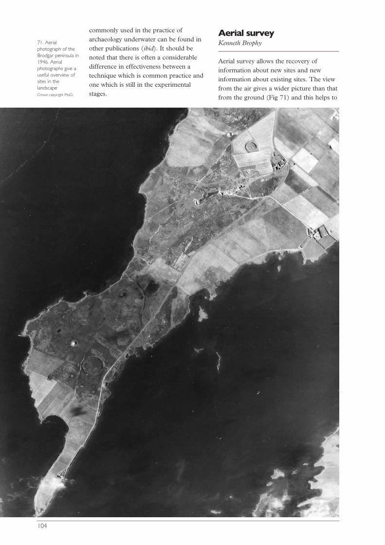
commonly used in the practice ofarchaeology underwater can be found inother publications (ibid). It should benoted that there is often a considerabledifference in effectiveness between atechnique which is common practice andone which is still in the experimentalstages.
Aerial surveyKenneth Brophy
Aerial survey allows the recovery ofinformation about new sites and newinformation about existing sites. The viewfrom the air gives a wider picture than thatfrom the ground (Fig 71) and this helps to
104
71. Aerialphotograph of theBrodgar peninsula in1946. Aerialphotographs give auseful overview ofsites in thelandscape Crown copyright MoD.
make sense of the archaeologicallandscape. Aerial survey not only looks atupstanding remains, it can also indicatesub-soil remains through a variety offactors, such as variations in crop growthwhich reflect variations in soil moistureover buried walls or ditches (known ascropmarks), or the visibility of shadowsfrom depleted mounds in low sunlight.Aerial photographs can be either obliqueor vertical and existing archives of materialfrom previous flights can be a valuablesource of information in addition to new,purposely directed flights.
In contrast to the rest of Scotland, Orkneyhas suffered from a lack of concentratedaerial reconnaissance. In parts of lowlandScotland aerial survey has caused arevolution in our understanding of theprehistoric landscape, but other areas havebeen neglected. This has been largely dueto logistics – RCAHMS flights leave fromEdinburgh airport, so journeys to Orkneytake several long 'steps' northwards, oftenlasting a few days and, once there, they aredependent on good weather, somethingthat is not easy to predict. There are alsono suitably equipped, or qualified,sponsored or local flyers operating inOrkney as in, for instance, HighlandRegion or Aberdeenshire.
Nevertheless, limited aerial reconnaissancehas been carried out in Orkney, partlythrough private flyers like John Dewar(who provided spectacular colour imagesof WHS sites during flights in the 1970sand 1980s) and also some limitedreconnaissance by RCAHMS since 1976.This has tended to concentrate on known,upstanding monuments, especially relatingto rural architecture, WWI and WWIIdefences and the oil industry.
Neolithic Orkney has benefited from theabove-ground survival of traces of pastmonuments in the form of earthworks andstanding stones. However, there is goodreason to believe that sub-surface tracesawait discovery, as shown by remnantartefact scatters on field surfaces and thediscovery of new sites such as Barnhouse.The concentration of agriculture on
Mainland and some islands of Orkney,including much of the WHS, has almostcertainly resulted in the degrading andflattening of earthworks; and, of course,other more ephemeral constructions, suchas timber-works, are impossible to pick upabove ground surface. Orkney thus hasgreat potential to yield cropmarks. This isaided by the state of the land: Orkney isrelatively flat and covered in a fairpercentage of arable land with cerealcrops.
A programme of concentrated aerialreconnaissance should be one of theresearch priorities in the WHS, not only todiscover cropmarks of new sites, but alsoto look for new elements to familiar sites.As well as oblique aerial photographytargeted to archaeology, it is vital to assessthe archaeological potential of the existingvertical photographic record: eg Royal AirForce and Ordnance Survey coveragesince the 1940s. Aerial photography hasproved itself to be a powerful andeconomical tool of prospection that cancover large areas relatively quickly.Importantly, in an area of such familiararchaeology as the WHS, it allows a newperspective. The WHS provides an area ofgreat archaeological potential, but it is adiminishing resource and it is essential thataerial photography be utilised to the full.
Geographical informationsystemsAngus Mackintosh
Geographical information systems (GIS)are a form of spatial database used toseamlessly integrate and analyse large anddisparate digital data sets. They thereforehave great strengths for archaeology.Conventionally, the data might comprisedigitised topographic data, the results ofgeophysical survey, aerial photographs etc,but it can also include extended textualrecords, other forms of digital images, aswell as audio and video files (Fig 64 hasbeen produced from a GIS-based system).
A GIS to meet the needs of the WHSshould be flexible enough to embrace a
105
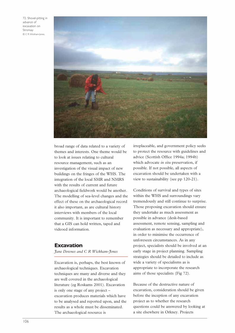
broad range of data related to a variety ofthemes and interests. One theme would beto look at issues relating to culturalresource management, such as aninvestigation of the visual impact of newbuildings on the fringes of the WHS. Theintegration of the local SMR and NMRSwith the results of current and futurearchaeological fieldwork would be another.The modelling of sea-level changes and theeffect of these on the archaeological recordit also important, as are cultural historyinterviews with members of the localcommunity. It is important to rememberthat a GIS can hold written, taped andvideoed information.
ExcavationJane Downes and C R Wickham-Jones
Excavation is, perhaps, the best known ofarchaeological techniques. Excavationtechniques are many and diverse and theyare well covered in the archaeologicalliterature (eg Roskams 2001). Excavationis only one stage of any project –excavation produces materials which haveto be analysed and reported upon, and theresults as a whole must be disseminated.The archaeological resource is
irreplaceable, and government policy seeksto protect the resource with guidelines andadvice (Scottish Office 1994a; 1994b)which advocate in situ preservation, ifpossible. If not possible, all aspects ofexcavation should be undertaken with aview to sustainability (see pp 120-21).
Conditions of survival and types of siteswithin the WHS and surroundings varytremendously and still continue to surprise.Those proposing excavation should ensurethey undertake as much assessment aspossible in advance (desk-basedassessment, remote sensing, sampling andevaluation as necessary and appropriate),in order to minimise the occurrence ofunforeseen circumstances. As in anyproject, specialists should be involved at anearly stage in project planning. Samplingstrategies should be detailed to include aswide a variety of specialisms as isappropriate to incorporate the researchaims of those specialists (Fig 72).
Because of the destructive nature ofexcavation, consideration should be givenbefore the inception of any excavationproject as to whether the researchquestions could be answered by looking ata site elsewhere in Orkney. Projects
106
72. Shovel-pitting inadvance ofexcavation onStronsay © C R Wickham-Jones.
undertaken in the WHS, and relatedprojects elsewhere in Orkney, should bedesigned with wider applications in mind,whether that be methodological,geographic, heritage management or otherapplications.
Any excavation that is undertaken in theWHS or the immediate environs (IBZs)will have enhanced management,interpretation and public access issues.Excavation may be required ahead ofactions in the Management Plan, inparticular those concerning improvementof visitor access, visitor management anderosion at the WHS monuments. Researchexcavations undertaken should incorporaterelevant management issues and widerapplications for management, and mayalso provide opportunities for long-termmonitoring following reinstatement ofsites.
Excavations in the WHS and immediateenvirons will be inevitably high profile andhighly visible because of the status of theWHS and the large amount of visitors toit. It is important that opportunities forpublic access, display or leaflets at the timeof excavation are considered early inplanning stages and are maximised.Prompt dissemination in an accessibleform to inform both heritage managersand the public is essential.
Any excavation undertaken in the WHS,no matter what the impetus or source offunding, should be carried out by thosewho have a knowledge of the history ofresearch of the WHS, and of the broadaims of the research framework (thisResearch Agenda) for the WHS. That wayall archaeological investigations, includingthose ahead of developer/managementactivities, can be designed to maximiseopportunities to contribute to overallresearch aims, and can be placed withinthe research framework that this documentprovides.
Excavation projects must adhere to thehighest professional standards (eg IFAStandards: www.archaeologists.net) andwork from the formulation of a robust
research design, through fieldworkmethods and recording to disseminationand archiving. Importantly, excavationprojects must be properly resourcedthrough all these stages of work.
Soil and sediment analyses Ian A Simpson
Background
Analyses of site formation processes,historic and prehistoric land resources,utilisation and palaeoenvironmentalcontexts are key research themesassociated with the Orkney WHS. Oneapproach to these issues is through soiland sediment analyses. Previous soil andsediment analyses in the Northern Isles,and the North Atlantic region moregenerally, have developed and tested anumber of methods that have potential forapplication within the Orkney WHS. Theuse and potential of these methods issummarised below.
Field survey
High quality soil survey and geologicalsurvey maps and descriptions for Orkneyalready exist at a scale of 1:50,000, andthese provide a foundation from which todesign land resource assessments (SoilSurvey for Scotland 1981; BritishGeological Survey 1936-1994). Soilsurveys have, for example, identifiedsignificant areas of relict ‘deep top’ soils inWest Mainland Orkney, and these havebeen demonstrated to be ‘plaggen’ soilscontaining significant information on earlyarable land management practices and therelationship between arable activity andlivestock husbandry (Simpson 1997).
Thin-section micromorphologyand associated techniques
Thin-section micromorphology allows themicroscopic examination of undisturbedsoils and sediments (Davidson andSimpson 2001; Courty et al 1989),permitting formal description of soil andsediment components (Bullock et al 1985).
107
The use of experimental and ethno-historical approaches to validation,combined with chemical microprobeanalyses of key features (Davidson andSimpson 2001; Macphail and Cruise2001), means that the interpretation ofthin-section components is becomingincreasingly robust. As a result, thistechnique contributes information to anincreasing range of archaeologicalquestions.
In a North Atlantic context,archaeological midden stratigraphies inOrkney have been examined to elucidatedistinctions between specialised fishingcommunities and farm-fishing sites overvarious time periods (Simpson et al 2000;Simpson and Barrett, J H 1996). Protoninduced X-ray emission microprobeanalyses with associated micro-focussynchrotron X-ray scattering analysis hasbeen used to establish the origin ofcrypto-crystalline products of bonedecomposition at these sites, providingthe potential to retrieve archaeologicallysignificant information from sites withpoor preservation (Simpson et al 2000;Adderley et al forth). Fuel residues incomplex midden stratigraphies can alsobe identified using thin-sectionmicromorphology, and quantified in twodimensions using image analysestechniques, and in three dimensions usinghigh resolution X-ray computedtomography (Adderley et al 2001;Simpson et al 2003). Similar analysescould be applied to the study ofoccupation surfaces, and these wouldprovide information on the in situ spatialpatterning of micro-artefacts and ecofactsin three dimensions, allowing new insightsinto the functions of archaeological sites.Currently, and of direct relevance to theOrkney WHS, thin-sectionmicromorphology analyses are beingapplied to midden stratigraphies at SkaraBrae (Simpson, forth). There is furtherscope to consider fossil soils beneath amonument as a way to assess theenvironmental conditions prior tomonument construction (Barclay, G J etal 1995; Simpson and Davidson 2000).Thin-section micromorphology can also
be applied to the study of ‘offsite’ soilsand sediments, contributing in particularto the identification of manuring andcultivation practices associated with earlyfield systems. Fuel residue inputs, the useof turf and intensities of cultivation, haveall been identified in early arable soils,which range from the Neolithic to theearly modern period. These observations,when integrated with biomarker analyses,provide powerful new insights into earlyland management strategies (Simpson1997; Simpson et al 1998a; Simpson et al1998b).
Biomarkers
Innovative organic geochemistrytechniques applied to soils and sedimentsare now making a major contribution tothe understanding of early landmanagement practices in Orkney and theNorth Atlantic region. These techniquesinclude the identification of free soil lipidswhich permits the identification oforganic materials used in manuringstrategies – human manures, omnivorousmanures and herbivorous manures -within arable and hay production systems(Bull et al 1999a; 1999b; Simpson et al1999b). These have now been verified inexperimental and ethno-historicalcontexts. Observations from the NorthernIsles suggest a focus on the use ofhousehold wastes in maintaining arableland fertility from the Neolithic throughto the early Iron Age, with a switch to theuse of animal manures from the late IronAge through to the early modern period.Advanced biomarker analyses usingcompound specific stable isotope analyses(δ15N on amino acids and δ13C on n-alkanoic acids) have further suggesteddifferentiation between manuredgrasslands, unmanured grasslands andcontinuous cereal cultivation, togetherwith the differentiation of terrestrial andmarine sourced organic inputs toarchaeological soils (Simpson et al 1997;1999a). These techniques can be appliedand developed further within the WHS toidentify the range and intensity of arableand grassland management strategies.
108
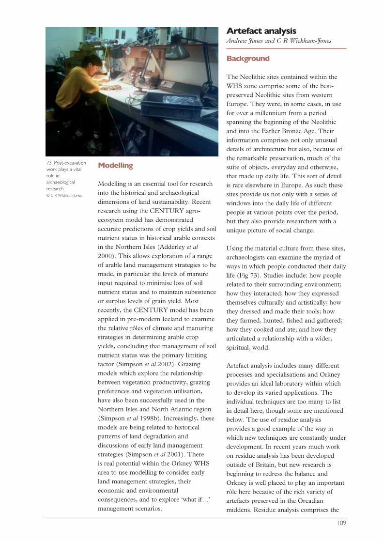
Modelling
Modelling is an essential tool for researchinto the historical and archaeologicaldimensions of land sustainability. Recentresearch using the CENTURY agro-ecosytem model has demonstratedaccurate predictions of crop yields and soilnutrient status in historical arable contextsin the Northern Isles (Adderley et al2000). This allows exploration of a rangeof arable land management strategies to bemade, in particular the levels of manureinput required to minimise loss of soilnutrient status and to maintain subsistenceor surplus levels of grain yield. Mostrecently, the CENTURY model has beenapplied in pre-modern Iceland to examinethe relative rôles of climate and manuringstrategies in determining arable cropyields, concluding that management of soilnutrient status was the primary limitingfactor (Simpson et al 2002). Grazingmodels which explore the relationshipbetween vegetation productivity, grazingpreferences and vegetation utilisation, have also been successfully used in theNorthern Isles and North Atlantic region(Simpson et al 1998b). Increasingly, thesemodels are being related to historicalpatterns of land degradation anddiscussions of early land managementstrategies (Simpson et al 2001). There is real potential within the Orkney WHSarea to use modelling to consider earlyland management strategies, theireconomic and environmentalconsequences, and to explore ‘what if…’management scenarios.
Artefact analysisAndrew Jones and C R Wickham-Jones
Background
The Neolithic sites contained within theWHS zone comprise some of the best-preserved Neolithic sites from westernEurope. They were, in some cases, in usefor over a millennium from a periodspanning the beginning of the Neolithicand into the Earlier Bronze Age. Theirinformation comprises not only unusualdetails of architecture but also, because ofthe remarkable preservation, much of thesuite of objects, everyday and otherwise,that made up daily life. This sort of detailis rare elsewhere in Europe. As such thesesites provide us not only with a series ofwindows into the daily life of differentpeople at various points over the period,but they also provide researchers with aunique picture of social change.
Using the material culture from these sites,archaeologists can examine the myriad ofways in which people conducted their dailylife (Fig 73). Studies include: how peoplerelated to their surrounding environment;how they interacted; how they expressedthemselves culturally and artistically; howthey dressed and made their tools; howthey farmed, hunted, fished and gathered;how they cooked and ate; and how theyarticulated a relationship with a wider,spiritual, world.
Artefact analysis includes many differentprocesses and specialisations and Orkneyprovides an ideal laboratory within whichto develop its varied applications. Theindividual techniques are too many to listin detail here, though some are mentionedbelow. The use of residue analysisprovides a good example of the way inwhich new techniques are constantly underdevelopment. In recent years much workon residue analysis has been developedoutside of Britain, but new research isbeginning to redress the balance andOrkney is well placed to play an importantrôle here because of the rich variety ofartefacts preserved in the Orcadianmiddens. Residue analysis comprises the
109
73. Post-excavationwork plays a vitalrole inarchaeologicalresearch © C R WIckham-Jones.

recovery and identification of traces thatare assumed to relate closely to the uses ofdifferent artefacts. It involves the study ofresidues (sometimes microscopic) thathave built up and been preserved onartefacts of various different materials.Bone, pottery and stone have all beenshown to harbour residues when thecircumstances are right. There are manyways in which residues can build up: burntremains on pottery; the incorporation ofstray grains and pollen into the fabric of apot; traces on stone and bone tools; andalterations of the actual fabric of tools. Notsurprisingly, residue analysis incorporatesmany different techniques in the quest torecord and identify these remains.Scanning electron microscopes, chemicalwork on lipids and starches, pollen analysisand more detailed work such as isotopestudies all have a part to play. Once theresidue work has been done, there areobvious benefits from the incorporation ofthe information into wider data sets so thataspects such as content might be playedinto the pottery research outlined above.
The following discussion is intended togive some idea of the wide range oftechniques involved in artefact analysis andto look at how some of the techniquesmight be applied, but it is not an attemptto be comprehensive.
Ceramics
Ceramics and community identities Ceramics are critically important forarchaeological interpretation because theyare used for the processing, consumptionand storage of food. While this activitymay seem mundane, it is fundamental toall human life and it has been shown to bevital to the expression of social dimensionssince in most cultures food plays a crucialrôle in the expression of affiliationsbetween people: at the household; kingroup; community; and inter-communitylevel. Not only this, but the production ofpottery using specific materials, indifferent styles and with distinctivedecoration, is generally associated with theexpression of social identity.
In Orkney, research into the use of theceramics as an expression of social identityis concerned with the relationship betweenthe production of early Neolithic bowlsand Unstan Wares, and that of lateNeolithic Grooved Wares. The materialsused in the production of the pottery canbe examined using petrological thin-sections. This technique has beentraditionally used to ask questionsconcerning the locality of potteryproduction and the nature of potteryexchange. However, work at the lateNeolithic settlement at Barnhouse hastaken a different approach (Jones inRichards (ed) forth). By using informationfrom multiple thin-sections derived frompottery from many locations within thesettlement, a more detailed picture ofpottery production could be produced.This indicated that each household wasmaking pottery from specific rawmaterials, suggesting that potteryproduction in the Neolithic was organisedby individual households. Using thistechnique, the Barnhouse analysis was ableto trace the life histories of the GroovedWare vessels from production to depo-sition. Petrological links were establishedbetween the locations of production andthose of deposition, not only within thesettlement, but further afield in Orkney, atsites such as the Stones of Stenness andthe Quanterness passage grave.
This research has provided importantevidence of the relationship betweenpeople and their environment. By taking itfurther, researchers can build up a pictureof the complex web of links betweenvessels deposited on the various differenttypes of site, so that material from thehenges and passage graves can be relatedto that deposited in the settlement sites.Furthermore, the links betweencontemporary settlements can beexamined.
Ceramic technology and settlementhistories Orkney has one of the best records ofNeolithic settlement in Europe.Furthermore, many of the earlierprehistoric settlements that have been
110

111
explanation. Sadly, the lack of basic work,including elementary publication, on allbut a few of the most recently excavatedassemblages, has limited the use of thissort of wider analysis. Work on lithicselsewhere, and on other artefact types inOrkney, shows the great benefits thatwould accrue from such work.
Provenance and exchange Other types of stone artefact include bothground and decorated stone, but onceagain there has been little work on thecharacterisation and analysis of groundstone tools in comparison to that on potteryproduction and circulation. There aremany stone tools of note from Orkney:including one of the major concentrationsof pestle maceheads in Britain; togetherwith a number of other macehead forms;carved stone balls; stone axes; and a varietyof coarse stone tools, such as Skaill knives.
There are many different aspects to theanalysis of stone tools, but one importantfacet would be to look at provenance andexchange through a detailed examinationof stone tool petrology and sourcing. Thishas wider application in terms of thenature of interaction networks both withinOrkney, and between Orkney and otherregions (Shetland and the Scottishmainland). Primary research ought tocommence with the construction of a localdatabase of sources, so that coarse stonetools and stone axes which are likely to beof local origin can be assessed. In thisrespect it is interesting to note thatpreliminary comparison of the rocksources for pottery production atBarnhouse with the sources of stone toolmaterials here suggest a close connection.Detailed analysis of the stone toollithologies is necessary to clarify thisconnection.
Social context The recovery of many ground anddecorated stone tools from settlement sitesand other excavations in Orkney providesanother opportunity: that of looking at theuse and deposition of these pieces. Thisshould include work on individual sites aswell as inter-site comparisons. Elsewhere
excavated are deeply stratified withsequences of remains that run from theearly Neolithic to the early Bronze Age. Asa consequence there are good sequences ofpottery for this period. However, thematerial record is not matched by ourunderstanding; there is still a poor grasp ofthe nature and periodicity of settlementhistories. How long were houses inhabitedfor? How did house and settlement historychange? How, and why, were settlementsabandoned? New research at SouthamptonUniversity is addressing this (Jones forth).
One approach is to combine theexamination of architectural history withan examination of the changes in ceramictechnology. Subtle changes in theproduction of pottery can be identifiedboth petrologically (see above) andtechnologically, and these can be definedin relation to changes in settlement history.In this way a detailed picture of the socialprocesses involved in the establishment,evolution and abandonment of settlementscan be drawn up.
Alongside the technological examination ofpottery in relation to settlement histories,will be a thorough assessment of the natureand quality of the existing 14C recordrelated to the Neolithic settlements. Ifnecessary, work will include thedevelopment of a parallel researchprogramme to obtain increased dates.
Stone tools
Flaked stone tools Flaked stone tools comprise one of themain sources of artefact information formuch of Neolithic Scotland. Their studyhas widened greatly in recent years withthe development and application oftechniques of analysis that take intoaccount the many fields of informationavailable, such as raw materials,procurement, technology, use and reuse,movement and deposition. Orkney offersan outstanding opportunity in this respectbecause the lithic record is derived from abackground of unique richness. In thisway, information from the stone tools canbe set into much wider contexts of social
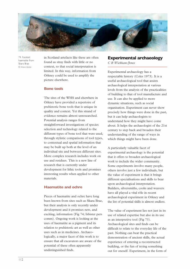
in Scotland artefacts like these are oftenfound as stray finds with little or nocontext, so that social interpretation islimited. In this way, information fromOrkney could be used to amplify thepicture elsewhere.
Bone tools
The sites of the WHS and elsewhere inOrkney have provided a repertoire ofprehistoric bone tools that is unique inquality and context. Yet this strand ofevidence remains almost unresearched.Potential analysis ranges fromstraightforward investigations of speciesselection and technology related to thedifferent types of bone tool that were used,through stylistic comparisons of tool types,to contextual and spatial information thatmay be built up both at the level of anindividual site and between different sites.More complex research includes work onuse and residues. This is a new line ofresearch that is currently underdevelopment for lithic tools and promisesinteresting results when applied to othermaterials.
Haematite and ochre
Pieces of haematite and ochre have longbeen known from sites such as Skara Brae,but their analysis is only recently underdevelopment and it promises new, andexciting, information (Fig 74; Isbister perscomm). Ongoing work is looking at theuses of haematite as a pigment and itsrelation to prehistoric art as well as otheruses such as in medicines. Archaeo-logically, a major facet of this work is toensure that all excavators are aware of thepotential of these often apparentlyundistinguished finds.
Experimental archaeologyC R Wickham-Jones
Experimental archaeology has arespectable history (Coles 1973). It is auseful archaeological tool that assistsarchaeological interpretation at variouslevels from the analysis of the practicalitiesof building to that of tool manufacture anduse. It can also be applied to moredynamic situations, such as socialorganisation. Experiment can never showprecisely how things were done in the past,but it can help archaeologists tounderstand how they might have comeabout. It helps the archaeologist of the 21stcentury to step back and broaden theirunderstanding of the range of ways inwhich things might have been done.
A particularly valuable facet ofexperimental archaeology is the potentialthat it offers to broaden archaeologicalwork to include the wider community.Some experiments involve many people,others involve just a few individuals, butthe value of experiment is that it bringsdifferent specialisations and skills to bearupon archaeological interpretation.Builders, silversmiths, cooks and weavershave all played a vital rôle in recentarchaeological experiment in Orkney andthe list of potential skills is almost endless.
The value of experiment lies not just in itsuse of related expertise but also in its useas an interpretive tool (Fig 75).Archaeological sites and finds can bedifficult to relate to the everyday life of thepast. Nothing can beat the practicaldemonstration of ancient skills, the actualexperience of entering a reconstructedbuilding, or the fun of trying somethingout for oneself. Experiment, in the form of
112
74. Facetedhaematite fromSkara Brae © Arlene Isbister.

experience, is particularly valuable forchildren, but also, of course, of greatinterest to the adult community.
Experiment in Orkney is itselflongstanding, from the elucidation byPetrie of the manufacture of Skaill knives(Petrie 1868), to the Minehowe Knowhowevent in 2002. Despite this, Britisharchaeologists rarely include experiment asa valid part of their studies in the sameway that takes place elsewhere, eg inDenmark(http://www.english.lejrecenter.dk/ visitedDecember 2003). The introduction ofmore archaeological experiment toresearch related to the WHS would notonly benefit archaeological knowledge inthe WHS, but also the place of Orkneywithin the archaeological profession as awhole.
Skeletal studies: humanorigins, diet and lifestyleC R Wickham Jones
Recent scientific advances have producedexciting results from the study of humanskeletal material. This is wide-rangingresearch that incorporates many differentskills, and much of it is still underdevelopment. Orkney contains one of thebest collections of human bone fromNeolithic Scotland as well as skeletalmaterial from more recent periods. Thequality of the human bone record fromOrkney including, as it does, both isolatedbones and well-stratified skeletons from arange of periods, provides great potentialfor the development and testing of thesemethods. This would not only benefitarchaeology, but also our knowledge ofOrkney. Likely information includesvarious different aspects of mobility andorigin (the birthplace and movements ofindividuals, as well as possible DNA links),as well as information on diet, such as therelative importance of fish versus meat. Inaddition, studies of disease and life-stylethrough the bones are undergoing rapidadvances and this should be applied to theOrcadian material.
Ecofactual analysisC R Wickham-Jones
Complementing the rôle of artefact studiesin archaeological interpretation is the rôleof ecofactual analysis. Ecofacts comprisethe natural finds from a site, includingshells and animal and fish bones,unworked antler and so on. Though theyhave been collected, and influenced, byhumans, ecofacts are not worked. They arenot tools per se, and their relationship withthe human community is complex. Thehigh quality of preservation in Orkneymeans that many sites have a good rangeof ecofacts and their analysis has a lot tooffer. Many different strands of ecofactualanalysis are under development andOrkney offers an ideal ground to test andfurther these studies.
113
75. Pre-heating aGrooved Ware-typevessel at Stonehall © Bill Brown and Richard
Jones.
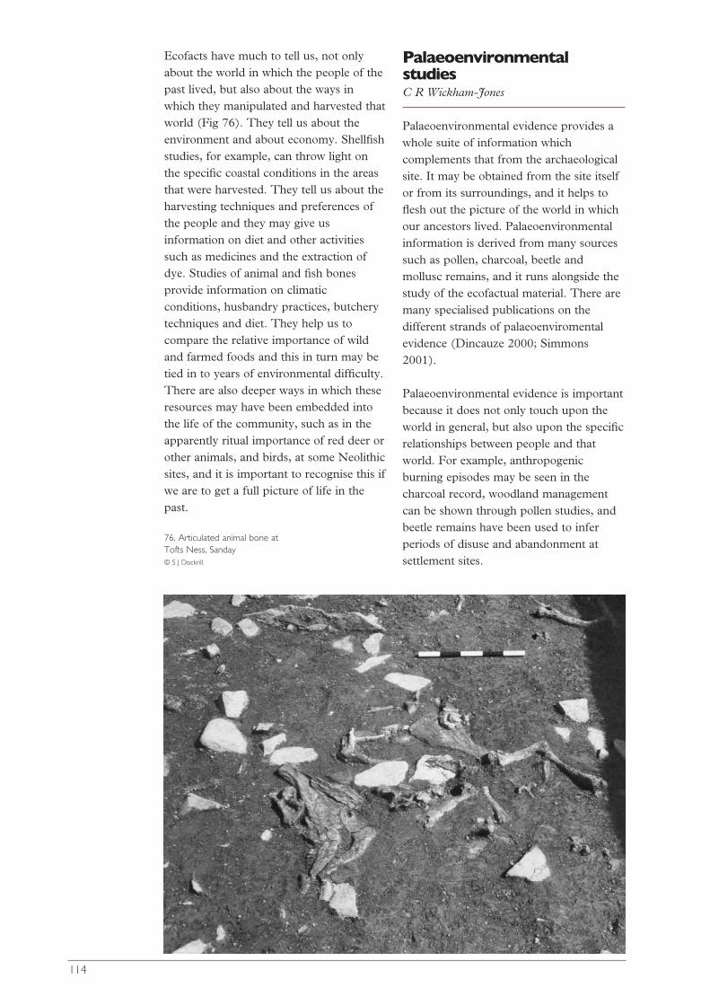
Ecofacts have much to tell us, not onlyabout the world in which the people of thepast lived, but also about the ways inwhich they manipulated and harvested thatworld (Fig 76). They tell us about theenvironment and about economy. Shellfishstudies, for example, can throw light onthe specific coastal conditions in the areasthat were harvested. They tell us about theharvesting techniques and preferences ofthe people and they may give usinformation on diet and other activitiessuch as medicines and the extraction ofdye. Studies of animal and fish bonesprovide information on climaticconditions, husbandry practices, butcherytechniques and diet. They help us tocompare the relative importance of wildand farmed foods and this in turn may betied in to years of environmental difficulty.There are also deeper ways in which theseresources may have been embedded intothe life of the community, such as in theapparently ritual importance of red deer orother animals, and birds, at some Neolithicsites, and it is important to recognise this ifwe are to get a full picture of life in thepast.
PalaeoenvironmentalstudiesC R Wickham-Jones
Palaeoenvironmental evidence provides awhole suite of information whichcomplements that from the archaeologicalsite. It may be obtained from the site itselfor from its surroundings, and it helps toflesh out the picture of the world in whichour ancestors lived. Palaeoenvironmentalinformation is derived from many sourcessuch as pollen, charcoal, beetle andmollusc remains, and it runs alongside thestudy of the ecofactual material. There aremany specialised publications on thedifferent strands of palaeoenviromentalevidence (Dincauze 2000; Simmons2001).
Palaeoenvironmental evidence is importantbecause it does not only touch upon theworld in general, but also upon the specificrelationships between people and thatworld. For example, anthropogenicburning episodes may be seen in thecharcoal record, woodland managementcan be shown through pollen studies, andbeetle remains have been used to inferperiods of disuse and abandonment atsettlement sites.
114
76. Articulated animal bone atTofts Ness, Sanday © S J Dockrill.
The palaeoenvironmental record fromOrkney is a rich one, wherein there isevidence both for the WHS in particularand the rest of Orkney. It is important toinclude it in any archaeological work thattakes place. This should not only apply totried and tested methods, but also to theapplication and development of newavenues of research.
Historical and cartographicsourcesSarah Jane Grieve
Historical and cartographic sourcesprovide a basis for understanding theevolution and development of the medievaland modern landscape and thereforesignificantly enhance our understanding ofthe WHS and its context.
Although these sources are not withoutproblems, a critical appreciation of theagendas and biases allows them to be usedto further knowledge at a landscape-holistic level as well as a more site-specificlevel.
Historical sources
There are very few early historical sourcesrelating to Orkney. The first major sourceis the Orkneyinga Saga written AD c1200in Iceland and detailing, in typical sagaprose, the lives and exploits of theNorwegian earls of Orkney (Taylor 1938).The importance of this source should notbe underestimated; it not only providesinformation on the settlement patterns of12th-century Orkney, but it was also thebasis for a number of influential studies inthe early 20th century in Orkney whichdeveloped the concept of a Viking ‘GoldenAge’. Other Scandinavian sources withreference to Orkney include Hakonar Saga,The Icelandic Annals and HistoriaeNorvegiae (Dasent 1894; Storm (ed) 1880;Storm (ed) 1888).
The first indigenous sources are a series oftaxation rentals, the earliest dating from1492, which detail the earldom andbishopric lands of Orkney (Peterkin 1820;Thomson 1996). These provide useful
information on townships and farms(especially the place-names and rentalvalues) from which it is possible torecreate much of the 15th-centuryagricultural landscape of Orkney. Previousscholars have used these Rentalsretrospectively to postulate land settlementpatterns for the Norse period, andalthough the medieval taxation system wasrelatively static, this is now considered tobe a misapplication of the rentalinformation.
There are a number of medieval sourcessuch as Decrees, Dispositions, Sasines andCharters as well as estate papers, some ofwhich were collected and published asRecords of the Earldom of Orkney (Clouston(ed) 1914). Other papers are to be foundin the Old-Lore Miscellany series (1892onwards) and the Orkney Archive, and allof these provide further information on thenature of: land division; the emergence,development and dissolution of estates;boundary delimitations; and other issuespertaining to settlement and land. Thesesources provide a wealth of informationwhich has not, as yet, been systematicallyor critically assessed to any great extent,though scholars such as Clouston ((ed)1914; 1927; 1932a), Marwick (1929d),and especially Thomson (1996), haveshown the potential of these sources forstudying the development of the medievallandscape of Orkney.
Later sources, more readily available,include the Old and New StatisticalAccounts, which in many instances providethe first recorded description ofmonuments and sites. The level of detail inthese was very dependent on the particularinterests of individual parish ministers,however, for example they give only verybasic descriptions of the monuments inStenness, though there is more detail ofthose in Sandwick (OSA vol 14, 134-5;OSA vol 16, 451-2, 458-61; NSA vol 15,68; NSA vol 15, 53-8). There are severalTours of the Northern Isles andDescriptions such as those by Ben (1529),Wallace (1693), Brand (1883), Low(Cuthbert 2001), Barry (1805) and Tudor(1883); and the detailed work of the
115
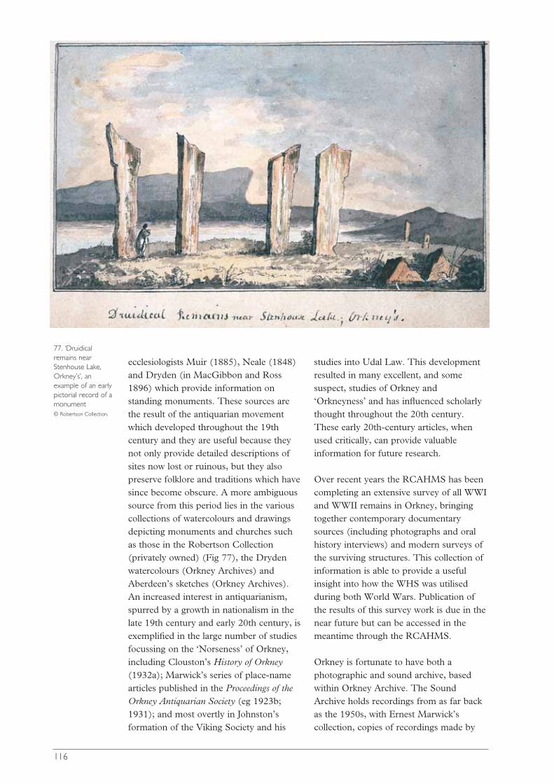
ecclesiologists Muir (1885), Neale (1848)and Dryden (in MacGibbon and Ross1896) which provide information onstanding monuments. These sources arethe result of the antiquarian movementwhich developed throughout the 19thcentury and they are useful because theynot only provide detailed descriptions ofsites now lost or ruinous, but they alsopreserve folklore and traditions which havesince become obscure. A more ambiguoussource from this period lies in the variouscollections of watercolours and drawingsdepicting monuments and churches suchas those in the Robertson Collection(privately owned) (Fig 77), the Drydenwatercolours (Orkney Archives) andAberdeen’s sketches (Orkney Archives). An increased interest in antiquarianism,spurred by a growth in nationalism in thelate 19th century and early 20th century, isexemplified in the large number of studiesfocussing on the ‘Norseness’ of Orkney,including Clouston’s History of Orkney(1932a); Marwick’s series of place-namearticles published in the Proceedings of theOrkney Antiquarian Society (eg 1923b;1931); and most overtly in Johnston’sformation of the Viking Society and his
studies into Udal Law. This developmentresulted in many excellent, and somesuspect, studies of Orkney and‘Orkneyness’ and has influenced scholarlythought throughout the 20th century.These early 20th-century articles, whenused critically, can provide valuableinformation for future research.
Over recent years the RCAHMS has beencompleting an extensive survey of all WWIand WWII remains in Orkney, bringingtogether contemporary documentarysources (including photographs and oralhistory interviews) and modern surveys ofthe surviving structures. This collection ofinformation is able to provide a usefulinsight into how the WHS was utilisedduring both World Wars. Publication ofthe results of this survey work is due in thenear future but can be accessed in themeantime through the RCAHMS.
Orkney is fortunate to have both aphotographic and sound archive, basedwithin Orkney Archive. The SoundArchive holds recordings from as far backas the 1950s, with Ernest Marwick’scollection, copies of recordings made by
116
77. ‘Druidicalremains nearStenhouse Lake,Orkney’s’, anexample of an earlypictorial record of amonument © Robertson Collection.
Alan Bruford of the School of ScottishStudies, and holds the archive ofrecordings made for BBC Radio Orkney.These have been supplemented with avariety of more recent oral history projectswhich have included oral history andfolklore-based work. The PhotographicArchive has a vast collection ofphotographic material which covers theWHS. Both archives have the potential toyield useful information which should bethe base from which any future oral historyor folklore research is developed.
Cartographic sources
The early cartographic sources, includingsea charts, estate maps and maps formedduring the Division of the Commons,provide useful and important informationon early land systems. When combinedwith the Rental information, they help toprovide an enhanced understanding ofpre-improvement Orkney (as shown inThomson 1996). The most importantearly charts for Orkney are Mackenzie’sCharts of 1750, which include townshipboundaries, manor houses, large farms andchurches. These not only preserve thetownship areas but also provide a source ofplace-names. A significant later source isthe Ordnance Survey first edition mapsand the Original Name-Books, which oftenpreserve accounts and locations ofpreviously unrecorded sites, authenticatedby local testimony.
The above sources provide significantcontextual information, which not onlyprovides insight into the medievallandscape of Orkney but also charts theprogress of antiquarian study and showsthe impact that this has had on ourunderstanding of the monuments and thelandscape in which they stand. To ensurethat these sources are used to their fullpotential, an inventory of the materialavailable for the Orkney WHA would be awelcome addition to the SMR or theOrkney Archives.
Qualitative interviewing andparticipant observationSiân Jones and Angela McClanahan
Research into the beliefs and values oflocal communities in relation toarchaeological remains and sacred sites hasled to productive developments in terms ofheritage management, legislation, researchpractices and visitor management. In thiswork participant observation andqualitative interviewing are importantmethods to acquire knowledge. Thisapproach involves a variety of methodsderived from anthropology, sociology andheritage management, includingquestionnaires, focussed interviews andparticipant observation, and it is seen as animportant contribution to challengeconventional aspects of heritagemanagement policies (eg see Bartu 1998;Moser 1999). Though it started out in thecontext of post-colonial countries withvocal indigenous minorities/localcommunities, it is now seen as aproductive part of the process of heritagemanagement in Britain.
The method of research requiresengagement with various differentcommunities and individuals, such as localinhabitants, farmers, archaeologists,visitors, tourist organisations, etc, in avariety of social settings, and this isachieved through the overarchingframework of ‘multi-sited’ ethnography(see Marcus 1998). This anthropologicalstrategy is intended specifically to observethe behaviour and social engagements ofgroups and individuals in different places.It centres on spending significant amountsof time in different cultural settings (bothphysical and virtual; for example, anarchaeological site vs. an internetdiscussion forum), viewing eachplace/situation as an individual field ‘site’.Within each site a combination of specificmethods can be employed: participantobservation; direct observation; focusedqualitative interviews; historical anddocumentary analysis; and questionnaires.
117

Participant observation involves livingamongst, and participating in, the activitiesand daily lives of the specific communitieswhich are the focus of research and it iswidely regarded as yielding the most in-depth insights and understandings ofpeople’s beliefs, traditions and practices(for an overview see Jorgensen 1989).Interviews comprise an important part ofthis in order to deal with specific issues:they may range from impromptu,informal, but focused, conversations thattake place during routine interaction, toformal semi-structured interviews thathave been specifically arranged. In thecontext of the WHS, the incorporation ofrelevant textual material relating toarchaeological sites and monuments (eg inleaflets and on display boards), heritagemanagement policies, community andagricultural organisations, folklore,newspaper articles etc, is important. Thiswork draws not only on contemporarypractice, but it is also important to providea historical dimension through the use oforal and written historical evidence. In thisway it is possible to provide a historicalcontext for people’s beliefs, traditions andpractices.
Studies of this type are taking place inOrkney (currently by Angela McClanahanas a PhD studentship, supervised by SiânJones, Manchester University and fundedby Historic Scotland; McClanahan 2004)and they will provide in-depth knowledgeabout people’s beliefs, perceptions andpractices as they relate to the WHS. Morebroadly, the rôle of the WHS in thedevelopment and transformation of a senseof place and local identity can be exploredin relation to other historic sites in Orkneyand elsewhere. At a national (orinternational) level the WHS offers adetailed case study to explore the widerissues concerning the impact ofarchaeological monuments, and theirresearch, management and presentation,upon a contemporary society.
Museum-based studiesAnne Brundle
Museum collections hold originalarchaeological and historical material, andassociated information. They have greatresearch potential. Previously publishedmaterial can be usefully re-examined with
118
78. Museumsprovide a place forstudy as well as fordisplay © C R Wickham-Jones.

reference to new information orcollections, sometimes overturningprevious assumptions (eg Forsyth 1995;Heald 2001). The principal archaeologicalcollections from excavations in Orkney arein the Orkney Museum and the NationalMuseums of Scotland, but there are asurprising number of other museums,elsewhere in Britain which also hold someof the older Orkney material.
Access to museum collections is hamperedby museum catalogues, many of which areincomplete and unpublished. TheMuseums Registration scheme includes ageneral requirement for registeredmuseums to address catalogue backlogs,and the Orkney Heritage DevelopmentPlan 2000-2003 included a commitmentby Orkney Islands Council to establish afive-year plan to address this issue, but, atpresent, only part of the OrkneyMuseum’s archaeological collection iscatalogued by the museum; most of theremainder is accessible only throughexcavation archives and published reports.
Museums hold material from publishedand unpublished excavations and isolatedfinds. For the published material, there arepost-excavation reports. Some of theseinclude wide-ranging re-evaluation of aclass of material (eg MacSween 1997).Other specialist reports are produced withlimited resources, so that it is not possiblefor the authors to look at comparativematerial in other collections, or to find
parallels which may be obscure. Thesematerials covered by such reports mightwell reward further study (Fig 78).
It is more difficult to study unpublishedassemblages, particularly those from olderexcavations. Researchers may have to relyon the advice of museum curators, orpersonal networks, to get access toinformation not yet in the public domain.Information about individual finds andsmall assemblages should be availablethrough museum catalogues.
Sadly, research visits to museums are rare,as are detailed enquiries. They need to beencouraged. Museum collections are thepublic heritage; they and their associatedinformation should be as freely available asis possible within the limits of theconservation needs of the material and ofthe museum resources of time and space.
With regard to the WHS, priority shouldbe given to putting together a catalogue ofall relevant museum holdings and theirlocation. Past archaeological research inthe WHS has created a wealth of materialfrom which more information can begained. This includes material derivedfrom sites elsewhere across Orkney, as wellas material from the WHS itself. Findsfrom previous excavations are a valuablearchaeological resource, the materialremains of sites that have been wholly orpartially excavated away. There is a still agreat deal to be learned from them.
119

00
Introduction
The preceding chapters demonstrate thelengthy history of archaeological andrelated research concerning the WHS.This is not surprising in an area that isdefined as being of such great archaeo-logical significance. It is also clear thatresearch relevant to the WHS comprisesnot only projects that look at the Neolithic,but also those that cover both precedingand all other periods, up to and includingthe present day. It all adds up to animpressive foundation for future research.The preceding texts have combined thework of many authors in setting out acomprehensive review of existingknowledge of the WHS, identifyingresearch themes, relevant techniques andgaps in knowledge. It is to the credit of theextraordinary quality and character of thearchaeological remains that such a broadgroup of specialists could be assembledand persuaded to contribute.
A research strategy should providepriorities and methods for implementing aresearch agenda, and so this strategy hasbeen formulated as a means by which theResearch Agenda might be put into action.The strategy is intended to help thoseresponsible for funding decisions to placeindividual projects within a wider contextand assess the value of the proposedresearch, and to provide a means by whichthose who intend to carry out research canbest plan their research.
Broad research themes were identified anddiscussed in Part 3; this section starts tobreak that down into a series of managabletopics and projects. We have not tried toprioritise individual projects because thespecific factors leading to prioritisation
will change with time, but we have set out a method by which priorities can bedrawn up.
We hope to see research moving forwardwithin an ethos of sustainability which is,we feel, the spirit that best safeguards thefuture well-being, and our understanding,of the WHS. The following paragraphsoutline this approach.
Sustainable research Sally M Foster
‘Scotland’s built heritage should bemanaged in a sustainable way, recognisingthat it is an irreplaceable resource’(Historic Scotland 2000, Article 3). Howshould this be applied in the context ofresearch in general, for the Orkney WHSin particular? As a starting point, it isuseful to paraphrase the Council forBritish Archaeology’s definition ofsustainable development: ‘sustainableresearch meets the needs of today withoutcompromising the ability of futuregenerations to understand, appreciate andbenefit from the historic environment ofthe WHS and its environs’ (Clark 1993,90). With this in mind there is only oneserious point at which there is the dangerof research not being sustainable and thatis through the destructive process ofarchaeological excavation, as recognisedabove (pp 33-5). However, there are manyways in which the sustainable qualities ofexcavation, and indeed of non-invasiveresearch, can be enhanced. Drawing uponthe broad principles for conservation setout in the Stirling Charter (HistoricScotland 2000), and Historic Scotland’s(2002) policy on sustainable managementof the historic environment, it is possible to
PART
5
120
Research strategy
121
identify a set of principles that shouldunderpin any research in the WHS andsurrounding areas.◆ Research aims should include the
conservation of the WHS for thebenefit and enjoyment of present andfuture generations.
◆ Research should recognise that theresource is irreplaceable and seek toensure that all aspects of its practice areas sustainable as possible.
◆ There should be a general presumptionin favour of preservation. Interventionshould be the last resort, after all otheravenues of research have beenexplored, and then it should beminimal.
◆ The precautionary principle shouldapply; unless it is possible to assess theimpact of any interventions or otheractions on the cultural and naturalheritage resource, including that whichis not to be disturbed, then potentiallydamaging actions should be avoided.
◆ In the case of invasive work,arrangements should be made for long-term monitoring of the condition of thesite once works have been completed,in order to understand better theconsequences of such intervention andfeed this knowledge into futurestrategies.
◆ As in all aspects of archaeological work,the highest standards must apply, notleast with regard to recording, ensuringthat there are proper records before,during and after work.
◆ Parties should work together to shareknowledge and resources, find solutionsto common questions or problems, andmaximise benefits, not least by ensuringthat research objectives address thebroadest possible spectrum of interests,including those of heritage managers.
◆ Addressing back-logged research mustbe a priority in order to make allavailable information widely accessible.
◆ Those undertaking research,particularly in the case of excavation,must have the highest qualityknowledge, skills, technologies andresources available to them. All periodsof human activity should be validsubjects for research, not just the main
periods of the monuments in the Site.◆ Investigation should, where possible,
contribute to the understanding of thebroader environment and the impact ofhuman actions on natural resourcesthrough time.
◆ Appropriate measures should be takento assist all people, particularly the localcommunity and tourists, to enjoy,appreciate, learn from and understandthe WHS.
◆ All research should aim not only toaddress the specific requirements of theWHS and its environs, but to constituteexamples of best practice with widerapplicability.
It is also important not to lose sight of thefact that significant, if less visuallyimpressive, archaeology lies on thedoorstep of the WHS, and indeed is to befound throughout Orkney. With an eye tosustainability, undue concentration ofeffort on the WHS should never beprejudicial in the long-run to otherarchaeological (and associated social)interests. The first question to be asked ofany research proposal must be whether itcan really only be addressed through workin the WHS. It is vital to continue to askquestions of what has happened in the pastand what we are doing now, but we haveto make sure that individual researchdesigns be assessed against a broaderresearch agenda, the horizons of whichextend well beyond the WHS itself.
Research rationaleJane Downes and C R Wickham-Jones
Research can be related to various basicthemes within archaeology and, as set outabove, this document has chosen toeschew the traditional period, subject, ormanagement-based themes for twobroader themes into which all traditionalthemes can be bound.
Artefacts, monuments and cultural identitylooks both at groups of artefacts, such aspottery, and at the monuments themselves,such as the stone circles. In doing so itremoves the distinctions of scale oftenapplied by archaeologists to their material.
The interplay between the differentelements of archaeology is examined to seehow they related and were used toconstruct a world, both at various times inthe past and in the present. In this way allarchaeological finds within the WHS arerecognised as valid research objects in theirown right, whatever their size or period. Itis also recognised that at any one time inthe past there have been previous pasts towhich people have related. At the sametime, the rôle of archaeology in the worldof today is a source of interest.
The formation and utilisation of thelandscape looks at the different processesthat have gone on to produce thelandscape of the 21st century. Under thisresearch theme it is appropriate to stop theprocess at any one particular time, in orderto highlight that period or process: forexample early Holocene climate change orthe introduction of agriculture. By buildingup a series of slices of information,projects that work within this theme will becontributing to the wider picture.
It is recognised that research relating to theWHS will not only take place in the WHS.The WHS has never existed in isolation; itis part of a wider system. Information fromoutwith the WHS has great bearing on theWHS, both as part of its natural settingand at an individual level as detail fromsites elsewhere can be used to explain gapsin our knowledge of the WHS sites. Fromthe perspective of Orkney, there are thusfour geographical frameworks for researchthat may be set out, though they are notintended to convey any sense of projectvalue:◆ site-specific research;◆ WHS-specific research;◆ zone-specific research;◆ research that is specific to Orkney as a
group of islands.
Sample research
For the purposes of this document,examples of research have been dividedinto broader topics and then set out asspecific projects. In this way it is possibleto see how research might go forwards as a
series of manageable actions that combineto provide wider information. The broadscale topics have been set out first, but itshould be emphasised that this list is by nomeans exclusive. It is not intended as anend point in itself, but rather as stimulationto the individual reader.
Sample research topics:artefacts, monuments andcultural identitySiân Jones, Colin Richards, Artefacts,Monuments and Cultural Identity Group,Temporality and Period-Based ResearchGroup
Archival assessment andsynthesis
Successful research depends on a goodknowledge of the artefact assemblages andrelated archival material held in museums.At present there is no archive of relevantmaterial. The finds from Orcadian sites arescattered across many museums, withinScotland and further afield, and in somecases finds from a single site reside inseveral different locations. A basicassessment and synthesis of museum-basedmaterial (to include both finds and archivematerial) in relation to the WHS and itsbuffer zones is necessary. An inclusive andaccessible archive, perhaps in the form of aweb-based index, would provide a vital toolas a starter for any research.
Architectural life histories
Much research has been carried out on thearchitecture of the Neolithic sites andmonuments included with the WHS areaand its buffer zones. This has, however,largely ignored the length of time overwhich these monuments have survived andtheir differing rôles throughout that time.There is a great need for research whichexplores the durability of the architectureover time, and the ways in which thesesites and monuments have been re-thought, re-fashioned and reused. Thisresearch extends beyond the Neolithic toinclude sites and monuments from otherperiods, and especially the dynamics oftheir relationships to the Neolithic remains.
122

The creation of the monuments
Detailed studies of how the monumentswere created – including both themechanics of construction, and theselection and acquirement of suitablematerials, as well as a consideration of the act of construction as an ongoingproject.
The life histories of artefacts
The production, use, consumption anddeposition of artefacts. Ultimately thisresearch should extend beyond site specificprojects to comparative and syntheticresearch. This might, for example, look atnetworks of production, circulation andconsumption. Most artefact studies focuson particular materials and it seems likely that there is useful information to be gained from trans-material studies.
Review and strategy for detailedphysical and chemical studies ofartefacts
This research should focus particularly onexisting museum collections and addressquestions such as:◆ What is the status of current analytical
techniques? ◆ What artefacts might benefit from
analysis? ◆ Where are these artefacts currently
housed?
Residue analysis
This is a specialised study incorporating avariety of techniques. Residue analysislocates, extracts and identifies ancientresidues from a range of tools, includingtools made of stone, bone and pottery.The high quality of artefact survival inOrkney means that the development ofresidue analyses holds particular potential.Work to date on pottery has shown thatthe survival of lipid/organic residues isvariable but well worthwhile. Further workis, however, needed. For example, it is
possible to find a chemical indicator forbarley but as yet it is impossible to saywhether this implies porridge, ‘bread’ orbeer. Work so far has been small scale andthere is a general lack of comparative orcontrol data. The high concentration ofNeolithic pottery in the WHS andsurrounding area mean that a large projectincorporating pottery from several siteswould be valuable.Work on residues andwear on lithic tools has been shown to beof value to archaeology, notably in theidentification of ancient plant remains,though this has largely been ignored inBritain. In the context of the early farmingcommunities who built the monuments ofthe WHS, examination of the survival andidentification of starch grains would be ofparticular relevance. Residue work on bonetools is currently being developed forBritain. The survival of a unique suite of well contexted bone tools in Orkneymeans that the application anddevelopment of this work has especialrelevance here.
Period-specific research onsocial identity
Broader programmes of research can belinked to examine the changing nature ofsocial identity through different times andlocales.
Typological reviews
Typology is a complex tool of artefactresearch and many existing typologies havenot been reviewed for a long time. Themost popular basis for typology is shape,sometimes combined with manufacture,but this has rarely been examined in thelight of recent knowledge and techniques.What, for instance, do the different potterytypes mean? If the apparent mutually-exclusive distribution of collared UnstanWares and of flanged-rim bowls is real,what else does it involve and whatimplication does this have for ourinterpretations of Orkney’s Neolithic?Similar work could look at the distributionand meaning of different lithicassemblages, bone tools and so on.
123
Experimental archaeology
Experiment is vital if we are to fullyunderstand the remains of the past. Itprovides an important dimension to thebuild-up of a lifestyle picture, forcesinvestigators to consider practical elementsof interpretation, social questions andenvironmental issues, and helps to form adynamic link between an excavation andthe post-excavation study of artefacts. Incomparison with work elsewhere, it hasbeen largely neglected in Britain.Experiment also provides an excellentmedium for education and interpretation. Itis of particular value in that it broadens thebase of archaeological expertise to includepresent-day craftspeople. This is of especialrelevance to Orkney where there is a largelyuntapped source of local expertise.
Landscape survey
Including studies of both the experientialand the physical landscape – terrestrial,marine and celestial. There is a need forclear and detailed knowledge of therelationship between the sites and thelandscape. Experientially, this shouldinclude research on how the landscape wasviewed, inhabited and negotiated, and itshould compare and contrast resultsthrough different periods of time.Physically, further exploration andevaluation of the landscape, both in theNeolithic and more recent times, wouldserve to enhance our understanding of the archaeological and historic landscapes(see also Formation and Use of Landscape).
Boundaries
The landscape has been used andcompartmentalised from the earliest timesto the present day, but little is known ofhow those divisions were manifested andmanipulated. This must include botharchitectural, physical, divisions andmental boundaries; and it should look attheir changes through time.
Useful research includes:◆ establishing the date of boundary
dykes;
◆ research into the construction of boundaries, including bothtechniques and organisation, as well asmaterials;
◆ the elaboration of the purpose ofboundaries and how they may reflectvariously stability or change within thesocial, economic, religious and politicallife of the world around them;
◆ research into the use of boundariesthrough time, including an examinationof maintenance, change, reuse,dislocation and abandonment, includingan exploration of the existing SoundArchive for references to boundaries;
◆ an understanding of the ways in whichboundaries may affect theinterpretation and experience oflandscape, both in the past and today(see also Formation and Use ofLandscape).
Astroarchaeological meanings
It is generally accepted that certain celestialevents were important to prehistoricpeople with concomitant consequences forour interpretations of monuments and forculture. Research into the WHS shouldtake account of this. Events such as theprediction of eclipses, the appearance ofthe moon at ‘maximum standstill’, theheliacal rising of certain stars or asterisms,like the Pleiades, the sun touching a specialmountain, or the periodic appearance/disappearance of a planet are all ofpotential significance. One approach is tocollect surveys that integrate landscape and‘skyscape’ (ie skyline measurements,prominent features, favoured or limitedranges of visibility, etc) and to try tocorrelate these with data fromneighbouring sites. This, more or less, isthe classical approach. Another approachmight pay more attention to bothquantitative and qualitative details of the landscape and combine these withfindings from the specialised analysis of finds.
Visitor surveys
Little exists by way of baseline statistics forvisitors to unstaffed monuments. This data
124

is required to inform site management andinterpretation as well as to monitor andassess visitor impact. This should relate tocontemporary experience (see below).
Contemporary experience
There is a general lack of research on theattitudes and experiences of residents andvisitors within the WHS and surroundingarea. Little is therefore known as to howthe monuments figure in people’s memo-ries, identities and attitudes. Research inthis field might involve two specifictechniques, each with its own time-frame:◆ interview-based research would provide
immediate results and should beconsidered a high priority. In particular,this might look at the impact of WHSstatus and its associated managementand presentation demands;
◆ ethnographic research over a longerperiod of time, involving participantobservation should provide moredetailed and fine-grained insights.
The rôle of archaeology ineducation in Orkney
An assessment of the current rôle ofarchaeology in education in Orkney, andof the educational potential of the WHS, isimportant if the aims of increasing publiceducation and enjoyment of the WHS areto be fulfilled. This should include anexamination of the ways in which artefactsfrom the WHS (both from existingmuseum collections and newly excavatedsites) can be used in education anddisplay.
Local history
Little is known of the place of thearchaeological sites and landscape in thelocal history of the area. In this respect, theuse of oral history techniques to focusspecifically on the archaeologicalmonuments and antiquarian/archaeologicalpractices would provide great insight intothe ways in which personal memories andnarrative have been informed by thearchaeology. An exploration of the existingOrkney Sound Archive for memories and
experiences relating to the monumentswould also prove valuable and extend theperiod of study beyond current livingmemory. This should include traditions offolklore and land use.
Literary research
Orkney has a strong and long literarytradition, but little is known of theinfluence of Orcadian archaeological siteson this. Conversely, the influence ofliterature on archaeological research is alsounknown. Both constitute useful areas ofresearch, necessary for a rounded pictureof the part played by the WHS over theages.
Folkloric research
Again, there is a strong tradition of folklore in Orkney, and archaeology playsa prominent part in this, but its rôle hasnever been quantified in detail. Asynthesis and analysis of folkloreconcerning both archaeological materials in Orkney in general, and also themonuments within the WHS and IBZ inparticular, would be of great interest.
Visual representations and theperception of landscape
There are many artistic representations ofthe archaeological landscape, and thesederive from Orcadian artists as well asfrom many who visit from further afield.This resource has been little studied,however. Studies of the representation oflandscape, and the historic material withinit, in a variety of media, are importantbecause they can provide a clear insightinto the ways in which the perceptions oflandscape and monuments changedthrough time. This may then be used toexamine the rôle of visual representation in constructing a sense of place andidentity.
Place-name research
Existing work on place-names took placesome time ago, and a critical evaluationwould be worthwhile, especially in
125
conjunction with specific research focussing on archaeological sites andmonuments both within and beyond the WHS.
Sample research topics: theformation and utilisation ofthe landscapeIngrid Mainland, Ian A Simpson, RichardTipping, Palaeoenvironment and Economy groupand Formation Processes and Dating group
Soil formation
One priority is to establish the non-anthropogenic component of soil formationas a baseline. During rapid inundationterrestrial deposits may have beenpreserved underwater. The complexpatterns of currents in the archipelagomean that the pattern of islands haschanged over time so that some depositsmay have been lost. Nevertheless, it is likelythat pockets of early soils survive and itmay be possible to identify sealed remainsof soils and sediments in contexts such asthe currently brackish Loch of Stennessthat will allow characterisation of purelynon-anthropogenic soils. Otherpreservation contexts may include thecurrently fresh-water Loch of Harray.Good soil baselines will facilitate theidentification of natural and anthropogenicchanges in subsequent periods. In addition,the study of soil formation processes mustboth acknowledge and contribute to ourunderstanding of wider landscape changes.
Modelling of landscape changesover time
This is an important component of theresearch framework. The major changes inthe coast line at Skara Brae, both beforeand after the construction of thesettlement, are well known; and the patternof aeolian deposition there can be retrievedfor recent times through documentaryresearch. The shapes of the Lochs ofStenness and Harray have changed overtime, though it is not clear when theoriginally fresh-water Loch of Stennesswas linked to the sea (see also Artefacts,Monuments and Cultural Identity).
Monument formation processes
Elucidation of the processes of monumentformation, from the pre-monument soilconditions through their construction andalteration, to the introduction today of newmaterials to the monuments as a part ofconservation and management, isimportant. It is important to recognise thevaried opportunities offered by thedifferent groups of monuments; indeed,the presence of mounds and banks ofdifferent ages creates a great potential for abetter understanding of the soil chrono-sequences, based on fossil soils under themonuments.
Agricultural and social landscapeformation processes
The survival of old land surfaces undermonuments and colluvium of variousdates in the Bookan, Wasbister andBrodgar locality presents variousopportunities for the multi-period analysesof small areas. It may be possible torecover information about land divisionand land use and their variations in time(see also Artefacts, Monuments andCultural Identity).
A comprehensive programme ofdating
This should be designed to provide anabsolute chronological framework and itshould include past landscapes, monumentformation, use and reuse and the broaderenvironmental context. It should make useboth of newly available samples and datingtechniques, as well as samples from olderexcavations and existing dating techniques.It is of crucial importance to reconsider thetaphonomy of samples from oldexcavations before any dating isundertaken.
Existing bioarchaeological data
Excavation in Orkney over the lasthundred years has created an unusuallyrich resource of bioarchaeologicalevidence, albeit mainly faunal, which couldpotentially be used to address many
126
research issues. To facilitate futureinvestigations, there is a need to compilean inventory of this material indicating, atthe very least, where the collection isstored, some basic information on thecontents of the collection (eg faunalmaterial and carbonised seeds), date ofexcavation, recovery methods (ie handrecovered or sieved), whether thecollection has been analysed and thelocation of any archive or publishedreports on the material.
Further excavation
This would be aimed specifically at therecovery of large, well-stratified and well-preserved bioarchaeological assemblagesand is necessary to implement many of theresearch themes identified. If analysis is tomove beyond the site-specificinterpretations of archaeofaunal andarchaeozoological remains, there is a needto target excavation towards variedcontemporary sites within thearchaeological landscapes, and inparticular to ensure the analysis ofenvironmental data from sites of varyingfunction. It can be argued that analysis ofbioarchaeological evidence from multi-period sites would allow useful insight intolong-term palaeoeconomic trends andprocesses, and economic strategies, thusavoiding period-specific biases.
Modelling climatic change
Precipitation is a major driving forcebehind climatic change (Vassijev et al1998) and the least ambiguous results areto be obtained from the analysis of lake-level changes (rises and falls) in upland, orgradually (or only modestly)anthropogenically modified catchments. Inthe last four years a sedimentologicalapproach to interpreting lake-level changehas been developed and this has resultedin the first continuous Holocenechronology for precipitation in the UK,from west Glen Affric in northernScotland (Tisdall 2000). This approachuses the spatial and temporal changesbetween lake sediment and fen peat fromtransects of correlated cores. It allows for
the development of models of climatechange, and a number of appropriatebasins for this sort of analysis lie withinthe WHS and its buffer zones.
Initial post-glacial colonisation ofOrkney
An understanding of the initial post-glacial colonisation of Orkney isimportant if we are to understandproperly the basis for the flowering ofculture that led to the monuments of theWHS. Very little information is currentlyavailable on this and it should beaccorded a high priority. It should berecognised that rising patterns of sea-levelmean that submerged sites are likely toplay an important rôle in the recovery ofinformation relating to the initial settlersof Orkney and their world.
Use of plants, especiallycultivated plants, in prehistoricOrkney
Current understanding of the balancebetween plant and animal diet in NeolithicOrkney and later is based more oninference than on sure data. Furtherrecovery and analyses of plant remainsfrom archaeological contexts are necessaryand isotope analysis of human bone wouldbe very useful.
Non-economic values andactivities apparent inbioarchaeological evidence
There is much scope for a reappraisal ofexisting data, and the targeting of futurerecovery strategies, to investigate therepresentation of particular species andtheir associations with particular contextsand or artefacts. Existing work hashighlighted the potential non-economicvalue of certain species in various differentcontexts (eg sea eagle at Isbister; red deerat Noltland) and this is worthy of furtherdevelopment. This research would befocused on aspects such as therelationship of various species to socialidentity, symbolic significance, ritual andconcepts of wild/domestic. Changes in
127

practice through time should not beforgotten, nor the changing interplaybetween humans and animals/plants indifferent settings.
Sample ProjectsAll Discussion Groups
Background
The projects below have been drawn fromthe contributions made by those attendingthe symposium and members of theAHRCC at various stages in theconsultation process. The list is notintended to be exhaustive, nor is it set outin any order of priority. Rather it isintended to act as a stimulus to thoseresearch workers and funding bodies whohave an interest in the future of The Heartof Neolithic Orkney. An attempt has beenmade to classify individual projects to thethemes and scale of research outlinedabove but, as readers will quickly realise,this is, in practice, difficult. Nevertheless, itis worthwhile because it helps to give aguide as to the scale and direction of eachproject.
Artefacts, monuments andcultural identity
Site specific1. Refinement of the dating of the
monuments of the WHS through thecompilation of a comprehensive datingprogramme for the monuments andtheir surrounding landscape. Newdates should include the use of a widerange of dating techniques. Inaddition, a register of all dateable anddated material should be built, as wellas a re-consideration of the taphonomyof all existing dates.
2. New excavation to establish thechronological position of importantcomplexes of monuments, such asthose at Ring of Brodgar andMaeshowe.
3. A study of the mechanics of construc-tion of the different monuments.
4. Examination of the possible meaningsattached to the actions of monumentconstruction.
5. A study of each monument to producea history, not only of its constructionbut also of its alteration and usethrough time to the present day.
6. Experimental studies relating toindividual types of artefact, eg of themanufacture and use of pottery. Thisshould include work on the sourcematerials and could be extended tolook at the relationships betweendifferent types of artefact, such as thesources used in pottery production andstone tool production.
7. Residue analyses to determine thefunction of various artefacts, such aspottery, bone or stone tools.
8. An examination of the preparation forsite construction relating to individualmonuments: is there evidence ofground preparation and/or the use ofintroduced materials to create aplatform? If materials were imported tothe site, what is their nature and origin?
9. Maeshowe: examination of thecomplex construction of the core cairn.What rôle did its revetting walls playduring natural consolidation of moundmaterial and thus shrinkage afterconstruction, and how did this relate tothe built walls of the chamber? Wasthe choice of mound material madewith consolidation in mind?
10.Maeshowe: what is the hydrologicalstatus of the mound and how does thataffect its long-term stability?
11.Maeshowe: conventional geophysics isof limited value here but the moundwould serve as a test-bed for GPR,electrical imaging and seismic study,while the base of the mound andplatform would benefit from intensivesurvey.
12. Skara Brae: analysis of the middens toexamine their development, use andmodification over time. Fuel residueanalyses of midden deposits will beimportant both in identifying theoriginal fuels and understanding theimportation of material to the site.
13. Skara Brae: functional analyses of thevarious occupation surfaces.
14. Skara Brae: analyses of site taphonomyincluding the decomposition productsof bone, (calcium, iron and phosphate
128
features) and of shell (calciumcarbonate features), the use of turf orother materials for roofing, and thedecomposition of stone.
15. Examination of the impact of earlierexcavation and conservation measureson the sites.
16. Assessment of the impact of theintroduction of new turf material andassociated biological agents for themanaged sites.
17. Assessment of the impact of theintroduction of new stone material formanaged sites.
WHS specific18. Compilation of an archive/synthesis of
museum-held material relating to theWHS.
19. Compilation of an updated inventoryof historical, pictorial, oral history andcartographic sources relating to theWHS.
20. Compilation of a database ofphotographs relating to the monumentsof the WHS. This should containinformation on current locations and besuitable for annual updating.
21. New excavation to establish thechronological position of importantcomplexes of monuments related tothe WHS, such as the site at Bookan.
22. Investigation of the importance of theWHS area to preceding non-farminggroups.
23. Exploratory geophysical survey of theWHS to locate new archaeologicalsites, using a combination of magneticscanning and magnetic susceptibilitysampling across detailed sample surveyblocks.
24. Survey by geophysics of specific sitesrelated to the WHS area, such as‘Stenness Palace’.
25. Construction of a detailed oral historyof the WHS monuments in Orkney.
26. Examination of the rôle of themonuments of the WHS incontemporary Orcadian society.
27. Examination of the place-names of theWHS.
28. The continuation of a fieldwalking
programme to cover whole of theWHS.
29. The evaluation of the results offieldwalking.
Zone specific30. A programme of astro-archaeological
research relating to the majormonuments and their relationship withthe surrounding land.
31. Exploratory geophysical survey of thebuffer zones to locate newarchaeological sites, using acombination of magnetic scanning andmagnetic susceptibility sampling acrossdetailed sample survey blocks.
32. All future developments with the widerzones should be preceded byappropriate geophysical investigation.
33. Systematic topographic survey of thesetting of the WHS in order to recordnew sites and provide a widerlandscape context to the monumentsof the WHS.
34. Field survey along the coast adjacent toSkara Brae and along the shorelines ofthe Lochs of Harray and Stenness, aswell as coastal survey within the OBZ,in order to record eroding sites.
35. The continuation of a fieldwalkingprogramme to cover whole of the IBZ.
36. The evaluation of the results offieldwalking.
37. Systematic underwater survey andevaluation of Harray and Stennesslochs, the results to be integrated withthose of land-based survey.
Orkney specific38. The petrological and macroscopic
examination of stone tools fromOrkney, along with a contextualanalysis.
39. Analysis of the relationship betweenthe sources of materials used forartefacts in Orkney and known sourcesfurther afield, such as the (GroupXXII) axe production site at theBeorgs of Uyea on Mainland Shetland.
40. A detailed study of the bone, antlerand shell tools of Neolithic Orkney, toinclude information on manufacture,
129
style, use and deposition.41. An examination of the social meaning
of specific artefact styles.42. An examination of the meaning and
function of Beaker pottery in Orkney. 43. An examination of individual artefacts
and monuments as period specificindicators of social identity.
44. Intra- and inter-site studies of artefactmanufacture, use and deposition.
45. The examination of the use of naturalpigments, such as haematite, inprehistoric Orkney using experimentaland other techniques.
46. Skeletal studies: Orkney holds anunparalleled skeletal record for someperiods of prehistory and recentadvances in techniques mean that thiscould be used to shed light on manydifferent aspects of great relevance tothe WHS, such as diet, illness, mobilityand origins.
47. Investigation of the size of thepopulation in Orkney through time,and the changing effects of populationpressure.
48. Investigation of the evidence for, anddate of, the initial post-glacialsettlement of Orkney.
49. Investigation of the mobility andconnections with the wider worldamong the first inhabitants of Orkney.
50. Investigation of the advent of farmingand nature of transition from hunter-gatherers in Orkney – what were therelationships between the two groups?
51. Investigation of the nature of BronzeAge settlement in Orkney.
52. Investigation of the nature, date andfunction of burnt mound sites inOrkney.
53. Investigation of the nature, date andfunction of souterrains in Orkney.
54. Mapping and investigation of crannogsites in Orkney.
55. Investigation of archaeology as aneducational tool in Orkney.
56. Investigation of the influences ofarchaeology on literature in Orkney.
57. Investigation of the influences ofarchaeology on art, both historical andmodern, in Orkney.
58. An evaluation of existing research intothe place-names of Orkney.
The formation and utilisation ofthe landscape
Site specific59. An examination of the pre-monument
landscape: soil conditions immediatelybefore monument construction.
60. An examination of the evidence forpre-monument construction activity: isthere any evidence for activities priorto the construction of individualmonuments, such as agriculture,funerary activity, the building ofsettlements, or the erection of stonesettings?
61. Skara Brae: an examination of thesequences of sand accumulation andsoil formation.
62. Skara Brae: Geophysics to assess theeffects of coastal erosion by helping todefine the extent of the site along theseashore and the limits inland.
63. An examination of local drainage: whatchanges in local drainage areassociated with monumentconstruction, within and aroundindividual sites? What rôle did theconstruction of drains play inalleviating the potentially negativeimpacts of new drainage regimes?What effects did new drainage regimeshave on soil stability and bearingstrength of soil?
WHS specific64. Compilation of an inventory of existing
bio-archaeological data for the WHS. 65. An examination of agricultural history
within the WHS: were materialsimported to create cultivation beds?
66. Analyses of pre- and post-depositionaltaphonomic history for faunalassemblages in Neolithic cairns andsettlement sites.
Zone specific67. Production of an agricultural history of
the WHS and buffer zones throughrelated techniques such as detailed soilanalyses and palaeo-environmentalanalysis.
68. Production of a detailed plan of landboundaries in and around the bufferzones and an examination of their
130
construction, morphology, functionsand meaning.
Orkney specific69. The construction of a detailed history
of field management strategies inOrkney through hand-auger survey ofknown deep topsoil areas within WestMainland, in order to provide depthdistributions of these cultural soilswhich can then be related to settlementsites. This should be combined withsurvey to identify new areas of deeptopsoil.
70. The location of buried, fossil, plaggen-type soils of prehistoric age, as at ToftsNess, Sanday could be undertaken andrelated to soil development in theWHS, for example in the wind-blownsand areas of Sandwick.
71. The recovery of palaeo-botanical dataand an examination of the rôle ofplants in prehistoric Orkney.
72. Investigation of the date and nature ofthe deglaciation of Orkney.
73. A programme of palaeo-environmentalwork across Orkney to investigate theenvironmental history of the Holocene.
74. Investigation of sea-level change inOrkney through the Holocene,including information on submergedlandscapes.
75. The survey of submerged areas torecover information on archaeologicalpreservation.
76. Investigation of the faunal history ofOrkney with reference to both wild anddomestic species.
77. Investigation of woodland usage andmanagement during the Holocene.
78. The colonisation of Orkney by itsmammalian fauna, especially inrelation to human migration.
Cross-theme
WHS specific79. The production of an enhanced SMR
specific to the WHS. This should beon-line and designed for maximumpublic accessibility.
80. Compilation of a database of allexisting geophysics work in the WHS.This should be held centrally and
suitable for the addition of new work.81. Compilation of a database of aerial
records relating to the WHS inparticular.
82. The analysis and publication of back-logged research, particularly regardingunfinished excavation projects in theWHS.
83. A season of concentrated aerialreconnaissance in Orkney targeting theWHS.
Zone specific84. Compilation of a GIS system relating
to the WHS and the buffer zones tocombine information on field survey,topographical history, monumentlocation.
85. Desk-based assessment of thearchaeological value of the currentaerial records, including both verticaland oblique photographs.
Orkney specific86. Establish a research centre for
archaeology in Orkney, under theauspices of an Archaeology Institutefor the Highlands and Islands: to act asan umbrella organisation for researchon the WHS.
87. Establishment of a post of communityarchaeologist.
88. Compilation of a database of aerialrecords relating to Orkney in general.
89. The analysis and publication of back-logged research, particularly regardingunfinished excavation projects inOrkney.
90. Study of history of archaeologicalresearch on Iron Age onwards inOrkney.
91. A review of existing evidence relatingto the Late Neolithic - early BronzeAge in Orkney, together with targetedfieldwork/artefact-based research inorder to investigate this poorlyunderstood period.
Prioritisation of research Julie Gibson
This volume has not tried to prioritiseresearch either by theme or topic, or on a
131

project by project basis. Instead, we havedevised a mechanism that takes account ofa variety of archaeological, historical andrelated projects. This mechanism may beused to assess, prioritise and furtherresearch. In this way, all types of projectcan be considered and relevance given tochanging priorities. This method acceptsthat priorities change so that it is notpossible to set out here a list of prioritiesthat will last into the long-term future.Instead, the table below outlines a scoringsystem based on a series of Threats andOpportunities which can be tailored to meetthe needs of future management.
This strategy assumes that a basic checkon sustainability will be considered first.This check should take account of thefollowing factors:
◆ Is the proposer competent and is theproject adequately resourced?
◆ Does the project offer an enhancementof knowledge and understanding?
◆ Does the project lead to the destructionof the resource and if so is thedestruction necessary, acceptable andinevitable?
◆ If it is a destructive project, should it bedone within the WHS and bufferzones?
◆ What mitigation strategies are in placeto ensure that damage is limited?
◆ What are the sustainable outcomes ofthe project?
After this has been done, the followingtable functions as a mechanism to enablethe factoring in of the many elements inorder to assist in the validation of a
132
Threats and opportunities Range of options: Score Low – high 1-10
Threats- timescale of loss of information slow/chronic – rapid/catastrophic- extent of loss of information slight – total- amount of damage anticipated if no action taken very little – total destruction
OpportunitiesManagement Opportunities- securing preservation for some time less than 10 years – perceived as permanent- methodological application limited – wider
Importance of site/landscape- scale of importance very local – international
Funding opportunity - type partial – total- value for money bad – good
Educational opportunities and community access- academic quality poor – excellent- academic publication local – international- range of inclusion community excluded – community participation- applicability to WHS interpretation poor – good- range of dissemination narrow – wide
Developing understanding (range and depth of applicability)- theoretical approaches poor – good- methodological development poor – good- conservation issues and techniques poor – good
particular project, or to prioritisecompeting designs for a project. This tableis intended as a guide for those who areworking on the development of researchprojects and also as a guide for those whofund them. It is not a dogma.Using this table to prioritise projects, aproject to record folklore in and relating tothe WHS might currently score very highlyin this table, especially if local volunteerswere used, and if the results weresustainable and accessible through thelocal archives and an internet resource.Where invasive archaeology is involvedthis system of prioritisation, workingtogether with the sustainable approach,encourages the development of highquality projects offering value for money.Furthermore, it emphasises communityparticipation and the need for widespreadaccess.
Communication anddisseminationC R Wickham-Jones
Research will inevitably lead to thecollection of new data regarding the WHS,but this is of limited value if it neverreaches the public arena. Data has to becommunicated to be useful.Communication is an integral part of anyresearch project. There are many methodsfor data communication: publications;lectures; electronic dissemination; use ofthe media such as radio and television. Allhave a respectable history regardinginformation relating to Orkney. Two levelsof dissemination are relevant: academicand public. Academic communicationcomprises more attention to the details ofthe data themselves; public communicationcomprises more attention to interpretation.Both may be used by people as they see fitand both are clearly necessary if knowledgeand management of the WHS is toadvance. Public communication has a clearrôle in education, itself a vital aspect of thearchaeological approaches to the WHS.
World Heritage Sites are designated to thebenefit of all, including the variedaudiences of the future. Given that most
people do not have the specialisedknowledge of the researchers who workwithin the WHS, interpretation is crucialto any WHS. This is not the place for adetailed discussion of interpretativetechniques, but for the purposes of thisdocument all interpretation can beregarded as education, thus bringingtogether two powerful tools ofcommunication. As such, interpretationtakes place in different places (on-site andoff-site) and it takes place on differentlevels (from the activity group of theprimary school pupil, to the tour ofspecialists).
Archaeologists working in Orkney aregenerally well aware of the value of publiccommunication and education. Orkney inthe 21st century is a society highly awareof the rôle of the past, and mostarchaeologists who work here have spenttime on public lectures, open days,seminars and demonstrations. This is ofparticular importance in an area such asOrkney where many finds are still madeeach year by members of the public,particularly within the farming community.This should not be allowed to drop and itcould be developed further to includesystematic work within the educationsystem, if support be found. At themoment archaeological contributions toschooling are given on an ad hoc basis butit is clear that there would be considerablebenefit were it to be developed. In thisrespect, the development of a YoungArchaeologists Club in Orkney, which hasbeen given limited support by the OrkneyIslands Council, is an important stepforward, as are Historic Scotland’sproposals for a WHS Ranger Service.
Professional communication is important ifwe are to make the most of our researchopportunities. This includes not only pre-project communication but also post-project work. The archaeological sites ofOrkney (and indeed elsewhere) have beendogged by the failure of many excavatorsto process and publish their results. Yet, ifresults are not made available to the widerworld, the site is lost. It is not uncommonin the early 21st century to meet
133
professional archaeologists who knownothing of the rich midden and artefactualremains of Neolithic Orkney, simplybecause of the failure to publish a few keysites. As we have seen, the Heart ofNeolithic Orkney plays a crucial rôle inour understanding of its times and this is asituation that must be rectified. It is, at thetime of writing, approaching solution withthe publication of the Barnhouse volume,and work on the 1970s excavations atSkara Brae is once again underway, butthere are still other sites to be publishedand professional archaeologists must becareful to ensure that this state of affairsdoes not happen again.
Interpretation relies on research to provide the data which it will work intoinformation. It is fluid, constantly changingas new research gives precedence to newideas. Interpretation is nothing withoutresearch, but it will stagnate if not fuelledby criticism and questioning, both ofwhich rely on access. There is thus avicious circle in that a key contribution toresearch comes from its very audience.When research is placed in the publicarena, the enhanced levels of criticism andquestioning that result themselves playvital rôles to ensure that interpretationremains meaningful and moves forward.For interpretation to be of maximumbenefit it is thus essential that it can takeaccount of change: whether this is in therenewal of text on interpretation boards;the regular updating of guidebooks; newlectures; ongoing training of interpreters;or the devising of new workshops. Theseare all vital to the success of the WHS inOrkney.
Logistics and fundingC R Wickham-Jones and Jane Downes
Previous research agendas for other areas(eg Brown and Glazebrook 2000) haveemphasised the necessity for researchinitiatives to work together. Isolatedresearch projects can lead to duplicationand redundancy, or limited information.Research in Orkney is generally strong oncross-institution and cross-discipline
collaboration. The Mine Howe excavationproject, for example, makes use ofspecialists from Orkney College andOrkney Archaeological Trust, theUniversity of Bradford, and the NationalMuseums of Scotland as well as variousindividual consultant archaeologists.Funding for projects such as this is drawnfrom a complex suite of grants includingresearch grants, local authority money andnational funding from bodies such asHistoric Scotland. Projects like this are notunusual in Orkney and they have anenhanced value. One aim of this ResearchAgenda is to promote the continuation andfurther development of that ethos bybringing together scholars of differentdisciplines from a variety of institutions aswell as independent researchers.
Careful project design is obviously centralto the success of any research. No matterwhat the scale of a project, precisequestions and targeted work are essentialin order to base it on a sound design. Thisextends to the actual undertaking of theproject. Vigilant project management andmonitoring are vital parts of any projectwhether it be a student thesis or a largescale excavation and interpretationexercise. It is also important that the initialdesign includes all stages of research – forinstance, an archaeological project runsfrom desk-based research, through fieldinvestigation and post-excavation topublication, artefact conservation, theformation and storage of an archive andthe deposition of material in a museum.The construction of comprehensive projectarchives and their deposition in a centralpoint, such as the Orkney Museum, or theNMRS, provides a vital source of data forfuture generations. Once destructiveexcavation has taken place archivesprovide the only means for testing orenhancing interpretation; they should thusincorporate access to more recent work.
Financially, past archaeology has beenboth rescue- and research-led. Both theimpetus for projects and the sources offunding have been divided. Rescue worktook place because a resource was underthreat, whether by developers or nature,
134
and it was funded either by the developeror by national bodies such as HistoricScotland. Research work, on the otherhand, was driven by the desire to fillperceived gaps in archaeologicalknowledge and usually funded by moneyfrom a variety of places including nationaland local research bodies, as well asnational and local authorities. In reality,the perceived importance of Orkney as anarchaeological resource has been such thatresearch has always played an importantrôle even where considerations ofdestruction were the main stimulus forwork. Today, the concept of sustainabilityand the requirement to make best use ofscarce resources render such a distinctionunhelpful and it is likely that futureprojects will make use of funds drawnfrom a wide and varied field.
Funding is one of the most obviouslogistical factors to affect research in theWHS. Quite apart from the variouspotential sources of funding forarchaeology, an important concept here isthe oft quoted ‘value for money’ that is soimportant to agencies such as HistoricScotland. It makes sense to ensure thatfunds are used carefully so that both dataand interpretation can be maximised.Nevertheless, it can be difficult to definewhat, precisely, individual agencies meanby ‘value for money’. Indeed, differentfunding bodies may well judge it incontrasting ways. Historic Scotland notethat post-project review should be anintegral element of any value for moneyassessment, and have set out the followingcriteria for any one project (HistoricScotland 1996): it must be necessary; itmust be done at an appropriate scale; itmust be well planned; it must be efficientlyexecuted; it must be well and promptlyreported; it should not be overly complex;it should not be overly intensive.
Larger archaeological projects cansometimes involve single organisationfunding, such as the contract work fundedby Historic Scotland which covers theinvestigation of findings of human remainsby a commercial archaeology unit (at thetime of writing, AOC (Scotland) Ltd).
Developer funding is another example ofsingle-organisation funding for anarchaeological project. It is, however, aninfrequent source of major funding inOrkney. Commercial pressures here, aselsewhere in Britain, tend to make it hardto maximise the potential of such work.Many projects, however, work to apackage of funding including money fromHistoric Scotland, Orkney Islands Council,and research funds. Work such as thiscurrently includes both university projectsand projects run by commercial units.
The smallest scale of project mightcomprise an individual research student,working on a closely defined project for astudent thesis. In some cases students workwith minimal funding - just enough tofinance travel and accommodation; otherstudents use money from one or other ofthe research bodies, whether they beuniversity specific funds (eg the MunroFund of the University of Edinburgh) ormedium research bodies (eg the Society ofAntiquaries of Scotland), or largerCouncils (eg the British Academy). Somestudents gain partnership funding, such asa University grant plus money fromHistoric Scotland, and this is especiallyuseful for wider projects such as PhDtheses. Other students come to work ontraining excavations such as Mine Howe.Excavations like this (funded by a widepackage, see above) provide importantteaching opportunities not only for youngprofessionals but also for volunteers who,while they do not intend to draw a livingfrom archaeology, wish to develop theirskills in it. There is an active body ofarchaeological volunteers in Orkney, co-ordinated under the aegis of the Friends ofOrkney Archaeological Trust. Volunteerwork does not just include excavation:post-excavation work is equally importantand takes place throughout the year,whether in Orkney Archaeological Trust,the Orkney Museum or for commercialarchaeological contractors.
As has been emphasised throughout,research into the WHS includes manydisciplines and these can each open doorsto different sources of funding. Some
135
projects, as noted above, combinedisciplines and thus call on an evenbroader base of funding. Some of thelarger funding bodies, such as theLeverhulme Trust, positively encourageinter-disciplinary work, thus opening theway for more projects of significantinternational value. There are plans inOrkney for the creation of a researchcentre for archaeology in Orkney, underthe auspices of an Archaeology Institutefor the Highlands and Islands. When thiscomes into existence it will be a usefulumbrella body to help co-ordinate fundingbids and house information.
It is important that individual researchprojects do not take place in isolation butrather add to the collective whole. In thatway the limited resources that are availablefor archaeological and historical researchcan be maximised, and the finite resourcethat is archaeology can be carefullymanaged (see p 35). Furthermore, theimportance of making findings accessibleand publishing results cannot be overstatedfor it is by this means that a wide researchcommunity centred around the OrkneyWHS can be maintained and sustained.
ManagementJane Downes and C R Wickham-Jones
The well-being of the archaeologicalresource is of paramount importance andto this end Historic Scotland has alreadyproduced a Management Plan (HistoricScotland 2001). This Research Agendahas been produced to be used hand inhand with the Management Plan. Researchprojects such as those outlined aboveprovide two sorts of information: theyprovide information that contributes to ourunderstanding of the rôle of themonuments at various times in the past;and they provide information on thephysical make-up and current conditionsof the monuments as well as on anychanges that have taken place with time.Both types of information can be playedinto the management practices in use atthe WHS in order to benefit thatmanagement. In this way goodmanagement can be built up on a broad
foundation of information to assist thewell-being of the monuments, asrecognised in the Management Plan.
At this point the importance ofcommunication becomes apparent as thiscan be where the interests of differentgroups diverge. The formation of theAHRCC was designed to take account ofthe views of all parties and this has beenplayed into the writing of the ResearchAgenda. As noted above, Orkney has anactive tradition of inter-communicationbetween interest groups and it is importantto continue this. The existence of theAHRCC as the most appropriate umbrellaunder which individual projects can thriveis vital, and it is recommended that thisCommittee continues to function both as abody which can facilitate communicationabout projects as well as advise on projectsand research directions, and can reviewand update the Research Agenda.
The quality of individual research projectsis of central importance - the higheststandards and all relevant techniques haveto be employed right through topublication and archiving. This is not tosay that all projects should emanate fromwithin the Committee, just the opposite.Outside projects and ideas are necessary tokeep up the stimulus that enablesmanagement and interpretation to moveforwards. The rôle of the Committee is tomaximise the context and implementationof any research project. In this context thepossible development of a new Institute ofArchaeology is exciting, with its potentialrôle as a co-ordinator for bodies such asthe AHRCC and as a centre for theexchange of information and ideas. Whilethe physical facilities of an Institute wouldoffer important benefits for the storage,processing and analysis of materials, thevirtual facilities of a talking-shop are just asimportant.
Orkney is a relatively isolated northernarchipelago and it has both a perceivedand a real geographic isolation, which canact as a drawback for researchers fromelsewhere. This adds to the value andimportance of effective communication. In
136

this respect an Institute, with a dedicatedweb of electronic communications, couldbe a vital lynchpin for the way forward forresearch in the WHS. Not only might itprovide basic information on the locationsof information, artefacts, or archives; itcould also help to co-ordinate research andavoid repetition and redundancy; and atthe same time help with centralisedequipment and facilities as well as financialand project development advice. Thevision is one where local expertise is tiedinto outside specialisations, andcollaboration between residents andvisitors is encouraged to thrive. In this waythe shared sense of ownership that lies atthe heart of the World Heritage conceptcan truly flourish.
Concluding comments
Research is vital to the well-being anddevelopment of The Heart of NeolithicOrkney WHS. It may seem from thisdocument that there are many gaps indeedin our knowledge of the WHS, and this isso, but we do know much: otherwise TheHeart of Neolithic Orkney would not existas a WHS. This section has tried to look atsome of the realities behind research in theWHS and to set out possible directionsforward. It is not intended to beprescriptive, but rather to inform thosewho have an interest in the area of waysthey might undertake research. Only timewill tell whether our deliberations of theearly 21st century were running in theright direction.
137
00
Appendix 1: Select investigations at the monuments in theWorld Heritage Site Nick Card
Skara Brae(HY21 NW12; OR 1246)
Note: the investigations listed here extend to the IBZ, that is the scheduled area, ratherthan the much smaller boundary of the area in State care (the PIC).
1850-68 Following the exposure of the site by a severe storm in the winter of 1850,William Watt, the laird of Skaill, conducted a series of investigations. Four ofthe houses were cleared (Petrie 1867; Traill 1868a).
1888 A Viking long cist containing a male inhumation was discovered c200m to thewest of the PIC (Watt 1888).
1913 Mr Balfour Stewart, the tenant of Skaill House, revealed parts of House 2(Stewart and Dawkins 1914).
1924 The site was placed under the guardianship of H M Commissioners of Works.1925-6 Work starts on sea-wall defences.1927 Preservation of the structures starts under the supervision of J Wilson Paterson
(Childe and Paterson 1929).1928-30 Excavations conducted by V Gordon Childe, in conjunction with conservation
measures. Four phases, two major and two minor, were identified (Childe,1930, 1931a, 1931b; Childe and Paterson 1929).
1972-3 Excavations by D V Clarke and A Ritchie addressed many unansweredquestions posed by Childe’s work. Environmental and 14C samples wererecovered. Two major phases were identified (Clarke 1976a).
1973 A geophysical survey was carried out to the south and west of the PIC(Bartlett 1973a).
1977 Eroding walls and a ‘stalled’ structure excavated by D V Clarke, c25m to thewest of the PIC (Clarke 1977b).
1978 A photographic and resistivity survey was undertaken of the eroding settlementmound to the west of the PIC (Morris et al 1985).
1982 Comparative survey work continued at eroding settlement site to west of WHS(DES 1982, 17).
1982 A rune stone was found face down during conservation work at Skara Brae(Ashmore and Johnsen 1984).
1993 A Neolithic butchery site was revealed by storms to the west of the PIC.Excavations undertaken by C Richards (Richards, forth).
1998 Geophysical survey and excavation were undertaken in the proximity of aneroding drystone wall and associated middens c200m west of the PIC (DES1998, 71).
2000 During a watching brief to observe the removal of old fence posts to the southand east of the PIC, midden deposits were encountered close to the south sideof House 7. Cobble tools, Skaill knives and a bone point were recovered (DES2000, 66).
PART
6
138
Appendices
139
2003 A new magnetometry survey immediately to the south of the PIC isundertaken (Griffith 2003).
Stones of Stenness(HY31 SW2; OR 1366)
A full history of the Stones of Stenness up to 1976 forms an integral part of J N GRitchie’s excavation report (Ritchie, J N G 1976).
1700 First reference to the stones (Wallace 1700).1701 Brand mentions the site during his tour (Brand 1883).1760 Richard Pococke, Bishop of Ossory both illustrates (British Library, Add. Ms
14257, f 79v) and describes the site (Pococke 1887). First reference to thenumber of standing stones (four erect, one recumbent) and to the surroundingditch (fossee). He estimates that there were originally eight stones.
1769 Robertson (1769) refers to the tradition that the moon was worshipped at theStones of Stenness and that victims were tied to the Odin Stone.
1772 Sir Joseph Banks and his party illustrate (Fig 24; Cleveley, J, British Library,Add. Ms 15511, f10), survey (the first measured plan) and describe the site(Lysaght 1974).
1774 George Low, minister of Birsay and Harray, mentions the site on his tourthrough Orkney and Shetland (Low 1879). First account of the ‘Promise ofOdin’.
1781 Alexander Gordon, Principal of the Scots College in Paris, visits and describesthe stones (Gordon 1792). Gordon considers the original number of stones asseven.
1789 The Stanley expedition surveys, illustrates and describes the site (West 1970-6).
1805 Barry in his History of the Orkney Islands (1805) attributes the stones to the‘Scandinavians’ and gives credence to a ‘dolmen’ in the centre of the circle.
1805 Hibbert makes the first reference to the stones as the ‘Temple of the Moon’.He also notes their similarity to the ‘Druid’ stone circles of England (Hibbert1823).
1805 Neill visits and describes the site during his tour of the Northern Isles (Neill1805).
1814 Sir Walter Scott visits the site and later includes it as a scene in his novel, ThePirate (1821). Scott’s description, in conjunction with Barry’s (1805), givesrise to the myth of a ‘dolmen’ in the centre of the circle.
1814 Partial destruction of the Stones of Stenness and removal of the Stone of Odinby Captain W MacKay, the tenant farmer (contemporary correspondencerelating to this is held in the Orkney Library, D2/17/4).
1848 Petrie briefly describes the stones in one of his notebooks (MS 542).1849 An accurate survey was undertaken by Captain F W L Thomas as part of his
general survey of the Brodgar area (see cover). He is one of the first authoritiesto speculate that there were originally 12 stones forming a circle. He alsosketches the ‘cromlech’ in the centre of the circle (Thomas 1852).
1879 Tudor gives a detailed description of the site (Tudor 1883).1885 Visited by General Pitt-Rivers (notebooks in Public Records Office, PRO
Work 39/15), in his capacity as Inspector of Ancient Monuments. He isaccompanied by his illustrator, W S Tomkin, who produces sketches of eachstone (notebooks in Public Records Office, PRO Work 39/16).
1905 A survey and report for the Society for the Protection of Ancient Buildingswas undertaken by the architect Basil Stallybrass. He recommends re-erectionof the fallen stones (Stallybrass 1906).
1906 Monument taken into State care; re-erection of stone no. 5 (Spence 1906).1907 Re-erection of stone no. 7 and creation of the ‘dolmen’.1929 Discovery of a stone socket close to the Watch Stone during roadworks.1972 Top stone of the dolmen removed.1973 Geophysical survey (Clark 1973) of the Stones of Stenness, was followed by
the excavations of Dr J N G Ritchie (Ritchie 1976).1991 Relocation of the socket for the Stone of Odin and another nearby socket
(Richards 2004).1997 RCAHMS take detailed aerial photographs of the site (D 16529 CN; D 16530
CN; D 16533 CN).1998 Fieldwork was carried out to investigate the acoustic properties of the site
(Watson and Keating 2000).1999 A new geophysical survey is undertaken by J Gater (GSB 1999a).2001 Historic Scotland commissions a new detailed topographic survey of the PIC
(Archival Drawing no. 555/285/34).
Apart from the illustrations listed above in connection with other work, a full catalogue ofearly illustrations of the Stones of Stenness and the Stone of Odin, by J N G Ritchie andE W Marwick, forms Appendix 11 in Ritchie 1976, 52-5.
Ring of Brodgar(HY21 SE1; OR 1314)
1529 First mention of the Ring of Brodgar (Ben 1529).1650’s Cromwellian troops dig into Salt Knowe (Thomas 1852).1700 Wallace briefly describes the Ring of Brodgar and considers it a ‘High-Place in
Pagan Times’ (Wallace 1700).1760 Richard Pococke, Bishop of Ossory, both illustrates (British Library, Add. Ms
14257, f.77v.) and describes the site (Pococke 1887). His illustration showsthe stones as being balanced on the inner lip of the ditch, with norepresentation of the causeways (Ritchie, J N G 1988, 342, fig 15.2).
1769 Robertson (1769) refers to the tradition that the sun was worshipped at Brodgar.1772 The Sir Joseph Banks expedition produced a series of illustrations and a survey
of the Brodgar area (Fig 24). On the plan (Ritchie, J N G 1988, 343, fig 15.3)produced by Frederick Herm Walden, the expedition surveyor, bothcauseways are shown and upright and fallen stones are differentiated. Waldenrefers to the Ring of Brodgar as the ‘Circle of Loda’. The mounds around thering are also plotted for the first time (Lysaaght 1974).
1774 Low briefly describes the site and speculates that the surrounding ‘tumuli’were formed from the earth from the ditch (Low 1879).
1781 Gordon records 16 stones still standing and with eight being recumbent(Gordon 1792).
1789 Sir John Henry Stanley’s expedition produced plans (Ritchie, J N G 1988,344, fig 15.4), drawings and descriptions of both the Ring and some of thesurrounding mounds. Like Walden’s plan, fallen and upright stones aredifferentiated and the causeways are shown (West 1970-76).
1805 Barry briefly describes the circle (Barry 1805).1805 Hibbert in his description of the site makes reference to it as the ‘Temple of
the Sun’ (Hibbert 1823).1805 Neill estimates that there were originally about 60 stones of which ‘fourteen
are still complete and standing on end’ (Neill 1805).1848 Petrie briefly describes the circle in one of his notebooks (MS 542).1849 Captain F W L Thomas produces the most accurate plan to date of the whole
of the Brodgar area (see cover). Within the detailed description of the site he
140

notes ‘thirteen erect and perfect; ten others are nearly perfect, but prostrate;and……stumps or fragments of thirteen more’ (Thomas 1852).
1851 Sir Henry Dryden and George Petrie accurately planned the site (Ritchie1988, 345, fig 15.5) and also produced a panorama of the stones (ibid, 347, fig15.6), differentiating between upright and fallen stones (NMRS ORD 89/10-13).
1853 Partial excavation of Fresh Knowe was undertaken by Farrer and Petrie. ‘Avery considerable cut…. was made across…the north end, but did not lead toany discovery’ (Petrie 1857).
1854 Plumcake Knowe was opened by Farrer and Petrie, who discovered two cists,one containing a large steatite urn (Petrie 1857).
1875 A plan of the stones was made by Captain W St G Burke of the RoyalEngineers. This included accurate elevations of many of the upright stones(reproduced in RCAHMS 1946, ii, 301, fig 376; Ritchie 1988, 348 fig 15.7).
1885 Visited by General Pitt-Rivers (notebooks in Public Records Office, PROWork 39/15), in his capacity as Inspector of Ancient Monuments, andaccompanied by his illustrator, W S Tomkin (notebooks in Public RecordsOffice, PRO Work 39/16).
1905 A survey and report for the Society for the Protection of Ancient Buildingswas undertaken by the architect Basil Stallybrass. He records 13 upright, 3part upright, 11 prostrate, 10 stumps and one in fragments. His reportinitiated remedial work to the site over the next 3 years (Stallybrass 1906).
1906 The site was taken into State care. Remedial work on the re-erection of thestones commenced.
1907 The Office of Works surveys the site (MW/1/1248).1908 Runes were discovered on one of the stones during remedial work (Cursiter
1908; Olsen 1909).1929 Charles Calder produces a plan for the RCAMS (RCAHMS 1946, ii, 300, fig
374).1971-4 A and A S Thom undertook a series of surveys and observations relating to
their theories about the Ring of Brodgar being used as a lunar observatory(Thom and Thom 1973; 1975).
1973 A geophysical survey (Bartlett 1973b) was followed by A C Renfrew’sexcavations. Three small trenches were opened, two across the ditch and onein an attempt to identify an outer bank (Renfrew 1979).
1980 Stone 17 of Calder’s RCAHMS plan was shattered when struck by lightening.1985-6 The heights of the stones are remeasured (Ritchie, J N G 1988).1997 RCAHMS take detailed aerial photographs of the site (D 16524 CN; D 16525
CN).1998 Fieldwork was carried out to investigate the acoustic properties of the site
(Watson and Keating 2000).2000 Historic Scotland commissions a new detailed topographic survey of the PIC
(Archival Drawing no. 551/042/32).2002 A new magnetometry survey is undertaken within and around the site as part
of the WHAGP (GSB 2002).
Maeshowe(HY31 SW1; OR 1365)
1153 Maeshowe is broken into by Harald Maddadarson (Orkneyinga Saga) and‘Viking’ (Norse) crusaders under the leadership of Earl Rognvald Kali.
1650’s According to Hibbert (1823) Cromwellian soldiers dug into the mound butfound nothing.
141
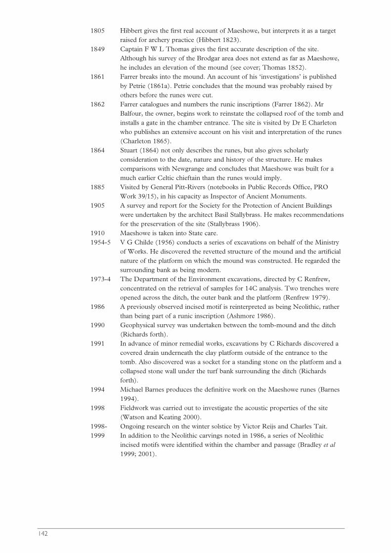
1805 Hibbert gives the first real account of Maeshowe, but interprets it as a targetraised for archery practice (Hibbert 1823).
1849 Captain F W L Thomas gives the first accurate description of the site.Although his survey of the Brodgar area does not extend as far as Maeshowe,he includes an elevation of the mound (see cover; Thomas 1852).
1861 Farrer breaks into the mound. An account of his ‘investigations’ is publishedby Petrie (1861a). Petrie concludes that the mound was probably raised byothers before the runes were cut.
1862 Farrer catalogues and numbers the runic inscriptions (Farrer 1862). MrBalfour, the owner, begins work to reinstate the collapsed roof of the tomb andinstalls a gate in the chamber entrance. The site is visited by Dr E Charletonwho publishes an extensive account on his visit and interpretation of the runes(Charleton 1865).
1864 Stuart (1864) not only describes the runes, but also gives scholarlyconsideration to the date, nature and history of the structure. He makescomparisons with Newgrange and concludes that Maeshowe was built for amuch earlier Celtic chieftain than the runes would imply.
1885 Visited by General Pitt-Rivers (notebooks in Public Records Office, PROWork 39/15), in his capacity as Inspector of Ancient Monuments.
1905 A survey and report for the Society for the Protection of Ancient Buildingswere undertaken by the architect Basil Stallybrass. He makes recommendationsfor the preservation of the site (Stallybrass 1906).
1910 Maeshowe is taken into State care.1954-5 V G Childe (1956) conducts a series of excavations on behalf of the Ministry
of Works. He discovered the revetted structure of the mound and the artificialnature of the platform on which the mound was constructed. He regarded thesurrounding bank as being modern.
1973-4 The Department of the Environment excavations, directed by C Renfrew,concentrated on the retrieval of samples for 14C analysis. Two trenches wereopened across the ditch, the outer bank and the platform (Renfrew 1979).
1986 A previously observed incised motif is reinterpreted as being Neolithic, ratherthan being part of a runic inscription (Ashmore 1986).
1990 Geophysical survey was undertaken between the tomb-mound and the ditch(Richards forth).
1991 In advance of minor remedial works, excavations by C Richards discovered acovered drain underneath the clay platform outside of the entrance to thetomb. Also discovered was a socket for a standing stone on the platform and acollapsed stone wall under the turf bank surrounding the ditch (Richardsforth).
1994 Michael Barnes produces the definitive work on the Maeshowe runes (Barnes1994).
1998 Fieldwork was carried out to investigate the acoustic properties of the site(Watson and Keating 2000).
1998- Ongoing research on the winter solstice by Victor Reijs and Charles Tait.1999 In addition to the Neolithic carvings noted in 1986, a series of Neolithic
incised motifs were identified within the chamber and passage (Bradley et al1999; 2001).
142

Appendix 2: ResourcesNick Card
Royal Commission on the Ancient and Historical Monuments of Scotland(RCAHMS), John Sinclair House, 16 Bernard Terrace, Edinburgh, EH8 9NX.RCAHMS is the Royal Commission on the Ancient and Historical Monuments ofScotland. It is an executive non-departmental government body financed by Parliamentthrough the Scottish Executive under the sponsorship of the Architectural Policy Unit.The RCAHMS holds the National Monuments Record of Scotland.Canmore and PASTMAP allows on-line access to the database of the NMRS,http://www.rcahms.gov.uk
Sites and Monuments Record is housed at the Orkney Archaeology Trust,Archaeology Centre, Orkney College, East Road, Kirkwall, KW15 1LX. Work is underway to make the SMR publicly available on the Internet.
Kirkwall Library, Junction Road, Kirkwall. The library houses the Orkney Room,which holds a comprehensive collection of books and articles relating to Orkney, theOrkney Archive which houses numerous documents, maps etc, and the Radio OrkneySound Archive.
Society of Antiquaries of Scotland, Royal Museum, Chambers Street, Edinburgh.The entire contents lists, and digital copies, of Archaeologia Scotica, the Proceedings of theSociety of Antiquaries of Scotland, and out-of-print monographs, are available on thewebsite of the Archaeology Data Service at: http://ads.ahds.ac.uk/catalogue/library/psas/
Museums and institutions holding significant archaeological collections fromOrkneyOrkney Museum (formally Tankerness House Museum), Broad Street, Kirkwall,Orkney, KW15 1DGNational Museums of Scotland (NMS), Chambers Street, Edinburgh, EH1 1JFHistoric Scotland, Longmore House, Salisbury Place, Edinburgh, EH9 1SHBritish Museum, Great Russell Street, London, WC1B 3DGHunterian Museum, University of Glasgow, Hillhead Street, Glasgow, G12 8QQMarischal Museum, Aberdeen, AB9 1ASNatural History Museum, Cromwell Road, South Kensington, London, SW7 5BD
Museums and institutions holding minor archaeological collections fromOrkneyBerwick Museum (Foxon, nd)Cambridge University Museum of Archaeology and EthnologyCarrick House, Eday, OrkneyFree Church College, Aberdeen (Foxon, nd)Kelvingrove Art Gallery and Museum, GlasgowManchester Museum (Foxon, nd)Museum of the Society of Antiquaries of Newcastle-upon-Tyne (Foxon, nd)Scapa Flow Visitor Centre and Museum, Lyness, Hoy, OrkneyStromness Museum, 52 Alfred Street, Stromness, Orkney, KW16 3DFTomb of the Eagles Visitor Centre, Liddle Farm, South Ronaldsay, Orkney
Scottish Wetlands Archaeological Database (SWAD)The Scottish Wetlands Archaeological Database (SWAD) is a Historic Scotland-commissioned project designed primarily to produce a fuller understanding of the
143
potential of Scottish wetland archaeology. As it now stands there are over 6,000 recordsin the database. The database is available at http://www.geo.ed.ac.uk
English Heritage Geophysics Survey Database, although covering mainly Englishsites, also holds reference to early geophysical work in Orkney. http://www.eng-h.gov.uk/SDB/
Historic Scotland’s Radiocarbon Data Base. List of Scottish radiocarbon datesThis searchable database of Scottish 14C dates can (in 2004) be found on the HistoricScotland web site: http://www.historic-scotland.gov.uk under Archaeology: CarbonDating Search. Despite its title it is up to date for dates paid for by HS until about AD2000. It does not include many dates recently obtained from developer-fundedexcavations, nor some of those obtained with funding from outwith Scotland, forinstance recent dates obtained for the early medieval cemetery at Newark, Orkney.
Tephra Base is a tephrochronological database hosted by the Department ofGeography, Edinburgh at http://www.geo.ed.ac.uk/tephra/
ScapaMAP (Scapa Flow Marine Archaeology Project) is a multi-disciplinary, multi-institution, international project involving government agencies, industry and theacademic community, designed to document a unique marine archaeological area in thewaters of Scapa Flow, Orkney.http://www.icit.demon.co.uk/scapamap1.htm
144
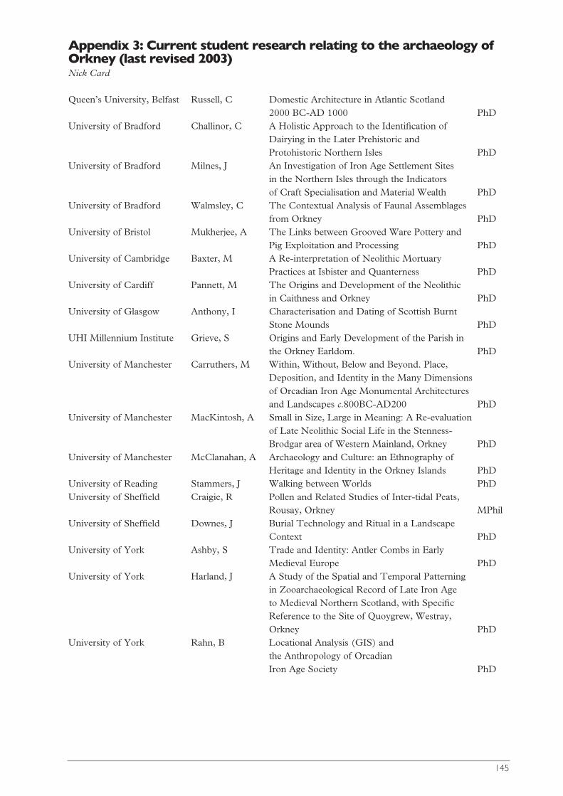
145
Appendix 3: Current student research relating to the archaeology ofOrkney (last revised 2003)Nick Card
Queen’s University, Belfast Russell, C Domestic Architecture in Atlantic Scotland 2000 BC-AD 1000 PhD
University of Bradford Challinor, C A Holistic Approach to the Identification of Dairying in the Later Prehistoric and Protohistoric Northern Isles PhD
University of Bradford Milnes, J An Investigation of Iron Age Settlement Sites in the Northern Isles through the Indicators of Craft Specialisation and Material Wealth PhD
University of Bradford Walmsley, C The Contextual Analysis of Faunal Assemblages from Orkney PhD
University of Bristol Mukherjee, A The Links between Grooved Ware Pottery and Pig Exploitation and Processing PhD
University of Cambridge Baxter, M A Re-interpretation of Neolithic Mortuary Practices at Isbister and Quanterness PhD
University of Cardiff Pannett, M The Origins and Development of the Neolithic in Caithness and Orkney PhD
University of Glasgow Anthony, I Characterisation and Dating of Scottish Burnt Stone Mounds PhD
UHI Millennium Institute Grieve, S Origins and Early Development of the Parish in the Orkney Earldom. PhD
University of Manchester Carruthers, M Within, Without, Below and Beyond. Place, Deposition, and Identity in the Many Dimensions of Orcadian Iron Age Monumental Architectures and Landscapes c.800BC-AD200 PhD
University of Manchester MacKintosh, A Small in Size, Large in Meaning: A Re-evaluation of Late Neolithic Social Life in the Stenness-Brodgar area of Western Mainland, Orkney PhD
University of Manchester McClanahan, A Archaeology and Culture: an Ethnography of Heritage and Identity in the Orkney Islands PhD
University of Reading Stammers, J Walking between Worlds PhDUniversity of Sheffield Craigie, R Pollen and Related Studies of Inter-tidal Peats,
Rousay, Orkney MPhilUniversity of Sheffield Downes, J Burial Technology and Ritual in a Landscape
Context PhDUniversity of York Ashby, S Trade and Identity: Antler Combs in Early
Medieval Europe PhDUniversity of York Harland, J A Study of the Spatial and Temporal Patterning
in Zooarchaeological Record of Late Iron Age to Medieval Northern Scotland, with Specific Reference to the Site of Quoygrew, Westray, Orkney PhD
University of York Rahn, B Locational Analysis (GIS) and the Anthropology of Orcadian Iron Age Society PhD
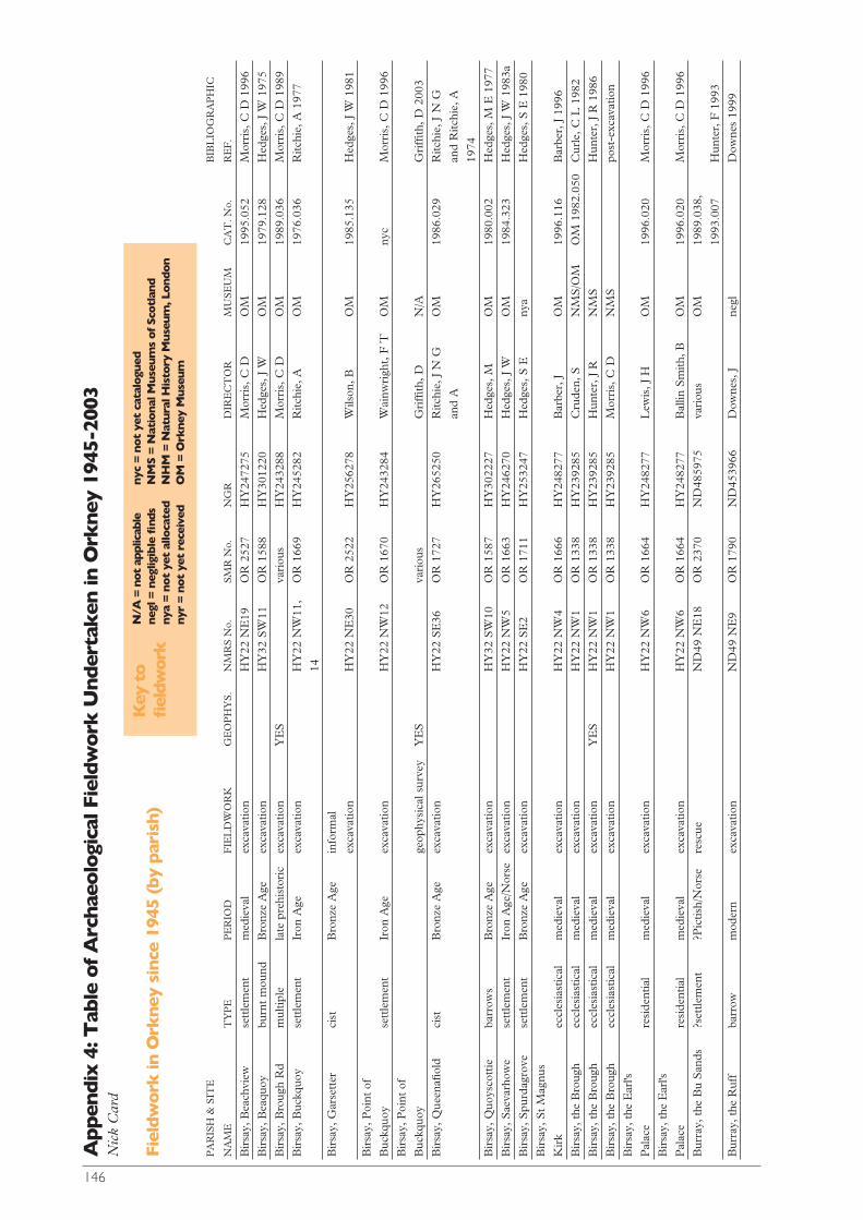
146
N/A
= n
ot a
pplic
able
neg
l = n
eglig
ible
find
sny
a =
not
yet
allo
cate
dny
r =
not
yet
rece
ived
nyc
= n
ot
yet
cata
logu
edN
MS
= N
atio
nal
Muse
um
s o
f Sc
otl
and
NH
M =
Nat
ural
His
tory
Mus
eum
, Lond
on
OM
= O
rkne
y M
useu
m
Key
to
fiel
dwor
k
Appen
dix
4: T
able
of
Arc
hae
olo
gica
l Fie
ldw
ork
Under
tak
en in
Ork
ney
194
5-20
03N
ick
Car
d
Fiel
dw
ork
in O
rkn
ey s
ince
194
5 (b
y p
aris
h)
PA
RIS
H &
SIT
EB
IBL
IOG
RA
PH
IC
NA
ME
TY
PE
PE
RIO
DF
IEL
DW
OR
KG
EO
PH
YS
.N
MR
S N
o.S
MR
No.
NG
RD
IRE
CT
OR
MU
SE
UM
CA
T. N
o.R
EF
.
Bir
say,
Bea
chvi
ewse
ttle
men
tm
edie
val
exca
vatio
nH
Y22
NE
19O
R 2
527
HY
2472
75M
orri
s, C
DO
M19
95.0
52M
orri
s, C
D 1
996
Bir
say,
Bea
quoy
burn
t m
ound
Bro
nze
Age
exca
vatio
nH
Y32
SW
11O
R 1
588
HY
3012
20H
edge
s, J
WO
M19
79.1
28H
edge
s, J
W 1
975
Bir
say,
Bro
ugh
Rd
mul
tiple
late
pre
hist
oric
exca
vatio
nY
ES
vari
ous
HY
2432
88M
orri
s, C
DO
M19
89.0
36M
orri
s, C
D 1
989
Bir
say,
Buc
kquo
yse
ttle
men
tIr
on A
geex
cava
tion
HY
22 N
W11
,O
R 1
669
HY
2452
82R
itchi
e, A
OM
1976
.036
Ritc
hie,
A 1
977
14
Bir
say,
Gar
sett
erci
stB
ronz
e A
gein
form
al
exca
vatio
nH
Y22
NE
30O
R 2
522
HY
2562
78W
ilson
, BO
M19
85.1
35H
edge
s, J
W 1
981
Bir
say,
Poi
nt o
f
Buc
kquo
yse
ttle
men
tIr
on A
geex
cava
tion
HY
22 N
W12
OR
167
0H
Y24
3284
Wai
nwri
ght,
F T
OM
nyc
Mor
ris,
C D
199
6
Bir
say,
Poi
nt o
f
Buc
kquo
yge
ophy
sica
l sur
vey
YE
Sva
riou
sG
riffi
th, D
N/A
Gri
ffith
, D 2
003
Bir
say,
Que
enafi
old
cist
B
ronz
e A
geex
cava
tion
HY
22 S
E36
OR
172
7H
Y26
5250
Ritc
hie,
J N
G
OM
1986
.029
Ritc
hie,
J N
G
and
Aan
d R
itchi
e, A
1974
Bir
say,
Quo
ysco
ttie
barr
ows
Bro
nze
Age
exca
vatio
nH
Y32
SW
10O
R 1
587
HY
3022
27H
edge
s, M
OM
1980
.002
Hed
ges,
M E
197
7
Bir
say,
Sae
varh
owe
sett
lem
ent
Iron
Age
/Nor
seex
cava
tion
HY
22 N
W5
OR
166
3H
Y24
6270
Hed
ges,
J W
OM
1984
.323
Hed
ges,
J W
198
3a
Bir
say,
Spu
rdag
rove
sett
lem
ent
Bro
nze
Age
exca
vatio
nH
Y22
SE
2O
R 1
711
HY
2532
47H
edge
s, S
Eny
aH
edge
s, S
E 1
980
Bir
say,
St
Mag
nus
Kir
kec
cles
iast
ical
med
ieva
lex
cava
tion
HY
22 N
W4
OR
166
6H
Y24
8277
Bar
ber,
JO
M19
96.1
16B
arbe
r, J
199
6
Bir
say,
the
Bro
ugh
eccl
esia
stic
alm
edie
val
exca
vatio
nH
Y22
NW
1O
R 1
338
HY
2392
85C
rude
n, S
NM
S/O
MO
M 1
982.
050
Cur
le, C
L 1
982
Bir
say,
the
Bro
ugh
eccl
esia
stic
alm
edie
val
exca
vatio
nY
ES
HY
22 N
W1
OR
133
8H
Y23
9285
Hun
ter,
J R
NM
SH
unte
r, J
R 1
986
Bir
say,
the
Bro
ugh
eccl
esia
stic
alm
edie
val
exca
vatio
nH
Y22
NW
1O
R 1
338
HY
2392
85M
orri
s, C
DN
MS
post
-exc
avat
ion
Bir
say,
the
Ear
l's
Pal
ace
resi
dent
ial
med
ieva
lex
cava
tion
HY
22 N
W6
OR
166
4H
Y24
8277
Lew
is, J
HO
M19
96.0
20M
orri
s, C
D 1
996
Bir
say,
the
Ear
l's
Pal
ace
resi
dent
ial
med
ieva
lex
cava
tion
HY
22 N
W6
OR
166
4H
Y24
8277
Bal
lin S
mith
, BO
M19
96.0
20
Mor
ris,
C D
199
6
Bur
ray,
the
Bu
San
ds?s
ettle
men
t?P
ictis
h/N
orse
resc
ueN
D49
NE
18O
R 2
370
ND
4859
75va
riou
sO
M19
89.0
38,
1993
.007
H
unte
r, F
199
3
Bur
ray,
the
Ruf
fba
rrow
mod
ern
exca
vatio
nN
D49
NE
9O
R 1
790
ND
4539
66D
owne
s, J
negl
Dow
nes
1999
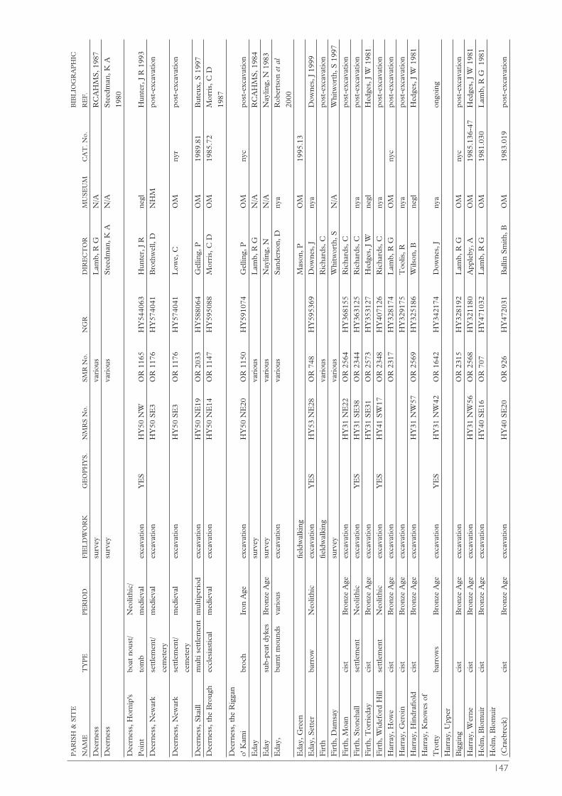
147
PA
RIS
H &
SIT
EB
IBL
IOG
RA
PH
IC
NA
ME
TY
PE
PE
RIO
DF
IEL
DW
OR
KG
EO
PH
YS
.N
MR
S N
o.S
MR
No.
NG
RD
IRE
CT
OR
MU
SE
UM
CA
T. N
o.R
EF
.
Dee
rnes
ssu
rvey
vari
ous
Lam
b, R
GN
/AR
CA
HM
S, 1
987
Dee
rnes
ssu
rvey
vari
ous
Ste
edm
an, K
AN
/AS
teed
man
, K A
1980
Dee
rnes
s, H
orni
p's
boat
nou
st/
Neo
lithi
c/
Poi
ntto
mb
med
ieva
lex
cava
tion
YE
SH
Y50
NW
OR
116
5H
Y54
4063
Hun
ter,
J R
ne
glH
unte
r, J
R 1
993
Dee
rnes
s, N
ewar
kse
ttle
men
t/ m
edie
val
exca
vatio
nH
Y50
SE
3O
R 1
176
HY
5740
41B
roth
wel
l, D
NH
Mpo
st-e
xcav
atio
n
cem
eter
y
Dee
rnes
s, N
ewar
kse
ttle
men
t/ m
edie
val
exca
vatio
nH
Y50
SE
3O
R 1
176
HY
5740
41L
owe,
CO
Mny
rpo
st-e
xcav
atio
n
cem
eter
y
Dee
rnes
s, S
kaill
mul
ti se
ttle
men
tm
ultip
erio
dex
cava
tion
HY
50 N
E19
OR
203
3H
Y58
8064
Gel
ling,
PO
M19
89.8
1B
uteu
x, S
199
7
Dee
rnes
s, t
he B
roug
hec
cles
iast
ical
med
ieva
lex
cava
tion
HY
50 N
E14
OR
114
7H
Y59
5088
Mor
ris,
C D
OM
1985
.72
Mor
ris,
C D
1987
Dee
rnes
s, t
he R
igga
n
o' K
ami
broc
h
Iron
Age
exca
vatio
nH
Y50
NE
20O
R 1
150
HY
5910
74G
ellin
g, P
OM
nyc
post
-exc
avat
ion
Eda
ysu
rvey
vari
ous
Lam
b, R
GN
/AR
CA
HM
S, 1
984
Eda
ysu
b-pe
at d
ykes
Bro
nze
Age
surv
eyva
riou
sN
aylin
g, N
N/A
Nay
ling,
N 1
983
Eda
y,bu
rnt
mou
nds
vari
ous
exca
vatio
nva
riou
sS
ande
rson
, Dny
aR
ober
tson
et
al
2000
Eda
y, G
reen
field
wal
king
Mas
on, P
OM
1995
.13
Eda
y, S
ette
rba
rrow
N
eolit
hic
exca
vatio
nY
ES
HY
53 N
E28
OR
748
HY
5953
69D
owne
s, J
nya
Dow
nes,
J 1
999
Fir
th
field
wal
king
vari
ous
Ric
hard
s, C
post
-exc
avat
ion
Fir
th, D
amsa
ysu
rvey
vari
ous
Whi
twor
th, S
N/A
Whi
twor
th, S
199
7
Fir
th, M
oan
cist
Bro
nze
Age
exca
vatio
nH
Y31
NE
22O
R 2
564
HY
3681
55R
icha
rds,
Cpo
st-e
xcav
atio
n
Fir
th, S
tone
hall
sett
lem
ent
Neo
lithi
cex
cava
tion
YE
SH
Y31
SE
38O
R 2
344
HY
3631
25R
icha
rds,
Cny
apo
st-e
xcav
atio
n
Fir
th, T
orri
eday
cist
Bro
nze
Age
exca
vatio
nH
Y31
SE
31O
R 2
573
HY
3531
27H
edge
s, J
Wne
glH
edge
s, J
W 1
981
Fir
th, W
idef
ord
Hill
sett
lem
ent
Neo
lithi
cex
cava
tion
YE
SH
Y41
SW
17O
R 2
348
HY
4071
26R
icha
rds,
Cny
apo
st-e
xcav
atio
n
Har
ray,
How
eci
stB
ronz
e A
geex
cava
tion
OR
231
7H
Y32
8174
Lam
b, R
GO
Mny
cpo
st-e
xcav
atio
n
Har
ray,
Ger
oin
cist
Bro
nze
Age
exca
vatio
nH
Y32
9175
Too
lis, R
nya
post
-exc
avat
ion
Har
ray,
Hin
drafi
old
cist
Bro
nze
Age
exca
vatio
nH
Y31
NW
57O
R 2
569
HY
3251
86W
ilson
, Bne
glH
edge
s, J
W 1
981
Har
ray,
Kno
wes
of
Tro
tty
barr
ows
Bro
nze
Age
exca
vatio
nY
ES
HY
31 N
W42
OR
164
2H
Y34
2174
Dow
nes,
Jny
aon
goin
g
Har
ray,
Upp
er
Big
ging
cist
Bro
nze
Age
exca
vatio
nO
R 2
315
HY
3281
92L
amb,
R G
OM
nyc
post
-exc
avat
ion
Har
ray,
Wer
neci
stB
ronz
e A
geex
cava
tion
HY
31 N
W56
OR
256
8H
Y32
1180
App
leby
, AO
M19
85.1
36-4
7H
edge
s, J
W 1
981
Hol
m, B
lom
uir
cist
Bro
nze
Age
exca
vatio
nH
Y40
SE
16O
R 7
07H
Y47
1032
Lam
b, R
GO
M19
81.0
30L
amb,
R G
19
81
Hol
m, B
lom
uir
(Cra
ebre
ck)
cist
Bro
nze
Age
exca
vatio
nH
Y40
SE
20O
R 9
26H
Y47
2031
Bal
lin S
mith
, B
OM
1983
.019
post
-exc
avat
ion
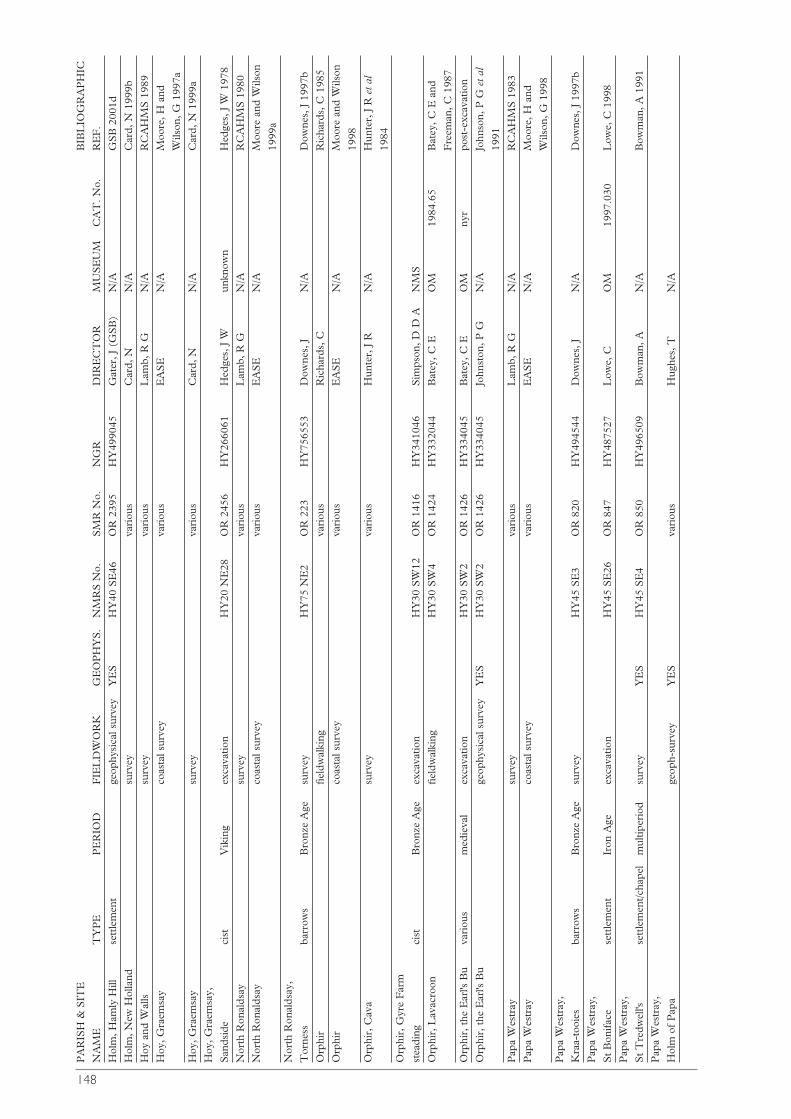
148
PA
RIS
H &
SIT
EB
IBL
IOG
RA
PH
IC
NA
ME
TY
PE
PE
RIO
DF
IEL
DW
OR
KG
EO
PH
YS
.N
MR
S N
o.S
MR
No.
NG
RD
IRE
CT
OR
MU
SE
UM
CA
T. N
o.R
EF
.
Hol
m, H
amly
Hill
sett
lem
ent
geop
hysi
cal s
urve
yY
ES
HY
40 S
E46
OR
239
5H
Y49
9045
Gat
er, J
(G
SB
)N
/AG
SB
200
1d
Hol
m, N
ew H
olla
ndsu
rvey
vari
ous
Car
d, N
N/A
Car
d, N
199
9b
Hoy
and
Wal
lssu
rvey
vari
ous
Lam
b, R
GN
/AR
CA
HM
S 1
989
Hoy
, Gra
emsa
yco
asta
l sur
vey
vari
ous
EA
SE
N/A
Moo
re, H
and
Wils
on, G
199
7a
Hoy
, Gra
emsa
ysu
rvey
vari
ous
Car
d, N
N/A
Car
d, N
199
9a
Hoy
, Gra
emsa
y,
San
dsid
eci
stV
ikin
gex
cava
tion
HY
20 N
E28
OR
245
6H
Y26
6061
Hed
ges,
J W
unkn
own
Hed
ges,
J W
197
8
Nor
th R
onal
dsay
surv
eyva
riou
sL
amb,
R G
N/A
RC
AH
MS
198
0
Nor
th R
onal
dsay
coas
tal s
urve
yva
riou
sE
AS
EN
/AM
oore
and
Wils
on
1999
a
Nor
th R
onal
dsay
,
Tor
ness
barr
ows
Bro
nze
Age
surv
eyH
Y75
NE
2O
R 2
23H
Y75
6553
Dow
nes,
JN
/AD
owne
s, J
199
7b
Orp
hir
field
wal
king
vari
ous
Ric
hard
s, C
Ric
hard
s, C
198
5
Orp
hir
coas
tal s
urve
yva
riou
sE
AS
EN
/AM
oore
and
Wils
on
1998
Orp
hir,
Cav
asu
rvey
vari
ous
Hun
ter,
J R
N
/AH
unte
r, J
R e
t al
1984
Orp
hir,
Gyr
e F
arm
stea
ding
cist
Bro
nze
Age
exca
vatio
nH
Y30
SW
12O
R 1
416
HY
3410
46S
imps
on, D
D A
NM
S
Orp
hir,
Lav
acro
onfie
ldw
alki
ngH
Y30
SW
4O
R 1
424
HY
3320
44B
atey
, C E
OM
1984
.65
Bat
ey, C
E a
nd
Fre
eman
, C 1
987
Orp
hir,
the
Ear
l's B
uva
riou
sm
edie
val
exca
vatio
nH
Y30
SW
2O
R 1
426
HY
3340
45B
atey
, C E
OM
nyr
post
-exc
avat
ion
Orp
hir,
the
Ear
l's B
uge
ophy
sica
l sur
vey
YE
SH
Y30
SW
2O
R 1
426
HY
3340
45Jo
hnst
on, P
GN
/AJo
hnso
n, P
G e
t al
1991
Pap
a W
estr
aysu
rvey
vari
ous
Lam
b, R
GN
/AR
CA
HM
S 1
983
Pap
a W
estr
ayco
asta
l sur
vey
vari
ous
EA
SE
N/A
Moo
re, H
and
Wils
on, G
199
8
Pap
a W
estr
ay,
Kra
a-to
oies
barr
ows
Bro
nze
Age
surv
eyH
Y45
SE
3O
R 8
20H
Y49
4544
Dow
nes,
JN
/AD
owne
s, J
199
7b
Pap
a W
estr
ay,
St
Bon
ifac
ese
ttle
men
tIr
on A
geex
cava
tion
HY
45 S
E26
OR
847
HY
4875
27L
owe,
CO
M19
97.0
30L
owe,
C 1
998
Pap
a W
estr
ay,
St
Tre
dwel
l'sse
ttle
men
t/cha
pel
mul
tiper
iod
surv
eyY
ES
HY
45 S
E4
OR
850
HY
4965
09B
owm
an, A
N/A
Bow
man
, A 1
991
Pap
a W
estr
ay,
Hol
m o
f P
apa
geop
h-su
rvey
YE
Sva
riou
sH
ughe
s, T
N/A
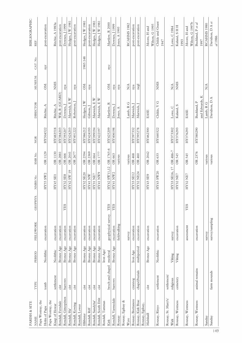
149
PA
RIS
H &
SIT
EB
IBL
IOG
RA
PH
IC
NA
ME
TY
PE
PE
RIO
DF
IEL
DW
OR
KG
EO
PH
YS
.N
MR
S N
o.S
MR
No.
NG
RD
IRE
CT
OR
MU
SE
UM
CA
T. N
o.R
EF
.
Pap
a W
estr
ay, t
he
Hol
m o
f P
apa
tom
bN
eolit
hic
exca
vatio
nH
Y55
SW
2O
R 1
129
HY
5045
22R
itchi
e, A
OM
nyr
post
-exc
avat
ion
Pap
a W
estr
ay, t
he
Kna
p of
How
arse
ttle
men
tN
eolit
hic
exca
vatio
nH
Y45
SE
1O
R 1
130
HY
4835
18R
itchi
e, A
NM
SR
itchi
e, A
198
3a
Ren
dall,
Fer
ndal
eci
stB
ronz
e A
geex
cava
tion
OR
288
1H
Y38
4203
Will
, R (
GU
AR
D)
post
-exc
avat
ion
Ren
dall,
Gitt
erpi
tten
barr
ows
Bro
nze
Age
exca
vatio
nY
ES
HY
32 S
E8
OR
666
HY
3932
07D
owne
s, J
nya
Dow
nes,
J 1
999
Ren
dall,
Ha'
cist
Bro
nze
Age
exca
vatio
nH
Y42
SW
19
OR
204
1H
Y42
4203
Mar
wic
k, E
WH
edge
s, J
W 1
981
Ren
dall,
Kew
ing
cist
Bro
nze
Age
exca
vatio
nO
R 2
677
HY
4012
22R
ober
tson
, Jny
apo
st-e
xcav
atio
n
Ren
dall,
Low
er
Elli
bist
erci
stB
ronz
e A
geex
cava
tion
HY
32 S
E20
OR
259
4H
Y38
6212
Hed
ges,
J W
OM
1985
.148
Hed
ges,
J W
198
1
Ren
dall,
Rif
fci
stB
ronz
e A
geex
cava
tion
HY
41 N
WO
R 2
369
HY
4241
93G
ibso
n, J
nya
post
-exc
avat
ion
Ren
dall,
San
dyha
'ci
stB
ronz
e A
geex
cava
tion
HY
31 N
E7
OR
664
HY
3991
94M
arw
ick,
E W
Hed
ges,
J W
198
1
Ren
dall,
Sou
th E
ttit
cist
Bro
nze
Age
exca
vatio
nH
Y41
NW
9O
R 1
777
HY
4221
97M
arw
ick,
E W
Hed
ges,
J W
198
1
Ren
dall,
Tam
mas
Ir
on A
ge/
Kir
kbr
och
and
chap
elm
edie
val
geop
hysi
cal s
urve
yY
ES
HY
42 S
W11
,12
OR
176
5-6
HY
4252
09M
artle
w, R
OM
nyc
Mar
tlew
, R 2
000
Ren
dall,
Var
med
ale
barr
ows
Bro
nze
Age
exca
vatio
nY
ES
HY
41 N
W2
OR
663
HY
4061
98D
owne
s, J
nya
Dow
nes,
J 1
999
Rou
say
field
wal
king
vari
ous
Jone
s, A
nya
Jone
s, A
199
5
Rou
say,
Egi
lsay
&
Wyr
esu
rvey
vari
ous
Lam
b, R
GN
/AR
CA
HM
S 1
982
Rou
say,
Bre
ttan
ess
cran
nog
Iron
Age
exca
vatio
nH
Y33
SE
12O
R 4
68H
Y39
7332
Mar
wic
k, J
nya
post
-exc
avat
ion
Rou
say,
Kir
k B
rae
chap
el/b
uria
lsm
ultip
erio
dex
cava
tion
HY
32 N
E24
OR
460
HY
3952
78M
arw
ick,
Jne
glpo
st-e
xcav
atio
n
Rou
say,
Egi
lsay
,
Mid
skai
llci
stB
ronz
e A
geex
cava
tion
HY
43 S
E9
OR
204
2H
Y46
2300
EA
SE
Moo
re, H
and
Wils
on, G
199
5
Rou
say,
Rin
yose
ttle
men
tN
eolit
hic
exca
vatio
nH
Y43
SW
20O
R 6
33H
Y44
0322
Chi
lde,
V G
NM
SC
hild
e an
d G
rant
1947
Rou
say,
St.
Mar
y's/
se
ttle
men
t/
Wir
kre
ligio
usV
ikin
gsu
rvey
HY
33 S
E16
, 17
OR
486
-7H
Y37
3302
Low
e, C
N/A
Low
e, C
198
4
Rou
say,
Wes
tnes
sce
met
ery
Vik
ing
exca
vatio
nH
Y32
NE
7O
R 5
45H
Y37
6293
Kal
and,
SN
MS
Kal
and,
S H
H
1993
Rou
say,
Wes
tnes
sas
sess
men
tY
ES
HY
32 N
E7
OR
545
HY
3762
93E
AS
EM
oore
, H a
nd
Wils
on, G
199
7b
Rou
say,
Wes
tnes
san
imal
rem
ains
exca
vatio
nO
R 2
376
HY
3802
90B
uckl
and,
P
Buc
klan
d, P
et
al
and
Edw
ards
, K19
97
San
day
surv
eyva
riou
sL
amb,
R G
N/A
RC
AH
MS
198
0
San
day
farm
mou
nds
surv
ey/s
ampl
ing
vari
ous
Dav
idso
n, D
AD
avid
son,
D A
et
al19
86
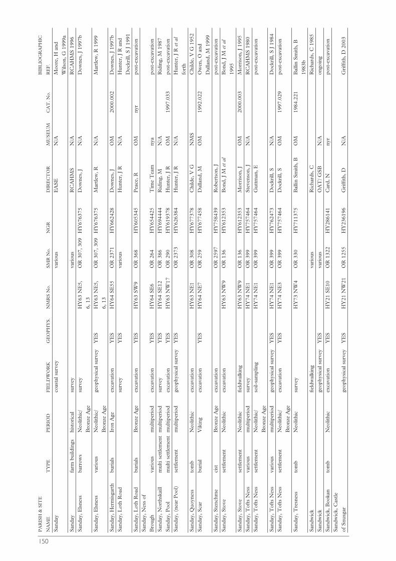
150
PA
RIS
H &
SIT
EB
IBL
IOG
RA
PH
IC
NA
ME
TY
PE
PE
RIO
DF
IEL
DW
OR
KG
EO
PH
YS
.N
MR
S N
o.S
MR
No.
NG
RD
IRE
CT
OR
MU
SE
UM
CA
T. N
o.R
EF
.
San
day
coas
tal s
urve
yva
riou
sE
AS
EN
/AM
oore
, H a
nd
Wils
on, G
199
9a
San
day
farm
bui
ldin
gshi
stor
ical
surv
eyva
riou
sR
CA
HM
SN
/AR
CA
HM
S 1
996
San
day,
Els
ness
barr
ows
Neo
lithi
c/su
rvey
HY
63 N
E5,
OR
307
, 309
HY
6763
75D
owne
s, J
N/A
Dow
nes,
J 1
997b
Bro
nze
Age
6, 1
3
San
day,
Els
ness
vari
ous
Neo
lithi
c/
geop
hysi
cal s
urve
yY
ES
HY
63 N
E5,
OR
307
, 309
HY
6763
75M
artle
w, R
N/A
Mar
tlew
, R 1
999
Bro
nze
Age
6, 1
3
San
day,
Her
mis
gart
hbu
rial
sIr
on A
geex
cava
tion
YE
SH
Y64
SE
55O
R 2
371
HY
6624
28D
owne
s, J
OM
2000
.002
Dow
nes,
J 1
997b
San
day,
Lot
h R
oad
surv
eyY
ES
vari
ous
Hun
ter,
J R
N
/AH
unte
r, J
R a
nd
Doc
krill
, S J
199
1
San
day,
Lot
h R
oad
buri
als
Bro
nze
Age
exca
vatio
nY
ES
HY
63 S
W9
OR
368
HY
6053
45P
eace
, RO
Mny
rpo
st-e
xcav
atio
n
San
day,
Nes
s of
Bro
ugh
vari
ous
mul
tiper
iod
exca
vatio
nY
ES
HY
64 S
E6
OR
264
HY
6544
25T
ime
Tea
mny
apo
st-e
xcav
atio
n
San
day,
Nor
thsk
aill
mul
ti se
ttle
men
tm
ultip
erio
dsu
rvey
YE
SH
Y64
SE
12O
R 3
86H
Y69
4444
Rid
ing,
MN
/AR
idin
g, M
198
7
San
day,
Poo
lm
ulti
sett
lem
ent
mul
tiper
iod
exca
vatio
nY
ES
HY
63 N
W17
OR
290
HY
6193
78H
unte
r, J
R
OM
1997
.033
post
-exc
avat
ion
San
day,
(ne
ar P
ool)
sett
lem
ent
mul
tiper
iod
geop
hysi
cal s
urve
yY
ES
OR
237
3H
Y62
6384
Hun
ter,
J R
N
/AH
unte
r, J
R e
t al
fort
h
San
day,
Quo
ynes
sto
mb
Neo
lithi
cex
cava
tion
HY
63 N
E1
OR
308
HY
6773
78C
hild
e, V
GN
MS
Chi
lde,
V G
195
2
San
day,
Sca
rbu
rial
Vik
ing
exca
vatio
nY
ES
HY
64 N
E7
OR
259
HY
6774
58D
alla
nd, M
OM
1992
.022
Ow
en, O
and
Dal
land
, M 1
999
San
day,
Ste
nchm
eci
stB
ronz
e A
geex
cava
tion
OR
259
7H
Y75
8439
Rob
erts
on, J
post
-exc
avat
ion
San
day,
Sto
ve
sett
lem
ent
Neo
lithi
cex
cava
tion
HY
63 N
W9
OR
136
HY
6123
53B
ond,
J M
et
alB
ond,
J M
et
al
1995
San
day,
Sto
ve
sett
lem
ent
Neo
lithi
cfie
ldw
alki
ngH
Y63
NW
9O
R 1
36H
Y61
2353
Mor
riso
n, J
OM
2000
.003
Mor
riso
n, J
199
5
San
day,
Tof
ts N
ess
vari
ous
mul
tiper
iod
surv
eyH
Y74
NE
1O
R 3
99H
Y75
7464
Ste
vens
on, J
N/A
RC
AH
MS
198
0
San
day,
Tof
ts N
ess
sett
lem
ent
Neo
lithi
c/so
il-sa
mpl
ing
HY
74 N
E1
OR
399
HY
7574
64G
uttm
an, E
post
-exc
avat
ion
Bro
nze
Age
San
day,
Tof
ts N
ess
vari
ous
mul
tiper
iod
geop
hysi
cal s
urve
yY
ES
HY
74 N
E1
OR
399
HY
7624
73D
ockr
ill, S
N/A
Doc
krill
, S J
198
4
San
day,
Tof
ts N
ess
sett
lem
ent
Neo
lithi
c/ex
cava
tion
YE
SH
Y74
NE
3O
R 3
99H
Y75
7464
Doc
krill
, SO
M19
97.0
29po
st-e
xcav
atio
n
Bro
nze
Age
San
day,
Tre
snes
sto
mb
Neo
lithi
csu
rvey
HY
73 N
W4
OR
330
HY
7113
75B
allin
Sm
ith, B
OM
1984
.221
Bal
lin S
mith
, B
1983
b
San
dwic
kfie
ldw
alki
ngva
riou
sR
icha
rds,
CR
icha
rds,
C 1
985
San
dwic
kge
ophy
sica
l sur
vey
YE
Sva
riou
sO
AT
/ GS
BN
/Aon
goin
g
San
dwic
k, B
ooka
nto
mb
Neo
lithi
cex
cava
tion
YE
SH
Y21
SE
10O
R 1
322
HY
2861
41C
ard,
Nny
rpo
st-e
xcav
atio
n
San
dwic
k, C
astle
of S
nusg
arge
ophy
sica
l sur
vey
YE
SH
Y21
NW
21O
R 1
255
HY
2361
96G
riffi
th, D
N/A
Gri
ffith
, D 2
003

151
PA
RIS
H &
SIT
EB
IBL
IOG
RA
PH
IC
NA
ME
TY
PE
PE
RIO
DF
IEL
DW
OR
KG
EO
PH
YS
.N
MR
S N
o.S
MR
No.
NG
RD
IRE
CT
OR
MU
SE
UM
CA
T. N
o.R
EF
.
San
dwic
k, L
inga
fiold
barr
owB
ronz
e A
geex
cava
tion
HY
21 N
E19
OR
127
9H
Y26
4153
EA
SE
Moo
re, H
and
Wils
on, G
199
5
San
dwic
k, L
inga
fiold
barr
ows
Bro
nze
Age
exca
vatio
nY
ES
HY
21 N
E19
OR
127
9H
Y26
4153
Dow
nes,
JO
M20
00.0
01po
st-e
xcav
atio
n
San
dwic
k, S
andfi
old
cist
Neo
lithi
c/
exca
vatio
nH
Y21
NW
35O
R 2
328
HY
2421
95D
alla
nd, M
OM
1997
.032
Dal
land
, M 1
999
Bro
nze
Age
San
dwic
k, S
kaill
Bay
sett
lem
ent/
med
ieva
lsu
rvey
YE
SH
Y21
NW
30.0
OR
251
4H
Y22
9187
Mor
ris,
C D
N/A
Mor
ris,
C D
et
al
buri
al19
85
San
dwic
k, S
kaill
Bay
cist
Iron
Age
exca
vatio
nH
Y21
NW
30.
02O
R 2
514
HY
2291
87Ja
mes
, HJa
mes
, H 1
999
San
dwic
k, S
kaill
sett
lem
ent
preh
isto
ric
exca
vatio
nY
ES
HY
21 N
W30
.01
OR
251
4H
Y22
9188
Sim
pson
, Bny
aS
imps
on, B
199
8
San
dwic
k, S
kaill
Hou
sece
met
ery
med
ieva
lex
cava
tion
HY
21 N
W40
OR
125
1H
Y23
4185
Jam
es, H
negl
post
-exc
avat
ion
San
dwic
k, S
kara
Bra
ese
ttle
men
tN
eolit
hic
geop
hysi
cal s
urve
yY
ES
HY
21 N
W12
OR
124
6H
Y23
1187
Bar
tlett
, A D
HN
/AB
artle
tt, A
D H
and
Cla
rk, A
J 1
973a
San
dwic
k, S
kara
Bra
ese
ttle
men
tN
eolit
hic
exca
vatio
nH
Y21
NW
12O
R 1
246
HY
2311
87C
lark
e, D
VN
MS
post
-exc
avat
ion
San
dwic
k, S
kara
Bra
ese
ttle
men
tN
eolit
hic
exca
vatio
nH
Y21
NW
12.0
2O
R 1
246
HY
2311
87R
icha
rds,
Cny
apo
st-e
xcav
atio
n
San
dwic
k, S
kara
Bra
ese
ttle
men
tN
eolit
hic
geop
h-su
rvey
YE
SH
Y21
NW
12O
R 1
246
HY
2311
87G
riffi
th, D
N/A
Gri
ffith
, D 2
003
San
dwic
k, U
niga
rth
sout
erra
inIr
on A
geex
cava
tion
HY
21 N
W29
OR
1258
HY
2461
74C
rude
n, S
San
dwic
k, V
erro
nbr
och
Iron
Age
exca
vatio
nH
Y21
NW
22O
R 1
256
HY
2311
97E
AS
Eny
apo
st-e
xcav
atio
n
San
dwic
k, V
estr
afiol
dba
rrow
sB
ronz
e A
geex
cava
tion
YE
SH
Y22
SW
9O
R 1
205
HY
2422
21D
owne
s, J
nya
Dow
nes,
J 1
999
San
dwic
k, V
estr
afiol
dqu
arry
Neo
lithi
cex
cava
tion
YE
SH
Y22
SW
7O
R 1
203
HY
2392
18R
icha
rds,
CN
/Apo
st-e
xcav
atio
n
San
dwic
k, V
estr
afiol
dto
mb
Neo
lithi
cex
cava
tion
YE
SH
Y22
SW
10O
R 1
206
HY
2042
18R
icha
rds,
Cny
apo
st-e
xcav
atio
n
San
dwic
k, V
oysu
rvey
vari
ous
For
bes,
RN
/A
Sha
pins
aysu
rvey
vari
ous
Lam
b, R
GN
/AR
CA
HM
S 1
987
Sha
pins
ay,
Bur
roug
hsto
nbr
och
Ir
on A
gere
cons
truc
tion
HY
52 S
W4
OR
112
3H
Y54
1210
Hill
, Jny
apo
st-e
xcav
atio
n
Sha
pins
ay, W
ardh
illca
irn
med
ieva
lex
cava
tion
YE
SH
Y52
SW
6O
R 1
081
HY
5081
74D
owne
s, J
nya
Dow
nes,
J 1
999
Sou
th R
onal
dsay
coas
tal s
urve
yva
riou
sE
AS
EN
/AM
oore
, H a
nd
Wils
on, G
199
7
Sou
th R
onal
dsay
,
Ban
ksci
stB
ronz
e A
geex
cava
tion
ND
48 S
E3
OR
188
3N
D46
3832
Sim
ison
, Rpo
st-e
xcav
atio
n
Sou
th R
onal
dsay
, C
arru
ther
s, M
Cai
rns
o' t
he B
ubr
och
Iron
Age
geop
h-su
rvey
YE
SN
D48
NE
14O
R 1
869
ND
4548
69C
arru
ther
s, M
N/A
2003
Sou
th R
onal
dsay
,
Isbi
ster
tom
bN
eolit
hic
exca
vatio
nN
D48
SE
1O
R 1
881
ND
4708
45S
imis
on, R
OM
1990
.112
Hed
ges,
J W
198
3b
Sou
th R
onal
dsay
,
Lid
dle
burn
t m
ound
Bro
nze
Age
exca
vatio
nY
ES
ND
48 S
E2
OR
188
2N
D46
5841
Hed
ges,
J W
OM
1979
.24
Hed
ges,
J W
197
5
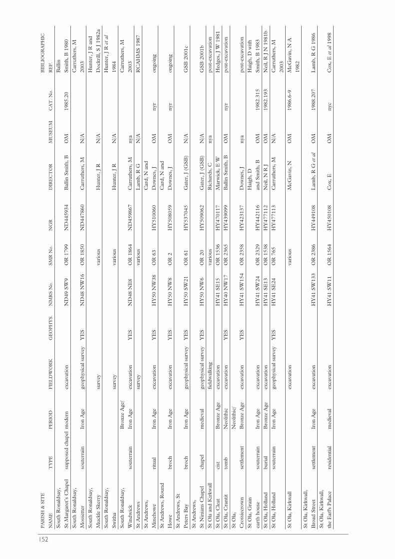
152
PA
RIS
H &
SIT
EB
IBL
IOG
RA
PH
IC
NA
ME
TY
PE
PE
RIO
DF
IEL
DW
OR
KG
EO
PH
YS
.N
MR
S N
o.S
MR
No.
NG
RD
IRE
CT
OR
MU
SE
UM
CA
T. N
o.R
EF
.
Sou
th R
onal
dsay
, B
allin
St
Mar
gare
t’s
Cha
pel
supp
osed
cha
pel
mod
ern
exca
vatio
nN
D49
SW
9O
R 1
799
ND
4459
34B
allin
Sm
ith, B
OM
1985
.20
Sm
ith, B
198
0
Sou
th R
onal
dsay
, C
arru
ther
s, M
Mos
sett
erso
uter
rain
Iron
Age
geop
hysi
cal s
urve
yY
ES
ND
48 N
W16
OR
185
0N
D44
7860
Car
ruth
ers,
MN
/A20
03
Sou
th R
onal
dsay
, H
unte
r, J
R a
nd
Muc
kle
Ske
rry
surv
eyva
riou
sH
unte
r, J
R
N/A
Doc
krill
, S J
198
2a
Sou
th R
onal
dsay
, H
unte
r, J
Ret
al
Sw
itha
surv
eyva
riou
sH
unte
r, J
R
N/A
1984
Sou
th R
onal
dsay
, B
ronz
e A
ge/
Car
ruth
ers,
M
Win
dwic
kso
uter
rain
Iron
Age
ex
cava
tion
YE
SN
D48
NE
8O
R 1
864
ND
4598
67C
arru
ther
s, M
nya
2003
St
And
rew
ssu
rvey
vari
ous
Lam
b, R
GN
/AR
CA
HM
S 1
987
St
And
rew
s,
Car
d, N
and
Min
ehow
eri
tual
Iron
Age
exca
vatio
nY
ES
HY
50 N
W38
OR
63
HY
5100
60D
owne
s, J
OM
nyr
ongo
ing
St
And
rew
s, R
ound
C
ard,
N a
nd
How
ebr
och
Ir
on A
geex
cava
tion
YE
SH
Y50
NW
8O
R 2
HY
5080
59D
owne
s, J
OM
nyr
ongo
ing
St
And
rew
s, S
t
Pet
ers
Bay
broc
h
Iron
Age
geop
hysi
cal s
urve
yY
ES
HY
50 S
W21
OR
61
HY
5370
45G
ater
, J (
GS
B)
N/A
GS
B 2
001c
St
And
rew
s,
St
Nin
ians
Cha
pel
chap
elm
edie
val
geop
hysi
cal s
urve
yY
ES
HY
50 N
W6
OR
20
HY
5090
62G
ater
, J (
GS
B)
N/A
GS
B 2
001b
St
Ola
and
Kir
kwal
lfie
ldw
alki
ngva
riou
sR
icha
rds,
Cny
apo
st-e
xcav
atio
n
St
Ola
, Cle
atci
stB
ronz
e A
geex
cava
tion
HY
41 S
E15
OR
153
6H
Y47
0117
Mar
wic
k, E
WH
edge
s, J
W 1
981
St
Ola
, Cra
ntit
tom
bN
eolit
hic
exca
vatio
nY
ES
HY
40 N
W17
OR
236
5H
Y43
9099
Bal
lin S
mith
, BO
Mny
rpo
st-e
xcav
atio
n
St
Ola
, N
eolit
hic/
Cro
ssie
crow
nse
ttle
men
tB
ronz
e A
geex
cava
tion
YE
SH
Y41
SW
154
OR
235
8H
Y42
3137
Dow
nes,
Jny
apo
st-e
xcav
atio
n
St
Ola
, Gra
in
Hai
gh, D
Hai
gh, D
with
eart
h ho
use
sout
erra
inIr
on A
geex
cava
tion
HY
41 S
W24
OR
232
9H
Y44
2116
and
Sm
ith, B
O
M19
82.3
15S
mith
, B 1
983
St
Ola
, Hol
land
buri
alB
ronz
e A
geex
cava
tion
HY
41 S
E13
OR
153
8H
Y47
7112
Nei
l, N
R J
OM
1982
.193
Nei
l, R
J N
198
1b
St
Ola
, Hol
land
sout
erra
inIr
on A
gege
ophy
sica
l sur
vey
YE
SH
Y41
SE
24O
R 7
65H
Y47
7113
Car
ruth
ers,
MN
/AC
arru
ther
s, M
2003
St
Ola
, Kir
kwal
lex
cava
tion
vari
ous
McG
avin
, NO
M19
86.6
-9M
cGav
in, N
A
1982
St
Ola
, Kir
kwal
l,
Bro
ad S
tree
tse
ttle
men
tIr
on A
geex
cava
tion
HY
41 S
W13
3O
R 2
386
HY
4491
08L
amb,
R G
et
alO
M19
88.2
07L
amb,
R G
198
6
St
Ola
, Kir
kwal
l,
the
Ear
l's P
alac
ere
side
ntia
lm
edie
val
exca
vatio
nH
Y41
SW
11O
R 1
564
HY
4501
08C
ox, E
OM
nyc
Cox
, E e
t al
1998
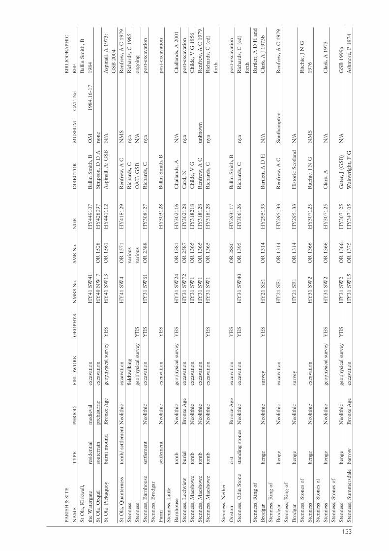
153
PA
RIS
H &
SIT
EB
IBL
IOG
RA
PH
IC
NA
ME
TY
PE
PE
RIO
DF
IEL
DW
OR
KG
EO
PH
YS
.N
MR
S N
o.S
MR
No.
NG
RD
IRE
CT
OR
MU
SE
UM
CA
T. N
o.R
EF
.
St
Ola
, Kir
kwal
l, B
allin
Sm
ith, B
the
Wat
erga
tere
side
ntia
lm
edie
val
exca
vatio
nH
Y41
SW
41H
Y44
9107
Bal
lin S
mith
, BO
M19
84.1
6-17
1984
St
Ola
, Orq
uil
sout
erra
inpr
ehis
tori
cex
cava
tion
HY
40 N
W 7
OR
152
8H
Y42
8097
Sim
pson
, D D
Ano
ne
St
Ola
, Pic
kaqu
oybu
rnt
mou
ndB
ronz
e A
gege
ophy
sica
l sur
vey
YE
SH
Y41
SW
13O
R 1
561
HY
4411
12A
spin
all,
A; G
SB
N/A
Asp
inal
l, A
197
3;
GS
B 2
004
St
Ola
, Qua
nter
ness
tom
b/ s
ettle
men
tN
eolit
hic
exca
vatio
nH
Y41
SW
4O
R 1
571
HY
4181
29R
enfr
ew, A
CN
MS
Ren
frew
, A C
197
9
Ste
nnes
sfie
ldw
alki
ngva
riou
sR
icha
rds,
Cny
aR
icha
rds,
C 1
985
Ste
nnes
sge
ophy
sica
l sur
vey
YE
Sva
riou
sO
AT
/ GS
BN
/Aon
goin
g
Ste
nnes
s, B
arnh
ouse
sett
lem
ent
Neo
lithi
cex
cava
tion
YE
SH
Y31
SW
61O
R 2
388
HY
3081
27R
icha
rds,
Cny
apo
st-e
xcav
atio
n
Ste
nnes
s, B
rodg
ar
Far
mse
ttle
men
tN
eolit
hic
exca
vatio
nY
ES
HY
3031
28B
allin
Sm
ith, B
post
-exc
avat
ion
Ste
nnes
s, L
ittle
Bar
nhou
seto
mb
Neo
lithi
cge
ophy
sica
l sur
vey
YE
SH
Y31
SW
24O
R 1
381
HY
3021
16C
halla
nds,
AN
/AC
halla
nds,
A 2
001
Ste
nnes
s, L
ochv
iew
buri
alB
ronz
e A
geex
cava
tion
HY
31 S
W72
OR
258
7H
Y30
2128
Car
d, N
nya
post
-exc
avat
ion
Ste
nnes
s, M
aesh
owe
tom
bN
eolit
hic
exca
vatio
nH
Y31
SW
1O
R 1
365
HY
3182
18C
hild
e, V
GC
hild
e, V
G 1
956
Ste
nnes
s, M
aesh
owe
tom
bN
eolit
hic
exca
vatio
nH
Y31
SW
1O
R 1
365
HY
3181
28R
enfr
ew, A
Cun
know
nR
enfr
ew, A
C 1
979
Ste
nnes
s, M
aesh
owe
tom
bN
eolit
hic
exca
vatio
nY
ES
HY
31 S
W1
OR
136
5H
Y31
8128
Ric
hard
s, C
nya
Ric
hard
s, C
(ed
)
fort
h
Ste
nnes
s, N
ethe
r
Ons
ton
cist
Bro
nze
Age
exca
vatio
nY
ES
OR
288
0H
Y29
3117
Bal
lin S
mith
, B
post
-exc
avat
ion
Ste
nnes
s, O
din
Sto
nest
andi
ng s
tone
sN
eolit
hic
exca
vatio
nY
ES
HY
31 S
W40
OR
139
5H
Y30
6126
Ric
hard
s, C
nya
Ric
hard
s, C
(ed
)
fort
h
Ste
nnes
s, R
ing
of
Bar
tlett
, A D
H a
nd
Bro
dgar
heng
eN
eolit
hic
surv
eyY
ES
HY
21 S
E1
OR
131
4H
Y29
5133
Bar
tlett
, A D
HN
/AC
lark
, A J
197
3b
Ste
nnes
s, R
ing
of
Bro
dgar
heng
eN
eolit
hic
exca
vatio
nH
Y21
SE
1O
R 1
314
HY
2951
33R
enfr
ew, A
CS
outh
ampt
onR
enfr
ew, A
C 1
979
Ste
nnes
s, R
ing
of
Bro
dgar
heng
eN
eolit
hic
surv
eyH
Y21
SE
1O
R 1
314
HY
2951
33H
isto
ric
Sco
tland
N/A
Ste
nnes
s, S
tone
s of
R
itchi
e, J
N G
Ste
nnes
she
nge
Neo
lithi
cex
cava
tion
HY
31 S
W2
OR
136
6H
Y30
7125
Ritc
hie,
J N
G
NM
S19
76
Ste
nnes
s, S
tone
s of
Ste
nnes
she
nge
Neo
lithi
cge
ophy
sica
l sur
vey
YE
SH
Y31
SW
2O
R 1
366
HY
3071
25C
lark
, AN
/AC
lark
, A 1
973
Ste
nnes
s, S
tone
s of
Ste
nnes
she
nge
Neo
lithi
cge
ophy
sica
l sur
vey
YE
SH
Y31
SW
2O
R 1
366
HY
3071
25G
ater
, J (
GS
B)
N/A
GS
B 1
999a
Ste
nnes
s, S
umm
ersd
ale
barr
owB
ronz
e A
geex
cava
tion
HY
31 S
W15
OR
137
5H
Y34
7105
Wai
nwri
ght,
F G
Ash
mor
e, P
197
4
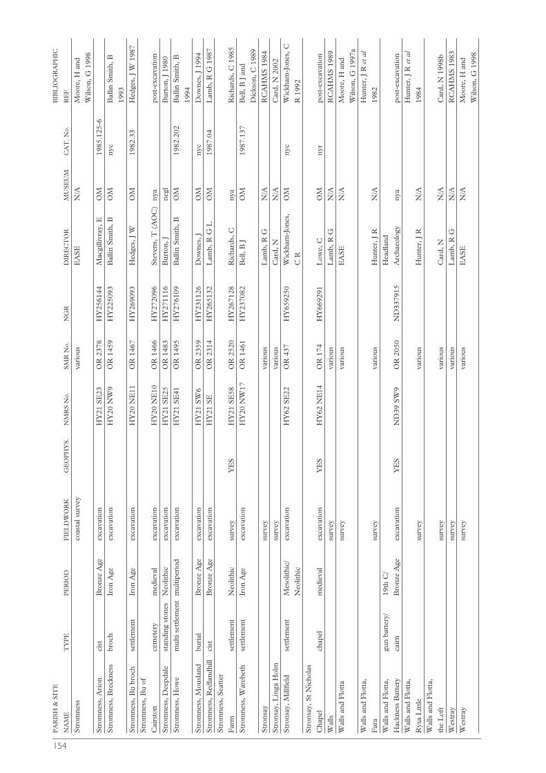
154
PA
RIS
H &
SIT
EB
IBL
IOG
RA
PH
IC
NA
ME
TY
PE
PE
RIO
DF
IEL
DW
OR
KG
EO
PH
YS
.N
MR
S N
o.S
MR
No.
NG
RD
IRE
CT
OR
MU
SE
UM
CA
T. N
o.R
EF
.
Str
omne
ssco
asta
l sur
vey
vari
ous
EA
SE
N/A
Moo
re, H
and
Wils
on, G
199
8
Str
omne
ss, A
rion
cist
Bro
nze
Age
exca
vatio
nH
Y21
SE
23O
R 2
378
HY
2561
44M
acgi
llivr
ay, E
OM
1985
.125
-6
Str
omne
ss, B
reck
ness
broc
hIr
on A
geex
cava
tion
HY
20 N
W9
OR
145
9H
Y22
5093
Bal
lin S
mith
, BO
Mny
cB
allin
Sm
ith, B
1993
Str
omne
ss, B
u br
och
sett
lem
ent
Iron
Age
exca
vatio
nH
Y20
NE
11O
R 1
467
HY
2690
93H
edge
s, J
WO
M19
82.3
3H
edge
s, J
W 1
987
Str
omne
ss, B
u of
Cai
rsto
nce
met
ery
med
ieva
lex
cava
tion
HY
20 N
E10
OR
146
6H
Y27
2096
Ste
vens
, T (
AO
C)
nya
post
-exc
avat
ion
Str
omne
ss, D
eepd
ale
stan
ding
sto
nes
Neo
lithi
cex
cava
tion
HY
21 S
E25
OR
148
3H
Y27
1116
Bur
ton,
Jne
glB
urto
n, J
198
0
Str
omne
ss, H
owe
mul
ti se
ttle
men
tm
ultip
erio
dex
cava
tion
HY
21 S
E41
OR
149
5H
Y27
6109
Bal
lin S
mith
, BO
M19
82.2
02B
allin
Sm
ith, B
1994
Str
omne
ss, M
ousl
and
buri
alB
ronz
e A
geex
cava
tion
HY
21 S
W6
OR
235
9H
Y23
1126
Dow
nes,
JO
Mny
cD
owne
s, J
199
4
Str
omne
ss, R
edla
ndhi
llci
stB
ronz
e A
geex
cava
tion
HY
21 S
EO
R 2
314
HY
2651
32L
amb,
R G
LO
M19
87.0
4L
amb,
R G
198
7
Str
omne
ss, S
eatt
er
Far
mse
ttle
men
tN
eolit
hic
surv
eyY
ES
HY
21 S
E58
OR
252
0H
Y26
7128
Ric
hard
s, C
nya
Ric
hard
s, C
198
5
Str
omne
ss, W
areb
eth
sett
lem
ent
Iron
Age
exca
vatio
nH
Y20
NW
17O
R 1
461
HY
2370
82B
ell,
B J
OM
1987
.137
Bel
l, B
J a
nd
Dic
kson
, C 1
989
Str
onsa
ysu
rvey
vari
ous
Lam
b, R
GN
/AR
CA
HM
S 1
984
Str
onsa
y, L
inga
Hol
msu
rvey
vari
ous
Car
d, N
N/A
Car
d, N
200
2
Str
onsa
y, M
illfie
ldse
ttle
men
tM
esol
ithic
/ex
cava
tion
HY
62 S
E22
OR
437
HY
6592
50W
ickh
am-J
ones
, O
Mny
cW
ickh
am-J
ones
, C
Neo
lithi
cC
RR
199
2
Str
onsa
y, S
t N
icho
las
Cha
pel
chap
elm
edie
val
exca
vatio
nY
ES
HY
62 N
E14
OR
174
HY
6692
91L
owe,
CO
Mny
rpo
st-e
xcav
atio
n
Wal
lssu
rvey
vari
ous
Lam
b, R
GN
/AR
CA
HM
S 1
989
Wal
ls a
nd F
lott
asu
rvey
vari
ous
EA
SE
N/A
Moo
re, H
and
Wils
on, G
199
7a
Wal
ls a
nd F
lott
a,
Hun
ter,
J R
et a
l
Far
asu
rvey
vari
ous
Hun
ter,
J R
N/A
1982
Wal
ls a
nd F
lott
a,gu
n ba
tter
y/
19th
C/
Hea
dlan
d
Hac
knes
s B
atte
ryca
irn
Bro
nze
Age
exca
vatio
nY
ES
ND
39 S
W9
OR
205
0N
D33
7915
Arc
haeo
logy
nya
post
-exc
avat
ion
Wal
ls a
nd F
lott
a,
Hun
ter,
J R
et
al
Rys
a L
ittle
surv
eyva
riou
sH
unte
r, J
R
N/A
1984
Wal
ls a
nd F
lott
a,
the
Lof
tsu
rvey
var
ious
Car
d, N
N/A
Car
d, N
199
8b
Wes
tray
surv
eyva
riou
sL
amb,
R G
N/A
RC
AH
MS
198
3
Wes
tray
surv
ey
v
ario
usE
AS
EN
/AM
oore
, H a
nd
Wils
on, G
199
8
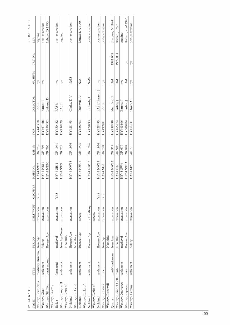
155
PA
RIS
H &
SIT
EB
IBL
IOG
RA
PH
IC
NA
ME
TY
PE
PE
RIO
DF
IEL
DW
OR
KG
EO
PH
YS
.N
MR
S N
o.S
MR
No.
NG
RD
IRE
CT
OR
MU
SE
UM
CA
T. N
o.R
EF
.
Wes
tray
, Ber
st N
ess
mor
tuar
y st
ruct
ure
Iron
Age
exca
vatio
nY
ES
HY
44 S
W2
OR
719
HY
4414
18E
AS
Eny
aon
goin
g
Wes
tray
, Cle
atse
ttle
men
tV
ikin
gex
cava
tion
HY
44 N
E11
OR
706
HY
4674
66B
arre
tt, J
nya
post
-exc
avat
ion
Wes
tray
, Gill
Pie
rbu
rnt
mou
ndB
ronz
e A
geex
cava
tion
HY
44 N
E10
OR
705
HY
4504
92L
ehan
e, D
Leh
ane,
D 1
990
Wes
tray
, Kes
tro
/
Bai
kie
farm
stea
dm
edie
val
exca
vatio
nY
ES
HY
44 S
E11
OR
104
1H
Y45
0432
EA
SE
nya
post
-exc
avat
ion
Wes
tray
, Lan
gska
illse
ttle
men
tIr
on A
ge/N
orse
exca
vatio
nH
Y44
SW
9O
R 7
29H
Y43
8429
EA
SE
nya
ongo
ing
Wes
tray
, Lin
ks o
f N
eolit
hic/
Nol
tland
sett
lem
ent
Bro
nze
Age
exca
vatio
nH
Y44
NW
33O
R 1
976
HY
4284
93C
lark
e, D
VN
MS
post
-exc
avat
ion
Wes
tray
, Lin
ks o
f N
eolit
hic/
Nol
tland
sett
lem
ent
Bro
nze
Age
surv
eyH
Y33
NW
33O
R 1
976
HY
4284
93D
unw
ell,
AN
/AD
unw
ell,
A 1
995
Wes
tray
, Lin
ks o
f
Nol
tland
sett
lem
ent
Bro
nze
Age
field
wal
king
HY
44 N
W33
OR
197
6H
Y42
8493
Ric
hard
s, C
NM
Spo
st-e
xcav
atio
n
Wes
tray
, Lin
ks o
f su
rvey
/
Nol
tland
sett
lem
ent
Bro
nze
Age
exca
vatio
nY
ES
HY
44 N
W33
OR
197
6H
Y42
8493
EA
SE
/ Bar
rett
, Jny
apo
st-e
xcav
atio
n
Wes
tray
, Pet
erki
rkbr
och
Iron
Age
exca
vatio
nY
ES
HY
44 S
E2
OR
724
HY
4994
01E
AS
Eny
apo
st-e
xcav
atio
n
Wes
tray
, Pie
row
all
Neo
lithi
c/
Qua
rry
tom
b/ s
ettle
men
tIr
on A
geex
cava
tion
HY
44 N
W32
OR
914
HY
4384
90S
harp
les,
NO
M19
81.0
01S
harp
les,
N 1
984
Wes
tray
, Poi
nt o
f C
ott
tom
bN
eolit
hic
exca
vatio
nH
Y44
NE
3O
R 9
06H
Y46
5474
Bar
ber,
JO
M19
97.0
31B
arbe
r, J
199
7
Wes
tray
, Quo
ygre
wse
ttle
men
tm
edie
val
exca
vatio
nH
Y45
SW
4O
R 6
77H
Y44
3506
Bar
rett
, Jny
aon
goin
g
Wes
tray
, Rap
ness
buri
alB
ronz
e A
geex
cava
tion
HY
54 S
W11
OR
884
HY
5004
04B
arbe
r, J
OM
nyc
Bar
ber,
J e
t al
199
6
Wes
tray
, Tuq
uoy
sett
lem
ent
Vik
ing
exca
vatio
nH
Y44
SE
5O
R 7
10H
Y45
4431
Ow
en, O
nya
nya
post
-exc
avat
ion

00

00
Adderley, W P, Simpson, I A, Lockheart, M J, Evershed, R P and Davidson, D A2000 ‘Modelling traditional manuringpractices: soil organic mattersustainability of an early Shetlandcommunity’, Human Ecology 28 (2000),415-31
Adderley, W P, Simpson, I A and MacLeod, G 2001 ‘Testing highresolution X-ray computed tomographyfor the micromorphological analyses ofarchaeological soils and sediments’,Archaeol Prospection 8 (2001), 107-12
Adderley, W P, Alberts, I L, Simpson, I A and Wess, T J forth ‘Calcium-iron-phosphate features in archaeologicalsediments: characterisation throughmicrofocus sychrotron X-rayscatterring analyses’, J Archaeol Sci.
Ager, B 1999 ‘Pierowall, Orkney: The rediscovered provenance of a pair of9th century Viking oval brooches in theDepartment of Medieval and LaterAntiquities of the British Museum’,Archaeol J 156 (1999), 359-70.
Albany, F 1909 ‘Rune Stone in the Brogar Circle, Stenness’, Old Lore Misc, 2(1909), 46-50.
Allen, A 1996 Orkney’s Maritime Heritage, Edinburgh.
Allen, J R and Anderson, J 1903 The Early Christian Monuments of Scotland, 3parts, (Soc Antiq Scot). Edinburgh(facsimile reprint 1993, 2 Vols, with anintroduction by I Henderson,Balgavies).
Alley, R B, Mayewski, P A, Sowers, T, Stuiver, M, Taylor, K C and Clark, PU 1997 ‘Holocene climatic instability: aprominent, widespread event 8200years ago’, Geology 25 (1997), 483-86.
Anderson, J 1873 The Orkneyinga Saga, Edinburgh.
- 1880 Notes on the Ornamentation ofthe Silver Brooches found at Skaill,
Orkney, and now in the Museum’, ProcSoc Antiq Scot 15 (1880-1), 286-98.
- 1881 Scotland in Early Christian Times,Edinburgh.
- 1883 Scotland in Pagan Times,Edinburgh.
- 1884 Guide to the Orkney Islands,Kirkwall.
- 1886 Scotland in Pagan Times: TheBronze and Stone Ages, Edinburgh.
- 1890 ‘Notice of Brochs or large roundtowers’, Arch Scot 5 (1890), 71-94.
- 1903 Anderson’s Guide to Orkney, with aDescription of Ruined Churches inOrkney and the Bells of St Magnus by theLate Sir Henry Dryden, 2nd Edition,Kirkwall.
Anderson, P D 1982 Robert Stewart Earl ofOrkney, Lord of Shetland, Edinburgh.
- 1992 Black Patie; the Life and Times ofPatrick Stewart, Earl of Orkney, Lord ofShetland, Edinburgh.
Anon 1864 ‘Orkney Folklore - Legend of the Dwarfie Stone’, Chambers Journal(Oct 18th 1864), 667-9.
- 1885 ‘Articles exhibited’, Proc Soc AntiqScot 19 (1884-5), 134-39.
- 1914 ‘Donations to the Museum andLibrary’, Proc Soc Antiq Scot 48 (1913-14), 109-111.
Appadurai, A (ed) 1986 The Social Life of Things, Cambridge.
Archibald, G 1925 ‘List of antiquities relating to Orkney in the NationalMuseum of Antiquities, Edinburgh’,Proc Orkney Antiq Soc 3 (1924-25), 81-9.
Armit, I 1997 Celtic Scotland, London.- 2003 Towers in the North: the Brochs of
Scotland, Stroud.Armit, I (ed) 1990 Beyond the Brochs,
Edinburgh.Armour Chelu, M J 1992 Vertebrate
Resource Exploitation, Ecology andTaphonomy in Neolithic Britain with
PART
7
156
Extended bibliographyCompiled by Nick Card
157
Special Reference to the Sites of the Linksof Noltland, Etton, and Maiden Castle.Unpubl PhD thesis, Institute ofArchaeology, University College,London and British Museum (NaturalHistory).
Arnold, C J 1975 ‘Fragments of bone combs from Papa Westray, Orkney’,Proc Soc Antiq Scot 106 (1974-5), 210-11.
Ashmore, P J 1974 ‘Excavations at Summersdale, Orkney, by F. G.Wainwright in July 1960’, Proc SocAntiq Scot 105 (1972-4), 41-2.
- 1986 ‘Neolithic carvings in MaesHowe’, Proc Soc Antiq Scot 116 (1986),57-62.
- 1996 Neolithic and Bronze Age Scotland,London.
- 2000a ‘Dating the Neolithic in Orkney’.In A Ritchie (ed) 2000, 299-308.
- 2000b ‘A List of ArchaeologicalRadiocarbon Dates’, Discovery ExcavScot 2000, 122-8, Edinburgh, Councilfor Scottish Archaeology.
- 2001 ‘A List of ArchaeologicalRadiocarbon Dates’, Discovery ExcavScot 2001, 122-8, Edinburgh, Councilfor Scottish Archaeology.
- 2003 ‘Orkney burials in the firstmillennium AD’. In J Downes and ARitchie (eds) 2003, 35-50.
Ashmore, P J and Johnsen, I S 1984 ‘A runestone from Skara Brae, Orkney’.Medieval Archaeol 28 (1984), 183-5.
Aspinal, A 1973 Archaeometry on Orkney: Magnetic Survey, 1973. Unpubltypewritten paper, copy held in SMR.
Australia ICOMOS 1997 The Burra Charter (The Australia ICOMOSCharter for Places of CulturalSignificance). Appendix in M Truscottand D Young (1997), ‘Revising theBurra Charter. Australia ICOMOSupdates its guidelines for conservationpractice’, Conservation and Managementof Archaeological Sites 4:2 (2000), 101-16.
Avebury Archaeological and Historical Research Group (AAHRG) 2001Archaeological Research Agenda for theAvebury World Heritage Site TWA Ltd,Salisbury.
Bäcklund, J 2001 ‘War or Peace? The
relations between the Picts and theNorse in Orkney’, Northern Studies 36(2001), 33-48.
Bailey, P 1971 Orkney, Plymouth. Bakka, E 1963 Some English decorated
metal objects found in NorwegianViking graves. Årb Univ Bergen HumSerie No 1.
Ballin Smith, B 1980 Full account of Excavations of St. Margaret’s Chapel, StMargaret’s Hope, South Ronaldsay,Orkney. Unpubl Report for North ofScotland Archaeological Services.
- 1983a Report on the ArchaeologicalFeatures at Newbigging Farm, Widewall,South Ronaldsay. Unpubl report forNorth of Scotland ArchaeologicalServices.
- 1983b Tresness, Sanday, Orkney.Unpubl typewritten manuscript, copyheld in SMR.
- 1984 A Stone Arch Recorded at theJunction of Watergate and Buttquoy,Kirkwall, Orkney. Unpubl typewrittenmanuscript, copy held in SMR.
- 1990 ‘New Insights into Later Iron AgeSettlement in the North: Howe’. In IArmit (ed) 1990, 32-41.
- 1993 ‘Breckness, Stromness Parish’,Discovery Excav Scot 1993, 105,Edinburgh, Council for ScottishArchaeology.
- 1998 Crantit, Orkney. Unpubl reportfor GUARD Project 619, Glasgow.
- 1999 Crantit, Orkney. Unpubl reportfor GUARD Project 619 and 619.2,Glasgow.
- 2001 ‘The Crantit Tomb, Orkney: ACase Study in Specialist Co-operationand Media Attention’. In E Williams(ed) 2001, Human Remains:Conservation, retrieval and Analysis (BritArchaeol Rep, Inter Ser, 934), Oxford,25-31.
- 2003 A New Late Neolithic House atBrodgar Farm, Stenness, Orkney.Unpubl report for GUARD Project1506, Glasgow.
Ballin Smith, B (ed) 1994 Howe: Four Millennia of Orkney Prehistory. SocAntiq Scotl Monogr Ser 9, Edinburgh.
Ballin Smith, B and Banks, I (eds) 2002 Inthe Shadow of the Brochs: the Iron Age inScotland, Stroud.

158
Barber, J 1988 ‘Isbister, Quanterness and the Point of Cott: the formulation andtesting of some middle range theory’. InJ C Barrett and I Kinnes (eds) 1988,57-62.
- 1992 ‘Megalithic Architecture’. In N Sharples and A Sheridan (eds) 1992,13-32.
- 1996 ‘Excavation at St Magnus’ Kirk, Birsay’. In C D Morris 1996, 11-31.
- 1997 The Excavation of a Stalled Cairnat the Point of Cott, Westray, Orkney,Edinburgh.
- 2000 ‘Death in Orkney: a Rare Event’.In A Ritchie (ed) 2000, 185-8.
Barber, J, Duffy, A and O’Sullivan, J 1996 ‘The excavation of two Bronze Ageburial cairns at Bu Farm, Rapness,Westray, Orkney’, Proc Soc Antiq Scot126 (1996), 103-120.
Barclay, G J 1990 ‘The clearing and partialexcavation of the cairns at Balnuaran ofClava, Inverness-shire, by MissKathleen Kennedy, 1930-31’, Proc SocAntiq Scot 120 (1990), 17-32.
- 1997 ‘The Neolithic’. In K Edwardsand I Ralston (eds) (1997), 127-49.
- 2000 Between Orkney and Wessex: theSearch for the Regional Neolithics ofBritain’. In A Ritchie (ed) 2000, 275-86.
Barclay, G J (ed) 1997 State-Funded ‘Rescue’ Archaeology in Scotland.Edinburgh. Historic Scotland AncientMonuments Division Occasional Paper 2.
Barclay, G J, Maxwell, G S, Simpson, I Aand Davidson, D A 1995 ‘The CleavenDyke: A Neolithic cursusmonument/bank barrow in Taysideregion, Scotland’, Antiquity 69 (1995),317-26.
Barclay, R S 1965 The Population of Orkney 1755-1961: A Record of theParishes and Islands, Kirkwall.
- 1977 Orkney Testaments and Inventories,1573-1615, Kirkwall.
Barclay, T 1863 ‘Explanation of the Inscriptions found in the chambers ofthe Maes Howe’, CollectaneaArchaeologica 2:1 (1863), 9-17.
Bargett, F unpub Notes on ministries in Orkney at the time of the Reformation.Copy in the Orkney Museum
Barnes, M P 1993 ‘The Interpretation of the Runic Inscriptions of Maeshowe’.In Batey et al (eds) 1993, 349-69.
- 1994 The Runic Inscriptions of Orkney,Uppsala.
- 1998 The Norn Language of Orkney andShetland, Lerwick.
- 2000 ‘Runic tradition in Orkney: FromOrphir to the Belsair Guest House’. InM Dallapiazza, O Hansen, P MSørensen, and Y S Bonnetain (eds)2000, International Scandinavian andMedieval Studies in Memory of GerdWolfgang Weber, Trieste.
Barnes, M P and Page, R forth ‘The runic inscriptions of Scotland: preservation,documentation and interpretation’. In SM Foster and M Cross (eds) forth, AbleMinds and Practised Hands. Scotland’sEarly Medieval Sculpture in the 21stCentury (Society for MedievalArchaeology).
Barrett, J C 1982 ‘Aspects of the Iron Age in Atlantic Scotland. A case study inthe problems of archaeologicalinterpretation’, Proc Soc Antiq Scot 111(1981), 205-19.
- 1988 ‘The living, the dead, and theancestors: Neolithic and early BronzeAge mortuary practices’. In J C Barrettand I Kinnes (eds) 1988, 30-41.
- 1994 Fragments from Antiquity, Oxford.- 1999 ‘Mythical Landscapes of the
British Iron Age’. In W Ashmore and AB Knapp (eds) 1999, Archaeologies ofLandscape: Contemporary Perspectives,Oxford.
Barrett, J C and Foster, S M 1991 ‘Passingthe Time in Iron Age Scotland’. In WHanson and E A Slater (eds) 1991,Scottish Archaeology: New Perspectives,Aberdeen, 44-56.
Barrett, J C and Kinnes, I (eds) 1988 The Archaeology of Context in the BritishNeolithic and Bronze Age: Recent trends,Sheffield.
Barrett, J H 1992 Farmers and Fishers in Norse Orkney: the Role of Foraging in anAgricultural Economy. Unpubl MAthesis, University of Toronto.
- 1995 Few know an Earl in fishing-clothes. Fish Middens and the Economy ofViking Age and Late Norse Earldoms ofOrkney and Caithness, Northern
159
Scotland. Unpubl PhD thesis,University of Glasgow.
- 1997 ‘Fish Trade in Norse Orkney andCaithness; a ZooarchaeologicalApproach’, Antiquity 71 (1997), 616-38.
- 2002 ‘Christian and pagan practiceduring the conversion of Viking AgeOrkney and Shetland’. In M Carver(ed) 2002, The Cross Goes North,Woodbridge, 207-26.
- 2003 ‘Culture Contact in Viking AgeScotland’. In J H Barrett (ed) 2003,Contact, Continuity and Collapse: TheNorse Colonization of the North Atlantic.Turnhout: Brepols, Studies in the EarlyMiddle Ages.
Barrett, J H, Simpson, I, Beukens, R and Davis, T 1998 ‘From the Viking Age tothe Middle Ages in Norse Orkney: anarchaeological investigation ofsecondary state formation in north-western Europe’. In P Renouf and T HMcGovern (eds) 1998, A Summit of theSea Conference: Conference Proceedings,NABO 97, 23-4, Newfoundland.
Barrett, J H, Nicholson, R A and Ceron-Carrasco, R 1999 ‘Archaeo-icthyological evidence for long-termsocioeconomic trends in northernScotland: 3500 BC to AD 1500’, JArchaeol Sci 26 (1999), 353-88.
Barrett, J H, Beukens, R P and Brothwell, D R 2000a ‘Radiocarbon dating andmarine reservoir correction of VikingAge Christian burials from Orkney’,Antiquity 74 (2000), 537-43
Barrett, J H, Beukens, R P, Simpson, I, Ashmore, P, Poaps, S and Huntly, J2000b ‘What was the Viking age andwhen did it happen? A view fromOrkney’, Norw Archaeol Rev 33 (2000),2-39.
Barrett, J H, Beukens, R P and Nicholson, R A 2001 ‘Diet and ethnicity duringthe Viking colonization of northernScotland: evidence from fish bones andstable carbon isotopes’, Antiquity 75(2001), 145-54.
Barry, G 1805 History of the Orkney Islands(1800), Edinburgh (repr. 1867).
Bartlett, A D H and Clark, A J 1973a Skara Brae, Orkney: magnetometersurvey 1973, Ancient Monuments Lab
Report (Old Series), No.1617.- 1973b Ring of Brodgar, Orkney:
magnetometer survey, AncientMonument Lab Report (Old Series),No.1616.
Bartu, A 1998 An archaeological landscapein the making: a view from Çatalhöyük.Anthropology at Çatalhöyük,http://catal.cam.ac.uk/Newsletter5/anthrop98.html
Batey, C E 1980 Excavations at Orphir 1979, Univs of Durham & Newcastle,Archaeol Reps for 1979, Durham, 33-5.
- 1981 Excavations at the Earl’s Bu atOrphir, Orkney, Univs of Durham &Newcastle Archaeol Reps for 1980,Durham, 33-5.
- 1993 ‘The discovery of a Norsehorizontal mill at Orphir, Orkney’, ProcSoc Antiq Scot 123 (1993), 453-4.
Batey, C E and Freeman, C 1987 ‘Lavacroon, Orphir, Orkney’, Proc SocAntiq Scot 116 (1986), 285-300.
Batey, C E, Jesch, J and Morris, C D (eds)1993 The Viking Age in Caithness,Orkney and the North Atlantic,Edinburgh.
Bell, B J and Dickson, C 1989 ‘Excavations at Warebeth (StromnessCemetery) Broch, Orkney’, Proc SocAntiq Scot 119 (1989), 101-31.
Bell, D L and Novak, T A 1993 ‘Some quality control considerations of remotesensing survey for archaeological sites’.In S O Smith (ed) 1993, UnderwaterArchaeological Proceedings from theSociety for Historical ArchaeologyConference, Kansas City 1993, Tucson,145–50.
Bellam, J 1986 Pottery from 1973-81 Excavations by P. Gelling at Site 6,Skaill Farm, Deerness, Orkney. Unpublundergraduate dissertation, Universityof Leicester.
Ben, J 1529 ‘Inscripto Insularum Orchadiarum’. In A Mitchell and J TClark (eds) 1908, 302-304.
Bender, B 1998 Stonehenge: Contested Space, Oxford: Berg.
Bennett, K D, Bunting, M J and Fossit, J A 1997 ‘Long-term Vegetation Changein the Western and Northern Isles ofScotland’, Botanical J Scot, 49(2)(1997), 127-40.
Berry, R J 1985 The Natural History of Orkney, London.
Berry, R J and Firth, H N (eds) 1986 The People of Orkney, Aspects of Orkney 4,Kirkwall.
Bevan, B (ed) 1999 Northern Exposure: Interpretative Devolution and the IronAges in Britain, Leicester ArchaeolMonogr 4, Leicester.
Bianchi, G G and McCave, I N 1999 ‘Holocene periodicity in North Atlanticclimate and deep-ocean flow’, Nature397, 515-17.
Bigelow, G F 1992 ‘Issues and prospects in Shetland Norse archaeology’. In C DMorris and D J Rackham (eds)1992,Norse and Later Settlement andSubsistence in the North Atlantic.Glasgow, 9-32.
Black, G F 1903 County Folk Lore III, Orkney and Shetland, London.
Blackford, J J, Edwards, K J, Buckland, P C and Dobney, K 1996 ‘Keith’s PeatBank, Hoy: Mesolithic HumanImpact?’. In A M Hall (ed) 1996, 62-8.
Blundell, F Odo 1913 ‘Further Notes on the Artificial Islands in the HighlandsArea’, Proc Soc Antiq Scot 47 (1912-13), 257-302.
Bond, G, Showers, W, Cheseby, M, Lotti, R, Almasi, P, deMenocal, P, Priore, P,Cullen, H, Hajdas, I, and Bonani, G1997 ‘A pervasive millennial-scale cyclein North Atlantic Holocene and glacialclimates’, Science 278 (1997), 1257-66.
Bond, J M 1995 Change and Continuity in an Island System: the Palaeoeconomy ofSanday, Orkney. Unpubl PhD. thesis,University of Bradford.
- 1998 ‘Beyond the fringe? Recognisingchange and adaptation in Pictish andNorse Orkney’. In C M Mills and GColes (eds) 1998, 81-90.
- 2002 ‘Pictish pigs and Celtic cowboys:food and farming in the Atlantic IronAge’. In B Ballin Smith and I Banks(eds) 2002, 177-84.
- 2003 ‘A growing success? Agriculturalintensification and risk management inLate Iron Age Orkney’. In J Downesand A Ritchie (eds) 2003, 105-110.
Bond, J M and Hunter, J R 1987 ‘Flax-growing in Orkney from the Norseperiod to the 18th century’, Proc Soc
Antiq Scot 117 (1987), 175-81.Bond, J M, Braby, A R, Dockrill, S J,
Downes, J and Richards, C C 1995‘Stove Bay: a new Orcadian groovedware settlement’, Scott Archaeol Rev9/10 (1995), 125-30.
Bowman, A 1991 St Tredwell’s Brough, Papa Westray. Unpubl MPhil, SIMS,University of St Andrews.
Boyd Dawkins, W 1914 ‘Notes on a further excavation at Skara, Orkney,with notes on remains found by WBoyd Dawkins’, Proc Soc Antiq Scot 46(1913-4), 344-55.
Braby, A 1996 Geramount, Sanday (Lady parish), cropmark. Discovery Excav Scot1996, 80, Edinburgh, Council forScottish Archaeology.
Bradley, R 1989 ‘Darkness and light in thedesign of megalithic tombs’, Oxford JArchaeol, 8 (1989), 251-9.
- 1998a ‘Incised motifs in the passage-graves at Quoyness and Cuween,Orkney’, Antiquity 72 (1998), 388-90.
- 1998b The Significance of Monuments,London and New York.
Bradley, R, Phillips, T, Richards, C and Webb, M 1999 ‘Discovering decoratedtombs in Neolithic Orkney’, CurrArchaeol, 14, 5, Feb 1999.
- 2001 ‘Decorating the Houses of theDead: Incised and Pecked Motifs inOrkney Chambered Tombs’,Cambridge Archaeol J 11(1) (2001), 45-67.
Brand, J 1883 A Brief Description of Orkney, Zetland, Pightland Firth andCaithness (1700), Edinburgh.
British Geological Survey 1936-94 1:63,360 and 1:50,000 Geological Mapsfor Orkney. Nottingham: BritishGeological Survey
Brooks, S 1988 Excavations by Peter Gelling at Skaill Farm, Orkney: Sites 1and 4. Unpubl undergraduatedissertation, University of Leicester.
Brothwell, D 1977 ‘On a mycoform stone structure in Orkney, and its relevanceto possible further interpretations of so-called souterrains’, Bull Lon InsArchaeol 14 (1977), 179-90.
Brown, J F 1992 ‘Flint as a resource for Stone Age Orcadians’, Orkney FieldClub Bulletin, 21-8.
160
Brown, M and Meehan, P 1968 Scapa Flow, London.
Brown, N and Glazebrook, J (eds) 2000 Research and Archaeology: a Frameworkfor the Eastern Counties, East AnglianArchaeology Occasional Paper No. 8Norwich.
Brundle, A, Lorimer, D H and Ritchie, A 2003 ‘Buckquoy revisited’. In J Downesand A Ritchie (eds) 2003, 95-104.
Bryce, T H 1927 ‘On the Bones from Graves at Ackergill, Caithness, and anUnderground Building at Rennibister,Orkney’, Proc Soc Antiq Scot 61 (1926-7), 301-17.
- 1940 ‘The so-called heel-shaped cairnsof Shetland, with remarks on thechambered tombs of Orkney andShetland’, Proc Soc Antiq Scot 74(1939-40), 23-36.
Buckland, P C, Edwards, K J, Craigie, R, Mainland, I, Keen, D, Hunter, P andWhittington, G 1997 Archaeological andEnvironmental Investigations at the Bayof Moaness, Rousay 1997: InterimReport. Unpubl report for Department.of Archaeology and Prehistory,University of Sheffield.
Buckley, V (ed) 1990 Burnt Offerings - International Contributions to BurntMound Archaeology, Dublin.
Bull, I D, Simpson, I A, Dockrill, S J and Evershed, R P 1999a ‘Organicgeochemical evidence concerning theorigin of ancient anthropogenic soildeposits at Tofts Ness, Sanday,Orkney’, Organic Geochemistry, 30(1999), 535-56.
Bull, I D Simpson, I A, van Bergen, P F and Evershed, R P 1999b ‘Muck ‘n’molecules: organic geochemicalmethods for detecting ancientmanuring’, Antiquity 73 (1999), 86-96.
Bullock, P, Federoff, N, Jongerius, A, Stoops, A, and Tursina, T 1985Handbook for Soil Thin SectionDescription, Wolverhampton.
Bunting, M J 1993 Environmental History and Human Impact on Orkney. UnpublPhD thesis, University of Cambridge.
- 1994 ‘Vegetation history of Orkney,Scotland: pollen records from two smallbasins in west Mainland’, New Phytol128 (1994), 771-92.
- 1996a ‘Holocene vegetation andenvironment of Orkney’. In A M Hall(ed) 1996, 20-9.
- 1996b ‘The development of heathlandin Orkney, Scotland: pollen recordsfrom Loch of Knitchen (Rousay) andLoch of Torness (Hoy)’, The Holocene6 (1996), 193-212.
- 1997 Pollen analysis on samplesassociated with the Bronze Agecemetery at Linga Fold, Mainland,Orkney. Unpubl report for HistoricScotland.
Bunting, M J, Tipping, R and Downes, J 2001 ‘“Anthropogenic” PollenAssemblages from a Bronze AgeCemetery at Linga Fiold, WestMainland, Orkney’, J Archaeol Sci 28(2001), 487-500.
Burgess, C and Miket, R (eds) 1976 Settlement and Economy in the Third andSecond Millennium BC (Brit ArchaeolRep, Brit Ser, 33), Oxford.
Burgher, L 1991 Orkney, An Illustrated Architectural Guide, Rutland.
Burton, J 1980 ‘Excavation of a standing stone site at Deepdale, Stromness,Orkney’, Proc Soc Antiq Scot 109(1977-8), 357-60.
Buteux, S 1997 Settlements at Skaill, Deerness, Orkney - Excavations by PeterGelling of the Prehistoric, Pictish, Vikingand Later Periods, 1963-1981 (BritArchaeol Rep, Brit Ser, 260), Oxford.
Calder, C S T 1937 A Neolithic Double Chambered Cairn ... on Calf of Eday’,Proc Soc Antiq Scot 71 (1936-7), 115-54.
- 1938 ‘Excavation of Three NeolithicChambered Cairns in Eday’, Proc SocAntiq Scot 72 (1937-8), 193-216.
- 1939 ‘Excavation of Iron AgeDwellings on Calf of Eday’, Proc SocAntiq Scot 73 (1938-9), 167-85.
Calder, C S T and Macdonald, G 1936 ‘The Dwarfie Stane of Hoy, Orkney: itsPeriod and Purpose; with a note on `JoBen’’, Proc Soc Antiq Scot 70 (1935-6),217-36.
Callander, J G 1922 ‘Three Bronze Age Hoards recently added to the NationalCollection’, Proc Soc Antiq Scot 56(1921-2), 351-64.
- 1931a ‘Notes on (1) Certain Prehistoric
161
Relics from Orkney, and (2) SkaraBrae, its culture and its period’, ProcSoc Antiq Scot 65 (1930-31), 78-114.
- 1931b ‘Some Orkney Antiquities’, ProcOrkney Antiq Soc 9 (1930-31), 17-20.
- 1933 ‘The Pottery found at Blows andthe Bronze Age pottery of Orkney andShetland’, Proc Soc Antiq Scot 67(1932-3), 345-58.
- 1934 ‘The Bronze Age pottery ofOrkney and Shetland’, Proc OrkneyAntiq Soc 12 (1933-4), 9-13.
- 1936 ‘Bronze Age urns of clay fromOrkney and Shetland, with a note onvitreous material called "cramp"’, ProcSoc Antiq Scot 70 (1935-6).
Callander, J G and Grant, W G 1934a ‘A Long Stalled Chambered Cairn orMausoleum ... near Midhowe’, Proc SocAntiq Scot 68 (1933-4), 320-50.
- 1934b ‘The Broch of Midhowe,Rousay’, Proc Soc Antiq Scot 68 (1933-4), 444-516.
- 1935 ‘The Knowe of Yarso’, Proc SocAntiq Scot 69 (1934-5), 325-51;donation of finds to RMS, 11.
- 1936 ‘A Stalled Chambered Cairn, theKnowe of Ramsay, at Hullion, Rousay’,Proc Soc Antiq Scot 70 (1935-6), 407-19.
- 1937 ‘Long Stalled Cairn atBlackhammer, Rousay, Orkney’, ProcSoc Antiq Scot 71 (1936-7), 297-308.
Campbell, E 2000 ‘The raw, the cooked and the burnt’, Archaeol Dialogues 7(2000), 184-98.
Campbell, A J 1938 Fifteen Centuries of the Church in Orkney, Kirkwall.
Cant, R G 1973 ‘The church in Orkney and Shetland and its relations withNorway and Scotland in the middleages’, Northern Scotland 1 (1972-3), 1-18.
Card, N 1998a ‘Lochview’, Discovery Excav Scot 1998, 71, Edinburgh,Council for Scottish Archaeology.
- 1998b The Loft, Longhope, Orkney.Unpubl survey for Farm AncientMonument Survey Grant Scheme.
- 1999a Fillets, Graemsay, Orkney.Unpubl survey for Farm AncientMonument Survey Grant Scheme.
- 1999b New Holland, Holm, Orkney.Unpubl survey for Farm Ancient
Monument Survey Grant Scheme.- 2002 Linga Holm, an Archaeological
Survey. Unpubl survey commissionedby the Scottish Wildlife Trust.
- forth Excavations at Bookan Chambered Cairn.
Card, N, Downes, J and Sharman, P 2000 Mine Howe, Tankerness, Orkney.Unpubl report for Historic Scotland.
Card, N and Downes, J 2003 ‘Mine Howe - the significance of space and place in
the Iron Age’. In J Downes and ARitchie (eds) 2003, 11-19.
Carr, R 1865 ‘Observations on some of the Runic Inscriptions at Maes Howe,Orkney’, Proc Soc Antiq Scot 6 (1875),70-83.
- 1871 ‘Note on No 7 of Mr. Petrie’scopy of Maes Howe Runes’, Proc SocAntiq Scot 8 (1871), 139-42.
Carruthers, M 2003 Souterrains of Orkney: Survey and Trial Trenching. Unpublreport, University of Manchester.
Challands, A 2001 Report on the Geophysical Survey at Little Barnhouse,Stenness, Orkney (ArchaeologicalGeophysics Rep No. AC/01/03).
Chapman, M R and Shackleton, N J 2000 ‘Evidence of 550-year and 1000-yearcyclicities in North Atlantic circulationpatterns during the Holocene’, TheHolocene 10 (2000), 287-92.
Charleson, M M 1898 ‘Notes on Stone Implements and other Relics of theEarly Inhabitants of Orkney’, Proc SocAntiq Scot 32 (1897-8), 316-24.
- 1902 ‘Note of a Chambered Cairn inthe Parish of Firth, Orkney’, Proc SocAntiq Scot 36 (1901-2), 733-8.
- 1903 ‘Notice of the excavation of aChambered Mound near Breckness,Stromness, Orkney’, Proc Soc Antiq Scot37 (1902-3), 352-9.
- 1904 ‘Notice of some ancient burials inOrkney’, Proc Soc Antiq Scot 38 (1903-4), 565-6.
- 1905a ‘Some Anthropological Notesfrom Orkney’, Saga Book the VikingClub 4 (1904-5), 82-101.
- 1905b Orcadian Papers, Stromness.Charleson, M M and Turner, W 1902
‘Notice of a Chambered Cairn atKewing Hill, in the Parish of Firth,Orkney. With a Description of the
162
Human Remains’, Proc Soc Antiq Scot36 (1901-2), 733-8.
Charlton, E 1865 ‘The Orkney Runes’, Archaeol Aeliana, 7 (1865), 127-47.
Childe, V G 1930 ‘Operations at Skara Brae during 1929’, Proc Soc Antiq Scot64 (1929-30), 158-91.
- 1931a Skara Brae: A Pictish Village inOrkney. London.
- 1931b ‘Final Report on the Operationsat Skara Brae’, Proc Soc Antiq Scot 65(1930-31), 27-77.
- 1931c ‘Skara Brae. A ‘Stone Age’Village in Orkney’, Antiquity 5 (1930-31), 47-59.
- 1933 Ancient Dwellings at Skara Brae,Orkney, Edinburgh.
- 1935 The Prehistory of Scotland,London.
- 1946 Scotland before the Scots, London.- 1950 Skara Brae, Edinburgh.- 1952 ‘Re-excavation of the chambered
cairn of Quoyness, Sanday, on behalfof the Ministry of Works in 1951-2’,Proc Soc Antiq Scot 86 (1951-2), 155-72.
- 1956 ‘Maes Howe’, Proc Soc Antiq Scot88 (1954-56), 155-72.
Childe, V G and Grant, W G 1939 ‘A Stone Age Settlement at the Braes ofRinyo, Rousay, Orkney’, Proc Soc AntiqScot 73 (1938-9), 6-31.
- 1947 ‘A Stone Age Settlement at theBraes of Rinyo, Rousay, Orkney(Second Report)’, Proc Soc Antiq Scot81 (1946-47), 16-42.
Childe, V G and Paterson, J Wilson 1929 ‘Provisional report on the excavationsat Skara Brae, and on finds from the1927 and 1928 campaigns’, Proc SocAntiq Scot 63 (1928-9), 225-79.
Childe, V G and Simpson, W D 1961 Illustrated Guide to Ancient Monumentsin the Ownership or Guardianship of TheMinistry of Works: vi: Scotland,Edinburgh.
Clark, A J 1973 Standing Stones of Stenness, Orkney: Survey by A.M.Laboratory Geophysics Section, August1973, Ancient Monuments Lab Report(Old Series), No.1613.
- 1975 ‘Archaeological Prospecting: AProgress Report’, J Archaeol Sci 2(1975), 297-314.
- 1996 Seeing Beneath the Soil, London.Clark, K 1993 ‘Sustainable development
and the historic environment’. In HSwain (ed) 1993, Rescuing the HistoricEnvironment. Archaeology, the GreenMovement and Conservation Strategiesfor the British Landscape, Hertford, 87-90.
Clarke, A 1989 ‘The Skaill knife as a butchering tool’, Lithics 10 (1989), 16-27.
- 1992 ‘Artefacts of coarse stone fromNeolithic Orkney’. In N Sharples and ASheridan (eds) 1992, 244-58.
Clarke, D V 1976a The Neolithic Village at Skara Brae, Orkney, Excavations 1972-3: an Interim Report, Edinburgh.
- 1976b ‘Excavations at Skara Brae, asummary account’. In C Burgess and RMiket (eds) 1976, 233-47.
- 1977a ‘Skara Brae, Mainland, OrkneyGrooved Ware settlement’, Proc PrehistSoc 43 (1977), 395.
- 1977b ‘Orkney, Mainland, Skara Brae,Grooved Ware settlement’. DiscoveryExcav Scot 1977, 24, Edinburgh,Council for Scottish Archaeology.
- 1981 ‘Links of Noltland’, DiscoveryExcav Scot 1981, 25-6, Edinburgh,Council for Scottish Archaeology.
- 1983 ‘Rinyo and the OrcadianNeolithic’. In A O’Connor and D VClarke (eds) 1983, From the Stone Ageto the ‘Forty Five’. Studies Presented toR.B.K. Stevenson, Edinburgh, 45-56.
- 2003 ‘Once upon a time Skara Braewas unique’. In I Armit, E Murphy, ENelis and D Simpson (eds) 2003,Neolithic Settlement in Ireland andWestern Britain, Oxford, 84-92.
Clarke, D V, Cowie, T G and Foxon, A 1985 Symbols of Power at the Time ofStonehenge, Edinburgh.
Clarke, D V and Sharples, N 1985 ‘Settlements and subsistence in thethird millennium BC’. In A C Renfrew(ed) 1985, 54-82.
Clarke D V, Hope, R and Wickham-Jones,C R 1978 ‘The Links of Noltland’,Curr Archaeol, 6, 2 (1978) no.61), 44-6.
Close-Brooks, J 1984 ‘Pictish and other burials’. In J G P Friell and W GWatson (eds) 1984, Pictish Studies:
163
Settlement, Burial and Art in Dark AgeNorthern Britain, 87-114 (Brit ArchaeolRep, Brit Ser, 125), Oxford.
Clouston, C 1842 In NSA (New StatisticalAccount of Scotland, Orkney,Edinburgh).
Clouston, J S 1909 ‘The Battle of Summersdale’, Old Lore Misc 2(1909), 95-100.
- 1917 ‘The Lawrikmen of Orkney’,Scott Hist Rev 14 (1917), 49-59.
- 1918a ‘The Old Chapels of Orkney’,Scott Hist Rev 15 (1918), no 58, pt 1,89-105; no 59, pt 2, 223-40.
- 1918b ‘Some early Orkney armorials’,Proc Soc Antiq Scot 52 (1917-18), 182-203.
- 1918c ‘Two Features of the OrkneyEarldom’, Scott Hist Rev 16 (1918), 15-28.
- 1919 ‘The Orkney Townships’, ScottHist Rev 16 (1919), 16-45.
- 1920 ‘The Orkney Townships’, ScottHist Rev 17 (1919-20), 16-45.
- 1922 ‘The Orkney Pennylands’, ScottHist Rev 20 (1922), 19-27.
- 1923a ‘Old Orkney Houses II’, ProcOrkney Antiq Soc 1 (1922-3), 39-47.
- 1923b ‘Old Orkney Houses 1’, ProcOrkney Antiq Soc 1 (1922-3), 11-19.
- 1924a ‘Old Orkney Houses’, ProcOrkney Antiq Soc 2 (1923-4), 7-14.
- 1924b ‘The Orkney Lands’, ProcOrkney Antiq Soc 2 (1923-4), 61-8.
- 1926 ‘An Early Orkney Castle’, ProcSoc Antiq Scot 60 (1925-6), 281-91.
- 1927 ‘The Orkney "Bus"’, Proc OrkneyAntiq Soc 5 (1926-27), 41-50.
- 1928 The Orkney Parishes, Kirkwall.- 1929 ‘Three Norse Strongholds in
Orkney’, Proc Orkney Antiq Soc 7(1928-9), 57-74.
- 1931 Early Norse Castles, Kirkwall.- 1932a A History of Orkney, Kirkwall.- 1932b ‘Our Ward Hills and Ensigns’,
Proc Orkney Antiq Soc 10 (1931-32),33-41.
- 1932c ‘Tammas-Kirk in Rendall’, ProcOrkney Antiq Soc 10 (1931-32), 9-16.
- 1933 ‘Something about Maes Howar’,Proc Orkney Antiq Soc 11 (1932-3), 9-17.
- 1937 ‘The Aikerness Stone’, ProcOrkney Antiq Soc 14 (1936-37), 9-20.
Clouston, J S (ed) 1914 Records of the Earldom of Orkney (Scottish HistorySociety), Edinburgh.
Clouston, R S 1885 ‘Notice of the excavation of a chambered cairn of theStone Age, at Unstan, in the Loch ofStennis, Orkney’, Proc Soc Antiq Scot 19(1884-5), 341-5,
Clouston, W 1791 ‘United Parishes of Cross and Burness, in the Isle ofSanday, and of N Ronaldsay’, OldStatistical Account (1791-9), 24-73.
- 1799 ‘United Parishes of Sandwick andStromness’, Old Statistical Account ofScotland, vol 19, Orkney and Shetland,1791-9, 213-72.
Clutton-Brock, J 1979 ‘Report on the mammalian remains other than rodentsfrom Quanterness’. In A C Renfrew1979, 112-34.
Clutton-Brock, J and MacGregor, A 1989‘An end to medieval reindeer inScotland’, Proc Soc Antiq Scot 118(1988), 23-36.
Cochrane, R 1899 Programme of Excursion and Illustrated Descriptive Guide to thePlaces to be Visited in the Western andNorthern Islands and Coast of Scotland.Edited for the Royal Society ofAntiquaries of Ireland.
Coles, J 1973 Archaeology by Experiment,London.
Colley, S 1982 Interim Report on the fish remains from Tuquoy, Westray,Orkney. Unpubl report.
- 1983 ‘Interpreting prehistoric fishingstrategies: an Orkney case study’. In CGrigson and J Clutton-Brock (eds)1983, Animals and Archaeology: 2 ShellMiddens, Fishes and Birds, Oxford (BritArchaeol Rep, Inter Ser, 183), 157-71.
- 1984 ‘Some methodological problemsin the interpretation of fish remainsfrom archaeological sites in Orkney’. InCNRS Centre de RecherchesArcheologiques Notes et MonographsTechniques 16, Valbonne.
Cook, J 1939 ‘A Comparison of Stonehenge with the Stone Circles ofthe Stenness Area’, Proc Orkney AntiqScot 15 (1937-9), 53-9.
Corrie, J M 1929 ‘A short cist at West Puldrite in the Parish of Evie andRendall, Orkney’, Proc Soc Antiq Scot
164
63 (1928-9), 190-5.- 1931 ‘Interesting Steatite Vessels found
in Orkney’, Proc Orkney Antiq Soc 9(1930-31), 47-8.
- 1932 ‘Notes on….a Viking Brooch ofSilver from Skaill Bay, Orkney’, ProcSoc Antiq Scot 66 (1931-32), 84-5.
Courty, M A, Goldberg, P and Macphail, R I 1989 Soils and Micromorphology inArchaeology, Cambridge.
Cowie, T G and Shepherd, I A G 1997 ‘The Bronze Age’. In K Edwards and IRalston (eds) 1997, 151-68.
Cox, E M, Owen, O and Pringle, D 1998 ‘The discovery of medieval depositsbeneath the Earl’s Palace, Kirkwall’,Orkney, Proc Soc Antiq Scot 128(1998), 567-80.
Crabtree, P J 1991 ‘Zooarchaeology and complex societies: some uses of faunalanalysis for the study of trade, socialstatus and ethnicity’. In M Schiffer (ed)1991, Archaeological Method andTheory, Vol. 2, 171-81.
Craven, J B 1883 History of the Episcopal Church in Orkney 1688-1882, Kirkwall.
- 1897 History of the Church in Orkney,1588-1662, Kirkwall.
- 1901 History of the Church in Orkneyprior to 1558, Kirkwall.
- 1912 History of the Episcopal Church inOrkney, 2nd edition, Kirkwall, vol for1688-1912.
Craw, J W 1931 ‘An underground building at Midhouse, Orkney; TwoUrns found at Lintlaw, Berwickshire...’,Proc Soc Antiq Scot 65 (1930-1), 357-72.
- 1934 ‘A Mound containing short cistsat Trumland Rousay’, Proc Soc AntiqScot 68 (1933-4), 68-70.
Crawford, B E 1971 The Earls of Orkney-Caithness and their Relations withNorway and Scotland: 1158-1470.Unpubl DPhil thesis, University of StAndrews.
- 1983 Birsay and the Early Earls andBishops of Orkney, Orkney Heritage, 2(1983).
- 1987 Scandinavian Scotland, Leicester.Crawford, B E (ed) 1988 St Magnus
Cathedral and Orkney’s Twelfth CenturyRenaissance, Aberdeen.
- 1995a Northern Isles Connections, Essays
from Orkney and Shetland Presented toPer Sveaas Anderson, Kirkwall.
- 1995b Scandinavian Settlement inNorthern Britain, Leicester.
- 1996 Scotland in Dark-Age Britain, StAndrews, St John’s House Papers,No.6.
Cruden, S H 1947 ‘The Horizontal Water-Mill at Dounby, on the Mainland ofOrkney’, Proc Soc Antiq Scot 81 (1946-7), 43-7.
- 1958 ‘Earl Thorfinn the Mighty andthe Brough of Birsay’. In K Eldjarn(ed), Third Viking Congress, Reykjavík(1956), Reykjavík, 156-62.
- 1965 ‘Excavations at Birsay, Orkney’.In A Small (ed) 1965, The FourthViking Congress (1965), 22-31.
- 1977 ‘The Cathedral and Relics of St.Magnus, Kirkwall’. In M R Apted, RGilyard-Beer and A D Saunders (eds)1977, Ancient Monuments and theirInterpretation, London and Chichester,85-97.
Curle, A O 1927 ‘The development and antiquity of the Scottish Brochs’,Antiquity, 1 (1926-7), 290-8.
Curle, C L 1974 ‘An engraved lead disc from the Brough of Birsay’, Orkney,Proc Soc Antiq Scot 105 (1972-4), 301-7.
- 1982 Pictish and Norse Finds from theBrough of Birsay, Orkney, 1934-74, SocAntiq Scotl Monogr Ser 1, Edinburgh.
Cursiter, J W 1882 ‘Note of a carved stoneball recently found in Orkney’, Proc SocAntiq Scot 16 (1881-82), 295-6.
- 1886 ‘Notice of a Wood-Carver’sTool-Box, with Celtic Ornamentation,recently discovered in a Peat Moss inthe Parish of Birsay, Orkney’, Proc SocAntiq Scot 20 (1885-6), 47-50.
- 1887a ‘Notice of the Bronze Weaponsof Orkney and Shetland, and of an IronAge deposit found in a cist at Moan,Harray’, Proc Soc Antiq Scot 21 (1886-7), 339-46.
- 1887b ‘Notice of a canoe recentlyfound in the island of Stronsay,Orkney’, Proc Soc Antiq Scot 21 (1886-7), 279-81.
- 1889 ‘Notes on a hoard of SilverOrnaments and coins discovered in theisland of Burray, Orkney’, Proc Soc
165

Antiq Scot 28 (1888-9), 318-22.- 1898a ‘Note on a stone bearing an
Incised Cross, from the site of St.Colm’s Chapel, Walls, Orkney’, ProcSoc Antiq Soc 32 (1897-98), 50-52, (fig1).
- 1898b The Scottish Brochs: their Ageand their Destruction. A Theory,Kirkwall.
- 1908 ‘Notices (1) of a BronzeDagger,... found in Rousay, and (2) ofan Inscription in Tree Runes ...on aStone in Stennis’, Proc Soc Antiq Scot42 (1907-08), 74-8.
- 1910 ‘Notice of a Stone Cist ofUnusual Type found at Crantit nearKirkwall’, Proc Soc Antiq Scot 44 (1909-1910), 215-17.
- 1923 ‘The Orkney Brochs’, ProcOrkney Antiq Soc 1 (1922-3), 49-52.
- 1930 ‘Underground Chamber atBraebister, Hoy’, Proc Orkney Antiq Soc8 (1929-30), 51-2.
- nd Orkney Antiquities, a Short Guide tothe Stenness area, Edinburgh.
Cuthbert, O D (ed) 2001 Low’s History of Orkney, Kirkwall.
Dalland, M 1999 ‘Sand Fiold: the excavation of an Exceptional Cist inOrkney’, Proc Prehist Soc 65 (1999),373-413.
Darvill, T 1998 ‘Notes towards the development of a prehistoric researchframework’. In A Woodward and JGardiner (eds) 1998, Wessex BeforeWords. Some New Research Directions forPrehistoric Wessex, Wessex Archaeologyfor the Council for British Archaeology,Salisbury, 5-6.
Dasent, G W 1894 The Saga of Hacon and a Fragment of the Saga of Magnus, withappendices. Volume IV RerumBritannicarum Medii Ævi ScriptoresSeries. London.
David, A 1995 Geophysical Survey in Archaeological Field Evaluation,Research and Professional ServicesGuideline no.1, London.
- 2000 Avebury Archaeological andHistorical Research Group, ResearchAgenda: Geophysical Survey. Unpublreport.
David, A and Payne, A 1997 ‘GeophysicalSurveys within the Stonehenge
Landscape: A Review of PastEndeavour and Future Potential’. In BCunliffe and A C Renfrew (eds) 1997,Science and Stonehenge, London, ProcBrit Acad, 92, 73-113.
Davidson, D A, Harkness, D D and Simpson, I A 1986 ‘The Formation ofFarm Mounds on the Island of Sanday,Orkney’, Geoarchaeology 1 (1986), 45-60.
Davidson, D A, Jones, R L and Renfrew, A C 1976 ‘PalaeoenvironmentalReconstruction and Evaluation - a CaseStudy from Orkney’, Trans Inst BritGeogr 1:3 (1976), 346-61.
Davidson, D A and Jones, R L 1985 ‘The environment of Orkney’. In A CRenfrew (ed) 1985, 10-35.
Davidson, D A, Lamb, R G and Simpson,I A 1983 ‘Farm Mounds in NorthOrkney: a preliminary report’, NorwArchaeol Rev 16 (1983), 39-44.
Davidson, D A and Simpson, I A 1984 ‘The Formation of Deep Topsoils inOrkney’, Earth Surface Processes andLandforms 9 (1984), 75-81.
- 1994 ‘Soils and Landscape History:Case Studies from the Northern Isles ofScotland’. In S M Foster and T CSmout (eds) 1994, The History of Soilsand Field Systems, Aberdeen, 66-74.
- 2001 ‘Archaeology and SoilMicromorphology’. In D R Brothwelland A M Pollard (eds) 2001, Handbookof Archaeological Sciences, Chichester.
Davidson, J L and Henshall, A S 1989 TheChambered Cairns of Orkney, Edinburgh.
- 1991 The Chambered Cairns ofCaithness, Edinburgh.
Davies, A L, Tisdall, E and Tipping, R forth ‘Holocene climatic variability andhuman settlement in the ScottishHighlands: fragility and robustness’. InR A Housley and G M Coles (eds)forth, Atlantic Connections &Adaptations, Oxford.
Davis, C A 1999 Reflexive Ethnography: Guide to Researching Ourselves andOthers, London.
Dawson, S and Smith, D E 1997 ‘Holocene relative sea-level change onthe margin of a glacio-isostaticallyuplifted area: an example fromnorthern Caithness, Scotland’, The
166
Holocene 7 (1997), 59-77.DCMS 2002 The Historic Environment: a
Force for our Future, London.Dean, M L, Ferrari, B J F, Oxley, I,
Redknap, M and Watson, K (eds) 1995Archaeology underwater: the NAS Guideto Principles and Practice, London.
Dennison, W T 1880 Orcadian Sketch-Book, Kirkwall.
- 1961 Orkney Folklore and Traditions,Kirkwall.
Díaz-Andreu, M and Champion, T C (eds) 1996 Nationalism and Archaeologyin Europe, London.
Dickens, B 1924 ‘Note on Maeshowe inscriptions, XXII. and XVI.-XVIII’,Proc Orkney Antiq Soc 2 (1923-4), 59.
- 1930 ‘The runic inscriptions of MaesHowe’, Proc Orkney Antiq Soc 8 (1929-30), 27-30.
- 1966 ‘An Orkney Scholar; HughMarwick, 1881-1965’, Saga Book 17(1966), Part 1.
Dickson, C 2000 ‘The decline of woodland in Orkney: early Neolithic tolate Iron Age’. In R Nicholson and TO’Connor (eds) 2000, People as Agentsof Environmental Change. Oxford, 37-44.
- nd Report on the seeds from SkaraBrae. Unpubl report.
Dietrichson, L and Meyer, G 1906 Monumenta Orcadica, Kristiania.
Dincauze, D F 2000 Environmental Archaeology: Principles and Practice,Cambridge.
Dineley, M 1996 ‘Finding Magic in StoneAge Real Ale’, British Archaeol 19(1996), 6.
- 1999 Barley, Malt and Ale in theNeolithic. Unpubl thesis for MPhil,University of Manchester.
- 2004 Barley, Malt and Ale in theNeolithic (Brit Archaeol Rep, Inter Ser,1213), Oxford.
Dineley, M and Dineley, G 2000a ‘Neolithic Ale: barley as a source ofsugars for fermentation’. In A Fairbairn(ed) 2000, Plants in the Neolithic andBeyond, Oxford,137-55.
- 2000b ‘From Grain to Ale: Skara Brae,a case study’. In A Ritchie (ed) 2000,196-200.
Dockrill, S J 1984 ‘A resistivity survey of
Tofts Ness, Sanday, Orkney’, Proc SocAntiq Scot 114 (1984), 586-8.
- 1986 ‘Resistivity survey of twosettlement sites at Tofts Ness, Sanday,Orkney’, Proc Soc Antiq Scot 116(1986), 561-5.
- 1993 The Human Palaeoecology ofSanday, Orkney, with ParticularReference to Tofts Ness. Unpubl MPhilthesis, University of Bradford.
- 2002 ‘Brochs, economy and power’. InBallin Smith and Banks (eds) 2002,153-62.
Dockrill, S J, Bond, J M, Milles, A, Simpson, I and Ambers, J 1994 ‘ToftsNess, Sanday, Orkney: an integratedstudy of a buried Orcadian landscape’.In P Rowley-Conwy and R Ruff (eds)1994, Wither EnvironmentalArchaeology?, Oxford, 115-32.
Dockrill, S J, Bond, J M, and Nicolson, R A forth Excavations at Tofts Ness,Sanday, Orkney. Soc Antiq ScotlMonogr Ser, Edinburgh.
Dockrill, S J and Simpson, I 1994 ‘The identification of prehistoricanthropogenic soils in the NorthernIsles using an integrated samplingmethodology’, Archaeol Prospection 1(1994), 75-92.
Donaldson, A M 1981 Pollen Analysis of a Peat Deposit on the Deerness Peninsula,Mainland, Orkney (Viking and EarlySettlement Research Project, Brough ofDeerness Biological Report no.3),Unpubl report, University of Durham.
Donaldson, A M, Morris, C D and Rackham, D J 1981 ‘The Birsay BayProject. Preliminary investigations intothe past exploitation of coastalenvironment at Birsay, Mainland,Orkney’. In D Brothwell and GDimbleby (eds) 1981, EnvironmentalAspects of Coasts and Islands, Symposiaof the Association for EnvironmentalArchaeology, no.1 (Brit Archaeol Rep,Inter Ser, 94), Oxford, 65-85.
Downes, J 1994 ‘Excavation of a Bronze Age burial at Mousland, Stromness,Orkney’, Proc Soc Antiq Scot 124(1994), 141-54.
- 1995 Linga Fold, Sandwick, Orkney.Unpubl report GUARD report 59.2,Glasgow.
167

- 1997a The Orkney Barrows Project:Survey Results and ManagementStrategy. Unpubl report, ARCUS,Sheffield.
- 1997b ‘Hermisgarth, Sanday: theinvestigation of pyre settings andPictish cist burials in Orkney’, Proc SocAntiq Scot 127 (1997), 609-26.
- 1997c The Orkney Barrows Project:Annex 3, Supplementary Survey ofElsness, Sanday; Kraa Tooies, PapaWestray; and Torness, North Ronaldsay.Unpubl Report, ARCUS, Sheffield.
- 1999 Orkney Barrows Project, Stage 3,Fieldwork and Education, UnpublReport, ARCUS report 245b.1,Sheffield.
- forth Burial Technology and Ritual in aLandscape Context.
Downes, J and Lamb, R G 2000 Prehistoric Houses at Sumburgh inShetland, Oxford.
Downes, J and Richards, C 2000 ‘Excavating the Neolithic and EarlyBronze Age of Orkney: Recognitionand Interpretation in the Field’. In ARitchie (ed) 2000, 159-68.
Downes, J and Ritchie, A (eds) 2003 Sea Change: Orkney and Northern Europe inthe later Iron Age AD 300-800,Balgavies.
Draper-Ali, S 1996 Marine Archaeology and Geophysical Survey: a Review ofCommercial Survey Practice and itsContribution to ArchaeologicalProspection, Hampshire and WightTrust for Maritime Archaeology,Southampton
Dryden, H 1874 Ruined Churches in Orkney and Shetland, 1867-74,Republished collection of OrcadianNewspaper articles.
- 1896 ‘Churches in Orkney andShetland’, Eccles Arch of Scotland 1(1896), 101-161.
- nd Orkney and Shetland, circles,broughs and etc., Plans, Soc AntiqScot. MS 170, NMRS.
Dryden, H and Petrie, G nd The Broughs of Skara and Lingrow, Orkney. SocAntiq Scot. MS 30, NationalMonuments Record of Scotland.
Dudd, S N, Evershed, R P and Gibson, R 1999 ‘Evidence for varying patterns of
exploitation of animal products indifferent prehistoric pottery traditionsbased on lipids present in surface andabsorbed residues’, J Archaeol Sci 26(1999), 1473-82.
Dumville, D N 1976 ‘A note on the Picts in Orkney’, Scot Gaelic Stud 12 (1976),266.
Dunwell, A 1995 Links of Noltland, Westray, Orkney: Topographic Survey,1980-81 &1994. Unpubl Report CFAUniversity of Edinburgh ReportNo.193.
Durning, S A 1997 Aspects of Ceramic Ecology: Replication and LaboratoryAnalysis of Pottery from Stonehall,Orkney within the Wider Context ofNeolithic Society. Unpubl Honoursdissertation, University of Glasgow.
Dyson Bruce, L, Dixon, P, Hingley, R andStevenson, J 1999 Historic LanduseAssessment (HLA): Development Potentialof a Technique for Assessing HistoricLanduse Patterns, Historic ScotlandResearch Report, Edinburgh.
Edwards, K J and Ralston, I B M (eds) 1997 Scotland: Environment andArchaeology, 8000 BC - AD 1000.Chichester.
Edwards, K and Whittington, G 1997 ‘Vegetation change’. In K Edwards andI Ralston (eds) 1997, 64-82.
Edwards, R 1988 Skaill, Deerness, Orkney: a report on the Norse sites excavated byPeter S Gelling. Unpubl undergraduatedissertation, University of Birmingham.
Ellesmere, Earl of 1848 Guide to Northern Archaeology, London.
Emery, N 1982 Survey of Coastline from Beachview to Saevar Howe April 1982,University of Durham VESAR ProjectReport.
English Heritage 1991 Exploring our Past: Strategies for the Archaeology of England,London.
- 1997 Sustaining the HistoricEnvironment: New Perspectives on theFuture. English Heritage DiscussionDocument.
- 1998 Avebury World Heritage SiteManagement Plan, London.
- 2000 Stonehenge World Heritage SiteManagement Plan, London.
- 2003 Exploring our Past, London.
168
English Heritage/Bournemouth University 2001 Draft of the Stonehenge WorldHeritage Site Research Agendahttp://csweb.bournemouth.ac.uk/consci/stonehenge/
English Heritage/Leicester University 2001An Archaeological Resource Assessmentand Research Agenda for the EastMidlandshttp://www.le.ac.uk/archaeology/east_midlands_research_framework.htm.
Erdtman, G 1924 ‘Studies in the micropalaeontology of postglacialdeposits in Northern Scotland and theScotch Isles’, J Linnean Society B46,449-504.
Evans, J G 1977 ‘The Palaeo-Environmentof Coastal Blown-Sand deposits inWestern and Northern Britain’, ScottArchaeol Forum 9 (1977), 16-26.
Fairhurst, H 1984 Excavations at Crosskirk Broch, Caithness, Soc Antiq ScotlMonogr Ser 3, Edinburgh.
Farrer, J 1857a ‘Notes on the Bronze and Iron Remains dug up in Eday’, Proc SocAntiq Scot 2 (1854-7), 178-9.
- 1857b ‘Notice of the Antiquities of theIsle of Eday ...’, Proc Soc Antiq Scot 2(1854-7), 154-7.
- 1857c ‘Notice of a ‘Burgh’, recentlyopened in the island of Burray,Orkney’, Proc Soc Antiq Scot 2 (1854-7), 5-6.
- 1862 Notice of Runic InscriptionsDiscovered During Recent Excavations inthe Orkneys, Edinburgh.
- 1864 ‘An account of the discoveries atthe Knowe of Saverough’, Proc SocAntiq Scot, 5 (1862-4), 9-12.
- 1868a ‘Notes of excavations inSanday’, Proc Soc Antiq Scot 7 (1866-8), 398-401.
- 1868b ‘Note respecting various articlesin bronze and stone found in Orkney,and now presented to the Museum’,Proc Soc Antiq Scot 7 (1866-8), 103-4,p 36 donations.
- 1889 ‘Notice of a burgh recentlyopened on the island of Burray’, ProcSoc Antiq Scot 28 (1888-9), 5-6.
Fawcett, R 2002 Scottish Medieval Churches. Architecture and Furnishings,Stroud.
Fea, J 1775 The Present State of the Orkney
Islands ... printed in the yearMDCCLXXV, Edinburgh.
Feilden, B M and Jokilehto, J 1993 Management Guidelines for WorldHeritage Sites, ICCROM Rome
Fenton, A 1978 The Northern Isles: Orkney and Shetland, Edinburgh.
Fenton, A and Pálsson, H (eds) 1984 The Northern and Western Isles in the VikingWorld, Edinburgh.
Fereday, R P 1971 The Longhope Battery and Towers, Stromness.
- 1983 The Lairds of the EighteenthCentury Orkney. Unpubl PhD thesis,University of Aberdeen.
Ferguson, D M 1985 The Wrecks of Scapa Flow, Kirkwall.
Fergusson, J 1877 Short Essay on the Age and Uses of the Brochs and Rude StoneMonuments of Orkney Islands and theNorth of Scotland, London.
Fernie, E 1985 ‘Early church architecture in Scotland’, Proc Soc Antiq Scot 116(1986), 393-411.
Findlay, N 1997 ‘The lithic assemblage’. In J Barber (1997), 30-34.
Firth, A, Watson, K and Ellis, C 1997 Tamar Estuaries Historic Environment: aReview of Marine and CoastalArchaeology, Plymouth ArchaeologyOccasional Publication No 3, Tamarestuaries historic environment forum,Plymouth
Firth, J 1920 Reminiscences of an Orkney Parish, Kirkwall.
Firth, J T, Bichan, M and Spence, S 1975 Harray, Orkney’s Inland Parish,Stromness.
Fischer, I 1993 ‘Orphir Church in its South Scandinavian Context’. In Bateyet al (eds) 1993, 375-80.
Fitzpatrick, A P 1989 ‘The submission of the Orkney Islands to Claudius: newevidence?’, Scott Archaeol Rev 6 (1989),24-33.
Fleming, A 1973 ‘Tombs for the living’, Man 8 (1973), 177-93.
Forbes, B 2003 ScapaMAP 2000-2002, Report Compiled for Historic Scotland onthe Mapping and Management of theSubmerged Archaeological Resource inScapa Flow, Orkney, Unpubl report forHistoric Scotland.
Forsyth, K 1995 ‘The ogham inscribed
169
spindle whorl from Buckquoy: evidencefor the Irish language in pre-VikingOrkney’, Proc Soc Antiq Scot 125(1995), 677-96.
- 1997 Language in Pictland, Utrecht.Forsythe, D 1980 ‘Urban incomers and
rural change. The impact of migrantsfrom the city on life in an Orkneycommunity’, Sociologia Ruralis 4, 287-307.
Foster, S M 1989a ‘Transformations in Social Space: The Iron Age of Orkneyand Caithness’, Scott Archaeol Rev 6(1989), 34-55.
- 1989b ‘Analysis of spatial patterns inbuildings (access analysis) as an insightinto social structure: examples from theScottish Atlantic Iron Age’, Antiquity63 (1989), 40-50.
- 1990 ‘Pins, Combs and the Chronologyof Later Atlantic Iron Age settlement’.In I Armit (ed) 1990, 143-74.
- 1989 Aspects of the Later Atlantic IronAge. Unpubl PhD thesis, University ofGlasgow.
- 1996 Picts, Gaels and Scots, London(rev 2004).
Foster, S M and Linge, L 2002 ‘World Heritage Site buffer zones. Statementsof fact or aspiration?’, Conservation andManagement of Archaeological Sites 5(2002), 141-50.
Foxon, A 1991 Bone, Antler, Tooth and Horn Technology and Utilisation inPrehistoric Scotland. Unpubl PhDthesis, University of Glasgow.
- nd Inventory of Neolithic and BronzeAge Finds from Orkney. Unpubltypescript, Tankerness House Museum.
Fraser, D 1980 ‘Investigations in NeolithicOrkney’, Glasgow Archaeol J 7 (1980),1-14.
- 1982 ‘The Archaeodemography ofIsbister’, Scot Archaeol J 1 (1982), 144-6.
- 1983 Land and Society in NeolithicOrkney, (Brit Archaeol Rep, Brit Ser,117), Oxford.
- 1988 ‘The orientation of visibility fromthe chambered cairns of Eday, Orkney’.In C L N Ruggles (ed) 1988, Records inStone: Papers in Memory of AlexanderThom, Cambridge, 325-36.
Fraser, J 1909 ‘Donations to the museum
and library’, Proc Soc Antiq Scot 43(1909), 176-78.
- 1913 ‘Note of the Discovery of aSteatite Urn in Harray, Orkney, Nowpresented to the Museum’, Proc SocAntiq Scot 47 (1912-13), 420-22.
- 1923 ‘Some Antiquities in HarrayParish’, Proc Orkney Antiq Soc 1 (1922-3), 31-7.
- 1924 ‘Antiquities of Sandwick Parish’,Proc Orkney Antiq Soc 2 (1923-4), 23-9.
- 1925 ‘Antiquities of Birsay Parish’, ProcOrkney Antiq Soc 3 (1924-5), 21-30.
- 1926 ‘Antiquities of Stenness Parish’,Proc Orkney Antiq Soc 4 (1925-6), 17-24.
- 1927’Antiquities of Firth Parish’, ProcOrkney Antiq Soc 5 (1926-7), 51-6.
- 1928 ‘Antiquities of Rendall Parish’,Proc Orkney Antiq Soc 6 (1927-8), 69-73.
- 1929 ‘Antiquities of Evie Parish’, ProcOrkney Antiq Soc 7 (1928-29), 41-6.
Gaffney, C, Gater, J and Ovenden, S 2002The Use of Geophysical Techniques inArchaeological Evaluations, IFATechnical Report No 6, Reading.
Geary, K 2001 Research Agenda for Wales, Archaeologist, 42 (2001), 8-10.
Gifford, J 1992 Highlands and Islands, the buildings of Scotland series, London.
Gilmour, S and Cook, M 1998 ‘Excavations at Dun Vulan: areinterpretation of the reappraised IronAge’, Antiquity 72 (1998), 327-37.
Goodfellow, A 1903 Birsay Church Historyincluding Harray, Kirkwall.
- 1912 Sanday Church History, Kirkwall.Goodier, R 1975 The Natural Environment
of Orkney, The Nature ConservancyCouncil, Edinburgh.
Gordon, A 1792 ‘Remarks made in a journey to the Orkney Islands’, TransSoc Antiq Scot 1 (1792), 256-68, 262-4.
Gordon, T C 1985 Early Flying in Orkney,Kirkwall.
Goudie, G 1885 ‘Notice of Unpublished Rentals of the Ancient Lordship ofShetland, and of the Earldom andBishopric of Orkney’, Proc Soc AntiqScot 19 (1884-5), 213-47.
- 1887 ‘The Danish Claims uponOrkney and Shetland’, Proc Soc Antiq
170
Scot 21 (1886-7), 236-51. Graeme, A S 1914 ‘An Account of the
Excavation of the Broch of Ayre, StMarys, Holm’, Proc Soc Antiq Scot 48(1913-14), 31-51.
Graham-Campbell, J 1980 Viking Artefacts:a Selective Catalogue, London.
- 1984 ‘Two Viking-age silver broochfragments believed to be from the 1858Skaill (Orkney) hoard’, Proc Soc AntiqScot 114 (1984), 289-301.
- 1985 ‘A lost Pictish Treasure (and twoViking-age gold arm-rings) from theBroch of Burgar, Orkney’, Proc SocAntiq Scot 115 (1985), 241-61.
- 1995 The Viking-Age Gold and Silver ofScotland (AD 850-1100), NationalMuseum of Scotland.
Graham-Campbell, J and Batey, C E 1998Vikings in Scotland: an ArchaeologicalSurvey, Edinburgh.
Grant, A 1991 ‘Economic or symbolic? Animals and ritual behaviour’. In PGarwood, D Jennings, R Skeates and JToms (eds) 1991, Sacred and Profane.Oxford, Oxford UniversityArchaeology Committee forArchaeology, No. 32, 109-114.
Grant, W G 1933a ‘Excavation of a denuded cairn containing fragments ofsteatite urns and cremated humanremains’, Proc Soc Antiq Scot 67 (1932-33), 24-6.
- 1933b ‘Further Burials at Blows,Deerness, Orkney’, Proc Soc Antiq Scot67 (1932-33), 343-58.
- 1934 ‘A Chambered Mound atWestness, Rousay’, Orkney, Proc SocAntiq Scot 68 (1933-34), 71-3.
- 1937 ‘Bronze Age Burial Mounds atQuandale’, Proc Soc Antiq Scot 71(1936-7), 72-84.
- 1939a ‘An Earth-House at Gripps,Frotoft, Rousay’, Proc Soc Antiq Scot 73(1938-39), 273-75.
- 1939b ‘Excavations on behalf of H.M.Office of Works at Taversoe Tuick’,Proc Soc Antiq Scot 73 (1938-9), 155-66.
Grant, W G and Wilson, D 1943 ‘The Knowe of Lairo, Rousay, Orkney’, ProcSoc Antiq Scot 77 (1942-3), 17-26.
Green, J 1990 Maritime Archaeology: a Technical Handbook, London.
Greig, W M 1931 ‘Prehistoric cemetery at Lochside, Stenness’, Proc Orkney AntiqSoc, 9 (1930-1), 61.
Grieg, S 1940 Viking Antiquities in Scotland, Viking Antiquities in GreatBritain and Ireland part II, Oslo.
Grieve, S J 1998 The Social Construction of Island Identity: an Archaeological Study.Unpubl undergraduate dissertation,University of Glasgow.
- 1999 Norse Castles in Orkney. Unpublthesis for MPhil, University ofGlasgow.
Griffith, D 2003 Birsay/ Skaill Landscape Project. Unpubl Report, University ofOxford.
GSB Prospection 1999a Stones of Stenness, Geophysical Report (GSB Report99/55), Bradford.
- 1999b Minehowe, Orkney, GeophysicalReport (GSB Report 99/131), Bradford.
- 2001a Roundhowe, Orkney, GeophysicalReport (GSB Report 2001/85),Bradford.
- 2001b St Ninian’s Chapel, Orkney,Geophysical Report (GSB Report2001/85a), Bradford.
- 2001c The Ness, St Peter’s Bay, Orkney,Geophysical Report (GSB Report2001/85b), Bradford.
- 2001d New Holland, Orkney,Geophysical Report (GSB Report2001/85c), Bradford.
- 2002 Orkney World Heritage Site,Geophysical Report, Phase 1 (GSBReport 2002/61), Bradford.
- 2003a Orkney World Heritage Site,Geophysical Report, Phase II (GSBReport 2003/12), Bradford.
- 2003b Orkney World Heritage Site,Geophysical Report, Phase III (GSBReport 2003/84), Bradford.
- 2004 Grainbank, Orkney (GSB Report2004/25), Bradford.
Gudmundsson, F 1965 Orkneyinga Saga: Magnuss Saga Skemmri Magnuss SagaLengri: Legenda de Sancto Magno: HelgaThattr og Ulfs. Islenzk Fornrit, 34,Reykjavík.
Gunn, J (ed) 1909 The Orkney Book, London.
Guttmann, E B 2001 Continuity and Change in Arable Land Management inthe Northern Isles: Evidence from
171
Anthropogenic Soils. Unpubl PhD thesis,University of Stirling.
Guttman, E B, Dockrill, S J and Simpson, I A forth ‘Arable agriculture in theNeolithic: new evidence from Scottishsoils’.
Guttmann, E B, Simpson, I A, Davidson, D A and Dockrill, S J forth ‘The man-agement of arable land in prehistory:case studies from the Northern Isles ofScotland’. Geoarchaeology.
Guy, J A nd Orkney Islands World War One and Two Defences; a Survey, 2volumes. Unpubl Report for HistoricScotland. Copy held in SMR.
Hagland, J R 1993 ‘Two Runic Inscriptions from Orphir, Orkney’. InBatey et al (eds) 1993, 370-74.
Haigh, D with Smith, B 1983 ‘A second earth-house at Grainbank, St Ola,Orkney’, Proc Soc Antiq Scot 113(1983), 367-72.
Haldane, J 1798 Journal of a Tour through the Northern Counties of Scotland and theOrkney Islands, Edinburgh.
Hall, A M (ed) 1996 The Quaternary of Orkney: Field Guide. Cambridge:Quaternary Research Association.
Halstead, P 1989 ‘Like rising damp? An ecological approach to the spread offarming in south east and CentralEurope’. In A Milles, D Williams andN Gardner (eds) 1989, The Beginningsof Agriculture. (Brit Archaeol Rep, InterSer, 496), 23-53.
- 1998 ‘Mortality models and milking:problems of uniformitarianism,optimality and equifinalityreconsidered’, Anthropozoologica 27(1998), 3-20.
Hamilton-Baillie, J R E 1979 Coastal Defences in Orkney in Two World Wars,Kirkwall.
Harding, A F with Lee, G E 1987 Henge Monuments and Related Sites of GreatBritain: Air Photographic Evidence andCatalogue (Brit Archaeol Rep, Brit Ser,175). Oxford.
Harding, D W 1990 ‘Changing perspectives in the Atlantic Iron Age’.In I Armit (ed) 1990, 5-16.
Haselgrove, C, Armit, I, Champion, T, Creighton, J, Gwilt, A, Hill, J D,Hunter, F and Woodward, A (eds)
2001 Understanding the British Iron Age:An Agenda for Action. Iron AgeResearch Seminar and PrehistoricSociety, Salisbury.
Hastorf, C A 1996 ‘Gender, space and food in prehistory’. In R W Preucel andI Hodder (eds) 1996, ContemporaryArchaeology in Theory, Oxford, 460-84.
Haynes, S, Searle, J and Dobney, K D 2001 ‘New evidence for thecolonisation history of the Orkney vole:a proxy for reconstructing the originsof early human settlers in Orkney’.Paper presented at Atlantic connectionsand adaptations, AEA/NABOconference, Glasgow 29th-31st March2001.
Heald, A 2001 ‘Knobbed spearbutts of theBritish and Irish Iron Age: newexamples and new thoughts’, Antiquity75 (2001), 689-96.
- 2003 The Material Culture of the IronAge on the Atlantic Seaboard of NWEurope. Unpubl PhD thesis, Universityof Edinburgh.
Hedges, J W 1975 ‘Excavation of two Orcadian burnt mounds at Liddle andBeaquoy’, Proc Soc Antiq Scot 106(1974-75), 39-99.
- 1978 ‘A long cist at Sandside,Graemsay, Orkney’, Proc Soc Antiq Scot109 (1977-78), 374-78.
- 1980 ‘Damage to the Ring of Brogar,Orkney caused by an electrical storm5/6/80’, North of Scotland ArchaeologicalServices Bulletin 1980.
- 1981 ‘Short cists recently excavated atLower Ellibister and other locations inOrkney’, Proc Soc Antiq Scot 110(1978-80), 44-71.
- 1982 ‘An archaeodemographicalperspective on Isbister’, Scott ArchaeolRev 1 (1982), 5-20.
- 1983a ‘Trial Excavations on Pictishand Viking Settlements at SaevarHowe’, Glasgow Archaeol J 10 (1983),73-124.
- 1983b Isbister: a Chambered Tomb inOrkney, (Brit Archaeol Rep, Brit Ser,115), Oxford.
- 1984 Tomb of the Eagles. London.- 1985 ‘The Broch Period’. In A C
Renfrew (ed) 1985, 150-75.
172
- 1987 Bu, Gurness and the Brochs ofOrkney, parts I, II, III (Brit ArchaeolRep, Brit Ser, 165), Oxford.
- 1990 ‘Surveying the foundations: Lifeafter ‘Brochs’’. In I Armit (ed) 1990,17-31.
Hedges, J W and Bell, B 1980 ‘That tower of Scottish prehistory - the broch’,Antiquity 54 (1980), 87-94.
Hedges, M E 1977 ‘The excavation of theKnowes of Quoyscottie, Orkney: acemetery of the early first millenniumBC’, Proc Soc Antiq Scot 108 (1976-7),130-55.
Hedges, R E M, Housley, R A, Law, I A and Perry, C 1993 ‘Radiocarbon datesfrom the Oxford AMS system:Archaeometry datelist 16’, Archaeometry35, 147-67.
Hedges, S E 1980 Spurdagrove, Orkney: a Prehistoric Farmstead, ScottishDevelopment Department (AncientMonuments), Edinburgh.
Heggie, D C 1981 Megalithic Science: Ancient Mathematics and Astronomy InNorth-West Europe, London.
Hemp, W J 1934 ‘The passage graves of Antequera, and Maes Howe, Orkney’,Antiq J 14 (1934), 404-13.
Henshall, A S 1963 The Chambered Tombs of Scotland, Vol 1 and 2, Edinburgh.
- 1971 ‘Clothing found at Huntsgarth,Harray, Orkney’, Proc Soc Antiq Scot101 (1968-9), 150-59.
- 1985 ‘The chambered cairns’. In A CRenfrew (ed) 1985, 83-117.
Henshall, A S and Ritchie, J N G 2001 The Chambered Cairns of the CentralHighlands, Edinburgh.
Herzfeld, M 1991 A Place in History: Socialand Monumental Time in a CretanTown, Princeton.
Hewison, W S 1995 Scapa Flow in War and Peace, Kirkwall.
- 1998 Who Was Who in Orkney,Kirkwall.
- 2000 This Great Harbour: Scapa Flow,Aspects of Orkney series, 3, Stromness.
Hibbert, S 1823 ‘Memoir on the Tings of Orkney and Shetland’, Trans Soc AntiqScot, 3 (1823), 103-210.
- 1857 ‘The Vitrified Cairns ofElsness...’, Arch Scot 4 (1857), 280-8.
Hill, J D 1995 Ritual and rubbish in the Iron
Age of Wessex (Brit Archaeol Rep, BritSer, 242), Oxford.
Hillman, G 1981 ‘Reconstructing crop husbandry practices from the charredremains of crops’. In R Mercer (ed)1981, Farming Practice in BritishPrehistory, Edinburgh, 123-62.
Hingley, R 1992 ‘Society in Scotland from700 BC to AD 200’, Proc Soc AntiqScot 122 (1992), 7-53.
- 1996 ‘Ancestors and identity in thelater prehistory of Atlantic Scotland:the reuse and reinvention of Neolithicmonuments and material culture’,World Archaeol, 28(2) (1996), 231-43.
- 1999 ‘The creation of later prehistoriclandscapes and the context of the re-use of Neolithic and earlier Bronze Agemonuments in Britain and Ireland’. InB Bevan (ed) 1999, 233-51.
Historic Scotland 1988 Nomination of Maes Howe and Brogar in NeolithicOrkney for inclusion in the WorldHeritage List. Submitted by the Secretaryof State for Scotland. Prepared by theHistoric Buildings and MonumentsDirectorate, Scottish DevelopmentDepartment.
- 1996 Project Design, Implementation andArchiving. Historic Scotland Archaeo-logical Procedure Paper 2, Edinburgh.
- 1997 State-funded ‘Rescue’ archaeology inScotland. Past Present and Future.Historic Scotland Ancient MonumentsDivision Occasional Paper 2, Edinburgh.
- 1998 Nomination of the Heart ofNeolithic Orkney for Inclusion in theWorld Heritage List. Documentsubmitted to UNESCO.
- 1999 Historic Landuse Assessment(HLA): Development and Potential of aTechnique for Assessing Historic LandusePatterns. Edinburgh (Historic ScotlandResearch Report).
- 2000 The Stirling Charter for theConservation of Scotland’s Built Heritage,Edinburgh.
- 2001 The Heart of Neolithic OrkneyWHS Management Plan, Edinburgh.See www.historic-scotland.gov.uk
- 2002 Passed to the Future. HistoricScotland’s Policy for the SustainableManagement of the Historic Environment,Edinburgh.
173

Hossack, B H 1900 Kirkwall in the Orkneys, 1900, Kirkwall.
Hunter, F 1993 ‘Four decorated antler mounts and a stone ‘egg’ amulet fromBu Sands, Burray, Orkney’, Proc SocAntiq Scot 123 (1993), 319-36.
Hunter, J R 1983 ‘Recent excavations on the Brough of Birsay’, Orkney Heritage,2 (1983), 152-70 (Proceedings of theBirsay Conference, 1982).
- 1986 Rescue Excavations on the Broughof Birsay 1974-82, Soc Antiq ScotlMonogr Ser 4, Edinburgh.
- 1990 ‘Pool, Sanday: a case study forthe late Iron Age and Viking Periods’.In I Armit (ed) 1990, 175-93.
- 1993 ‘A new Neolithic burial Cairn inOrkney?’, Proc Soc Antiq Scot 123(1993), 9-12.
- 1994 ‘Maritime Culture’: notes fromthe land, International J NauticalArchaeology, 23.4, (1994), 261–4.
- 2000 ‘Pool, Sanday, and a sequence forthe Orcadian Neolithic’. In A Ritchie(ed) 2000, 117-26.
Hunter, J R, Bond, J M and Smith, A N 1993 ‘Some Aspects of Early Vikingsettlement in Orkney’. In Batey et al(eds) 1993, 272-84.
Hunter, J R and Dockrill, S 1982a ‘The Island of Muckle Skerry, Orkney’, ProcSoc Antiq Scot 112 (1982), 518-24.
- 1982b ‘Some Norse sites on Sanday,Orkney’, Proc Soc Antiq Scot 112(1982), 570-76.
- 1990 ‘Recent research into burntmounds on Fair Isle, Shetland andSanday, Orkney’. In V Buckley (ed)1990, 62-8.
- 1991 Loth Approach Road, Sanday,Orkney, an Archaeological Evaluation.Unpubl report for Bradford UniversityArchaeological Management andConsultancy Services.
Hunter, S J, Bond, J M and Smith, A N(eds) forth Investigations at Pool, Sanday, Orkney. Soc Antiq Scotl Monogr Ser, Edinburgh.
Hunter, J R, Dockrill, S and McKinley, J I 1982 The Sites and Mounuments ofFara, Orkney, Arch Science Occ Paperno 1, Bradford.
- 1984 The Sites and Monuments of Cava,Rysa Little and Switha, Arch Science
Occ Paper no 4, Bradford.Hunter, J R and MacSween, A 1991 ‘A
sequence for the Orcadian Neolithic’,Antiquity 65 (1991), 911-14.
Hunter, J R and Morris, C D 1981 ‘Recent excavations at the Brough ofBirsay, Orkney’. In H Bekker-Nielsen,P Foote and O Olsen (eds) 1981,Proceedings of the Eighth VikingCongress, Odense, 245-58.
Huxtable, J, Aitken, M J, Hedges, J W and Renfrew, A C 1976 ‘Dating asettlement pattern bythermoluminescence: the burnt moundsof Orkney’, Archaeometry 18 (1976), 5-17.
Imsen, S 1999 ‘Public Life in Shetland and Orkney c.1300-1550’, New OrkneyAntiq J, 1 (1999), 53-65.
Ingold, T 2000 The Perception of the Environment: Essays on Livelihood,Dwelling and Skill, London.
Institute of Field Archaeologists 1997 By-laws of the Institute of FieldArchaeologists, Code of Conduct, IFA,Reading.
- 1998 By-laws of the Institute of FieldArchaeologists, Code of ApprovedPractice for the Regulation of ContractualArrangements in Field Archaeology, IFA,Reading.
- 1999a Standard and Guidance forArchaeological Desk-based Assessment,IFA, Reading.
- 1999b Standard and Guidance forArchaeological Field Evaluation, IFA,Reading.
Irvine, J T and ne Coll`ns nd Historical Collections, relating to Orkney andShetland, comprising letters, notes andnewspaper cuttings, in RMS, ref. DA882.
Irving, J 1997 Skaill House, Orkney, Kirkwall.
Irwin, J 1998 The Archaeologist as a Tourist:Pot, Smoke and Weed – ArchaeologicalScience and Experiment on the Ceramicsfrom Neolithic Stonehall in Orkney.Unpubl Honours dissertation,University of Glasgow.
James, H F 1997 Skaill House and the Bay of Skaill, Sandwick, Orkney, Unpublreport GUARD report 426 Glasgow.
- 1999 ‘Excavations of a medieval
174
cemetery at Skaill House, and a cist inthe Bay of Skaill’, Proc Soc Antiq Scot129 (1999), 753-79.
James, S 1999 The Atlantic Celts: Ancient People or Modern Myth, London.
Jesch, J 1993 ‘England and Orkneyinga Saga’. In Batey et al (eds) 1993, 222-39.
Johnson, P G, Harry, R C and Morris, C D 1991 Earl’s Bu, GeophysicalInvestigations 1991, Unpubl report forUniversity of Glasgow Archaeol Dept.
Johnson, P G and Batey, C E 2003 Surveyat the Earl’s Bu, Orphir, Orkney 1989-91 - Geophysical work on a Late NorseEstate Complex, Scot Archaeol InternetRep 4, www.sair.org.uk.
Johnston, A W 1896 The Dwarfie Stone of Hoy, Orkney, London.
- 1903a ‘The Earls Bu and RoundChurch of Orphir’, Saga Book 3, pt 2(1901-03), 174-216.
- 1903b ‘Notes on the Earl’s Bu atOrphir, Orkney and on the remains ofthe Round Church there’, Proc SocAntiq Scot 37 (1902-03), 16-31.
Jones, A 1995 Rousay Fieldwalking Project, Unpubl report for University ofGlasgow.
- 1997 A Biography of Ceramics: Food andCulture in Late Neolithic Orkney.Unpubl PhD thesis, University ofGlasgow.
- 1998 ‘Where eagles dare: landscape,animals and the Neolithic of Orkney’, JMaterial Culture 3(3) (1998), 301-24.
- 1999 ‘The world on a plate: ceramics,food technology and cosmology inNeolithic Orkney’, World Archaeol31(1) (1999), 55-78.
- 2000 ‘Life after Death: Monuments,Material Culture and Social Change inNeolithic Orkney’. In A Ritchie (ed)2000, 127-138.
- 2002 Archaeological Theory andScientific Practice, Cambridge.
- forth ‘Natural Histories and SocialIdentities in Neolithic Orkney’. In ECasella and C Fowler (eds) forth, TheArchaeology of Shifting Identities, NewYork.
Jones, R E and Brown, B 2000 ‘Neolithic Pottery-making in Orkney: a NewLook’. In A Ritchie (ed) 2000, 169-84.
Jones, S 1997 The Archaeology of Ethnicity, London.
Jones, S and McClanahan, A 2000 Excavation, Representation and theConstruction of Identities in the OrkneyIslands. Unpubl paper.
Jones, S and Richards, C 2000 ‘Neolithic Cultures in Orkney: Classification andInterpretation’. In A Ritchie (ed) 2000,101-6.
Jorgensen, D L 1989 Participant Observation: a Methodology for theHuman Sciences. London.
Kaland, S H H 1973 ‘Westnessutgravningene paa Rousay,Orknøyene’, Viking 37 (1973), 77-101.
- 1993 ‘The settlement of Westness,Rousay’. In Batey et al (eds) 1993,308-17.
Keatinge, T H and Dickson, J H 1979 ‘Mid-Flandrian changes in vegetationon Mainland Orkney’, New Phytol 82(1979), 585-612.
Kenworthy, J B 1979 ‘A mace-head from Orkney’, Proc Soc Antiq Scot 108(1976-7), 366-7.
Kilbride-Jones, H E 1934 ‘Stone circles: a new theory on the erection of themonoliths’, Proc Soc Antiq Scot 68(1933-4), 81-99.
- 1973 ‘On some aspects of Neolithicbuilding techniques in Orkney’, ActaPraehistorica et Archaeologica 4 (1973),75-96.
Kinnes, I 1985 ‘Circumstance not context:the Neolithic of Scotland as seen fromoutside’, Proc Soc Antiq Scot 115(1985), 15-57.
Kirkwall Museum Day-Book nd Kirkwall Town Museum. Original “day-book”or accessions register of the formerKirkwall Town Museum, now in theOrkney Museum.
Kirkness, W 1921 ‘Notes on the discovery of a coped monument and an inscribedcross-slab at the graveyard of StBoniface Church, P.W.’, Proc Soc AntiqScot 55 (1920-1), 131-4.
- 1925 ‘The discovery of a short Cist atRendall Orkney’, Proc Soc Antiq Scot 59(1924-1925), 236-7.
- 1926 ‘Report on the discovery of TwoShort Cists containing CrematedHuman Remains at Hundatown,
175

Orkney’, Proc Soc Antiq Scot 61 (1926-7), 238-40.
- 1928a ‘An Underground Building atDale, Harray’, Proc Soc Antiq Scot 62(1927-8), 155-61.
- 1928b ‘Dale (Harray) and otherKindred Structures’, Proc Orkney AntiqSoc 6 (1927-28), 59-67.
- 1930 ‘A Pillared UndergroundChamber at Biggings, Harray’, Proc SocAntiq Scot 64 (1929-30), 222-32.
- 1935 ‘Note on the Discovery of a Platefrom an early Bronze Age Necklace’,Proc Orkney Antiq Soc 13 (1934-5), 41.
- 1955 ‘A Further note on the Celticcarved box from Orkney’, Proc SocAntiq Scot 87 (1952-53), 195-6.
Klitgaard-Kristensen, D, Sejrup, H P, Haflidason, H, Johnsen, S and Spurk,M 1998 ‘A regional 8200 cal. year BPcooling event in northwest Europe,induced by final stages of theLaurentide ice-sheet deglaciation?’, JQuaternary Science 13 (1998), 165-70.
Kohl, P L and Fawcett, C (eds) 1995 Nationalism, Politics and the Practice ofArchaeology, Cambridge.
Kroon, D, Shimmield, G B, Austin, B, Derrick, S, Knutz, P and Shimmield, T2000 ‘Century to millennial scalesedimentological-geochemical recordsof glacial-Holocene sediment variationsfrom the Barra Fan (NE Atlantic)’, JGeological Society, 157 (2000), 643-53.
Lacaille, A D 1935 ‘The small flint knives of Orkney’, Proc Soc Antiq Scot 69(1934-5), 251-61.
- 1954 The Stone Age in Scotland,London.
Laing, L 1974 Orkney and Shetland, Newton Abbot.
Laing, S 1868 ‘On the Age of the Burgs or‘Brochs,’ and some other Pre-historicRemains, of Orkney and Caithness’,Proc Soc Antiq Scot 7 (1866-8), 56-79.
Lamb, G 1988 Orkney Wordbook, Kirkwall.
- 1991 Naggles of Piapittem (ThePlacenames of Sanday), Kirkwall.
Lamb, R G 1973a Coastal Fortifications and Settlements of North Atlantic Britain.Unpubl PhD thesis, University ofBirmingham.
- 1973b ‘Coastal Settlements of the
North’, Scott Archaeol Forum, 5 (1973),76-98.
- 1974 ‘The Cathedral of Christchurchand the Monastery of Birsay’, Proc SocAntiq Scot 105 (1972-4), 200-5.
- 1980a ‘A stack site off Stronsay,Orkney’, Proc Soc Antiq Scot 110(1978-80), 517-19.
- 1980b Iron Age Promontory Forts in theNorthern Isles (Brit Archaeol Rep, BritSer, 79), Oxford.
- 1981 Investigation of a Short Cist withCremation Burial at Blomuir, Holm,Orkney. Unpubl typewrittenmanuscript, copy in SMR.
- 1983 ‘The Orkney Trebs’. In J CChapman and H C Mytum (eds) 1983,Settlement in North Britain 1000 BC-AD 400 (Brit Archaeol Rep, Brit Ser,118), Oxford, 175-84.
- 1986 Observations in Kirkwall, 1986.Unpubl typewritten manuscript, copyheld in SMR.
- 1987 Excavations of a Cist atRedlandhill, Stromness. Unpubltypewritten manuscript, copy held inSMR.
- 1993a ‘Congress Diary’. In Batey et al(eds) 1993, 44-9.
- 1993b ‘Carolingian Orkney and itsTransformation’. In Batey et al (eds)1993, 260-71.
- 1995 ‘Papil, Picts and Papar’. In BCrawford (ed) 1995a, 9-27.
- 1997 ‘Historical Background to theNorse Settlement’. In S Buteux 1997,13-16.
Lambeck, K 1993 ‘Glacial Rebound in the British Isles -II A high-resolution,high-precision model’, Geophysical JInternational, 115, 960 - 990.
- 1995 ‘Glacial isostasy and water depthsin the Late Devensian and Holocene onthe Scottish shelf west of the OuterHebrides’, J Quaternary Science, 10(1995), 83 - 86.
Land Use Consultants 1998 Orkney Landscape Character Assessment,Scottish Natural Heritage ReviewNo.100.
Lehane, D 1990 ‘Gill Pier burnt mound, Westray, Orkney’. In V Buckley (ed)1990, 80-81.
Leith, P 1935 ‘The Smiths of Tormiston’,
176
Proc Orkney Antiq Soc 13 (1934-5), 9-14.
- 1937 ‘The Bellendens and the Palace ofStenness’, Proc Orkney Antiq Soc 14(1936-7), 41-4.
- 1956 The Kirk and Parish of Stenness(Typewritten pamphlet).
Leith, P K I 1997 ‘Stenness during the war’, The wey hid wis, StennessDiamond Club, 42-3.
Liestøl, A 1968 ‘The Maeshowe Runes. Some new interpretations’. InNicolaisen, B (ed) 1965, Fifth VikingCongress, Torshavn, 55-61.
Lipe, B 2001 ‘Threat to knowledge’, Common Ground. Archaeology andEthnography in the Public Interest 6:1(2001), 24-33.
Livens, R G 1956 ‘Three tanged flint points from Scotland’, Proc Soc AntiqScot 89 (1955-6), 438-43.
Longworth, I H 1963 ‘Early Iron Age Vessel from Muckle Skerry’, Proc SocAntiq Scot 96 (1962-3), 354-5.
Low, G 1879 A Tour through the Islands of Orkney and Shetland in 1774, Kirkwall.
- 1915 ‘A Tour through the North Islesand part of the Mainland of Orkney, in1778, with botanical notes by Col.Halcro-Johnston’, Old Lore Misc, 8(1915), 131-54.
Lowe, C E 1984 Archaeological Survey of St Mary’s Church and the Wirk, Rousay,in Relation to the Architectural Fragmentsat Westside, Trumland & Eynhallow.Unpubl typewritten manuscript,University of Durham. Copy held inSMR.
- 1987 Early Ecclesiastical Sites in theNorthern Isles and the Isle of Man: AnArchaeological Survey (2 Vols). UnpublPhD thesis, University of Durham.
- 1994 ‘George Petrie and the ‘brochs’ ofPapa Westray’, Proc Soc Antiq Scot 124(1994), 173-87.
- 1998 St. Boniface Church, Orkney -Coastal Erosion and ArchaeologicalAssessment, Stroud.
Lysaght, A M 1972 ‘Note on a grave excavated by Joseph Banks and GeorgeLow at Skaill in 1772’, Proc Soc AntiqScot 104 (1971-2), 285-9.
- 1974 ‘Joseph Banks at Skara Brae andStennis, Orkney’, Notes and Records of
the Royal Society, 28:2 (1974), 221-34.M`Crie, G M 1881 ‘Notice of the
Discovery of an Urn of Steatite in oneof Five Tumuli excavated at Corquoy...’, Proc Soc Antiq Scot 15 (1880-1),71-3.
Macaulay Institute of Soil Research 1978 Annual Report, 1977-78.
McClanahan, A 2004 The Heart of Neolithic Orkney in its ContemporaryContexts, Unpubl report for HistoricScotland.
McCormick, F 1998 ‘Calf slaughter as a response to marginality’. In G Colesand C Mills (eds) 1998, HumanSettlement in Marginal Areas, Oxford,49-51.
McCormick, F and Buckland, P C 1997 ‘The vertebrate fauna’. In K Edwardsand I Ralston (eds) 1997, 83-103.
McCrie, G M 1881 ‘Notice of the Discovery of an urn of Steatite in oneof five Tumuli excavated at Corquoy,in the Island of Rousay, Orkney’, ProcSoc Antiq Scot 15 (1881-2), 71-3.
McGavin, N A 1982 ‘Excavations in Kirkwall’, Proc Soc Antiq Scot 112(1982), 392-436.
MacGibbon, D and Ross, T 1896 The Ecclesiastical Architecture of Scotlandfrom the Earliest Christian Times to theSeventeenth Century, 3 Vol, Edinburgh.
MacGregor, A 1974 ‘The Broch of Burrian, North Ronaldsay, Orkney’,Proc Soc Antiq Scot 105 (1972-4), 63-118.
McIntosh, R J, Tainter, J A and McIntosh,S K 2000 The Way the Wind Blows.Climate, History and Human Action,New York.
Mackay Brown, G 1981 Portrait of Orkney,London.
Mackay Mackenzie, W 1937 ‘The Dragonesque Figure in Maeshowe,Orkney’, Proc Soc Antiq Scot 71 (1936-7), 157-73.
McKenzie, M 1750 Orcades: or a Geographic and Hyrdographic Survey ofthe Orkney and Lewis Islands in EightMaps. Exhibiting the Rocks, Shoals,Soundings, Quality of the Bottom,Diversities of the Coast, Flowings,Settings of the Tides, and Distant Viewsof the Land. Also an Account of the
177

Orkney Islands; the Manner of Taking theSurvey; the State of the Tides; and aParticular Description of the Rocks,Shoals, Channels, Harbours, Anchoring-places, the Directions, Irregularities, andVelocities of the Several Streams of TideRound each Island. Interspersed withSuitable Directions for Sailors. London.
Mackenzie, M A 1991 Androgynous Objects: String Bags and Gender inCentral New Guinea, Reading.
Mackie, E W 1965 ‘The origins and development of the broch andwheelhouse building cultures of theScottish Iron Age’, Proc Prehist Soc 31(1965), 93-146.
- 1975 Scotland: An Archaeological Guide,London.
- 1976a ‘Notes and news. The Glasgowconference on ceremonial and science inprehistoric Britain’, Antiquity, 50(1976), 136-8.
- 1976b ‘Iron-Age Pottery from theStones of Stenness, 1906’, In J N GRitchie 1976, 25-7.
- 1977 Science and Society in PrehistoricBritain, London.
- 1983 ‘Testing hypotheses about brochs’,Scott Archaeol Rev 2 (1983), 117-28.
- 1994 ‘Gurness and Midhowe brochs inOrkney: some problems ofmisinterpretation’, Archaeol J 151(1994), 98-157.
- 1997 ‘Maes Howe and the WinterSolstice: ceremonial aspects of theOrkney Grooved Ware culture’,Antiquity 71 (1997), 338-359.
- 1998 ‘Continuity over three thousandyears of Northern Prehistory: the ‘tel’ atHowe, Orkney’, Antiq J 78 (1998), 1-42.
- 2002 The Roundhouses, Brochs andWheelhouses of Atlantic Scotland c.700BC- AD500. Part 1: The Orkney andShetland Isles (Brit Archaeol Rep, BritSer, 342), Oxford.
Mackintosh, A and Damianoff, D 2003 Ness of Brodgar: a Geophysical SurveyReport. Unpubl report for OAT.
Macphail, R I and Cruise, J 2001 The soil micromorphologist as a team player: Amulti-analytical approach to the study ofEuropean microstratigraphy. In PGoldberg, V T Holliday and C R
Ferring (eds), Earth Sciences andArchaeology, 241-67, New York.
MacSween, A 1990 The Neolithic and Iron Age Pottery from Pool, Sanday: anArchaeological, Technological andAnalytical Study. Unpubl PhD thesis,University of Bradford.
- 1992 ‘Orcadian Grooved Ware’. In NSharples and A Sheridan (eds) 1992,259-71.
- 1997 ‘The Pottery’. In J Barber, 1997,27-9.
MacSween, A, Hunter, J R and Warren, S R 1988 ‘Analysis of coarse wares fromthe Orkney Islands’. In Slater, E A andTate, J O (eds) 1988, Science andArchaeology: Glasgow 1987 (BritArchaeol Rep, Brit Ser, 196), Oxford,95-106.
Mainland, I L forth ‘The potential of dental microwear for exploring seasonalaspects of sheep husbandry andmanagement in Norse Greenland’. In APike-Tay (ed) forth, Assessing Season ofCapture, Age and Sex of Archaeofaunas,ICAZ 1998. Archaeozoolgia.
Major, A F 1909 ‘Rune Stones in the Brodgar Circle’, Old Lore Misc 2(1909), 46-50.
Marcus, G E 1998 Ethnography Through Thick and Thin, Princeton.
Marshall, D N 1977 ‘Carved stone balls’, Proc Soc Antiq Scot 108 (1976-7), 40-72.
Marshall, F 1994 ‘Food sharing and body part representation in Okiek faunalassemblages’, J Archaeol Sci 21 (1994),65-77.
Martlew, R 1999 Elsness, Sanday, Orkney Unpubl Preliminary Report, Universityof Leeds, Centre for GeoarchaeologicalStudies.
- 2000 Fieldwork at St Thomas’ Kirk andBroch, Hall of Rendall, Evie and Rendall,Orkney. Unpubl preliminary report,University of Leeds, Centre forGeoarchaeological Studies.
Marwick, E W 1975 The Folklore of Orkneyand Shetland, London.
- 1976 ‘The Stone of Odin’. In J N GRitchie 1976, 28-34.
Marwick, G nd Howastedgarth, the standing stones, Stennis. Paper read onbehalf of the Mutual Improvement
178

Association, Quoyloo, Sandwick.Archives of the Stromness Museum,Orkney.
Marwick, H 1922 ‘A rune-inscribed stone from Birsay, Orkney’, Proc Soc AntiqScot 56 (1921-2), 67-71.
- 1923a ‘Antiquarian Notes on Sanday’,Proc Orkney Antiq Soc 1 (1922-3), 21-9.
- 1923b ‘Place names of NorthRonaldsay’, Proc Orkney Antiq Soc 1(1922-3), 53-64.
- 1923c ‘Celtic Place-Names of Orkney’,Proc Soc Antiq Scot 57 (1922-3), 251-65.
- 1924a ‘Two sculptured stones foundrecently in Orkney’, Proc Soc Antiq Scot58 (1923-4), 295-9.
- 1924b ‘A Description of Orkney, 1773:Account of an unpublished MS of RevGeo Low’, Proc Orkney Antiq Soc 2(1923-4), 49-58.
- 1924c ‘Antiquarian Notes in Rousay’,Proc Orkney Antiq Soc 2 (1923-4), 15-21.
- 1924d ‘Burial Cist discovered atCrantit, St Ola, Orkney’, Proc OrkneyAntiq Scot 2 (1923-4), 48.
- 1925a ‘Antiquarian Notes on PapaWestray’, Proc Orkney Antiq Soc 3(1924-5), 31-47.
- 1925b ‘Note on Incised Stone found atBrogar’, Proc Orkney Antiq Soc 3(1924-5), 91.
- 1927a ‘Antiquarian Notes on Stronsay’,Proc Orkney Antiq Soc 5 (1926-7), 61-84.
- 1927b ‘Underground GalleriedBuilding at Rennibister, Orkney’, ProcSoc Antiq Scot 61 (1926-7), 296-301.
- 1927c ‘Gallery Grave at Rennibister’,Proc Orkney Antiq Soc 5 (1926-7), 84-6.
- 1927d ‘Underground Structure inHarray’, Proc Orkney Antiq Soc 5(1926-27), 87-8.
- 1928a ‘Two Unrecorded Stone-Circles,in Rousay’, Proc Orkney Antiq Soc 6(1927-8), 17-18.
- 1928b ‘Kolbein Hruga’s Castle, Wyre’,Proc Orkney Antiq Soc 6 (1927-8), 9-11.
- 1928c ‘Cist Burials in Holm, Orkney’,Proc Soc Antiq Scot 62 (1927-8), 263-8.
- 1929a ‘Urn Burial in Deerness’, ProcOrkney Antiq Soc 7 (1928-29), 75-6.
- 1929b ‘Some Cist Burials in Orkney’,Proc Soc Antiq Scot 63 (1928-9), 377-83.
- 1929c ‘Skerrabrae’, Proc Orkney AntiqSoc 7 (1928-9), 18-26.
- 1929d ‘A Record of Miscellany’, ProcOrkney Antiq Soc 7 (1928-29), 37-40.
- 1929e The Orkney Norn, Oxford.- 1931 ‘Orkney farm-name studies’, Proc
Orkney Antiq Soc 9 (1930-31), 25-34.- 1932 ‘Notes on Viking Burials’, Proc
Orkney Antiq Soc 10 (1931-2), 27-30.- 1946 ‘“Earth-House” at Naversdale,
Orphir’, Proc Soc Antiq Scot 80 (1945-6), 143-4.
- 1947 The Place Names of Rousay,Kirkwall.
- 1951a Orkney, London.- 1951b ‘Notes of archaeological remains
found in Orkney’, Proc Soc Antiq Scot83 (1948-9), 236-40.
- 1952a Orkney Farm-Names, Kirkwall. - 1952b Ancient Monuments of Orkney,
Edinburgh.- 1970 The Place Names of Birsay,
Aberdeen.Marwick, J 1984 ‘Brettaness’, Discovery
Excav Scot 1984, 20, Edinburgh,Council for Scottish Archaeology.
Marwick, J G 1927 ‘Discovery of stone cists at Stenness’, Proc Soc Antiq Scot60 (1925-6), 34-6.
- 1928 ‘Notes on some relics fromOrkney exhibited before the Society’,Proc Soc Antiq Scot 62 (1927-8), 121-2.
Mercer, R 1992 ‘Cumulative cairn construction and cultural continuity inCaithness and Orkney’. In N Sharplesand A Sheridan (eds) 1992, 49-61.
Meskell, L (ed) 1998 Archaeology Under Fire: Nationalism, Politics and Heritagein the Eastern Mediterranean and MiddleEast, London.
Miller, K W P 1996 Molecular Genetic Analysis of Human Populations inOrkney and the North Atlantic Region.Unpubl PhD thesis, MagdaleneCollege, University of Cambridge.
Mills, C M and Coles, G (eds) 1998 Life on the Edge: Human Settlement andMarginality, Oxbow Monograph 100,Oxford.
179
Minerals Management Service 1994 Guidelines for Marine ArchaeologicalReconnaissance Surveys, Virginia
Mitchell, A and Clark, J T (eds) 1908 ‘Geographical Collections relating toScotland made by Walter MacFarlane,Vol 3’. Publication of the ScottishHistorical Society 53, Edinburgh.
Mitchell, J M 1864 ‘Translations of the Runic Inscriptions at Maeshowe,Orkney’, Proc Soc Antiq Scot 5 (1862-4), 20.
Mithen, S 2000 ‘Mesolithic sedentism on Oronsay? New evidence fromradiocarbon dates from adjacentislands’, Antiquity 74 (2000), 288-304.
Moar, N T 1969 ‘Two pollen diagrams from the Mainland, Orkney Islands’,New Phytol 68 (1969), 201-8.
Moir, G 1981 ‘Some archaeological and astronomical objections to scientificastronomy in British prehistory’. In CL N Ruggles, and A R W Whittle (eds)1981, Astronomy and Society in Britainduring the Period 4000-1500 B.C. (BritArchaeol Rep, Brit Ser, 88), Oxford,221-41.
Molleson, T 1981 ‘The relative dating of bones from Quanterness chamberedcairn, Orkney’, Antiquity 55 (1981),127-9.
Monteith, R 1711 Description of the Islands of Orkney and Zetland, Edinburgh.
Mooney, J 1926 ‘Deerness: Its Islands’, Proc Orkney Antiq Soc 4 (1925-6), 25-9.
- 1929 ‘Internments and Excavations inSt Magnus Cathedral’, Proc OrkneyAntiq Soc 7 (1928-9), 27-32.
- 1984 Eynhallow: the Holy Island of theOrkneys, 2nd edn, Kirkwall 1949.
Mooney, R B 1926 ‘A French “Stone of Odin”’, Proc Orkney Antiq Soc 4 (1925-6), 17.
Moore, H and Wilson, G 1995 Two Orcadian cist burials: excavations atMidskaill, Egilsay and Linga Fiold,Sandwick’, Proc Soc Antiq Scot 125(1995), 237-51.
- 1997a Report on a Coastal ZoneAssessment of Orkney: Burray, Flotta,Graemsay, Hoy and South Ronaldsay;Historic Scotland.
- 1997b An Archaeological Assessment atMoa Ness, (Westness), Rousay, Orkney,
EASE, Edinburgh.- 1998 Report on a Coastal Zone
Assessment of Orkney: Westray, PapaWestray and South Mainland, HistoricScotland.
- 1999a Report on a Coastal ZoneAssessment of Orkney: Sanday and NorthRonaldsay, Historic Scotland.
- 1999b ‘Burnt Mounds in Shetland’,Proc Soc Antiq Scot 129 (1999), 203-37.
- 2003 Knowe of Skea, Excavations 2002.Unpubl report for Historic Scotland.
Morris, C D 1976 ‘Brough of Deerness, Orkney, Excavations 1975: InterimReport’, Northern Studies 7-8 (1976),33-7.
- 1977 ‘The Brough of Deerness,Orkney: a New Survey’, ArchaeolAtlantica 2 (1977), 65-79.
- 1978 ‘Brough of Deerness, Orkney:Interim Report on Excavations andSurvey 1976-7’, Northern Studies 11(1978), 16-19.
- 1979 Birsay, Orkney: ‘Small Sites’excavations and survey, Univs ofDurham & Newcastle, Archaeol Reps for1978, Durham, 11-19.
- 1980 Birsay: Excavation and Survey1979, Univs of Durham & Newcastle,Archaeol Reps for 1979, Durham, 22-32.
- 1981 Excavations at Birsay, Orkney,Univs of Durham & Newcastle, ArchaeolReps for 1980, Durham, 35-40.
- 1982 Excavations at Birsay, Orkney,Univs of Durham & Newcastle, ArchaeolReps for 1981, Durham, 46-53.
- 1983 ‘Excavations around the Bay ofBirsay’, Orkney Heritage 2 (1983), 141-7.
- 1989 The Birsay Bay Project: CoastalSites beside the Brough Road, Birsay,Orkney: Excavations 1976-1982, Volume1, University of Durham, Dept ofArchaeology, Monogr Ser 1. Durham.
- 1993 ‘The Birsay Bay Project: AResume’. In Batey et al (eds) 1993,285-307.
- 1996 The Birsay Bay Project: Sites inBirsay Village and on the Brough ofBirsay, Orkney: Excavations 1976-1982,Volume 2, University of Durham, Deptof Archaeology, Monogr Ser 2, Durham.
Morris, C D (ed), with Emery, N, Owen, O A, Rains, M J and Watt, H M 1985
182
‘Skaill, Sandwick, Orkney: preliminaryinvestigations of a mound-site nearSkara Brae’, Glasgow Archaeol J 12(1985), 82-92.
Morris, C D with Emery, N 1987 ‘The chapel and enclosure on the Brough ofDeerness, Orkney: survey andexcavations, 1975-77’, Proc Soc AntiqScot 116 (1986), 301-74.
Morris, R W B 1989 ‘The Prehistoric Rock Art of Great Britain: a survey ofall sites bearing motifs more complexthan simple cup-marks’, Proc PrehistSoc 55 (1989), 45-88.
Morrison, J 1995 A Field Walking Survey of the Neolithic Settlement, at the Bay ofStove, Sanday, Orkney. UnpublHonours dissertation, University ofGlasgow.
Moser, S 1999 Community archaeology. Research at Quseir al-Qadim,http://www.arch.soton.ac.uk/Research/Quseir/1999/community.htm
Muir, T 1999 The Mermaid Bride and Other Orkney Folktales, Kirkwall.
Muir, T S 1885 Ecclesiological Notes on some of the Islands of Scotland,Edinburgh.
Munro, H nd An Orkney War Diary 1940-44, no page numbers. Unpubl.
Mykura, W 1975 ‘The geological basis of the Orkney environment’. In R Goodier1975, 1-9.
- 1976 British Regional Geology: Orkneyand Shetland, Edinburgh.
Nayling, N 1983 Sub-peat Dykes on Eday, Orkney. Unpubl BA dissertation,University of Durham.
Neale, J M 1848 Ecclesiological Notes on Isleof Man, Ross, Sutherland, and theOrkneys; or a Summer Pilgrimage to SMaughold and S Magnus, London.
Neil, R J N 1981a ‘A newly discovered decorated stone from Orkney’,Antiquity 55 (1981), 129-31.
- 1981b ‘A Bronze Age Burial Mound atHolland, St Ola, Orkney’, GlasgowArchaeol J 8 (1981), 32-45.
Neill, P 1805 A Tour through some of the Islands of Orkney and Shetland,Edinburgh.
Nicolaisen, W F H 1969 ‘Norse Settlement in the Northern andWestern Isles; Some Place-name
Evidence’, Scott Hist Rev 48 (1969), 6-17.
Nicholson, R A 1998 ‘Fishing in the Northern Isles: a case study based onfish bone assemblages from two multi-period sites on Sanday, Orkney’,Environ Archaeol 2, (1998), 15-28.
Noble, J 1888 ‘Notice of a stone, apparently a sinker, with incised figuresof animals, from a Tumulus at Bridgeof Brodgar, Stennis’, Proc Soc AntiqScot 22 (1887-8), 266-7.
Noddle, B 1978 ‘A brief account of the history of domestic animals inCaithness and Orkney’, The Ark 9(1978), 309-12.
- 1983 ‘The animal bones’. In A Ritchie1983a, 40-121.
- nd The Animal Bones from Skara Brae.Unpubl manuscript.
NSA 1845 The New Statistical Account of Scotland by the Ministers of theRespective Parishes under theSuperintendence of a Committee of theSociety for the Benefit of the Sons andDaughters of the Clergy, 15v, Edinburgh.
O’Brien, S R, Mayewski, P A, Meeker, L D, Meese, D A, Twickler, M S andWhitlow, S I 1995 ‘Complexity ofHolocene climate as reconstructed froma Greenland ice core’, Science 270(1995), 1962-4.
Old-Lore Miscellany nd Old-Lore Miscellany of Shetland, Orkney &Caithness: Occasional Series of the VikingClub (now Viking Society for NorthernResearch).
Olivier, A 1996 Frameworks for Our Past. AReview of Research Frameworks,Strategies and Perceptions, EnglishHeritage, London.
Olsen, M 1909 ‘A newly discovered Inscription in Crypt Runes from theBrodgar Circle....’, Saga Book of VikingClub, 5, 256-61.
ONB nd Original Name-Books of the Ordnance Survey, 1879- (Numbers inthe references refer to numberedvolumes in the Orkney series).
Omand, D 1993 ‘The Landscape of Caithness and Orkney’. In Batey et al(eds) 1993, 102-110.
OSA 1791-99 The (Old) Statistical Account of Scotland 1791-99, edited by Sir John
181
Sinclair. Reprint 20 vol, 1978, Orkneyand Shetland vol XIX, Ilkley.
Øvrevik, S 1985 ‘The Second Millennium and After’. In A C Renfrew (ed) 1985,Edinburgh, 131-49.
Owen, O 1983 Rescue Project at Tuquoy, Westray, Orkney, 1982, Universities ofDurham and Newcastle upon TyneArchaeol Rep, 6, 1983.
- 1984 The Archaeological Rescue Projectat Tuquoy, Westray, Orkney,Universities of Durham and Newcastleupon Tyne Archaeol Rep, 7, 1984.
- 1993 ‘Tuquoy, Westray, Orkney: achallenge for the future?’. In Batey et al(eds) 1993, 318-39.
Owen, O and Dalland, M 1999 Scar, a Viking Boat Burial on Sanday, Orkney,East Linton.
Owen, O and McKinnell, J 1989 ‘A runic inscription from Tuquoy, Westray,Orkney [in a hall-like structure]’,Medieval Archaeol 33 (1989), 53-9.
Oxley, I 1995 ‘The assessment of the environment of archaeological sitesunderwater’. In J Beavis and K BarkerScience and Site: Evaluation andConservation. Proceedings of theconference 8–10 September 1993,School of Conservation SciencesOccasional Paper No 1, BournemouthUniversity, Bournemouth, 53–71.
- 2002 ‘Scapa Flow and the protectionand management of Scotland’s historicmilitary shipwrecks’, Antiquity 76(2002), 862-8.
Pálsson, H and Edwards, P (trans) 1981 Orkneyinga Saga the History of the Earlsof Orkney, London.
Parker Pearson, M 2000 ‘Ancestors, bonesand stones’. In A Ritchie (ed) 2000,203-14.
Parker Pearson, M and Richards, C 1994 ‘Architecture and order: spatialrepresentation and archaeology’. In MParker-Pearson and C Richards (eds)1994, Architecture and Order:Approaches to Social Space, London andNew York, 38-72.
Parker Pearson, M, Sharples, N and Mulville, J 1996 ‘Brochs and Iron AgeSociety: a reappraisal’, Antiquity 70(1996), 57-67.
Parkin, I, Tillyard, R and Brennan and
Whalley 2002 The Heart of NeolithicOrkney WHS Access and InterpretationStrategy. Unpubl report for HistoricScotland, Orkney Islands Council,Scottish Natural Heritage and RoyalSociety for the Protection of Birds.
Payne, A 1994 Stonehenge: 20th Century Excavations Project. Report onGeophysical Surveys 1993-94, Unpublreport AM Laboratory Reports Series33/94.
Peterkin, A 1820 Rentals of the Ancient Earldom and Bishopric of Orkney,Edinburgh.
- 1822 Notes on Orkney and Zetland:Illustrative of the History, Antiquities,Scenery, and Customs of those Islands,Edinburgh.
Petrie, G 1857 ‘Description of antiquities in Orkney recently examined, withillustrative drawings’, Proc Soc AntiqScot 2 (1854-7), 56-62.
- 1860 ‘Notice of a barrow atHuntisgarth in Harray, Orkney recentlyopened’, Proc Soc Antiq Scot 3 (1857-60), 201-19.
- 1861a ‘Notice on the opening of atumulus in the parish of Stenness onthe Mainland of Orkney’, Archaeol J 18(1861), 353-8.
- 1861b ‘Notice of Remains of a RoundChurch with semi-circular apse, in theparish Orphir, Orkney’, Archaeol J 18(1861), 227-30.
- 1863a ‘The Picts’-houses in theOrkneys’, Archaeol J 20 (1863), 32-7.
- 1863b The Ancient Inhabitants ofOrkney. Printed in The Orcadian 10 Jan1863.
- 1866a ‘Notice of the brochs and the so-called Picts’ houses in Orkney’, MemAnthrop Soc London 2 (1865-6), 223-4.
- 1866b ‘Notice of a Barrow containingCists, on the farm of Newbigging, etc’,Proc Soc Antiq Scot 6 (1864-6), 411-18.
- 1866c ‘Proceedings at Meetings of theArchaeological Institute’, Archaeol J 24(1867), 278.
- 1867 ‘Notice of ruins of ancientdwellings at Skara, Bay of Skaill, in theparish of Sandwick, Orkney, recentlyexcavated’, Proc Soc Antiq Scot 7(1866-7), 201-19.
- 1868 ‘Some Rude Stone Implements
182

found in Orkney’, Proc Soc Antiq Scot 7(1866-8).
- 1870 ‘Notice of Excavations, andDiscovery of Cists containing largeStone Urns in Stronsay, Orkney’, ProcSoc Antiq Scot 8 (1868-70), 347-51.
- 1871 ‘On ancient modes of sepulture inthe Orkneys’ (read to the BritishAssociation, Edinburgh 1871). OrkneyHerald 16 August 1871.
- 1872 ‘Notice of the brochs or largeround towers of Orkney, with plans,sections, drawings, and tables ofmeasurements of Orkney and Shetlandbrochs’, Archaeol Scot, 5 (1873), 71-94.
- 1888 ‘Notice of Ruins of AncientDwellings at Skara, Bay of Skaill, in theparish of Sandwick, Orkney, recentlyexcavated’, Proc Soc Antiq Scot 7(1886-8), 201 and 426.
- 1927 ‘Primeval antiquities of Orkney’,Proc Orkney Antiq Soc, 5 (1926-7), 19-29, paper written 1859.
- nd Sketchbooks, notebooks,manuscripts and correspondence, SocAntiq Scot, now housed in the NMRS.
Phillips, T 2002 Landscapes of the Living, Landscapes of the Dead (Brit ArchaeolRep, Brit Ser, 328), Oxford.
Phillips, T and Bradley, R 2000 ‘Pick-Dressing on the Neolithic Monumentsof Orkney’, Scot Archaeol J 22 (2000),103-110.
Piggott, C M 1947 ‘A Late Bronze Age “Razor” from Orkney’, Proc Soc AntiqScot 81 (1946-7), 173.
Piggott, S 1936 ‘Grooved Ware’. In S H Warren, S Piggott, J G D Clark, M CBurkitt, H Godwin and M E Godwin,‘Archaeology of the submerged landsurface of the Essex coast’, Proc PrehistSoc 2 (1936), 191-201.
- 1954 The Neolithic Cultures of theBritish Isles, Cambridge.
Plant, J A and Dunsire, A 1974 The Climate of Orkney, ClimatologicalMemorandum, No.71, Edinburgh.
Platt, M I 1936 ‘Reindeer Antlers from Rousay, Orkney’, Proc Soc Antiq Scot70 (1935-6), 435-41.
Pococke, R 1887 ‘Tours in Scotland’ (1760), Publications of Scottish HistorySociety, 1, D W Kemp (ed) 1887,Edinburgh.
Prehistoric Society 1999 Research Frameworks for the Palaeolithic andMesolithic of Britain and Ireland,London.
Pringle, D 1999 ‘The Houses of the Stewart Earls in Orkney and Shetland’,The New Orkney Antiq J 1 (1999), 17-41.
Quinn R, Bull, J M, Dix, J K and Adams, JR 1997 ‘The Mary Rose site –geophysical evidence for palaeo-scourmarks’, International J NauticalArchaeology, 26.1, 3–16.
Rackham, D J, Allison, E, Colley, S Lamden, B and Nye, S 1996 ‘Thebiological assemblage’. In C D Morris1996, 161-91.
Rae, D A 1976 Aspects of Glaciation in Orkney. Unpubl PhD thesis, Universityof Liverpool.
Rahmstorf, S 1995 ‘Bifurcations of the thermohaline circulation in response tochanges in the hydrological cycle’,Nature 378 (1995), 145-49.
RCAHMS 1946 Twelfth Report with an Inventory of the Ancient Monuments ofOrkney and Shetland, II, Edinburgh.
- 1980 The Archaeological Sites andMonuments of Sanday and NorthRonaldsay, Orkney Islands Area, Thearchaeological sites and monuments ofScotland series No. 11, Edinburgh.
- 1982 The Archaeological Sites andMonuments of Rousay, Egilsay andWyre, Orkney Islands Area, Thearchaeological sites and monuments ofScotland series No.16, Edinburgh.
- 1983 The Archaeological Sites andMonuments of Papa Westray andWestray, Orkney Islands Area, Thearchaeological sites and monuments ofScotland series No.19, Edinburgh.
- 1984 The Archaeological Sites andMonuments of Eday and Stronsay,Orkney Islands Area, The archaeologicalsites and monuments of Scotland seriesNo.23, Edinburgh.
- 1987 The Archaeological Sites andMonuments of Shapinsay, St Andrewsand Deerness, Orkney Islands Area, Thearchaeological sites and monuments ofScotland series No.27, Edinburgh.
- 1989 The Archaeological Sites andMonuments of Hoy and Waas, Orkney
183
Islands Area, The archaeological sitesand monuments of Scotland seriesNo.29, Edinburgh.
- 1996 Scottish Farm Buildings Survey, 2,Orkney, (Sanday), Edinburgh.
- 1999 Pictish Symbol Stones: anIllustrated Gazetteer, Edinburgh.
- 2000a Scotland from the Air vol 1:Catalogue of Lufftwaffe Photographs inthe NMRS.
- 2000b Scotland from the Air 1939 - 49vol 2: Catalogue of the RAF WWIIPhotographs in the NMRS.
RCAHMS Notebooks (J M Corrie) nd Original field notebooks of the RoyalCommission on Ancient and HistoricalMonuments of Scotland. Notebooks inRMS. Copies held in SMR.
Rendall, R 1931 ‘Notes on a collection of flints from Wideford Hill’, Proc OrkneyAntiq Soc 9 (1930-1), 21-4.
- 1934a ‘Notes on UndergroundChamber at South Keigar, Deerness’,Proc Orkney Antiq Soc 12 (1933-4), 26-9.
- 1934b ‘Further notes on an Orkneyflintfield’, Proc Orkney Antiq Soc 12(1933-4), 19-25.
- 1936 ‘The South Ettit Flint Industries’,Proc Orkney Antiq Soc 14 (1936-7), 45-56.
- 1959 Birsay’s Forgotten Palace, in TheOrkney Herald 21st April 1959.
Renfrew, A C 1973 Before Civilisation: the Radiocarbon Revolution and PrehistoricEurope, London.
- 1979 Investigations in Orkney, SocAntiq Research Rep 38, London.
- 2000 ‘The Auld Hoose Spaeks: Societyand Life in Stone Age Orkney’. In ARitchie (ed) 2000, 1-22.
Renfrew, A C (ed) 1985 The Prehistory of Orkney, Edinburgh (repr. 1990).
Renfrew, A C, Harkness, D and Switsur, R 1976 ‘Quanterness, radiocarbon andthe Orkney cairns’, Antiquity, 50(1976), 197-203.
Reynolds, D M 1985 ‘’How we found a tumulus’, a story of the Orkney Islands-The Journal of Lady Burroughs’, ProcSoc Antiq Scot 115 (1985), 115-24.
Reynolds, D M and Ritchie, J N G 1985 ‘Walter Gordon Grant: anarchaeological appreciation’, Proc Soc
Antiq Scot 115 (1985), 67-73.Richards, C 1984 Burials, Monumentality
and Society: a Re-analysis of the NeolithicBurial Record in Orkney. Unpublmanuscript.
- 1985 Orkney Survey Project, InterimReport 1984, Unpubl report, Universityof Glasgow.
- 1988 ‘Altered images: a re-examinationof Neolithic mortuary practices inOrkney’. In J C Barrett and I Kinnes(eds)1988, 42-56.
- 1990a ‘The late Neolithic settlementcomplex at Barnhouse Farm, Stenness,Orkney’. In A C Renfrew (ed) 1985,305-16.
- 1990b ‘Skara Brae: revisiting aNeolithic village in Orkney’. In W SHanson and E A Slater (eds) 1990,Scottish Archaeology. New Perceptions,Aberdeen, 24-43.
- 1991a ‘The Late Neolithic House inOrkney’. In R Samson (ed) 1991, TheSocial Archaeology of Houses,Edinburgh, 111-24.
- 1991b ‘Excavations at Skara Brae andRinyo: research and redemption’, ProcSoc Antiq Scot 121 (1991), 452-4.
- 1992a ‘Doorways into another world:the Orkney-Cromarty chamberedTombs’. In N Sharples and A Sheridan(eds) 1992, 62-76.
- 1992b Survey & Excavation ofBarnhouse, Stenness, Orkney, 1991, anInterim Report for Orkney IslandsCouncil on the Survey and Excavationsat Barnhouse, Unpubl report, Universityof Glasgow.
- 1993a An Archaeological Study ofNeolithic Orkney: Architecture, Order andSocial Classification. Unpubl PhDthesis, University of Glasgow.
- 1993b ‘Monumental choreography:architecture and spatial representationin Late Neolithic Orkney’. In C Tilley(ed) 1993, Interpretative Archaeology,Oxford and Washington (DC): Berg,143-78.
- 1995 ‘Vere Gordon Childe at SkaraBrae and Rinyo: research andredemption’. In P Gathercole, T HIrving and G Melleuish (eds) 1995,Childe and Australia: Archaeology,Politics and Ideas, St Lucia, 118-27.
184

- 1996a ‘Monuments as landscape:creating the centre of the world in lateNeolithic Orkney’, World Archaeol28(2) (1996), 190-208.
- 1996b ‘Henges and water: towards anelemental understanding ofmonumentality and landscape in LateNeolithic Britain’, J Material Culture,1(3) (1996), 313-36.
- 1998 ‘Centralising tendencies? A re-examination of social evolution in LateNeolithic Orkney’. In M Edmonds andC Richards (eds) 1998, Understandingthe Neolithic of North-western Europe,Edinburgh, 516-32.
- 1999 ‘Rethinking the Neolithic ofOrkney’, British Archaeol, 42 (1999),12-13.
- 2002 Report of the Field Survey at theQuarry Site of Vestra Fiold, Sandwick,Mainland, Orkney. Unpubl typewrittenmanuscript, University of Manchester.Copy held in SMR.
- 2003 Excavation of the Early NeolithicSettlement at Wideford Hill, Mainland,Orkney. Unpubl report for HistoricScotland, University of Manchester.
- 2004 ‘A Choreography of Construction:Monuments, Mobilization and SocialOrganisation in Neolithic Orkney’. In JCherry, C Scarre and S Shennan (eds)2004, Explaining Social Change. Studiesin Honour of Colin Renfrew, Cambridge.
Richards, C (ed) forth Dwelling Among the Monuments. Excavations at Barnhouseand Maeshowe, Orkney, Cambridge.
Richards, C, Card, N, Downes, J, Jones, R E and Jones, S forth The SocialConstruction of Neolithic Communities inOrkney.Richards, J 1990 The Stonehenge Environs
Project, London.Richards, M P and Hedges, R 1999 ‘A
Neolithic revolution: new evidence fordiet in the British Neolithic’, Antiquity72 (1999), 891-97.
Richardson, J S 1948 The Broch of Gurness,Aikerness, West Mainland, Orkney,Edinburgh.
Riding, M 1987 Examination of the Mound at Northskaill (Sanday) using MagneticSusceptibility. Unpubl undergraduatedissertation, University of Bradford.
Ritchie, A 1972 ‘Painted pebbles in early
Scotland’, Proc Soc Antiq Scot 104(1971-2), 297-301.
- 1974 ‘Pict and Norseman in NorthernScotland’, Scott Archaeol Forum 6(1974), 23-36.
- 1977 ‘Excavation of Pictish and Viking-age farmsteads at Buckquoy, Orkney’,Proc Soc Antiq Scot 108 (1976-77),174-227.
- 1983a ‘Excavation of a Neolithicfarmstead at Knap of Howar, PapaWestray, Orkney’, Proc Soc Antiq Scot113 (1983), 40-121.
- 1983b ‘Birsay around AD 800’, OrkneyHeritage 2 (1983), 46-66.
- 1985a Exploring Scotland’s Heritage:Orkney and Shetland, Edinburgh.
- 1985b ‘The first settlers’. In A CRenfrew (ed) 1985, 36-53.
- 1988 Brough of Birsay, Edinburgh.- 1995 Prehistoric Orkney, London.- 1996 Orkney, RCAHMS, Edinburgh.- 2003 ‘Paganism among the Picts and
the conversion of Orkney’. In J Downesand A Ritchie (eds) 2003, 3-10.
- forth Excavation report on thechambered cairn, Holm of PapaWestray North, Orkney.
Ritchie, A (ed) 2000 Neolithic Orkney in itsEuropean Context, Cambridge.
Ritchie, A and Ritchie, J N G 1986 The Ancient Monuments of Orkney. OfficialGuide Book, Edinburgh.
Ritchie, J N G 1971 ‘Two New Pictish Symbol Stones from Orkney’, Proc SocAntiq Scot 101 (1968-9), 130-33.
- 1976 ‘The Stones of Stenness, Orkney’,Proc Soc Antiq Scot 107 (1975-6), 1-60.
- 1982 ‘Archaeology and astronomy: anarchaeological view’. In D C Heggie(ed) 1982, Archaeoastronomy in the OldWorld, Cambridge, 25-44.
- 1985 ‘Ritual monuments’. In A CRenfrew (ed) 1985, 118-30.
- 1988 ‘The Ring of Brodgar, Orkney’.In C L N Ruggles (ed) 1988, Records inStone: Papers in Memory of AlexanderThom, Cambridge, 337-50.
- 2003 ‘Pictish art in Orkney’. In JDownes and A Ritchie (eds) 2003,117-126.
Ritchie, J N G and Ritchie, A 1974 ‘Excavation of a barrow at Queenafjold,Twatt, Orkney’, Proc Soc Antiq Scot 105
185

(1972-4), 33-40.Ritchie, P R 1959a ‘A Chambered Cairn
at Isbister, South Ronaldsay, Orkney’,Proc Soc Antiq Scot 92 (1958-59), 25-32.
- 1959b ‘An Earth-House at SouthUnigarth, Sandwick, Orkney’, Proc SocAntiq Scot 92 (1958-59), 118-19.
Ritchie, R 1992 ‘Stone axeheads and Cushion maceheads from Orkney andShetland: some similarities andcontrasts’. In N Sharples and ASheridan (eds) 1992, 213-20.
Roberts, J 1996 Analysis of Animal Remainsfrom Skaill Bay, Mainland, Orkney.Unpubl specialist report.
Robertson, J 1769 Observations made on a Tour thro’ the Islands of Orkney andShetland, in the Year 1769. ShetlandArchives, Tom Henderson Collection,D.25/88/1.
Robertson, J N, Anthony, I M C, Sanderson, D C W, Downes, J andHousley, R A 2000 Characterisation andDating of Burnt Mounds from Orkneyand Shetland - Eday Burnt Mounds,Unpubl report, SURRC, Glasgow.
Robertson, W N 1969 ‘The Viking grave found at the Broch of Gurness,Aikerness’, Proc Soc Antiq Scot 106(1968-9), 289-91.
Roskams, S 2001 Excavation, Cambridge.Ruggles, C L N and Whittle, A W R (eds)
1981 Astronomy and Society during thePeriod 4000-1500 BC (Brit ArchaeolRep, Brit Ser, 93), Oxford.
Saga Book nd Saga Book of the Viking Club, London. Continued as "VikingSociety for Northern Research".
Samson, R (ed) 1991 The Social Archaeology of Houses, Edinburgh.
Sandnes, B 1999 ‘Place-names in Orkney as Evidence for Language Contact’,Northern Studies, 34 (1999), 23-34.
Saville, A 1994 ‘A decorated Skaill Knife from Skara Brae, Orkney’, Proc SocAntiq Scot 124 (1994), 103-111.
- 1996 ‘Lacaille, Microliths and theMesolithic in Orkney’. In T Pollard andA Morrison (eds) 1996, The EarlyPrehistory of Scotland, 213-24.
- 1997 ‘Palaeolithic handaxes inScotland’, Proc Soc Antiq Scot 127(1997), 1-16.
- 2000 ‘Orkney and Scotland Before theNeolithic Period’. In A Ritchie (ed)2000, 91-100.
Schulting, R J 1998 ‘Slighting the sea: stable isotope evidence for thetransition to farming in northwesternEurope’, Documenta Praehistorica 25(1998), 203-218.
Scott, A B 1926 ‘The Celtic Church in Orkney’, Proc Orkney Antiq Soc 4(1925-6), 45-56.
Scott, L 1951 ‘The colonisation of Scotland in the second millenniumBC’, Proc Prehist Soc 17 (1951), 16-82.
Scott, W 1821 The Pirate, Edinburgh.Scottish Office 1994a National Planning
and Policy Guideline 5: Archaeology andPlanning, Edinburgh.
- 1994b Planning Advice Note 42:Archaeology - the Planning Process andScheduled Monument Procedures,Edinburgh.
Sharman, P and Stewart, D 2000 ‘Skara Brae’. Discovery Excav Scot 2000, 66,Edinburgh, Council for ScottishArchaeology.
Sharples, N 1982 ‘The excavation of a chambered cairn, the Ord North, atLairg, Sutherland by J. X. W. P.Corcoran’, Proc Soc Antiq Scot 111(1981), 21-62.
- 1984 ‘Excavations at Pierowall Quarry,Westray, Orkney’, Proc Soc Antiq Scot114 (1984), 75-126.
- 1985 ‘Individual and Community: thechanging role of megaliths in theOrcadian Neolithic’, Proc Prehist Soc 51(1985), 59-74.
- 1992 ‘Aspects of Regionalisation in theScottish Neolithic’. In N Sharples andA Sheridan (eds) 1992, 322-31.
- 1996 ‘Nationalism or internationalism:the problematic Scottish experience’. InJ A Atkinson, I Banks and J O’Sullivan(eds) 1996, Nationalism andArchaeology, Glasgow, 77-88.
- 1998 Scalloway, Oxbow Monogr 82,Exeter.
- 2000 ‘Antlers and Orcadian Rituals: anAmbiguous Role for Red Deer in theNeolithic’. In A Ritchie (ed) 2000,107-116.
Sharples, N and Parker-Pearson, M 1997 ‘Why were brochs built? Recent studies
186

in the Iron Age of Atlantic Scotland’. InA Gwilt and C Haselgrove (eds) 1997,Reconstructing Iron Age Societies: NewApproaches to the British Iron Age,Oxford, 254-65.
Sharples, N and Sheridan, A (eds) 1992 Vessels for the Ancestors: Essays on theNeolithic of Britain and Ireland,Edinburgh.
Shee Twohig, E 1981 The Megalithic Art ofWestern Europe, Oxford.
Shepherd, A 2000 ‘Skara Brae: ExpressingIdentity in a Neolithic Community’. InA Ritchie (ed) 2000, 139-58.
Sheridan, A, Kochman, W and Aranauskas, R 2003 ‘The grave goodsfrom the Knowes of Trotty, Orkney:reconsideration and replication’. In JDownes and A Ritchie (eds) 2003,176-88.
Shetelig, H (ed) 1940-54 Viking Antiquitiesin Great Britain and Ireland, six parts,Oslo.
Simmons, I 2001 An Environmental Historyof Great Britain from 10,000 years ago tothe Present, Edinburgh.
Simpson, B 1998 Skaill Bay. Unpubl report GUARD report 619, Glasgow.
Simpson, D and Ransom, R 1992 ‘Maceheads and the OrcadianNeolithic’. In N Sharples and ASheridan (eds) 1992, 221-43.
Simpson, D D A 1971 Archaeological Excavations, Orkney.
Simpson, I A 1985a Anthropogenic Sedimentation in Orkney: The Formationof Deep Top Soils and Farm Mounds.Unpubl PhD thesis, University ofStrathclyde.
- 1985b ‘Stable carbon isotope analysisof anthropogenic soils and sediments inOrkney’. In N R J Feiller, D DGilbertson, and N G A Ralph (eds)(1985), PalaeoenvironmentalInvestigations: Research Design, Methodsand Data Analysis (Brit Archaeol Rep,Inter Ser, 258), Oxford, 55-65.
- 1993 ‘The chronology ofanthropogenic soils in Orkney’, ScottGeogrl Mag 109 (1993), 4-11.
- 1994 ‘Spatial constraints onanthropogenic soil formation inOrkney’, Scott Geogrl Mag 110 (1994),100-104.
- 1997 ‘Relict properties ofanthropogenic deep top soils asindicators of infield management inMarwick, West Mainland, Orkney’, JArchaeol Sci 24 (1997), 365-80.
- 1998 ‘Early land management at ToftsNess, Sanday, Orkney: the evidence ofthin section micromorphology’. In C MMills and G Coles (eds) 1998, 91-98.
Simpson, IA and Barrett, J H 1996 ‘Interpreting midden formationprocesses at Robert’s Haven, Caithness,Scotland, using thin sectionmicromorphology’, J Archaeol Sci 23(1996), 543-56
Simpson, I A and Dockrill, S J 1996 ‘Earlycultivated soils at Tofts Ness, Sanday,Orkney’. In A M Hall (ed) 1996, 130-144.
Simpson, I A, Bol, R, Dockrill, S J, Petzke,K-J and Evershed, R P 1997‘Compound specific δ15N amino acidsignals as indicators of early land use: apreliminary study’, Archaeol Prospection4 (1997), 147-52.
Simpson, I A, Dockrill, S J, Bull, I D and Evershed, R P 1998a ‘Earlyanthropogenic soil formation at ToftsNess, Sanday, Orkney’, J Archaeol Sci25 (1998), 729-46.
Simpson, I A, Dockrill, S J and Lancaster, S J 1998b ‘Making arable soils:anthropogenic soil formation in amultiperiod landscape’. In R ANicholson and S J Dockrill (eds) 1998,Old Scatness Broch, Shetland: Retrospectand Prospect, Preston, 111-26.
Simpson, I A, Kirkpatrick, A H, Scott, L, Gill, J P, Hanley, N and MacDonald, AJ 1998c ‘Application of a grazing modelto predict heather moorland utilisationand implications for natureconservation’, J EnvironmentalManagement 54, 215-31
Simpson, I A, Bol, R, Bull, I D, Evershed, R P, Petzke, K-J and Dockrill, S J1999a ‘Interpreting early landmanagement through compoundspecific stable isotope analyses ofarchaeological soils’, RapidCommunications in Mass Spectrometry13, 1315-19
Simpson, I A, van Bergen, P F, Perrett, V, Elhmmali, M M, Roberts, D J and
187
Evershed, R P 1999b ‘Lipid biomarkersof manuring practice in relictanthropogenic soils’, The Holocene 9(1999), 223-9.
Simpson, I A, Perdikaris, N, Cook, G, Campbell, J L and Teesdale, W J 2000‘Cultural sediment analyses andtransitions in early fishing activity atLangenesvaeret, Vesteralen, northernNorway’, Geoarchaeology 15, 743-63
Simpson, I A and Davidson, D A 2000 ‘Palaeosols of the Clava Cairns’. In RBradley (ed) 2000, The Good Stones - ANew Investigation of the Clava Cairns.Soc Antiq Scotl Monogr Ser 17:Edinburgh, 89-96.
Simpson, I A, Dugmore, A J, Thomson, Aand Vésteinsson, O 2001 ‘Crossing thethresholds: human ecology andhistorical patterns of landscapedegradation’, Catena, 42, 175-92.
Simpson, I A, Adderley, W P, Gu∂mundsson, G, Hallsdóttir, M,Sigurgeirsson, M Á and Snæsdóttir, M2002 ‘Soil limitations to agrarian landproduction in premodern Iceland’,Human Ecology 30, 423-43.
Simpson, I A, Vésteinsson, O, Adderley, W P and McGovern, TH 2003 ‘Fuelresource utilisation in landscapes ofsettlement’, J Archaeol Sci 30, 1401-20.
Simpson, I A, Dockrill, S J, Guttman, E A,Bull, I D and Evershed, R P forth ‘Soilsand the early cultural landscape ofTofts Ness, Sanday’. In J R Hunter, S JDockrill, J M Bond, and A N Smith(eds), forth
Simpson, I A, Guttmann, E B and Shepherd, A forth ‘Characterisingmidden in Neolithic settlementconstruction: an assessment from SkaraBrae, Orkney’, Geoarchaeology.
Simpson, W D 1952 ‘Noltland Castle, Westray. A Critical Study’. In MooneyJ (ed) 1952, Kirkwall Charters ThirdSpalding Club, 131-57.
- 1961 The Castle of Bergen and theBishops Palace at Kirkwall, Edinburgh.
Skea Map nd 6-inch map of N end of Sanday, annotated by George Skea(died 1908), place names in possessionof W J Skea, 7 Nicolson St, Kirkwall.
Skea, M S nd Place Names in Lady Parish, MS from material of W Skea of
Hillhead, pre-1945 prepared by W JSkea of 7 Nicolson St, Kirkwall and inhis possession.
Smith, B 1999 ‘Earl Robert and Earl Patrick in Shetland: good, bad orindifferent?’, New Orkney Antiq J 1(1999), 6-16.
- 2001 ‘The Picts and the Martyrs or didVikings kill the native population ofOrkney and Shetland’, Northern Studies36 (2001), 7-32.
- 2003 ‘Not welcome at all: Viking andthe native population in Orkney andShetland’. In J Downes and A Ritchie(eds) 2003, 145-150.
Smith, D E, de la Vega, A C and Dawson,S 1996 ‘Relative sea-level changes inOrkney’. In A M Hall (ed) 1996, 16-19.
Smith, J 1907 The Church in Orkney, Kirkwall.
Soil Survey for Scotland 1981 1:50,000 Soil Maps of Orkney. Aberdeen:Macaulay Institute for Soil Research
Spence, J 1915 ‘Kirk o Kirkgoe and Dicky Dykes of Birsa’, Old Lore Misc 8(1915), 87-94.
Spence, M 1906 ‘Reports of District Secretaries….Renovation andPreservation of the Standing Stones,Stenness’, Saga Book Viking Club 5(1906), 60-5 and 252-3.
Spencer, P J 1975 ‘Habitat change in coastal sand-dune areas: the molluscanevidence’. In J G Evans, S Limbrey andH Cleere (eds) 1975, The Effect of Manon the Landscape: The Highland Zone.CBA Res Rep 11, Nottingham, 96-103.
Stager, J C and Mayewski, P A 1997 ‘Abrupt early to mid-Holocene climatictransition registered at the equator andthe poles’, Science 276 (1997), 1834-6.
Stallybrass, B 1906 Report on the Standing Stones of Stenness, National Archives ofScotland, MW/1/586.
Statistical Account 1851 Topographical, Statistical and Historical Gazetteer ofScotland, Vol. 2, 1851, Edinburgh.
Steedman, K A 1980 The Archaeology of the Deerness Peninsula, Orkney.Undergraduate dissertation, Universityof Durham. Microfiche file in Morriswith Emery (1987).
Steenman-Clark, N 1997 An ArchaeologicalSurvey of Lead Mining Sites in Orkney -
188
with Special Reference to the Lead-mineat Warebeth, near Stromness. Unpublundergraduate project submitted to theUniversity of Cambridge Localexamination Syndicate for archaeology.
Steinnes, A 1959 ‘The ‘Huseby’ System inOrkney’, Scott Hist Rev 38 (1959), 36-46.
Stephen, D 1882 ‘Broch at Taft Greeny’, Proc Soc Antiq Scot 16 (1881-82), 449-50.
Stephens, G 1862 ‘The Runic Inscriptionsat Maeshowe’, The GentlemenMagazine, 13 (1862), 286-91.
Stevenson, R B K 1954 ‘Celtic Carved Box from Orkney’, Proc Soc Antiq Scot86 (1951-52), 186-90.
- 1955 ‘Pins and the chronology ofbrochs’, Proc Prehist Soc, 21 (1955),282-94.
- 1958 A Wooden Sword of the LateBronze Age’, Proc Soc Antiq Scot 91(1957-8), 191-3.
- 1988 ‘The Celtic brooch fromWestness, Orkney, and hinged-pins’,Proc Soc Antiq Scot 119 (1989), 239-69.
Stewart, W B and Dawkins, W B 1914 ‘Note on a further excavation ofancient dwellings at Skara, in the parishof Sandwick, Orkney, made duringAugust 1913’, Proc Soc Antiq Scot 48(1914), 344-55.
Storm, G (ed) 1880 Monumenta Historica Norvegiæ: Latinske Kildeskrister TilNorges Historie i Middelalderen.Christiania.
- 1888 Islandske Annaler indtil 1578.Christiania.
Stuart, J 1857 ‘Notice of Antiquities on the Isle of Eday, Orkney, recentlyexamined by J Farrer’, Proc Soc AntiqScot 2 (1854-7), 154-8.
- 1864 ‘Notice of excavations in thechambered mound of Maes Howe inOrkney and of the runic inscriptions onthe walls of its central chamber’, ProcSoc Antiq Scot 5 (1862-4), 249-79.
Sutherland, P J 1995 ‘Church discipline and its enforcement in early 18thcentury Kirkwall’. In The Making ofModern Orkney: A Selection of StudentEssays. University of Aberdeen Centrefor Continuing Education
Taylor, A B 1931 ‘Some Saga Place-
Names’, Proc Orkney Antiq Soc 9(1930-1), 41-5.
- 1938 The Orkneyinga Saga. A NewTranslation with Introduction and Notes,London and Edinburgh.
Thom, A 1967 Megalithic Sites in Britain, Oxford.
Thom, A and Thom, A S 1973 ‘A megalithic lunar observatory inOrkney’, J Hist Astronomy 4 (1973),111-23.
- 1975 ‘Further work on the Brogar lunarobservatory’, J Hist Astronomy 6(1975), 100-114.
- 1978 Megalithic Remains in Britain andBrittany, Oxford.
Thom, A, Thom, A S and Burl, H A 1980Megalithic Rings (Brit Archaeol Rep,Brit Ser, 81), Oxford.
Thomas, F W L 1852 ‘An account of some of the Celtic antiquities ofOrkney, including the Stones ofStenness, tumuli, Picts houses etc. withplans’, Archaeologia 34 (1852), 88-136.
Thomison, C 1997 ‘The Stenness Hotel’, The wey hid wis, Stenness DiamondClub, 45.
Thomson, W P L 1983 Kelp-Making in Orkney, Aspects of Orkney, Kirkwall.
- 1986 ‘St Findan and the Pictish-NorseTransition’. In R J Berry and H N Firth(eds) 1986, 279-87.
- 1987 History of Orkney, Edinburgh.- 1990 ‘Settlement Patterns at Tuquoy,
Westray, Orkney’, Northern Studies 27,35-49.
- 1993 ‘Some Settlement Patterns inMedieval Orkney’. In Batey et al (eds)1993, 340-48.
- 1995 ‘Orkney farm-names: areassessment of their chronology’. In BCrawford (ed) 1995b, 42-63.
- 1996 Lord Henry Sinclair’s 1492 Rentalof Orkney, Kirkwall.
- 2001 A New History of Orkney,Edinburgh.
Thorsteinsson, A 1968 ‘The Viking Burial Place at Pierowall’. In B Niclasen (ed)1968, The Fifth Viking Congress,Torshávn, 150-73.
Thurlby, M 1997 ‘Aspects of the architectural history of KirkwallCathedral’, Proc Soc Antiq Scot 127(1997), 855-88.
189
Tilley, C 1994 A Phenomenology of Landscape, Berg: Oxford
Tipping, R 1994 ‘The form and fate of Scottish woodlands’, Proc Soc AntiqScot 124 (1994), 1-54.
Tisdall, E W 2000 Holocene Climate Change in Glen Affric, NorthernScotland: A Multi-Proxy Approach.Unpubl PhD thesis, University ofStirling.
Traill, J 1890 ‘Notes on the Further Excavations of Howmae’, Proc SocAntiq Scot 24 (1889-90), 451-61.
Traill, S A S nd Orkney Notes and Memoranda - deposited by JosephAnderson 1890, unpaginated. MS inRMS.
Traill, W 1868a ‘General remarks on the dwellings of the pre-historic races inOrkney; with a special notice of thePict’s House of Skerrabrae, in theparish of Sandwick, showing thepresent state of the excavations latelymade there’, Proc Soc Antiq Scot 7(1866-8), 426-39.
- 1868b ‘On submarine forests and otherremains of indigenous wood inOrkney’, Trans Bot Soc Edinburgh 9(1868), 146-54.
- 1875 ‘Notice of two Cists on the Farmof Antabreck, North Ronaldsay,Orkney’, Proc Soc Antiq Scot 11 (1874-6), 309-10.
- 1885 ‘Notice of Excavations atStenabreck and Howmae in NRonaldsay, Orkney’, Proc Soc Antiq Scot19 (1884-5), 14-33.
- 1890 ‘Results of Excavations at theBroch of Burrian, N Ronaldsay,Orkney, during the summers of 1870and 1871’, Archaeologia Scotica 5(1874-90), 341-64.
Traill, W and Kirkness, W 1937 ‘Howar, aPrehistoric Structure on Papa Westray’,Proc Soc Antiq Scot 71 (1936-7), 309-21.
Tudor, J 1883 The Orkneys and Shetland; their Past and Present State, London.
Turner, W 1903 ‘Account of a Chambered Cairn and Cremation Cistsat Taversoe Tuick’, Proc Soc Antiq Scot37 (1902-3), 73-82.
Tyldesley, D and Associates 2001 Landscape Capacity Study of the Setting
of the Heart of Neolithic Orkney WorldHeritage Site and a Comparison ofLandscape Character Assessment andHistoric Landuse Assessment in the Area.Unpubl report for Scottish NaturalHeritage and Historic Scotland.
Ucko, P J 2000 ‘Enlivening a dead past’, Conservation and Management ofArchaeological Sites 4:2 (2000), 67-92.
Vassijev, J, Harrison, S P and Guiot, J 1998 ‘Simulating the Holocene lakelevel record of Lake Bysjon, southernSweden, Quaternary Research 49, 62-71.
Verhart, L B M 1995 ‘Fishing for the Mesolithic. The North Sea : asubmerged Mesolithic landscape’. In AFischer (ed) 1995 Man and Sea in theMesolithic, Oxford: Oxbow Monogr 53,291-302.
von Droste, B, Plachter, H and Rössler, M 1995 Cultural Landscapes ofUniversal Value, New York.
von Graffenstein, U 1998 ‘The cold event 8200 years ago documented in oxygenisotope records of precipitation inEurope and Greenland’, ClimateDynamics 14 (1998), 73-81.
Wainwright, F T 1962 The Northern Isles, London and Edinburgh.
Wainwright, G J 1979 Mount Pleasant, Dorset: Excavations 1970-1971,London: Society of Antiquarians.
Wallace, J 1693 A Description of the Islands of Orkney, Edinburgh.
- 1700 An Account of the Islands ofOrkney, London.
Watson, A and Keating, D 2000 ‘The Architecture of Sound in NeolithicOrkney’. In A Ritchie (ed) 2000, 259-66.
Watt, W G T 1878 ‘Notice of the discovery of a cist, with three skeletonsat Innertown, near Stromness’, Proc SocAntiq Scot 12 (1876-8), 301-2.
- 1882 ‘Notice of the Broch known asBurwick or Borwick, Yescanbee,Sandwick, Orkney’, Proc Soc Antiq Scot16 (1881-2), 442-50.
- 1885 ‘Notice of the discovery of twocists with Urns . . .’, Proc Soc Antiq Scot19 (1884-5), 160-1.
- 1888 ‘Notice of the discovery of astone cist, with an Iron Age interment .
190
. .’, Proc Soc Antiq Scot 22 (1887-8),283-5.
- 1940 ‘Grave Find of the Viking Period,from Links of Skaill’, Viking Antiquitiesin Great Britain and Ireland, 2, 81-84.
Waugh, D (ed) 2001 The faces of Orkney; Stones, Skalds and Saints, Kirkwall.
Weber, B 1993 ‘Norwegian reindeer antlerexport to Orkney and Shetland: ananalysis of combs from Pictish/earlyNorse sites’, UniversitetetsOldsaksamling Årbok (1991/92), Oslo,161-74.
Wenham, S 1995 ‘From linseed to linen: the manufacture of linen on an Orkneyestate, 1770-1810’. In The Making ofModern Orkney: A Selection of StudentEssays. University of Aberdeen Centrefor Continuing Education.
West, J F (ed) 1970-6 The Journal of the Stanley Expedition to the Faeroe Islandsand Iceland in 1789, Torshaum.
Whittle, A 1989 ‘Islands of history: secondmillennium change in the north ofScotland’. In H A Nordstrom and AKnape (eds) 1989 Bronze Age Studies.Transactions of the British-ScandinavianColloquium in Stockholm, May 10-11,1985, Stockholm, 163-72.
Whitworth, S 1997 Desk-based and Field Study of the Island of Damsay. Unpublcoursework assignment, FieldArchaeology - Prospection, Universityof Aberdeen.
Wickham-Jones, C R 1977 The Flint and Chert assemblage from the 1972-73Excavations at Skara Brae, Orkney: aPreliminary Assessment. Unpubl MAthesis, University of Edinburgh.
- 1992 ‘Fieldwork to investigate thelocation of the tanged point fromMillfield, Stronsay’, Lithics 13 (1992),40-51.
- 1994 Scotland’s First Settlers, London- 1998 Orkney, a Historical Guide,
Edinburgh.Wickham-Jones, C R and Firth, C R 2000
‘The Mesolithic Settlement of Northern
Scotland: First Results of Fieldwork inCaithness and Orkney’. In R Young(ed) 2000, Mesolithic Lifeways,Leicester Archaeol Monogr 7,Leicester, 119-32.
Williams, D F 1982 ‘Aspects of prehistoricpottery making in Orkney’. In IFreestone, C Johns and T Potter (eds)1982, Current Research in Ceramics:Thin-section Studies (Occasional Paper32) London: British Museum, 9-13.
Wilson, D 1851 Archaeology and PrehistoricAnnals of Scotland, Edinburgh.
Wilson Collection nd Sir Daniel Wilson Collection. MS s65. MetropolitanToronto Library, Baldwin Room.
Wilson, G V, Edwards,W, Knox, J, Jones, R C B and Stephens, J V 1935 TheGeology of the Orkneys, Memoirs of theGeological Survey of Great Britain,Edinburgh.
Windwick, J P 1928 ‘The Ladykirk Stone’,Proc Orkney Antiq Soc 6 (1927-8), 55-8.
Wood, A 1927 ‘Supplementary Notes on Firth Parish’, Proc Orkney Antiq Soc 5(1926-7), 57.
Wood, J 2003 ‘The Orkney hood - an ancient recycled textile’. In J Downesand A Ritchie (eds) 2003, 171-5.
Wood, K 1988 Shapinsay Field Names, Manpower Service CommissionProject, typewritten manuscript.
Wood, W 1826 ‘Description of Tumulus in the island of Sanday’, Edinburgh NewPhilosophical Journal, 1, p 21.Reprinted Proc Orkney Antiq Soc 8(1929-30), 55-6.
Zawadzki, M (ed) nd The Balfours and Balfour Castle. Unpubl typewrittenmanuscript. Copy held in SMR.
Zeder, M and Arter, S R 1996 ‘Meat consumption and bone use in aMississippian village’. In E Reitz and SJ Scudder (eds), Case Studies inEnvironmental Archaeology, New York,319-38.
191