planning in orkney
TRANSCRIPT
Supplementary Guidance: Aquaculture
1
Planning in Orkney Status of this Supplementary Guidance The main planning document in Orkney is the Orkney Local Development Plan (the plan), which provides the policy framework and land allocations for dealing with planning applications efficiently and with certainty. All decisions on planning applications require that an appropriate balance is struck between the relevant development plan policies and other material considerations.
Supplementary Guidance is produced for given policy areas and subjects where a specific requirement is highlighted within the plan. It is the purpose of supplementary guidance to provide further information, policy and advice on complex planning matters and seeks to expand upon the core policies or land allocations in the plan. Supplementary guidance is always subject to full public consultation and is submitted to the Scottish Government prior to adoption. Once adopted, supplementary guidance has statutory weight in the determination of planning applications and forms part of the plan.
Planning Policy Advice (PPA) is prepared to provide further information and advice on policies and issues where a specific requirement to produce supplementary guidance has not been set out within the plan. Many Development Briefs for land allocations are set at this level, along with the majority of advice and information that is prepared for members of the public and Development Management. PPA is always subject to full public consultation and council approval prior to adoption and publication. Once adopted, PPA is a material planning consideration although it does not bear the same weight as the plan itself.
Development Management Guidance (DMG) is produced to provide advice on technical issues and the interpretation of given policies where a need arises. It is the intention of DMG to ensure a consistency of approach and to highlight the original intention/spirit of a policy where there is any ambiguity. DMG is also produced for less-complex land allocations to ensure a co-ordinated approach to development can be achieved - Conservation Area Appraisals and Conservation Statements are also set at this level within Orkney. Whilst DMG is not subject to public consultation, it is approved by Council prior to adoption and publication. As such, DMG is a material consideration in the determination of planning applications, which is considered to be the standing advice of the Local Planning Authority.
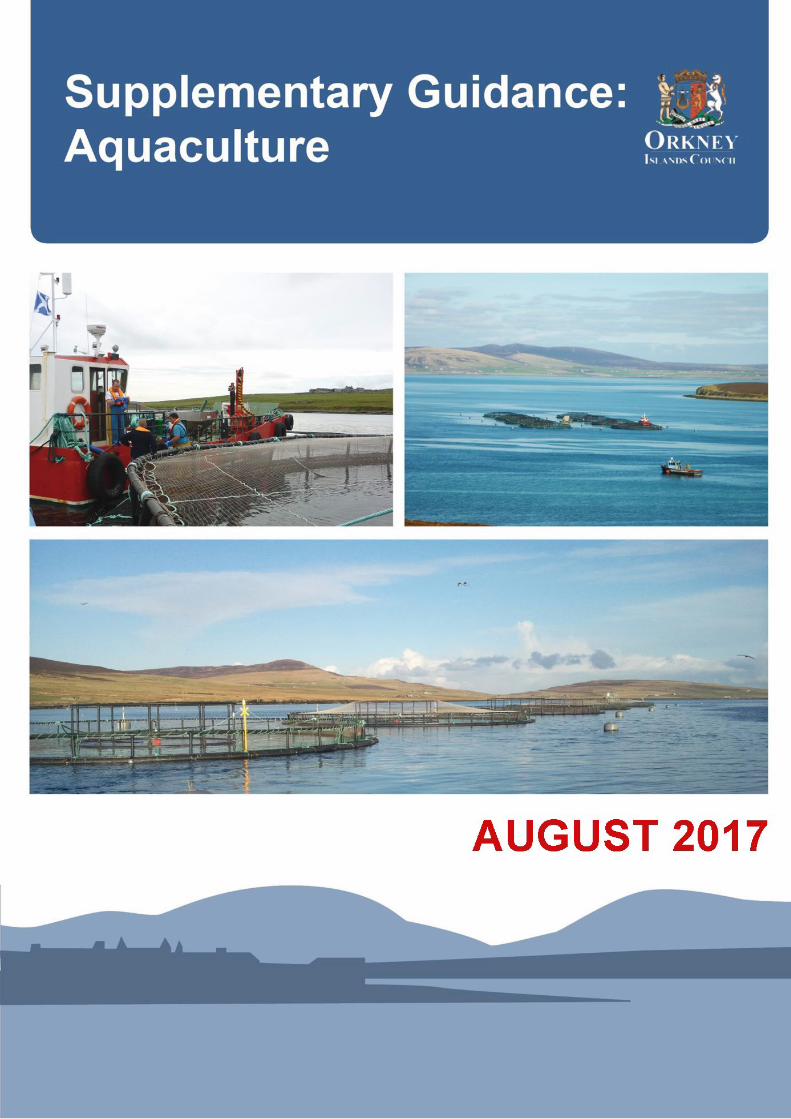
Contacting the Council Should you wish to discuss any aspect of this Supplementary Guidance, an Officer from Development Management will be available from 09:00 to 17:00, Monday to Friday to meet at the OIC Customer Services in Kirkwall or via telephone 01865873535. www.orkney.gov.uk Photo Credits: ‘Kirk Noust’ Fish Farm, off Rousay (lower image on front cover), image courtesy of Cooke Aquaculture. Front and back page graphic: View to Hoy Hills from Copland’s Dock, Stromness. Graphic © iDesign from original photograph courtesy of Anne Flint.
Supplementary Guidance: Aquaculture
2
Contents. 1. Introduction .................................................................................................... 4
How to use this guidance........................................................................................ 4
Background ........................................................................................................... 5
Policy Context ....................................................................................................... 5
Local Planning Policy .............................................................................................. 7
Spatial Strategy ..................................................................................................... 8
Spatial Strategy Map ............................................................................................ 12
Pre-application phase and preparing planning applications ..................................... 13
2. The Development Criteria .................................................................................. 14
Introduction ........................................................................................................ 14
Development Criterion 1: Landscape, Coast, Siting and Design ................................. 16
Map DC1 – Landscape Designations and Wild Land Areas ........................................ 18
Development Criterion 2: Natural Heritage Designations, Protected Species and the Wider Biodiversity and Geodiversity ...................................................................... 19
Map DC2a – International Nature Conservation Designations .................................. 22
Map DC2b – National Nature Conservation Designations ......................................... 23
Map DC2c – Designated Seal Haul-Outs ................................................................. 24
Development Criterion 3: Predator Control and Interaction with Other Species ......... 25
Development Criterion 4: Wild Salmonid Fish Populations ....................................... 27
Map DC4 – Orkney’s principal sea trout spawning burns ......................................... 31
Development Criterion 5: Water Quality and Benthic Impacts .................................. 32
Map DC5 – The Water Environment ...................................................................... 35
Development Criterion 6: Historic Environment ..................................................... 36
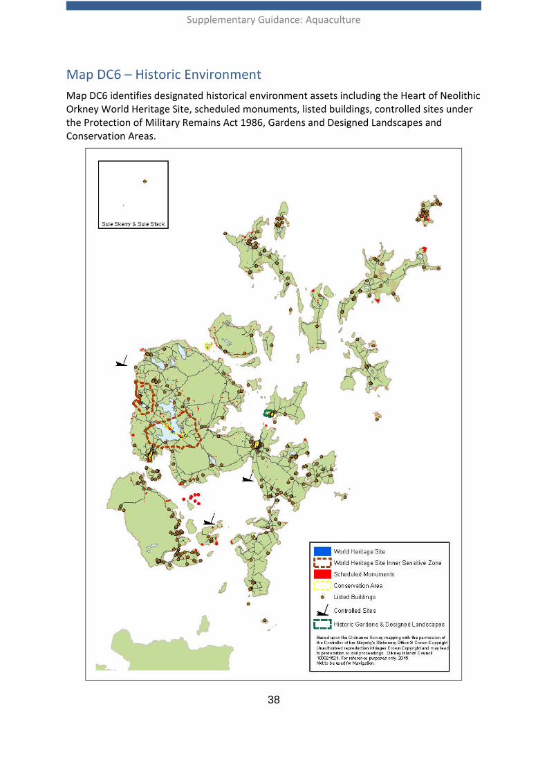
Map DC6 – Historic Environment........................................................................... 38
Development Criterion 7: Social and Economic Impacts ........................................... 39
Supplementary Guidance: Aquaculture
3
Development Criterion 8: Other Marine Users ........................................................ 40
Map DC8a – Active Aquaculture Sites .................................................................... 47
Map DC8b – Ports, Harbours, Ferries, Shipping and Navigation ................................ 48
Map DC8c – Marine Renewable Energy .................................................................. 49
Map DC8d – Pipeline, Electricity and Telecommunications Infrastructure.................. 50
Development Criterion 9: Construction and Operational Impacts ............................. 51
Development Criterion 10: Decommissioning and Reinstatement ............................ 53
3. Further Information ............................................................................................ 54
Annex 1: The role of other statutory bodies ............................................................... 60
Annex 2: Potentially significant natural heritage impact pathways arising from aquaculture operations in Orkney waters .................................................................. 63

Supplementary Guidance: Aquaculture
4
1. Introduction How to use this guidance 1.01 Applicants for planning permission and wider stakeholders are encouraged to refer
to this guidance at the earliest opportunity as it contains information to guide the location, operational aspects, scale and form of proposed aquaculture development. Planning applications will be assessed against Orkney Local Development Plan Policy 12 Coastal Development - Aquaculture and the Development Criteria set out in this Supplementary Guidance.
1.02 A successful planning application for aquaculture development will have to accord with the adopted Orkney Local Development Plan and this Supplementary Guidance, as well as other material considerations.
1.03 Aquaculture, for the purposes of this guidance, covers ‘fish farming’ which is legally defined in the Town and Country Planning (Scotland) Act 1997 (as amended) as “the breeding, rearing or keeping of fish or shellfish” (which includes any kind of crustacean or mollusc). This was amended by the Town and Country Planning (Marine Fish Farming) (Scotland) Regulations 2013 to include any kind of sea urchin. At the time of writing this guidance, seaweed cultivation requires a license from Marine Scotland and would also require a works license from Orkney Islands Council within the Orkney Harbour Area. This guidance also applies to land based aquaculture developments including hatcheries.
1.04 Planning permission is required for fish farming developments, including alterations to existing sites. It should also be noted that fish farming developments are afforded certain Permitted Development rights under the Town and Country Planning (General Permitted Development) (Fish Farming) (Scotland) Amendment Order 2012.
1.05 Planning control (i.e. the requirement for planning permission) for marine fish farming extends from mean high water springs to 12 nautical miles (the limit of territorial waters), as set out in section 26(6) of the Town and Country Planning 1997 Act (as amended). Planning permission is also required for relevant land based aquaculture developments. Currently, the jurisdiction of local development plans in relation to planning for fish farming extends out to the 3 nautical mile limit. Marine waters out to 3 nautical miles were divided into marine planning zones by the Town and Country Planning (Marine Fish Farming) (Scotland) Order 2007. As the fish farming industry looks to develop beyond 3 nautical miles, Scottish Ministers will have to consider the need to extend these marine planning zones further.
1.06 It should be noted that Scotland’s National Marine Plan encourages planners and the industry to identify opportunities for larger aquaculture developments further offshore, to increase the value of the Scottish industry and reduce potential environmental impacts at more sensitive inshore locations. In future, should fish
Supplementary Guidance: Aquaculture
5
farming extend beyond 12 nautical miles, a Marine Licence from Marine Scotland would be required as the primary consent to develop.
1.07 Relevant information and legislation is provided in the Further Information section of this guidance.
Background 1.08 Orkney, as an island community, has a long established cultural, economic and
environmental association with the sea. Salmon farming has been established for many years and the industry provides significant employment and wider economic benefit to our island communities. Salmon producers in Orkney are looking to expand their existing operations, particularly as the marine environment around Orkney enables the production of premium quality salmon products. In light of this potential for growth, it is important that aquaculture development is managed sustainably to safeguard the quality of the marine environment, whilst maximising local benefits.
Policy Context 1.09 The Council supports the growth of the aquaculture industry and the many benefits
the industry can bring to local communities. The Council aims to support the industry whilst protecting and maintaining the environment upon which our communities depend. Opportunities to diversify the aquaculture sector in Orkney will be supported, including the growth of shellfish farming and the farming of other finfish species such as halibut and wrasse. Seaweed production and multiple-trophic aquaculture systems provide further opportunities for growth and diversification of the sector.
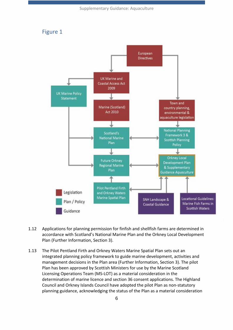
1.10 Orkney Local Development Plan Policy 12 Coastal Development – Aquaculture and this Supplementary Guidance have been developed in accordance with and/or in alignment with, as appropriate, the current relevant legislation, policies and plans identified in Figure 1. Figure 1 is not intended to be exhaustive; it simply aims to identify the main legislation, policies, plans and guidance of relevance.
1.11 Scottish Planning Policy (Further Information, Section 3) recognises that planning can help facilitate sustainable aquaculture, whilst protecting and maintaining the ecosystem upon which it depends. Scottish Planning Policy states that local development plans should make positive provision for aquaculture developments, taking account of Marine Scotland’s locational policies when identifying areas potentially suitable for new development as well as sensitive areas. Furthermore, SPP identifies that planning can play a role in supporting the sectoral growth targets to sustainably grow marine finfish (including farmed Atlantic salmon) production to 210,000 tonnes; and shellfish, particularly mussels, to 13,000 tonnes with due regard to the marine environment by 2020. This Supplementary Guidance addresses the planning issues identified in SPP for assessing specific aquaculture developments.
Supplementary Guidance: Aquaculture
6
Figure 1
1.12 Applications for planning permission for finfish and shellfish farms are determined in accordance with Scotland’s National Marine Plan and the Orkney Local Development Plan (Further Information, Section 3).
1.13 The Pilot Pentland Firth and Orkney Waters Marine Spatial Plan sets out an integrated planning policy framework to guide marine development, activities and management decisions in the Plan area (Further Information, Section 3). The pilot Plan has been approved by Scottish Ministers for use by the Marine Scotland Licensing Operations Team (MS-LOT) as a material consideration in the determination of marine licence and section 36 consent applications. The Highland Council and Orkney Islands Council have adopted the pilot Plan as non-statutory planning guidance, acknowledging the status of the Plan as a material consideration
Supplementary Guidance: Aquaculture
7
in the determination of relevant planning applications, including those for aquaculture. The pilot Plan’s General Policies apply to all development(s) and activities and should be considered in relation to aquaculture. Sectoral Policy 2 Aquaculture, and supporting information, is also applicable. The wider suite of Sectoral Policies in the pilot Plan should be considered when assessing the potential effects of aquaculture development(s) and activities on other sectors.
1.14 The Marine Spatial Plan policies are supported by spatial information presented in associated maps with the Plan. Further to this, the Plan’s spatial information can be accessed on National Marine Plan interactive (NMPi), Marine Scotland’s web based Geographical Information System (GIS), which enables users to overlay data to build up a more sophisticated picture of marine development, infrastructure, activities and resources (Further Information, Section 3).
Local Planning Policy 1.15 This Supplementary Guidance accompanies Policy 12 Coastal Development –
Aquaculture of the Orkney Local Development Plan and aims to support the development of aquaculture in appropriate locations in Orkney. The Council supports the sustainable growth of the aquaculture industry and aims to secure the significant potential benefits and address the associated challenges. This Supplementary Guidance aims to address these challenges by providing a robust framework to assess new development whilst maximising the potential benefits from the aquaculture industry in Orkney.
Supplementary Guidance: Aquaculture
8
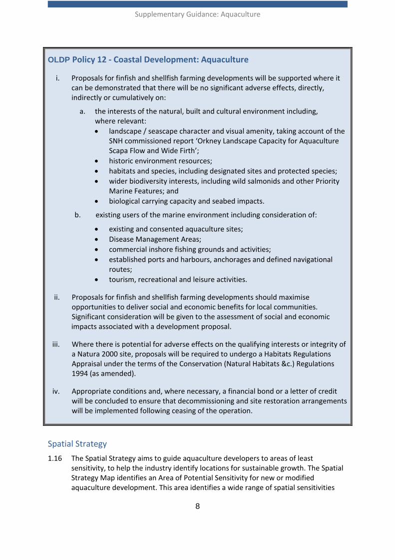
OLDP Policy 12 - Coastal Development: Aquaculture
i. Proposals for finfish and shellfish farming developments will be supported where it can be demonstrated that there will be no significant adverse effects, directly, indirectly or cumulatively on:
a. the interests of the natural, built and cultural environment including, where relevant: • landscape / seascape character and visual amenity, taking account of the
SNH commissioned report ‘Orkney Landscape Capacity for Aquaculture Scapa Flow and Wide Firth’;
• historic environment resources; • habitats and species, including designated sites and protected species; • wider biodiversity interests, including wild salmonids and other Priority
Marine Features; and • biological carrying capacity and seabed impacts.
b. existing users of the marine environment including consideration of:
• existing and consented aquaculture sites; • Disease Management Areas; • commercial inshore fishing grounds and activities; • established ports and harbours, anchorages and defined navigational
routes; • tourism, recreational and leisure activities.
ii. Proposals for finfish and shellfish farming developments should maximise opportunities to deliver social and economic benefits for local communities. Significant consideration will be given to the assessment of social and economic impacts associated with a development proposal.
iii. Where there is potential for adverse effects on the qualifying interests or integrity of a Natura 2000 site, proposals will be required to undergo a Habitats Regulations Appraisal under the terms of the Conservation (Natural Habitats &c.) Regulations 1994 (as amended).
iv. Appropriate conditions and, where necessary, a financial bond or a letter of credit will be concluded to ensure that decommissioning and site restoration arrangements will be implemented following ceasing of the operation.
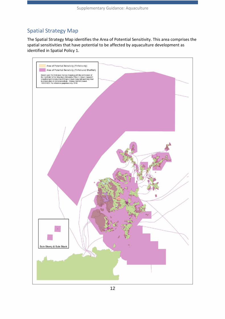
Spatial Strategy 1.16 The Spatial Strategy aims to guide aquaculture developers to areas of least
sensitivity, to help the industry identify locations for sustainable growth. The Spatial Strategy Map identifies an Area of Potential Sensitivity for new or modified aquaculture development. This area identifies a wide range of spatial sensitivities
Supplementary Guidance: Aquaculture
9
that have potential to be affected by aquaculture development. These relevant factors should be considered in the assessment of planning applications, in accordance with the Development Criteria set out in Section 2 of this guidance. The Development Criteria are supported by maps containing the sensitivities identified in the Spatial Strategy Map – Area of Potential Sensitivity.
1.17 The Spatial Strategy does not consider factors including water depth, tidal flows, current speeds, wave climate and exposure. Detailed investigation and modelling will be required on a site by site basis to inform decisions on the suitability of particular locations for aquaculture development.
1.18 Shellfish Water Protected Areas have been identified as a potential constraint in relation to new or modified finfish farms. Where new finfish development or changes to existing development is proposed within Shellfish Water Protected Areas, the likely effects on water quality of the area will be considered by the planning authority in consultation with Scottish Environment Protection Agency (SEPA). Refer to Development Criteria 5 for further information.
1.19 Due to the piecemeal nature of available spatial information on the location of benthic habitats of conservation importance, this information has not been provided to support the Spatial Strategy. Scottish Natural Heritage (SNH) can provide advice and information on the known locations of marine habitats of conservation importance (e.g. habitats identified in the UK Biodiversity Action Plan). This information should inform the site selection process for new and extended aquaculture development, so that due regard is given to marine habitats and species of conservation importance. Refer to Development Criteria 2 and Annex 2 for further guidance relating to the identification of interactions between aquaculture developments and activities and features of conservation importance.
1.20 An interactive online version of the Supplementary Guidance Aquaculture can be accessed in Further Information, Section 3. This online tool allows users to interact with the spatial information contained within the Development Criteria maps and view specific locations in greater detail.
1.21 It should be noted that the data contained within the Spatial Strategy and Development Criteria maps was current at the point in time of publishing this guidance. For up to date spatial data it is recommended that users of this guidance source information from the relevant data owners. Spatial data can be accessed on National Marine Plan interactive (NMPi).
Supplementary Guidance: Aquaculture
10
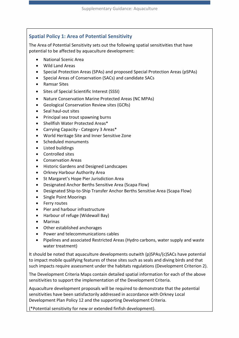
Spatial Policy 1: Area of Potential Sensitivity The Area of Potential Sensitivity sets out the following spatial sensitivities that have potential to be affected by aquaculture development:
• National Scenic Area. • Wild Land Areas. • Special Protection Areas (SPAs) and proposed Special Protection Areas (pSPAs). • Special Areas of Conservation (SACs) and candidate SACs • Ramsar Sites. • Sites of Special Scientific Interest (SSSI). • Nature Conservation Marine Protected Areas (NC MPAs). • Geological Conservation Review sites (GCRs). • Seal haul-out sites. • Principal sea trout spawning burns. • Shellfish Water Protected Areas*. • Carrying Capacity - Category 3 Areas*. • World Heritage Site and Inner Sensitive Zone. • Scheduled monuments. • Listed buildings. • Controlled sites. • Conservation Areas. • Historic Gardens and Designed Landscapes. • Orkney Harbour Authority Area. • St Margaret’s Hope Pier Jurisdiction Area. • Designated Anchor Berths Sensitive Area (Scapa Flow). • Designated Ship-to-Ship Transfer Anchor Berths Sensitive Area (Scapa Flow). • Single Point Moorings. • Ferry routes. • Pier and harbour infrastructure. • Harbour of refuge (Widewall Bay). • Marinas. • Other established anchorages • Power and telecommunications cables. • Pipelines and associated Restricted Areas (Hydro carbons, water supply and waste
water treatment).
It should be noted that aquaculture developments outwith (p)SPAs/(c)SACs have potential to impact mobile qualifying features of these sites such as seals and diving birds and that such impacts require assessment under the habitats regulations (Development Criterion 2).
The Development Criteria Maps contain detailed spatial information for each of the above sensitivities to support the implementation of the Development Criteria.
Aquaculture development proposals will be required to demonstrate that the potential sensitivities have been satisfactorily addressed in accordance with Orkney Local Development Plan Policy 12 and the supporting Development Criteria.
(*Potential sensitivity for new or extended finfish development).

Supplementary Guidance: Aquaculture
11
Supplementary Guidance: Aquaculture
12
Spatial Strategy Map The Spatial Strategy Map identifies the Area of Potential Sensitivity. This area comprises the spatial sensitivities that have potential to be affected by aquaculture development as identified in Spatial Policy 1.
Supplementary Guidance: Aquaculture
13
Pre-application phase and preparing planning applications 1.22 Scotland’s National Marine Plan (Marine Planning Policy - Aquaculture 10) states that
operators should carry out pre-application discussion and consultation, and engage with local communities and others who may be affected, to identify and, where possible, address any concerns in advance of submitting an application.
1.23 Applicants are advised to commence pre- application discussions with the planning authority (Orkney Islands Council), Orkney Harbour Authority, Scottish Natural Heritage (SNH), Marine Scotland and the Scottish Environment Protection Agency (SEPA) at the earliest possible stage. This approach will help to improve the efficiency of processing consent applications and reduce the risk of significant issues emerging later in the consenting process. The Fish Farming Planning Protocol provides further information to guide fish farming companies on their approach to pre-application engagement and consultation (Further Information, Section 3).
1.24 Applications for most finfish farms will require assessment under the Town and Country Planning (Environmental Impact Assessment) (Scotland) Regulations 2011. Where appropriate, this can involve screening and scoping stages, and Environmental Impact Assessment (EIA) information presented within an Environmental Statement. There is currently no requirement for shellfish sites to undergo EIA, though the planning authority can request all the environmental information it requires to determine an application.
1.25 Environmental Statements are complex documents. Developers need to ensure that they are accurate and there is consistency of information both within the Environmental Statement and between the Environmental Statement and the development proposals within the planning application.
1.26 Development classed as ‘national’ under the National Planning Framework or ‘major’ under the Town and Country Planning (Hierarchy of Development) (Scotland) Regulations 2009 will require formal pre-application consultation. The Scottish Government Circular 5/2009 Hierarchy of Developments provides useful guidance regarding the requirements of the regulations. For fish farms, ‘major’ developments are those with an equipment surface area exceeding 2.0 hectares, and therefore require formal pre- application consultation.
1.27 A processing agreement can be a useful project management tool to support a planning application, identifying the key processes involved in determining an application, the information required, from whom, and the timescales for the delivery of various stages of the process. When a processing agreement is appropriate, it should be developed in consultation with the other relevant agencies (See Annex 1). Further Information on processing agreements can be found in Circular 3/2013 Development Management Procedures (Further Information, Section 3).
Supplementary Guidance: Aquaculture
14
2. The Development Criteria
Introduction 2.01 This section sets out the Development Criteria against which all proposals for
aquaculture development will be assessed. It is recommended that the extent to which cumulative factors should be assessed under any of the Development Criteria is agreed with the planning authority at the earliest opportunity, preferably at the pre-application stage and/or as part of a formal EIA screening/scoping opinion. The consideration of cumulative impacts is of particular importance for proposed developments within the enclosed waters of Scapa Flow.
2.02 As set out in Table 1, Development Criteria 1, 2, 4, 5, 6 and 8 are supported by Development Criteria Maps that indicate the location of features that could be potentially sensitive to aquaculture development proposals. Further planning considerations that have not been presented spatially in the Development Criteria Maps are set out in the Development Criteria and the supporting information.
Table 1: Development Criteria and Development Criteria Maps
Development Criterion
Topic Maps
DC1 Landscape, coast , siting and design
Map DC1 – Landscape Designations and Wild Land Area 41 :Hoy
DC2 Natural heritage designations, protected species and the wider biodiversity
Map DC2a – International Nature Conservation Designations Map DC2b – National Nature Conservation Designations Map DC2c – Designated Seal Haul-Outs
DC3 Predator control and interaction with other species
DC4 Wild salmonid fish populations Map DC4 – Principal Sea Trout Burns
DC5 Water quality and benthic impacts
Map DC5 – Water Environment
DC6 Historic environment Map DC6 – Historic Environment
DC7 Social and economic impacts
DC8 Other marine users Map DC8a – Active Aquaculture Sites Map DC8b – Ports, Harbours, Ferries, Shipping and Navigation Map DC8c – Marine Renewable Energy Map DC8d Pipelines, Electricity, and

Supplementary Guidance: Aquaculture
15
Development Criterion
Topic Maps
Telecommunications Infrastructure
DC9 Construction and Operational Impacts
DC10 Decommissioning and Reinstatement
Supplementary Guidance: Aquaculture
16
Development Criterion 1: Landscape, Coast, Siting and Design
Development Criteria 1
Relevant OLDP Policy: Policy 9 - Natural Heritage and Landscape
Aquaculture development proposals must be sited and designed to minimise negative impacts on the landscape, townscape and coastal characteristics and sensitivities that are identified in the Orkney Landscape Character Assessment and North Caithness and the Orkney Coastal Character Assessment, and should be sympathetic to important natural, cultural and/or historic features within the landscape.
Consideration should be given to the siting, scale and design of the proposal, as well as the potential for cumulative effects with other developments.
Aquaculture developments with potential to have adverse effects on landscape, townscape, coastal character and visual amenity should be supported by a Landscape and Visual Impact Assessment (LVIA), in accordance with current best practice and guidance. Scottish Natural Heritage recommend use of the Guidelines for Landscape and Visual Impact Assessment (GLVIA3) developed by the Landscape Institute and Institute of Environmental Management and Assessment (IEMA) and the SNH Guidance on Landscape/Seascape Capacity for Aquaculture (Further Information, Section 3).
Where appropriate, a Landscape and Visual Impact Assessment (LVIA) should include a full cumulative assessment (CLVIA) of the proposed development, taking into consideration any existing and proposed developments.
Developers are advised to seek pre-application advice from the planning authority, in consultation with Scottish Natural Heritage, to inform decisions relating to siting and design and the scope and content of any LVIA.
2.03 The Orkney Islands feature a wide range of landscapes and coastlines, each with its own character and in turn capacity to accommodate new development. Landscape/coastal impacts and visual impacts are closely interconnected, but are assessed separately. Landscape impacts relate to the physical effect a proposed development may have, as well as the potential effect a proposed development may have on the character and the identity of a location. Visual impacts relate to what people can experience and see from places they frequent, in particular their local communities and residences, from particular viewpoints and/or sequentially along routes, including pedestrian, cycling, vehicular and ferry routes.
2.04 As a general rule, aquaculture development should not dominate its landscape/coastal setting or become the main feature, and proposals should minimise negative impacts on the overall quality of the landscape. Significant negative impact would include an adverse material change to the established landscape or coastal character which is likely to significantly affect its enjoyment.
Supplementary Guidance: Aquaculture
17
2.05 The siting, layout and design of all aquaculture proposals should reflect the character and, in particular, the scale of the landscape/coastline. Proposals should be informed by initial findings from the assessment of landscape, coastal and visual impact as part of an iterative design process, to mitigate adverse impacts.
2.06 Development should follow the dominant line and orientation of the coast and should avoid filling up a bay or the entrance to a bay. The scale, configuration and number of cages, along with the cage grid size and the design of any other support structures, should ensure the proposal is capable of being absorbed into the landscape/seascape with minimal intrusion (see SNH guidance at 2.09). Existing aquaculture development should be considered as part of the baseline coastal character.
2.07 The form of feed barges should be appropriate to the marine context and be of an appropriate scale to avoid significant detrimental impacts on the qualities of the landscape and coastal character. Given the diversity of coastal character in the Orkney Isles and the typically low viewing elevations, an iterative approach should be adopted for each development, informed by context.
2.08 Cages and lines which are too large or too numerous could coalesce, obscuring the distinct pattern and scale of coastline, intruding upon the experience of offshore islands. The pattern of mooring and navigation buoys should be simple and uniform. Lighting can affect landscape and visual amenity and methods to minimise adverse effects should be proposed by developers. Further guidance is provided in Development Criteria 9 - Construction and Operational Impacts.
2.09 Guidance on how aquaculture may be accommodated within landscapes and seascapes is provided by Scottish Natural Heritage and, where appropriate, development proposals should be informed by the following publications (Further Information, Section 3):
• The Siting and Design of Aquaculture in the Landscape: Visual and Landscape Considerations;
• Guidance on Landscape / Seascape Capacity for Aquaculture; and • Orkney Landscape Capacity for Aquaculture: Scapa Flow and Wide Firth.
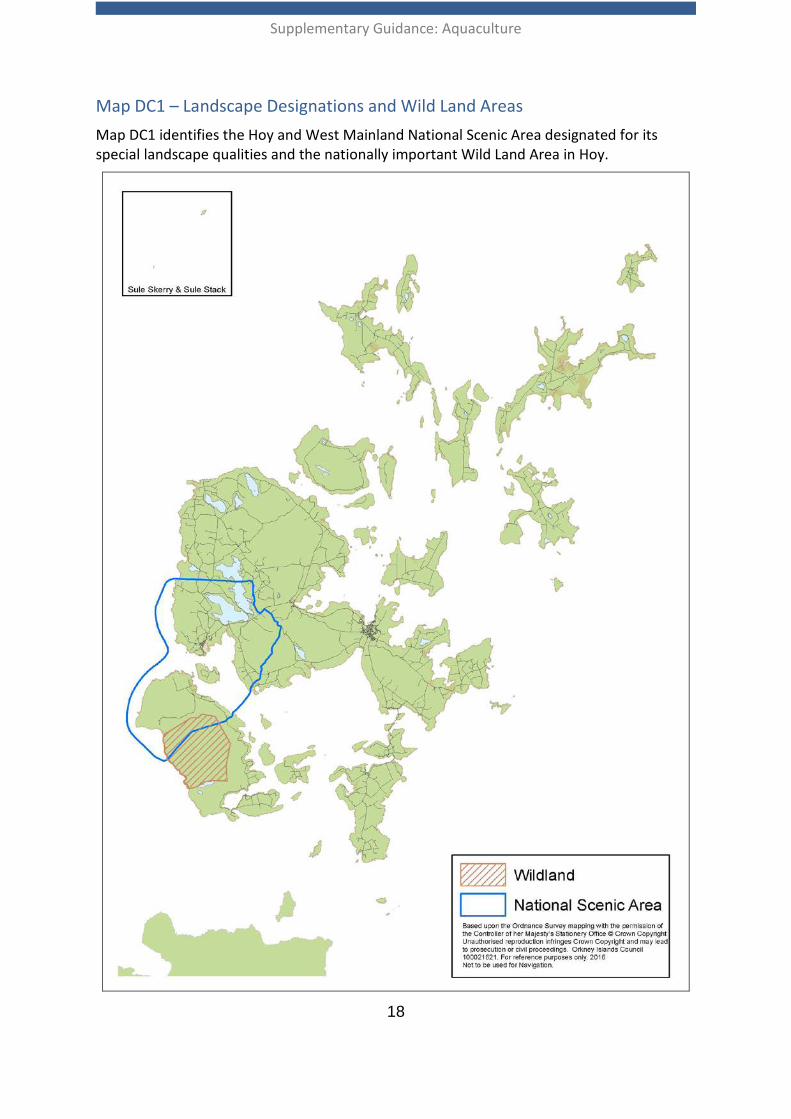
2.10 Additionally, consideration should be given to the current Orkney Landscape Character Assessment and North Caithness and Orkney Coastal Character Assessment in accordance with DC1. In relevant locations consideration should be given to potential impacts on the Hoy and West Mainland National Scenic Area (NSA) and areas of wild land. The boundary to the NSA and the Hoy Wild Land Area (WLA) are shown on Map DC1. Within the NSA, particular consideration should be given to the potential impact that a new or modified development may have on the special qualities of the NSA and/or characteristics of the WLA. Refer to Further Information, Section 3, for a description of the NSA and its special qualities along with reference to relevant character assessments.
Supplementary Guidance: Aquaculture
18
Map DC1 – Landscape Designations and Wild Land Areas Map DC1 identifies the Hoy and West Mainland National Scenic Area designated for its special landscape qualities and the nationally important Wild Land Area in Hoy.
Supplementary Guidance: Aquaculture
19
Development Criterion 2: Natural Heritage Designations, Protected Species and the Wider Biodiversity and Geodiversity
Development Criteria 2 Relevant OLDP Policy: Policy 9 - Natural Heritage and Landscape
Aquaculture development will only be permitted where due regard is given to the importance of natural heritage:
Development proposals should not result in significant adverse effects, either individually or cumulatively, on Natura 2000 sites, Ramsar Sites, Sites of Special Scientific Interest, Nature Conservation Marine Protected Areas, Local Nature Conservation Sites, Local Nature Reserves and Geological Conservation Review sites.
Developers will be required to have due regard to European Protected Species, other protected species, Priority Marine Features and the wider biodiversity and geodiversity.
Planning applications must be supported by an assessment of impact and potential mitigation which complies with the current best practice and is completed to the satisfaction of the planning authority.
Further guidance on wildlife legislation and licencing, as well as information on how locally important biodiversity and geodiversity is safeguarded, is provided in Supplementary Guidance Natural Environment (Further Information, Section 3).
2.11 Orkney has a rich and varied natural heritage which includes internationally, nationally and locally designated sites, as well as legally protected species and the wider biodiversity and geodiversity. The Nature Conservation (Scotland) Act 2004 places a duty on public bodies to further the conservation of biodiversity when exercising their respective functions. Planning is one of the Council’s functions and it is essential that the potential for adverse effects on natural heritage interests are understood and addressed in the determination of planning applications.
2.12 Applicants should be aware of the pathways by which aquaculture development may impact the natural heritage. Some of the main impact pathways relevant to aquaculture development in Orkney waters, and which should be considered in environmental assessments, are summarised in Annex 2. EIAs should inform the siting, scale/design and operation of aquaculture developments to ensure that individual or cumulative adverse effects on the natural heritage are avoided or minimised.
2.13 It is particularly important to assess impacts on the following designations and the features for which they are designated:
• Natura 2000 sites - (Special Protection Areas (SPAs) and Special Areas of Conservation (SACs)); including proposed Natura sites (as set out in Scottish Planning Policy the Scottish Government has a policy of protecting proposed SPAs (pSPAs) and candidate SACs (cSACs) as if they were designated);
Supplementary Guidance: Aquaculture
20
• Ramsar Sites; • Nature Conservation Marine Protected Areas (NC MPA); • Sites of Special Scientific Interest (SSSI); • Local Nature Reserves (LNR) ; and • Local Nature Conservation Sites (LNCS).
2.14 The boundaries of international and national natural heritage designations are shown at Map DC 2a and DC2b. Refer to Supplementary Guidance Natural Environment for information on Local Nature Reserves and Local Nature Conservation Sites (Further Information, Section 3). Development proposals will not be successful where there would be significant adverse effects, either individually or cumulatively, on Natura 2000 sites; Ramsar sites; Sites of Special Scientific Interest or Nature Conservation Marine Protected Areas, with the national policy tests for each designation guiding assessment. Developers will be required to have due regard to wider biodiversity and geodiversity interests and to comply with the relevant policies of the Orkney Local Development Plan. Further detailed policy guidance on these natural heritage interests is provided in Supplementary Guidance Natural Environment (Further Information, Section 3).
2.15 Under the terms of the Marine (Scotland) Act 2010 it is an offence to kill, injure or take a seal at any time of year, except to alleviate suffering or where a licence has been issued to do so, e.g. to protect the interests of aquaculture. The Act also provides for additional protection for seals at designated haul-out sites, where it is an offence to intentionally or recklessly harass seals. Designated seal haul-outs in Orkney are identified in Map DC2c and a list of sites can be accessed in Further Information, Section 3. The Scottish Government is responsible for the identification and designation of seal haul-out sites.
2.16 Priority Marine Features (PMF) are habitats and species which are considered to be of conservation importance in Scotland’s seas. They include many features which are characteristic of the Scottish marine environment; examples of particular relevance to aquaculture developments in Orkney include benthic habitats such as maerl beds, horse mussel beds and seagrass meadows and species such as sea trout, basking shark, common/flapper skate, fan mussel, northern featherstar, spiny lobster and ocean quahog. The full list of 81 PMFs can be accessed on the Scottish Natural Heritage website (Further Information, Section 3).
2.17 Information on PMFs, including seabed habitats and species in Orkney waters, as elsewhere, is piecemeal. Systematic national sample surveys in the 1980s for the Joint Nature Conservation Committee’s (JNCC) Marine Nature Conservation Review (MNCR) have been augmented recently by further surveys to support application of the Scottish Government’s Guidelines on the selection of Marine Protected Areas (MPAs) and development of the MPA network. Other site based surveys have been carried out to support aquaculture and marine renewables developments. MNCR records and more recent data collected by public bodies can be accessed from National Marine Plan interactive (NMPi). This is periodically updated by Scottish Natural Heritage and JNCC (Further Information, Section 3).
Supplementary Guidance: Aquaculture
21
2.18 Where sufficient recent benthic habitat information is not available, site specific habitat survey and assessments will be required to support planning applications. For new fish farms or extensions exceeding standard thresholds, applicants will be required to carry out a visual survey. Thresholds and standards for visual surveys are detailed in the SEPA Fish Farm Manual, Annex F (Further Information, Section 3).
2.19 The planning authority will be advised by Scottish Natural Heritage in relation to the potential effects of development on nationally and internationally designated sites as well as protected species. The potential impact of a development proposal on the wider biodiversity and geodiversity, including protected species which are located outwith designated areas, will also be considered for all applications.
2.20 NMPi and the Orkney Wildlife Information and Records Centre provide useful sources of information on the distribution of priority habitats or species in Orkney and developers are encouraged to make use of these resources (Further Information, Section 3).
Supplementary Guidance: Aquaculture
22
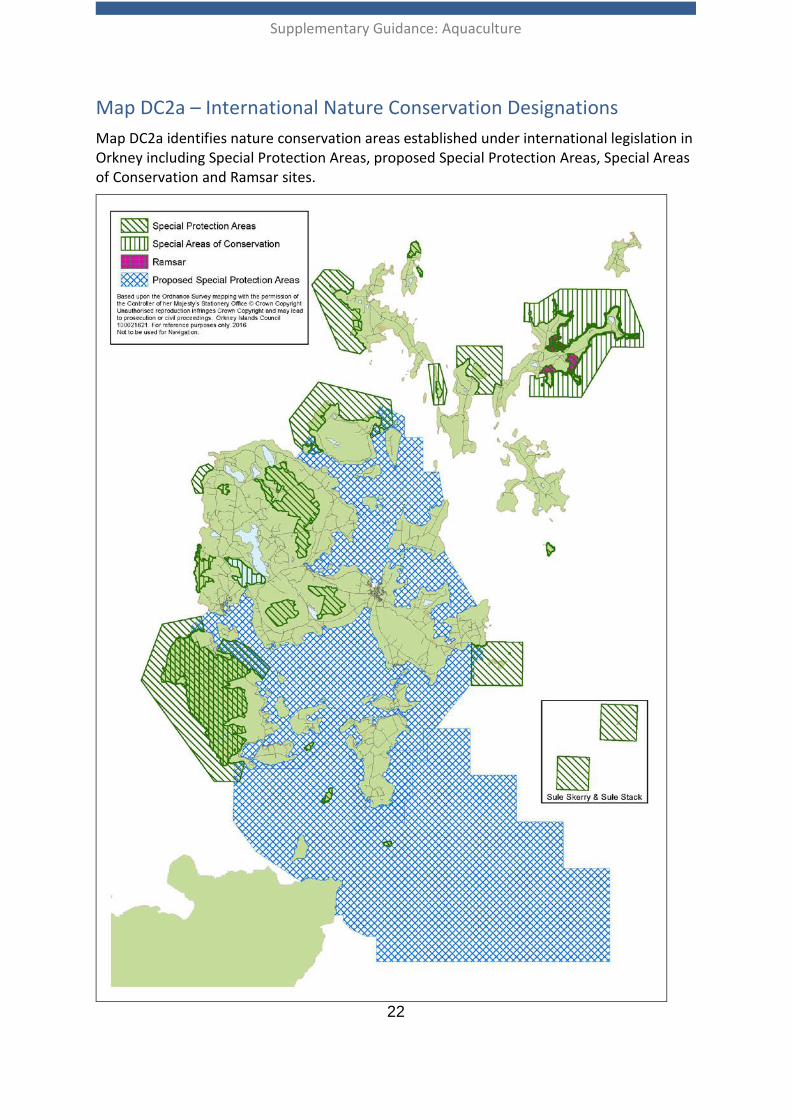
Map DC2a – International Nature Conservation Designations Map DC2a identifies nature conservation areas established under international legislation in Orkney including Special Protection Areas, proposed Special Protection Areas, Special Areas of Conservation and Ramsar sites.
Supplementary Guidance: Aquaculture
23
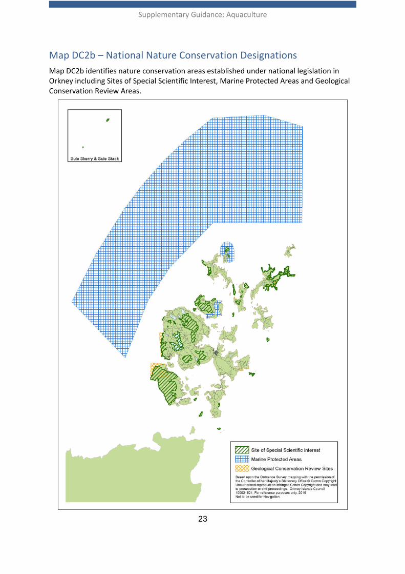
Map DC2b – National Nature Conservation Designations Map DC2b identifies nature conservation areas established under national legislation in Orkney including Sites of Special Scientific Interest, Marine Protected Areas and Geological Conservation Review Areas.
Supplementary Guidance: Aquaculture
24
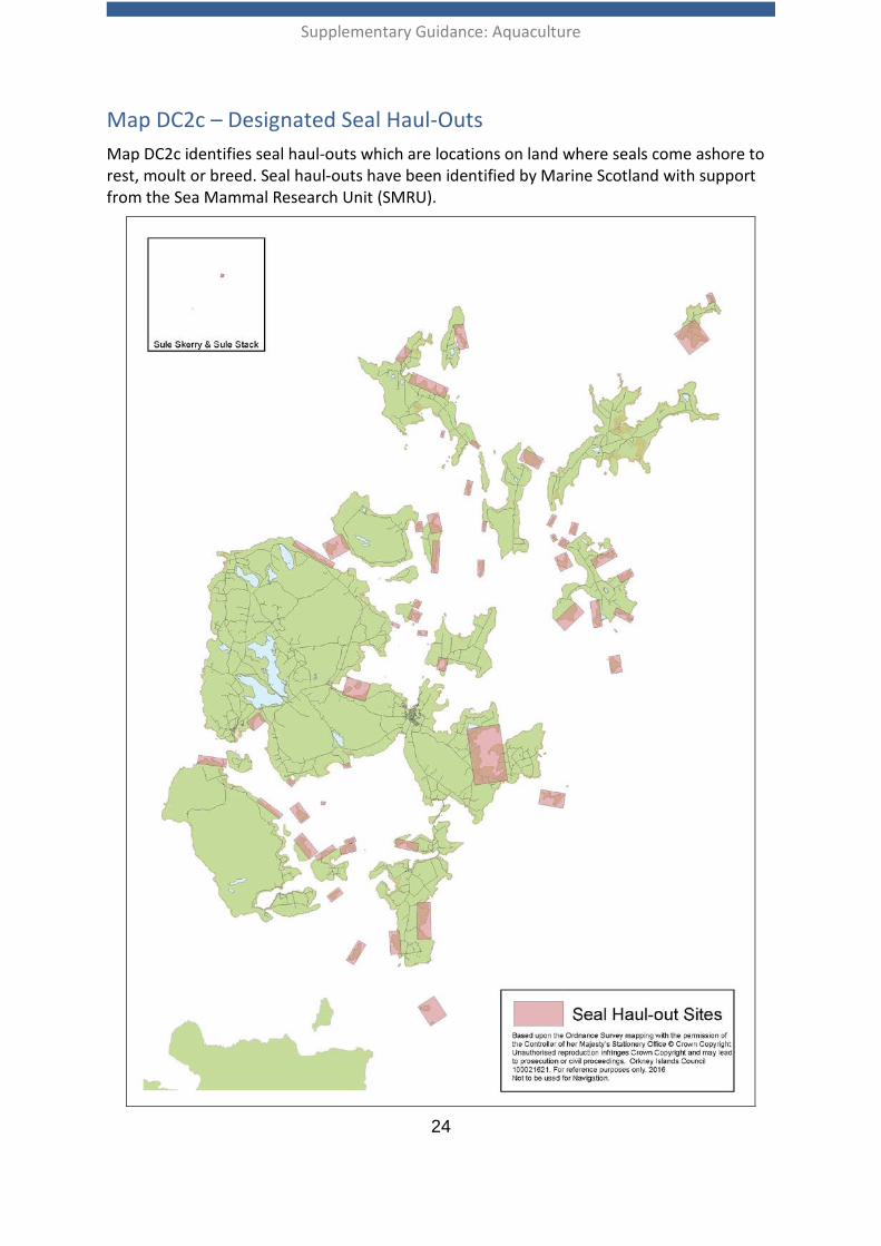
Map DC2c – Designated Seal Haul-Outs Map DC2c identifies seal haul-outs which are locations on land where seals come ashore to rest, moult or breed. Seal haul-outs have been identified by Marine Scotland with support from the Sea Mammal Research Unit (SMRU).
Supplementary Guidance: Aquaculture
25
Development Criterion 3: Predator Control and Interaction with Other Species
Development Criteria 3 Relevant OLDP Policy: Policy 9 - Natural Heritage and Landscape
Where appropriate, planning applications should be supported by a predator management strategy which complies with the current guidance and best practice from Scottish Natural Heritage and is completed to the satisfaction of the planning authority. Predator control methods should not result in significant adverse effects on natural heritage.
In order to enable the determination of site-specific risks, where appropriate, the developer will be required to provide information on the proposed predator management system, as well as the presence and abundance of species that might be at risk from any proposed anti-predator method.
An Environmental Management Plan may require to be submitted as part of a planning application to support ongoing monitoring, reporting and adaptive management measures for predator control through the lifetime of the development. An adaptive Environmental Management Plan can provide a useful mechanism to allow development where the impacts are not fully understood, enabling data to be collected and the development to be amended during its lifetime.
The Planning Authority will be advised by Marine Scotland and Scottish Natural Heritage on the potential for predator control measures to affect European Protected Species.
2.21 Aquaculture developers should aim to locate developments in locations that reduce the risk of predation and associated potentially damaging interactions with predators. Wild predators, which may include seals, otters and certain bird species, may be attracted to stocked fish cages, and there is potential for finfish farms to sustain considerable losses. These may occur either as a result of direct fish kills and removal, or as excess fish mortality following wounds or stress sustained during unsuccessful attacks. Damage caused to cage nets by seals can have a significant negative financial impact on fish farm operators and may also allow large scale fish escapes into the open sea with adverse consequences for wild salmonid fish populations, see Development Criterion 4. Shellfish farms also attract predators, in particular diving birds such as eider, which feed on mussel stocks.
2.22 Certain measures to deter predators may prove effective in preventing loss of stock but at the same time could carry an unacceptable level of risk to marine birds and mammals (see Annex 2). For example, top nets and sub-sea nets can pose a risk of fatal entanglement to diving birds. Where appropriate, the preferred method of predator control would be passive, non-destructive methods, such as well tensioned nets of appropriate mesh size and the use of locations where the risk of potentially damaging interactions with wildlife are low.
Supplementary Guidance: Aquaculture
26
2.23 Site location is an important factor for consideration when determining the suitability of Acoustic Deterrent Devices (ADDs) as a method for deterring predation by seals. Within or near to the following sensitive areas, the deployment of ADDs has potential to adversely affect wildlife:
• Special Areas of Conservation, where seal is one of the qualifying interests; • designated seal haul-out sites and pupping areas; • Straits, sounds and embayments, where cetaceans (which are European
Protected Species) are frequently observed and where the presence of ADDs may cause a barrier to passage;
• Headlands and tidal upwelling areas that may be important feeding areas for cetaceans.
2.24 The use of ADDs that could cause disturbance to European Protected Species (EPS) may require an EPS licence, which will only be granted if the applicant can satisfy strict legal tests.
2.25 The predator management strategy should identify measures which will prevent stock escapes, while also avoiding or minimising adverse effects on predatory species, including incidental impacts on other non-predatory species. It should set out the hierarchy of proposed measures to be adopted, including measures to be adopted in the case of persistent predation, as well as a detailed description of the proposed operational methods. For example, net materials and colours; mesh sizes; tensioning systems on cage and anti-predator nets; separation distances between top nets and the water surface and/or between external predator nets and cage nets; the frequency with which fish mortalities will be removed; the frequency with which nets will be checked for entanglement, and how records of entanglements will be maintained and made available to the planning authority and Scottish Natural Heritage.
2.26 Marine Scotland, with advice from SNH, licences lethal control of seals and uses Potential Biological Removal (PBR) figures developed by the Sea Mammal Research Unit for each seal management region to inform the total number of licences that may be granted. It should be noted that the status of the harbour seal population within the Orkney and North Coast Management Area and low PBR means that in 2016 no licences were issued for lethal control of harbour seals in Orkney waters.
Supplementary Guidance: Aquaculture
27
Development Criterion 4: Wild Salmonid Fish Populations
Development Criteria 4
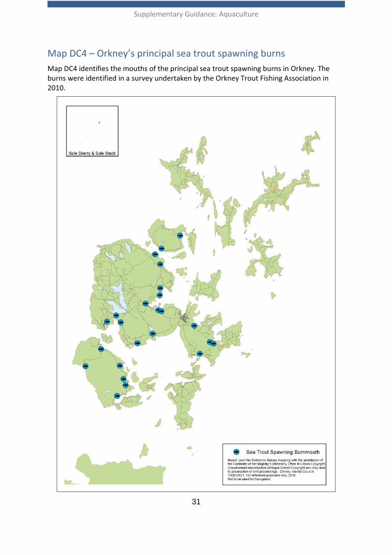
Relevant OLDP Policy: Policy 9 - Natural Heritage and Landscape
Where there are potentially significant risks, developers should provide an assessment of the potential impacts, including cumulative impacts, on wild salmonid fish populations as identified in the UK Biodiversity Action Plan and/or Scottish Biodiversity Strategy, as part of an Environmental Impact Assessment (EIA).
Marine Scotland will be consulted on planning applications that have potential for significant adverse effects, including cumulative effects, on wild salmonid fish species. The planning authority will be advised by Marine Scotland as to whether a proposed development is likely to have any significant adverse effects on wild salmonid fish populations.
Where it is determined that a development is likely to have significant adverse effects, planning applications should be supported by a mitigation plan to minimise impacts on wild salmonid fish populations.
An Environmental Management Plan may require to be submitted as part of a planning application to demonstrate how it is proposed to ensure sustainable management of wild salmonid fish stocks including details of ongoing monitoring, reporting and adaptive management measures throughout the lifetime of the development.
Development proposals with potential for significant adverse effects on wild salmonid fish species, that are not addressed through effective mitigation, will not be supported.
Context 2.27 Wild salmonid fish populations represent an important economic, environmental
and recreational resource in Orkney. Coastal waters support populations of sea trout Salmo trutta, a species which forms part of a vibrant sport fishery, enabling angling tourism to make a significant contribution to the Orkney economy. The sea trout is a brown trout which migrates to the sea for a part of its life cycle, returning to certain freshwater burns to spawn. The sea trout is listed as a Priority Species in the UK Biodiversity Action Plan, the Scottish Biodiversity List and in its marine phase is also included on the list of Priority Marine Features (PMFs). There are no Atlantic salmon Salmo salar breeding rivers in Orkney though salmon are likely to migrate through Orkney waters.
2.28 Scotland’s National Marine Plan recognises that salmon and trout fisheries make a significant contribution to the Scottish economy and aims to maintain and improve the environment within which the sustainable exploitation of salmon and trout can continue to provide economic, social and recreational benefits.

Supplementary Guidance: Aquaculture
28
2.29 The key potential impacts of aquaculture development on wild salmonid fish populations are:
• impacts of parasites (sea lice) and disease on wild fish resulting from the presence of fish farms;
• disruption of genetic integrity and local adaptations of wild stocks arising from interbreeding with escapees from salmon farms; and
• introduction of non-native farmed species.
2.30 Marine Scotland enforces provisions on containment and parasite (sea lice) control under the Aquaculture and Fisheries (Scotland) Act 2007. The Act provides for a series of information gathering, inspection and enforcement measures aimed at controlling parasites on finfish and shellfish farms and improving, in respect of finfish farms only, the containment and recovery of escaped fish. It also contains measures which regulate the movement of live fish with a view to preventing the spread of fish diseases.
2.31 Marine Scotland requires the developer to provide information which demonstrates that the business has taken adequate consideration of measures to minimise the impact of escapes, minimise the risk of disease spread and deter predation. Marine Scotland provides formal advice to the planning authority on the adequacy of control measures available to developers to deal with sea louse infestations in order to minimise the potential impacts on wild salmonid stocks. This allows the planning authority to make informed decisions on the suitability of developments in terms of the potential for impacts on populations of wild salmonid stocks in proximity to any proposed development.
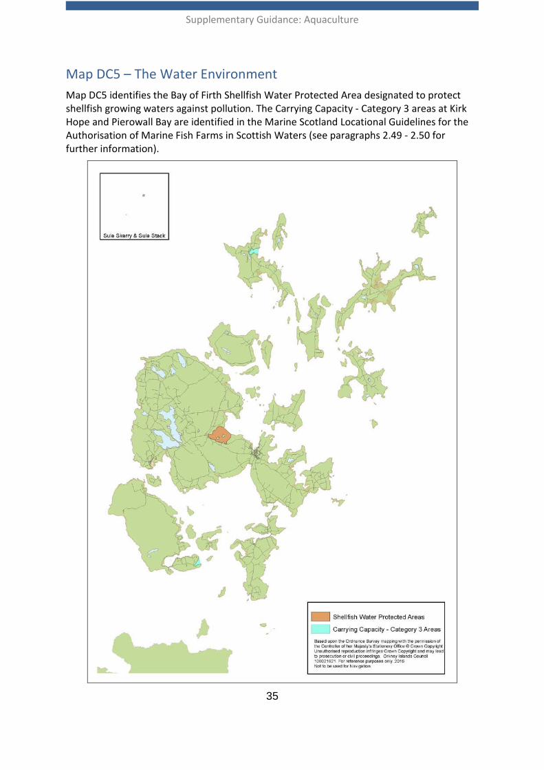
Sea lice management 2.32 Sea lice are naturally occurring parasites which are routinely present in low numbers
within wild salmonid fish populations. In the marine environment farmed fish are also susceptible to infection by sea lice where, due to the intensive nature of aquaculture, there is potential for large numbers of lice to become concentrated within relatively small areas. Wild sea trout, in particular juvenile fish entering the sea from spawning burns, are vulnerable to infection by the species Lepeophtheirus salmonis. Heavy burdens of L.salmonis can compromise the future viability of individual infected fish and also have potential to impact on sea trout at the population level. Caligus elongatus is another species of sea louse found in Orkney waters, however it is not considered to carry a significant risk to wild salmonid fish populations.
2.33 A survey undertaken by the Orkney Trout Fishing Association in 2010 has identified the principal sea trout spawning burns in Orkney (Further Information, Section 3). The mouths of the principal sea trout spawning burns in Orkney are identified on Map DC4.
2.34 There is potential for sea lice from fish farms to impact on wild sea trout, although the extent to which sea trout populations are affected is not clear and will depend
Supplementary Guidance: Aquaculture
29
on movements of both lice and sea trout populations, which are currently not well understood. The larval stages of sea lice are planktonic, occupying the upper layers of the water column. Site specific factors including tidal currents, prevailing wind and local topography can have a significant impact on the direction and extent of lice dispersal.
2.35 SEPA is the licensing authority for the discharge of medicines that are used to treat farmed fish for sea louse infestation but has no powers to control or regulate sea louse infestations, or the consequences of such infestations upon wild salmonid stocks. Marine Scotland is the licensing authority for the discharge of medicines that are used to treat farmed fish in well boats for sea louse infestations. Well boats are only licensed to discharge at the corresponding fish farm.
2.36 Other methods of controlling sea lice include the use of cleaner fish such as wrasse or lumpfish. The planning authority is supportive of the use of cleaner fish in principle, subject to the developer demonstrating that permission has been granted by the Fish Health Inspectorate (FHI) to include such species on the relevant Aquaculture Production Business authorisation. The use of sustainably sourced cleaner fish is encouraged.
2.37 In assessing risk of parasite or disease transfer, consideration will be given to species, site position, husbandry techniques and the hydrology of the surrounding area, as well as interactions among sites. The assessment should also consider the cumulative effects of the proposed development with existing aquaculture developments. In order to enable a full assessment to be undertaken of the likely cumulative effects, developers will be expected to share information as necessary.
Containment and fish escapes 2.38 Industry best practice on containment is provided in the Code of Good Practice for
Finfish Aquaculture (Further Information, Section 3). Developers should adhere to the industry Code of Good Practice to minimise the risk of fish escapes as, once in the wild, most escapees are unlikely to be recovered.
2.39 A Technical Standard for Scottish Finfish Aquaculture has been developed to help prevent fish escapes as a result of technical failure. Following the publication of the Scottish Technical Requirements Regulations, all relevant equipment must comply with the standard by 2020 at the latest (Further information, Section 3).
2.40 However, it is possible that numbers of fish may enter the local environment from where, in order to protect wild salmonid spawning waters, developers are expected to produce a realistic plan for their recovery. Given the absence of salmon rivers in Orkney, potential impacts associated with fish escapes are more likely to affect migratory salmon or salmon populations, and hence fresh water pearl mussel populations, in rivers outwith Orkney. Planning conditions may be used to ensure that the relevant management/containment plan is put in place prior to the commencement of development.
Supplementary Guidance: Aquaculture
30
2.41 Given the importance of Orkney waters to populations of diving birds, including SPA populations, there are considerable constraints around any proposed use of gill or other static nets to recapture escaped fish. Where deployment of such nets could impact birds from SPA or pSPAs, any authorisation by Marine Scotland for the use of gill nets would require them, as the Competent Authority, and with advice from SNH, to carry out an appropriate assessment in view of the sites’ conservation objectives for their qualifying interest(s). This requirement may render use of gill nets unfeasible in the context of emergency response to fish escape, as additional time would be required to consider any application for use. The planning authority does not support the use of gill nets to recapture escaped fish in Orkney waters.
Fish Farm Management 2.42 Area Management Agreements between neighbouring fish farms can enable a
coordinated approach to fish farm management, including sea lice control, and can also lead to improved fallowing strategies, as well as more robust contingency plans for fish escapes. Synchronous fallowing, where clusters of sites operate as single year-class sites, can be effective in breaking the cycle of sealice infestation, maturation and larval dispersion. The planning authority supports the development of binding Area Management Agreements to promote the sustainable management of aquaculture in Orkney and to encourage cooperation between the local aquaculture industry and wild fisheries interests.
2.43 Disease Management Areas were established in the Final Report of the Joint Government/Industry Working Group on Infectious Salmon Anaemia in January 2000, based on separation distances around active farms, taking into account tidal excursions and other epidemiological risk factors. Farms with overlapping separation distances are usually within the same Disease Management Area. At the time of drafting this guidance, there were three disease management areas in Orkney, though it should be noted that Disease Management Area boundaries may be revised by Marine Scotland to take account of any changes in fish farm location. See Further Information Section 3 to access the Marine Scotland Disease Management Area Maps.
2.44 New sites that would have no effect on existing disease management areas or are in disease management areas of their own, pose less of a risk to the spread of disease than those which bridge disease management areas. Therefore, there is a general presumption against farming at new sites that bridge existing Disease Management Areas as detailed in Scotland’s National Marine Plan policy Aquaculture 6.
Supplementary Guidance: Aquaculture
31
Map DC4 – Orkney’s principal sea trout spawning burns Map DC4 identifies the mouths of the principal sea trout spawning burns in Orkney. The burns were identified in a survey undertaken by the Orkney Trout Fishing Association in 2010.
Supplementary Guidance: Aquaculture
32
Development Criterion 5: Water Quality and Benthic Impacts
Development Criteria 5 Relevant OLDP Policy: Policy 9 - Natural Heritage and Landscape
Aquaculture development proposals should seek to protect and, where possible, improve the water environment. Where this is not possible, it must be clearly demonstrated that the development will avoid causing deterioration in the water quality or overall status of water bodies and, for any water body currently not achieving good status, will not prevent it from being able to achieve good status in the future.
Development proposals will require to be supported by modelling and calculations which demonstrate that the water column and benthic impacts are localised and within environmental limits, taking account of cumulative impacts.
The planning authority will be advised by SEPA on issues relating to water quality and benthic impacts.
2.45 All aquaculture developments rely on high water quality and a degree of tidal flushing. In inshore marine locations it is important to select sites with good water exchange characteristics where tidal currents can disperse waste materials, maintaining well-oxygenated water conditions and, in the case of shellfish cultivation, providing adequate supplies of planktonic food organisms.
2.46 Finfish cage sites are likely to impact upon the seabed. Inputs to the environment include fish feed, chemicals and medicines authorised for the treatment of sea lice and other fish health issues. Outputs from a farm include uneaten food, faecal waste, nutrients and mortalities. Potential impacts on the benthic (seabed) environment include enrichment with nutrient and carbon rich wastes, causing anoxic conditions to develop on the seabed and disturbance to the balance of organisms at the site. In addition, dissolved wastes may cause elevated levels of nutrients in the water column. The inputs from shellfish farms to the water column are usually minimal, as shellfish feed on marine plankton and no additional feed is required. However, shellfish farms do give rise to limited seabed impacts and in particularly sensitive locations (e.g. designated reefs, maerl beds) these may need to be considered. Please see Further Information in Section 3 for more details.
2.47 In order to realise improvements to water quality, a key objective of the Scotland River Basin Management Plan (Further Information, Section 3) is that water bodies should achieve a standard known as ‘good ecological status’, and that there is no deterioration in current status. Coastal waters in and around Orkney are currently classified as being at either ‘good’ or ‘high’ water quality and overall status. The Water Environment (Controlled Activities) (Scotland) Regulations 2011 (CAR) provide the Scottish Environment Protection Agency (SEPA) with powers to ensure that activities which may pose a risk to the water environment are controlled. With regard to fin fish farming, SEPA sets limits on the amount of fish (biomass) that can
Supplementary Guidance: Aquaculture
33
be held in the cages, the amount of food used and the amount of certain medicines that can be administered and discharged. The CAR licencing process takes account of the likely effects of discharges from the proposed development on both the water column and benthic environments. Where planning permission is being sought for new sites or modifications involving an increase in biomass, or the installation of equipment which is likely to result in an increase in the level of benthic effects from carbon deposition, evidence will be required to satisfy SEPA that these impacts will be within acceptable limits before it can be recommended to the planning authority that a proposed development can proceed. River Basin Management Plan for Scotland identifies one inland burn in Orkney at bad status, the Hourston Burn, but this is for reasons unrelated to aquaculture development.
2.48 Where operational practices include the need to discharge from a well boat, for example following onboard treatment of fish for sea lice or disease, Marine Scotland licence this activity under the Marine (Scotland) Act 2010. The Scottish Government however recently published a document including an intention to move the licensing of wellboat discharges at fish farm premises into the CAR regime. See Further Information Section 3, Independent review of Scottish aquaculture consenting - Scottish Government Response.
2.49 The Marine Scotland Locational Guidelines for the Authorisation of Marine Fish Farms in Scottish Waters (Further Information Section 3) categorise sea lochs, voes and embayments into three categories based on predictions of the impacts from the existing scale of development. Models predicting the nutrient enhancement of the water column and the proportion of sea bed likely to be degraded are used to identify sea lochs, voes and embayments more likely to be able to support additional farmed fish biomass. Currently, no further increases in maximum biomass are permitted in Category 1 areas. Increases are more likely to be permitted in Category 2 and 3 areas (subject to EIA and CAR).
2.50 Scotland’s National Marine Plan Policy Aquaculture 8 states that in relation to nutrient enhancement and benthic impacts, fish farm development is likely to be acceptable in Category 3 areas, subject to other criteria being satisfied. Within Orkney, Kirk Hope in Walls and Pierowall Bay, Westray, are identified as Category 3 areas (Map DC5). The remainder of Orkney waters have not been categorised as the Marine Scotland Locational Guidelines do not categorise bodies of open water as these cannot be accurately assessed by the predictive models available. Site selection in these areas will therefore require site specific survey including assessment of exposure, depth and current speed and direction.
2.51 Shellfish growing waters are regulated and protected in order to support shellfish life and growth, contributing to the high quality of edible shellfish products and also to protect shellfish growing waters against pollution and, where necessary, establish programmes to reduce pollution. Bacteria in the water column, for example from discharges of sewage as well as agricultural and urban diffuse pollution, may threaten the quality of waters used for growing shellfish. The Scottish Government has introduced a package of measures to ensure the continued protection and
Supplementary Guidance: Aquaculture
34
improvement of Scotland’s shellfish growing waters by integrating these within the river basin management planning process and defining them as Shellfish Water Protected Areas.
2.52 Scotland’s National Marine Plan policy Aquaculture 4 sets out a presumption that further sustainable expansion of shellfish farms should be located in designated shellfish waters if these have sufficient capacity to support such development. The Bay of Firth is the only Shellfish Water Protected Area in Orkney (Map DC5). It should be noted that in principle the planning authority supports the development of new shell fish growing sites, particularly in Shellfish Water Protected Areas. Where this is not possible, the location of new shellfish sites in proximity to existing sewage discharges or waters with diffuse pollution inputs should be avoided, in consultation with SEPA. Refer to Map DC8d for the location of waste water treatment discharges. Where new finfish development or changes to existing development is proposed within a Shellfish Water Protection Area the likely effects on water quality of the area will be considered by the planning authority in consultation with SEPA. It is not anticipated that the presence of an aquaculture site will impose additional investment requirements on Scottish Water authorised activities making discharges to the water environment.
2.53 Further guidance on identifying and assessing effects on benthic habitats of conservation importance is provided within Development Criteria 2.
Supplementary Guidance: Aquaculture
35
Map DC5 – The Water Environment Map DC5 identifies the Bay of Firth Shellfish Water Protected Area designated to protect shellfish growing waters against pollution. The Carrying Capacity - Category 3 areas at Kirk Hope and Pierowall Bay are identified in the Marine Scotland Locational Guidelines for the Authorisation of Marine Fish Farms in Scottish Waters (see paragraphs 2.49 - 2.50 for further information).
Supplementary Guidance: Aquaculture
36
Development Criterion 6: Historic Environment
Development Criteria 6 Relevant OLDP Policy: Policy 8 - Historic Environment and Cultural Heritage
Aquaculture development which preserves or enhances the archaeological, architectural, artistic, commemorative or historic significance of cultural heritage assets, including their settings, will be supported. Development which would have a substantial adverse impact on this significance will only be permitted where it can be demonstrated that:
i. All reasonable measures will be taken to mitigate any loss of this significance.
ii. Any lost significance which cannot be mitigated is outweighed by the social, economic, environmental or safety benefits of the development.
Further information on all aspects of the implementation of this policy can be found in Supplementary Guidance Historic Environment and Cultural Heritage (Further Information, Section 3).
2.54 Orkney’s marine archaeology is an internationally significant part of the county’s cultural heritage, and is an important economic resource for the local tourism industry. The most well-known sites include the wrecks of the German High Seas Fleet and those of HMS Royal Oak, HMS Vanguard and HMS Hampshire, along with other wrecked ships and planes from the First and Second World Wars. Other marine archaeological remains include wrecks from earlier periods, such as the Svecia, and environmental deposits in submerged landscapes. These sites could be affected by aquaculture either directly, through physical disturbance, or indirectly, such as through changes to settings or sediment regimes.
2.55 A substantial amount of cultural heritage is also located on Orkney’s coastlines, including a significant proportion of marine infrastructure, such as piers and lighthouses. Several historic settlements, such as Kirkwall, Stromness and St Margaret’s Hope, are also located around historic harbours. Aquaculture developments could affect the settings of these sites.
2.56 The following sites have legal protection, which should be fully taken into account when designing and siting aquaculture developments:
• The Heart of Neolithic Orkney World Heritage Site • Listed buildings • Conservation Areas • Gardens and Designed Landscapes • Scheduled monuments • Historic Marine Protected Areas • Battlefields • Protected places and controlled sites under the Protection of Military Remains
Act 1986 • Sites containing human remains.
Supplementary Guidance: Aquaculture
37
2.57 The above sites in Orkney waters are identified on Map DC6. PastMap is a web based Geographical information System (GIS) maintained by Historic Environment Scotland containing data on the sites identified at 2.56. Information on non-designated historic environment remains can be accessed via the Canmore database (Further Information, Section 3).
2.58 For fin fish farms, the historic environment should be considered in an Environmental Impact Assessment (EIA). The assessment should include the direct and indirect effect of the development on the setting of scheduled monuments, listed buildings and unscheduled monuments, as well as the likelihood of transboundary impacts on scheduled wrecks and protected war graves. Additional factors for consideration include hydrology and sedimentary regimes and any chemical/biological changes that may occur in the water environment in the vicinity of underwater sites as a result of the development and its ongoing operation. Developers may be required to provide a visual impact analysis or Cultural Heritage Impact Assessment to enable potential impacts to be assessed. For non EIA development, where appropriate, information regarding effects on the historic environment will be requested by the planning authority.
Supplementary Guidance: Aquaculture
38
Map DC6 – Historic Environment Map DC6 identifies designated historical environment assets including the Heart of Neolithic Orkney World Heritage Site, scheduled monuments, listed buildings, controlled sites under the Protection of Military Remains Act 1986, Gardens and Designed Landscapes and Conservation Areas.
Supplementary Guidance: Aquaculture
39
Development Criterion 7: Social and Economic Impacts
Development Criteria 7 Sustainable aquaculture development which provides significant social and/or economic benefits for local communities will be supported.
When assessing the social and economic impact of a development proposal, the following factors will be taken into consideration by the planning authority:
• Potential for the development to create sustainable employment benefits and create skilled employment in local communities;
• Opportunities from the development to support local supply chains; • Significant adverse social, economic and operational effects on existing activities
and/or infrastructure have been avoided or, where avoidance is not possible, adverse effects have been appropriately mitigated;
For relevant planning applications, socio-economic impacts should be assessed as part of the Environmental Impact Assessment (EIA). Where an EIA is not required, the planning authority may request information from the developer to enable an assessment of socio-economic impacts to be undertaken.
Further relevant guidance on the assessment of impacts on other marine users is set out under Development Criteria 8.
2.59 Scottish Planning Policy recognises that aquaculture makes a significant contribution to the Scottish economy, particularly for coastal and island communities. The Council supports the sustainable growth of the aquaculture sector in Orkney, to help realise the potentially significant socio-economic benefits. Marine Scotland commissioned An Assessment of the Benefits to Scotland of Aquaculture in 2014 (Further Information, Section 3).
2.60 Orkney Local Development Plan Policy 12 Coastal Development – Aquaculture states that proposals for finfish and shellfish farming developments should maximise opportunities to deliver social and economic benefits for local communities. Furthermore, this policy states that significant consideration will be given to the assessment of social and economic impacts associated with a development proposal.
2.61 Scotland’s National Marine Plan recognises that the combination of developments in traditional aquaculture production, seaweed cultivation and offshore renewables may offer synergies to these sectors. Where appropriate, the planning authority will support opportunities to deliver synergistic benefits between new development and any existing or new activities, to realise socio-economic and environmental benefits (e.g. aquaculture and renewable energy or aquaculture and tourism).
Supplementary Guidance: Aquaculture
40
Development Criterion 8: Other Marine Users
Development Criteria 8 Proposals for new aquaculture development and extensions to existing aquaculture development should have due regard to other marine users including, but not limited to:
• Commercial fisheries • Existing aquaculture developments • Ferry services • Flotta Oil Terminal • Port and Harbour Area operations (including ship to ship operations) • Marine renewable energy • Pipelines, electricity and telecommunications infrastructure • Recreation, sport and leisure • Shipping and navigation
Due regard should be given to the guidance at paragraphs 2.62 to 2.91 when assessing potential impacts on other marine users.
Context 2.62 The marine environment in Orkney is an important social, economic and
environmental resource that is used for many functional, commercial, cultural and recreational purposes. The Council aims to encourage coexistence and potential synergies, between existing and new marine development and activities. The following information sets out the key factors that will be considered when assessing aquaculture developments and potential impacts on other users of marine space.
2.63 The potential impacts from aquaculture developments, both on and offshore, can affect existing users. In addition to direct impacts caused by physical development, there may also be indirect impacts arising from displacement of existing activities to new locations (e.g. commercial fishing). Where appropriate, developers will need to assess impacts on the other marine users identified in Development Criterion 8. Where significant impacts are identified, appropriate mitigation measures will be required by the planning authority.
Commercial fisheries 2.64 Commercial fisheries make a significant contribution to the economy of the islands
and are an important source of income, particularly in the more remote and fragile communities of Orkney. Species including lobster, crab, razor fish, scallops and queenies form part of important commercial fisheries in Orkney waters.
2.65 Inshore fishing activities can spatially overlap with proposed aquaculture sites. Aquaculture development in productive areas for inshore fisheries will reduce part of the total fishing opportunity, while locations in unproductive areas will cause less disruption. Fishing, by its very nature, is a dynamic industry and when assessing the
Supplementary Guidance: Aquaculture
41
impact of an aquaculture development on commercial fishing, a number of factors need to be taken into account. The assessment of a development that is likely to have a significant impact on commercial fisheries should consider:
• Potential impacts on commercial fishing opportunities, taking into account seasonality and the year round operation of the affected fishery;
• the environmental impact on nursery and spawning areas for commercially-fished species, and associated habitats and species;
• the potential effect of displacement on fish stocks, the wider environment, the use of fuel by fishing vessels and the socio-economic costs to fishers and their communities;
• the importance of safe access to marine space including the seabed, water column and sea surface, and navigational access to and from landfall areas that support fishing vessels;
• the cultural and economic importance of fishing, in particular to vulnerable coastal and island communities.
2.66 As highlighted in Scotland’s National Marine Plan, there is concern about the potential for sea lice treatments to affect inshore shellfish stocks. SEPA regulate the quantities of discharges from fish farms through the CAR licensing process. The planning authority will be advised by SEPA regarding the potential for discharges to affect wild commercial shellfish stocks.
2.67 When existing fishing opportunities or activity cannot be safeguarded, a Fisheries Management and Mitigation Strategy should be prepared by the proposer of the development, as outlined in the National Marine Plan, Policy Fisheries 3. All efforts should be made to agree the Strategy with local fisheries interests who should also undertake to provide transparent and accurate information and data to help complete the Strategy.
2.68 Orkney Sustainable Fisheries Ltd (OSF) is the Orkney Management Group, which is the equivalent of an Inshore Fisheries Group in Orkney. The Orkney Fisheries Association (OFA) represents local members from inshore fishing vessels in the whitefish, prawn, scallop and creel sectors (Further Information, Section 3). Marine Scotland, OSF, OFA and fishers that use an area that could be affected by a proposed development should be consulted at an early stage in the pre-application process.
2.69 ScotMap is a Marine Scotland project which provides spatial information on the fishing activity of Scottish registered commercial fishing vessels under 15m in overall length (Further Information, Section 3). The data were collected during face-to-face interviews with individual vessel owners and operators and relate to fishing activity for the period 2007 to 2011. Interviewees were asked to identify the areas in which they fish, and to provide associated information on their fishing vessel, species targeted, fishing gear used and income from fishing. ScotMap is a useful tool to inform the site selection process for aquaculture developers, though its use should not substitute consultation with fishers that use an area affected by an aquaculture development and/or with wider fisheries interests.
Supplementary Guidance: Aquaculture
42
Existing Aquaculture 2.70 Existing aquaculture development should be considered when investigating the
location of new aquaculture development, as adequate separation between individual aquaculture developments will be required to minimise the potential for the transmission of infection and disease. Specific separation distances have not been defined in Orkney. The suitability of locations for aquaculture development are dependent on the type of development proposed and the environmental conditions, including the hydrology of the location. Proposed aquaculture developments in close proximity to other aquaculture development should be supported by hydrological and bathymetric surveys that follow best practice guidance provided by SEPA and Marine Scotland. The planning authority will be advised by SEPA and Marine Scotland on these matters, including any cumulative impacts.
2.71 Management measures also have a key role to play to enable the co-existence of sustainable aquaculture developments. Farm Management Agreements are an important mechanism to support this process and neighbouring fish farms are encouraged to work collaboratively to facilitate biological co-existence and address potential cumulative effects.
Ferry services 2.72 As an island community, Orkney is reliant on ferries for Scottish mainland and inter-
island transport links. Safety is the paramount consideration in all aspects of marine traffic and ferry operations. Adverse impacts on existing or planned ferry routes, navigational safety and access to ports and harbours should be avoided, or appropriately mitigated, taking account of ferry movements in all weather conditions.
2.73 Proposed aquaculture development that would have a significant adverse impact on the efficient and safe movement of ferries will not be supported by the planning authority. Orkney Ferries, the Orkney Harbour Authority, Marine Scotland and the Maritime and Coastguard Agency should be consulted at an early stage in the pre-application process. Map DC8b contains indicative ferry routes in Orkney waters.
Flotta Oil Terminal 2.74 The Flotta Oil Terminal is where oil is imported via a subsea pipeline and processed
before being exported by tanker. Oil-related vessels operate within Scapa Flow and its approaches. The locations of hydro-carbon pipelines, the terminal jetty and Single Point Moorings (SPMs) are identified on Map DC8d.
2.75 Aquaculture development that would have a significant adverse impact on the functions and operations of the Flotta Oil Terminal and associated infrastructure will not be supported by the planning authority.
Supplementary Guidance: Aquaculture
43
Port and Harbour Area Operations (including Ship-to-Ship operations) 2.76 The Orkney Harbour Area is defined in the Orkney County Council Act 1974, which
authorises Orkney Islands Council to exercise jurisdiction as a Competent Harbour Authority. The Harbour Authority Area includes Scapa Flow and its approaches, Wide Firth and Shapinsay Sound and also includes the ports of Stromness, Kirkwall and the Flotta Oil Terminal. The Orkney Islands Council Order Confirmation Act 1978 and the Orkney Islands Council Harbour Revision Order 1989 extended jurisdiction to include 12 additional piers and harbours in the North Isles of Orkney (Map DC8b).
2.77 The Orkney County Council Act 1974 (as amended) established the Council as a Statutory Harbour Authority (SHA) with all of the powers conferred and referred to in the Harbours, Docks and Pier Clauses Act 1847 and Harbours Act 1964. The 1974 Act confers a range of statutory duties onto the SHA including facilitating the safe use of the harbour and conserving the harbour so that it is fit for purpose. The Harbour Master has day-to-day responsibility for managing the safe operation of navigation and other marine activities in the harbour and its approaches. Aquaculture developers should consult Orkney Harbour Authority at the earliest possible stage in the pre-application process to consider the potential for proposals for new or extended aquaculture developments to impact on Harbour Area operations, harbour infrastructure, navigation, shipping and established anchorages.
2.78 Scapa Flow is one of the principal locations in Europe for Ship-to-Ship (STS) operations for the transfer of crude and fuel oils. There are 15 designated anchor berths in Scapa Flow including 4 STS berths. Map DC8b identifies an area of sensitivity associated with STS transfer operations and designated anchor berths within Scapa Flow. This area identifies a significant constraint to new or extended aquaculture proposals. Development that would have a significant adverse impact on Harbour Area operations and/or navigational safety will not be supported by the planning authority. Widewall Bay in South Ronaldsay is a recognised harbour of refuge, the operation of which will be safeguarded by the planning authority.
2.79 The area of sensitivity associated with STS berths and the other designated anchor berths in Scapa Flow has been identified applying a 1000 metre buffer around STS berths 1 to 4 and anchor berths 1 to 11. 1000m is the minimum distance required to safely manoeuvre an oil tanker into position, taking account of vessel length, anchor cable lengths and tug vessels operating to the rear. It should be noted that potential impacts from aquaculture developments on STS and designated anchor berths can occur out with the identified area of sensitivity.
2.80 St Margaret’s Hope pier has associated harbour limits set out in the Pier and Harbour Orders Confirmation (No.2) Act 1902. This Order sets out the limits within which the Trustees of the St Margaret’s Hope Pier Trust has authority and within which the powers of the harbour master may be exercised. For developments that are likely to affect the St Margaret’s Hope pier area of jurisdiction (Map DC8b), the St Margaret’s Hope Pier Trust should be consulted at an early stage in the pre-application process.
Supplementary Guidance: Aquaculture
44
Marine Renewable Energy 2.81 The Pentland Firth and Orkney Waters (PFOW) area has some of the best sources of
marine energy generation in the UK and the European Marine Energy Centre (EMEC) provides a globally unique facility for testing marine energy devices. At the time of drafting this guidance, the area had a total of 12 Crown Estate Agreements for Lease areas, seven held by developers and five held by EMEC for sea trials and testing. The Marine Scotland Sectoral Marine Plans for offshore renewable energy aim to steer the location of commercial scale (i.e. 30MW for wave and tidal and 100MW for offshore wind) offshore renewable energy developments. Within the PFOW area there are seven Plan Options, one for wind, two for wave and four for tidal. These areas are identified on Map DC8c.
2.82 The sustainable growth of marine renewable energy and the potential for coexistence and synergies between other marine users is a key objective of the Pilot Pentland Firth and Orkney Waters Marine Spatial Plan. The principle of sharing space between renewable energy sectors and other sectors such as aquaculture will be supported by the planning authority, where operational, environmental, health and safety requirements permit. Furthermore, the principle of using renewable energy technologies in combination with aquaculture developments will also be supported.
Pipelines, Electricity and Telecommunications Infrastructure 2.83 Infrastructure associated with the electricity network, telecommunications, water
supply, waste water treatment and the oil and gas industry will be safeguarded. Map DC8d contains the locations of power cables, telecoms cables and pipelines associated with hydro carbons, water supply and waste water treatment in the marine area. Map DC8d identifies the Flotta Oil Terminal pipeline Restricted Area.
2.84 Developments and activities that could potentially damage cables or pipelines should comply with relevant industry requirements with regard to any proposed works and safety considerations. Information sources such as the Kingfisher Information Service – Offshore Renewable and Cable Awareness (KIS-ORCA) can be used to ensure the locations of cables are known and taken account of when carrying out such developments and activities (Further Information, Section 3).
2.85 Proposed aquaculture development that would pose a significant risk to power cables, telecoms cables, water supply, waste water treatment and hydro carbon pipelines will not be supported by the planning authority.
Recreation, Sport and Leisure 2.86 Marine and coastal areas in Orkney support a wide range of activities associated with
recreation, sport and leisure and these make a significant contribution to the local economy, culture and quality of life. They include, but are not limited to, walking, sailing, diving, angling, kayaking, surfing and wildlife watching.
Supplementary Guidance: Aquaculture
45
2.87 Aquaculture development proposals should minimise and/or mitigate disruption or disturbance to recreation, sport or leisure activities. The Scottish Marine Recreation and Tourism Survey 2015, commissioned by the Scottish Government, contains information on recreation and tourism activities around the Scottish coastline, including Orkney (Further Information, Section 3). The Pilot Pentland Firth and Orkney Waters Marine Spatial Plan also contains information on the location of marine and coastal recreational activities within the Plan area. Aquaculture developers should identify potential impacts on recreation, sport and leisure activities in consultation with affected stakeholders and ensure that any significant disturbance or disruption is minimised or appropriately mitigated.
Shipping and Navigation 2.88 The safety of shipping and navigation is of paramount importance when assessing
the impact of aquaculture development proposals. Navigable channels allow for the passage of vessels, including oil and gas tankers, ferries, cruise ships and freighters. There are also a number of established anchorages located around the coast of Orkney. These areas are identified on Map DC8.
2.89 The Marine Scotland Shipping Study for Pentland Firth and Orkney Waters 2012 (Further Information, Section 3) provides a detailed picture of some aspects of shipping activity in the PFOW area. The study considered commercial shipping and recreational vessel activity, including yachts (cruising and racing), power boats, motor cruisers, recreational and sports fishing (e.g. sea angling), wildlife cruises and recreational diving. Commercial fishing (under licence) was excluded from the work as this is covered by other licensing requirements. Military and naval vessel activity were also excluded.
2.90 Aquaculture developers should consult the Orkney Harbour Authority and the Marine and Coastguard Agency (MCA) at an early stage in the pre-application process to identify any potential shipping and navigational safety and/or operational issues. It is also recommended that developers consult Royal Yachting Association Scotland. Proposed aquaculture development that would have a significant adverse impact on the efficient and safe navigation of shipping, established anchorages and marinas will not be supported by the planning authority. Significant weight in decision making will be afforded to established anchorages within the Orkney Harbour Area, see Map DC8b. A proportionate assessment and consideration of potential impacts on other established anchorages in Orkney waters, as identified on Map DC8b, will be undertaken with due regard to operational and safety requirements. Other established anchorages identified in Map DC8b include those marked on the Admiralty Charts and those listed in the Clyde Cruising Club Sailing Directions and Anchorages: Orkney and Shetland Islands including North and Northeast Scotland (Further Information, Section 3). When feasible from a navigational safety perspective, developers should make reasonable provision for the passage of vessels, including fishing and recreational craft, between fish farms and the shore.

Supplementary Guidance: Aquaculture
46
2.91 Further information on navigation and operations within the Orkney Harbour Area is provided in the Orkney Islands Council, Marine Services, Ports Handbook (Further Information, Section 3).
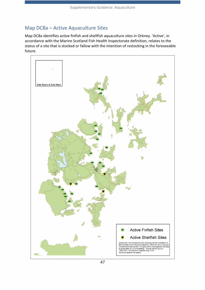
Supplementary Guidance: Aquaculture
47
Map DC8a – Active Aquaculture Sites Map DC8a identifies active finfish and shellfish aquaculture sites in Orkney. ‘Active’, in accordance with the Marine Scotland Fish Health Inspectorate definition, relates to the status of a site that is stocked or fallow with the intention of restocking in the foreseeable future.
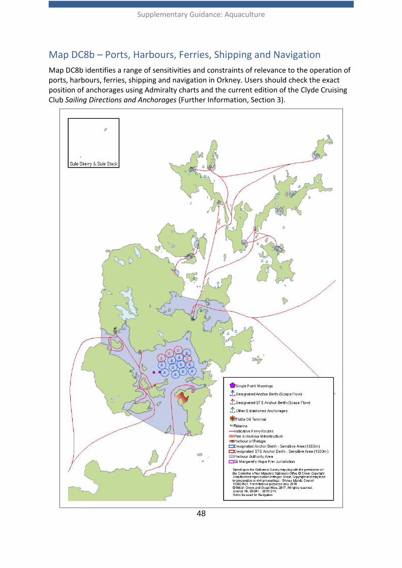
Supplementary Guidance: Aquaculture
48
Map DC8b – Ports, Harbours, Ferries, Shipping and Navigation Map DC8b identifies a range of sensitivities and constraints of relevance to the operation of ports, harbours, ferries, shipping and navigation in Orkney. Users should check the exact position of anchorages using Admiralty charts and the current edition of the Clyde Cruising Club Sailing Directions and Anchorages (Further Information, Section 3).
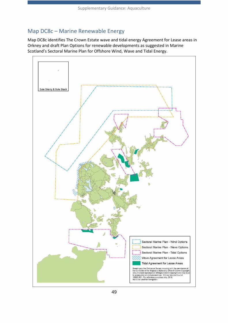
Supplementary Guidance: Aquaculture
49
Map DC8c – Marine Renewable Energy Map DC8c identifies The Crown Estate wave and tidal energy Agreement for Lease areas in Orkney and draft Plan Options for renewable developments as suggested in Marine Scotland’s Sectoral Marine Plan for Offshore Wind, Wave and Tidal Energy.
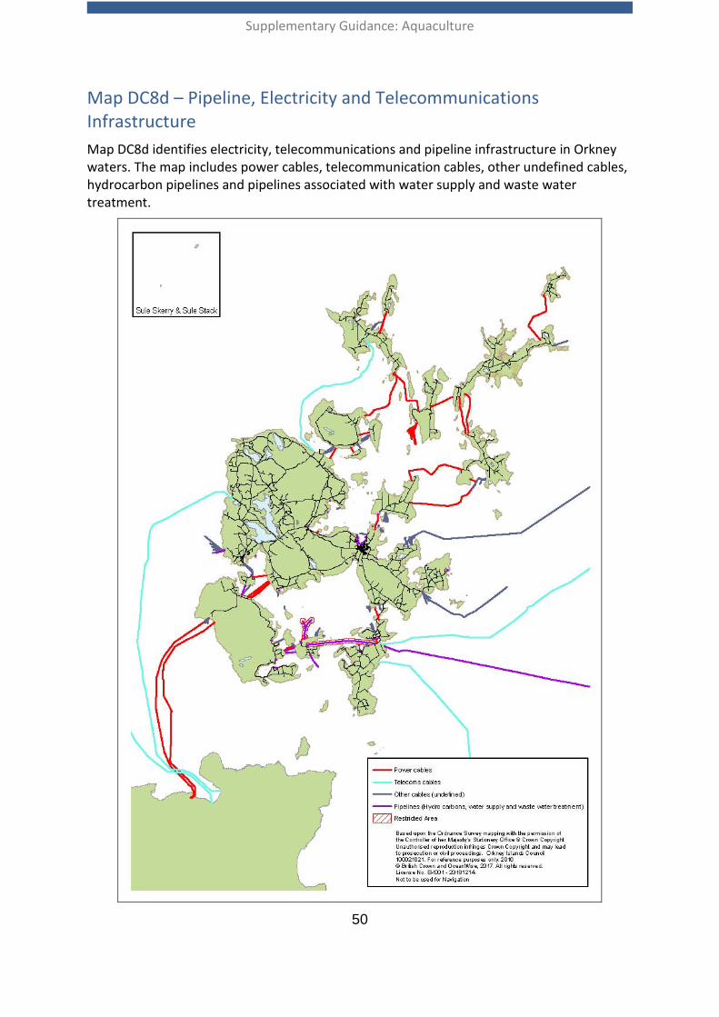
Supplementary Guidance: Aquaculture
50
Map DC8d – Pipeline, Electricity and Telecommunications Infrastructure Map DC8d identifies electricity, telecommunications and pipeline infrastructure in Orkney waters. The map includes power cables, telecommunication cables, other undefined cables, hydrocarbon pipelines and pipelines associated with water supply and waste water treatment.
Supplementary Guidance: Aquaculture
51
Development Criterion 9: Construction and Operational Impacts
Development Criteria 9 Aquaculture development proposals should avoid or appropriately mitigate significant adverse effects due to waste, noise, light and odour.
Developers should demonstrate that any potential significant adverse effects on the transportation and outdoor access network have been assessed and addressed through appropriate mitigation measures.
Where appropriate, a planning application should be supported by an appropriate Site Waste Management Plan and/or Transport Assessment or Statement.
Planning applications should identify any onshore sites associated with the proposal, both for temporary use for the construction of cages and permanent on shore sites (e.g. feed stores, piers etc.)
2.92 The potential construction and operational impacts from aquaculture developments, both on and offshore, can affect the amenity of neighbouring users. Where appropriate, developers will need to provide details of waste management measures and assess impacts on the transport and outdoor access network. Where significant impacts relating to waste, transport, outdoor access, noise, light and odour are identified, appropriate mitigation measures will be required by the planning authority.
Waste Management 2.93 There is potential for aquaculture development to generate waste during
construction, operation and decommissioning. Waste can affect both visual amenity and the natural environment. For example residual waste from operations includes redundant parts of fish cages, plastic bags, old ropes, and discarded buoys and floats.
2.94 A Site Waste Management Plan should demonstrate how waste generated by the development during the construction, operational and decommissioning phases will be dealt with, including steps that will be taken to reduce, re-use and re-cycle. The Plan should detail how remaining wastes including mortalities will be disposed of.
2.95 Development proposals should be designed to minimise any adverse environmental or amenity impacts and satisfactory measures for the restoration of the site should be proposed, including the removal of redundant equipment.
Transportation and Outdoor Access 2.96 Where the roads authority (Orkney Islands Council) identifies the potential for a
development to have significant effects on the local transport network, a developer must provide sufficient information regarding vehicular and other types (eg walking, cycling, horse riding, etc) of access/egress to the site during construction, operation
Supplementary Guidance: Aquaculture
52
and decommissioning phases. The developer may be required to carry out improvements to the existing road or path network to accommodate construction works, facilitate day to day operations and any decommissioning works. The roads authority should be consulted at an early stage in the pre-application process. For large-scale developments where the roads authority identifies potential for significant impacts on the road and pedestrian network, it may be necessary to provide a Transport Assessment or Statement. Further guidance is provided in the National Roads Development Guide which has been adopted by the Council as Planning Policy Advice (Further Information Section 3).
2.97 Aquaculture development should avoid or appropriately mitigate adverse impacts on statutory access rights, core paths, other public footpaths and rights of way, in accordance with Orkney Local Development Plan Policy 10. The Orkney Core Paths Plan (Further Information, Section 3) provides information on the location of core paths in Orkney and information on access rights and rights of way can be obtained from the Council’s Access Officer.
Lighting 2.98 The Northern Lighthouse Board advises developers and regulators of navigational
lighting requirements at sea. The Harbour Authority also provides advice regarding lighting requirements within the Harbour Area.
2.99 Lighting associated with aquaculture development may be installed for the safety of navigation, for night-time working or to improve security at a shore base. Where such lighting has to be provided, either onshore or at sea, it should be designed to minimise light pollution in accordance with Orkney Local Development Plan Policy 2. To avoid adverse impacts on visual amenity and wildlife, baffles or guards can be installed to reduce light pollution, and lighting should be extinguished when it is not required.
2.100 Underwater lighting may be used in fish cages to slow the rate at which fish reach sexual maturity. It does not cause a direct glare but the glow it produces can change the character of a night time landscape, particularly in areas with low levels of artificial lighting. Sub-sea lighting may also have an impact upon wildlife. In the event that underwater lighting is installed, measures to reduce the impact to the surrounding environment, e.g. downward directed lighting, should be agreed with the planning authority.
Supplementary Guidance: Aquaculture
53
Development Criterion 10: Decommissioning and Reinstatement
Development Criteria 10 A Decommissioning Statement should be submitted in support of a planning application for new fish farm development. Modifications to existing fish farm developments may have to update the Decommissioning Statement for the existing fish farm to take account of the modifications, or provide a new Decommissioning Statement for the modification being sought. This statement should be updated at least one year before the cessation of operation of the site. This statement should be written in accordance with best practice and in consultation with the planning authority.
Appropriate conditions and, where necessary, a financial bond or a letter of credit, will be concluded to ensure that decommissioning and site restoration arrangements will be implemented following cessation of the operation.
Decommissioning and Reinstatement 2.101 Decommissioning refers to the operations to be carried out once a site is no longer
required for aquaculture production. In most instances appropriate conditions are attached to a planning consent to ensure adequate restoration of a site.
2.102 The condition generally used is “in the event that the fish cages or associated equipment approved by this permission cease to be in operational use for the growing of finfish or shellfish for a period exceeding three years, they shall be wholly removed and the site restored to the satisfaction of the planning authority within 4 months of being notified, unless agreed otherwise in writing by the planning authority.”
2.103 A Decommissioning Statement should provide a detailed account of the necessary works and the method of reinstatement of the site to its original condition, with the removal of all equipment associated with the development. The Decommissioning Statement should be proportionate to the scale of the development and the sensitivities of the site.
Financial bond or letter of credit 2.104 Decommissioning and reinstatement measures set out in the Decommissioning
Statement need to be supported by significant financial investment by the developer; therefore, a financial bond or letter of credit may be required to support a planning application. As a point of information, in the case of aquaculture development, a Section 75 Agreement is not an appropriate mechanism for developments on the seabed. It is not envisaged that a letter of credit or financial bond would be required to support all planning applications for aquaculture development. Developers are advised to seek pre-application advice from the planning authority to determine whether a financial bond or letter of credit will be required.
Supplementary Guidance: Aquaculture
54
3. Further Information Policy Context Scottish Planning Policy: http://www.gov.scot/Topics/Built-Environment/planning/Policy
Scotland’s National Marine Plan: http://www.gov.scot/Topics/marine/seamanagement/national
Pilot Pentland Firth and Orkney Waters Marine Spatial Plan: http://www.gov.scot/Topics/marine/seamanagement/regional/activity/pentlandorkney
National Marine Plan interactive: http://www.gov.scot/Topics/marine/seamanagement/nmpihome
Local Planning Policy Orkney Local Development Plan: http://www.orkney.gov.uk/Service-Directory/O/Orkney-Local-Development-Plan.htm
Spatial Strategy Interactive online version of Supplementary Guidance: Aquaculture http://oic.maps.arcgis.com/apps/MapJournal/index.html?appid=0ddc90deebc34cbda89d2064c648809c
National Marine Plan interactive: http://www.gov.scot/Topics/marine/seamanagement/nmpihome
Pre-application phase and preparing planning applications
Fish farming planning protocol (SSPO): http://scottishsalmon.co.uk/fish-farming-planning-protocol/
Circular 3/2013 Development Management Procedures: http://www.gov.scot/Resource/0044/00441568.pdf
Development Criterion 1: Landscape, Coast, Siting and Design Guidelines for Landscape and Visual Impact Assessment (GLVIA3) developed by the Landscape Institute and I.E.M.A. (3rd edition): https://www.routledge.com/Guidelines-for-Landscape-and-Visual-Impact-Assessment-3rd-Edition/Landscape-Institute-IEMA/p/book/9780415680042
Supplementary Guidance: Aquaculture
55
Guidance on Coastal Character Assessment (SNH): http://www.snh.gov.uk/protecting-scotlands-nature/looking-after-landscapes/cca/
Supplementary Guidance Natural Environment: http://www.orkney.gov.uk/Service-Directory/D/natural-environment.htm
The siting and design of aquaculture in the landscape: visual and landscape considerations (SNH): http://www.snh.gov.uk/protecting-scotlands-nature/looking-after-landscapes/landscape-policy-and-guidance/landscape-planning-and-development/landscape-and-aquaculture/ Guidance on Landscape/Seascape Capacity for Aquaculture (SNH): http://www.snh.gov.uk/protecting-scotlands-nature/looking-after-landscapes/landscape-policy-and-guidance/landscape-planning-and-development/landscape-and-aquaculture/
Orkney Landscape Capacity for Aquaculture: Scapa Flow and Wide Firth (SNH):www.snh.org.uk/pdfs/publications/commissioned_reports/466.pdf
Orkney Landscape Character Assessment (SNH): http://www.snh.gov.uk/protecting-scotlands-nature/looking-after-landscapes/lca/ North Caithness and Orkney Coastal Character Assessment (SNH): http://www.snh.gov.uk/protecting-scotlands-nature/looking-after-landscapes/lca/ Hoy and West Mainland National Scenic Area (SNH): http://www.snh.gov.uk/protecting-scotlands-nature/protected-areas/national-designations/nsa/ Wild Land (SNH): http://www.snh.gov.uk/protecting-scotlands-nature/looking-after-landscapes/landscape-policy-and-guidance/wild-land/
Development Criterion 2: Natural Heritage Designations, Protected Species and the Wider Biodiversity and Geodiversity Supplementary Guidance Natural Environment: http://www.orkney.gov.uk/Service-Directory/D/natural-environment.htm
Scottish Natural Heritage Sitelink: http://gateway.snh.gov.uk/sitelink/index.jsp
Scottish Natural Heritage Protected Species: http://www.snh.gov.uk/protecting-scotlands-nature/protected-species/
List of seal haul-outs: http://www.gov.scot/Topics/marine/marine-environment/species/19887/20814/haulouts
Supplementary Guidance: Aquaculture
56
Scottish Natural Heritage Priority Marine Features: http://www.snh.gov.uk/protecting-scotlands-nature/priority-marine-features/
List of Priority Marine Features: http://www.snh.gov.uk/docs/A1327320.pdf
National Marine Plan interactive: http://www.gov.scot/Topics/marine/seamanagement/nmpihome
Orkney Wildlife Information and Records Centre: http://www.orkneylibrary.org.uk/OBRC/index.htm
Development Criterion 4: Wild Salmonid Fish Populations Orkney Trout Fishing Association Sea Trout Survey 2010: http://www.orkneytroutfishing.co.uk/envirionment/e_seatroutsurvey.html
A Code of Good Practice for Scottish Finfish Aquaculture: http://www.thecodeofgoodpractice.co.uk/
A Technical Standard for Scottish Finfish Aquaculture: http://www.gov.scot/Publications/2015/06/5747
Disease Management Area Maps: http://www.gov.scot/Topics/marine/Fish-Shellfish/FHI/managementagreement
Development Criterion 5: Water Quality and Benthic Impacts Fish Farm Manual (SEPA): https://www.sepa.org.uk/regulations/water/aquaculture/fish-farm-manual/ River Basin Management Planning: http://www.sepa.org.uk/environment/water/river-basin-management-planning
Locational Guidelines for the Authorisation of Marine Fish Farms in Scottish Waters: http://www.gov.scot/Topics/marine/Publications/publicationslatest/farmedfish/locationalfishfarms
SARF053: A systematic assessment of the environmental impact of Scottish shellfish farms including benthos, water column and relevant special interactions: http://www.sarf.org.uk/projects/sarf053.php
Independent review of Scottish aquaculture consenting - Scottish Government Response:
http://www.gov.scot/Publications/2017/01/9447/downloads
Supplementary Guidance: Aquaculture
57
Development Criterion 6: Historic Environment Supplementary Guidance: Historic Environment and Cultural Heritage: http://www.orkney.gov.uk/Service-Directory/D/historic-environment-and-cultural-heritage.htm PastMap: http://pastmap.org.uk/
Canmore: https://canmore.org.uk/
Development Criterion 8: Other Marine Users Orkney Fisheries Association: http://www.orkneyfisheries.com/
Orkney Sustainable Fisheries: http://www.orkneysustainablefisheries.co.uk/
ScotMap: http://www.gov.scot/Topics/marine/science/MSInteractive/Themes/ScotMap
The Kingfisher Information Service – Offshore Renewable and Cable Awareness (KIS-ORCA): http://www.kis-orca.eu/
Scottish Marine Recreation and Tourism Survey 2015: http://www.gov.scot/Topics/marine/seamanagement/national/RecandTourism
Shipping Study of the Pentland Firth and Orkney Waters: http://www.gov.scot/Publications/2012/12/1868/downloads
Clyde Cruising Club Sailing Directions and Anchorages: Orkney and Shetland Islands including North and Northeast Scotland:
https://www.clyde.org/publications/ Orkney Ports Handbook: http://www.orkneyharbours.com/pdfs/PortsHandbook-2012-V5.pdf
Development Criterion 9: Construction and Operational Impacts The National Roads Development Guide: http://www.orkney.gov.uk/Service-Directory/R/national-roads-development-guide.htm
Orkney Core Paths Plan: http://www.orkney.gov.uk/Service-Directory/C/Core-Paths.htm
Supplementary Guidance: Aquaculture
58
General Information Scotland’s Aquaculture - Public access to aquaculture information held by the following regulators: Marine Scotland, SEPA, Food Standards Scotland and The Crown Estate: http://aquaculture.scotland.gov.uk/
Independent Review of Scottish Aquaculture Consenting: http://www.gov.scot/Publications/2016/07/9269
An Assessment of the Benefits to Scotland of Aquaculture: http://www.gov.scot/Resource/0045/00450799.pdf Working Arrangement - Requirements of Statutory Consultees (Scottish Environment Protection Agency, Scottish Natural Heritage, Marine Scotland Science and the District Salmon Fisheries Boards) and Consultation Protocol for Marine Aquaculture Planning Applications: http://www.gov.scot/resource/doc/295194/0106302.pdf
Scottish Environmental Protection Agency, Land Use Planning System SEPA Guidance Note 17: Marine development and marine aquaculture planning guidance: http://www.sepa.org.uk/media/143325/lups-gu17-marine-development-and-marine-aquaculture-planning-guidance.pdf
Community Engagement Charter (SSPO): http://scottishsalmon.co.uk/wp-content/uploads/2016/09/community_charter_2016_digital.pdf
Relevant legislation Please note that this is not intended to be an exhaustive list of all the relevant legislation, it simply aims to identify the main legislation of relevance.
• Aquaculture and Fisheries (Scotland) Act 2007 • Aquaculture and Fisheries (Scotland) Act 2013 • Aquatic Animal Health (Scotland) Regulations 2009 • Climate Change (Scotland) Act 2009 • Crown Estate Act 1961 • Dangerous Substances in Harbour Areas Regulations 1987 – amended 2016 • Dangerous Vessels Act 1985 • EU Marine Strategy Framework Directive (MSFD) (2008/56/EC)EU Water
Framework Directive (WFD) (2000/60/EC) • Harbours Act 1964 • Harbours, Docks and Pier Clauses Act 1847 • Health and Safety at Work Act 1974 • Marine (Scotland) Act 2010 • Marine and Coastal Access Act 2009
Supplementary Guidance: Aquaculture
59
• Merchant Shipping Act 1995 • Nature Conservation (Scotland) Act 2004 • Orkney County Council Act 1974 (As Amended) • Orkney Islands Council Order Confirmation Act 1978 • Orkney Islands Council Harbour Revision Order 1989 • Pilotage Act 1987 • Planning etc. (Scotland) Act 2006 • Pier and Harbour Orders Confirmation (No.2) Act 1902 • The Conservation (Natural Habitats &c) Regulations 1994: • The Protection of Seals (Designation of Seal Haul-Out Sites) (Scotland) Order 2014 • The Water Environment (Shellfish Water Protected Areas: Designation) (Scotland)
Order 2013 • Town and Country Planning (Development Management Procedure) (Scotland)
Regulations 2013 • Town and Country Planning (Environmental Impact Assessment) (Scotland)
Regulations 2011 • Town and Country Planning (General Permitted Development) (Fish Farming)
(Scotland) Amendment Order 2012 • Town and Country Planning (Marine Fish Farming) (Scotland) Order 2007 • Town and Country Planning (Marine Fish Farming) (Scotland) Regulations 2013 • Town and Country Planning (Scotland) Act 1997 • Water Environment (Controlled Activities) (Scotland) Regulations 2011 • Water Environment and Water Services (Scotland) Act 2003 • Wildlife and Countryside Act 1981 • Wildlife and Natural Environment (Scotland) Act 2011
Supplementary Guidance: Aquaculture
60
Annex 1: The role of other statutory bodies A1.01 In addition to planning permission, a successful aquaculture development requires
other consents, licences and lease agreements from Marine Scotland, the Scottish Environment Protection Agency (finfish only) and the Crown Estate. The Planning Authority will aim to ensure that planning controls exercised do not duplicate the controls and licensing requirements of other agencies.
A1.02 Further information on the role of statutory bodies is provided in Working Arrangement Requirements of Statutory Consultees (Scottish Environment Protection Agency, Scottish Natural Heritage, Marine Scotland Science and the District Salmon Fisheries Boards) and Consultation Protocol for Marine Aquaculture Planning Applications (Further Information, Section 3).
Marine Scotland A1.03 Marine Scotland – Licensing Operations Team (MS-LOT) issues marine licences under
the provisions of the Marine (Scotland) Act 2010 on behalf of Scottish Ministers. Marine fish farms, for finfish and shellfish, require a marine licence for navigational purposes if they involve the creation, alteration or maintenance of artificial reefs or, if their installation causes, or is likely to cause, obstruction or danger to navigation. Marine Scotland considers that all fish and shellfish farms have the potential to cause navigational obstruction and so all fish and shellfish farms should be covered by a valid marine licence.
A1.04 The discharge of chemotherapeutants from a wellboat requires a marine licence from Marine Scotland. The Fish Health Inspectorate, at the Marine Scotland Marine Laboratory, enforces provisions under the Aquaculture and Fisheries (Scotland) Act 2007 in relation to containment and parasite control of the farmed species.
A1.05 The Fish Health Inspectorate is responsible for monitoring imports of live fish and shellfish, including non-native species, into Scotland from outside Great Britain. The Fish Health Inspectorate carries out spot-checks on imports at points of entry and at destination points and also provides movement documents in order to meet the requirements for fish and shellfish moving to other parts of the EU.
A1.06 The Fish Health Inspectorate at the Marine Scotland Marine Laboratory provide authorisation for all Aquaculture Production Businesses under the Aquatic Animal Health (Scotland) Regulations 2009 in relation to animal health requirements and the control of certain diseases in aquatic animals.
A1.07 MS-LOT may issue a European Protected Species Licence when an activity could cause disturbance to a European Protected Species. Strict legal tests are required to be satisfied.
Supplementary Guidance: Aquaculture
61
A1.08 Marine Scotland is the licencing authority for the control of seals under the Marine (Scotland) Act 2010. It can issue licences for the killing of seals to protect the health and welfare of farmed fish, addressing issues of predation where non-lethal alternatives cannot be used.
A1.09 At the time of drafting this Supplementary Guidance, seaweed cultivation farms require a licence from Marine Scotland.
A1.10 There is no District Salmon Fisheries Board (DSFD) that covers Orkney. Marine Scotland performs the role of the DSFD in Orkney and advises on issues relating to impacts on wild salmonid fish species.
Scottish Environment Protection Agency (SEPA) A1.11 Under the Water Environment (Controlled Activities) (Scotland) Regulations 2011,
SEPA regulates activities which may pose a risk to the water environment. For finfish farming, SEPA sets limits on the types and amount of fish that can be held in a cage configuration (fish biomass) and the amount of medicines (chemotheraputants) that can be administered and thus discharged into the environment from the fish cages. Known as a CAR licence, sites are assessed on the likely effects of discharges from a development on both the water column and the benthic environment. Shellfish farms are not regulated by SEPA under the CAR regulations.
Scottish Natural Heritage (SNH) A1.12 Scottish Natural Heritage is the statutory adviser in relation to nature conservation in
Scotland. SNH advises the Council, as the Competent Authority under the Conservation (Natural Habitats, &c.) Regulations 1994, with regard to Natura sites (Special Areas of Conservation and Special Protection Areas) and European Protected Species (EPS). SNH provide further advice to the Council on matters relating to Nature Conservation Marine Protected Areas, landscape and coastal character, species protected under the Wildlife & Countryside Act 1981 and the wider biodiversity.
A1.13 SNH advises Marine Scotland with respect to EPS licensing and the seal licensing system under the Marine (Scotland) Act 2010.
A1.14 SNH is the licencing authority for marine activities with a research or education
purpose and are the licencing authority for otters in all circumstances.
Historic Environment Scotland (HES) A1.15 Historic Environment Scotland is a national public body which is the statutory advisor
on the historic environment for Scotland. It was formed in 2015 as a successor to Historic Scotland. It is responsible for designating scheduled monuments, listed buildings, Gardens and Designed Landscapes and Battlefields, and is consulted by Marine Scotland on the designation of Historic Marine Protected Areas. It is
Supplementary Guidance: Aquaculture
62
responsible for determining scheduled monument consent, and for advising Marine Scotland and the Council on works to other designated assets.
The Crown Estate (TCE) A1.16 The Crown Estate is the public body in Scotland that owns and manages
approximately 50 percent of the foreshore, the beds of tidal rivers and territorial seabed out to 12 nautical miles, with renewable energy and (non-hydrocarbon) mineral rights out to 200 nautical miles. The Crown Estate management of the territorial seabed means that any developer acquiring the necessary permissions to implement an aquaculture development will require rights to the area of seabed to which those continuation permissions apply, in the form of a lease of seabed from The Crown Estate, in order to exercise those permissions.
A1.17 Planning permission for an aquaculture development granted by the planning authority attaches to the land (or seabed in this case) and not the applicant, and therefore securing the necessary seabed rights is part and parcel of ensuring a successful outcome for any development proposal. It should also be borne in mind that anyone is free to apply for a lease for an area of seabed for which planning permission has been granted. Therefore, the planning authority recommends that developers contact The Crown Estate at the earliest opportunity to ensure their interests in the leasing of the seabed are appropriately secured.
Food Standards Scotland and Environmental Health A1.18 Regulation (EC) 853/2004 specifies the health standards for the production and
placing on the market of live bivalve molluscs, tunicates, echinoderms and marine gastropods, such as mussels, oysters, scallops and razor fish. Under European Regulation (EC) 854/2004 Food Standards Scotland (FSS), as competent authority, must undertake Sanitary Surveys relating to official controls on live bivalve molluscs intended for human consumption and identify appropriate production area boundaries for all new shellfish production areas. The local authority environmental health department acts on behalf of FSS to ensure that end product standards are met for shellfish sold for human consumption.
A1.19 Shellfish Harvesting Classifications are determined and reported on by FSS. As these
are regularly updated, developers should consult the FSS website for the latest information.
Scottish Water A1.20 Scottish Water will be consulted on all relevant aquaculture related applications.
Supplementary Guidance: Aquaculture
63
Annex 2: Potentially significant natural heritage impact pathways arising from aquaculture operations in Orkney waters For ease of reference this table (on following pages) includes the headings used in the Scottish Aquaculture Research Forum (SARF) Aquaculture EIA scoping templates. It should be noted that heading 5 focuses on consideration of the potential national significance of impacts arising from pathways identified under the previous headings, in particular 1 (benthic) and 3 (interaction with predators).
Note that this list is not exhaustive and that pre-application discussion with Scottish Natural Heritage (SNH), starting at the earliest possible opportunity, is recommended.
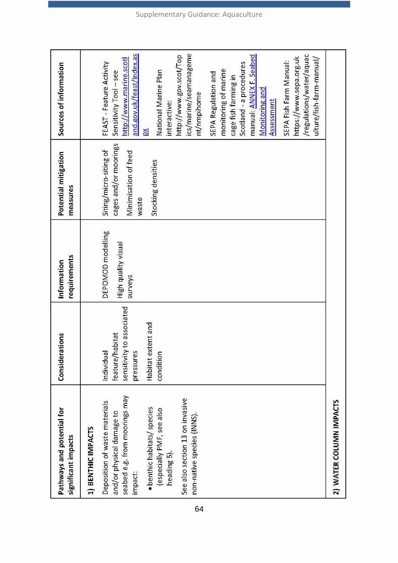
Supplementary Guidance: Aquaculture
64
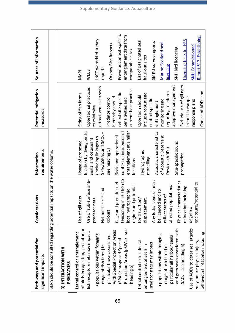
Supplementary Guidance: Aquaculture
65
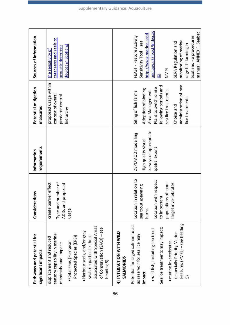
Supplementary Guidance: Aquaculture
66
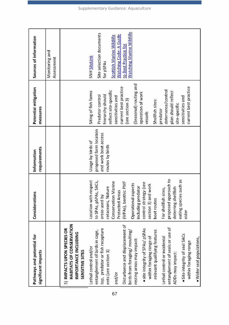
Supplementary Guidance: Aquaculture
67
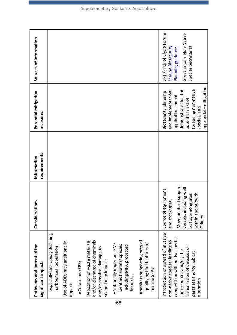
Supplementary Guidance: Aquaculture
68
Supplementary Guidance: Aquaculture
69