igarss__rtc.pdf
TRANSCRIPT

Don Atwood & David Small IGARSS July 2011 1
USE OF RADIOMETRIC TERRAIN CORRECTION TO IMPROVE POLSAR LAND COVER CLASSIFICATION
Don Atwood1 and David Small2
1) University of Alaska Fairbanks 2) University of Zurich, Switzerland

Don Atwood & David Small IGARSS July 2011 2
Presentation Overview
• Introduce Boreal Land Cover Classification project
• Focus on species differentiation in boreal environment
• Introduce reference data for land cover classification
• Introduce method of Radiometric Terrain Correction (RTC)
• Terrain-flattened Gamma Naught Backscatter
• Perform RTC on polarimetric parameters to address topography
• Demonstrate synergy of PolSARpro and MapReady Tools
• Compare results for RTC-corrected and non-corrected classification
• Characterize optimal classification approach for Interior Alaska

Don Atwood & David Small IGARSS July 2011 3
Study Region
Boreal environment of Interior Alaska
Characterized by:
• rivers
• wetlands
• herbaceous tundra
• black spruce forests (north facing)
• birch forests (south facing)
• low intensity urban areas
Don Atwood & David Small IGARSS July 2011 4
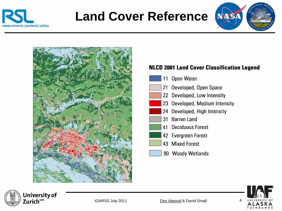
Land Cover Reference
Don Atwood & David Small IGARSS July 2011 5
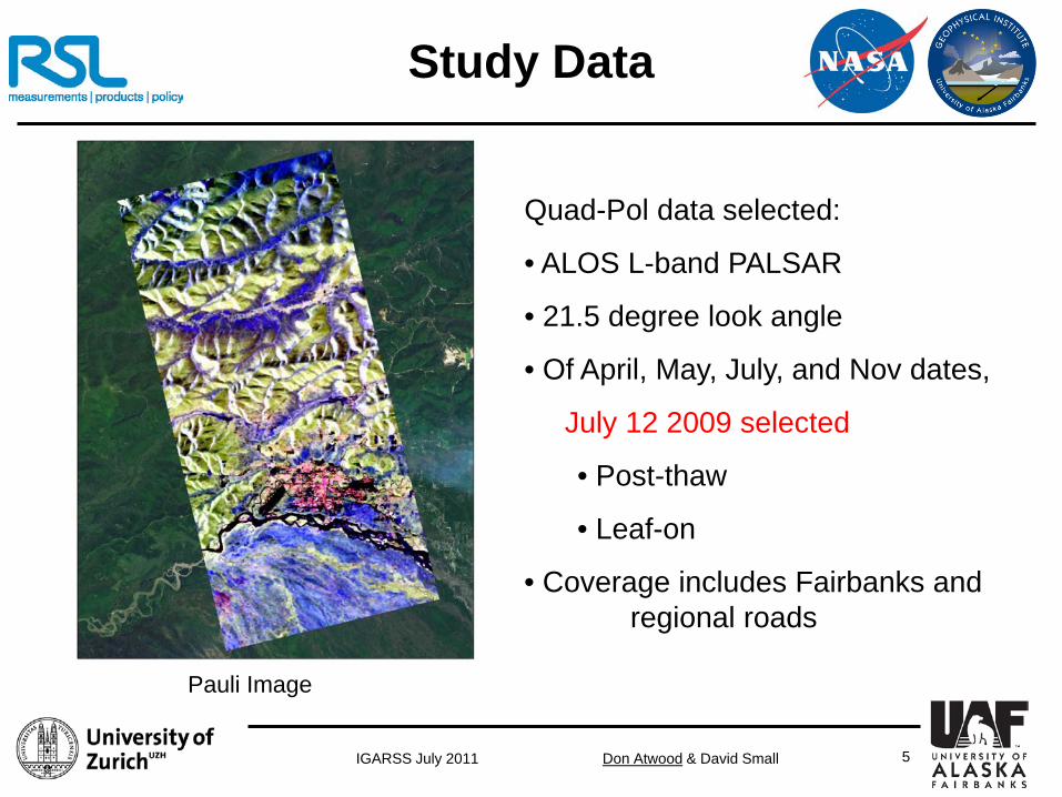
Study Data
Quad-Pol data selected:
• ALOS L-band PALSAR
• 21.5 degree look angle
• Of April, May, July, and Nov dates,
July 12 2009 selected
• Post-thaw
• Leaf-on
• Coverage includes Fairbanks and regional roads
Pauli Image

Don Atwood & David Small IGARSS July 2011 6
Problem of Topography
Span (Trace of T3 Matrix) Wishart Segmentation

Don Atwood & David Small IGARSS July 2011 7
Backscatter Reference Areas
Nadir
Sensor
Far
Near
Aσ & σ0
Aγ & γ0
Aβ & β0
Standard areas for Ellipsoid Normalization

Don Atwood & David Small IGARSS July 2011 8
Relationships between cross sections
for ellipsoidal surfaces
Backscatter Reference Areas

Don Atwood & David Small IGARSS July 2011 9
Terrain-flattening
The concept of a single Local Incident Angle determining the terrain’s local normalization area is flawed: • adapted from ellipsoidal incident angle for ocean, sea-ice, &
flatlands
• fails to account for foreshortening and the radiometric impact of topography.
To improve sensor model:
➡use local contributing area, not angle!
Ref.: Small, D., Flattening Gamma: Radiometric Terrain Correction for SAR Imagery, IEEE Transactions on Geoscience and Remote Sensing, 13p (in press).

Don Atwood & David Small IGARSS July 2011 10
Terrain-flattening
X
Solution: Use simulated image to Normalize β0
Example over Switzerland ASAR WS data courtesy ESA
Don Atwood & David Small IGARSS July 2011 11
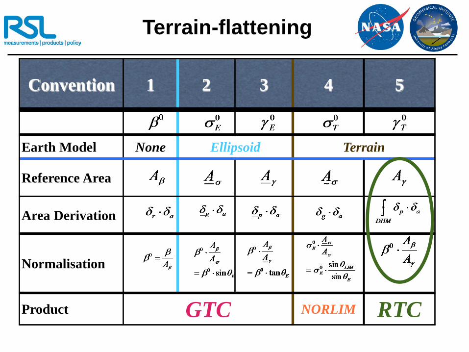
Terrain-flattening
Convention 1 2 3 4 5
Earth Model None Ellipsoid Terrain
Reference Area
Area Derivation
Normalisation
Product GTC NORLIM RTC
Don Atwood & David Small IGARSS July 2011 12
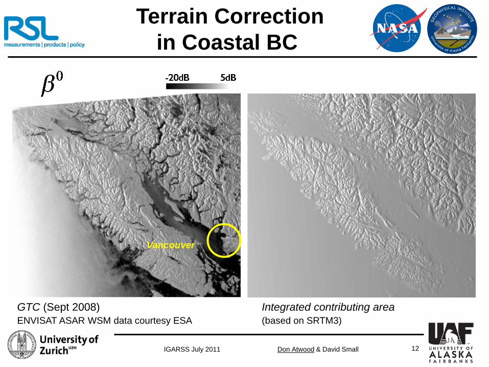
Vancouver
GTC (Sept 2008) Integrated contributing area ENVISAT ASAR WSM data courtesy ESA (based on SRTM3)
Terrain Correction in Coastal BC

Don Atwood & David Small IGARSS July 2011 13
Terrain Correction in Coastal BC
GTC (Sept 2008) Integrated contributing area ENVISAT ASAR WSM data courtesy ESA (based on SRTM3)
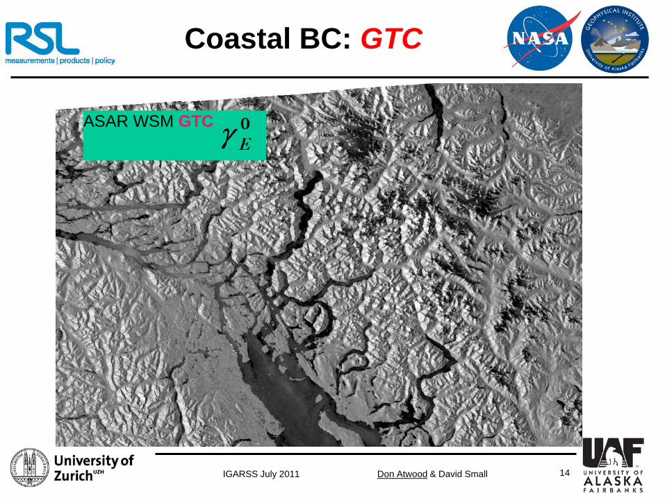
Don Atwood & David Small IGARSS July 2011 14
ASAR WSM GTC
Coastal BC: GTC
Don Atwood & David Small IGARSS July 2011 15
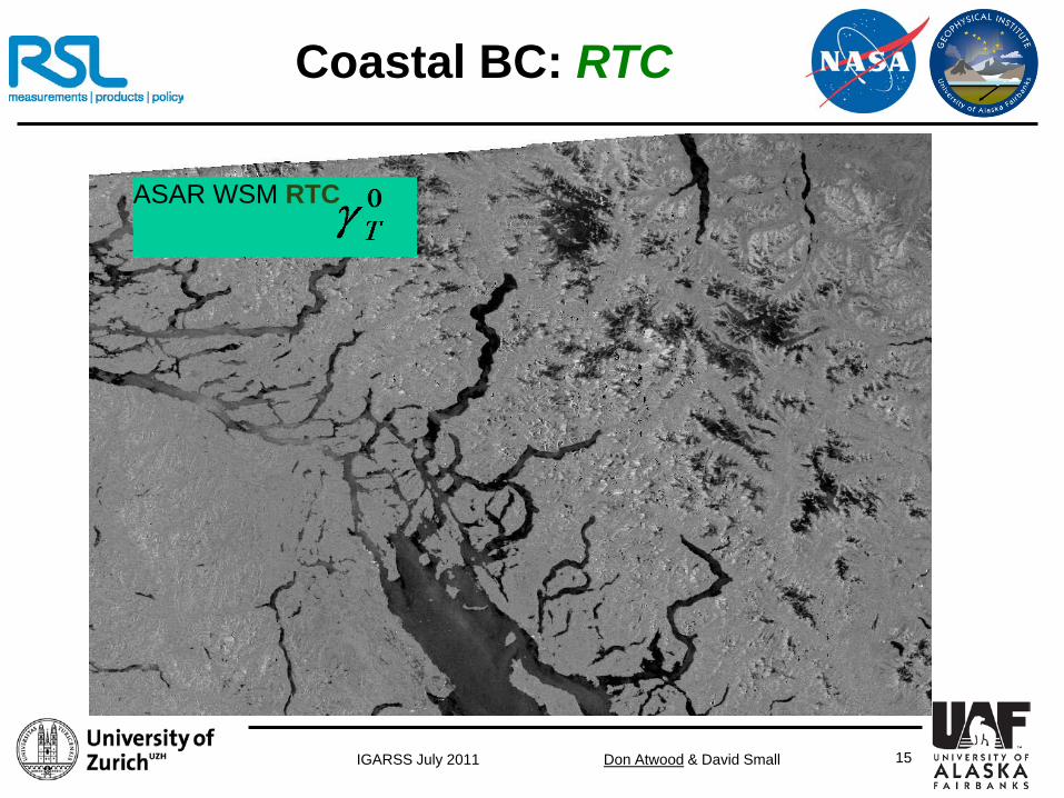
ASAR WSM RTC
Coastal BC: RTC
Don Atwood & David Small IGARSS July 2011 16
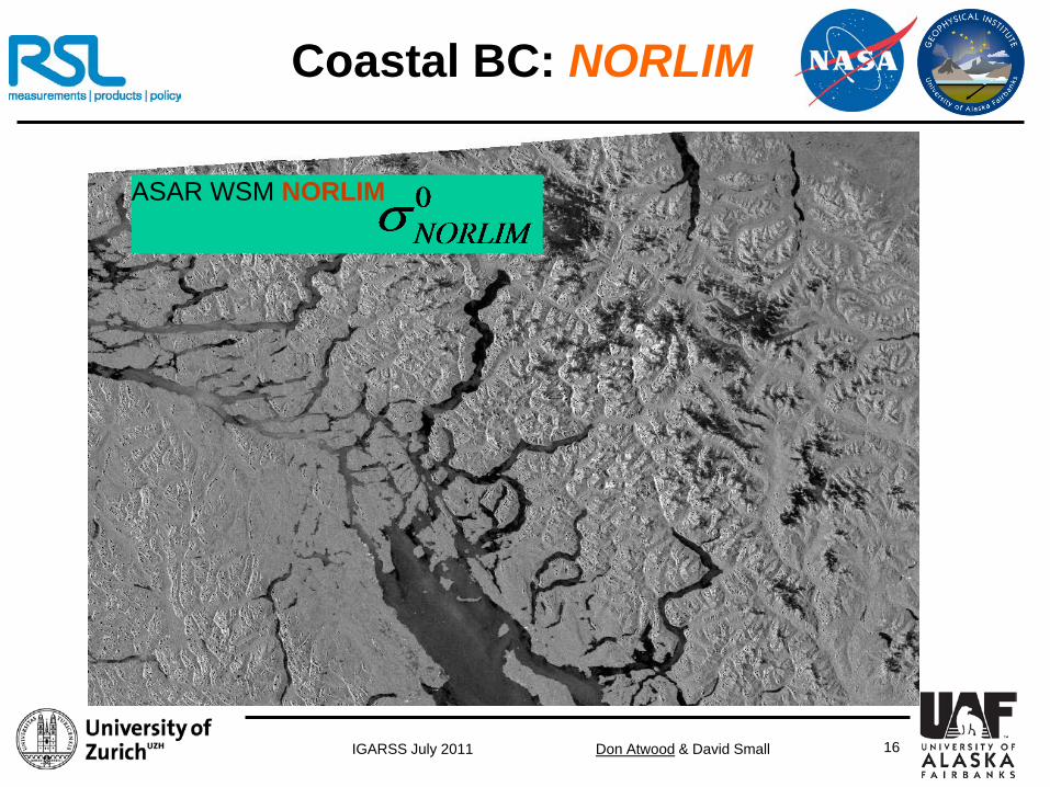
ASAR WSM NORLIM
Coastal BC: NORLIM

Don Atwood & David Small IGARSS July 2011 17
Coherency Matrix
=
YXYX
XYXX
SSSS
S
Scattering Matrix
( )( ) ( )( )( ) ( )
( ) ( )
−+
−−+−
+−++
=2**
*2*
**2
3
422
2
2*
21
XYYYXXXYYYXXXY
XYYYXXYYXXYYXXYYXX
XYYYXXYYXXYYXXYYXX
SSSSSSS
SSSSSSSSS
SSSSSSSSS
T
22T11T 33T: “Single Bounce” : “Double Bounce” : “Volume Scattering”

Don Atwood & David Small IGARSS July 2011 18
Radiometric Terrain Correction of Coherency Matrix
• Radiometric Terrain Correction:
Area Normalization
terrain corrected Coherency Matrix
=
333231
232221
131211
3
TTTTTTTTT
T
Coherency Matrix
=
333231
232221
131211
3
TTTTTTTTT
T
• Scale all matrix elements by Area Normalization • Acknowledge that angular dependence of scattering
mechanisms is not addressed

Don Atwood & David Small IGARSS July 2011 19
Radiometric Terrain Correction of Coherency Matrix
GTC: No Normalization RTC: Terrain-model Normalization

Don Atwood & David Small IGARSS July 2011 20
Radiometric Terrain Correction of Coherency Matrix
GTC: No Normalization RTC: Terrain-model Normalization
Don Atwood & David Small IGARSS July 2011 21
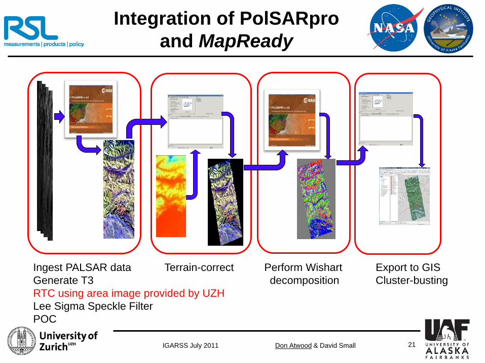
Ingest PALSAR data Terrain-correct Perform Wishart Export to GIS Generate T3 decomposition Cluster-busting RTC using area image provided by UZH Lee Sigma Speckle Filter POC
Integration of PolSARpro and MapReady
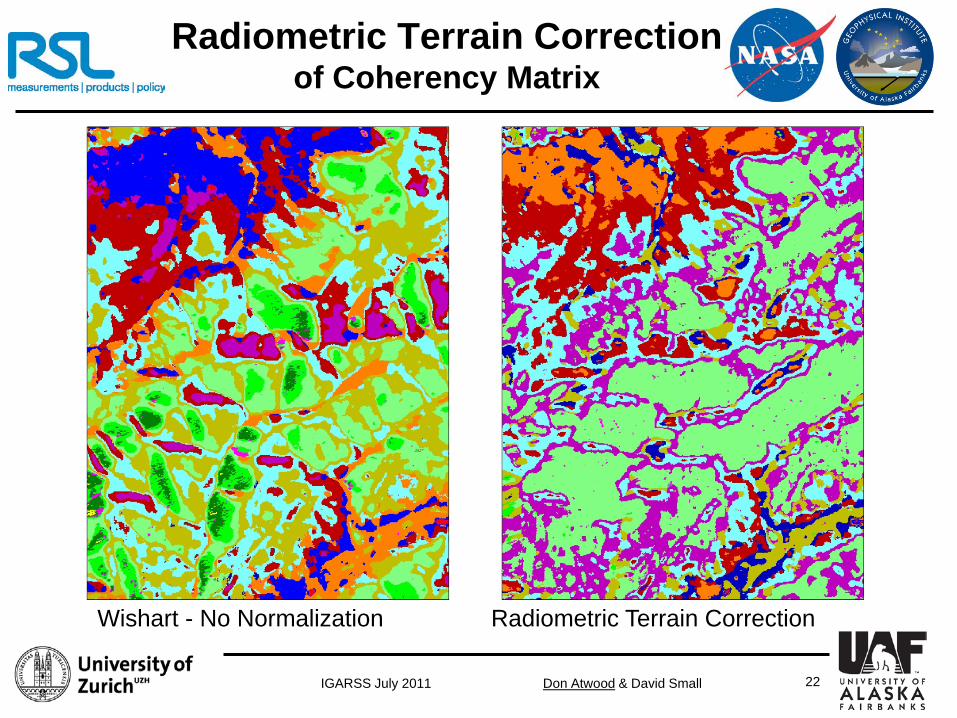
Don Atwood & David Small IGARSS July 2011 22
Radiometric Terrain Correction of Coherency Matrix
Wishart - No Normalization Radiometric Terrain Correction

Don Atwood & David Small IGARSS July 2011 23
Radiometric Terrain Correction of Coherency Matrix
USGS Reference Radiometric Terrain Correction

Don Atwood & David Small IGARSS July 2011 24
Classification Results
Urban areas missed / Identified as Open Water

Don Atwood & David Small IGARSS July 2011 25
Classification Results
Inability to distinguish Mixed Forests and Shrub / Scrub

Don Atwood & David Small IGARSS July 2011 26
Classification Results
No Normalization USGS Reference RTC
Don Atwood & David Small IGARSS July 2011 27
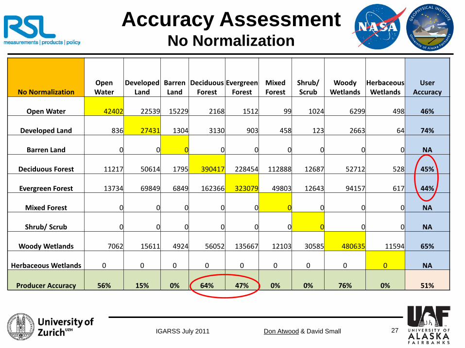
Accuracy Assessment No Normalization
No Normalization Open Water
Developed Land
Barren Land
Deciduous Forest
Evergreen Forest
Mixed Forest
Shrub/ Scrub
Woody Wetlands
Herbaceous Wetlands
User Accuracy
Open Water 42402 22539 15229 2168 1512 99 1024 6299 498 46%
Developed Land 836 27431 1304 3130 903 458 123 2663 64 74%
Barren Land 0 0 0 0 0 0 0 0 0 NA
Deciduous Forest 11217 50614 1795 390417 228454 112888 12687 52712 528 45%
Evergreen Forest 13734 69849 6849 162366 323079 49803 12643 94157 617 44%
Mixed Forest 0 0 0 0 0 0 0 0 0 NA
Shrub/ Scrub 0 0 0 0 0 0 0 0 0 NA
Woody Wetlands 7062 15611 4924 56052 135667 12103 30585 480635 11594 65%
Herbaceous Wetlands 0 0 0 0 0 0 0 0 0 NA
Producer Accuracy 56% 15% 0% 64% 47% 0% 0% 76% 0% 51%

Don Atwood & David Small IGARSS July 2011 28
Accuracy Assessment With RTC
Normalized T3 Open Water
Developed Land
Barren Land
Deciduous Forest
Evergreen Forest
Mixed Forest
Shrub/ Scrub
Woody Wetlands
Herbaceous Wetlands
User Accuracy
Open Water 45570 33695 17297 3595 2188 165 1616 9905 739 40%
Developed Land 942 27464 1320 4717 1547 608 148 1878 27 71%
Barren Land 0 0 0 0 0 0 0 0 0 NA
Deciduous Forest 10161 59438 1461 482548 234568 128097 10344 30375 147 50%
Evergreen Forest 10614 50149 4409 53025 335583 30621 13520 138224 527 53%
Mixed Forest 0 0 0 0 0 0 0 0 0 NA
Shrub/ Scrub 0 0 0 0 0 0 0 0 0 NA
Woody Wetlands 7964 15298 5614 70248 115729 15860 31434 456084 11861 64%
Herbaceous Wetlands 0 0 0 0 0 0 0 0 0 NA
Producer Accuracy 61% 15% 0% 79% 49% 0% 0% 72% 0% 54%

Don Atwood & David Small IGARSS July 2011 29
Accuracy Assessment Comparison
Producer Class RTC No RTC Improvement
Open Water 61% 56% 5%
Developed Land 15% 15% 0%
Deciduous Forest 79% 64% 15%
Evergreen Forest 49% 47% 2%
Woody Wetlands 72% 76% -4%
• RTC yields improved accuracy (particularly for Deciduous Forest) • But statistics may not tell the whole story: the USGS reference has a stated accuracy of approximately 75%!

Don Atwood & David Small IGARSS July 2011 30
Impact of RTC on forest classification
No Normalization USGS Reference RTC

Don Atwood & David Small IGARSS July 2011 31
Conclusions
• In general, PolSAR classification is difficult!
• Data fusion provides greatest hope for accurate classification results
• Radiometric variability caused by topography dominates PolSAR classification
• Area-based RTC offers effective way to “flatten” SAR radiometry
• RTC of Coherency Matrix shown to improve classification accuracy:
• Impact most pronounced for Deciduous Forests
• Although not complete, RTC approach is simple and effective
• Different scattering mechanisms (SB, DB, Volume) have different sensitivities to topography. RTC does not address this
• However, RTC is very effective first order correction for segmenting polarimetric data by phenology rather than topography

Don Atwood & David Small IGARSS July 2011 32
Discussion
Don Atwood [email protected] (907) 474-7380
Photo Credit: Don Atwood