greater charlotte regional freight mobility plan › wp-content › uploads › 2015 › 11 ›...
TRANSCRIPT

GREATER CHARLOTTE REGIONAL FREIGHT MOBILITY PLAN
PLANES, TRAINS, & SEMIS: KEEPING A DYNAMIC ECONOMY ON THE MOVE
NOVEMBER 13, 2015
1

Plan Purpose1
. Un
der
stan
din
g th
e
Cu
rren
t Fr
eigh
t C
limat
e
The efficient, reliable, and safe movement of goods and commodities in the Greater Charlotte region is required to sustain private sector commerce.
Manufacturing, logistics, distribution and agricultural sectors rely on freight transportation to connect their supply chains.
In order for existing businesses to grow and attract customers, the freight system must provide mobility to get goods to market.
2. L
oo
kin
g To
war
d t
he
Fu
ture
The Greater Charlotte Region should look to position itself as an emerging trade hub in Southeast.
The region is rich in the attributes and characteristics to become a national and global trade hub.
The major west-east and south-north highway corridors, and first class access to the rail network with Charlotte as a hub.
The Charlotte-Douglas International Airport recently developed their multimodal strategic plan and should serve as a tool to inform the Freight Mobility Plan.
2
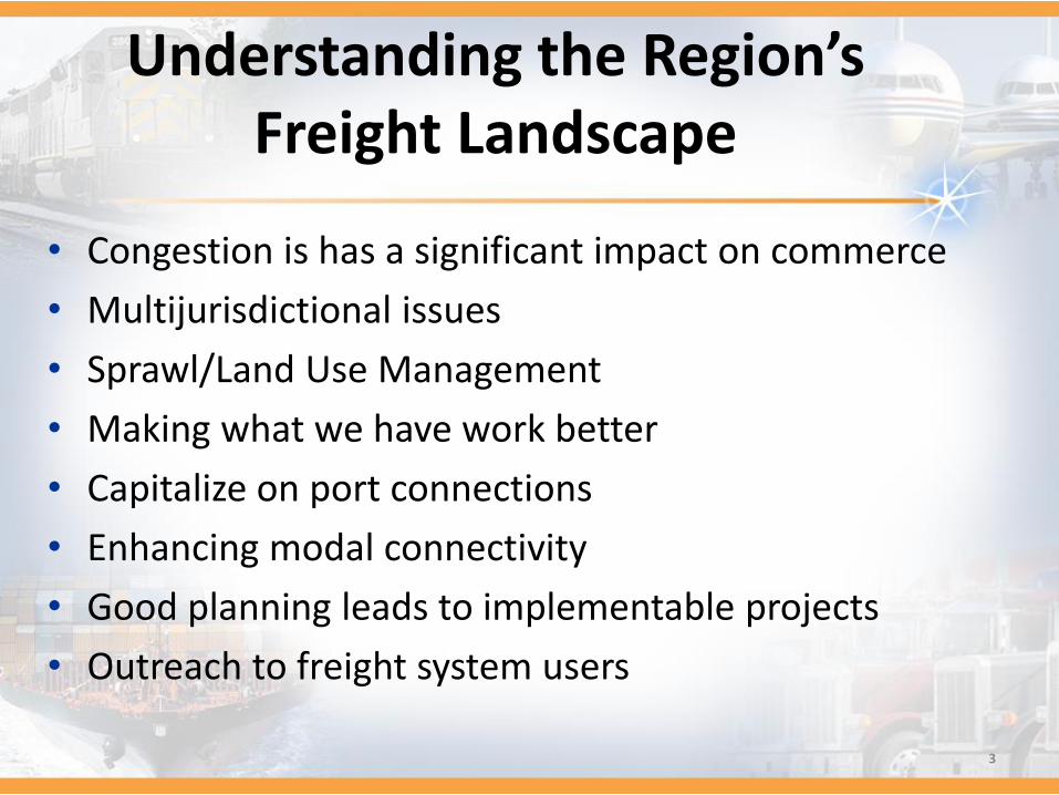
Understanding the Region’s Freight Landscape
• Congestion is has a significant impact on commerce
• Multijurisdictional issues
• Sprawl/Land Use Management
• Making what we have work better
• Capitalize on port connections
• Enhancing modal connectivity
• Good planning leads to implementable projects
• Outreach to freight system users
3
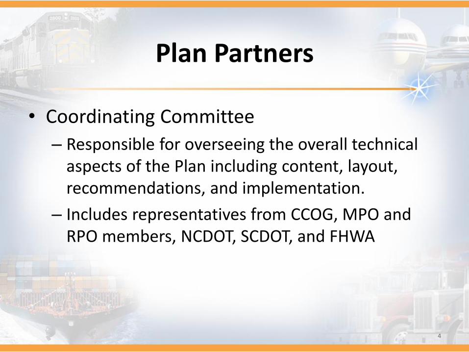
Plan Partners
• Coordinating Committee
– Responsible for overseeing the overall technical aspects of the Plan including content, layout, recommendations, and implementation.
– Includes representatives from CCOG, MPO and RPO members, NCDOT, SCDOT, and FHWA
4

Plan Partners
• Steering Committee
– Responsible for the policy level elements of the Plan, serving as advisors to the Coordinating Committee in addition to reviewing Plan recommendations and findings.
– Includes MPO TCC members, representatives from counties, economic development community, modal representatives (air, rail, water), etc.
5

Plan Partners
• Freight Advisory Committee (FAC)
– A FAC will be established by identifying members during the Plan development process.
– It will be composed of members of the private sector including firms related to trucking, rail and aviation.
– Members will assist in the implementation of the Plan on an on-going basis.
6

Stakeholder Engagement
• Three Rounds of Interviews/Surveys
1. Industry surveys and interviews—Conditions and Performance
2. Driver Interviews
3. Industry surveys and interviews—Needs and priorities
7

Plan Development Process
Existing Conditions
Bottlenecks
Commodity Flows
O-D Analysis and Freight Corridors
Network Identification
Economic Impacts
Truck Parking
Land Use, Facility,
Infrastructure & Regulatory
Gaps
Existing Land Uses
Regional Freight Land Use Policies and Regulations
Truck Parking Capacity and
Needs
Road/Rail Network Corridor
Demand
Best Practices
Technology Trends
Safety and Security
Public Private Partnerships
Prioritizing Regional Needs
Bottlenecks & LOS
Pavement/Bridge Conditions
High Crash Location
Economic Opportunity
Rail/Truck Grade Crossings
Intermodal Connections
Performance Measures
Goals Addressed
Freight Impacted, Related or Focused
Quantifiable and Trackable
Gre
ater C
harlo
tte R
egio
nal Fre
ight M
ob
ility Plan
Stakeholder Engagement8

Plan Outcomes
• Recommendations and guidance for actions, policies and investments
• Project prioritization processes for North Carolina’s Strategic Transportation Investments law (STI)
• Identification of opportunities to capitalize on increased federal funding (MAP-21 and beyond)
• Freight transportation conditions, performance, needs and opportunities
• Freight logistical, infrastructure, land use and economic impacts
It is critical that the Charlotte region prioritize needs that provide the greatest impact to freight mobility to capitalize on
opportunities. 9

Progress to Date
10
• Base data collection
• Freight network inventory
• Truck parking inventory and utilization
• Review of existing plans
• Mapping
• Update meetings with committees
• Begin to identify Plan stakeholders
• Safety/Crash statistics
• Existing Commodity Flows from FAF4

Study Area Boundary
11

Truck Roadway Network Inventory
Roadway Type MilesInterstate 556.86US Highway 920.06State 1,846.41Local 12,051.34
12

Bridges—Structurally Deficient
• North Carolina: 282 Bridges
• South Carolina: 139
13

Bridges—Functionally Obsolete
• North Carolina: 831 bridges
• South Carolina: 67
14

Truck Parking Demand
• Observations
– Heavy utilization of truck parking facilities along I-77 between Exit 65 and Exit 36 in Iredell County. Trucks parked on multiple I-77 interchange and rest area ramps.
– Heavy utilization of I-85 truck parking facilities from Exit 71 in Rowan County to Exit 39 in Mecklenburg. Trucks observed being parked on shoulders, ramps and side streets.
– Heavy utilization of I-77 facilities south of the city through Chester County, SC.
15
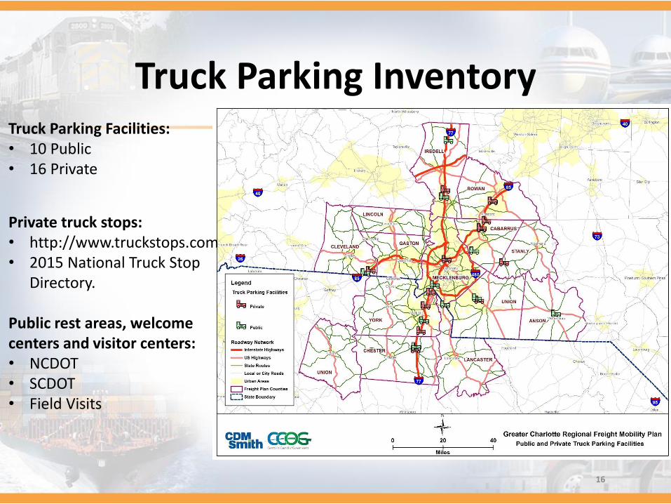
Truck Parking Inventory
Private truck stops:• http://www.truckstops.com• 2015 National Truck Stop
Directory.
Public rest areas, welcome centers and visitor centers:• NCDOT• SCDOT• Field Visits
Truck Parking Facilities:• 10 Public• 16 Private
16
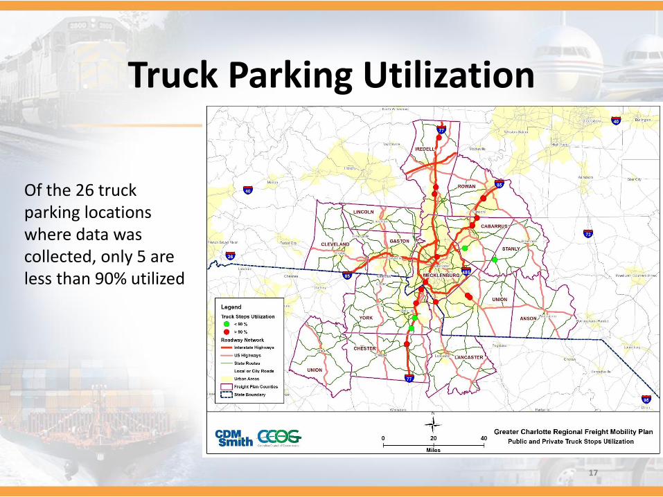
Truck Parking Utilization
Of the 26 truck parking locations where data was collected, only 5 are less than 90% utilized
17

Truck Crash Statistics
Commercial Vehicle and All Motor Vehicle Crashes (2009 -2013)
YearCommercial
Vehicle Crashes
All Motor Vehicle Crashes
CMV/All Vehicle Crashes
2009 1,172 51,411 2.3%
2010 1,298 52,145 2.5%
2011 1,321 52,172 2.5%
2012 1,437 56,270 2.6%
2013 1,398 59,593 2.3%
Total 6,626 271,591 2.4%
18

Truck Crash Statistics
19
Commercial Vehicle Crashes by Roadway Type and Severity (2009 – 2013)
Roadway Type Fatal Injury PDO Unknown Total
Interstate 30 819 1,808 6 2,663
US Highway 11 240 476 2 729
State Primary 15 178 311 3 507
State Secondary 8 139 243 6 396
County/ Local 12 581 1,702 36 2,331
Total 76 1,957 4,540 53 6,626

Truck Crash Densities
20

Region’s RailroadsRailroad Owner Miles
Aberdeen Carolina & Western Railway
50.8
Alexander Railroad Company
13.6
Carolina Coastal Railway
13.5
CSX 335.0
NCDOT 1.0Norfolk Southern 593.7Piedmont & Northern Railway
15.5
Winston-Salem Southbound Railway
42.10
Lancaster & Chester 66.8Others/Unknown 10.0
21

Rail/Highway at-Grade Crossings
North Carolina -1,158 crossings
South Carolina -343 crossings
22

Rail Bottlenecks and Constraints
• Along both the NS Main line and the CSX SF line at the ADM Mill in downtown Charlotte.
• The Charlotte Junction Wye, located west of downtown Charlotte, connecting the NS Main line and the R line.
• Aberdeen Carolina & Western Railway (ACW) corridor creating bottlenecks in CSX’s North Davidson yard.
• Extensive CSX northwest yard terminal operation impacting local roadway networks.
23

Region’s Airports
Commercial Service Airports - 2
General Aviation Airports - 12
24
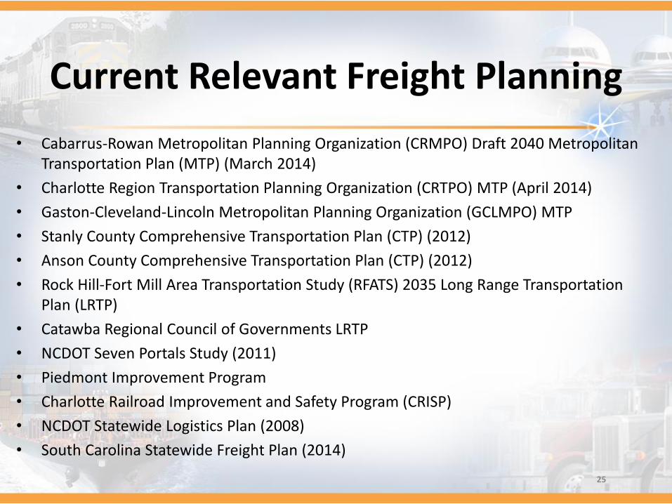
Current Relevant Freight Planning
• Cabarrus-Rowan Metropolitan Planning Organization (CRMPO) Draft 2040 Metropolitan Transportation Plan (MTP) (March 2014)
• Charlotte Region Transportation Planning Organization (CRTPO) MTP (April 2014)
• Gaston-Cleveland-Lincoln Metropolitan Planning Organization (GCLMPO) MTP
• Stanly County Comprehensive Transportation Plan (CTP) (2012)
• Anson County Comprehensive Transportation Plan (CTP) (2012)
• Rock Hill-Fort Mill Area Transportation Study (RFATS) 2035 Long Range Transportation Plan (LRTP)
• Catawba Regional Council of Governments LRTP
• NCDOT Seven Portals Study (2011)
• Piedmont Improvement Program
• Charlotte Railroad Improvement and Safety Program (CRISP)
• NCDOT Statewide Logistics Plan (2008)
• South Carolina Statewide Freight Plan (2014)
25

Commodity FlowsFAF Boundaries within the NCDOT Statewide Model
26
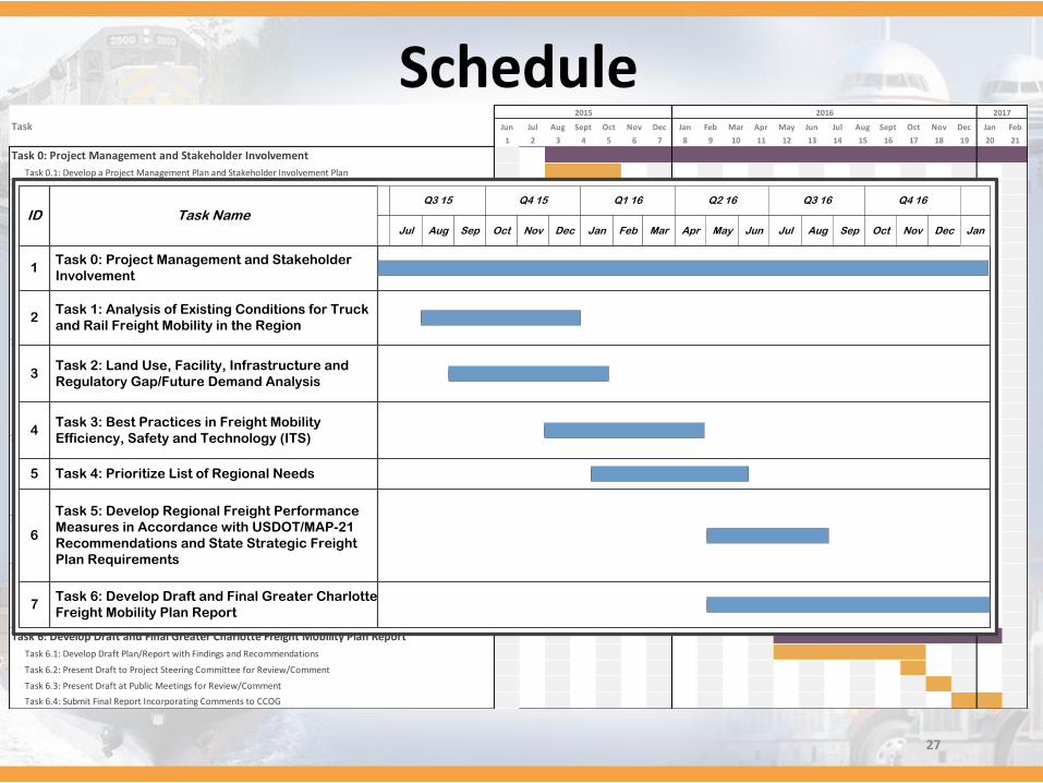
ScheduleTask Jun Jul Aug Sept Oct Nov Dec Jan Feb Mar Apr May Jun Jul Aug Sept Oct Nov Dec Jan Feb
1 2 3 4 5 6 7 8 9 10 11 12 13 14 15 16 17 18 19 20 21
Task 0: Project Management and Stakeholder Involvement
Task 0.1: Develop a Project Management Plan and Stakeholder Involvement Plan
Task 1: Analysis of Existing Conditions for Truck and Rail Freight Mobility in the Region
Task 1.1: Truck Freight Bottleneck Analysis-Interstate and Major Regional Routes
Task 1.2: Truck Origin/Destination Analysis and Identification of Critical Freight Corridors
Task 1.3: Truck Network Identification
Task 1.4: Truck Freight Economic Impact Analysis
Task 1.5: Truck Parking Facility/Utilization Rate Analysis
Task 1.6: Overview of Rail Freight System and Identification of Key Corridors and Facilities
Task 1.7: Existing Freight Rail System Bottlenecks and Constraints
Task 1.8: Existing Commodity Freight Flow and Train Volume Analysis
Task 1.9: Rail Freight Economic Impact Analysis
Task 2: Land Use, Facility, Infrastructure and Regulatory Gap/Future Demand Analysis
Task 2.1: Inventory of Existing Regional Freight/Intermodal Land Use
Task 2.2: Regional Freight Land Use Policies and Regulations
Task 2.3: Intermodal and Truck Parking Facility Capacity
Task 2.4: Road Network Corridors (Interstate and Local)
Task 2.5: Rail Network Corridors (Dedicated and Shared Use)
Task 3: Best Practices in Freight Mobility Efficiency, Safety and Technology (ITS)
Task 3.1: Peer Review of National Freight Mobility Plan 'Best Practices' Models
Task 3.2: Future Technology Trends and Applications
Task 3.3: Freight Safety and Security Features
Task 3.4: Opportunities for Public/Private Partnerships
Task 4: Prioritize List of Regional Needs
Task 4.1: Prioritize List of Regional Needs (for inclusion in CTP, MTP and STIP processes)
Task 4.2: Policy Recommendations
Task 5: Develop Regional Freight Performance Measures in Accordance with USDOT/MAP-21
Recommendations and State Strategic Freight Plan Requirements
Task 5.1: Determine Quantitative Metrics to Support MAP-21 and NCDOT Requirements
Task 5.2: Define Regional Quantitative Data Collection Processes and Partner Responsibilities
Task 6: Develop Draft and Final Greater Charlotte Freight Mobility Plan Report
Task 6.1: Develop Draft Plan/Report with Findings and Recommendations
Task 6.2: Present Draft to Project Steering Committee for Review/Comment
Task 6.3: Present Draft at Public Meetings for Review/Comment
Task 6.4: Submit Final Report Incorporating Comments to CCOG
2015 2016 2017
ID Task NameQ4 15 Q1 16 Q4 16Q3 16Q3 15 Q2 16
MayOct SepDecNov NovJul DecAprAug JulFeb AugJan JunSep OctMar
2Task 1: Analysis of Existing Conditions for Truck
and Rail Freight Mobility in the Region
3Task 2: Land Use, Facility, Infrastructure and
Regulatory Gap/Future Demand Analysis
4Task 3: Best Practices in Freight Mobility
Efficiency, Safety and Technology (ITS)
5 Task 4: Prioritize List of Regional Needs
6
Task 5: Develop Regional Freight Performance
Measures in Accordance with USDOT/MAP-21
Recommendations and State Strategic Freight
Plan Requirements
7Task 6: Develop Draft and Final Greater Charlotte
Freight Mobility Plan Report
1Task 0: Project Management and Stakeholder
Involvement
Jan
27

Thank You!
Questions?
28