geological and geophysical summary report - ontario · geological and geophysical summary report...
TRANSCRIPT
41P16SW2002 2.18261 TUDHOPE
I
Geological and Geophysical Summary Report
on the MERICO - ETHEL PROPERTY
010
James and Tudhope Townships, District of Timiskaming, Ontario
Larder Lake Mining DivisionNTS 41P/16 and NTS 41P/9
800-16.5'W - 470-45 NRECEIVED
MAR r 3 1998
GEOSCIENCE ASSESSMENT
Operated by: CUSIL VENTURE CORPORATION
#507-595 Howe Street Vancouver, British Columbia V6C 2T5
By:
TJ. Quesnel B.Sc.
and
Lawrence Othmer P.Eng.
January 21, 1998
41P16SW2002 2 .18261 TUDHOPE
TABLE OF CONTENTSSUMMARY.................................................................................................................l
COST ESTIMATE OF PHASE ONE .................................................................................3
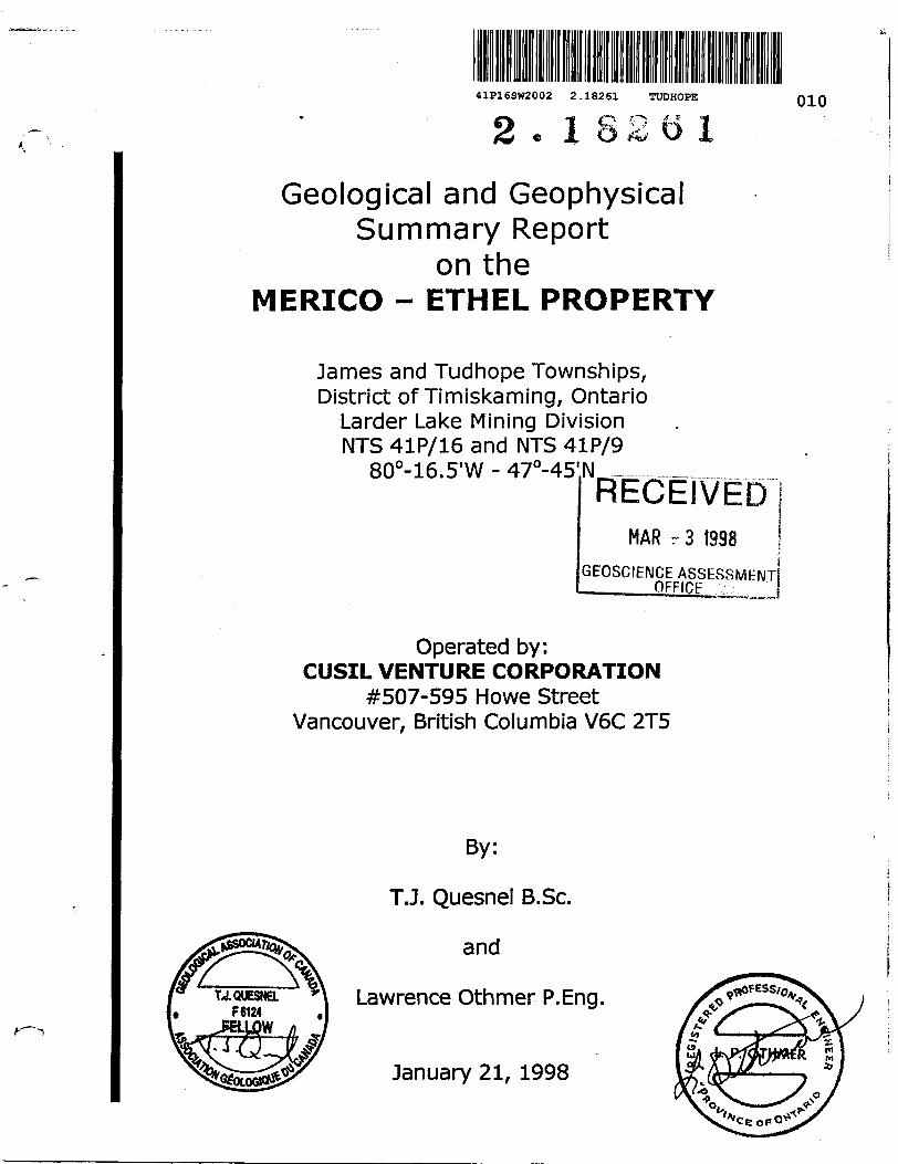
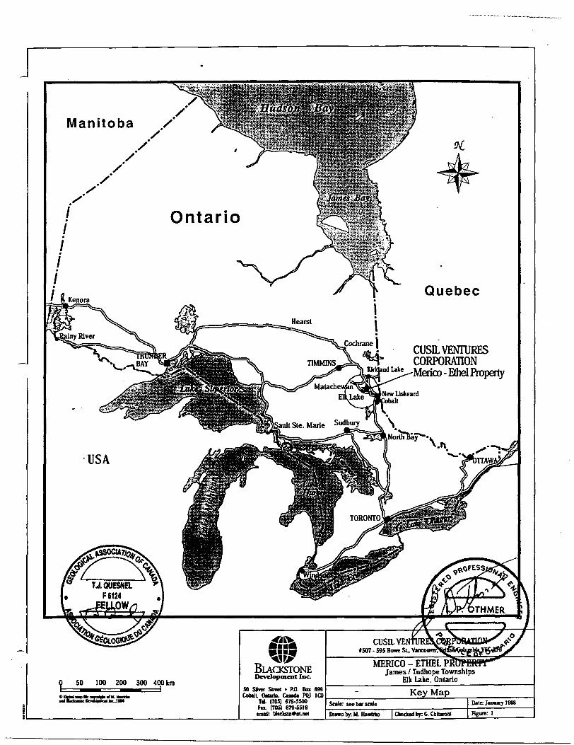
GEOGRAPHIC AND PHYSIOGRAPHIC POSITION....................................................................4Figure l Key Map. ..................................................................................................2
MAJOR MINING CAMPS IN NORTHEASTERN ONTARIO ..........................................................4Figure 2 Major Mining Camps of Northeastern Ontario............................................... 5
PROPERTY DEFINITION. .....................................................................................................6Figure 3 Claim Map.................................................................................................?
REGIONAL GEOLOGY..........................................................................................................8Figure 4 Regional Geology Map - Abitibi Subprovince................................................ 9
LOCAL GEOLOGY..............................................................................................................10Figure 5 Geology and Sample Location Map West Section........................................ 11Figure 6 Geology and Sample Location Map East Section......................................... 12
PREVIOUS WORK.............................................................................................................13
SUMMARY OF WORK PROGRAMS....................................................................................... 14Rgure 7 Total Ground Survey Area Coverage......................................................... 15Figure 8 Magnetometer Survey Area Coverage....................................................... 16Rgure 9 TDIP Induced Polarization Survey Coverage.............................................. 17
MAGNETIC SURVEYS.....................................................................................................18Figure 10 Magnetic Survey.................................................................................... 20
TDIP INDUCED POLARIZATION SURVEY.......................................................................... 18Rgure 11 QuantecTDIP. Interpretation Plan Map................................................... 21Rgure 12 Quantec TDIP. Apparent Resistivity........................................................ 22Figure 13 Quantec TDIP. Window 7 Chargeability................................................... 23Figure 14 Quantec TDIP. Realsection L5+OOE.......................................................24Rgure 15 Quantec TDIP. Realsection L6+OOE.......................................................25Rgure 16 Quantec TDIP. Realsection L 7+OOE....................................................... 26Rgure 17 Quantec TDIP. Realsection L8+OOE....................................................... 27Rgure 18 Quantec TDIP. Realsection L 11+OOE..................................................... 28Rgure 19 Quantec TDIP. Realsection L 12+OOE.....................................................29
RECOMMENDATIONS........................................................................................................30PHASE 1...............................................................................................................30Diamond Drilling....................................................................................................30Geological Mapping and Geochemical Sampling ....................................................... 30PHASE 2...............................................................................................................30
REFERENCES
APPENDIX
Certificate of Qualifications (TJ. Quesnel)Certificate of Qualifications (Lawrence Othmer)Geology. Trench lGeology. Trench 2Geology. Trench 3Geology. Trench 4Summary Analysis Merico - Ethel Property, Samples Collected 1997Whole Rock Analysis Diabase - Merico Shaft Area SamplesAssay Certificate, Swastika Laboratories. Certificate #7W-4126-RA1.Assay Certificate, Swastika Laboratories. Certificate #7W-4463-RAl.Quantec IP Inc. - Main Body of Report (pages 3-15 from Quantec Report)Quantec Statements of Qualifications - 5 pages
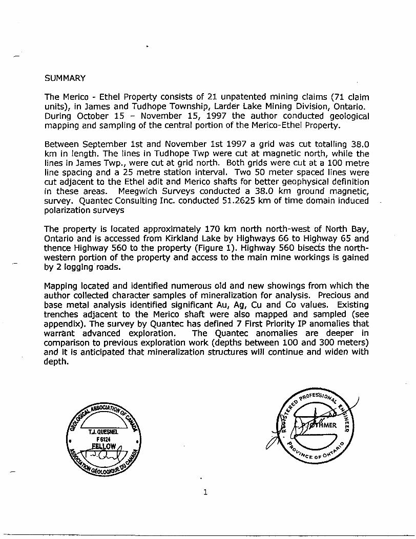
SUMMARY
The Merico - Ethel Property consists of 21 unpatented mining claims (71 claim units), in James and Tudhope Township, Larder Lake Mining Division, Ontario. During October 15 - November 15, 1997 the author conducted geological mapping and sampling of the central portion of the Merico-Ethel Property.
Between September 1st and November 1st 1997 a grid was cut totalling 38.0 km in length. The lines in Tudhope Twp were cut at magnetic north, while the lines in James Twp., were cut at grid north. Both grids were cut at a 100 metre line spacing and a 25 metre station interval. Two 50 meter spaced lines were cut adjacent to the Ethel adit and Merico shafts for better geophysical definition in these areas. Meegwich Surveys conducted a 38.0 km ground magnetic, survey. Quantec Consulting Inc. conducted 51.2625 km of time domain induced polarization surveys
The property is located approximately 170 km north north-west of North Bay, Ontario and is accessed from Kirkland Lake by Highways 66 to Highway 65 and thence Highway 560 to the property (Figure 1). Highway 560 bisects the north western portion of the property and access to the main mine workings is gained by 2 logging roads.
Mapping located and identified numerous old and new showings from which the author collected character samples of mineralization for analysis. Precious and base metal analysis identified significant Au, Ag, Cu and Co values. Existing trenches adjacent to the Merico shaft were also mapped and sampled (see appendix). The survey by Quantec has defined 7 First Priority IP anomalies that warrant advanced exploration. The Quantec anomalies are deeper in comparison to previous exploration work (depths between 100 and 300 meters) and it is anticipated that mineralization structures will continue and widen with depth.
TJ.QUESNEL. F 6124 .
KELLOW
Manitoba X
Ontario
Quebec
CUSH VENTURES CORPORATION
co - Ethel Property
T,
BlACKSTONEDevelopment Inc.
SO Sim Street - P.O. Box 699OnUrio. Cundi PU ICO
Td. (705) 679-5500FM. (705) 679-5519raid: tlacksu*ol.w(
MERICO - ETHEL PRC James l Tudhope Townships
Elk Lake. Ontario
Key MapScale: Me bar sole
Drawn by: M. HawUo Checked by: G. Cblunnl
Date: Jinuary 1998
Figure l
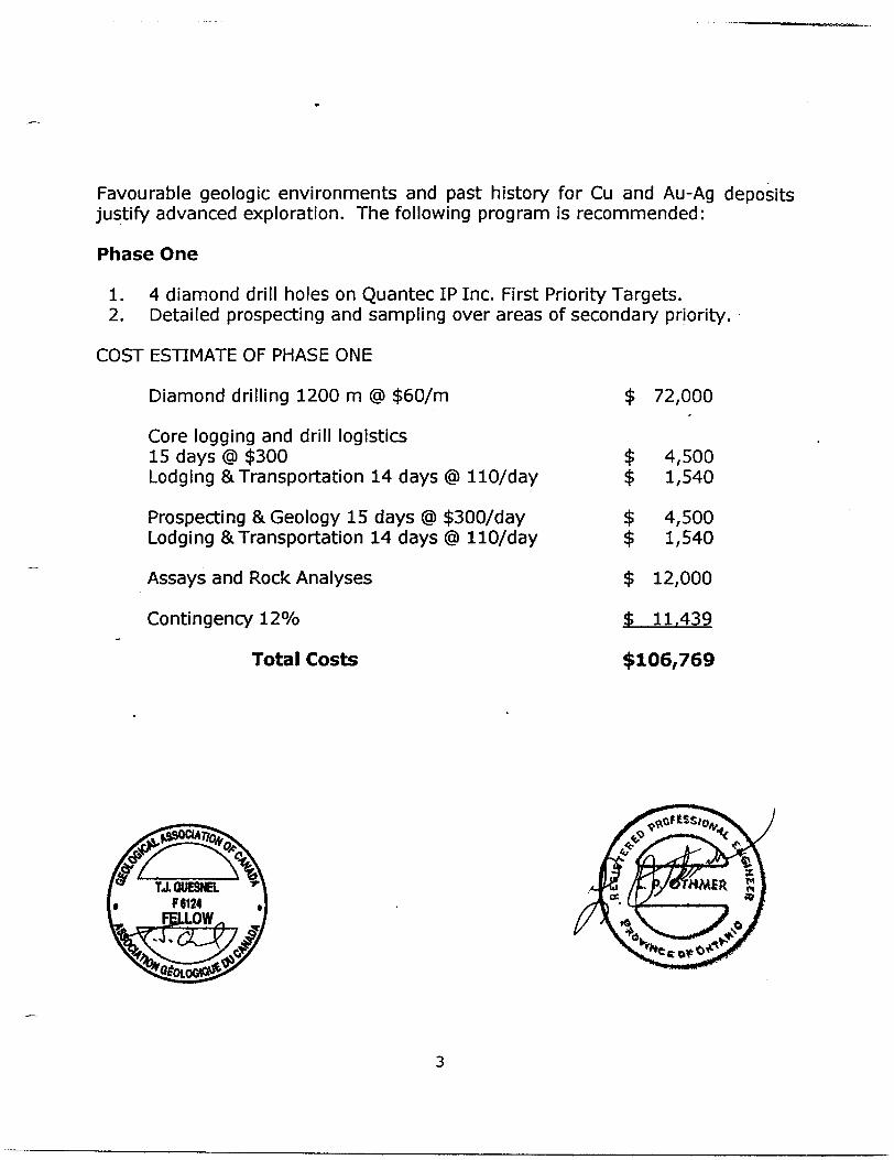
Favourable geologic environments and past history for Cu and Au-Ag deposits justify advanced exploration. The following program is recommended:
Phase One
1. 4 diamond drill holes on Quantec IP Inc. First Priority Targets.2. Detailed prospecting and sampling over areas of secondary priority.
COST ESTIMATE OF PHASE ONE
Diamond drilling 1200 m @ $60/m
Core logging and drill logistics15 days @ $300Lodging 81 Transportation 14 days @ 110/day
Prospecting 8a Geology 15 days @ $300/day Lodging S. Transportation 14 days @ 110/day
Assays and Rock Analyses
Contingency 120Xo
Total Costs
$ 72,000
$$$$s4
4,500 1,540
4,500 1,540
12,000
11.439
$106,769
& T j nuTCMci f
GEOGRAPHIC AND PHYSIOGRAPHIC POSITION.
The claims are centred at 800 16.5'W longitude and 470 45'N latitude in James and Tudhope Townships of the District of Timiskaming, Ontario which is found on map sheet NTS 41P/16 and NTS 41P/9 in the Larder Lake Mining Division as shown on Figure 1. The area is between elevations 300 and 350 meters above sea level.
As previously mentioned, the property is located approximately 170 km north north-west of North Bay, Ontario and is accessed from Kirkland Lake by Highways 66 to Highway 65 and thence Highway 560 to the property. Highway 560 bisects the north-western portion of the property and access to the main mine workings is gained by 2 logging roads.
The claims, which have modest relief, are covered by mixed forest, ponds and swamps. Highway 560 runs across the northern portion of the property. There are no major lakes or major man made features on the property
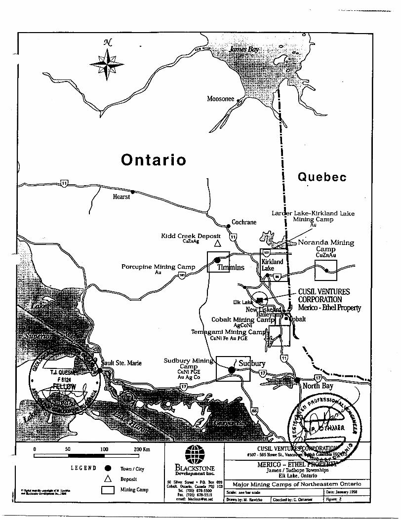
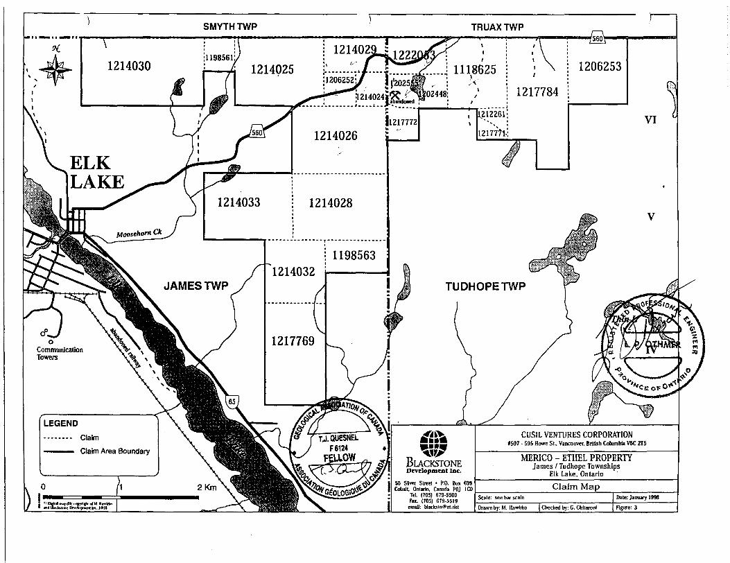
MAJOR MINING CAMPS IN NORTHEASTERN ONTARIO (Figure 2.)
Northeastern Ontario is the source of a major portion of Canadian mining production; part of which is compiled below.
Rouyn-Noranda Mining CampPast production (96,366,373 tonnes of ore) and reserves (35 166 300 tonnes) total 2,039,000 tonnes with 2,038,306 tonnes contained Cu, 947,000 tonnes Zn, 1,332,000 kg Ag and 341,000 kg Au.
Kirkland Lake Mining Camp (Larder Lake Mining Division) The following production figure to 1995 for gold mines was reported by (MNDM Ontario) Resident Geologist Gerhard Meyer: 118,309,000 tonnes @ 10.4 gm/tonne ^ 1,228,000 kg Au.
Timmins Camp (Porcupine Mining Division)Production to 1995 from the Timmins resident geologist's area included four polymetallic Cu-Zn massive sulphide deposits (Including Kidd Creek Mine) which produced 2,373,000 tonnes Cu and 6,880,000 tonnes Zn from 104,803,000 tonnes of ore. Also five polymetallic Ni-Cu sulphide deposits produced 25,000 tonnes Ni from 1,419,000 tonnes of ore.
Sudbury Mining CampLocated 160 km south-southwest of the Ethel Merico property is the centre of the Sudbury Mining Camp 14 km north-west of the Grenville (geological) Subprovince. To 1994 Sudbury camp produced 9,072,000
OntarioQuebec
Larder Lake-Kirkland Lake Cochrane j Mining Camp
Kidd Creek Deposit hiCuZnAg A Noranda Mining
Camp CuZnAu
Porcupine Mining CampAu i—
101
I-CUSH VENTURESCORPORATION
NewjSEia^Ll J Merico-Ethel PropertySWSobaltCobalt Mining amp
AgCoNFTenjagami Mining Cam
CuNi Fe Au PGE
Sudbury Minin Camp
CuNi PGE Au Ag Co
CUSILVEf 507-595 Howe St, Vu*
MERICO - ETHELJames l Tudhope Townships
Elk Lake, Ontario50 SBvtr Sowl - P.O. Bur 699 Cobilt. Ontirio. Cundi POJ 100
Td. (705) 679-5500 (705) 679-5519
enufl:
Major Mining Camps of Northeastern Ontario
tonnes Ni, 9,072,000 tonnes Cu, 54,431 tonnes Co, 124,414 kg Au, 778,000 kg platinum group metals (PGM) and 3,266,000 kg Ag from 725,748,000 tonnes of ore mined from post Archean rocks of the Sudbury Irruptive.
Temagami Mining CampWithin the Temagami Mining camp the following drill indicated reserves are reported:
b. Copper-fields Mining Corp. Ltd. "Pyrite Zone" 698,532 tonnes @ 1.040Xo Cu and Q.46% Ni.
b. Kanichee Mining Inc.1,871,522 tonnes at Q.41% Cu and Q.26% Ni.
b. Stroud Resources Lecky Property, also known as 'Little Dan, Manitoba or Eastern Property 307,410 tonnes at 0.27 oz Au.
b. Diadem Teck Strathcona Twp. Northeastern arm of Lake Temagami. 453,592 tonnes at 0.50Xo cu and Q.1% Ni to 122 metres.
Past Production from the Temagami Mining Camp includes: b. 30,430 tonnes Cu 7 5812 kg Ag and 316 Kg Au from 467,567 tons
mined by Copper-fields Mining Corp. Ltd. At a 4 0Xo cut off grade and b. 45 tonnes Cu, 30 tonnes Ni, l kg oz Au, 28 kg Ag, 3 kg Pt and 6 kg
Pd from 3010 tonnes by Kanichee Mining Inc. from its Ajax(Caniptau) Mine during 1963.
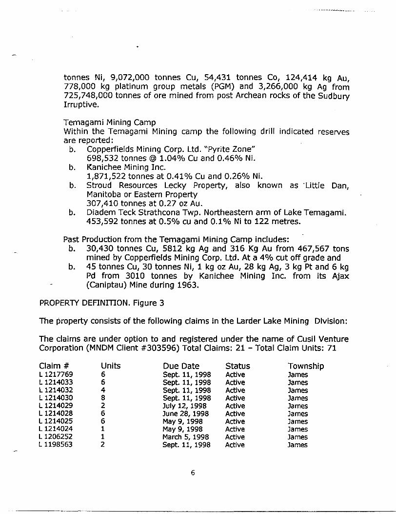
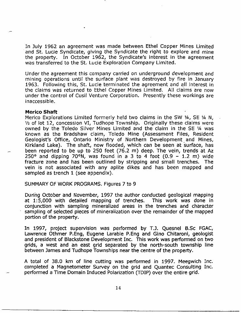
PROPERTY DEFINITION. Figure 3
The property consists of the following claims in the Larder Lake Mining Division:
The claims are under option to and registered under the name of Cusil Venture Corporation (MNDM Client #303596) Total Claims: 21 - Total Claim Units: 71
Claim # Units Due Date Status TownshipL1217769 6 Sept. 11,1998 Active JamesL1214033 6 Sept. 11, 1998 Active JamesL1214032 4 Sept. 11, 1998 Active JamesL1214030 8 Sept. 11,1998 Active JamesL1214029 2 July 12,1998 Active JamesL1214028 6 June 28,1998 Active JamesL1214025 6 May 9,1998 Active JamesL1214024 l May 9, 1998 Active JamesL1206252 l March 5, 1998 Active JamesL1198563 2 Sept. 11,1998 Active James
SMYTHTWP TRUAXTWP
4 1214025
1214024^^.abandoned J
ELK LAKE
JAMES TWP TUDHOPETWP
Communication Towers
CUSIL VENTURES CORPORATION1507 - 595 Howe Si.. Vancouver. British Columbia V6C ZT5
Claim
Claim Area Boundary
QUESNEL F 6124
FELLOW MERICO - ETHEL PROPERTYJames l Tudhope Townships
Elk Lake. Ontario
Cobalt. Ontario. Canada POJ ICOTel. (705) 679-5500 Fan. (705) 679-5519
emal: [email protected] Drawn by: M. Hawlrfco | Checked by: C. Chllaronl
L1198561 l Sept. 11, 1998 Active JamesL1214026 6 May 9, 1998 Active JamesL1202555 l April 26, 1998 Active TudhopeL1202448 l April 26, 1998 Active TudhopeL1212261 l Sept. 11, 1998 Active TudhopeL1206253 4 Match 5, 1998 Active TudhopeL1118625 4 Oct. 21, 1998 Active TudhopeL1217772 l Sept. 24, 1998 Active TudhopeL1217784 7 June 5, 1999 Active TudhopeL1222053 2 May 15, 1999 Active TudhopeL1217771 l Sept. 241998 Active Tudhope21 Claims 71 units
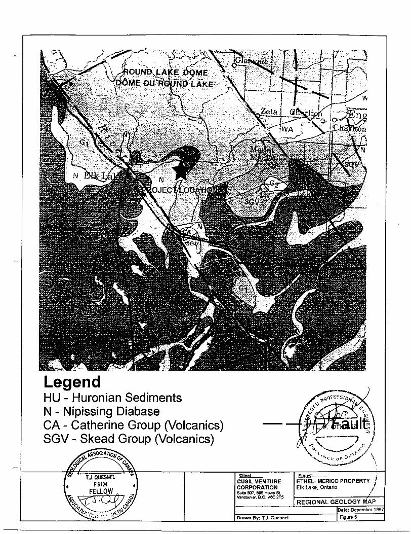
REGIONAL GEOLOGY
The best documented regional geology is found on Ontario Geological Survey Map 2484 titled "Lithostratigraphic Map of the Abitibi Subprovince" which is duplicated as Figure 4 in this report at scale 1:500 000 and from Geology of the Hill Lake Area, District of Timiskaming, Ontario Geological Survey Geological Report 250 (presented below). The Abitibi Subprovince of Archean age volcanics, sediments and intrusives is commonly called the Abitibi Greenstone Belt.
"The townships of James and Tudhope are underlain by Early Precambrian metavolcanics of the Abitibi Greenstone Belt that have been unconformably overlain by the sedimentary rocks of the Cobalt Group, part of the Huronian Supergroup which is Middle Precambrian in age.
The metavolcanics are subdivided into three groups which are from the oldest to the youngest: The Wabewawa Group, the Catharine Group, and the Skead Group. These groups form a southeast-facing homoclinal sequence approximately 11 000 m thick. The Wabewawa Group, composed of interbedded high magnesium tholeiitic basalt, high iron tholeiitic basalt, komatiitic basalt and ultramafic flows, is 1800 to 3000 m thick. The Catharine Group is 4400 m thick, conformably overlies the Wabewawa Group, and consists of high iron tholeiitic basalt. The Skead Group, 4480 m thick, is composed of interdigitated to graded, calc-alkalic andesitic to dacitic quartz- feldspar porphyry, pyroclastic breccia, tuff-breccia, lapilli-tuff, lapillistone and tuff, and conformably overlies the Catharine Group. None of these volcanics outcrop on the Merico - Ethel Property.
Various intrusions are associated with the metavolcanic groups. The Wabewawa Group has been intruded by small, localized gabbros and a
LegendHU - Huronian SedimentsN - Nipissing DiabaseGA - Catherine Group (Volcanics)SGV - Skead Group (Volcanics)
CUSIL VENTURE CORPORATIONSuite 507, 595 Howe St Vancouver. B.C. V6C 2T5
ETHEL- MERICO PROPERTY Elk Lake. Ontario
REGIONAL GEOLOGY MAPDate: December 1997
Drawn By: T.J. Quesnel Figure 5
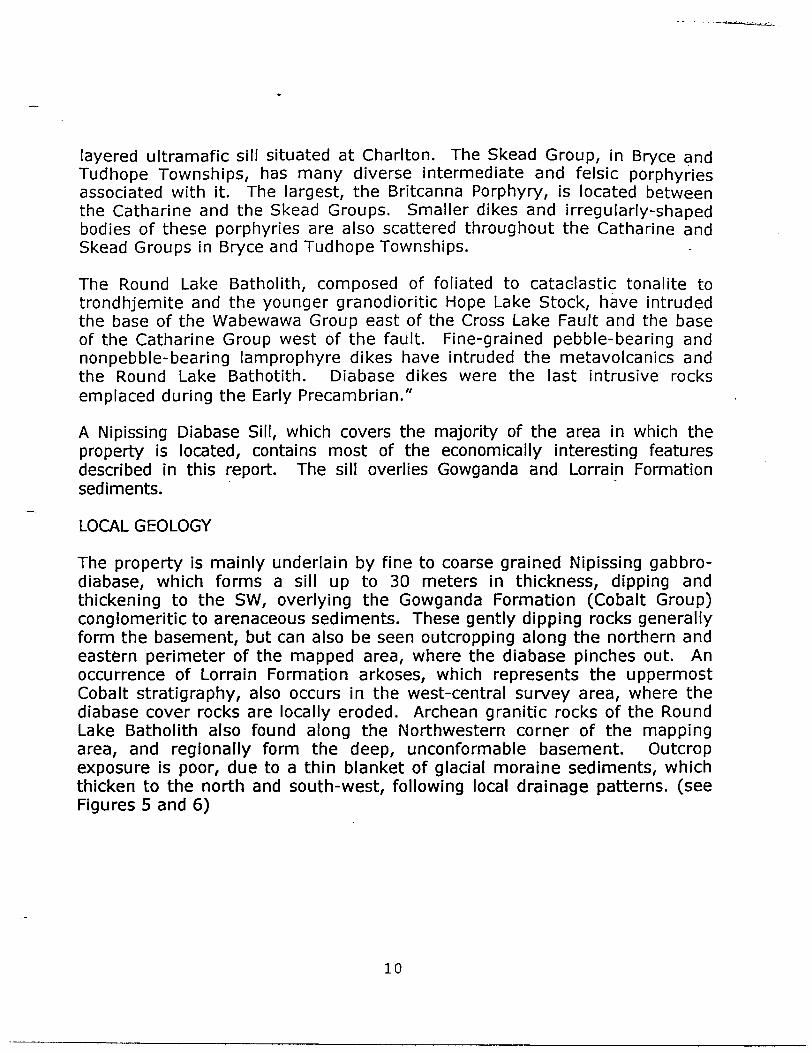
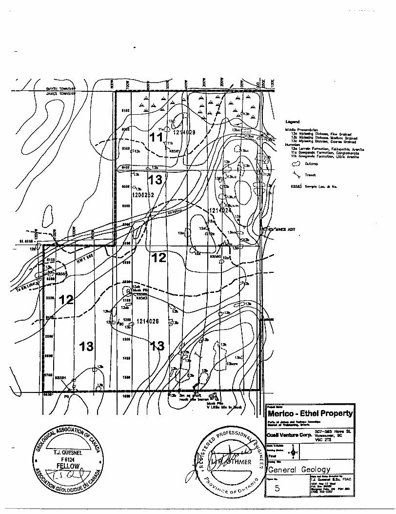
layered ultramafic sill situated at Charlton. The Skead Group, in Bryce and Tudhope Townships, has many diverse intermediate and felsic porphyries associated with it. The largest, the Britcanna Porphyry, is located between the Catharine and the Skead Groups. Smaller dikes and irregularly-shaped bodies of these porphyries are also scattered throughout the Catharine and Skead Groups in Bryce and Tudhope Townships.
The Round Lake Batholith, composed of foliated to cataclastic tonalite to trondhjemite and the younger granodioritic Hope Lake Stock, have intruded the base of the Wabewawa Group east of the Cross Lake Fault and the base of the Catharine Group west of the fault. Fine-grained pebble-bearing and nonpebble-bearing lamprophyre dikes have intruded the metavolcanics and the Round Lake Bathotith. Diabase dikes were the last intrusive rocks emplaced during the Early Precambrian."
A Nipissing Diabase Sill, which covers the majority of the area in which the property is located, contains most of the economically interesting features described in this report. The sill overlies Gowganda and Lorrain Formation sediments.
LOCAL GEOLOGY
The property is mainly underlain by fine to coarse grained Nipissing gabbro- diabase, which forms a sill up to 30 meters in thickness, dipping and thickening to the SW, overlying the Gowganda Formation (Cobalt Group) conglomeritic to arenaceous sediments. These gently dipping rocks generally form the basement, but can also be seen outcropping along the northern and eastern perimeter of the mapped area, where the diabase pinches out. An occurrence of Lorrain Formation arkoses, which represents the uppermost Cobalt stratigraphy, also occurs in the west-central survey area, where the diabase cover rocks are locally eroded. Archean granitic rocks of the Round Lake Batholith also found along the Northwestern corner of the mapping area, and regionally form the deep, unconformable basement. Outcrop exposure is poor, due to a thin blanket of glacial moraine sediments, which thicken to the north and south-west, following local drainage patterns, (see Figures 5 and 6)
10
LJ.QUESNELF 6124
FALLOW
Ulddta PraoombrlonISo Nlplxlno. Dlobou. Flni Grolnod 136 NlplHlng DloboM. Uadum Grolnod 13c NVlMkig OKbou, Cant Groined
Huronian12o Lorrain Formation, F*ld*?alhlc ArantU 11a Covganda Formation. CongtomoroU 11b Cowgondo Formation, lithic Aronlto
,~2 Outcrop
^s. Traneh
SampU Lot * No.
INE5 AOT
Merico -rokiCJnaaMX DMlMotlmi lit
Ethel PropertyOjitoh
- ..., . - S07-50S HOM SL CtMflVwifairaCorp. Vonoouwr. BC
V6C 2T5if-*-'•^B*
General Geologyrv-..
5r-l Quanol fi^Sc. FCAC ISA Hv 17 ItarfPA l taaa• r, .. Mk. M POM IB CJOQTB-UV
TRUAX TOWNSHIP
j TUDHOPE TOXNSHP
MMdli Praeombrtan13o Nttafno. DfetaM. Fm* Orrinttf 13b NlpMnf CXoboM. Medium Grafcrcrf 13c NlpliiVii DWnM, Con* OrakMd
Huron Ion120 Lorrofn Farmottan. Fdd^iothle Arvitta 11a Cmigonda FanrwUfln, Canajom*vtt lib Oratonda FomxUai. Uttife Annlli
"\,. Trm*
K85U Snnpll Lot k No.
Merico - Ethel Property
~ .. ,. -^ ^ S07-S93 Howt SLCu*ll Venture Corp. Vancouver, BCVBC ZT3
General Geology7.j..oimn(i s.sc. roAC
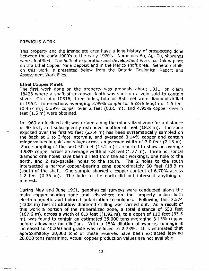
PREVIOUS WORK
This property and the immediate area have a long history of prospecting done between the early 1900's to the early 1970's. Numerous Au, Ag, Cu, showings were identified. The bulk of exploration and development work has taken place on the Ethel Copper Mine Deposit and in the Merico shaft area. General details on this work is presented below from the Ontario Geological Report and Assessment Work Files.
Ethel Copper MinesThe first work done on the property was probably about 1911, on claim 18423 where a shaft of unknown depth was sunk on a vein said to contain silver. On claim 10316, three holes, totaling 850 feet were diamond drilled in 1952. Intersections averaging 2.9907o copper for a core length of 1.5 feet (0.457 m); Q.39% copper over 2 feet (0.61 m); and 4.91 07o copper over 5 feet (1.5 m) were obtained.
In 1960 an inclined adit was driven along the mineralized zone for a distance of 90 feet, and subsequently extended another 60 feet (18.3 m). The zone exposed over the first 90 feet (27.4 m) has been systematically sampled on the back at 2 to 3-foot intervals, and averaged 3.1407o copper and contain minor values in gold and silver across an average width of 7.0 feet (2.13 m). Face sampling of the next 50 feet (15.2 m) is reported to show an average
3.980Xo copper across an average width of 5.8 feet (1.77 m). Three horizontal diamond drill holes have been drilled from the adit workings, one hole to the north, and 2 sub-parallel holes to the south. The 2 holes to the south intersected a narrow copper-bearing zone approximately 60 feet (18.3 m )south of the shaft. One sample showed a copper content of 6.7007o across 1.2 feet (0.36 m). The hole to the north did not intersect anything of interest.
During May and June 1961, geophysical surveys were conducted along the main copper-bearing zone and elsewhere on the property using both electromagnetic and induced polarization techniques. Following this 7,574 (2308 m) feet of shallow d iamond drilling was carried out. As a result of this work a portion of the mineralized zone, a total distance of 550 feet (167.6 m), across a width of 6.3 feet ((1.92 m), to a depth of 110 feet (33.5 m), was found to contain an estimated 35,000 tons averaging 3.1507o copper before allowance for dilution. With a 1507o dilution allowance, tonnage is increased to 40,250 and grade was reduced to 2.7307o. It is estimated that approximately 20,000 tons of these reserves have been extracted leaving 20,000 tons remaining. Actual copper production values are not available.
13
In July 1962 an agreement was made between Ethel Copper Mines Limited and St. Lucie Syndicate, giving the Syndicate the right to explore and mine the property. In October 1962, the Syndicate's interest in the agreement was transferred to the St. Lucie Exploration Company Limited.
Under the agreement this company carried on underground development and mining operations until the surface plant was destroyed by fire in January 1963. Following this, St. Lucie terminated the agreement and all interest in the claims was returned to Ethel Copper Mines Limited. All claims are now under the control of Cusil Venture Corporation. Presently these workings are inaccessible.
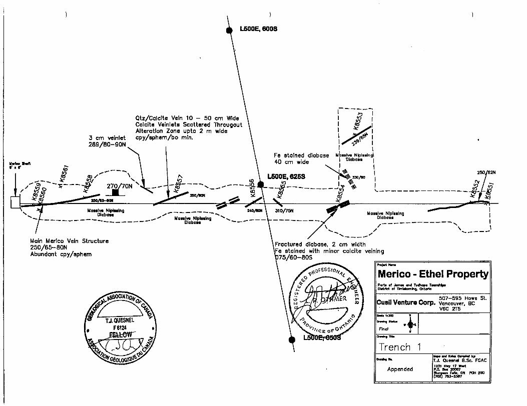
Merico ShaftMerico Explorations Limited formerly held two claims in the SW Vi, SE V4 N, V2 of lot 12, concession VI, Tudhope Township. Originally these claims were owned by the Toledo Silver Mines Limited and the claim in the SE 1A was known as the Bradshaw claim, Toledo Mine (Assessment Files, Resident Geologist's Office, Ontario Ministry of Northern Development and Mines, Kirkland Lake). The shaft, now flooded, which can be seen at surface, has been reported to be up to 250 feet (76.2 m) deep. The vein, trends at Az 2500 and dipping 700 N, was found in a 3 to 4 foot (0.9 - 1.2 m) wide fracture zone and has been outlined by stripping and small trenches. The vein is not associated with any aplite dikes and has been mapped and sampled as trench l (see appendix).
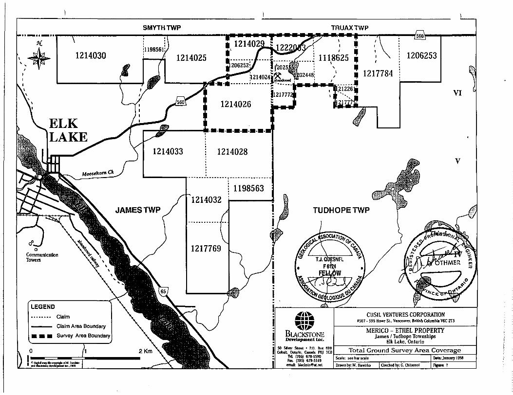
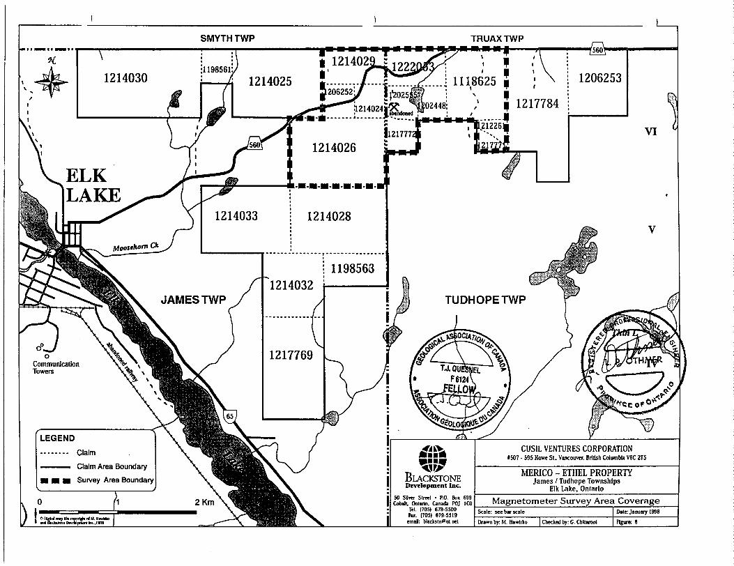
SUMMARY OF WORK PROGRAMS. Figures 7 to 9
During October and November, 1997 the author conducted geological mapping at 1:5,000 with detailed mapping of trenches. This work was done in conjunction with sampling mineralized areas in the trenches and character sampling of selected pieces of mineralization over the remainder of the mapped portion of the property.
In 1997, project supervision was performed by T.J. Quesnel B.Sc FGAC, Lawrence Othmer P.Eng, Eugene Larabie P.Eng and Gino Chitaroni, geologist and president of Blackstone Development Inc. This work was performed on two grids, a west and an east grid separated by the north-south township line between James and Tudhope Townships near the centre of the property.
A total of 38.0 km of line cutting was performed in 1997. Meegwich Inc. completed a Magnetometer Survey on the grid and Quantec Consulting Inc. performed a Time Domain Induced Polarization (TDIP) over the entire grid.
14
SMYTH TWP TRUAXTWP
ELK LAKE
JAMES TWP TUDHOPETWP
Communication Towers
CUSIL VENTURES CORPORATION1507 - 595 Howe Si.. Vancouver. British Columbia V6C ZT5
Claim
Claim Area Boundary
Survey Area BoundaryD WBLACKSTONE MERICO - ETHEL PROPERTY
James l Tudhope TownshipsElk Lake, OntarioDevelopment Inc.
SO Silver Street - P.O. Box 699Cobalt, Ontario. Canada POJ ICO
Tel. (705) 679-5500Fix. (705) 679-55(9
emifl: Uacltstn9nt.net
Total Ground Survey Area Coverage
Drawn by: M. Hawlrko | Checked by: C. Chllaronl
SMYTH TWP TRUAXTWP
ft 121402 lk 1 214025
ELK LAKE
J AMES TWP TUDHOPETWP
Communication Towers
CUSIL VENTURES CORPORATION1507 - 595 Howe St., Vancouver. BrtUsh CdumbU V6C 2T5
Claim Area Boundary
Survey Area BoundaryMERICO - ETHEL PROPERTY
James l Tudhope TownshipsElk Lake, Ontario
50 SUm Slnwl - P.O. Bo* 699Cobalt, Onlirin, Canada POJ ICO
Tel. (705) 679-5500Fu. (705) 679-5519
email: Wacksln^nl.trel
Magnetometer Survey Area Coverage
Drawn by: M. Hawfrta) | Cheeked by: G. Chllarotil
SMYTH TWP TRUAXTWP
f
JAMES TWP TUDHOPETWP
Communication Towers
CUSIL VENTURES CORPORATION1507 - 595 Howe St., Vancouver, British Columbia V6C 2T5
Claim
Claim Area Boundary
Survey Area BoundaryMERICO - ETHEL PROPERTY
James l Tudhope TownshipsElk Lake. Ontario
TDIP - Induced Polarization Survey CoverageCobllt. Ontario. Canada POJ ICOTd. (705) 679-5500 Fax. (705) 679-5514
email: [email protected]'l IfeM mip Ik nmflri. n(M l ml dUfalnir D itimn H.-.I Drawn by: M. Hawtrico | Cheeked by: C. Chliaronl
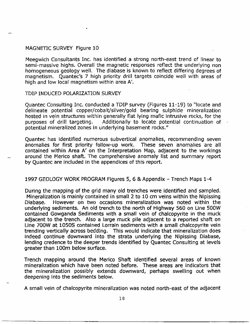
MAGNETIC SURVEY Figure 10
Meegwich Consultants Inc. has identified a strong north-east trend of linear to semi-massive highs. Overall the magnetic responses reflect the underlying non homogeneous geology well. The diabase is known to reflect differing degrees of magnetism. Quantec's 7 high priority drill targets coincide well with areas of high and low local magnetism within area A'.
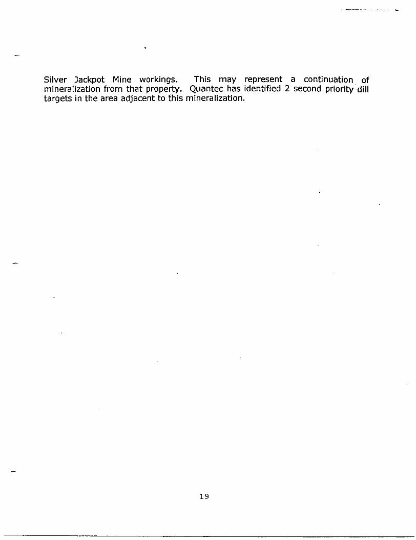
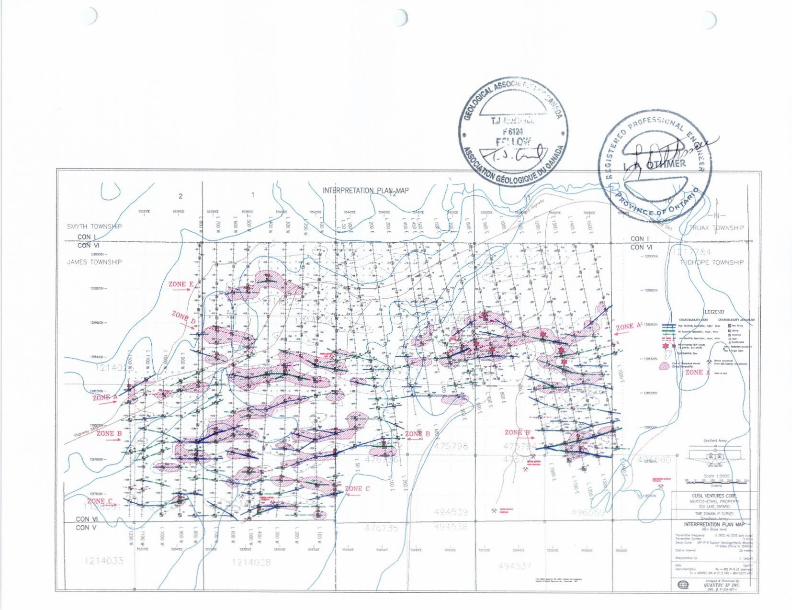
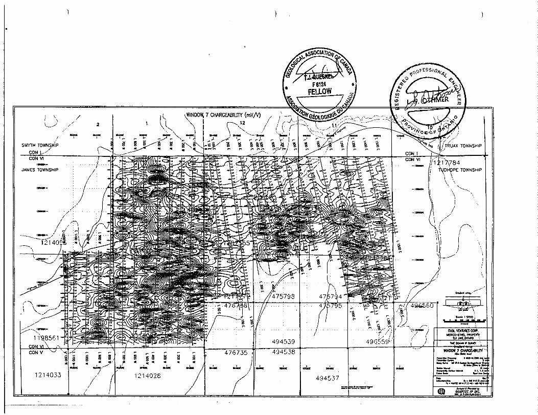
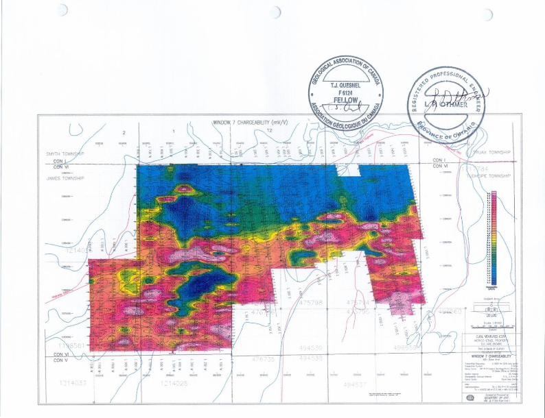
TDIP INDUCED POLARIZATION SURVEY
Quantec Consulting Inc. conducted a TDIP survey (Figures 11-19) to "locate and delineate potential copper/cobalt/silver/gold bearing sulphide mineralization hosted in vein structures within generally flat lying mafic intrusive rocks, for the purposes of drill targeting. Additionally to locate potential continuation of potential mineralized zones in underlying basement rocks."
Quantec has identified numerous subvertical anomalies, recommending seven anomalies for first priority follow-up work. These seven anomalies are all contained within Area A' on the Interpretation Map, adjacent to the workings around the Merico shaft. The comprehensive anomaly list and summary report by Quantec are included in the appendices of this report.
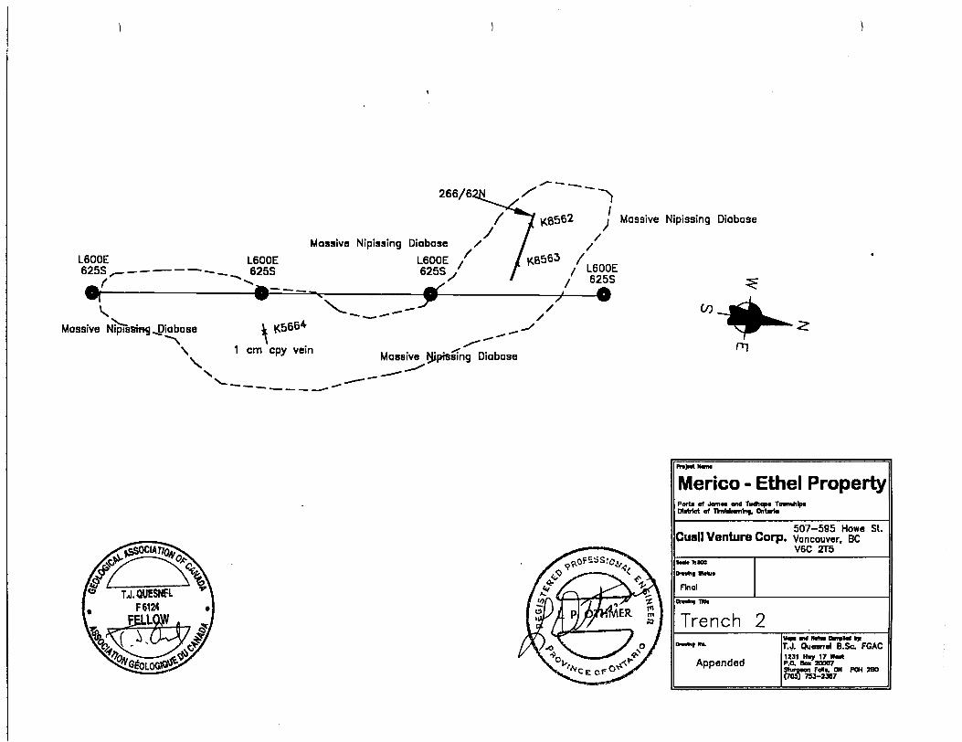
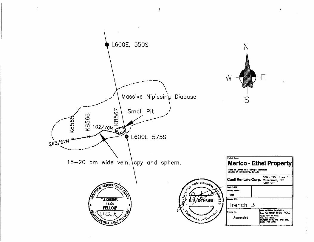
1997 GEOLOGY WORK PROGRAM Figures 5, 6 81 Appendix - Trench Maps 1-4
During the mapping of the grid many old trenches were identified and sampled. Mineralization is mainly contained in small 2 to 10 cm veins within the Nipissing
Diabase. However on two occasions mineralization was noted within the underlying sediments. An old trench to the north of Highway 560 on Line 500W contained Gowganda Sediments with a small vein of chalcopyrite in the muck adjacent to the trench. Also a large muck pile adjacent to a reported shaft on Line 700W at 1050S contained Lorrain sediments with a small chalcopyrite vein trending vertically across bedding. This would indicate that mineralization does indeed continue downward into the strata underlying the Nipissing Diabase, lending credence to the deeper trends identified by Quantec Consulting at levels greater than 100m below surface.
Trench mapping around the Merico Shaft identified several areas of known mineralization which have been noted before. These areas are indicators that the mineralization possibly extends downward, perhaps swelling out when deepening into the sediments below.
A small vein of chalcopyrite mineralization was noted north-east of the adjacent
18
Silver Jackpot Mine workings. This may represent a continuation of mineralization from that property. Quantec has identified 2 second priority dill targets in the area adjacent to this mineralization.
19
12WO
N
12BB
800N
I2B
8600N
128B
40W
t
AREN7 RESISTIVITY (ohm-metres) 12
APPARENT RESISTIVITY (ohm-metres)
90QS 8005 7005 600 S 500S 4QOS JOOS 200S f DOS O
WINDOW 7 CHARGEABILITY (mV/V)
7005 600S 500S 400 S .5005 200S 1 00S O
9oos soos 70os BOOS SODS 4oos joos 2005 1005
LINE 5+OOE
Scole 1 :500050 l DO 150 200 250 300
CUSIL VENTURES CORP.MERICO-CTHEL PROPERTY
ELK LAKE,ONTARIO
TIME DOMAIN IP SURVEY REALSECTION L5+OOE
Surveyed # PfOCfSSftf by:
qUANTEC IP INC.
Q. UJ O
900Si
-100-
-200-
-300-
-WO-
8003 l
APPARENT RESISTIVITY (ohm-metres)
700S 600S 500S 400S 300S 200S 100S l_____l_____l_____l_____l_____l_____l
900S 800S 700S 600S 500S 4OOS 300S 200S 100S
-O
—100
--200
--300
--WO
Om -D
LINE 5+OOE
Gradient Array——AB——————(D———
a.UJ
a
WINDOW 7 CHARGEABILITY (mV/V)
OOOS 800S 700S BOOS 500S 400S 300S 200S 100S O J_____l_____l_____l_____l_____l_____l_____l_____l^^^.
0-
-100-
-200-
-300-
-400-
-0
—100
—200
300
WO
900S 800S 700S 600S 500S 400S 300S 200S IOCS O
o m o
plot points
Scalo 1:500050 O M 100 ISO 100 250 300
(nwtrac)
CUSIL VENTURES CORP.MERICO-ETHEL PROPERTY
ELK LAKE .ONTARIO
TIME DOMAIN IP SURVEY REALSECTION L5-rOOE
TronsmiUer.Frequency 0.0625 H: (5055 duty cycle)Tronsmitter Current 3 AmpsDecoy Curve: QlP IP-6 Custom Semilogarithmic Windows
10 Gates (60ms to 3540ms)
Station Interval: Resistivity Contour Interval: Chargeability Contour Interval: Colour Scale:
25 meters10 levels/log decade
0.5, 2.5 mV/VEqual Areg Zoning
Dote: Oct/97Instrumentation: Rx - IRIS IP-6 (6 channels)
Tx s HUNTEC MK-4 (7.5 kW) * UC-10(10 WA)
Surveyed A Processed by:QUANTSC IP INC.DWG, j : P-204-RSIP-5+OOE

APPARENT RESISTIVITY (ohm-metres)
eoos 7oos eoos soos 4oos joos 2ocs iocs o
aoos 7oos eoos soos 4005 JOGS 2oos iocs
SOOS 700S BOOS 500S 4QOS 300S 200S IOCS
CUSIL VENTURES CORP.MERICO-ETHEL PROPERTY
ELK LAKE,ONTARIO
TIME: DOMAIN IP SURVEYREALSECTION L6-fOOE
rransntiilsr Frtqugicy 0.0625 Hi (SOS d uty cycte)
Oeetf CUM*: O fP IP-6 Custom Swiitogarilltmic Windows 10 Coles (SOms to 3540ms|
teistFvily Contour irteraji: ID lerels/ka) decadeOwqeoMity Contour Intervo': 0.5. 1.5 mV/vCtHour Sco'e 1 E iiuol *r*q Znnfng
Surveyed d- Pritessett toy:
QUANTEC IP INC.DWG. f. P-2QJ-ESIP-6HME
x t— a.
a.Ld
800S
APPARENT RESISTIVITY (ohm-metres)
700S 600S 500S 400S 300S ZOOS 100S l_____l______l______l______l______l.^^^l
0-
-100-
-200-
-joo-
-400-
-o
--100
-o--200 -H
x
—300
—400
800S 700S COOS 500S 400S 300S 200S 100S O
WINDOW 7 CHARGEABILITY (mV/V)
600S 700S 6005 500S 400S 300S ZOOS 100S O l______l______l______l______l—^——-l^-———l______l
0- -
-100-
-200-
-300-
-400-
-O
^-100
--200
—300
l W
I l l l l l l l T BOOS 700S 600S 500S 400S 300S 200S 100S O
O m -o
LINE 6+OOE
plot points
Scale 1:500050 O 50 100 150 200 250 300
CUSIL VENTURES CORP.MERICO-ETHEL PROPERTY
ELK LAKE,ONTARIO
TIME DOMAIN IP SURVEY REALSECTION L6+OOE
Transmitter Frequency 0.0625 Hz (50/5 duty cycle)Tronsmitter Current 3 XmpjDecoy Curve: QIP IP-6 Custom Semilooorithmic Windo*s
10 Coles (iOms to 3540ms)Stotion Intervol: Resistivity Contour Interval; Chargeability Contour Intervol: Colour Scale:
25 meters10 levels/log decode
0.5, a.Smy/VEqual Area Zoning
Dote: Oct/97Instrumentation: Rx ^ IRIS IP-6 (6 channels)
Tx * HUNTEC MK-4 (7.5 kW) * MG-10(10 WA)
Surveyed A Processed by:QUANTEC IP INC.DWG. f : P-204-RSIP-6+OOE
APPARENT RESISTIVITY (ohm-metres)
BOOS 700S 6QOS 500S 400S 300S 200S IOCS
800S 700S 600S 500S 4005 300S 200S 100S O
WINDOW 7 CHARGEABILITY (mV/V)
SOOS 700S 600S 500S 400 S JOOS 2003 100S
CUSIL VENTURES CORP.MERICO-ETHEL PROPERTY
ELK LAKE,ONTARIO
TIME DOMAIN IP SURVEY REALSECTION L7-HDOE
Suiveye/} 6 Pieces*?!} byQUANTEC IP INC.
X h- O.
O-
-100-
-200-
-300-
-400-
APPARENT RESISTIVITY (ohm-metres)
800S 7005 600S 500S 400S 300S ' 200S 100S l_____l_____l______l______l______l______l_____l
—100
--200
--300
—WO
l l l l l l l l 800S 700S 600S 500S 400S 300S ZOOS 100S O
WINDOW 7 CHARGEABILITY (mV/V)
0-
-100--
-200-
Z ^
-400-
800S 700S BOOS 500S 400S 300S 200S 100S O l_____l______l______l______l______l______l______l______l
-0
r-loo
—200
^-300
—wo
800S 700S 600S 500S 400S 300S 200S 100S O
o m
LINE 7+OOE
Gradient Arroy————— AB—————
o
50
plot points
Scale 1:5000O 50 1 00 150 200 250 300
(irwin*)
CUSIL VENTURES CORP,MERICO-ETHEL PROPERTY
ELK LAKE,ONTARIO
TIME DOMAIN IP SURVEY REALSECTION L7+OOE
Transmitter Frequency 0.0625 Hz (50* duty cycle)Transmitter Current 3 AmpsDecay Curve: QlP IP-6 Custom Semilogarithmic Windo*s
l O Gates (60ms to 3540ms)Station Interval: 25 metersResistivity Contour Interval: 10 levels/log decodeChargeability Contour Interval: 0.5, 2.5 mV/VColour Scole: Equal Area Zoning
Dote: Oct/97Instrumentation: RK * IRIS IP-6 (6 channels)
Tx . HUNTK MK-* (7.5 kW) t MG-10{10 kVA)
Surveyed i Processed by:QUANTEC IP INC.
DWG, f : P-204-RSIP-7*OOE
APPARENT RESISTIVITY (ohm-metres)
eoos 70GS BOOS soos 400S JDOS 2003 iocs
BOOS 700S 6 00 S 5DOS 400S 300S 200S 10OS
WINDOW 7 CHARGEABILITY (mV/V)
800S 700S 600S 500S 400S 300S 2005 100S O
CUSIL VENTURES CORPMERICO-ETHEL PROPERTY
ELK LAKE,ONTARIO
:ri— o.
Q.-
APPARENT RESISTIVITY (ohm-metres)
8003 700S 600S 500S 400S 300S .2003 100S J_____l_____l______l____ l_____l
0-
-100-
800S 700S BOOS 500S 4OOS 300S 200S IOCS
-200-
MOO-
WINDOW 7 CHARGEABILITY (mV/V)
800S 700S 600S 500S 400S 300S 200S 100S O J_____l______l______l______l______l______l_____l______l
0-
-100-
-200-
-400-
-0
--100
Om -o
—200 -Hac
--300
—400
800S 700S 600S 500S 400S 300S 200S 100S O
LINE 8+OOE
Grodient Arroy———AB——————©———
plot point)
Scale 1:500050 O 50 100 150 200 250 300
(metre*)
CUSIL VENTURES CORP.MERICO-ETHEL PROPERTY
ELK LAKE, ONTARIO
TIME DOMAIN IP SURVEY REALSECTiON L8+OOE
Transmitter Frequency 0.0625 Hz (50X dirty cycle)Transmitter Current - 3 AmpsDecoy Curve: QIP IP-6 Custom Semilogarithmic Windows
10 Gates (60ms to 3540mj)
Station Interval: Resistivity Contour Interval: Chargeability Contour Interval: Colour Scale:
25 meters10 levels/loo, decode
0.5, 2.5 mV/VEqual Area Zoning
Dote: Oct/97Instrumentation: Rx s IRIS IP-6 (6 channels)
Tx = HUNTEC MK-4 (7.5 kW) * MG-10(10 WA)
Surveyed i Processad by:QUANTJSC IP INC.DWG. f P-204-RSIP-8+OOE
APPARENT RESISTIVITY (ohm-metres)
WINDOW 7 CHARGEABILITY (mV/V)
1300S I20QS HODS loons BOOS fioos ?oos eoos sons aoos soos 20QS loos o
CUSIL VENTURES CORP.MERICO-OHEL PROPERTY
ELK LAKE,ONTARIO
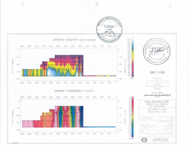
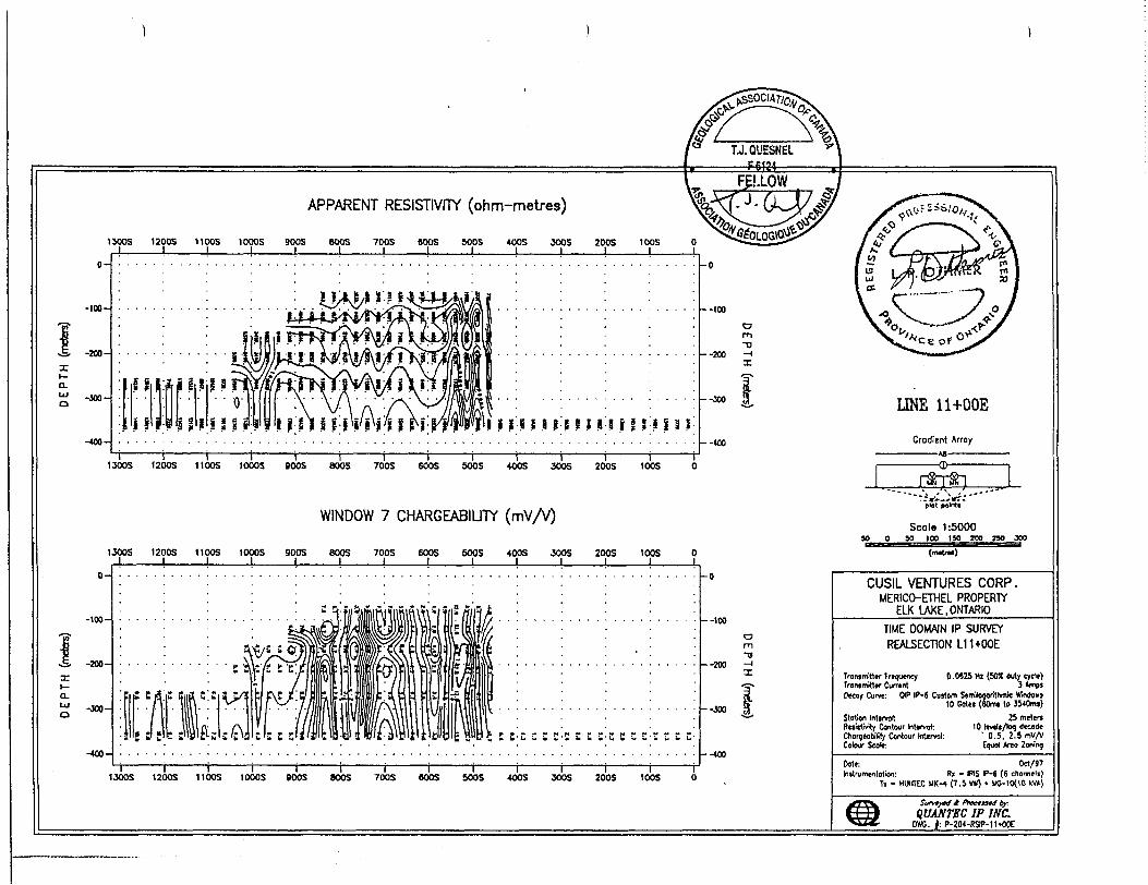
TIME DOMAIN IP SURVEY REALSECT10N L11+OOE
APPARENT RESISTIVITY (ohm-metres)
1300S 1200S 11005 J______l______l
0-
-100-
-300-
-400-
1000S 900S BOOS 700S eoosl
900S 4 DOS l
300S 2005 100S
:l j! H J! 8 l P M M M
1300S 1200S 11 DOS 1000S BOOS BOOS 700S 600S 5OOS 400S 3005 200S 100S O
WINDOW 7 CHARGEABILITY (mV/V)
1JOOS 1200S 11 COS 1000S 900S BOOS 700S 600S 5003 400S JOOS ZOOS tOOS O
II- Q.
0-
-100-
-200-
-JOO-
-400-
:-E s c c z z t: ~ n : t:
-o
--100
--200
--JOO
O mTJ
--400
1300S 1200S 1100S 1000S SOOS 800S 70QS 600S 500S 400S 3OOS 200S 100S O
Scale 1:500030 O 80 100 ISO ZOO Z50 300
CUSIL VENTURES CORP.MERICO-ETHEL PROPERTY
ELK LAKE,ONTARIO
TIME DOMAIN IP SURVEY REALSECTION L11+OOE
TronsmMw Frequency 0 .0825 Hz (50JC My cycle)Transmitter Current 3 AmpsDecay Curve: W IP-6 Custom Semiboc-rlthmic Windows
to Gates (60ms to 33*0ms)Station Intervol: 25 metersResistivity Contour Intervc* 10 levels/tog, decadeChargeability Contour Intervol: ' 0.5, 2.5 myAColour Scale: Equal Area Zoning
Dote: Od/97Instfumentotion: Rx m IRIS IP-6 (6 chonneii)
Tx - HUMTEC MK-4 (7.5 kW) *
QUANTSC IP INC.OW. /:P-204-RSIP-lltOQE
APPARENT RESISTIVITY (ohm-metres)
WINDOW 7 CHARGEABILITY (mV/V)
iOOS 70QS 6003 500S 400S 300S 2OOS IOCSJ___l___l___l___l___l___l___l—
13005 12005 11005 l OOOS 900S 600S 70DS 6003 50OS 400S 300S 200S 1 COS O
CUSIL VENTURES CORP.UERICO-ETHEL PROPERTY
ELK LAKE,ONTARIO
TIME DOMAIN IP SURVEY
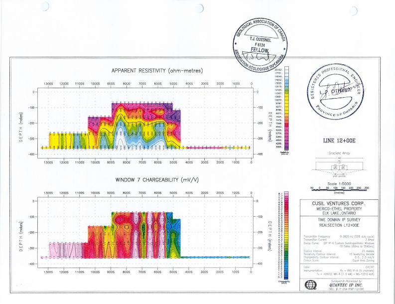
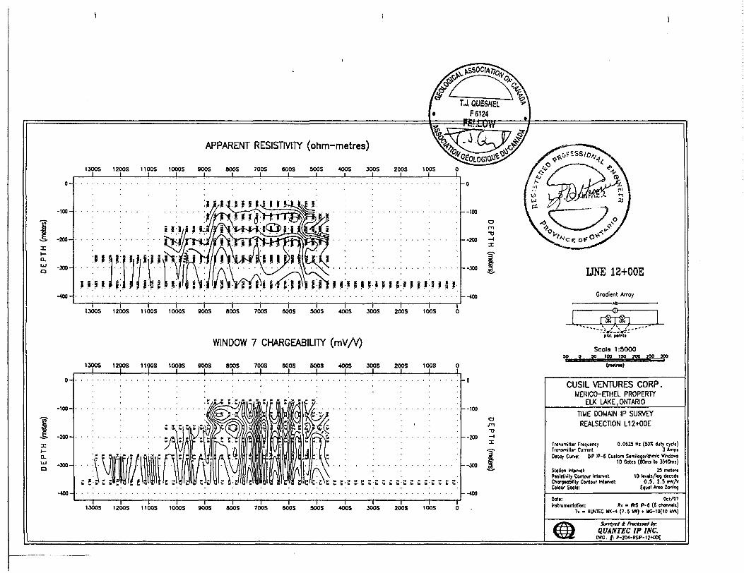
REALSECTION L12+OOE
APPARENT RESISTIVITY (ohm-metres)
BOOS BOOS 700S COOS SOOS 400S JOOS 200S 1005
WINDOW 7 CHARGEABILITY
900S 800S 700S BOOS SOOS 400S JOOS 200S 100S
CUSIL VENTURES CORPMERICO-ETHEL PROPERTY
ELK LAKE,ONTARIO
TIME DOMAIN IP SURVEY REALSECTION L12+OOE
Transmitter Frequency 0.0625 Hi (50* duty cycle) Tronsmitter Current 3 Amos Decoy Curve: DIP IP-6 Custom Semitogoritnmic
10 Gote) (60ms to 3540ms)Station Intervol: 2S metertResistivity Contour Interval: 10 levels/log decodeChorotcMIy Contour Interval: 0.5, 2.5 mv/vColour ScoK: Equol Areo Z '
Dote: Oct/97Instrumentation: RK * IRIS P-6 (6 channels)
Tx - HUNTEC MK-4 (7.5 kW) . 1*5-10(10 kVA)
l l l l BOOS BOOS 700S BOOS SOOS 4OOS JOOS 200S t DOS O
t Pmtnat bf QUANTEC IP INC.
D*C. |: P-204-RSIP-i;*OOt
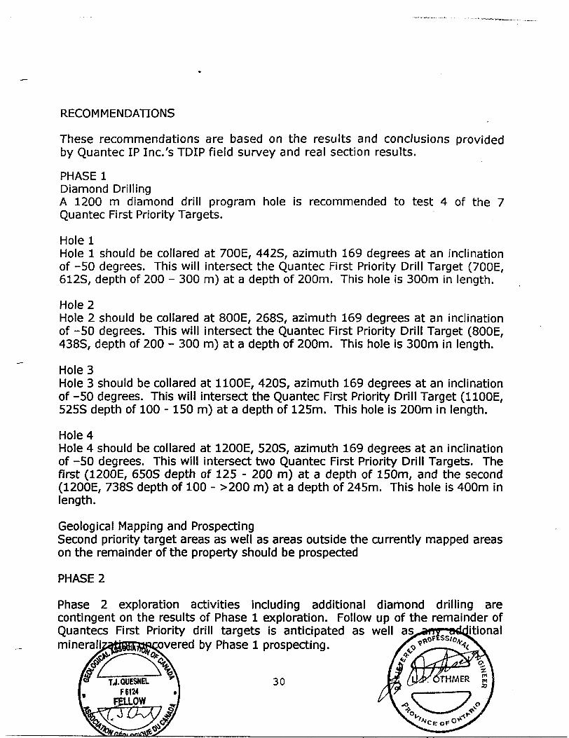
RECOMMENDATIONS
These recommendations are based on the results and conclusions provided by Quantec IP Inc.'s TDIP field survey and real section results.
PHASE lDiamond DrillingA 1200 m diamond drill program hole is recommended to test 4 of the 7Quantec First Priority Targets.
Hole lHole l should be collared at 700E, 442S, azimuth 169 degrees at an inclination of -50 degrees. This will intersect the Quantec First Priority Drill Target (700E, 612S, depth of 200 - 300 m) at a depth of 200m. This hole is 300m in length.
Hole 2Hole 2 should be collared at 800E, 268S, azimuth 169 degrees at an inclination of -50 degrees. This will intersect the Quantec First Priority Drill Target (800E, 438S, depth of 200 - 300 m) at a depth of 200m. This hole is 300m in length.
Hole3Hole 3 should be collared at 1100E, 420S, azimuth 169 degrees at an inclination of -50 degrees. This will intersect the Quantec First Priority Drill Target (1100E, 525S depth of 100 -150 m) at a depth of 125m. This hole is 200m in length.
Hole 4Hole 4 should be collared at 1200E, 520S, azimuth 169 degrees at an inclinationof -50 degrees. This will intersect two Quantec First Priority Drill Targets. Thefirst (1200E, 650S depth of 125 - 200 m) at a depth of 150m, and the second(1200E, 738S depth of 100 - ^00 m) at a depth of 245m. This hole is 400m inlength.
Geological Mapping and ProspectingSecond priority target areas as well as areas outside the currently mapped areason the remainder of the property should be prospected
PHASE 2
Phase 2 exploration activities including additional diamond drilling are contingent on the results of Phase l exploration. Follow up of the remainder of Quantecs First Priority drill targets is anticipated as well mineraliz^ggiRfflRa)vered by Phase l prospecting.
30TJ.QUESNH.F 6124
FELLQW
REFERENCES
Geological Survey/Ministere de I'Energie et des Resources, Quebec1:500 000: catalogued as "Map 2484" in Ontario and "DV 83-16" in Quebec.
Johns, G.WGeology of the Hill Lake Area, District of Timiskaming, Ontario Geological
Survey Geological Report 250, lOOp. Accompanied by Map 2501, scale 1:31680
Laronde, D., 1997Geophysical Surveys, Merico-Ethel Property, James and Tudhope Twps.
Mackean, B.E.Geology of the Elk Lake Area, District of Timiskaming, , Ontario Geological Survey Geological Report 62, 62p, Accompanied by maps, 2150, 2151 and 2152.
MERQ-OGS 1983Lithostratigraphic map of the Abitibi Subprovince; Ontario
Ontario Geological Survey 1991.Bedrock geology of Ontario, east-central sheet; Ontario Geological Survey, Map 2543, scale 1:1 000 000
Ontario Geological Survey 1992.Tectonic Assemblages of Ontario, east-central sheet; Ontario Geological Survey, Map 2577, scale 1:1 000 000
Quantec IP Incorporated, 1997Geophysical Survey, Summary Interpretation Report regarding the Gradient - Realsection TDIP Induced polarization survey on the Merico- Ethel Property, James and Tudhope Twp., near Elk Lake, ON, on behalf of Cusil Venture Corp., Vancouver, BC.
APPENDIX
Certificate of Qualifications (TJ. Quesnel)Certificate of Qualifications (Lawrence Othmer)Geology. Trench lGeology. Trench 2Geology. Trench 3Geology. Trench 4Summary Analysis Merico - Ethel Property, Samples Collected 1997Whole Rock Analysis Diabase - Merico Shaft Area SamplesAssay Certificate, Swastika Laboratories. Certificate #7W-4126-RA1.Assay Certificate, Swastika Laboratories. Certificate #7W-4463-RAl.Quantec IP Inc. - Main Body of Report (pages 3-15, Appendix C and D from Quantec Report)Quantec Statements of Qualifications - 5 pages
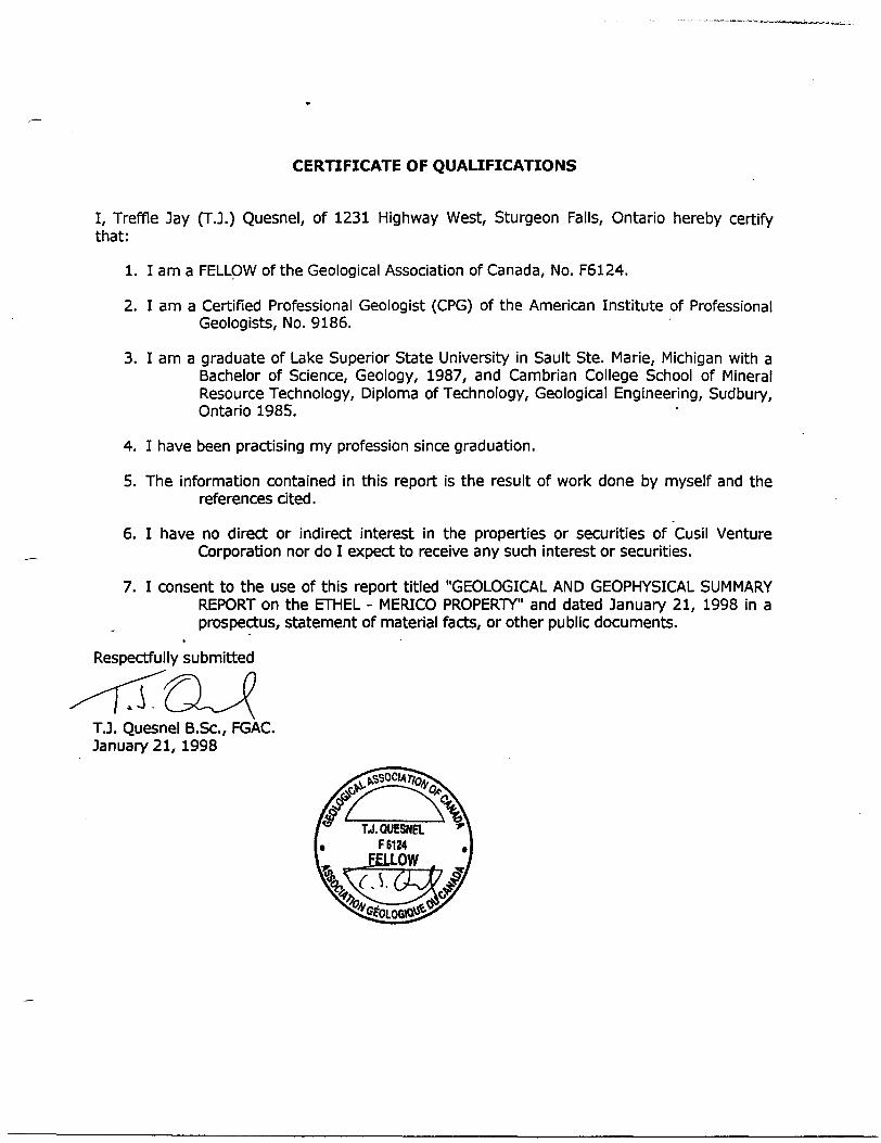
CERTIFICATE OF QUALIFICATIONS
I, Treffle Jay (T.J.) Quesnel, of 1231 Highway West, Sturgeon Falls, Ontario hereby certify that:
1. I am a FELLOW of the Geological Association of Canada, No. F6124.
2. I am a Certified Professional Geologist (CPG) of the American Institute of Professional Geologists, No. 9186.
3. I am a graduate of Lake Superior State University in Sault Ste. Marie, Michigan with a Bachelor of Science, Geology, 1987, and Cambrian College School of Mineral Resource Technology, Diploma of Technology, Geological Engineering, Sudbury, Ontario 1985.
4. I have been practising my profession since graduation.
5. The information contained in this report is the result of work done by myself and the references cited.
6. I have no direct or indirect interest in the properties or securities of Cusil Venture Corporation nor do I expect to receive any such interest or securities.
7. I consent to the use of this report titled "GEOLOGICAL AND GEOPHYSICAL SUMMARY REPORT on the ETHEL - MERICO PROPERTY" and dated January 21, 1998 in a prospectus, statement of material facts, or other public documents.
Respectfully submitted
T.J. Quesnel B.Sc, FGAC. January 21, 1998
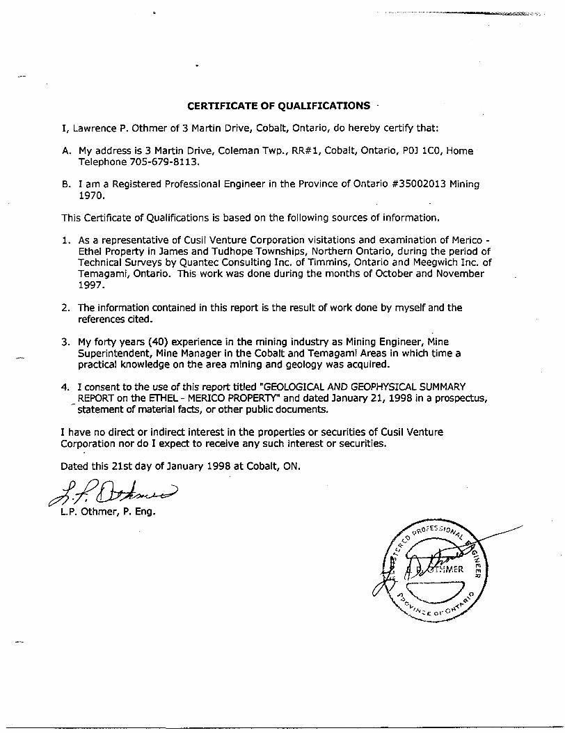
CERTIFICATE OF QUALIFICATIONS
I, Lawrence P. Othmer of 3 Martin Drive, Cobalt, Ontario, do hereby certify that:
A. My address is 3 Martin Drive, Coleman Twp., RR#1, Cobalt, Ontario, POJ ICO, Home Telephone 705-679-8113.
B. lama Registered Professional Engineer in the Province of Ontario #35002013 Mining 1970.
This Certificate of Qualifications is based on the following sources of information.
1. As a representative of Cusil Venture Corporation visitations and examination of Merico - Ethel Property in James and Tudhope Townships, Northern Ontario, during the period of Technical Surveys by Quantec Consulting Inc. of Timmins, Ontario and Meegwich Inc. of Temagami, Ontario. This work was done during the months of October and November 1997.
2. The information contained in this report is the result of work done by myself and the references cited.
3. My forty years (40) experience in the mining industry as Mining Engineer, Mine Superintendent, Mine Manager in the Cobalt and Temagami Areas in which time a practical knowledge on the area mining and geology was acquired.
4. I consent to the use of this report titled "GEOLOGICAL AND GEOPHYSICAL SUMMARY ^REPORT on the ETHEL - MERICO PROPERTY" and dated January 21, 1998 in a prospectus, ' statement of material facts, or other public documents.
I have no direct or indirect interest in the properties or securities of Cusil Venture Corporation nor do I expect to receive any such interest or securities.
Dated this 21st day of January 1998 at Cobalt, ON.
L.P. Othmer, P. Eng.
L500E, 6008
Qtz/Calclte Vein 10 - 50 cm Wide Calcite Vein lets Scattered Througout Alteration Zone upto 2 m wide cpy/sphem/bo min.3 cm veinlet
289/80-90N
Fc stained diabase 40 cm wide
L600E. 6253
Moiilv* Nlplnlng DlobOM Maiilva NiplHing
OlabaiaMaalva Nlplnlng DlabQH
Main Merico Vein Structure250/65-80NAbundant cpy/sphem
Fractured diabase, 2 cm width e stained with minor calcite vein in g 75/60-SOS
Merico - Ethel PropertyPenm of JamM and Tbdhap* Tnmhfp* Dlitrfct at HmWwnha, Oltorto
507-595 Howe St. Vancouver. BC V6C ZT5
~ n w A. ** CUSH Venture Corp.
TJ.QUESNEL F 6124
Trench 1T.J. Quesnd B.Se. FGAC
L600E625S - — — —— — —
266/
Massive Nipissing Diabase /
L600E L600E X 625S
i Massive Nipissing DiabaseX
/
L600E
*!live Nipissm^ Diabase
\
"^"-^
s
i K566*
1 cm cpy vein
S 1 j 625S—————— ap ________ n
^~srn
Merico - Ethel PropertyPart* of Jomw and Tudhop* Tavnthlpt DliWct of TVnWtomVlj, Ontario
Cuall Venture
IW* 1:900
Dm*t| Itolu*
Final
Dmtof TOl
Trench
507-595 Howe St. Corp. Vancouver. BC
V6C 2T5
2UnMlf M*.
AppendedT.J. Quaanal B.Sc. FGAC1231 Hvy 17 Wot P.O. Ban 20007 Sturooon Folll. ON POM 2BO (70S) 7S3-JJB7
L600E, 550S
wl
Massive Nipissing Diabase\
Small Pit
L600E 575S
15-20 cm wide vein,\cpy and sphem. Merico - Ethel PropertyPort, of Jvnx end TVidhapi Ti OMrfct Df IVnMarnbit Ontario
^ .... ^ ~ 507-595 Howe St. GUSH Venture Corp. Vancouver, BC
V6C 2T5
Final
Trench 3
Appended
*V( mtT.J. Ourand B.Sc. FGAC1131 Hi? 17 WatP.O. Ba 20007SlufJ—n FoDl. ON POH 2BO{705) 7I3-UB7
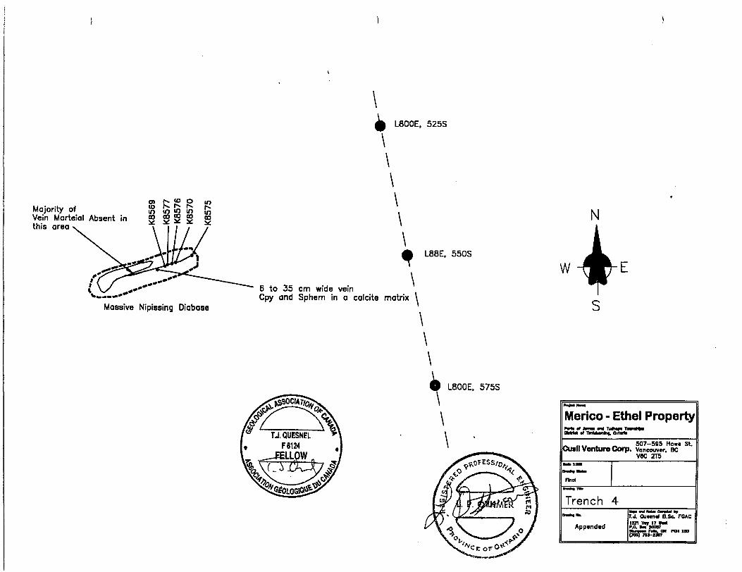
L800E, 525S
Majority ofVein Morteial Absent inthis area
S r? f? P **
Massive Nipissing Diabase
L88E. 550S
6 to 35 cm wide veinCpy and Sphem in a calcite matrix \
\
L800E. 575S
Merico - Ethel PropertyDMM d nnWmhf!o!Kb
~ .... ^ -. 507-595 Horn* Cusll Venture Corp. Vancouver. BC
V8C 2T5
Find
Trench 4
Appended
St.
r.J. Quran* B.Se. FCAC
yuinn nh, ON PW in(TOO) 73*-I3V7
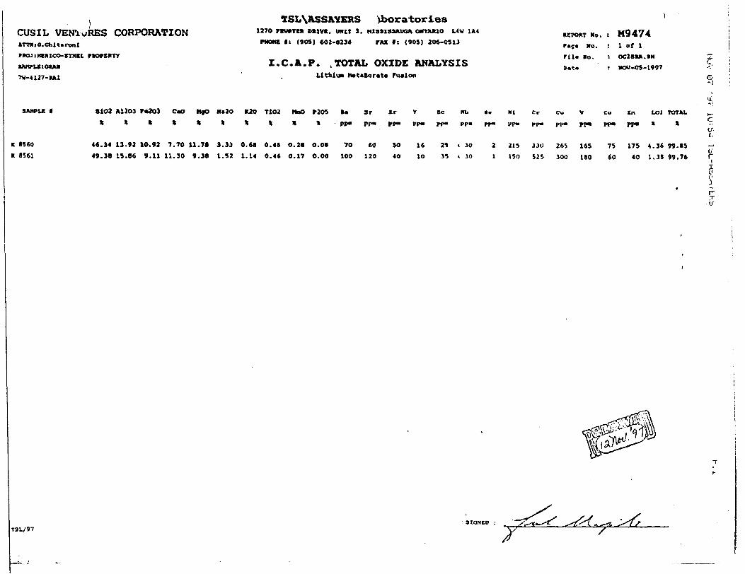
CUSIL VENTURES CORPORATIONATTIfiO.Chltarvnt
nomenBAKrUlOHM
7V-4127-IUU
TSL\ASSAYERS tboratories1270 FKUBTCM DftWK. UNIT J. MI39IS3AUOA OMTAJUO L4V 1*4
PNOMC tt (905) 602-8234 rMC l: (90S) 2O6-O313
Z.C.A.P. .TOTAL OXIDE ANALYSISLttklui M*t*Borate Fusion
REPOKT Ha. : M9474
P*S* No. i l of lrU. lo. : OC2BMI.ON
Dat* t NOV-OS-1997
SAMPLE f
K 1560
R 8561
3102 M 203 F*ZO3 C*O MjO N*2O K2o T1O2 PtaO P2O5
******t**X
46.34 13.92 1O.92 7.70 11.78 3.33 0.68 0.46 0.28 0.08
49.38 15.66 9.11 11.30 9.38 1.S2 1.14 0.4* 0.17 O.OS
70100
SrPP"
60
120
Ir
M-
SO 40
16
1O
29
33
Kb
pp.
30
30
4
2
1
(CI Cr Cu V
PP- PP" PP" PP-
215 330 265 16S
150 525 300 ISO
Cu
PP-
75
60
In L01
pp. t
175
40
4
1
.36
.31
TOTAL
*
99. IS
99.76O"
l c;
T
h
T3L/9731ONED ;
J
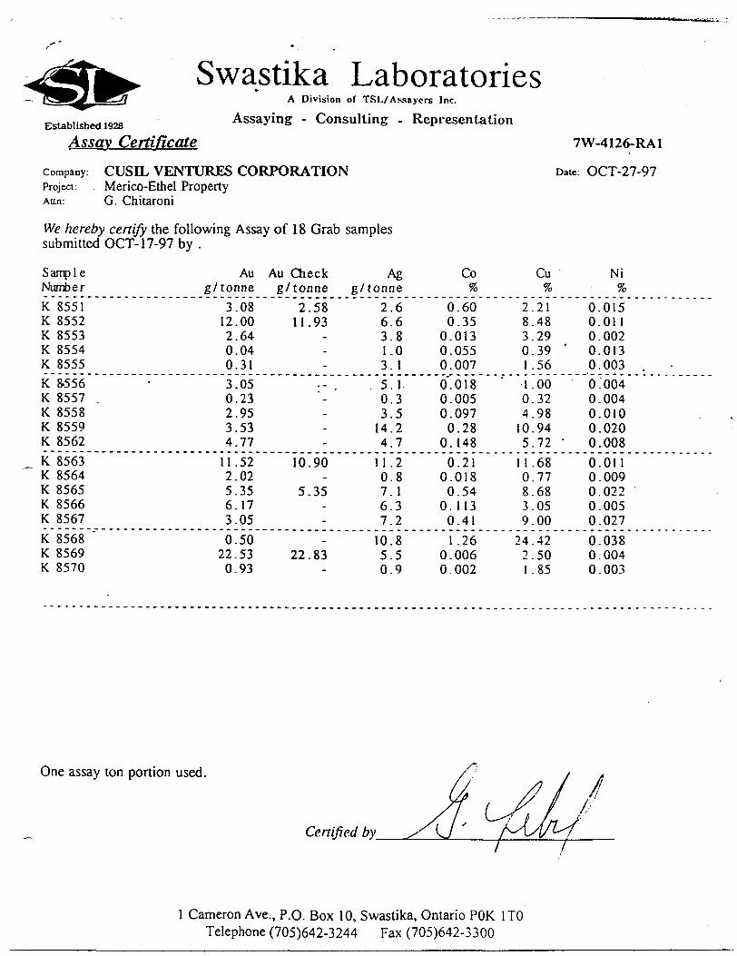
Swastika LaboratoriesA Division of TSL/Assaycrs Inc.
Assaying - Consulting - RepresentationEstablished 1928
Assay Certificate
company: CUSEL VENTURES CORPORATIONProject: Merico-Ethel PropertyAim: G. Chitaroni
We hereby certify the following Assay of 18 Grab samples submitted OCT-17-97 by .
7W-4126-RA1
Date: OCT-27-97
Sample NumberK 8551 K 8552 K 8553 K 8554 K 8555K 8-556 K 8557 K 8558 K 8559 K 8562K 8563 K 8564 K 8565 K 8566 K 8567K 8568 K 8569 K 8570
Au g/tonne
3.08 12.00 2.64 0.04 0.313.05 0.23 2.95 3.53 4.7711.52 2.02 5.35 6.17 3.050.50
22.53 0.93
Au Check g/tonne
2.58 11.93
-
10.90
5.35
22.83
Ag g/tonne
2.6 6.6 3.8 1.0 3.15. 1 0.3 3.5 14.2 4.711.2 0.8 7. 1 6.3 7.210.8 5.5 0.9
CoVo
0.60 0.35
0.013 0.055 0.0070.018 0.005 0.097 0.28
0.1480.21
0.018 0.54
0. 113 0.411.26
0.006 0.002
Cu7o
2.21 8.48 3.29 0.39 '
1 .561.00 0.32 4.98 10.94 5.72 '11.68 0.77 8.68 3.05 9.00
24.42 2.50 1 .85
Ni 7o
0.015 0.011 0.002 0.013 0.0030.004 0.004 0.010 0.020 0.0080.011 0.009 0.022 0.005 0.0270.038 0.0040 . 003
One assay ton portion used.
Certified by-
l Cameron Ave., P.O. Box 10, Swastika, Ontario POK l TO Telephone (705)642-3244 Fax (705)642-3300
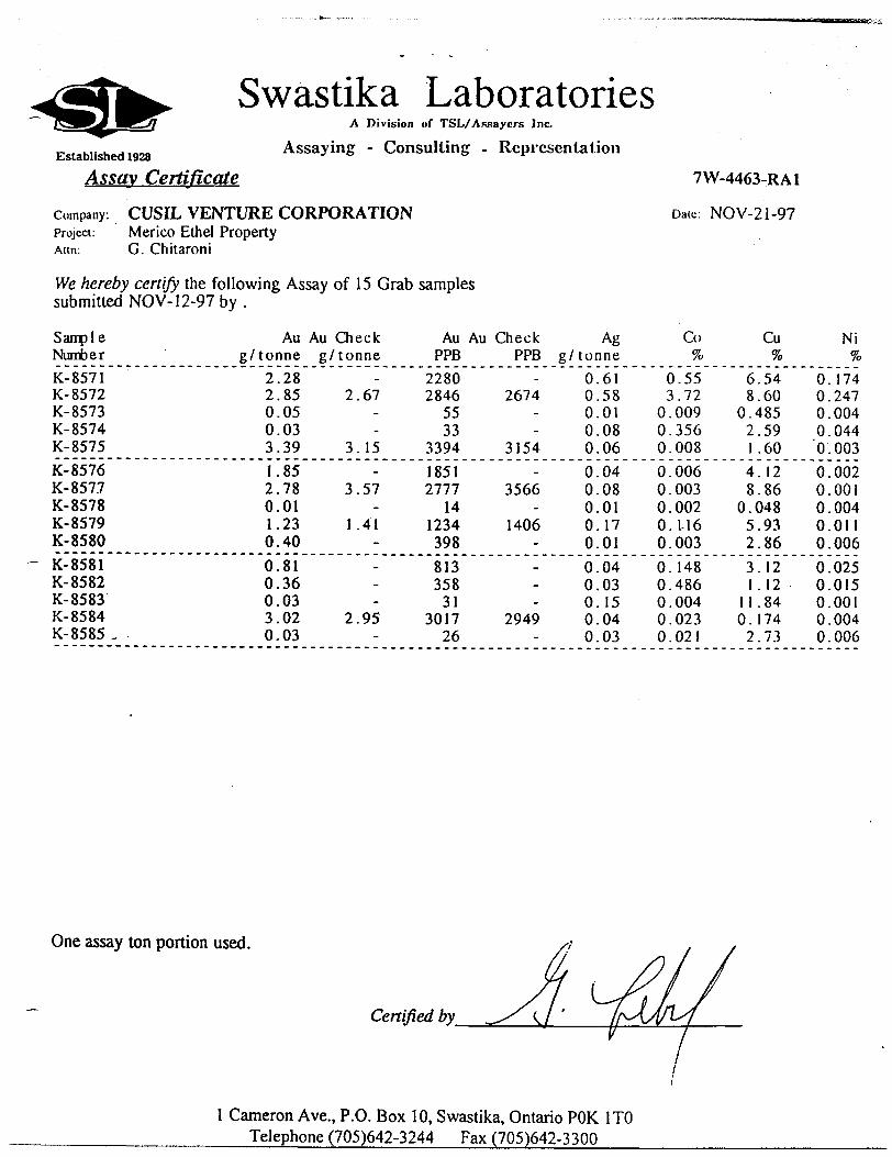
Swastika LaboratoriesA Division of TSL/Assaycrs Inc.
Assaying - Consulting . RepresentationEstablished 1928Assay Certificate
Company: CUSIL VENTURE CORPORATIONProject: Merico Ethel PropertyAim: G. Chitaroni
We hereby certify the following Assay of 15 Grab samples submitted NOV-12-97 by .
7W-4463-RA1
Dale: NOV-21-97
Sample NumberK-8571 K- 8572 K- 8573 K- 8574 K- 8575K- 8576 K- 8577 K- 8578 K- 8579 K- 8580K- 8581 K- 8582 K- 8583 K- 8584 K- 8585 ,
Au Au Check g/tonne g/tonne
2 2 0 0 31 2 0 1 00 0 0 3 0
.28
.85
.05
.03
.39
.85
.78
.01
.23
.40
.81
.36
.03
.02
.03
2.67
3.15
3.57
1.41
2.95
Au Au Check Ag PPB PPB g/tonne
2280 2846
55 33
33941851 2777
14 1234 398813 358 31
3017 26
2674
3154
3566
1406
2949
0 0 0 0 00 0 0 0 00 0 0 0 0
.61
.58
.01
.08
.06
.04
.08
.01
.17
.01
.04
.03
. 15
.04
.03
Co7o
0.55 3.72
0.009 0.356 0.0080.006 0.003 0.002 0.1-16 0.0030.148 0.486 0.004 0 . 023 0.021
Cu 7o
6.54 8.60
0.485 2.59 1.604.12 8.86
0.048 5.93 2.863.12 1.12
11 .84 0.174 2.73
0. 0. 0. 0. '0.
0. 0. 0. 0. 0.0. 0. 0. 0. 0.
NiVo
174 247 004 044 003002 001 004 Oil 006025 015 001 004 006
One assay ton portion used.
Certified by
l Cameron Ave., P.O. Box 10, Swastika, Ontario POK l TO Telephone (705)642-3244 Fax (705)642-3300
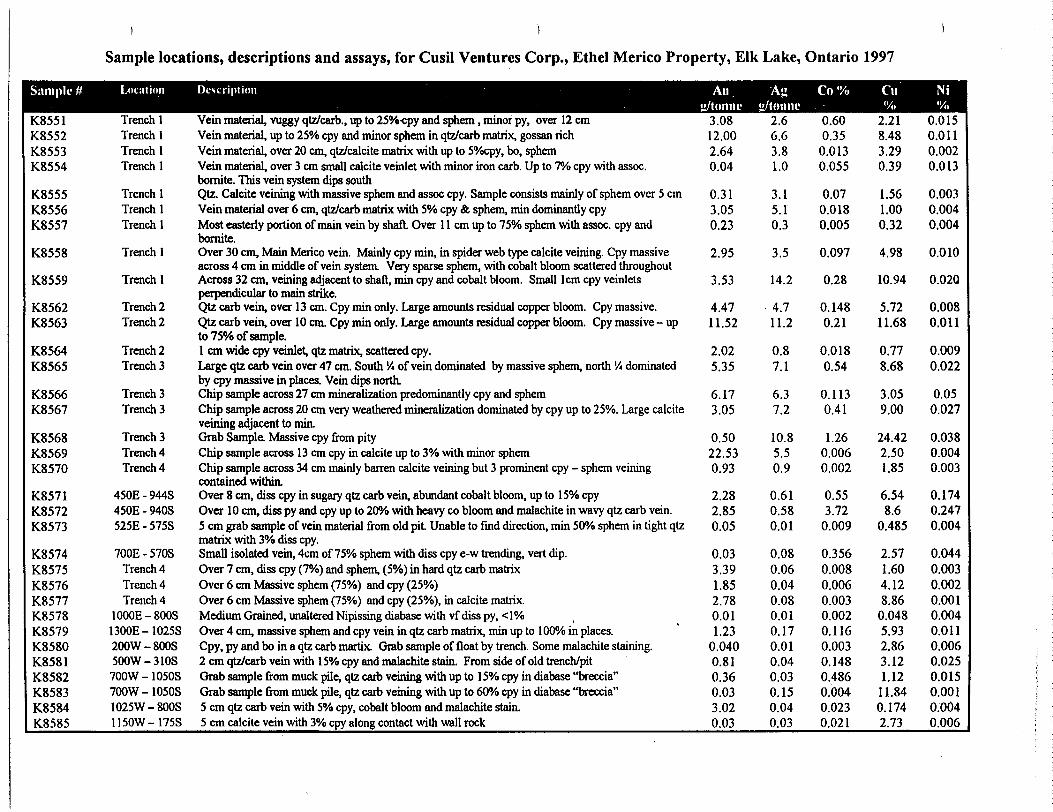
Sample locations, descriptions and assays, for Cusil Ventures Corp., Ethel Merico Property, Elk Lake, Ontario 1997
Sample #
K8551K8552K8553K8554
K8555K8556K8557
K8558
K8559
K8562K8563
K8564K8565
K8566K8567
K8568K8569K8570
K8571K8572K8573
K8574K8575K8576K8577K8578K8579K8580K8581K8582K8583K8584K8585
Location
Trench 1Trench 1Trench 1Trench 1
Trench 1Trench 1Trench 1
Trench 1
Trench 1
Trench 2Trench 2
Trench 2Trench 3
Trench 3Trench 3
Trench 3Trench 4Trench 4
450E - 944S450E-940S525E-575S
700E-570STrench 4Trench 4Trench 4
1000E-800S1300E-1025S200W-800S500W-310S700W - 1050S700W - 1050S1025W-800S1150W-175S
Description
Vein material, vuggy qtz/carb., up to 25%-cpy and sphem , minor py, over 12 cmVein material, up to 250Xo cpy and minor sphem in qtz/carb matrix, gossan richVein material, over 20 cm, qtz/calcite matrix with up to S'Xocpy, bo, sphemVein material, over 3 cm small calcite veinlet with minor iron carb. Up to TO cpy with assoc.bornite. This vein system dips southQtz. Calcite veining with massive sphem and assoc cpy. Sample consists mainly of sphem over 5 cmVein material over 6 cm, qtz/carb matrix with 5*34 cpy Se. sphem, min dominantly cpyMost easterly portion of main vein by shaft Over 1 1 cm up to 750Xo sphem with assoc. cpy andbornite.Over 30 cm, Main Merico vein. Mainly cpy min, in spider web type calcite veining. Cpy massiveacross 4 cm in middle of vein system. Very sparse sphem, with cobalt bloom scattered throughoutAcross 32 cm, veining adjacent to shaft, min cpy and cobalt bloom. Small lcm cpy veinletsperpendicular to main strike.Qtz carb vein, over 13 cm. Cpy min only. Large amounts residual copper bloom. Cpy massive.Qtz carb vein, over 10 cm. Cpy min only. Large amounts residual copper bloom. Cpy massive - upto ly/o of sample.1 cm wide cpy veinlet, qtz matrix, scattered cpy.Large qtz carb vein over 47 cm. South '/4 of vein dominated by massive sphem, north '/i dominatedby cpy massive in places. Vein dips northChip sample across 27 cm mineralization predominantly cpy and sphemChip sample across 20 cm very weathered mineralization dominated by cpy up to 250Xo. Large calciteveining adjacent to min.Grab Sample. Massive cpy from pityChip sample across 13 cm cpy in calcite up to 30Xo with minor sphemChip sample across 34 cm mainly barren calcite veining but 3 prominent cpy - sphem veiningcontained within.Over 8 cm, diss cpy in sugary qtz carb vein, abundant cobalt bloom, up to 150Xo cpyOver 10 cm, diss py and cpy up to 20^0 with heavy co bloom and malachite in wavy qtz carb vein.5 cm grab sample of vein material from old pit Unable to find direction, min 50"Xo sphem in tight qtzmatrix with 3*34 diss cpy.Small isolated vein, 4cm of 750Xo sphem with diss cpy e-w trending, vert dip.Over 7 cm, diss cpy (7*34) and sphem, (594) in hard qtz carb matrixOver 6 cm Massive sphem (750Xo) and cpy (25Vo)Over 6 cm Massive sphem (75*34) and cpy (25*34), in calcite matrix.Medium Grained, unaltered Nipissing diabase with vf diss py, -c 1 *34Over 4 cm, massive sphem and cpy vein in qtz carb matrix, min up to 100*34 in places.Cpy, py and bo in a qtz carb martix. Grab sample of float by trench. Some malachite staining.2 cm qtz/carb vein with 150Xo cpy and malachite stain. From side of old trench/pitGrab sample from muck pile, qtz carb veining with up to 150Xo cpy in diabase "breccia"Grab sample from muck pile, qtz carb veining with up to 60*34 cpy in diabase "breccia"5 cm qtz carb vein with 5"Xo cpy, cobalt bloom and malachite stain.5 cm calcite vein with 30Xo cpy along contact with wall rock
KQH"/tonne
3.0812.002.640.04
0.313.050.23
2.95
3.53
4.4711.52
2.025.35
6.173.05
0.5022.530.93
2.282.850.05
0.033.391.852.780.011.23
0.0400.810.360.033.020.03
E39"/tonne
2.66.63.81.0
3.15.10.3
3.5
14.2
4.711.2
0.87.1
6.37.2
10.85.50.9
0.610.580.01
0.080.060.040.080.010.170.010.040.030.150.040.03
Co '/o
0.600.35
0.0130.055
0.070.0180.005
0.097
0.28
0.1480.21
0.0180.54
0.1130.41
1.260.0060.002
0.553.72
0.009
0.3560.0080.0060.0030.0020.1160.0030.1480.4860.0040.0230.021
di"/,
2.218.483.290.39
1.561.000.32
4.98
10.94
5.7211.68
0.778.68
3.059.00
24.422.501.85
6.548.6
0.485
2.571.604.128.86
0.0485.932.863.121.12
11.840.1742.73
mm•x,0.0150.0110.0020.013
0.0030.0040.004
0.010
0.020
0.0080.011
0.0090.022
0.050.027
0.0380.0040.003
0.1740.2470.004
0.0440.0030.0020.0010.0040.0110.0060.0250.0150.0010.0040.006
QIPP-204 Cusl Ventures Corp. Merico-Ethd Property RSIP
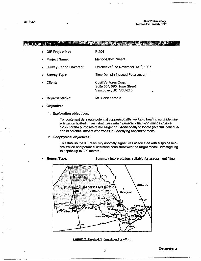
P-204
Merico-Ethel Project
October 21 ST to November 13™. 1997
Time Domain Induced Polarization
Cusil Ventures Corp. Suite 507, 595 Howe Street Vancouver. BC V6C-2T5
Mr. Gene Larabie
* QIP Project No:
* Project Name:
* Survey Period Covered:
* Survey Type:
* Client:
* Representative:
* Objectives:
1. Exploration objectives:
To locate and delineate potential copper/cobalt/silver/gold bearing sulphide min eralization hosted in vein structures within generally flat lying mafic intrusive rocks, for the purposes of drill targeting. Additionally to locate potential continua tion of potential mineralized zones in underlying basement rocks.
2. Geophysical objectives:
To establish the IP/Resistivity anomaly signatures associated with sulphide min eralization and potential alteration consistent with the target model, investigating to depths up to 300 meters.
Report Type: Summary Interpretation, suitable for assessment filing
Figure 1: General Survey Area Location.
Quantec
QIP P-204 CusS Ventures Corp. Merico-Ethel Property RSIP
2.1 LOCATION
* Township or District:
* Province or State:
* Country:
* Nearest Settlement:
* NTS Map Reference:
* Mining Claims Surveyed:1
a) James TWP.: 1214024, 1214025,1214026, 121*029, 1214030,1206252, 1198561
b) Tudhope Twp.:1222053, .1202448,1217772,1118625.1212261,1217771.1217784. .496559475794,475798,476736,
James and Tudhope Twp.
Ontario
Canada
Elk Lake, Ontario
31M/5
2.2 ACCESS
. Base of Operations:
* Mode of Access to Property:
* Mode of Access to Grid:
* Nearest Road:
2.3 SURVEY GRID
* Coordinate Reference System:
* Line Direction:
* Line Separation:
* Station Interval:
Moose Lake Motel, Elk Lake, Ontario
East on Hwy. 560 out of Elk Lake for approx 8 km in pick up truck, then south on log roads..
Truck and foot
Hwy. 560
Local exploration grid (non-UTM ref.)
N-011 0 andN-0000
100 meters
25 meters and 12.5 meters
1 Ref. Cusil Ventures Corp. Merico-Ethel Property Claim/Line Location map (Boreal Res. Inc., 11/97).
4 Quantec
QIP P-204 Citsfl Venbxes Corp. Merico-Elhel Property RSIP
3.1 GENERALITIES
* Survey Dates:
* Survey Period:
* Survey Days:
* Weather Days:
* Preparation Days:
* Mob/Demob Days:
* Total km Surveyed:
3.2 PERSONNEL
* Project Supervisor
* Field Supervisor
* Field Assistants:
3.3 SPECIFICATIONS
* Array:
October 21 ST to November 13™, 1997
24 days
20.5 days
1.5 day
O day
2 days
51.2625km
G.R. Jeff Wame, Geophysicist, Porcupine, ON
K MacKenzie, Geophysicist, Sidney, NS
Chris Sawyer, Mississauga, ON Dave Gouthro, Sidney, NS Dave MacGillivary, Timmins, ON
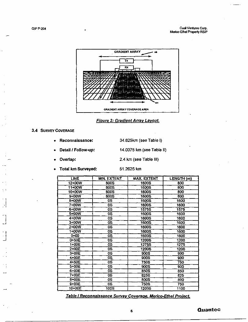
Multiple Gradient (see Figure 2 )
MN (Receiver Dipole Separation): 25 metres,12.5 meters
* Sampling Interval:
. Total Gradient AB Blocks:
* Total Realsections:
25 meters
4
6
Approximate Anal Coverage: 4.3 km2
Quantec
QIP P-204 CusS Ventures Corp. Merico-Ettiel Property RSIP
GRADIENT ARRAY
GRADIENT ARRAY COVERAGE AREA
Figure 2: Gradient Array Layout.
3.4 SURVEY COVERAGE
* Reconnaissance:
* Detail l Follow-up:
* Overlap:
* Total km Surveyed:
34.825km (see Table l)
14.0375 km (see Table II)
2.4 km (see Table III)
51.2625km
' l
J
LINE12+OOW11+OOW10+00 W9+OOW8+OOW7+OOW6+OOW5+OOW4+OOW3+OOW2+OOW1+00 W0+000+50E1+OOE2+OOE3+OOE4+OOE4+50E5+OOE6+OOE7+OOE8+OOE9+OOE10+OOE
MIN. EXTENT800S800S800S800SOSOSOSOSOSOSOSOSOSOSosososososososososos100S
MAX. EXTENT1600S1600S1600S1600S1600S1600S1575S1600S1600S1600S1600S1600S1600S1200S1275S1200S900S900S750S900S850S825S800S750S1200S
LENGTH (m)8008008008001600160015751600160016001600160016001200127512009009007509008508258007501100
Table l Reconnaissance Survev Coverage. Merico-Ethel Project
Quantec

QIP P-204 Cusi Ventures Corp. Merico-Ethe! Property RSIP
LINE11+OOE12+OOE13+OOE14+OOE15+OOETOTAL
MINI. EXTENTOSOSOSOSOS
MAX. EXTENT1300S1350S1300S1200S650S
LENGTH (m)1300135013001200650
34825
Table l fcont): Reconnaissance Survey Coverage.
Detailed (Realsection) Coverage
LINEBlock B5+OOE6+OOE7+OOE8+OOE
Block A11+OOE12+OOETOTAL
# DEPTH LEVELS
5544
55
WIN. EXTENT
300S300S300S300S
450S450S
MAX. EXTENT
900S850S825SBOOS
130081300S
TOTAL LENGTH (m)
2312.5217519501800
29002900
14037.5
Table li: Realsection Survey Coverage.
LINE4+OOW3+OOE
-10+OOETOTAL
BLOCKS SURVEYEDA&BB&CA&B
WIN. EXTENT500S300S300S
MAX. EXTENT1550S900S1050S
LENGTH (m)1050600750
2400
3.5 INSTRUMENTATION
J * Receiver
* Transmitter:
* . Power Supply:
Table III: Overlap Survey Coverage.
IRIS IP-6 (time domain 16 channels)
Huntec MK-4 (7.5 kW)
Kohler MG (2 cyl. 125 HP) with 30 kVA Westinghouse Alternator (400 Hz 1110V out)
Quantec
QIP P-204 CusJ Ventures Corp. Merico-Ethel Property RSIP
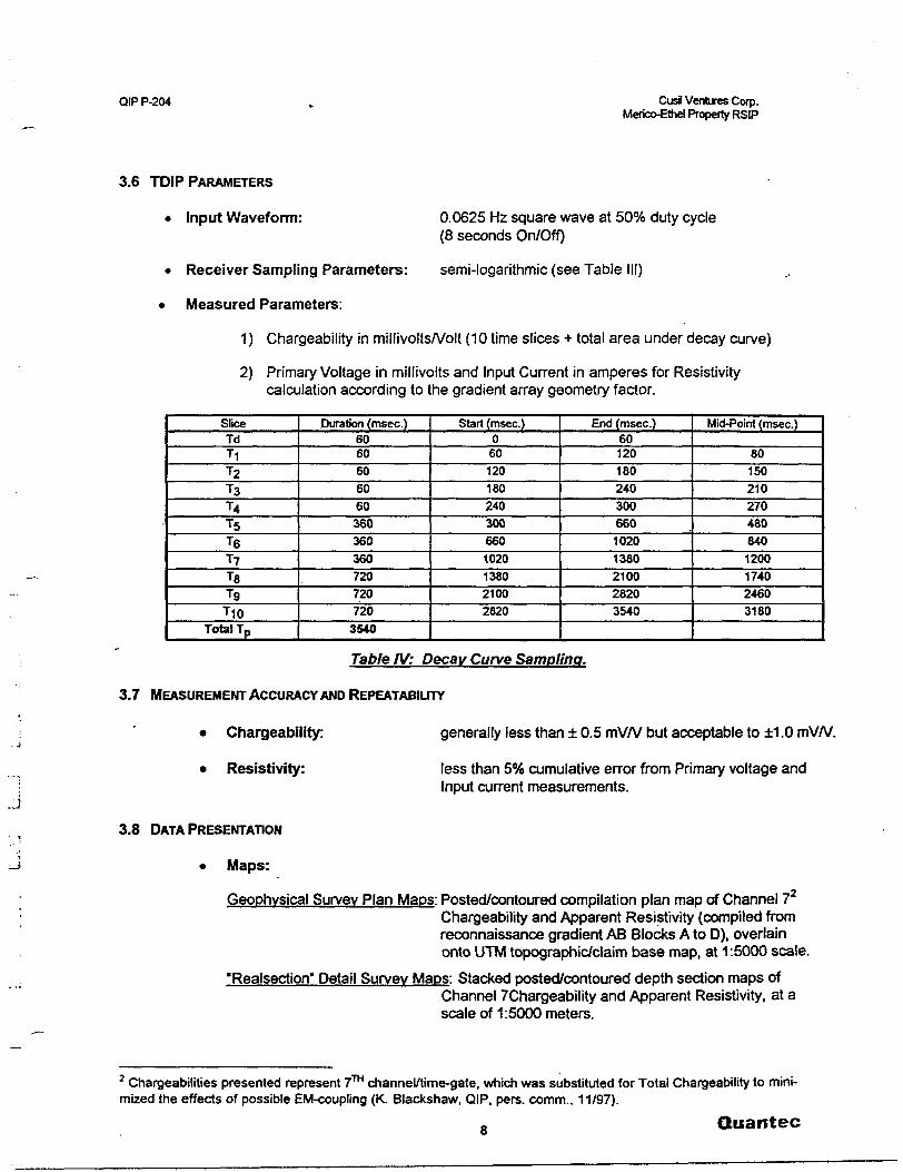
3.6 TDIP PARAMETERS
* Input Waveform:
* Receiver Sampling Parameters:
* Measured Parameters:
0.0625 Hz square wave at 5007o duty cycle (8 seconds On/Off)
semi-logarithmic (see Table III)
1) Chargeability in millivolts/Volt (10 time slices + total area under decay curve)
2) Primary Voltage in millivolts and Input Current in amperes for Resistivity calculation according to the gradient array geometry factor.
SliceTdTIT2T3T4T5T6T7TBT9TIO
Total Tp
Duration (msec.)6060606060360360360720720720
3540
Start (msec.)0601201802403006601020138021002820
End (msec.)6012018024030066010201380210028203540
Mid-Point (msec.)
801502102704808401200174024603180
Table IV: Decay Curve Sampling.
3.7 MEASUREMENT ACCURACY AND REPEATABILITY
Chargeability:
Resistivity:
generally less than ± 0.5 mV/V but acceptable to ±1.0 mV/V.
less than 5(56 cumulative error from Primary voltage and Input current measurements.
3.8 DATA PRESENTATION
* Maps:
Geophysical Survey Plan Maps: Posted/contoured compilation plan map of Channel 7Chargeability and Apparent Resistivity (compiled from reconnaissance gradient AB Blocks A to D), overlain onto UTM topographic/claim base map, at 1:5000 scale.
"Realsection' Detail Survey Maps: Stacked posted/contoured depth section maps ofChannel /Chargeability and Apparent Resistivity, at a scale of 1:5000 meters.
2 Changeabilities presented represent 7™ channel/time-gate, which was substituted for Total Chargeability to mini mized the effects of possible EM-coupling (K. Blackshaw, QIP, pers. comm., 11/97).
8 Quantec
QIP P-204 Cud Ventures Cotp. Merico-Ethel Property RSIP
Maps (cent):
Interpretation Plan Map:
Digital:
Raw data:
Processed data:
using the following format:
Interpreted chargeability anomalies, correlated into axes, and zones of contrasting high/low resistivity, as well as interpreted structures, all overlain onto UTM topo graphic/claim base map, at 1:5000 meter scale.
IP-6 digital dump file (See also Appendix C).
Geosoft .XYZ format.
Column 1 = L ine (X Position), in metersColumn 2 s Station (Y Position), in metersColumn 3 = Channel 7 Chargeability (see Table III), in mV/VColumn 4 = Apparent Resistivity, in Q-mColumn ^ ~ TDIP Spectral Estimates, derived using IPREDC™
Quantec
QIP P-204 CusJ Ventures Corp.Merico-Elhel Property RSIP
4.1 OVERVIEW
The Gradient Realsection IP/Resistivity surveys over the Merico-Ethel Property were designed to first establish resistivity and chargeability signatures associated with known mineralization, then to iden tify potential drill-targets consistent with the target model elsewhere on the property. The exploration tar get consists of vein/shear-hosted copper/cobalt/silver/gold bearing disseminated to stringer sulphides, associated with pervasive quartz-carbonate alteration, and occurring along subvertical structures both in the diabase-sill and possibly also extending from the metasedimentary basement rocks.
The property is mainly underlain by Nippissing gabbro-diabase, which forms a O^SOm thick sill dip ping/thickening to the SW, overlying Cobalt Group Gowganda Formation conglomerite lo arenaceous sediments. These gently dipping rocks mainly form the basement, but also outcrop along the northern and eastern perimeter, where the diabase pinches out. A small occurrence of Lorrain Formation arkoses, which represents the uppermost Cobalt stratigraphy, also occurs in the west-central survey area, where the cover rocks are locally eroded. Archean granitic rocks of the Round Lake Batholith also lie along the NW corner of the survey area, and form the deep, unconformable basement regionally (ref. Cusil Ven tures Corp., Merico-Ethel Property OGS Underlay. 1:10000 scale, TJ Quesnel, 1997). Outcrop exposure is poor, due to a thin blanket of glacial moraine sediments, which thicken to the north and south-west, following drainage patterns.
Mineral occurrences on the property consist of: a) the Ethel Copper Mine (ECM) in James Twp., which encompasses a main incline shaft near LO-L1WYw7S and other workings between L2W-L6W7*14S (ref. OGS Geologic Compilation, Mickle and James Townships. Map 2501,1968); and b) the Merico Mine workings (MMW) in Tudhope Twp., near L5E/6S. The area has been extensively explored for copper- silver, dating back to the early century, with the Ethel Copper mine in operation for a brief period in the mid-1960's. The central and eastern half of the property remain relatively unexplored /poorly documented and concentrated on the Merico site where a shaft and several pits predate the Ethel Copper in the early 1960's (from OMNDM Report. Cobalt District. 1996). Other nearby copper-silver occurrences include the Silver Jackpot/Northern Silver Fox Mine, and a vein system 800m further east - both of which lie just south of the survey coverage in Lots 12-11 of Cone. VI, respectively (ref. OGS Geologic Compilation, Hill Lake. Map 2501,1985). The mineral occurrences are polymetallic/polymineral and typically form narrow (1-3m) steeply dipping quartz-carbonate altered, vein-shear systems, which follow ESE, ENE and NNE strike directions and host S-25% copper and attendant Au-Ag-Co, within chalcopyrite, bornite and specu larite.
Previous geophysics on the property include IPVResistivity by McPhar Geophysics in 1961, which out lined the mineralization surrounding Ethel Copper adit, as well as Self-Potential at Merico, in 1953, which delineated the showing (ref. BE MacKean, Elk Lake Area. OGS Report, 1968). More recently, ground magnetics and VLF-EM have been undertaken in 1995 (ref. D J McCormack and H Bes, Merico-Ethel Project. 1995 OPAP Report; G J Gerehty, Tudhope Twp. Plan No. M252. Magnetic and VLF Survey Re port, 01/96), in the central portion of the present survey area, but along differing survey lines. Presently, a ground magnetic survey has been undertaken concurrently with the IPVResistivity (ref. Meegwich, 1997), the results of which can be used for comparison. The present Gradient IPVResistivity survey consists of reconnaissance gradient coverage over most of the grid area, with detailed Realsection coverage limited to six (6) lines in the eastern half of the property, which is the area of greatest exploration interest. The Gradient-Realsection technique was chosen based on its combined high resolution and deep penetration capabilities, having the ability to detect and characterize targets at depths of several hundred metres, and to determine the possible extension of mineralization into the deeper basement.
10 Quantec
QIP P-204 Cusil Ventures Corp.Merico-ethel Property RSIP
4.2 GRADIENT-REALSECTION SURVEY RESULTS
The IP\Resistivity and TFMA/LF results successfully discriminate signatures potentially associated with lithology, fault-fracture structures, chemical alteration, and, most importantly, chargeability responses related to sulphides and, potentially, precious and base metals mineralization. The geophysical compila tion/interpretation plan presents the interpreted anomaly axes - highlighting the strength and resistivity- association of the IP axes, which relates to their source/alteration type: a) High resistivity IP axes, related to disseminate sulphides possibly associated with quartz-carbonate altered vein systems; b) Nil p and contact-type IP axes likely to correspond to more weakly-altered 8Jor thin/buried sulphides zones; and c) Low resistivity IP axes generally relating to either subcropping mineralized, clay-altered faults or possibly stringer sulphide mineralization. The line-to-line correlation of anomalies into axes is based primarily on resistivity association (i.e. resistive and conductive anomalies never aligned along the same axis due to likely dissimilar mineralogy/alteration/origin). It is clear, however, that, depending on the conditions and the target-model, all anomaly types could represent equally valid exploration targets - even the weakest anomalies in areas of deeper OB cover. In assessing their relative importance of chargeability features, insofar as the relative percent composition and width, equal amounts of mineralization in low, nil and high IP axes are likely to produce progressively weaker anomalies - as noted in Appendix C. In order to better visualize the relationships between the IP and Resistivity, contrasting zones of high/low resistivity have been identified on the interpretation plan, using the cross-hatching, to highlight potential geologic con tacts, alteration zones and fault-fracture structure. Finally, zones of strong chargeability have also been identified on the interpretation plan-map, as these represent the areas most favourable to host economic mineralization, based on the target model.
The IPVResistivity response at Ethel-Merico is characterized by the presence, of two to three east- westerly bands of moderate to high chargeability, which extend across the central and southern part of the survey area and directly coincide with broad zones of high resistivity - suggesting an EW structural control to the mineralized quartz-carbonate altered system across the property. All known mineralized -showings, including the ECM and MMW, are also contained within these zones, which is significant. Both the apparent resistivity and chargeability plans emphasize ENE, EW and ESE trends - agreeing with the geologic and structural directions. The measured chargeabilities vary between 0-1 SmV/V, and anomalies falling into the weak to mod-strong range - consistent with ^-5^) bulk disseminated sulphides. The lack of very strong IP ^20mv7V) indicates that strong concentrations of sulphides are either absent or more deeply buried. The chargeabilities are strongest to the south and weaken progressively northward - ei ther as a result of thickening overburden and/or due to thinning of the diabase cover rocks which are the more favourable geologic host for mineralization. If the contrasting chargeabilities are due to thicker overburden, rather than bulk mineralization, then anomalies from the two contrasting regions of overbur den cover need to be considered separately - with differences likely to exceed 50*56 for axes of similar bulk composition. The IP axes are strike-extensive (;-100-500m), but display significant variations in strength - reflecting pinching/swelling of mineralization along strike. In cross-section/Realsection, the chargeability anomalies display little or no vertical layering, except for possible slight increases across Nippissing/Gowganda contact and in the deeper basement - which are both significant to the exploration model, as this reaffirms the subcropping and subvertical nature and the hydrothermal control to the sul phide mineralization, which is unrelated to lithology.
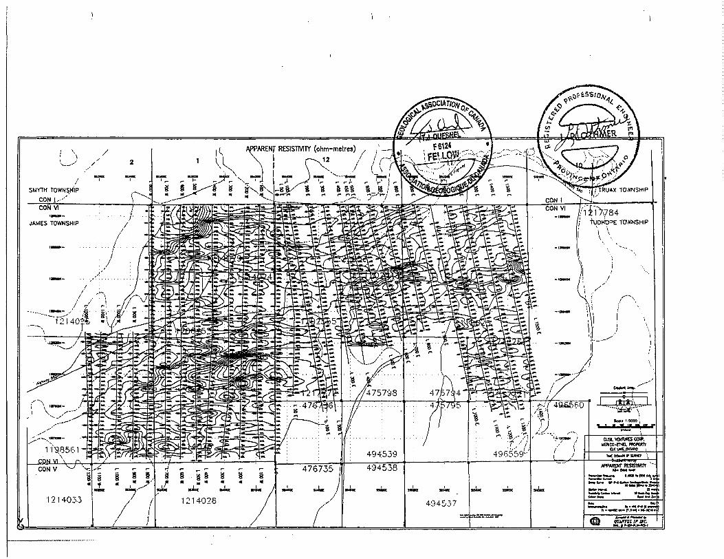
The apparent resistivities show a moderate range, varying between 2k-35k ohm-metres, which is con sistent with lower porosity units and the absence of strong/thick concentrations of sulphides (or graphite) - as also suggested in the IP results. The glacial overburden's thin and poorly conductive nature affects the gradient resistivity results to a lesser extent than the IP or Magnetics - with narrow lineaments clearly visible throughout the property, except to the far-north and south, where stronger, linear resistivity lows, devoid of correlative IP (i.e. barren/unmineralized) likely represent deeper, graben-like overburden troughs. In contrast, the linear high resistivity zones generally correlate with highly polarizeable material, and therefore likely relate to quartz-carbonate altered mineralization - otherwise, to barren zones of out crop or less porous rocks. As noted in the magnetics (ref. Meegwich, 1997), there appears to be little di rect correlation between the bedrock geologic contacts and the IP\Resistivity, except for a general less-
Quantec
QIP P-204 Cusi Ventures Corp.Merico-Ethel Property RSIP
ening of the chargeability and resistivity along the northern rim of the property, which is either explained by changing lithology (Gowganda) or geomorphology (overburden), as noted. The Lorrain sediment uplift in the west-central grid is also indiscernible in the Gradient results - except possibly as a poorly defined resistivity high. It is likely that this poor geologic correlation is due to the flat-lying and thin/variable na ture of the Nippissing diabase cover overlying the Gowganda basement rocks, as compared to the rela tively deep exploration depth obtained from the reconnaissance gradient coverage, which exceeds 350m. In Realsection, however, the shallow south-dipping Nippissing diabase correlates well with a low- resistivity layer observed to extend from its thinnest point near 4S-5S across L5E- 8E, while it is also more flat-lying across L11E-12E (K. Blackshaw, QIP, pers. comm., 12/97).
The IPVResistivity signatures show good anomaly correlation with known showings, including a) the Ethel Copper adit (LO/688S) which lies in an area of interest and coincides with a moderately strong IP axis, lying along a geoelectric contact which follows an ENE-trend - agreeing with the key structural direc tion; b) the Merico workings (between L5E/638S to L7E/538S) which also coincides with an area of inter est, including possible cross-cutting ENE, ESE and EW strong IP axes - also agreeing with the mapped geologic trends; and c) other ECM workings in the south-west survey area are closely related to several short EW to ENE-oriented, mod-strong, high to nil resistivity IP axes. The VLF-EM and magnetics cover age described by Gerehty (01/96) and McCormack (01/96) is limited to the north-central portion of the present survey area (118625-West, 1222053-East and 120448-West), but were collected along different cut/survey lines - making direct comparisons difficult. However, of the five VLF conductor axes picked, only one correlates with a narrow zone of IP\Resistivity low and furthermore none is polarizeable. Hence, we conclude that the VLF-EM features, if real, represent open faults and contacts which are bar- ren/unmineralized and therefore of limited economic or geologic interest. The most recent ground mag netic coverage by Meegwich (09/97) indicates that, as with the IP\Resistivity, the variation in magnetic susceptibilities also do not correlate with geologic contacts. The magnetic high lineaments appear to map more mafic/magnetite-rich phases of the Nippissing diabase. On the other hand, a broad ENE-trending magnetic low indicated through the east-central portion of the survey, which was suggested to possibly represent a zone of alteration/magnetite-depletion in the diabase, also coincides with a region of high resistivity - agreeing with an interpreted zone of quartz-carbonate alteration. It is clear, however, that as well as offering better resolution and penetration, the Gradient chargeabilities and resistivities are in all likelihood better indicators of mineralization and type-alteration than the ground magnetics.
As many as sixty (60) moderate to strong IP axes of significance have been defined, and these have been loosely grouped and named Zones A-E, based on their close spatial proximity and strike trend, as shown on the interpretation plan map The weakest IP signatures have been identified in plan, but not correlated from line-to-line, in order to better visualize the best drill-targets on the property. The most significant chargeability signatures have been prioritized according to their relative strength and anomaly- definition in Realsection, and are described in Table V. Although nearly all the strongest chargeability anomalies represent good drill-targets, the list presented in Table V is designed to help direct DDH- testing into the best portion of each major axis. For the most part the axes are ESE to ENE trending, fol lowing the known structural trends. The strongest IP axes are concentrated through the central portion, along Zones A-A', where the strongest high resistivity band occurs, suggesting a major qtz-altered structural zone, and coinciding with the ECM and MMW showings, as well as all the highest priority axes lying further east. A second and third zone of strong IP occurs further south along Zones B-B' and Zone C, which also lie on-strike with the Silver Fox deposits, but less highly resistive (less altered?), weaker l more discontinuous (less mineralized ?) than A and are also not characterized in Realsection. The strength of IP axes decreases markedly to the north, possibly largely due to heavier overburden cover - although gradient-analysis of the data suggest that the buried zones are also possibly more weakly min eralized to the north. Zones D-E are exceptions, which despite being relatively smaller and weaker, co incide with anomalous resistivity high (qtz-altered ?), resembling A. If their IP responses have also been attenuated due to overburden, these could potentially host stronger mineralization than indicated and also possibly represent significant cross-cutting features - these too have not been adequately characterized for drill-targeting.
12 Quantec
QIP P-204 Cusil Ventures Corp. Merico-Ethe! Property RSIP
In Realsection, the axes appear to be subvertically dipping, thin ^25m), and subcropping to partly buried and associated with horst-like high-resistivity structures - suggesting a deeper hydrothermal source. The chargeabilities in Realsection also suggests that the sulphide mineralization, across Zone A* and B', is vertically continuous, with occasional pinching/swelling possibly along the diabase/sediment contacts. The IP also strengthens in the deeper AB levels which suggests that the sulphide mineraliza tion extends from surface into the deeper sedimentary basement, as hoped, possibly below 300m depths.
The chargeability axes are equally divided between high and nil trends, with the low-resistivity axes being the fewest. The high to nil resistivity axes best represent disseminated sulphides within quartz- carbonate altered, EW to ESE shears and likely represent good exploration targets. The nil to conductive axes, which make up the bulk of the highest priority targets, either represent sulphide mineralized, open or clay-altered-faults or, more importantly structurally controlled stringer to semi-massive sulphide miner alization - with the greater sulphide content overprinting the lower porosities associated with the attendant quartz-carbonate alteration - making these the highest priority targets.
NAME
Zone A
Zone A1
"
Zone B
Zone B'
Zone C
Zone D
Zone E
LINE
1200W800W300W100W
500E600E700E800E800E1100E1100E1200E1200E800W700W500WOOOEOOOE
1200E1200E1000W500W400W300W100WOOOEOOOEOOOE700W700W500W400W
STATION
863S838S762S712S
675S625S61 2S438S650S525S825S650S738S1262S1112S1238S1112S1238S
1138S1212S1512S1338S1562S1388S1588S1112S1238S1450S51 2S662S288S21 2S
STRENGTH
Mod-StrongMod-Strong
StrongStrong
StrongStrongStrongStrongStrongStrongStrongStrongStrongStrongStrong
Mod-StrongMod -Strong
Strong
Mod-StrongStrongStrong
Mod-StrongStrong
Mod-StrongMod-StrongMod-Strong
StrongStrong
ModerateModerate
Mod-StrongMod-Strong
RESISTIVITYASSOCIATION
HighLowNilNil
NilHighLowLowHighNilNilNilNil
HighHighHighHighHigh
NilHighNilNilNilNilNil
HighHighHighLowNilNilNil
DEPTH
----
150i-*250m150+^OOm200+^OOm200+^OOm200**300m
•elOO+MSOm^50-i^200m•e125*^00m•:100-t^200m
—----
———------—-—--
PRIORITY
2222
22111111122222
22222222222222
COMMENT
Probable qtz-altered disseminated sulphidesPossible clay-altered or stringer sulphidesPossible weak-altered, thin/diss. sulphidesPossible weak-altered, thin/diss. sulphides
Possible weak-altered, thin/diss. sulphidesProbable qtz-altered disseminated sulphidesPossible day-altered or stringer sulphidesPossible day-altered or stringer sulphidesProbable qtz-altered disseminated sulphidesPossible weak-altered, thin/diss. sulphidesPossible weak-altered, thin/diss. sulphidesPossible weak-altered, thin/diss. sulphidesPossible weak-altered, thin/diss. sulphidesProbable qtz-altered disseminated sulphidesProbable qtz-altered disseminated sulphidesProbable qtz-altered disseminated sulphidesProbable qtz-altered disseminated sulphidesProbable qtz-altered disseminated sulphides
Possible weak-altered, thin/diss. sulphidesProbable qtz-altered disseminated sulphidesPossible weak-altered, thin/diss. sulphidesPossible weak-altered, thin/diss. sulphidesPossible weak-altered, thin/cfiss. sulphidesPossible weak-altered, thin/diss. sulphidesPossible weak-altered, thin/diss. sulphidesProbable qtz-altered disseminated sulphidesProbable qtz-aKered disseminated sulphidesProbable qtz-aKered disseminated sulphidesPossible buried, day-ridi, stringer sulphidesPossible buried, weakly-altered sulphidesPossible buried, weakly-altered sulphidesPossible buried, weakly-altered sulphides
Table V: Recommended Targets for Follow-up at Ethel-Merico.
13 Quantec
QIP P-204 Cusfl Ventures Corp.Merico-Ethel Property RSIP
The Gradient-Realsection induced polarization and resistivity surveys over the Ethel-Merico prop erty have successfully identified geophysical signatures, consistent with lithologies, structure, alteration and, most importantly, disseminated to possibly stringer sulphide mineralization, resembling the target model. In response to the survey objectives, all known mineralization have been shown to coincide with anomalous IP\Resistivity signatures, and at least seven (7) previously undiscovered high priority targets have been identified in the eastern half of the grid area, which are of significant strength and vertical ex tent, having been adequately characterized in Realsection, to merit immediate follow-up by drill-testing (see Table V). In addition, as many as twenty (20) high-second priority features have been identified which warrant ground follow-up, and possibly DDK-testing - although these resemble the high priority tar get signatures, these are mainly found in the west grid and have not been fully delineated in cross- section, thereby meriting a lesser priority (see Table IV). The IP axes of significance ca'n be grouped into five (5) basic trends (A-E), which generally follow the key ENE, EW and ESE trends, and roughly coincide with broad linear zones of resistivity high - likely representing structurally-controlled, quartz-carbonate altered mineralized hydrothermal zones.
The main zone of interest (A) features a band of multiple, moderate to strong, mixed resistivity and ESE to ENE oriented IP axes which cross-cut the entire survey area and encompassing both the Ethel- Copper and Merico showings - it lies along a prominent ENE trending band of resistivity high, suggesting a major structural, quartz-carbonate altered zone of mineralization. In addition to the ECM and MMW, Zone A hosts several stronger IP responses west and east of the known showings which merit immediate follow-up. Zone B is a similar EW-trending, multiple horizon, lying 300-500m further south, which despite its weaker resistivity (possibly less altered) lies directly on strike with the Silver Jackpot workings - it re quires additional RSIP coverage to better target DDH-drilling. Zone C is the southernmost trend of inter est, and is the least well-defined of the three major IP lineaments - it coincides with the southern Ethel- Copper mine workings and also suggests a spatial relationship with the south Silver Jackpot mineraliza tion. Unless it has been fully DDH-tested, it's relative strength suggests it merits additional follow-up. To the northwest, in the area of deeper overburden, Zones D-E are smaller, shorter EW *o ESE trends which coincide with high resistivity similar to Zone A. These both feature several moderate to strong IP re sponses, which if buried, could be more strongly mineralized relative to the southern region, and are therefore sufficient interest to merit additional follow-up - D in particular is aligned with the ECM and may represent an important cross-cutting mineralizing structure.
We recommend that these data be combined with the existing geoscientific information and the re sults more fully evaluated prior to drill-testing. The IP axes display a wide variety of strengths, resistivity associations and strike orientations, such that, on the basis of the geophysics alone, all the most signifi cant axes would represent equally good targets. Particular attention should be given to the resistivity as sociation, which relates to the type-alteration, as well as the indicate target-depth, particularly at the initial stages of drilling. Additional comparison between specific target signatures and known mineral re sources may allow the identification of a key signature thereby providing a better prioritization of these targets. Due to poor vertical depth-control inherent with the gradient technique, we recommend that zones of interest receive additional detailed IP\Resistivity coverage prior to drill-targeting.
14 Quantec
QIP P-204 Cusfl Ventures Corp. Merico-Ethel Property RSIP
We note that the moderate strength of the axes and the nil/low resistivity may be the result of their depth of burial and alteration nature rather than a direct reflection of their sulphide content - aH zones appear to strengthen with depth. The VLF-EM survey results from a small survey area show poor correla tion with the IP\Resistivity, and seem mainly related to barren contact-type structures or overburden fea tures. The TFM-magnetics are also of limited use, relative to the IP, due to the thin/variable and flat-lying nature of the Nippissing diabase - although eastern Zone A partly coincides with a region of magnetic- low, possibly relating to hydrothermal alteration/magnetite-depletion. We note that the a weaker strength of axes to the north may be the result of less favourable host rock or deeper overburden - in which case, the two regions may have to be considered separately. However, there appears to be sufficient axes of interest in the south, which are indicated to be shallow-buried, deeply rooted/vertically extensive from the diabase into the basement, to adequately determine the mineral potential of the property during the next step of the exploration program.
RESPECTFULLY SUBMITTED
QUANTEC IP INC.
G. R. Jeffrey Warne Senior Geophysicist
Jean M. Legault, P.Eng.Senior GeophysicistReg. No. 90531542
Kevin Blackshaw Senior Geophysicist
Andrew Oswald Junior Geophysicist
Kevin MacKenzie Field Supervisor
Paul Plazek Senior Geophysicist
Porcupine, ON December, 1997.
15 Quantec
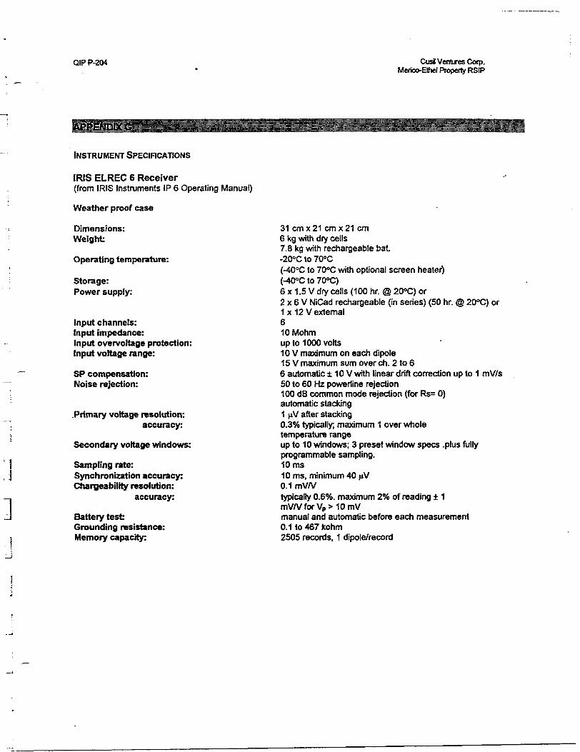
QIP P-204 Cusil Ventures Cotp. Merico-Ethe) Property RSIP
INSTRUMENT SPECIFICATIONS
IRIS ELREC 6 Receiver(from IRIS Instruments IP 6 Operating Manual)
Weather proof case
Dimensions: Weight:
Operating temperature:
Storage: Power supply:
Input channels:Input impedance:Input overvoftage protection:Input voltage range:
SP compensation: Noise rejection:
.Primary voltage resolution: accuracy:
Secondary voltage windows:
Sampling rate: Synchronization accuracy: Chargeability resolution:
accuracy:
Battery test Grounding resistance: Memory capacity:
31 cm x 21 cm x 21 cm6 kg with dry cells7.8 kg with rechargeable bat.-200C to 70"C(-400C to 700C with optional screen heater)(-40"C to 700C)6 x 1.5 V dry cells (100 hr. @ 200C) or2 x 6 V NiCad rechargeable (in series) (50 hr. @ 200C) or1 x 12 V external610 Mohmup to 1000 volts10V maximum on each dipole15V maximum sum over eh. 2 to 66 automatic ± 10 V with linear drift correction up to 1 mV/s50 to 60 Hz powerline rejection100 dB common mode rejection (for Rs= 0)automatic stacking1 fxV after stackingD.3% typically, maximum 1 over wholetemperature rangeup to 10 windows; 3 preset window specs .plus fullyprogrammable sampling.10ms10 ms, minimum 40 jiV0.1 mV/Vtypically D.6%. maximum 2 'ft of reading ± 1mV/VforVpS-IOmVmanual and automatic before each measurement0.1 lo 467 kohm2505 records, 1 dipole/record
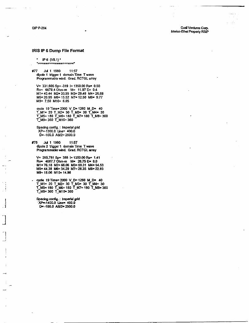
QIP P-204 Cusi Ventures Corp.Merico-Bhel Property RSIP
IRIS IP 6 Dump File Format
* IP 6 (V9.1)*
#77 Jul 1 1980 11:57dipole 1 trigger 1 domain Time T wave Programmable wind. Grad. RCTGL array
V= 331.605Sp^319 1=1 350.00 Rs* 0.50 Ro= 6679.4 Ohm-m M" 11.97E* 0.4 M1 * 40.44 M2- 33.55 M3= 29.48 M4" 26.68 M5= 20.95 M6= 15.52 M7* 12.50 M8= 9.77 M9= 7.50 M^ 6.05
cyde 19 Times 2000 V.D* 1260 M D" 40 TJUI1- 20 T M2* 30 T M3* 30 T M4- 30 TJA5* 1 80 f.M6s 180 :f_M7= 1 80~T M8= 360 ^9=360 T.M1 0=360
Spacing config. : Imperial grid XP— 1300.0 Lir^ 400.0 DS -100.0 AB^ 2500.0
#78 Jul 1 1980 11:57dipole 2 trigger 1 domain Time T wave Programmable wind. Grad. RCTGL array
V" 265.781 Sp- 388 1=1 350.00 Rs- 1.41 Ro- 4687.7 Ohm-m M" 26.75 E- 0.0 M1*76.18 M2- 66.06 M3* 59.31 M4" 54.53 MS* 44.38 M6-3429 M7- 28.35 f^ 22.83 M9- 18.06 M1CN 14.96
- cyde 19 Time- 2000 V-O 1260 M D* 40 T.M1" 20 T.M2* 30 T.M3* 30 T~M4" 30
180 T.M6s 180 T.M7" 180 "t.MS" 360
Spacing config. : Imperial grid •XP--1 400.0 Line" 400.0 O -100.0 ABC* 2500.0
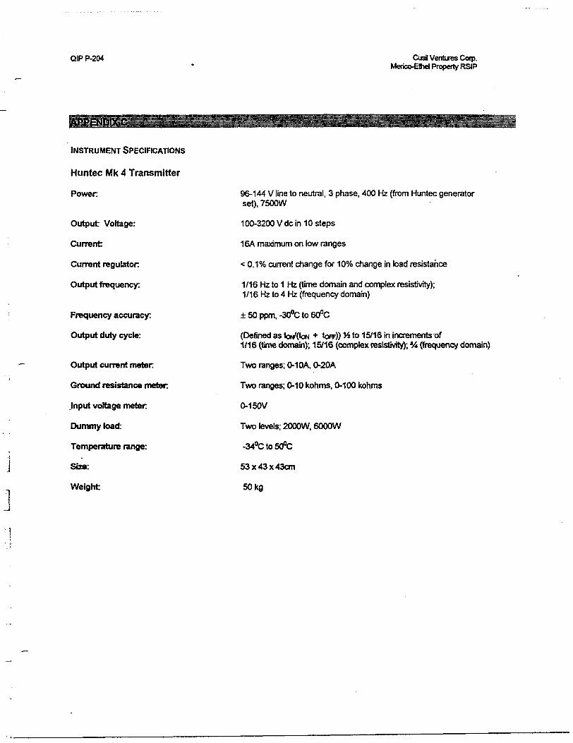
QIP P-204 CusS Ventures Corp. Merico-Ethel Property RSIP
INSTRUMENT SPECIFICATIONS
Huntec Mk 4 Transmitter
Power
Output Voltage:
Current
Current regulator
Output frequency:
Frequency accuracy:
Output duty cycle:
Output current meter
Ground resistance meter.
.Input voltage meter
Dummy load:
Temperature range:
Size:
Weight
96-144 V line to neutral, 3 phase, 400 Hz (from Huntec generator set), 7500W
100-3200 V de in 10 steps
16A maximum on low ranges
< 0.1 "/o current change for 10"7o change in load resistance
1/16 Hz to 1 Hz (time domain and complex resistivity); 1/16 Hz to 4 Hz (frequency domain)
±50ppm,-300Cto600C
(Defined as toV(tON * tor)) J* to 15/16 in increments of1/16 (time domain); 15/16 (complex resistivity); *A (frequency domain)
Two ranges; 0-10A, 0-20A
Two ranges; 0-10 kohms. 0-100 kohms
0-150V
Two levels; 2000W, 6000W
-340Cto500C
53 x 43 x 43cm
50kg
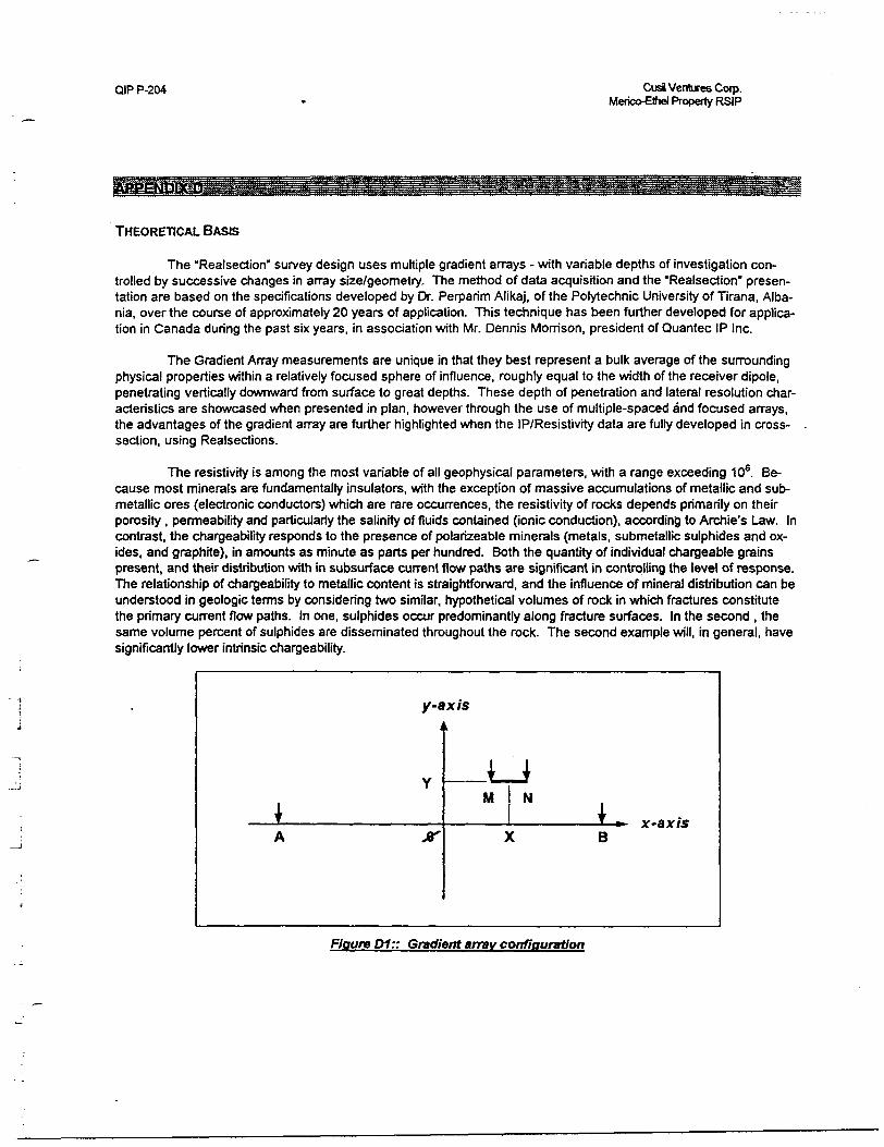
CUP P-204 Cusi Ventures Corp. Merico-Ethel Property RSIP
THEORETICAL BASIS
The "Realsection" survey design uses multiple gradient arrays - with variable depths of investigation con trolled by successive changes in array size/geometry. The method of data acquisition and the "Realsection" presen tation are based on the specifications developed by Dr. Perparim Alikaj, of the Polytechnic University of Tirana, Alba nia, over the course of approximately 20 years of application. This technique has been further developed for applica tion in Canada during the past six years, in association with Mr. Dennis Morrison, president of Quantec IP Inc.
The Gradient Array measurements are unique in that they best represent a bulk average of the surrounding physical properties within a relatively focused sphere of influence, roughly equal to the width of the receiver dipole, penetrating vertically downward from surface to great depths. These depth of penetration and lateral resolution char acteristics are showcased when presented in plan, however through the use of multiple-spaced and focused arrays, the advantages of the gradient array are further highlighted when the IP/Resistivity data are fully developed in cross- section, using Realsections.
The resistivity is among the most variable of all geophysical parameters, with a range exceeding 106 . Be cause most minerals are fundamentally insulators, with the exception of massive accumulations of metallic and sub metallic ores (electronic conductors) which are rare occurrences, the resistivity of rocks depends primarily on their porosity , permeability and particularly the salinity of fluids contained (ionic conduction), according to Archie's Law. In contrast, the chargeability responds to the presence of polarizeable minerals (metals, submetallic sulphides and ox ides, and graphite), in amounts as minute as parts per hundred. Both the quantity of individual chargeable grains present, and their distribution with in subsurface current flow paths are significant in controlling the level of response. The relationship of chargeability to metallic content is straightforward, and the influence of mineral distribution can be understood in geologic terms by considering two similar, hypothetical volumes of rock in which fractures constitute the primary current flow paths. In one, sulphides occur predominantly along fracture surfaces. In the second , the same volume percent of sulphides are disseminated throughout the rock. The second example will, in general, have significantly lower intrinsic chargeability.
y-axis
M N
Bx-axis
Figure D1:: Gradient array configuration
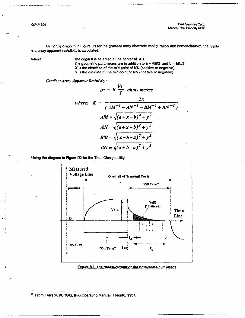
QIP P-204 CusJ Ventures Corp. Merico-Shel Property RSIP
Using the diagram in Rgure D1 for the gradient array electrode configuration and nomenclature:2 , the gradi ent array apparent resistivity is calculated:
where: the origin O is selected at the center of AB the geometric parameters are in addition to a * AB/2 and b = MN/2 X is the abscissa of the mid-point of MN (positive or negative) Y is the ordinate of the mid-point of MN (positive or negative)
Gradient Array Apparent Resistivity:VPpa = K —— ohm - metres
•where: K = (AM'1 -AN'1 -BM'1 + BN'1 )
AM=J(a+x-b)2 +y 2
+y
= ^j(x-b-a)2 +y 2
Using the diagram in Rgure D2 for the Total Chargeability:
f Measured Voltage Line One half of Transmit Cycle
"Off Time"
Vs(t) (10 slices)
V 7 Time i Line
Figure D2 The measurement of the time-domain IP effect
From Terraplus\BRGM, IP-6 Operating Manual. Toronto, 1987.
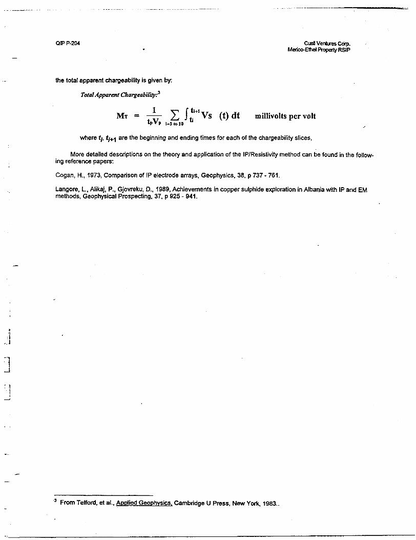
QIP P-204 Cusa Ventures Corp.Merico-Ethel Property RSIP
the total apparent chargeability is given by:
Total Apparent Chargeability?
Mr — —— 2.1 J t, Vs (t) dt millivolts per volttpVp |,| ,0 10
where f/, tj+i are the beginning and ending times for each of the chargeability slices,
More detailed descriptions on the theory and application of the IP/Resistivity method can be found in the follow ing reference papers:
Cogan, H., 1973. Comparison of IP electrode arrays, Geophysics, 38, p 737 - 761.
Langore, L, Alikaj, P., Gjovreku, D., 1989. Achievements in copper sulphide exploration in Albania with IP and EM methods, Geophysical Prospecting, 37, p 925 - 941.
3 From Telford, et al.. Applied Geophysics. Cambridge U Press, New York, 1983..
QIP P-204 CusJ Ventures Corp. Merico-Ethel Property RSIP
STATEMENT OF QUALIFICATIONS
l, G.R. Jeffrey Wame, hereby declare that:
1. l am a geophysicist with residence in South Porcupine, Ontario and am presently employed in this capacity with Quantec IP Inc. of Waterdown. Ontario.
2. l studied Engineering Geophysics in the Faculty of Applied Science at Queen's University in King ston. Ontario, completing all but two of the course requirements for a B.Sc.(Eng.) in 1981.
3. l have practiced my profession continuously since May, 1981 in Canada, the United States and Chile.
4. l have no interest, nor do l expect to receive any interest in the properties or securities of Cusil Ventures Corp.
5. The statements made in this report represent my professional opinion based on my consideration of the information available to me at the time of writing this report.
Porcupine, Canada December, 1997
G.R. Jeffrey Wame Senior Geophysicist General Manager - QIP
QIP P-204 CusH Ventures Corp.Merico-Ethel Property RSIP
STATEMENT OF QUALIFICATIONS:
l, Jean M. Legault, declare that:
1. l am a consulting geophysicist with residence in South Porcupine, Ontario and am presently employed in this capacity with Quantec IP Inc. of Waterdown, Ontario.
2. l obtained a Bachelor's Degree, with Honours, in Applied Science (B.A.Sc.), Geological Engineering (Geophysics Option), from Queen's University at Kingston, Ontario, in Spring 1982.
3. l am a registered professional engineer, since 1985, with license to practice in the Province of Ontano (Reg. # 90531542).
4. l have practiced my profession continuously since May, 1982, in North-America, South-America and North- Africa.
5. l am a member of the Association of Professional Engineers of Ontario, the Quebec Prospectors Associa tion, the Prospectors and Developers Association of Canada, and the Society of Exploration Geophysicists.
6. l have no interest, nor do l expect to receive any interest in the properties or securities of Cusil Ventures Corp.
7. The statements made in this report represent my professional opinion based on my consideration of the in formation available to me at the time of writing this report.
Porcupine, Ontario December., 1997
Jean M. Legault, P.Eng. (ON) Chief Geophysicist Dir. Technical Services Quantec Group
QIP P-204 CusJ Ventures Corp.Merico-Bhd Property RSIP
STATEMENT OF QUAUFICATIONS:
l, Kevin Blackshaw. declare that:
1. l am currently employed by Quantec IP Inc. of Waterdown, Ontario as a field supervisor.
2. l graduated from Cambrian College in Sudbury, Ontario with a Geological Engineering Technology diploma in 1983.
3. l have continuously been employed in this field since graduation.
4. l have no interest nor do l expect to receive any interest in the properties or securities of Cusil Ventures Corp.
Porcupine, Ontario December., 1997
.l Kevin BlackshawOperations Manager (QIP)
QIP P-204 Cusi Ventures Corp.Merico-Ethel Property RSIP
STATEMENT OF QUAUFICATIONS:
l, Paul J. Plazek, hereby declare that:
1. l am a geophysicist with residence in Renfrew, Ontario and am presently employed in this capac ity with Quantec Consulting Inc. of Porcupine, Ontario.
2. l am a graduate of Queen's University, Kingston, Ont., in 1989, with an Honours Bachelor of Sci ence Degree in Geological Engineering.
3. l have practiced my profession in Canada since graduation.
4. l have no interest nor do l expect to receive any interest, direct or indirect, in the properties or se curities of Cusil Ventures Corp.
5. l am the technical interpreter for this report; l constructed this report to the best of my ability with my cur rent level of understanding.
Porcupine, Ontario December, 1997
Paul J. Plazek, B.Sc. n Geophysicist J Quantec Consulting
Technical Servicesj•i
QIP P-204 CusS Ventures Cofp.Merico-Ethel Property RSIP
STATEMENT OF QUALIFICATIONS:
l, Andrew Oswald, declare that:
1. l am currently employed by Quantec Consulting Inc. of Porcupine, Ontario as a processing geo physicist.
2. l am a graduate of Cambrian College, Sudbury, ON, on May, 22,1996 with a Diploma in Geological Engineering Technology.
3. l have no interest nor do l expect to receive any interest in the properties or securities of Cusil Ventures Corp.
4. l am the technical writer for this report; l constructed this report and generated-plots to the best of my ability with my current level of understanding.
Porcupine, Ontario December.. 1997
Andrew Oswald Processing Geophysicist Quantec Technical Services
41P16SW2002 2.18261 TUDHOPE 020
2 . l
MAGNETOMETER SURVEYMERICO-ETHEL PROPERTYTudhope/James Township
Cusil Venture Corp.November 1997.
RECEIVEDMAR - 3 1998
GEOSCIENCE ASSESSMENT OFFICE-(—————
NTS 41 P /16 4 41 P /9
Merico-Ethel Property
41P16SW2002 2.18261 TUDHOPE 0 20C
TABLE OF CONTENTS
l .0 Introduction
2.0 Property
3.0 Location and Access
4.0 Geologic Setting
5.0 Magnetometer Survey
5. l Instrumentation
5.2 Survey Results
6.0 Conclusions and Recommendations
LIST OF FIGURES
Figure l Claim Map
Figure 2 Geology Map
Figure 3 Location Map
LIST OF MAPS
Magnetometer contour map
Meegwich Consultants Inc P.O. Box 482, Temagami, Ontario POH 2HO Td. (705) 56S*-2904 Fax. (705) 569-2817
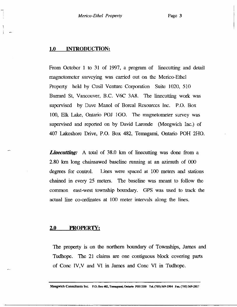
Merico-Ethel Property Page 3
1.0 INTRODUCTION:
From October l to 31 of 1997, a program of linecutting and detail
magnetometer surveying was carried out on the Merico-Ethel
Property held by Cusil Venture Corporation Suite 1020, 510
Burrard St, Vancouver, B.C. V6C 3A8. The linecutting work was
supervised by Dave Manol of Boreal Resources Inc. P.O. Box
100, Elk Lake, Ontario POJ l GO. The magnetometer survey was
supervised and reported on by David Laronde (Meegwich Inc.) of
407 Lakeshore Drive, P.O. Box 482, Temagami, Ontario POH 2HO.
Linecutting: A total of 38.0 km of linecutting was done from a
2.80 km long chainsawed baseline running at an azimuth of 000
degrees for control. Lines were spaced at 100 meters and stations
chained in every 25 meters. The baseline was meant to follow the
common east-west township boundary. GPS was used to track the
actual line co-ordinates at 100 meter intervals along the lines.
2.0 PROPERTY:
The property is on the northern boundary of Townships, James and
Tudhope. The 21 claims are one contiguous block covering parts
of Cone IV,V and VI in James and Cone VI in Tudhope.
Meegwich Consultants Inc. P.O. Box 482, Temagami, Ontario POH 2HO TeL (705) 569-2904 Fax. (705) 569-2817
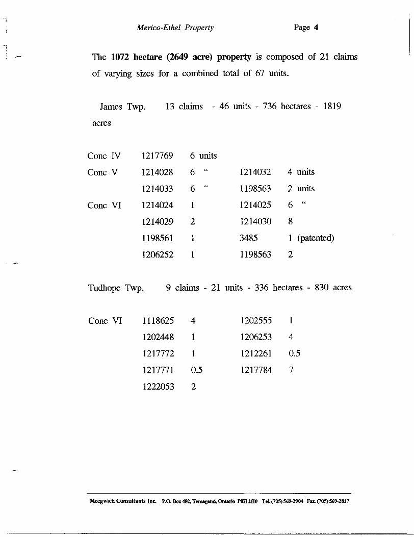
Merico-Ethel Property Page 4
The 1072 hectare (2649 acre) property is composed of 21 claims
of varying sizes for a combined total of 67 units.
James Twp. 13 claims - 46 units - 736 hectares - 1819
acres
Cone IV
Cone V
Cone VI
Tudhope Twp
Cone VI
1217769
1214028
1214033
1214024
1214029
1198561
1206252
9
1118625
1202448
1217772
1217771
1222053
6 units6 "
6 "
1
2
1
1
claims -21
4
1
1
0.5
2
1214032
1198563
1214025
1214030
3485
1198563
units - 336
1202555
1206253
1212261
1217784
4 units
2 units6 "
8
1 (patented)
2
hectares - 830 acres
1
4
0.5
7
Meegwich Consultants Inc. P.O. Box 482, Temagami, Ontario POH 2HO TeL (705) 569-2904 Fax. (705) 569-2817
Merico-Ethel Property Page 5
3.0 LOCATION AND ACCESS:
The property is situated 4 km east of the small village of Elk Lake
which is some 55 km north-west of the town of New Liskeard as
the crow flies.
The property has excellent access since Hwy 560 runs through the
middle of it.
4.0 GEOLOGIC SETTING:
The property is underlain primarily by Precambrian Nipissing gabbro
and Gowganda Formation sediments. A small patch of Lorrain
Formation sediments and the edge of the Round Lake batholith are
also noted. Structure trends north-east containing copper
mineralization that appears to be confined to shear zones.
Historical workings of shaft sinking and driving adits were done by
Merico Explorations (Tudhope Tp.) and Ethel Copper (James Tp.).
High grade copper values were encountered and continue to spur
interest in base and precious metal exploration.
Ethel Copper and Merico Explorations both performed advanced
stage exploration on underground workings in shear zones containing
promising grades of copper near the common township boundary of
James and Tudhope.
Meegwich Consultants Inc. P.O. Box 482, Temagami, Ontario POH 2HO Td. (705) 56!*-2904 Fat (705) 569-2817
Merico-Ethel Property Page 6
5.0 MAGNETOMETER SURVEY;
A total of 38.00 km was surveyed on a grid with 25 meter stations
picketed on lines spaced at 100 meters. Readings were taken at 2.5
meter intervals (15,200 readings) but were plotted at 5 meter stations
to facilitate plotting.
5.1 Instrumentation; Gem Systems GSM-19 overhauser
magnetometers ser. No. 58479, 67559 were used for the survey in
the "walking" mode. These instruments are state of the art micro
processor based and measure the earth's total magnetic field to an
accuracy of 1/100th of a gamma. . An EDA Omni IV base station
was set up to monitor and correct for the diurnal variation during
the course of the survey. The base station is accurate to 1710th of
a gamma.
5.2 Survey Results; The results are presented on contoured
plans at 1:5000 scale.
The survey results are marked by north-east trending linear to semi-
massive highs. A more massive looking high is observed from L O
to L 3 W from 200 to 800 S. A broken low trend can be seen
crossing the grid diagonally from the south-west corner to the north
east corner of the survey area. Another low can be seen heading
north-west from L 3 W at 800 S.
Meegwich Consultants Inc P.O. Box 482, Temagami, Ontario POH2HO Td. (705) 569-2904 Fax. (70S) 569-2817
Merico-Ethel Property Page 7
The south-west corner of the survey area is mostly part of a low
with a narrow high (dike) trending north-east.
Overall, the general appearance of the magnetic responses reflect
non-homogeneous geology. There are many spotty high areas. The
gabbro is known to occur in several grades with varying magnetic
mineral content.
The low in the north-east claim is co-incident with mapped
sediments. The low to the west side may quite possibly be a grade
of gabbro with a reverse magnetic signature.
CONCLUSIONS AND RECOMMENDATIONS;
The magnetometer survey has outlined the gabbro and the sediments
fairly well. Priority should be given to the gabbro since historic
occurrences are associated with structure within this rock type.
Several trends of faulting could be interpreted. Seeing that the
existing mineralization (Merico and Ethel) is restricted to fault
controlled vein systems it may be prudent to carry on identifying
these features and test zones that have not already been drilled or
worked. It is interesting to note cross structure or fracture sets with
a south-east trend are mineralized as well as north-east trending.
High grade copper values from past workings continue to spur
interest in this mineral occurrence and potential remains high.
Meegwich Consultants Inc. P.O. Box 482, Temagami, Ontario POH2HO Td. (70S) 569-2904 Fat (705) 569-2817
Merico-Ethel Property Page 8
Further follow-up recommended should consist of detail geological mapping and sampling to detect and delineate more mineralized
fracture zones. Induced polarization should also be used to outline
possible stockwork of veins and/or larger concentrations of
mineralization that may be at depth.
Respectfully submitted,
David LarondeGeology Engineering Technologist
Meegwich Consultants Inc P.O. Boi 482, Temagami Ontario POII2HO Td. (705) 569-2904 Fax. (70S) 569-2817
Merico-Ethel Property Page 9
References
1986 Geology of the Hill Lake Area - District of Timiskaming
Ontario Geologic Survey - Report 250
1975 Ontario Geologic Survey Map 2205 Tirnmins-Kirkland Lake
Geological Compilation Series 1:250,000
1968 Geology of the Elk Lake Area - District of Timiskaming
Ontario Dept. of Mines - Report 62
Meegwich Consultants Inc. P.O. Box 482, Temagami, Ontario POH 2HO Tel (705) 569-2904 Fax. (705) 569-2817
Merico-Ethel Property Page 10
CERTIFICATE OF AUTHOR
I, David Laronde of the town of Temagami, Ontario hereby certify:
1. That I am a geology technologist and have been
engaged in my profession for the past 16 years.
2. That I am a graduate of Cambrian College in
Sudbury with a diploma in Geology Engineering
Technology in 1979.
3. That my knowledge of the property described herein
was acquired by field work and documentation.
ndDated at Temagami this 2 day of November 1997
David Laronde
Meegwich Consultants Inc. P.O. Box 482, Temagami, Ontario POH 2HO Td. (70S) 569-2904 Fax. (705) 569-2817
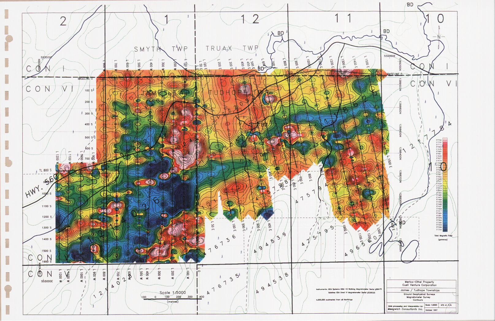
l l
l l l l l ll)l l l l l l lfl
: B[U SrVwru Q SU-K Wolklnfi UagnilDrnvtar Swtol
Sdrrtnu EDA Omnt N Uopiwtamitar Swlol JJ2JJJ2SScale IrSOQOO 100 200 300
Mflrlco-Ethsl Property Cusll Venture Corporation
James f Tudhope TownshipsGround G*ophyilcal Surv*y*
Uogn*tom*t*r Survey Contour*
3ao|( 1:0000
^
NTS 41 . t '/I
Meogwich Consultants Inc. aanm i M?
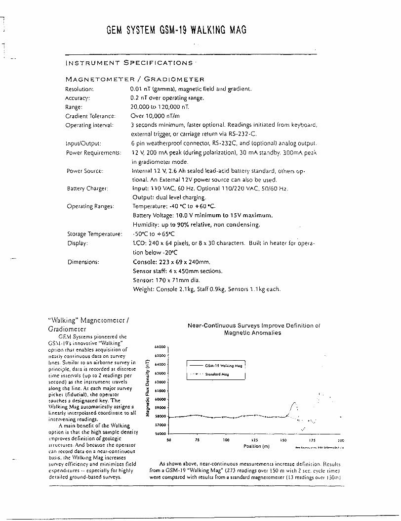
GEM SYSTEM GSM-19 WALKING MAG
INSTRUMENT SPECIFICATIONS
MAGNETOMETEResolution:Accuracy:Range:Gradient Tolerance:Operating interval:
Input/Output:
Power Requirements:
Power Source:
Battery Charger:
Operating Ranges:
Storage Temperature: Display:
Dimensions:
R 7 GRADIOMETER0.01 nT (gamma), magnetic field and gradient.0.2 nT over operating range.20,00010 120,000 nT.Over 10,000 nT/m3 seconds minimum, faster optional. Readings initiated from keyboard,external trigger, or carriage return via RS-232-C.
6 pin weatherproof connector, RS-232C, and (optional) analog output.
12 V, 200 mA peak (during polarization), 30 mA standby. 300mA peakin gradiometer mode.Internal 12V, 2.6 Ah sealed lead-acid battery standard, others op tional. An External 12V power source can also be used.Input: 110 VAC, 60 Hz. Optional 110/220 VAC, 50/60 Hz.Output: dual level charging.Temperature: -40 'C to +60 'C.Battery Voltage: 10.0 V minimum to 15V maximum.
Humidity: up to 90% relative, non condensing.-500Cto *G5 0CLCD: 240 x 64 pixels, or 8 x 30 characters. Built in heater for opera
tion below -20"C
Console: 223 x 69 x 240mm.Sensor staff: 4 x 450mm sections.Sensor: 170 x 71mm dia.Weight: Console 2.1kg, Staff 0.9kg, Sensors 1.1kg each.
"Walking" Magnetometer l Gradiomecer
GEM Systems pioneered the GSM-19's innovative "Walking" option that enables acquisition of nearly continuous data on survey lines. Similar to an airborne survey in principle, data is recorded at discrete lime intervals (up (o 2 readings per second) as the instrument travels along the line. At each major survey picket (fiducial), the operator touches a designated key. The Walking Mag automatically assigns a linearly interpolated coordinate to all intervening readings.
A main benefit of the Walking option is that the high sample density improves definition of geologic structures. And because the operator can record data on a near-continuous basis, the Walking Mag increases survey efficiency and minimizes field expenditures - especially for highly detailed ground-based surveys.
so
Near-Continuous Surveys Improve Definition of Magnetic Anomalies
Density (nT)
xrfo1g) n
66000
65000
64000
63000
65000
61000
60000
59000
58000
57000
SiOOO
————— CSM-19 Waiting Mog
- - *- - - Standard Mog
,.
r-.j \
_________ -H ————— '~~——^^-*r~^^^'——— ——— '--. ____ ,-^X'. :
' 'V ' ' '-\.'
v"
75 100 125 150 175 Position (m) O., CM._1M.
As shown above, near-continuous measurements increase definition. Results from a GSM-19 "Walking Mag" (273 readings over 150 m with 2 sec. cycle time) were compared with results from a standard magnetometer (13 readings over 150m)
JAMES/TUDHOPE TWPS.
GEOLOGY MAP
1 IN. TO 1/2 Ml. i1-*cT^ 8adb ~ ' 3-^Sah/ V-
x ' .-X lorffo i^'t'A Bahd'Sj [^65.78aD 8a .-^ ' f" \?S-, i X iS; s^S?\ er j A' \ ^A^ —3--*^ 8"1 -' 1 ' V ; M,V^H__-^-/-X- ----X'i^p^-^C-. i-.u .-^_^^l^/f^XAW'Oc^feAI ^^-*///); iss)v"lte^.j-fe -K/n ^r^V :^^fr ,-
y-P / i y r '- ."^a a---- .^ r-yfc^f- J'x ,^/ ! 'V-VA'^I'.^- C-;A^8"- A-V-^7-/! ^^,' , rr^
-sw /! X -'to/^tx::-- ';i^i;8iSim,^1/L,.^/ ''/l'*"-'. 'T^^&y. - :.' J '? b A- 8b ~"' " /-^- ••' :-'\Nx ^
n./ y ;s-\ " 87 XX"'Vw' .vH-^k l
x "7 ...,i, wftJvW'
LOCATION MAP
Ontario Ministry*Northern Development•Ad MIft**
Declaration of AMeument Work Performed on Mining Land
Act. tubeecfen W(2) ** W), M.0.1HO
Tre/vedtor
AweMment
D* tubsectlon* es(2) md M(3) el the Mining Ad. Under tectlon l d the review the UMMJTttnt work and correspond wRhttw mining tend hotter. Recorder, MWtlry of Northern Development and Mn**, *h Floor.
41P16SW2002 2.18261 TUDHOPE 900
Instructions: - For work performed on Crown Lands before recording a claim, use form 0240. ." . - Please type or print in Ink.
1. Recorded holder (t) (Attach a list if necessary) 2. l 8261Mem*
Cusil Venture CorporationX33reei""- —— - 507-595 Howe Street
Vancouver, B.C. V6C 2T5N4fl*
Addreet
f ^ .
Client Number 303596
Telephone Number (604)
Ftx.Number (604)
CSwK Number
Telephone Number
Pu Number ———— ———
681-6466
681-21.61
. . . —.. --
.
2. Type of work performed: Check ( ^ ) and report on only ONE of the following groups tor this declaration.
Geotechnical: prospecting, surveys, assays and work under section 18 (regs)
Physical: drilling, stripping, trenching and associated assays
Work Type
bete* Work . Performed
. .Line Cutting (machete ^and chain saw) Geological Mapping and SamplingGeophysical Surveys
Ffom tt u&M v-? 7 To 2P will 33. SGtobeJ Petitioning System Data (H tvtiUW*) Township/ArM
Tudhope and JamesU or 6-PUn Number
M0252 and M0225
Office UsaCommodity . — — ....Total 1 Value of ~ ,Work Claimed ^ J? M^4
NTS Reference ' ,- ~ "
MUilnCj WIVlSiOn l\ f, . J . -^ r\^(~i L o
Resident Geologist ^ ,/)
Please remember to: - obtain a work permit from the Ministry of Natural Resources as required;- provide proper notice to surface rights holders before starting work;- complete and attach a Statement of Costs, form 0212;- provide a map showing contiguous mining lands that ara linked for assigning work;'- Include two copies of your technical report.
3. Parson or companies who prepared the technical report (Attach a fist H necessary)Hem*
L. P. Othmer P.- Eng.fMnM 3 Martin Drive, RR #1, Cobalt, Ont.pQJlCCName
T. J. Quesnel G. A. C.A*Jr^*1231 Hwy. 17 West P.O. Box 20007
Sturgeon Falls, Oftt. POH 2BON*mt David LarondeA^dr^M P.O. Box 482 Temagami, .Ont. POH 2HO.
4. Certification by Recorded Holder or Agent. Eugene Larabie
piMNvn*)forth in this Declaration of Assessment Work havln
RECEIV——— MAP - 9 IQQ^ ——— i
TeUphone Number ^^ (705) 679-8113
Fax Number
Te)*ptor* Number ( ?()5) 753.3337
FtxNumber ( 70 5) 753-6113
Telephone Numbet ( 705 ) 595-2904
FuNumber (705) V ' 5 69-2817
Eftn J*MriMi\ a 1330
ftd^&^&imHautsiJ th9Fw^fiff tr b* r*f1'
^personal knowledga of the facts sat rmed or witnessed the same durlna
or after Its completion and, to the best of my knowledge, the annexed, report is true.
A Feb. 20, 1998v^- ^^ ^—-n IT^MpnoAi NwnMfHowe St., Vancouver, BC V6C 2TSj (604) 681-6466 (604) 681-2161
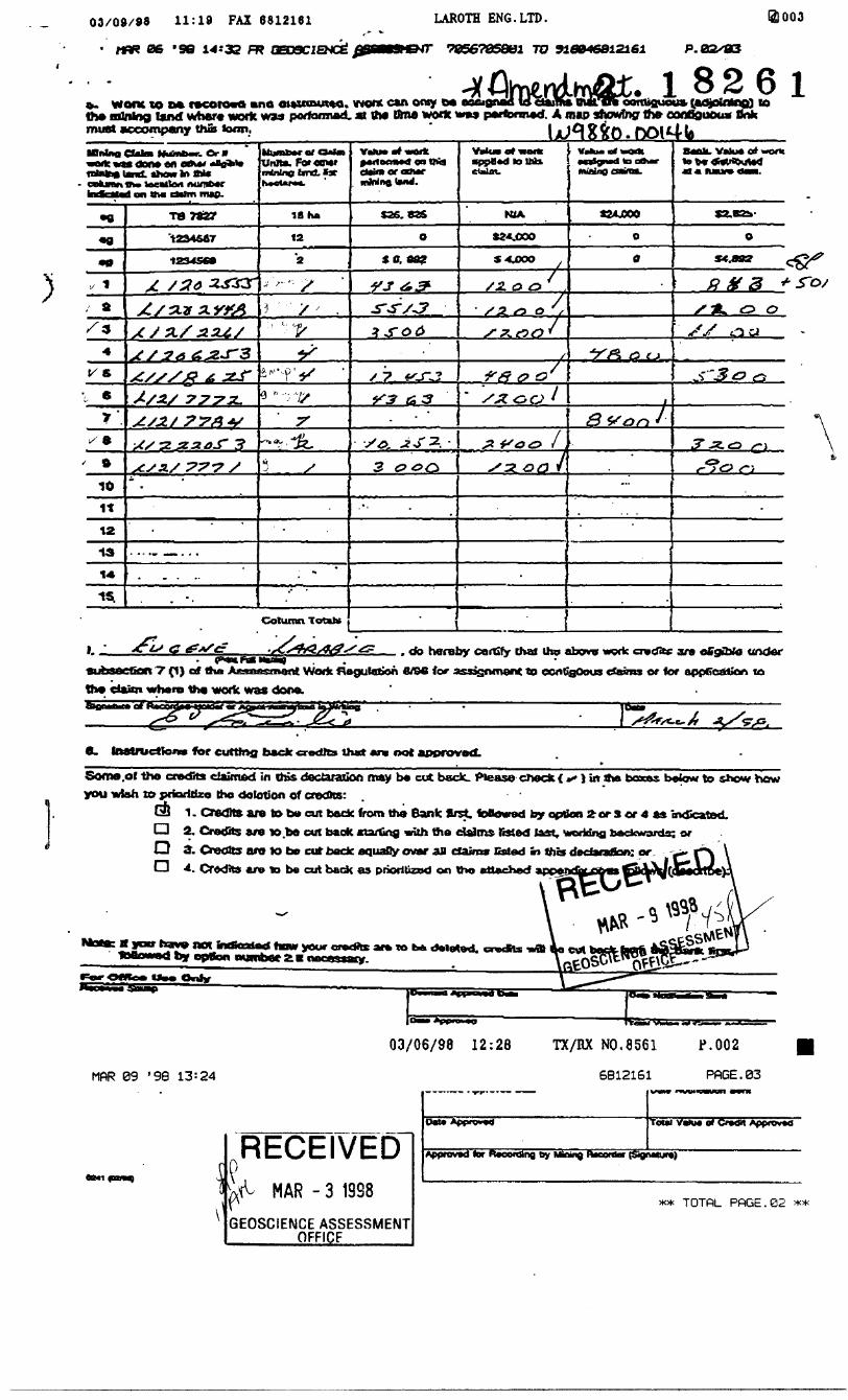
)
LAROTH ENG.LTD.
•7856785801 TO 926046812161
03/09/98 11:19 FAX 6812161
' HflK 06 'SG 14:33 R?
o. Wont to a* racotoaa ano otauinutto. vnof* can oray o*tha mining land Vrher* work wu porformad. A the Urn* work was performed.must accompany thus loon.
i)003
P. 02/83
. l 8261alfca malTR contiguous, (aojoinb^) to A map showing tfw eonfiououx tink
done on o*** aBaM* hawtott*
column 1an Ow EMm nwp-
s*
t/S
10it12
13
14.
is.
'1234567
AS
7773-
"3
77*7 S
Unlta.nrinlne bnd. BattMCUfM.
IS ha
12
Column Total*
JL*
Ytito* at wftft 9*if oci**4 en cftimoraaMr
S36.93&
*ff. tt?
X 7
3
claim.
KiA
S24.000
S4JOOO
/l o a
1
GO
ouBinp
*24JOOO
a t
8 V 'on /
Vtfu* erf wont
. do hereby carCfy thai Iho abow votk avtftf ara oCgOrfo unctor SubsaeCon 7 (1) of tha AaaafeemafJ Work Aagulation S/SC for asasnment to eonCgOous ctevns or for appfiedtion TO tho claim wham tha work was done.
e. teatrudfofM fef cutting back credos that an not approved.
Some .ol the credits claimed in this dectaration may ba cut back, ftease check ( * \ \n sha boacea below to show how you wish to priorittzo tho dotation of credits:
QJ 1. Credits are to Da cut bade from tho Bank flrrt. foBowed by option 2 or S or 4 ft* ovCcated.O 2. Credits are w.ba out back aiarCng with tha claims listed last. Moridng backwards; orO a: Create aro tote cuf bode eqiiaOyovar an claim* Bsted fe fna dedanribn: orO 4. Credits ara ID ba cut back as prioritized on tho attached appajH
*oir "^T? **ot mewaiarf tarn your oradte ara m b* delated, cradte by opVon number 2 B necessary
MftR 09 '98 13=24
03/06/98 12:28 TX/BX NO.8561 P.002
6812161 PPGE.03
RECEIVEDMAR - 3 1938
GEOSCIENCE ASSESSMENT ______OFFICE
Tottl VaXM 0* Credit Approvxi
Appravod lor Recording by Mining riaoxtlar (StgtMlur*)
TOTPL PftGE.02
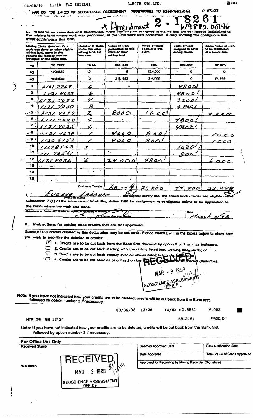
03/09/98 11:18 FAX 6812161 LAROTH ENG.LTD.
. 1-flR 36 '98 14:35 FR OBDSCJENCE ASSESSMENT 7066705891 -TO 916046812361 P.
o.G *Y*one to o* r*ooro*a ana aMWiauiM. wont can onjy DO asagnoo 10 claim* mot are contiguous {.4djoinlAQ) t
tend where work was performed, at the Ume worx ives perfennetf. A. .-nap showing the contiouou* ffnk must accompany tnis form.
. Or irdtMV* on fltlwr *X0ifal*
mining lux), moir M Oil* BOhicnn th* locate* 0cmb*r
*n th* cteim mtp.
•0
9
1O
1tta13
TB 7SZ7
1234587
r 0333 2.
As x/ z*st szs •y o x Qj / y. s
s/20
A S'*./ 4*4X6.
Hutno+r at Qalm Unite, foietti+e inMna ttntf. fat
t*
Column TetvJ*
v*iu*on UMK
S B. 83?
V*i(M o* wow•ppKttdla M* claim.
N/A
S 4.000
IB atlwr
324.000
*t a incur* 40*.
S2.X2S
/(i
*t^
' 'l
y y
-f *~\ " -e.
tf'nMAaMimq]7 (1) of (hA Assessment Worfc Regulation 6T96 for
tlte cUfcn where the work waua
CBftiiy thai the above uortr erecfits are efipUv'* u
to oontiaOous tiaiinc or lor appficatUon lo
b0nBune4 A*ocm*tl H^d*rot AOW/
t
fc. Instruction* for cutting back not
Some.or the cfftdits daim*d 'm this dodaraxioo may be cut been. PJease cJieck. ( r- } in 8w you iwteJr to poootaro the defetlon of crofts:
befcnw to show ho*
D 2. Credits an* to ba cut back *iarfing *rtift the cfaJms Bsi*cj last, woiking backwards; ord 8 . Credits 0*9 to bo cur back equally over afl da/mi /fcaarf ^O 4. Credits a/e to b* cut back as prioritized on
credfts will be cut back from the Bank first
03/06/98 12:28 TX/KX NO.8561 P.003
MfiR 09 '98 13=24 6812161 PflGE.04
Note: If you have not indicated how your credits are to be deleted, credits will be cut back from the Bank first followed by option number 2 if necessary.
For Office Ute Only _______________Received Stamp
0940(03*7)
RECEIVERMAR - 3 1988
GEOSCIENCE ASSESSMENT OFF1CF
Deemed Approved Dal*
Date Approved
Date Notification Sent
Total Value of Credit Approved
Approved for Recording by Mining Recorder (Signature)
FEB 19 '99 13--19 FR GEOSCJENCE /ASSESSMENT 7056705981 TO 9-1 -604-631 -2161 P.02./02
Ministry OfNorthern Development Statement of Costs
for Assessment Credit[Transaction N umber (office use)wm
Personal intormalion collectod on this form is obtained under the authority of subsection 6(1) of th* Assessment Work Regulation 6/96. Under section 8 oflhe Mininfl Act. the information is a public record. This information Will b* used to review the assessment work and correspond with the mining land holder. Questions about this collection should be directed to the Chief Mining Recorder, Ministry c* Northern Development and Mine*, 6W Floor, 933 Ramsey Lake Road, Sudbury, Ontario, P3E 685. ir-, "l ,' - ' . ii ;|
^-JJ ^ (1 V^ ~ - -' **F ie.
Work Type
*!,z*r* jL^r^jj**/^9^;^ 7^ Swev^"0 v*K?# /^ /^* ?2s*-fro o
(2 tfJ /o -} * r ** / /S/*//''' T
Units of WorkDepending on the type of work, list the number erf hours/days wosfced, metres of drilling, kilo metres of grid line, number of samples, etc.
4t S ^ /f
*2 *G ~ j^
C" y "2 S jb
/s **** ^^y c ^,^j
Associated Costs (e.g. supplies, mobilization and demobilization).
/f aa *- #trsr?t) 6 t /S 2^.*s
^? r*~ * f * t "7 —— "*J~ I
s ~~* s
\" ^^ * ft J,* i jffj 1 ^t ^^ }^ J* * .^ 0 jt^ ^^~ J^ f*
•"-"/^ - 7 v X ' -/- -S /
Transportation Costs
Food and Lodging Costs
^•J X ' ^^ (~ x^Cy c?csf* y /- -T ' -^•'V^ O cXX tx-^r^, ^-/^ tr"';^/
Calculations of Filing Discounts:
1 . Work filed within two years of f 2. If work is filed after two years i
Cost Per Unit of work
Total Cost
.^ x •*1^'3*7ev//^*^ /y 363. e C
^/to/*-*f 3 \*~S J& *~~**-***
•* X^ 0 0 f #st. V
3 ^/Zf-tfsf s
^^7/^y
P Q | \j [^E^l tf alue of Assessment Work v
^^ A X6.00f - ^
j" O O i O O
•*S ? 0 o. ^ o
^ZreO.OS
g/ y?, o oS ~o 5* s ty c
-73 o o, o ~ti
^3-Z^-V*
fyS^tfZ ,0c)
MAR - 3 1998 TfifcOSfirfeWQIASfe^^il^J kb of the above Total Value of Assessment Work.Jld UO to fiw3lyiSfcJafifir.IierfC rman^P, H ran nnly h*. r.\pirnt*ri tf fino^ ^f tfn* TP^I
Value of Assessment Work. If this situation applies to your claims, use the calculation below:
TOTAL VALUE OF ASSESSMENT WORK x 0.50 = Total S value of worked claimed.
Note;- Work older than 5 years is not eligible for credit.- A recorded holder may be required to verify expenditures claimed in this statement of costs within 45 days of a request for verification and/or correction/clarification. If verification and/or correction/clarification is not made, the Minister may reject all or part of the assessment work submitted.
Certification verifvina costs:
' do hereby certify, that the amounts shown are as accurate as may
reasonably be determined and the costs were incurred while conducting assessment work on the lands indicated on
the accompanying Declaration of Work form as *J'04?*7~ t/c y/ yyX'^y *^*. i am(record** hoWof. *9*nt. or state company position with waning authority
to make this certification.
0212(02/86)
Signature Dal*
** TOTfiL PPGE.02 **
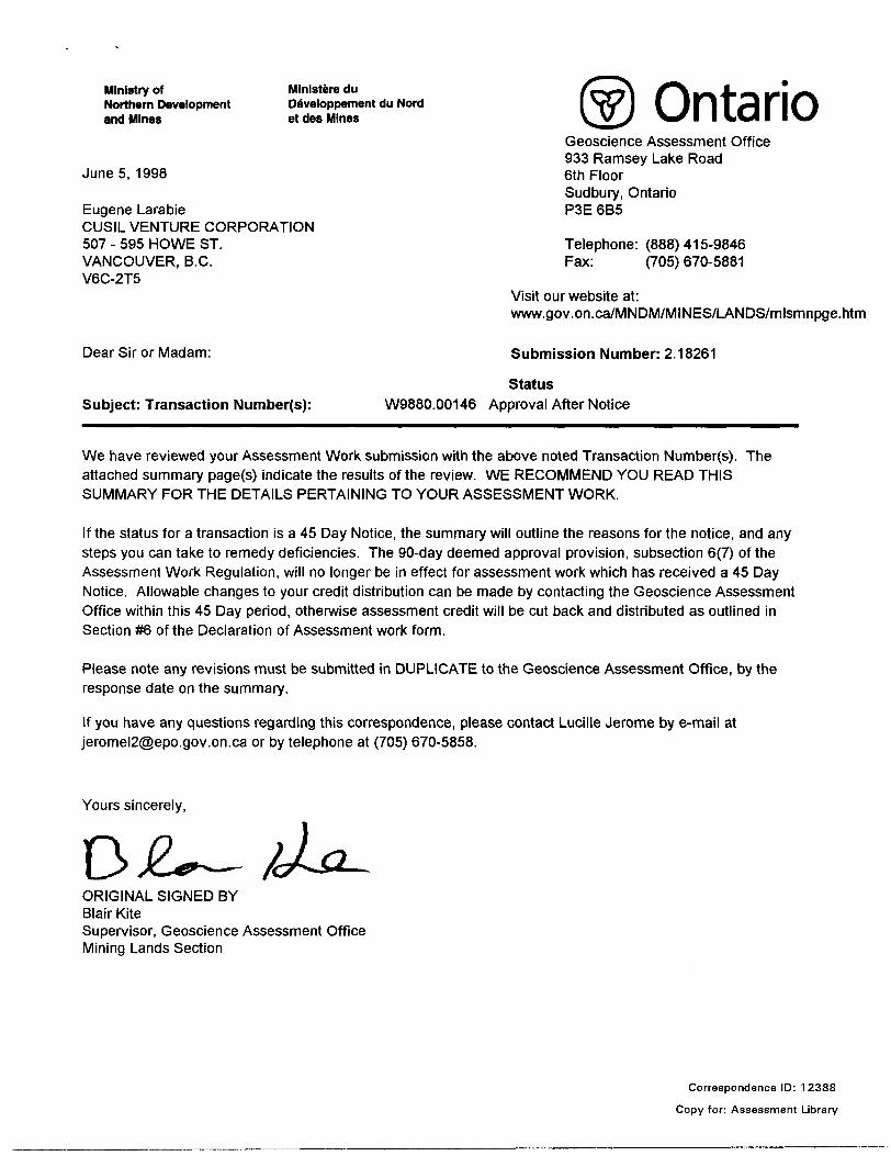
Ministry of Ministers duNorthern Development Developpement du Nordand Mines et des Mines Ontario
Geoscience Assessment Office 933 Ramsey Lake Road
Junes, 1998 6th FloorSudbury, Ontario
Eugene Larabie P3E 6B5CUSIL VENTURE CORPORATION507 - 595 HOWE ST. Telephone: (888) 415-9846VANCOUVER, B.C. Fax: (705) 670-5881V6C-2T5
Visit our website at: www.gov.on.ca/MNDM/MINES/LANDS/mlsmnpge.htm
Dear Sir or Madam: S ubmission Number: 2 .18261
Status Subject: Transaction Number(s): W9880.00146 Approval After Notice
We have reviewed your Assessment Work submission with the above noted Transaction Number(s). The attached summary page(s) indicate the results of the review. WE RECOMMEND YOU READ THIS SUMMARY FOR THE DETAILS PERTAINING TO YOUR ASSESSMENT WORK.
If the status for a transaction is a 45 Day Notice, the summary will outline the reasons for the notice, and any steps you can take to remedy deficiencies. The 90-day deemed approval provision, subsection 6(7) of the Assessment Work Regulation, will no longer be in effect for assessment work which has received a 45 Day Notice. Allowable changes to your credit distribution can be made by contacting the Geoscience Assessment Office within this 45 Day period, otherwise assessment credit will be cut back and distributed as outlined in Section #6 of the Declaration of Assessment work form.
Please note any revisions must be submitted in DUPLICATE to the Geoscience Assessment Office, by the response date on the summary.
If you have any questions regarding this correspondence, please contact Lucille Jerome by e-mail at [email protected] or by telephone at (705) 670-5858.
Yours sincerely,
ORIGINAL SIGNED BYBlair KiteSupervisor, Geoscience Assessment OfficeMining Lands Section
Correspondence ID: 12388
Copy for: Assessment Library
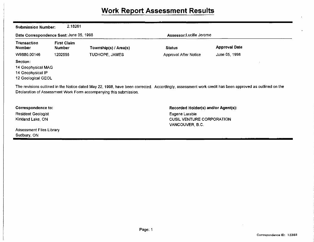
Work Report Assessment Results
Submission Number: 2.18261
Date Correspondence Sent: June 05, 1998 Assessor:Lucille Jerome
Transaction NumberW9880.00146
First Claim Number1202555
Township(s) 1 Area(s)TUDHOPE, JAMES
StatusApproval After Notice
Approval Date
June 05, 1998Section:14 Geophysical MAG 14 Geophysical IP 12 Geological GEOL
The revisions outlined in the Notice dated May 22,1998, have been corrected. Accordingly, assessment work credit has been approved as outlined on the Declaration of Assessment Work Form accompanying this submission.
Correspondence to:Resident Geologist Kirkland Lake, ON
Assessment Files Library Sudbury, ON
Recorded Holder(s) and/or Agent(s):Eugene LarabieCUSIL VENTURE CORPORATIONVANCOUVER, B.C.
Page: 1Correspondence ID: 1 2388
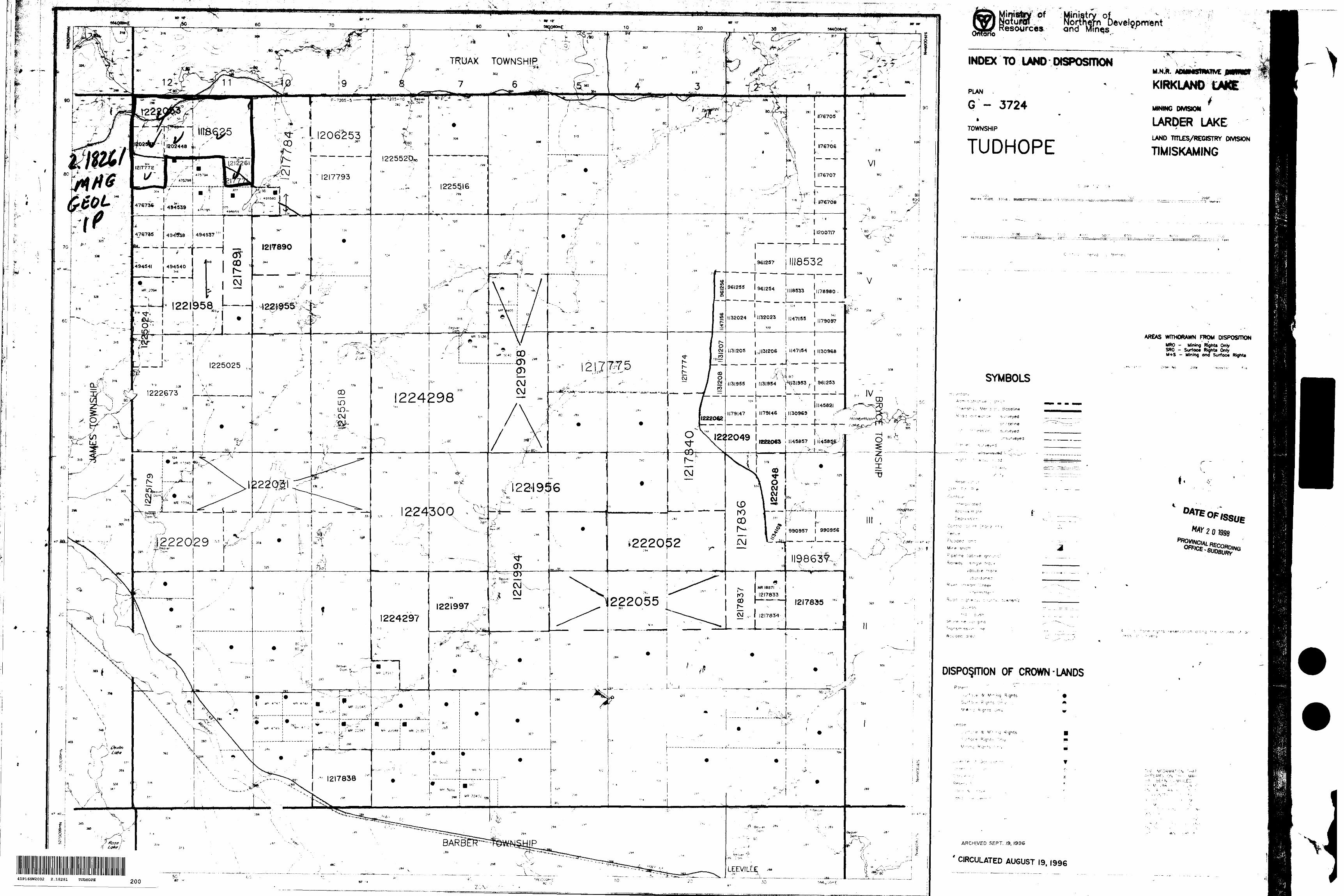
S.*ry oitriern Development
Mmes "
INDEX TO LAND DISPOSITIONTRUAX TOWNSHIP"-Sii
M.N.R. A0MMSMKTIVE
KIRKLAND LAKE
MINING OMSIOM
LARDER LAKE^ LAND TFTLES/REGISTRY OMSWN
TIMISKAMING1120^53
TUDHOPE
1225516
—— —— —— l- ————— J-
l ^3'fei. — -— l
1118532
J958 .l———
AREAS WfTMORAWN FTOM DISPOSfTIONMRO - Mining RlighU Only SRO - Surface Rightfl Ooty M+S - Mining W Surfoc* Right*
1147154 i 1130968
1225025 ,
SYMBOLS1131955 1131954 TMI3I953 ,- 961253
_=4__L.. -—— l—--PT — -l1224298
1179147 J 1179146 i 1130969
---i - 4.^-4-:- ^™ 1 l
122-1946
2243OQMAY 201998J* 990957 i 990956
.222029' li Bsave-
( 7 "'o™'^222052
II98637-,
^1222055l W i1221997
1224297 __l
DISPOSmON OF CROWN-LANDS
ARCHIVED SEPT. 19, 1996
CIRCULATED AUGUST 19, 1996LEEVILtt;
41P16SW2002 2 .18261 TUDHOPE
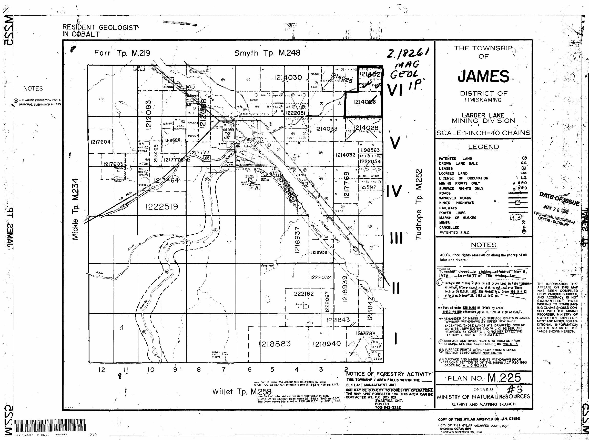
V* -, s
RESIDENT GEOLOGIST- IN COBALT
NOTES
- PLANNED DISPOSITION FOR A MUNICIPAL SUBDIVISION IN 1993
Farr Tp. M.2I9 Smyth Tp. M.248 IZl&l
fO
is-
o
J 21-4030
PT-' \*408;V2t4 1221J a. a?* a
1314033-
1^14032^22054
222519
1231843^ ——*HxM~'
218883
OF FORESTRY ACTIVITYTHB TOWNSHT ; AREA FALLS WTTHW THE .^
Willet Tp.*** Part of order W-L-OI/93 NER REOPENED by orierO-ONT-06/92 NER/CR effective March 16 1992 at 4:15 pm E.S.T. gLK LAKE MANAGEMENT UNIT
AW MAY
f O-ONT-07/92 NER/CR dat*d March 23 1 992 at 8*5 om E.S.T. This Ordsr comes into affect at 7:00 AM E.S.T, or JUNE l. 1992.
THIS AREA CAMSWASTIKA, ONT.POKITO
J P V.K.
THE TOWNSHIP OF
DISTRICT OFTIMISKAMING
LARDER LAKEMINING DIVISION
* * -,-.
SCALE: HNChh4'O CHAINS
LEGEND
PATENTED LANDCROWN LAND SALELEASES'LOCATED L ANDLICENSE OF OCCUPATIONMINING R IGHTS ONLYSURFACE R IGHTS ONLY.ROADSIMPROVED ROADSKING'S HIGHWAYS *RAILWAYSPOWER LINESMARSH OR MUSKEGMINES ' rCANCELLEDPATENTED S.R.O.
NOTES '400*surface rights reservation along the shorcf of all lake and rivers. 1
Section 36 R.S.Q. etfecti
tt* Pant of order m H /82 RE-OPENED by orderl 3, 1WO it 7:00 Mt E.B.T.
•** REMAINDER OF MINING AND SURFACE RIGHTS IN JAMES TOWNSHIP WITHDRAWN BY ORDER NRW 14/62. EXCEPTING THOSE -LANDS WITHDRAWN^ ORDERS WQ 5/83 . NRW 106/84 AND W-L-QJ/92 NER. ARE
NER EFFEREOPENED BY ORDER O-l -0179 FECTIVE
41P16SH2002 2.18261 TUDHOPE 210
JANUARY 7. 1992 AT 9:00 AM E.S.T.SURFACE AND MINING RIGHTS WITHDRAWN FROM STAKING. SECTION 36 /9O ORDER J.9. WO-5^3
) SURF ACE RIGHTS WITHDRAWN FROM STAKING SECTION 36/80 ORDER NRW IO6/84
J) SURFACE AND MINING RIGHTS WITHDRAWN FROM y S TAKING. SECTION 35 OF THE MINING ACT RSO /990
ORDER NO. W-L-Oi/92 NER.
•PLAN NO, M. 225
ONTARIO T" 4C' S
NISTRY OF NATURALLRCSOURCESSURVEYS AND MAPPING BRANCH
4 * ^
^"^ -
f' s
f ". ' '''
; r
PY OF THS MYLAR ARCHMED (Mf OAK 03/92 , f•" ' - " . t. l
PY OF THIS MYLAR ARCHIVED JUNK 1. 19.92 ' ' ;' IGMVEP OCT J*, WM RCHJVED DECEMBER 30, 1996 - . j
i
*
,t
, f
faV. V.
*mi
*i ..r /-
.s.
/"*h,i/ . f. i
44
rr
i. 1-- -\
THE INFORMATION THAT APPEARS ON THfS MAPHAS BEEN COMPILED ?RQM VARIOUS SOURCES, AND ACCURACY IS NOT GUARANTEED; THOSE WISHING TO STAKB^MIN- ING CLAIMS 3HOULD CON SULT WITH "tHE MINING RECORDER, MINISTRY OF NORTHERN DEVELOP MENT AND MINES, FOR AD DITIONAL INFORMATIONON THE STATUS OF'T!ife '.ANpS SHOWN HERECN.
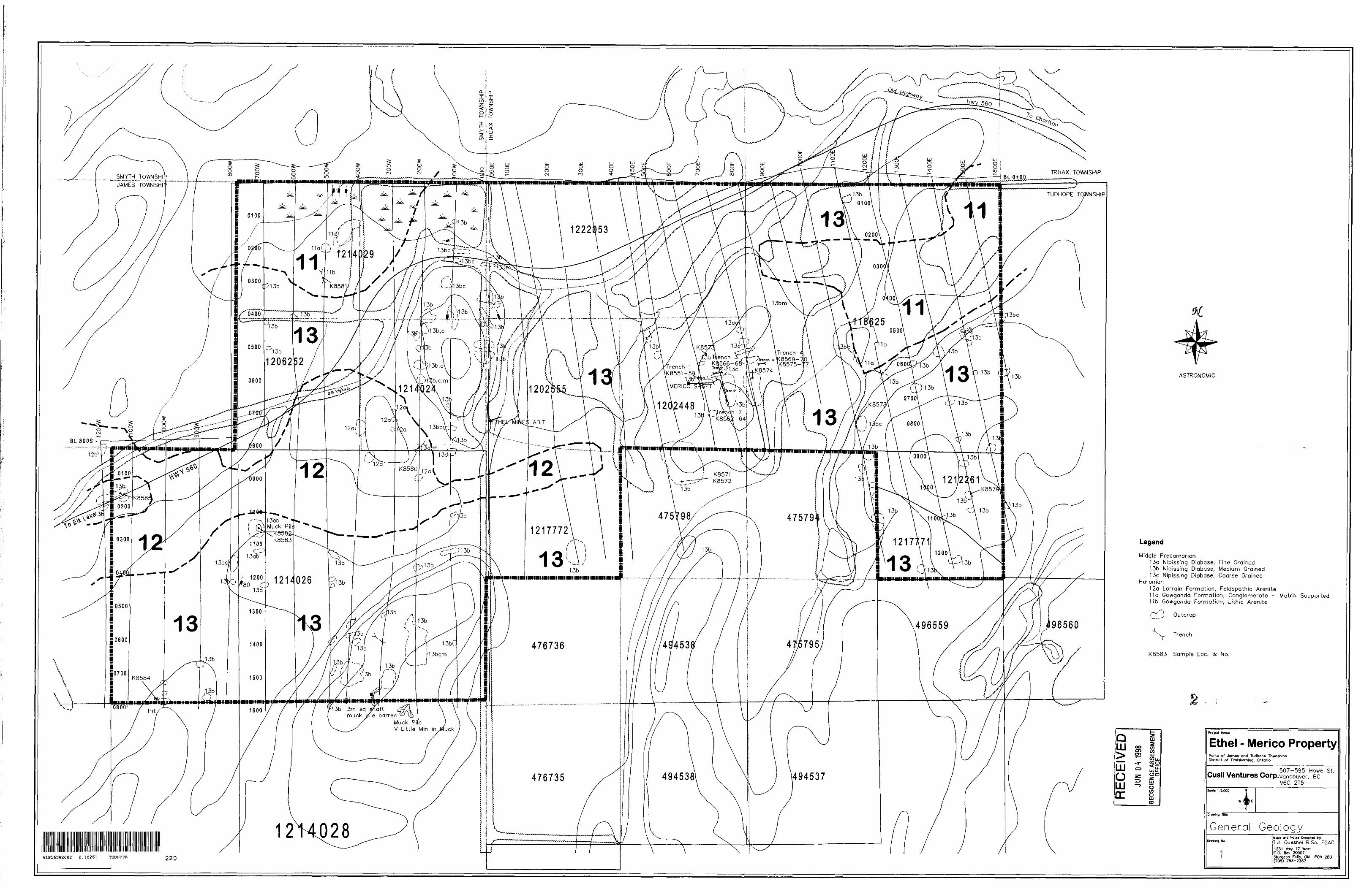
SMYT
H
TOW
NSH
IP
TRU
AX
TO
WN
SHIP
mnm
imum
nmnm
nmim
nuim
nmim
tt
RE
CE
IVE
D
GEO
SCIE
NCE
ASS
ESSM
ENT
OFFI
CE
1 o
——
—
Z p
—.
. - .-
-. ——
i ^
^
j\jf
^j^
^^
~-
ti?!oi
V?g^
1 f
O*"
S
-s
— S
?
"if
col
- of
I
*K
^}
S
t*0
o
D
o i
0 f
O) 2 __ o CD Q o" i^-
ip a j* g
c~
^^
^m
O 2L ^~ (D r* T CO O O ^O
l Q
O
0
'-H
5 to x
CD O
O
S
(H C/)
li rn
I"o
^
t
z5.
Z ^
S
?l 2L
*f g
1 2
" —
_SI
CD
Q
O
^V
1 5*
W
^^fc
1 O
0)•D 3 T3
(D f^
^^
^
o
^ S-
^fl)
O
D
i '~*
: l
fD
C
T3 -o O 1-t-
O) Q-
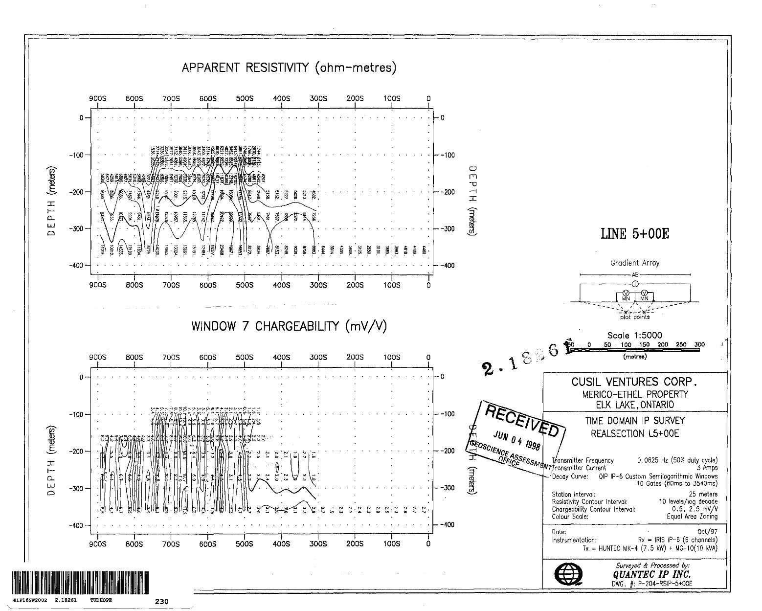
D-UJQ
e? l
Q-LJ Q
APPARENT RESISTIVITY (ohm-metres)
900S J__
0-
-100-
-200-
-300-
-400
800S J
700S 600S 500S 400S 300Sl
200S 100S
900S 800S 700S 600S 500S 400S 300S 200S 1 COS
WINDOW 7 CHARGEABILITY (mV/V)
-100
-200
-300-
-400-
900S 800S 700S 600S 500S 400S 300S 200S 10OS
-100
-200
--300
-400
900S 800S 700S 600S 500S 400S 300S 200S 1 COS O J_ i l l l___ l l______\^^^^^l______L
k-100
-200
-300
--400
o m"D
f.W,
O - ' "b v
LINE 5+OOE
Gradient Array——————AB ——————
MN MN
plot points
Scale 1:500050 100 150 200 250 300^^••••'••c
(metres)
CUSIL VENTURES CORP.MERICO-ETHEL PROPERTY
ELK LAKE,ONTARIO
TIME DOMAIN IP SURVEY REALSECTION L5+OOE
Frequency 0,0625 Hz (50!S duty cycle) Current 3 Amps
'Decay Curve; QIP IP-6 Custom Semilogarithmic Windows10 Gates (60ms to 3540ms)
Station Interval: Resistivity Contour Interval: Chargeability Contour Interval: Colour Scale:
25 meters10 levels/log decade
0.5, 2.5 mV/VEqual Area Zoning
Date: - Oct/97Instrumentation: Rx = I RIS IP-6 (6 channels)
Tx ^ HUNTEC MK-4 (7.5 kW) * MG-10(10 kVA)
Surveyed Se Processed by;QUANTEC IP INC.DWG. f: P-204-RSIP-5+OOE
41F16SW2002 2.18261 TUDHOPE 230
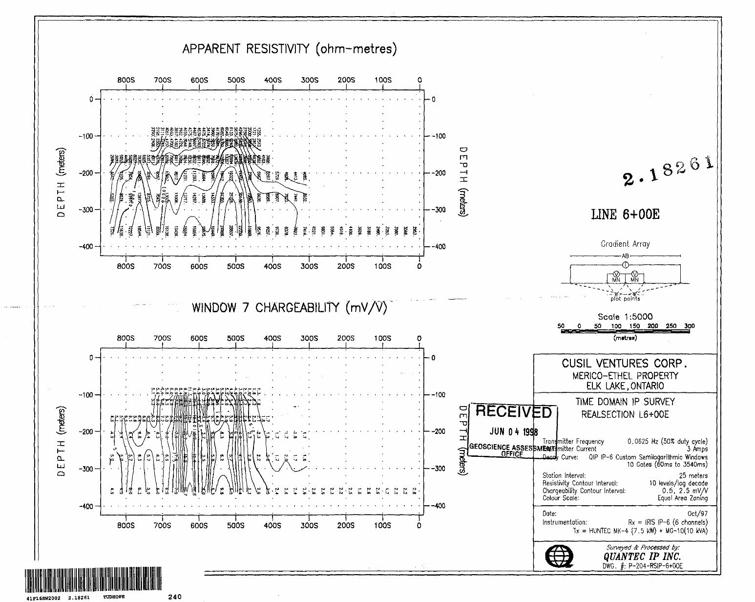
a.LoJo
e
CL LU Q
-100
-200
-300-
-400-
-100-
-200-
-300
-400-
APPARENT RESISTIVITY (ohm-metres)
800S 700S 600S 500S 400S 3005 200S 100S O l______l__ l _____l______l______t______l______l______L
800S 700S 600S 500S 400S 300S 200S 100S
--100
—200
—300
—400
O
WINDOW 7 CHARGEABILITY (mV/tf)
800S 700S 600S 500S 400S 300S 200S 1 DOS O l______l_____ L l______l. — J _____l______t______L
M F^ K*
--I K3 fO 01
-O
k-100
—200
—300
--400
800S 700S 600S 500S 400S 300S 200S 100S o
m"D
LINE 6+OOE
Gradient Array-AB-
MN MN
50
plot points
Scale 1:500050 100 150 200 250 300
5ESSSSS (metres)
Om"D
RECEIVJUN 04
GEOSCIENCE
19SBASSES 5MBWT;
CUSIL VENTURES CORP.MERICO-ETHEL PROPERTY
ELK LAKE.ONTARIO
ED
Tran
TIME DOMAIN IP SURVEY REALSECTION L6+OOE
mitter Frequency 0,0625 Hz (503! duty cycle) mitter Current 3 Amps
Curve: QIP IP-6 Custom Semilogarithmic Windows 10 Gates (60ms to 3540ms)
Station Interval: Resistivity Contour Interval: Chargeability Contour Interval: Colour Scale:
25 meters10 levels/log decade
0.5. 2.5 mV/VEqual Area Zoning
Date: Oct/97Instrumentation: Rx = I RIS IP-6 (6 channels)
Tx s HUNTEC MK-4 (7,5 kW) * MG-10(10 kVA)
Surveyed Se Processed by:QUANTEC IP INC.DWG. #: P-204-RSIP-6+OOE
41P16SW2002 2.18261 TUDHOPE 240
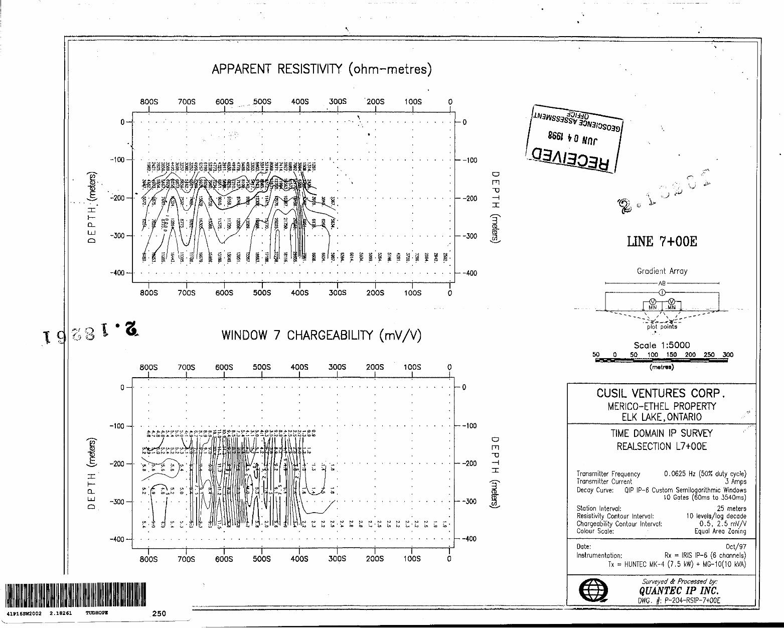
C
D- UJ O
Q-LU
o-
-100-
-200
-300
-400
APPARENT RESISTIVITY (ohm-metres)
800S 700S 600S 500S 400S 300S ' 200S 10OS O l l l l______l -. l______l l l
l l 800S 700S
l 600S 500S 4-OOS 300S 200S 100S
WINDOW 7 CHARGEABILITY (mV/V)
800S 700S l i
600S 500S 4005 300S 200S J ______ I ______ l ______ l ______ l
1 0OS
o-
-100
-200-
-300-
-400
-O
--10Q
--200
--300
--400
O
MtrfKltn^-OdCO-JWimiSit^KJVluaeO
-100
-200
-300
-400
800S 700S 600S 500S 400S 300S 200S 100S O
O m"D
a rn
'©J* Cv*x/.. t)
UNE 7+OOE
Gradient Array ————AB————
MN -MN
50 O
plot p oints*
Scale 1:500050 100 150 200 250 300
(metnw)
CUSIL VENTURES CORP.MERICO-ETHEL PROPERTY
ELK LAKE,ONTARIOTIME DOMAIN IP SURVEY
REALSECTION L7+OOE
Transmitter Frequency 0.0625 Hz (50% duty cycle) Transmitter Current 3 Arnps Decay Curve: QIP IP-6 Custom Semilogarithmic Windows
10 Gates (60ms to 3540ms)
Station Interval: Resistivity Contour Interval: Chargeability Contour Interval: Colour Scale:
25 meters10 levels/log decade
0.5, 2.5mVyVEqual Area Zoning
Date: Oct/97Instrumentation: Rx = IRIS IP-6 (6 channels)
Tx - HUNTEC MK-4 (7.5 kW) * MG-10(10 kVA)
Surveyed & Processed by:QUANTEC IP INC.
DWG. |: P-204-RSIP-7+OOE41P16SW2002 2.18261 TUDHOPE 250
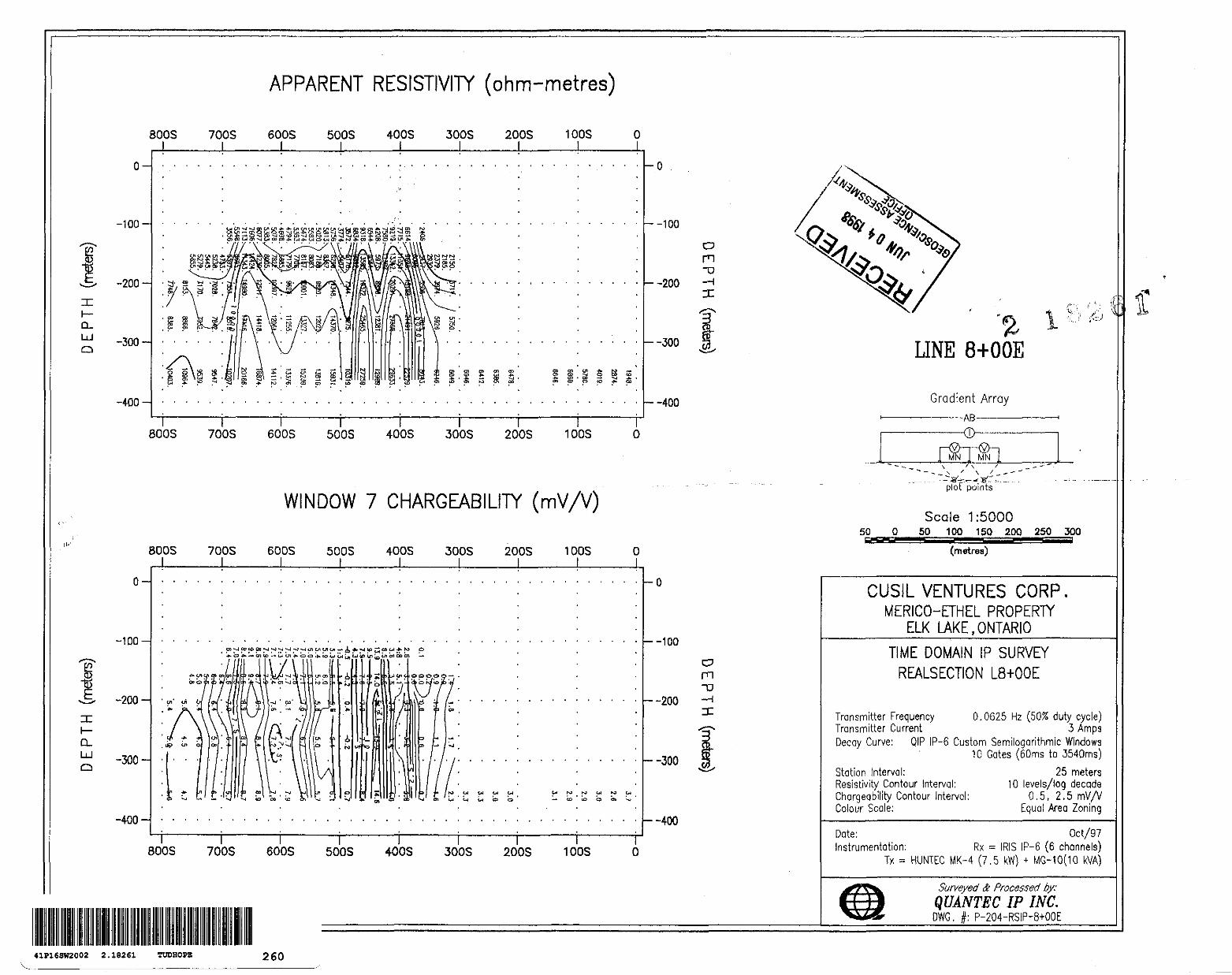
e?
Q- UJ Q
CL UJ Q
APPARENT RESISTIVITY (ohm-metres)
8003 700S
0-
-100-
-200
-300
-400-
600S 500S 400S 300S L l J____ l
200S 100S O
Q) P). S fi
i5 S Ki
en 01 * M —co ~*i o co toS . co -* -g -fc
O (O *. CO
l \ 800S 700S 600S 500S 400S 300S 200S 100S
-O
--100
--200
--300
-400
WINDOW 7 CHARGEABILITY (mV/V)
800S 700S 600S 5005 400S 300S 200S 100S O
0-
•100-
-200-
-300-
-400-
-O
—-100
--200
-300
--400
BOOS 700S 600S 500S 400S 300S 200S 100S o
o m -D
a m
LINE 8+OOE
Gradient Array ————AB————
-(D
ON MN
SO O
plot points
Scale 1:500050 100 150 200 250 300
-U u(metres)
CUSIL VENTURES CORP.MERICO-ETHEL PROPERTY
ELK LAKE .ONTARIOTIME DOMAIN IP SURVEY
REALSECTION L8+OOE
Transmitter Frequency 0,0625 Hz (50/5 duty cycle) Transmitter Current 3 Amps Decoy Curve: QIP IP-6 Custom Semilogarithmic Windows
10 Gates (60ms to 3540ms)
Station Interval: Resistivity Contour Interval: Chargeability Contour Interval: Colour Scale:
25 meters10 levels/log decade
0.5, 2.5 mV/VEqual Area Zoning
Date: Oct/97Instrumentation: Rx ~ I RIS IP-6 (6 channels)
Tx ~ HUNTEC MK-4 (7.5 kW) * MG-10(10 kVA)
Surveyed ft Processed by:QUANTEC IP INC.DWG. #: P-204-RS1P-8+OOE
41F16SW2002 2.18261 TUDHOPE! 260
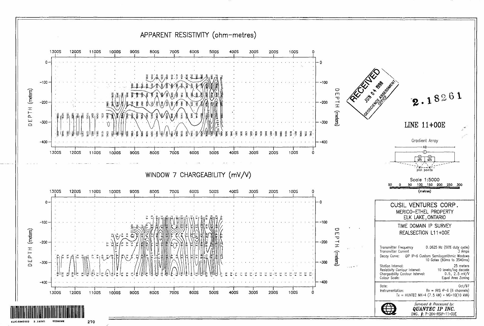
H
D. UJo
CL UJ Q
APPARENT RESISTIVITY (ohm-metres)
1300S 1200S 110OS 10OOS 900S 800S 700S 600S 50QS 400S 300S 200S 10OS J______l______i______l______l______l______l______i______l______l______J____ l J—
-100
-200-
-300-
-400
- ~ b) L-J CO
-o
--100
--200
--300
--400
l l l l1300S 1200S 11 COS 1000S 900S
\ 800S
r700S 600S
l500S 400S 300S
l 200S 100S
WINDOW 7 CHARGEABILITY ( mV/V)
1300S 1200S 11QOS 1000S J______l l_ L
900S 800S 700S
0-
-100
-200
-300
-400
600S l
500S 400S 300S 200S 100S l_
Oi '(AV
-O
-100
-200
-300
--400
1300S 1200S 1100S 1000S
mn
900S 800S 700S 600S 500S 400S 300S 200S 100S
O m -D
m"D—l x
IT
. lLINE 11+OOE
Gradient Array —————AB—————
MN ,. MN
50
plot points
Scale 1:500050 100 150 200 250 300
SKSSSSS(metres)
CUSIL VENTURES CORP.MERICO-ETHEL PROPERTY
ELK LAKE .ONTARIOTIME DOMAIN IP SURVEY REALSECTION L11+OOE
Transmitter Frequency 0.0625 Hz (SO/S duty cycle) Transmitter Current 3 AmpsDecay Curve; QIP IP-6 Custom Semilogarithmic Windows
10 Gates (60ms to 3540ms)
Station Interval; Resistivity Contour Interval: Chargeability Contour Interval: Colour Scale:
25 meters10 levels/log decade
0.5, 2.5 rnVAEqual Area Zoning
Date: Instrumentation:
Tx * H UNTEC
Oct/97Rx = IRIS IP-6 (6 channels)
(-4 (7,5 kW) * MG-10(10 kVA)
Surveyed A Processed by;QUANTEC IP INC.
DWG. j : P-204-RSIP-mOQE
41P16SW2002 2.182S1 TUDHOPE 270
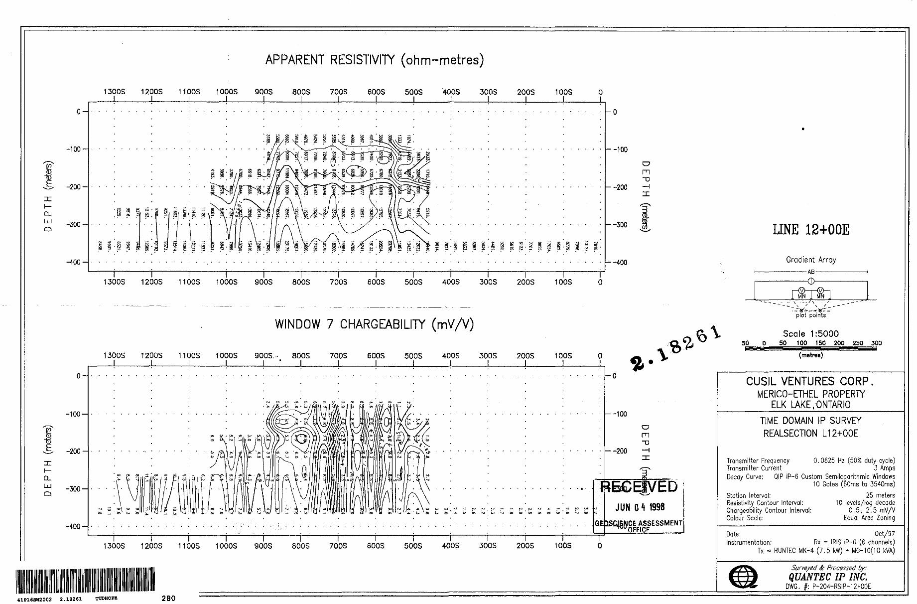
CL. UJ Q
h-a.LU Q
-100
-200-
-300-
-400-
-100-
-200-
-300-
-400
APPARENT RESISTIVITY (ohm-metres)
1300S 1200S 1100S 1000S 900S 800S 700S BOOS —J______l______l______l______l______l______l______L-
500S 400S 300S 200S 100S O
1300S 1200S 1100S 1000S 900Sl
800S 700S 600ST
500S 400Sl
30QS 200S 100S
--100
--2QO
—300
--400
WINDOW 7 CHARGEABILITY (mV/V)
1300S 1200S 110OS 10OOS 900S. - 800S 700S 600S 500S 400S 3005 200S 10OS O
-O
--100
--200
O m "D
o m -o-H
BBCEJVEDJUN O 4 1998
QE ISCJENCE ASSESSMENT ^ Wt7
1300S 1200S 11 COS 1000S 900S 800S 700S 600S 500S 4QOS 300S 200S 100S o
LINE 12+OOE
Gradient Array———— AB————
MN~1
50
plot points
Scale 1:5000SO 100 150 200 250 300sessssm
(metres)
CUSIL VENTURES CORP.MERICO-ETHEL PROPERTY
ELK LAKE,ONTARIOTIME DOMAIN IP SURVEY REALSECTION L12+OOE
Transmitter Frequency 0.0625 Hz (505S duty cycle) Transmitter Current 3 Amps Decay Curve: QIP IP-6 Custom Semilogarithmic Windows
10 Gates (60ms to 3540ms)
Station Interval; Resistivity Contour Interval; Chargeability Contour Interval: Colour Scale:
25 meters10 levels/log decade
0.5, 2.5 mV/VEqual Area Zoning
Date: Oct/97Instrumentation: Rx - IRIS IP-6 (6 channels)
Tx s HUNTEC MK-4 (7.5 kW) * MG-10(10 kVA)
Surveyed ft Processed by:QUANTEC IP INC.
DWG. #: P-204-RSIP-12+OOE41P16SW2002 2.18261 TUDHOPE 280
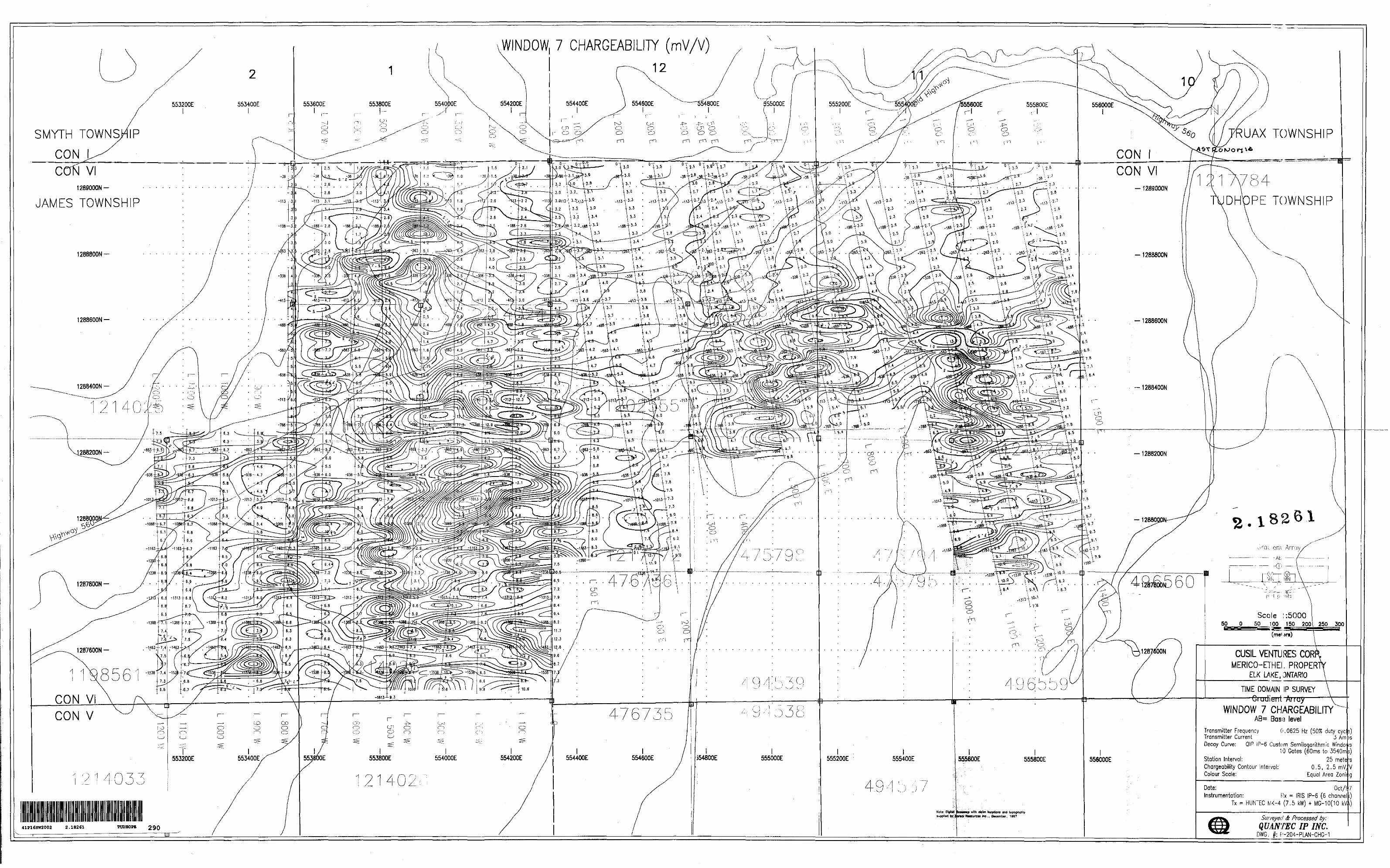
WINDOW, 7 CHARGEABILITY (mV/V)
UAX TOWNSHIPSMYTH TOWNSHIP
CON VI1289000N-
JAMES TOWNSHIP
CON VI-1289000N
PE TOWNSHIP
1288400N-
T2
2-1^ rat leni Array/'
Scale 1:500050 O 50 100 150 200
CUSIL VENTURES CORKMERICO-ETHEL PROPERTY
ELK LAKE. ONTARIO \
TIME DOMAIN IP SURVEY Giudient Array
WINDOW 7 CHARGEABILITYCON VICON V AB= Basa level
Transmitter Frequency Transmitter Current
0.0625 Hz 50:*5 duty eye
Decay Curve: QIP IP-6 Custom Semilogarithmic WindoJ/s10 Gates (60ms to 3540mt)
Station Interval: Chargeability Contour Interval: Colour Scale:
0.5, 2.5 mV,Equal Area Zonn
Kx = IRIS IP-6 (6 channelTx s HUNTEC MK-4 (7.5 kW) t MG-10(10 kV
guppllad by anal RtNurcu inc.. 0*Mmbar. 1997 Surveyed 8 Processed by:QUANTEC IP INC.
DWG. : F'-204-PLAN-CHG-141P16SW2002 2.18261
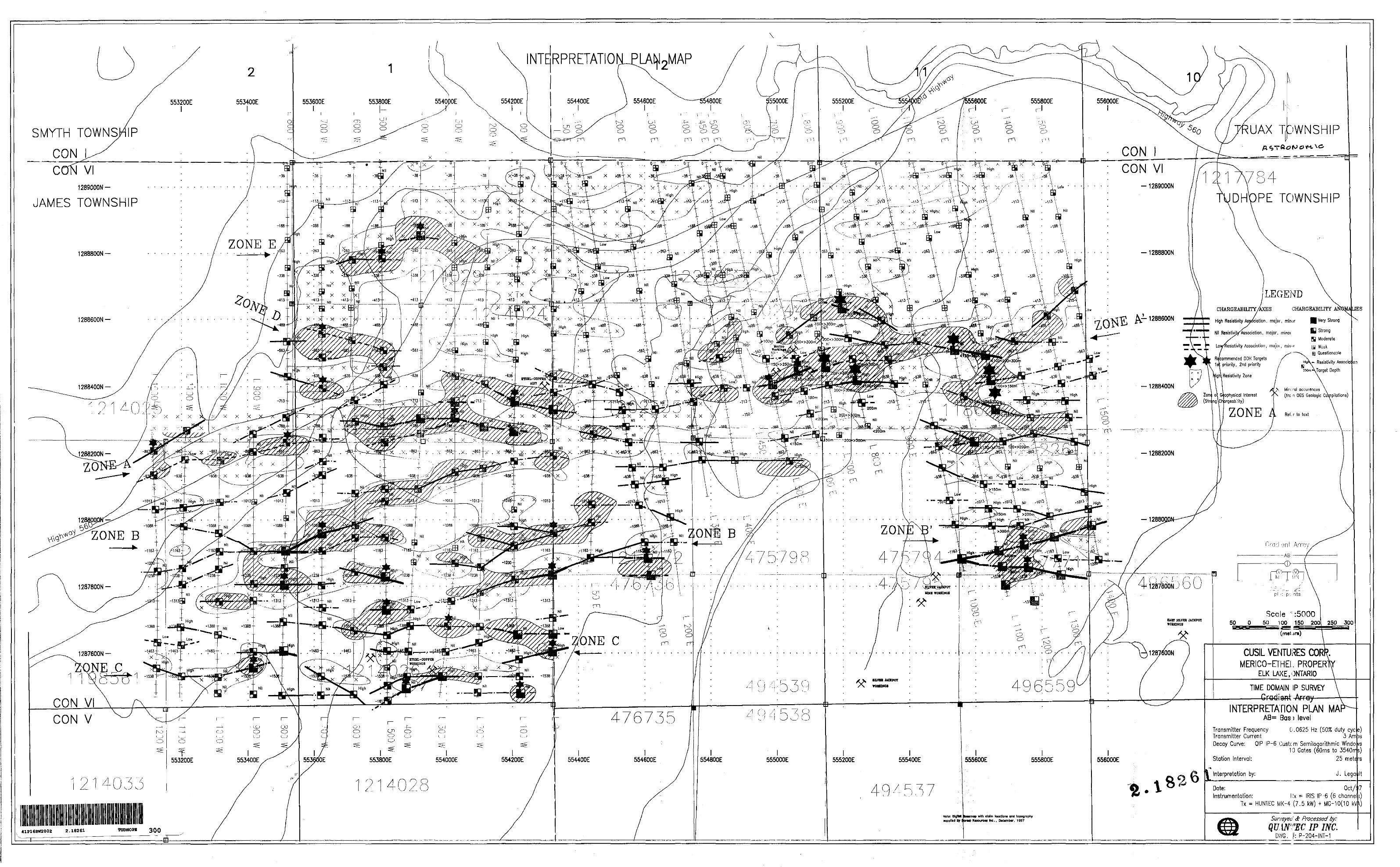
INTBRPRETATIO
UAX T DWNSHIPSMYTH TOWNSHIP
CON VI-1289000N1289000N-
JAMES TOWNSHIP-, ' w 'XT x x :--' ^ x - ^ '
PE TOWNSHIP
ZONE E-1288800N
CHARGEABILITY/AXES CHARGEABILITY
High Resistivity Association, major, minor Very Strong
il Resistivii/^ssociotion, major, minor
1288600N-Strong
Moderate istivity Association, mojoi, mimr Wuuk
^ Questionable commended DOH Targets
- Resistivity ASSOCIQpnonty, 2nd priority
Resistivity Zone
, Mint rat occurences(fro.n OGS Geologic Compilations)opnysical Interest
(Stn}ng\Cr jrgeabitity)
ZONE A
\ I J50m--- --200*y
y . x -.8s*-.x. ^6?tx . x -m
ZONE B
1287800N-
Scale ' :500050 O 50 100 150 200
(met jra)
ONE CCUSIL VENTURES CORP.
MERICO-ETHEI. PROPER ELK LAKE,ONTARIO
1287600N-
NE C-"TIME DOMAIN IP SURVEY
ArrayCON VI INTERPRETATION PLAN MAAB= Bass level476735CON V
0.0625 Hz 5070 duty eyeTransmitter Frequency Transmitter CurrentDecay Curve: QIP IP-6 Custom Semilogarithmic Windo
10 Gates (60ms to 3540rr25 mete rs
J. Legallt
Station Interval:
Interpretation by:
Date: Instrumentation: Jx ^ IRIS IP-6 6 channel
Tx = HUNTEC MK-4 7.5 M 4 MG-10(10 kVO
toMinap with dotm location* end topography Surveyed Se Processed by:QUANTEC IP INC.
. l: P -204-INT-1
•upplltd Dy l w**t RMOUTCH ne., D*c*mb*r, 1997
TUDHOPE 30041P16SW2002 2.18261
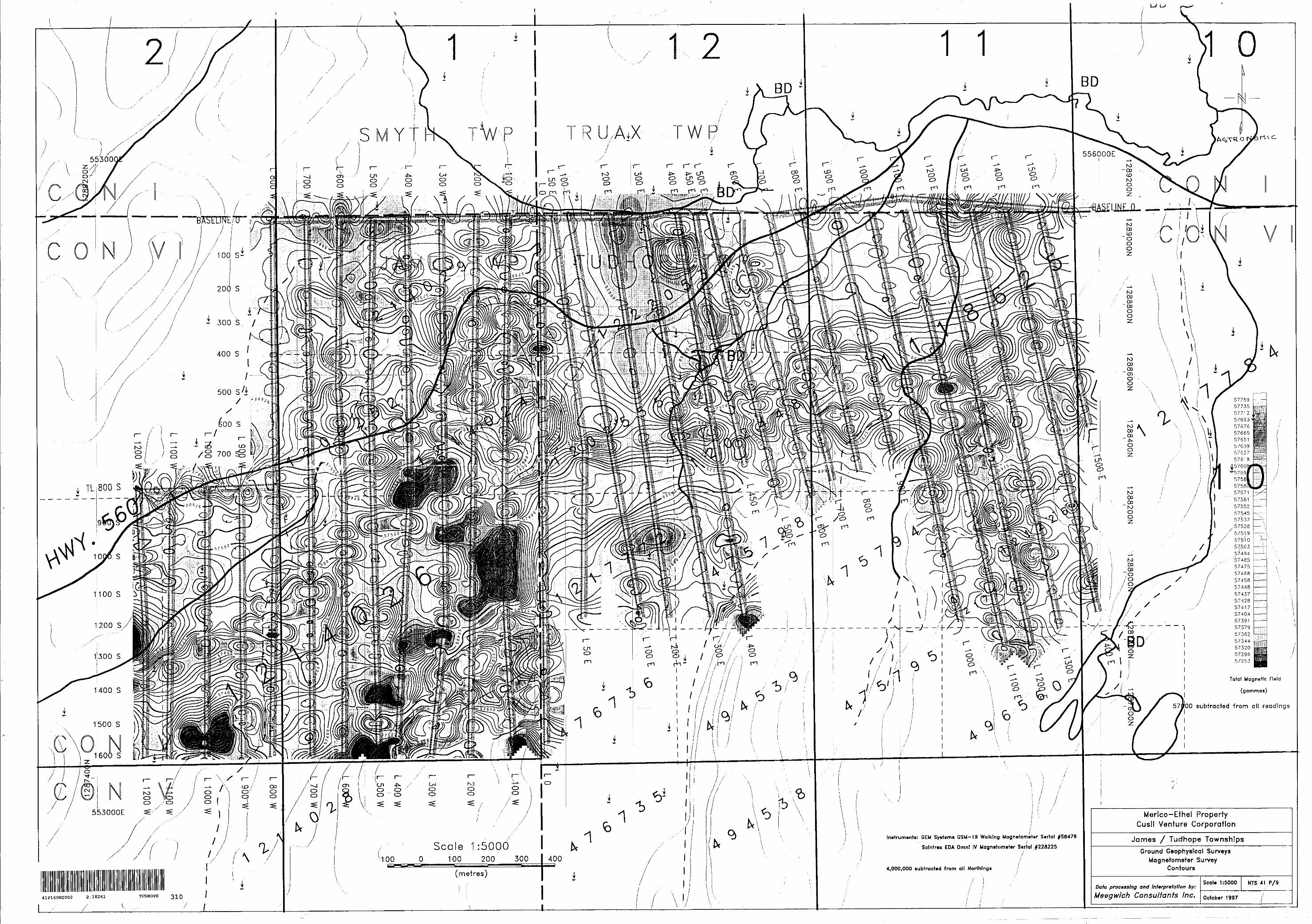
556000E
BASEUNL/D
x 100 S-
^ 300 S, V
/g 700
57537 ——- ...57528 -——i
5751.9 -57510 — ~-
57.50357494 \ - ^5748557475 h5746857458574485743757428574175740457391573795736257344573205729657253
Total Magnetic Field
(gammas)
subtracted from alt readings
553000E
Scale 1:5000
41P16SW2002 2 .18261
/
TUDHOPE 310
l
30 0 100 200 300
(metres)
4C
Initrumanti: GEM Systami GSM-19 Walking Magnatometor SaHal #58479
Solntrex EDA Omni IV Magnatomater Serial #228225/'/' i
4,000,000 subtracted from all Northings ,'
Merico-Ethel Property Cusll Venture Corporation
James f Tudhope TownshipsGround GeophysTcal Surveys
Magnetometer Survey Contours
Data processing and Interpretation by: ^^^^^^^^^
Meegwlch Consultants Inc. October 1997
Seal* 1:5000 NTS 41 P/9