geological, geophysical and geochemical report
TRANSCRIPT
GEOLOGICAL, GEOPHYSICAL AND GEOCHEMICAL REPORT
ON THE BETA CLAIM
GREENWOOD M I N I N G D I V I S I O N , B.C.
NTS: 8 2 E / 2 WEST: LONG. 118" 5 4 ' , LAT. 4 9 " 0 3 '
S.S. TAN, P. ENG.
JULY 2 1 , 1 9 8 4
OWNER AND OPERATOR OF CLAIM: S.S. TAN (RAND RESOURCES INC. )
G E O L O G I C A L B R A N C H .~.S~ESSMF:?:T P : ~ P O R T
CONTENTS
page
INTRODUCTION
LOCATION AND ACCESS
PROPERTY
PHYSI CAL FEATURES
AREAL GEOLOGY
LOCAL GEOLOGY
- L i tho logy - S t r u c t u r a l Geology - M i n e r a l i z a t i o n
GEOPHYSICAL SURVEY (VLF-EM, RONKA-16)
- Resul ts
GEOCHEMICAL SURVEY
- Discussion o f Resul ts
CONCLUSIONS AND RECOMMENDATIONS
REFERENCES
CERTIFICATE OF QUALIFICATIONS
ITEMIZED COST STATEMENT
APPEND1 X
C e r t i f i c a t e o f Analys is
I LLUSTRATIONS
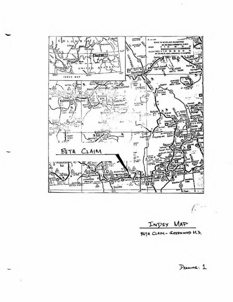
DRAWING 1. Index Map A t Rear
2. Claim Locat ion A t Rear
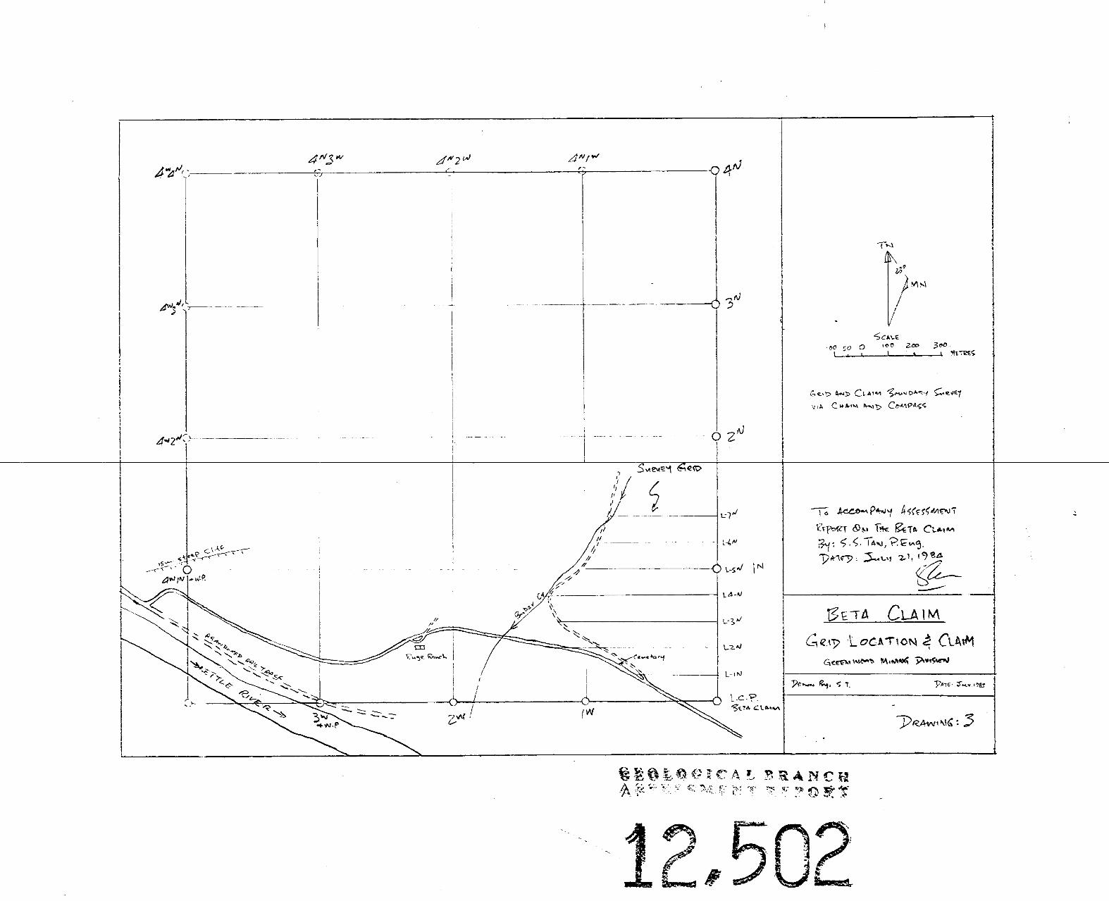
3. Gr id Locat ion and Claim Map Pocket
4. Geology - Beta Claim Map Pocket
5 . VLF-EM Contour Plan Map Pocket
6. Soi 1 Geochemical Plan (Au.-ppb. ) Map Pocket
INTRODUCTION
The 16 un i t s Beta Claim i s approximately 10 km. northwest of the Village of Midway. The claim is access ible by road from Midway via Highway #3 and thence from the Kett le River Bridge f o r 3 km. of we1 1 maintained gravelled road.
Geophysical, geochemical and geological surveys were conducted on par t of the claim to t a l l i ng 9 Line Km. of Survey of which 4.5. Line Km. were survey gr id l i ne s . In the qeochemical survey, 158 so i l samples and 14 rock-chip samples were collected and analysed f o r gold. The Electromagnetic survey (Ronka EM-16) t o t a l l ed 4.5 Line Km. a t 25 meter s t a t i on within the gr id area. Geological mapping and prospecting t o t a l l ed 9 Line Km. The east-west flagged grid l i n e s , a t 100 metre i n t e rva l s , were chain and compass surveyed. Likewise, the access road along the southern segment of the claim and along Bubar Creek Valley were s imi la r ly surveyed. The gridded area covers a l l of un i t 1 and segments of un i t 2 , and u n i t 16. The 2 km. Base 1 ine extends along the e a s t claim boundary. Areas covered outside the survey gr id include par t s of uni ts 3, 4, 17 and 27 which were prospected. The r e su l t s of the surveys a r e presented i n 1:2500 scale maps.
LOCATION - & ACCESS
NTS: 82E/2 West Approximate Co-ordinates: Long. 118" 54' ( Greenwood) - a t property center - Lat. 49" 03'
The Beta claim i s 10 km. northwest of the Village of Midway in t he Boundary D i s t r i c t of south central Br i t i sh Columbia. The claim i s access ible from Midway via Highway #3 t o the Kett le River Bridge thence along 3 km. of gravelled road. The Kett le River and the abandoned Canadian Pacif ic Railway l i n e occupy the southwest segment of the property area. Greenwood, with a population of about one thousand, i s 10 km. e a s t of Midway. I t i s the supply centre f o r the a rea , ca ter ing mainly t o the logging and ranching indus t r i es . Greenwood was an important mining camp from the 1890's t o 1919 when the Granby Consolidated Mining, Smelting and Power Company operated several nearby copper mines contai ni ng by-product go1 d and s i 1 ver. Granby began open p i t mining a t the nearby Phoenix copper mine in 1955 and continued production unti 1 1978.
Figure 1 depic ts the property location and access routes.
PROPERTY
The 16 un i t s Beta claim i s in the Greenwood Mining Division.
Claim Name -- No. Units -- Record - No. Expiry Date
Beta 16 3528 Feb. 24, 1985

PHYSICAL FEATURES
Elevat ions on the proper ty range f rom 600 meters t o 900 meters a.m. s. 1. Segments o f t h e proper ty a re w i t h i n the Bubar Creek Val l e y . The t e r r a i n var ies from moderately steep t o rugged slopes w i t h a s c a t t e r i n g o f l o c a l c l i f f s . The lower slopes are grass covered and the upper slopes are t h i n l y f o res ted w i t h good s ized p ine. The area i s dra ined by Bubar Creek and i t s t r i b u t a r i e s which f l o w i n t o the K e t t l e R iver a t the southwest sec tor o f the proper ty . The area i s i n a semi-ar id b e l t w i t h moderate t o low annual p r e c i p i t a t i o n .
AREAL GEOLOGY
The reg iona l geology o f t he area i s documented i n Map 6-1957, K e t t l e R iver East Ha l f , scaled a t 1 i nch = 4 mi les, issued by the Geological Survey o f Canada.
Paleocene o r Eocene rocks o f t he Phoenix Volcanic Group and t h e K e t t l e R iver Formation u n d e r l i e the area. The K e t t l e R ive r Formation cons i s t s o f r h y o l i t e and d a c i t e t u f f , sandstone, shale and r h y o l i t e . The Phoenix Volcanic Group inc ludes andesi te , t rachy te , minor b a s a l t and 1 ocal l y i n t e r - bedded t u f f , shale and s i l t s t o n e . The government map shows two n o r t h e r l y t rend ing f a u l t s a t t he west h a l f o f t he proper ty .
LOCAL GEOLOGY
S i x rock u n i t s were mapped w i t h i n t h e g r i d area. These a re (1 ) Q u a r t z i t e , (2) Greywacke, (3 ) Hornfe ls , (4 ) Quartz-Feldspar Porphyry ( i n t r u s i v e p o r p h y r i t i c r h y o l i t e ) , (5 ) Granod ior i te and ( 6 ) Basa l t . The s t r i k e o f t he rock u n i t s i s approximately nor thwester ly . F a u l t and shear zones and gossans were a1 so mapped.
L i tho1 ogy
(1 ) Q u a r t z i t e : This u n i t i s f rom 100 m. t o 200 m. wide and l i e s a t t h e cent re o f t he mapped area bounded by t h e quar tz - fe ldspar porphyry t o the west, g ranod ior i t e t o t h e south and b a s a l t t o t h e east. I t s eastern and western contacts a re de f ined by f a u l t zones. I t i s f i n e grained, l i g h t grey and massive. The maf ic cement i s o f t e n c h l o r i t i z e d . The bedding, where d i sce rn ib le , s t r i k e no r theas te r l y and d i p s teep ly from 65" t o 80° northwest. ( 2 ) Greywacke: The rock i s f i n e grained, dark-grey and massive. The maf ic cons t i t uen ts a re c h l o r i t i z e d . The bedding s t r i k e s n o r t h e a s t e r l y and d ips about 70" northwest. (3 ) Hornfe l s : This u n i t i s a t t he southeast o f t h e mapped area. I t i s b lack, massive and hard. The rock conta ins abundant quar tz healed f rac tu res . The bedding s t r i k e s nor theas t and d ips 80" NW. ( 4 ) Quartz-Feldspar porphyry: The rock i s l i g h t coloured, massive and conta ins anhedral t o subhedral phenocrysts from 2 mm. t o 5 mm. long. L o c a l l y i t i s
a1 tered via s i 1 ic i f ica t ion and chlori t ization. The outcrops form prominent ridge tops. This u n i t i s probably an intrusive rhyolite dyke. ( 5 ) The Granodiori t e i s probably an apophysis of a larger body to the south. I t i s equigranular, medium grained and massive. I t s greenish to mauve tinge i s due to hydrothermal a1 teration via chlori- t i zation and secondary k-fel dspar a1 teration. (6) Basalt: The edges of the basalt outcrops form prominent c l i f f faces expressed in f a u l t scarps. The rock i s brown to maroon coloured. Vesicular, amygdaloidal, and massive variet ies are present. Epi dote, ch lor i te , ca lc i te and zeolites commonly f i 11 the vesicles.
Structural Geology
The regional s t r ike of the mapped rock units i s northeasterly and dipping steeply to the northwest. Two northeasterly s t r iking fau l t s conformable with the bedding of the sediments and acting as l i thological contacts were mapped. Both fau l t s dip from 80" t o 87" northwest. Another regional f a u l t a t N20°E s t r ike and 85" dip to the northwest i s located a t the eas t edge of the mapped area. A ser ies of shorter east-west s t r iking fau l t s dipping 80" south were also mapped. Most f a u l t scarps are topographically expressed as c l i f f faces.
Mineralization
Three gossan zones were found within the quartzite u n i t . They are iron stained 1 imoni te-hemati t e s i 1 i ca boxwork derived mostly from pyrite. Disseminated pyrite and quartz-pyri t e s t r ingers are present in the wall rock adjacent to the gossans. Quartz masses and veinlets are common i n the vicini ty of the gossans.
The resul ts obtained i n the geological mapping w i 11 be discussed further in conjunction w i t h resul t s from the geochemical and geophysical surveys i n the conclusion section of th i s report.
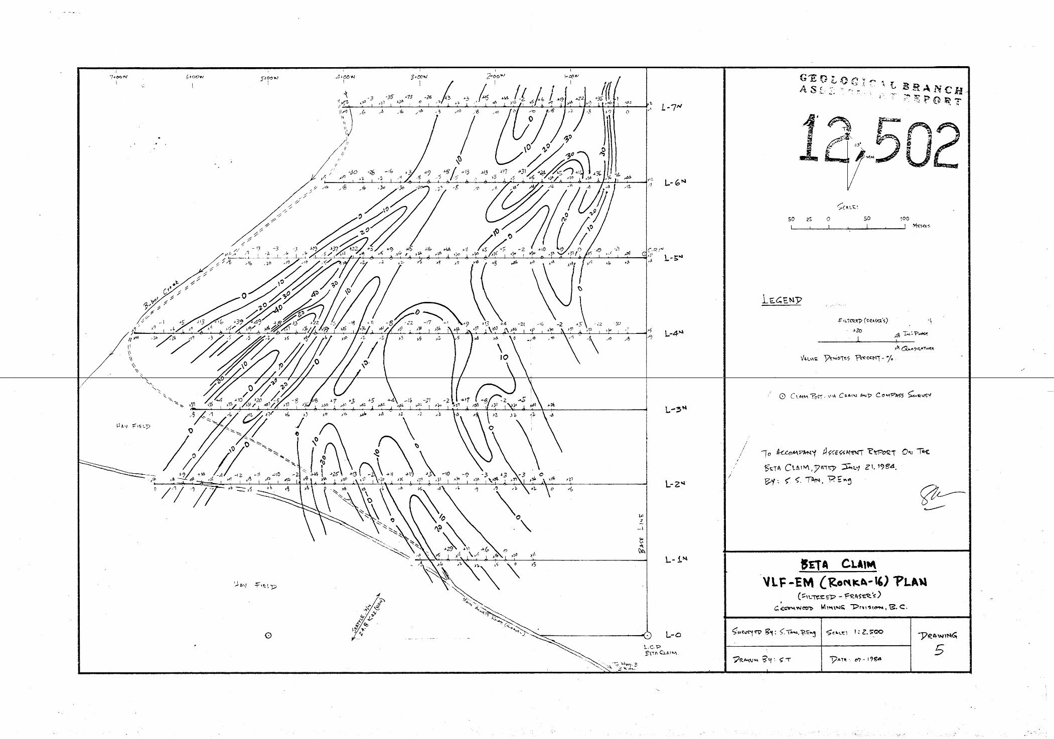
GEOPHYSICAL SURVEY (VLF-EM, RONKA-16)
The survey was conducted over the east-west grid l ines a t 100 m. spacing, with readings taken a t 25 m. s ta t ion.
A Ronka EM-16 manufactured by Geonic Limited was used in the survey. The Seat t le transmitter s ta t ion a t the new frequency of 24.8 KHz was used in the survey. This s ta t ion was selected to best suit the east-west grid l ines.
The quadrature and in-phase components expressed in percentage were taken a t each s tat ion. These resul ts were then f i l t e red using the Fraser's method (Geophysics: Vol. 34, No. 6 , Dec. 1969). The f i l t e red data are presented i n a contour plan, accompanied by the basic data, i n Drawing 5.
Results
Two moderately strong EM anomalies and two weaker anomalies were disclosed i n the survey. The two former a r e subparal le l . The s t rongest and l a rge s t anomaly a t the west s ide of the gr id has a peak f i l t e r e d value of 49%. I t i s from 50 m. t o 150 m. wide i n a length of 600 m. t h a t i s opened a t i t s southwest and northeast ends, The second 1 a rges t anomaly i s a t the northeast corner of the gr id area. I t i s subparallel t o the l a rge s t anomaly. This consisted of two adjacent anomalies each of about 75 m. wide i n a measured length of 200 m. I t s northern extension i s open. The o ther two weaker anomalies a re a t the south central segment of the gr id area. Both a r e about 75 m. wide, trending northwesterly and have a determined individual length of 80 m. t h a t i s opened t o the southeast.
The two s t rongest anomalies appear t o correspond t o the s t r i k e of the f e l dspar-porphyry u n i t and associated faul ts and t o the qua r t z i t e u n i t ' s geologic boundary a t the northeast of the survey area where gossans occur.
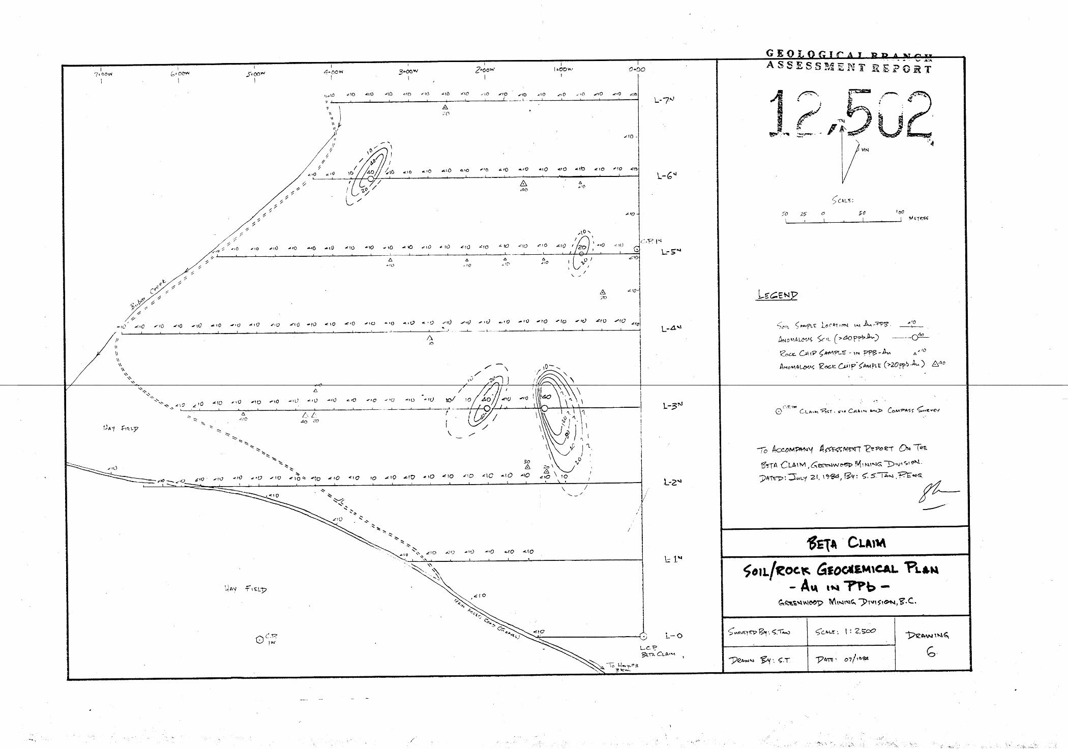
GEOCHEMICAL -- SURVEY
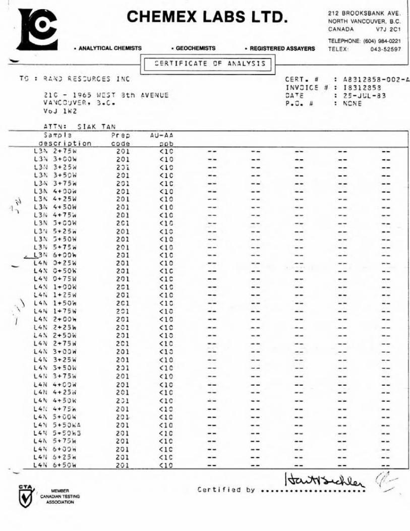
A t o t a l of 158 soi 1 samples were col lec ted during the survey. Of these 138 samples were col lec ted a t 25 m. s t a t i on from the gridded area and 20 samples were taken a t 100 m. i n te rva l s along the north bank of the main access road. Fourteen (14) rock chip samples were taken within the gr id . The s o i l samples were taken w i t h a mattock. Soil sample depths vary from 20 cm. t o 80 cm. The "B" so i l horizon was sampled. The rock chip-samples were taken f rom outcrops of quartz-fel dspar porphyry, greywacke, qua r t z i t e , granodiori t e , and mineral i zed showings (e . g. gossans) . The basal t u n i t W ~ S not sampled.
The samples were analysed f o r gold content by Chemex Labs Ltd. of North Vancouver. In ex t rac t ion , the -80 mesh sieved f rac t ions of the samples were digested i n aquaregia. The gold contentsin the samples were then analysed by the atomic absorption (A-A) method and the r e su l t s given i n par ts per b i l l i on ( p p b ) .
Discussion of Results
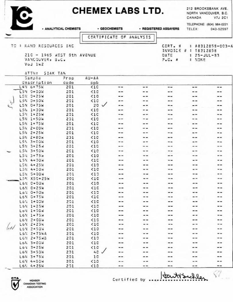
The background gold content i n the s o i l samples collected i s l e s s than 10 ppb. Au. Values i n excess of 40 ppb. A u . a r e considered anomalous in t h i s survey. Three spot value anomalies were disclosed.
The s t rongest , a t 140 ppb. Au. peak value, i s centred a t Line 3N, 1+25W. I t i s approximately 50 m. wide by 100 m. long. Related t o this i s a weaker anomaly, a t 40 ppb A u . , s i t e d 50 m. t o the west. Both anomalies a r e j u s t down-slope from an east-west f a u l t zone along a hydro thermally
a l t e r e d g ranod io r i t e outcrop. The t h i r d anomaly, a t 40 ppb. Au. peak value, i s i n L ine 6N, 3+50W. I t i s approximately 25 m. by 60 m. I t i s near a greywacke outcrop and l i e s a long the p ro jec ted s t r i k e o f a no r theas te r l y f a u l t .
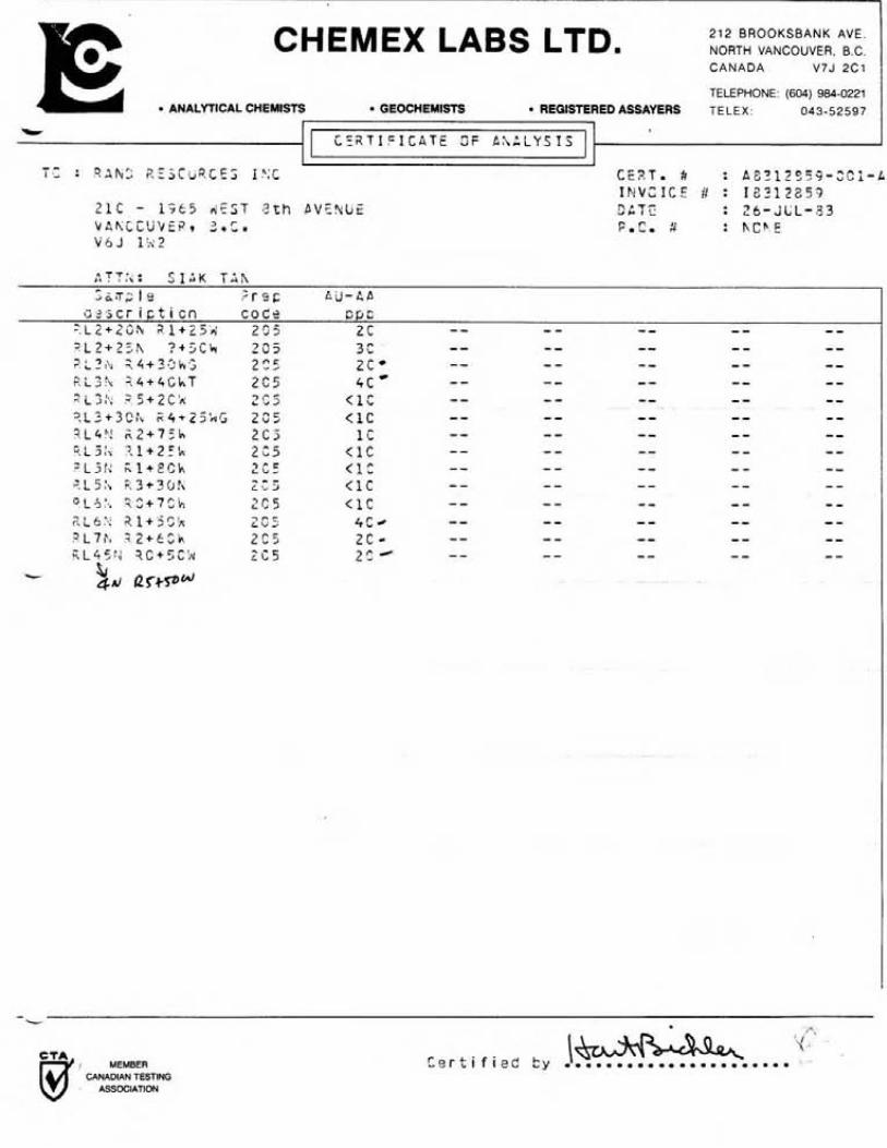
Two rock ch ip samples taken from a1 te red granod ior i t e a t 100 m. south o f the f i r s t two s o i l anomalies showed 20 ppb. Au. and 30 ppb. Au. respect ive ly . The go ld content i s considered anomalous i n these two rock-chip samples, s ince t h e granod ior i t e background value f o r gold i s l e s s than 10 ppb. Au. Rock chips from q u a r t z i t e i n d i c a t e a background o f l ess than 10 ppb. Au. Two anomalous samples a t 40 ppb. Au. and 20 ppb. Au. were taken from q u a r t z i t e associated w i t h a gossan a t L ine 3N, 4+50W. One anomalous quar tz - fe ldspar porphyry rock ch ip sample a t 40 ppb. Au. was sampled a t L ine 6N, 1+50W.
CONCLUSIONS - & RECOMMENDATIONS
The surveys i n d i c a t e a good c o r r e l a t i o n amongst t h e geo log ica l , geo- chemi ca l and electromagnetic (VLF-EM) r e s u l t s . The boundary o f t he st rongest VE-F-EM anomaly t o the west appears t o o u t l i n e the contact o f t he quartz- f e ldspar porphyry u n i t w i t h the q u a r t z i t e i n a d d i t i o n t o d e f i n i n g the mapped f a u l t s contained w i t h in . The second EM anomaly 1 i kewise co r re la ted w i t h the q u a r t z i t e u n i t t o the nor theast . One s o i l gold anomaly i s w i t h i n the boundary o f the s t rongest EM anomaly. The o the r go ld s o i l anomalies are outs ide and downhi l l from weaker EM anomalies b u t are c lose t o an east-west f a u l t i n hydrothermal l y a1 te red granod ior i te . I t appears t h a t these are associated w i t h the f a u l t zone. Anomalous go ld value were obta ined from q u a r t z i te, greywacke and a1 te red granod ior i t e t h a t are n o t associated w i t h f a u l t o r shear zones.
I n d i c a t i o n o f the presence o f go ld m i n e r a l i z a t i o n w i t h i n the proper ty has been confirmed i n the geochemical so i l l r o c k survey. The quartz-fc:bspar porphyry and quartz i te lgreywacke members are geo log ica l l y favorable l o c i f o r t he occurrence o f bedded go ld deposits. Such geologic type go ld deposi ts are a c t i v e l y being explored f o r present ly .
I t i s the re fo re recommended t h a t t he balance o f the proper ty be sub jec t t o an exp lo ra t i on program.
Ju l y 21, 1984 , i_-
S.S. Tan, P. Eng.
REFERENCES
1. Cairnes , E.E. . 1940
2 . Litt le , H . W . 1957
4. Monger, J.W.H. 1967
K e t t l e River (West H a l f ) , B . C . , Geol . Surv. , Canada, Map 538A.
Nelson (West H a l f ) , B . C . , Geol . Surv. , Canada, Map 3-1956
Kettle River ( E a s t H a l f ) , B . C . Geol. Surv . , Canada, Map 6-1957
Ear ly T e r t i a r y S t r a t i f i e d Rocks, Greenwood Map-Area. Geol . Surv. , Canada, Paper 67-42
Various B. C. Dept. Mines Annual Reports.

CERTIFICATE OF QUALIFICATIONS
I , Siak S. Tan, residing i n the City of Vancouver, Province of Br i t i sh Columbia, hereby c e r t i f y t ha t :
1. I am a consulting Geological Engineer with o f f i ces a t 207 - 2170 West 44th Avenue, Vancouver, B . C . , V6M 263.
2. I was graduated i n Geology (B.Sc., 1964) from Carlton University, Ottawa, Ontario and completed one year of post graduate s tud ies a t the University of Toronto (1965). My courses included geophysics and geochemistry.
3. I am a regis tered member of the Association of Professional Engineers of the Province of Br i t i sh Columbia i n the Geological Engi neeri ng Di vi si on.
4. I have been engaged i n my profession f o r the pas t nineteen years , having been employed by various mining companies and consulting engineering firms in my capacity a s a geological engineer and geol ogi s t .
5. The attached assessment repor t on the Beta Claim, Greenwood Mining Division, i s based on my personal f i e l d work on the property during June 9 , 1983 t o June 26, 1983 inclusive.
Dated a t Vancouver, B . C . , t h i s 21st day of July, 1984.
Siak S. Tan, P. Eng.
ITEMIZED COST STATEMENTS
The following costs were incurred i n the geological , geochemical and geophysical surveys of the Beta Claims, Greenwood Mining Division.
Personnel: ( a ) M. Tan - f i e l d a s s i s t a n t ( b ) S.S. Tan, P. Eng.
1. Food & Accommodati on : June 9-26, 1983 = 18 days $47.80/man day ( r men)
2. Transportation: June 9-26, 1983 = 18 days Vehicle,expenses and mileage @$44.75/day
3. Instrument Rental (EM-16) : @$lO/day
4. Field Supplies and Sundries: @$8.50/man day
5. Analyses: Chemex Labs: 158 soi 1s and 14 rock samples Soil @$6.40, Rock @$7.50
6. Wages : M. Tan (June 9-26, 1983) : 13 working days @$50
Fees : S. Tan, P . Eng. Field Time June 9-26, 1983 = 18 days @$400/day
= $7200 Preparation of Report: 4 days @$400/day
= $1600
TOTAL
S.S. an, P. Eng.
A P P E N D I X
C e r t i f i c a t e o f Analys is

I I
CHEMEX LABS LTD. 212 BROOKSBANK AVE NORTH VANCOUVER, B C CANADA V7J 2C1
TELEPHONE (604) 984-0221 ANALYTICAL CHEMISTS GEOCHEMISTS REGISTERED ASSAYERS TELEX 043-52597
*Cr
T 2 : 9 A N C P E S C d R C E S I N C C E R T * # : A 3 3 1 2 3 5 S - 2 S l - A I N V Z I C E 1 : 1 5 3 1 2 3 5 8
2 1 0 - 1 9 6 5 M E S T 3 th bVENUE QATE : 2 5 - J e L - 3 3 ' J A h t Z 5 V C R q 3.C. P.C* # : N C N f VsJ l k ! 2
S a r a l e P r e p O'J-CA i e s c r i p t i c n c o d e S F L
3 / L 4+3*2iY 20 1 < l C -- - - -- -- -- 2 / L 4+50N 2 3 1 < l o -- - - -- -- -- 3/L 5+0i)tV 2 3 1 < l C -- - - -- -- -- ? / L 5+5GN Z C 1 < 1 C - - - - - - -- -- 3 / L 6+:30h; 2 0 1 < 1 C -- - - -- -- - - 3 / L b+SOF< 2 0 i < 1 3 -- - - -- -- -- 3 / L 7+09h Z C 1 < 1 C -- - - -- -- --
--C-
i l k l + ' S O P d l z i 2C1 < 1 C -- -- -- -- -- L l ' i i + 7 5 k 14) 2 C l < 1 C -- - - - - -- --
IF' L ~ N Z + C G ~ (,i 2 c i (10 -- - - -- -- -- L Z h 2 + 2 5 4 ( J 2 9 1 < 1 C -- - - -- - - -- L l X 2+58k i I \ ) 2 0 1 < 1 0 -- - - -- -- --
-- - - -- - - -- - L 1 \ 2 + 7 % I . ' 2 0 1 < 1 C L Z Y l +39W 2 0 1 1 C -- - - -- - - -- - L2N i+25'v\! 2 9 1 < L C - - - - - - -- -- LZpd i + 5 0 K 2 0 1 < 1 C -- - - -- -- -- L Z 4 1 + 7 5 2 2 3 1 <I3 -- - - - - -- -- L Z Y 2 + c c l j 2 3 1 (10 - - - - -- -- -- i Z X 2+25W Z O i < l 2 -- - - -- -- -- LZ"Y+53bJ 2 0 1 < I S -- - - -- -- -- i 2 h 2 t75k i 2 3 1 < 1 C -- - - -- -- -- t 2 ; 3+3C'ri 2 0 1 < I S -- - - -- -- -- i 2 N 3 + 2 5 ' ~ 231 ( 1 0 -- - - -- -- --
i t ' L Z H ~ + ~ C I A 2 0 1 1 c -- - - -- - - -- L2h 3+75i.; 2 0 1 (10 -- - - -- -- -- L Z h , 4+OCI'N' 2 0 1 < 1 C -- - - -- -- -- L Z Z 4 + 2 5 % 2 C i <1c - - - - -- -- -- LZ 'L 4*3i)k 2 3 1 < l C - - - - -- - - -- LZS 4+75'f-i 2C1 < 19 -- - - -- - - -- L Z S 5+?32X 2 3 1 < I 2 -- - - -- -- -- L Z ? \ 5+Z?'r : 20 1 :tl -- - - - - -- - - LZ'U 5 + ' ; 3 * 2 s 1 (13 - - - - -- - - -- L2: ! 5 + 7 5 k 2 5 1 < 1 S -- - - -- -- -- I-?\ ~ + G C ' N i n ~ -- - - -- -- -- - L3:\. 1+Z5k 2 7 1 ' "7 1 4 s -- - - -- -- - - L 3 . b 1 + 5 G i ~ 2 2 1 < L C -- - - -- - - -- L3": I t 7 5 8 2 2 1 -- - - -- -- --
<IC J -- L3h 2+Cbk 2C1 4 C - - -- -- -- L 3 2 r 2+25ih( 2 $2 1 I f -- - - -- -- - - 131. 2+33i.r 201 1 C -- - - -- - - -- - - , 9 -.
I- C , l , C e r t i f i e d by ..,.. .... d MEMBER B CANADIAN TESTING
ASSOCIATION
CHEMEX LABS LTD. 212 BROOKSBANK AVE. NORTH VANCOUVER, B C CANADA V7J 2C1
TELEPHONE (604) 984-0221 ANALYTICAL CHEMISTS GEOCHEMISTS REGISTERED ASSAYERS TELEX 043-52597
ATT3: S I k K T A R S a s p l a P r e p AU-AP
d e s c r i p t i on c o d e s o b L3Fv 2 + 7 5 k 201 < 1 C - - - - -- -- -- L 3 h 3+S3k 201 (10 -- -- -- -- -- L3:d 3 + 2 5 k i 23i (10 -- - - -- -- -- L34 3350'ri' 201 <1C -- - - -- - - -- L3M 3+?5h 251 <1C -- - - -- - - -- L3h 4 + 3 3 h 2Cl < l o -- a - -- - - --
' L3h 4+25W 20 1 < : C -- -- -- - - -- 34 1 , L 3 h 4++SOiY 201 < 1 C -- - - -- -- --
L 3 h 4 + 7 5 k 201 < 1 C -- - - -- -- -- L 3 Y 5+531.1 2Ci < 1 C -- - - -- -- -- L3'u 5+25rr 201 <1C -- -- -- -- -- L32 ;+33Y 201 < 10 -- - - -- -- -- L 3 h 5+75iY 201 < 1 '3 -- - - -- -- --
&3t; 6+31)k 201 <1C -- - - -- -- -- L 4 % 3+25h 201 <1C -- -- -- -- -- - L 4 N i;+50\i 231 <1C -- - - -- - - -- L 4 V rJi75iri 201 <1C -- - - -- -- -- L 4 Y ltri9in! 2Sl < l C -- - - -- -- -- i 4 i u 1+25w 201 < 1 C -- - - -- -- - -
\ L 4 h 3+50k 2 C l < 1 .S -- - - -- -- -- if+:u 1+756 - 721 < i o -- - - -- - - --
I L 4 h 2 + G 9 h 2C1 <1C -- - - -- - - -- L 4 K 2 + 2 5 k 2 3 1 < 1 C -- - - -- -- -- i4h 2+53k 201 (10 -- - - -- - - -- L 4 X 2 i 7 S d 2Cl (12 -- - - -- -- -- 14s ?+i!3w 201 < 1 2 -- - - -- - - -- 1 4 9 3 t 2 S w 201 (10 -- -- -- -- -- L 4 \ 3+59k 2 3 1 < 1 C -- - - -- - - - - L4:4 3+752 201 (10 -- -- -- -- -- L 4 N 4 t C l j d 231 < 1 C -- - - -- -- -- L 4 i . j 4 + 2 5 d 2C1 <1C -- - - -- - - -- L4'L 4+59h' 2;1 <1c -- - - - - -- -- L 4 i : 4+75,v 2 0 1 < 1 c -- - - -- - - -- L 4 X 5+GG\.c 20 1. < L C -- - - -- - - -- L42! 5+53K.;8 291 < i O -- - - -- - - -- L4.4 5+53!45 231 <LC -- - - -- -- -- L4f\ 5+?5'yu 2 0 1 <LC - - - - -- -- -- L 4 h 6+33ir 2.51 <1C -- -- -- -- -- 14% Sc23i.r 231 < 1 C -- - - -- - - -- L4 : i 6+5rJt i 201 <10 - - - - -- -- -- -
, MEMBER CANADIAN TESTING
ASSOCIATION
I CHEMEX LABS LTD. 212 BROOKSBANK AVE
NORTH VANCOUVER, B C CANADA V7J 2C1
TELEPHONE (604) 984-0221 ANALYTICAL CHEMISTS GEOCHEMISTS REGISTERED ASSAYERS TELEX 043-52597
C E R T - # : 58312853-CC3-A I N V O I C E # : 1 8 3 1 2 8 5 8 O A T % : 2 5 - J U L - 3 3 ?*C* # : N S K E
- Z I C - 1 3 6 5 A Z S T 3 t h AVEYUE ' J A Y C G U V % t 3 - C - VoJ l k 2
I C E i t T I F I C P T E OF ANALYSIS I 1 1
S z ~ a l e 2 r ep A U - A A ~4 4,3cr O .-. i p t i o n code s p b
L4'4 6 + 7 5 M 201 <1C -- - - -- -- --
L51; 4+3aw Z C 1 <1C -- - - -- -- -- L5i . i 4+25Li 231 (1.9 - - -- -- - - -- L5P! 4+5Cr4 201 (10 -- - - -- - - -- i s h 5 + 3 3 g 2.9 1 <l? -- - - -- -- --
-- -- -- - - - - - L5Y X 5 C i Z 5 k 201 < 1 C i S N G+i)i)k 2 0 1 ( 1 0 -- -- -- -- -- i b N C + 2 5 k 231 <1C -- - - -- -- -- Lo'; C+53w 2 0 1 < I S - - - - -- -- -- LS":+75h 291 <1C -- - - -- -- -- Li;'.r 1+22b! 2 2 1 < 1 C - - - - -- -- -- L 5 Y 1+25ini 271. <lZ -- - - -- - - -- LoY 1r23G& 2G1 < L O -- - - -- -- -- L 6 9 1 + 7 5 k 2 0 1 (10 -- - - -- - - -- i 4 v 2+c3;.r 201 <1C -- - - -- -- -- L 6 U 2 + 2 3 k 2C1 <1C -- - - -- - - -- L 4 L6\! z + j 9 i 2 3 1 <lo -- - - -- -- -- LSS 2 + 7 5 k A 2.3 f < 1 C -- - - -- - - -- ~kt! 2 i 7 5 4 3 231 (13 - - - - -- -- -- i s h 3+L?(3iJ 201 (12 -- - - -- -- -- LO'\ 3 + 2 5 H 2C1 -- - - -- - - -- L 6 Y 3 + 5 3 h 231 < l C J 4G -- - - -- -- -- Lbiv 7,+75'E;' 291 1 C -- - - -- -- -- L S Y j 4 * 1 5 i j H 201 < I 3 -- - - -- -- -- 1-6"- 4+25W 2 3 1 < L 9 -- - - -- -- -- -
-C
1 MEMBER CANADIAN TESTING
ASSOCIATION
C e r t i f i e d by

CHEMEX LABS LTD. 212 BROOKSBANK AVE NORTH VANCOUVER, B.C CANADA V7J 2C1
TELEPHONE (604) 984-0221 ANALYTICAL CHEMISTS GEOCHEMISTS REGISTERED ASSAYERS TELEX 043-52597
1' I ] T C : Z A M 2 R E S C Y R S E S INC CESTa # : A 8 3 1 2 5 5 8 - 0 0 4 - C
I N V 3 1 C E 3 : I3312550 2 1 0 - 1 3 6 5 d E S T 8 th PVE!dUE S A T E : 2 5 - J U L - 4 3 V A ) ! C O U V i R * a,c. 2.c, 3 : K G ~ E V 6 J li42
vrrr
L TT?,,: S I A K TAR:
I C E R T I F I C A T E CF ANBL'/jISI
3 e s c r i p t i o n c o d e p p b L7V 0 + 2 5 t j 2 0 1 < l C -- - - -- - - - -
CANADIAN TESTING ASSOCIATION
CHEMEX LABS LTD. 212 BROOKSBANK AVE. NORTH VANCOUVER, B.C. CANADA V7J 2C1
TELEPHONE: (604) 984-0221 ANALYTICAL CHEMISTS GEOCHEMISTS REGISTERED ASSAYERS TELEX : 043-52597
2 ~ a ; l o = r c c A d - C P a ? s c r i ~ t i c n c o d e FIsc
?iz+i3& 2 1 + 2 5 d 2 3 5 2 c -- - - -- -- - - ; L 2 + 2 f A ? + 5 C h 2 2 5 3C -- .. - -- - - -- 7 L 3 h ? . 4 + 3 3 k ; 2 C f 2 c * -- - - -- - - -- F L 3 2 ? 4 + 4 G k T 2 C 5 4 c * - - - - -- -- - - F i j ; , ; 5 + 2 C h ? ? s < 1 C -- - - -- -- -- ? L 3 + 3 2 h 2 4 + 2 5 h G 2 8 5 < i C -- - - - - - - ? L 4 V ! 2 + 7 J k 2 C 3 1 C -- - - -- - - -- F,L?;\ ? 1 + 2 F h 2 C 5 < 1 C - - - - -- - - -- =LJ!< i i l + E C k 2 c d r < l C -- - - -- - - -- 7 L S h i ? + 3 o f \ - - -
L ," 5 < 1 C - - - - -- - - - - "L6'*, C 2 + 7 C h : c 5 < 1 C -- - - - - - - - - 2LS*sq ?.l+ 5 S h L ~ r - r u 2 4C -- - - - - -- - - 717P4 ;2+62h 2 ~ r " A 2 c - -- - - -- - - -- K L 4 5 f l ? C + 5 2 2 2 i 5 2 ; -- - - -- -- --
b Sr 4rr/ 12r+sod
CANADIAN TESTING ASSOCIATION