geological and geophysical perspectives on the magmatic and
TRANSCRIPT

fl d015-21 2nd pgs page 435
435
The Geological Society of AmericaField Guide 15
2009
Geological and geophysical perspectives on the magmatic and tectonic development,
High Lava Plains and northwest Basin and Range
Andrew Meigs*Oregon State University, Department of Geosciences, Wilkinson 104, Corvallis, Oregon 97331, USA
Kaleb ScarberryColorado State University, Department of Geosciences, 322 Natural Resources Building, Fort Collins, Colorado 80523, USA
Anita GrunderOregon State University, Department of Geosciences, Wilkinson 104, Corvallis, Oregon 97331, USA
Richard CarlsonCarnegie Institution of Washington, Department of Terrestrial Magnetism, 5241 Broad Branch Road, NW,
Washington, D.C. 20015, USA
Mark T. FordOregon State University, Department of Geosciences, Wilkinson 104, Corvallis, Oregon 97331, USA
Matt FouchArizona State University, School of Earth & Space Exploration, P.O. Box 871404, Tempe, Arizona 85287, USA
Tim GroveMassachusetts Institute of Technology, Department of Earth, Atmospheric, & Planetary Sciences,
77 Massachusetts Avenue, Cambridge, Massachusetts 02139, USA
William K. HartMiami University, Department of Geology, Shideler Hall 114, Oxford, Ohio 45056, USA
Mike IademarcoOregon State University, Department of Geosciences, Wilkinson 104, Corvallis, Oregon 97331, USA
Brennan JordanUniversity of South Dakota, Department of Earth Sciences, 414 E. Clark St., Vermillion, South Dakota 57069, USA
Justin MilliardOregon State University, Department of Geosciences, Wilkinson 104, Corvallis, Oregon, 97331, USA
Meigs, A., Scarberry, K., Grunder, A., Carlson, R., Ford, M.T., Fouch, M., Grove, T., Hart, W.K., Iademarco, M., Jordan, B., Milliard, J., Streck, M., Trench, D., and Weldon, R., 2009, Geological and geophysical perspectives on the magmatic and tectonic development, High Lava Plains and northwest Basin and Range, in O’Connor, J.E., Dorsey, R.J., and Madin, I.P., eds., Volcanoes to Vineyards: Geologic Field Trips through the Dynamic Landscape of the Pacifi c Northwest: Geological Society of America Field Guide 15, p. 435–470, doi: 10.1130/2009.fl d015(21). For permission to copy, contact [email protected]. ©2009 The Geological Society of America. All rights reserved.

436 Meigs et al.
fl d015-21 2nd pgs page 436
GEOLOGIC SETTING OF THE HIGH LAVA PLAINS
The Crust
The High Lava Plains province of eastern Oregon is bounded to the north by the non-extended Blue Mountains prov-ince, to the south by the Basin and Range, to the west by the Cascade Range and to the east by Precambrian North America (Fig. 1). In this area, the western margin of the Precambrian
North American craton is well delineated only along the western Idaho shear zone, a steep structural boundary near the Idaho-Washington border that is coincident with an abrupt change in the initial 87Sr/86Sr of Mesozoic and Cenozoic magmatic rocks from <0.706 west to >0.706 east of the western Idaho shear zone (Armstrong et al., 1977; Manduca et al., 1992). Elsewhere, the location of the Proterozoic cratonic margin is more enigmatic but can be inferred from the location of the “0.706 line” (Fig. 1). Pre-Cenozoic crust west of the craton margin is exposed in
Martin StreckPortland State University, Department of Geology, P.O. Box 751, Portland, Oregon 97207, USA
David TrenchOregon State University, Department of Geosciences, Wilkinson 104, Corvallis, Oregon 97331, USA
Ray WeldonUniversity of Oregon, Department of Geological Sciences, 151 Cascade Annex, 1272 University of Oregon,
Eugene, Oregon 97403, USA
ABSTRACT
A large part of the northwestern United States has undergone extensive late Cenozoic magmatic activity yielding one of the great continental volcanic provinces on Earth. Within this broader area lies the High Lava Plains province, the focus of this fi eld guide. For our purposes, the High Lava Plains is a middle and late Cenozoic volcanic upland, contiguous with and gradational into the Basin and Range province to the south.
The High Lava Plains province of southeastern Oregon is characterized by thin, widespread Miocene-Pleistocene lava fl ows of primitive basalt and a belt of silicic eruptive centers. The rhyolitic rocks generally are successively younger to the north-west, describing a mirror image to the basalt plateau and rhyolite age progression of the Snake River Plain. The High Lava Plains is associated with a zone of numer-ous, small northwest-striking faults and lies at the northern limit of major Basin and Range normal faults. The abundant late Cenozoic bimodal volcanism occupies an enigmatic intracontinental tectonic setting affected by Cascadia subduction, Basin and Range extension, the Yellowstone plume, and lithospheric topography at the edge of the North American craton. The purpose of this fi eld trip is to focus on the late Cenozoic lithospheric evolution of this region, through the lens of the High Lava Plains, by considering structural, geophysical, petrologic, and temporal perspectives.
A grand tour southeast from Bend to Valley Falls, north to Burns, and then east to Venator, Oregon, takes participants from the eastern edge of the Cascade volcanic arc, across several basins and ranges in eastern Oregon, and onto the volcanic plateau of the High Lava Plains. Day 1 provides an overview of Newberry Volcano and the western edge of Basin and Range, including the Ana River and Summer Lake fault zones. On Day 2, the early magmatic and extensional history of the region is explored along the Abert Rim range-front fault. Participants are introduced to the bimodal vol-canism within the High Lava Plains, with focus on the Harney Basin and Rattlesnake ignimbrite event. An evening session will highlight geophysical results from the High Lava Plains, including new data from one of the largest active-source seismic experi-ments to be conducted in North America. Day 3 activities examine early bimodal volcanic history of the eastern High Lava Plains and the late Miocene and Pliocene subsidence history on the east edge of the Harney Basin east of Burns, Oregon.

Magmatic and tectonic development, High Lava Plains 437
fl d015-21 2nd pgs page 437
northeastern and central Oregon and westernmost Idaho and consists of Paleozoic-Mesozoic oceanic volcanic arcs, accre-tionary prism complexes, and associated basinal successions accreted to western North America during Jurassic arc-continent collision (e.g., Coney and Reynolds, 1977; Dickinson, 1979; Oldow et al., 1984; Vallier, 1995). Similar terranes are exposed in the Klamath Mountains of southwestern Oregon and northern California. If such basement exists under the High Lava Plains, it is covered by Cenozoic volcanic rocks.
From a seismic refraction transect along the High Lava Plains, Catchings and Mooney (1988) inferred a Moho depth of 37 km and high seismic velocity (7.4 km/s) in the lower crust. Preliminary receiver function analysis of Moho depths beneath the High Lava Plains seismic array shows the following system-atic variations (K.C. Eagar, 2009, pers. commun.). Crustal thick-nesses beneath the High Cascades are ~40–42 km, but diminish abruptly to ~30 km in the westernmost High Lava Plains. These depths gradually increase to ~35 km to the east beneath Jordan Craters, and then increase dramatically to ~42 km and perhaps thicker beneath the Owyhee Plateau.
Regional Volcanism
Western North America has experienced aerially extensive, voluminous volcanism throughout the Cenozoic that can be sepa-rated into three phases: the “ignimbrite sweep,” characterized by large-volume eruptions of silicic magmas from centers migrat-ing over much of western North America between 50 and 20 Ma (e.g., Lipman et al., 1972); the fl ood basalt episode between 17 and 15 Ma that involved the massive emplacement of dikes and the eruption of fl ood basalt along a ~700-km-long, north-south line that follows the western margin of Precambrian North America (e.g., Hooper et al., 1997); and fi nally, more distributed and generally bimodal (silicic and basaltic) volcanism along the margins of the Basin and Range (Fig. 1). During the third, still continuing, phase, the largest volumes of magma were erupted in the High Lava Plains and along the Snake River Plain. By ca. 12 Ma, volcanism in eastern Oregon became more clearly organized to form two migrating tracks, one moving at plate speed and plate direction to the northeast along the Snake River Plain toward Yel-lowstone (Pierce and Morgan, 1992) and the other moving in the
OR
ID
MT
WY
NV
CA
UT
WA
SM OP
OWL
V
BED
Mc
ESRPWSRPHLP
87Sr/86Sr > 0.706
SAFZ
14
1210
86
42
0
0
2
46
810
NNR
North American Plate14-26 km/Ma
JdFPlate
NB
OR
ID
MT
WY
NV
CA
UT
WABasaltAndesiteRhyolite
< 5 5-10 10-17 Ma
CJ
C
Figure 1. Volcanic and tectonic elements of the western United States: (A) Distribution of volcanic rocks younger than 17 Ma, by age and composition (Luedke and Smith, 1984), illustrates the tremendous volcanic activity east of the Cascade Range in the northern extent of the Basin and Range province. (B) Some tectonic elements (after Jordan et al., 2004) superimposed on the map of Luedke and Smith (1984). Solid brown line outlines the Basin and Range province. Volcanic fi elds younger than 5 Ma illustrate the continuing activity in the Cascade Range and along the High Lava Plains (HLP; brown fi eld) and the eastern Snake River Plain (ESRP). Short curves along the HLP and ESRP are isochrons (ages in Ma) for the migrating silicic volcanism along each volcanic trace. Flood basalt activity was fed from dike systems in the northern Nevada rift (NNR), Steens Mountain (SM), the western Snake River Plain (WSRP) and the Chief Joseph (CJ) and Cornucopia (C) dike swarms of the Columbia River Basalt Group. These dikes occur near the western border of Precambrian North America as defi ned by the 87Sr/86Sr 0.706 line (large dot-dash line). Northwest-trending fault systems—Olympic-Wallowa lineament (OWL), Vale (V), Brothers (B), Eugene-Denio (ED) and McLoughlin (Mc)—are shown by the short-dashed lines. Additional features include Newberry Volcano (NB), Owyhee Plateau (OP), Juan de Fuca Plate, San Andreas fault zone (SAFZ), and Mendocino triple junction (MTJ).CA—California; ID—Idaho; OR—Oregon; NV—Nevada; UT—Utah; WA—Washington; WY—Wyoming.

438 Meigs et al.
fl d015-21 2nd pgs page 438
opposite direction (west-northwest) at a similar rate along the High Lava Plains (Jordan et al., 2004; MacLeod et al., 1975). The spatio-temporal progression is defi ned by silicic volcanism, which is estimated to be about ten times less voluminous along the High Lava Plains than along the Yellowstone track (Pierce et al., 2000). The migrating silicic volcanism of the High Lava Plains ends today near Newberry Volcano (Fig. 2), an active vol-cano of the Cascade volcanic arc. At the latitude of Newberry and the Three Sisters, the Cascade arc has unusually abundant Quaternary mafi c volcanic rocks owing to youthful intra-arc rift-ing and has a fairly thin (35–42 km) and mafi c crust (Conrey et al., 2000; Sherrod and Smith, 1990; Trehu et al., 1994). A link between volcanism in the High Lava Plains and the Cas-cades is indicated by enhanced volcanic output of the Cascade Range from Crater Lake to Mount Jefferson, isotopic similarity of primitive low-K tholeiites, and a westward merging of High Lava Plains structures with the High Cascades graben.
Unlike the silicic activity, basaltic volcanism of the High Lava Plains is not age-progressive. Instead, it changed from widely distributed in the Miocene to focused in the Pliocene to defi ne the geomorphic High Lava Plains (Fig. 1). There was a prominent pulse of basaltic activity all across the High Lava Plains at ca. 7.5–8 Ma (Jordan et al., 2004). After passage of the silicic volcanic front, volcanism persisted along both tracks, erupting primarily basalt to the present day along most of the High Lava Plains and Snake River Plain. Inasmuch as silicic vol-canism is driven by mafi c volcanism, there may be an age pro-gression superimposed on the near 7.5–8 Ma basaltic burst.
With the beginning of the High Lava Plains activity, basaltic volcanism shifted from the large-volume eruptions of differenti-ated basalt that typify the Steens–Columbia River fl ood basalt to primarily primitive, low-K, high-Al, olivine tholeiite (HAOT of Hart, 1985) that shares many compositional similarities with mid-ocean ridge basalt. This type of primitive basalt occurs throughout eastern Oregon (Conrey et al., 1997; Hart et al., 1984; McKee et al., 1983), along the Snake River Plain to Yel-lowstone (Leeman, 1982), and at various centers in the Cascade
Range (Bacon et al., 1997) but is essentially absent in the central and southern Basin and Range (Nevada to Arizona). Experimen-tal petrologic investigations of HAOT from the Cascade Range give a shallow mantle equilibration depth of 1.1 GPa (11 kbar) (Bartels et al., 1991) indicating that HAOT equilibrated close to the base of the crust (~33 km depth). Seismic tomography under the High Lava Plains (Roth et al., 2008) shows well-developed regions of low seismic velocity beneath surface expressions of recent volcanism that extend to depths of only 100–150 km, in agreement with the shallow origin of the volcanism indicated by the petrology of the basalts.
The <12 Ma rhyolites of the High Lava Plains and adja-cent regions of the northwestern most Basin and Range Province are mainly high-silica rhyolites with >72 wt% SiO2 (Figs. 3 and 4; Table 1) They fall into three general compositional groups. (1) Fe-rich rhyolites are essentially restricted to the basalt plateau of the High Lava Plains. The Rattlesnake Tuff is of this group. These rhyolites are closely tied to basalt in space and composition and have their origin mainly as partial melts of a mafi c crust fol-lowed by extensive crystal fractionation to make the most evolved members of the suite (Streck and Grunder, 2008). Some of these may also be simple basalt fractionates as demonstrated for similar rhyolites on the Snake River Plain (Ford et al., 2004; McCurry et al., 2008; Whitaker et al., 2008). On the whole, this group coin-cides with Fe-Ca distribution comparable to rift zone rhyolites of Iceland (Fig. 3) (Jónasson, 2007). (2) Calcic rhyolites are widely distributed, have chemical affi nities with the Cascades (particularly Medicine Lake Volcano), and may have their origin as extracts from granitoid crystal mushes (Bachmann and Bergantz, 2004; Hildreth, 2004). (3) Alkalic, and in some instances substantially peralkaline rhyolites, are found mainly in the central High Lava Plains.
Active Tectonics of the Northwestern Basin and Range
A variety of data suggest that the Cascadia forearc, or the central Oregon block, is moving westward and northward about a pole located in northeast Oregon or eastern Washington (Wells
Mgal-10-20-30-40 10 200
120° 115° 110°125°
40°
45°
50°
Figure 2. Residual isostatic gravity anoma-ly map for the northwestern U.S. (Keller et al., 2002). The expanded map to the right shows the general volcanic geology de-picted in Figure 1 draped over a digital el-evation model of southeast Oregon. Dashed outline depicts the approximate extent of the Devine Canyon Ash-Flow Tuff. Ab-breviations in yellow are: NV—Newberry Volcano; JD—John Day; B—Burns; DC—Diamond Craters; SM—Steens Mountain; HV—Hawkes Valley volcanic fi eld; MD—McDermitt volcanic fi eld; JVVF—Jordan Valley volcanic fi eld; JV—Jordan Valley; SC—Santa Rosa–Calico volcanic fi eld and northern part of northern Nevada rift; OP—Owyhee Plateau; WSRP—western Snake River Plain.

Magmatic and tectonic development, High Lava Plains 439
fl d015-21 2nd pgs page 439
TABLE 1. REPRESENTATIVE RHYOLITE COMPOSITIONS FROM THE HIGH LAVA PLAINS (HLP) AND SOUTHEASTERN OREGON (FIG. 3) NORMALIZED TO 100% ANHYDROUS
RST A RST E Horse Mountain Quartz Mountain Roundtop Butte Cox Flat Location HLP HLP HLP HLP HLP NWBR most evolved least evolved peralkaline Fe-rich calcic (low Fe) calcic (low Fe) Age (Ma) 7.05 7.05 7.096 1.13 ~6.5 8.05 SiO2 77.74 75.64 76.49 75.51 76.29 76.71 TiO2 0.11 0.16 0.20 0.103 0.07 0.061 Al2O3 11.97 12.29 10.43 13.39 13.41 13.46 FeO* 0.78 1.96 3.25 1.45 0.57 0.49 MnO 0.08 0.10 0.10 0.038 0.06 0.070 MgO 0.05 0.01 0.00 0.05 0.00 0.05 CaO 0.26 0.50 0.18 0.89 0.81 0.84 Na2O 3.46 4.62 4.83 4.49 4.02 3.57 K2O 5.53 4.70 4.50 4.07 4.77 4.75 P2O5 0.02 0.01 0.02 0.013 0.01 0.008 AT 99.90 99.50 99.10 99.12 99.09 97.08
Rb (ppm) 122 64 122.6 129.0 131 142.4 Ba 39 1835 175 922 332 47 Sr 2.1 23.4 0.5 60 31 27 Zr 175 457 733 173 67 59 Nb 39.4 26.4 40.7 8.11 12.8 10.92
87Sr/86Sr 0.70499 0.70431 0.70320* 0.70440 ~0.7045 0.70628 143Nd/144Nd 0.51284 0.51282 0.512860 0.512910 0.512860206Pb/204Pb 18.849 18.847 18.8608 19.0620 18.7560 207Pb/204Pb 15.620 15.622 15.5983 15.6217 15.5914 208Pb/204Pb 38.535 38.547 38.5203 38.7146 38.4091 Note: Cox flat is a sample from the northwest Basin and Range (NWBR). Rattlesnake tuff samples are RST. AT indicates analytical totals. Data from Streck and Grunder (2008) and Ford and Grunder (unpublished). *Due to very high Rb/Sr ratios, the initial value cannot be accurately calculated with the given age precision.
0
2
4
6
8
10
12
14
57 62 67 72 77SiO2
FeO
*
Within HLP samples
South of HLP samples
including Rattlesnake Tuff
Other HLP tuffsNewberry Volcano
Key
Iceland fieldCascades field
mildly peralkaline compositions
Iceland dataCascades data
Data for fields
0
2
4
6
8
10
12
14
57 62 67 72 77
Figure 3. FeO* versus SiO2 plot for samples >57% SiO2 of the High Lava Plains (HLP) with an arbitrary dividing line between the more tholeiitic samples from the physiographic HLP, including vo-luminous tuffs, and the more calc-alkaline samples of the northern Basin and Range (cf. Christiansen and McCurry). Also shown are samples from Newberry Volcano and fi elds representing >425 sam-ples from Iceland and >900 sam-ples from the Cascades along with an inset showing these data points. The line nicely separates HLP and Basin and Range (south of the HLP samples) andesite to low silica rhyolite (57–72 wt% SiO2) com-positions but does not distinguish high silica rhyolites. High silica rocks of the study area are also not readily separated in other element variation diagrams a characteristic that has been noted in other prov-inces (e.g., Snake River Plain by Christiansen and McCurry, 2008). Mildly peralkaline compositions occur within the ellipse.

440 Meigs et al.
fl d015-21 2nd pgs page 440
et al., 1998). Global Positioning System (GPS) and paleomag-netic studies (Hammond and Thatcher, 2005; McCaffrey et al., 2000; Wells and Simpson, 2001) have suggested three different Euler pole locations to accommodate the western and northward movement of the central Oregon block and the subsequent extension of central Oregon (Fig. 5). McCaffrey et al. (2000) use geodetic data to place a best-fi t pole for the rotation of the central Oregon block at 45.9° ± 0.6° N, 118.7° ± 0.7° W, lying on the Oregon-Washington border. Wells and Simpson (2001) also resolve a pole of rotation for
the Oregon coastal block along the Oregon-Washington border at 45.54° N, 119.60° W, but do so from geologic and paleomagnetic data, independent of geodetic data. The two-sigma error for the major axis of the pole is 5.1° along a 010° azimuth, with the minor axis at 2.96° (Wells and Simpson, 2001). Hammond and Thatcher (2005) place the Euler pole for the central Oregon block in northern Oregon, at 44.3° N, 118.04° W.
Implications for the instantaneous velocities and thus the magnitude of extension across the northwest Basin and Range
Figure 4. Map of eastern Oregon showing the spatial distribution of basalts and rhyolite lavas and tuffs. The location of 21 new 40Ar/39Ar ages are given (solid squares, reported to two decimals) including four unpublished ages of Scarberry et al. (2009) (+ sym-bol), ages from Jordan et al. (2004; 40Ar/39Ar ages, dark diamonds, reported to two decimals), and Fiebelkorn et al. (1983; K-Ar ages, open stars, reported to one decimal). Green boxes approximate cities (B—Burns, L—Lakeview). Proposed location for the Rattlesnake Tuff from Streck and Grunder (1997) and Ar-Ar age for the Hampton Tuff from Iademarco (2009). Black lines are major roads and heavy black dashed line outlines the High Lava Plains physiographic province.
9.3
9.5
11.3
15.1
15.9
10.6 10.38
10.50
11.36.49
5.79
15.1
6.90
5.785.74
7.68
2.89
7.18
6.35
7.17
7.28
7.18
15.63 8.28
7.13
6.90
8.58+
9.75+
12.05+
8.79+
13.9
10.6
7.26
7.1015.65
15.34
5.17
5.77
17.30
8.966.79
7.3
8.055.86.87
7.6
4.8
5.2
7.917.54
5.67
6.25
5.59
4.34
6.8 4.0
0.6
0.8 0.9 1.1
4.65.0
5.2
3.7
2.4
HamptonTuff 3.80
RattlesnakeTuff 7.05
Prater CreekTuff 8.41
Devine CanyonTuff 9.74
118°119°120°121°
43°
42°
44°
Newberry
Bend
B
L
Ste
ens
15.03
6.16
6.52++
40 0 4020 Km
Undifferentiated sedimentary rocks and rocks older than Oligocene Oligocenc rhyolite, rhyodacite and dacite
KEY:Rhyolite, rhyodacite and dacite Miocene and younger
Ash flow and air fall tuffs including the Rattlesnake, Prater Creek, Devine Canyon, Silver Lake and Hampton
Miocene and younger basalts and basaltic andesites, including Steens Basalt
New 40Ar/39Ar dates Jordan, et al., 2004 40Ar/39Ar datesFiebelkorn et al., 1983 K-Ar dates
Latitude – Longitude marker
Inferred source locations of major tuffs and Newberry Caldera


Magmatic and tectonic development, High Lava Plains 443
fl d015-21 2nd pgs page 443
La Pine
Bend
Fort Rock
Summer Lake
SilverLake
A Day 1 Overview Map
A
D
C
B
97
31
31
31
97 20
31
S1-2
L1-1
S1-1
I1-4
S1-3
S1-5
S1-4
I1-15I1-16
I1-17
S1-6S1-7
I1-9
Point Lat Long Distance to Cumulativenext point distance
L1-1 43.970 121.347 4.4 4.4I1-1 43.908 121.356 0.1 4.5S1-1 43.910 121.357 12.3 16.8I1-2 43.752 121.460 12.9 29.7I1-3 43.710 121.273 3.9 33.6S1-2 43.689 121.255 24.8 58.4I1-4 43.647 121.523 25.1 83.5I1-5 43.391 121.223 0.8 84.3I1-6 43.390 121.208 0.3 84.6I1-7 43.392 121.204 0.9 85.5I1-8 43.412 121.209 0.2 85.7S1-3 43.413 121.206 7.3 93.0I1-9 43.353 121.177 12.1 105.1
I1-10 43.356 120.940 7.5 112.6I1-11 43.414 120.858 6.4 119.0I1-12 43.422 120.734 2.8 121.8S1-4 43.387 120.725 1.5 123.3I1-13 43.375 120.712 1.2 124.5I1-14 43.374 120.690 2.9 127.4S1-5 43.336 120.677 7.4 134.8I1-15 43.238 120.661 1.0 135.8I1-16 43.238 120.681 14.2 150.0
Point Lat Long Distance to Cumulativenext point distance
I1-17 43.115 120.862 7.3 157.3I1-18 43.030 120.791 5.0 162.3I1-19 42.990 120.804 0.5 162.8S1-6 42.984 120.800 8.1 170.9I1-20 43.002 120.776 2.2 173.1I1-21 43.002 120.733 1.4 174.5S1-7 42.989 120.732 5.6 180.1
Lodge 42.956 120.782
0 5 10 15 milesN
Intersection (I) or Landmark (L)
Field trip Stop (S)
Figure 7 (continued on following page). (A) Overview of Day 1 route with stop, intersection, and landmark coordinates. (B–E) Detailed maps of each stop. Stops are indicated with the letter S followed by the day and stop number. Key inter-sections (I) and prominent landmarks (L) are indicated. Distances are in miles. Note that the Ana River active fault stop S1–7 will visit a newly exposed trench at intersection I1–21. Figures 14–16 are from the point marked S-7 and will be visited if time and access permit.
information on Newberry is available in the fi eld guide for the pre-meeting fi eld trip concentrating on Newberry (Jensen et al., 2009), which builds on a previous guidebook (Jensen, 2006) and ongoing work by J.M. Donnelly-Nolan, R.A. Jensen, and D.W. Ramsey.
Newberry Volcano has been constructed by lava fl ows rang-ing from basalt to rhyolite, with a concentration of activity toward these two end-member compositions. Newberry has erupted numerous primitive basalt fl ows (Table 2; Fig. 10). These HAOT lavas are nearly aphyric, equigranular basalt with an intersertal tex-
ture. Many of the lavas are vesicular and display a well-developed diktytaxitic texture. Geochemically, these lavas can be divided into two groups. The fi rst is similar in composition to the HAOT distributed widely across the High Lava Plains. These basalts are characterized by relatively smooth normalized incompatible ele-ment abundances showing only slight relative enrichment in the more incompatible elements (Table 2, col. 2; Fig. 10). The other type of basalt shows a stronger calc-alkaline major element sig-nature (slightly higher SiO2 and K2O, and lower FeO and TiO2)

444 Meigs et al.
fl d015-21 2nd pgs page 444
compared to the HAOT (Table 2, col. 3; Fig. 10). The calc-alkaline lavas show dramatically different normalized incompatible ele-ment patterns compared to the HAOT, with both strong enrichment in the more highly incompatible elements and the development of strong relative defi ciencies in high-fi eld-strength elements like Nb and Ta and enrichments of fl uid-mobile elements like Ba and Sr (Fig. 10). The two compositional types are distinguished by small but reproducible differences in isotopic composition, with the calc-alkaline lavas having slightly higher 87Sr/86Sr and 187Os/188Os, and lower 143Nd/144Nd than the HAOT. The range in isotopic composi-tion, however, is small, with the HAOT extending to 87Sr/86Sr as low as 0.70322 and the calc-alkaline lavas to as high as 0.70382. The Big Obsidian Flow has a 87Sr/86Sr of 0.70364 (Table 2, col. 1),
testifying to the limited range of isotopic composition of Newberry lavas despite their wide compositional range.
Driving Instructions
Details of our visit to Newberry Volcano depend on weather-related access. If the autumn snows have not yet arrived, we will make one stop at the Paulina Peak overlook (Stop 1-2), Newber-ry’s summit. If this is not feasible, then two stops will be made on the fl anks of the volcano, one at Lava Butte and the second at Hole in the Ground. Note that on the fi gures and in the tables related to the driving instructions the letter (S) indicates a Stop, (I) indicates a critical intersection, and (L) denotes prominent landmarks
I1-1S1-1
S1-2
I1-3
I1-4
I1-2
L1-1 B0 4 miles
I1-5 I1-7I1-6
I1-8
S1-3
C0 1 2 miles
31
97
S1-4
S1-5
I1-10
I1-12
I1-11
I1-13I1-14
D 0 4 miles
I1-18
S1-7
I1-21
To the Lodge S1-6
I1-19
I1-20
E 0 2 miles
31
Intersection (I) or Landmark (L)
Field trip Stop (S)N
Figure 7 (continued).

Magmatic and tectonic development, High Lava Plains 445
fl d015-21 2nd pgs page 445
Travel south from Bend on U.S. Highway 97. Continue 4.4 miles beyond the entrance to the High Desert Museum (L1-1). Turn right (I1-1) into the Lava Lands Visitor Center for stop 1 at Lava Butte (S1-1). The lookout tower on top of Lava Butte, if open, provides the best viewpoint.
Stop 1-1. Lava Butte (43.910°N, 121.357°W)
Lava Butte is the northernmost vent along a Holocene fi ssure that extends over 30 km southeast to Newberry caldera. The Lava Butte eruption, which occurred ~7000 years ago (MacLeod et al., 1975), began as a 2.4-km-long fi ssure with eruptive activity even-tually becoming concentrated at the site of Lava Butte (Jensen et al., 2009). Lava Butte itself is a 150-m-high cinder cone, but the eruption’s products include spatter ramparts and lavas fl ows that cover a total of 23 km2. The fl ows erupted from various vents along this fi ssure range considerably in composition, with SiO2 from 51.3 to 58.4 wt%, whereas the fl ows from Lava Butte show a more restricted range, from 55.3 to 56.2 wt% (Jensen et al., 2009).
Figure 8 (Stop 1-2). Regional geographic setting of Newberry Volcano and vicinity. Shading indicates extent of Newberry’s volcanic edifi ce and associated lava fl ows. From Sherrod et al. (1997).
Figure 9 (Stop 1-2). View northeast across Newberry caldera from Pau-lina Peak. The barren fl ow in center is the Big Obsidian Flow, which erupted from near the south wall of the caldera. The Big Obsidian Flow is one of several intracaldera eruptive events active after formation of the caldera ~80,000 years ago.
Besides the opportunity to examine features of this young basaltic andesite eruption, this location allows a broad view of the topographic variation and nature of volcanism seen sequen-tially eastward from the Cascade Range, across Newberry Vol-cano, and onto the High Lava Plains. In the distance to the west of Lava Butte, the largely intermediate composition stratovolcanoes of the High Cascades, notably the Three Sisters complex and Mount Bachelor, are visible. Mount Bachelor, the culminating vent in a lengthy volcanic chain to its south, is chiefl y basaltic andesite. Looking to the southeast, the gentle slopes of the broad Newberry shield volcano are dotted by numerous small eruptive centers. More evolved lava fl ows, particularly the intermediate to silicic components of Newberry volcanism, are concentrated toward the caldera, in the center of the Newberry shield.
Driving Instructions
After leaving Lava Butte, drive south on U.S. Highway 97 ~12.2 miles and turn left (east) onto County Route 21, the Pau-lina Lake Road (I1-2), paved. Drive ~12.9 miles to the rim of the caldera, and then turn right (south) (I1-3) along Forest Service Road 500, the Paulina Peak road (gravel). Continue 3.9 miles to the Paulina Peak overlook (S1-2).
Stop 1-2. Paulina Peak (43.689°N, 121.255°W)
Paulina Peak, at 2434 m, provides an excellent vista into New-berry caldera, down the fl anks of the shield, and a wide view of the changing topography from the Cascades to the west, east into the High Lava Plains. As described in (Jensen, 2006), the parking lot atop Paulina Peak is built on top of the drilling pad for Occidental


448 Meigs et al.
fl d015-21 2nd pgs page 448
of Lava Mountain. These relations suggest that the Four Craters and East lava fi elds are related. We will get a closer look at the Four Craters lava at the next stop.
Lunch at the campground below the lookout.
Driving Instructions
Continue to the southeast, after 1.5 miles, bear right at the fork in road (I1-13). The left fork goes to Green Mountain East. As the road approaches the margin of the Four Craters lava, note distinct ‘a‘! fl ow morphology. Drive 1.2 miles and turn right (south) at the fl ow onto BLM Road 6109, Lava Road (I1-14) then continue on 2.9 miles to Crack-in-the-Ground (S1-5). There is a small parking area on the left.
Stop 1-5. Volcanism and Faulting: Crack-in-the-Ground (43.336°N, 120.677°W)
This locality features a great northwest-striking crack, Crack-in-the-Ground, developed in the Green Mountain lava (740 ± 59 ka, Jordan et al., 2004, Fig. 10). The crack coincides with a Quaternary normal-fault trace that extends beyond the crack to the north and the south, strong evidence for a tectonic interpreta-tion (Peterson and Groh, 1964; Pezzopane and Weldon, 1993). The crack penetrates more than one lava fl ow, further evidence for a tectonic rather than volcanic origin. There are ~10 m of ver-tical displacement between rocks southwest (high) and northeast (low) of the crack. The crack has developed in what is essentially the upper hinge of a monocline generated by displacement on a steep normal fault below. Similar features are described in trans-verse fault zones in Iceland (e.g., Gudmundsson et al., 1993).
From the parking area, head east on the marked trail to Crack-in-the-Ground. At the crack, go right (southeast) and enter the crack. In this segment, the crack is deep and narrow, which aids in the visual matching or surface irregularities on opposite sides of the crack match (pure normal separation). Now reverse direction and proceed northwest. View the crack from within and also from the east side to appreciate the generally monocli-nal structure that has formed here. In the crack, look for places where more than one fl ow has been cracked. Follow the crack to where the Four Craters lava fl owed into the crack. Continue along the southwest margin of the Four Craters lava. Pezzopane and Weldon (1993) suggest that the Four Craters lava has itself been cracked (though to a lesser degree than the Green Mountain lava), indicating Holocene displacement on this structure (Fig. 12). Evidence for development of the crack in the younger lava is ambiguous.
Driving Instructions
Return to vehicles and continue south on Lava Road, which becomes Crack-in-the-Ground Road, to Christmas Valley Road (I1-15), turn right and go west 1.0 miles. At Christmas Tree Lane (I1-16), turn left, which becomes County Route 5-14F,
Old Lake Road (may also be labeled Wagontire Road). Continue 14.2 miles southwest to the intersection with Highway 31 (I1-17). Turn left (southeast) and drive 7.3 miles to the intersection with Forest Road 290 (I1-18). Turn to right (southwest) and pro-ceed 5.0 miles uphill to the intersection with an unnamed forest road (I1-19) and turn left. Continue ~0.5 miles to view point (S1-6). Parking and space to turn around is limited.
Stop 1-6. Active tectonics of the Basin and Range Overview from Winter Ridge (42.984°N, 120.800°W)
At this view stop on Winter Ridge, an overview of the struc-ture and active tectonics of the northwestern Basin and Range extensional province will be presented. The stop is in the foot-wall of the Winter Ridge fault system and the hanging wall half graben containing Summer Lake can be seen to the southeast. To the east, north-northwest–trending faults seen to the north of the north shore of Summer Lake include the Ana River fault, which will be visited at Stop 1-7.
After the Klamath graben along the western edge of the Basin and Range extensional province in Oregon, the north-trending Winter Ridge fault system defi nes the fi rst prominent extensional escarpment (Badger and Watters, 2004; Pezzopane and Weldon, 1993). An east-dipping fault system composed of numerous individual fault strands defi nes the Winter Ridge fault system, individual segments of which are partly obscured by pro-lifi c landslides along the base of Winter Ridge (Badger and Wat-ters, 2004). Like Lake Abert to the east, Summer Lake sits on the hanging wall adjacent to the rim-bounding fault system (Fig. 13). Topographic relief across the north end of the Winter Ridge fault system diminishes to the north as the fault system terminates in an array of northwest-striking faults (Fig. 6). This same geomet-ric confi guration occurs at the northern ends of the Abert Rim and
Figure 12 (Stop 1-5). Aerial photo of Crack-in-the-Ground.


Magmatic and tectonic development, High Lava Plains 451
fl d015-21 2nd pgs page 451
Background
The Cenozoic tectonic and magmatic evolution of western North America has bred an extensive and controversial litera-ture debating diverse tectonic models to account for distinct tec-tonomagmatic episodes. The geologic record in the High Lava Plains and northwest Basin and Range is best examined in terms of three distinct phases (1) Early Miocene, >20 Ma, dominantly intermediate composition volcanism, (2) Middle Miocene, ca. 17–14 Ma fundamentally bimodal volcanism highlighted by the Steens Basalt event, which fl ooded the region beginning at ca. 16.6 Ma, and (3) Late Miocene, post–10 Ma volcanism that is characterized by widespread basalt eruptions and age- progressive rhyolite eruptions of the High Lava Plains.
The geologic history prior to the middle Miocene is dif-fi cult to unravel because exposures are covered by the 16.6–15.3 Ma fl ood basalts associated with Steens Mountain volca-nism (Brueseke et al., 2007; Hooper et al., 2002) and by post–10 Ma bimodal basalt-rhyolite volcanism of the High Lava Plains (Johnson, 1995; Johnson et al., 1998). Eocene to Lower Miocene
volcanic rocks are widely exposed north of the High Lava Plains, within the John Day Basin. They presumably underlie the High Lava Plains, since ~30-m.y.-old Hampton Butte (Iademarco, 2009) lies at the northern edge of the High Lava Plains (Day 3 stop S3-4) and rocks emplaced between 26 and 20 Ma crop out in fault scarps in the northwest Basin and Range (Langer, 1991; Mathis, 1993; Scarberry et al., 2009). The upper Oligocene and lower Miocene volcanic rocks were emplaced chiefl y as trachy-andesite composite volcanoes with satellite vents and domes of trachyte and rhyolite, but they range from basaltic andesite strombolian volcanic rocks to rhyolite ignimbrites and even pan-tellerite (Mathis, 1993).
A paucity of radiometric ages for the interval between 19 and 17 Ma implies a brief magmatic hiatus during that time. Volcanism in the High Lava Plains–northwest Basin and Range region volcanism resumed ca. 16.6 Ma. The most obvious marker of this change is the emplacement of dikes and the eruption of massive fl ood basalts along a ~700-km-long north-trending zone along the western margin of Precambrian North America, includ-ing the Northern Nevada Rift (Zoback et al., 1994), dikes of the
Figure 16 (Stop 1-7). A progressive reconstruction of the River trench South Wall trench logs constrains the timing of paleoearthquakes. Note that age constraints on surface- rupturing events are constrained by the Mazama Pumice, Pumice of Cas-tle Rock, and the Mount St. Helens (MSH) Cy tephra.

452 Meigs et al.
fl d015-21 2nd pgs page 452
Steens Basalt at Steens Mountain (Brueseke et al., 2007; Camp et al., 2003; Carlson and Hart, 1987; Hooper et al., 2002) and the dike swarms of the Columbia River Basalt Group (CRBG) farther north (e.g., Hooper et al., 1997). In the Oregon-Nevada-Idaho border and northwest Basin and Range regions, the fl ood basalt volcanism was accompanied by large volume rhyolitic activity at localities such as McDermitt (Conrad, 1984; Rytuba and McKee, 1984) and Virgin Valley (Castor and Henry, 2000), and at other volcanic fi elds around the margins of Owyhee Pla-teau (Brueseke and Hart, 2008; Ekren et al., 1982). Based on its plate-motion-direction projection from the hotspot track along
the central-eastern Snake River Plain, the McDermitt area often is identifi ed as the impact point of the Yellowstone mantle plume (Camp et al., 2003; Hooper et al., 1997; Suppe et al., 1975). How-ever, predominantly bimodal volcanism from ca. 17–14 Ma was widely scattered across southeast Oregon and northern Nevada (Brueseke and Hart, 2008). During the waning stages of the mid-Miocene bimodal volcanic period, High Lava Plains region volcanism became more localized such that, by ca. 11–12 Ma, activity was focused toward the area that now forms the western margin of the Owyhee Plateau (Hart et al., 1984; Russell et al., 1988; Shoemaker and Hart, 2001).
C
B
Day 2 Overview Map
S2-1
S2-2
S2-4
S2-5
S2-3
I2-1
I2-4
Riley
Intersection (I) or Landmark (L)
Field trip Stop (S)N
Wagontire
Summer Lake
Paisley
Valley Falls
20
31
395
395
Point Lat Long Distance to Cumulativenext point distance
Lodge 42.956 120.782 51.1 51.1I2-1 42.486 120.282 25.0 76.1S2-1 42.791 120.086 14.5 90.6S2-2 42.972 119.993 7.9 98.5I2-2 43.086 119.972 1.7 100.2I2-3 43.079 119.938 0.7 100.9S2-3 43.089 119.934 27.1 128.0I2-4 43.339 119.697 3.1 131.1S2-4 43.336 119.640 18.9 150.0I2-5 43.521 119.517 0.2 150.2S2-5 43.522 119.512 1.5 151.7I2-6 43.542 119.506 26.5 178.2
Burns
0 10 20 miles
B 395
I2-2
I2-3
S2-3
0 1 mile
C
I2-5
I2-6
S2-5
To Burns0 1 mile
20
395
Riley
A
Figure 17. (A) Overview of Day 2 route with stop, intersection, and landmark coordinates. (B and C) Detailed stop lo-cations. Stops are indicated with the let-ter S followed by the day and stop num-ber. Key intersections (I) and prominent landmarks (L) are indicated. Distances are in miles.

Magmatic and tectonic development, High Lava Plains 453
fl d015-21 2nd pgs page 453
The third and modern stage of High Lava Plains–northwest Basin and Range volcanism began ca. 10.5 Ma as the bimodal suite of widespread tholeiitic basalt and age-progressive rhyo-lites. At Abert Rim, basalt was erupted from Sawed Horn and Venator Butte; rhyolites include the Alkali Butte dome and the Rattlesnake Tuff.
Pre–Basin and Range Magmatism and Timing of Onset of Extension
The sweeping belts of intermediate composition magma-tism that characterized the Basin and Range province prior to ca. 18 Ma are associated with extreme extension in many places (e.g., Armstrong and Ward, 1991; Seedorff et al., 1991; Stewart and Carlson, 1974). The wide distribution of middle Tertiary calc-alkaline magmatism of the Basin and Range has been attributed principally to (1) shallow subduction followed by delamination of the slab from the base of the lithosphere with attendant mantle upwelling (Best and Christiansen, 1991; Coney and Reynolds, 1977) and (2) extreme extension of thick-ened Laramide crust via low-angle detachment faulting (e.g., Armstrong and Ward, 1991; Wernicke, 1992). Modeled gen-eration of these magmas involves mixing mantle-derived basalt with crustal rocks, in either a thickened, unextending crust (e.g., Best and Christiansen, 1991) or a ductile, rapidly extending lower crust (e.g., Gans et al., 1989).
The transition from middle Tertiary calc-alkaline magma-tism to late Tertiary and Quaternary, bimodal basalt-rhyolite magmatism occurred between ca. 22 and 16 Ma in southeast-ern Oregon (Scarberry et al., 2007). In northern Nevada, peak Oligocene–Early Miocene (ca. 31–20 Ma) volcanism was bimodal and alkaline in composition (Colgan et al., 2006; Lerch et al., 2008), whereas time-equivalent, large-volume ignim-brite sheets that characterize the Basin and Range Province to the south and east are more intermediate and calc-alkaline in composition (Best and Christiansen, 1991). The ignimbrite sweep generally is ascribed to melting above a steepening or delaminating, subducting plate after a period of shallow-slab subduction. Yet the largely high-silica nature of the volcanism during this phase is unusual for typical convergent margin volcanism, and the east-trending alignment of the sweeping front is at odds to the more north-trending orientation of the convergent margin. Alternative models call on crustal thinning following Laramide shortening, and thickening, of the crust. In southeastern Oregon, middle to late Miocene magmatism is complex with respect to tectonic infl uences. On the one hand, part of the transition from intermediate calc-alkaline to basaltic volcanism is similar to what is observed during evolution of the margins of the Basin and Range Province in general (e.g., Christiansen and McKee, 1978). On the other hand, the region is potentially infl uenced by the Yellowstone hotspot (e.g., Camp et al., 2003; Jordan et al., 2004) or mantle fl ow related to northward migration of the Mendocino triple junction (e.g., Christiansen et al., 2002).
Driving Instructions
Leave the Summer Lake Lodge and proceed southeast 51.1 miles on Highway 31 to the intersection with U.S. Highway 395 (I2-1), just before the town of Valley Falls. Turn north and travel 25.0 miles to Coleman Hills roadcut (S2-1). Park on the left.
Stop 2-1. The Coleman Hills (42.791°N, 120.086°W)
Volcanic rocks of the Coleman Hills formed ca. 22 Ma (Scar-berry et al., 2009). They crop out over an area of ~80 km2 (Fig. 18). Topography represented by the Coleman Hills separates the Alkali Lake and Lake Abert basins (Fig. 19). The Coleman Hills are the eroded remnants of a composite volcano, consisting largely of intermediate composition lavas and intrusive rhyolite and dacite plugs, dikes and domes. Compositionally, the interme-diate rocks are high-K, basaltic trachyandesite to trachyandesite (54.6–61.0 wt% SiO2), trachyte (60.9–65.7 wt% SiO2) and rhyo-lite (70.7–71.9 wt% SiO2) (V.E. Camp, 2009, personal commun.; Scarberry et al., 2009). Field relations indicate that rhyolite and trachyte eruptions (stage 1) predate basaltic trachyandesite to tra-chyandesite volcanism (stage 2) throughout the volcanic com-plex. The volcano formed a paleotopographic high against which middle and upper Miocene volcanic units were disconformably deposited. This is consistent with the model of Mankinen et al. (1987), which suggests that as much as 1 km of relief existed locally prior to Middle Miocene Steens Basalt volcanism.
Our fi rst stop is along U.S. Highway 395 where the road crests the rim north of the Lake Abert basin (Figs. 19 and 20). Here we will examine early Miocene dikes, sills, and volcanicla-stic sediment that are exposed in a series of three roadcuts (Fig. 20). Many features in these outcrops point to locally explosive near-surface deposition in a wet environment. Some impor-tant observations include: (1) mafi c dikes that are vesicular and exhibit quenched, glassy margins, (2) irregular contact boundaries between “sills” and tuff breccia and (3) dune forms in the lithic tuff, which consists of small ash- to lapilli-size lithic fragments and larger pumiceous lapilli that are rounded and reworked. Col-lectively, these relations suggest that stage 1 pyroclastic deposits mixed with sediment and accumulated in a shallow basin fi lled with water-saturated sediment that was then injected by mafi c dikes during stage 2. Locally there is evidence to suggest that rhy-olitic volcanism predated trachytic volcanism during stage 1 and that trachytic volcanism overlapped in time with stage 2 events.
Driving Instructions
Continue north on Highway 395 14.5 miles to Grays Butte access (S2-2).
Stop 2-2. Grays Butte (Stop at 42.972°N, 119.993°W)
Our second stop is at an alluvial fan on the southwest fl ank of Grays Butte, located ~15 miles to the north along U.S. Highway

454 Meigs et al.
fl d015-21 2nd pgs page 454
Figure 19 (Stop 2-1). Simplifi ed geology of the Coleman Hills. From Scarberry et al. (2009).
A
6
PJ
WR
24
108
Cascades
Newberry Caldera
ARSM
High lava Plains
CH
VBJM
AB
Abert Rim fault
7
8
FR
John Day basin
Blue Mountain terrain
Basin and Range CoH
120.1667˚ 119.9333˚
˚7617.24˚0009.24
GB
RH
100 km
B
10 km
Figure 18 (Stop 2-1). Structural setting of Cole-man Hills. (A) Regional structural grain of north-west Basin and Range showing location of fi eld area to the south of the High Lava Plains, which coincides with black volcanic units and the silicic volcanic age progression (showing age in Ma). WR—Winter Ridge; AR—Abert Rim; PJ— Poker Jim Ridge; SM—Steens Mountain. (B) Local detail of the widely spaced, NNE-striking major Basin and Range faults and intersecting, abundant small NW-striking faults characteristic of the Brothers fault zone. AB—Alkali Butte; GB—Grays Butte; JM—Juniper Mountain; VB— Venator Butte; CH—Coleman Hills, FR—Flint Ridge; RH— Rabbit Hills. Box shows area of Figure 17.

Magmatic and tectonic development, High Lava Plains 455
fl d015-21 2nd pgs page 455
395 heading toward Burns (Figs. 17 and 19). Stop on the east side of the road 0.4 mi north of the Alkali Lake Station. From the road we can see a complicated contact relation between Grays Butte and the layers exposed in the footwall of Abert Rim just south of the butte (Fig. 22A). If time permits, we will hike up the fan to look at these rocks more closely (Fig. 22B).
New 40Ar/39Ar ages from this area indicate that the Grays Butte (8.9 Ma, unpublished) intrusion occurred during the earli-est stage of Late Miocene silicic volcanism in this region (ca. 7.5–9 Ma), which coincided with formation of the southern segment of the Abert Rim fault (Figs. 21 and 22A). A mafi c lava located at the top of the tilted section along the side of Grays Butte (unit 3;
A CB
ED
F
G
(same for G)
Figure 20 (Stop 2-1). Faults and dikes in the Coleman Hills volcano. (A) Detail of tuffaceous sandstone (TCh). Loca-tion of photo shown on panel E. (B) View looking south to Lake Abert from the roadcut in 395 of the stop. Lake Abert in the distance is also in the hanging wall of the Abert Rim fault and sits topographically lower than the Coleman Hills. (C) Cross-cutting relationship between older dikes and sills and younger tuff and breccia within the Coleman Hills volcano. (D) Offset Coleman Hills–aged dike, which is shown in the interpretive line drawing of roadcut on east side of highway at Stop 2-3. (F and G) Photograph and interpretive line drawing of roadcut on east side of Highway 395 at Stop 2-3 showing the intrusive relationship between dikes and sills into tuff and breccia of the Coleman Hills, all of which are cut by a younger generation of normal faults.


Magmatic and tectonic development, High Lava Plains 457
fl d015-21 2nd pgs page 457
clinopyroxene. It varies from nonwelded to densely welded; most outcrops are of greenish-gray stony devitrifi ed tuff. Thickness is ~30 m near the type section ~0.5 km northeast of the confl uence with Poison Creek and corresponds to observed maximal thick-nesses (Greene, 1973). A 40Ar/39Ar age of 9.74 ± 0.02 Ma was obtained from sanidine separates (Jordan et al., 2004).
Prater Creek Tuff
The Prater Creek Ash-Flow Tuff is mainly a devitrifi ed, crystal-poor ash fl ow tuff. Exposures of the type section on the walls of Poison Creek (Designated by Walker, 1979) can be seen from U.S. Highway 395. There the maximum thickness is 12 m; lithologic variations can be seen in reference sections in Prater Creek, ~5 km east of Poison Creek. The type section consists chiefl y of pale-grayish-red, devitrifi ed tuff with grayish-pink gas cavities to ~2 cm in diameter. Flattened, devitrifi ed pumice frag-ments are present throughout but are not abundant. Alkali feld-spar and quartz are sparse, and the tuff contains rare lithic frag-ments (Walker, 1979). Devitrifi ed whole-rock tuff gave an age of 8.41 ± 0.16 Ma (Jordan et al., 2004).
Rattlesnake Tuff
The Rattlesnake Tuff is nonwelded to densely welded pumice- to-ash-rich tuff with spherulitic, lithophysal, devitrifi ed and vapor-phase crystallization zones. Phenocryst content is !1% throughout the bulk of the tuff; phenocrysts are mainly alkali-feldspar, Fe-rich clinopyroxene, quartz, magnetite, and fayalite. Where pumiceous, the tuff commonly has distinctive white, gray, black, and banded pumice lapilli and bombs set in a salt-and-pepper matrix of white and gray glass shards. Typically the tuff occurs as 10–20-m-thick cliff-forming rimrock; maximum thickness is ~70 m. The tuff likely originally covered 35,000 km2. Weighted mean age of 15 single-crystal 40Ar/39Ar analyses of alkali feldspar yielded an age of 7.05 ± 0.01 Ma (Streck and Grunder, 1995). Maximal run-out distance, as based on today’s outcrop remnants, is ~150 km to the north and south from its likely source area in the western Harney Basin (Streck and Grunder, 1995). For its size, the Rattlesnake Tuff is among the most far-traveled ignimbrite known.
The Rattlesnake Tuff is an important case study for address-ing the effect of magmatism on the crust. The stages in its pet-rogenesis require either thermal or material inputs from basalt and so are evidence for “basaltifi cation” of the crust beneath the High Lava Plains.
Basalt is required for Rattlesnake rhyolite genesis in two main ways:
1. Energy, likely in the form of basalt intraplating of the crust, is required to melt the mafi c wacke protolith shown by (Streck, 2002) to be plausible protolith for least-evolved “rhyolite E” of the Rattlesnake Tuff.
2. Heat is required to thermally sustain the crystal-poor rhyolite and the fractionation, by 50%, of rhyolite E to produce rhyolites D, C, B, and fi nally A (Streck and Grunder, 1995).
In turn, the Rattlesnake Tuff provides a density fi lter that traps mafi c magma, causing extensive fractionation and recharge beneath the chamber, as represented by trace-element-enriched basaltic andesite inclusions in the tuff. This basaltic andesite composition contributes to basaltifi cation and also serves as a mixing end member for scarce dacite pumice in the tuff (Streck and Grunder, 1999).
Evidence for crustal basaltifi cation in the Harney Basin area is supported by increasing basalt-like isotopic characteristics among successively younger rhyolites in western Harney Basin (Streck and Grunder, 2008). Finally, the decreasing basinward dip of volcanic units from Devine Canyon time to ca. 2 Ma, when fl at-lying basalt ponded in the basin (such as Wright’s Point lava fl ow (Jordan et al., 2004), is consistent with increasing of crustal density by basalt intraplating in time. Emplacement of a gabbro layer into the crust has been modeled to explain the depressed topography in the Snake River Plain. The intrusion of magma may also have accommodated some extension in lieu of faulting.
Driving Instructions
Return to Highway 395 and continue north. Drive 7.9 miles north to intersection I2-2 and turn right (east). Follow the road 1.7 miles to I2-3 and turn left (north). Go 0.7 miles and park (S2-3).
Stop 2-3: Rattlesnake Tuff and basalt at Abert Rim (43.11°N, 119.95°W)
In the escarpment near the cow camp we will look at the Rattlesnake Tuff and the basalts that underlie and intrude it.
The Abert Rim escarpment diminishes in relief to the north and curves northwest, becoming “Alkali Rim” (informal geo-graphic name denoting the topographic rim that bounds the east side of Alkali Valley). Exposed in the escarpment is a thick sec-tion of Rattlesnake Tuff underlain, overlain, and invaded by high-alumina olivine tholeiite. The base of the tuff is a distinct thin white, near-horizontal band. The tuff overlies infl ated pahoehoe basalt that overlies another ignimbrite, likely the Prater Creek Ash-Flow Tuff, based on its stratigraphic position and lack of crystals. The Rattlesnake Tuff grades abruptly upsection from vitric nonwelded, incipiently welded, partially welded, and densely welded facies to a devitrifi ed, lithophysal, and vapor-phase altered facies that makes up most of the section. Three basalt sills intrude the tuff. Near the northern termination of the ~1-m-thick upper sill, pipe vesicles are developed at the lower and upper contact. Intruding features include ripped-up pieces of Rattlesnake Tuff and well-developed vesicle sheets near the upper contacts of both the thick middle sill and the upper sill.
Driving Instructions
Return to Highway 395 and continue north. The highway crosses numerous northwest-striking faults that increase in abundance as Abert Rim loses topographic expression and dies

458 Meigs et al.
fl d015-21 2nd pgs page 458
Fault plane inclination 78°
Apparent bed inclination
Strike and dip of bedding
Horizontal bed
7°
15°
Normal Fault(stick and ball on down-thrown side)
Qal - Quaternary alluvium
QTr - Iron Mtn. (2.9 Ma)
QTb - Basalt (2.2 - 2.5 Ma)
Tob - Olivine basalt (5.7 Ma)
Ts - Tuffaceous sed. (4 - 7 Ma)
Tat - Rattlesnake Tuff (7.05 Ma)
Tb - Basalt (7.5 Ma)
Tp - Prater Creek (8.4 Ma)
QTp - Alec Butte
19°
10°
3°
78° 5°
16°9°
13°
10°
7°
10
N
12°
26°
SMH
HFs
1
2
5 kilometers
HB
SAH
BLC
119.7° 119.6° W119.5° 119.4°
N43.2°
43.1°
43.0°
43.3°
Tat
Tb
Tob
QTb
Qal
QTp
QTr
Contour interval 30 meters
Limit ofmapping
A A'
B
C
B'
C'
Unit contact (+ 10 m)
LL
BC
1420
Figure 23 (Stop 2-4). Geologic map of the Brothers fault zone near Alec Butte. BC—Buzzard Canyon; BLC—Black Canyon; SMH—Smokey Hollow; LL—Lunch Lake; HFs, Hart Mountain fault system; HB—Harney basin; SAH—Sand Hollow. Cross sections A–A!, B–B!, and C–C! are shown on Figure 22. From Trench (2008). Unit ages are from Jordan et al. (2004) and Streck and Grunder (1995).
out in the plain. Drive 24.7 miles to intersection of “Alec Butte Road” (I2-3), gravel, and turn right (east). This turn is 11.0 miles north of the town of Wagontire. Follow the road to edge of the northwest-trending rimrock, ~3.1 miles and park (S2-4).
Stop 2-4. Alec Butte and the Brothers Fault Zone (43.336°N, 119.640°W)
This stop is to consider the structure and timing of the Broth-ers fault zone. U.S. Highway 395 crossed into the Brothers fault zone at 43.3°N, 119.8°W, roughly 8 km southwest of the turnoff to this stop. The Brothers fault zone is a regionally extensive fault system that separates the principal north-northeast– striking
Basin and Range extensional faults in south-central Oregon from less extended terrain to the north. At its eastern edge, the Brothers fault zone marks the southern edge of the modern Har-ney Basin. There is 150–180 m of topographic relief between the Brothers fault zone and the Harney Basin on the north. Faults of the Brothers fault zone strike mainly northwest. Vertical off-set is typically down to the northeast (Fig. 6) (Lawrence, 1976; Trench, 2008).
At this stop, the Alec Butte cinder cone (Qtp) (Fig. 23) con-formably overlies an olivine basalt that forms the rim rock of fault escarpments to the north of the stop, which we correlate with a 5.68 Ma olivine basalt dated to the northwest of Alec Butte (Tob, Jordan et al., 2004; Trench, 2008). The stop is in


460 Meigs et al.
fl d015-21 2nd pgs page 460
slip history implied from the cross-section reconstructions. Regional structural relations fi t well in a model for regional active deformation that combines fault lengthening to the north-northeast with fault-tip deformation consumed on northwest-trending faults and pole-of-rotation-driven plate-scale deformation.
Driving Instructions
Return to Highway 395 and continue north 15.8 miles to the road that leads to a cinder quarry (I2-4) and turn right (east). Travel 0.2 miles to the quarry (S2-5).
Stop 2-5 (optional). Overview of mafi c volcanism from near Shields Butte (43.522°N, 119.512°W)
This stop is near the western margin of the Harney Basin and, from here, several mafi c vents and lava sequences can be viewed that span a wide range of compositions over a small area. Late Miocene to Quaternary mafi c volcanism of the western Harney Basin is of three types defi ning two trends. The regional HAOT is dominant and evolves to enriched basaltic trachyandesite through recharge and
A
B
MAP VIEW
C
N
Stage 1
Stage 2
Stage 3
1
21
32
1
Figure 25 (Stop 2-4). Block diagrams showing schematic sequence of fault propagation. (A) Normal fault propagates along strike, with incipient horsetail splay (labeled “1”) at termination. (B) Continued propagation truncates the initial horsetail as termination becomes new incipient splay (“2”). (C) Continued fault propagation truncates earlier horsetail fractures (from Trench, 2008, modifi ed from Crider, 2001).
fractionation, as represented by the mafi c inclusion of the Rattlesnake Tuff and the basaltic trachyandesite of Paiute Butte. Another trend is toward calc-alkaline basaltic andesite through crustal contamination, as well as potential recharge and crystal fractionation.
Shields Butte, 2.4 km south-southwest of Riley, is a pile of lavas—many agglutinated—and is part of the scoria cone exposed here. Shields Butte is disrupted by Brothers fault zone structures. Shield Butte basaltic andesite contains 52.8% SiO2 and shows calc-alkaline affi nity.
The view from the hill that makes the east side of the quarry includes (Fig. 26) (1) Palomino Butte (azimuth 104°, age 6.35 ± 0.03 Ma); (2) Blacktie Butte (subdued hill at azimuth 96°), a mafi c vent of very incompatible trace-element–enriched trachyandesite; (3) Oakerman Butte (azimuth 58°, age 5.25 ± 0.09 Ma), a mafi c vent of basaltic trachyandesite that is tran-sitional between calc-alkaline and the most enriched basal-tic trachyandesite; (4) fault scarps (azimuth 40°, age 7.60 ± 0.11 Ma at base) in which are exposed a sequence of calc- alkaline basaltic andesite fl ows that grade into basalt near the base of the section, (5) Dry Mountain (338°), a mid-Miocene andesitic center (Fig. 4), Shields Butte (304°), and Juniper Ridge (245°–270°, where a sample from sample from the east-ern edge is 6.90 ± 0.02 Ma, and a sample on the west margin is 5.78 ± 0.02 Ma). Paiute Butte (254°, age 2.37 ± 0.04 Ma) is the sharp butte that peaks up behind Juniper Ridge; it erupted lavas of very enriched basaltic trachyandesite.
Driving Instructions
Return to Highway 395 and continue north 1.5 miles to the junction with U.S. Highway 20 at Riley (I2-5). The likely buried source region of the Rattlesnake Tuff lies to the south of this junc-tion (Fig. 4). Drive east ~26.5 miles to motels in Burns. Check in and meet for dinner and a geophysical overview.
Overview of High Lava Plains Project Geophysical ResultsThe goal of the High Lava Plains seismic experiment is to
understand the dynamics of the Juan de Fuca subduction system as it relates to the evolution of tectonomagmatism across the backarc, including fl ood basalt of the Columbia River Basalt Group, volcanism across the High Lava Plains, and the time-progressive Newberry and Yellowstone hotspot tracks. To pro-vide images of the regional crust and mantle, the High Lava Plains seismic team has utilized broadband seismic data from several arrays, including the USArray Transportable Array and the 118 stations of the High Lava Plains seismic array. The High Lava Plains seismic array’s fi rst stations were deployed in January 2006, and the network is slated for demobilization in September 2009.
Images from body wave tomography (Roth et al., 2008) and upper mantle discontinuity receiver function results (K.C. Eagar, 2009, personal commun.) are broadly consistent with each other and demonstrate that the Juan de Fuca slab is well

Magmatic and tectonic development, High Lava Plains 461
fl d015-21 2nd pgs page 461
imaged and extends to depths of ~500 km, perhaps deeper. Zones of focused reduced seismic velocities are evident beneath both Newberry Volcano and the surface expression of the Columbia River Basalt Group. At lower-mantle depths (700 km and deeper), we image planar deep structures that may correspond to a slab break that occurred ca. 15 Ma. We fi nd no evidence for mantle plume-type structures across the High Lava Plains–Newberry–Columbia River Basalt Group region. Simi-larly, we fi nd no evidence for a zone of low velocities beneath the Juan de Fuca slab. Further, we demonstrate, by a thorough series of resolution tests, that the absence of a slab signature in central Oregon, interpreted by some groups as a “hole” in the slab, is instead an inversion artifact due to imperfect ray cover-age and the presence of the reduced velocity zone coincident with Newberry Volcano.
DAY 3, MORNING. MODERN AND PROTO-HARNEY BASIN AND THE HIGH LAVA PLAINS PROVINCE (FIGURE 27)
Deposits and structures preserved in a set of north-striking tilt blocks in the Crowcamp Hills along the eastern margin of
the Harney basin east of Burns, Oregon (Figs. 6 and 28), herein referred to as the Crane basin, reveal some of the earliest evi-dence of extensional deformation in the northwestern Basin and Range. Stratigraphic relationships of sediments accumu-lated in the Crane basin, a regionally extensive depocenter, records initial fault development after eruption of the 16 Ma Steens Basalt, but prior to High Lava Plains volcanism. The basal contact of these fl uvial and lacustrine deposits uncon-formably overlies the ca. 16.6 Ma Steens Basalt and a suite of ca. 12 Ma rhyodacite intrusions. Fluvial and lacustrine depos-its thicken toward normal faults bounding individual half gra-ben, which demonstrates that extension-related basins formed prior to eruption of the 9.7 Ma Devine Canyon Tuff (Stop 3-1). Extension-related subsidence in the Crane basin continued after Devine Canyon time and through eruption of the ca. 7.1–7.2 Ma Drinkwater Basalt (Fig. 28) (Greene et al., 1972). A suite of east-trending faults discontinuously exposed along the valleys of Crane Creek and the south fork of the Malheur River separate relatively little extended domains from more extended domains. Because these faults are orthogonal to the principal normal faults and presumably parallel to the regional extension direction, we refer to the suite of faults as the Crane shear zone and interpret
mk 02mk 51
mk 01 mk 5
8.41±0.16
7.68±0.04
7.60±0.11
5.44±0.10
6.35±0.03
2.37±0.042.20±0.04
6.90±0.02
5.68±0.02
5.74±0.02
5.78±0.02
Burns
Dry Mountain
Alec ButteStop 2–4
Stop2–5
Blackie Butte
Oakerman Butte
Juniper Ridge
Palomino ButtesPaiuteButte
395
39520
20
119°30' 119° 15'119°45'
43°22.5'
43°37.5'
Base from U.S. Geological SurveyBurns sheet, 1970, scale 1:250,000North American datum 1927
Figure 26 (Stop 2-5). Wheel diagram for view from Shields Butte. Inspired and constructed by D. Sherrod.

462 Meigs et al.
fl d015-21 2nd pgs page 462
it as a transfer fault zone (Stop 3-2) (Faulds and Varga, 1998). After ca. 7 Ma, deformation shifted to the west, which resulted in formation of the Harney Basin. Deformation in the Crane basin largely ceased after ca. 7 Ma (Stop 3-3).
Driving Instructions
To reach the Day 3 morning stops, drive east from Burns ~28 miles on Oregon Highway 78 toward Crane. In Crane, go east at the intersection (I3-1) on the Crane-Venator Road.
About four miles east of Crane, you leave Harney basin, an internally-drained basin. Low topographic divides on the east side of the basin isolate the Harney basin from the Malheur River sys-tem. In Pleistocene time, however, pluvial Malheur Lake over-topped the divides several times (Dugas, 1998). The road passes through Crane Creek Gap, one of the divides, and continues east along Crane Creek, a tributary of the South Fork of Malheur River. Venator lies at the tributary junction of Crane Creek and the south fork of the Malheur River, the other major outlet of Pluvial Mal-heur Lake (L3-1), 17.5 miles beyond Crane. Continue 1.9 miles beyond Venator to the Crane basin overview (S3-1).
Stop 3-1. Stratigraphic Relationships within a Crane Basin Half Graben (43.372°N, 118.291°W)
Growth strata that both predate and postdate the deposition of the Devine Canyon ignimbrite illustrate the timing of faulting and deposition in the Crane basin (Fig. 29). From this vantage point the prominent marker beds are the Devine Canyon Tuff in the mid-slope and the Drinkwater Basalt forming the rim rock. Fluvial and lacustrine deposits underlie the recessive slopes below the two marker beds. Hanging wall strata thickening westward toward an east-dipping normal fault, which is particularly clear in the change in thickness of the sediments between the two marker beds. A 4° angular discordance between the Devine Canyon Tuff (Tdv) and the Drinkwater Basalt (Tdw) (Fig. 29) indicates pro-gressive tilting of the half-graben strata during deposition. To the east, out of frame of Figure 29, units pinch out due to onlap onto the Steens Basalt (Tba) and a younger rhyodacite intrusion (Trd). A period of subsidence beginning after Steens Basalt eruption at 16.5 Ma and continuing through eruption of the capping Drink-water Basalt (Tdw) is revealed by these relations. We obtained a 40Ar/39Ar plateau age of 7.25 ± 0.09 Ma (Fig. 30) from an out-
Stops S3-1, S3-2, S3-3
20
78
78
205
78
D
ay 3 Overview
Map
Intersection (I) or Landmark (L)
Field trip Stop (S)N
0 5 10 miles
I3-1
BurnsPoint Lat Long Distance to Cumulative
next point distanceBurns 28.0 28.0I3-1 43.420 118.589 17.5 45.5L3-1 43.348 118.304 1.9 47.4S3-1 43.372 118.291 6.4 53.8S3-2 43.436 118.238 20.2 74.0S3-3 43.390 118.491 102.0 176.0L3-2 43.674 120.237 4.9 180.9I3-2 43.712 120.318 7.3 188.2S3-4 43.774 120.281 End
Crane
L3-1
S3-2
S3-1
S3-3
snruB morF
dneB oT
I3-2
S3-4
L3-2
0 2 miles
Stop S3-4
All overview and inset maps adapted from Google maps.
20
20
Figure 27. Day 3 leg of the fi eld trip with stop, intersection, and landmark coordinates. Stops are indicated with the letter S followed by the day and stop number. Key intersections (I) and prominent landmarks (L) are indicated. Distances are in miles.
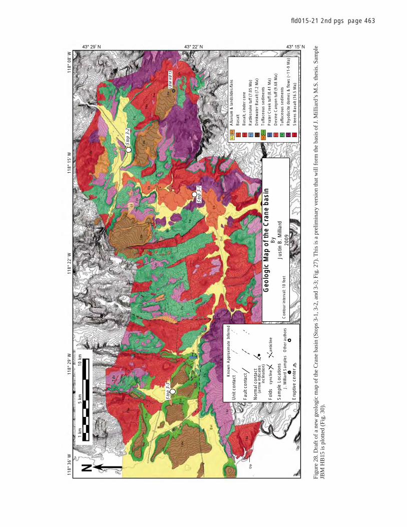
Magmatic and tectonic development, High Lava Plains 463
fl d015-21 2nd pgs page 463
JBM
HB
15
1km
5km
10km
N
Qls
fQ
al Trd
Tdv
Tst
Tsts
Qtp
Tts
Tba
TdwQb
Tpc
Trs
Allu
vium
& la
ndsl
ides
/fans
Rhy
odac
ite d
omes
& fl
ows
(~11
-9 M
a)
Dev
ine
Can
yon
tuff
(9.6
8 M
a)
Ste
ens
Bas
alt (
16.5
Ma)
Drin
kwat
er B
asal
t (7.
2 M
a)
Bas
alt
Bas
alt,
cind
er c
one
Pra
ter
Cre
ek tu
ff (8
.41
Ma)
Rat
tlesn
ake
tuff
(7.0
5 M
a)
Tuf
face
ous
sedi
men
ts
Tuf
face
ous
sedi
men
ts
Geo
log
icM
apo
fth
eC
ran
eb
asin
By
Just
inB
.Mill
iard
2009
Con
tour
inte
rval
: 10
feet
Fau
lt co
ntac
t
Nor
mal
con
tact
(arr
ow in
dica
tes
in
clin
atio
n)
Sam
ple
Loca
tions
J. M
illia
rd S
ampl
esO
ther
aut
hors
Fol
dsan
ticlin
esy
nclin
e
Eru
ptiv
e ce
nter
Uni
t con
tactK
now
nA
ppro
xim
ate
Infe
rred
Tdw
Qal
Tdv
Tba
Qtp
Tst
s
Tba
Tts
Qls
Tst
s
Tdv
Tts
Trd
Tdv
Qal
Trd
Qb
Tts
Tdw
Tdv
Tst
Qb
Tba
Tdw
TrdTt
s
Tba
Tst
Tdv
Tdw
Qf
Trs
Sto
p3-
1
Sto
p3-
2
Sto
p3-
3
118°
36'W
118°
08'
' ' '
W11
8°22
'W11
8°29
'W11
8°15
'W
Figu
re 2
8. D
raft
of a
new
geo
logi
c m
ap o
f the
Cra
ne b
asin
(Sto
ps 3
-1, 3
-2, a
nd 3
-3; F
ig. 2
7). T
his
is a
pre
limin
ary
vers
ion
that
will
form
the
basi
s of
J. M
illia
rd’s
M.S
. the
sis.
Sam
ple
JBM
HB
15 is
plo
tted
(Fig
. 30)
.


Magmatic and tectonic development, High Lava Plains 467
fl d015-21 2nd pgs page 467
42 15
TwtQal
Tst
Qs
Tst
Tst
Twt
Twt
Twt
Twt
O
Y
Y
Y
Y
Y
O
O
O
O
O
D
U
U
U
D
D
U D
O Y
Y
Tob
Tob
Qs
Qal
Tsv
Tsv
Tsv
Tsv
Tsv
DU
D U
2
1
Ta
1
2
1
1
Ta
Qls
Qal
Qcl
2
U D
80
20
62
18
59
56
28
YYTob1 Y
5
6
4
UD
Faults- decreasing degree of certainty for location, dotted where hidden bar and ball on down thrown side, U&D show relative motion accross fault
Approximate vent locationDike
Qal
Qcl
Joint with dip
Strike and dip of structures surface
10
10 Strike and dip of foliation
Vertical joint
42
62
S3-4
13-2
Qs
stTst
Tst
Twt
Twt
Qal
4
Qs
36 23
23.866
Mesozoic
Late Cretaceous Paleocene Oligocene Miocene Cretaceous Paleogene
Eocene12
John Day Fm. volcanism
Age (Ma) 33.7
Cenozoic
Pliocene PleistoceneNeogene
High Lava Plains volcanism54.8
Holocene
Ta
Qs
QlsQcl
Tst
Twt
Tsv2
Tsv1
Tob1
Tob2
Qal
Rhyodacite
Dacite
Andesite
Basalt
Hampton Tuff
Basalt
Siliceous tuffaceous sediments
*
16°
TN
MN
03/04/08
Kilometers
Meters
00
1.5110001000
Twt
Quaternary sediments
Landslide debrisQuaternary alluvium
Quaternary colluvium
43°
47.0
00 N
43°
46.0
00 N
43°
45.0
00 N
43°
44.0
00 N
43°
43.0
00 N
43°
43.0
00 N
120° 19.000 W 120° 18.000 W 120° 17.000 W 120° 16.000 W 120° 15.000 W
120° 21.000 W 120° 20.000 W 120° 19.000 W 120° 18.000 W 120° 17.000 W 120° 16.000 W 120° 15.000 W
120° 20.000 W120° 21.000 W
43°
47.0
00 N
43°
46.0
00 N
43°
45.0
00 N
43°
44.0
00 N
43°
43.0
00 N
43°
43.0
00 N
Figure 34 (Stop 3-4). Hampton Butte geologic map for Stop 3-4 (Fig. 27) Preliminary version that will form the basis of M. Iademarco’s M.S. thesis.

468 Meigs et al.
fl d015-21 2nd pgs page 468
REFERENCES CITED
Allison, I.S., 1982, Geology of Pluvial Lake Chewaucan, Lake County, Oregon: Corvallis, Oregon State University Press, 79 p.
Arestad, J.F., Potter, R.W., and Stewart, G.E., 1988, Stratigraphic test drilling in the Newberry Crater KGRA, Oregon: Geothermal Resources Council Bulletin, v. 17, p. 3–8.
Armstrong, R.L., and Ward, P., 1991, Evolving geographic patterns of the Cenozoic magmatism in the North American Cordillera: the temporal and spatial asso-ciation of magmatism and metamorphic core complexes: Journal of Geophysi-cal Research, v. 96, p. 13,201–13,224, doi: 10.1029/91JB00412.
Armstrong, R.L., Taubeneck, W.H., and Hales, P.O., 1977, Rb-Sr and K-Ar geochronometry of Mesozoic granitic rocks and the Sr isotopic composi-tion, Oregon, Washington and Idaho: Geological Society of America Bul-letin, v. 81, p. 3513–3536.
Atwater, T., and Stock, J., 1998, Pacifi c-North America Plate Tectonics of the Neogene Southwestern United States: An Update: International Geology Review, v. 40, p. 375–402, doi: 10.1080/00206819809465216.
Bachmann, O., and Bergantz, G.W., 2004, On the origin of crystal-pore rhy-olites; extracted from batholithic crystal mushes: Journal of Petrology, v. 45, p. 1565–1582, doi: 10.1093/petrology/egh019.
Bacon, C.R., 2008, Geologic map of Mount Mazama and Crater Lake caldera, Oregon: U.S. Geological Survey Scientifi c Investigations Map, v. 2832.
Bacon, C.R., Bruggman, P.E., Christiansen, R.L., Clynne, M.A., Donnelly-Nolan, J.M., and Hildreth, W., 1997, Primitive magmas at fi ve Cascades volcanic fi elds: melts from hot, heterogeneous sub-arc mantle: Canadian Mineralogist, v. 35, p. 397–423.
Badger, T.C., and Watters, R.J., 2004, Gigantic seismogenic landslides of Sum-mer Lake basin, south-central Oregon: Geological Society of America Bulletin, v. 116, p. 687–697, doi: 10.1130/B25333.1.
Bartels, K.S., Kinzler, R.J., and Grove, T.L., 1991, High pressure phase rela-tions of primitive high-alumina basalts from Medicine Lake volcano, northern California: Contributions to Mineralogy and Petrology, v. 108, p. 253–270, doi: 10.1007/BF00285935.
Bennett, R.A., Wernicke, B.P., Niemi, N.A., Friedrich, A.M., and Davis, J.L., 2003, Contemporary strain rates in the northern Basin and Range Prov-ince from GPS data: Tectonics, v. 22.
Best, M.G., and Christiansen, E.H., 1991, Limited extension during peak Ter-tiary volcanism, Great Basin of Nevada and Utah: Journal of Geophysical Research, v. 96, p. 13.
Brueseke, M.E., and Hart, W.K., 2008, Geology and petrology of the mid- Miocene Santa Rosa–Calico volcanic fi eld, northern Nevada: Nevada Bureau of Mines and Geology Bulletin, v. 70, p. 343-360.
Brueseke, M.E., Heizler, M.T., Hart, W.K., and Mertzman, S.A., 2007, Distri-bution and geochronology of Oregon Plateau (U.S.A.) fl ood basalt volca-nism; the Steens Basalt revisited: Journal of Volcanology and Geothermal Research, v. 161, p. 187–214, doi: 10.1016/j.jvolgeores.2006.12.004.
Camp, V.E., Ross, M.E., and Hanson, W.E., 2003, Genesis of fl ood basalts and Basin and Range volcanic rocks from Steens Mountain to the Malheur River Gorge, Oregon: Geological Society of America Bulletin, v. 115, p. 105–128, doi: 10.1130/0016-7606(2003)115<0105:GOFBAB>2.0.CO;2.
Carlson, R.W., and Hart, W.K., 1987, Crustal Genesis on the Oregon Plateau: Journal of Geophysical Research, v. 92, p. 6191–6208, doi: 10.1029/JB092iB07p06191.
Castor, S.B., and Henry, C.D., 2000, Geology, Geochemistry, and origin of vol-canic rock-hosted uranium deposits in northwestern Nevada and south-eastern Oregon, USA: Ore Geology Reviews, v. 16, p. 1–40, doi: 10.1016/S0169-1368(99)00021-9.
Catchings, R.D., and Mooney, W.D., 1988, Crustal structure of east central Ore-gon; relation between Newberry Volcano and regional crustal structure: Journal of Geophysical Research, v. 93, p. 10,081–10,094.
Christiansen, E.H., and McCurry, M., 2008, Contrasting origins of Cenozoic silicic volcanic rocks from the western Cordillera of the United States Bulletin of Volcanology, v. 70, p. 251–267.
Christiansen, R.L., and McKee, E.H., 1978, Late Cenozoic volcanic and tec-tonic evolution of the Great Basin and Columbia Intermontane regions, in Smith, R.B., and Eaton, G.P., eds., Cenozoic tectonics and regional geophysics of the western Cordillera: Geological Society of America Memoir 152, p. 283–311.
Christiansen, R.L., and Yeats, R.S., 1992, Post-Laramide geology of the U.S. Cordilleran region, in Burchfi el, B.C., Lipman, P.W., and Zoback, M.L.,
eds., The Cordilleran Orogen, Conterminous U.S.: Geological Society of America, Geology of North America, v. G-3, p. 261–406.
Christiansen, R.L., Evans, J.R., and Foulger, G.R., 2002, Upper-mantle ori-gin of the Yellowstone Hotspot: Geological Society of America Bul-letin, v. 114, p. 1245–1256, doi: 10.1130/0016-7606(2002)114<1245:UMOOTY>2.0.CO;2.
Colgan, J.P., Dumitru, T.A., McWilliams, M.O., and Miller, E.L., 2006, Timing of Cenozoic volcanism and Basin and Range extension in northwestern Nevada; new constraints from the northern Pine Forest Range: Geological Society of America Bulletin, v. 118, p. 126–139, doi: 10.1130/B25681.1.
Coney, P.J., and Reynolds, S.J., 1977, Cordilleran Benioff zones: Nature, v. 270, p. 403–406, doi: 10.1038/270403a0.
Conrad, W.K., 1984, The mineralogy and petrology of compositionally zoned ash fl ow tuffs, and related silicic volcanic rocks, from the McDermitt cal-dera complex, Nevada-Oregon: Journal of Geophysical Research, v. 89, p. 8639–8664, doi: 10.1029/JB089iB10p08639.
Conrey, R.M., Donnelly-Nolan, J.M., and Taylor, E.M., 2000, The north-central Cascade margin: exploring petrologic and tectonic intimacy in a propagat-ing intra-arc rift: MARGINS 2000 Meeting Field Guide, p. 61.
Conrey, R.M., Sherrod, D.R., Hooper, P.R., and Swanson, D.A., 1997, Diverse, primitive magmas in the Cascade arc, northeast Oregon and southern Washington: Canadian Mineralogist, v. 35, p. 367–396.
Crider, J.G., 2001, Oblique slip and the geometry of normal-fault linkage: mechan-ics and case study from the Basin and Range in Oregon: Journal of Structural Geology, v. 23, p. 1997–2009, doi: 10.1016/S0191-8141(01)00047-5.
Davis, J.O., 1985, Correlation of Late Quaternary tephra layers in a long plu-vial sequence near Summer Lake, Oregon: Quaternary Research, v. 23, p. 38–53, doi: 10.1016/0033-5894(85)90070-5.
Dickinson, W.R., 1979, Mesozoic forearc basin in central Oregon: Geology, v. 7, p. 166–170, doi: 10.1130/0091-7613(1979)7<166:MFBICO>2.0.CO;2.
Donath, F.A., 1962, Analysis of basin-range structure, south-central Ore-gon: Geological Society of America Bulletin, v. 73, p. 1–16, doi: 10.1130/0016-7606(1962)73[1:AOBSSO]2.0.CO;2.
Dugas, D.P., 1998, Late Quaternary variations in the level of paleo-Lake Malheur, eastern Oregon: Quaternary Research, v. 50, p. 276–282, doi: 10.1006/qres.1998.2005.
Ekren, E.B., McIntyre, D.H., Bennett, E.H., and Marvin, R.F., 1982, Cenozoic stratigraphy of western Owyhee County, Idaho, in Bonnichsen, B., and Breckenridge, R.M., eds., Cenozoic Geology of Idaho, Volume 26, Idaho Bureau of Mines Geology Bulletin, p. 215–235.
Faulds, J.E., and Varga, R.J., 1998, The role of accommodation zones and trans-fer zones in the regional segmentation of extended terranes, in Faulds, J.E., and Stewart, J.H., Accommodation Zones and Transfer Zones: The Regional Segmentation of the Basin and Range Province: Geological Society of America Special Paper 323, p. 1–45.
Faulds, J.E., Henry, C.D., and Hinz, N.H., 2005, Kinematics of the northern Walker Lane; an incipient transform fault along the Pacifi c-North Ameri-can Plate boundary: Geology, v. 33, p. 505–508, doi: 10.1130/G21274.1.
Fiebelkorn, R.B., Walker, G.W., MacLeod, N.S., McKee, E.H., and Smith, J.G., 1983, Isochron/WestIndex to K-Ar determinations for the State of Oregon: Isochron/West, v. 37.
Ford, M.T., McCurry, M., and Chadwick, J., 2004, Genesis of Quaternary rhyo-lite domes of the eastern Snake River plain and Blackfoot volcanic fi eld, SE Idaho: Geological Society of America Abstracts with Programs, v. 36, no. 4, p. 11.
Gans, P.B., Mahood, G.A., and Schermer, E.R., 1989, Synextensional magma-tism in the Basin and Range Province; a case study from the eastern Great Basin: Geological Society of America Special Paper 233, 60 p.
Greene, R.C., 1973, Petrology of the welded tuff of Devine Canyon, south-eastern Oregon: U.S. Geological Survey Professional Paper 797, p. 1–26.
Greene, R.C., Walker, G.W., and Corcoran, R.E., 1972, Geologic map of the Burns quadrangle, Oregon: Reston, Virginia, U.S. Geological Survey. Miscellaneous Geologic Investigations Map I-680.
Gudmundsson, A., Brynjolfsson, S., and Jonsson, M.T., 1993, Structural analy-sis of a transform fault-rift zone junction in North Iceland: Tectonophys-ics, v. 220, p. 205–221, doi: 10.1016/0040-1951(93)90232-9.
Hammond, W.C., and Thatcher, W., 2005, Northwest Basin and Range tectonic deformation observed with the Global Positioning System, 1999–2003: Journal of Geophysical Research, v. 110, p. 12.
Hart, W.K., 1985, Chemical and isotopic evidence for mixing between depleted and enriched mantle, northwestern U.S.A: Geochimica et Cosmochimica Acta, v. 49, p. 131–144, doi: 10.1016/0016-7037(85)90197-8.

Magmatic and tectonic development, High Lava Plains 469
fl d015-21 2nd pgs page 469
Hart, W.K., Aronson, J.L., and Mertzman, S.A., 1984, Areal distribution and age of low-K, high-alumina olivine tholeiite magmatism in the northwest-ern Great Basin: Geological Society of America Bulletin, v. 95, p. 186–195, doi: 10.1130/0016-7606(1984)95<186:ADAAOL>2.0.CO;2.
Hildreth, W., 2004, Volcanological perspectives on Long Valley, Mammoth Mountain, and Mono Craters; several contiguous but discrete systems: Journal of Volcanology and Geothermal Research, v. 136, p. 169–198.
Hooper, P.R., Mahoney, J.J., and Coffi n, M.F., 1997, The Columbia River fl ood basalt province: current status, Large Igneous Provinces: Washington, American Geophysical Union, p. 1–28.
Hooper, P.R., Binger, G.B., and Lees, K.R., 2002, Ages of the Steens and Columbia River fl ood basalts and their relationship to extension-related calc-alkalic volcanism in eastern Oregon: Geological Society of Amer-ica Bulletin, v. 114, p. 43–50, doi: 10.1130/0016-7606(2002)114<0043:AOTSAC>2.0.CO;2.
Humphreys, E.D., 1995, Post-Laramide removal of the Farallon Slab: Western United States: Geology, v. 23, p. 987–990, doi: 10.1130/0091-7613(1995)023<0987:PLROTF>2.3.CO;2.
Humphreys, E.D., and Coblentz, D.D., 2007, North American dynamics and Western U. S. tectonics: Reviews of Geophysics, v. 45, RG3001, doi: 10.1029/2005RG000181.
Iademarco, M.J., 2009, Volcanism and Faulting along the Northern Margin of Oregon’s High Lava Plains: Hampton Butte to Dry Mountain [M.S. the-sis]: Corvallis, Oregon, Oregon State University, p. 150.
Jensen, R.A., 2006, Roadside guide to the geology and history of Newberry Volcano: Bend, Oregon, CenOreGeoPub, 182 p.
Jensen, R.A., Donnelly-Nolan, J.M., and Mckay, D.M., 2009, A fi eld guide to Newberry Volcano, Oregon, in O’Connor, J.E., Dorsey, R.J., and Madin, I.P., eds., Volcanoes to Vineyards: Geologic Field Trips through the Dynamic Landscape of the Pacifi c Northwest: Geological Society of America Field Guide 15, doi: 10.1130/2009.fl d015(03).
Johnson, J.A., 1995, Geologic evolution of the Duck Creek Butte eruptive center, High Lava Plains, southeastern Oregon [M.S. thesis]: Corvallis, Oregon, Oregon State university, 151 p.
Johnson, J.A., and Grunder, A.L., 2000, The making of intermediate compo-sition magma in a bimodal suite; Duck Butte eruptive center, Oregon, USA: Journal of Volcanology and Geothermal Research, v. 95, p. 175, doi: 10.1016/S0377-0273(99)00125-0.
Johnson, J.A., Hawkesworth, C.J., Hooper, P.R., and Binger, G.B., 1998, Major- and trace-element analyses of Steens Basalt, southeastern Oregon: U.S. Geological Survey Open-File Report 0196-1497, p. 30.
Jónasson, K., 2007, Silicic volcanism in Iceland: Composition and distribution within the active volcanic zones: Journal of Geodynamics, v. 43, p. 101–117, doi: 10.1016/j.jog.2006.09.004.
Jordan, B.T., Streck, M.J., and Grunder, A.L., 2002, Bimodal volcanism and tectonism of the High Lava Plains, Oregon: Oregon Department of Geol-ogy and Mineral Industries, Special Paper, v. 36, p. 23.
Jordan, B.T., Grunder, A.L., Duncam, R.A., and Deino, A.L., 2004, Geochro-nology of age-progressive volcanism of the Oregon High Lava Plains: Implications for the plume interpretation of Yellowstone: Journal of Geo-physical Research, v. 109, B10202, doi: 10.1029/2003JB002776.
Keller, G.R., Hildenbrand, T.G., Kucks, R., Roman, D., and Hittleman, A.M., 2002, Upgraded gravity anomaly base of the United States: Leading Edge, v. 21, p. 366–367, doi: 10.1190/1.1471598.
Langer, V.W., 1991, Geology and petrologic evolution of silicic and intermedi-ate volcanic rocks underneath Steens Mountain Basalt, SE Oregon [M.S. Thesis]: Corvallis, Oregon State University, 109 p.
Langridge, R., Pezzopane, S., and Weldon, R., 2001, Slip rate, recurrence inter-vals, and paleoearthquakes for the Ana River Fault, central Oregon, in Negrini, R., Pezzopane, S., and Badger, T., eds., Quaternary Studies near Summer Lake, Oregon: Bakersfi eld, Friends of the Pleistocene, Pacifi c Northwest Cell, p. RL1–12.
Lawrence, R.D., 1976, Strike-slip faulting terminates the Basin and Range Province in Oregon: Geological Society of America Bulletin, v. 87, p. 846–850, doi: 10.1130/0016-7606(1976)87<846:SFTTBA>2.0.CO;2.
Leeman, W.P., 1982, Olivine tholeiitic basalts of the Snake River Plain, Idaho, in Bonnichsen, B., and Breckenridge, R.M., eds., Cenozoic Geology of Idaho: Idaho Bureau of Mines and Geology Bulletin, v. 26, p. 181–191.
Lerch, D.W., Miller, E., McWilliams, M., and Colgan, J., 2008, Tectonic and mag-matic evolution of the northwestern Basin and Range and its transition to unex-tended volcanic plateaus: Black Rock Range, Nevada: Geological Society of America Bulletin, v. 120, p. 300–311, doi: 10.1130/B26151.1.
Lipman, P.W., Prostka, H.J., and Christiansen, R.L., 1972, Cenozoic volcanism and plate tectonic evolution of the western United States, I: Philosophical Transactions of the Royal Society of London. Series A: Mathematical and Physical Sciences, v. 271, p. 217–248, doi: 10.1098/rsta.1972.0008.
Luedke, R.G., and Smith, R.L., 1984, Map showing distribution, composition, and age of late Cenozoic volcanic centers in the western conterminous United States: U.S. Geological Survey Miscellaneous Investigations Series Map I-1523, scale 1:2,500,000.
MacLeod, N.S., Walker, G.W., and McKee, E.H., 1975, Geothermal signifi cance of eastward increase in age of upper Cenozoic rhyolitic domes in southeast-ern Oregon: U.S. Geological Survey Open-File Report 75-034, 21 p.
MacLeod, N.S., Sherrod, D.R., Chitwood, L.A., and Jensen, R.A., 1995, Geo-logic map of Newberry volcano, Deschutes, Klamath, and Lake coun-ties, Oregon: U.S. Geological Survey Miscellaneous Investigations Map I2455, scale 1:62,500 and 1:24,000.
Manduca, C.A., Silver, L.T., and Taylor, H.P., 1992, 87Sr/86Sr and 18O/16O iso-topic systematics and geochemistry of granitoid plutons across a steeply-dipping boundary between contrasting lithospheric blocks in western Idaho: Contributions to Mineralogy and Petrology, v. 109, p. 355–372, doi: 10.1007/BF00283324.
Mankinen, E.A., Larson, E.E., Gromme, C.S., Prevot, M., and Coe, R.S., 1987, The Steens Mountain (Oregon) geomagnetic polarity transition; 3, Its regional signifi cance: Journal of Geophysical Research, v. 92, p. 8057–8076, doi: 10.1029/JB092iB08p08057.
Mathis, A.C., 1993, Geology and petrology of a 26-Ma trachybasalt to peral-kaline rhyolite suite exposed at Hart Mountain, southern Oregon [M.S. thesis]: Corvallis, Oregon State University, 141 p.
McCaffrey, R., Long, M.D., Goldfi nger, C., Zwick, P.C., Nabelek, J.L., John-son, C.K., and Smith, C., 2000, Rotation and plate locking at the southern Cascadia subduction zone: Geophysical Research Letters, v. 27, p. 3117–3120, doi: 10.1029/2000GL011768.
McCurry, M., Hayden, K.P., Morse, L.H., and Mertzman, S., 2008, Genesis of post-hotspot, A-type rhyolite of the Eastern Snake River Plain volcanic fi eld by extreme fractional crystallization of olivine tholeiite: Bulletin of Volcanology, v. 70, p. 361–383, doi: 10.1007/s00445-007-0143-4.
McDonough, W.F., and Sun, S.-s., 1995, The composition of the Earth: Chemi-cal Geology, v. 120, p. 223–253, doi: 10.1016/0009-2541(94)00140-4.
McKee, E.H., Duffi eld, W.A., and Stern, R.J., 1983, Late Miocene and early Pliocene basaltic rocks and their implications for crustal structure, north-eastern California and south-central Oregon: Geological Society of Amer-ica Bulletin, v. 94, p. 292–304, doi: 10.1130/0016-7606(1983)94<292:LMAEPB>2.0.CO;2.
Miller, M.M., Dixon, T.H., Dokka, R.K., and Johnson, D.J., 2001, Refi ned kinematics of the Eastern California shear zone from GPS observations, 1993–1998: Journal of Geophysical Research, v. 106, p. 2245–2263, doi: 10.1029/2000JB900328.
Minor, S.A., Plouff, D., Esparaza, L.E., and Peters, T.J., 1987, Mineral resources of the High Steens and Little Blitzen Gorge Wilderness Study Areas, Harney County, Oregon: U.S. Geological Survey Bulletin 8755-531X p. A1–A21.
Oldow, J.S., Carlson, R.L., and Kobayashi, K., 1984, Evolution of a late Meso-zoic back-arc fold and thrust belt, northwestern Great Basin, U.S.A: Geo-dynamics of back-arc regions, v. 102, p. 245–274.
Peterson, N.V., and Groh, E.A., 1964, Crack-in-the-Ground, Lake County, Ore-gon: Oregon Department of Geology and Mineral Industries: Portland, Oregon, Ore Bin, v. 26, p. 158–166.
Pezzopane, S., 2001, Pluvial Lake Chewaucan shoreline elevations, in Negrini, R., Pezzopane, S., and Badger, T., eds., Quaternary Studies near Summer Lake, Oregon: Bakersfi eld, Friends of the Pleistocene, Pacifi c Northwest Cell, p. SP1–5.
Pezzopane, S.K., and Weldon, R.J., II, 1993, Tectonic role of active faulting in central Oregon: Tectonics, v. 12, p. 1140–1169.
Pierce, K.L., and Morgan, L.A., 1992, The track of the Yellowstone hot spot: Volcanism, faulting, and uplift, in Link, P.K., Kuntz, M.A., and Platt, L.B., eds., Regional Geology of Eastern Idaho and Western Wyoming: Geological Society of America Memoir 179, p. 1–53.
Pierce, K.L., Morgan, L.A., and Saltus, R.W., 2000, Yellowstone plume head: postulated tectonic relations to the Vancouver slab, continental boundaries, and climate: U.S. Geological Survey Open File Report 2000-498, p. 25.
Roth, J.B., Fouch, M.J., James, D.E., and Carlson, R.W., 2008, 3D seis-mic velocity structure of the northwestern United States: Geophysical Research Letters, v. 35, p. L15304, doi: 10.1029/2008GL034669.

470 Meigs et al.
fl d015-21 2nd pgs page 470
Russell, J.K., Nixon, G.T., and Pearce, T.H., 1988, Petrographic constraints on modelling the crystallization of basalt magma, Cow Lakes, Southeast Oregon: Canadian Journal of Earth Sciences (Revue Canadienne des Sci-ences de la Terre), v. 25, p. 486–494.
Rytuba, J.J., and McKee, E.H., 1984, Peralkaline ash fl ow tuffs and calderas of the McDermitt volcanic fi eld, Southeast Oregon and north central Nevada: Journal of Geophysical Research, v. 89, p. 8616–8628.
Scarberry, K., Grunder, A., and Meigs, A., 2007, Transition from intermedi-ate to bimodal volcanism and inception and style of extensional faulting within the margin of the basin and range province, southern Oregon: Eos (Transactions, American Geophysical Union), v. 88.
Scarberry, K., Meigs, A., and Grunder, A., 2009, Inception and style of fault-ing at the edge of a propagating continental rift system: Insight from the structural development of the Abert Rim fault, southern Oregon: Tectono-physics (in press).
Seedorff, E., Raines, G.L., Lisle, R.E., Schafer, R.W., and Wilkinson, W.H., 1991, Magmatism, extension, and ore deposits of Eocene to Holocene age in the Great Basin; mutual effects and preliminary proposed genetic relationships Geology and ore deposits of the Great Basin; symposium proceedings: Reno, Nevada, Geological Society of Nevada, p. 133–178.
Sherrod, D.R., and Smith, J.G., 1990, Quaternary extrusion rates of the Cas-cade Range, northwestern Unites States and southern British Columbia: Journal of Geophysical Research, v. 95, p. 19465–19747, doi: 10.1029/JB095iB12p19465.
Sherrod, D.R., Mastin, L.G., Scott, W.E., and Schilling, S.P., 1997, Volcano hazards at Newberry volcano, Oregon: U.S. Geological Survey Open-File Report 97-513, 14 p.
Shoemaker, K.A., and Hart, W.K., 2001, Time-space patterns of basaltic volca-nism on the Owyhee Plateau, Oregon-Nevada-Idaho: Geological Society of America Abstracts with Programs, v. 33, no. 6, p. 139.
Stewart, J.H., and Carlson, J.E., 1974, Preliminary geologic map of Nevada, U.S. Geological Survey Miscellaneous Field Studies Map, MF-609, scale 1:500,000.
Streck, M.J., 2002, Partial melting to produce high-silica rhyolites of a young bimodal suite; compositional constraints among rhyolites, basalts, and metamorphic xenoliths from the Harney Basin, Oregon: Berlin, Federal Republic of Germany, Springer International, Geologische Rundschau (International Journal of Earth Sciences), v. 91, p. 583–593.
Streck, M.J., and Grunder, A.L., 1995, Crystallization and welding variations in a widespread ignimbrite sheet; the Rattlesnake Tuff, eastern Oregon, USA: Bulletin of Volcanology, v. 57, p. 151–169.
Streck, M.J., and Grunder, A.L., 1997, Compositional gradients and gaps in high-silica rhyolites of the Rattlesnake Tuff, Oregon: Journal of Petrol-ogy, v. 38, p. 133–163, doi: 10.1093/petrology/38.1.133.
Streck, M.J., and Grunder, A.L., 1999, Enrichment of basalt and mixing of dacite in the rootzone of a large rhyolite chamber: inclusions and pum-ices from the Rattlesnake Tuff, Oregon: Contributions to Mineralogy and Petrology, v. 136, p. 193–212, doi: 10.1007/s004100050532.
Streck, M.J., and Grunder, A.L., 2008, Phenocryst-poor rhyolites of bimodal, tholeiitic provinces: the Rattlesnake Tuff and implications for mush extraction models: Bulletin of Volcanology, v. 70, p. 385–401, doi: 10.1007/s00445-007-0144-3.
Suppe, J., Powell, C., and Berry, R., 1975, Regional topography, seismic-ity, Quaternary volcanism, and the present day tectonics of the western United States: American Journal of Science, v. 275A, p. 397–417.
Trehu, A.M., Asudeh, I., Brocher, T.M., Luetgert, J.H., Mooney, W.D., Nabelek, J.L., and Nakamura, Y., 1994, Crustal architecture of the Cascadia Forearc: Science, v. 266, p. 237–243, doi: 10.1126/science.266.5183.237.
Trench, D., 2008, The Termination of the Basin and Range Province into a Clockwise Rotating Region of Transtension and Volcanism, Central Ore-gon [M.S. thesis]: Corvallis, Oregon State University, 64 p.
Vallier, T.L., 1995, Petrology of pre-Tertiary igneous rocks in the Blue Moun-tains region of Oregon, Idaho, and Washington; implications for the geo-logic evolution of a complex island arc: U.S. Geological Survey Profes-sional Paper 1438, p. 125–209.
Walker, G.W., 1979, Revisions to the Cenozoic stratigraphy of Harney Basin, southeastern Oregon: U.S. Geological Survey Bulletin 1475, 35 p.
Walker, G.W., and MacLeod, N.S., 1991, Geologic Map of Oregon: Denver, U.S. Geological Survey, scale: 1:500,000.
Wells, R.E., 1980, Drake Peak; a structurally complex rhyolite center in southeastern Oregon: U.S. Geological Survey Professional Paper 1124, p. E1–E16.
Wells, R.E., and Heller, P.L., 1988, The relative contribution of accretion, shear, and extension to Cenozoic tectonic rotation in the Pacifi c North-west: Geological Society of America Bulletin, v. 100, p. 325–338, doi: 10.1130/0016-7606(1988)100<0325:TRCOAS>2.3.CO;2.
Wells, R.E., and Simpson, R.W., 2001, Northward migration of the Cascadia forearc in the northwestern U.S. and implications for subduction deforma-tion: Earth, Planets, and Space, v. 53, p. 275–283.
Wells, R.E., Weaver, C.S., and Blakely, R.J., 1998, Fore arc migration in Cas-cadia and its neotectonic signifi cance: Geology, v. 26, p. 759–762, doi: 10.1130/0091-7613(1998)026<0759:FAMICA>2.3.CO;2.
Wernicke, B.P., 1992, Cenozoic extensional tectonics of the U.S. Cordillera in Burchfi el, B.C., Lipman, P.W., and Zoback, M.L., eds., Cordilleran Orogen; conterminous U.S.: Geological Society of America, Geology of North America, v. G-3, p. 553–581.
Wesnousky, S.G., 2005, Neotectonics and contemporary strain accumulation across the Walker Lane and northern Great Basin, USA: Eos (Transac-tions, American Geophysical Union), v. 86 p. g51d.
Whitaker, M.L., Nekvasil, H., Lindsley, D.H., and McCurry, M., 2008, Can crystallization of olivine tholeiite give rise to potassic rhyolites? An experimental investigation: Bulletin of Volcanology, v. 70, p. 417–434, doi: 10.1007/s00445-007-0146-1.
Zandt, G., and Humphreys, E., 2008, Toroidal mantle fl ow through the Western U.S. slab window: Geology, v. 36, p. 295–298, doi: 10.1130/G24611A.1.
Zoback, M.L., 1989, State of stress and modern deformation of the north-ern Basin and Range Province Journal of Geophysical Research, v. 94, p. 7105–7128.
Zoback, M.L., McKee, E.H., Blakely, R.J., and Thompson, G.A., 1994, The northern Nevada rift: regional tectono-magmatic relations and Middle Miocene stress direction: Geological Society of America Bulletin, v. 106, p. 371–382, doi: 10.1130/0016-7606(1994)106<0371:TNNRRT>2.3.CO;2.
MANUSCRIPT ACCEPTED BY THE SOCIETY 17 JULY 2009
Printed in the USA