celebrating taws 'saves': but lessons still to be learnt
TRANSCRIPT

Celebrating TAWS ‘Saves’: But lessons still to be learnt.
Introduction This paper reviews six approach and landing incidents involving controlled flight towards terrain (CFTT). All had the potential for a fatal accident, but this outcome was avoided by the Terrain Awareness Warning System (TAWS) alerting the crews to the hazard. The following review of the circumstances and precursors that lead to these incidents indicate that the industry still has much to learn or remember about how to identify and counter latent threats particularly during the approach and landing phase.
In addition, the industry still has to maintain focus on the problems of human error, particularly those situations which have potential for error or containing threats that were either not identified or were mismanaged. There were many errors in human thought and behaviour. Several common features were identified; most had been seen in previous controlled flight into terrain (CFIT) accidents.
The objective of this paper is to promote the values of sharing safety information. None of the operators, aircraft, or crew involved in these incidents is identified; indeed the review and subsequent communication processes do not require these details in order to be highly effective safety tools. Thus this paper provides an example of how successful confidential reporting and local investigation can be providing crews submit safety reports and the operators undertake an open, ‘blame free’ investigation.
Background
Throughout the history of aviation, CFIT has been a major cause of fatal accidents. In response to this hazard, the industry developed and implemented the Ground Proximity Warning System (GPWS), which automatically warned pilots if the aircraft was dangerously approaching the ground. Since the mandate for large airplanes to carry GPWS in 1974, the number of CFIT accidents reduced significantly (Figure 1). In 2000, the requirements were extended to smaller commuter planes.
GPWS is limited in only being able to detect terrain directly below the aircraft. If there is a sharp change in terrain, GPWS does not detect the aircraft closure rate until it is too late for evasive action. Furthermore, the detection logic has to be switched to enable aircraft to land without unwarranted warnings, thus, when the airplane is configured for landing the GPWS will not warn of insufficient terrain clearance. Even so, the system has been very successful as indicated by the marked reduction in the accident rate.
To overcome the limitations of GPWS, a new technology Enhanced Ground Proximity Warning System (EGWPS) was introduced; which combines a worldwide digital terrain database with an accurate navigation system, ideally using the Global Positioning System. The aircraft’s navigation position is compared with a database of the Earth's terrain; if there is a discrepancy, pilots receive a timely caution or warning of terrain hazards. EGPWS or generically TAWS, will provide a warning in advance of steeply rising ground and also extends the warning area almost to the runway threshold, overcoming the limitations of GPWS.
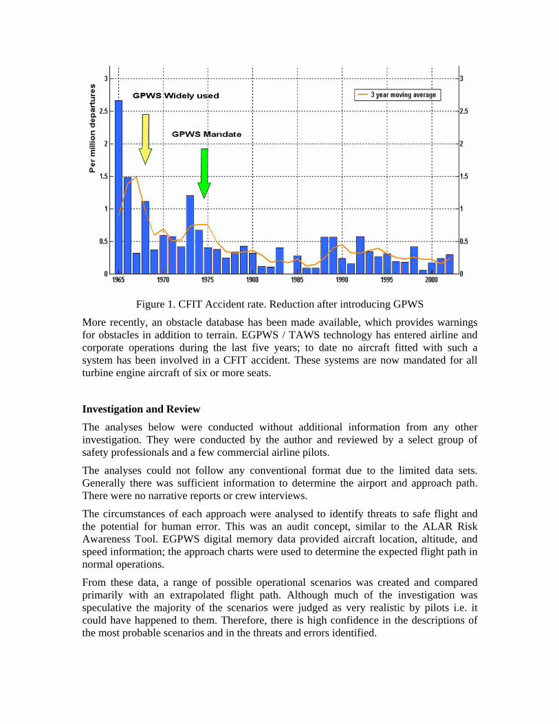
Figure 1. CFIT Accident rate. Reduction after introducing GPWS
More recently, an obstacle database has been made available, which provides warnings for obstacles in addition to terrain. EGPWS / TAWS technology has entered airline and corporate operations during the last five years; to date no aircraft fitted with such a system has been involved in a CFIT accident. These systems are now mandated for all turbine engine aircraft of six or more seats.
Investigation and Review The analyses below were conducted without additional information from any other investigation. They were conducted by the author and reviewed by a select group of safety professionals and a few commercial airline pilots.
The analyses could not follow any conventional format due to the limited data sets. Generally there was sufficient information to determine the airport and approach path. There were no narrative reports or crew interviews.
The circumstances of each approach were analysed to identify threats to safe flight and the potential for human error. This was an audit concept, similar to the ALAR Risk Awareness Tool. EGPWS digital memory data provided aircraft location, altitude, and speed information; the approach charts were used to determine the expected flight path in normal operations.
From these data, a range of possible operational scenarios was created and compared primarily with an extrapolated flight path. Although much of the investigation was speculative the majority of the scenarios were judged as very realistic by pilots i.e. it could have happened to them. Therefore, there is high confidence in the descriptions of the most probable scenarios and in the threats and errors identified.

In this paper, the author uses the notion that error is a categorization of the outcome of human behaviour, something that can only be discovered after the facts are established or by considering ‘what if’; thus, human error should not be seen as a cause of an event or something which is blameworthy.
“Errors…are shaped and provoked by upstream workplace and organizational factors. Identifying an error is merely the beginning of the search for causes, not the end.”
James Reason, ‘Managing the Risks of Organizational Accidents’, Ashgate 1997.
The definition used for threats was slightly wider than usual; an event or situation that was generally outside the influence of the flight crew, but which requires either management intervention or crew attention and action if safety margins are to be maintained.
Threat management allows you to manage your future.
Error management requires you to manage your past. Capt Don Gunther. Continental Airlines
‘Saves’ – An accident avoided. The industry has recorded a number of ‘saves’ where TAWS provided a timely alert to the crew to avoid an accident; some of these events were sufficiently serious that national authority investigations were required, reports of these are expected to be published. Other ‘saves’ have been investigated by operators and manufacturers to gain an understanding of how the aircraft became exposed to a terrain or obstacle hazard and to identify the circumstances that prevented the crew from detecting the threats earlier.
A particular group of incidents, those involving premature final descent for landing, is used in this report to seek answers as to both the nature of the threats and the circumstances of the crew’s behaviour.
There were no common features involving the same operator, size of airline, or world location. However, although the data is from a very small sample, there was some correlation with the well documented factors in previous CFIT accidents (Special Report ‘Killers in Aviation’ – Flight Safety Foundation Digest Nov-Dec 98 Jan-Feb 99).
There were several interesting features in the premature descent incidents.
• They all involved modern, relatively well equipped aircraft with FMS and EFIS; some were capable of flying FMS RNAV and VNAV approaches.
• All of the approaches involved non-precision approach procedures (NPA).

• All but one involved large commercial aircraft.
The premature descents fell into in two broad groups, those beyond 5nm from the runway threshold with warnings given above 500ft above ground level (a.g.l.) and those within 5nm of the threshold with warnings occurring below 500ft a.g.l, The latter group of incidents are the focus of this report. The relationship between altitude and distance to the runway for several incidents is shown in Figure 2.
Figure 2. Warnings (saves) below 500 ft
The TAWS warning boundary shown approximates to the EGPWS ‘Terrain Clearance Floor’ over flat terrain. In reality the boundary is proportional to the terrain for all heights above the runway, thus the warning anticipates high ground on the approach. Alternatively if the aircraft were to be in a valley below a hill-top runway a false terrain datum is provided to generate timely warnings. The altitude at which the warnings were given (figure 2), indicate the actual terrain warning boundary at the incident airport. The incidents are plotted relative to the threshold to enable comparison and analysis. All of the aircraft received warnings in a correct and timely manner.
Note that other TAWS use conceptually similar alerting and warning boundaries; operators should familiarize themselves with the particular equipment fitted to their aircraft, the operational procedures, and limitations.
TAWS Manufactures continually review and if necessary amend their system’s warning boundaries based on the investigation reports of CFIT accidents. Operators should ensure that they have the latest warning boundary software in addition to maintaining a current terrain and obstacle databases.

‘Saves’ – or Unidentified Threats and Errors?
Incident 1. Night visual – modern wide body aircraft FMS VNAV.
The aircraft was making a visual approach to a major airport in a remote geographic area. The crew had a VOR DME approach procedure chart for reference. Figure 3 shows the vertical profile; the Final Approach Fix (FAF) was at 5nm DME (5.4nm from the threshold).
After the FAF the aircraft flew below the expected flight path. A TERRAIN PULL UP warning was given at 250ft agl (125 ft above airport level) at 1.5nm, the aircraft recovered from the 300 ft/min descent for an uneventful landing.
Figure 3. Vertical profile
Several features of the procedure were considered as contributors to the incident; the following items were the pre-existing conditions which could be considered as threats to safety:
• The 3 degree glidepath starts from 4.3 DME and not at the FAF. If the crew misinterpreted this point, an early descent from 5 DME could result in a low flight path.
• Similar problems might occur if the DME information was entered into the FMS for a VNAV approach without cross checking the threshold crossing altitude.
• The DME was not collocated with the runway threshold, thus an early descent could be sustained if the crew were to use DME as a range check believing zero to be at the threshold. Distance information would have to be mentally manipulated – add 0.4nm to all DME ranges; this is the equivalent of 120ft altitude error below the glidepath (3 deg glidepath is approx 300 ft/nm). In addition, the chart depiction of the DME offset was not to scale. The actual distance 0.4nm, was scaled as approx 1.5nm, which could add confusion and opportunity for error in mental calculations; it could also increase mental workload.

• The charted procedure did not have an altitude / range table to aid the crew in monitoring the descent; there was no evidence that the operator or crew had prepared their own table, or that they had programmed a VNAV approach profile; thus the descent was flown unmonitored.
None of the features above were judged to provide a matching scenario for the recorded flight path. This had a noticeable bow shape, consisting of an initial steep descent that slowly flattened out resulting in a low vertical speed. This is typical of a flight path where a pilot follows a false optical cue – the classic ‘black hole approach’. The preconditions for this were present:
• A night visual approach.
• A long straight-in final approach.
• A runway in a remote location, few lights in the local area, but with a town in the distance beyond the airport or to the side.
• Up sloping terrain before the runway.
Black hole conditions induce a visual illusion of the aircraft being high on the approach, which usually results in the aircraft being flown below the optimum glidepath and in the extreme, landing short of the runway.
Lessons to be learnt:
1. Black hole conditions are a pre-existing threat which can be identified, avoided, or at least the effects mitigated by the crew prior to an approach. Threat information can be gained from the chart (approach briefing) and from an airport briefing guide (operator survey / audit). When a black hole threat is identified then additional awareness and monitoring defences must be implemented.
2. Without cross monitoring or intervention alerting the pilot-flying to any flight path deviation, a threat condition can quickly become a significant safety hazard. In black hole conditions there is no point in the pilot-monitoring using the same visual references as the pilot-flying as both could suffer from the same illusion. An altitude / range table or an electronically defined VNAV flight path would provide the basis of independent monitoring, altitude checks should be made every 300ft (1nm).
3. The runway should always be shown on the EFIS map display. If fitted, the vertical profile display must be monitored during final approach.
4. In this incident, if the pilot flew below the optimum glidepath due to a visual illusion; there was inappropriate or no cross monitoring. The safety resources were either unavailable or not used, but primarily the crew’s mental picture of the where the aircraft was in relationship to the runway deteriorated to a hazardous low level. TAWS saved the aircraft from the combination of threats, error provoking situation, and false perception encountered during this approach.

Incident 2. Day IFR. Modern EFIS / FMS – VNAV equipped aircraft
The crew planned to fly the VOR/DME procedure. However, the aircraft commenced descent approximately 4nm before the FAF; a TERRAIN PULL UP warning was given at 540ft at 4.5 nm from the runway. This altitude is above the minimum descent altitude (MDA). The 460 ft/min descent was reversed and the aircraft climbed away safely. The approach procedure and vertical flight profile is shown in Figure 4. An extract of the approach plan view is at Figure 5.
Figure 4. Vertical profile
Figure 5. Approach plan view; dotted box.
The following features were considered as threats to safety:
• The operator uses metric altimeter procedures.
• DME not collocated with threshold.
• Chart ranges not to scale.
• FAF at 11.7 DME gives a long final descent.

• There was an initial approach fix at 25 DME and an intermediate fix at 16 DME; both were shown in a dotted box in the plan view, but not shown on the vertical profile.
A positive safety feature was that the chart had a metric altitude conversion table (m/ft) and an approach altitude / range table, although the altitude was only given in feet.
The most probable sequence of events was that the crew mistook the intermediate fix at 16 DME as being the FAF (11.7 DME) and commenced the descent 4.3nm early. The error could have originated from any of the following issues:
• A simple misinterpretation of the chart. Both pilots confused the intermediate fix in the dotted box (a different range scale from that on the final approach), with the FAF.
• Incorrect FMS programming or misinterpretation of FMS / EFIS waypoints.
Contributory aspects in failing to identify the erroneous descent point:
• Altitude / range not monitored during the descent although a table was provided.
• Descending below the NDB / marker check altitude before over-flying the beacon.
• Airport / runway not programmed as a TO waypoint on the FMS EFIS Map
• Airport / runway not displayed or observed on the EFIS Map - a 12nm final from FAF (11.7 DME), possible inappropriate use of 10nm EFIS Map scale.
• Mistook the EFIS Map ADF symbol for the airport and used an open descent mode or ‘green arc’ descent towards the ADF symbol instead of the runway.
Lessons to be learnt:
1. Simple mistakes or misinterpretations often occur; these must be identified by careful cross checking and monitoring. It is probable that both pilots made the same error, thus SOPs must guard against such occurrences by requiring use of independent charts and a crosscheck of what has been briefed.
2. Special checks or monitoring may be required where non standard procedures or charts are used e.g. metric altimeter operation.
3. Always ensure that the runway is displayed on the EFIS map before commencing a descent. Always check that the aircraft altitude is proportional to the range to touchdown – 11nm for the 3900ft descent. (3 deg is approx 300 ft/nm).
4. It is essential to use altitude as the trigger for the altitude / range cross-check during the descent. If the crew wait for the marker position or specific range they could have already descended below the required check altitude resulting in reduced terrain clearance. In this incident the aircraft should have stopped the descent at the marker altitude, it did not, and the resulting EGPWS warning was given just above the MDA.
Inci
During the descent briefing most crews rigorously check that their chart dates agree, but how many crews cross check if their understandings of the approach agree?

Incident 3. Night VFR (haze) VOR / DME, wide body aircraft.
The aircraft descended 2nm early on a 3 degree flight path. A TERRAIN PULL UP warning was given at 250 ft agl (6.7nm), the aircraft climbed slightly to maintain the MDA. After 1.5 nm of level flight a TOO LOW TERRAIN alert was given, after a short period the aircraft commenced a climb.
The procedure profile and aircraft flight path are shown in Figure 6.
Figure 6. Vertical profile and erroneous flight path
The most probable scenario was that the descent was commenced at 9 DME; there were several contributing factors:
• The approach chart was for a VOR/DME or VOR procedure, but it also included RNAV waypoint symbols and identifiers (FD 09, RW 09) suggesting RNAV use.
• The descent should commence at the FAF at 7 DME, an earlier point at 8nm was shown, but it applied (erroneously) to the VOR lateral procedure.
• The chart plan showed turn points for two groups of aircraft categories (A, B and C, D) at 8 and 9 DME respectively. The chart profile repeated the turn points in an ambiguous layout, which could be interpreted as alternative descent points for different aircraft categories at 8 and 9 DME.
• In addition to the DME distance, the FAF was identified as a FMS waypoint FD09, applicable to runway 09, but the text format and alignment enabled the opportunity for misidentification as a DME position.
• The VOR procedure could also be misinterpreted as requiring 8 or 9 DME ‘alternative’ descent points. This added more confusion as DME would not normally be available during a pure VOR approach. The outbound turn or descent points could not be defined by DME; thus the descent would commence on the inbound leg, but to a higher MDA. It is assumed that these distances were associated with the RNAV symbols, implying a RNAV turn procedure, but not stated as such.

The following possible violation and errors were considered:
• The crew deliberately descended early – duck under, dive and drive procedure.
• The crew suffered from the black hole illusion (the conditions existed).
• The approach was programmed in the FMS. The track might have been automatically construction from the database, or it required the crew to enter a 9 DME waypoint (089/9) on the runway centreline. This would be necessary to give a continuous turn from the 9 mile outbound leg turn point, back on to the centreline. Subsequently the crew mistook the 089/9 way point as the FAF descent point (Figure 7).
• After receiving an EGPWS warning the crew though that they were visual with the (distant) runway, they climbed to MDA and continued the approach, after 1.5nm a further EGPWS warning was given and after a further delay a climb was commenced.
• The runway position was either not displayed or not referred to on the EFIS map.
Figure 7. FMS / crew generated waypoint; erroneous descent point.
Significant safety facts:
• The crew did not monitor altitude / range although a table was provided.
• The crew did not pull up and climb to a safe altitude after the first EGPWS warning.
• The aircraft was flying level at MDA just after the FAF (1500ft lower than required).
• Both crewmembers lost awareness of the progress of the approach; this may have included failing to scan the radio altimeter ( > 500ft before the FAF on a NPA).
Lessons to be learnt:
1. Cross check all FMS generated routings with the charted procedure, then check that all crew members understand the procedure, both from the chart and the FMS / EFIS.
2. The SOP (rule) for crew action in the event of an EGPWS warning must require an immediate climb to a safe altitude; then re-evaluate the situation. MDA is not a ‘safe altitude’ for an EGPWS Pull Up.
3. Monitor altitude / range on all approaches; the altitude element of a constraint or check point must take priority over the range element.

Incident 4. Night VFR. Wrong airport. ‘RJ’ EFIS / FMS equipped aircraft
Turning on to the runway centreline after a DME ARC procedure, the crew became visual with the runway and commenced descent. A TERRAIN alert was given. The crew realised that they were approaching the wrong airport. The alert was given because the mistaken runway was not in the TAWS airport database due to its restricted length. The TAWS database is configurable for runway length according to the operator’s requirements. The approximate flight path is shown in Figure 8.
Figure 8 DME Arc procedure, wrong airport.
Threats and opportunities for error:
• The initial approach procedure requires a 7 DME arc, then over flying the VOR/DME for a straight in approach. The runway is a further 7 nm beyond the beacon. At the transition point from the arc to approach there was a small ‘down-town’ airport within 7 nm distance. The altitude at the arc transition point approximates to the decent point for a final approach to the wrong airport.
• The runway headings are similar, within 30 degrees; terrain could mask any distinguishing or differentiating lighting features between the two airports.
The most likely scenario was that the crew misidentified the runway during the arc transition; the following issues may have contributed to the error:

• Tiredness or fatigue, which may have reduced the capacity for careful thought:
o Loss of mental timing, loss of positional awareness.
o Inability to maintain an accurate mental plan of the approach.
o Poor or no cross checking of the visual position with navigation aids.
• The crew expected to see a runway, ‘wish thinking’, enabling misidentification.
• There were several potential threats that would contribute to a ‘mental map shift’:
o Similar in runway headings,
o Similar altitudes, 1600 ft procedure turn and 1620 ft check altitude on final.
o The same distances between the arc transition point to the DME beacon, and between the DME and the runway (7nm). These could have been misidentified on the EFIS map display.
If the crew had used a FMS route, waypoints would be positioned at the arc transition, the DME beacon, and the runway. Most EFIS map formats follow the convention to use ‘DIST’ to identify distance between waypoints, and ‘DME’ for DME range values. If the crew’s mental attention was low, they could interchange these identities. Familiarity with the approach may also have contributed to their mistake.
The crew were ‘expecting’ a 7nm DIST value to the runway; they were expecting a descent point. At the transition point the crew saw 7nm to ‘the runway’, except it was to the DME, their expectations were met. They had inadvertently shifted their mental position by 7 miles to the beacon, a mental map shift; they commenced a visual descent at the ‘correct point’ towards ‘the runway’, but this was at the wrong airport.
Lessons to be learnt:
1. Beware of habit and complacency, ‘we have always done it this way’ and expecting to see something.
2. Mental resources and ability for careful thought are reduced with tiredness, fatigue, or stress; in these circumstances humans are susceptible to errors of mind (mental map) slip, situation awareness, timing, and failure to monitor. Pilots must refocus their attention on lateral and vertical position before starting an approach.
3. Conscious effort must be made to avoid distraction or fixation on the nearest or brightest lights; visual approaches should always be cross checked with navigation aids.
So the Bellman would cry: and the crew would reply “They are merely conventional signs!” “Other maps are such shapes, with their islands and capes! But we've got our brave Captain to thank” (So the crew would protest) “that he's bought us the best - a perfect and absolute blank!” from 'The Hunting of the Snark', Lewis Carroll (1876)

Incident 5. Night IFR - Obstacle
During a LOC DME approach the aircraft was 250ft below the required glidepath; this is equivalent to commencing a descent approximately 1nm early. An ‘OBSTACLE’, ‘OBSTACLE’ PULL UP warning was given at 480ft, 2.2nm from the runway; the crew commenced a climb within 2sec. The obstacle was a series of multi-story buildings 340ft high and 1.8 nm from the threshold; these were at the edge of the obstacle free surface protecting the instrument approach glidepath.
The procedure descent should commence from the FAF; this was defined either by DME or a VOR cross radial; if the VOR was used, then a higher MDA is used to account for any position error. The DME origin was offset 0.8nm beyond the runway threshold.
There was only one check altitude in the procedure; beyond that the crew were dependant on the protection given by a go around at MDA or by establishing visual contact with the runway environment. The approach chart depicted a ‘dive and drive’ or ‘stepped down’ procedure that detracted from the recommended constant angle approach path that would have provided a stabilised approach. There was no altitude / range table. The final part of the approach is shown in Figure 9.
Figure 9. Night IFR. Obstacle warning.
There was no indication that the crew had or used an altitude / range table. Thus any error in commencing an early descent was not identified during the approach; additional flight path errors could occur due a higher rate of descent than required.
The reason for the aircraft’s low approach was not established. However, this error enabled the crew to make ground contact at an earlier point than the conditions would have normally allowed.
At the time of the warning the aircraft was below MDA; the crew, believing that they had seen the approach lights were continuing the approach partly visual, in foggy conditions.
It was concluded that the crew mistook the regular pattern of street lights for the approach lights; there were alignments both longitudinally (centreline), laterally (cross bars), and patterns resembling PAPI.

Figure 10. Street lighting pattern at 2nm (runway upper left). © Google Earth
Lessons to be learnt:
1. This is incident is understood to be the first ‘save’ with the EGPWS ‘obstacle’ mode. All operators should retrofit or activate the ‘obstacle’ mode.
The obstacle mode is built into every EGPWS computer. The modification or Supplemental Type Certificate amendment only requires a wire strapping change.
2. It is essential that crews determine the correct descent point, and choose the appropriate MDA according to the navigation aid used for positioning.
3. The approach timing and vertical speed required for the approach must be calculated on all NPAs. Accurate descent rate and speed control are required to avoid large deviations in the flight path.
4. Beware of misidentifying lighting features in poor visibility. Take time to confirm what has been seen to avoid the tendency to ‘see’ what is expected to be seen.
5. It is difficult for crewmembers to crosscheck the visual scene at the first point of contact. This check is not normally undertaken by the monitoring pilot, if it were and an error has occurred, then both pilots could be susceptible to the same error. Therefore it is essential that the monitoring function is based on independent information which can confirm the aircraft’s continuing safe flight path below MDA; altitude / range checks, together with track and airspeed information are vital elements of a monitoring scan.

Incident 6. IFR NPA
The crew had planned and briefed an ILS approach. During the descent just before the initial approach fix the ILS ground equipment failed. The crew changed their approach briefing to the VOR/DME procedure.
A descent was commenced following normal procedures and flying a stabilised approach; altitude / range crosschecks were available. When passing 500ft a TERRAIN PULL UP warning was given, the aircraft climbed immediately. The aircraft was at 6nm from the threshold; the low flight path was equivalent to an error in the descent point of 4nm.
National Aviation Authorities hold the responsibility for designing and approving procedures. They publish a master copy that all chart providers must follow, but not necessarily using the same formatting.
The ILS procedure was associated with a DME originating within 0.1nm of the threshold.
The VOR/DME procedure was based on a beacon at 3.8nm on the final approach.
The National Authority had published separate procedures for the ILS and the VOR/DME approaches; each clearly identified the descent point and provided specific altitude / range tables, one for each procedure. The VOR table had ranges from the DME and also the runway threshold which would enable FMS (VNAV) monitoring. The tables and charts were clear and unambiguous.
The procedure chart and altitude / range table used by the operator is believed to have been similar to those shown in Figure 11.
The vertical profile was an amalgamation of the ILS and VOR/DME procedures. In addition it contained details of the LOC glideslope-out procedure which assumed a serviceable ILS DME.
The altitude / range table was also an amalgamation of the master procedure tables, it provided distance from the respective DME beacons. The ranges for both the LOC and VOR / DME procedures were shown, but the crew would have to deduce that the ILS ranges were the same as the LOC procedure. The table was divided horizontally into LOC and VOR/DME sections so that the altitude and range data were presented one above the other in a combined table.
The approach chart also contained extensive supporting information on the three procedures. Although this decreased clarity, the chart it was typical of many used for similar amalgamated procedures.
The format of the altitude / range table provided a threat to safety by enabling the opportunity for error in misreading the data.. The altitude values were shown for two datum, the pressure setting and HAT. This adds visual and mental clutter that could slow data acquisition and increase mental workload. Similarly the ‘before’ and ‘after’ prefix for the VOR DME ranges add complexity; any error avoidance value from their inclusion would have to be offset against the mental workload in reading and interpretation.
Range values were above the altitude. As discussed in incident 2 it is essential to consider altitude before range when monitoring the flight path, thus the table format could bias the crew toward a range check before altitude. Furthermore, the upper location of the LOC

ranges could have given them a higher mental priority than for the VOR ranges; it is most likely that a pilot would have read the top line before reading the lower lines. Therefore more mental effort and concentration is required to remember which procedure is being flown and for searching down the chart for VOR data.
The amalgamation of procedures and thus chart format were presumably chosen for convenience or to minimise paperwork.
Figure 11. Combined ILS, LOC (GS out) and VOR DME Procedures.
The most likely scenario was that the descent was commenced at 6.8 nm from the VOR instead of 2.9 nm. The crew had retuned the DME from the ILS to the VOR, but failed to move their mental position by 4 nm with respect to the DME. This lapse, together with chart weaknesses, inclined them to use the LOC (GS out) altitude / range table for monitoring instead of the VOR DME table. The approach appeared safe and correct.
The mistake of using the wrong table could have been avoided with separate charts or improved format. It is assumed that the operator had either requested the particular format, or had accepted another operator’s layout.
Lessons to be learnt:
1. Late changes of plan and hurried briefing expose crews to seemingly innocuous threats and errors. “Retuning frequencies always require retuning of the mental map”.
2. Latent threats can originate from well intentioned alterations of the chart format to simplify procedures or improve efficiency.
3. Monitoring is only effective if the correct data are being used.

Discussion and Summary
Threats and Errors. The analyses identified many threats and errors that could be encountered in daily operations. Most crews on most days will manage these threats and avoid error prone behaviour, but in some circumstances or in particular situations, opportunities arise where the threats and the opportunity for error overcome the human capability and a technological solution is required. Where the threat involves terrain or obstacles TAWS provides the alert to the crew, but ultimately the crew are responsible for managing the threats and avoiding error both before and after the alert.
The threats in the incidents could be placed in two groups; first the pre-existing conditions that can be found in most operations and which in isolation pose no undue risk. The second group arose from the particular flight and the situation, again in isolation not of great concern, but when these two groups met then the risk of an error increased significantly.
• Pre-existing threat conditions: Airport susceptibility to black hole illusion, lack of chart altitude / range tables, ambiguous procedures, chart layout and scaling, chart format, operations using non precision approaches (NPA), and offset DME.
• Threat conditions that arise from the situation: Night, IFR, late change of plan, failure to react to alerts and warnings.
All of the pre-existing conditions would be identifiable with management audit or crew vigilance. A risk assessment process should consider other most likely conditions that might act as risk multipliers; i.e. a runway predisposed to black hole conditions is a significant risk at night. Similarly flying an NPA in conjunction with chart weaknesses is a particularly high risk. In all circumstances where potential threat conditions are identified they must be reported, removed, avoided, or any residual effects countered. It is essential that crews recognise situational threats as they, the crew, are the last line of defence. This requires focussed attention, scan patterns to maintain good flight path awareness, and sound decision making to avoid or mitigate the risks posed by the threats.
The errors assumed to have been made in the analyses appear to originate from the circumstantial conditions, or from unidentified or mismanaged threats. The crew either did not understand the situation, or they if did, then they chose an incorrect course of action.
• Thinking that the situation is understood, but it is not – poor situation awareness. Errors in this category included visual illusion or misidentifying visual cues, misinterpreting procedures (charts and SOPs), not understanding a procedure, not having or sharing a mental model, and suffering a mental map slip. These are errors that originate in the cognitive (thinking) processes, i.e. what we think about, how and on what we focus our attention, and why we think that something is important.
• Selecting the wrong course of action. These errors are often simple slips or mistakes, or memory lapses; some may be the result of lax training or poor discipline. They originate from the weaknesses in cognitive control, the way in which we control our thinking i.e. self discipline, double checking, managing time, avoiding preconceptions, and not rushing to conclusions.

All of the errors should have been detected with self or cross-crew monitoring. These require application of CRM skills involving communication for sharing mental models, crosschecking facts and understandings, and monitoring the situation that must include both the flight path and personal and crew understandings. When errors are detected in normal operations, they must be reported so that the circumstances may be identified, assessed and if warranted, safety action taken. Depending on individual preference, confidential reporting can be used. Crews should openly debrief errors to identify the contributors and the mechanism of detection and recovery. Pay attention to the good points, the not so good, what was interesting or not known, and why. It is essential that individuals conduct a self debrief to clarify their understanding of any error, the situational circumstances and threats, or the behaviour that may have led to the error. An error is a source of learning and opportunity to gain experience.
Monitoring. Monitoring is an essential aspect of threat and error management, yet in all of the incidents, for one reason or another, monitoring failed. In some incidents it was the lack of information (altitude / range tables) or the failure to use those aids which were provided i.e. EFIS map. The solution to these problems requires organisational action to provide the information and procedures, and personal commitment to use them.
The monitoring process must be accurately defined, trained, and practiced to enable skilful application. To be effective, monitoring must be truly independent; there is little value in both pilots using the same source as a crosscheck. This is also important for flight path control; there is no point in the pilot-monitoring calling altitudes and ranges during the approach for pilot-flying to follow if the pilot-monitoring has misidentified the information or the basis of it is incorrect; there is no independence. The monitoring ‘independence’ starts with the approach briefing. Each pilot monitors the briefing by crosschecking the details on his/her chart and of his/her understanding of the plan for the approach. Briefings are the “flight plan for the mind”; they provide a pattern for subsequent comparisons. The crew need to have a common understanding – a shared mental model, but most importantly it has to be the correct model for the situation. Most pilots think in pictures, but communicate with words; both of these are skills that can be taught and improved.
Situation awareness. Humans have a tendency to build internal models (patterns) of the way things should be, both in the sense of an “ideal” current situation, and for future events. Crews need to guard against short term tactical thinking where response to what we expect often dominates more sound assessment and judgment in strategic thought. Crews need to control their thinking, make an earlier consideration of what a situation could be (what if ?), consider options and alternatives, and if in doubt ask – what, when, where, why, how? In all of the incidents, the crew lost awareness of the aircraft’s position relative to the runway in terms of altitude, distance, and time.
The most important aspect in decision-making is the objective. For an approach and landing the objective is to land safely on the runway, thus the focus of attention must include the location of the runway in the situation assessment process; continually update the mental model of the aircraft’s position relative to the runway. Also use the physical tools; display the runway position on the EFIS, pay attention to vertical displays, and select the terrain map for all approaches as well as for departure.

Stress. A TAWS warning or alert often creates surprise and stress due to the unexpected nature of the event. Before acting, pilots experience the need to understand the situation, thus commence a new assessment process, this can delay action. Furthermore, stress increases difficulties in perceiving information, in thinking, which can extend the time needed to determine the cause of the warning. TAWS warnings require action without thought, an unconscious automatic behavior. In order to gain this skill crews need to practice their pull-up technique in response to a TWAS warning, this should be done in surprising, stressful training situations. Use of a ‘glass mountain’ terrain model during simulator training provides surprise and enables crews to test their pull-up reaction. In debriefing, the crews might argue that the warning was out of context, they ‘new where they were’ and there was no terrain threat. The counter position is that this is exactly the erroneous mind-set that all of the incident crews may have held, they were convinced that they knew where they were, “it was the TAWS warning that was wrong”, not them. It is essential that training overcomes this mind-set and the desire to understand the situation before acting; a pull-up must be flown without hesitation. The use of conditional phrases in procedures should be avoided. There is no need for the ‘if visual’ or ‘if certain of position’ statements that were often associated with GPWS; the thinking time and effort required to assess the condition cause further delay. The crew must react to every warning irrespective of the circumstances; the after-flight debriefing will establish the actual conditions and the circumstances.
Conclusions
In the six incidents reviewed, the industry was ‘lucky’ to maintain a good safety record, but just how lucky?
All of the incidents involved aircraft with modern technology, glass flight decks; with equipment that should have enhanced situation awareness, but all of the aircraft were exposed to terrain hazards.
In the majority of the incidents the crew were apparently unaware of the aircraft’s position relative to the runway, either in space, time, or both.
In two incidents the aircraft were at very low altitude preparing to land, yet still 1.5nm from the runway.
The single incident involving an obstacle warning involved the only aircraft in the operator’s entire fleet that had the Obstacle mode activated.
Luck in these incidents could be defined as having safety defences that just matched the hazard or risk. However, in an industry that seeks defence in depth and where all of the incidents involved the last defence, i.e. the crew pulling up following a warning, this definition of luck is unacceptable. We cannot expect that the last line of defence to always hold; in one incident even the reliance on the crew to pull up was almost breached.
The required in-depth defences should be based on active threat and error management at all management and operational levels; this requires constant vigilance to identify threats and errors, risk assessment, and timely decisions to select corrective courses of action. These processes depend on critical thinking skills which are the foundations of airmanship, leadership, and professional management.

This review has identified several opportunities for the industry to learn or relearn lessons
effective safety tool yet it still depends on crew
ecommendations: tterns (check lists) to improve threat awareness.
WS - is more than a Terrain Awareness and Warning System;
cknowledgment:- ors for sharing the incident data for the future benefit of everyone in
, Yasuo Ishihara, and the Honeywell EGPWS safety team for their
ath.
Threat and Error Management
Situation Awareness, Risk Assessment, Decision Making
Critical Thinking
(Discipline, Skill and Proficiency, Knowledge, Situation Awareness, Judgement) Airmanship Leadership Professional Management
involving threat and error management.
The ‘saves’ confirm that TAWS is a veryaction for the last defence; always pull up when a warning is given.
R
Teach specific scan pa
Conduct audits of airports, SOPs, charts, and approach procedures.
Provide altitude / range tables and SOPs to ensure they are used.
Focus operational training on thinking skills; cognitive CRM.
Fit or activate the TAWS / EGPWS obstacle mode.
Report, investigate, and share information.
Conduct crew and self debriefings.
Think. . . .
TA
It is a Thinking Awareness Warning System
AThe crews and operatthe industry.
Don Batemanassistance and technical advice in preparing this paper.
Google Earth for the picture of the ‘obstacle’ approach p
References:-
in Proof the World's Airline Fleet”. Don Bateman FSF IASS 1991
eman FSF IASS 2003
ution of human factors in transport safety investigation”.
Avoid Errors on the Commercial Flight Deck”, William H.
se: The Misunderstood Role of Pilot Error in Airline Accidents” Key Dismukes
Proximity Warning System (EGPWS) Data for Aviation Safety
ome other TAWS ‘saves’:-
hold; crew misinterpreted the approach chart, incorrect FMS entry, and
f
“How to Terra
“Revisiting an Old Problem - How to Terrain Proof the World's Airlines”. Don Bat
Flight Safety Foundation Digest. Special Report “Killers in Aviation” Nov 98 - Jan 99.
Flight Safety Foundation. ALAR Tool Kit.
“Who moved my (Swiss) cheese? The (r)evolM. Young, S. Shorrock, J. Faulkner & G, Braithwaite Department of Aviation, University of New South Wales, Australia & Cranfield University, UK
“Thinking Ahead: Using Strategic Behavior to Rogers HESSD 1998
“The Limits of ExpertiAmes Research Center, Ben Berman and Loukia Loukopoulos San Jose State University Foundation at NASA Ames Research Center
“The Use of Enhanced Ground Investigation”. Neil A. H. Campbell. ATSB
S
1. B737 during an extended fatigue considerations. ASTB Report 200402747 http://www.atsb.gov.au/publications/investigation_reports/2004/AAIR/pdf/aair200402747_001.pd
2.
3. urs/occurs_detail.cfm?ID=760
Avro RJ at 400ft after takeoff during flap retraction. Operations from a ‘cold’ airport with ‘advisory ATC’ only. No temperature correction made to altimeters.
B747 during go-around. http://www.atsb.gov.au/aviation/occ
th, no
5. ayed pull-up. __g_nvsb.cfm
4. B777 during IFR approach; false ILS glidepath due to ground station test mode; low flight paaltitude - range monitoring, descent below outer marker altitude.
DHC-8 during visual approach in poor weather; below glidepath, delhttp://www.aaib.gov.uk/publications/bulletins/september_2005/dhc_8_311_dash_8
uthor:- Dan Gurney trained as an aeronautical engineer and attended the Royal Air Force College for Aflight training. In military service he flew fighter aircraft with duties as a weapons instructor and a ‘top gun’ school instructor. Dan is a graduate of the US Navy Test Pilot School, Patuxent River. He conducted experimental test flying in the late 1970’s with the Blind Landing Experimental Unit at RAE Bedford, this included early evaluations of HUD, GPWS, FMS, and similar equipment. He is a co-author of papers on ‘Manual Landings in Fog’ and ‘The Economic Category Three Program’. In 1980 Dan joined BAE SYSTEMS to work on the HS125 executive jet and the BAe146 aircraft. His association with the 146 and latterly the Avro RJ, spanned these aircraft’s complete development and production histories. From 1990 Dan was the project test pilot for the Avro RJ captaining all of the prototypes first flights. In 1998 he was appointed Head of Flight Safety for BAE SYSTEMS, where in addition to accident investigation and safety management he proactively supported worldwide flight safety initiatives. He has been a member of the AIA Propulsion System Malfunction and Inappropriate Crew Response (PSM+ICR) project, the JAA Human Factors Steering Group (HFStG), and the JAA Joint Strategic Initiative (JSSI) Action Planning Team. As a member of Flight Safety Foundation’s CFIT and Approach and Landing Action Group (CAAG) Dan has contributed to the ALAR Tool Kit and regional workshops. Dan is a long time member of the Foundations European Advisory Committee and in his retirement continues to work on safety initiatives; his current work contributes to the FSF human factors tool kit - an operator’s guide to human factors in aviation.

Addendum to Celebrating TAWS Saves - But lessons still to be learnt Introduction Since reviewing the six incidents in the main paper, details of other TAWS incidents have been made available for evaluation. Two significant events are discussed below. Both occurred during night VFR approaches. The characteristics of these incidents, for example aircraft size, avionic standard, and type of operation were similar to the previous incidents. However, there were notable differences in that the TAWS warnings occurred at greater distances from the runway threshold and that crew failed to react appropriately to the warnings. An overview of all of the incidents indicates that there are patterns of circumstantial factors which pose a threat to safety and need urgent action. Incident 7. Night Visual Approach The crew briefed for a visual approach and set the altitude pre-selector to 4200 ft, which was approximately 1500ft above the runway. The airport was equipped with ILS and RNAV was an approved approach procedure. As the aircraft descended below 5300ft, still 10nm from the threshold, a TAWS Terrain Ahead alert was given; the flight path was towards terrain 1500ft below. The descent was continued; at 4600ft a Terrain Pull Up warning was given. The crew stated that they flew level, and after visually verifying safe terrain clearance continued the approach. Further TAWS warnings, including ‘To Low Gear’ were given until the aircraft approached the visual glide path. The EGPWS memory data indicated that the aircraft had not flown level as the crew believed and that it had followed a flight path well below that which the crew had perceived. The minimum ground clearance was 500ft as confirmed by the gear warning; in addition, the aircraft had over-flown a mast of elevation 4180ft with less than 300ft clearance. The profile of the flight path is shown in Fig 12 below.

The analysis considered three scenarios: • Mis-set altimeter. The altitude deviation was between 1000ft and 1500ft. A mis-set
altimeter was a possible scenario, but this was unlikely to have been the main problem although it could have contributed to the crew’s initial perception of a safe flight path.
• A range error which resulted in an early decent approximately 5nm before the required approach path. The DME/TACAN is within 0.5nm of the runway threshold, which other than misreading would not account for the discrepancy. There are no other DMEs in the locality which could be mis-identified.
• The crew suffered a visual illusion which encouraged an early descent and then progressively contributed to a low approach path. The conditions for a black hole illusion were present and the flight path had the characteristic bow shape. It is concluded that this scenario is the most likely one that the crew encountered.
The airport would have been expected to have Minimum Safe/Sector Altitude Warning (MSAW) equipment. No information was available about the installation or it’s serviceability, or if a warning was given but not relayed to the crew by ATC. Note that after a crew declares a visual approach then some interpretations of ATC responsibilities thereafter might not provide MSAW information (see reference; NTSB recommendations to FAA). Lessons to be learned: • A black hole illusion can be experience during any night approach; it is a significant
hazard to safe flight. • The illusion can affect both pilots simultaneously. In these circumstances the
external scene does not provide a reliable means of judging the start of a descent or for confirming terrain clearance after a TAWS warning.
• Alterative means of monitoring altitude and range must be included in SOPs, especially for night visual approaches.
• On a visual approach towards a runway where a precision approach is available, the navigation aid should be displayed and monitored.
• Altitude must be compared with range on all approaches; altitude range tables are provided for electronic glide-paths, similar tables are required for visual flight paths.
• An approach briefing must consider all safe altitudes, their appropriate ranges, and sectors.
• Activate the TAWS obstacle mode (see incident 5). • Do not set a ‘reminder’ altitude datum too early; in this instance 4200ft would only
be safe within 5nm of the airport. • The EFIS terrain map must be displayed for all approaches; select a map range scale
so that the runway is in view at the start of the approach. • Crews must pull up for all TAWS warnings without question; any error in assessing
altitude, particularly involving an illusion or incorrect QNH, could also affect the process of confirming adequate terrain clearance.
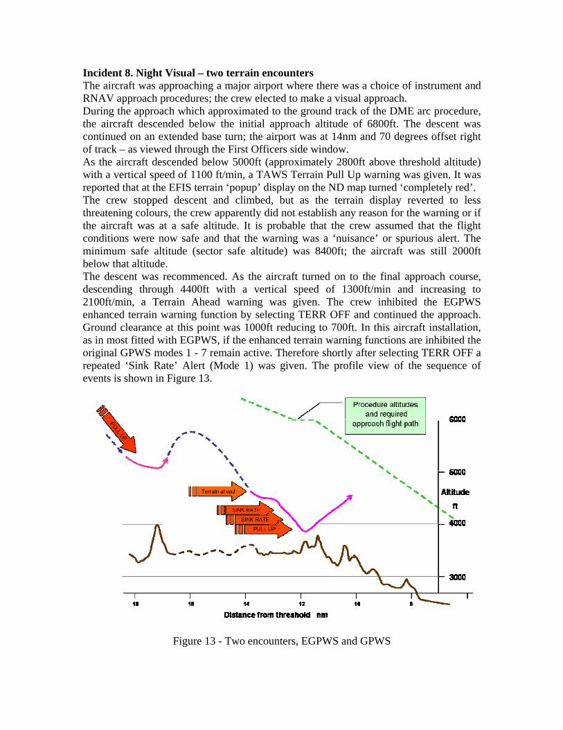
Incident 8. Night Visual – two terrain encounters The aircraft was approaching a major airport where there was a choice of instrument and RNAV approach procedures; the crew elected to make a visual approach. During the approach which approximated to the ground track of the DME arc procedure, the aircraft descended below the initial approach altitude of 6800ft. The descent was continued on an extended base turn; the airport was at 14nm and 70 degrees offset right of track – as viewed through the First Officers side window. As the aircraft descended below 5000ft (approximately 2800ft above threshold altitude) with a vertical speed of 1100 ft/min, a TAWS Terrain Pull Up warning was given. It was reported that at the EFIS terrain ‘popup’ display on the ND map turned ‘completely red’. The crew stopped descent and climbed, but as the terrain display reverted to less threatening colours, the crew apparently did not establish any reason for the warning or if the aircraft was at a safe altitude. It is probable that the crew assumed that the flight conditions were now safe and that the warning was a ‘nuisance’ or spurious alert. The minimum safe altitude (sector safe altitude) was 8400ft; the aircraft was still 2000ft below that altitude. The descent was recommenced. As the aircraft turned on to the final approach course, descending through 4400ft with a vertical speed of 1300ft/min and increasing to 2100ft/min, a Terrain Ahead warning was given. The crew inhibited the EGPWS enhanced terrain warning function by selecting TERR OFF and continued the approach. Ground clearance at this point was 1000ft reducing to 700ft. In this aircraft installation, as in most fitted with EGPWS, if the enhanced terrain warning functions are inhibited the original GPWS modes 1 - 7 remain active. Therefore shortly after selecting TERR OFF a repeated ‘Sink Rate’ Alert (Mode 1) was given. The profile view of the sequence of events is shown in Figure 13.
Figure 13 - Two encounters, EGPWS and GPWS

The descent was continued, with a ground clearance of 420ft (Radio Altitude) and at a vertical speed of 2000ft/min, a continuous ‘Sink-Rate’ ‘Pull Up’ Warning (Mode2) was given. The crew complied with this warning approximately 30 sec after the start of the second series of alerts. During the pull up the aircraft cleared terrain by 160ft, which previously was above the aircraft’s descending flight path. No definitive understanding of the crew’s perception of the situation could be established due to the limited information available. There was no supporting information on human factors contributions which could have affected the crew, e.g. fatigue, training, currency. No explanation of the crew’s intent or actions was available. However, the following circumstances have been considered as possible contributors: • The crew established and maintained visual contact with the airport, but both pilots
experienced a ‘black hole’ illusion (see incidents 1 and 7). All of the conditions for this illusion existed, and perhaps more so due to the relative position of the runway before turning onto final approach. Figures 14 and 15 show a graphic representation of the scene at the time of the first warning.
Fig 14 Night scene - apparent safety. Fig 15 - reality. • The crew may have mis-set the altimeter pressure datum or used an incorrect value.
The initial altitude deviation was similar to that to be expected from an error of 1 inch of mercury e.g. 29.77 instead of 28.77. Alternatively the standard value (29.92) was retained for an approach where the airport value was 28.92; in either event the aircraft could have been at least 1000ft below the indicated altitude.
• It is unlikely that the crew had mistaken the distance to the airport as the aircraft track approximated the DME arc, however ATC may have issued an early ‘visual’ approach clearance which was misunderstood as a clearance for further descent to 4300ft, (which is only safe within 9.3nm). The crew either commenced an early descent on this clearance without crosschecking the aircraft location or they used the visual scene for guidance and underestimated the range. This perception also existed during the final approach. Figures 16 and 17 show a graphic representation of the scene at the time of the second warning where the crew were flying a steep descent

to regain a flight path that they perceived as correct, but they were in fact nearly 2000ft below the required glide path.
Fig 16 final approach – black hole. Fig 17 reality The analysis of the crew’s behaviour can only be conjecture; there was no crew report, debrief notes, or investigation summary available. • As with most TAWS warnings the crew probably suffered surprise; this may have
been heightened by the very compelling EFIS ND with the ‘all red’ terrain display. The stress of the warning might have been alleviated if the terrain display had been selected prior to descending and the crew could have seen the terrain colours gradually change indicating the increasing threat of the terrain hazard.
• The crew did not climb to a safe altitude and evaluate the situation. The factors driving the crew’s situational awareness must have been very strong for them not to question their location, particularly their altitude. Strong driving factors come from the visual scene – runway in sight, and from the aircraft instruments – altimeter reading. Thus a visual illusion, a mis-set altimeter, or both in combination might have enabled both crewmembers to perceive a safe situation.
• The perception of safety may have been further enhanced by the reversal in terrain colours on the EFIS ND during the first pull up. The terrain display would have changed from an ‘all red’ warning to shades of yellow and then green as the climb continued. A predominantly green display indicates normality which at that time could have reinforced the crew’s perception of a safe altitude, and also supported the perception that the first warning was a nuisance or unwarranted alert.
• The reason for the crew inhibiting the enhanced terrain functions was not established. It is possible that if the crew had previous experience of a TAWS warning due to a FMS map slip or navigation aid failure then they may have retained an unwarranted, (even subconscious) belief that TAWS can give nuisance alerts. A similar belief could have been held about older GPWS. It is possible that the crew’s mis-assessment of altitude together with a belief that the first warning was a nuisance, led to their decision to switch off a valuable warning system.
• If ATC had issued an early approach clearance it could have triggered a habit response enabling the crew to continue the descent; providing a false sense of

security. It would be safe to give an approach/descent clearance at 9nm, or even 10nm when on-course, at this airport. However, if the clearance was given during the DME arc procedure with greater than 14 track miles to the runway, then this could provide an incorrect perception of a safe location and hence the rationalization to descend early.
Other safety issues in this incident include the apparent lack of Minimum Safe/Sector Altitude Warning (MSAW), the failure to use a VNAV procedure and the fortuitous availability of the other GPWS Modes. • The airport was of the size and location where MSAW equipment would be expected,
thus the comment and observations on MSAW in incident 7 also apply here. • A VNAV approach was available. VNAV approach waypoints are constructed using
pressure altitude based on the QNH datum. Thus although VNAV is widely promoted as having greater safety margins than a non precision approach, it depends on the crew setting the ONH accurately and cross checking altitude vs range. The safety threat from QNH error is doubled because both the FMS VNAV calculations and the altimeter displays rely on a common (crew) input; thus a single mishearing / mis-setting of QNH could result in two powerful, but erroneous cues of altitude. The threat of altimeter mis-settings could be alleviated by use of appropriate SOPs and ensuring that TAWS use an embedded GPS to provide a geometric altitude output to display of ‘true’ altitude (see geometric altitude reference).
• The availability of the basic GPWS warnings when the advanced terrain functions are inhibited provided two additional safety defences. First, having disabled the ‘EGPWS’ (believing the first warning to be a ‘nuisance’) the crew might have been surprised by subsequent GPWS alerts due to their lack of knowledge or failure to recall their understanding of aircraft systems; this perhaps challenged their earlier misperceptions. Second, the Mode 2 warning only gives the Pull Up command when the aircraft is not in the final landing configuration (gear and flap). In this incident although the landing gear was down, the flap was not fully set. Thus the emphasis from the additional Pull Up command over that of Sink Rate may have been the final cue for the crew to reject their earlier beliefs and pull up just in time. It would be conjecture to assume that the crew would not have reacted if the Pull Up command was absent, but they had already tolerated the continuous Sink Rate for some time.
There are many lessons to be learned from this incident: 1. Crews must have a high standard of technical knowledge of TAWS. They must know
what the display colours depicting terrain mean, and what the terrain height is relative to the aircraft altitude.
2. Crews must appreciate that EGPWS is significantly more reliable than previous systems, thus nuisance or unwarranted warnings are most unlikely.
3. SOPs should require the terrain display to be shown on at least one EFIS ND for the duration of the descent. Use Peaks mode if fitted; monitor the appearance of the terrain throughout the approach. Crews should remember that a terrain display is like weather radar – a threat detector, except that it is looking at the ground and that the coloured areas show significant hazards.

4. Always pull up to the sector safe altitude for TAWS warnings This provides an additional margin of safety for incorrect altimeter reading e.g. the procedure altitude is not necessarily safe if both crew members have mis-set their altimeters.
5. SOPS must ensure that the altimeter pressure datum is correctly set. Ideally both crew members should receive and set the value independently before crosschecking. Monitoring processes require dual paths to enable error detection by comparison.
6. Crews must establish the reason for any TAWS warning before continuing an approach. Procedures should include informing ATC of the warning, requesting confirmation of the altimeter setting and a check of navigation position. Cross check the altitude vs the distance to the runway (always display the runway on the EFIS map), check the radio altimeter - it should not indicate below 500ft before the final approach fix.
7. Never switch TAWS off believing that it has given a nuisance warning. System failures are now less likely than crew error. Instead of considering ‘switch TAWS off’ crews must change their behaviour to ‘switch “safety thinking” on’ and establish the reasons for the warning.
8. Procedures for TAWS warning ‘Pull Up’ should not include conditional items such as ‘if visual’, ‘if sure of position’. These statements do not protect crew from the effects of powerful and compelling visual illusions or mis-set altimeters.
Discussion The recent incidents add to a pattern where night visual approaches add significant risk to flight operations. A major hazard (safety threat) is the human vulnerability to the ‘black hole’ illusion. In addition, both pilots may suffer from the illusion at the same time. The primary error – a violation, was the crew’s failure to react correctly to TAWS warnings. There would be additional concern if the underlying reasons for this behaviour appear in other operational scenarios where a timely response to a warning is essential i.e. ACAS, Windshear, or RAAS. Factors which contribute to crew’s misperceptions and behaviour could include poor technical knowledge, unwarranted bias from a history of nuisance warnings form previous equipment (or aircraft), and weaknesses in procedures (QNH setting, cross monitoring, and the use of conditional phrases in Pull Up SOPs). Another pattern is the failure to report and investigate TAWS warnings. Human error, which is only identified retrospectively, is often associated with stigma and ridicule. Error (including illusion) is difficult to comprehend and thus it is rarely reported, or if it is, then the circumstances are often inaccurately described. Difficulties in reporting often originate in operators’ safety culture. This pattern might also reflect the lack of meaningful reports from formal investigations as they are unable to consider a range of speculative scenarios that contribute to error due to ICAO guidelines restricting them to factual information. The combination of threats and error in the TAWS incidents fit precisely the accident model involving unsafe acts (error and violation) and latent factors (threats) - Prof James
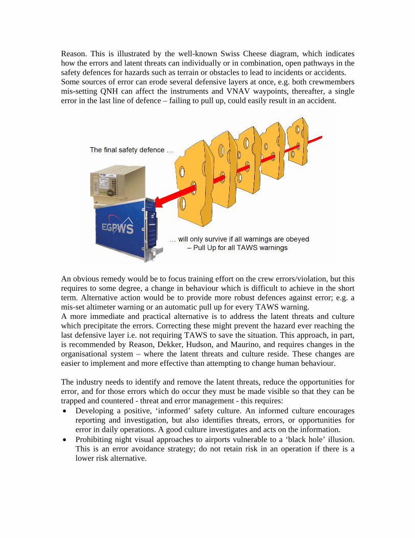
Reason. This is illustrated by the well-known Swiss Cheese diagram, which indicates how the errors and latent threats can individually or in combination, open pathways in the safety defences for hazards such as terrain or obstacles to lead to incidents or accidents. Some sources of error can erode several defensive layers at once, e.g. both crewmembers mis-setting QNH can affect the instruments and VNAV waypoints, thereafter, a single error in the last line of defence – failing to pull up, could easily result in an accident.
An obvious remedy would be to focus training effort on the crew errors/violation, but this requires to some degree, a change in behaviour which is difficult to achieve in the short term. Alternative action would be to provide more robust defences against error; e.g. a mis-set altimeter warning or an automatic pull up for every TAWS warning. A more immediate and practical alternative is to address the latent threats and culture which precipitate the errors. Correcting these might prevent the hazard ever reaching the last defensive layer i.e. not requiring TAWS to save the situation. This approach, in part, is recommended by Reason, Dekker, Hudson, and Maurino, and requires changes in the organisational system – where the latent threats and culture reside. These changes are easier to implement and more effective than attempting to change human behaviour. The industry needs to identify and remove the latent threats, reduce the opportunities for error, and for those errors which do occur they must be made visible so that they can be trapped and countered - threat and error management - this requires: • Developing a positive, ‘informed’ safety culture. An informed culture encourages
reporting and investigation, but also identifies threats, errors, or opportunities for error in daily operations. A good culture investigates and acts on the information.
• Prohibiting night visual approaches to airports vulnerable to a ‘black hole’ illusion. This is an error avoidance strategy; do not retain risk in an operation if there is a lower risk alternative.

• Requiring visual approaches to follow the altitude constrains of precision approaches. This will ‘make errors visible’ by enabling crew’s to monitor the actual flight path with respect to a safe flight path in a published procedure.
• Altimeter setting SOPs must have independent paths for obtaining and setting QNH before crosschecking. A well structured SOP will provide opportunities to detect errors and counter them before they become hazardous.
• Selecting the EFIS terrain display on all approaches; this makes the threat or error visible. Pilots should think of a terrain display like weather radar, except that TAWS colours are the ground or obstacles, and all of them could become a significant threat.
• Providing in-depth technical training for all safety systems. This provides crew’s with additional ability to detect error provoking situations in advance.
• Educating crews in the differences between TAWS and previous systems, thus removing adverse influences (bias) from the crew’s perception or decisions.
• Removing all conditional assessments in Pull Up SOPs – requiring an immediate Pull Up and climb to the sector safe altitude for all TAWS warnings. This mitigates the immediate effect of any errors from illusion or mis-set altimeters.
• SOPs should provide guidance on what to check after pulling up, to determine the source of the warning – reminding crews that a deducing a nuisance or false warning is not an option and that misperception (human error) is a more probable explanation.
Conclusion The incidents described in this addendum involved timely TAWS warnings, but these were not heeded by the crew. In both events the normal margins of safety were eroded by human behaviour – inaction or inappropriate action after a warning was given. This resulted in undesired states - “being as close as you would ever want to be to an accident”. • TAWS make threats and errors visible, but to be effective these systems have to be
understood and used correctly. • TAWS do not provide error proof solutions for terrain encounters; this requires
timely and accurate human activity. • TAWS demand prior operational involvement to identify threats and error provoking
opportunities – make them visible, to provide SOPs and training for the inevitable errors – recovery and mitigating action, and to develop a generative, informed culture, avoiding blame by encouraging fault free reporting, and then acting to remove or mitigate the latent threats in daily operations.
The industry has enjoyed great success in reducing the contribution of CFIT to the accident rate, but there is no room for complacency. We must ensure that modern technology does not just cover over the cracks, but in conjunction with systematic and organisational safety activities, it provides a lasting change in our operations.
TAWS incidents are reminders of the continuing threat
to safety from the hazard of CFIT.
References and additional material: 1. Flight Safety Foundation ALAR Tool Kit http://www.flightsafety.org/alar_resources.html 2. NTSB Safety Recommendations - MSAW http://www.ntsb.gov/recs/letters/2006/a06%5F44%5F47.pdf 3. Geometric Altitude - http://www.honeywell.com/sites/aero/Egpws-Home3_CB54AACBB-D557-208D-8CE0-EC44CECAAB3B_H93F4FDC5-3734-3A2F-1939-E2D290ED1616.htm 4. “Human error and organisational failure” - Prof James Reason http://qhc.bmjjournals.com/cgi/content/full/14/1/56 5. “Diagnosing ‘vulnerable system syndrome’: … effective risk management” - Prof James Reason http://qhc.bmjjournals.com/cgi/reprint/10/suppl_2/ii21 6. “Achieving a safe culture: theory and practice” - Prof James Reason http://scholar.google.com/url?sa=U&q=http://www.shef.ac.uk/~mcn/6810/reading/reason-1998-safety-culture.pdf 7. “Human error in aviation … the years to come” – Capt D. Maurino http://www.hufag.nl/archief/huf03_maurino.pdf 8. “Errors in understanding human error”- Prof S. Dekker http://www.lusa.lu.se/o.o.i.s/6131 9. “Applying the lessons of high risk industries” – Prof P. Hudson. http://qhc.bmjjournals.com/cgi/reprint/12/suppl_1/i7?maxtoshow=&HITS=10&hits=10&RESULTFORMAT=&searchid=1&FIRSTINDEX=70&minscore=5000&resourcetype=HWCIT 10. “Punishing people or learning from failures” - Prof S. Dekker http://www.hufag.nl/archief/huf03_dekker.pdf “Why do people break rules or fail to follow procedures? And what can you do about it?” - “The Violation Manual” - P.T.W. Hudson, W.L.G.Verschuur, R. Lawton, D Parker, J .T .Reason Recent incident investigation reports:- Operating error, incorrect DME; need to fit EGPWS. http://www.aaib.gov.uk/publications/bulletins/august_2006/embraer_e120_brazilia__f_gfeo.cfm Operating erro, mis-set altimeter (no EGPWS on freight a/c?). http://www.aaib.gov.uk/publications/bulletins/august_2006/mcdonnell_douglas_md_11__n701gc.cfm Value in displaying Terrain during an approach. http://www.aaib.gov.uk/publications/bulletins/august_2006/boeing_757_2t7__g_mone.cfm