a resource booklet for sace stage 1 earth and ... -...
TRANSCRIPT

A Resource Booklet for SACE Stage 1 Earth and Environmental Science The following pages have been prepared by practicing teachers of SACE Earth and Environmental Science. The six Chapters are aligned with the six topics described in the SACE Stage 1 subject outline. They aim to provide an additional source of contexts and ideas to help teachers plan to teach this subject. For further information, including the general and assessment requirements of the course see: https://www.sace.sa.edu.au/web/earth-and-environmental-science/stage-1/planning-to-teach/subject-outline
A Note for Teachers The resources in this booklet are not intended for ‘publication’. They are ‘drafts’ that have been developed by teachers for teachers. They can be freely used for educational purposes, including course design, topic and lesson planning. Each Chapter is a living document, intended for continuous improvement in the future. Teachers of Earth and Environmental Science are invited to provide feedback, particularly suggestions of new contexts, field-work and practical investigations that have been found to work well with students. Your suggestions for improvement would be greatly appreciated and should be directed to our project coordinator:: [email protected]
Preparation of this booklet has been coordinated and funded by the Geoscience Pathways Project, under the sponsorship of the Geological Society of Australia (GSA) and the Teacher Earth Science Education Program (TESEP). In-kind support has been provided by the SA Department of Energy and Mining (DEM) and the Geological Survey of South Australia (GSSA). FAIR USE: The teachers named alongside each chapter of this document have researched available resources, selected and collated these notes and images from a wide range of sources. These resources have been adapted in fair use, for educational and collaborative purposes within our not-for-profit organization. https://www.alrc.gov.au/publications/14-education/fair-use-and-education
Chapter 3
TOPIC 3: Processes in the Geosphere
1.1 Uniformitarianism
1.2 Finding evidence of the Earth’s structure
1.3 Processes within the Earth’s interior
1.4 The Earth’s tectonic processes
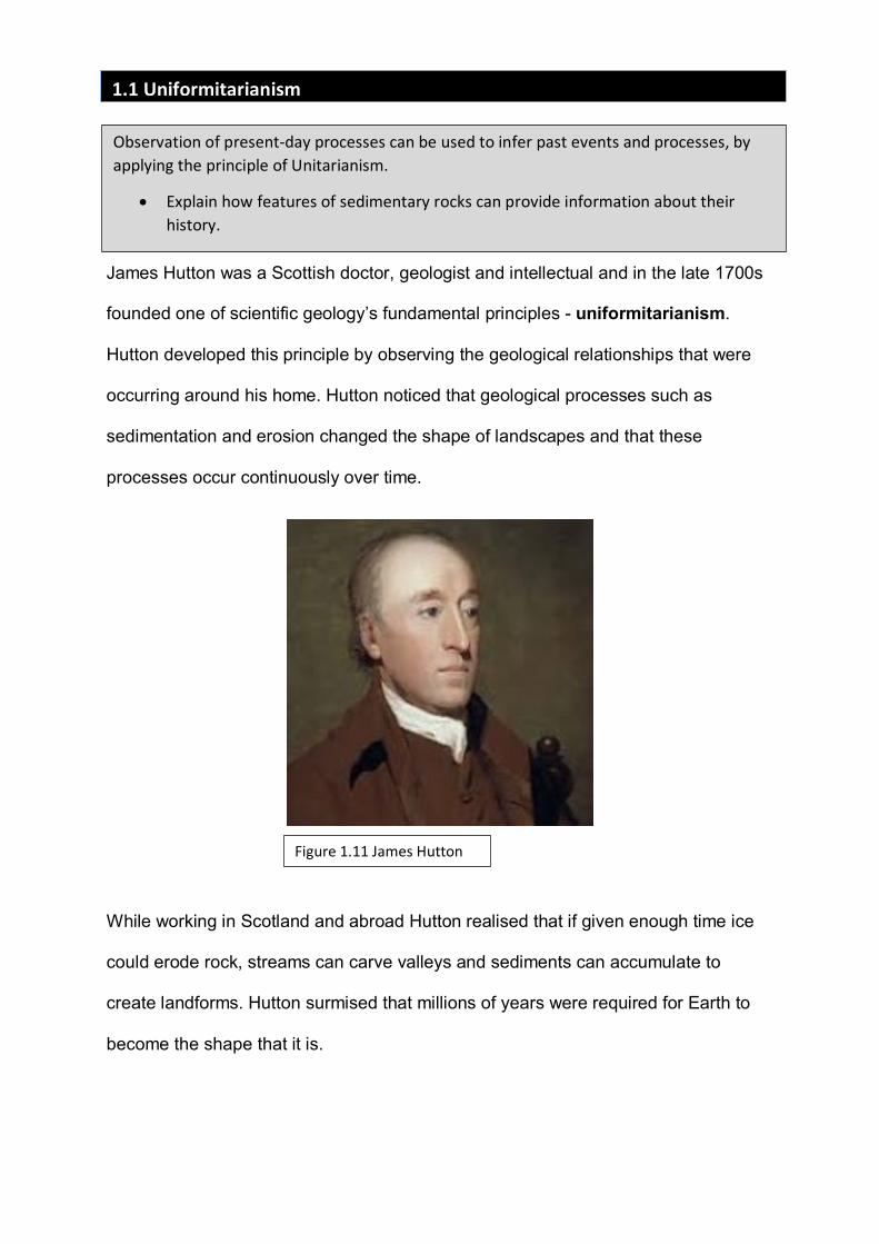
James Hutton was a Scottish doctor, geologist and intellectual and in the late 1700s
founded one of scientific geology’s fundamental principles - uniformitarianism.
Hutton developed this principle by observing the geological relationships that were
occurring around his home. Hutton noticed that geological processes such as
sedimentation and erosion changed the shape of landscapes and that these
processes occur continuously over time.
While working in Scotland and abroad Hutton realised that if given enough time ice
could erode rock, streams can carve valleys and sediments can accumulate to
create landforms. Hutton surmised that millions of years were required for Earth to
become the shape that it is.
1.1 Uniformitarianism Observation of present-day processes can be used to infer past events and processes, by
applying the principle of Unitarianism.
• Explain how features of sedimentary rocks can provide information about their history.
Figure 1.11 James Hutton
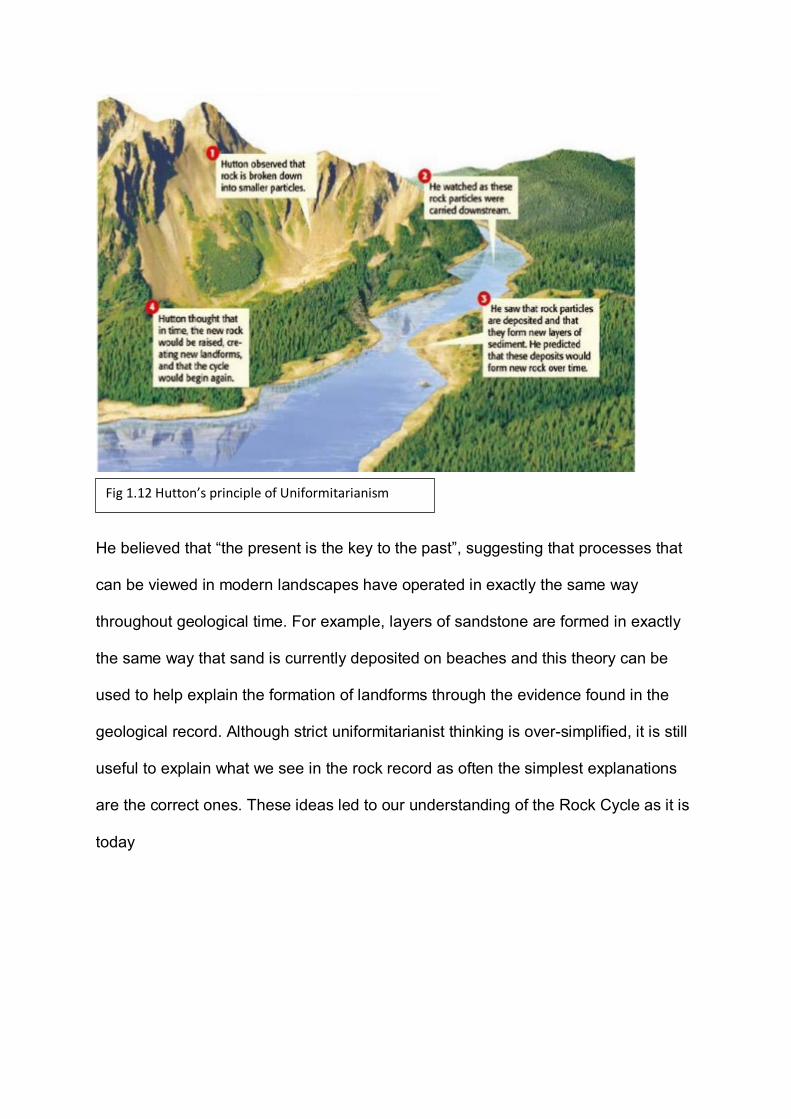
He believed that “the present is the key to the past”, suggesting that processes that
can be viewed in modern landscapes have operated in exactly the same way
throughout geological time. For example, layers of sandstone are formed in exactly
the same way that sand is currently deposited on beaches and this theory can be
used to help explain the formation of landforms through the evidence found in the
geological record. Although strict uniformitarianist thinking is over-simplified, it is still
useful to explain what we see in the rock record as often the simplest explanations
are the correct ones. These ideas led to our understanding of the Rock Cycle as it is
today
Fig 1.12 Hutton’s principle of Uniformitarianism
Use of Sedimentary features
All around us there are many geological features that can be interpreted by using the
principle of uniformitarianism and modern sedimentary environments are one such
example. High water energy like that found in a fast running stream or active
shoreline usually has much finer sediments. When we see these types of distinctive
features we assume that deposition of those sediments have been influenced by the
environmental factors that can be seen in the current environment.
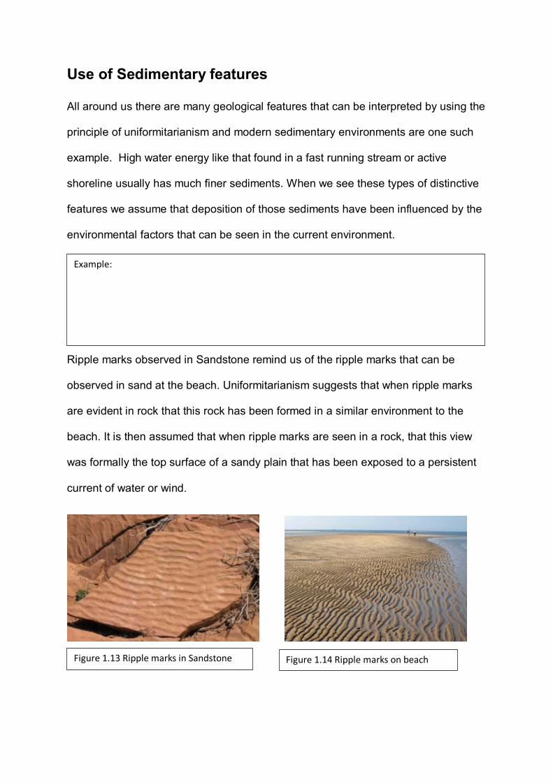
Ripple marks observed in Sandstone remind us of the ripple marks that can be
observed in sand at the beach. Uniformitarianism suggests that when ripple marks
are evident in rock that this rock has been formed in a similar environment to the
beach. It is then assumed that when ripple marks are seen in a rock, that this view
was formally the top surface of a sandy plain that has been exposed to a persistent
current of water or wind.
Example:
Figure 1.13 Ripple marks in Sandstone Figure 1.14 Ripple marks on beach
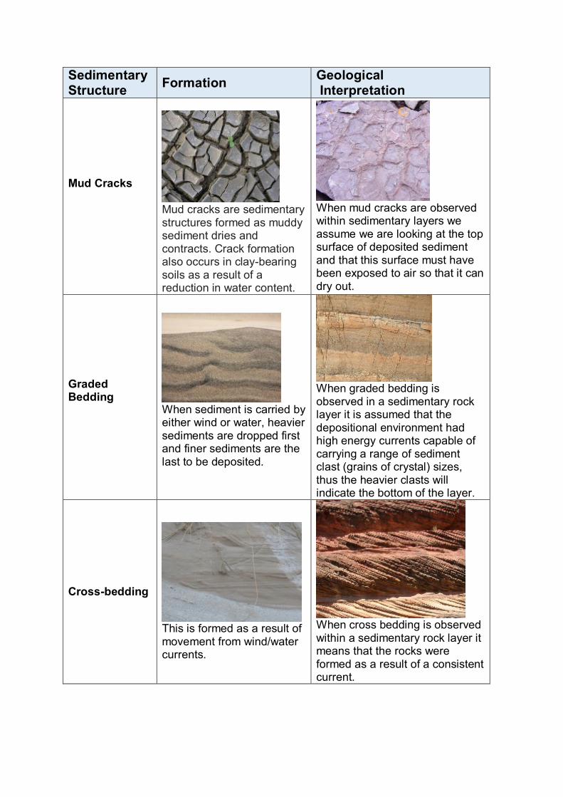
Sedimentary Structure Formation Geological
Interpretation
Mud Cracks
Mud cracks are sedimentary structures formed as muddy sediment dries and contracts. Crack formation also occurs in clay-bearing soils as a result of a reduction in water content.
When mud cracks are observed within sedimentary layers we assume we are looking at the top surface of deposited sediment and that this surface must have been exposed to air so that it can dry out.
Graded Bedding
When sediment is carried by either wind or water, heavier sediments are dropped first and finer sediments are the last to be deposited.
When graded bedding is observed in a sedimentary rock layer it is assumed that the depositional environment had high energy currents capable of carrying a range of sediment clast (grains of crystal) sizes, thus the heavier clasts will indicate the bottom of the layer.
Cross-bedding
This is formed as a result of movement from wind/water currents.
When cross bedding is observed within a sedimentary rock layer it means that the rocks were formed as a result of a consistent current.
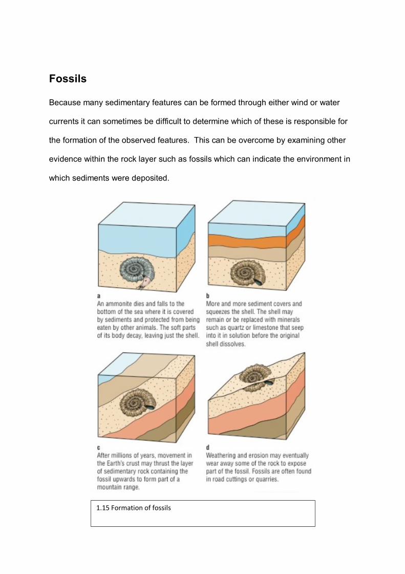
Fossils
Because many sedimentary features can be formed through either wind or water
currents it can sometimes be difficult to determine which of these is responsible for
the formation of the observed features. This can be overcome by examining other
evidence within the rock layer such as fossils which can indicate the environment in
which sediments were deposited.
1.15 Formation of fossils
Organisms can leave traces of their existence in geological deposits in the form of
fossils. Fossils are the remains or impression of a prehistoric plant or animal
embedded in rock and preserved in petrified form. Using uniformitarianism we can
say that if an organism lives in a particular environment today, any ancestors in the
form of fossils must have lived in a similar environment in the past.
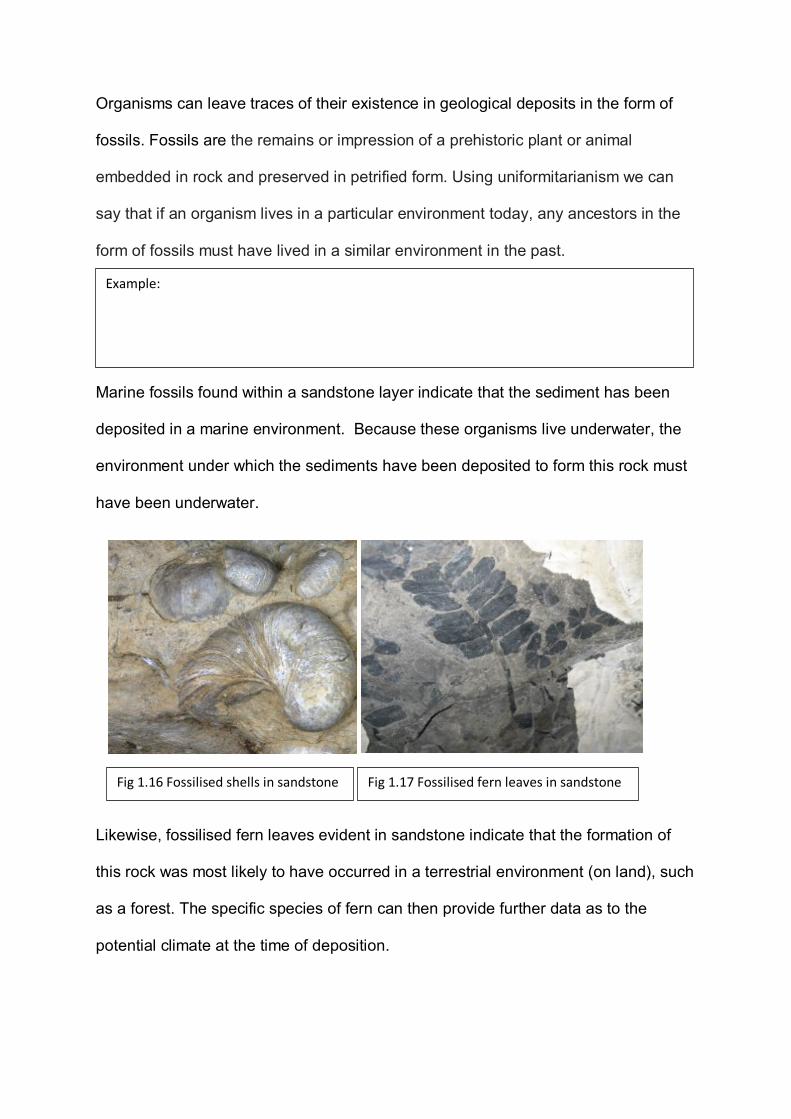
Marine fossils found within a sandstone layer indicate that the sediment has been
deposited in a marine environment. Because these organisms live underwater, the
environment under which the sediments have been deposited to form this rock must
have been underwater.
Likewise, fossilised fern leaves evident in sandstone indicate that the formation of
this rock was most likely to have occurred in a terrestrial environment (on land), such
as a forest. The specific species of fern can then provide further data as to the
potential climate at the time of deposition.
Example:
Fig 1.16 Fossilised shells in sandstone Fig 1.17 Fossilised fern leaves in sandstone
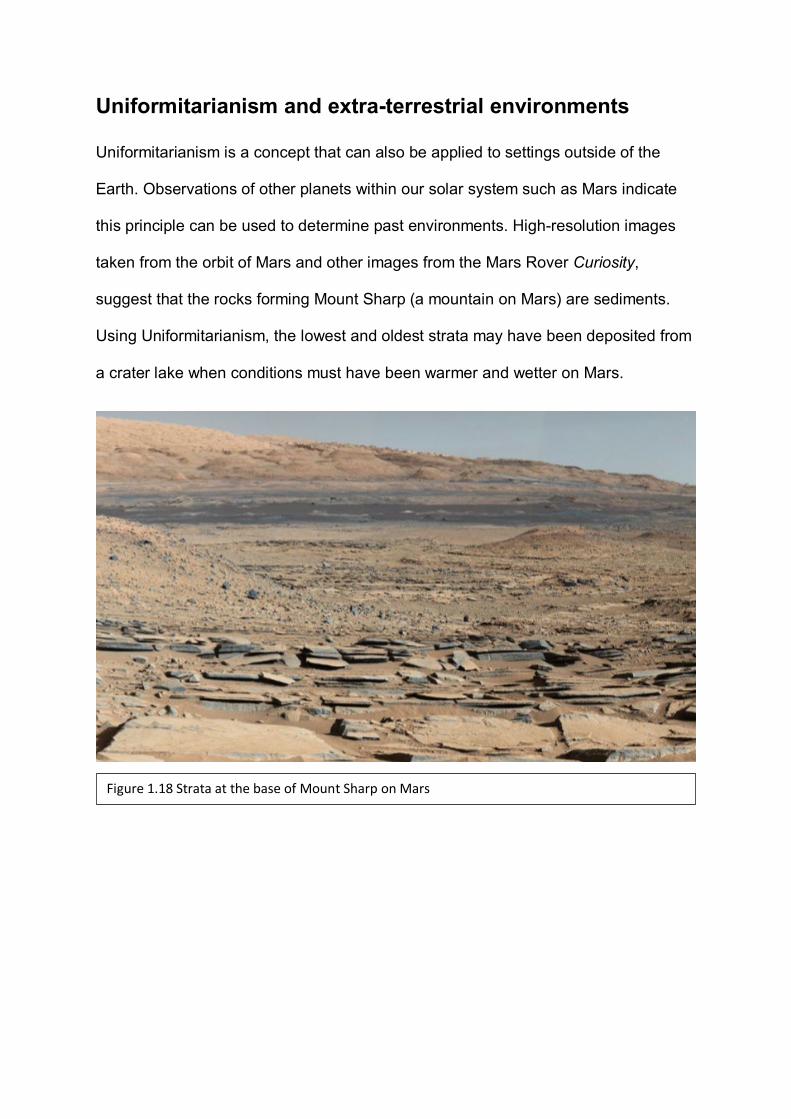
Uniformitarianism and extra-terrestrial environments
Uniformitarianism is a concept that can also be applied to settings outside of the
Earth. Observations of other planets within our solar system such as Mars indicate
this principle can be used to determine past environments. High-resolution images
taken from the orbit of Mars and other images from the Mars Rover Curiosity,
suggest that the rocks forming Mount Sharp (a mountain on Mars) are sediments.
Using Uniformitarianism, the lowest and oldest strata may have been deposited from
a crater lake when conditions must have been warmer and wetter on Mars.
Figure 1.18 Strata at the base of Mount Sharp on Mars

Uniformitarianism is used by geologists to help understand the depositional
environments required to form the rocks we see today.
(a) In the Sturt Gorge of South Australia geologists have found solid rocks that
are texturally similar to loose sediments that are now being deposited by
active glaciers in the European Alps. Geoscientists have concluded that there
must have been glaciers in South Australia in the past. State the principal
used to make this conclusion.
___________________________________________________(1 mark) KA1
(b) Explain how the quote “the present is the key to the past” relates to the
principal of uniformitarianism.
______________________________________________________________
______________________________________________________________
______________________________________________________________
______________________________________________________________
______________________________________________________________
______________________________________________________________
______________________________________________________________
_____________________________________ (3 marks) KA1
(c) James Hutton was a Scottish philanthropist who is responsible for the
introduction of the uniformitarianism principle. Describe the influence James
Hutton had when forming his idea.
______________________________________________________________
______________________________________________________________
Question 1
______________________________________________________________
______________________________________________________________
______________________________________________________________
_______________________ (2 marks) KA3
(d) In recent geological history, some inland areas of Australia have been
covered by sea. Explain what evidence could be used to form this conclusion.
______________________________________________________________
______________________________________________________________
______________________________________________________________
______________________________________________________________
______________________________________________________________
______________________________________________________________
_______________________________(3 marks) KA2
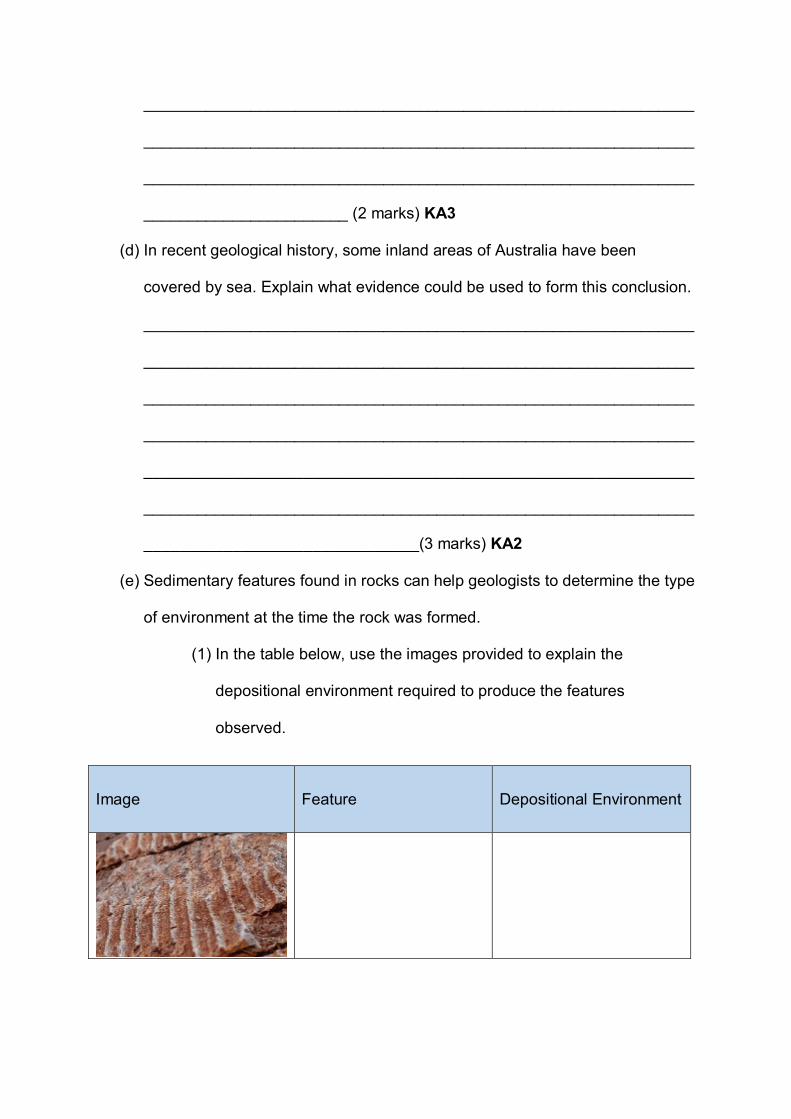
(e) Sedimentary features found in rocks can help geologists to determine the type
of environment at the time the rock was formed.
(1) In the table below, use the images provided to explain the
depositional environment required to produce the features
observed.
Image Feature Depositional Environment
(2 marks) KA2
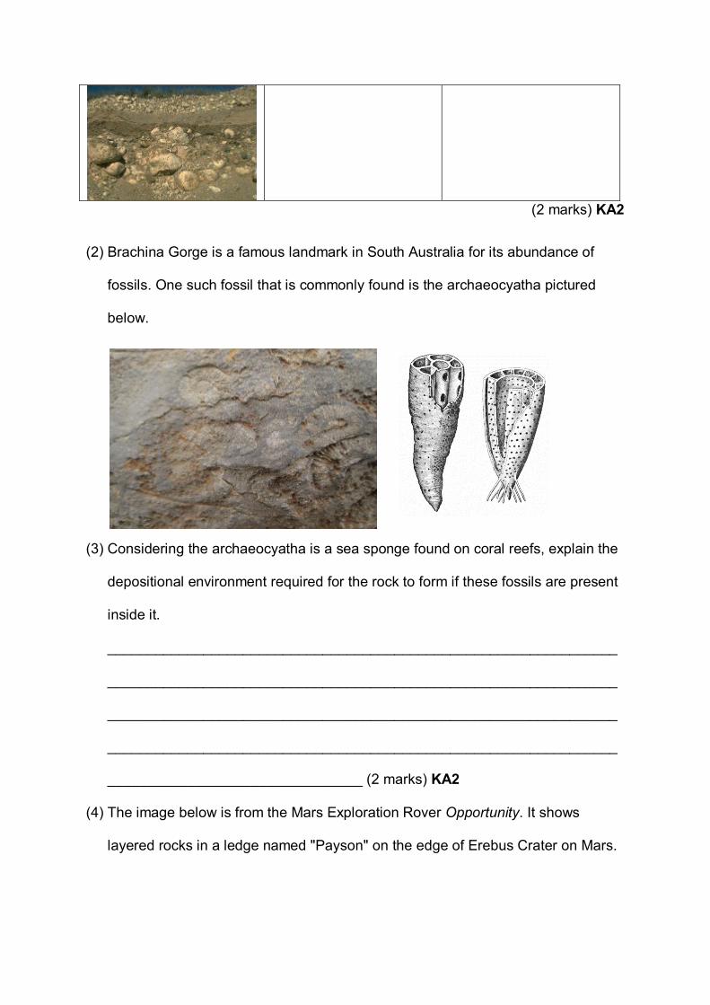
(2) Brachina Gorge is a famous landmark in South Australia for its abundance of
fossils. One such fossil that is commonly found is the archaeocyatha pictured
below.
(3) Considering the archaeocyatha is a sea sponge found on coral reefs, explain the
depositional environment required for the rock to form if these fossils are present
inside it.
________________________________________________________________
________________________________________________________________
________________________________________________________________
________________________________________________________________
________________________________ (2 marks) KA2
(4) The image below is from the Mars Exploration Rover Opportunity. It shows
layered rocks in a ledge named "Payson" on the edge of Erebus Crater on Mars.

Explain how this sedimentary feature suggests water was once present on Mars.
________________________________________________________________
________________________________________________________________
________________________________________________________________
________________________________________________________________
________________________________________________________________
________________________________________________________________
________________________________________________________________
________________________________________________________________
________________ (3 marks) KA2
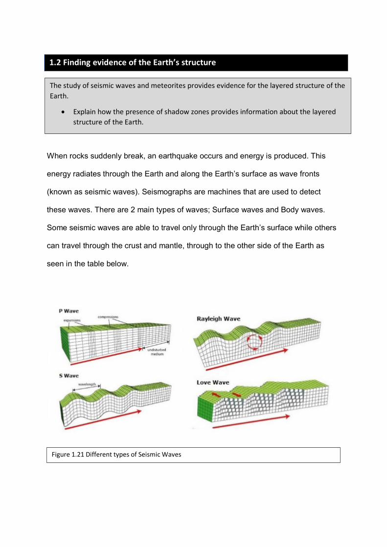
When rocks suddenly break, an earthquake occurs and energy is produced. This
energy radiates through the Earth and along the Earth’s surface as wave fronts
(known as seismic waves). Seismographs are machines that are used to detect
these waves. There are 2 main types of waves; Surface waves and Body waves.
Some seismic waves are able to travel only through the Earth’s surface while others
can travel through the crust and mantle, through to the other side of the Earth as
seen in the table below.
1.2 Finding evidence of the Earth’s structure The study of seismic waves and meteorites provides evidence for the layered structure of the
Earth.
• Explain how the presence of shadow zones provides information about the layered structure of the Earth.
Figure 1.21 Different types of Seismic Waves
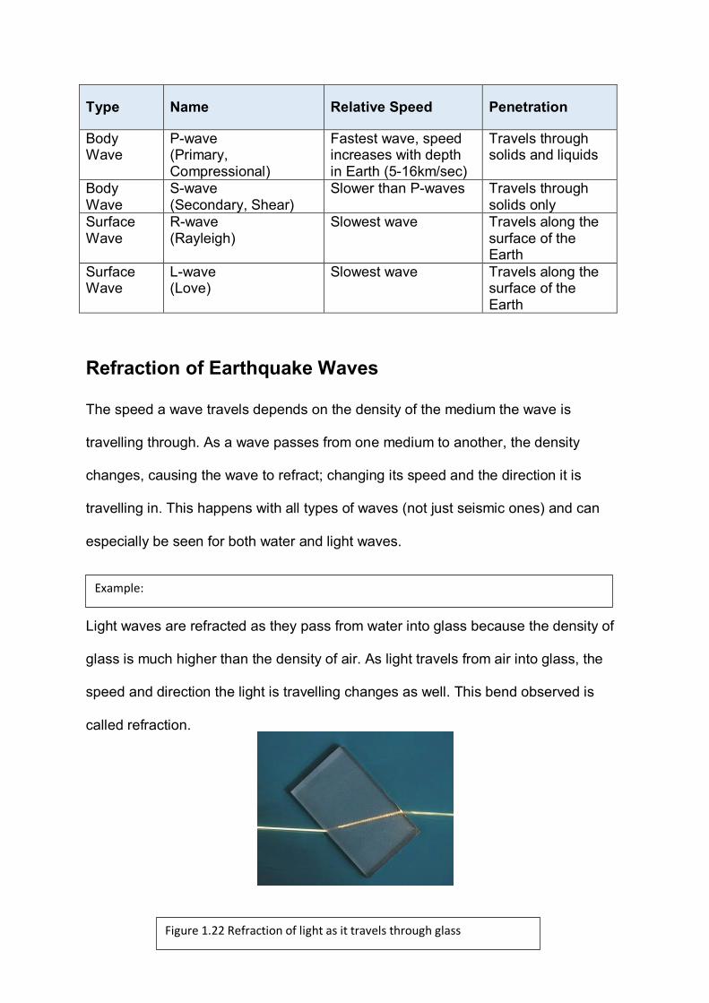
Type Name Relative Speed Penetration
Body Wave
P-wave (Primary, Compressional)
Fastest wave, speed increases with depth in Earth (5-16km/sec)
Travels through solids and liquids
Body Wave
S-wave (Secondary, Shear)
Slower than P-waves Travels through solids only
Surface Wave
R-wave (Rayleigh)
Slowest wave Travels along the surface of the Earth
Surface Wave
L-wave (Love)
Slowest wave Travels along the surface of the Earth
Refraction of Earthquake Waves
The speed a wave travels depends on the density of the medium the wave is
travelling through. As a wave passes from one medium to another, the density
changes, causing the wave to refract; changing its speed and the direction it is
travelling in. This happens with all types of waves (not just seismic ones) and can
especially be seen for both water and light waves.
Light waves are refracted as they pass from water into glass because the density of
glass is much higher than the density of air. As light travels from air into glass, the
speed and direction the light is travelling changes as well. This bend observed is
called refraction.
Example:
Figure 1.22 Refraction of light as it travels through glass
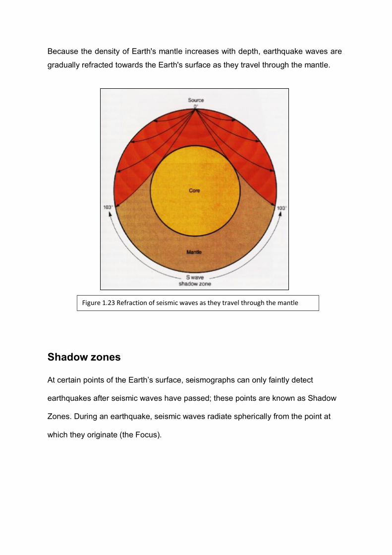
Because the density of Earth's mantle increases with depth, earthquake waves are
gradually refracted towards the Earth's surface as they travel through the mantle.
Shadow zones
At certain points of the Earth’s surface, seismographs can only faintly detect
earthquakes after seismic waves have passed; these points are known as Shadow
Zones. During an earthquake, seismic waves radiate spherically from the point at
which they originate (the Focus).
Figure 1.23 Refraction of seismic waves as they travel through the mantle
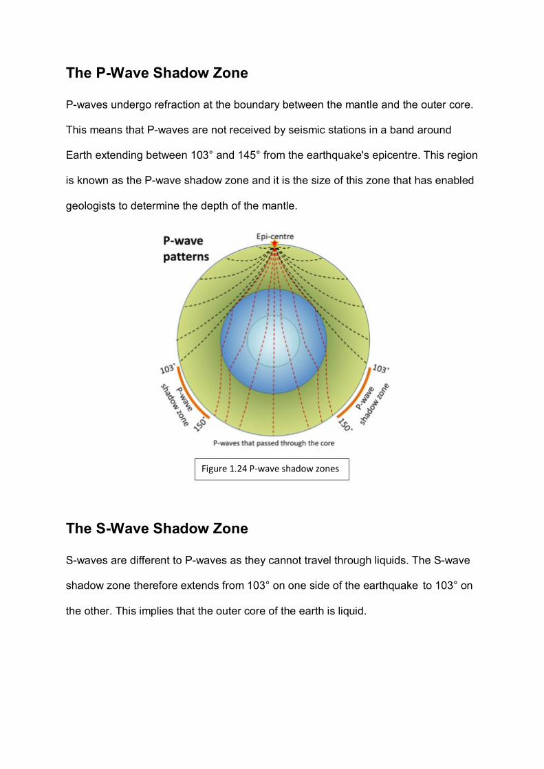
The P-Wave Shadow Zone
P-waves undergo refraction at the boundary between the mantle and the outer core.
This means that P-waves are not received by seismic stations in a band around
Earth extending between 103° and 145° from the earthquake's epicentre. This region
is known as the P-wave shadow zone and it is the size of this zone that has enabled
geologists to determine the depth of the mantle.
The S-Wave Shadow Zone
S-waves are different to P-waves as they cannot travel through liquids. The S-wave
shadow zone therefore extends from 103° on one side of the earthquake to 103° on
the other. This implies that the outer core of the earth is liquid.
Figure 1.24 P-wave shadow zones
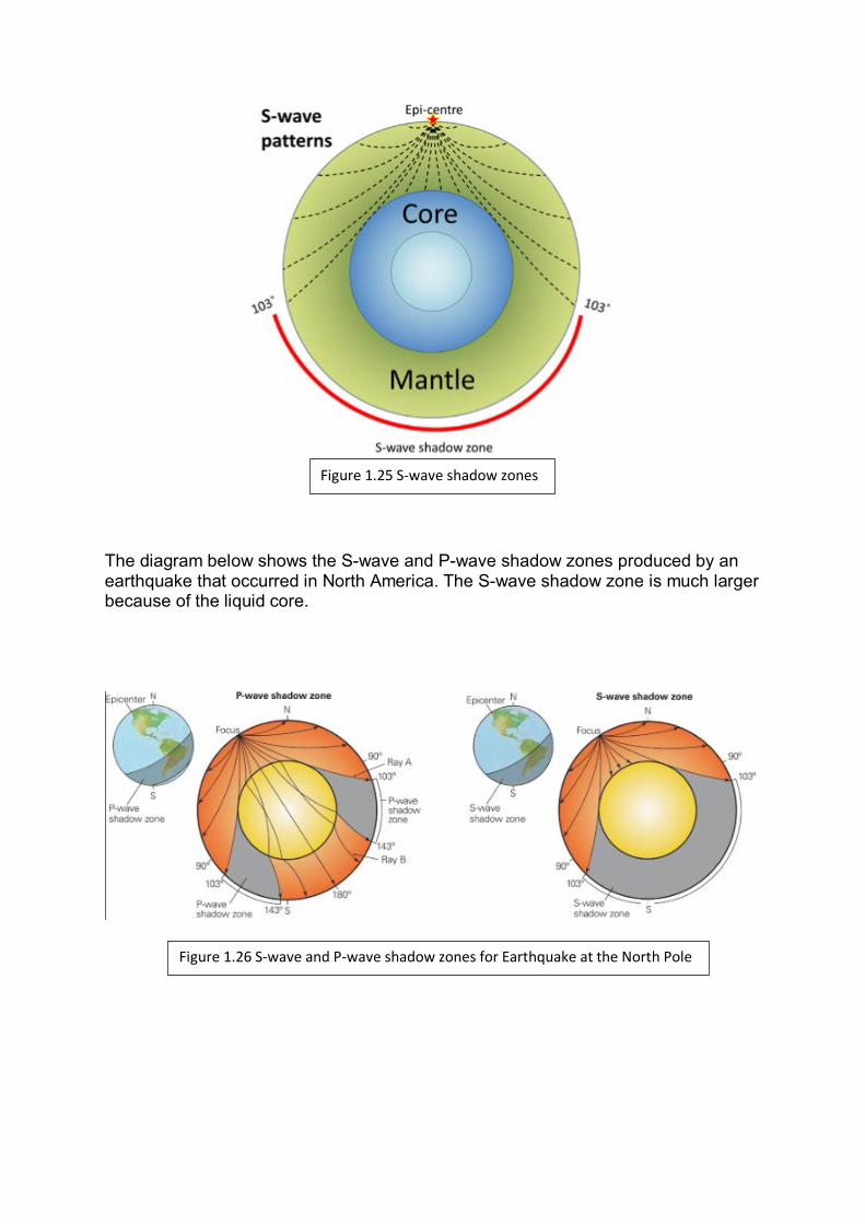
The diagram below shows the S-wave and P-wave shadow zones produced by an earthquake that occurred in North America. The S-wave shadow zone is much larger because of the liquid core.
Figure 1.26 S-wave and P-wave shadow zones for Earthquake at the North Pole
Figure 1.25 S-wave shadow zones
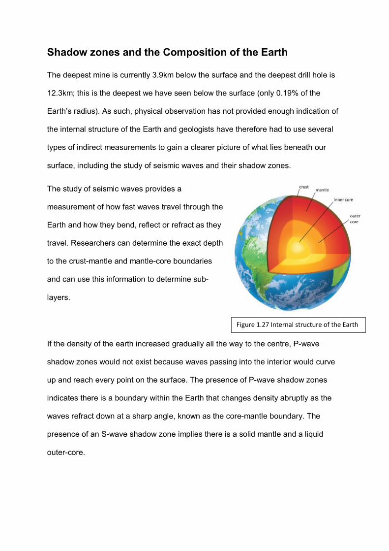
Shadow zones and the Composition of the Earth
The deepest mine is currently 3.9km below the surface and the deepest drill hole is
12.3km; this is the deepest we have seen below the surface (only 0.19% of the
Earth’s radius). As such, physical observation has not provided enough indication of
the internal structure of the Earth and geologists have therefore had to use several
types of indirect measurements to gain a clearer picture of what lies beneath our
surface, including the study of seismic waves and their shadow zones.
The study of seismic waves provides a
measurement of how fast waves travel through the
Earth and how they bend, reflect or refract as they
travel. Researchers can determine the exact depth
to the crust-mantle and mantle-core boundaries
and can use this information to determine sub-
layers.
If the density of the earth increased gradually all the way to the centre, P-wave
shadow zones would not exist because waves passing into the interior would curve
up and reach every point on the surface. The presence of P-wave shadow zones
indicates there is a boundary within the Earth that changes density abruptly as the
waves refract down at a sharp angle, known as the core-mantle boundary. The
presence of an S-wave shadow zone implies there is a solid mantle and a liquid
outer-core.
Figure 1.27 Internal structure of the Earth
Geologists have used the study of seismic waves to help determine the structure of
the Earth.
(a) State the category each of the following seismic waves belong to (body or
surface).
a. P-wave
________________________________________________________
b. S-wave
________________________________________________________
c. L-wave
________________________________________________________
d. R-wave
________________________________________________________
(2 marks) KA1
(b) Describe the motion of Love and Rayleigh waves.
______________________________________________________________
______________________________________________________________
______________________________________________________________
______________________________________________________________
______________________________________________________________
_______________________ (2 marks) KA1
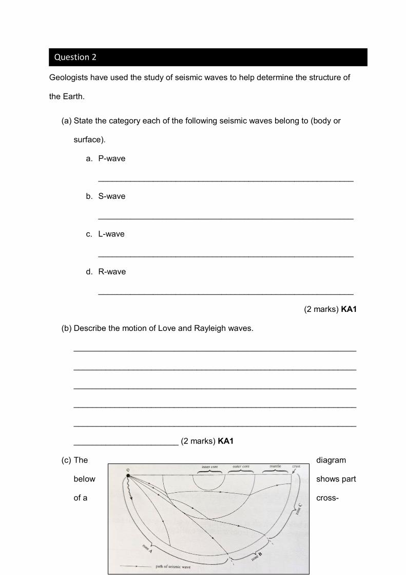
(c) The diagram
below shows part
of a cross-
Question 2

section through the Earth and the paths of some of the P, S and L seismic
waves that originated at point Q. Three different seismic zones are marked A,
B and C.
(1) Name the scale used to measure the intensity of the seismic waves
detected.
__________________________________________ (1 mark) KA1
(2) State the term used to describe the zone around the Earth where
neither P or S-waves can be received.
__________________________________________ (1 mark) KA1
(3) Describe whether or not P and/or S-waves could be received in
each of the zones, A, B and C on the cross-section diagram from an
earthquake that originated at point Q.
______________________________________________________
______________________________________________________
______________________________________________________
______________________________________________________
______________________________________________________
______________________________________________________
______________________________________________________
______________________________________________________
______________________________________________________
________________________________________ (3 marks) KA2
(4) Explain why some locations (in part (3)) could not receive P and/or
S waves.
______________________________________________________
______________________________________________________
______________________________________________________
______________________________________________________
______________________________________________________
______________________________________________________
______________________________________________________
______________________________________________________
______________________________________________________
_________________________________________(3 marks) KA2
(5) Explain what would happen to the size of the zone where no P or S-
waves were detected if the size of the outer core were larger.
______________________________________________________
______________________________________________________
______________________________________________________
______________________________________________________
______________________________________________________
_________________________________________ (2 marks) KA2
The study of seismic waves and meteorites provides evidence for the layered structure of the Earth.
• Explain how the composition of a meteorite can provide evidence of the internal composition of the Earth.
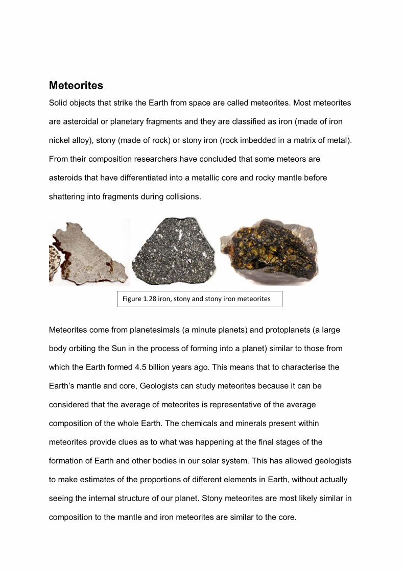
Meteorites Solid objects that strike the Earth from space are called meteorites. Most meteorites
are asteroidal or planetary fragments and they are classified as iron (made of iron
nickel alloy), stony (made of rock) or stony iron (rock imbedded in a matrix of metal).
From their composition researchers have concluded that some meteors are
asteroids that have differentiated into a metallic core and rocky mantle before
shattering into fragments during collisions.
Meteorites come from planetesimals (a minute planets) and protoplanets (a large
body orbiting the Sun in the process of forming into a planet) similar to those from
which the Earth formed 4.5 billion years ago. This means that to characterise the
Earth’s mantle and core, Geologists can study meteorites because it can be
considered that the average of meteorites is representative of the average
composition of the whole Earth. The chemicals and minerals present within
meteorites provide clues as to what was happening at the final stages of the
formation of Earth and other bodies in our solar system. This has allowed geologists
to make estimates of the proportions of different elements in Earth, without actually
seeing the internal structure of our planet. Stony meteorites are most likely similar in
composition to the mantle and iron meteorites are similar to the core.
Figure 1.28 iron, stony and stony iron meteorites
Potential Field Trip:
If you wish to see examples of meteorites, there are a number of specimens on display
in the TATE Museum at the University of Adelaide and the South Australian Museum.
Guides can be found on the following links:
www.adelaide.edu.au/uni-collections/unimuseums/UC_Tate_Museum_EMAIL.pdf
www.samuseum.sa.gov.au/Upload/files-education/text/seniormineralinvestigation.pdf
Potential SHE task topics:
• The development of scientific investigation into determining the layers of the
Earth’s interior.
• The collaboration that has occurred between different geologists/geophysicists
across the globe in order to determine the layers of the Earth’s interior.
• The applications and limitations of seismographs when determining the layers of
the Earth.
• The Influence seismographs have had in the classification of the layers of the
Earth.
Analysis of meteorites have been instrumental in the formation of a model of the
Earth’s structure.
(a) Explain how the composition of meteorites has influenced the development of
our current model of the internal structure of the Earth.
______________________________________________________________
______________________________________________________________
______________________________________________________________
______________________________________________________________
______________________________________________________________
______________________________________________________________
______________________________________________________________
______________________________________________________________
______________________________________________________________
______________________________________________________________
______________________________________________________________
______________________________________________________________
______________________________________________________________
______________________________________________________________
______________________________________________________________
______________________________________________________________
_______________________________ (6 marks) KA3
Question 3
(b) Discuss one limitation the use of meteorites may have on the validity of our
model of the Earth’s core.
______________________________________________________________
______________________________________________________________
______________________________________________________________
______________________________________________________________
______________________________________________________________
______________________________________________________________
______________________________________________________________
______________________________________________________________
______________________________________________________________
_________________________________________________(3 marks) KA3
(c) Research a major meteorite impact in Australia. Discuss when it occurred, the
effect it had on the local environment and species at the time and what
features remained from the time of impact.
______________________________________________________________
______________________________________________________________
______________________________________________________________
______________________________________________________________
______________________________________________________________
______________________________________________________________
______________________________________________________________
______________________________________________________________
______________________________________________________________
______________________________________________________________

______________________________________________________________
______________________________________________________________
______________________________________________________________
______________________________________________________________
______________________________________________________________
______________________________________________________________
______________________________________________________________
______________________________________________________________
______________________________________________________________
______________________________________________________________
______________________________________________________________
______________________________________________________________
______________________________________________________________
______________________________________________________________
______________________________________________________________
______________________________________________________________
______________________________________________________________
______________________________________________________________
______________________________________________________________
______________________________________________________________
______________________________________________________________
______________________________________________________________
______________________________________________________________
_________________________________________________ (10 marks) KA4
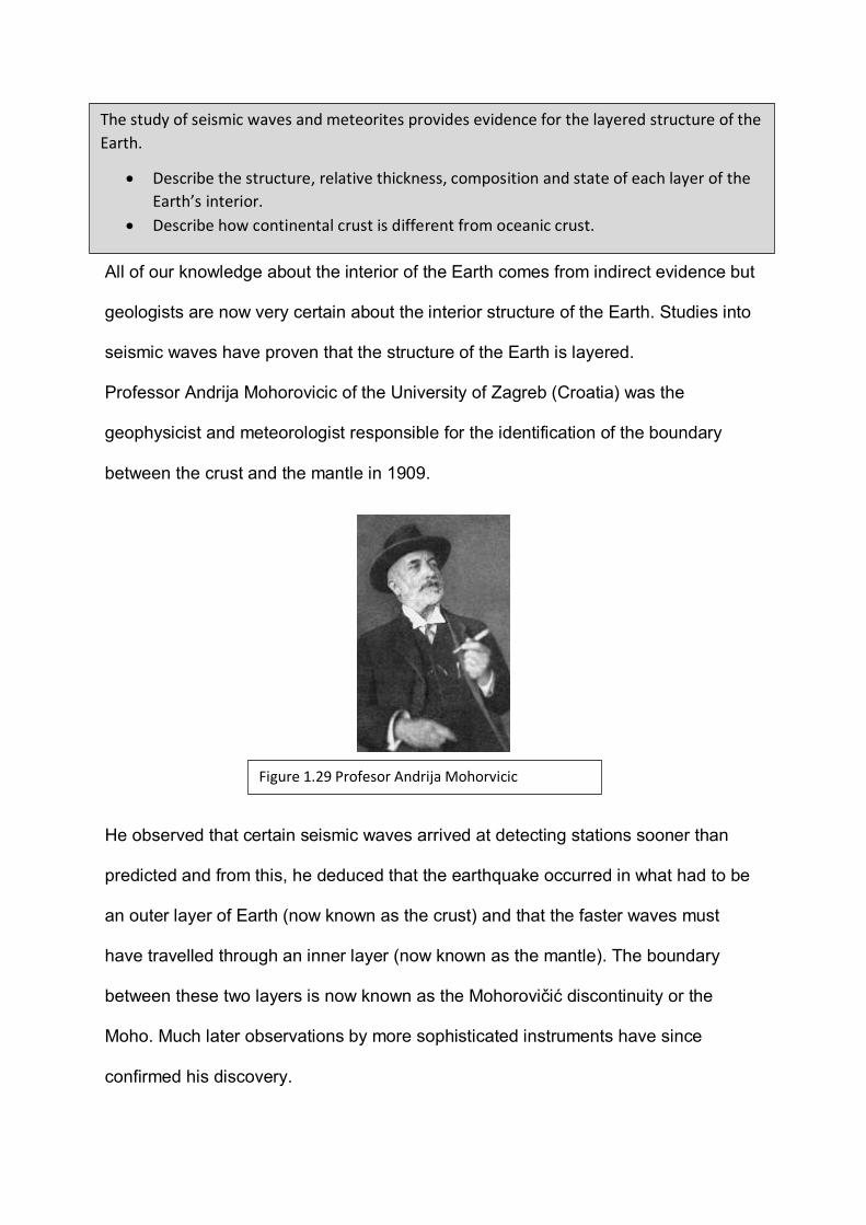
All of our knowledge about the interior of the Earth comes from indirect evidence but
geologists are now very certain about the interior structure of the Earth. Studies into
seismic waves have proven that the structure of the Earth is layered.
Professor Andrija Mohorovicic of the University of Zagreb (Croatia) was the
geophysicist and meteorologist responsible for the identification of the boundary
between the crust and the mantle in 1909.
He observed that certain seismic waves arrived at detecting stations sooner than
predicted and from this, he deduced that the earthquake occurred in what had to be
an outer layer of Earth (now known as the crust) and that the faster waves must
have travelled through an inner layer (now known as the mantle). The boundary
between these two layers is now known as the Mohorovičić discontinuity or the
Moho. Much later observations by more sophisticated instruments have since
confirmed his discovery.
The study of seismic waves and meteorites provides evidence for the layered structure of the Earth.
• Describe the structure, relative thickness, composition and state of each layer of the Earth’s interior.
• Describe how continental crust is different from oceanic crust.
Figure 1.29 Profesor Andrija Mohorvicic
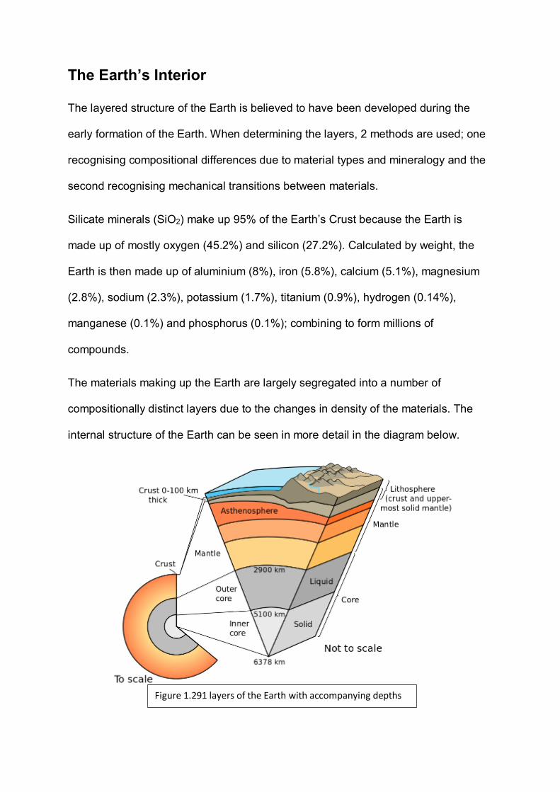
The Earth’s Interior
The layered structure of the Earth is believed to have been developed during the
early formation of the Earth. When determining the layers, 2 methods are used; one
recognising compositional differences due to material types and mineralogy and the
second recognising mechanical transitions between materials.
Silicate minerals (SiO2) make up 95% of the Earth’s Crust because the Earth is
made up of mostly oxygen (45.2%) and silicon (27.2%). Calculated by weight, the
Earth is then made up of aluminium (8%), iron (5.8%), calcium (5.1%), magnesium
(2.8%), sodium (2.3%), potassium (1.7%), titanium (0.9%), hydrogen (0.14%),
manganese (0.1%) and phosphorus (0.1%); combining to form millions of
compounds.
The materials making up the Earth are largely segregated into a number of
compositionally distinct layers due to the changes in density of the materials. The
internal structure of the Earth can be seen in more detail in the diagram below.
Figure 1.291 layers of the Earth with accompanying depths

The following table summarises the essential properties for each of Earth's layers.
Name of Layer
Thickness (km) Physical
state
Composition
Crust: Continental Oceanic
25 – 70 7-10
solid solid
granitic (sial) basaltic (sima)
Mantle
2885
solid
peridotite
Outer core
2100
liquid
alloy of Fe & Ni
Inner core
1400
solid
same as outer core.
The Crust
The surface of the Earth is actually its outermost layer, known as the crust. As it is
the layer we are standing on, it is the layer we are the most familiar with. While it
contains all of our resources the crust is the thinnest layer of the Earth, being only
0.1-1% of the Earth’s radius. The exact thickness of the crust varies greatly however,
depending on the location.
Figure 1.292 differences in thickness of the crust beneath North America

The map (Figure1.292) is compiled from measurements of seismic waves and
gravity. Because crustal rocks have lower density than mantle rocks, the force of
gravity tends to be slightly weaker over regions of thickened crust.
Geologists distinguish between two fundamentally different layers of the crust;
continental and oceanic. These two layers are different in both composition and
density. The continental crust averages 4-5 times the thickness of oceanic crust but
is much less dense. Continental Crust is less dense as it is rich in silicon and
aluminium (Si and Al; hence sial) and composed of more felsic igneous rocks such
as granite. Oceanic crust is denser as it is composed of materials that are denser in
composition; silicon and magnesium (Si and Ma; hence sima) and is made up of
more mafic igneous rocks such as basalt.
The Mantle
The mantle of the Earth forms the thickest layer at around 2900km surrounding the
core. This layer is made up of higher density silicate rocks such as olivine, pyroxene,
garnet, spinel and peridotite but once the mantle is deeper than 660km, pressure
becomes too high and these form into rocks that can only be seen at the surface
from high pressure rock experiments. The mantle makes up 84% of the Earth by
volume.
Because of this massive pressure difference at 660km, geoscientists have divided
this layer into 2 sub-layers; the upper and lower mantle. Almost all of the mantle is
solid rock but the temperature of this rock is so hot from a depth of 100-150km, that
the rocks are soft enough to flow. The flow is extremely slow however, at a rate of
15cm per year. Though overall the temperature of the mantle increases with depth,
the specific temperature also depends on the location as some areas are considered
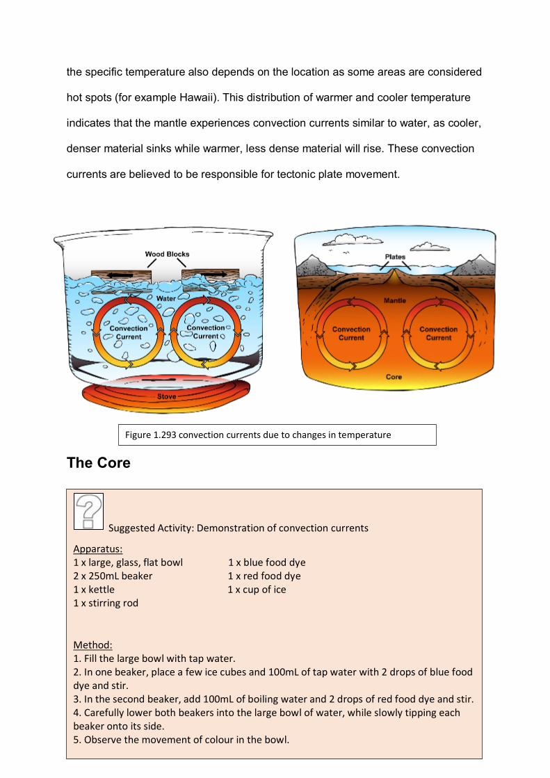
hot spots (for example Hawaii). This distribution of warmer and cooler temperature
indicates that the mantle experiences convection currents similar to water, as cooler,
denser material sinks while warmer, less dense material will rise. These convection
currents are believed to be responsible for tectonic plate movement.
The Core
The core consists of 2 sub-layers; the inner and outer core and is composed mostly
of iron and nickel, bound with small amounts of other heavy elements. It is believed
that a solid inner core is enclosed within a molten, liquid outer core due to P-wave
reflections. The differences in state is likely due to the impact of pressure on the
melting temperatures of iron. While the inner and outer core have different states,
the composition is believed to be the same.
Figure 1.293 convection currents due to changes in temperature
Suggested Activity: Demonstration of convection currents
Apparatus: 1 x large, glass, flat bowl 1 x blue food dye 2 x 250mL beaker 1 x red food dye 1 x kettle 1 x cup of ice 1 x stirring rod
Method: 1. Fill the large bowl with tap water. 2. In one beaker, place a few ice cubes and 100mL of tap water with 2 drops of blue food dye and stir. 3. In the second beaker, add 100mL of boiling water and 2 drops of red food dye and stir. 4. Carefully lower both beakers into the large bowl of water, while slowly tipping each beaker onto its side. 5. Observe the movement of colour in the bowl.
Potential SHE task topics:
• Explore the contributions (communication and collaboration) different scientists
have made during the last century to form our current understanding of the
structure of the Earth’s interior.
• Discuss how the developments in technology over the last century have made
understanding the interior of the Earth much easier.
The interior of the Earth is made up of 3 main layers; the crust, the mantle and the
core.
(a) Mohorovicic first identified the boundary between the crust and the mantle in
1909.
(1) The Moho was identified by mapping variations in the velocity of
seismic waves within the rocky outer layers of the planet. State the
physical feature of the planetary interior that this seismic
discontinuity corresponds to.
__________________________________________ (1 mark) KA1
(2) Explain how the development of technology has allowed
geoscientists to state with more certainty the composition and
layering of the Earth’s interior.
______________________________________________________
______________________________________________________
______________________________________________________
______________________________________________________
______________________________________________________
______________________________________________________
______________________________________________________
______________________________________________________
______________________________________________________
________________________________________ (3 marks) KA3
(b) Sima and sial are simplified compositional criteria used to subdivide the outer
crust of the Earth.
Question 4

(1) Describe what makes crustal rock either sima or sial.
________________________________________________________
________________________________________________________
________________________________________________________
________________________________________________________
________________________________________________________
________________________________________________________
________________________________________________________
______________________________________(3 marks) KA1
(2) Explain why they are different from the terms oceanic and continental
crust.
________________________________________________________
________________________________________________________
________________________________________________________
________________________________________________________
________________________________________________________
________________________________________________________
_______________________________(3 marks) KA1
(3) Explain how oceanic and continental crust are different.
________________________________________________________
________________________________________________________
________________________________________________________
________________________________________________________
________________________________________________________
________________________________________________________
________________________________________________________
________________________________________________________
____________________________________________ (3 marks) KA1
(c) In the space below draw a labelled infographic, with the relevant depths
depicting the interior layers of the Earth.
(5 marks) KA2
A gradient is a gradual change in some physical or chemical property and can be
either sharp or shallow. Heat energy always moves down a temperature gradient
from a warmer place to a cooler one. This is why heat from the Earth’s hot centre
flows outward towards the cooler surface, affecting rocks within each layer, from the
core to the crust.
Measurements have been taken worldwide in underground mines or wells to harvest
rock and measure properties such as temperature, radioactivity and porosity. These
measurements have been useful in determining the Earth’s temperature gradient
and in demonstrating the increase of temperature with depth.
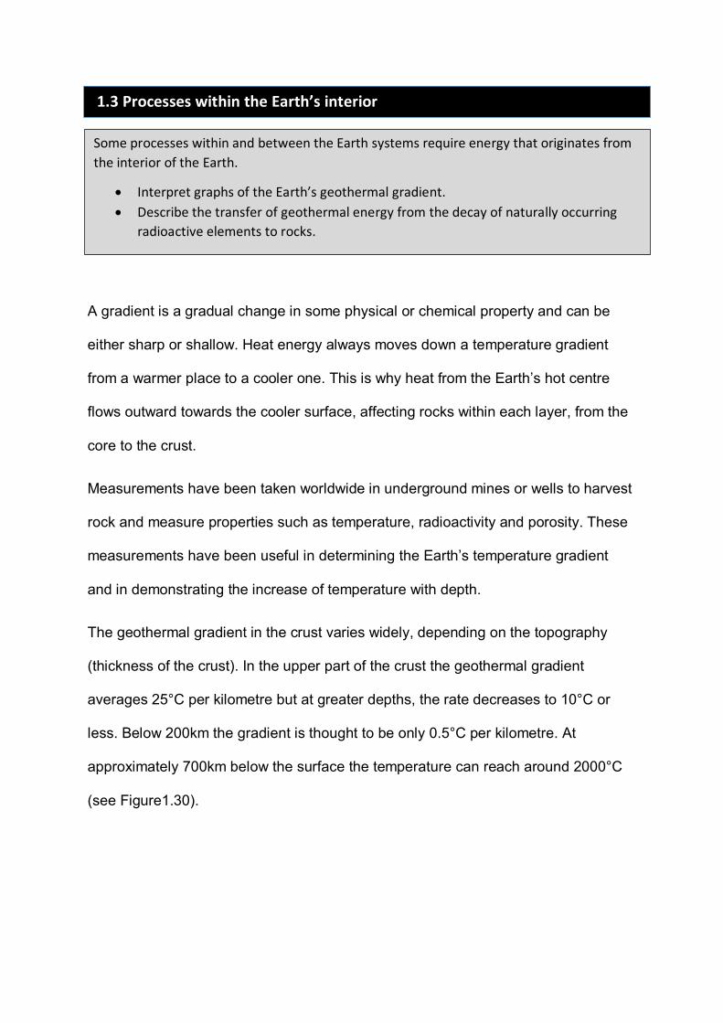
The geothermal gradient in the crust varies widely, depending on the topography
(thickness of the crust). In the upper part of the crust the geothermal gradient
averages 25°C per kilometre but at greater depths, the rate decreases to 10°C or
less. Below 200km the gradient is thought to be only 0.5°C per kilometre. At
approximately 700km below the surface the temperature can reach around 2000°C
(see Figure1.30).
1.3 Processes within the Earth’s interior
Some processes within and between the Earth systems require energy that originates from the interior of the Earth.
• Interpret graphs of the Earth’s geothermal gradient. • Describe the transfer of geothermal energy from the decay of naturally occurring
radioactive elements to rocks.
Geothermal Energy
If the Earth was not hot inside, igneous processes would not occur. The heat in the
Earth is a remnant of the Earth’s formation. According to the Nebula Theory, Earth
formed from the collision and merging of millions of planetismals and as each
collision occurred, kinetic energy (from the motion of the planetimals) was
transformed into thermal energy.
Figure 1.30 The Earth’s geothermal gradient illustrates how temperature increases with depth.

As the Earth grew gravity pulled matter inward, until the weight of over lying material
squeezed the matter inside tightly together. The compression inside the Earth also
made the Earth’s interior hotter. Once the earth had grown to become a planet, the
Earth continued to be bombarded by colliding planetismals, adding increasing heat
energy.
Eventually this process caused iron within the Earth to melt, increasing its density,
allowing it to sink to the core. Friction between the sinking iron and its surroundings
caused more heat. This process transformed gravitational potential energy into
thermal energy.
These collisions and differentiations made the earth so hot, it is believed that it was
made partially molten throughout and the surface was likely to have been an ocean
of lava. Since then, the Earth has radiated heat into space, slowly cooling over the
last 4.5 billion years and the sea of lava has solidified, forming igneous rock.
Figure 1.31 Early formation of the Earth

Radioactive Decay
While some of the Earth’s internal energy dates from the Earth’s early formation,
some is also produced from radioactive decay in minerals. As there has been no
external heat added since the end of the bombardment of planetismals, the fact that
the Earth still has continuous igneous processes indicates that another source of
heat energy must be present in the form of radioactive decay. If this was not the
case, the planet would be too cool for igneous activity to occur. Decay of a single
radioactive atom only produces a very small amount of heat, but the cumulative
effect of radioactive decay throughout the Earth has been sufficient to slow down the
cooling of the planet. This is why Earth is still hot today, reaching almost 1 300°C at
the base of the lithosphere (crust and upper mantle) and 4 700°C within the core.
Many chemical elements in the earth are naturally radioactive including radium,
uranium and thorium, making them unstable. These elements emit radiation as they
spontaneously break down into stable daughter elements such as lead and
potassium. This process releases a small amount of thermal energy which then
continues to heat the earth internally.
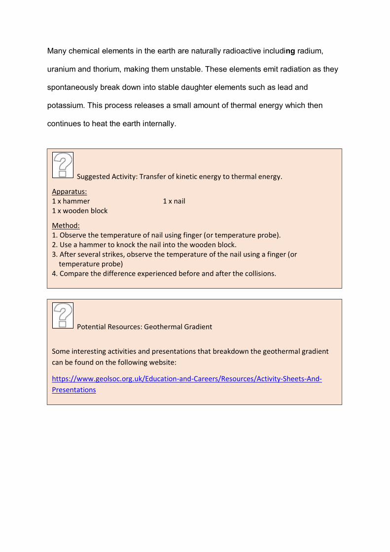
Suggested Activity: Transfer of kinetic energy to thermal energy.
Apparatus: 1 x hammer 1 x nail 1 x wooden block
Method: 1. Observe the temperature of nail using finger (or temperature probe). 2. Use a hammer to knock the nail into the wooden block. 3. After several strikes, observe the temperature of the nail using a finger (or temperature probe) 4. Compare the difference experienced before and after the collisions.
Potential Resources: Geothermal Gradient
Some interesting activities and presentations that breakdown the geothermal gradient can be found on the following website:
https://www.geolsoc.org.uk/Education-and-Careers/Resources/Activity-Sheets-And-Presentations
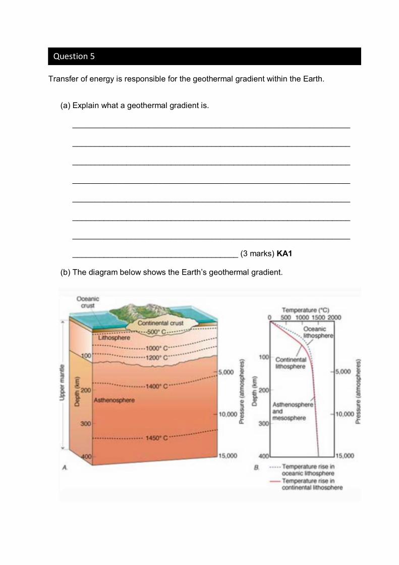
Transfer of energy is responsible for the geothermal gradient within the Earth.
(a) Explain what a geothermal gradient is.
______________________________________________________________
______________________________________________________________
______________________________________________________________
______________________________________________________________
______________________________________________________________
______________________________________________________________
______________________________________________________________
_____________________________________ (3 marks) KA1
(b) The diagram below shows the Earth’s geothermal gradient.
Question 5
(1) Use the graph above to determine which crust (lithosphere) is
cooler at a depth of 50m; oceanic or continental.
__________________________________________(1 mark) IAE3
(2) Explain why this crust (as stated in (1)) would be cooler.
______________________________________________________
______________________________________________________
______________________________________________________
______________________________________________________
______________________________________________________
______________________________________________________
______________________________________________________
______________________________________________________
______________________________________________________
_________________________________________ (3 marks) KA2
(3) Explain whether or not the geothermal gradient is constant from
Earth’s surface to the centre.
______________________________________________________
______________________________________________________
______________________________________________________
______________________________________________________
______________________________________________________
______________________________________________________
________________________(2 marks) KA2
(c) Explain what is involved in the process of radioactive decay.
______________________________________________________________
______________________________________________________________
______________________________________________________________
______________________________________________________________
______________________________________________________________
_______________________ (3 marks) KA1
(d) Discuss where the Earth’s geothermal energy comes from.
______________________________________________________________
______________________________________________________________
______________________________________________________________
______________________________________________________________
______________________________________________________________
______________________________________________________________
______________________________________________________________
______________________________________________________________
______________________________________________________________
______________________________________________________________
______________________________________________________________
______________________________________________________________
______________________________________________________________
______________________________________________________________
______________________________________________________________
_______________________ (6 marks) KA4
(e) Research the Geothermal Hot Rocks method for the production of electricity.
(1) Explain how geothermal hot rocks uses heat generated from
radioactive decay to create electricity.
______________________________________________________
______________________________________________________
______________________________________________________
______________________________________________________
______________________________________________________
______________________________________________________
________________________ (3 marks) KA1
(2) Discuss how this method of electricity is potentially more
environmentally sustainable than other sources (application).
______________________________________________________
______________________________________________________
______________________________________________________
______________________________________________________
______________________________________________________
______________________________________________________
________________________ (3 marks) KA3
(3) Discuss a limitation that this method may have for the generation of
electricity in Australia.
______________________________________________________
______________________________________________________
______________________________________________________
______________________________________________________

______________________________________________________
______________________________________________________
________________________ (3 marks) KA3
Plate tectonics is a concept that is still fairly recent. The Canadian geophysicist John
Tuzo-Wilson was initially sceptical of the theory of Plate Tectonics, but eventually
became one of its most famous supporters, proposing two important ideas; the most
famous of these being ‘hot-spots’.
“much as I admired the elegance of physical theories which at the time, geology wholly lacked, I preferred a life in the woods, to one in the laboratory”
In 1915, the highly controversial theory of continental drift was first published by
Alfred Wegener (the founder) but by the early 1950’s the theory still didn’t explain
why active volcanoes are found many thousands of kilometres from the nearest plate
boundary. In 1963, Tuzo-Wilson proposed that plates might move over fixed hots-pots
in the mantle forming volcanic island chains like Hawaii. John Tuzo Wilson noted that
active hot spot volcanoes occur at the end of the dead, volcanic islands and
1.4 The Earth’s Tectonic Processes
Transfers and transformations of energy in the Earth’s interior cause plume formation and drive the movement of tectonic plates, through processes such as mantle convection, slab pull and ridge push.
• Describe how plumes from the mantle can transfer heat energy from the Earth’s interior to produce ‘hot-spot’ volcanic activity and form an island chain.
Figure 1.40 John Tuzo-Wilson
seamounts (extinct volcanoes). This theory filled in the gaps that were previously
missing in ‘continental drift’.
Hot Spot Volcanoes
Volcanoes usually occur in volcanic arcs (above sea-level volcanoes next to the
border of ocean trenches) or along mid-ocean ridges (often hidden underwater).
Because these type of volcanoes are formed as a consequence of tectonic
movement along a plate boundary, they are known as plate boundary volcanoes. Not
all volcanoes on Earth are plate boundary volcanoes however. The most well-known
of these are the islands of Hawaii (lying in the centre of the Pacific Plate) however,
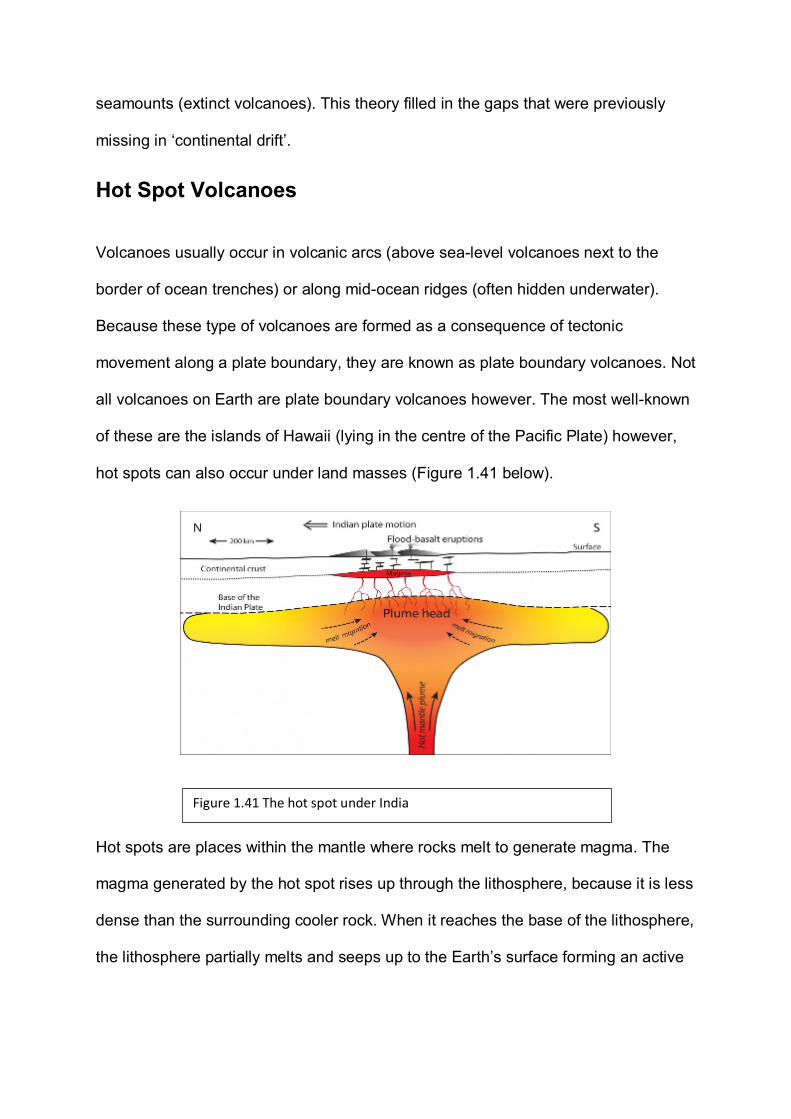
hot spots can also occur under land masses (Figure 1.41 below).
Hot spots are places within the mantle where rocks melt to generate magma. The
magma generated by the hot spot rises up through the lithosphere, because it is less
dense than the surrounding cooler rock. When it reaches the base of the lithosphere,
the lithosphere partially melts and seeps up to the Earth’s surface forming an active
Figure 1.41 The hot spot under India

volcano. This upwelling of magma from the mantle is known as a mantle plume; the
hot spot develops above the plume.
After Tuzo-Wilson’s research, it is believed that the heat source of the hotspot is in a
fixed location. As can be seen (Figure 1.42 below), it is the plate that is moving,
creating what is known as a volcanic arc. Movement of the plate slowly carries the
volcano off the top of the plume, making it extinct and a new, younger volcano then
grows above where the plume is still located. World-wide, there approximately 100
volcanoes that exist in isolated places away from plate boundaries due to hot spots.
In 1965, Tuzo-Wilson followed this discovery with the idea of a third type of plate
boundary; transform faults. Also known as transverse plate boundaries (and
transform boundaries) these faults slip horizontally, connecting oceanic ridges
(divergent boundaries) to ocean trenches (convergent boundaries) and allow plates
to slide past each other without any oceanic crust being created or destroyed. At the
time, transform faults were regarded as the missing piece in the puzzle of plate
tectonic theory; the most famous of which is the San Andreas Fault between the
North American and Pacific plates.
1 2
3 4
Figure 1.42 Formation of volcanic arcs
The concept of hot-spots helped to explain gaps that were found in Wegener’s
continental drift theory.
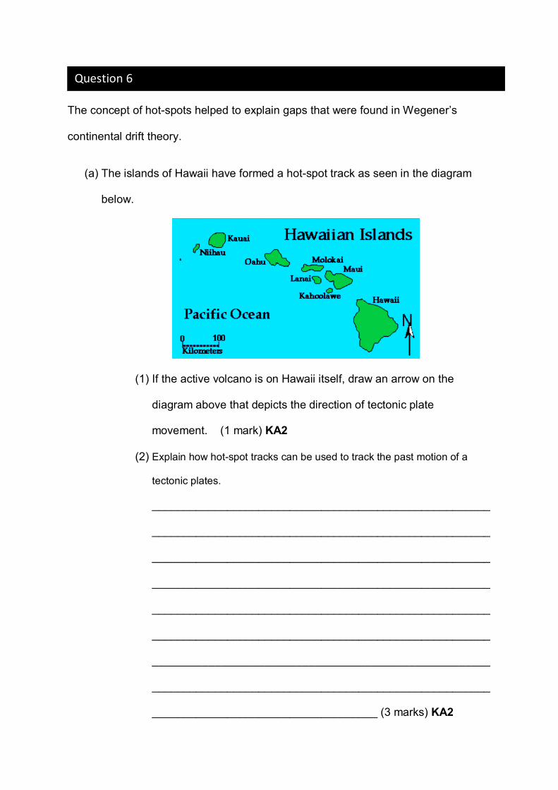
(a) The islands of Hawaii have formed a hot-spot track as seen in the diagram
below.
(1) If the active volcano is on Hawaii itself, draw an arrow on the
diagram above that depicts the direction of tectonic plate
movement. (1 mark) KA2
(2) Explain how hot-spot tracks can be used to track the past motion of a
tectonic plates.
______________________________________________________
______________________________________________________
______________________________________________________
______________________________________________________
______________________________________________________
______________________________________________________
______________________________________________________
______________________________________________________
____________________________________ (3 marks) KA2
Question 6
(b) Explain how a hot-spot track is produced.
______________________________________________________________
______________________________________________________________
______________________________________________________________
______________________________________________________________
______________________________________________________________
______________________________________________________________
______________________________________________________________
______________________________________________________________
____________________________________________ (3 marks) KA1
(c) Explain how a chain of islands caused from a hot-spot differ from a chain of islands
caused by a subduction zone.
______________________________________________________________
______________________________________________________________
______________________________________________________________
______________________________________________________________
______________________________________________________________
______________________________________________________________
______________________________________________________________
______________________________________________________________
____________________________________________ (3 marks) KA2
(d) Discuss the significance of scientific collaboration in the development of
continental drift theory.
______________________________________________________________
______________________________________________________________
______________________________________________________________
______________________________________________________________
______________________________________________________________
______________________________________________________________
______________________________________________________________
______________________________________________________________
______________________________________________________________
______________________________________________________________
______________________________________________________________
______________________________________________________________
______________________________________________________________
______________________________________________________________
_________________ (4 marks) KA3
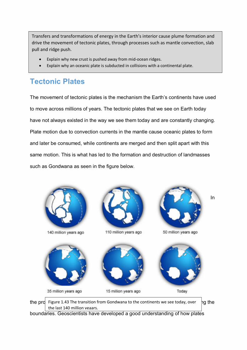
Tectonic Plates
The movement of tectonic plates is the mechanism the Earth’s continents have used
to move across millions of years. The tectonic plates that we see on Earth today
have not always existed in the way we see them today and are constantly changing.
Plate motion due to convection currents in the mantle cause oceanic plates to form
and later be consumed, while continents are merged and then split apart with this
same motion. This is what has led to the formation and destruction of landmasses
such as Gondwana as seen in the figure below.
In
the process of movement, the plates are forced to interact with each other along the
boundaries. Geoscientists have developed a good understanding of how plates
Transfers and transformations of energy in the Earth’s interior cause plume formation and drive the movement of tectonic plates, through processes such as mantle convection, slab pull and ridge push.
• Explain why new crust is pushed away from mid-ocean ridges. • Explain why an oceanic plate is subducted in collisions with a continental plate.
Figure 1.43 The transition from Gondwana to the continents we see today, over the last 140 million yeaars.
move and how these movements relate to tectonic activity. Most movement occurs
between narrow zones where the results of tectonic forces are most evident.
There are four types of plate boundaries:
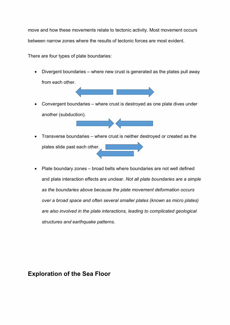
• Divergent boundaries – where new crust is generated as the plates pull away
from each other.
• Convergent boundaries – where crust is destroyed as one plate dives under
another (subduction).
• Transverse boundaries – where crust is neither destroyed or created as the
plates slide past each other.
• Plate boundary zones – broad belts where boundaries are not well defined
and plate interaction effects are unclear. Not all plate boundaries are a simple
as the boundaries above because the plate movement deformation occurs
over a broad space and often several smaller plates (known as micro plates)
are also involved in the plate interactions, leading to complicated geological
structures and earthquake patterns.
Exploration of the Sea Floor
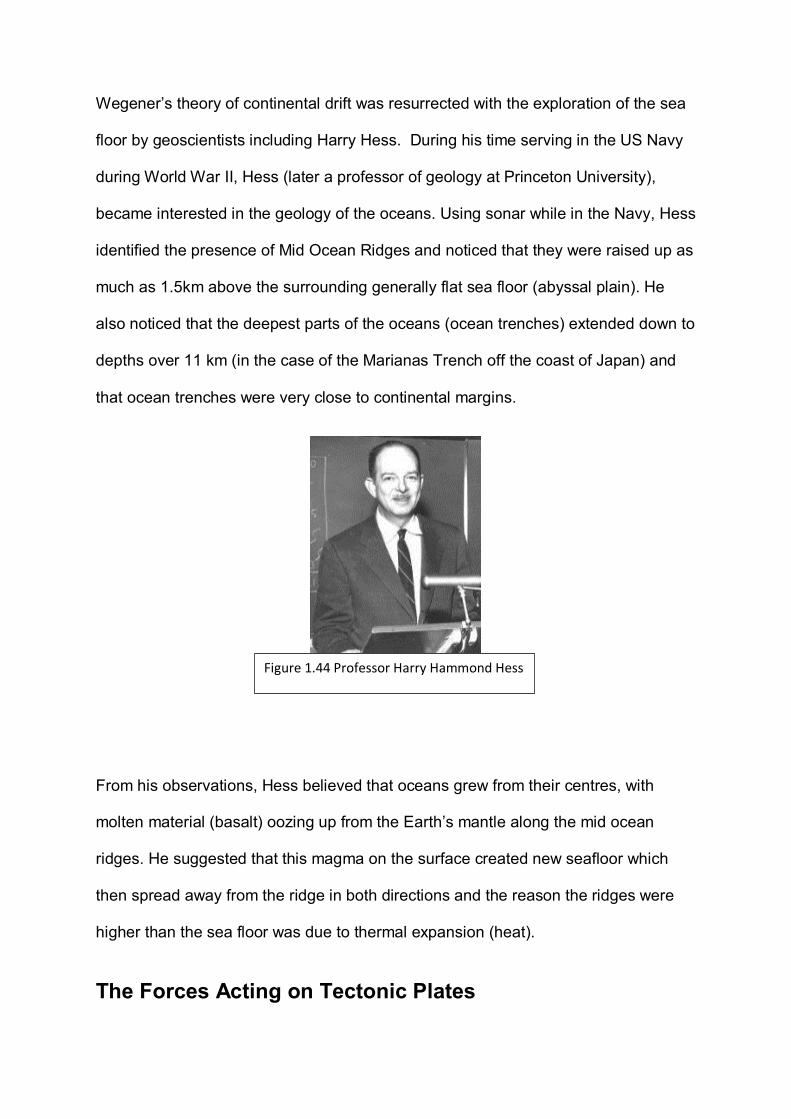
Wegener’s theory of continental drift was resurrected with the exploration of the sea
floor by geoscientists including Harry Hess. During his time serving in the US Navy
during World War II, Hess (later a professor of geology at Princeton University),
became interested in the geology of the oceans. Using sonar while in the Navy, Hess
identified the presence of Mid Ocean Ridges and noticed that they were raised up as
much as 1.5km above the surrounding generally flat sea floor (abyssal plain). He
also noticed that the deepest parts of the oceans (ocean trenches) extended down to
depths over 11 km (in the case of the Marianas Trench off the coast of Japan) and
that ocean trenches were very close to continental margins.
From his observations, Hess believed that oceans grew from their centres, with
molten material (basalt) oozing up from the Earth’s mantle along the mid ocean
ridges. He suggested that this magma on the surface created new seafloor which
then spread away from the ridge in both directions and the reason the ridges were
higher than the sea floor was due to thermal expansion (heat).
The Forces Acting on Tectonic Plates
Figure 1.44 Professor Harry Hammond Hess
Early geoscientists originally believed that convection currents within the mantle was
solely responsible for the movement of tectonic plates however it is now accepted
that while convection flow does occur, it does not directly drive motion. Hot magma
definitely rises and sinks in some locations because of difference in temperature and
this does influence plate motion but the local directions of this flow does not always
align with the overall direction of plate movement. This is because the plates are a
huge landmass, of substantial weight and other forces are also involved (such as
momentum). Geoscientists hypothesise that two forces (ridge-push forces and slab-
pull force) strongly influence the motion of individual plates.
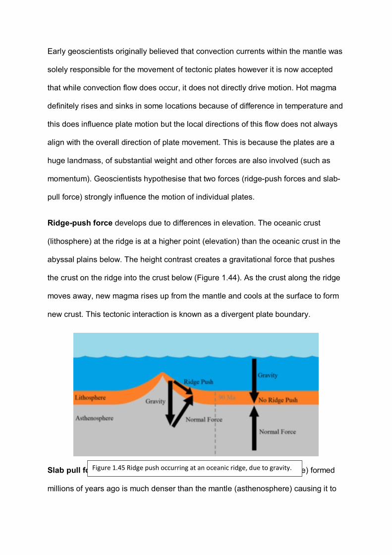
Ridge-push force develops due to differences in elevation. The oceanic crust
(lithosphere) at the ridge is at a higher point (elevation) than the oceanic crust in the
abyssal plains below. The height contrast creates a gravitational force that pushes
the crust on the ridge into the crust below (Figure 1.44). As the crust along the ridge
moves away, new magma rises up from the mantle and cools at the surface to form
new crust. This tectonic interaction is known as a divergent plate boundary.
Slab pull force develops due to differences in density. Crust (lithosphere) formed
millions of years ago is much denser than the mantle (asthenosphere) causing it to
Figure 1.45 Ridge push occurring at an oceanic ridge, due to gravity.
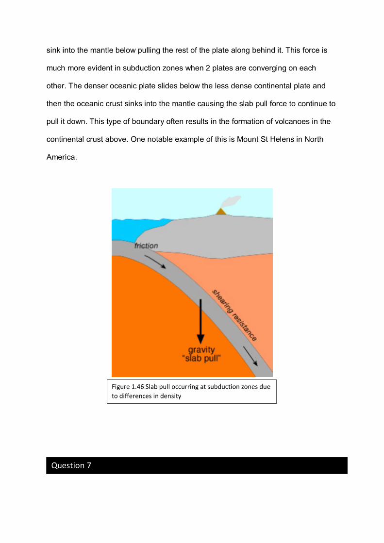
sink into the mantle below pulling the rest of the plate along behind it. This force is
much more evident in subduction zones when 2 plates are converging on each
other. The denser oceanic plate slides below the less dense continental plate and
then the oceanic crust sinks into the mantle causing the slab pull force to continue to
pull it down. This type of boundary often results in the formation of volcanoes in the
continental crust above. One notable example of this is Mount St Helens in North
America.
Figure 1.46 Slab pull occurring at subduction zones due to differences in density
Question 7
Tectonic plate movement is responsible for landscape we see on the surface today.
(a) Identify the driving force behind the push-pull model.
__________________________________________________ (1 mark) KA1
(b) Describe the evidence that supports the model of ridge push.
______________________________________________________________
______________________________________________________________
______________________________________________________________
______________________________________________________________
______________________________________________________________
______________________________________________________________
______________________________________________________________
_____________________________________ (3 marks) KA2
(c) Explain how slab pull works.
______________________________________________________________
______________________________________________________________
______________________________________________________________
______________________________________________________________
______________________________________________________________
______________________________________________________________
______________________________________________________________
_____________________________________ (3 marks) KA1
(d) There are four main types of tectonic plate boundaries.
(1) State which plate boundary is most likely to occur between two
plates that are made of oceanic and continental crust.
__________________________________________ (1 mark) KA1
(2) Describe the interaction that would occur at this boundary.
______________________________________________________
______________________________________________________
______________________________________________________
______________________________________________________
______________________________________________________
__________________ (2 marks) KA2
(3) Explain why this interaction occurs.
______________________________________________________
______________________________________________________
______________________________________________________
______________________________________________________
______________________________________________________
______________________________________________________
______________________________________________________
______________________________________________________
____________________________________ (3 marks) KA2
(4) Give one geographic example of where each of the following
boundaries can be observed at the surface of the Earth.
Divergent:
___________________________________________________
Convergent:
_________________________________________________
Transverse:
__________________________________________________
(3 marks) KA1
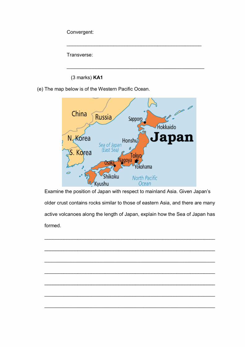
(e) The map below is of the Western Pacific Ocean.
Examine the position of Japan with respect to mainland Asia. Given Japan’s
older crust contains rocks similar to those of eastern Asia, and there are many
active volcanoes along the length of Japan, explain how the Sea of Japan has
formed.
______________________________________________________________
______________________________________________________________
______________________________________________________________
______________________________________________________________
______________________________________________________________
______________________________________________________________
______________________________________________________________
______________________________________________________________
______________________________________________________________
______________________________________________________________
_________________________________________________(4 marks) KA2
Potential Field Trip:
If you want to introduce students to a university environment, The Institute for Mineral
and Energy Resources;
Centre for Tectonics, Resources and Exploration at Adelaide University runs TRaX
Seminars weekly on Fridays at 12.10pm-1.00pm, in the Mawson Lecture Theatre.
Information about the sessions and contact details to book a class can be found at the
following location:
https://www.adelaide.edu.au/trax/
Potential SHE task topics:
• Explore the contributions (communication and collaboration) different scientists
have made during the last century to form the modern theory of plate tectonics.
• Discuss the influence technology from World War II has had in understanding
geological processes.
Potential Activity: What’s the angle
Activity kindly provided by;
Earthquake data is recorded by seismometers all around the world. With three or more good
sets of data from a scatter of seismometers it is possible to establish the location of the
earthquake at the surface (called the epicentre) and the depth of the earthquake’s origin
below the epicentre (called the foci).
In this exercise there is real data for 22 earthquakes that have occurred in South America
between 1993 and 1994 (Table 1). The epicentre for each earthquake is given by the
latitude and longitude coordinates and the foci are given by the depth.
EXTRA INFORMATION:
Latitude and Longitude
Latitude and longitude are a global
coordinate system that allows scientists to
give any point on the Earth’s surface a
unique coordinate pair. The Equator (0o)
divides the Earth into Northern and
Southern Hemishpheres; latitudes in the
Southern Hemisphere are followed with an
S (for example 19.8o S) or in digital systems
Southern Hemisphere latitudes are prefixed
with the minus symbol (for example -
19.8o). Likewise the Prime Meridien (0o at Greenwich) divides the Earth into Eastern and
Western Hemispheres. Longitudes east and west are suffixed with an E or W accordingly.
Western longitudes are prefixed with a minus symbol in digital systems.
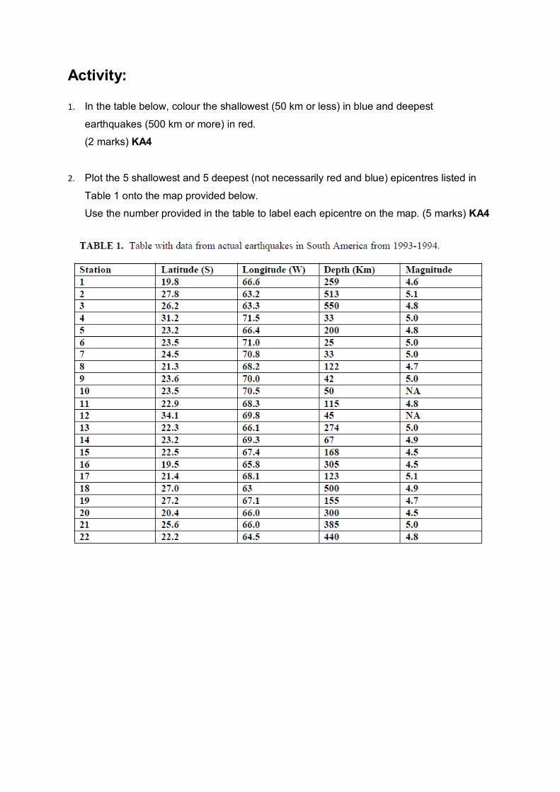
Activity:
1. In the table below, colour the shallowest (50 km or less) in blue and deepest
earthquakes (500 km or more) in red. (2 marks) KA4
2. Plot the 5 shallowest and 5 deepest (not necessarily red and blue) epicentres listed in
Table 1 onto the map provided below. Use the number provided in the table to label each epicentre on the map. (5 marks) KA4
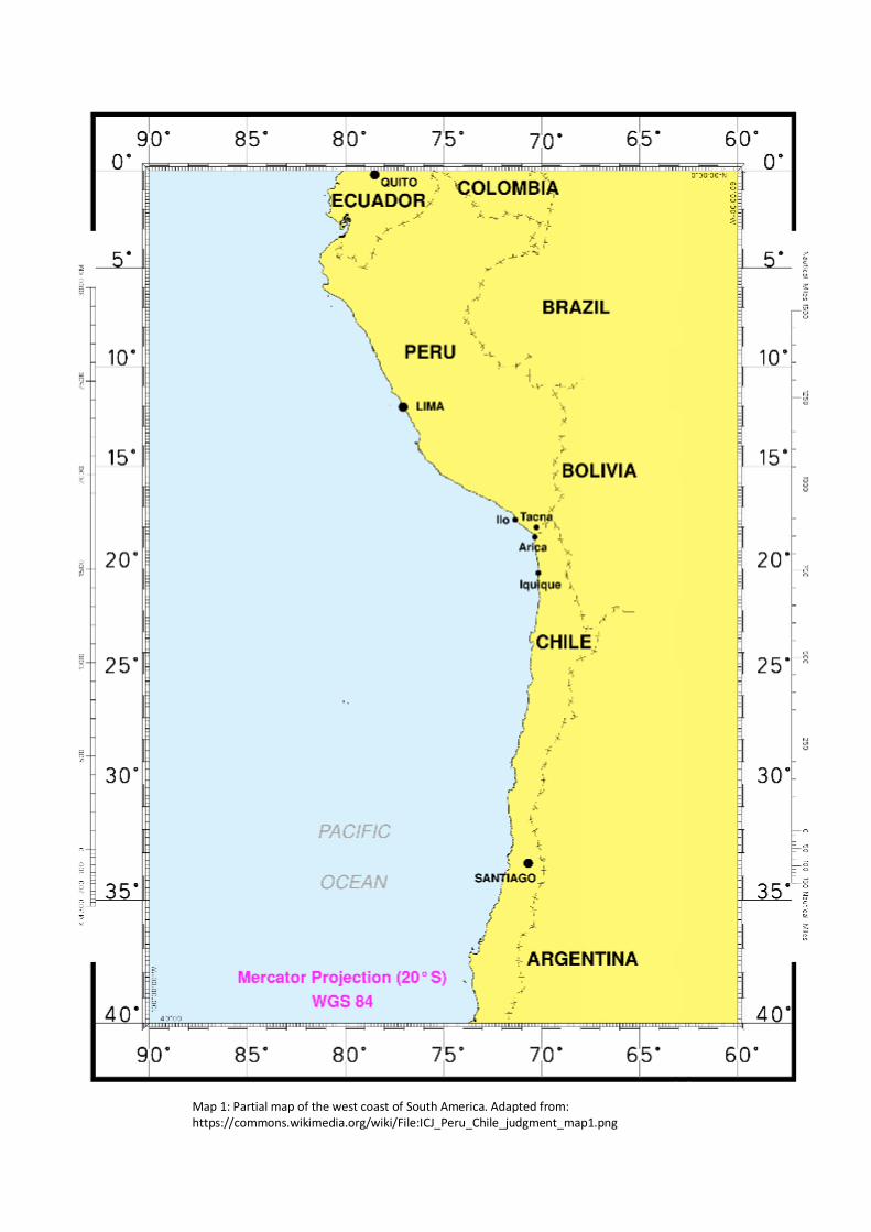
Map 1: Partial map of the west coast of South America. Adapted from: https://commons.wikimedia.org/wiki/File:ICJ_Peru_Chile_judgment_map1.png
3. Describe any trends that can be inferred from the data you have plotted.
______________________________________________________________________
______________________________________________________________________
______________________________________________________________________
______________________________________________________________________
______________________________________________________________________
______________________________________________________________________
______________________________________________________________________
______________________________________________________________________
______________________________________________________________________
______________________________________________________________________
______________________________________________________________________
______________________________________________________________________
______________________________________________________________________
__________________________ (5 marks) KA2
4. This earthquake zone on the map represents the San Andreas fault line. State the type of earthquake zone it is. __________________________________________________________ (1 mark) KA1
5. Explain which type/s of crust is involved in this earthquake zone.
______________________________________________________________________
______________________________________________________________________
______________________________________________________________________
______________________________________________________________________
______________________________________________________________________
______________________________________________________________________
______________________________________________________________________
___________________________________________________ (3 marks) KA1
This document is based on an exercise published by the Geological Society of America but with substantial modifications and additions
References Andrija Mohorovicic 2005, Andrija Mohorovicic Memorial Rooms, accessed 25 September 2018, <http://www.gfz.hr/sobe-en/andrija.htm>.
Clark, I & Cook, B 1983, Geological Science Perspectives of the Earth, First edn, Australian Academy of Science, Canberra, ACT.
Drurey, S 2018, A Hint of Life on Mars, Earth-pages, accessed 1 November 2018, <https://wileyearthpages.wordpress.com/category/planetary-extraterrestrial-geology-and-meteoritics/>.
Encyclopedia Britannica 2018, James Hutton, accessed 15 November 2018, <https://www.britannica.com/biography/James-Hutton>.
Heffernan, D, Mahon, R, McDougall, J & Gillies, K 2009, Spotlight Earth & Environmental Science 1, Science Press, Marrickville, NSW.
Heffernan, D, Mahon, R, McDougall, J & Gillies, K 2009, Spotlight Earth & Environmental Science 2, Science Press, Marrickville, NSW.
Hot Spots and Volcanoes 2018, Galapagos Conservation Trust, accessed 1 November 2018, <http://www.discoveringgalapagos.org.uk/discover/geographical-processes/location-formation/hot-spots-volcanoes/>.
Hutchinson, G 2014, Earthquakes and Earth's Interior, Slide Player, accessed 15 September 2018, <https://slideplayer.com/slide/6242488>.
James Hutton: The Founder of Modern Geology 2018, American Museum of Natural History, accessed 29 October 2018, <https://www.amnh.org/explore/resource-collections/earth-inside-and-out/james-hutton-the-founder-of-modern-geology>.
Mantle Plume Under India 2018, Eurek Alert! The Global Source of Science News, accessed 28 October 2018, <https://www.eurekalert.org/multimedia/pub/91103.php>.
Marshak, S 2012, Earth Portrait of a Planet, Fourth edn, W.W Norton & Company, New York, NY.
McCloskey, M 2016, Convection Currents and the Mantle, Mother Teresa High School, Canada, accessed 23 October 2018, <https://sites.google.com/a/ocsb.ca/cgc-1d/a-unit-2-3-natural-disasters--earthquakes/1-4-convection-currents/2-convection-currents>. Mehmood, M 2018, Seismic Study of the Earth's Interior, Learning Geology, accessed 20 October 2018, <http://geologylearn.blogspot.com/2016/03/seismic-study-of-earths-interior.html>.
Munyard, A, Tompkins, D, Watts, M, Winwood, R & Zander, S 2010, Exploring Earth & Environmental Science, Earth Science Western Australia, Perth, WA.
Seismic Shadow Zone: Basic Introduction 2018, Incorporated Research Institutions for Seismology, accessed 28 October 2018, <https://www.iris.edu/hq/inclass/animation/seismic_shadow_zone_basic_introduction>.
Seismic Waves 2007, Science Learning Hub, accessed 28 October 2018, <https://www.sciencelearn.org.nz/resources/340-seismic-waves>.
Seismic Waves 2018, BBC Bitesize, accessed 28 October 2018, <https://www.bbc.com/bitesize/guides/zswkjty/revision/1>.

Shadow Zones 2018, USGS Science for a Changing World, accessed 1 November 2018, <https://earthquake.usgs.gov/learn/glossary/?term=shadow%20zone>.
Skinner, B, Porter, S & Park, J 2004, Dynamic Earth an Introduction to Physical Geology, Fifth edn, Wiley, Washington DC.
Tompkins, D & Watkins, J 2016, Exploring Earth & Environmental Science Year 11, Earth Science Western Australia, Perth, WA.
Uniformitarianism: Charles Lyell 2018, Understanding Evolution, accessed 9 November 2018, <https://evolution.berkeley.edu/evolibrary/article/history_12>.