work zone activity data (wzad) data dictionary report · 2019-08-19 · this work zone data...
TRANSCRIPT

Work Zone Activity Data (WZAD)
Data Dictionary Report Version 2
Publication No. FHWA-XXX-XX-XXXX
March 15, 2019

i
Notice
This document is disseminated under the sponsorship of the U.S. Department of Transportation in the interest of information
exchange. The U.S. Government assumes no liability for the use of the information contained in this document.
The U.S. Government does not endorse products or manufacturers. Trademarks or manufacturers' names appear in
this report only because they are considered essential to the objective of the document.
Quality Assurance Statement
The Federal Highway Administration (FHWA) provides high-quality information to serve Government, industry, and the
public in a manner that promotes public understanding. Standards and policies are used to ensure and maximize the quality,
objectivity, utility, and integrity of its information. FHWA periodically reviews quality issues and adjusts its programs and
processes to ensure continuous quality improvement.
ii
VERSION HISTORY
ver Date Author(s) Comment
1 August 10, 2018 ICF Team First Version of the Data Dictionary
2 March 15, 2019 ICF Team Added Use Case data flows mapping table; incorporated comments from WZDI Workshop (11 Sept 2018)

iii
Technical Report Documentation Page 1. Report No. FHWA-XXX-XX-XXXX
2. Government Accession No.
3. Recipient’s Catalog No.
4. Title and Subtitle Work Zone Activity Data (WZAD) – Data Dictionary Report (Version 2)
5. Report Date March 15, 2019 6. Performing Organization Code
7. Authors Ms. Polly Okunieff, ICF; Dr. Denny Stephens, Vital Assurance; Ms. Rachel Ostroff, ICF
8. Performing Organization Report No.
9. Performing Organization Name and Address 10. Work Unit No. (TRAIS)
ICF Incorporated, L.L.C. 9300 Lee Highway Fairfax, VA 22031
11. Contract or Grant No.
12. Sponsoring Agency Name and Address U.S. Department of Transportation Federal Highway Administration 1200 New Jersey Avenue, SE Washington, DC 20590
13. Type of Report and Period Covered
14. Sponsoring Agency Code
15. Supplementary Notes Todd Peterson (TOCOR), Harry Crump (COR) 16. Abstract This document is the Work Zone Data Dictionary (WZDD) Report, developed as the primary deliverable for Task 4 under the Federal Highway Administration (FHWA’s) Work Zone Data Initiative (WZDI) Project. It describes the methodology and components included within Work Zone Activity Data (WZAD). This document supports the desired WZAD elements identified during stakeholder outreach discussions under Task 2 of the WZDI and documented in Work Zone Activity Data Needs and Opportunities (FHWA-XXX-XX-XXXX). It also includes traceability to data flows detailed under the Task 3 companion document, Framework for Work Zone Activity Data Collection and Management (FHWA-XX-XXXX). It is not meant as a prescriptive database nor does it profess to contain all the data that are needed by each individual data provider or consumer. Rather, it is composed of work zone-related data concepts driven by industry needs. It attempts to specify consistent data with respect to meaning and enumerated values. Its contents may serve as a reference to organizations developing their own Work Zone Data Systems (WZDS) particularly in areas that vary significantly from organization to organization such as assignment of locations (e.g., begin / end locations), temporal states, and impacts. Additionally, this document is set up to enable WZDS to adopt data concepts as they are ready or as specific stakeholder groups are incorporated into the data environment. The migration and rollout approach is described in the Work Zone Activity Data (WZAD) Guidance Document (FHWA-XXX-XX-XXXX). 17. Key Words work zone data dictionary, work zone data element, work zone schema, work zone activity data, WZAD, temporary traffic control data, TTC data, work zone data exchange standard, work zone data feed
18. Distribution Statement
19. Security Classif. (of this report) Unclassified
20. Security Classif. (of this page) Unclassified
21. No of Pages 97
22. Price N/A
Form DOT F 1700.7 (8-72) Reproduction of completed page authorized

iv
ACKNOWLEDGMENTS
The WZDD development team would like to thank the industry stakeholders that provided valuable input, identified needs and participated in the stakeholder outreach workshops in the spring and fall of 2018. We would also like to acknowledge the timely and high-quality support provided by the USDOT.

v
PREFACE
This Work Zone Data Dictionary (WZDD) Report, developed as the primary deliverable for Task 4 under the Federal Highway Administration (FHWA’s) Work Zone Data Initiative (WZDI) Project, is not meant as a prescriptive database nor does it profess to contain all the data that are needed by each individual data provider or consumer. Rather, the WZDD Report is composed of work zone-related data concepts driven by industry needs that were identified during stakeholder outreach discussions that occurred during Task 2 of the WZDI.
While meeting stakeholder needs, the WZDD Report attempts to specify consistent data with respect to meaning and enumerated values. Its contents may serve as a reference to organizations developing their own Work Zone Data Systems (WZDS),1 particularly in areas that vary significantly from organization to organization such as assignment of locations (e.g., begin / end locations), temporal states, and impacts. The WZDD Report attempts to address the heterogeneous descriptions currently used by State, regional and local organizations by:
Clearly defining geometric and temporal concepts;
Building a framework for classification topics that enable data providers to categorize local details;
Applying scenarios to the data; and
Grouping data to mitigate ambiguity.
Additionally, the WZDD Report is set up to enable WZDS to adopt data concepts as they are ready or as specific stakeholder groups are incorporated into the data environment. The migration and rollout approach is described in the Work Zone Activity Data (WZAD) Guidance Document (FHWA-XXX-XX-XXXX) (currently under development).
1 A WZDS supports the collecting, editing, storing, disseminating, and archiving of WZAD over the work zone life cycle. For the purposes of this document it is illustrated (in Figure 2) as a single “black box” data repository with WZAD inputs and outputs. However, an actual WZDS may be distributed across multiple agency data systems.

vi
TABLE OF CONTENTS
1 Introduction ......................................................................................................................................... 1
1.1 Scope ............................................................................................................................................. 1
1.2 Audience ....................................................................................................................................... 1
1.3 Document Organization ................................................................................................................ 1
2 WZDD Report Overview .................................................................................................................... 2
2.1 Traceability to Use Categories and Framework ............................................................................ 2
2.1.1 Mapping identified WZDS Framework Content to WZAD concepts ............................... 2
2.1.2 Mapping External Data Sources to WZDD Concepts ....................................................... 3
2.2 WZDD Components overview ...................................................................................................... 5
2.2.1 Data Dictionary ................................................................................................................. 5
2.2.2 Data Frames ...................................................................................................................... 5
2.2.3 Enumerated Types ............................................................................................................. 6
2.2.4 Data Schema ...................................................................................................................... 6
3 WZDD Components ......................................................................................................................... 24
3.1 Data Frames ................................................................................................................................ 43
3.1.1 Project Event Identifiers .................................................................................................. 44
3.1.2 Geometry and Spatial Features ....................................................................................... 44
3.1.3 Date and Time Data frames ............................................................................................. 52
3.1.4 Other Data Frames .......................................................................................................... 54
3.2 Enumerated Types....................................................................................................................... 56
4 References .......................................................................................................................................... 60
Appendix A. Terms and Acronyms .................................................................................................. A-1
Appendix A-1. Terms for ITS data Dictionary .............................................................................. A-1
Appendix A-2. wz-Status Enumerated Value Definitions ............................................................. A-3
Appendix A-3. List of Acronyms .................................................................................................. A-4
Appendix B. Traceability to WZAD Framework ........................................................................... B-1
Appendix B-1. Detailed Trace to Use Case Content and WZDD Data Concepts ......................... B-1
Appendix B-2. Detailed Trace between Framework External Data and WZDD External Data Sources B-15
Appendix C. ITS Standards Applied to the WZDD ....................................................................... C-1
Appendix C-1. Enumerated Value Definitions Derived from TMDD Standard ........................... C-1
Attachment A: Guidelines on Applying WZDD ................................................................................... C-1

vii
LIST OF TABLES
Table 1. Data Schema Table Description .................................................................................................. 9
Table 2. Data Schema Attribute Descriptions ........................................................................................ 10
Table 3. WZ Project Schedule Data Feed Description .......................................................................... 21
Table 4. Law Enforcement (LE) Support Needs Data Feed Description ............................................. 22
Table 5: Description of External Data Sources Traceability to WZAD Framework ......................... 23
Table 6. Work Zone Data Concept Dictionary ....................................................................................... 25
Table 7. Project Event ID Data Frame Description ............................................................................... 44
Table 8. Location Referencing Method Data Frames Descriptions...................................................... 45
Table 9. Path and Point Feature Data Frames Descriptions ................................................................. 46
Table 10. Area Feature Data Frame Description ................................................................................... 47
Table 11. Work Zone Geometry Data Frame Description .................................................................... 47
Table 12. Begin and End Location Data Frames Descriptions ............................................................. 48
Table 13. Begin and End Activity Location Data Frames Descriptions ............................................... 49
Table 14. Intersection Location Data Frame Description ..................................................................... 50
Table 15. Advanced Warning Data Frames Descriptions ..................................................................... 51
Table 16. Data, Time, and Recurring Time Data Frames Descriptions ............................................... 52
Table 17. Other Data Frames Descriptions ............................................................................................ 54
Table 18. Enumeration Type Value Description .................................................................................... 56
Table 19. Terms Defined ........................................................................................................................ A-1
Table 20. Trace from Framework Data Concept to Work Zone Data Dictionary Data Concept ... B-1
viii
LIST OF FIGURES
Figure 1. WZAD Traceability to Stakeholder Needs and Requirements ............................................... 2
Figure 2: Comprehensive View of the WZDS Conceptual Architecture [1] ......................................... 4
Figure 3: WZAD Concept Data Model ..................................................................................................... 8
1
1 INTRODUCTION 1.1 SCOPE
This document is the Work Zone Data Dictionary (WZDD) Report, developed as the primary deliverable for Task 4 under the Federal Highway Administration (FHWA’s) Work Zone Data Initiative (WZDI) Project. It describes the methodology and components included within WZAD. This document supports the desired WZAD elements identified during stakeholder outreach discussions under Task 2 of the WZDI and documented in Work Zone Activity Data Needs and Opportunities (FHWA-XXX-XX-XXXX) [1]. It also includes traceability to data flows detailed under the Task 3 companion document, Framework for Work Zone Activity Data Collection and Management (FHWA-XX-XXXX) [2].
1.2 AUDIENCE
The WZAD described in this document are intended to provide clear and unambiguous meaning to data concepts for organizations collecting, storing, disseminating and consuming work zone data. This document uses terminology developed for Intelligent Transportation Systems (ITS) standards and explained in ISO 14817 [3] including data concept, element, frame, and schema. Definitions for these terms are found in this document under Appendix A. Terms and Acronyms.
1.3 DOCUMENT ORGANIZATION
This document includes the following sections:
Section 2. WZDD Report Overview. Describes the traceability between this Report and the preceding foundational tasks. It also provides an overview the report organization.
Section 3. WZDD Components. Provides detailed tables for the WZDD components summarized in the section above.
Appendix A. Terms and Acronyms. Contains a glossary of technical terms and acronyms used in this document.
Appendix B. Traceability to WZAD Framework. Maps the Framework use cases and data content with the work zone data concepts described in this document.
Appendix C. ITS Standards Applied to the WZDD. Contains a mapping of ITS standard data concepts to the WZ data concepts.

2
2 WZDD REPORT OVERVIEW 2.1 TRACEABILITY TO USE CATEGORIES AND FRAMEWORK
The work zone data concepts included in this document are driven by: (1) needs and requirements derived from stakeholder discussions [1]; (2) use categories and associated use cases [1]; and (3) data content and flows outlined in the WZDS Framework [2]. Mapping of these needs, requirements, use cases, and data flows to the data dictionary elements is essential to “right-size” the WZDD. This information not only focuses on current capabilities and data collection needs, but also on desired data collection and management needs to support future technologies, performance measures and analytics.
Traceability to preceding tasks can be viewed through the following four-step process (Figure 1). This process is used to organize the following sub-sections.
Figure 1. WZAD Traceability to Stakeholder Needs and Requirements
2.1.1 Mapping identified WZDS Framework Content to WZAD concepts
The WZAD Framework identified 59 WZAD data concepts. The industry standard defines a data concept as “an abstraction or thing in the natural world that can be identified with explicit boundaries and meaning and whose properties and behavior all follow the same rules.” A data concept may reference a single, discrete data element or it may refer to a grouping of several data elements (i.e., a data frame)2. These terms are defined as follows:
Data Element – Discrete data concept that cannot be broken down into smaller units.
Data Frame - Data concept that describes a portion of a message or data feed that may contain other data elements or data frames.
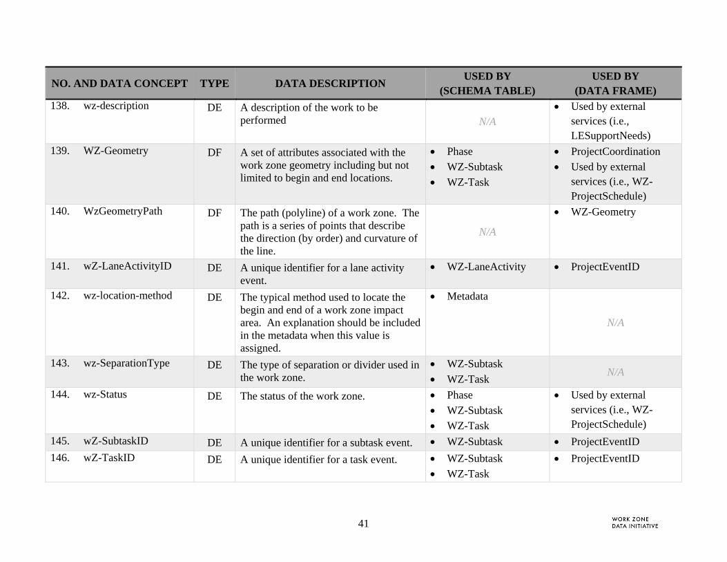
A consolidated list of data derived from the Framework use cases was used to generate WZDD concepts. From the 59 data concepts identified, 147 WZDD concepts were generated. The
2 Definitions for data concept, data element, and data frame are adapted from [3] the ISO ITS Data Dictionary standard.

3
mapping table between the Framework needs and Work Zone Data Dictionary is detailed in Appendix B: Traceability to WZAD Framework.
2.1.2 Mapping External Data Sources to WZDD Concepts
The Framework Document [1] also describes WZDS external data needed to meet user objectives. Stakeholder input recommended that external data not be defined by the WZDD and not be stored in the WZAD. However, linkages should be identified to specific stakeholder systems. The external systems are depicted as arrows between the WZDS and other systems as shown in Figure 2. The specific data needs are detailed in the 50 Use Cases included in that document. From the 50 use cases, a consolidated set of 25 external data needs were identified with an additional 6 data concepts derived from WZAD content. For example, signal timing plans and devices affected by work zone activities. Although the external sources and their data descriptions are out of scope for this dictionary, the specific data may be referenced by this document. Alignment of the external data needs and the WZDD Data Concept Model (Figure 3) are described in Section 2.2.4.2.
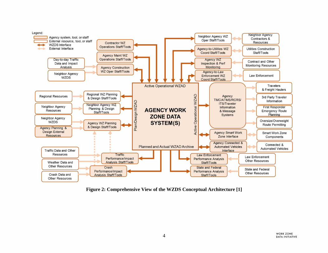
4
Figure 2: Comprehensive View of the WZDS Conceptual Architecture [1]

5
2.2 WZDD COMPONENTS OVERVIEW
The WZDD Report is composed of work zone-related data concepts that meet stakeholder needs for consistent data with respect to their meaning and enumerated values. In developing unambiguous geometric and temporal concepts, building a framework for classification schemes, and grouping data to mitigate ambiguity, the WZDD includes several elements including: Data Dictionary, Data Frames, Enumerated Values, and Data Schema. These elements are summarized in the sub-sections below and described in further detail in Section 3.
2.2.1 Data Dictionary
The WZDD is a consolidated tabular list of all the data concepts (i.e., data frames, data elements, and enumerated values) that were identified under this effort. For each discrete data concept, the tabular list includes the following information:
Name of the data concept
Data concept designator (data frame (DF), data element (DE), or enumerated type (Enum))
Data concept description
Used by (lists the schema table and/or data frame table that includes the data concept)
Related notes
For the comprehensive data dictionary see Table 6.
2.2.2 Data Frames
As noted earlier, a data frame groups data elements and data frames by concept. The groups may be constructed using similar types of data such as location referencing methods (spherical, linear), data that are meaningful only when referenced together such as latitude and longitude, or a combination. Each data frame included in the WZDD (Table 6) is detailed in its own separate tabular list in Section 3.1 that provides the following information:
Data frame name
Associated data concepts
Concept descriptions
Conformance (required, optional or conditional)
The data frames identified under this effort are grouped as follows:
Section 3.1.1. Project Event Identifiers. Data frames used to describe unique identifiers for project events.
Section 3.1.2. Geometry and Spatial Features. Data frames used to describe geometry and spatial features, including location aggregate domains and groupings of associated data such as work zone geometry.
6
Section 3.1.3. Date and Time . Data frames used to describe date, time, and time periods.
Section 3.1.4. Other Data Frames. Data frames used to describe work, the roadway, and restrictions.
2.2.3 Enumerated Types
The enumerated types described in Section 3.2 contain a data element, data definition, and associated formalized data values (i.e., a list of related data). Many of the values identified are adapted from existing industry sources. For example the data element facilityType is derived from an enumerated list specified in the Traffic Management Data Dictionary [4]. An example of the facilityType definition:
Data Element – facilityType
Definition – A type of road facility
Enumerated Values – mainline, shoulder, ramp, connector
2.2.4 Data Schema
A data schema organizes data concepts into logical groupings to meet business needs and objectives. In the case of the WZAD, these needs were derived from the information received from stakeholders in Task 2 and generated into use cases in the Task 3 Framework document. For example, the following bulleted list provides needs for structuring the components of a work zone project:
A Work Zone Project is composed of one or more Phases.
A Phase may be composed of one or more WZ-Tasks (or events).
A WZ-Task may be composed of zero or more WZ-Subtasks (or subevents) or WZ-Lane Activity(ies).
A WZ-Subtask may be composed of zero or more WZ-Lane Activity(ies).
These groupings are shown either through a visual data model (i.e., a diagram) and/or a table. For this report, the project team developed a visual data model that depicts the relationship among data concepts (Figure 3). This model provides the reader with information on:
Schema tables. Groupings of data elements and data frames that meet user needs. Tables define core project events and their relationship to each other (e.g., a WZ task may be composed of zero or more WZ subtasks) as well as other characteristics that distinguish or impact the event activities (e.g., Roles or Project Coordination List)
Data Lists/Logs. Include WZAD information collected through a file/list entry
Databases. WZAD information gathered from external data sources that feed into various data schema tables and/or data lists/logs
External Data Services. Such as APIs and data feeds that provide necessary WZAD content to external stakeholders
7
Additionally, the model includes information on relationships and data flows. The dark blue lines with circular end points represent a one (or zero)-to-many relationship in which the abstraction described by a table may be characterized by zero or more instances of a related table. For example “a phase may be composed of one or more WZ tasks.” Arrows in the model provide the reader with information on data flows between one system and another. For example, crash data, stored in an external source, flows into the impact analysis schema table. Lastly, light blue boxes in the model represent data schema tables which resolve many-to-many relationships. For example, a state department of transportation (Organization) may have multiple roles in a work zone project (e.g., capital planning, construction & engineering, safety, maintenance) and each may have a different role associated with a different phase or task. The schema method, depicted by the light blue, resolves the ambiguity.

8
Figure 3: WZAD Concept Data Model

9
The following tables provide additional information on each data schema table (noted by the identification number box at the top left of each rectangle in the model). Table 1 provides a detailed description of each data schema table. Table 2 lists out the data concepts that are included in each data schema table. The definitions provided for each data concept correlate directly to the WZDD.
Table 1. Data Schema Table Description
TABLE NAME TABLE DESCRIPTION CONFORMANCE
1. Contract Business Rules Roles and responsibilities including performance measures, penalties and incentives by contract
Optional
2. Design and Operational Change Log
A set of changes to the design or operational elements that impact the project phase, task, subtask or lane activity such as a change to a phase plan (no left turn) or disruption such as a broken drill.
Optional
3. Impact Analysis Association between incentive/penalty and performance/provision compliance for each period
Optional
4. Incentives Penalties Describes the value of a Role meeting its performance and compliance goals over specified periods
Optional
5. Metadata A detailed description of quality methods and metrics associated with time and location information.
Required
6. Operational Log A list of actions or events triggered by requests for information by external sources (e.g., WZDx data feed or Law Enforcement Activity Data)
Optional
7. Organization An organization that participates or is associated with the work zone project. Required
8. Performance Assessment Each instance of a Role meeting its performance and compliance goals Optional
9. Phase A stage of a project that requires a work zone (e.g., construction, maintenance, or other)
Required
10. Project Coordination List A set of project and project liaisons that require coordination based on specific coordination needs.
Optional
11. Role The role associated between and organization and their involvement in a work zone project (phase, task, subtask, or lane activity). The role may require a permit or be assigned specific contract provisions (or business rules).
Required
12. Version Log A list of all the changes, actions and events associated with the WZDS Required

10
TABLE NAME TABLE DESCRIPTION CONFORMANCEincluding editor, timestamp, attribute change and reason for change.
13. Work Zone Project The general description of a work zone project. Required
14. WZ-LaneActivity A detailed description of a work zone project event by individual lanes within the task or subtask geometry.
Optional
15. WZ-Subtask Detailed description of a work zone project that details a specific event associated with a task. The WZ-Subtask inherits the characteristics of its parent project phase and task but may identify an exception by date to its parent task.
Optional
16. WZ-Task A description of a work zone project tasks. Each task is described by a single road segment in a single direction.
Required
Table 2. Data Schema Attribute Descriptions
DATA NAME DATA DESCRIPTION CONFORMANCE
Table 1. Contract Business Rules
a) contractURL A link (URL) to a contract or contract provisions associated with a contractor's contract to perform specified work.
required
b) projectName The name of the project as published. required
c) ProjectEventID A unique identifier associated with one or more project event identifier types and other associated references identifier such as contract number.
required
d) businessRuleConformance An instance of requirement or business rule which will be measured for impact, compliance or performance
optional
e) descriptionCBR A concise description of the business rule optional
Table 2. Design and Operational Change Log
a) timestamp A timestamp that identifies the time and date the change was made, a request was sent or data was collected.
required
b) changeLogNumber An automated log number that uniquely identifies the entry. required

11
DATA NAME DATA DESCRIPTION CONFORMANCE
c) projectName The name of the project as published. required
d) ProjectEventID A unique identifier associated with one or more project event identifier types and other associated references identifier such as contract number.
required
e) design-opsChangeType The type of design or operational change that impacts a project task. For example, the change may include signal timing changes, schedule changes, location or geometry changes.
required
f) attributeName The attribute name wherein the change was made conditional (if design-opsChangeType is an attribute change – add, remove, edit)
g) fromValue The original or last value which was changed. conditional (if the design-
opsChangeType is an attribute value change
– original value)
h) toValue The new value inserted in the database conditional (if the design-
opsChangeType is an attribute value change
– new value)
i) reason The reason for the change such as safety, operational, or coordination with other projects
optional
Table 3. Impact Analysis
a) contractRole The organization's role with respect to the project event. required
b) businessRuleConformance An instance of requirement or business rule which will be measured for impact, compliance or performance
required
c) targetValue The requirement value under review required
d) actualValue The actual value measured during period required

12
DATA NAME DATA DESCRIPTION CONFORMANCE
e) timestamp A timestamp that identifies the time and date the change was made, a request was sent or data was collected.
required
f) performancePeriod The compliance period required
g) ProjectEventID A unique identifier associated with one or more project event identifier types and other associated references identifier such as contract number.
required
Table 4. Incentives Penalties
a) contractURL A link (URL) to a contract or contract provisions associated with a contractor's contract to perform specified work.
required
b) incentiveValue The amount of incentive or penalty for the requirement required
c) businessRuleConformance An instance of requirement or business rule which will be measured for impact, compliance or performance
required
d) performancePeriod The compliance period required
e) ProjectEventID A unique identifier associated with one or more project event identifier types and other associated references identifier such as contract number.
required
Table 5. Metadata
a) issuingOrganization The name of the issuing organization. This name should match the name of the owner of the Work Zone Activity Database.
required
b) ProjectEventID A unique identifier associated with one or more project event identifier types and other associated references identifier such as contract number.
required
c) location-verify-method The method used to verify the accuracy of the location information. optional
d) wz-location-method The typical method used to locate the begin and end of a work zone impact area. An explanation should be included in the metadata when this value is assigned.
optional
e) lrs-Type Describes the type of linear referencing system used for the milepost measurements.
optional
f) lrs-URL A URL where additional information on the LRS information and optional
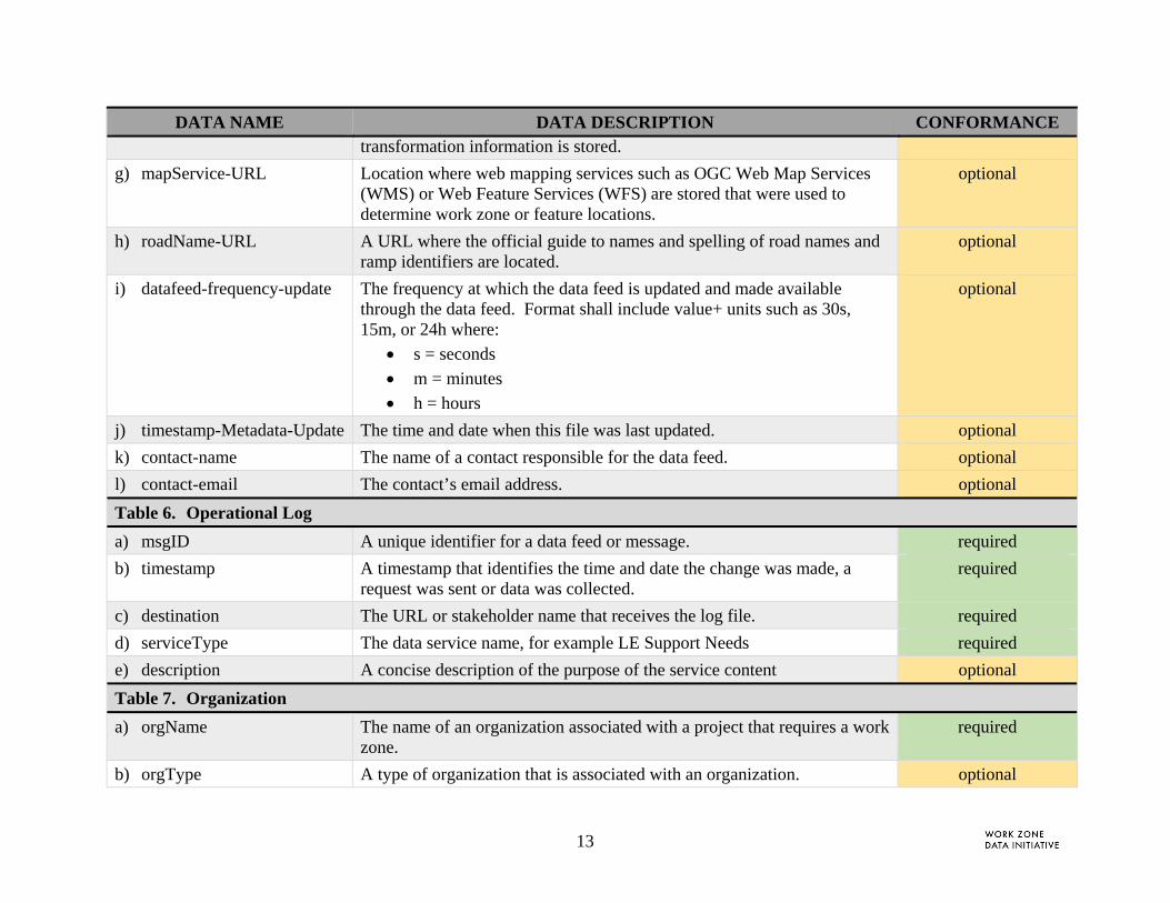
13
DATA NAME DATA DESCRIPTION CONFORMANCE transformation information is stored.
g) mapService-URL Location where web mapping services such as OGC Web Map Services (WMS) or Web Feature Services (WFS) are stored that were used to determine work zone or feature locations.
optional
h) roadName-URL A URL where the official guide to names and spelling of road names and ramp identifiers are located.
optional
i) datafeed-frequency-update The frequency at which the data feed is updated and made available through the data feed. Format shall include value+ units such as 30s, 15m, or 24h where:
s = seconds
m = minutes
h = hours
optional
j) timestamp-Metadata-Update The time and date when this file was last updated. optional
k) contact-name The name of a contact responsible for the data feed. optional
l) contact-email The contact’s email address. optional
Table 6. Operational Log
a) msgID A unique identifier for a data feed or message. required
b) timestamp A timestamp that identifies the time and date the change was made, a request was sent or data was collected.
required
c) destination The URL or stakeholder name that receives the log file. required
d) serviceType The data service name, for example LE Support Needs required
e) description A concise description of the purpose of the service content optional
Table 7. Organization
a) orgName The name of an organization associated with a project that requires a work zone.
required
b) orgType A type of organization that is associated with an organization. optional
14
DATA NAME DATA DESCRIPTION CONFORMANCE
c) orgTelephone A contact telephone number associated with related organization. optional
d) orgAddress A business address associated with related organization. optional
e) region A known jurisdiction, area or corridor. Also used to describe an organization's address.
optional
f) orgURL The web address for the organization. This may specify a file storage site. optional
g) orgContactName The organization's contact person for the project. optional
h) orgContactEmail The email address for the organization's contact. optional
i) orgContactTelephone The phone number for the organization's contact. optional
Table 8. Performance Assessment
a) contractRole The organization's role with respect to the project event. required
b) performancePeriod The compliance period required
c) businessRuleConformance An instance of requirement or business rule which will be measured for impact, compliance or performance
required
d) markValue The difference between target and actual values required
e) incentiveValue The amount of incentive or penalty for the requirement required
f) targetValue The requirement value under review optional
g) actualValue The actual value measured during period optional
h) ProjectEventID A unique identifier associated with one or more project event identifier types and other associated references identifier such as contract number.
required
Table 9. Phase
a) phaseID A unique identifier for a project phase. required
b) ProjectEventID A unique identifier associated with one or more project event identifier types and other associated references identifier such as contract number.
optional
c) descriptionPhase A concise description of the phase optional
d) WZ-Geometry A set of attributes associated with the work zone geometry including but required
15
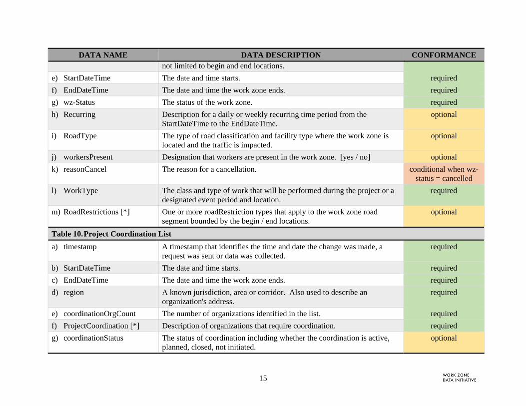
DATA NAME DATA DESCRIPTION CONFORMANCE not limited to begin and end locations.
e) StartDateTime The date and time starts. required
f) EndDateTime The date and time the work zone ends. required
g) wz-Status The status of the work zone. required
h) Recurring Description for a daily or weekly recurring time period from the StartDateTime to the EndDateTime.
optional
i) RoadType The type of road classification and facility type where the work zone is located and the traffic is impacted.
optional
j) workersPresent Designation that workers are present in the work zone. [yes / no] optional
k) reasonCancel The reason for a cancellation. conditional when wz-status = cancelled
l) WorkType The class and type of work that will be performed during the project or a designated event period and location.
required
m) RoadRestrictions [*] One or more roadRestriction types that apply to the work zone road segment bounded by the begin / end locations.
optional
Table 10. Project Coordination List
a) timestamp A timestamp that identifies the time and date the change was made, a request was sent or data was collected.
required
b) StartDateTime The date and time starts. required
c) EndDateTime The date and time the work zone ends. required
d) region A known jurisdiction, area or corridor. Also used to describe an organization's address.
required
e) coordinationOrgCount The number of organizations identified in the list. required
f) ProjectCoordination [*] Description of organizations that require coordination. required
g) coordinationStatus The status of coordination including whether the coordination is active, planned, closed, not initiated.
optional
16
DATA NAME DATA DESCRIPTION CONFORMANCE
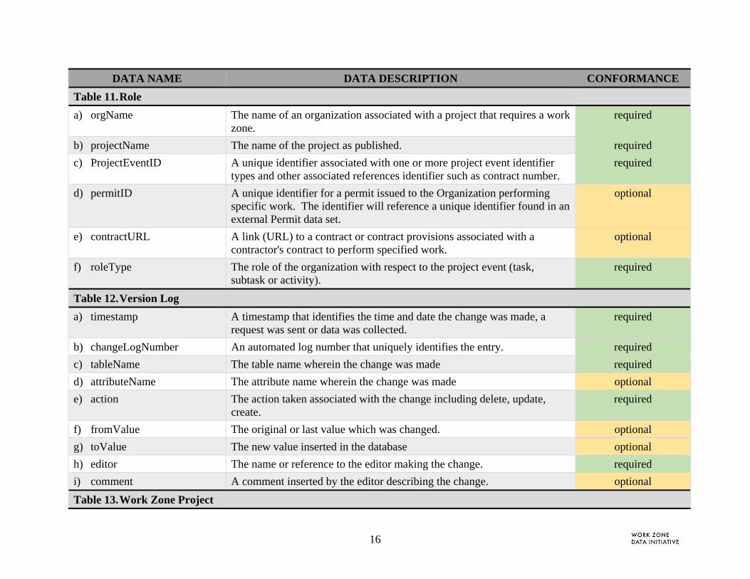
Table 11. Role
a) orgName The name of an organization associated with a project that requires a work zone.
required
b) projectName The name of the project as published. required
c) ProjectEventID A unique identifier associated with one or more project event identifier types and other associated references identifier such as contract number.
required
d) permitID A unique identifier for a permit issued to the Organization performing specific work. The identifier will reference a unique identifier found in an external Permit data set.
optional
e) contractURL A link (URL) to a contract or contract provisions associated with a contractor's contract to perform specified work.
optional
f) roleType The role of the organization with respect to the project event (task, subtask or activity).
required
Table 12. Version Log
a) timestamp A timestamp that identifies the time and date the change was made, a request was sent or data was collected.
required
b) changeLogNumber An automated log number that uniquely identifies the entry. required
c) tableName The table name wherein the change was made required
d) attributeName The attribute name wherein the change was made optional
e) action The action taken associated with the change including delete, update, create.
required
f) fromValue The original or last value which was changed. optional
g) toValue The new value inserted in the database optional
h) editor The name or reference to the editor making the change. required
i) comment A comment inserted by the editor describing the change. optional
Table 13. Work Zone Project

17
DATA NAME DATA DESCRIPTION CONFORMANCE
a) projectName The name of the project as published. required
b) projectDescription A concise description of the project purpose and scope. required
c) totalPhases The number of phases in the project optional
d) totalWZTasks The total number of work zone project tasks. optional
e) allocationType The type of financial allocation associated with this project, e.g., planned, requested, pending, partially allocated, fully allocated, etc.
optional
f) allocationValue The funding requirements to complete the project optional
g) WorkType The class and type of work that will be performed during the project or a designated event period and location.
required
Table 14. WZ-LaneActivity
a) wZ-LaneActivityID A unique identifier for a lane activity event. required
b) ProjectEventID A unique identifier associated with one or more project event identifier types and other associated references identifier such as contract number.
required
c) laneID An unique identifier for a lane required
d) laneType The type of lane associated with the road segment. optional
e) laneStatus The status of the lane. Values include: open, closed, open w/o restriction (e.g., driving on shoulder)
optional
f) laneRestriction The type of restrictions associated with the referenced lane. optional
g) travelPathEffect The type of travel path effect implemented leading up to or from a work zone. Where lt indicates left (e.g., merge left) and rt indicates right (e.g., merge right)
optional
h) LaneGeometryPath A path that defines the change in curvature of the lane. optional
i) laneDescription A text description or link (URL) for the lane along the segment of road geometry identified in WZ-Subtask and or LaneGeometryPath.
optional
Table 15. WZ-Subtask
18
DATA NAME DATA DESCRIPTION CONFORMANCE
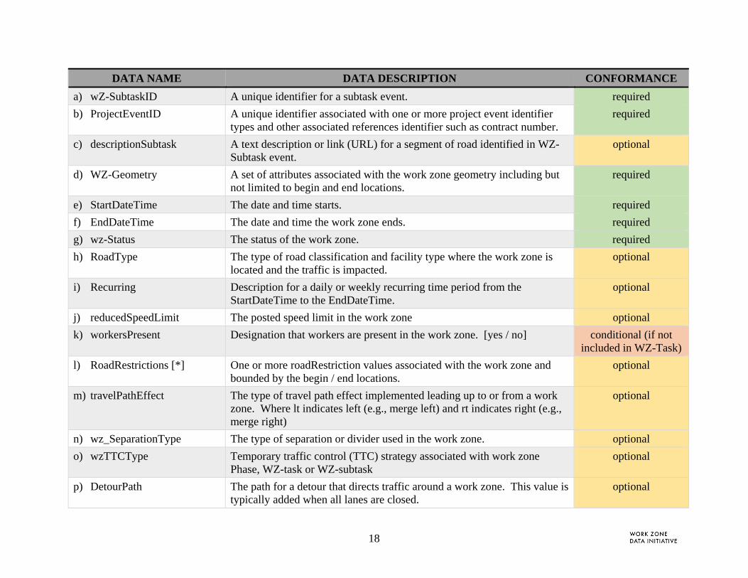
a) wZ-SubtaskID A unique identifier for a subtask event. required
b) ProjectEventID A unique identifier associated with one or more project event identifier types and other associated references identifier such as contract number.
required
c) descriptionSubtask A text description or link (URL) for a segment of road identified in WZ-Subtask event.
optional
d) WZ-Geometry A set of attributes associated with the work zone geometry including but not limited to begin and end locations.
required
e) StartDateTime The date and time starts. required
f) EndDateTime The date and time the work zone ends. required
g) wz-Status The status of the work zone. required
h) RoadType The type of road classification and facility type where the work zone is located and the traffic is impacted.
optional
i) Recurring Description for a daily or weekly recurring time period from the StartDateTime to the EndDateTime.
optional
j) reducedSpeedLimit The posted speed limit in the work zone optional
k) workersPresent Designation that workers are present in the work zone. [yes / no] conditional (if not included in WZ-Task)
l) RoadRestrictions [*] One or more roadRestriction values associated with the work zone and bounded by the begin / end locations.
optional
m) travelPathEffect The type of travel path effect implemented leading up to or from a work zone. Where lt indicates left (e.g., merge left) and rt indicates right (e.g., merge right)
optional
n) wz_SeparationType The type of separation or divider used in the work zone. optional
o) wzTTCType Temporary traffic control (TTC) strategy associated with work zone Phase, WZ-task or WZ-subtask
optional
p) DetourPath The path for a detour that directs traffic around a work zone. This value is typically added when all lanes are closed.
optional
19
DATA NAME DATA DESCRIPTION CONFORMANCE
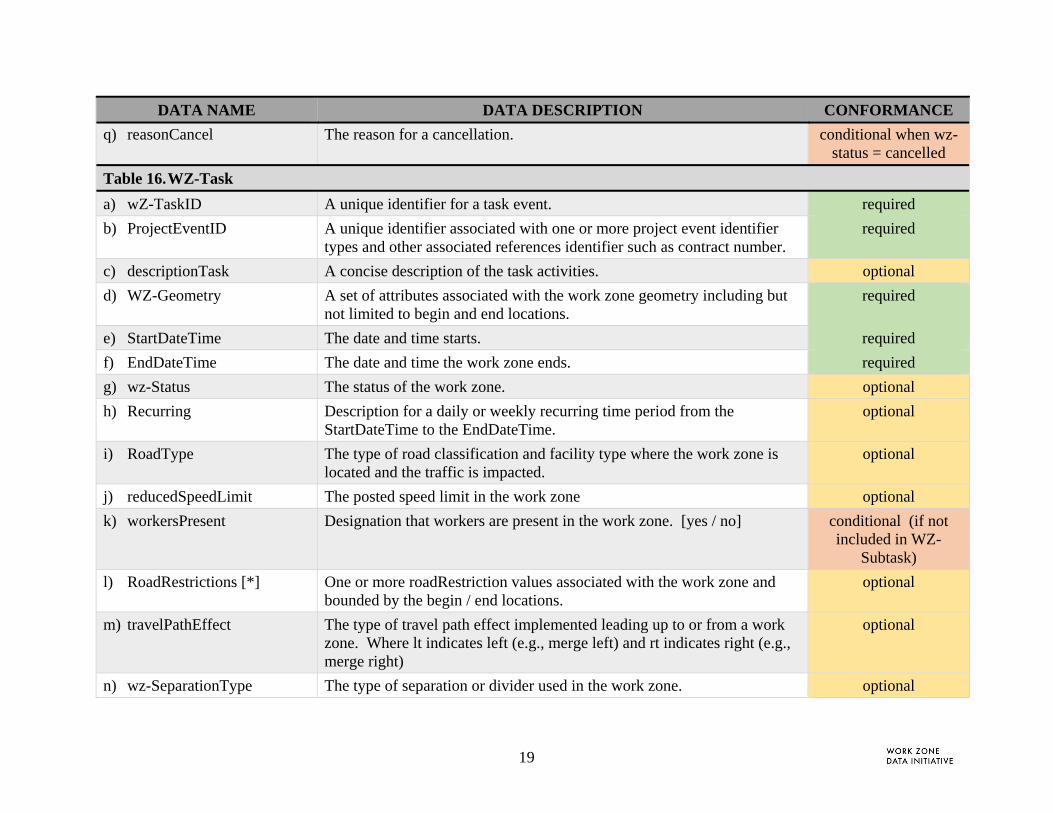
q) reasonCancel The reason for a cancellation. conditional when wz-status = cancelled
Table 16. WZ-Task
a) wZ-TaskID A unique identifier for a task event. required
b) ProjectEventID A unique identifier associated with one or more project event identifier types and other associated references identifier such as contract number.
required
c) descriptionTask A concise description of the task activities. optional
d) WZ-Geometry A set of attributes associated with the work zone geometry including but not limited to begin and end locations.
required
e) StartDateTime The date and time starts. required
f) EndDateTime The date and time the work zone ends. required
g) wz-Status The status of the work zone. optional
h) Recurring Description for a daily or weekly recurring time period from the StartDateTime to the EndDateTime.
optional
i) RoadType The type of road classification and facility type where the work zone is located and the traffic is impacted.
optional
j) reducedSpeedLimit The posted speed limit in the work zone optional
k) workersPresent Designation that workers are present in the work zone. [yes / no] conditional (if not included in WZ-
Subtask)
l) RoadRestrictions [*] One or more roadRestriction values associated with the work zone and bounded by the begin / end locations.
optional
m) travelPathEffect The type of travel path effect implemented leading up to or from a work zone. Where lt indicates left (e.g., merge left) and rt indicates right (e.g., merge right)
optional
n) wz-SeparationType The type of separation or divider used in the work zone. optional

20
DATA NAME DATA DESCRIPTION CONFORMANCE
o) wzTTCType Temporary traffic control (TTC) strategy associated with work zone Phase, WZ-task or WZ-subtask
optional
p) DetourPath The path for a detour that directs traffic around a work zone. This value is typically added when all lanes are closed.
optional
q) reasonCancel The reason for a cancellation. conditional when wz-status = cancelled

21
2.2.4.1 Service Content - Data Services, APIs, and Data Feeds
The schema includes work zone services. These are data feeds, queries, and other information flows that flow from the WZDS to outside sources. When working with stakeholders, it was observed that many stakeholders require similar data. For example, a schedule of the planned and updated work zone projects – their location, timing and impact. Based on the information received, the project team grouped data exchange requirements into the following data services: (1) WZ Project Schedule, (2) Law Enforcement Needs and (3) WZDx v.1. These data services are tracked through the Operational Log schema table. This table captures the requirements associated with tracking and distributing the information sets.
1. WZ Project Schedule. A Work Zone Project Schedule describes WZ projects and project events for downstream systems.
Table 3. WZ Project Schedule Data Feed Description
DATA CONCEPT DESCRIPTION CONFORMANCE
a) projectName The name of the project as published. required
b) ProjectEventID A unique identifier associated with one or more project event identifier types and other associated references identifier such as contract number.
required
c) WZ-Geometry A set of attributes associated with the work zone geometry including but not limited to begin and end locations.
required
d) StartDateTime The date and time starts. required
e) EndDateTime The date and time the work zone ends. required
f) wz-Status The status of the work zone. optional
g) WorkType The class and type of work that will be performed during the project or a designated event period and location.
optional
h) lastUpdate The date of the last update. optional

22
2. Law Enforcement Needs. The Law Enforcement Support Need service lists the law enforcement coverage, timing and type of service as requested by work zone staff.
Table 4. Law Enforcement (LE) Support Needs Data Feed Description
DATA CONCEPT DESCRIPTION CONFORMANCE
a) projectName The name of the project as published. required
b) ProjectEventID A unique identifier associated with one or more project event identifier types and other associated references identifier such as contract number.
required
c) leType The type of law enforcement needed: continuous, swing, periodic patrol
required
d) startDateTime-est The estimated start time and date when a work zone status = planned, pending, active estimated or active spatial verified (i.e., not cancelled, completed or time verified)
required
e) endDateTime-est The estimated end time and date when a work zone status = planned, pending, or active (i.e., not cancelled, completed)
required
f) Area The area for enforcement (geofence, region or point location if stationary)
optional
g) wz-description A description of the work to be performed optional
3. WZDx V1.1 – Common Core Data Specification. The USDOT’s Work Zone Data Exchange (WZDx) effort was developed, in conjunction with the WZDI, to jumpstart the voluntary adoption of a basic work zone data specification through collaboration with data producers and users. The specification developed will continue to be updated as additional information is gathered. The specification and associated reference documents can be found on its GitHub page.
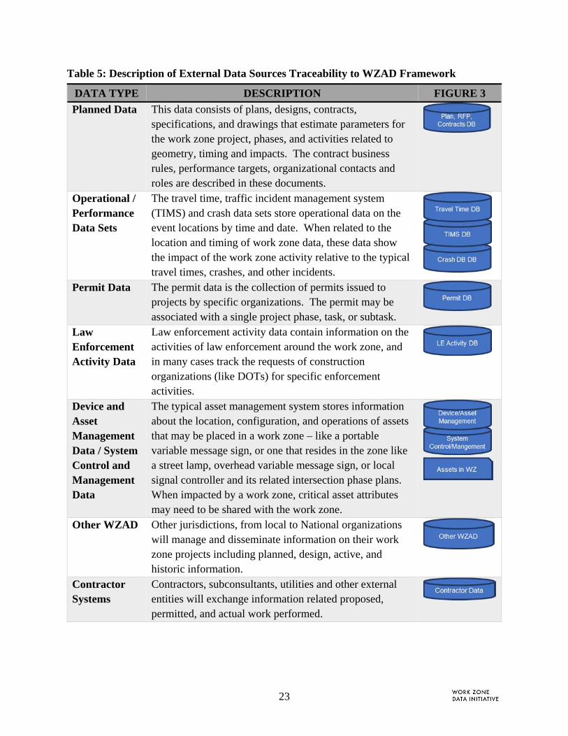
2.2.4.2 External Data Sources
Another component of the data schema are external data sources. These external sources are described in the WZDS Framework [2] and contain data sets referenced and consumed by the WZDS. General description of the information contained in those data sets is below. A detailed mapping of the WZDD and Framework external data needs is found in Appendix B.
23
Table 5: Description of External Data Sources Traceability to WZAD Framework
DATA TYPE DESCRIPTION FIGURE 3
Planned Data This data consists of plans, designs, contracts, specifications, and drawings that estimate parameters for the work zone project, phases, and activities related to geometry, timing and impacts. The contract business rules, performance targets, organizational contacts and roles are described in these documents.
Operational / Performance Data Sets
The travel time, traffic incident management system (TIMS) and crash data sets store operational data on the event locations by time and date. When related to the location and timing of work zone data, these data show the impact of the work zone activity relative to the typical travel times, crashes, and other incidents.
Permit Data The permit data is the collection of permits issued to projects by specific organizations. The permit may be associated with a single project phase, task, or subtask.
Law Enforcement Activity Data
Law enforcement activity data contain information on the activities of law enforcement around the work zone, and in many cases track the requests of construction organizations (like DOTs) for specific enforcement activities.
Device and Asset Management Data / System Control and Management Data
The typical asset management system stores information about the location, configuration, and operations of assets that may be placed in a work zone – like a portable variable message sign, or one that resides in the zone like a street lamp, overhead variable message sign, or local signal controller and its related intersection phase plans. When impacted by a work zone, critical asset attributes may need to be shared with the work zone.
Other WZAD Other jurisdictions, from local to National organizations will manage and disseminate information on their work zone projects including planned, design, active, and historic information.
Contractor Systems
Contractors, subconsultants, utilities and other external entities will exchange information related proposed, permitted, and actual work performed.

24
3 WZDD COMPONENTS
This section provides the detailed tables for the WZDD components summarized in Section 2. Examples of the artifacts detailed in this section are implemented in Attachment A: Guidelines on Applying WZDD.
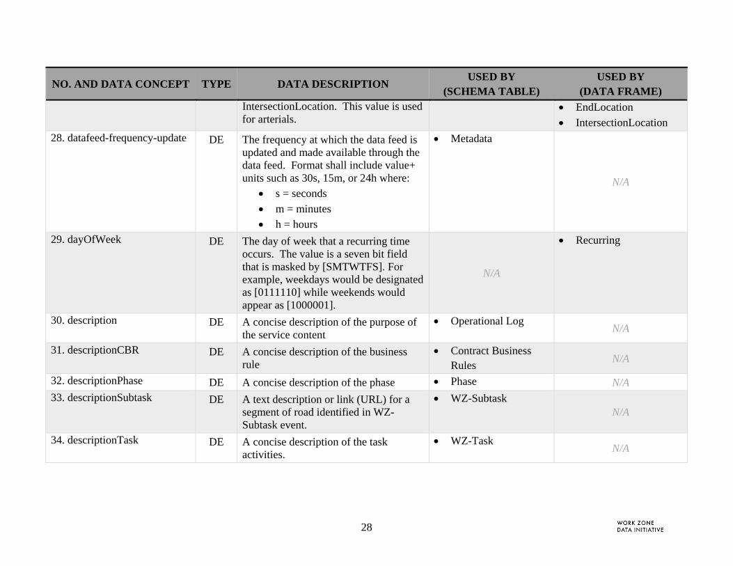
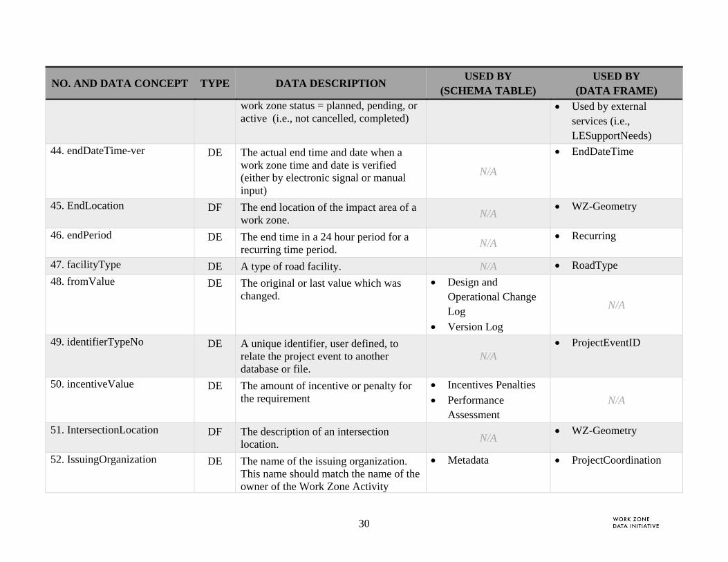
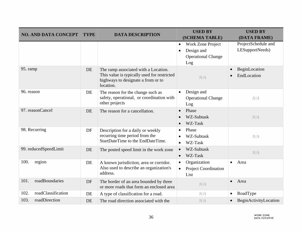
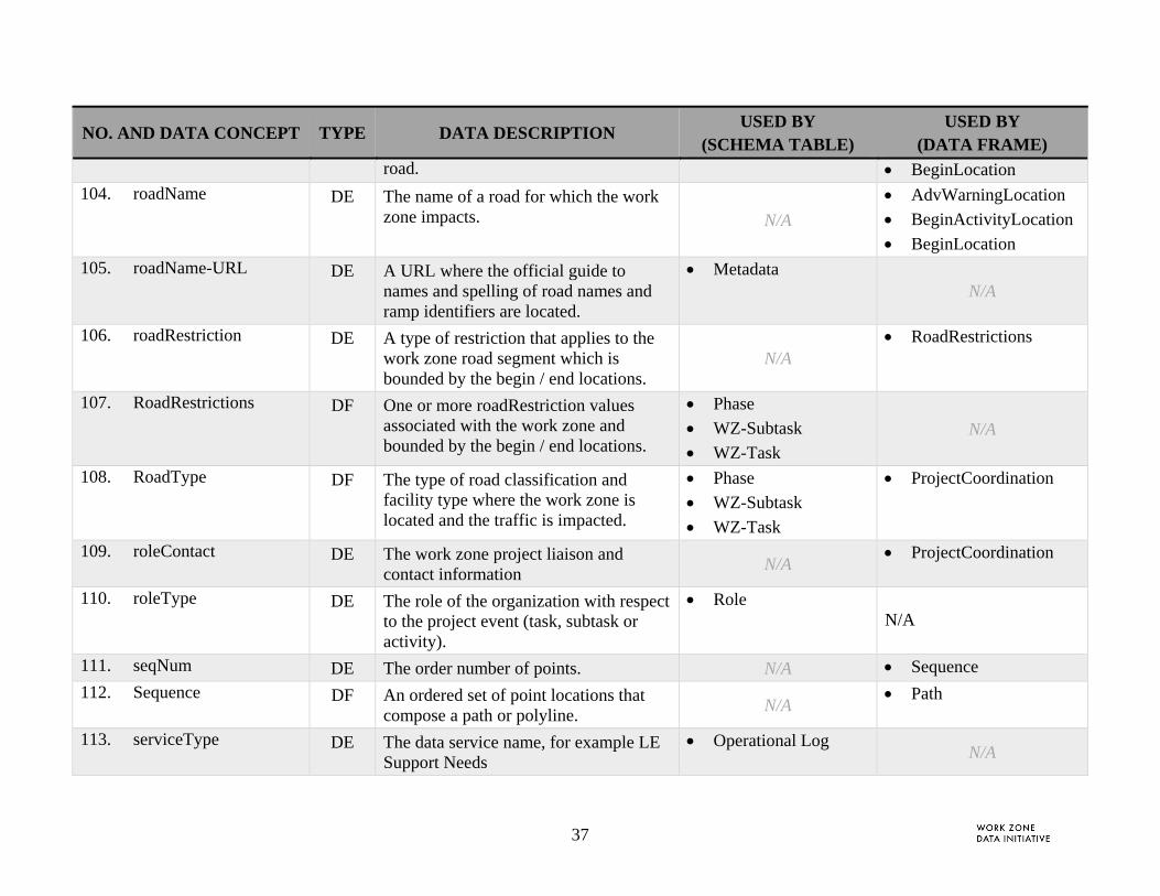
The WZDD (Table 6) includes the following information:
No. A unique reference for each record
Data Name. The name of the data concept (listed in the table in alphabetical order)
Type. The type of data concept describing the data o Data element (DE) o Data frame (DF)
Data Description. A description for the data concept
Used by Table. Schema tables which reference the data concept
Used by Data Frame. Data frame which references the data concept
25
Table 6. Work Zone Data Concept Dictionary
NO. AND DATA CONCEPT TYPE DATA DESCRIPTION USED BY
(SCHEMA TABLE) USED BY
(DATA FRAME)
1. action DE The action taken associated with the change including delete, update, create.
Version Log N/A
2. actualValue DE The actual value measured during period Impact Analysis
Performance Assessment
N/A
3. AdvancedWarning DF The location of types of work zone assets such as signs or barriers located in or near a work zone.
N/A WZ-Geometry
4. AdvWarningLocation DF A location associated with work zone asset that serves to alert vehicle / drivers of work zone characteristics.
N/A AdvancedWarning
5. advWarningType DE The type of advanced warning assets that are located in or near a work zone.
N/A AdvancedWarning
6. allocationType DE The type of financial allocation associated with this project, e.g., planned, requested, pending, partially allocated, fully allocated, etc.
Work Zone Project
N/A
7. allocationValue DE The funding requirements to complete the project
Work Zone Project N/A
8. altitude-est DE Estimated height above sea level measured in feet.
N/A Spherical
9. altitude-ver DE The height above sea level measured in feet.
N/A Spherical
26
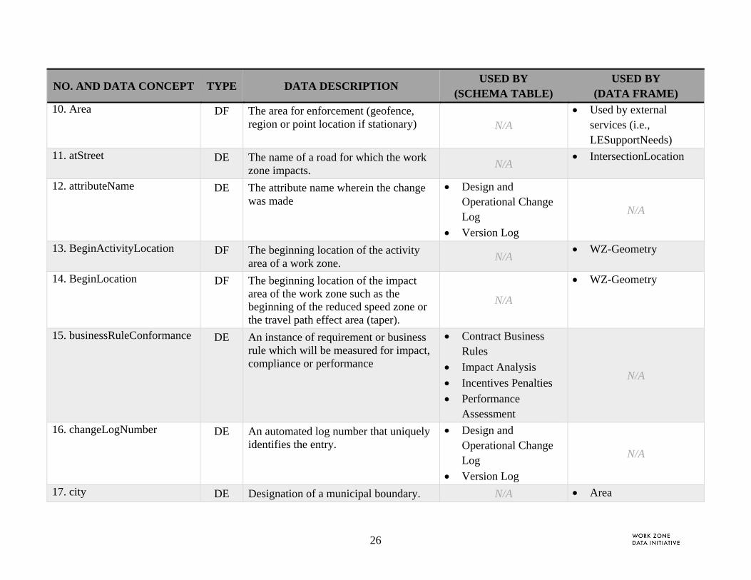
NO. AND DATA CONCEPT TYPE DATA DESCRIPTION USED BY
(SCHEMA TABLE) USED BY
(DATA FRAME) 10. Area DF The area for enforcement (geofence,
region or point location if stationary) N/A Used by external
services (i.e., LESupportNeeds)
11. atStreet DE The name of a road for which the work zone impacts.
N/A IntersectionLocation
12. attributeName DE The attribute name wherein the change was made
Design and Operational Change Log
Version Log
N/A
13. BeginActivityLocation DF The beginning location of the activity area of a work zone.
N/A WZ-Geometry
14. BeginLocation DF The beginning location of the impact area of the work zone such as the beginning of the reduced speed zone or the travel path effect area (taper).
N/A
WZ-Geometry
15. businessRuleConformance DE An instance of requirement or business rule which will be measured for impact, compliance or performance
Contract Business Rules
Impact Analysis
Incentives Penalties
Performance Assessment
N/A
16. changeLogNumber DE An automated log number that uniquely identifies the entry.
Design and Operational Change Log
Version Log
N/A
17. city DE Designation of a municipal boundary. N/A Area
27
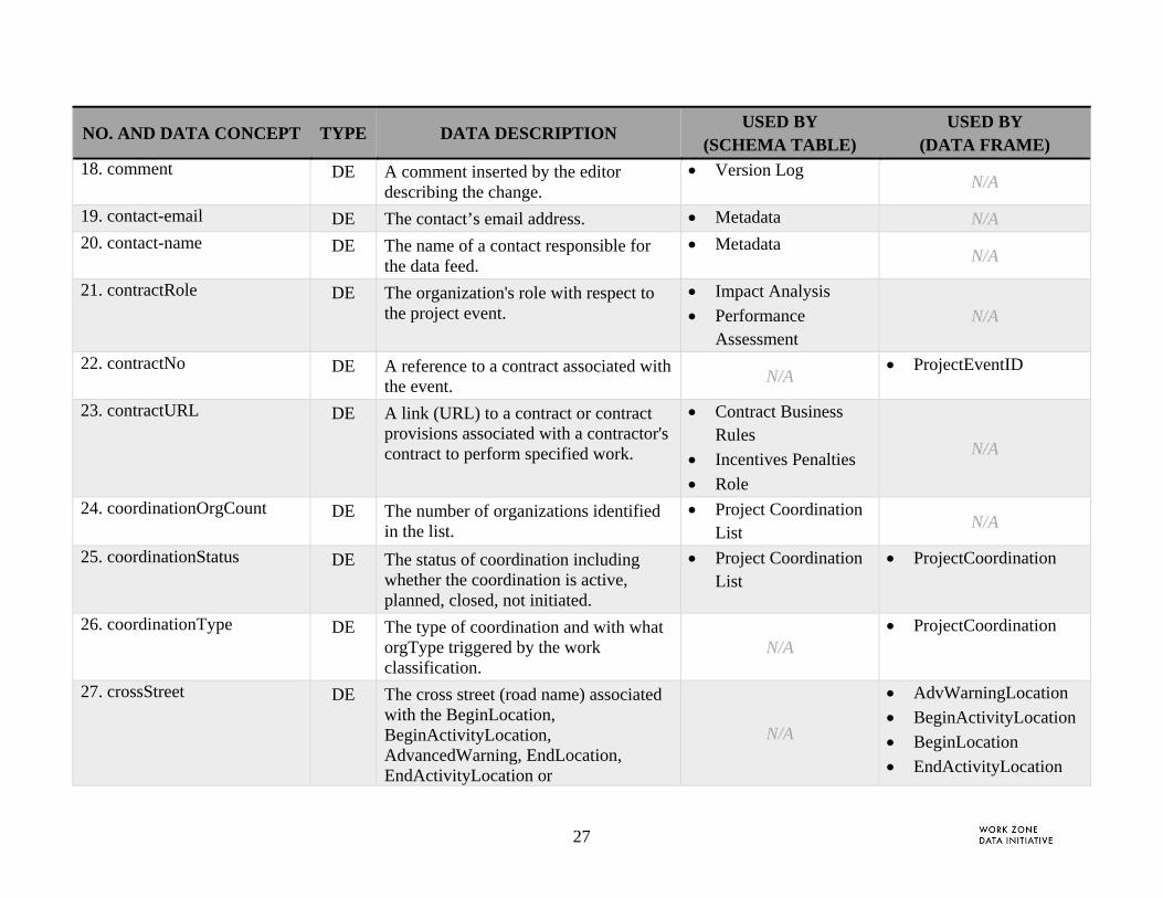
NO. AND DATA CONCEPT TYPE DATA DESCRIPTION USED BY
(SCHEMA TABLE) USED BY
(DATA FRAME) 18. comment DE A comment inserted by the editor
describing the change. Version Log
N/A
19. contact-email DE The contact’s email address. Metadata N/A 20. contact-name DE The name of a contact responsible for
the data feed. Metadata
N/A
21. contractRole DE The organization's role with respect to the project event.
Impact Analysis
Performance Assessment
N/A
22. contractNo DE A reference to a contract associated with the event.
N/A ProjectEventID
23. contractURL DE A link (URL) to a contract or contract provisions associated with a contractor's contract to perform specified work.
Contract Business Rules
Incentives Penalties
Role
N/A
24. coordinationOrgCount DE The number of organizations identified in the list.
Project Coordination List
N/A
25. coordinationStatus DE The status of coordination including whether the coordination is active, planned, closed, not initiated.
Project Coordination List
ProjectCoordination
26. coordinationType DE The type of coordination and with what orgType triggered by the work classification.
N/A ProjectCoordination
27. crossStreet DE The cross street (road name) associated with the BeginLocation, BeginActivityLocation, AdvancedWarning, EndLocation, EndActivityLocation or
N/A
AdvWarningLocation
BeginActivityLocation
BeginLocation
EndActivityLocation
28
NO. AND DATA CONCEPT TYPE DATA DESCRIPTION USED BY
(SCHEMA TABLE) USED BY
(DATA FRAME) IntersectionLocation. This value is used for arterials.
EndLocation
IntersectionLocation 28. datafeed-frequency-update DE The frequency at which the data feed is
updated and made available through the data feed. Format shall include value+ units such as 30s, 15m, or 24h where:
s = seconds
m = minutes
h = hours
Metadata
N/A
29. dayOfWeek DE The day of week that a recurring time occurs. The value is a seven bit field that is masked by [SMTWTFS]. For example, weekdays would be designated as [0111110] while weekends would appear as [1000001].
N/A
Recurring
30. description DE A concise description of the purpose of the service content
Operational Log N/A
31. descriptionCBR DE A concise description of the business rule
Contract Business Rules
N/A
32. descriptionPhase DE A concise description of the phase Phase N/A 33. descriptionSubtask DE A text description or link (URL) for a
segment of road identified in WZ-Subtask event.
WZ-Subtask N/A
34. descriptionTask DE A concise description of the task activities.
WZ-Task N/A

29
NO. AND DATA CONCEPT TYPE DATA DESCRIPTION USED BY
(SCHEMA TABLE) USED BY
(DATA FRAME) 35. design-opsChangeType DE The type of design or operational
change that impacts a project task. For example, the change may include signal timing changes, schedule changes, location or geometry changes.
Design and Operational Change Log N/A
36. destination DE The URL or stakeholder name that receives the log file.
Operational Log N/A
37. DetourPath DF The path for a detour that directs traffic around a work zone. This value is typically added when all lanes are closed.
WZ-Subtask
WZ-Task N/A
38. editor DE The name or reference to the editor making the change.
Version Log N/A
39. EndActivityLocation DF The end location of the activity area of a work zone.
N/A WZ-Geometry
40. EndDateTime DF The date and time the work zone ends. Phase
Project Coordination List
WZ-Subtask
WZ-Task
ProjectCoordination
Used by external services (i.e., WZ-ProjectSchedule)
41. endDateTime-cancelled DE The end time and date when a work zone is cancelled, i.e., when status = cancelled
N/A EndDateTime
42. endDateTime-complete DE The end time and date when a work zone is completed i.e., when status = completed
N/A EndDateTime
43. endDateTime-est DE The estimated end time and date when a N/A EndDateTime
30
NO. AND DATA CONCEPT TYPE DATA DESCRIPTION USED BY
(SCHEMA TABLE) USED BY
(DATA FRAME) work zone status = planned, pending, or active (i.e., not cancelled, completed)
Used by external services (i.e., LESupportNeeds)
44. endDateTime-ver DE The actual end time and date when a work zone time and date is verified (either by electronic signal or manual input)
N/A
EndDateTime
45. EndLocation DF The end location of the impact area of a work zone.
N/A WZ-Geometry
46. endPeriod DE The end time in a 24 hour period for a recurring time period.
N/A Recurring
47. facilityType DE A type of road facility. N/A RoadType
48. fromValue DE The original or last value which was changed.
Design and Operational Change Log
Version Log
N/A
49. identifierTypeNo DE A unique identifier, user defined, to relate the project event to another database or file.
N/A ProjectEventID
50. incentiveValue DE The amount of incentive or penalty for the requirement
Incentives Penalties
Performance Assessment
N/A
51. IntersectionLocation DF The description of an intersection location.
N/A WZ-Geometry
52. IssuingOrganization DE The name of the issuing organization. This name should match the name of the owner of the Work Zone Activity
Metadata ProjectCoordination

31
NO. AND DATA CONCEPT TYPE DATA DESCRIPTION USED BY
(SCHEMA TABLE) USED BY
(DATA FRAME) Database.
53. laneDescription DE A text description or link (URL) for the lane along the segment of road geometry identified in WZ-Subtask and or LaneGeometryPath.
WZ-LaneActivity
N/A
54. LaneGeometryPath DF A path that defines the change in curvature of the lane.
WZ-LaneActivity N/A
55. laneID DE An unique identifier for a lane WZ-LaneActivity N/A 56. laneRestriction DE The type of restrictions associated with
the referenced lane. WZ-LaneActivity
N/A
57. lanesClosed DE The laneType that is closed due to the work zone on the road segment designated by the BeginLocation and EndLocation.
N/A
WZ-Geometry
58. lanesOpen DE The laneType that is opened on the road segment designated by the work zone BeginLocation.
N/A WZ-Geometry
59. laneStatus DE The status of the lane. Values include: open, closed, open w/o restriction (e.g., driving on shoulder)
WZ-LaneActivity N/A
60. laneType DE The type of lane associated with the road segment.
WZ-LaneActivity N/A
61. lastUpdate DE The date of the last update. N/A
Used by external services (i.e., WZ-ProjectSchedule)
62. latitude-est DE Estimated latitude measurement of the World Geodetic System (WGS) 84
N/A Spherical

32
NO. AND DATA CONCEPT TYPE DATA DESCRIPTION USED BY
(SCHEMA TABLE) USED BY
(DATA FRAME) coordinate system associated with a Location.
63. latitude-ver DE Actual latitude measurement of the World Geodetic System (WGS) 84 coordinate system associated with a Location.
N/A
Spherical
64. leType DE The type of law enforcement needed: continuous, swing, periodic patrol N/A
Used by external services (i.e., LESupportNeeds)
65. locationAccuracy DE Describes the variance (+/-) accuracy of the LOCATION measurements. N/A
Milepost
Spherical 66. locationConfidence DE Describes the % confidence that the
locations will be placed at these positions.
N/A Milepost
Spherical
67. location-verify-method DE The method used to verify the accuracy of the location information.
Metadata
68. longitude-est DE Estimated longitude measurement of the World Geodetic System (WGS) 84 coordinate system associated with a Location.
N/A
Spherical
69. longitude-ver DE Actual longitude measurement of the World Geodetic System (WGS) 84 coordinate system associated with a Location.
N/A
Spherical
70. lrs-Type DE Describes the type of linear referencing system used for the milepost measurements.
Metadata N/A

33
NO. AND DATA CONCEPT TYPE DATA DESCRIPTION USED BY
(SCHEMA TABLE) USED BY
(DATA FRAME) 71. lrs-URL DE A URL where additional information on
the LRS information and transformation information is stored.
Metadata N/A
72. mapService-URL DE Location where web mapping services such as OGC Web Map Services (WMS) or Web Feature Services (WFS) are stored that were used to determine work zone or feature locations.
Metadata
N/A
73. markValue DE The difference between target and actual values
Performance Assessment
N/A
74. milemarker-est DE Estimated distance relative to a physical or virtual marker measured along a roadway.
N/A Milepost
75. milemarker-ver DE Actual distance relative to a physical or virtual marker measured along a roadway.
N/A Milepost
76. Milepost DF The milepost or milemarker (projection) associated with a Location.
N/A
AdvWarningLocation
BeginActivityLocation
BeginLocation
EndActivityLocation
EndLocation
IntersectionLocation
PointLocation 77. msgID DE A unique identifier for a data feed or
message. Operational Log
N/A
78. orgAddress DE A business address associated with related organization.
Organization N/A

34
NO. AND DATA CONCEPT TYPE DATA DESCRIPTION USED BY
(SCHEMA TABLE) USED BY
(DATA FRAME) 79. orgContactEmail DE The email address for the organization's
contact. Organization
N/A
80. orgContactName DE The organization's contact person for the project.
Organization N/A
81. orgContactTelephone DE The phone number for the organization's contact.
Organization N/A
82. orgName DE The name of an organization associated with a project that requires a work zone.
Organization
Role N/A
83. orgTelephone DE A contact telephone number associated with related organization.
Organization N/A
84. orgType DE A type of organization that is associated with an organization.
Organization N/A
85. orgURL DE The web address for the organization. This may specify a file storage site.
Organization N/A
86. Path DF A Path is defined as an ordered sequence of points. N/A
LaneGeometryPath
WzGeometryPath
DetourPath 87. performancePeriod DE The compliance period Impact Analysis
Incentives Penalties Performance Assessment
N/A
88. permitID DE A unique identifier for a permit issued to the Organization performing specific work. The identifier will reference a unique identifier found in an external Permit data set.
Role
N/A

35
NO. AND DATA CONCEPT TYPE DATA DESCRIPTION USED BY
(SCHEMA TABLE) USED BY
(DATA FRAME) 89. phaseID DE A unique identifier for a project phase. Phase ProjectEventID
90. PointLocation DF A set of points that is associated with a path, line or polyline.
N/A Area
Sequence 91. ProjectCoordination DF Description of organizations that require
coordination. Project Coordination
List
92. projectDescription DE A concise description of the project purpose and scope.
Work Zone Project N/A
93. ProjectEventID DF A unique identifier associated with one or more project event identifier types and other associated references identifier such as contract number.
Contract Business Rules
Design and Operational Change Log
Impact Analysis
Incentives and Penalties
Metadata
Performance Assessment
Phase
Role
WZ-LaneActivity
WZ-Subtask
WZ-Task
ProjectCoordination
Used by external services (i.e., WZ-ProjectSchedule and LESupport Needs)
94. projectName DE The name of the project as published. Contract Business Rules
Role
ProjectCoordination
Used by external services (i.e., WZ-
36
NO. AND DATA CONCEPT TYPE DATA DESCRIPTION USED BY
(SCHEMA TABLE) USED BY
(DATA FRAME)
Work Zone Project
Design and Operational Change Log
ProjectSchedule and LESupportNeeds)
95. ramp DE The ramp associated with a Location. This value is typically used for restricted highways to designate a from or to location.
N/A
BeginLocation
EndLocation
96. reason DE The reason for the change such as safety, operational, or coordination with other projects
Design and Operational Change Log
N/A
97. reasonCancel DE The reason for a cancellation. Phase
WZ-Subtask
WZ-Task N/A
98. Recurring DF Description for a daily or weekly recurring time period from the StartDateTime to the EndDateTime.
Phase
WZ-Subtask
WZ-Task N/A
99. reducedSpeedLimit DE The posted speed limit in the work zone WZ-Subtask
WZ-Task N/A
100. region DE A known jurisdiction, area or corridor. Also used to describe an organization's address.
Organization
Project Coordination List
Area
101. roadBoundaries DF The border of an area bounded by three or more roads that form an enclosed area
N/A Area
102. roadClassification DE A type of classification for a road. N/A RoadType
103. roadDirection DE The road direction associated with the N/A BeginActivityLocation
37
NO. AND DATA CONCEPT TYPE DATA DESCRIPTION USED BY
(SCHEMA TABLE) USED BY
(DATA FRAME) road. BeginLocation
104. roadName DE The name of a road for which the work zone impacts. N/A
AdvWarningLocation
BeginActivityLocation
BeginLocation 105. roadName-URL DE A URL where the official guide to
names and spelling of road names and ramp identifiers are located.
Metadata N/A
106. roadRestriction DE A type of restriction that applies to the work zone road segment which is bounded by the begin / end locations.
N/A RoadRestrictions
107. RoadRestrictions DF One or more roadRestriction values associated with the work zone and bounded by the begin / end locations.
Phase
WZ-Subtask
WZ-Task N/A
108. RoadType DF The type of road classification and facility type where the work zone is located and the traffic is impacted.
Phase
WZ-Subtask
WZ-Task
ProjectCoordination
109. roleContact DE The work zone project liaison and contact information
N/A ProjectCoordination
110. roleType DE The role of the organization with respect to the project event (task, subtask or activity).
Role N/A
111. seqNum DE The order number of points. N/A Sequence
112. Sequence DF An ordered set of point locations that compose a path or polyline.
N/A Path
113. serviceType DE The data service name, for example LE Support Needs
Operational Log N/A

38
NO. AND DATA CONCEPT TYPE DATA DESCRIPTION USED BY
(SCHEMA TABLE) USED BY
(DATA FRAME) 114. shouldersClosed DE The shoulder(s) that are closed within
the begin / end activity location (or if not identified, within the begin/end location).
N/A
WZ-Geometry
115. Spherical DF A latitude and longitude measurement of the World Geodetic System (WGS) 84 coordinate system associated with a Location.
N/A
AdvWarningLocation
BeginActivityLocation
BeginLocation
EndActivityLocation
EndLocation
IntersectionLocation
PointLocation 116. StartDateTime DF The date and time starts. Phase
ProjectCoordinationList
WZ-Subtask
WZ-Task
ProjectCoordination
Used by external services (i.e., WZ-ProjectSchedule)
117. startDateTime-cancelled
DE The start time and date when a work zone is cancelled, i.e., when status = cancelled
N/A StartDateTime
118. startDateTime-est DE The estimated start time and date when a work zone status = planned, pending, active estimated or active spatial verified (i.e., not cancelled, completed or time verified)
N/A
StartDateTime
Used by external services (i.e., LESupportNeeds)
119. startDateTime-ver DE The actual start time and date when a work zone status = active time verified or active verified (both time and spatial)
N/A StartDateTime

39
NO. AND DATA CONCEPT TYPE DATA DESCRIPTION USED BY
(SCHEMA TABLE) USED BY
(DATA FRAME) 120. startPeriod DE The start time in a 24 hour period for a
recurring time period. N/A
Recurring
121. state DE Designation of one of the fifty states. N/A Area
122. tableName DE The table name wherein the change was made
Version Log N/A
123. targetValue DE The requirement value under review Impact Analysis
Performance Assessment
N/A
124. timeConfidence DE Describes the % confidence that the time and date will be occur when specified. Verified indicates that the confidence level is 100%.
N/A
EndDateTime
StartDateTime
125. timeStamp DE A timestamp that identifies the time and date the change was made, a request was sent or data was collected.
Design and Operational Change Log
Impact Analysis
Operational Log
Project Coordination List
Version Log
N/A
126. timestamp-Metadata-Update
DE The time and date when this file was last updated.
Metadata N/A
127. totalLanes DE The total number of lanes in a roadway. The road name is part of the BeginLocation data frame.
N/A WZ-Geometry
128. totalPoints DE The total number of points in the N/A Path

40
NO. AND DATA CONCEPT TYPE DATA DESCRIPTION USED BY
(SCHEMA TABLE) USED BY
(DATA FRAME) sequence of Point Locations.
129. totalPhases DE The number of phases in the project Work Zone Project N/A 130. totalWZTasks DE The total number of work zone project
tasks. Work Zone Project
N/A
131. toValue DE The new value inserted in the database Design and Operational Change Log
Version Log
N/A
132. travelPathEffect DE The type of travel path effect implemented leading up to or from a work zone. Where lt indicates left (e.g., merge left) and rt indicates right (e.g., merge right)
WZ-LaneActivity
WZ-Subtask
WZ-Task N/A
133. workClassicationDetail DE Detailed work type grouped under the work classification type
N/A WorkType
134. workClassicationType DE The type of work N/A WorkType
135. workersPresent DE Designation that workers are present in the work zone. [yes / no]
Phase
WZ-Subtask
WZ-Task N/A
136. WorkType DF The class and type of work that will be performed during the project or a designated event period and location.
Phase
Work Zone Project
ProjectCoordination
Used by external services (i.e., WZ-ProjectSchedule)
137. wz-activityType DE The type of activity associated with the work zone configuration. Examples include warning zone, buffer zone, taper zone.
N/A
BeginActivityLocation
41
NO. AND DATA CONCEPT TYPE DATA DESCRIPTION USED BY
(SCHEMA TABLE) USED BY
(DATA FRAME) 138. wz-description DE A description of the work to be
performed N/A Used by external
services (i.e., LESupportNeeds)
139. WZ-Geometry DF A set of attributes associated with the work zone geometry including but not limited to begin and end locations.
Phase
WZ-Subtask
WZ-Task
ProjectCoordination
Used by external services (i.e., WZ-ProjectSchedule)
140. WzGeometryPath DF The path (polyline) of a work zone. The path is a series of points that describe the direction (by order) and curvature of the line.
N/A
WZ-Geometry
141. wZ-LaneActivityID DE A unique identifier for a lane activity event.
WZ-LaneActivity ProjectEventID
142. wz-location-method DE The typical method used to locate the begin and end of a work zone impact area. An explanation should be included in the metadata when this value is assigned.
Metadata
N/A
143. wz-SeparationType DE The type of separation or divider used in the work zone.
WZ-Subtask
WZ-Task N/A
144. wz-Status DE The status of the work zone. Phase
WZ-Subtask
WZ-Task
Used by external services (i.e., WZ-ProjectSchedule)
145. wZ-SubtaskID DE A unique identifier for a subtask event. WZ-Subtask ProjectEventID
146. wZ-TaskID DE A unique identifier for a task event. WZ-Subtask
WZ-Task
ProjectEventID

42
NO. AND DATA CONCEPT TYPE DATA DESCRIPTION USED BY
(SCHEMA TABLE) USED BY
(DATA FRAME) 147. wzTTCType DE Temporary traffic control (TTC)
strategy associated with work zone Phase, WZ-task or WZ-subtask
WZ-Subtask
WZ-Task N/A

43
3.1 DATA FRAMES
This section details the data frames summarized in Section 2.2.2. It includes the data elements within each data frame along with associated data descriptions and conformance.
The data frames are organized as follows:
Section 3.1.1. Project Event Identifiers. Data frames used to describe unique identifiers for project events.
Section 3.1.2. Geometry and Spatial Features. Data frames used to describe geometry and spatial features, including location aggregate domains and groupings of associated data such as work zone geometry.
Section 3.1.3. Date and Time . Data frames used to describe date, time, and time periods.
Section 3.1.4. Other Data Frames. Data frames used to describe work, the roadway, and restrictions

44
3.1.1 Project Event Identifiers
Table 7. Project Event ID Data Frame Description
DATA FRAME DATA ELEMENT DESCRIPTION CONFORMANCE
ProjectEventID a) phaseID A unique identifier for a project phase. Conditional upon at least one data element is included
ProjectEventID b) wZ-TaskID A unique identifier for a task event. Conditional upon at least one data element is included
ProjectEventID c) wZ-SubtaskID A unique identifier for a subtask event. Conditional upon at least one data element is included
ProjectEventID d) wZ-LaneActivityID A unique identifier for a lane activity event. Conditional upon at least one data element is included
ProjectEventID e) contractNo A reference to a contract associated with the event. Optional
ProjectEventID f) identierTypeNo A unique identifier, user defined, to relate the project event to another database or file.
Optional
3.1.2 Geometry and Spatial Features
Location Referencing (Table 8). Data concepts used to describe various methods for referencing location.
Path and Point Features (Table 9). Data concepts used to describe path and point features.
Area Features (Table 10). Data concepts used to describe a jurisdiction or physical area.
Work Zone Geometry Features (Table 11). Data concepts associated with work zone geometry.
Begin Location and End Location (Table 12). Data concepts describing the impact area where work begins and ends.
Begin Activity Location and End Activity Location (Table 13). Data concepts identifying the area where work zones occur.
Intersection Location (Table 14). Data concepts describing an intersection.
Advanced Warning (Table 15). Data concepts describing the location of work zone assets located in or near a work zone.

45
Table 8. Location Referencing Method Data Frames Descriptions
DATA FRAME
DATA ELEMENT DESCRIPTION CONFORMANCE
Milepost a) milemaker-est Estimated distance relative to a physical or virtual marker measured along a roadway.
conditionally required when at least on milemarker (-ver or -est) is
included
Milepost b) milemarker-ver Actual distance relative to a physical or virtual marker measured along a roadway.
conditional when at least one milemarker (-ver or -est) is included
Milepost c) locationConfidence Describes the % confidence that the locations will be placed at these positions.
optional
Milepost d) locationAccuracy Describes the variance (+/-) accuracy of the LOCATION measurements.
optional
Spherical a) latitude-est Estimated latitude measurement of the World Geodetic System (WGS) 84 coordinate system associated with a Location.
conditionally required when at least on latitude (-ver or -est) is included
Spherical b) longitude-est Estimated longitude measurement of the World Geodetic System (WGS) 84 coordinate system associated with a Location.
conditionally required when at least on longitude (-ver or -est) is
included
Spherical c) altitude-est Estimated height above sea level measured in feet. Conditional for no more than one altitude (-ver or -est) is included
Spherical d) latitude-ver Actual latitude measurement of the World Geodetic System (WGS) 84 coordinate system associated with a Location.
conditionally required when at least on latitude (-ver or -est) is included
Spherical e) longitude-ver Actual longitude measurement of the World Geodetic System (WGS) 84 coordinate system associated with a Location.
conditionally required when at least on longitude (-ver or -est) is
included
Spherical f) altitude-ver The height above sea level measured in feet. Conditional for no more than one altitude (-ver or -est) is included
Spherical g) locationConfidence Describes the % confidence that the locations will be optional

46
DATA FRAME
DATA ELEMENT DESCRIPTION CONFORMANCE
placed at these positions.
Spherical h) locationAccuracy Describes the variance (+/-) accuracy of the LOCATION measurements.
optional
Table 9. Path and Point Feature Data Frames Descriptions
DATA FRAME DATA ELEMENT DESCRIPTION CONFORMANCE
Path a) totalPoints The total number of points in the sequence of Point Locations. required
Path b) Sequence An ordered set of point locations that compose a path or polyline.
required
Sequence a) seqNum The order number of points. required
Sequence b) PointLocation A set of points that is associated with a path, line or polyline. required
PointLocation a) Spherical A latitude and longitude measurement of the World Geodetic System (WGS) 84 coordinate system associated with a Location.
required
PointLocation b) Milepost The milepost or milemarker (projection) associated with a Location.
optional
LaneGeometryPath a) Path A Path is defined as an ordered sequence of points. optional
WzGeometryPath a) Path A Path is defined as an ordered sequence of points. optional
DetourPath a) Path A Path is defined as an ordered sequence of points. optional

47
Table 10. Area Feature Data Frame Description
DATA FRAME DATA ELEMENT DESCRIPTION CONFORMANCE
Area a) city Designation of a municipal boundary. optional
Area b) state Designation of one of the fifty states. optional
Area c) region A known jurisdiction, area or corridor. Also used to describe an organization's address.
optional
Area d) roadBoundaries The border of an area bounded by three or more roads that form an enclosed area
conditional (either roadBoundaries or PointLocation)
Area e) Point Location A set of points that is associated with a path, line or polyline.
conditional (either roadBoundaries or PointLocation)
Table 11. Work Zone Geometry Data Frame Description
DATA FRAME DATA ELEMENT DESCRIPTION CONFORMANCE
WZ-Geometry a) BeginLocation The beginning location of the impact area of the work zone such as the beginning of the reduced speed zone or the travel path effect area (taper).
required
WZ-Geometry b) BeginActivityLocation The beginning location of the activity area of a work zone. optional
WZ-Geometry c) EndLocation The end location of the impact area of a work zone. required
WZ-Geometry d) EndActivityLocation The end location of the activity area of a work zone. optional
WZ-Geometry e) IntersectionLocation The description of an intersection location. Optional
WZ-Geometry f) AdvancedWarning The location of types of work zone assets such as signs or barriers located in or near a work zone.
optional
WZ-Geometry g) WzGeometryPath The path (polyline) of a work zone. The path is a series of points that describe the direction (by order) and curvature of the line.
optional
WZ-Geometry h) shouldersClosed The shoulder(s) that are closed within the begin / end activity location (or if not identified, within the begin/end
required
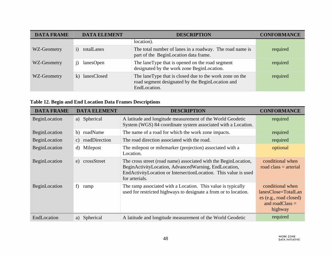
48
DATA FRAME DATA ELEMENT DESCRIPTION CONFORMANCE location).
WZ-Geometry i) totalLanes The total number of lanes in a roadway. The road name is part of the BeginLocation data frame.
required
WZ-Geometry j) lanesOpen The laneType that is opened on the road segment designated by the work zone BeginLocation.
required
WZ-Geometry k) lanesClosed The laneType that is closed due to the work zone on the road segment designated by the BeginLocation and EndLocation.
required
Table 12. Begin and End Location Data Frames Descriptions
DATA FRAME DATA ELEMENT DESCRIPTION CONFORMANCE
BeginLocation a) Spherical A latitude and longitude measurement of the World Geodetic System (WGS) 84 coordinate system associated with a Location.
required
BeginLocation b) roadName The name of a road for which the work zone impacts. required
BeginLocation c) roadDirection The road direction associated with the road. required
BeginLocation d) Milepost The milepost or milemarker (projection) associated with a Location.
optional
BeginLocation e) crossStreet The cross street (road name) associated with the BeginLocation, BeginActivityLocation, AdvancedWarning, EndLocation, EndActivityLocation or IntersectionLocation. This value is used for arterials.
conditional when road class = arterial
BeginLocation f) ramp The ramp associated with a Location. This value is typically used for restricted highways to designate a from or to location.
conditional when lanesClose=TotalLanes (e.g., road closed)
and roadClass = highway
EndLocation a) Spherical A latitude and longitude measurement of the World Geodetic required

49
DATA FRAME DATA ELEMENT DESCRIPTION CONFORMANCE
System (WGS) 84 coordinate system associated with a Location.
EndLocation b) Milepost The milepost or milemarker (projection) associated with a Location.
optional
EndLocation c) crossStreet The cross street (road name) associated with the BeginLocation, BeginActivityLocation, AdvancedWarning, EndLocation, EndActivityLocation or IntersectionLocation. This value is used for arterials.
optional
EndLocation d) ramp The ramp associated with a Location. This value is typically used for restricted highways to designate a from or to location.
conditional when lanesClose=TotalLanes (e.g., road closed)
and roadClass = highway
Table 13. Begin and End Activity Location Data Frames Descriptions
DATA FRAME DATA ELEMENT DESCRIPTION CONFORMANCE
BeginActivityLocation a) Spherical A latitude and longitude measurement of the World Geodetic System (WGS) 84 coordinate system associated with a Location.
required
BeginActivityLocation b) roadName The name of a road for which the work zone impacts. optional
BeginActivityLocation c) roadDirection The road direction associated with the road. optional [required when the direction
differs from the BeginLocation]
BeginActivityLocation d) Milepost The milepost or milemarker (projection) associated with a Location.
optional
BeginActivityLocation e) crossStreet The cross street (road name) associated with the BeginLocation, BeginActivityLocation, AdvancedWarning, EndLocation, EndActivityLocation or IntersectionLocation.
optional
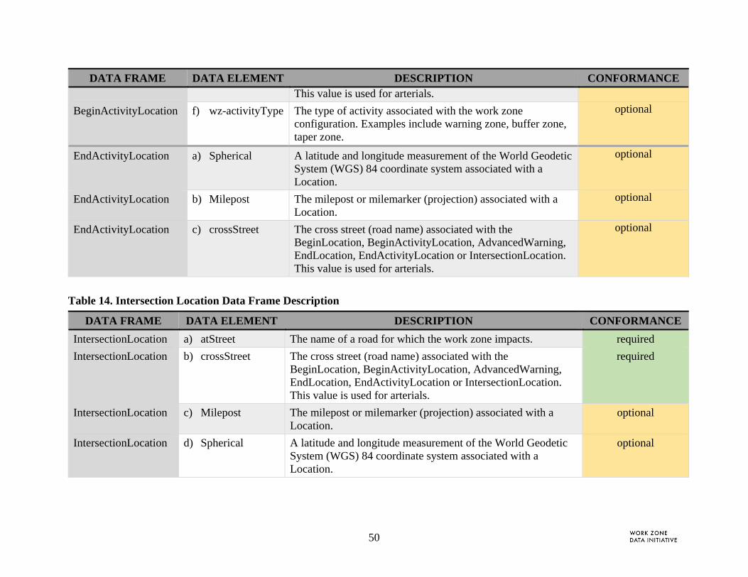
50
DATA FRAME DATA ELEMENT DESCRIPTION CONFORMANCE This value is used for arterials.
BeginActivityLocation f) wz-activityType The type of activity associated with the work zone configuration. Examples include warning zone, buffer zone, taper zone.
optional
EndActivityLocation a) Spherical A latitude and longitude measurement of the World Geodetic System (WGS) 84 coordinate system associated with a Location.
optional
EndActivityLocation b) Milepost The milepost or milemarker (projection) associated with a Location.
optional
EndActivityLocation c) crossStreet The cross street (road name) associated with the BeginLocation, BeginActivityLocation, AdvancedWarning, EndLocation, EndActivityLocation or IntersectionLocation. This value is used for arterials.
optional
Table 14. Intersection Location Data Frame Description
DATA FRAME DATA ELEMENT DESCRIPTION CONFORMANCE
IntersectionLocation a) atStreet The name of a road for which the work zone impacts. required
IntersectionLocation b) crossStreet The cross street (road name) associated with the BeginLocation, BeginActivityLocation, AdvancedWarning, EndLocation, EndActivityLocation or IntersectionLocation. This value is used for arterials.
required
IntersectionLocation c) Milepost The milepost or milemarker (projection) associated with a Location.
optional
IntersectionLocation d) Spherical A latitude and longitude measurement of the World Geodetic System (WGS) 84 coordinate system associated with a Location.
optional
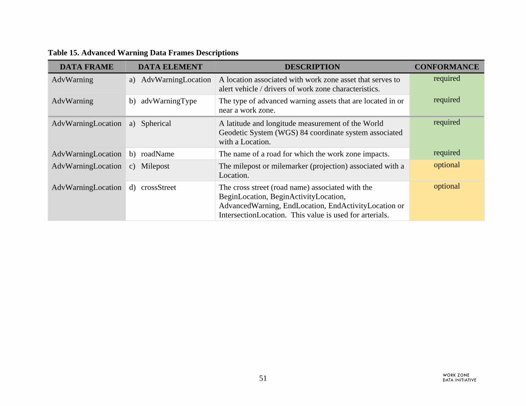
51
Table 15. Advanced Warning Data Frames Descriptions
DATA FRAME DATA ELEMENT DESCRIPTION CONFORMANCE
AdvWarning a) AdvWarningLocation A location associated with work zone asset that serves to alert vehicle / drivers of work zone characteristics.
required
AdvWarning b) advWarningType The type of advanced warning assets that are located in or near a work zone.
required
AdvWarningLocation a) Spherical A latitude and longitude measurement of the World Geodetic System (WGS) 84 coordinate system associated with a Location.
required
AdvWarningLocation b) roadName The name of a road for which the work zone impacts. required
AdvWarningLocation c) Milepost The milepost or milemarker (projection) associated with a Location.
optional
AdvWarningLocation d) crossStreet The cross street (road name) associated with the BeginLocation, BeginActivityLocation, AdvancedWarning, EndLocation, EndActivityLocation or IntersectionLocation. This value is used for arterials.
optional
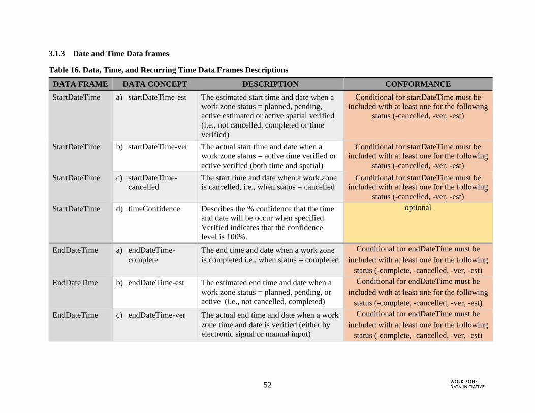
52
3.1.3 Date and Time Data frames
Table 16. Data, Time, and Recurring Time Data Frames Descriptions
DATA FRAME DATA CONCEPT DESCRIPTION CONFORMANCE
StartDateTime a) startDateTime-est The estimated start time and date when a work zone status = planned, pending, active estimated or active spatial verified (i.e., not cancelled, completed or time verified)
Conditional for startDateTime must be included with at least one for the following
status (-cancelled, -ver, -est)
StartDateTime b) startDateTime-ver The actual start time and date when a work zone status = active time verified or active verified (both time and spatial)
Conditional for startDateTime must be included with at least one for the following
status (-cancelled, -ver, -est)
StartDateTime c) startDateTime-cancelled
The start time and date when a work zone is cancelled, i.e., when status = cancelled
Conditional for startDateTime must be included with at least one for the following
status (-cancelled, -ver, -est)
StartDateTime d) timeConfidence Describes the % confidence that the time and date will be occur when specified. Verified indicates that the confidence level is 100%.
optional
EndDateTime a) endDateTime-complete
The end time and date when a work zone is completed i.e., when status = completed
Conditional for endDateTime must be included with at least one for the following
status (-complete, -cancelled, -ver, -est)
EndDateTime b) endDateTime-est The estimated end time and date when a work zone status = planned, pending, or active (i.e., not cancelled, completed)
Conditional for endDateTime must be included with at least one for the following
status (-complete, -cancelled, -ver, -est)
EndDateTime c) endDateTime-ver The actual end time and date when a work zone time and date is verified (either by electronic signal or manual input)
Conditional for endDateTime must be included with at least one for the following
status (-complete, -cancelled, -ver, -est)
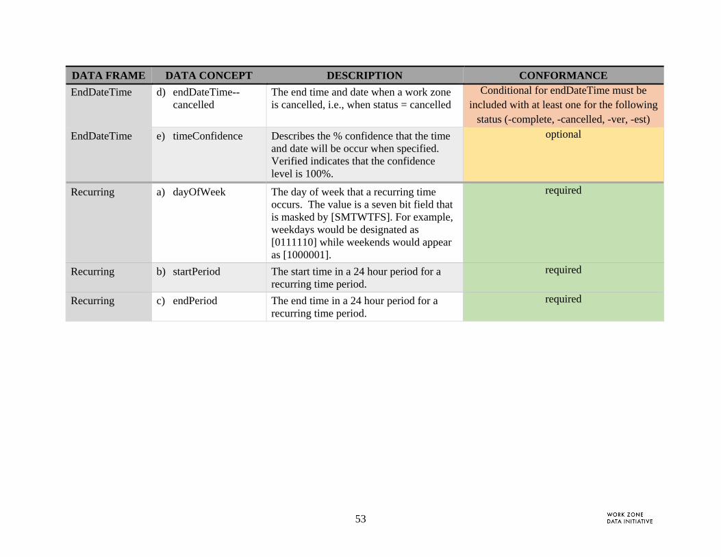
53
DATA FRAME DATA CONCEPT DESCRIPTION CONFORMANCE
EndDateTime d) endDateTime--cancelled
The end time and date when a work zone is cancelled, i.e., when status = cancelled
Conditional for endDateTime must be included with at least one for the following
status (-complete, -cancelled, -ver, -est)
EndDateTime e) timeConfidence Describes the % confidence that the time and date will be occur when specified. Verified indicates that the confidence level is 100%.
optional
Recurring a) dayOfWeek The day of week that a recurring time occurs. The value is a seven bit field that is masked by [SMTWTFS]. For example, weekdays would be designated as [0111110] while weekends would appear as [1000001].
required
Recurring b) startPeriod The start time in a 24 hour period for a recurring time period.
required
Recurring c) endPeriod The end time in a 24 hour period for a recurring time period.
required
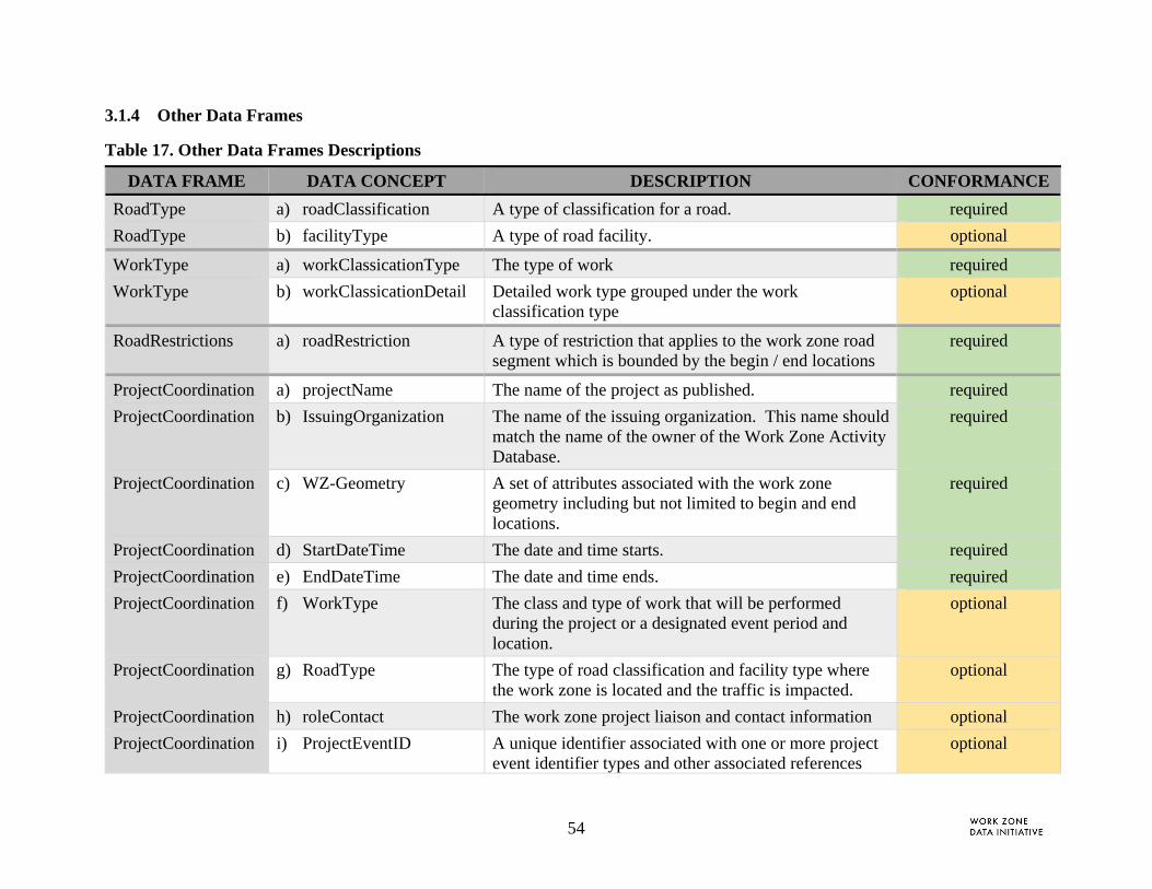
54
3.1.4 Other Data Frames
Table 17. Other Data Frames Descriptions
DATA FRAME DATA CONCEPT DESCRIPTION CONFORMANCE
RoadType a) roadClassification A type of classification for a road. required
RoadType b) facilityType A type of road facility. optional
WorkType a) workClassicationType The type of work required
WorkType b) workClassicationDetail Detailed work type grouped under the work classification type
optional
RoadRestrictions a) roadRestriction A type of restriction that applies to the work zone road segment which is bounded by the begin / end locations
required
ProjectCoordination a) projectName The name of the project as published. required
ProjectCoordination b) IssuingOrganization The name of the issuing organization. This name should match the name of the owner of the Work Zone Activity Database.
required
ProjectCoordination c) WZ-Geometry A set of attributes associated with the work zone geometry including but not limited to begin and end locations.
required
ProjectCoordination d) StartDateTime The date and time starts. required
ProjectCoordination e) EndDateTime The date and time ends. required
ProjectCoordination f) WorkType The class and type of work that will be performed during the project or a designated event period and location.
optional
ProjectCoordination g) RoadType The type of road classification and facility type where the work zone is located and the traffic is impacted.
optional
ProjectCoordination h) roleContact The work zone project liaison and contact information optional
ProjectCoordination i) ProjectEventID A unique identifier associated with one or more project event identifier types and other associated references
optional

55
DATA FRAME DATA CONCEPT DESCRIPTION CONFORMANCE identifier such as contract number.
ProjectCoordination j) coordinationStatus The status of coordination including whether the coordination is active, planned, closed, not initiated.
optional
ProjectCoordination k) coordinationType The type of coordination and with what orgType triggered by the work classification.
required
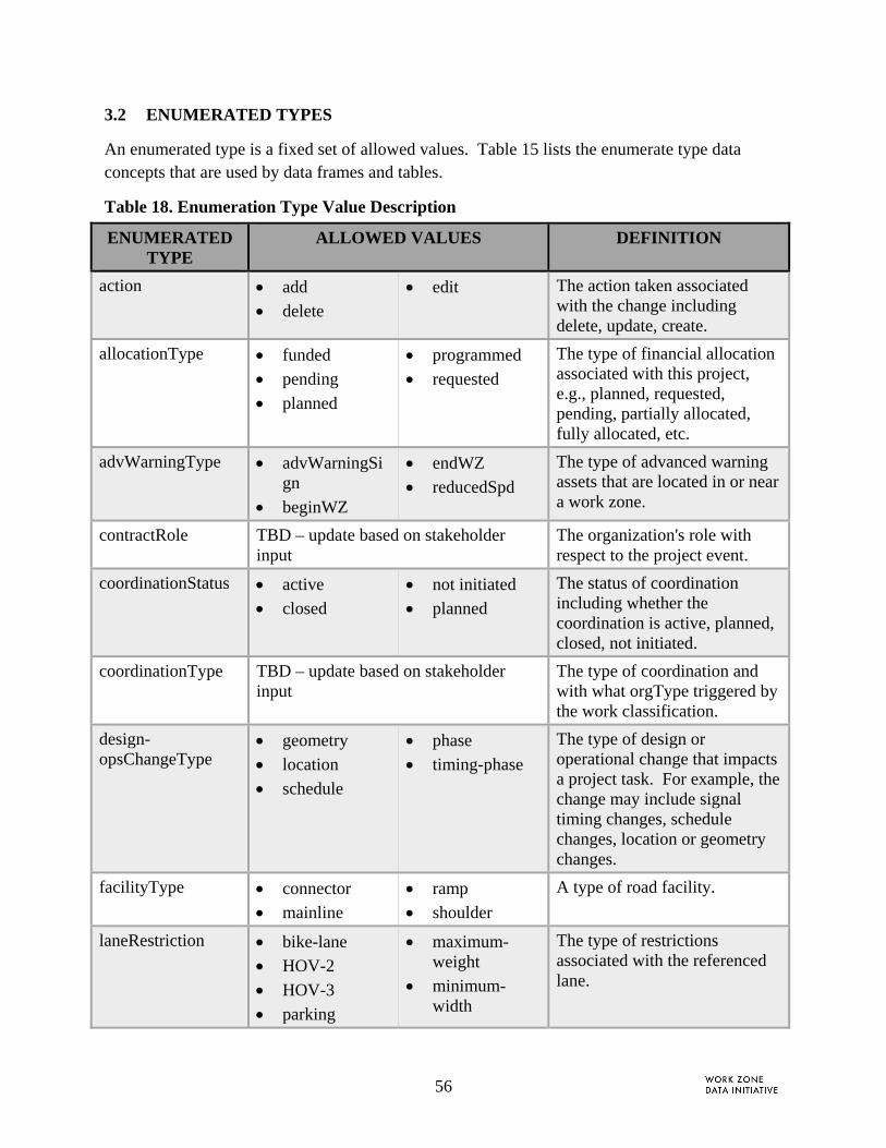
56
3.2 ENUMERATED TYPES
An enumerated type is a fixed set of allowed values. Table 15 lists the enumerate type data concepts that are used by data frames and tables.
Table 18. Enumeration Type Value Description
ENUMERATED TYPE
ALLOWED VALUES DEFINITION
action add
delete
edit The action taken associated with the change including delete, update, create.
allocationType funded
pending
planned
programmed
requested
The type of financial allocation associated with this project, e.g., planned, requested, pending, partially allocated, fully allocated, etc.
advWarningType advWarningSign
beginWZ
endWZ
reducedSpd
The type of advanced warning assets that are located in or near a work zone.
contractRole TBD – update based on stakeholder input
The organization's role with respect to the project event.
coordinationStatus active
closed
not initiated
planned
The status of coordination including whether the coordination is active, planned, closed, not initiated.
coordinationType TBD – update based on stakeholder input
The type of coordination and with what orgType triggered by the work classification.
design-opsChangeType
geometry
location
schedule
phase
timing-phase
The type of design or operational change that impacts a project task. For example, the change may include signal timing changes, schedule changes, location or geometry changes.
facilityType connector
mainline
ramp
shoulder
A type of road facility.
laneRestriction bike-lane
HOV-2
HOV-3
parking
maximum-weight
minimum-width
The type of restrictions associated with the referenced lane.
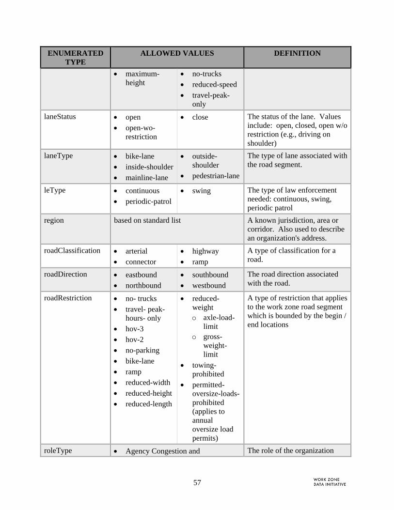
57
ENUMERATED TYPE
ALLOWED VALUES DEFINITION
maximum-height
no-trucks
reduced-speed
travel-peak-only
laneStatus open
open-wo-restriction
close The status of the lane. Values include: open, closed, open w/o restriction (e.g., driving on shoulder)
laneType bike-lane
inside-shoulder
mainline-lane
outside-shoulder
pedestrian-lane
The type of lane associated with the road segment.
leType continuous
periodic-patrol
swing The type of law enforcement needed: continuous, swing, periodic patrol
region based on standard list A known jurisdiction, area or corridor. Also used to describe an organization's address.
roadClassification arterial
connector
highway
ramp
A type of classification for a road.
roadDirection eastbound
northbound
southbound
westbound
The road direction associated with the road.
roadRestriction no- trucks
travel- peak- hours- only
hov-3
hov-2
no-parking
bike-lane
ramp
reduced-width
reduced-height
reduced-length
reduced- weight o axle-load-
limit o gross-
weight-limit
towing-prohibited
permitted-oversize-loads-prohibited (applies to annual oversize load permits)
A type of restriction that applies to the work zone road segment which is bounded by the begin / end locations
roleType Agency Congestion and The role of the organization

58
ENUMERATED TYPE
ALLOWED VALUES DEFINITION
Performance Manager
Agency Construction Operations Manager and Inspector
Agency Design and Engineering
Agency Oversize/Overweight Permitting Function
Agency Roadway Maintenance Manager Function
Agency Work Zone Data Systems Development and Operations
Agency Work Zone Planning and Coordination
ATMS Operator Function
Connected and Automated Vehicles
Construction Contractors
Freight Haulers
ITS/DMS/Traveler Information Systems
Law Enforcement
Law Enforcement Coordination
Neighbor and Regional Partner Agencies
State and Federal Transportation Agencies
Third-Party Traveler Information Providers
Travelers
Utilities
Utilities Construction Work Zone Coordination
with respect to the project event (task, subtask or activity).
shouldersClosed See enumerated values in ITS Standards Applied to the WZDD
The shoulder(s) that are closed within the begin / end activity location (or if not identified, within the begin/end location).
travelPathEffect alternating-one-way
merge
merge-lt
shift
shift-lt
shift-rt
unknown
The type of travel path effect implemented leading up to or from a work zone. Where lt indicates left (e.g., merge left) and rt indicates right (e.g.,

59
ENUMERATED TYPE
ALLOWED VALUES DEFINITION
merge-rt merge right)
workClassificationDetail
TBD -- developed by each region Detailed work type grouped under the work classification type
workClassificationType
Construction
Contract-Maintenance
In-House-Maintenance-Operations
Special -Event-Traffic-Control
Utility
Vertical-Construction
The type of work
wz-location-method channel-device-method
sign-method
junction-method
unknown – when method for locating the begin and end locations of the work zone is not known
other – when the method for locating the begin and end locations do not closely match any of the alternatives. An explanation should be included in the metadata when this value is assigned.
The typical method used to locate the begin and end of a work zone impact area. An explanation should be included in the metadata when this value is assigned.
wz-SeparationType channelizing
portable-concrete
steel-barrier The type of separation or divider used in the work zone.
wz-Status active
canceled
completed
pending
planned
The status of the work zone.
wzTTCType alternating-one-way
continuously-moving
intermittent-moving-operations
lane-closure
lane-shifts
ramp-closure
road-closure
shoulder-closure
traffic-splits
TTC strategy associated with work zone Phase, WZ-task or WZ-subtask

60
4 REFERENCES This section lists relevant references cited in this report.
[1] Work Zone Activity Data Needs and Opportunities (FHWA-XXX-XX-XXXX)
[2] Framework for Work Zone Activity Data Collection and Management (FHWA-XX-XXXX)
[3] ISO 14817-1:2015 Intelligent Transport Systems -- ITS central data dictionaries -- Part 1: Requirements for ITS data definitions.
[4] Traffic Management Data Dictionary Standard for Traffic Management Center-to-Center Communications. Institute of Transportation Engineers, 2013. [https://www.standards.its.dot.gov/Content/documents/advisories/TMDD_2013.aspx]
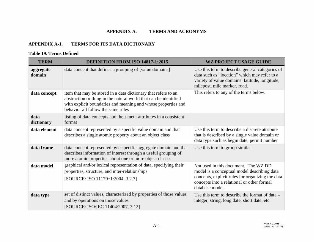
A-1
APPENDIX A. TERMS AND ACRONYMS APPENDIX A-1. TERMS FOR ITS DATA DICTIONARY
Table 19. Terms Defined
TERM DEFINITION FROM ISO 14817-1:2015 WZ PROJECT USAGE GUIDE
aggregate domain
data concept that defines a grouping of [value domains] Use this term to describe general categories of data such as “location” which may refer to a variety of value domains: latitude, longitude, milepost, mile marker, road.
data concept item that may be stored in a data dictionary that refers to an abstraction or thing in the natural world that can be identified with explicit boundaries and meaning and whose properties and behavior all follow the same rules
This refers to any of the terms below.
data dictionary
listing of data concepts and their meta-attributes in a consistent format
data element data concept represented by a specific value domain and that describes a single atomic property about an object class
Use this term to describe a discrete attribute that is described by a single value domain or data type such as begin date, permit number
data frame data concept represented by a specific aggregate domain and that describes information of interest through a useful grouping of more atomic properties about one or more object classes
Use this term to group similar
data model graphical and/or lexical representation of data, specifying their properties, structure, and inter-relationships
[SOURCE: ISO 11179‑1:2004, 3.2.7]
Not used in this document. The WZ DD model is a conceptual model describing data concepts, explicit rules for organizing the data concepts into a relational or other formal database model.
data type set of distinct values, characterized by properties of those values and by operations on those values [SOURCE: ISO/IEC 11404:2007, 3.12]
Use this term to describe the format of data – integer, string, long date, short date, etc.

A-2
TERM DEFINITION FROM ISO 14817-1:2015 WZ PROJECT USAGE GUIDE
object class description of a set of objects that share the same properties, relationships, and semantics
Not included in the WZ data dictionary
value domain data concept that defines a set of permissible values
Use this term to define features or terms such as latitude.
Note: Date is a value domain and it can be formatted using different data types.
Reference: https://www.iso.org/obp/ui/#iso:std:iso:14817:-1:ed-1:v1:en

A-3
APPENDIX A-2. WZ-STATUS ENUMERATED VALUE DEFINITIONS
Planned. General information Project associated with overall project or phase timing and locations. Typically, this information is estimated during planning or early design stages.
Pending. Used to alert stakeholder that work is planned and scheduled for the near future (e.g., 2-3 weeks). The certainty of starting at this time is greater than 90% (barring weather and other unforeseen circumstances).
Time horizon: approximate begin / end dates
Location: coverage area and main road name; polyline (or geofence) around zone area
Active. Specific information about a Work Zone that is in place and operating. The precision of the duration and location are identified by the suffix on the respective project event fields.
Cancelled. Reported cancellation of a proposed or active WZ; the coverage applies to all work zone activities (tasks, subtasks and/or lane activities) inherited by the following:
When a proposed WZ is cancelled, the dates should correspond to the proposed report
The date time suffix for estimated or verified determine the certainty of the cancellation duration.
Completed. Work Zone is closed or is assigned a date for completion when all work zone activities are completed.

A-4
APPENDIX A-3. LIST OF ACRONYMS
API Application Programming Interface
ATMS Advanced Traffic Management System
DE Data Element
DF Data Frame
Enum Enumerated Type
est estimated
FHWA Federal Highway Administration
HOV High Occupancy Vehicle
ISO International Organization for Standardization
ITS Intelligent Transportation Systems
LE Law Enforcement
LRS Linear Referencing System
lt Left
MOU Memorandum of Understanding
OGC Open Geospatial Consortium
OSOW Oversize/Overweight
RFP Request for Proposal
rt Right
SAE Society of Automotive Engineers
TIMS Traffic Incident Management System
TMDD Traffic Management Data Dictionary
TTC Temporary Traffic Control
WFS Web Feature Services
WGS World Geodetic System
WMS Web Map Services
WZ Work Zone

A-5
WZAD Work Zone Activity Data
WZDD Work Zone Data Dictionary
WZDI Work Zone Data Initiative Project
WZDS Work Zone Data Systems
WZDx Work Zone Data Exchange
URL Uniform Resource Locator
USDOT United States Department of Transportation
ver verified

B-1
APPENDIX B. TRACEABILITY TO WZAD FRAMEWORK
APPENDIX B-1. DETAILED TRACE TO USE CASE CONTENT AND WZDD DATA CONCEPTS
The WZAD Framework document identified 59 WZAD content data concepts and 25 “external data [concepts] needed for user objectives.” Industry standard [3] defines a data concept as may reference a single, discrete data element or it may refer to a grouping of several data elements (i.e., a data frame)3. These terms are defined as follows:
Data Element – Discrete data concept that cannot be broken down into smaller units.
Data Frame - Data concept that describes a portion of a message or data feed that may contain other data elements or data frames.
A consolidated list of data derived from the Framework’s use cases was used to generate WZDD concepts. From the 59 data concepts identified, 147 WZDD concepts were generated and several external data sources were defined with respect to the WZDS Conceptual Framework (Figure 2). The mapping table between the Framework needs and Work Zone Data Dictionary includes the following information:
No. – Unique identifier for each row of data
Framework Data Content – Desired data elements derived from stakeholders.
Schema Table – (If applicable), a table that includes a collection of data elements and frames which is logically related by work zone state, time, geometry and impact, or a group of data concepts that characterize activities related to a work zone. The schema tables used in this document refer to abstract group of data concepts rather than a physical or logical representation defined to a model database. Additional information on the schema tables can be found in Section 2.2.4.
Data Frame/Element – (If applicable), data concepts which house data elements and/or data frames. Additional information on the data frames can be found in Section 2.2.2.
Framework Use Case – the use case numbers which reference the data content
Notes – Additional information provided for context and clarity.
3 Definitions for data concept, data element, and data frame are adapted from [3] the ISO ITS Data Dictionary standard.
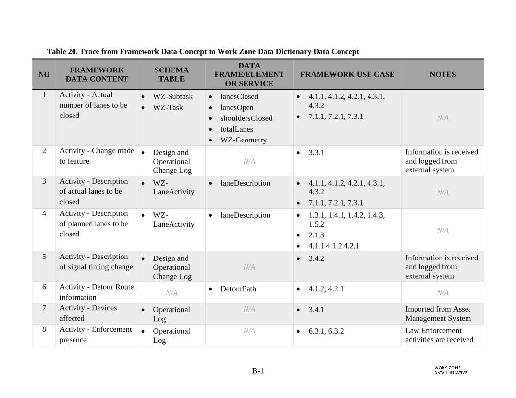
B-1
Table 20. Trace from Framework Data Concept to Work Zone Data Dictionary Data Concept
NO FRAMEWORK
DATA CONTENT SCHEMA TABLE
DATA FRAME/ELEMENT
OR SERVICE FRAMEWORK USE CASE NOTES
1 Activity - Actual number of lanes to be closed
WZ-Subtask
WZ-Task
lanesClosed
lanesOpen
shouldersClosed
totalLanes
WZ-Geometry
4.1.1, 4.1.2, 4.2.1, 4.3.1, 4.3.2
7.1.1, 7.2.1, 7.3.1 N/A
2 Activity - Change made to feature
Design and Operational Change Log
N/A 3.3.1 Information is received
and logged from external system
3 Activity - Description of actual lanes to be closed
WZ-LaneActivity
laneDescription 4.1.1, 4.1.2, 4.2.1, 4.3.1, 4.3.2
7.1.1, 7.2.1, 7.3.1 N/A
4 Activity - Description of planned lanes to be closed
WZ-LaneActivity
laneDescription 1.3.1, 1.4.1, 1.4.2, 1.4.3, 1.5.2
2.1.3
4.1.1 4.1.2 4.2.1
N/A
5 Activity - Description of signal timing change
Design and Operational Change Log
N/A 3.4.2 Information is received
and logged from external system
6 Activity - Detour Route information
N/A DetourPath 4.1.2, 4.2.1 N/A
7 Activity - Devices affected
Operational Log
N/A 3.4.1 Imported from Asset Management System
8 Activity - Enforcement presence
Operational Log
N/A 6.3.1, 6.3.2 Law Enforcement activities are received

B-2
NO FRAMEWORK
DATA CONTENT SCHEMA TABLE
DATA FRAME/ELEMENT
OR SERVICE FRAMEWORK USE CASE NOTES
and logged from external system
9 Activity - Expected effect on travel time/delay/queuing
Operational Log
N/A 1.3.1, 1.4.2, 1.4.3, 1.5.2
2.1.3
4.1.1, 4.1.2, 4.2.1, 4.3.1
7.1.1, 7.2.1, 7.3.1
Stakeholders identified that traffic performance and impact should be referenced from external system.
10 Activity - Expected geometrics associated with each event/subevent
Phase
WZ-LaneActivity
WZ-Subtask
WZ-Task
LaneGeometryPath
WzGeometryPath
2.1.1
N/A
11 Activity - Expected traffic control device(s) associated with each event/subevent
WZ-Subtask
WZ-Task
WzTTCType 2.1.1 “Expected” is indicated when wz-status is planned or pending
12 Activity - Feature that is modified relative to project plans
Design and Operational Change Log
N/A 3.3.1 Information is received
and logged from external system
13 Activity - General description about Maintenance of Traffic approach
Phase WorkType 1.1.2
N/A
14 Activity - General description of event/subevent
Phase
WZ-Subtask
WZ-Task
descriptionTask 1.1.1, 1.1.2, 1.2.1, 1.2.2, 1.3.2 N/A

B-3
NO FRAMEWORK
DATA CONTENT SCHEMA TABLE
DATA FRAME/ELEMENT
OR SERVICE FRAMEWORK USE CASE NOTES
15 Activity - Indication that the Maintenance of Traffic requires coordination between the projects
Project Coordination List N/A
1.2.1, 1.2.2
2.2.1, 2.2.2
3.2.3 N/A
16 Activity - Indicator that signal timing has changed
Design and Operational Change Log
N/A 3.4.2 Information is received
and logged from external system
17 Activity - Indicator that the work involves cutting or otherwise affecting the pavement
N/A
workClassificationDetail
workClassificationType
WorkType
1.4.3, 1.5.2
N/A
18 Activity - Lane closure permit number
Role permitID 1.4.1 N/A
19 Activity - List of changes to notify travelers
Operational Log N/A
4.2.2 WZDx is a public data feed specification
20 Activity - Number of activities requiring Law Enforcement support OR flag indicating event/subevent needs Law Enforcement support
Operational Log
LESupportNeeds 6.4.1 LE Support Needs is the set of WZ activities that require law enforcement support

B-4
NO FRAMEWORK
DATA CONTENT SCHEMA TABLE
DATA FRAME/ELEMENT
OR SERVICE FRAMEWORK USE CASE NOTES
21 Activity - Planned number of lanes to be closed
Phase
WZ-Subtask
WZ-Task
lanesClosed
WZ-Geometry
1.3.1, 1.4.1, 1.4.2, 1.4.3, 1.5.2
2.1.3
4.1.1, 4.1.2, 4.2.1
N/A
22 Activity - Planned number of lanes to be open
Phase
WZ-Subtask
WZ-Task
lanesOpen
WZ-Geometry
1.3.1, 1.4.1, 1.4.2, 1.4.3, 1.5.2
2.1.3 N/A
23 Activity - Planned number of short-term lane closures
Phase
WZ-Subtask
WZ-Task
lanesClosed
WZ-Geometry
2.1.3 N/A
24 Activity - Reduce Speed Limit
WZ-Subtask
WZ-Task
reducedSpeedLimit 5.1.3, 5.2.1
6.1.2 N/A
25 Activity - Reference to projects that need to coordinated with (Project IDs?)
Project Coordination List
ProjectEventID 1.2.1, 1.2.2
2.2.1, 2.2.2
3.2.3
related data element:
projectName
26 Activity - Temporary restrictions in place
WZ-Subtask
WZ-Task
laneRestriction
wz-SeparationType
1.5.1, 1.6.1
4.1.1, 4.3.1
7.1.1, 7.2.1, 7.3.1
N/A
27 Activity - Total number of lanes
Phase
WZ-Subtask
WZ-Task
totalLanes
WZ-Geometry
1.3.1, 1.4.1, 1.4.2, 1.4.3, 1.5.2
2.1.3 N/A
28 Activity - TTC used to make feature change
WZ-LaneActivity
travelPathEffect
WZ-Geometry
3.3.1 Change to project is logged

B-5
NO FRAMEWORK
DATA CONTENT SCHEMA TABLE
DATA FRAME/ELEMENT
OR SERVICE FRAMEWORK USE CASE NOTES
WZ-Subtask
WZ-Task 29 Activity - Warning
notifications Phase
WZ-Subtask
WZ-Task
AdvancedWarning
WZ-Geometry
4.2.1 Data Frame that includes location, notification type and message.
30 Actual geometrics associated with each event/subevent
Phase
WZ-LaneActivity
WZ-Subtask
WZ-Task
LaneGeomteryPath
Path
WZGeometryPath
5.1.1, 5.1.2, 5.2.2, 5.2.3, 5.3.1, 5.3.2
These are part of WZ-Geometry
31 Actual number of phases
Work Zone Project
totalPhases 5.1.1, 5.1.2, 5.2.2, 5.2.3, 5.3.1, 5.3.2
When Project is completed
32 Actual traffic control device(s) associated with each event/subevent
WZ-Subtask
WZ-Task
wzTTCType 5.1.1, 5.1.2, 5.2.2, 5.2.3, 5.3.1, 5.3.2
N/A
34 Contractor/subcontractors
Role contractRole
roleType
1.2.1, 1.2.2, 1.3.1, 1.3.2, 1.4.1, 1.4.2, 1.4.3, 1.5.2
3.1.2, 3.1.3, 3.2.1, 3.2.2, 3.2.3, 3.3.1, 3.4.1, 3.4.2
5.1.1, 5.1.2, 5.2.2, 5.2.3, 5.3.1, 5.3.2
6.5.1
N/A
35 Date/Time Advance Notice Received
Operational Log
timeStamp N/A Notice received by WZAD when
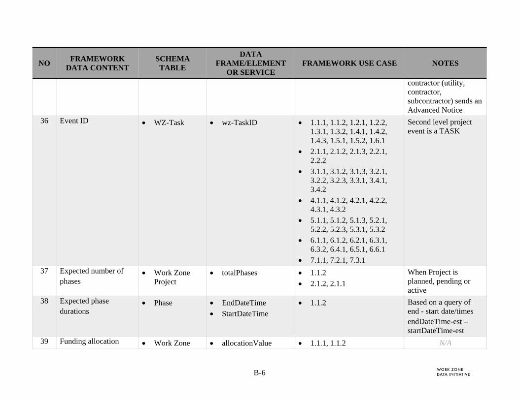
B-6
NO FRAMEWORK
DATA CONTENT SCHEMA TABLE
DATA FRAME/ELEMENT
OR SERVICE FRAMEWORK USE CASE NOTES
contractor (utility, contractor, subcontractor) sends an Advanced Notice
36 Event ID WZ-Task wz-TaskID 1.1.1, 1.1.2, 1.2.1, 1.2.2, 1.3.1, 1.3.2, 1.4.1, 1.4.2, 1.4.3, 1.5.1, 1.5.2, 1.6.1
2.1.1, 2.1.2, 2.1.3, 2.2.1, 2.2.2
3.1.1, 3.1.2, 3.1.3, 3.2.1, 3.2.2, 3.2.3, 3.3.1, 3.4.1, 3.4.2
4.1.1, 4.1.2, 4.2.1, 4.2.2, 4.3.1, 4.3.2
5.1.1, 5.1.2, 5.1.3, 5.2.1, 5.2.2, 5.2.3, 5.3.1, 5.3.2
6.1.1, 6.1.2, 6.2.1, 6.3.1, 6.3.2, 6.4.1, 6.5.1, 6.6.1
7.1.1, 7.2.1, 7.3.1
Second level project event is a TASK
37 Expected number of phases
Work Zone Project
totalPhases 1.1.2
2.1.2, 2.1.1
When Project is planned, pending or active
38 Expected phase durations
Phase EndDateTime
StartDateTime
1.1.2 Based on a query of end - start date/times endDateTime-est – startDateTime-est
39 Funding allocation Work Zone allocationValue 1.1.1, 1.1.2 N/A
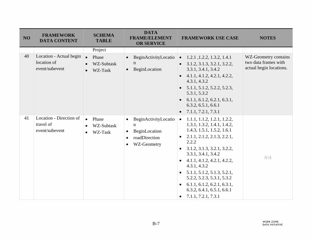
B-7
NO FRAMEWORK
DATA CONTENT SCHEMA TABLE
DATA FRAME/ELEMENT
OR SERVICE FRAMEWORK USE CASE NOTES
Project 40 Location - Actual begin
location of event/subevent
Phase
WZ-Subtask
WZ-Task
BeginActivityLocation
BeginLocation
1.2.1 ,1.2.2, 1.3.2, 1.4.1
3.1.2, 3.1.3, 3.2.1, 3.2.2, 3.3.1, 3.4.1, 3.4.2
4.1.1, 4.1.2, 4.2.1, 4.2.2, 4.3.1, 4.3.2
5.1.1, 5.1.2, 5.2.2, 5.2.3, 5.3.1, 5.3.2
6.1.1, 6.1.2, 6.2.1, 6.3.1, 6.3.2, 6.5.1, 6.6.1
7.1.1, 7.2.1, 7.3.1
WZ-Geometry contains two data frames with actual begin locations.
41 Location - Direction of travel of event/subevent
Phase
WZ-Subtask
WZ-Task
BeginActivityLocation
BeginLocation
roadDirection
WZ-Geometry
1.1.1, 1.1.2, 1.2.1, 1.2.2, 1.3.1, 1.3.2, 1.4.1, 1.4.2, 1.4.3, 1.5.1, 1.5.2, 1.6.1
2.1.1, 2.1.2, 2.1.3, 2.2.1, 2.2.2
3.1.2, 3.1.3, 3.2.1, 3.2.2, 3.3.1, 3.4.1, 3.4.2
4.1.1, 4.1.2, 4.2.1, 4.2.2, 4.3.1, 4.3.2
5.1.1, 5.1.2, 5.1.3, 5.2.1, 5.2.2, 5.2.3, 5.3.1, 5.3.2
6.1.1, 6.1.2, 6.2.1, 6.3.1, 6.3.2, 6.4.1, 6.5.1, 6.6.1
7.1.1, 7.2.1, 7.3.1
N/A

B-8
NO FRAMEWORK
DATA CONTENT SCHEMA TABLE
DATA FRAME/ELEMENT
OR SERVICE FRAMEWORK USE CASE NOTES
42 Location - Facility type of roadway where event/subevent is located
Phase
WZ-Subtask
WZ-Task
RoadType
facilityType
1.1.1, 1.1.2, 1.2.1, 1.2.2, 1.3.1, 1.3.2, 1.4.1, 1.4.2, 1.4.3, 1.5.1, 1.5.2, 1.6.1
2.1.1, 2.1.2, 2.1.3, 2.2.1, 2.2.2
3.1.1, 3.1.2, 3.1.3, 3.2.1, 3.2.2, 3.2.3, 3.3.1, 3.4.1, 3.4.2
4.1.1, 4.1.2, 4.2.1, 4.2.2, 4.3.1, 4.3.2
5.1.1, 5.1.2, 5.1.3, 5.2.1, 5.2.2, 5.2.3, 5.3.1, 5.3.2
6.1.1, 6.1.2, 6.2.1, 6.3.1, 6.3.2, 6.4.1, 6.5.1, 6.6.1
7.1.1, 7.2.1, 7.3.1
N/A
43 Location - Name of roadway where event/subevent is located
Phase
WZ-Subtask
WZ-Task
BeginLocation
roadName
WZ-Geometry
1.1.1, 1.1.2, 1.2.1, 1.2.2, 1.3.1, 1.3.2, 1.4.1, 1.4.2, 1.4.3, 1.5.1, 1.5.2, 1.6.1
2.1.1, 2.1.2, 2.1.3, 2.2.1, 2.2.2
3.1.1, 3.1.2, 3.1.3, 3.2.1, 3.2.2, 3.2.3, 3.3.1, 3.4.1, 3.4.2
4.1.1, 4.1.2, 4.2.1, 4.2.2, 4.3.1, 4.3.2
5.1.1, 5.1.2, 5.1.3, 5.2.1, 5.2.2, 5.2.3, 5.3.1, 5.3.2
Project event activity may be at any project event level: phase, task, subtask
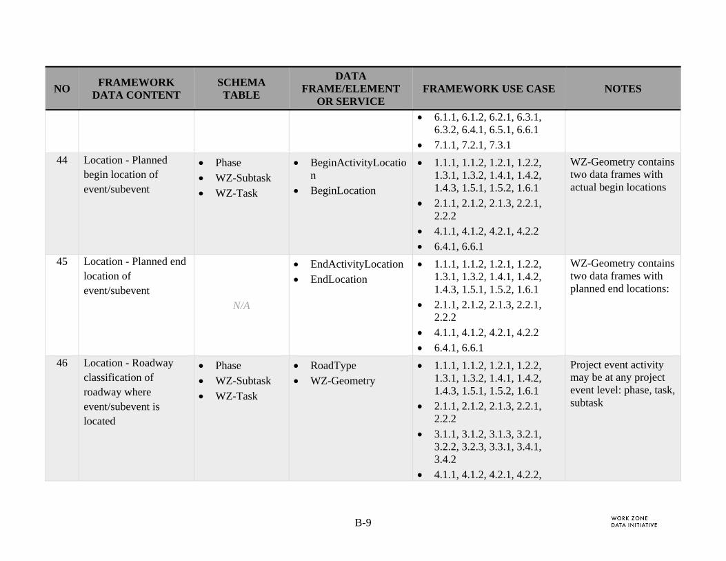
B-9
NO FRAMEWORK
DATA CONTENT SCHEMA TABLE
DATA FRAME/ELEMENT
OR SERVICE FRAMEWORK USE CASE NOTES
6.1.1, 6.1.2, 6.2.1, 6.3.1, 6.3.2, 6.4.1, 6.5.1, 6.6.1
7.1.1, 7.2.1, 7.3.1 44 Location - Planned
begin location of event/subevent
Phase
WZ-Subtask
WZ-Task
BeginActivityLocation
BeginLocation
1.1.1, 1.1.2, 1.2.1, 1.2.2, 1.3.1, 1.3.2, 1.4.1, 1.4.2, 1.4.3, 1.5.1, 1.5.2, 1.6.1
2.1.1, 2.1.2, 2.1.3, 2.2.1, 2.2.2
4.1.1, 4.1.2, 4.2.1, 4.2.2
6.4.1, 6.6.1
WZ-Geometry contains two data frames with actual begin locations
45 Location - Planned end location of event/subevent
N/A
EndActivityLocation
EndLocation
1.1.1, 1.1.2, 1.2.1, 1.2.2, 1.3.1, 1.3.2, 1.4.1, 1.4.2, 1.4.3, 1.5.1, 1.5.2, 1.6.1
2.1.1, 2.1.2, 2.1.3, 2.2.1, 2.2.2
4.1.1, 4.1.2, 4.2.1, 4.2.2
6.4.1, 6.6.1
WZ-Geometry contains two data frames with planned end locations:
46 Location - Roadway classification of roadway where event/subevent is located
Phase
WZ-Subtask
WZ-Task
RoadType
WZ-Geometry
1.1.1, 1.1.2, 1.2.1, 1.2.2, 1.3.1, 1.3.2, 1.4.1, 1.4.2, 1.4.3, 1.5.1, 1.5.2, 1.6.1
2.1.1, 2.1.2, 2.1.3, 2.2.1, 2.2.2
3.1.1, 3.1.2, 3.1.3, 3.2.1, 3.2.2, 3.2.3, 3.3.1, 3.4.1, 3.4.2
4.1.1, 4.1.2, 4.2.1, 4.2.2,
Project event activity may be at any project event level: phase, task, subtask

B-10
NO FRAMEWORK
DATA CONTENT SCHEMA TABLE
DATA FRAME/ELEMENT
OR SERVICE FRAMEWORK USE CASE NOTES
4.3.1, 4.3.2
5.1.1, 5.1.2, 5.1.3, 5.2.1, 5.2.2, 5.2.3, 5.3.1, 5.3.2
6.1.1, 6.1.2, 6.2.1, 6.3.1, 6.3.2, 6.4.1, 6.5.1, 6.6.1
7.1.1, 7.2.1, 7.3.1 47 Metadata - Indicator
that a change to an event/subevent entry has been made
N/A
WZ-ProjectSchedule 1.1.1, 1.1.2, 1.2.1, 1.2.2, 1.3.1, 1.3.2, 1.4.1, 1.4.2, 1.4.3, 1.5.2
4.1.1, 4.1.2, 4.2.1, 4.2.2, 4.3.1, 4.3.2
7.1.1, 7.2.1, 7.3.1
All data concept changes should be logged in the VersionLog.
48 Owner agency Organization orgName
orgTelephone
orgType
orgURL
region
1.1.1, 1.1.2, 1.2.1, 1.2.2, 1.3.1, 1.4.2, 1.4.3, 1.5.1, 1.5.2, 1.6.1
2.1.1, 2.1.2, 2.1.3, 2.2.1, 2.2.2
3.2.3
5.1.1, 5.1.2, 5.2.2, 5.2.3, 5.3.1, 5.3.2
N/A
49 Owner agency Project Manager
Organization orgName
orgTelephone
orgType
orgURL
region
1.2.1, 1.2.2, 3.2.3
N/A
50 Project ID Phase ProjectEventID 1.1.1, 1.1.2, 1.2.1, 1.2.2, N/A
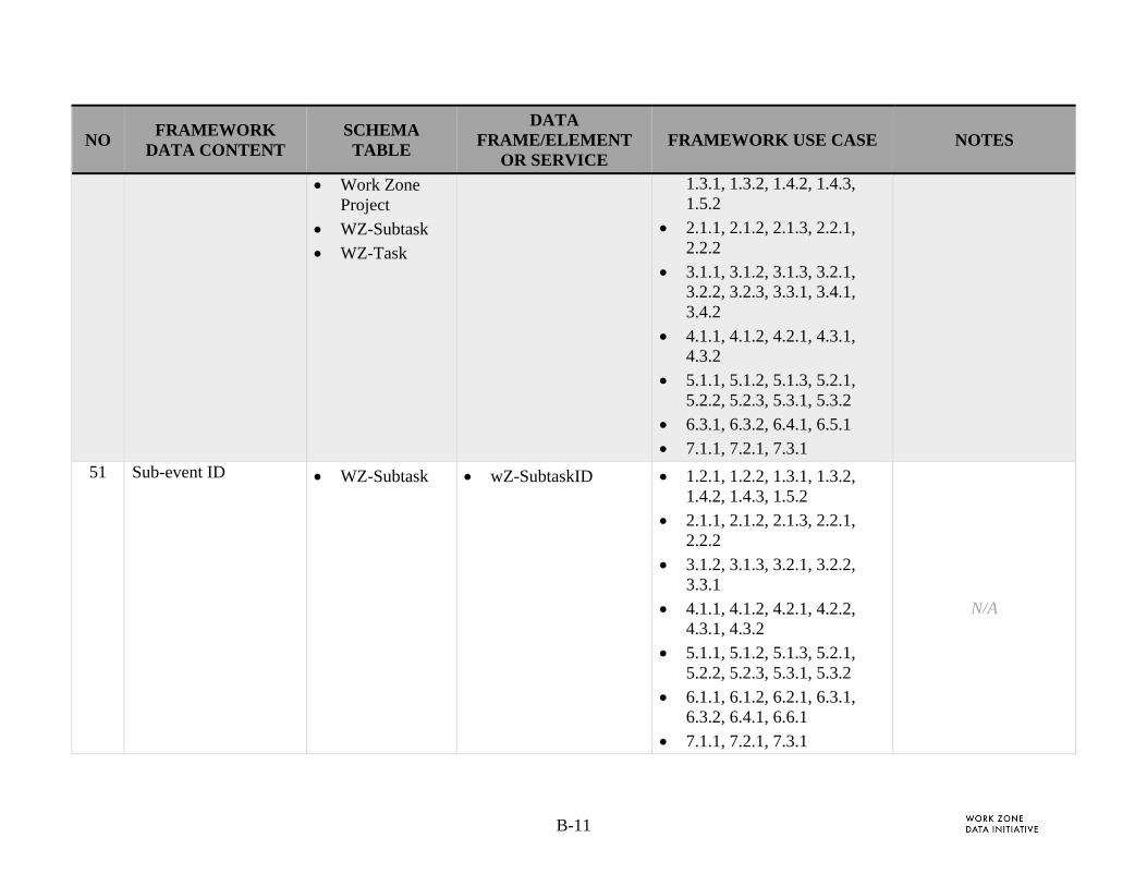
B-11
NO FRAMEWORK
DATA CONTENT SCHEMA TABLE
DATA FRAME/ELEMENT
OR SERVICE FRAMEWORK USE CASE NOTES
Work Zone Project
WZ-Subtask
WZ-Task
1.3.1, 1.3.2, 1.4.2, 1.4.3, 1.5.2
2.1.1, 2.1.2, 2.1.3, 2.2.1, 2.2.2
3.1.1, 3.1.2, 3.1.3, 3.2.1, 3.2.2, 3.2.3, 3.3.1, 3.4.1, 3.4.2
4.1.1, 4.1.2, 4.2.1, 4.3.1, 4.3.2
5.1.1, 5.1.2, 5.1.3, 5.2.1, 5.2.2, 5.2.3, 5.3.1, 5.3.2
6.3.1, 6.3.2, 6.4.1, 6.5.1
7.1.1, 7.2.1, 7.3.1 51 Sub-event ID WZ-Subtask wZ-SubtaskID 1.2.1, 1.2.2, 1.3.1, 1.3.2,
1.4.2, 1.4.3, 1.5.2
2.1.1, 2.1.2, 2.1.3, 2.2.1, 2.2.2
3.1.2, 3.1.3, 3.2.1, 3.2.2, 3.3.1
4.1.1, 4.1.2, 4.2.1, 4.2.2, 4.3.1, 4.3.2
5.1.1, 5.1.2, 5.1.3, 5.2.1, 5.2.2, 5.2.3, 5.3.1, 5.3.2
6.1.1, 6.1.2, 6.2.1, 6.3.1, 6.3.2, 6.4.1, 6.6.1
7.1.1, 7.2.1, 7.3.1
N/A

B-12
NO FRAMEWORK
DATA CONTENT SCHEMA TABLE
DATA FRAME/ELEMENT
OR SERVICE FRAMEWORK USE CASE NOTES
52 Time - Actual end date/time of event/subevent
Phase
WZ-Subtask
WZ-Task
EndDateTime
endDateTime-cancelled
endDateTime-complete
endDateTime-ver
timeConfidence
1.2.1, 1.2.2, 1.3.2, 1.4.1
3.1.2, 3.1.3, 3.2.1, 3.2.2, 3.3.1, 3.4.1, 3.4.2
4.1.1, 4.1.2, 4.2.1, 4.2.2, 4.3.1, 4.3.2
5.1.1, 5.1.2, 5.2.2, 5.2.3, 5.3.1, 5.3.2
6.1.1, 6.1.2, 6.2.1, 6.3.1, 6.3.2, 6.5.1, 6.6.1
7.1.1, 7.2.1, 7.3.1
N/A
53 Time - Actual start date/time of event/subevent
Phase
WZ-Subtask
WZ-Task
StartDateTime 1.2.1, 1.2.2, 1.3.2, 1.4.1
3.1.2, 3.1.3, 3.2.1, 3.2.2, 3.3.1, 3.4.1, 3.4.2
4.1.1, 4.1.2, 4.2.1, 4.2.2, 4.3.1, 4.3.2
5.1.1, 5.1.2, 5.2.2, 5.2.3, 5.3.1, 5.3.2
6.1.1, 6.1.2, 6.2.1, 6.3.1, 6.3.2, 6.5.1, 6.6.1
7.1.1, 7.2.1, 7.3.1
N/A
54 Time - Indicator for level of confidence in expected start date
Phase
WZ-Subtask
WZ-Task
StartDateTime
timeConfidence
1.1.1, 1.1.2 N/A
55 Time - Planned end date/time of event/subevent
Phase
WZ-Subtask
WZ-Task
WZ-Geometry
EndLocation
1.2.1, 1.2.2, 1.3.1, 1.3.2, 1.4.1, 1.4.2, 1.4.3, 1.5.1, 1.5.2, 1.6.1
N/A
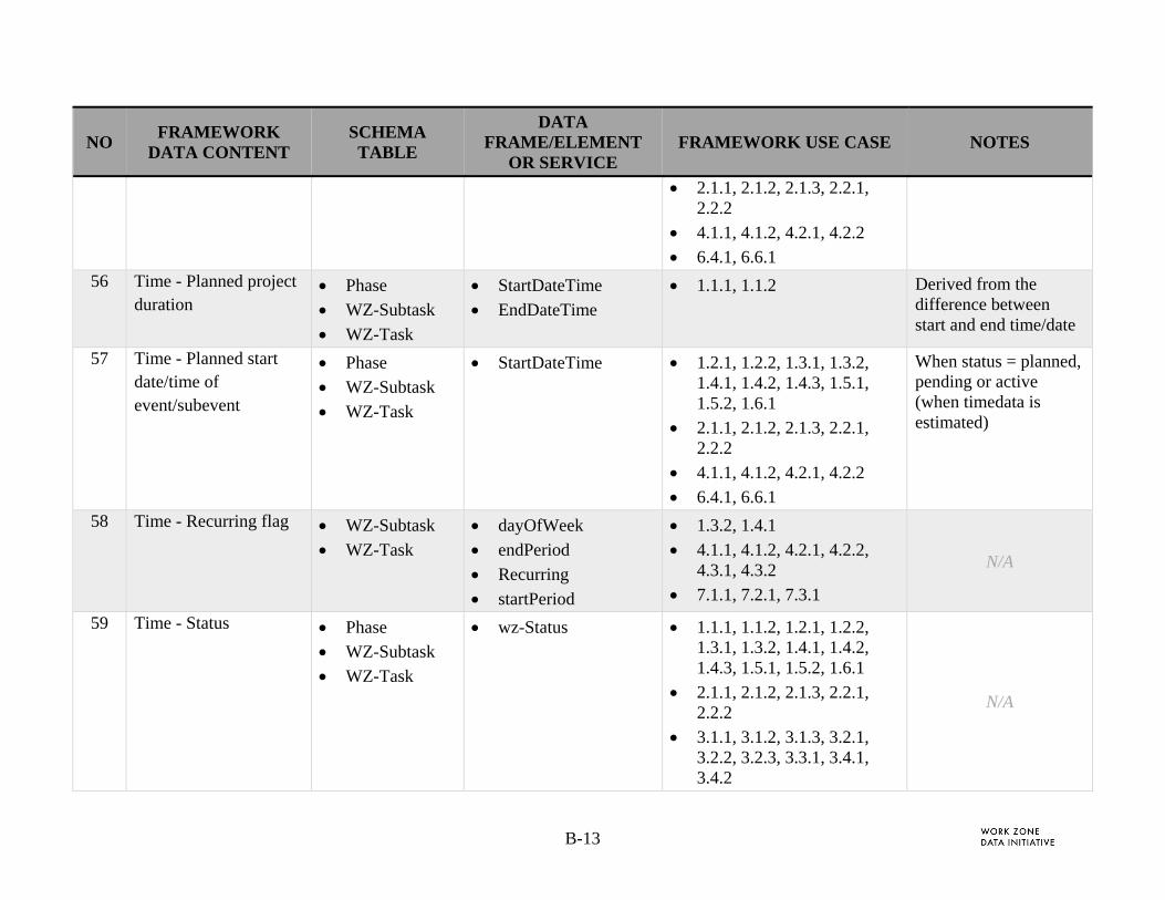
B-13
NO FRAMEWORK
DATA CONTENT SCHEMA TABLE
DATA FRAME/ELEMENT
OR SERVICE FRAMEWORK USE CASE NOTES
2.1.1, 2.1.2, 2.1.3, 2.2.1, 2.2.2
4.1.1, 4.1.2, 4.2.1, 4.2.2
6.4.1, 6.6.1 56 Time - Planned project
duration Phase
WZ-Subtask
WZ-Task
StartDateTime
EndDateTime
1.1.1, 1.1.2 Derived from the difference between start and end time/date
57 Time - Planned start date/time of event/subevent
Phase
WZ-Subtask
WZ-Task
StartDateTime 1.2.1, 1.2.2, 1.3.1, 1.3.2, 1.4.1, 1.4.2, 1.4.3, 1.5.1, 1.5.2, 1.6.1
2.1.1, 2.1.2, 2.1.3, 2.2.1, 2.2.2
4.1.1, 4.1.2, 4.2.1, 4.2.2
6.4.1, 6.6.1
When status = planned, pending or active (when timedata is estimated)
58 Time - Recurring flag WZ-Subtask
WZ-Task
dayOfWeek
endPeriod
Recurring
startPeriod
1.3.2, 1.4.1
4.1.1, 4.1.2, 4.2.1, 4.2.2, 4.3.1, 4.3.2
7.1.1, 7.2.1, 7.3.1
N/A
59 Time - Status Phase
WZ-Subtask
WZ-Task
wz-Status 1.1.1, 1.1.2, 1.2.1, 1.2.2, 1.3.1, 1.3.2, 1.4.1, 1.4.2, 1.4.3, 1.5.1, 1.5.2, 1.6.1
2.1.1, 2.1.2, 2.1.3, 2.2.1, 2.2.2
3.1.1, 3.1.2, 3.1.3, 3.2.1, 3.2.2, 3.2.3, 3.3.1, 3.4.1, 3.4.2
N/A
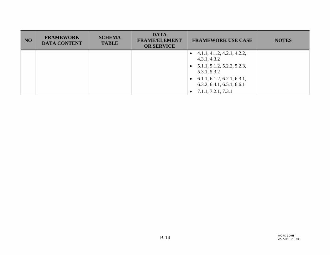
B-14
NO FRAMEWORK
DATA CONTENT SCHEMA TABLE
DATA FRAME/ELEMENT
OR SERVICE FRAMEWORK USE CASE NOTES
4.1.1, 4.1.2, 4.2.1, 4.2.2, 4.3.1, 4.3.2
5.1.1, 5.1.2, 5.2.2, 5.2.3, 5.3.1, 5.3.2
6.1.1, 6.1.2, 6.2.1, 6.3.1, 6.3.2, 6.4.1, 6.5.1, 6.6.1
7.1.1, 7.2.1, 7.3.1

B-15
APPENDIX B-2. DETAILED TRACE BETWEEN FRAMEWORK EXTERNAL DATA AND WZDD EXTERNAL DATA SOURCES
The Framework document [2] identifies “external data needed for user objectives” in the detailed Use Cases. These data detail information flows between the WZDS and stakeholders. In this WZDD, the conceptual data model (Figure 3) identifies sets of external data sources. These data sources are derived from the Framework external data descriptions as well as WZDS content that is imported from external sources. The section below identifies the WZDD Data Concept Model external data sources to the artifacts identified in the Framework document.
In Section 2.1.2, the WZDD external data sources illustrated in the Figure 3: WZAD Concept Data Model was grouped into categories of data including:
Planned Data
Operational / Performance Data Sets
Permit Data
Law Enforcement Activity Data
Device and Asset Management Data / System Control and Management Data
Other WZAD
Contractor Data
Each of these categories are mapped to specific data needs and use cases that reference them. The use case numbers reference the Framework document (see [2] for more information).
Planned Data. This data consists of plans, designs, contracts, specifications, and drawings that estimate parameters for the work zone project, phases, and activities related to geometry, timing and impacts. The contract business rules, performance targets, organizational contacts and roles are described in these documents.
External and Related Content Referenced in Framework Use Case
Construction Contracts 3.1.1, 3.1.2, 3.1.3, 3.2.1, 3.2.2, 3.2.3, 3.3.1, 3.4.1, 3.4.2 Construction Plan 3.1.1, 3.1.2, 3.1.3, 3.2.1, 3.2.2, 3.2.3, 3.3.1, 3.4.1, 3.4.2 Construction RFP 3.1.1, 3.1.2, 3.1.3, 3.2.1, 3.2.2, 3.2.3, 3.3.1, 3.4.1, 3.4.2 Pre-Construction Mobility Data 2.1.1, 2.2.1, 2.2.2
Operational / Performance Data Sets. The travel time, TIMS and crash data sets store operational data on the event locations by time and date. When related to the location and timing of work zone data, these data show the impact of the work zone activity relative to the typical travel times, crashes, and other incidents.

B-16
External and Related Content Referenced in Framework Use Case
Activity - Description of signal timing change 3.4.2 Activity - Expected effect on travel time/delay/queuing
1.3.1, 1.4.2, 1.4.3, 1.5.2, 2.1.3, 4.1.1, 4.1.2, 4.2.1, 4.3.1, 7.1.1, 7.2.1, 7.3.1
Agency or Third party connected vehicle and automated vehicle systems (in the cloud)
7.3.1, 7.1.1, 7.2.1
Agency OSOW Routing Plans 1.6.1 Corresponding local and regional crash data 5.1.2 Corresponding local and regional traffic data 5.1.1, 5.1.2 Corresponding regional crash data 5.2.1, 5.2.2, 5.2.3, 5.2.1, 5.2.2, 5.2.3 Daily Construction Plan Updates 6.4.1, 6.5.1 Pre-Construction Safety Data 2.1.2, 2.1.3 WZ Mobility Performance History Analysis 2.1.1, 2.2.1, 2.2.2
Permit Data. The permit data is the collection of permits issued to projects by specific organizations. The permit may be associated with a single project phase, task, or subtask.
External and Related Content Referenced in Framework Use Case
Lane Closure/Right-of-Way Access Approval 6.2.1
Law Enforcement Activity Data. Law enforcement activity data contain information on the activities of law enforcement around the work zone, and in many cases track the requests of construction organizations (like DOTs) for specific enforcement activities.
External and Related Content Referenced in Framework Use Case
Activity - Enforcement presence 6.3.1, 6.3.2 Law Enforcement Citation Database 6.3.1, 6.3.2 Law Enforcement Citations 6.1.1, 6.1.2 Law Enforcement WZ enforcement support MOU
6.3.1, 6.3.2, 6.4.1, 6.5.1
Device and Asset Management Data / System Control and Management Data. The typical asset management system stores information about the location, configuration, and operations of assets that may be placed in a work zone – like a portable variable message sign, or one that resides in the zone like a street lamp, overhead variable message sign, or local signal controller and its related intersection phase plans.

B-17
When impacted by a work zone, critical asset attributes may need to be shared with the work zone.
External and Related Content Referenced in Framework Use Case
Activity - Devices affected 3.4.1 Activity - Expected traffic control device(s) associated with each event/subevent
2.1.1
Actual traffic control device(s) associated with each event/subevent
5.1.1, 5.1.2, 5.2.2, 5.2.3, 5.3.1, 5.3.2
Other WZAD. Other jurisdictions, from local to National organizations will manage and disseminate information on their work zone projects including planned, in design, active, and historic information.
External and Related Content Referenced in Framework Use Case
Corresponding local, regional, and national safety and mobility performance data
5.3.1, 5.3.2
National WZAD 5.3.1, 5.3.2 Neighbor Agency Construction & WZ Operations Schedules
1.3.2
Neighbor Agency Temporary Traffic Control Designs 1.2.1 Neighbor Agency Temporary Traffic Control Plans 1.2.2 Neighbor Agency WZ Schedules 1.2.1, 1.2.2 Regional WZAD 5.2.1, 5.2.2, 5.2.3
Contractor Systems. Contractors, subconsultants, utilities and other external entities will exchange information related proposed, permitted, and actual work performed.
External and Related Content Referenced in Framework Use Case
Utility Construction & Maintenance schedule 1.5.1, 1.5.2

C-1
APPENDIX C. ITS STANDARDS APPLIED TO THE WZDD APPENDIX C-1. ENUMERATED VALUE DEFINITIONS DERIVED FROM TMDD STANDARD
The following tables show the translation from TMDD to the WZDD.
Example of data frame in the TMDD (specified in ASN.1 format)
DATA-TYPE "EventLane ::= SEQUENCE { lanes-type ITIS.LaneRoadway OPTIONAL, link-direction OPTIONAL, lanes-total-original Link-lanes-count OPTIONAL, lanes-total-affected Link-lanes-count OPTIONAL, event-lanes-affected SEQUENCE (SIZE(1..64)) OF Link-lane-number OPTIONAL, lanes-status ITIS.Closures OPTIONAL,
... }"
C-1.1. openLanes and closedLanes (Derived from TMDD)
Note: LaneRoadway is imported into TMDD from SAE 2540 (ITIS Standard)
LaneRoadway enumerations [TMDD]
Used for laneOpen and laneClosed
Description
all-roadways (8192) all Indicates that road all lanes are open or closed. If all lanes are closed then road is effectively closed.
through-lanes (8193) Not used left-lane (8194) left-lane The left most lane (inside lane) right-lane (8195) right-lane The right most lane (outside lane) left-2-lanes The two most left lanes left-3-lanes The three most left lanes right-2-lanes The two most right lanes right-3-lanes The 3 most right lanes center-lane (8196) Not used middle-lanes (8197) middle-lane The center most lane where are a
total of an odd number of lanes middle-two-lanes (8198) middle-two-lanes The center most lane where are a
total of an even number of lanes right-turning-lanes (8199)
right-turning-lane A right lane where right turns are permissible
left-turning-lanes (8200) left-turning-lane A left lane where left turns are permissible
upper-deck-lanes (8201) Not used lower-deck-lanes (8202) Not used reversible-lanes (8203) Not used
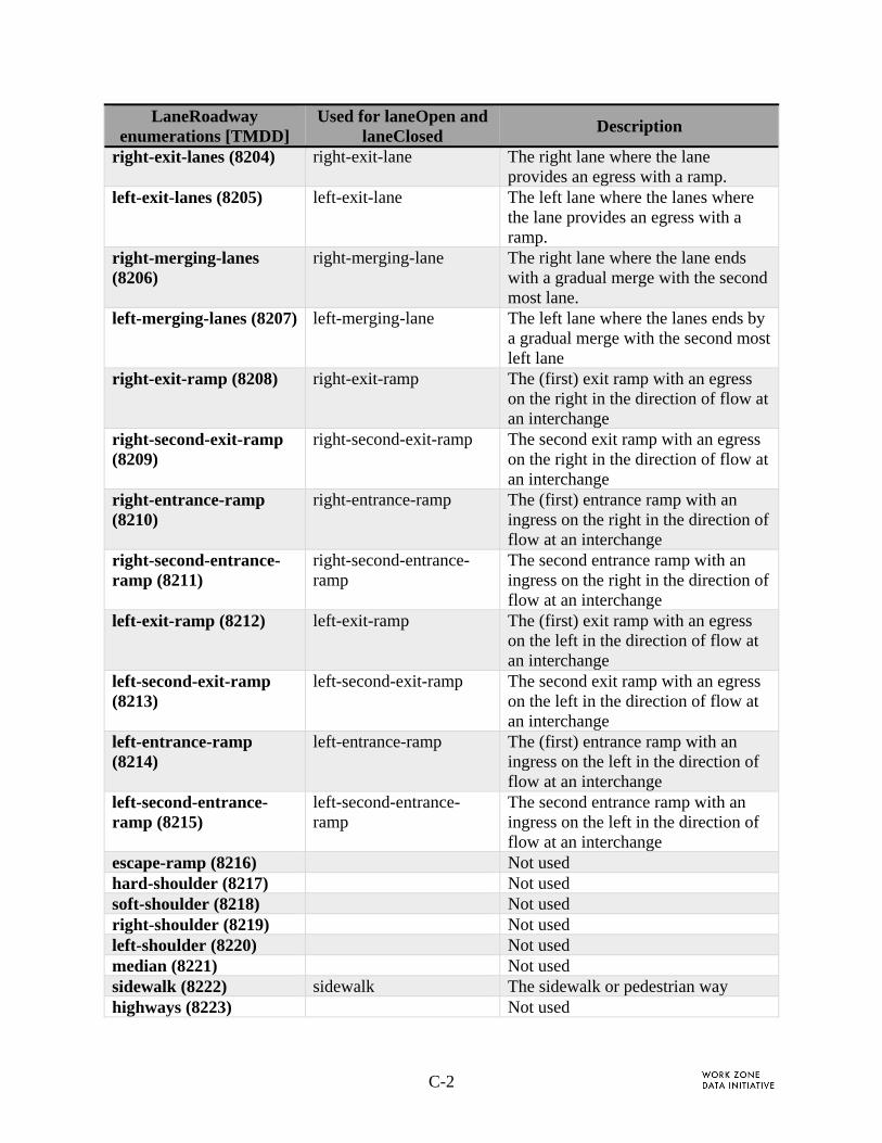
C-2
LaneRoadway enumerations [TMDD]
Used for laneOpen and laneClosed
Description
right-exit-lanes (8204) right-exit-lane The right lane where the lane provides an egress with a ramp.
left-exit-lanes (8205) left-exit-lane The left lane where the lanes where the lane provides an egress with a ramp.
right-merging-lanes (8206)
right-merging-lane The right lane where the lane ends with a gradual merge with the second most lane.
left-merging-lanes (8207) left-merging-lane The left lane where the lanes ends by a gradual merge with the second most left lane
right-exit-ramp (8208) right-exit-ramp The (first) exit ramp with an egress on the right in the direction of flow at an interchange
right-second-exit-ramp (8209)
right-second-exit-ramp The second exit ramp with an egress on the right in the direction of flow at an interchange
right-entrance-ramp (8210)
right-entrance-ramp The (first) entrance ramp with an ingress on the right in the direction of flow at an interchange
right-second-entrance-ramp (8211)
right-second-entrance-ramp
The second entrance ramp with an ingress on the right in the direction of flow at an interchange
left-exit-ramp (8212) left-exit-ramp The (first) exit ramp with an egress on the left in the direction of flow at an interchange
left-second-exit-ramp (8213)
left-second-exit-ramp The second exit ramp with an egress on the left in the direction of flow at an interchange
left-entrance-ramp (8214)
left-entrance-ramp The (first) entrance ramp with an ingress on the left in the direction of flow at an interchange
left-second-entrance-ramp (8215)
left-second-entrance-ramp
The second entrance ramp with an ingress on the left in the direction of flow at an interchange
escape-ramp (8216) Not used hard-shoulder (8217) Not used soft-shoulder (8218) Not used right-shoulder (8219) Not used left-shoulder (8220) Not used median (8221) Not used sidewalk (8222) sidewalk The sidewalk or pedestrian way highways (8223) Not used
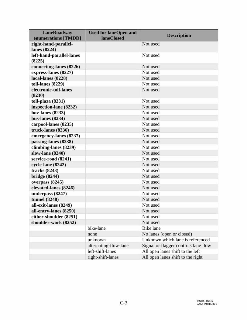
C-3
LaneRoadway enumerations [TMDD]
Used for laneOpen and laneClosed
Description
right-hand-parallel-lanes (8224)
Not used
left-hand-parallel-lanes (8225)
Not used
connecting-lanes (8226) Not used express-lanes (8227) Not used local-lanes (8228) Not used toll-lanes (8229) Not used electronic-toll-lanes (8230)
Not used
toll-plaza (8231) Not used inspection-lane (8232) Not used hov-lanes (8233) Not used bus-lanes (8234) Not used carpool-lanes (8235) Not used truck-lanes (8236) Not used emergency-lanes (8237) Not used passing-lanes (8238) Not used climbing-lanes (8239) Not used slow-lane (8240) Not used service-road (8241) Not used cycle-lane (8242) Not used tracks (8243) Not used bridge (8244) Not used overpass (8245) Not used elevated-lanes (8246) Not used underpass (8247) Not used tunnel (8248) Not used all-exit-lanes (8249) Not used all-entry-lanes (8250) Not used either-shoulder (8251) Not used shoulder-work (8252) Not used bike-lane Bike lane none No lanes (open or closed) unknown Unknown which lane is referenced alternating-flow-lane Signal or flagger controls lane flow left-shift-lanes All open lanes shift to the left right-shift-lanes All open lanes shift to the right

C-4
C-1.2. Shoulder Closed (Derived from TMDD)
Note: LaneRoadway is imported into TMDD from SAE 2540 (ITIS Standard)
LaneRoadway Enumerations
[TMDD]
Used for shoulderClosed
Description
right-shoulder (8219) outside The outer lane or the right most lane. left-shoulder (8220) inside The inner lane or the left most lane both Both inside and outside shoulders none Not needed if field is optional. This is the
default value unknown Unknown if shoulder is open, closed or not
existing.
C-1.3. Road Direction (Derived from TMDD)
Note: Link-alignment is imported from TMDD
Link-alignment enumerations
[TMDD]
Used for roadDirection
Description
northbound (1) northbound Road flow is in the northbound direction eastbound (2) eastbound Road flow is in the eastbound direction southbound (3) southbound Road flow is in the southbound direction westbound (4) westbound Road flow is in the westbound direction inner-loop (5) Not used outer-loop (6) Not used

ATTACHMENT A: GUIDELINES ON APPLYING WZDD

U.S. Department of Transportation
Federal Highway Administration
Office of Operations
1200 New Jersey Avenue, SE
Washington, DC 20590
Toll-Free “Help Line” 866-367-7487
www.ops.fhwa.dot.gov
Month Year
FHWA-XXX-XX-XXX