maps full data dictionary - university of california,...
TRANSCRIPT
MAPS Manual | 35
MAPS FULL DATA DICTIONARY
1. Data Entry Dictionary: variable names and item-level coding
Route: Destinations and Land Use Section Item Item Content Coding
LU1 How is audit information collected? Foot (walked route) = 1 Auto (drove route) = 2 Both = 3
LU2a What parking facilities are present? None No = 0 Yes = 1
LU2b What parking facilities are present? On-street, parallel, or angled No = 0 Yes = 1
LU2c What parking facilities are present? Small lot or garage No = 0 Yes = 1
LU2d What parking facilities are present? Med to large lot or garage No = 0 Yes = 1
LU3a Single family homes No = 0 Yes = 1
LU3b Multi-unit homes (duplex,4plx) No = 0 Yes = 1
LU3c Apartments or condominiums No = 0 Yes = 1
LU3d Apartments above street retail No = 0 Yes = 1
LU3e Retirement/Senior living facility No = 0 Yes = 1
LU3f Other No = 0 Yes = 1
LU4 How many non-residential buildings are adjacent to the pedestrian
walkway or sidewalk and/or street?
0% = 1 1-33% = 2 34-66% = 3 67-99% = 4 100% = 5 N/A (all residential) = 6 N/A (no walkway) = 7
LU5 How many of the non-residential buildings have parking lots or drives
between the pedestrian walkway or sidewalk along the street and their
entrances?
0% = 1 1-33% = 2 34-66% = 3 67-99% = 4 100% = 5 N/A (all residential) = 6 N/A (no walkway) = 7
LU6a Food-related uses: Fast food restaurant 0 = 0 1 = 1 2+ = 2
LU6b Food-related uses: Sit-down restaurant 0 = 0 1 = 1 2+ = 2
MAPS Manual | 36
LU6c Food-related land uses: Grocery/supermarket
0 = 0 1 = 1 2+ = 2
LU6d Food-related land uses: Convenience store (incl. gas station)
0 = 0 1 = 1 2+ = 2
LU6e Food-related uses: Café or coffee shop 0 = 0 1 = 1 2+ = 2
LU6f Food-related land uses: Liquor/alcohol store 0 = 0 1 = 1 2+ = 2
LU6g Food-related uses: Big box store 0 = 0 1 = 1 2+ = 2
LU6h Food-related uses: Specialty food store 0 = 0 1 = 1 2+ = 2
LU6i Retail and service-oriented land uses: Pharmacy or drug store 0 = 0 1 = 1 2+ = 2
LU6j Retail and service-oriented land uses: Bank or credit union 0 = 0 1 = 1 2+ = 2
LU6k Retail and service-oriented land uses: Health-related professional 0 = 0 1 = 1 2+ = 2
LU6l Retail and service-oriented land uses: Entertainment 0 = 0 1 = 1 2+ = 2
LU6m Retail and service-oriented land uses: Other service 0 = 0 1 = 1 2+ = 2
LU6n Retail and service-oriented land uses: Other retail 0 = 0 1 = 1 2+ = 2
LU6o Government or community land use: Health or social services 0 = 0 1 = 1 2+ = 2
LU6p Government or community land use: Library/museums 0 = 0 1 = 1 2+ = 2
LU6q Government or community land use: Post office 0 = 0 1 = 1 2+ = 2
LU6r Government or community land use: Senior center
0 = 0 1 = 1 2+ = 2
MAPS Manual | 37
LU6s Government or community land use: Place of worship 0 = 0 1 = 1 2+ = 2
LU6t Government or community land use: School 0 = 0 1 = 1 2+ = 2
LU6u Other land use: Warehouse/factory/industrial 0 = 0 1 = 1 2+ = 2
LU6v Other land use: Abandoned building 0 = 0 1 = 1 2+ = 2
LU6w Other land use: Unmaintained lot/field
0 = 0 1 = 1 2+ = 2
LU6x Other land use: Casino 0 = 0 1 = 1 2+ = 2
LU6y Recreational land use: Community garden 0 = 0 1 = 1 2+ = 2
LU6z Recreational land use: Private indoor 0 = 0 1 = 1 2+ = 2
LU6aa Recreational land use: Public indoor 0 = 0 1 = 1 2+ = 2
LU6ab Recreational land use: Private outdoor 0 = 0 1 = 1 2+ = 2
LU6ac Recreational land use: Public outdoor pay 0 = 0 1 = 1 2+ = 2
LU6ad Recreational land use: Public park 0 = 0 1 = 1 2+ = 2
LU7a Shopping centers: Shopping mall No = 0 Yes = 1
LU7b Shopping centers: Strip mall No = 0 Yes = 1
LU7c Shopping centers: Shopping arcade No = 0 Yes = 1
Route: Streetscape Section
Item Item Content Coding
SS1a Number of public transit stops: Bus stops #
SS1b Number of public transit stops: senior transit/paratransit #
MAPS Manual | 38
SS2_1a Transit stop #1: Route # text
SS2_1b What is available at each transit stop? Transit stop #1 Bench No = 0 Yes = 1
SS2_1c What is available at each transit stop? Transit stop #1
Covered shelter
No = 0 Yes = 1
SS2_1d What is available at each transit stop? Transit stop #1
Timetable No = 0 Yes = 1
SS2_2a Transit stop #2: Route # text
SS2_2b What is available at each transit stop? Transit stop #2 Bench No = 0 Yes = 1
SS2_2c What is available at each transit stop? Transit stop #2
Covered shelter No = 0 Yes = 1
SS2_2d What is available at each transit stop? Transit stop #2
Timetable No = 0 Yes = 1
SS2_3a Transit stop #3: Route# Text
SS2_3b What is available at each transit stop? Transit stop #3 Bench No = 0 Yes = 1
SS2_3c What is available at each transit stop? Transit stop #3 Covered
shelter No = 0 Yes = 1
SS2_3d What is available at each transit stop? Transit stop #3
Timetable No = 0 Yes = 1
SS2_4a Transit stop #4: Route# Text
SS2_4b What is available at each transit stop? Transit stop #4 Bench No = 0 Yes = 1
SS2_4c What is available at each transit stop? Transit stop #4 Covered
shelter No = 0 Yes = 1
SS2_4d What is available at each transit stop? Transit stop #4
Timetable No = 0 Yes = 1
SS3a Is there a posted speed limit along the route? Regular 0-45spd
limit No = 0 Yes = speed limit (text)
SS3b Is there a posted speed limit along the route? Special zone 0-
35 speed limit No = 0 Yes = speed limit (text)
SS4a What other street characteristics are present? Traffic calming
(signs, circles, speed tables, speed humps, curb) #
SS4b Roll-over curbs (if whole segment = 1)
#
SS4c Drainage ditches (count one side of street) #
SS4d Instructional signs for pedestrians #
SS4e Crosswalk signage or other pedestrian signage (for drivers) #
SS5 Are street lights installed? None = 1 Some = 2 Ample = 3
MAPS Manual | 39
SS6 How many driveways or alleys are there? (none, 1-2, 3-5, 6+)
None = 1 1-2 = 2 3-5 = 3 6+ = 4
SS7a Presence of street amenities: Building overhangs that provide
shelter…
No = 0 Yes = 1
SS7b Presence of street amenities: Trash bins No = 0 Yes = 1
SS7c Presence of street amenities: Benches/places to sit No = 0 Yes = 1
SS7d Presence of street amenities: Bicycle racks No = 0 Yes = 1
SS7e Presence of street amenities: Working drinking fountains No = 0 Yes = 1
SS7f Presence of street amenities: Working public telephones No = 0 Yes = 1
SS7g Presence of street amenities: Kiosks or info booths No = 0 Yes = 1
SS8 Presence of any mid-segment street crossing. No = 0 Yes = 1
Route: Aesthetics and Social Section
Item Item Content Coding
A1 Do you observe pleasant hardscape features, such as fountains,
sculptures, or art (public or private)? No = 0 Yes = 1
A2 Do you observe softscape features such as gardens or
landscaping? No = 0 Yes = 1
A3 Are there observable historic or cultural features along the
route? No = 0 Yes = 1
A4 Are the buildings well-maintained? (%)
0% = 1 1-49% = 2 50-99% = 3 100% = 4
A5 Is the landscape well maintained? (%)
0% = 1 1-49% = 2 50-99% = 3 100% = 4
A6a Which of the following physical disorders are present? Graffiti/tagging
No = 0 Yes = 1
A6b Which of the following physical disorders are present?
Abandoned cars No = 0 Yes = 1
A6c Which of the following physical disorders are present? Buildings with broken/boarded windows
No = 0 Yes = 1
A6d Which of the following physical disorders are present? Drug paraphernalia
No = 0 Yes = 1
A6e Which of the following physical disorders are present? Broken glass
No = 0 Yes = 1
MAPS Manual | 40
A6f Which of the following physical disorders are present? Beer/liquor bottles/cans
No = 0 Yes = 1
A6g Which of the following physical disorders are present? Litter in yards
No = 0 Yes = 1
A6h Which of the following physical disorders are present? Noticeable/excessive litter in street/sidewalk
No = 0 Yes = 1
A6i Which of the following physical disorders are present?
Neighborhood watch signs No = 0 Yes = 1
A6j Which of the following physical disorders are present? Signage for commercial destinations or parks
No = 0 Yes = 1
A7 Rate the extent of physical disorder
None = 1 A little = 2 Some = 3 A lot = 4
A8 Rate the extent of social disorder
None = 1 A little = 2 Some = 3 A lot = 4
A9a Other obstructions to walking: railroad tracks No = 0 Yes = 1
A9b Other obstructions to walking: Highway nearby No = 0 Yes = 1
A9c Other obstructions to walking: Other No = 0 Yes = 1
A10 Presence of anyone walking? No = 0 Yes = 1
Segments Section (Each item should be prefaced by the Segment number – this table shows Segment 1 =S1_X).
Item Item Content Coding
S1_1 Is a sidewalk present? No = 0 Yes = 1
S1_2 What is the width of the majority of the sidewalk?
<3 feet = 1 3-5 feet = 2 >5 feet = 3 No sidewalk =-777
S1_3a Is there a buffer present? No sidewalk = -777 No = 0 Yes = 1
S1_3b How wide is the majority of the buffer?
<3 feet = 1 3-5 feet = 2 >5 feet = 3 No sidewalk = -777
S1_4 Is the sidewalk continuous within the segment? No = 0 Yes = 1 No sidewalk = -777
S1_5a Are there poorly maintained sections of the sidewalk that
constitute trip hazards?(e.g, heaves, misalignment, cracks,
overgrowth)
None = 1 One = 2 A few = 3
MAPS Manual | 41
Minor- moderate A lot = 4 No sidewalk = -777
S1_5b
Are there poorly maintained sections of the sidewalk that
constitute trip hazards?(e.g, heaves, misalignment, cracks,
overgrowth) Major
None = 1 One = 2 A few = 3 A lot = 4 No sidewalk = -777
S1_6a How steep is the sidewalk at the steepest point in the
segment? (excluding heaves) # No sidewalk = -777
S1_6b How much of the segment is at or near this level of steepness
(follow-up question to S1_6a)?
Little (1-25%) = 1 Some (26-75%) = 2 Most or all (76-100%) = 3 No sidewalk = -777
S1_6c If answer to 6(b) is “Little,” provide a steepness measure that
represents the majority of the segment # No sidewalk or N/A = -777
S1_7 What is the steepest unavoidable cross-slope that affects
walkers? # No sidewalk = -777
S1_8 Are there permanent obstructions in the sidewalk? (e.g.,
telephone poles, trees, café tables, shrubs, basketball hoops)
None = 1 Some = 2 Many = 3 No sidewalk = -777
S1_9 Are the temporary obstructions in the sidewalk? (e.g., parked
cars, sandwich boards, garbage cans)
None = 1 Some = 2 Many = 3 No sidewalk = -777
S1_10 How many traffic lanes are present (include all lanes that
traffic can use; choose most predominant)? #
S1_11 Is the street predominantly one-way or two-way? One-way = 1 Two-way = 2
S1_12a If no sidewalk, is there any other place to walk that is safe
from traffic? Unpaved pathway (goat path)
No = 0 Yes = 1 Sidewalk=-777
S1_12b If no sidewalk, is there any other place to walk that is safe
from traffic? Street shoulder
No = 0 Yes = 1 Sidewalk=-777
S1_12c If no sidewalk, is there any other place to walk that is safe
from traffic? Buffer
No = 0 Yes = 1 Sidewalk=-777
S1_13 If no sidewalk, what is the width of the place on which one
could safely walk?
None = 1 <4 feet = 2 ≥4 feet = 3 N/A = -777
S1_14 Is there a marked bicycle lane marked with a line or a raised
curb? No = 0 Yes = 1
S1_15 Are there any signs indicating bicycle use (share the road,
etc.)?
No = 0 Yes = 1
S1_16 Are there any signs or structures discouraging skateboard
usage? No = 0 Yes = 1
MAPS Manual | 42
S1_17 Is there an informal path (shortcut), not on a cul-de-sac
which connects to something else? No = 0 Yes = 1
S1_18a Is this a dead-end street? No = 0 Yes = 1
S1_18b Is there a paved or informal path at the end of the cul-de-sac
or dead-end street which connects to something else (follow-
up question to S1_18a)?
No = 0 Yes = 1 N/A = -777
S1_19 Estimate the proportion of street segment that has ground
floor or street-level windows within 40 feet of
sidewalk/walkway (or street
1-25% = 1 26-50% = 2 51-75% = 3 76-100% = 4 No sidewalk = -777
S1_20 How many different predominant building façade colors exist
on the street segment? (Count both sides of the street)
1 = 1 2-3 = 2 4-6 = 3 >6 = 4 No building = -777
S1_21 How many different building accent colors exist on the street
segment? (Count both sides of the street)
1 = 1 2-3 = 2 4-6 = 3 >6 = 4 No building = -777
S1_22 How many different predominant building materials (e.g.,
brick, concrete, steel, wood) exist along the street segment?
(both sides of street)
1 = 1 2-3 = 2 4-6 = 3 >6 = 4 No buildings= -777
S1_23
How many trees exist within 5 feet of either side of the
sidewalk/pathway (can be in buffer or setback; also count
trees that are more than 5 feet away if they provide shade for
the sidewalk/pathway)
0-1 = 1 2-5 = 2 6-10 = 3 11-20 = 4 21+ = 5 No sidewalk= -777
S1_24 How are the trees generally spaced? Evenly = 1 Irregularly = 2 No sidewalk =-777
S1_25 What percentage of the length of the sidewalk/walkway is
covered by trees, awnings or other overhead coverage?
1-25% = 1 26-50% = 2 51-75% = 3 76-100% = 4 No coverage = 5 No sidewalk = -777
S1_26 What is the smallest building setback from the sidewalk?
No building = 1 <10 feet = 2 10-20 feet = 3 21-50 feet = 4 51-100 feet = 5 >100 feet = 6
S1_27 What is the largest building setback from the
sidewalk/walkway? No building = 1 <10 feet = 2
MAPS Manual | 43
10-20 feet = 3 21-50 feet = 4 51-100 feet = 5 >100 feet = 6
S1_28 What is the average height of buildings? (Count both sides of
the street)
No building = 1 1-2 stories = 2 3-5 stories = 3 6-10 stories = 4 >10 stories = 5
Crossings Section
(Each item should be prefaced by the Crossing number – this table shows Crossing 1= C1_X)
Item Item Content Coding
C1_1a Intersection control: Yield signs No = 0 Yes = 1
C1_1b Intersection control: Stop signs No = 0 Yes = 1
C1_1c Intersection control: Traffic signal No = 0 Yes = 1
C1_1d Intersection control: Traffic circle No = 0 Yes = 1
C1_1e Intersection control: N/A (Unanticipated mid-segment
crossing) No = 0 Yes = 1
C1_2 Number of legs at intersection T-intersection = 1 4-way = 2 >4-way = 3
C1_3a Signalization: Green arrows for dedicated vehicle turn No = 0 Yes = 1
C1_3b Signalization: Pedestrian walk signals No = 0 Yes = 1
C1_3c Signalization: Push buttons No = 0 Yes = 1
C1_3d Signalization: Countdown signal No = 0 Yes = 1
C1_3e Signalization: Audible walk signal No = 0 Yes = 1
C1_4 Crosswalk timing # of seconds No crosswalk = -777 No signal = -778
C1_5a Pre-crossing curb Ramp lines up w/xing = 1 Ramp does not line up = 2 No ramp = 3
C1_5b Post-crossing curb Ramp lines up w/xing = 1 Ramp does not line up = 2 No ramp = 3
C1_6 Gutters present in crossing No = 0 Yes = 1
C1_7a Other characteristics of crossing: Steep slope or cross-slope No = 0 Yes = 1
MAPS Manual | 44
C1_7b Other characteristics of crossing: Temporary obstructions No = 0 Yes = 1
C1_7c Other characteristics of crossing: Crossing aids No = 0 Yes = 1
C1_8a Crosswalk treatment: Marked crosswalk No = 0 Yes = 1
C1_8b Crosswalk treatment: High-visibility striping No = 0 Yes = 1
C1_8c Crosswalk treatment: Stop lines on road or additional
crosswalk warnings
No = 0 Yes = 1
C1_8d Crosswalk treatment: Raised crosswalk No = 0 Yes = 1
C1_8e Crosswalk treatment: Different material than road No = 0 Yes = 1
C1_9 Bike lane crosses the crossing? No = 0 Yes = 1
C1_10 Distance of crossing leg, including all potential parking and
turn lanes (# lanes)
#
C1_11a Features: Specifically identified lanes turning into crossing-
right turn No = 0 Yes = 1
C1_11b Features: Specifically identified lanes turning into crossing-
left turn No = 0 Yes = 1
C1_11c Features: Protected refuge islands No = 0 Yes = 1
C1_11d Features: One-way streets through crossing No = 0 Yes = 1
C1_11e Features: Curb extensions No = 0 Yes = 1
C1_12a Misc problems: Lack of lampposts or street lamps No = 0 Yes = 1
C1_12b Misc problems: Poor condition of crossing surface No = 0 Yes = 1
C1_12c Misc problems: Poor visibility at corners No = 0 Yes = 1
C1_12d Misc problems: Faded or worn crosswalk markings No = 0 Yes = 1
C1_12e Misc problems: Unanticipated mid-segment crossing No = 0 Yes = 1
C1_12f Misc problems: Other No = 0 Yes = 1
C1_12f1 “other” reason (if above is applicable) Text
MAPS Manual | 45
Cul-De-Sac Section (Each item should be prefaced by the Culdesac number – this table shows Culdesac
1= D1_X)
Item Item Content Coding
D1_1 How close is cul-de-sac or dead-end to participant’s home?
On the Cds = 1 Adjacent = 2 <200 feet away = 3 >200 feet away = 4
D1_2 How big is cul-de-sac at its largest diameter?
<50 feet = 1 51-100 feet = 2 101-200 feet = 3 >200 feet = 4
D1_3a What is incline/grade of cul-de-sac at its steepest point? #
D1_3b What is incline/grade of street at opening to cul-de-sac? #
D1_4 What percentage of cul-de-sac is paved?
<25% = 1 25-50% = 2 51-75% = 3 >75% = 4
D1_5 For paved part, how smooth is pavement?
Not smooth = 1 Somewhat smooth = 2 Mostly smooth = 3 Very smooth = 4
D1_6a
What amenities exist at opening to or in cul-de-sac? Basketball hoops (number)
#
D1_6b What amenities exist at opening to or in cul-de-sac? Skateboard features (number)
#
D1_6c What amenities exist at opening to or in cul-de-sac? Streetlights (number)
#
D1_6d What amenities exist at opening to or in cul-de-sac? Pedestrian or other safety signage
#
D1_6e1 What amenities exist at opening to or in cul-de-sac? Other
#
D1_6e2 What amenities exist at opening to or in cul-de-sac? Other (describe)
Text
D1_7 Can most of the cul-de-sac area be seen from participant’s
home? No = 0 Yes = 1
D1_8 Can most of the cul-de-sac area be seen from other homes? No = 0 Yes = 1
D1_9 Number of driveways that enter into the cul-de-sac #
D1_10 Is there an island in the cul-de-sac? No = 0 Yes = 1
D1_11 Is parking allowed in the area? No = 0 Yes = 1
D1_12a Is there access through the end of the cul-de-sac to another
public street or area? No = 0 Yes = 1
D1_12b1 If yes: what type of access? No = 0
MAPS Manual | 46
Formal path Yes = 1
D1_12b2 If yes: what type of access? Informal path
No = 0 Yes = 1
D1_12b3
If yes: what type of access? Informal, no path
No = 0 Yes = 1
D1_12c1 If yes: what is on the other side? Another street
No = 0 Yes = 1
D1_12c2 If yes: what is on the other side? A recreation or play area
No = 0 Yes = 1
D1_12c3 If yes: what is on the other side? Open space
No = 0 Yes = 1
D1_12c4 If yes: what is on the other side? Commercial or retail area
No = 0 Yes = 1
D1_12c5 If yes: what is on the other side? Other
No = 0 Yes = 1
MAPS Data Dictionary: Item Recodes and Subscale Creation
Part 1: Route A. Route: Destinations and Land Use
Item
Item Content
Scoring Residential Density Subscale
ResMix Residential Mix Apartment over retail only =1 Apts or multi-family only =2 Mixed or other = 3 Single family only = 4 None=0
Res_Density_Mix_reco
de Residential density mix recoded (points) 0=commercial
1=single family 2=multi-family only and any
other mix 3=apts over retail only
Shops Subscale Shops Shops Subscale Score LU6c + LU6d + LU6f +
LU6g + LU6h + LU6i +
LU6n +LU7a + LU7b +
LU7c Restaurant and Entertainment Subscale Restaur_ Ent Restaurants and Entertainment subscale LU6a + LU6b + LU6e +
LU6l Institutional/Services Subscale Institu_Svc Institutional/Services subscale LU6j + LU6k + LU6m Government Services Subscale Govt_Svcs Government Services subscale LU6o + LU6p + LU6q+
LU6r Worship Land Uses LU6s Government or community land use: Place of worship 0=0
1=1 2+ =2
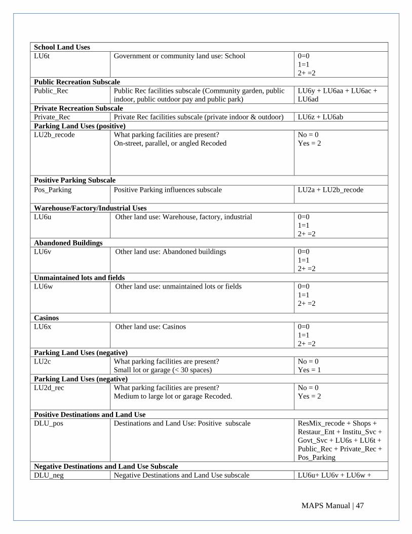
MAPS Manual | 47
School Land Uses LU6t Government or community land use: School 0=0
1=1 2+ =2
Public Recreation Subscale Public_Rec Public Rec facilities subscale (Community garden, public
indoor, public outdoor pay and public park) LU6y + LU6aa + LU6ac +
LU6ad Private Recreation Subscale Private_Rec Private Rec facilities subscale (private indoor & outdoor) LU6z + LU6ab Parking Land Uses (positive) LU2b_recode What parking facilities are present?
On-street, parallel, or angled Recoded No = 0 Yes = 2
Positive Parking Subscale
Pos_Parking Positive Parking influences subscale LU2a + LU2b_recode
Warehouse/Factory/Industrial Uses LU6u Other land use: Warehouse, factory, industrial
0=0 1=1 2+ =2
Abandoned Buildings LU6v Other land use: Abandoned buildings
0=0 1=1 2+ =2
Unmaintained lots and fields LU6w Other land use: unmaintained lots or fields
0=0 1=1 2+ =2
Casinos LU6x Other land use: Casinos
0=0 1=1 2+ =2
Parking Land Uses (negative) LU2c What parking facilities are present?
Small lot or garage (< 30 spaces) No = 0 Yes = 1
Parking Land Uses (negative) LU2d_rec What parking facilities are present?
Medium to large lot or garage Recoded. No = 0 Yes = 2
Positive Destinations and Land Use DLU_pos Destinations and Land Use: Positive subscale
ResMix_recode + Shops +
Restaur_Ent + Institu_Svc +
Govt_Svc + LU6s + LU6t +
Public_Rec + Private_Rec +
Pos_Parking Negative Destinations and Land Use Subscale DLU_neg Negative Destinations and Land Use subscale LU6u+ LU6v + LU6w +
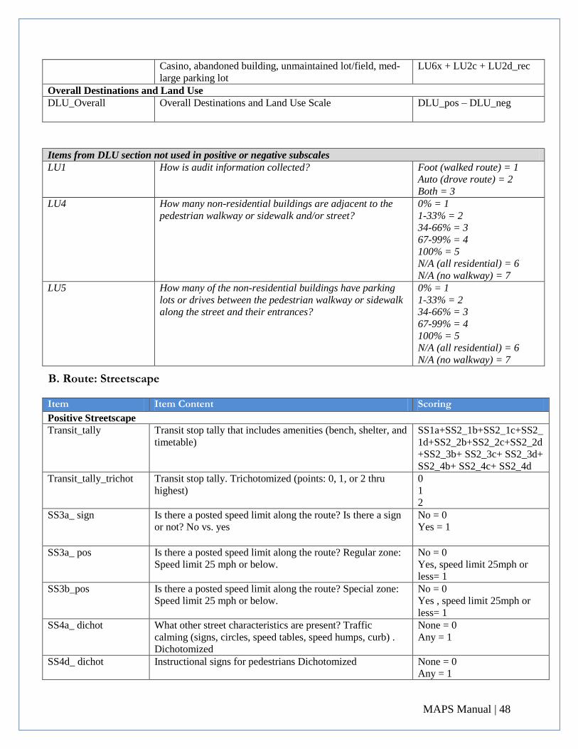
MAPS Manual | 48
Casino, abandoned building, unmaintained lot/field, med-
large parking lot LU6x + LU2c + LU2d_rec
Overall Destinations and Land Use DLU_Overall Overall Destinations and Land Use Scale DLU_pos – DLU_neg
Items from DLU section not used in positive or negative subscales LU1 How is audit information collected? Foot (walked route) = 1
Auto (drove route) = 2 Both = 3
LU4 How many non-residential buildings are adjacent to the
pedestrian walkway or sidewalk and/or street? 0% = 1 1-33% = 2 34-66% = 3 67-99% = 4 100% = 5 N/A (all residential) = 6 N/A (no walkway) = 7
LU5 How many of the non-residential buildings have parking
lots or drives between the pedestrian walkway or sidewalk
along the street and their entrances?
0% = 1 1-33% = 2 34-66% = 3 67-99% = 4 100% = 5 N/A (all residential) = 6 N/A (no walkway) = 7
B. Route: Streetscape
Item
Item Content
Scoring Positive Streetscape
Transit_tally Transit stop tally that includes amenities (bench, shelter, and
timetable) SS1a+SS2_1b+SS2_1c+SS2_
1d+SS2_2b+SS2_2c+SS2_2d
+SS2_3b+ SS2_3c+ SS2_3d+
SS2_4b+ SS2_4c+ SS2_4d Transit_tally_trichot Transit stop tally. Trichotomized (points: 0, 1, or 2 thru
highest) 0 1 2
SS3a_ sign Is there a posted speed limit along the route? Is there a sign
or not? No vs. yes No = 0 Yes = 1
SS3a_ pos Is there a posted speed limit along the route? Regular zone:
Speed limit 25 mph or below. No = 0 Yes, speed limit 25mph or
less= 1 SS3b_pos Is there a posted speed limit along the route? Special zone:
Speed limit 25 mph or below. No = 0 Yes , speed limit 25mph or
less= 1 SS4a_ dichot What other street characteristics are present? Traffic
calming (signs, circles, speed tables, speed humps, curb) .
Dichotomized
None = 0 Any = 1
SS4d_ dichot Instructional signs for pedestrians Dichotomized None = 0 Any = 1
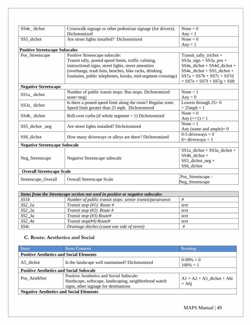
MAPS Manual | 49
SS4e_ dichot Crosswalk signage or other pedestrian signage (for drivers).
Dichotomized None = 0 Any = 1
SS5_dichot Are street lights installed? Dichotomized None = 0 Any = 1
Positive Streetscape Subscales Pos_Streetscape Positive Streetscape subscale:
Transit tally, posted speed limits, traffic calming,
instructional signs, street lights, street amenities
(overhangs, trash bins, benches, bike racks, drinking
fountains, public telephones, kiosks, mid-segment crossings)
Transit_tally_trichot +
SS3a_sign + SS3a_pos +
SS4a_dichot + SS4d_dichot +
SS4e_dichot + SS5_dichot +
SS7a + SS7b + SS7c + SS7d
+ SS7e + SS7f + SS7g + SS8 Negative Streetscape
SS1a_ dichot Number of public transit stops: Bus stops. Dichotomized
none=neg) None = 1 Any = 0
SS3a_ dichot Is there a posted speed limit along the route? Regular zone:
Speed limit greater than 25 mph. Dichotomized Lowest through 25= 0 > 25mph = 1
SS4b_ dichot Roll-over curbs (if whole segment = 1) Dichotomized None = 0 Any (>=1) = 1
SS5_dichot _neg Are street lights installed? Dichotomized None = 1 Any (some and ample)= 0
SS6_dichot How many driveways or alleys are there? Dichotomized 0-5 driveways = 0 6+ driveways = 1
Negative Streetscape Subscale
Neg_Streetscape Negative Streetscape subscale
SS1a_dichot + SS3a_dichot +
SS4b_dichot +
SS5_dichot_neg +
SS6_dichot Overall Streetscape Scale
Streetscape_Overall Overall Streetscape Scale Pos_Streetscape -
Neg_Streetscape
Items from the Streetscape section not used in positive or negative subscales SS1b Number of public transit stops: senior transit/paratransit # SS2_1a Transit stop (#1): Route # text SS2_2a Transit stop (#2) Route # text SS2_3a Transit stop (#3) Route# text SS2_4a Transit stop(#4) Route# text SS4c Drainage ditches (count one side of street) #
C. Route: Aesthetics and Social
Item
Item Content
Scoring Positive Aesthetics and Social Elements
A5_dichot Is the landscape well maintained? Dichotomized 0-99% = 0 100% = 1
Positive Aesthetics and Social Subscale
Pos_AesthSoc
Positive Aesthetics and Social Subscale: Hardscape, softscape, landscaping, neighborhood watch
signs, other signage for destinations
A1 + A2 + A5_dichot + A6i
+ A6j
Negative Aesthetics and Social Elements
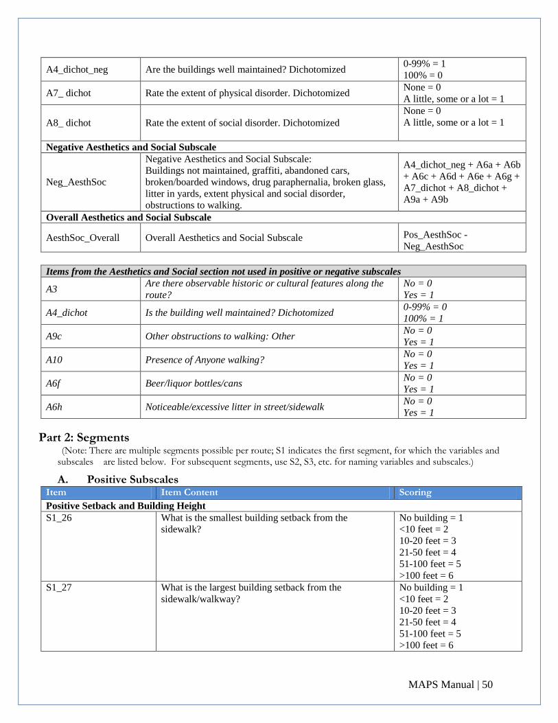
MAPS Manual | 50
A4_dichot_neg Are the buildings well maintained? Dichotomized 0-99% = 1 100% = 0
A7_ dichot Rate the extent of physical disorder. Dichotomized None = 0 A little, some or a lot = 1
A8_ dichot Rate the extent of social disorder. Dichotomized None = 0 A little, some or a lot = 1
Negative Aesthetics and Social Subscale
Neg_AesthSoc
Negative Aesthetics and Social Subscale: Buildings not maintained, graffiti, abandoned cars,
broken/boarded windows, drug paraphernalia, broken glass,
litter in yards, extent physical and social disorder,
obstructions to walking.
A4_dichot_neg + A6a + A6b
+ A6c + A6d + A6e + A6g +
A7_dichot + A8_dichot +
A9a + A9b
Overall Aesthetics and Social Subscale
AesthSoc_Overall Overall Aesthetics and Social Subscale Pos_AesthSoc -
Neg_AesthSoc
Items from the Aesthetics and Social section not used in positive or negative subscales
A3 Are there observable historic or cultural features along the
route? No = 0 Yes = 1
A4_dichot Is the building well maintained? Dichotomized 0-99% = 0 100% = 1
A9c Other obstructions to walking: Other No = 0 Yes = 1
A10 Presence of Anyone walking? No = 0 Yes = 1
A6f Beer/liquor bottles/cans No = 0 Yes = 1
A6h Noticeable/excessive litter in street/sidewalk No = 0 Yes = 1
Part 2: Segments (Note: There are multiple segments possible per route; S1 indicates the first segment, for which the variables and
subscales are listed below. For subsequent segments, use S2, S3, etc. for naming variables and subscales.)
A. Positive Subscales Item
Item Content
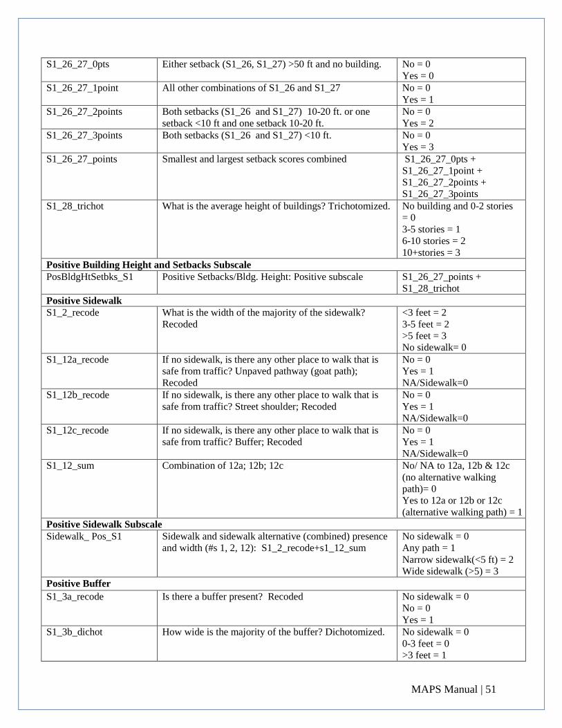
Scoring Positive Setback and Building Height
S1_26 What is the smallest building setback from the
sidewalk? No building = 1 <10 feet = 2 10-20 feet = 3 21-50 feet = 4 51-100 feet = 5 >100 feet = 6
S1_27 What is the largest building setback from the
sidewalk/walkway? No building = 1 <10 feet = 2 10-20 feet = 3 21-50 feet = 4 51-100 feet = 5 >100 feet = 6
MAPS Manual | 51
S1_26_27_0pts Either setback (S1_26, S1_27) >50 ft and no building. No = 0 Yes = 0
S1_26_27_1point All other combinations of S1_26 and S1_27 No = 0 Yes = 1
S1_26_27_2points Both setbacks (S1_26 and S1_27) 10-20 ft. or one
setback <10 ft and one setback 10-20 ft. No = 0 Yes = 2
S1_26_27_3points Both setbacks (S1_26 and S1_27) <10 ft. No = 0 Yes = 3
S1_26_27_points Smallest and largest setback scores combined S1_26_27_0pts +
S1_26_27_1point +
S1_26_27_2points +
S1_26_27_3points S1_28_trichot What is the average height of buildings? Trichotomized.
No building and 0-2 stories
= 0 3-5 stories = 1 6-10 stories = 2 10+stories = 3
Positive Building Height and Setbacks Subscale PosBldgHtSetbks_S1 Positive Setbacks/Bldg. Height: Positive subscale S1_26_27_points +
S1_28_trichot Positive Sidewalk S1_2_recode What is the width of the majority of the sidewalk?
Recoded <3 feet = 2 3-5 feet = 2 >5 feet = 3 No sidewalk= 0
S1_12a_recode If no sidewalk, is there any other place to walk that is
safe from traffic? Unpaved pathway (goat path);
Recoded
No = 0 Yes = 1 NA/Sidewalk=0
S1_12b_recode If no sidewalk, is there any other place to walk that is
safe from traffic? Street shoulder; Recoded No = 0 Yes = 1 NA/Sidewalk=0
S1_12c_recode If no sidewalk, is there any other place to walk that is
safe from traffic? Buffer; Recoded No = 0 Yes = 1 NA/Sidewalk=0
S1_12_sum Combination of 12a; 12b; 12c No/ NA to 12a, 12b & 12c
(no alternative walking
path)= 0 Yes to 12a or 12b or 12c
(alternative walking path) = 1 Positive Sidewalk Subscale Sidewalk_ Pos_S1 Sidewalk and sidewalk alternative (combined) presence
and width (#s 1, 2, 12): S1_2_recode+s1_12_sum No sidewalk = 0 Any path = 1 Narrow sidewalk(<5 ft) = 2 Wide sidewalk (>5) = 3
Positive Buffer
S1_3a_recode Is there a buffer present? Recoded No sidewalk = 0 No = 0 Yes = 1
S1_3b_dichot How wide is the majority of the buffer? Dichotomized. No sidewalk = 0 0-3 feet = 0 >3 feet = 1
MAPS Manual | 52
Buffer Positive Subscale Buffers_Pos_S1 Buffers: Positive subscale S1_3a_recode +
S1_3b_dichot
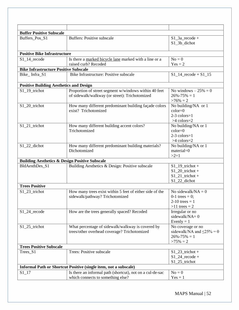
Positive Bike Infrastructure
S1_14_recode Is there a marked bicycle lane marked with a line or a
raised curb? Recoded No = 0 Yes = 2
Bike Infrastructure Positive Subscale Bike_ Infra_S1 Bike Infrastructure: Positive subscale S1_14_recode + S1_15
Positive Building Aesthetics and Design
S1_19_trichot Proportion of street segment w/windows within 40 feet
of sidewalk/walkway (or street): Trichotomized No windows – 25% = 0 26%-75% = 1 >76% = 2
S1_20_trichot How many different predominant building façade colors
exist? Trichotomized No building/NA or 1
color=0 2-3 colors=1 >4 colors=2
S1_21_trichot How many different building accent colors?
Trichotomized No building/NA or 1
color=0 2-3 colors=1 >4 colors=2
S1_22_dichot How many different predominant building materials? Dichotomized
No building/NA or 1
material=0 >2=1
Building Aesthetics & Design Positive Subscale BldAesthDes_S1 Building Aesthetics & Design: Positive subscale S1_19_trichot +
S1_20_trichot +
S1_21_trichot +
S1_22_dichot Trees Positive
S1_23_trichot How many trees exist within 5 feet of either side of the
sidewalk/pathway? Trichotomized
No sidewalk/NA = 0 0-1 trees = 0; 2-10 trees = 1 >11 trees = 2
S1_24_recode How are the trees generally spaced? Recoded
Irregular or no
sidewalk/NA= 0 Evenly = 1
S1_25_trichot What percentage of sidewalk/walkway is covered by
trees/other overhead coverage? Trichotomized
No coverage or no
sidewalk/NA and ≤25% = 0 26%-75% = 1 >75% = 2
Trees Positive Subscale Trees_S1 Trees: Positive subscale S1_23_trichot +
S1_24_recode +
S1_25_trichot Informal Path or Shortcut Positive (single item, not a subscale)
S1_17 Is there an informal path (shortcut), not on a cul-de-sac
which connects to something else? No = 0 Yes = 1
MAPS Manual | 53
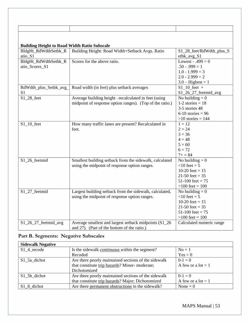
Building Height to Road Width Ratio Subscale BldgHt_RdWdthSetbk_R
atio_S1 Building Height: Road Width+Setback Avgs. Ratio S1_28_feet/RdWdth_plus_S
etbk_avg_S1 BldgHt_RdWdthSetbk_R
atio_Scores_S1 Scores for the above ratio.
Lowest - .499 = 0 .50 - .999 = 1 1.0 - 1.999 = 3 2.0 - 2.999 = 2 3.0 – Highest = 1
RdWdth_plus_Setbk_avg_
S1 Road width (in feet) plus setback averages S1_10_feet +
S1_26_27_feetmid_avg S1_28_feet Average building height –recalculated in feet (using
midpoint of response option ranges). (Top of the ratio.) No building = 0 1-2 stories = 18 3-5 stories 48 6-10 stories = 96 >10 stories = 144
S1_10_feet How many traffic lanes are present? Recalculated in
feet. 1 = 12 2 = 24 3 = 36 4 = 48 5 = 60 6 = 72 7+ = 84
S1_26_feetmid Smallest building setback from the sidewalk, calculated
using the midpoint of response option ranges. No building = 0 <10 feet = 5 10-20 feet = 15 21-50 feet = 35 51-100 feet = 75 >100 feet = 100
S1_27_feetmid Largest building setback from the sidewalk, calculated,
using the midpoint of response option ranges. No building = 0 <10 feet = 5 10-20 feet = 15 21-50 feet = 35 51-100 feet = 75 >100 feet = 100
S1_26_27_feetmid_avg Average smallest and largest setback midpoints (S1_26
and 27). (Part of the bottom of the ratio.) Calculated numeric range
Part B. Segments: Negative Subscales
Sidewalk Negative S1_4_recode Is the sidewalk continuous within the segment?
Recoded No = 1 Yes = 0
S1_5a_dichot Are there poorly maintained sections of the sidewalk
that constitute trip hazards? Minor- moderate;
Dichotomized
0-1 = 0 A few or a lot = 1
S1_5b_dichot Are there poorly maintained sections of the sidewalk
that constitute trip hazards? Major; Dichotomized 0-1 = 0 A few or a lot = 1
S1_8_dichot Are there permanent obstructions in the sidewalk? None = 0
MAPS Manual | 54
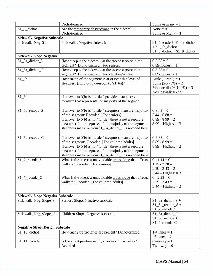
Dichotomized Some or many = 1 S1_9_dichot Are the temporary obstructions in the sidewalk?
Dichotomized None = 0 Some or Many = 1
Sidewalk Negative Subscale Sidewalk_Neg_S1 Sidewalk : Negative subscale S1_4recode + S1_5a_dichot
+ S1_5b_dichot +
S1_8_dichot + S1_9_dichot Sidewalk Slope Negative
S1_6a_dichot_S How steep is the sidewalk at the steepest point in the
segment? Dichotomized. [For seniors] 0-6.88 = 0 6.89-highest = 1
S1_6a_dichot_C How steep is the sidewalk at the steepest point in the
segment? Dichotomized. [For children/adults] 0-6.88 = 0 6.89-highest = 1
S1_6b How much of the segment is at or near this level of
steepness (follow-up question to S1_6a)? Little (1-25%) = 1 Some (26-75%) = 2 Most or all (76-100%) = 3 No sidewalk = -777
S1_6c If answer to 6(b) is “Little,” provide a steepness
measure that represents the majority of the segment
#
S1_6c_recode_S If answer to 6(b) is “Little,” steepness measure-majority
of the segment: Recoded. [For seniors] If answer to 6(b) is not “Little” there is not a separate
measure of the steepness of the majority of the segment,
steepness measure from s1_6a_dichot_S is recoded here.
0-3.43 = 0 3.44 - 6.88 = 1 6.89 - 8.99 = 2 8.99 – Highest = 3
S1_6c_recode_C If answer to 6(b) is “Little,” steepness measure-majority
of the segment: Recoded. [For children/adults] If answer to 6(b) is not “Little” there is not a separate
measure of the steepness of the majority of the segment,
steepness measure from s1_6a_dichot_S is recoded here.
0-6.88 = 0 6.89 - 8.99 = 1 8.99 – Highest = 2
S1_7_recode_S What is the steepest unavoidable cross-slope that affects
walkers? Recoded. [For seniors] 0 - 1.14 = 0 1.15 - 2.28 = 1 2.29 - 3.43 = 2 3.44 – Highest = 3
S1_7_recode_C What is the steepest unavoidable cross-slope that affects
walkers? Recoded. [For children/adults]
0 - 2.28 = 0 2.29 - 3.43 = 1 3.44 – Highest = 2
Sidewalk Slope Negative Subscale Sidewalk_Neg_Slope_S Seniors Slope: Negative subscale S1_6a_dichot_S +
S1_6c_recode_S +
S1_7_recode_S Sidewalk_Neg_Slope_C Children Slope: Negative subscale S1_6a_dichot_C +
S1_6c_recode_C +
S1_7_recode_C Negative Street Design Subscale
S1_10_dichot How many traffic lanes are present? Dichotomized 1-4 lanes = 1 >5 lanes = 2
S1_11_recode Is the street predominantly one-way or two-way?
Recoded One-way = 1 Two-way = 0
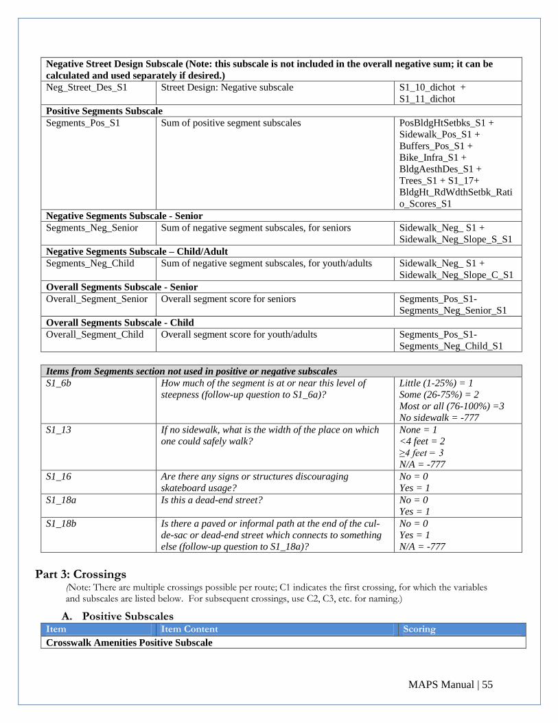
MAPS Manual | 55
Negative Street Design Subscale (Note: this subscale is not included in the overall negative sum; it can be
calculated and used separately if desired.) Neg_Street_Des_S1 Street Design: Negative subscale S1_10_dichot +
S1_11_dichot Positive Segments Subscale Segments_Pos_S1 Sum of positive segment subscales PosBldgHtSetbks_S1 +
Sidewalk_Pos_S1 +
Buffers_Pos_S1 +
Bike_Infra_S1 +
BldgAesthDes_S1 +
Trees_S1 + S1_17+
BldgHt_RdWdthSetbk_Rati
o_Scores_S1 Negative Segments Subscale - Senior Segments_Neg_Senior Sum of negative segment subscales, for seniors Sidewalk_Neg_ S1 +
Sidewalk_Neg_Slope_S_S1 Negative Segments Subscale – Child/Adult Segments_Neg_Child Sum of negative segment subscales, for youth/adults Sidewalk_Neg_ S1 +
Sidewalk_Neg_Slope_C_S1 Overall Segments Subscale - Senior Overall_Segment_Senior Overall segment score for seniors Segments_Pos_S1-
Segments_Neg_Senior_S1 Overall Segments Subscale - Child Overall_Segment_Child Overall segment score for youth/adults Segments_Pos_S1-
Segments_Neg_Child_S1
Items from Segments section not used in positive or negative subscales S1_6b How much of the segment is at or near this level of
steepness (follow-up question to S1_6a)? Little (1-25%) = 1 Some (26-75%) = 2 Most or all (76-100%) =3 No sidewalk = -777
S1_13 If no sidewalk, what is the width of the place on which
one could safely walk? None = 1 <4 feet = 2 ≥4 feet = 3 N/A = -777
S1_16 Are there any signs or structures discouraging
skateboard usage? No = 0 Yes = 1
S1_18a Is this a dead-end street? No = 0 Yes = 1
S1_18b Is there a paved or informal path at the end of the cul-
de-sac or dead-end street which connects to something
else (follow-up question to S1_18a)?
No = 0 Yes = 1 N/A = -777
Part 3: Crossings
(Note: There are multiple crossings possible per route; C1 indicates the first crossing, for which the variables and subscales are listed below. For subsequent crossings, use C2, C3, etc. for naming.)
A. Positive Subscales Item
Item Content
Scoring Crosswalk Amenities Positive Subscale
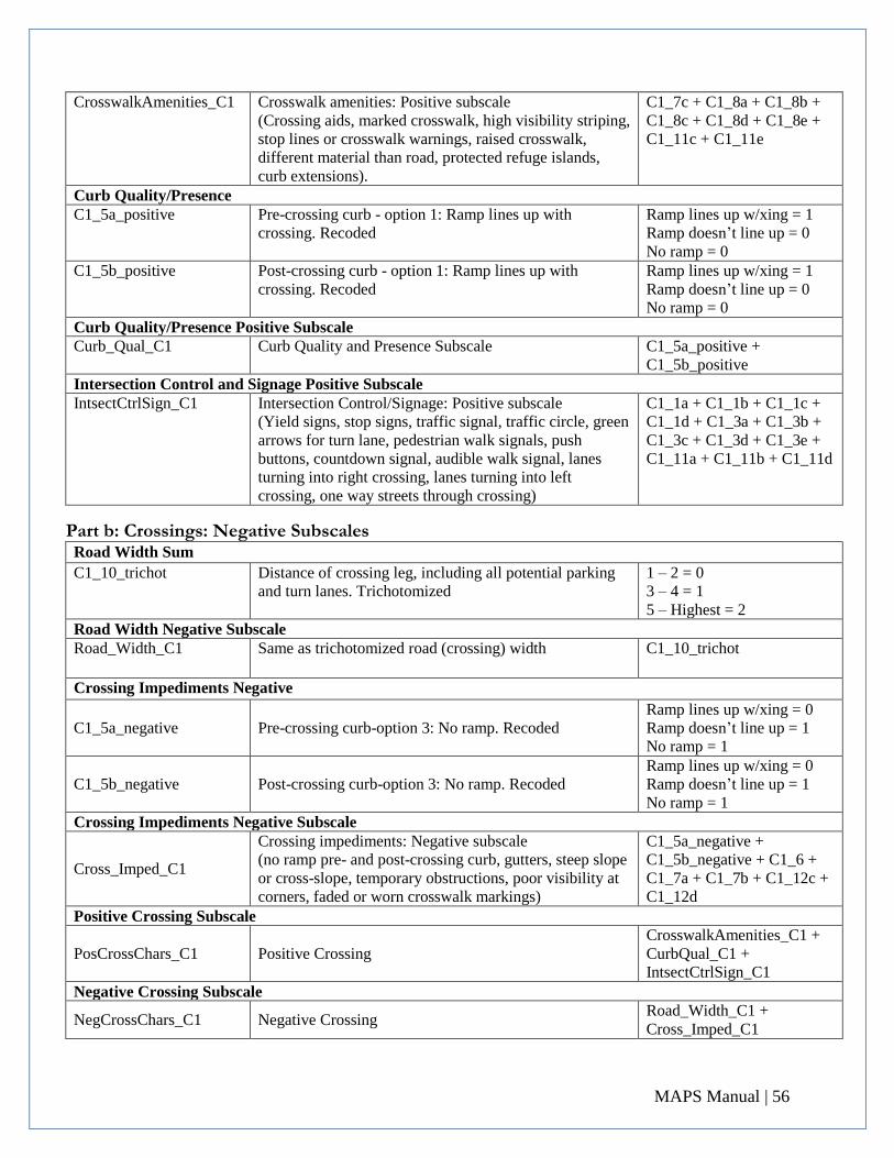
MAPS Manual | 56
CrosswalkAmenities_C1 Crosswalk amenities: Positive subscale (Crossing aids, marked crosswalk, high visibility striping,
stop lines or crosswalk warnings, raised crosswalk,
different material than road, protected refuge islands,
curb extensions).
C1_7c + C1_8a + C1_8b +
C1_8c + C1_8d + C1_8e +
C1_11c + C1_11e
Curb Quality/Presence C1_5a_positive Pre-crossing curb - option 1: Ramp lines up with
crossing. Recoded Ramp lines up w/xing = 1 Ramp doesn’t line up = 0 No ramp = 0
C1_5b_positive Post-crossing curb - option 1: Ramp lines up with
crossing. Recoded Ramp lines up w/xing = 1 Ramp doesn’t line up = 0 No ramp = 0
Curb Quality/Presence Positive Subscale Curb_Qual_C1 Curb Quality and Presence Subscale C1_5a_positive +
C1_5b_positive Intersection Control and Signage Positive Subscale IntsectCtrlSign_C1 Intersection Control/Signage: Positive subscale
(Yield signs, stop signs, traffic signal, traffic circle, green
arrows for turn lane, pedestrian walk signals, push
buttons, countdown signal, audible walk signal, lanes
turning into right crossing, lanes turning into left
crossing, one way streets through crossing)
C1_1a + C1_1b + C1_1c +
C1_1d + C1_3a + C1_3b +
C1_3c + C1_3d + C1_3e +
C1_11a + C1_11b + C1_11d
Part b: Crossings: Negative Subscales
Road Width Sum
C1_10_trichot Distance of crossing leg, including all potential parking
and turn lanes. Trichotomized 1 – 2 = 0 3 – 4 = 1 5 – Highest = 2
Road Width Negative Subscale Road_Width_C1 Same as trichotomized road (crossing) width C1_10_trichot
Crossing Impediments Negative
C1_5a_negative Pre-crossing curb-option 3: No ramp. Recoded Ramp lines up w/xing = 0 Ramp doesn’t line up = 1 No ramp = 1
C1_5b_negative Post-crossing curb-option 3: No ramp. Recoded Ramp lines up w/xing = 0 Ramp doesn’t line up = 1 No ramp = 1
Crossing Impediments Negative Subscale
Cross_Imped_C1
Crossing impediments: Negative subscale (no ramp pre- and post-crossing curb, gutters, steep slope
or cross-slope, temporary obstructions, poor visibility at
corners, faded or worn crosswalk markings)
C1_5a_negative +
C1_5b_negative + C1_6 +
C1_7a + C1_7b + C1_12c +
C1_12d Positive Crossing Subscale
PosCrossChars_C1 Positive Crossing CrosswalkAmenities_C1 +
CurbQual_C1 +
IntsectCtrlSign_C1 Negative Crossing Subscale
NegCrossChars_C1 Negative Crossing Road_Width_C1 +
Cross_Imped_C1
MAPS Manual | 57
Overall Crossing
OverallCrossScore_C1 Overall Crossing Scale PosCrossChars_C1 –
NegCrossChars_C1
Items from Crossings section not used in positive or negative subscales C1_2 Number of legs at intersection T-intersection = 1
4-way = 2 >4-way = 3
C1_4 Crosswalk timing # of seconds No crosswalk = -777 No signal = -778
C1_5a_opt2 Pre-crossing curb-option 2: Ramp doesn’t line up with
crossing Ramp does not line up = 1
C1_5b_opt2 Post-crossing curb-option 2: Ramp doesn’t line up with
crossing Ramp does not line up = 1
C1_9 Bike lane crosses the crossing? No = 0 Yes = 1
C1_12a Misc problems: Lack of lampposts or street lamps No = 0 Yes = 1
C1_12b Misc problems: Poor condition of crossing surface No = 0 Yes = 1
C1_12e Misc problems: Unanticipated mid-segment crossing No = 0 Yes = 1
C1_12f Misc problems: Other No = 0 Yes = 1
C1_12f1 “other” reason (if above is applicable)
Text
Part 4: Cul-De-Sacs
(Note: There may be multiple cul-de-sacs (CdS) per route; D1 indicates the first cul-de-sac, for which the variables and subscale are listed below. For subsequent cul-de-sacs, use D2, D3, etc., for naming.)
Item
Item Content
Scoring
D1_1_dichot How close is cul-de-sac or dead-end to participant’s
home? Dichotomized. On the CdS = 1 Adjacent = 1 <200 feet away = 0 >200 feet away = 0
D1_2_dichot How big is cul-de-sac at its largest diameter?
Dichotomized.
<50 feet = 0 51-100 feet = 1 101-200 feet =1 >200 feet = 1
D1_3a_dichot What is incline/grade of cul-de-sac at its steepest point?
Dichotomized. 0 thru 6.88 = 1 6.89 thru highest = 0
D1_3b_dichot What is incline/grade of street at opening to cul-de-sac?
Dichotomized. 0 thru 6.88 = 1 6.89 thru highest = 0
D1_5_dichot For paved part, how smooth is pavement? Dichotomized. Not smooth = 0 Somewhat smooth = 0 Mostly smooth = 0 Very smooth = 1
D1_6_sum Total amenities: basketball hoops + skateboard features + #
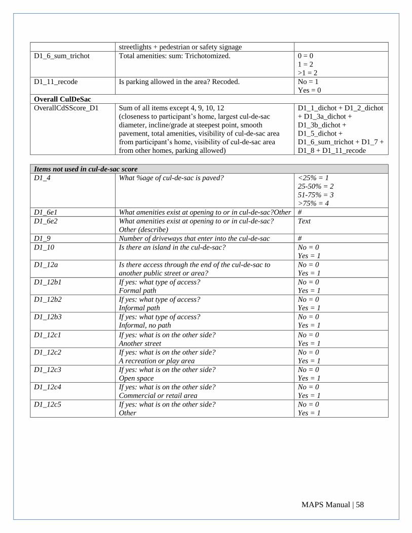
MAPS Manual | 58
streetlights + pedestrian or safety signage D1_6_sum_trichot Total amenities: sum: Trichotomized. 0 = 0
1 = 2 >1 = 2
D1_11_recode Is parking allowed in the area? Recoded. No = 1 Yes = 0
Overall CulDeSac OverallCdSScore_D1 Sum of all items except 4, 9, 10, 12
(closeness to participant’s home, largest cul-de-sac
diameter, incline/grade at steepest point, smooth
pavement, total amenities, visibility of cul-de-sac area
from participant’s home, visibility of cul-de-sac area
from other homes, parking allowed)
D1_1_dichot + D1_2_dichot
+ D1_3a_dichot +
D1_3b_dichot +
D1_5_dichot +
D1_6_sum_trichot + D1_7 +
D1_8 + D1_11_recode
Items not used in cul-de-sac score D1_4 What %age of cul-de-sac is paved? <25% = 1
25-50% = 2 51-75% = 3 >75% = 4
D1_6e1 What amenities exist at opening to or in cul-de-sac?Other # D1_6e2 What amenities exist at opening to or in cul-de-sac?
Other (describe) Text
D1_9 Number of driveways that enter into the cul-de-sac # D1_10 Is there an island in the cul-de-sac? No = 0
Yes = 1 D1_12a Is there access through the end of the cul-de-sac to
another public street or area? No = 0 Yes = 1
D1_12b1 If yes: what type of access? Formal path
No = 0 Yes = 1
D1_12b2 If yes: what type of access? Informal path
No = 0 Yes = 1
D1_12b3
If yes: what type of access? Informal, no path
No = 0 Yes = 1
D1_12c1 If yes: what is on the other side? Another street
No = 0 Yes = 1
D1_12c2 If yes: what is on the other side? A recreation or play area
No = 0 Yes = 1
D1_12c3 If yes: what is on the other side? Open space
No = 0 Yes = 1
D1_12c4 If yes: what is on the other side? Commercial or retail area
No = 0 Yes = 1
D1_12c5 If yes: what is on the other side? Other
No = 0 Yes = 1