using openstreetmap data in arcmap - tufts university · tufts data lab 1 using openstreetmap data...
TRANSCRIPT
Tufts Data Lab
1
Using OpenStreetMap Data in ArcMap
Written by Kyle Monahan March 8th 2017 Updated by Catherine Ressijac February 28th 2018
PRIOR TO CLASS ................................................................................................................................................................................ 1
USING OPENSTREETMAP (OSM) ........................................................................................................................................................ 2
TOOLS FOR EXTRACTION AND EXPORT OF OSM DATA ...................................................................................................................... 2
HUMANITARIAN OPENSTREETMAP TEAM (HOT) EXPORT TOOL ........................................................................................................ 3
FURTHER READING AND VIEWING..................................................................................................................................................... 8
Skills covered in this Tutorial Include:
Understanding the type of data that OpenStreetMap provides
Learning key concepts when looking for data on online repositories (availability, data format, etc.)
Using online extraction tools to export OpenStreetMap data into ArcMap
Prior to Class
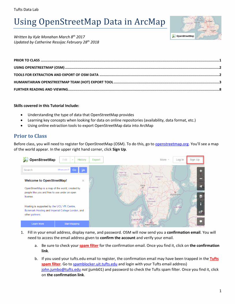
Before class, you will need to register for OpenStreetMap (OSM). To do this, go to openstreetmap.org. You’ll see a map
of the world appear. In the upper right hand corner, click Sign Up.
1. Fill in your email address, display name, and password. OSM will now send you a confirmation email. You will
need to access the email address given to confirm the account and verify your email.
a. Be sure to check your spam filter for the confirmation email. Once you find it, click on the confirmation
link.
b. If you used your tufts.edu email to register, the confirmation email may have been trapped in the Tufts
spam filter. Go to spamblocker.uit.tufts.edu and login with your Tufts email address)
[email protected] not jjumb01) and password to check the Tufts spam filter. Once you find it, click
on the confirmation link.
Tufts Data Lab
2
2. Once you’ve done that, go back to openstreetmap.org and login with the username and password you’ve
created.
3. We will also have you create an account with the Humanitarian OpenStreetMap Team (HOT) Export Tool.
Navigate to export.hotosm.org.
4. Click Login in the upper right hand corner and login with the username and password you created in Step 1.
5. A pop up will appear. Click Grant Access to allow the OSM (HOT) Export Tool to access your account.
6. You might be prompted to confirm your email address again. If this happens, type in your email address again
and you will be sent another confirmation email. Locate the confirmation email from HOT Export Tool and click
on the confirmation link. (You might have to check your spam filter again.)
7. You are now logged into OSM and the HOT Extract Tool.
Using OpenStreetMap (OSM)
OpenStreetMap is a collaborative effort to create a free and editable map of the world. Many other maps have copyright
limitations, but OSM provides layers which you can download and use freely under an open license. If you would like to
learn more about OSM, go to https://www.openstreetmap.org/about.
Today, we will use the online export tools within OSM and the HOT Extract Tool to export and work with data from
Allepo, Syria and other locations of your choice.
1. Go back to openstreetmap.org. Search for “Syria” in the search bar. Scroll down the results list and click on State
Boundary Aleppo, Syria. This will highlight the boundaries of Syria and the location of Aleppo. Zoom in to a city
in Syria and see what data are available. You can view the data here even if you aren’t logged in.
2. Search through two other locations, using the mouse scroll wheel or the plus ( ) and minus ( ) signs on the
map tool to explore different map extents.
3. How does that data shown change as you zoom to different extents? Why does this matter?
4. What type of data do you see for your locations? Look at the available layers ( ) and the legend ( ). Use the
query tool ( ) to find out more about some interesting feature. (You might need to zoom in for that.)
Tools for Extraction and Export of OSM Data
There are many methods for downloading and working with OSM data. A great reference for this information is found in
the OSM Wiki at wiki.openstreetmap.org. Some selected pages to open and look through:
OSM Wiki Shapefiles – Overview of tools and techniques to download OSM in GIS formats. You can find a
summary of the tools you can use to access OSM data here, including the ones below.
https://wiki.openstreetmap.org/wiki/Shapefiles
Humanitarian OpenStreetMap Team (HOT) Export Tool – Allows custom OSM GIS extracts for much of the
world. This is the first method we will use to extract OSM data.
https://export.hotosm.org/en/v3/exports/new/describe
Humanitarian Data Exchange HDX) OSM Extracts
https://data.humdata.org/dataset?tags=openstreetmap
Tufts Data Lab
3
Method 1: Humanitarian OpenStreetMap Team (HOT) Export Tool
The Humanitarian OpenStreetMap Team Export Tool is a service which allows for customized OSM GIS data extracts for
much of the developing world. It is a streamlined and simple interface, and we will use this method first.
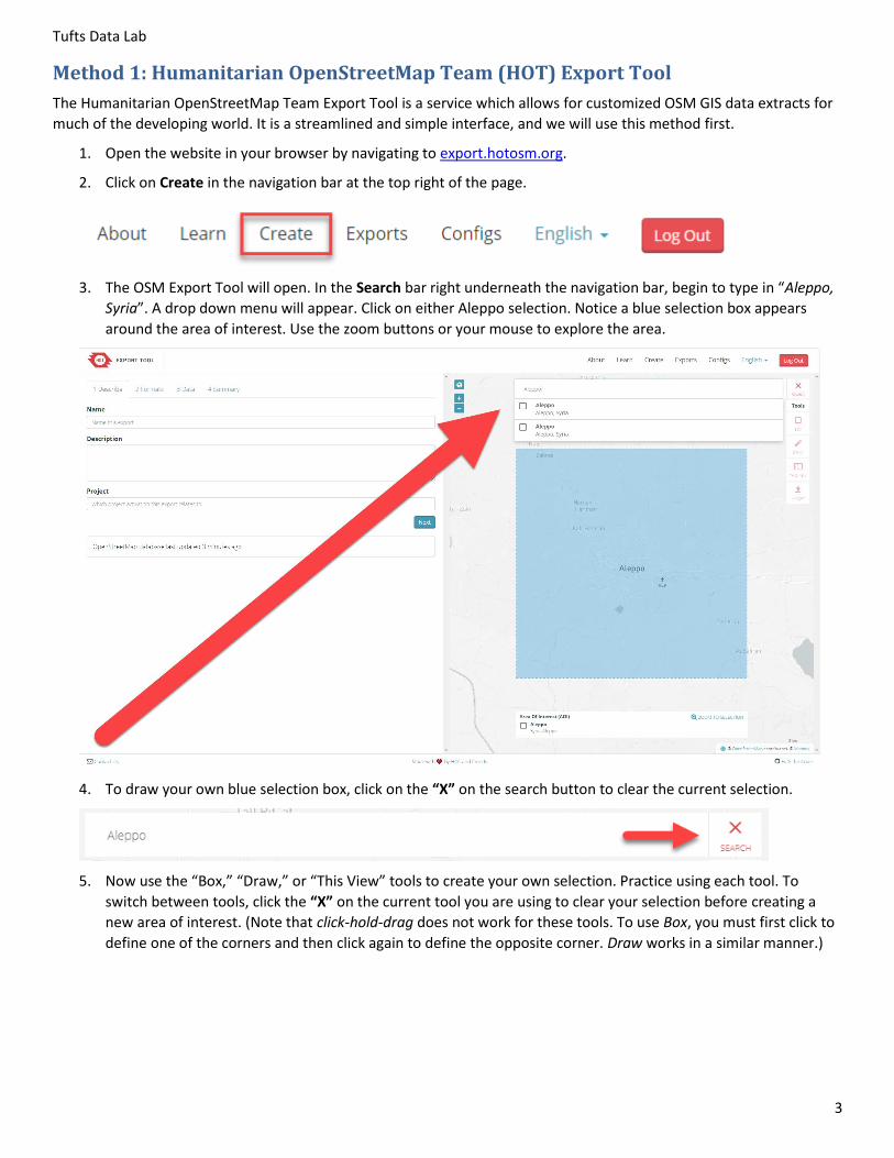
1. Open the website in your browser by navigating to export.hotosm.org.
2. Click on Create in the navigation bar at the top right of the page.
3. The OSM Export Tool will open. In the Search bar right underneath the navigation bar, begin to type in “Aleppo,
Syria”. A drop down menu will appear. Click on either Aleppo selection. Notice a blue selection box appears
around the area of interest. Use the zoom buttons or your mouse to explore the area.
4. To draw your own blue selection box, click on the “X” on the search button to clear the current selection.
5. Now use the “Box,” “Draw,” or “This View” tools to create your own selection. Practice using each tool. To
switch between tools, click the “X” on the current tool you are using to clear your selection before creating a
new area of interest. (Note that click-hold-drag does not work for these tools. To use Box, you must first click to
define one of the corners and then click again to define the opposite corner. Draw works in a similar manner.)
Tufts Data Lab
4
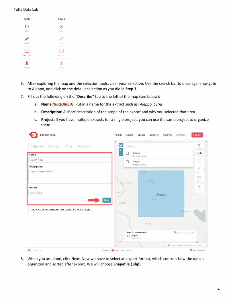
6. After exploring the map and the selection tools, clear your selection. Use the search bar to once again navigate
to Aleppo, and click on the default selection as you did in Step 3.
7. Fill out the following on the “Describe” tab to the left of the map (see below):
a. Name [REQUIRED]: Put in a name for the extract such as: Aleppo_Syria
b. Description: A short description of the scope of the export and why you selected that area.
c. Project: If you have multiple extracts for a single project, you can use the same project to organize
them.
8. When you are done, click Next. Now we have to select an export format, which controls how the data is
organized and sorted after export. We will choose Shapefile (.shp).
Tufts Data Lab
5
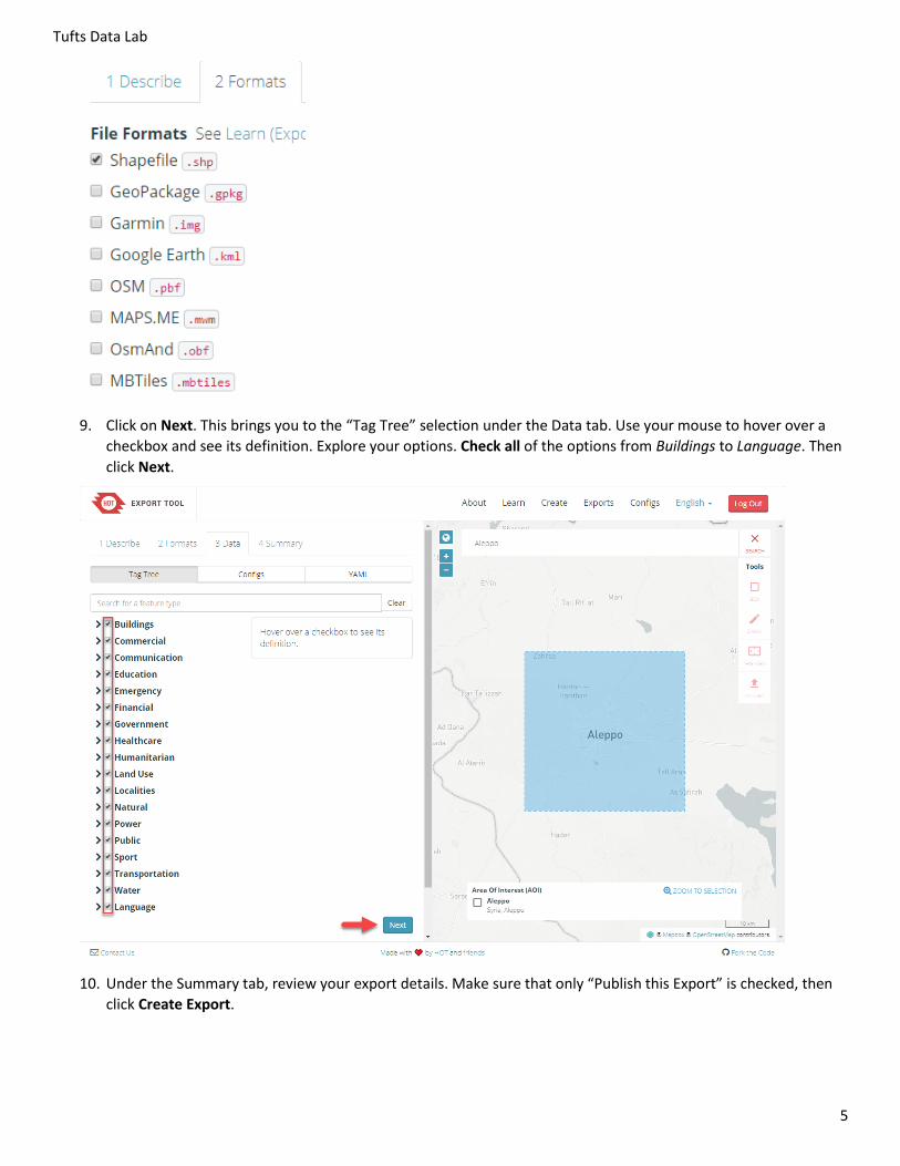
9. Click on Next. This brings you to the “Tag Tree” selection under the Data tab. Use your mouse to hover over a
checkbox and see its definition. Explore your options. Check all of the options from Buildings to Language. Then
click Next.
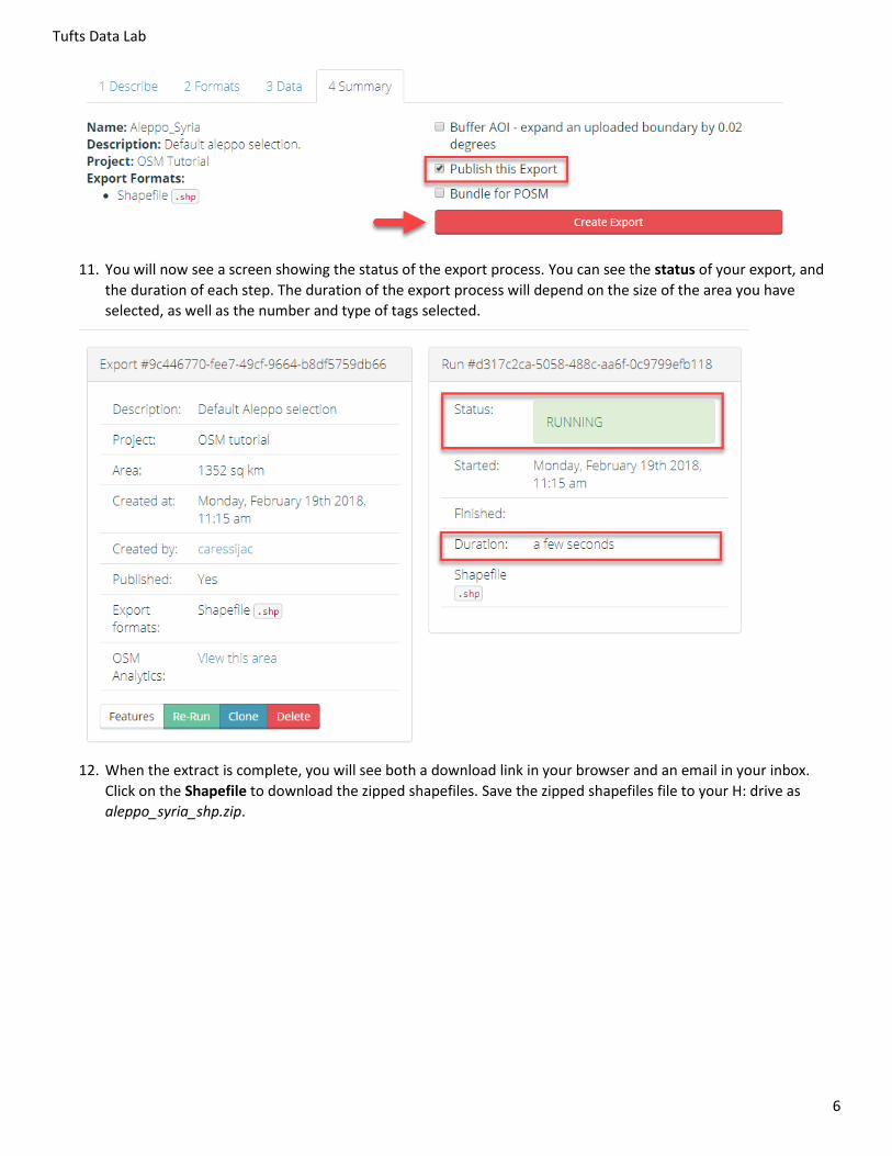
10. Under the Summary tab, review your export details. Make sure that only “Publish this Export” is checked, then
click Create Export.
Tufts Data Lab
6
11. You will now see a screen showing the status of the export process. You can see the status of your export, and
the duration of each step. The duration of the export process will depend on the size of the area you have
selected, as well as the number and type of tags selected.
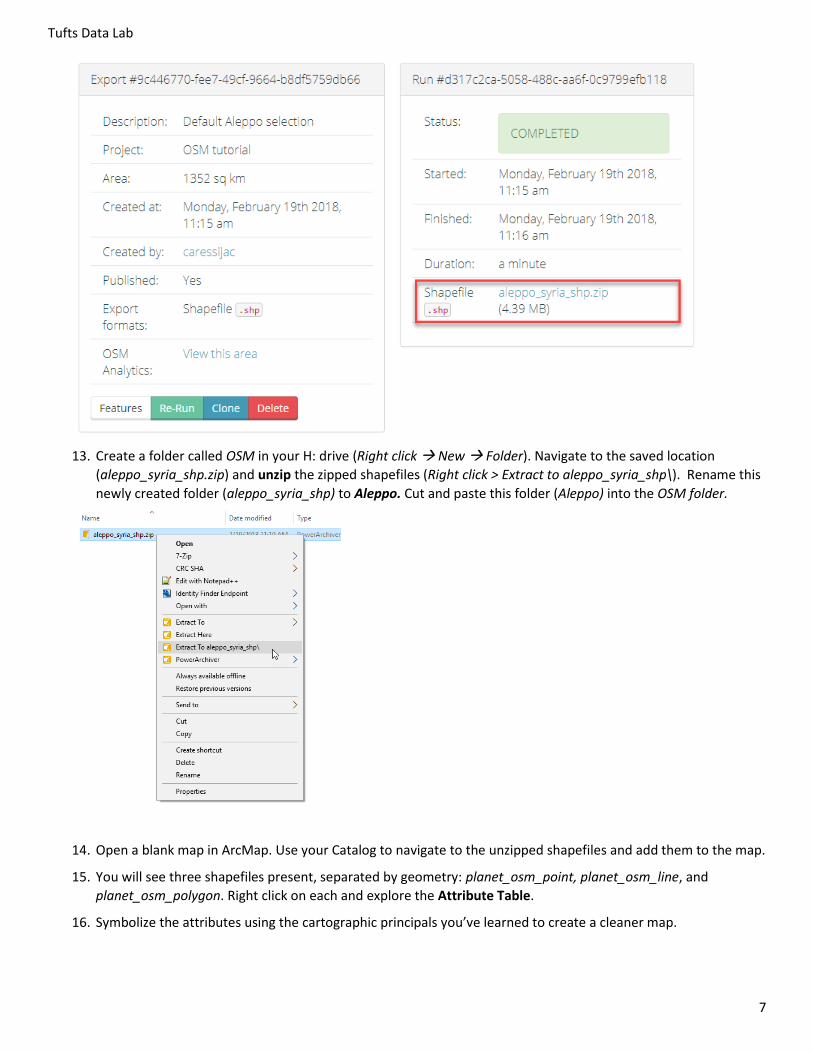
12. When the extract is complete, you will see both a download link in your browser and an email in your inbox.
Click on the Shapefile to download the zipped shapefiles. Save the zipped shapefiles file to your H: drive as
aleppo_syria_shp.zip.
Tufts Data Lab
7
13. Create a folder called OSM in your H: drive (Right click New Folder). Navigate to the saved location
(aleppo_syria_shp.zip) and unzip the zipped shapefiles (Right click > Extract to aleppo_syria_shp\). Rename this
newly created folder (aleppo_syria_shp) to Aleppo. Cut and paste this folder (Aleppo) into the OSM folder.
14. Open a blank map in ArcMap. Use your Catalog to navigate to the unzipped shapefiles and add them to the map.
15. You will see three shapefiles present, separated by geometry: planet_osm_point, planet_osm_line, and
planet_osm_polygon. Right click on each and explore the Attribute Table.
16. Symbolize the attributes using the cartographic principals you’ve learned to create a cleaner map.
Tufts Data Lab
8
Further reading and viewing
If you would like to learn more about OSM and HOT tools, please see these links.
Jeff Haack. "Beginning OpenStreetMap 1 - Getting Started - HOT." Online video clip. YouTube. 22 October, 2011.
Jeff Haack. "Beginning OpenStreetMap 2 - Signing Up and Making Your First Edits - HOT." Online video clip.
YouTube. 24 October, 2011.
Humanitarian OpenStreetMap Team (HOT). “News” https://hotosm.org/updates. Online news aggregate. HOT.
Last Updated: 06 March, 2016.
Map Kibera. “Citizen Mapping Project in Nairobi Using OSM” Unknown date. Accessed: 3-8-2017
LearnOSM. “LearnOSM Step by Step.” Unknown date. Accessed: 3-8-2017
TeachOSM. “Teach OpenStreetMap Step by Step.” Unknown date. Accessed: 3-8-2017