umbagong brochure - ginninderra catchment group
TRANSCRIPT

Contacts If you would like more information on Umbagong Landcare Group activities please contact Ginninderra Catchment Group and we will be able to keep you informed on working bees and events. Ginninderra catchment co-ordinator Ph 6278 3309 or www.ginninderralandcare.org.au ACT urban landcare Ph 13 22 81
References
and other resources Lyall Gillespie, 1992, Ginninderra—Forerunner to
Canberra, A History of the Ginninderra District, The Wizard Canberra Local History Series.
Lyall Gillespie, 1991, Canberra 1820-1913, AGPS, Canberra.
Peter Rimus Kabaila, 1997, Belconnen's Aboriginal Past—a glimpse into the archaeology of the Australian Capital Territory.
A Rowell, 1992/3 for ACT Public Works. Flora and Fauna Survey and Recommendations for Management and Ecological Enhancement.
Where are the frogs? North Belconnen Landcare Group
Thank you
for your cooperation
• All fauna, flora, Aboriginal sites and rock formations are protected.
• Please take rubbish home with you, bins are not provided.
• There are no toilet facilities within the park. • Confine your cats after dark and keep dogs on a
leash to protect animal and bird life in the park. • Remove invasive weeds from your garden and do not
dispose of garden waste in the park. • Minimise your use of plastic bags. • Don't pour anything down the storm water drain that
you wouldn't be prepared to drink.
About
our landcare group
The members of Umbagong landcare group enjoy; • the company of other people, • working to protect local plants and wildlife, • discovering the environment, and • planning for a sustainable future.
Protecting and extending native habitat along Ginninderra Creek and managing and monitoring native grasslands are key interests of the group.
The group evolved from the 'Friends of Latham District Park', who were successful in preventing residential development on the land now proclaimed as park. In 1994, the park and the new group adopted the name Umbagong, a Ngunnawal word for 'axe', as a recognition of the importance of this area to the Ngunnawal people.
This brochure was prepared by Umbagong Landcare Group with assistance from the Ginninderra Catchment Group, funded through the Federal Government’s Caring for Our Country Program & the ACT Government. Illustrations by J Hoy and J Hannan.
Let’s Discover
District Park
Ginniderra Creek Corridor Latham ACT
Discover…
Umbagong district park While Umbagong district park may not offer the excitement of bungee jumping or the natural wonders of wilderness country it does provide a great opportunity for outdoor activity.
Surrounded by the suburbs of Latham, Holt, Higgins, Macgregor, Charnwood, and Flynn, the park provides over 50 hectares of open space for recreation.
• cycle, walk or jog your way to a fitter lifestyle.
• explore the remoter parts of the park where bird watching, field studies and nature photography are often well rewarded.
• plant trees, shrubs and reeds along Ginninderra Creek with Umbagong Landcare Group members.
climb to the top of the play tower if you are young at heart.
• enjoy a family picnic or BBQ by the creek side.
• try a 'theme walk' described in this brochure.
• escape a busy urban life to be on your own.
of history
The first inhabitants of this part of Belconnen were the Ngunnawal Aboriginal people. A number of axe grinding grooves in the volcanic tuff of the creek bed are a reminder of the importance of this area to these people. The Ginninderra Creek 'chain of ponds' would have provided a reliable source of water for the Aboriginal community. It would also have attracted many animals and supported a variety of plant species. Chain of ponds waterways were discontinuous streams, which held water on floodplains and creek beds in pools instead of draining it off the land in continuous channels favoured by European management.
European settlers first established themselves in the Canberra region in the late 1820s. Three men: George Thomas Palmer, John Langdon, and Richard Popham settled along the Ginninderra Creek. Early surveys of their land reveal it was covered with grassy open forest.
By 1910, surveyors noted that the land was mostly cleared. This was just prior to Commonwealth government resuming the land for the Australian Capital Territory.
By the 1950s, the land surrounding Ginninderra Creek was entirely clear of trees, with only two or three willows present in the creek bed. The willows spread and soon occupied the entire length of the creek, shading out much of the native vegetation.
In 1968, development began in the area to form the suburb of Latham, with a wide strip of land being reserved along the creek. Many exotic and native trees and shrubs were planted and the area was proclaimed a district park for residents in 1993.
A Place…
by the creek
Umbagong district park is part of the Ginninderra Creek corridor. This green corridor meanders through the suburbs from Lake Ginninderra to Parkwood where it meets with Gooromon Ponds. The waters of both streams rush down Ginninderra Gorge, cascade over Ginninderra falls and flow on into the Murrumbidgee River. Ginninderra Creek is part of the Murray Darling Basin.
Because the Ginninderra Creek catchment is highly urbanised, its creeks are subject to fast flowing drainage water that causes erosion and carries pollutants such as oil, paint, fertiliser, and pet faeces, which enter via the stormwater drains and flow untreated into the Murrumbidgee River. This pollution affects the diversity of plant and animal life in and along the creek and the river.
In recent years the creek has attracted the interest and care of many Belconnen residents. Local groups include: Umbagong Landcare Group, North Belconnen Landcare Group, Dunlop Environmental Volunteers, and Macgregor Landcare Group. A common concern is water quality, and the protection and extension of native creek habitat. These and other groups have formed the Ginninderra Catchment Group and are working towards implementing a catchment management plan.
For a healthy creek, don't pour anything down a stormwater drain that you wouldn't expect a frog to swim in. There are many species of frog to be found along the creek and it's up to us to ensure that they continue to live here.
Turn the page To discover an urban park with a Difference
A Place…
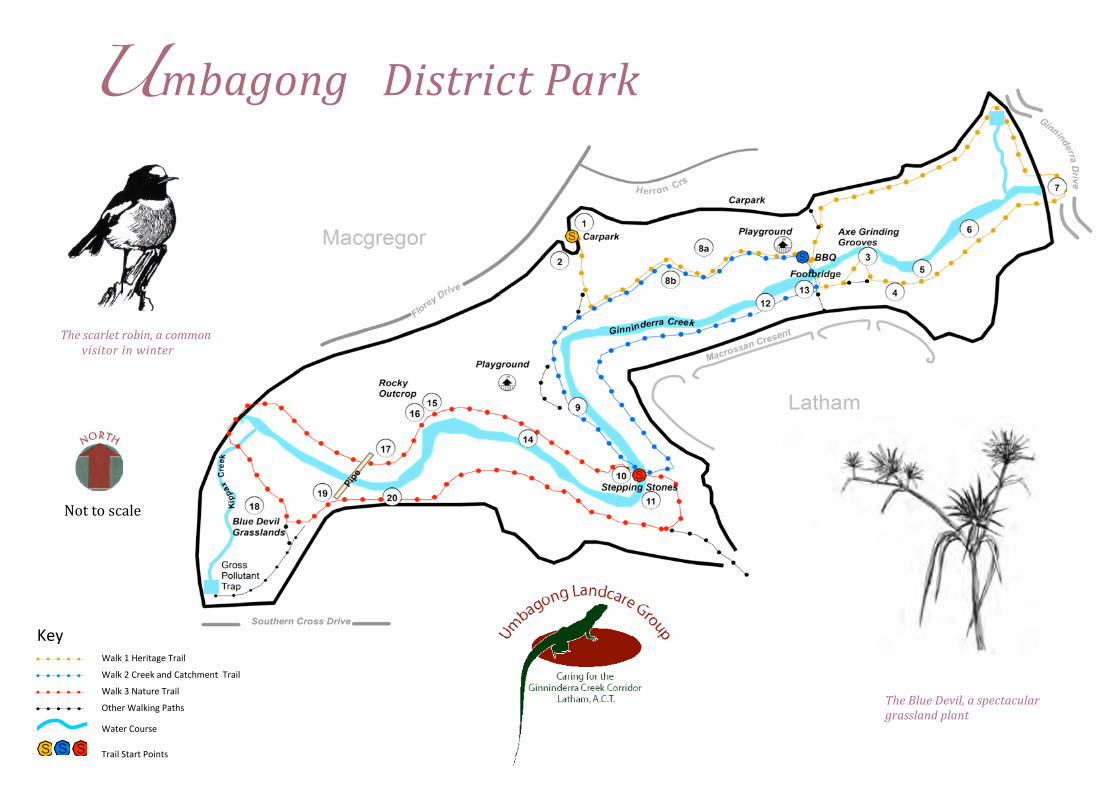
UmbagongDistrictPark
Nottoscale
Thescarletrobin,acommon
visitorinwinter
!
"#$!! ! ! ! ! ! %&'(!)!*#+,-&.#!/+&,'!
! ! ! ! ! ! %&'(!0!1+##(!&23!1&-456#2-!!/+&,'!
! ! ! ! ! ! %&'(!7!8&-9+#!/+&,'!
! ! ! ! ! ! :-5#+!%&'(,2.!;&-5<!
! %&-#+!1=9+<#!
!"!"!"! /+&,'!>-&+-!;=,2-<!
TheBlueDevil,aspectacular
grasslandplant
Walk 1 Heritage Trail
Time/Distance 60 mins/2.5 km Starting Point Car park off Florey Drive
This walk focuses on the history of land use, featuring a number of Aboriginal axe grinding grooves in the creek bed and some more recent plantings in the park. Poplars reflect a European aesthetic but suckers need regular control.
Points of interest: 1 Umbagong sign with artistic impression of grooves 2 Plantings of native shrubs – Bursaria and Acacia 3 Axe grinding grooves and picturesque rock pools 4 Comparison site for introduced pasture grasses by the river and native grasses and flowers among the rocks 5 ULG bottlebrush planting for erosion control and wildlife 6 Quaking poplars planted for landscape enhancement 7 Footbridge on Ginninderra Drive
Walk 2
Creek and Catchment Trail Time/Distance 50mins/1.8km
Starting Point Footbridge near Macrossan Cres
This short walk includes sites supporting creek habitat and those which illustrate catchment management issues. Two artificial swamps are located along drainage lines (Stop 8). They are of interest because of the role they play in filtering stormwater and in providing habitat for aquatic plants and animals. Unfortunately, the water in the swamps is often littered and murky. Dragonflies, clamorous reed warblers and spotted grass frogs are among the swamps’ residents.
Points of interest: 8a & 8b Artificial swamps providing frog and aquatic habitat 9 River bottlebrush on 'chain of ponds' site 10 Stepping stones: poplar suckers invade the creek bed 11 Stormwater draining from Macrossan Crescent 12 Reed bed planting; willows were removed in 2000 13 Gabion to protect the creek banks during flooding
Walk 3 Nature Trail
Time/Distance 60 mins/2.5 km Starting Point Stepping stones
This walk focuses on the fragile ecosystems surviving in the park. These areas are at risk due to the pressures placed upon them by an urban environment; • overturning stones destroys lizard habitat, • cats prowling the grasslands kill wildlife and • invasive weeds threaten native vegetation.
Despite these pressures, a surprising variety of wildlife can be found here: • watch the little pied cormorant: a waterbird able to
use minor rivers, it dives for prey and perches on snags • listen for the 'crick crick' of the eastern froglet in the
swamps • smell the sweet perfume of the delicate chocolate lily
in the grassland • be startled by the spotted skink on the rocky outcrop.
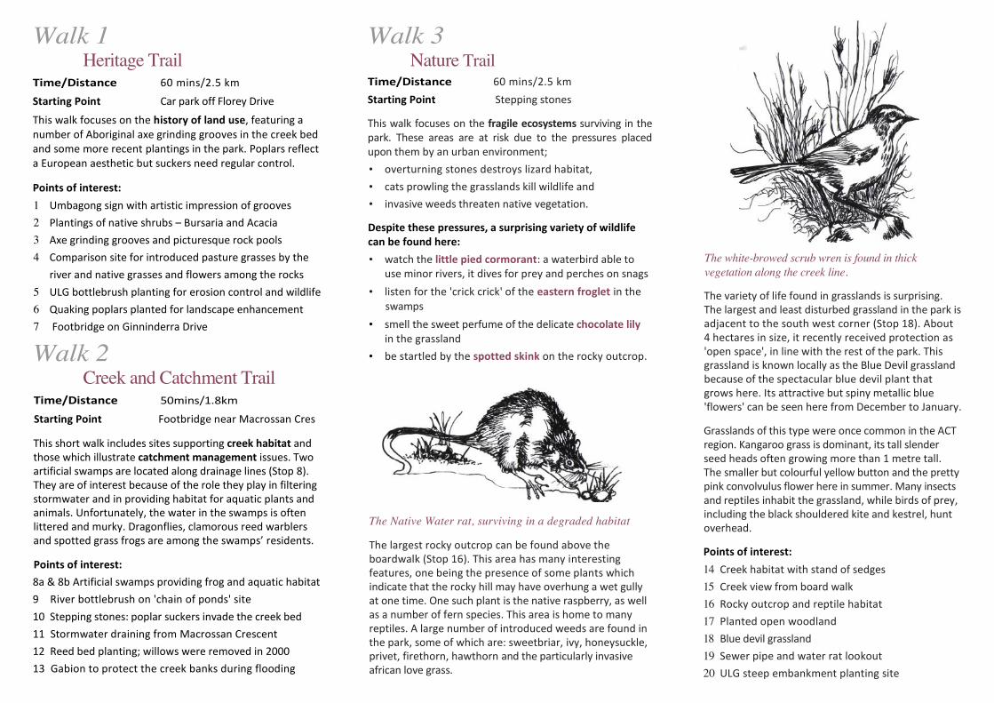
The Native Water rat, surviving in a degraded habitat
The largest rocky outcrop can be found above the boardwalk (Stop 16). This area has many interesting features, one being the presence of some plants which indicate that the rocky hill may have overhung a wet gully at one time. One such plant is the native raspberry, as well as a number of fern species. This area is home to many reptiles. A large number of introduced weeds are found in the park, some of which are: sweetbriar, ivy, honeysuckle, privet, firethorn, hawthorn and the particularly invasive african love grass.
The white-browed scrub wren is found in thick vegetation along the creek line.
The variety of life found in grasslands is surprising. The largest and least disturbed grassland in the park is adjacent to the south west corner (Stop 18). About 4 hectares in size, it recently received protection as 'open space', in line with the rest of the park. This grassland is known locally as the Blue Devil grassland because of the spectacular blue devil plant that grows here. Its attractive but spiny metallic blue 'flowers' can be seen here from December to January.
Grasslands of this type were once common in the ACT region. Kangaroo grass is dominant, its tall slender seed heads often growing more than 1 metre tall. The smaller but colourful yellow button and the pretty pink convolvulus flower here in summer. Many insects and reptiles inhabit the grassland, while birds of prey, including the black shouldered kite and kestrel, hunt overhead.
Points of interest: 14 Creek habitat with stand of sedges 15 Creek view from board walk 16 Rocky outcrop and reptile habitat 17 Planted open woodland 18 Blue devil grassland 19 Sewer pipe and water rat lookout 20 ULG steep embankment planting site