traditional agricultural land use and some changing...
TRANSCRIPT
Traditional agricultural land use and some changing trends in Maridi District, southern Sudan
This article looks at the differences in land use management in Maridi District, southern Sudan, and asserts that these reflect not only varying socioecological and environmental circumstances, but also factors such as population press- ure, sociocultural and traditional beliefs and values, economic and resource fac- tors, opportunities and accessibility and historical trends. The article con- cludes that policy makers and socioeconomic development planners of the rural areas of southern Sudan should identify constraints to increases in food production. This is only possi- ble through appropriate knowledge ab- out the different enterprise patterns and crops grown, including information on socioecological factors, environmental resource use and farmers’ perceptions and production techniques. It should be possible to offer alternative methods of analysis essential for effective rural and agricultural land use development plan- ning in similar socioecological and en- vironmental situations in the southern Sudan and other areas of tropical Afri- ca.
Dr Lado is Senior Lecturer at the Depart- ment of Geography, Moi University, PO Box 3900, Eldoret, Kenya.
‘D.A. Davidson, ed, Landscapes, Ecology and Land use, Hutchinson, London, UK, 1983. ‘J. Kenyatta, Facing Mount Kenya: the Tribal Life of the Gikuvu. Lonaman. Lon-
’ - don, UK, 1938. 3A.D. Goddard, ‘Land tenure, land holding and agricultural development in the Cen- tral Sokoto close-settled zone, Nigeria’, Savanna, Vol 1, No 1, 1972, pp 29-41. %.K. Udo, The Human Geography of Tro-
continued on page 325
Cleophas Lado
Land use is an expression of the way people manage natural ecosystems to provide some of their basic needs.’ Thus, the activities related to agricultural land use have formed the socioeconomic backbone of society. In rural areas, land and its tenure are the key to life, ensuring that tillage of the soil is necessary for people’s material needs and ‘traditional’ ceremonies.2 Land tenure arrangements have long been recognized as playing a fundamental role in the development process.”
Land tenure may be defined as ‘the fabric of rights and obligations comprising the tripartite relationship between man, land and society’.4 Studies on land use in the Western World have mainly focused on agricultural potential, physical characteristics of the soil and its inherent fertility and productivity, as well as economic, political, social and productivity data.5 However, most work done so far in Third World countries has failed to account for the multiplicity of factors influencing land use, due to a preoccupation with standard economic principles.6 The past neglect of ‘traditional’ agricultural systems by research scien- tists is mainly due to the fact that the methods of cultivation and the complexities of habitats and land use techniques are deeply rooted in indigenous thought and culture. Consequently, these studies have often failed to portray the variety of agricultural techniques, land use and crop management strategies. As a result of their long experience - through trial and error, and past observations of soil, natural vegetation, climate (particularly rainfall) and other natural phenomena - peasant farmers have learned to adapt their cultivation methods and patterns of cropping and land use, and have the ability to find and grow the most suitable types of crop for the various microclimatic and socioecological condi- tions. In addition, during the civil war of 1955-72 farmers’ adoption of various management strategies’ - such as the maintenance of soil fertility, the making of ridges and mounds (to concentrate fertile topsoil around crops and facilitate drainage), the adoption of new crop varieties (eg locust- and drought-resistant hybrid maize and sorghum) and pest management - were shown to be undertaken for rational reasons, such as risk-avoidance or minimization within the existing environmental circumstances.
324 0264-8377/89/04324-l 7$03.00 8 1989 Butterworth & Co (Publishers) Ltd
continued from page 324 pica/ Africa, Heinemann, London, UK, 1982, p 49. ‘For example, D. Stamp, ‘Fertility, produc- tivity and classification of land in Britain’, Geographical Journal, Vol 96, 1940, pp 389-412; N. Hilton, An Approach to Agri- cultural land Classification in Great Bri- tain: Land Use and Resources Studies in Applied Geography, Institute of British Geographers,- Sbecial Publication No 1, London. UK. 1968. KID 127-142. %. Wicker; ‘Some’kpects of agricultural development in the tropics’, Tropical Agri- culture, Vol 37, No 3, 1960, pp 166-180. ‘From some East African countries. ‘H.H.G. Lebon, Land Use in the Sudan, Geographical Publications, Bude, Corn- wall, UK, 1965. gJ.R. Catford, 1951; Government of Sudan, Department of Agriculture, Maridi, File No RMANtY5.6.K. 1979.
Traditional agriculrural land use in Maridi Districr, Southern Sudan
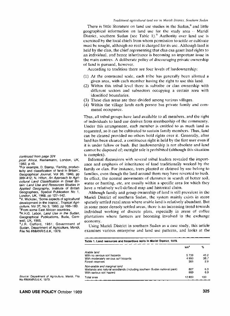
There is little literature on land use studies in the Sudan,” and little geographical information on land use for the study area - Maridi District, southern Sudan (see Table 1).9 Authority over land use is exercised by the local chiefs from whom permission to settle or cultivate must be sought, although no rent is charged for its use. Although land is held by the clan, the chief representing that clan can grant land rights to an individual, and hence inheritance is becoming an important issue in the main centres. A deliberate policy of discouraging private ownership of land is pursued, however.
According to tradition there are four levels of landownership:
(1)
(2)
(3) (4)
At the communal scale, each tribe has generally been allotted a given area, with each member having the right to use this land. Within this tribal level there is subtribe or clan ownership with different sectors and subsectors occupying a certain area with identified boundaries. These clan areas are then divided among various villages. Within the village lands each person has private family and com- munal occupance.
Thus, all tribal groups have land available to all members, and the right of individuals to land use derives from membership of the community. Under this arrangement, each member is entitled to as much land as requested, so it can be cultivated to sustain family members. Thus, land can be cleared provided no others hold rights over it. Generally, after land has been cleared, a continuous right is held by the first user even if it is under fallow or bush. But landownership is not absolute and land cannot be disposed of; outright sale is prohibited (although this situation is complex).
Informal discussions with several tribal leaders revealed the import- ance and emphasis of inheritance of land traditionally worked by the family or clan. For instance, trees planted or claimed by use belong to families, even though the land around them may have reverted to bush. In effect, the normal movements of clansmen in search of better soil, water or hunting, etc, are usually within a specific area for which they have a relatively well-defined map and historical claim.
Although family and group ownership of land is still prevalent in the Maridi District of southern Sudan, the system mainly exists in more sparsely settled rural areas where arable land is relatively abundant. But in some more densely settled areas, there is an increasing trend towards individual working of discrete plots, especially in areas of coffee plantations where farmers are becoming involved in the exchange economy.
Using Maridi District in southern Sudan as a case study, this article examines various enterprise and land use patterns, and looks at the
Table 1. Land resources and hazardous soils in Maridi District, 1979.
Arable land With no serious soil hazards With moderately serious soil hazards Forest reserves
Non-arable and marginal land Wetlands and natural woodlands (including southern Sudan national park) With serious soil hazard
Total area
km2 %
5 739 45.2 4 950 38.7
365 2.9
807 6.3 889 6.9
12800 100 Source: Department of Agriculture, Maridi, File No RMANR/5.6.K, 1979.
LAND USE POLICY October 1989 325
Traditional agricultural land use in Maridi District, Southern Sudun
‘OC. Lado, ‘Environment, knowledge and change: a case study of peasant farming in Maridi District, southern Sudan’, unpub- lished PhD thesis, Department of Geogra- phy, University of Durham, UK, 1985.
326
effect of ‘traditional’ knowledge on the crops grown, environmental resource use, economic opportunities, accessibility and production techniques. Some variations in land use in the study area reflect not only varying environmental or zonal circumstances, but also factors such as historical, sociocultural and tribal traditions and population pressure. For example, during the last civil war most of the peasant farmers took refuge in the neighbouring African countries (Zaire, Uganda, Central African Republic), where they were exposed to different agricultural land use practices. Additionally, the natural population increase together with the return and rehabilitation of refugees have led to the decrease of shifting agriculture. Thus there is a trend towards using more chemical fertilizers. The ‘traditional’ land use system, katiri, is becoming confined to the remote rural areas.
After a brief examination of the relevant physical and human background, and the methodology adopted in this study, this article: (1) outlines the rationale of tropical agricultural land use and soil poten- tials; (2) demonstrates the katiri as a ‘traditional’ land use strategy; and (3) elucidates some agricultural land use changes, trends and manage- ment processes.
Study area and methodology
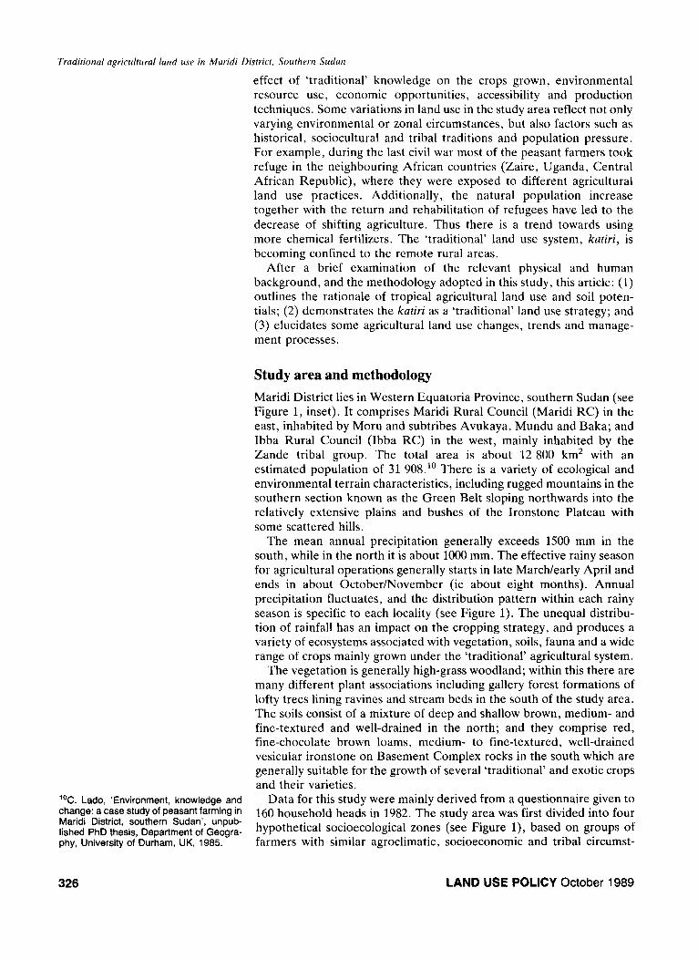
Maridi District lies in Western Equatoria Province, southern Sudan (see Figure 1, inset). It comprises Maridi Rural Council (Maridi RC) in the east, inhabited by Moru and subtribes Avukaya, Mundu and Baka; and Ibba Rural Council (Ibba RC) in the west, mainly inhabited by the Zande tribal group. The total area is about 12 800 km* with an estimated population of 31 908.” There is a variety of ecological and environmental terrain characteristics, including rugged mountains in the southern section known as the Green Belt sloping northwards into the relatively extensive plains and bushes of the Ironstone Plateau with some scattered hills.
The mean annual precipitation generally exceeds 1500 mm in the south, while in the north it is about 1000 mm. The effective rainy season for agricultural operations generally starts in late March/early April and ends in about October/November (ie about eight months). Annual precipitation fluctuates, and the distribution pattern within each rainy season is specific to each locality (see Figure 1). The unequal distribu- tion of rainfall has an impact on the cropping strategy, and produces a variety of ecosystems associated with vegetation, soils, fauna and a wide range of crops mainly grown under the ‘traditional’ agricultural system.
The vegetation is generally high-grass woodland; within this there are many different plant associations including gallery forest formations of lofty trees lining ravines and stream beds in the south of the study area. The soils consist of a mixture of deep and shallow brown, medium- and fine-textured and well-drained in the north; and they comprise red, fine-chocolate brown loams, medium- to fine-textured, well-drained vesicular ironstone on Basement Complex rocks in the south which are generally suitable for the growth of several ‘traditional’ and exotic crops and their varieties.
Data for this study were mainly derived from a questionnaire given to 160 household heads in 1982. The study area was first divided into four hypothetical socioecological zones (see Figure l), based on groups of farmers with similar agroclimatic, socioeconomic and tribal circumst-
LAND USE POLICY October 1989
Traditional agricultural land use in Maridi Disrricr, Southern Sudan
i
1’
Zone 1 i
I
‘_ -\
& Study area
KEY
Langua \ District Rural 4 Council HQS
+.............. .d..-..-.‘-.. . . . ..(... H Rural Council HQS
l Bahr Naam \ a Sample villages
-- District boundary
____ Rural council (social) boundary
. . . .._. Ecological zone
Zones 1 and 2 ’ lbba Rural Council
Zones 3 and 4 Maridi Rural Council
Figure 1. Location of sample villages and seasonality of mean annual rainfall (mm) for selected stations in the study area, 1941-70. Source: Landsat image and Sudan meteorological department.
antes. It was expected that these zones would exhibit a variety of constraints and enterprise patterns due to the different key factors inherent in ‘traditional’ farming systems.
“P.H. Nye and D.J. Greenland, The Soil Under Shifting Cultivation, Commonwealth Bureau Soils, Technical Paper No 51, Lon- don, UK, 1965. “H. Vine, ‘Is lack of fertility of tropical African soils exaggerated?’ Proceedings, Second Inter-African Soils Conference, Lbopoldville, Congo, 1954.
Tropical agricultural land use and soil potentials
This section briefly examines the basis of current ‘traditional’ tropical agricultural practices and land use patterns as a means of exploiting the physical environment by peasant farmers in Maridi District. Thus, it is vital to consider the tropical agricultural ecosystem. Nye and Greenland note that in high rainfall regions with high rates of leaching, storage of nutrients takes place in the vegetation rather than the soil. Once the rich vegetation has been cleared, soil is generally of low nutrient status.” However, this does not necessarily mean that tropical soils are unpro- ductive, rather that they have to be managed carefully if farming is to succeed.‘*
Peasant farmers generally tap the productivity of the tropical forest ecosystem through rotational bush-fallowing or land rotation. High forest or scrub is cleared by felling. The relatively bigger trees, particularly those providing an economic return (eg tamarind, shea
LAND USE POLICY October 1989 327
Trodiriond ugricuhrai ktnd use in Mwidi Disiricr, Sot&tern Sudwt
butter), are often left standing. The cut wood, usually supplemented by brushwood collected from neighbouring areas, is assembled into large heaps, allowed to dry so as to have sufficient time for the leaves and branches to enrich the soil, and burned at the end of the dry season (December-March).
Immediately after the first rains, usually in April, the sowing or planting of crops takes place on the cleared soil that has been ‘fertilized’ by mineral ash from the burned vegetation. The repeated clearance and burning of forest and scrub lowers the quality of the natural tree growth and hence reduces fertility; this would be increasingly reduced if a plot were exhausted. As a result of the large net loss of nutrients from the site, farmers in Maridi District wisely allow fallow to run its full course and cleared plots can only be utilized for a relatively short time. In inaccessible fertile areas, natural vegetation is being replaced by coffee plantations and fruit trees. This does not allow the farmer to maintain an idea of the location of his former plots (theoretically under fallow), and thus encourages a sense of individual or family landownership as opposed to a more general notion of territoriality encountered in communities with a relatively abundant land supply.
Informal discussions with farmers showed that progressive weed infestation and declining yields are often the major signals for plots to be abandoned, usually after two or three years of use, and a new plot of land is selected.‘” The natural vegetation cover left in situ re-establishes itself over a period of 20 to 25 years and enables the build-up of nutrient reserves (humus) in the soil. Because of only partial clearance of forest, bush regrowth is fast; in about four to five years a farm may become an unrecognizable thicket. Cassava may be left in the ground for several years. The invasion of bush-fallow by cassava is increasingly important as a reserve against famine. The farmers’ practice of concentrating all refuse and manure on homestead (kitchen) gardens - eg potato peel- ings, cassava, groundnut shell residues, oil-palm bunches, maize and sorghum husks, and human waste - is important in increasing soil fertility in the study area.
Thus tropical peasant farmers make the best or maximum possible use of existing land resources with the means available to them. In fact, the tropical agricultural system allows for relative flexibility on the part of farmers who have little control over environmental forces. Thus the system is unlikeiy to be abandoned or extensively transformed in the foreseeable future, until its potential has been exhausted, population pressure becomes too great, or alternatives such as infrastructura~ facilities are developed and utilized. i4 To illustrate further some of the characteristics of traditional land use patterns in the study area, some of the farm management and land use strategies and potentials are examined.
13Lado, op cif, Ref 10. 14J C Flinn, et al, ‘Barriers to increase food production in the lowland humid tro-
Katiri: an improved land use system?
pics of Africa’, paper presented at Seminar A traditional land use system known as katiri is practised mainly by the of CLAClMEA Program Advisors in Agri- culture, International Institute of Tropical
Moru tribal group in Maridi RC (zones 3 and 4). This form of
Agriculture (IITA), Ibadan, Nigeria, 1974; agriculture has evolved from shifting cultivation. Usually, in recurrent C.G. Knight and R.P. Wilcox, Triumph and cultivation systems more than one class of land is cultivated - ‘home- Triage? The World Food Problem in Geog- raphical Perspecfive, Association of Amer-
stead fields’ and those farther away from the homesteads. An attempt is
ican Geographers, Washington, DC, USA, made to outline this land use system with special emphasis on the
1976. significant governing factors.
LAND USE POLICY October 1989
Traditional agricultural land use in Maridi District, Southern Sudan
Among the non-Moru, including the Avukaya, Baka and Mundu tribal groups, modified forms of the system known as disiyaka and gamufu are followed. There is also a difference in the Baka and Mundu systems resulting from their tendency to grow sorghum in pure stand and not intermixed with sesame. In this discussion of the system, however, Moru terminology is employed.
The katiri is a roughly circular area of cultivation with a radius of about 200-400 m, divided among six to eight closely related families of the same clan. Kutiri refers to the feature such as a termite mound or a large tree which is chosen as the centre of the system. First the fertile or virgin land (lowa) is selected and the vegetation is burnt. Then one of the senior members of the clan mounts the mound or tree and divides the full circle according to the hoe strength of the clan. This division is dependent upon the total of adult women - wives, widows, sisters, daughters and mothers of the household heads. The various responsibi- lities of cultivation are strictly differentiated between sexes. At the division of the katiri each wife is allocated a portion of land to which she confines her efforts. Each household head controls one or a number of segments according to the wives in his family; he also undertakes the relatively heavy work such as land clearing, ploughing (hoeing) and sowing or planting operations. The full circle in the kutiri may be divided into 10 or 12 segments. If there are more adult women than this in the clan, a second kutiri may be opened elsewhere. The spread of the individual segments is chosen with the objective that each should be carried outwards to the same direction or distance from the centre. There is also a strict adherence to straight paths (kiswe) between the segments.
When the land has been cleared and cultivation has reached its limit for the season, a hedge (agu) of brushwood and thorns is built around the extent of the circle of the system which is used for two to three seasons during which the land is not redivided. After abandoning the land for five to seven years, sometimes longer, the same clan usually returns to the previous kutiri site. After this time, traces of former cultivation have disappeared and the composition of the clan has changed, thus leading to a new division of the system. The clan usually has two kutiri cultivations in use - one on recently opened fertile or virgin land (lowu) and the other (tiriku) in its second year after lowa. Occasionally, the Moru may also have kutiri land (mou) in its third year. The system also relates to the crop associations of which five ‘field types’ or land use classifications are significant, as outlined below.
Mogu or siiriimiindi land
This refers to land before it has been cleared, with dense woodland trees and bush. This land is cleared in November and December; some large trees may be ring-barked and left to dry and die slowly. In March the cut trees and scrubs are burnt. No preparatory cultivation is required but the land is usually sown with siirtimiindi (groundnuts) and maize in crooked lines, the seed being dibbled in and covered with the modern hoe (toriu) which permits deeper cultivation than the traditional long- handled hoe (kye’bo). The use of toriu, kye’bo (Moru) and gitu (Zande) co-exists.
Lowa land
Lowu land is recently cleared land with less-dense bush. It is selected in
LAND USE POLICY October 1989 329
Truditional agricultural land use in Maridi District, Southern Sudan
December and a fire belt is demarcated around the field and burnt, usually in June. As soon as the grass regrowth appears, the association of nyarango, kyifo dringuru and/or koso, ktinyu and kaza are broadcast. This is followed by a light hoeing with kye’bo to cover the seeds and destroy the weeds and grasses that have regrown. Thus, these opera- tions (hoeing and sowing) are rolled into one. If the land is not ready in time for the nyarango association, the bari variety in association with kyifo ndringuru and/or koso follows in August and September, followed by a light tilling with kye’bo.
Tirika land
Tirika is second-year land requiring no preparatory operations, thus facilitating early sowing. The long-term deri/~oro sorghum varieties in association with khyu, koso and/or covered by a shallow hoeing with the kye’bo predominate. If this land is dug too deep, then crops are buried and cannot grow or appear out of the ground.
Moa land
This is the third and subsequent years’ land (tirika in the previous year) but is treated exactly the same way and put down to nyarango associations. Depending on the inherent fertility, moa land may be used for four or five years. When the fertility decreases, it may be planted with cassava or cassavalgroundnuts intercropped in April and May. The latter practice is becoming increasingly popular in zones 3 and 4 (Maridi RC).
~ura’du land
This is the immediate homestead land, reportedly fertile through the addition of household refuse, manure from animal and human waste, and crop peelings and other by-products. Okra, pumpkins, sweet potatoes, maize, yams, vegetables, etc, are planted in this land, usually in April, May and June. Sometimes the sweet sorghum or cassava is interplanted with maize. Different minor rotations (not crop rotations as understood by the concept in ‘modern farming’) and crop associations were noted according to different crop varieties, but this aspect was not explored due to the survey’s resource and time constraints.
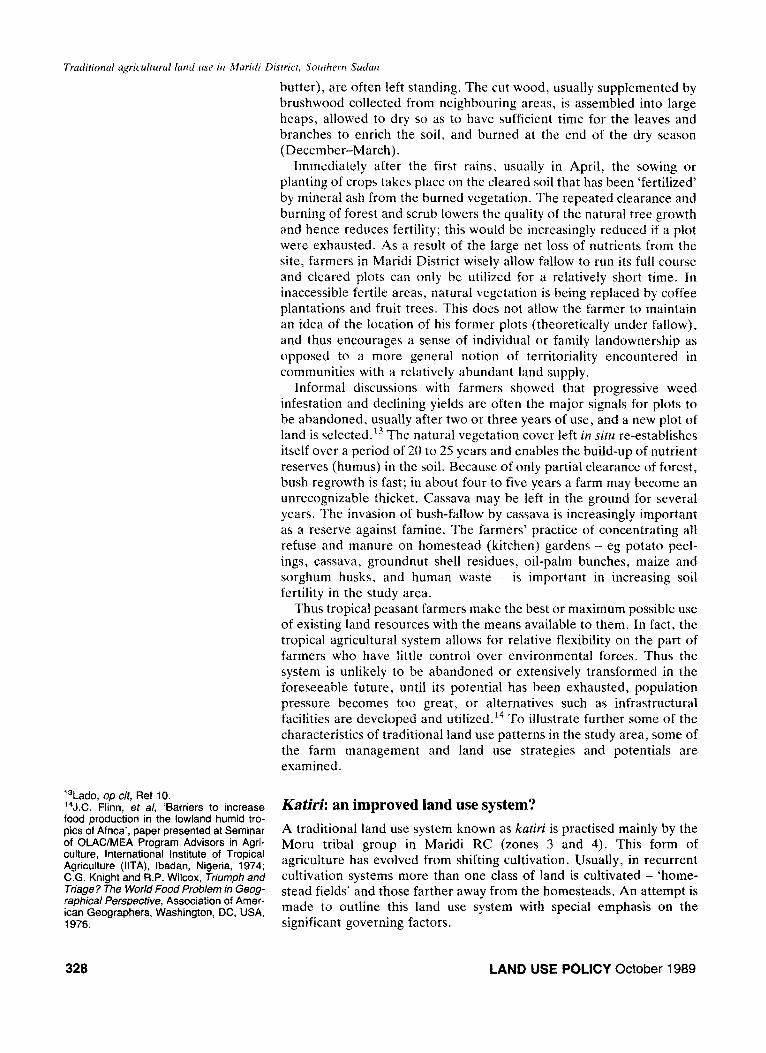
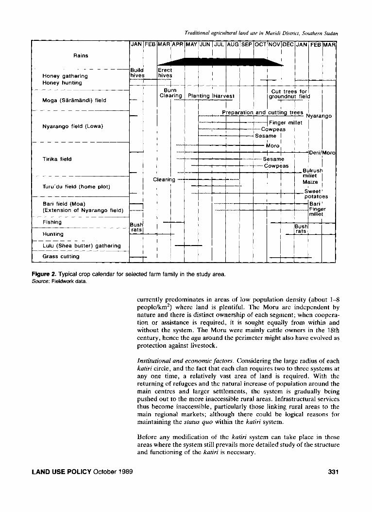
A typical crop association by field-type and a family farm calendar in Maridi RC (zones 3 and 4) is shown in Figure 2.
Having outhned the nature and characteristics of the kadri system, it is useful to identify some of the factors generally governing it including physical, social, historical, institutional and economic factors.
Pistysicai factors. About 10% of the sample farmers living in isolated settlements away from the main roads and villages were practising the katiri system. Thus, there is plenty of brushwood and thorn to form aga. The variability and spatiotemporal distribution of rainfall is countered by cropping associations, so if conditions are unfavourable for one crop, at least others will develop or grow. This is also advantageous in checking weed growth. Additionally, the aga around the system affords some protection against wild animals and other pests.
Social and historical factors. The system is most common among the Moru tribal group, which has strong family and clan loyalty, and the katiri is instrumental in maintaining this social structure. The system
330 LAND USE POLICY October 1989
Traditional agricultural land use in Maridi District, Southern Sudan
Rains
Honey gathering Honey hunting
Moga (Slrlmlndi) field . . . . .
t I I I Li
Nyarango field (Lowa)
I I
Tirika field
Turu’du field (home plot)
Bari field (Moa) (Extension of Nyarango field) . . . . . . . . . I
Burn I Clearing Planting I
Cleari
-
AAR APR MAY JU
........ L
. . ........ ,..a ......... . . . . ........ . . . . ....... ........ L
. . . . . . . . . . I?= . . . . . . . . . .
1 .“- EE .._
4 . . . . . . . . . . . . .
JUL AUG SEP OCT NOV DEC JAN FEB MAI
/ / / I........... H . . . . . . . A
1 / / , \ \ ,
iarvest ’ I I I Cut’ tree& f,or I
/
gro’?~F_“l4
.... Prepar,ation and cutting trees / ’ I I I I I , Nyarango
I... .” Sesame I Moro I
_.............. SLsame Deri/Mor
. . . . . . . . . . . . . ~owp&as i i Bulrush millet
-_ . . . . . . . Maize .._ ”
S’weet I
. . . . . . . . . . . . . . . . . . . . . . . . . . . . . . . . .
potatoes
. Bari 1 .< . . . . . . . . . . Finger
millet
Figure 2. Typical crop calendar for selected farm family in the study area. Source: Fieldwork data.
currently predominates in areas of low population density (about 1-8 people/km2) where land is plentiful. The Moru are independent by nature and there is distinct ownership of each segment; when coopera- tion or assistance is required, it is sought equally from within and without the system. The Moru were mainly cattle owners in the 18th century, hence the uga around the perimeter might also have evolved as protection against livestock.
Institutional and economic factors. Considering the large radius of each kutiri circle, and the fact that each clan requires two to three systems at any one time, a relatively vast area of land is required. With the returning of refugees and the natural increase of population around the main centres and larger settlements, the system is gradually being pushed out to the more inaccessible rural areas. Infrastructural services thus become inaccessible, particularly those linking rural areas to the main regional markets; although there could be logical reasons for maintaining the status quo within the katiri system.
Before any modification of the katiri system can take place in those areas where the system still prevails more detailed study of the structure and functioning of the katiri is necessary.
LAND USE POLICY October 1989 331
Traditional agricultural land use in Maridi District, Southern Sudan
Before noting some of the changing land use trends, the practices of the Zande tribal group in Ibba RC (zones 1 and 2) are reviewed, to show any tribal group differences in the crop associations and land classifica- tions in the study area. The cultivation season starts as soon as the rains break in either March or April; and sowing of the first crops (maize and groundnuts) continues either until the end of June or into July and August. Some farmers may start to sow finger millet (eleusine) in July, although August is the period for this operation. Once a cultivation field has been opened up, crop succession/association continues until it is left to rest under a long grass and bush fallow. New land (ngasu) in the first half of the rains is cleared and sown with groundnuts.
When a farmer has decided to sow a large area of groundnuts, then he continues clearing land - cutting the smaller trees and ring-barking or burning the large ones, leaving grass lying on the ground. This is when eleusine is sown. The grass and brushwood are then burnt in situ. From informal interviews it appears that this burn is considered vital for the eleusine crop to produce a relatively good yield. Any unburnt remains are raked up and burned in heaps and then eleusine is sown.
In the second cultivation year (fute), if the first year’s plot appears ‘good’ eleusine may be sown again, although not usually as a pure stand. Sesame may be intercropped, possibly with a little maize and sorghum. If a mixture of eleusine and sesame is sown, cassava may be planted through it to grow during the third year, when eleusine or sesame may again be sown into it. Some farmers plant cotton into the third year’s crop. Alternatively, the second year’s plot may be planted with oil-seed cucurbits (kpagu), cow-peas or sweet potatoes. Apart from the main plots there are usually homestead gardens (pan&z), mainly sown with a variety of crops including maize, groundnuts, beans, sweet potatoes, cassava and vegetables. This practice is similar to that of the Moru. When it is considered unprofitable to cultivate a plot again - because of infertility or excess weeds such as rekondo (Commelina spp) after two or more years - it is allowed to revert to bush for several years.
Changing trends in small-scale farming and land use
There seems to be a general consensus held by scientists dealing with the development of ‘traditional’ or small-scale agriculture in Third World countries that farmers are naive or unenterprising; that their farming practices and methods have remained unchanged for generations. As such, farming systems may be well adjusted to social requirements and environmental circumstances but, it is supposed, they are outmoded.‘5 The evidence often advanced in support of this is that farm equipment and operations, management strategies, crop combinations and the farming rhythm do not seem to have changed over a long period. In fact, this is part of a set of assumptions which have given rise to the ‘appropriate’ or ‘intermediate’ technology fit for the general socioeco- nomic circumstances of the rural population. The presumption is that the pre-industrial economies are not able to absorb dramatic innovation or to change easily and quickly. Rural people should thus be provided with new farm equipment that slots readily into the existing socioecono- mic and institutional structures. ‘Small’ is said to be beautiful for the
“P De Schlippe, Shifting Cultivation in Africa: the Zande System of Agriculture,
small-scale farmers, while ‘large’ has been the lynchpin of improved
Routledge & Kegan Paul, London, UK, productivity, higher crop output and raised material standards of living 1956; Lado, op tit, Ref 10. in industrialized societies.
332 LAND USE POLICY October 1989
Traditional agricultural land use in Maridi District, Southern Sudan
However, without a continuous series of experiments, land use adjustments and modifications, the present small-scale farming systems could never have been devised and maintained. This section aims to provide a brief note on the small-scale farmer and the changing land use patterns in Maridi District; specifically, farmers’ attitudes, perceptions, socioeconomic and cultural traditions, and their evaluation of land use management strategies. Some of the ‘traditional’ land use changes have been mentioned earlier, in terms of the decreasing significance of the katiri system due to increasing population pressure, particularly on available and relatively fertile arable lands around the main centres and larger villages.
In the study area, informal discussions with extension staff and farmers indicated that some food crops (eg sorghum varieties of nyarango moro, ndala, deri, cassava, sesame, groundnuts) were increas- ing in popularity with concentration in specific zones due to some socioeconomic and environmental circumstances. Other crops (such as cotton and sweet potatoes) were reported to be diminishing in import- ance. Some of the related reasons for the increase and decrease in significance of the above-mentioned crops are outlined below.
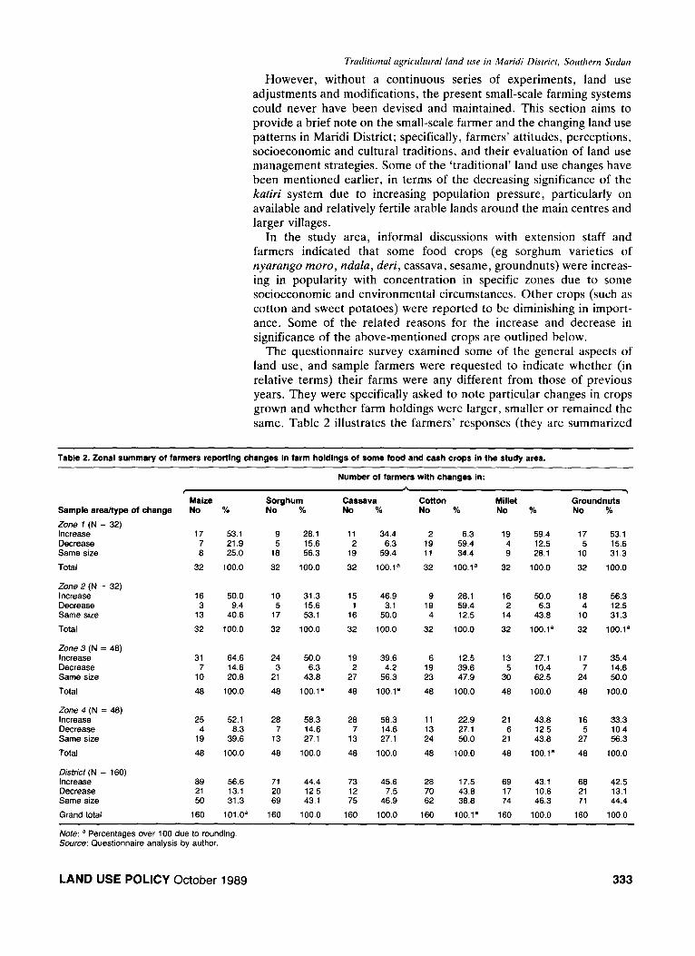
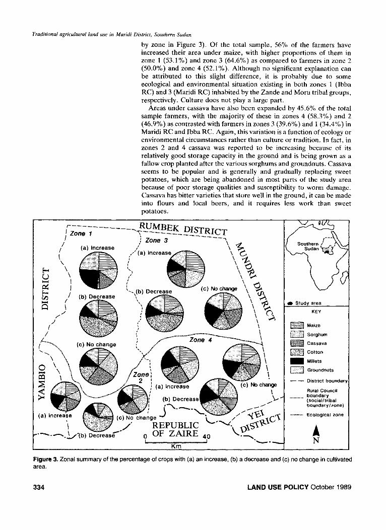
The questionnaire survey examined some of the general aspects of land use, and sample farmers were requested to indicate whether (in relative terms) their farms were any different from those of previous years. They were specifically asked to note particular changes in crops grown and whether farm holdings were larger, smaller or remained the same. Table 2 illustrates the farmers’ responses (they are summarized
Table 2. Zonal summary of farmers reporting changes in farm holdings of some food and cash crops in the study area.
Number of farmers with changes in:
P Cassava
\
Sample area/type of change
Zone 7 (N = 32) Increase Decrease Same size
Total
Maize No %
Sorghum No % No % No %
Millet No % No %
Zone 2 (N = 32) Increase Decrease Same size
Total
Zone 3 (N = 48) Increase Decrease Same size
Total
Zone 4 (N = 48) Increase Decrease Same size
Total
Disfrict (N = 160) Increase Decrease Same size
Grand total
17 53.1 9 28.1 11 34.4 2 6.3 19 59.4 17 53.1 7 21.9 5 15.6 2 6.3 19 59.4 4 12.5 5 15.6 8 25.0 10 56.3 19 59.4 11 34.4 9 28.1 IO 31.3
32 100.0 32 100.0 32 100.1a 32 100.1a 32 100.0 32 100.0
16 3
13
32
31 7
10
48
25 52.1 2% 58.3 28 58.3 11 22.9 21 43.8 16 33.3 4 8.3 7 14.6 7 14.6 13 27.1 6 12.5 5 10.4
19 39.6 13 27.1 13 27.1 24 50.0 21 43.0 27 56.3
48 100.0 48 100.0 40 100.0 40 100.0 40 100.1a 48 100.0
69 21 50
160
50.0 IO 31.3 15 46.9 9 28.1 16 50.0 18 56.3 9.4 5 15.6 1 3.1 19 59.4 2 6.3 4 12.5
40.6 17 53.1 16 50.0 4 12.5 14 43.8 IO 31.3
100.0 32 100.0 32 100.0 32 100.0 32 100.1a 32 100.1a
64.6 24 50.0 19 39.6 6 12.5 13 27.1 17 35.4 14.6 3 6.3 2 4.2 19 39.6 5 10.4 7 14.6 20.8 21 43.0 27 56.3 23 47.9 30 62.5 24 50.0
100.0 48 100.1a 48 100.1a 48 100.0 48 100.0 40 100.0
56.6 13.1 31.3
101.0a
71 20 69
160
44.4 73 45.6 28 12.5 12 7.5 70 43.1 75 46.9 62
100.0 160 100.0 160
17.5 43.0 38.8
100.1a
69 43.1 17 10.6 74 46.3
160 100.0
68 21 71
160
42.5 13.1 44.4
100.0
Note: a Percentages over 100 due to rounding. Source: Questionnaire analysis by author.
LAND USE POLICY October 1989 333
Traditional agricultural land use in Maridi Disirict, Southern Sudun
by zone in Figure 3). Of the total sample, 56% of the farmers have increased their area under maize, with higher proportions of them in zone 1 (53.1%) and zone 3 (64.6%) as compared to farmers in zone 2 (50.0%) and zone 4 (52.1%). Although no significant explanation can be attributed to this slight difference, it is probably due to some ecological and environmental situation existing in both zones 1 (Ibba RC) and 3 (Maridi RC) inhabited by the Zande and Moru tribal groups, respectively. Culture does not play a large part.
Areas under cassava have also been expanded by 45.6% of the total sample farmers, with the majority of these in zones 4 (58.3%) and 2 (46.9%) as contrasted with farmers in zones 3 (39.6%) and 1 (34.4%) in Maridi RC and Ibba RC. Again, this variation is a function of ecology or environmental circumstances rather than culture or tradition. In fact, in zones 2 and 4 cassava was reported to be increasing because of its relatively good storage capacity in the ground and is being grown as a fallow crop planted after the various sorghums and groundnuts. Cassava seems to be popular and is generally and gradually replacing sweet potatoes, which are being abandoned in most parts of the study area because of poor storage qualities and susceptibility to worm damage. Cassava has bitter varieties that store well in the ground, it can be made into flours and local beers, and it requires less work than sweet potatoes.
Study area
KEY
\ . - \ fZZJ Maize
\ \ I m Sorghum
1 t Zone i -1.
a \ I @jig&j Cassava
m Cotton
I ii , M Millets
boundary
I
(social/tribal boundary/zone)
_**.***.* Ecological zone
,~~_; -REPUBLIC L-Tyi Decrease t-, OF ZAIRE 4o L-“;
Km 1Y
Figure 3. Zonal summary of the percentage of crops with (a) an increase, (b) a decrease and (c) no change in cultivated area.
334 LAND USE POLICY October 1989
Tradirional agricuhral land use in Maridi Disrricr, Southern Sudan
Of the total sample, 44.4% of the respondents have increased their area under sorghum, with a high proportion of them in Maridi RC (zone 4, 58.3%; zone 3, 50.0%) as compared with their counterparts in zones 2 (31.3%) and 1 (28.1%) in Ibba RC. Informal interviews with farmers revealed that the sorghum varieties of nyarungo, ndulu, mom, deri and mubior, which are widely grown by the Moru (zones 3 and 4), were reported to be increasing in importance because of their storage ability, resistance to drought and the quantity and quality of yield; the Moru have a long tradition of growing sorghum. During 1936-39, there was a disastrous fall in the cash crop economy, including cotton. Cotton was widely grown by the Zande due to the cotton scheme introduced by the British colonial administrators, and the Zande were not involved in much food crop production. l6 During this period, sorghum became an extra source of income, and during the war economy of the early 1940s it was exploited and became exportable. It was not felt to be of long-term value, however, and so was played down in favour of cotton (grown mainly within the Zande Cotton Scheme in 1928).
Cotton growth was drastically decreased by 43.8% of the sample farmers, mainly in zone 1 (59.4%) and zone 2 (59.4%) in Ibba RC (inhabited by the Zande) as compared to Maridi RC - zones 3 (39.6%) and 4 (27.1%) - dominated by the Moru. From 1928 colonial adminis- trators saw the success of their cotton policy particularly in Ibba RC (zones 1 and 2), and this policy was mainly incorporated into the Zande Scheme with its ideal soil and climate conditions. Zones 3 and 4 (Maridi RC) were not included in the scheme. Additionally, the mandatory policy of growing cotton was, to some extent, relaxed among the Moru tribal group. Cotton was not taken on among the Moru in the same way as the Zande, although efforts to encourage cotton growing through schools (spontaneous diffusion and adoption) were made. ” The forced introduction of cotton growing, together with its strict rules and ruthless administration,18 created a general distrust among the Zande who considered it (and still do) a ‘government crop’ (gu irungbi sunge) rather than a profitable cash crop; the crop is marketed and controlled by government agents who have failed to meet the needs of farmers in terms of secured prices with minimal transaction delays. Hence, it is not surprising that growth of and area under cotton are either decreasing or remaining the same in the study area.
Interviews showed the increase of sesame in zones 1 and 3 because of its various uses - oil, paste and in bread. Finger millet was reported to be popular in zones 1 and 2 due to sociocultural and economic reasons. In general, groundnuts were reported to be prominent in zones 1 and 2 where exotic varieties were being grown by several farmers. Maize appears to be increasing in significance and may in the foreseeable future replace sorghum in the study area.
Farmers put forward various reasons for their farm management strategies and land use trends and changes, many of which provide some evidence of the types of agricultural opportunities and constraints experienced locally. Of the farmers increasing their crops, about 60% of these in zone 3,75% in zone 4,45% in zone 1 and 55% in zone 2 made such a move because of a larger input of family labour and the need for extra food for household sustenance. However, about 50% of farmers acknowledged the need for more cash to meet some of their sociocultu- ral and economic obligations, and to acquire other mass-manufactured consumer items from local rural markets. However, 10% of the farmers
‘%. Lado, ‘Some aspects of cotton as a cash crop development in an historical perspective in Maridi District, southern Sudan’, Journal of Eastern African Re- search and Development, Vol18,1988, pp 24-43. “M Bowili, personal communication, 198;. ‘%.C. Reining, The Zande Scheme: an Anthropological Case Study of Economic Development in Africa, Northwestern Uni- versity Press, Evanston, WY, USA, 1966.
LAND USE POLICY October 1989 335
Traditional agricultural land use in Maridi Disrrict, Sourhern Sudan
received some cash from relatives working in the main centres and hence could hire labour. This acts as a ‘push’ factor for the decision to increase crop areas. About 52% of the farmers cited several reasons for the decrease of crop area, including: lack of seeds; sickness and fulfilment of sociocultural obligations (eg funeral and death attend- ance); labour supply constraints; old age and children reaching school age; lack of rain and burning of crops (reported by 8%); and the late starting of rains. Of those farmers whose farm areas remained the same (no change), the majority reported that their farms are no different from those of ancestors or parents. However, this latter response category is likely to defend the sort of ‘traditional’ farming practices and land use considered by farmers as ‘effective’.
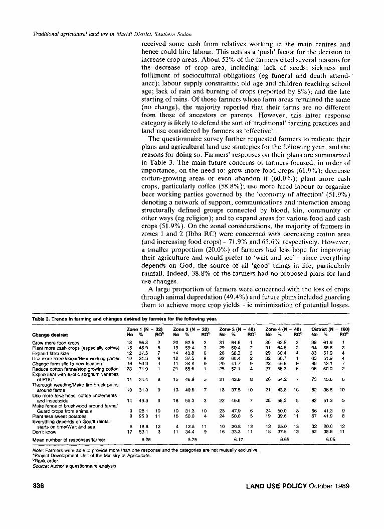
The questionnaire survey further requested farmers to indicate their plans and agricultural land use strategies for the following year, and the reasons for doing so. Farmers’ responses on their plans are summarized in Table 3. The main future concerns of farmers focused, in order of importance, on the need to: grow more food crops (61.9%); decrease cotton-growing areas or even abandon it (60.0%); plant more cash crops, particularly coffee (58.8%); use more hired labour or organize beer working parties governed by the ‘economy of affection’ (51.9%) denoting a network of support, communications and interaction among structurally defined groups connected by blood, kin, community or other ways (eg religion); and to expand areas for various food and cash crops (51.9%). On the zonal considerations, the majority of farmers in zones 1 and 2 (Ibba RC) were concerned with decreasing cotton area (and increasing food crops) - 71.9% and 65.6% respectively. However, a smaller proportion (20.0%) of farmers had less hope for improving their agriculture and would prefer to ‘wait and see’ - since everything depends on God, the source of all ‘good’ things in life, particularly rainfall. Indeed, 38.8% of the farmers had no proposed plans for land use changes.
A large proportion of farmers were concerned with the loss of crops through animal depredation (49.4%) and future plans included guarding them to achieve more crop yields - ie minimization of potential losses.
Table 3. Trends in farming and changes desired by farmers for the following year.
Change desired
Grow more food crops Plant more cash crops (especially coffee) Expand farm size Usa more hired IabourBeer working parties Change farm site to new location Reduce cotton farms/stop growing cotton Experiment with exotic sorghum varieties
of PDUe
Zone 1 (N = 32) No % Rob
16 56.3 2 15 46.9 5 12 37.5 7 IO 31.3 9 16 50.0 4 23 71.9 1
Zone 3 (N = 46) Zone 4 (N = 46) No % ROb No % Rob
31 64.6 I 30 62.5 3 29 60.4 2 31 64.6 2 26 56.3 3 23 60.4 4 29 60.4 2 32 66.7 1 20 41.7 9 22 45.6 9 25 52.1 4 27 56.3 6
District (N = 160) No % ROb
99 61.9 1 94 56.6 3 63 51.9 4 63 51.9 4 69 43.1 7 96 60.0 2
Thorough weeding/Make fire break paths around farms
11 34.4 6
10 31.3 9
Zone 2 (N = 32) No % FtOb
20 62.5 2 19 59.4 3 14 43.6 6 12 37.5 6 11 34.4 9 21 65.6 1
15 46.9 5
13 40.6 7
18 56.3 3
10 31.3 10 16 50.0 4
4 12.5 11 11 34.4 9
5.75
21 43.6 6
16 37.5 10
26 54.2 7 73 45.6 6
Use more toria hoes, coffee implements and insecticide
21 43.8 10
20 56.3 5
62 36.8 10
14 43.6 6 22 45.6 7 Make fence of brushwood around farms/
Guard crops from animals Plant less sweet potatoes Evetything depends on God/If rainfall
starts on time/Wait and see Don’t know
62 51.3 5
9 26.1 10 6 25.0 11
23 47.9 6 24 50.0 8 66 41.3 9 24 50.0 5 19 39.6 11 67 41.9 8
32 20.0 12 62 36.8 11
Mean number of responses/farmer
6 16.6 12 17 53.1 3
5.26
10 20.6 12 12 25.0 13 16 33.3 11 16 37.5 12
6.17 6.65 6.05
Note: Farmers were able to provide more than one response and the categories are not mutually exclusive. “Project Development Unit of the Ministry of Agriculture. “Rank order. Source: Author’s questionnaire analysis.
336 LAND USE POLICY October 1989
Traditional agricultural land use in Maridi District, Southern Sudan
In addition, 45.6% of farmers planned to reduce cotton growing because of marketing constraints (the previous years’ cotton produce was not purchased) and price fluctuations. Other reasons advanced included the need for more food surplus for household requirements and cash (42.5%); 43.1% planned to change their farm sites to other new areas due to the loss of soil fertility. Only 16.3% of them intended to employ paid labour, whether in cash or kind.
In summary, it has been outlined that various changes in land use have been made, such as area under particular food and cash crops. However, farmers who have increased or propose to increase food crop area are in many instances subsistence-motivated. Thus, subsistence elements (including the need for more food and the feeding of more mouths) certainly loom as large as the cash-oriented factors, eg ‘to earn more income’ and to ‘pay for children’s education’ are some of the farmers’ explanations for the adoption of particular land use strategies. If this subsistence factor is ignored, then it might be difficult to mobilize community support for and interest in some of the broader issues of environmental resource management in the study area. Indeed, far- mers’ decision-making procedures with regard to their utilization of available resources are focused on the attainment of particular desired objectives. Thus, sociocultural, traditional and environmental factors generally play a significant role in farmers’ decision-making processes in relation to land use strategies and resource or economic accessibility.
Conclusion
This article has shown that there is some rationality in the ‘traditional’ agricultural land use patterns; and that cropping associations, succes- sions and intercropping practices do determine cropping patterns and land use classifications. The system allow high yields per unit of labour, with relatively little effort needed to produce expected harvests from a ‘typical’ cropping pattern. By mimicking the diversity of the natural vegetation, the farmer enables a more balanced depletion of soil nutrients, while the mixing of crops discourages the rapid spread of diseases and other pests. The food and cash crops grown (see Appendix) are keyed to the rainfall cycle, and farmers’ perceptions of their sociocultural traditions and beliefs are significant. Economic and histor- ical factors are also vital. Crop management strategies and operations are well developed in order to achieve sufficient food supply and stability.
The relatively low population densities in much of the study area mean that the acquisition of land is not considered a serious constraint to food production, although much of it is uncultivable or of poor quality. However, other factors - such as accessibility to improved water facilities - may act as a major constraint to some of the arable or cultivable fertile lands. Despite the small numbers of people practising shifting bush-fallow agriculture, the land use situation is changing. There is a tendency to nucleate, with the establishment of government agricultural and forestry projects especially favouring such a move. In effect, the increasing population in particular localities will gradually lead to an increase in the amount of labour and a decrease in the amount
“J.D. Stryker, ‘Population density, agri- cultural technique and land utilization in a
of land per person despite the availability of free land further afield.”
village economy’, American Economic Re- Thus, shifting modes of production are becoming unsuitable, especially view, June 1976, pp 347-356. around the main centres, and this is being accelerated by the incorpora-
LAND USE POLICY October 1989 337
Traditional agricultural land use in Maridi District. Southern Sudan
tion of coffee and other cash crops into the land use pattern. This fact is evident in the confinement of the ‘traditional’ land use system of the katiri to remote rural areas. In conclusion, farmers’ differences in land use management strategies and crop decision-making procedures reflect not only their sociocultural and economic opportunities and accessibility to infrastructural services and historical factors, but also the interaction of varying ecological and environmental circumstances. Indeed, the civil war of 1955-72 has also influenced these responses.
Policy makers and planners concerned with the socioeconomic de- velopment of the poor rural areas of southern Sudan should identify constraints to the increase in output of food and cash crops, and the processes of agricultural land use change and diffusion of innovations. The different enterprise patterns and appropriate knowledge about the crops grown, environmental resource use, and production techniques and practices prevailing in the four socioecological zones should also be taken into consideration. The survey of individual zonal homogeneity would suggest solutions for various climatic, edaphic, economic, social and political problems when planning rural economic progress, and when matching potentials with performance. Information relating to farmers’ circumstances, values, attitudes, traditions and systems of belief, and perceptions of the physical and socioeconomic environments should be noted. It should be possible to offer alternative programmes for effective rural and agricultural land use development planning in similar socioecological and environmental conditions in the southern Sudan in general and the study area in particular. Since rural Africa contains many people of diverse sociocultural and ‘traditional’ values, the lessons drawn from Maridi District with its Zande-Moru sociologic- al split could be a clear and significant message for other areas of the continent with similar socioecological conditions. Farmers’ land use management strategies based on their intimate knowledge of the seasonality of crop production and other features of ‘traditional’ crop varieties, including crop associations and successive plantings and the adoption of failsafe production techniques, should therefore be recog- nized as valid, useful and productive. This calls for their consideration as important partners in the policy-making process. Efforts to introduce modern techniques to revitalize farm enterprises should also take account of regional agroclimatic and socioeconomic factors, rather than specifying policies for a political or administrative unit as a whole. Crop and livestock patterns, concentration or diversification, regional imba- lances in productivity levels, the degree of commercialization, and crop sequence analysis are all important in highlighting and interpreting zonal variations in ‘traditional’ agricultural development and rural land
use.
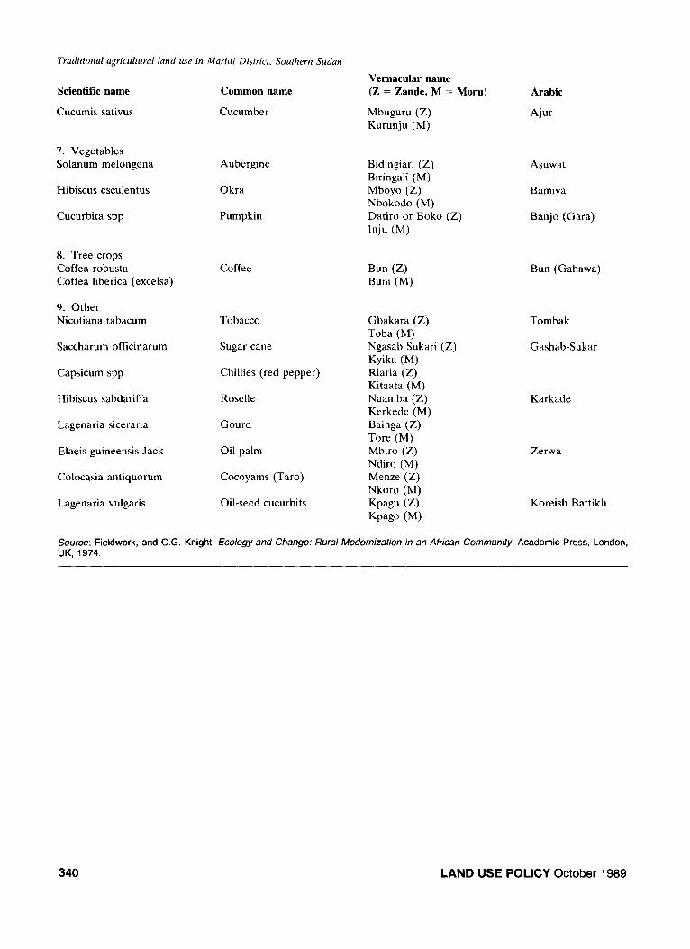
Appendix Main crops grown in the study area
Scientific name
1. Cereals Sorghum bicolor
Common name
Sorghum
338
Vernacular name (Z = Zande, M = Moru) Arabic
Vunde (Z)
Inya (M)
Dura
LAND USE POLICY October 1989
Traditional agricultural land use in Maridi District. Southern Sudan
Scientific name
Zea mays
Pennisetum typhoides
Eleusine coranaca
Oryza sativa
2. Legumes Arachis hypogaea
Voandzeia subterranea
Cajanus cajan
Phaseolus aureus
Vigna unguiculata
3. Root crops Manihot esculenta
Ipomoea batatas
Dioscorea spp
4. Oil crops Sesamum indicum
Hyptis spicigera
5. Fibre crop Gossypium spp
6. Fruits Carica papaya
Ananas comosus
Psidium guajava
Mangifera indica
Citrus sinensis
Citrus limon
Musa sapientum
Lycopersicon esculentum
Common name
Maize
Bulrush millet
Finger millet
Rice
Groundnuts
Bambara nuts
Pigeon peas
Green gram or beans
Cow-peas
Cassava
Sweet potato
Yam
Sesame (Simsim)
Hyptis (hard simsin)
Cotton
Pawpaw
Pineapple
Guava
Mango
Orange
Lemon, lime
Banana
Tomato
Vernacular name (Z = Zande, M = Mont)
Waya W Dabali (M) Ngiria (Z) Kaza (M) Moru (Z) Kifo (M) Maponga (2) Ruzu (M)
Awande (Z) Saramandi (M) Baunda (Z) Kosokara (M) Adugo (Z)
Tuga (M) Abakpa (Z) Dudura (M) Abapu (Z) Koso (M)
Gbanda (Z) Gbanda (M) Abangbe (Z) Mondo (M) Gbara (Z) Koro (M)
Soro or Ngbindia (Z) Kanyu (M) Andoka (Z) Kino (M)
Gutun (Z) Kodo (M)
Paipai (Z) Pai-pai (M) Ananasi (Z) Ana-Nasi (M) Guafa (Z) Ngofo (M) Manga (Z) Manga (M) Orenji (Z) Lamonindiri (M) Lemon-ria (Z) Lamoni-atra (M)
Bu (Z) Bogwo (M) Komandore (Z) Timati (M)
Arabic
Dura Shami/Asharif
Dukhun
Telebun
Uruz
Ful
Abu gowi
Bisila
Gesharingeik
Lubia akhdar
Bafora
Bambe
-
Simsim
Simsim gowi
Gotton
Bayibayi
Ananas
Jowafa
Manja
Borodokal
Lemon-mur
Mouzi
Timatim
LAND USE POLICY October 1989 339
Tradirional agricultural land use in Maridi District, Southern Sudan
Scientific name
Cucumis sativus
7. Vegetables Solanum melongena
Hibiscus esculentus
Cucurbita spp
8. Tree crops Coffea robusta Coffea liberica (excelsa)
9. Other Nicotiana tabacum
Saccharum officinarum
Capsicum spp
Hibiscus sabdariffa
Lagenaria siceraria
Elaeis guineensis Jack
Colocasia antiquorum
Lagenaria vulgaris
Common name
Cucumber
Aubergine
Okra
Pumpkin
Coffee
Tobacco
Sugar cane
Chillies (red pepper)
Roselle
Gourd
Oil palm
Cocoyams (Taro)
Oil-seed cucurbits
Vernacular name (Z = Zande, M = Moru)
Mbuguru (Z) Kurunju (M)
Bidingiari (Z) Biringali (M) Mboyo (Z) Nbokodo (M) Datiro or Boko (Z) Inju (M)
Bun (Z) Buni (M)
Gbakara (Z) Toba (M) Ngasab Sukari (Z) Kyika (M) Riaria (Z) Kitaata (M) Naamba (Z) Kerkede (M) Bainga (Z) Tore (M) Mbiro (Z) Ndiro (M) Menze (Z) Nkoro (M)
Kpagu (Z) Kpago (M)
Arabic
Ajur
Asuwat
Bamiya
Banjo (Gara)
Bun (Gahawa)
Tombak
Gashab-Sukar
Karkade
Zerwa
Koreish Battikh
Source: Fieldwork, and C.G. Knight, Ecology and Change: Rural Modernization in an African Community, Academic Press, London, UK, 1974.
340 LAND USE POLICY October 1989