the eastern shore of virginia: strategies for adapting … shore of virginia: strategies for...
TRANSCRIPT

1
The Eastern Shore of Virginia: Strategies for Adapting to Climate Change
REPORT FROM THE EASTERN SHORE CLIMATE CHANGE ADAPTATION STRATEGIES WORKSHOP
A PROJECT FUNDED BY THE VIRGINIA ENVIRONMENTAL ENDOWMENT AND
THE WILDLIFE CONSERVATION SOCIETY
THE NATURE CONSERVANCY IN VIRGINIA MAY 2011

‘

The Eastern Shore of Virginia: Strategies for Adapting to Climate Change
REPORT FROM THE EASTERN SHORE CLIMATE CHANGE ADAPTATION STRATEGIES WORKSHOP
A PROJECT FUNDED BY THE VIRGINIA ENVIRONMENTAL ENDOWMENT AND
THE WILDLIFE CONSERVATION SOCIETY
THE NATURE CONSERVANCY IN VIRGINIA JUNE 2011
PLEASE DIRECT INQUIRES AND COMMENTS TO
Steve Parker, Director TNC/ Virginia Coast Reserve
P.O. Box 158, 11332 Brownsville Road Nassawadox, VA 23219 Phone: (757) 442-3049 Email: [email protected]
OR
Gwynn Crichton, Senior Conservation Projects Manager
TNC/ Virginia Chapter 490 Westfield Road
Charlottesville, VA 22901 Phone: (434) 951-0571
Email: [email protected]
TO DOWNLOAD A COPY OF THIS REPORT AND OTHER MATERIALS RELATED TO THE EASTERN SHORE CLIMATE CHANGE ADAPTION PROJECT, PLEASE VISIT: ://CONSERVEONLINE.ORG/WORKSPACES/E-
SHORE-VA-CC-ADAPTATION


i
BY THE VIRGINIA ENVIRONMENTAL ENDOWMENT AND
Acknowledgements This project was possible through the generous support of the Virginia Environmental Endowment and the Wildlife Conservation Society. The Nature Conservancy thanks all the people who participated and contributed their valuable perspectives and expertise during the workshop in August 2010 at Cobb Island Station:
Larry Atkinson, Hank Badger, Sandra Benson, Ruth Boettcher, Josh Bundick, Chris Burkett, Grayson Chesser, Bob Christian, Paul Clarke, Bridgett Costanzo, Carmie Duer, Dot Field, Darlene Finch, Josh Freeman, Troy Hartley, Peter Henderson, Pam Denmon, Tina Jerome, Bill Kittrell, Pat Linton, Mark Luckenbach, Jim McGowan, Laura McKay, Elaine Meil, Bill Neville, Chelsie Papiez, Steve Parker, John Porter, Walt Priest, Mark Reiter, Sue Rice, Nikki Rovner, Joe Scalf, Courtney Schupp, Art Schwartzchild, Gwen Shaughnessy, Bill Shockley, Tom Smith, Peter Stith, Kyle Sturgis, Barry Truitt, Brian vanEerden, Tom Walker, Bryan Watts, Chris Burkett, and Alex Wilke
Special thanks to our guest speakers and panelists:
Joseph F. Bouchard, Hon. Grayson Chesser, Elaine Meile, Tom Walker, Laura McKay Josh Freeman, Bob Christian, and John Porter
Special thanks to TNC staff and others who organized workshop logistics, facilitated and documented the workshop:
Pam Crosby, Steve Parker, Anne Truitt, Bev Watson, Annie Hess, Bo Lusk, Judy Dunscomb, Mary Conley, Gwen Shaughnessy and Gwynn Crichton.
Special thanks to the Eastern Shore Climate Adaptation Working Group members for continuing to engage on realize many of the actions recommended in this report:
Art Schwarzchild, Carmie Duer, Curt Smith, Elaine Meil, Dave Burden, Grayson Chesser, Hank Badger, Denard Spady, Jane Lassiter, Jim McGowan, Lou Hinds, Laura McKay, Peter Stith, Rob Testerman, Sandra Benson, Tina Jerome, Tom Brockenbrough, Tom Walker, Pete Henderson and Bill Neville
Cover photo credits: Clockwise from upper left: Dave Burden, Joe Scalf, Dave Burden, Dave Temens, Blue Heron Realty, Barry Truitt, Dave Burden (center photo)

ii

iii
Executive Summary The Eastern Shore is no stranger to the vagaries of climate and the inherent hazards associated with living in a dynamic coastal environment. However, our growing body of knowledge about global climate change strongly indicates that the rates of change and scale of impact will be greater in intensity and severity than ever before. Based on recent reports we can expect sea levels to rise at an accelerated rate of at least a meter or more by 2100 and cause increased coastal flooding, shoreline erosion and inundation mainland areas. In addition, we can expect precipitation extremes and increasing frequency of droughts. While the Eastern Shore benefits from more natural resiliency due to the high proportion of coastal wetlands, barrier islands and mainland edge protected by The Nature Conservancy and other public agencies, the specter of global climate change nevertheless renders the Eastern Shore vulnerable to dramatic changes over the next century. There is ample opportunity to begin planning now for the future to effectively build on the natural
resiliency of this unique place and adapt to the coming changes. Toward this end, The Nature Conservancy launched a climate change adaptation project for the Eastern Shore of Virginia to more specifically characterize the current understanding of potential ecological effects due to climate change through an expert workshop, literature review and assessment of resource vulnerability using LiDAR (Light Detection and Ranging) data. In addition, the Conservancy, in
collaboration with partners and the local community, set out to use this understanding to inform the identification of strategic actions that will enhance resilience and facilitate adaptation of this globally important and productive coastal area upon which local communities and wildlife depend. To accomplish the latter, the Conservancy hosted the Eastern Shore Climate Change Adaptation Strategies Workshop in August 2010. Workshop participants included a range of industries and communities that will be affected by sea-level rise and other climate change effects, including local representatives from aquaculture, agriculture, local government and community organizations. The shared vision for adapting the Eastern Shore to effects of climate change that emerged from the workshop was as follows:
Coastal resources migrate and remain productive as sea-level rises Planned, livable and safe communities are resilient to climate change
Town of Willis Wharf ©Patrick Hendrickson of Highcamera Aerial Photographic Service
iv
Adequate freshwater resources exist for drinking, agriculture, ecosystem function, and businesses
The shore supports stable, natural resource based businesses from agriculture and aquaculture to science and spaceflight
Wildlife, birds, fisheries and people thrive Participants agreed on five priority climate change adaptation strategies to pursue in the future:
1. Local Adaptation Planning: Review county comprehensive plans and hazard mitigation plans to incorporate the current and predicted effects of sea-level rise and coastal flooding using vulnerability assessment derived from LiDAR and best available scientific data.
2. Shoreline Management: Develop shoreline management plans for all Eastern Shore stream reaches in consultation with VIMS that are incorporated into county comprehensive plans per the new statewide statutory requirement, and promote new general permit for living shorelines with land owners through education and demonstration projects.
3. Restoration and Protection of Natural Systems: Work with public and private partners to enhance climate change adaption by species, habitats and ecological systems through expansion and restoration of a resilient, productive and connected network of protected lands that capture habitat gradients and transition zones from sub-tidal coastal bays to upland forests across the Eastern Shore of Virginia landscape.
4. Groundwater Management: Enhance and maintain groundwater recharge zone along Highway 13 corridor based on full consideration of climate change effects on water supply and demand projections.
5. Education and Outreach: Establish Eastern Shore Climate Adaptation Working Group to promote political will by developing education and outreach programs for the public and helping to facilitate the implementation of key adaptation strategies by Accomack and Northampton counties.
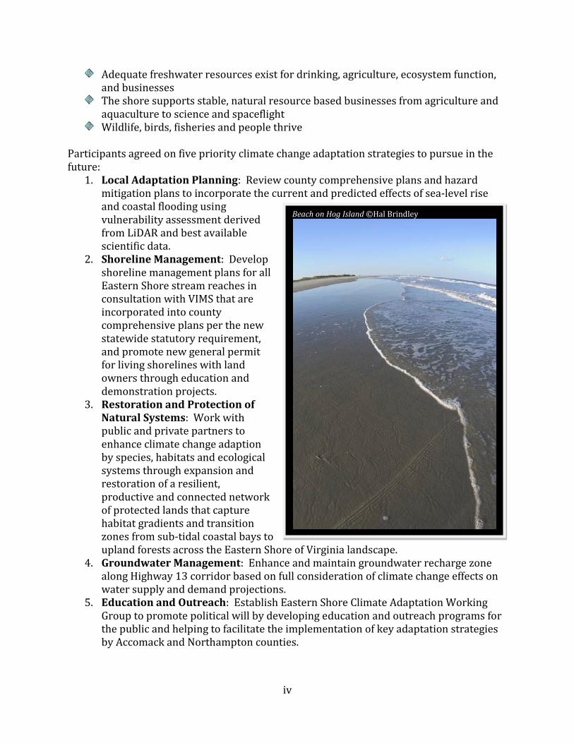
Beach on Hog Island ©Hal Brindley

v
While many challenges are associated with these strategies, there are an equal number of emerging opportunities—in terms of information and action--that Eastern Shore localities and stakeholders can take advantage to prepare citizens and natural systems to better adapt to climate change. These include:
The forthcoming LiDAR vulnerability assessments, which will greatly inform hazard mitigation planning, county comprehensive planning, and land use policy
The new shoreline management legislation that requires shoreline management plans and living shoreline general permit regulation for coastal localities
Eastern Shore Hazard Mitigation Plans revision Accomack and Northampton Counties’ Comprehensive Plan reviews and updates Accomack and Northampton Counties’ Water Supply Plan reviews Virginia Coastal Zone Management Program’s Special Area Management Plan
process. Potential boundary expansion of the Chincoteague National Wildlife Refuge to adapt
to sea-level rise through the U.S. Fish and Wildlife Service’s Comprehensive Conservation Plan
Virginia Coastal Zone Management Program’s funding of the Seaside Coastal Partnership along with a pending funding request to the NOAA Community Partnership Grant program continue restoring oysters and eelgrass in the coastal bays
To take full advantage of these opportunities, many workshop participants have agreed to serve on the Eastern Shore Climate Adaptation Working Group. With better understanding of climate change effects comes the realization that those changes will profoundly affect all people who live here, regardless of age, occupation or neighborhood. Livelihoods will be jeopardized, infrastructure will be threatened and human health and safety will be at greater risk. A knowledgeable citizenry and informed decision-making based on the most realistic assessment of risk to the community will be the foundation future efforts. There is clear consensus by the working group that much can be done to manage and minimize disruptions to this community, and the time to take action is now.
Volunteer workday at Brownsville Preserve ©TNC

vi

vii
Table of Contents
Acknowledgements ............................................................................................................................................................. i Executive Summary ........................................................................................................................................................... iii Table of Contents............................................................................................................................................................... vii Introduction .......................................................................................................................................................................... 1
What Is at Stake? ................................................................................................................................................................. 8
Vision for Adaptation ...................................................................................................................................................... 12
Priority Adaptation Actions ......................................................................................................................................... 13
Adaptation Action #1. Local Adaptation Planning ........................................................................................ 14
Adaptation Action #2. Shoreline Management Plans ................................................................................... 19
Adaptation Action #3. Restoration and protection of natural systems................................................. 24
Adaptation Action #4. Groundwater Management ....................................................................................... 31
Adaptation Action #5. Education and Outreach ............................................................................................. 38
Conclusion ........................................................................................................................................................................... 41
References ........................................................................................................................................................................... 43
MAPS Map 1. General reference map of the Eastern Shore of Virginia……………………………………………………………….4 Map 2. Conservation lands by ownership on the Virginia Eastern Shore………………………………………………….5 Map 3. Illustration of the geographic coverage and available LiDAR data for the Eastern
Shore of Virginia……………………………………………………………………………………………………..……………….16 Map 4. Eastern Shore ground water map showing the location of recharge, transitional, and
discharge areas………………………………………………………………………………………………………………..………33 TABLE Table 1. Summary of projected global climate change effects at the Eastern Shore of Virginia…………………6 Table 2. Membership of the Eastern Shore Climate Adaptation Working Group……………………………………..40 BOXES Box 1. Summary of concerns regarding resources at risk due to climate change on the
Eastern Shore of Virginia………………………………………………………………………………………………………….10 Box 2. Five priority climate change adaptation actions……………………...………………………………………………….13 Box 3. What is LiDAR?.........................................................................................................................................................................17 Box 4. Coastal shoreline continuum ideal and living shorelines treatment…………………………………………….21 Box 5. Conceptual ground water flow illustration for the Eastern Shore of Virginia………...………………….....32 Box 6. Conceptual diagram of aquifer storage and recovery system………………………………………………..…………37 APPENDICES

viii

Eastern Shore of Virginia: Strategies for Adapting to Climate Change 1
Introduction Human communities and wildlife on the Eastern Shore of Virginia (Map 1) have been dealing with the vagaries of climate, storms, flooding and rising sea levels since the end of the last glacial period 18,000 years ago. With European settlement of the barrier islands and southern Delmarva Peninsula beginning in the early 17th century, towns and local economies have prospered and boomed only to wither away or be abandoned due to major storms, flooding and shifting shorelines—or as in the case of the towns of Chincoteague and Wachapreague, to rebuild repeatedly. The most famous example is the town of Broadwater, founded on Hog Island in the mid-19th century that was a part of the popular hunting, fishing and tourist-based barrier island economy on the Eastern Shore. Broadwater thrived for decades before Hog Island’s shoreline dramatically shifted due to storms, erosion and overwash, forcing residents to evacuate for good in 1941. From the Great September Gust of 1821 to the 1933 hurricane known as the August Storm to Hurricane Isabel in 2003, storms and flooding have shaped culture, economies and natural systems on the Eastern Shore and its barrier islands, defining a way of life. The Eastern Shore, therefore, is no stranger to climate change and the inherent hazards associated with living in a dynamic coastal environment. However, our growing body of knowledge about global climate change strongly indicates that the rates of change and scale of impact will be greater in intensity and severity than ever before. Based on recent reports (Table 1 and references therein), we can expect sea levels to rise at an accelerated rate of at least a meter or more by 2100. Rising sea levels, along with the potential increased intensity and frequency of storms, will lead to increased coastal flooding, erosion and inundation. In addition, warming air temperatures will likely lead to more extremes in precipitation, with wetter winters and drier, hotter summers expected and multi-year droughts likely to be more frequent and severe. In response to air temperature increases, water temperatures will likely rise in streams, tidal creeks and lagoons, and water chemistry will become more acidic in ocean waters. These are extraordinary stresses even on a resilient natural system that is accustomed to stress; they are likely to be catastrophic to a human community that is unprepared. While little certainty exists regarding rate of change and predictability of specific effects, the probability that the Eastern Shore will experience greater scope and scale of changes relative to past decades and centuries is likely. The built environment and human footprint is more extensive than in the past due to second home development along vulnerable shorelines and improving infrastructures. The rural economy that is based primarily on
Participants at August Workshop @ G. Crichton
Eastern Shore of Virginia: Strategies for Adapting to Climate Change 2
agriculture, poultry industry, aquaculture, tourism and NASA spaceport at Wallops Flight Facility is fragile at best, with Accomack being one of the poorest counties in Virginia. At
the same time, the Eastern Shore enjoys the benefits of protection by a mostly wild and unaltered chain of barrier islands and extensive marshes that help absorb nature’s shocks by protecting the mainland from flooding, erosion and storm surges (Map 2). While the system has more resiliency due to the high proportion of coastal wetlands, island and mainland edge protected by The Nature Conservancy, U.S. Fish and Wildlife Service, the National Park Service and others, the specter of global climate change renders the Eastern Shore vulnerable to dramatic changes over the next century. There is ample opportunity to begin planning now for the future to effectively build on the natural resiliency of this unique place and adapt to the coming changes. Toward this end, The Nature Conservancy launched a climate change adaptation project for the Eastern Shore of Virginia to more specifically characterize the current understanding of potential ecological effects due to climate change. In collaboration with partners and the local community, the Conservancy set out to identify strategies that can enhance resilience and facilitate adaptation of this globally important and productive coastal area upon which local communities and wildlife depend. We held a workshop in early 2009 in which we brought together 30 academic experts and researchers from 12 institutions to characterize local climate change effects to ecological systems at the Virginia Coast Reserve on the Eastern Shore and the associated uncertainty with these effects. The synthesized outcomes of the workshop were summarized in a report entitled “Effect of Global Climate Change at the Virginia Coast Reserve” (TNC 2010). This first workshop was a research-based exercise attended by academics, applied conservation scientists, and ecologists. It focused on the Conservancy’s deep investments in protection and management of islands, marshes and mainland habitats on the shore. During this process, we quickly recognized that developing meaningful strategies for adaptation of the natural environment was inherently linked with how human communities respond to climate change, for better or worse. We broadened the focus of the adaptation project to more deliberately include the range of people, industry and communities that will be affected by sea-level rise and other climate change effects. In August 2010 we held a second workshop that included local representatives from
aquaculture, agriculture, local government and community organizations (Appendix A). The objectives of the workshop were to accomplish the following (Appendix B):
Postcard from 2080: Dear Annie, Wish you were here. You would not believe the great job they have done here in maintaining functional coastal ecosystems. The islands have migrated westward up to two miles in some places, but the marshes look healthy in a surprising number of places. The seaside villages are, of course, smaller (Oyster is largely abandoned), but nice, small, high density villages more inland have replaced them. The national trend toward more locally-grown, organic foods has been a great boom for the area, leading to the re-emergence of small vegetable farms. Your pal, Frank

Eastern Shore of Virginia: Strategies for Adapting to Climate Change 3
1. Identify a set of shared concerns and
goals regarding common resources, ecological services and community assets vulnerable to global climate change.
2. Identify and prioritize adaptation strategies for sustaining resources, ecological services and community assets of concern.
3. Outline follow-up actions for soliciting wider initial outreach, broader input on strategies and greater participation in implementation actions.
This report represents the proceedings from this second workshop and relevant activities and developments that have transpired since. The report for both workshops and related materials (e.g. presentations, handouts, etc.) are available online at ://conserveonline.org/workspaces/e-shore-va-cc-adaptation.
Catch of the day @ Dave Burden

Eastern Shore of Virginia: Strategies for Adapting to Climate Change 4
Map 2. General reference map of the Eastern Shore of Virginia.

Eastern Shore of Virginia: Strategies for Adapting to Climate Change 5
Map 2. Conservation lands by ownership on the Virginia Eastern Shore.

Eastern Shore of Virginia: Strategies for Adapting to Climate Change 6
Table 1. Summary of projected global climate change effects at the Eastern Shore of Virginia.
SUMMARY OF PROJECTED CLIMATE CHANGES
Climate Variable
General Change
Expected Specific Change Expected
Size of Projected Change compared to Recent Changes
Information About Seasonal Patterns
of Change Confidence Source(s) & Context
Sea level Increase Relative sea-level rise predicted to rise by approximately 1 meter (3.3 feet) or more by 2100 in Mid-Atlantic.
In Mid-Atlantic, relative sea-level rose by 30.5 cm (1 foot) in 20th century; current rate of relative sea-level rise for Eastern Shore is 4 mm (0.16 inch) per year.
n/a High confidence that sea-level is rising, but local rate of increase and subsidence less certain.
-Publication: Williams et al. 2009 -NOAA Tide Predictions Database
Temperature Increase Eastern Shore could experience an increase of 3.8° to 8° F compared to 1961-1990 average.
Projected warming at least double that experienced throughout southeast during the 20th century.
The number of days with high temperatures extremes will increase, with a significant increase in the number of days per year over 90°F.
High confidence that warming will occur in Mid-Atlantic region.
-Karl et al. 2009 -Projections derived
from several climate models on climatewizard.org
Precipitation Unknown E. Shore could experience either an average annual decrease of precipitation by 16% or an annual increase of almost 20% by 2080 compared to 1961-1990 average; distribution of seasonal rainfall will change. Increase in multi-year droughts.
Projected precipitation changes will be more extreme than in 20th century. Since mid-1970s, southeast has experienced increases in heavy downpours and increases in moderate to severe droughts (trend has varied locally).
Wetter winters/ springs and drier summers/falls.
High uncertainty regarding actual projected changes in precipitation. Moderate certainty that precipitation extremes will occur with wetter winters and drier growing season.
-Karl et al. 2009 -Projections derived
from several climate models on climatewizard.org
Storms Unknown Increasing sea surface temperatures will lead to increased intensity of hurricanes (for each 1.8° F increase in sea surface temp, tropical storm rainfall rates increase by 6-18% ) Higher frequency and intensity of Nor’easters.
During the past 30 years, annual sea surface temperatures have increased by almost 2°F in Atlantic hurricane development region, coinciding with an increase in tropical storm/ hurricane intensity. E. Shore has had 15 Nor’easters on average per year from 1885 to 1990 characterized by high variability from year to year.
Hurricanes will occur in growing season while Nor’easters will typically occur in winter months (late fall to early spring).
Uncertainty regarding whether tropical storms and hurricanes will occur with more intensity in Mid-Atlantic and Eastern Shore. High uncertainty and inconclusive data regarding the increase in intensity or frequency of Nor’easters on the Eastern Shore.
-Karl et al. 2008 -Karl et al. 2009 -Hayden and Hayden 2003 -Hayden et al. 1999

Eastern Shore of Virginia: Strategies for Adapting to Climate Change 7
SUMMARY OF PROJECTED CLIMATE CHANGES
Climate Variable
General Change
Expected Specific Change Expected
Size of Projected Change compared to Recent Changes
Information About Seasonal Patterns
of Change Confidence Source(s) & Context
CO2 levels Increase Global atmospheric CO2
concentrations predicted to increase 41-158% (between 583-983 ppm) by 2100. Dissolved inorganic carbon will decrease 60% in world oceans by 2100 leading to a decrease in ocean pH to 7.7 by 2100.
Atmospheric CO2 has increased from 318 ppm to 387 ppm since 1959. Current average ocean pH is 8.05.
N/A Very high certainty that CO2 is increasing, but uncertainty regarding rate of increase in CO2
given changing technologies, demand, and global treaties and policies on greenhouse gas emissions.
-Solomon et al. 2007 -Dr. Pieter Tans, NOAA/ESRL ( .esrl.noaa.gov/gmd/ccgg/trends/) -Orr et al. 2005 -Nicholls et al. 2007)

Eastern Shore of Virginia: Strategies for Adapting to Climate Change 8
What Is at Stake? During the workshop, we strove to develop a common understanding of the community concerns about the hazards and other effects of climate change to the Eastern Shore and collectively, the most highly valued human and natural assets vulnerable to such hazards. A panel that represented a cross-section of sectors on the Eastern Shore (Appendix B) was asked to discuss the following two questions in a plenary format followed by small group
discussions:
1. Which climate change effects and coastal hazards is your community or sector most concerned about (e.g. flooding, inundation, salt water intrusion, storm surge, winter storms)?
2. Which highly valued human or natural assets or resources are potentially most vulnerable to these hazards (e.g. public infrastructure and utilities, private property, agricultural activities, real estate, water resources, public health, aquaculture industry, marshes, wildlife, barrier islands, etc.)? Describe the societal, economic, and ecological value of these assets and resources at risk. During the panel discussion and the small group discussions, workshop participants expressed several concerns about how climate change will impact the community and identified many highly valued human and natural assets, resources and services that may be vulnerable (Box 1). Overall, participants expressed a great love for the Eastern Shore and a recognition that its way of life, culture and economy is changing and at risk due to sea-level rise and other effects of global climate change. One of the most significant concerns expressed by participants was the lack of political will and public education about global climate change and sea-level rise on the Eastern Shore. The consensus among participants was that public understanding and education regarding the implications and consequences of sea-level rise, coastal flooding, and other global climate change effects is poor.
Long-time or multigenerational residents are highly invested in staying in the same place. The current status-quo policy regarding vulnerable residential and commercial infrastructure in Accomack and Northampton counties is to keep structures in place and enable them to withstand flooding and damage. A program through the A-NPDC assists homeowners in low-lying coastal areas by providing money to enable them to elevate their homes. While moving people is far more cost-effective and funds are available to move people to higher ground, long-time residents are determined to stay where they are.
Postcard from 2080: Dear Fred, Great stay here on VA’s Eastern Shore. We are in a B&B in the town center. I took a bike ride along the seaside trail through a forest. It reminds me of visiting Germany’s concentrated villages and rural countryside, intact beaches, underdeveloped shorelines, great fall migration. Sincerely, Your Uncle Ned

Eastern Shore of Virginia: Strategies for Adapting to Climate Change 9
Newer residents and second home-owners invest a great deal of money in staying where they are by raising houses and constructing barriers around their property, including armoring shorelines with revetments, bulkheads and seawalls. This population may well be aware of the risks, but can afford to mitigate for flooding or rely on their insurance policies and federal subsidies for compensation. Workshop participants also recognized that, relative to most coastal communities on the Atlantic seaboard, the Eastern Shore of Virginia will likely be more resilient to the negative effects of global climate change because of its rural, agrarian character and the fact that the majority of the marshes, barrier islands and mainland edge are protected. Agriculture is still the dominant land use on the mainland. More than 90% of the shoreline and more than 133,000 acres are in conservation or public ownership (Map 2). 80,000 acres of highly productive marshes covers the coastal bays providing flood control, filtering water, and providing habitat for birds and other wildlife. Of the 18 barrier island, 14 are in conservation ownership, remaining unaltered and allowed to naturally function and migrate as barriers in response to the sea’s winds, storms and tides. This provides residents of the Eastern Shore a unique opportunity to adapt well to changes that will be wrought by climate in the future, providing more options than might otherwise be possible. Box 1 summarizes specific concerns about the effects of climate change to Eastern Shore resources articulated by workshop participants under the headings of freshwater supply, agriculture, natural resources, infrastructure, and socio-economic issues.
Panelists at the August workshop (from left to right: Josh Freeman, Grayson Chesser, Tom Walker, Elaine Meil and Laura McKay © G. Crichton

Eastern Shore of Virginia: Strategies for Adapting to Climate Change 10
Box 1. Summary of concerns regarding resources at risk due to climate change on the Eastern Shore of Virginia. Freshwater Supply • Shrinking aquifer lens and shrinking recharge areas leading to decrease in groundwater
supply • Diminishing drinking water supply and degraded drinking water quality • Failing private septic systems • Saltwater intrusion into shallow water wells • Challenge of maintaining National Wildlife Refuge freshwater impoundments in order
to protect migratory waterfowl • More irrigation ponds built in creeks Agriculture • Loss of productive, arable land due to inundation • Diminished crop productivity • Increased risk of heat stress to crops • Increased demand for irrigation water due to longer and warmer growing season
coupled with current inefficient water delivery and storage system • Range shift northward of commodity crops, e.g. currently experiencing a decrease in
market window for tomatoes • Increased risk of pest outbreaks and weeds Forests • Reduction of forested area due to inundation • Increase in growth and productivity in the near-term where soil moisture is adequate
and fire risk is low • Shift in the distribution and range of species • Increased risk of forest insect and diseases outbreaks and competition from invasive
species • Increased risk of wild fires Coastal Ecosystems and Services • Accelerated landward migration and erosion of barrier islands; thinner, smaller barrier
islands may lead to more storm damage and flooding of mainland • Loss of tidal salt marsh, and, as a consequence:
o reduced protection and buffering from storm surges and flooding o loss of filtration of run-off leading to degraded water quality o reduced productivity leading to poorer fisheries
o Shifting productivity of aquaculture beds Biodiversity • Shift in the distribution and range of species • Loss of species not able to adapt to changes (e.g. eelgrass) • Increase in predation and disease (e.g., to oysters) • Loss of habitat (e.g., tidal salt marsh and wetlands) • Loss of rare wetland community types, e.g., sea-level fens due to sea-level rise • Loss of rare plant communities due to invasive species • Reduction in size of sandy-bottom perennial streams

Eastern Shore of Virginia: Strategies for Adapting to Climate Change 11
Box 1. Summary of concerns regarding resources at risk due to climate change on the Eastern Shore of Virginia. Public and Private Infrastructure • Inundation and flooding of residential property in low-lying areas • Inundation of emergency shelters, such as schools and fire stations, in low-lying areas. • Damage to bridges that span necks • Damage to transportation infrastructure in general, especially Chincoteague Causeway • Storm damage to NASA Wallops Flight Facility infrastructure • Siltation of deep water ports and marine landings. Socio-Economic and Cultural Issues • Disproportionate burden on poor who can only afford to live in vulnerable low-lying
areas • Loss of tourism on Assateague and Chincoteague due to less beach access • Loss of jobs should NASA Wallops have to relocate flight facility • Vulnerable island communities: Tangier, Saxis and Chincoteague • Reduced tax base, property values and jobs • Loss of traditional development patterns, villages, hamlets, waterfront communities • Loss of family farms • Loss of important cultural/historical sites near coastline e.g., Brownsville House, old
cemeteries • Loss of way of life
Dock at Boxtree ©A. Wilke

Eastern Shore of Virginia: Strategies for Adapting to Climate Change 12
Vision for Adaptation Participants were asked to imagine how the Eastern Shore’s economy, environment and culture will have adapted to climate change by 2080. The exercise involved writing a “postcard from the future” to friends or family that describe how the community and place will have changed due to climate change and how effectively people will have adapted to these changes by 2080. The purpose of this exercise was to ask participants to describe their vision for an Eastern Shore that successfully adapts to the changing climatic conditions. Samples of these postcards from 2080 are inserted throughout this document as sidebars. Based on the results of this exercise, workshop participants agreed to a shared vision for how they want the Eastern Shore to adapt to climate change by 2080. The core components of this common vision are as follows:
Coastal resources migrate and remain productive as sea-level rises
Planned, livable and safe communities are resilient to climate change
Adequate freshwater resources exist for drinking, agriculture, ecosystem function, and businesses
The shore supports stable, natural resource based businesses from agriculture and aquaculture to science and spaceflight
Wildlife, birds, fisheries and people thrive These aspirational goals formed the basis for the discussion on adaptation actions.
Postcard from 2080 Dear John, I’m staying in a B&B, a very popular option for tourists there these days. The locals have been successful in promoting sustainable tourism in the form of hunting, fishing, bird watching and, because this is still one of the few intact coastal zones along the Atlantic seaboard, tourism has caught on globally. Green energy companies have established themselves here. Several towns have doubled or tripled in size while retaining their historic charm in key commercial areas and neighborhoods. The zoning, land, buffer, conservation and water management planning showed such amazing foresight and tenacity that, although this area has changed, it retains much of its quality and charm. Sincerely, Your Uncle Fred
Seaside Coastal Bay ©Hal Brindley

Eastern Shore of Virginia: Strategies for Adapting to Climate Change 13
Priority Adaptation Actions After coming to agreement about common concerns and sketching out a shared vision for climate change adaptation on the Eastern Shore, we then began to define specific adaptation strategies or actions that could be collectively implemented by localities, state/federal agencies, non-profits, private industry/ landowners to achieve the vision. Small focus groups brainstormed lists of potential adaptation actions, exploring the full gamut of possibilities and opinions about how to design a road map for adaptation on the Eastern Shore. To ensure maximum input by all participants, we employed a “world café” approach, in which four small groups rotated every 20 minutes among four different strategy topics: forests and farms, the built environment, freshwater resources and coastal resources. The following question was posed to each group: What actions can be taken to facilitate the adaptation of the Eastern Shore to climate change factors and build resiliency into human and natural resources? Collectively the groups generated 40 strategies listed in Appendix C. Participants were asked to review all 40 strategies and vote for only five which they believed to be most important to meet adaptation goals. The five actions selected by the group are listed in Box 2. Participants were asked to articulate the benefits of these strategies, the opportunities, needs and challenges involved with implementation, and the initial action steps. Below, each of these strategies is discussed in more detail.
Box 2. Five priority climate change adaptation actions
1. Local Adaptation Planning: Review county comprehensive plans and hazard mitigation plans to incorporate the current and predicted effects of sea-level rise and coastal flooding using vulnerability assessment derived from LiDAR and best available scientific data.
2. Shoreline Management: Develop shoreline management plans for all Eastern Shore stream reaches in consultation with VIMS that are incorporated into county comprehensive plans per the new statewide statutory requirement, and promote new general permit for living shorelines with land owners through education and demonstration projects.
3. Restoration and Protection of Natural Systems: Work with public and private partners to enhance climate change adaption by species, habitats and ecological systems through expansion and restoration of a resilient, productive and connected network of protected lands that capture habitat gradients and transition zones from sub-tidal coastal bays to upland forests across the Eastern Shore of Virginia landscape.
4. Groundwater Management: Enhance and maintain groundwater recharge zone along Highway 13 corridor based on full consideration of climate change effects on water supply and demand projections.
5. Education and Outreach: Establish Eastern Shore Climate Adaptation Working Group to promote political will by developing education and outreach programs for the public and helping to facilitate the implementation of key adaptation strategies by Accomack and Northampton counties.

Eastern Shore of Virginia: Strategies for Adapting to Climate Change 14
Adaptation Action #1. Local Adaptation Planning Review county comprehensive plans and hazard mitigation plans to incorporate the current and predicted effects of sea-level rise and coastal flooding using vulnerability assessment derived from LiDAR and best available scientific data. Recommended steps to implement this action, each discussed in more detail below:
1. Convene Eastern Shore LiDAR Working Group to ensure the coordinated and efficient distribution, storage, and analysis of the LiDAR data in evaluating vulnerability of coastal areas to sea-level rise.
2. Incorporate sea-level rise data and vulnerability analysis in revision of Eastern Shore Hazard Mitigation Plan and Northampton and Accomack County Comprehensive Plans and amend plans to better protect vulnerable areas and promote adaptation.
3. Hold series of public outreach forums to educate community about vulnerable areas and introduce alternative scenarios for adaptation as part of the Eastern Shore Hazard Mitigation Plan revision and Northampton and Accomack County Comprehensive Plans review process.
1. Convene Eastern Shore LiDAR Working Group to ensure the coordinated and
efficient distribution, storage, and analysis of the LiDAR data in evaluating vulnerability of coastal areas to sea-level rise.
Effective adaptation planning on the Eastern Shore requires analyzing various flooding and inundation scenarios using high-resolution elevation data. Toward this end, The Nature Conservancy, University of Virginia’s Long-Term Ecological Research project (LTER), and the U.S. Geological Society (USGS) contracted Sanborn Geospatial to fly and process Light Detection and Ranging (LiDAR) data for the entirety of Northampton and Accomack counties (Map 3, Box 3). These data will be publically available by early summer 2011. Workshop participants recommended that an Eastern Shore LiDAR Working Group be convened to ensure the best and most efficient application and analysis of the LiDAR data in evaluating vulnerability of coastal areas to sea-level rise. This group consists of GIS users from localities, the Accomack-Northampton Planning District Commission (A-NPDC), National Oceanic and Atmospheric Administration’s (NOAA) Coastal Services Center, the U.S. Fish and Wildlife Service (USFWS), Virginia Coastal Zone Management Program (CZM), Virginia Department of Conservation and Recreation (DCR), Virginia Institute of Marine Sciences (VIMS), the National Park Service (NPS), The Nature Conservancy, LTER, and the Virginia Geographic Information Network (VGIN). The common goal of this group is to characterize the vulnerability, risk, and resiliency of the Eastern Shore mainland, marshes and barrier islands to accelerated sea-level rise and storm surges. Ultimately, local, state, federal and non-governmental entities will need to agree to a common set of assumptions regarding how sea-level rise and flooding will affect shared resources on the Eastern Shore in order to successfully work together on actions to prepare for and appropriately adapt to coming changes. This will only be achieved through close coordination and communication regarding the application, analysis and interpretation of the LiDAR data.

Eastern Shore of Virginia: Strategies for Adapting to Climate Change 15
Toward this end, the LiDAR working group developed a work plan regarding the distribution, storage, and use of these data to most efficiently leverage its impact with elected local officials and the community at large (see attachment entitled “Eastern Shore LiDAR Data Plan for Distribution, Storage and Use”). Preliminary sample data products have also been developed as a preview of how these data can be used to assess vulnerability of places and resources to sea-level rise (Box 3). Once the data are fully quality assessed, the NOAA Coastal Services Center (CSC) will analyze the vulnerability of infrastructure, tax parcels, land use, conservation lands and habitat types to sea-level rise and inundation. The following products will be included as part of CSC’s analyses:
• Assessment showing predicted inundation at high tide for baseline conditions, selected sea-level rise increments to be determined overlaid with lands in conservation ownership and habitat/ land cover types.
• Maps showing frequency and duration of shallow flooding in flood-prone areas under baseline conditions and various sea-level rise scenarios based on predicted water levels exceeding specific tidal heights as issued by the local National Weather Service office.
• Basic model and maps depicting shifting tidal salt marsh distribution based on elevation and frequency of inundation under various sea-level rise scenarios subtracting rates of accretion
• Maps of relative confidence regarding sea-level rise inundation areas based on errors (uncertainty) in elevation and tidal data.
The Conservancy, VGIN, LTER and USGS will develop a coordinated media and public outreach effort once the data are publically released. In addition, these entities will host an open house for community groups to learn about the LiDAR data and how it can inform planning for adaptation to sea-level rise and coastal flooding.
Small discussion group at August workshop ©B. Kittrell

Eastern Shore of Virginia: Strategies for Adapting to Climate Change 16
Map 3. Illustration of the geographic coverage and available LiDAR data for the Eastern Shore of Virginia.

Eastern Shore of Virginia: Strategies for Adapting to Climate Change 17
Box 3. What is LiDAR?

Eastern Shore of Virginia: Strategies for Adapting to Climate Change 18
2. Incorporate sea-level rise data and vulnerability analysis in revision of Eastern Shore Hazard Mitigation Plan and Northampton and Accomack County Comprehensive Plans and amend plans to better protect vulnerable areas and promote adaptation.
Amending the hazard mitigation plan (HMP) and county comprehensive plans (“comp plans”) to incorporate high resolution elevation models that identify property, resources and infrastructure most vulnerable to coastal flooding is the first and most fundamental step in achieving tangible adaptation actions related to land use regulations. Potential adaptation actions that should be considered by localities in these planning efforts include overlay zones or tiered zoning with increasingly strict regulations within areas of vulnerability and increased no-build buffers in areas of vulnerability. Workshop participants strongly recommended that inundation and flooding models using LiDAR data should be integrated into future revisions of the 2005 Hazard Mitigation Plan and county comp plans. The HMP process is organized and led by the A-NPDC staff. The counties are required by the Virginia Department of Emergency Management to develop an HMP to qualify for federal funding from Federal Emergency Management Act’s Hazard Mitigation Grant Program under the Disaster Mitigation Act of 2000. The public is given opportunities to provide comment on the HMP revisions, which occur every five years which and are also subject to Board of Supervisor approval. Proposed mitigation actions recommended in the hazard mitigation plan must be formally adopted into the comp plan and land use ordinances to have regulatory authority. Therefore, it is critical that the analysis and recommendations included in the mitigation plan are included in the comp plans as well. Both counties are preparing for full updates of their comp plans in the next couple of years. Updates will be largely driven by inclusion of vulnerability assessment and recommendations in hazard mitigation plan regarding coastal flooding and sea-level rise. As background, the Code of Virginia requires county comprehensive plans guide all land use and zoning decisions by county officials. This code also mandates that the comp plan be reviewed at least once every five years. Proposed amendments or revisions to the comp plan are submitted for public review process, which includes public hearings before the Planning Commission and Board of Supervisors. Amendments must be officially voted upon and adopted by the Board of Supervisors to change the comp plan.
Small group discussion at August Workshop ©B. Kittrell
Eastern Shore of Virginia: Strategies for Adapting to Climate Change 19
3. Hold series of public outreach forums to educate community about vulnerable areas and introduce alternative scenarios for adaptation as part of the Eastern Shore hazard mitigation planning and county comprehensive plan review process.
Overall, participants warned about the tremendous challenge involved in amending comp plans to include new land use regulations or zoning ordinances in response to sea-level rise. They said that the key to ensuring amendments pass is to engender strong community support while developing revisions to the comp plans. One major recommendation was that as part of the HMP revision process and comp plan updates, A-NPDC hold public forums to present findings of the vulnerability analysis using LiDAR data and explore alternative adaptation scenarios. This would enable the public to understand the issues and the range of options regarding land use regulations and incentives to mitigate the hazards of sea-level rise and inundation. Public safety should be one of the main drivers of these alternatives for adaptation. In preparing for their comp plan review, Accomack County is currently laying the groundwork for incorporation of sea-level rise into the update through a grant received from the Virginia Coastal Zone Management. The purpose of this grant is to implement the Accomack County Sustainable Community Project that builds upon the Blue and Green Infrastructure Study completed in early 2010. This grant project involves preparing information on the effects of sea-level rise (using LiDAR data) and related topics such as erosion and storm water that will be featured on the Accomack County website and included as an element in the comp plan revision. Part of the grant deliverables include offering a public workshop about sea-level rise and these other issues to raise community awareness and offer practical solutions and best practices addressing flooding and erosion. This work will complement the efforts of the A-NPDC to hold public forums regarding the vulnerability analyses and adaptation alternatives. Adaptation Action #2. Shoreline Management Plans Develop shoreline management plans for all Eastern Shore stream reaches in consultation with Virginia Institute of Marine Sciences (VIMS) that are incorporated into county comprehensive plans per the new statewide statutory requirement, and promote new general permit for living shorelines with land owners through education and demonstration projects. Recommended steps to implement this action, each discussed in more detail below:
Postcard from 2080: Dear Mary, I am having a wonderful vacation here on the Eastern Shore. The kayaking and fishing are as wonderful as they were sixty years ago when were first visited here. What is interesting is that the tidal marshes and estuaries are all several miles to the west of where they used to be. Thank goodness local leaders understood the importance of allowing natural habitat to evolve as climate changed. They even helped facilitate it! Love, John

Eastern Shore of Virginia: Strategies for Adapting to Climate Change 20
1. Promote and implement new legislation passed by the General Assembly that requires localities to incorporate coastal resource management guidance (aka plans) into scheduled revision of comp plans.
2. Promote new general permit for “living shorelines” as the preferred alternative to stabilize shorelines by continuing to build on past public outreach and education programs regarding alternative shoreline management through workshops and demonstration projects such as Occohannock Creek.
1. Promote and implement new legislation passed by the General Assembly that
requires localities to incorporate coastal resource management guidance (aka plans) into scheduled revision of comp plans.
Shoreline armoring using sea walls, revetments, bulkheads, groins or jetties, while often effective at protecting private property in the short term, tends to exacerbate rather than prevent erosion in the long term by disconnecting shoreline habitats from the water. This
in turn causes a loss of beaches, marshes and other transitional habitats that support a diversity of wetland vegetation, birds, crabs, fish and other invertebrates. Hardened structures along shorelines essentially make it impossible for important habitats such as marshes to migrate or adapt to rising water levels, thereby eliminating important ecosystem services such as flood control and water quality filtering that people rely upon. Workshop participants advocated for promoting alternative, “soft”, or
“living” shoreline management approaches that effectively stabilize the shoreline while also maintaining connectivity of the shoreline ecosystem, sustaining native habitats for wildlife and enhancing water quality. Living shoreline options may include riparian vegetation restoration and management, tidal marsh creation and enhancement, oyster reef restoration, beach nourishment and dune restoration, and bank grading (Hardaway et al. 2010). Living shorelines may also include structures such as low- or high-grade stone sills or offshore breakwaters where high energy wave action has caused significant erosion. Since the workshop in August, the Virginia General Assembly passed new legislation1 during the 2011 session that requires both comprehensive plan to include coastal resource management guidance and the development of a general permit and guidance for living shorelines as the preferred alternative to stabilize tidal shorelines in the Commonwealth ( ://lis.virginia.gov/cgi-bin/legp604.exe?111+ful+SB964ER). Prior to this legislation being 1 As of this writing, the Senate Bill 964ER has not yet been signed into law by the governor.
Living shoreline project in Oyster ©J. Scalf
Eastern Shore of Virginia: Strategies for Adapting to Climate Change 21
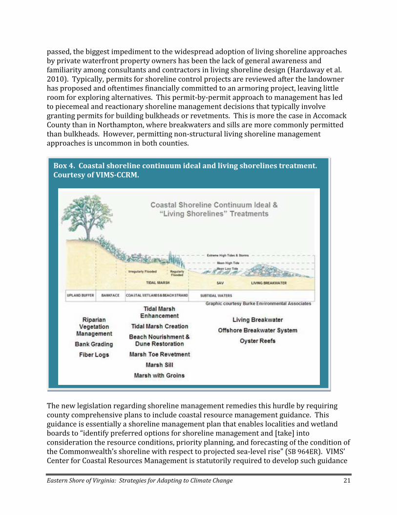
passed, the biggest impediment to the widespread adoption of living shoreline approaches by private waterfront property owners has been the lack of general awareness and familiarity among consultants and contractors in living shoreline design (Hardaway et al. 2010). Typically, permits for shoreline control projects are reviewed after the landowner has proposed and oftentimes financially committed to an armoring project, leaving little room for exploring alternatives. This permit-by-permit approach to management has led to piecemeal and reactionary shoreline management decisions that typically involve granting permits for building bulkheads or revetments. This is more the case in Accomack County than in Northampton, where breakwaters and sills are more commonly permitted than bulkheads. However, permitting non-structural living shoreline management approaches is uncommon in both counties.
The new legislation regarding shoreline management remedies this hurdle by requiring county comprehensive plans to include coastal resource management guidance. This guidance is essentially a shoreline management plan that enables localities and wetland boards to “identify preferred options for shoreline management and [take] into consideration the resource conditions, priority planning, and forecasting of the condition of the Commonwealth’s shoreline with respect to projected sea-level rise” (SB 964ER). VIMS’ Center for Coastal Resources Management is statutorily required to develop such guidance
Box 4. Coastal shoreline continuum ideal and living shorelines treatment. Courtesy of VIMS-CCRM.

Eastern Shore of Virginia: Strategies for Adapting to Climate Change 22
for local governments. To comply with this new legislation, Northampton and Accomack counties, along with other partners such as The Nature Conservancy, will work with VIMS to develop shoreline management plans, which will then be incorporated into the next scheduled review of the county comprehensive plan for each respective county. Specifically, shoreline management plans characterize the condition of distinct sections or reaches of the shoreline, including information on the presence of existing marine resources, wave climate, storm surge and long-term sea-level rise projections (Hardaway et al. 2010). This information is used to provide the most appropriate management recommendations to stabilize individual reaches. In each case, these recommendations seek to ensure maximum connectivity between vegetated uplands, marshes, and inter- and sub-tidal habitats (e.g., oyster reefs or submerged aquatic vegetation) to sustain functional shoreline ecosystems that protect against erosion, buffer sediments, and improve water quality. However, the major issue facing VIMS and the localities in fulfilling the new statutory mandate to prepare coastal resource management guidance for shorelines is that the state has not allocated any specific funds to conduct this work. VIMS is pursuing funding for this mandate from the Environmental Protection Agency’s Wetlands Program Development Grants program and has no expectation that localities will contribute financially to developing the shoreline planning process. VIMS has some start-up funding to conduct a shoreline condition inventory for Northampton County, which will be complete by October 2011.
Promote new general permit for “living shorelines” as the preferred alternative for stabilizing shorelines in Virginia by continuing to build on past public outreach and education programs regarding alternative shoreline management through workshops and demonstration projects such as Occohannock Creek.
Shoreline management plans will recommend variations of living shorelines as the preferred alternative for controlling erosion along most reaches in a locality. Under the new legislation, VMRC, in consultation with DCR and VIMS, is required to develop a general
permit regulation that authorizes and encourages the use of living shorelines as the preferred alternative for shoreline stabilization in the areas of tidal influence throughout the state. This, in and of itself, will create an incentive for landowners to implement living shorelines because it would greatly simplify and streamline the permitting process for shoreline stabilization by
Living shoreline project at Oyster ©J. Scalf

Eastern Shore of Virginia: Strategies for Adapting to Climate Change 23
creating less review time and obviate the need for public hearings while also reducing or eliminating the overall permitting fees. There will be significant opportunity for public comment and negotiation regarding the requirements included in the general permit regulation as it is developed over the next year. Eastern Shore stakeholders and community leaders will have a role in publicly supporting and advocating for a permit regulation that fully supports living shoreline options that optimize healthy adaptation of wetlands and wildlife to rising sea levels. Active participation will be important to ensure an outcome that will foster adaptation of natural shorelines to sea-level rise. Obviously, it will be critical to educate landowners, contractors and county wetland boards to achieve buy-in and support for both a living shoreline general permit regulation as well as a county-specific shoreline management plan. Such buy-in will happen most effectively through the successful demonstration and pilot projects put in place by “early adopters.” A good example: In 2008, the Eastern Shore Resource Conservation and Development (RC&D) Council funded VIMS to complete a Shoreline Management Plan for a stretch of Occohannock Creek (Hardaway et al. 2008). The purpose of this project was to demonstrate the process and benefits of living shoreline conceptual design for local contractors. More demonstration projects like this are necessary for creating the political will for Accomack and Northampton’s to support implementation of living shoreline management for these coastal areas per the new legislation. Moreover, while living shoreline projects are generally much less expensive that traditional shoreline hardening such as revetments and bulkheads, triggering such a significant departure from “business as usual” should involve financial incentives to be successful. As mentioned above, a general permit will likely provide financial relief by reducing or eliminating fees associated with individual permits. Cost-share programs or permit fee waivers are two additional approaches that have worked in other states. However, given the fiscal climate in Virginia, few opportunities for financial incentives are available to assist with the actual construction of the living shoreline, whose cost may vary greatly depending on whether earthworks and hauling heavy materials are involved. Two existing potential financial assistance programs cited by VIMS in its recommendations to the General Assembly are the Living Shorelines Initiative administered by the Chesapeake Bay Trust with NOAA Restoration Center, the Campbell Foundation, and the National Fish and Wildlife Foundation (NFWF) partners and the
Postcard from 2080: Dear Michael, The shore community is amazing! Everyone has come together with a common goal – ensuring the sustainability of the shore’s ecosystems. Large tracts of shoreline have been designated as “no build” zones. Development has been clustered using adaptive planning methods and new ideas have been developed to creatively adjust to climate change. Warm regards, William

Eastern Shore of Virginia: Strategies for Adapting to Climate Change 24
Chesapeake Bay Small Watersheds Program administered by NFWF (VIMS 2010). Identifying and delivering such incentive programs to local land owners was one of the top priorities of the RC&D Council; however, upon the writing of this document, the USDA funding for Eastern Shore RC&D has been cut by the U.S. Congress. Most likely, the responsibility for delivering limited cost-share programs will be assumed by the Eastern Shore Soil and Water Conservation District. Adaptation Action #3. Restoration and Protection of Natural Systems Work with public and private partners to enhance climate change adaption by species, habitats and ecological systems through expansion and restoration of a resilient, productive and connected network of protected lands that capture habitat gradients and transition zones from sub-tidal coastal bays to upland forests across the Eastern Shore of Virginia landscape. Recommended action steps:
1. Use LiDAR vulnerability assessment to identify and prioritize critical areas for protection and restoration to facilitate adaptation and build resiliency of habitats and ecological systems on the Eastern Shore in response to accelerated sea-level rise and climate change.
2. Work with the Southern Tip Ecological Partnership (STEP) to secure funding to acquire high priority adaptation lands.
3. Develop easement restrictions that support adaptation to climate change. 4. Adaptively manage existing and emerging conservation and restoration projects
based on ecological monitoring and new research regarding climate change effects to increase the adaptive capacity and resiliency of Eastern Shore ecological systems.
5. Incorporate climate change considerations in developing a coastal and marine spatial plan under CZM-funded Special Area Management Program.
1. Use LiDAR vulnerability assessment to identify and prioritize critical areas for
protection and restoration to facilitate adaptation and build resiliency of habitats and ecological systems on the Eastern Shore in response to accelerated sea-level rise and climate change.
Mutton Hunk Fen Natural Area Preserve @ R. Ayers

Eastern Shore of Virginia: Strategies for Adapting to Climate Change 25
The Eastern Shore conservation partners are well positioned with a proven record of success and effectiveness in securing public funds to protect and conserve mainland properties via the Southern Tip Ecological Partnership (STEP). The Nature Conservancy and FWS began working together in 2002 to initiate the first major cooperative effort toward large-scale land protection and habitat restoration on Virginia’s Eastern Shore which led to a formal MOU in 2005 among the Conservancy, FWS, the Virginia Department of Conservation and Recreation (DCR), Department of Game and Inland Fisheries (DGIF), and Coastal Zone Management Program at the Department of Environmental Quality (CZM). In addition to these signatories, Ducks Unlimited, the Virginia Eastern Shore Land Trust, Northampton County and the Audubon Society also participate in STEP. The mission of STEP is to increase conservation ownership of lands in the Southern Tip and to protect and restore habitats for migratory birds. The geographical boundaries have been expanded recently to include the entire Eastern Shore of Virginia. To date, STEP has garnered over $12.6 million to protect 4,471 acres and restore 531 acres of songbird habitat. Significant opportunity exists to re-evaluate STEP goals and broaden its priorities based on assessments of habitat vulnerability using the 2010 LiDAR data to identify the most resilient lands for future investment. Specifically, to increase resiliency and facilitate climate change adaptation, the partnership’s goal is to expand the existing network of conservation lands, protect and restore additional key habitats and enhance ecological connectivity across a range of morphological gradients and a diversity ecological
transition zones from marine benthic seagrass meadows and oyster reefs, across salt marshes to upland deciduous forests and freshwater perennial streams. This vulnerability assessment may lead to the elimination of certain existing protection priorities that are poor investments in the face of sea-level rise, while new shoreline and mainland areas may emerge as resilient places for adaptation that were not previously considered priorities for protection.
2. Work with the Southern Tip Partnership to secure funding to acquire high priority adaptation lands.
Several important opportunities exist for STEP to advance adaptation-focused land protection efforts: expansion of Chincoteague National Wildlife Refuge
Postcard from 2080: Dear Kids, This is a picture of where my house at Box Tree was when I first moved here. You can see the ocean has risen, the woods have moved back up the hill and the old fireplace is now covered with oysters. But the whimbrels are still here, feeding on fiddler crabs that are still in the marsh. The water, woods and marsh are all still here – they had room to move, just like I did. But there are lots more oysters. They are big, fat and salty. You will like to eat them when you visit with your kids this fall. Love, Dad
Prairie warbler ©D. White

Eastern Shore of Virginia: Strategies for Adapting to Climate Change 26
boundaries and protection of buffer lands surrounding Wallops Flight Facility. The Chincoteague National Wildlife Refuge (NWR) will be undergoing a Comprehensive Conservation Plan (CCP) process in 2011 per the 1997 Refuge System Improvement Act. The CCP will address the management and operation plans for Chincoteague NWR including an approved acquisition boundary and a Land Protection Plan (LPP). Chincoteague NWR wants to expand refuge boundaries through the CCP and LPP process to increase conservation opportunities at a landscape scale and to better adapt refuge goals and activities to climate change, specifically sea-level rise. The CCP must go through the NEPA process in which an Environmental Assessment (EA) is typically developed, where alternatives are evaluated, public meetings held and public comments received. STEP can play an influential role in advocating for new refuge boundaries based on a careful vulnerability assessment using LiDAR data to identify areas best suited to meet FWS goals for wildlife habitat management over the long term. There is also a promising opportunity for STEP to work with NASA, the U.S Navy, Orbital
Sciences, Inc., and Accomack County to protect lands surrounding the Wallops Flight Facility to ensure that security, safety and environmental issues are addressed in anticipation of larger and more powerful rocket launches at the Wallops Flight Facility. These buffer lands can also meet conservation objectives by protecting seaside migratory land bird habitat and water quality, marsh and mudflat habitat in the coastal lagoons. Protection of buffer lands can more specifically include areas identified in the proposed CCP for the expansion of Chincoteague NWF, facilitating an extension of former
cooperative agreement between USFWS and NASA regarding land management. To accomplish protection of lands important for adaptation to sea-level rise, STEP will need to take full advantage of federal, state and local funding opportunities to fund acquisition. Programs that have funded STEP projects over the past five years include:
• The Land and Water Conservation Fund (LWCF) • The North American Wetlands Conservation Act grant program (NAWCA) • The National Coastal Wetlands Conservation Grant Program (Coastal Grants
Program) • Coastal and Estuarine Land Conservation Program (CELCP) • Farm Bill Programs including the Farm and Ranch Land Protection Program (FRPP) • Conservation Reserve Program (CRP) • Virginia Coastal Zone Management NOAA Grants Program
Tree planting at Brownsville Farm ©J. Scalf

Eastern Shore of Virginia: Strategies for Adapting to Climate Change 27
• Virginia Land Conservation Foundation (VLCF) • Private conservation donations and gifts of conservation easements
Workshop participants believe that STEP has increased chances of being funded if adaptation response becomes a key criterion for determining how federal funding sources are awarded for land conservation. STEP can do this best by demonstrating the urgent need for adaptation-response land protection programs on the Eastern Shore and thereby raising the profile of this issue. In general, federal land protection funding agencies are moving toward including such criteria in their funding opportunities. One example of this is Endangered Species Conservation Fund grants administered by the FWS under Section 6 of the Endangered Species Act, which will be placing more emphasis on funding projects that demonstrate management actions to facilitate adaptation of endangered species to climate change. In addition, the upcoming State Wildlife Action Plan (SWAP) revision to be completed by 2015 will include climate change as a major theme for management and conservation action. This will influence adaptation funding from other sources such as NAWCA that see the SWAPs as setting protection and conservation priorities statewide. Another opportunity to fund adaptation projects may lie in the revision of the Virginia Outdoors Plan (VOP) in 2012, which fulfills the planning requirement for Department of Conservation and Recreation to receive stateside LWCF funding. While the VOP focuses on state recreational needs, and will not be an adaptation plan per se, many of the recreational opportunities on the Eastern Shore will be affected by sea-level rise. Therefore, raising these concerns and ensuring their inclusion in the plan revision may help to direct more funding for adaptation protection priorities on the Eastern Shore in the future.
3. Develop easement restrictions that support adaptation to climate change. Another protection action that workshop participants suggested is to develop model aeasement restrictions that account for the changing shoreline or mean low water line as sea levels rise. These are commonly referred to as “rolling easements.” Such easements provide restrictions in which riparian and wetland/marsh buffers and delineation of wetland/marsh areas themselves move as the mean low water line migrates inland. As is already standard practice, conservation easements generally promote natural shoreline
Eelgrass seed collection ©D. White

Eastern Shore of Virginia: Strategies for Adapting to Climate Change 28
management by prohibiting hard coastal armoring or hardening and do not allow development of any new structures in riparian zones or wetland areas. Currently, easement restrictions are based on a baseline report that establishes both in the narrative and a map (using GPS locations and Virginia Base Map Imagery) the location of the wetland/marsh/stream areas and associated buffers. New model easement language should allow for reevaluation of these baseline conditions based on sea-level rise to implement dynamic restrictions that roll with the changing conditions of the property. Moreover, a significant limitation to this is that donated or voluntary rolling easements can only roll as far as the property which is eased. Should this property become entirely inundated, the riparian and wetland areas would not be protected from shoreline hardening or development on the next inland parcel. One way to address this limitation is through localities considering implementation of a rolling easement acquisition program as recommended in Governor Kaine’s Commission on Climate Change Climate Action Plan (CCC 2009). Such a program would enable the counties to acquire voluntary rolling easements that would continue to move as sea-level rises irrespective of the land owner. The Georgetown Climate Center explores the legality of rolling easements in a review of Virginia’s local government authority to manage coastal flooding related to climate change (Silton and Grannis 2010). The authors of the report state that such a program, while a promising tool for facilitating adaptation, has never been tested in Virginia and involves several legal complexities. The authors state that rolling
easement areas must be established as a recognized and enforced property interest in Virginia that can be held by public entities. Given these challenges, in the near term at least, donated conservation easements that have rolling restrictions are a much more likely avenue to protect shorelines than establishing legal precedent for a program in which localities acquire such easements.
4. Adaptively manage existing and emerging conservation and restoration projects based on ecological monitoring and new research regarding climate change effects to increase the adaptive capacity and resiliency of Eastern Shore ecological systems. Habitat restoration on the Eastern Shore of Virginia conducted by multiple federal, state and local partners on the Eastern Shore falls into two distinct categories: mainland restoration of wetland and upland forest to benefit migratory birds, and restoration of coastal bays focused on oyster reefs and
VIMS researchers at eelgrass restoration site ©D. White

Eastern Shore of Virginia: Strategies for Adapting to Climate Change 29
eelgrass meadows. Mainland restoration projects, mostly funded and implemented through STEP, have been identified and designed to protect and restore declining wetland and riparian forest habitats as well as upland forests to increase the availability of food resources during the fall stopover of imperiled neotropical migratory birds and enhance habitat values for other migratory birds. To date, STEP has restored 531 acres of mainland wetland and forest habitats. In the coastal bays, the Seaside Restoration Partnership, composed of the VIMS, VMRC, The Nature Conservancy, and CZM, was formed almost a decade ago and has been funded by the NOAA-TNC Community Restoration Program, the CZM’s Seaside Heritage Program, NOAA stimulus funds allocated under the America Recovery and Reinvestment Act of 2009, and private foundations. This restoration partnership now has a proven record of success over the past ten years in the restoration of eelgrass and oyster reefs in the coastal bays of Virginia. To date, more than fifty acres of functional oyster reefs have been restored and maintained in sanctuaries throughout the southern coastal bays, and more than 300 acres
of eelgrass have been planted via seed and now spread over 4,500 acres in four different coastal bays. This is the largest seagrass restoration project underway in the world, and the oyster restoration has now resulted in functional oyster reefs with some of the highest densities of oysters found in the mid-Atlantic region. In addition, bay scallops have been experimentally reintroduced in a field nursery site. Workshop participants raised several questions about whether these partnerships—STEP and the
Seaside Restoration Partnership—are conducting restoration in the right places with the right species within the context of a strong consideration of climate change effects. Specifically of great concern is the possible future die-off and extirpation of eelgrass from Virginia’s coastal bays due to increasing growing season water temperatures. Participants emphasized the need for ecological monitoring and research to determine how climate change factors may be affecting restoration success and that this information be used to adaptively manage these projects. Two major academic institutions, the University of Virginia’s Long Term Ecological Research Station and VIMS are actively engaged in studying climate change effects that will inform restoration activities in the future. Predicting and mitigating vulnerability of marsh ecosystems will figure prominently in LTER’s request for another six years of funding from the National Science Foundation due in January 2012. Currently, UVA researchers from LTER are completing a study that quantifies rates of shoreline changes along salt marsh
Monitoring oyster reef restoration @B. Lusk

Eastern Shore of Virginia: Strategies for Adapting to Climate Change 30
margins of coastal bays on the seaside based on historical sea-level rise and future predicted sea-level rise scenarios using an approach called “Digital Shoreline Analysis System (DSAS)” in combination with the LiDAR data (McLoughlin et al. in review). Related research initiatives include modeling how the threshold for marsh inundation is affected by the rate of relative sea-level rise and the suspended sediment concentration in the water column. This model will ultimately produce a vulnerability map for marsh loss in response to sea-level rise on the seaside of the Eastern Shore. Other research projects slated for the NSF proposal involve quantifying the ecosystem services provided by both oyster reefs and seagrass meadows, specifically investigating how these habitats may protect marsh edges from erosion and promote marsh accretion in coastal bays. Moreover, VIMS’ Center for Coastal Resources Management will be conducting a shoreline condition inventory in addition to high-resolution mapping of all marshes on the Eastern Shore using LiDAR data as part of the new statutory mandate to provide coastal resource management guidance to coastal localities in the Commonwealth. Also, CZM, working with VIMS, has recently conducted a new classification to synthesize the best available natural resource information into a single geospatial product called the Coastal Virginia Ecological Value Assessment (VEVA) that provides information on current condition and land use necessary to evaluate potential adaptation sites for protection and restoration. LTER research on predicted shoreline erosion, marsh migration and other geomorphic changes due to sea-level rise coupled with VIMS comprehensive shoreline and marsh inventory and VEVA model will inform and help identify the most resilient future protection and restoration investments in the coastal bays and on the mainland of the Eastern Shore to best facilitate climate change adaptation.
5. Incorporate climate change considerations in developing a coastal and marine
spatial plan under CZM-funded Special Area Management Program. The Special Area Management Plan currently under development through funding from the CZM program is a mechanism to evaluate the distribution and productivity of marine resources and suggest guidelines and recommendations to assist VMRC with the spatial allocation of uses on the seaside. The seaside is a particularly dynamic environment and made more so by accelerating climate change effects, creating the need for a flexible and
Skiff full of aquacultured clams ©D. Burden

Eastern Shore of Virginia: Strategies for Adapting to Climate Change 31
robust regulatory and management regime that equitably and transparently protects the overall ecological health and productivity of the system while avoiding or minimizing conflicts between stakeholders and other users. To date, project team members have mapped and completed suitability assessments for leased and public Baylor Grounds, aquaculture activities, restored oyster sanctuaries and eelgrass restoration set asides, along with shorebird foraging sites and public recreational access and uses. In many cases, current spatial allocations appear outdated, inefficient and in need of re-evaluation. Adaptation Action #4. Groundwater Management Enhance and sustain groundwater resources through incorporating climate change effects in planning for future water resource supply and demand and implementing appropriate management and conservation actions. Recommended action steps
1. Address and incorporate climate change considerations in county water supply plans and the revision of the Ground Water Supply Protection and Management Plan that includes improved projections of future water supply and demand and more comprehensive assessment of all water uses.
:
2. Increase and expand financial incentives and cost-share programs to encourage shallow water aquifer use by agricultural sector.
3. Work with dominant non-agricultural users such as the poultry industry and developers to increase water use efficiency.
4. Provide tax incentives for developers to use permeable surfaces for parking lots and other paved areas.
5. Explore alternative technologies such as aquifer storage and recovery (ASR) systems to create a water resources bank.
1. Address and incorporate climate change considerations in county water supply plans and the revision of the Ground Water Supply Protection and Management Plan that includes improved projections of future water supply and demand and more comprehensive assessment of all water uses.
Escalating annual and seasonal precipitation extremes pose a significant threat to the sole source of freshwater on the Eastern Shore: the groundwater aquifer system. Fresh ground water comes from two systems: the Columbia aquifer and Yorktown-Eastover aquifer. The Columbia aquifer, also known as the water table or surficial aquifer, provides water for non-potable uses such as irrigation, while the Yorktown-Eastover aquifer, the confined deep-water aquifer, provides most drinking water (Box 5). Per the draft Northampton Water Supply Plan (Malcolm Pirnie and A-NPDC, 2010b): “Groundwater availability in the Columbia Aquifer is characterized by relatively large recharge rates, lower aquifer storage, and a higher susceptibility to contamination; conversely, groundwater availability in the Yorktown-Eastover aquifer is characterized by relatively low recharge rate, higher aquifer storage and lower susceptibility to contamination.” Annual precipitation averaging 44

Eastern Shore of Virginia: Strategies for Adapting to Climate Change 32
inches recharges both aquifers along the spine corresponding to the Highway 13 corridor (Map 4). Competition between agricultural, municipal, residential, industrial and ecological uses results in overpumping of groundwater. This trend will likely intensify under most climate change scenarios. Overpumping reduces the size of the fresh water lens as does inundation due to sea-level rise. According to both the Northampton and Accomack draft county water supply plans, while current ground water use has not yet decreased the freshwater lens to the point of limiting freshwater availability over significant areas, overpumping has already resulted in limited or localized areas of salt water intrusion into the water table (Malcolm-Pirnie and A-NPCD, 2010a and 2010b). If ground water withdrawals increase substantially (two to three times the current maximum monthly use), significant saltwater intrusions will occur in coastal areas and along the spine near pumping areas. Groundwater protection and management has been a well-recognized and significant priority for local government of the Eastern Shore for the last 20 years. The Eastern Shore of Virginia Ground Water Committee, formed in 1990 by both counties and coordinated by A-NPDC, has the goal of educating localities and residents about ground water resource protection and management. The committee is currently working to address how to sustainably manage the groundwater resources through revision of the 1992 Ground Water Supply Protection and Management Plan (“groundwater management plan”). Concurrent with this effort, both counties have drafted Water Supply Plans, respectively, per the Local and Regional Water Supply Planning Regulation (9 VAC 25-780) set forth in the Code of Virginia (Section 62.1-44.38:1). The regulation requires that all counties, towns and cities in the state submit local or regional water supply plans to the State Water
Box 5. Conceptual Ground Water Flow Illustration for the Eastern Shore of Virginia ground water system. Courtesy of Malcolm-Pirnie, Inc.

Eastern Shore of Virginia: Strategies for Adapting to Climate Change 33
Control Board. Local water supply plans are required to include information on existing water resources, uses, conservation practices, projected water demand and a statement of need based on the adequacy of existing water sources to meet current and projected water demand over the planning period (a minimum of 30 years to a maximum of 50 years). Both counties have hired consultants Malcolm-Pirnie, Inc. to work with the A-NPDC to draft and complete their respective waters supply plans. Based on drafts issued in April 2010, final
approvals for the respective plans are currently pending. Currently, climate change considerations are not required by the state’s water supply planning regulation. Workshop participants recommended the water supply plan process and the revision of the groundwater management plan incorporate climate change consideration in the projections of water supply and demand as well as drought contingency and response planning. This involves study of future rates of annual and seasonal precipitation to plan for the possibility of greater extremes and a potential net increase in multi-year droughts. In addition, it involves predicting the effects of sea-level rise and inundation on the size and storage capacity of the freshwater lens. While predictions of precipitation and drought are far less certain than rising sea levels, consideration of these variables may inform the statement of future need in water supply plans and provide greater impetus to increase conservation and supply systems. Moreover, participants also emphasized the need to make robust and accurate predictions of future water demand to
better deal with the consequences of climate change on water supply. Such predictions are based in part on the baseline of current water use and are critical for adaptively managing the water supply plans. Currently, withdrawals less than 300,000 gallons per month do not require permits from DEQ. Data on smaller farms and private/ residential well withdrawals are incomplete and tend to underrepresent actual use. Workshop participants
Map 4. Eastern Shore Ground Water Map showing the location of recharge, transitional, and discharge areas. Courtesy of Malcolm-Pirnie, Inc.

Eastern Shore of Virginia: Strategies for Adapting to Climate Change 34
emphasized the need to augment these data gaps through strategically increasing the ability to monitor non-permitted uses in order to inform management decisions.
Increase and expand financial incentives and cost-share programs to encourage shallow-water aquifer use by the agricultural sector.
Fresh ground water is most abundant near the spine recharge area along Highway 13. Therefore, taking actions to enhance and maintain recharge along this corridor is critical to sustaining the ground water resource. A key strategy for doing this is to preserve the confined aquifer through encouraging use of the water table aquifer for non-potable uses—a recommendation stated in the draft water supply plans and echoed in the workshop. Given that irrigation is one of the most significant uses of groundwater on the Eastern Shore, a major priority is to assist the agricultural community with development of water capture, storage and re-use systems through various cost-share programs as well as high-
efficiency upgrades to irrigation systems. Specifically, digging new or expanding existing retention or irrigation ponds is a best practice that has the potential to significantly increase water storage capacity for agricultural use and reduce pumping pressure on the confined aquifer. NRCS Environmental Quality Incentives Program (EQIP) provides cost-sharing for farmers who are currently relying on confined aquifer (or “deep water”) wells to establish shallow water ponds to provide irrigation needs and lessen reliance on deep water wells. Many farmers on the Eastern Shore are interested in this program, but EQIP cost-share funds have been inadequate to meet
the demand. To remedy this situation, representatives from the local soil and water conservation district and advocates such as The Nature Conservancy can work with NRCS via the state technical committee and the Cooperative Conservation Partnership Initiative (CCPI) to advocate for increasing EQIP funding for dug ponds on the Eastern Shore. Workshop participants warned that the practice of dug ponds for irrigation could lead to the unintended consequence of increased conversion of existing wetlands and stream headwaters. It is most economical for farmers to create ponds in existing wet or low-lying areas rather than using valuable upland property. However, this is destructive to valuable natural aquatic habitats that are highly vulnerable to climate change and support wildlife and buffer water quality in the coastal bays. Effectively delivering the EQIP program can be highly influential in helping farmers identify upland areas appropriate for ponds that are least productive for agriculture while also ensuring preservation of wetlands and headwaters.
Brownsville Farm © J. Scalf

Eastern Shore of Virginia: Strategies for Adapting to Climate Change 35
3. Work with dominant non-agricultural users such as the poultry industry and developers to increase water use efficiency and recharge. The largest individual permitted users of ground water on the Eastern Shore are two poultry processing plants—Tyson and Perdue—located in Accomack County. Together, these two plants account for 42% of the total permitted withdrawals on the Eastern Shore, according to the Land Use and Ground Water Resources Report produced by the A-NPDC in 2010. These significant uses of ground water have led to several prominent cones of depression
around the Tyson and Perdue plants. The draft Accomack Water Supply Plan projects that the estimated annual average ground water demand will more than double for the Tyson plant by 2040 compared to 2010 levels and that the maximum monthly demand for ground water will double for both the Tyson and Perdue plants over the same time period. Participants suggested that Accomack County and DEQ work closely with Tyson and Perdue to encourage or provide incentives for these plants to use newer technologies that improve their water efficiency with the goal of reducing or maintaining steady demand as production grows. New development over the next 30 years will lead to a substantial increase in demand for groundwater resource as well (though this will be orders of magnitude less than the demand for the poultry processing plants) in certain population centers such as Cape Charles and Onancock, according to the draft water supply plans for both counties. Cape Charles is projected to increase its average daily demand for water by more than four times 2010 levels by 2030. A recent study produced by the A-NPDC identifies areas most suitable for development on the Eastern Shore based on proximity to groundwater recharge areas, soil types, existing zoning ordinances (including build-out parcels) and existing land use (A-NPDC 2010). The study makes recommendations regarding consideration of available groundwater resources associated relative to growth potential, highlighting areas where groundwater quality and availability will either be compromised by increased demand or sustainable with growth potential. Potential growth areas flagged for possible shortages in future groundwater supply are those along shorelines where the fresh ground water lens is thin and overpumping can lead to salt water intrusions. Potential growth areas characterized by more sustainable ground water usage are found along the Highway 13 recharge spine. Analyses such as this are necessary to inform and influence how counties plan for development, and should incorporate effects of global climate change on groundwater in future iterations. Consistent with the A-NPDC report, workshop participants recommended that the localities work with developers to build in growth potential areas
Chicken houses and farm fields along the Pocomoke River ©IAN
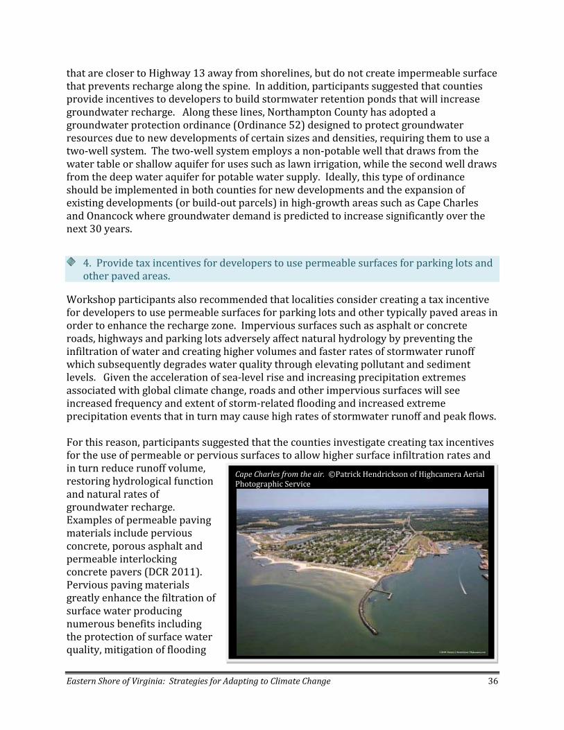
Eastern Shore of Virginia: Strategies for Adapting to Climate Change 36
that are closer to Highway 13 away from shorelines, but do not create impermeable surface that prevents recharge along the spine. In addition, participants suggested that counties provide incentives to developers to build stormwater retention ponds that will increase groundwater recharge. Along these lines, Northampton County has adopted a groundwater protection ordinance (Ordinance 52) designed to protect groundwater resources due to new developments of certain sizes and densities, requiring them to use a two-well system. The two-well system employs a non-potable well that draws from the water table or shallow aquifer for uses such as lawn irrigation, while the second well draws from the deep water aquifer for potable water supply. Ideally, this type of ordinance should be implemented in both counties for new developments and the expansion of existing developments (or build-out parcels) in high-growth areas such as Cape Charles and Onancock where groundwater demand is predicted to increase significantly over the next 30 years.
4. Provide tax incentives for developers to use permeable surfaces for parking lots and other paved areas.
Workshop participants also recommended that localities consider creating a tax incentive for developers to use permeable surfaces for parking lots and other typically paved areas in order to enhance the recharge zone. Impervious surfaces such as asphalt or concrete roads, highways and parking lots adversely affect natural hydrology by preventing the infiltration of water and creating higher volumes and faster rates of stormwater runoff which subsequently degrades water quality through elevating pollutant and sediment levels. Given the acceleration of sea-level rise and increasing precipitation extremes associated with global climate change, roads and other impervious surfaces will see increased frequency and extent of storm-related flooding and increased extreme precipitation events that in turn may cause high rates of stormwater runoff and peak flows. For this reason, participants suggested that the counties investigate creating tax incentives for the use of permeable or pervious surfaces to allow higher surface infiltration rates and in turn reduce runoff volume, restoring hydrological function and natural rates of groundwater recharge. Examples of permeable paving materials include pervious concrete, porous asphalt and permeable interlocking concrete pavers (DCR 2011). Pervious paving materials greatly enhance the filtration of surface water producing numerous benefits including the protection of surface water quality, mitigation of flooding
Cape Charles from the air. ©Patrick Hendrickson of Highcamera Aerial Photographic Service

Eastern Shore of Virginia: Strategies for Adapting to Climate Change 37
hazards, and protection of groundwater supply (Collins et al. 2007)—all of which would contribute to building more adaptive capacity and resiliency into perennial streams and the groundwater system on the Eastern Shore. However, the challenges involved with the adoption of pervious paving materials include prohibitive cost and regulatory hurdles.
5. Explore alternative technologies such as aquifer storage and recovery (ASR) systems to create a water resources bank.
Implementing an aquifer storage and recovery (ASR) system is another strategy suggested during the workshop. ASR technology enables the use of the confined aquifer as a reservoir in which water can be stored and reused (Malcolm-Pirnie and A-NPDC, 2010a and 2010b). Water may be treated and injected into wells in the confined aquifer during wet periods (in which supply is protected from evaporation and contamination) and withdrawn as needed during seasonal or multi-year droughts (Box 6). In this way, the ASR system can serve as a water resources bank in which there is no net loss of water to the confined aquifer. Importantly, such a system can also reduce the potential for saltwater intrusion in the confined aquifer due to overpumping. While such technology is already being used in many places throughout the United States, the regulatory authority for permitting an underground reservoir in a DEQ-designated Groundwater Management Area in Virginia is unprecedented (Malcolm-Pirnie and A-NPDC, 2010a and 2010b). However, other states have amended statutory definitions of reservoir to include aquifers in recent years. This issue must be resolved before such technology can be employed on the Eastern Shore. Moreover, opportunity costs associated with this innovative technology must be financed by the counties though grant programs may exist for a pilot project.
Box 6. Conceptual diagram of aquifer storage and recovery systems. Courtesy of the Commonwealth Scientific and Industrial Research
Organisation (Australia)

Eastern Shore of Virginia: Strategies for Adapting to Climate Change 38
Adaptation Action #5. Education and Outreach Establish Eastern Shore Climate Adaptation Working Group to promote political will by developing education and outreach programs for the public and helping to facilitate the implementation of key adaptation strategies by the two counties. Workshop participants elected to organize an Eastern Shore Climate Adaptation Working Group composed of major stakeholders to develop a coordinated approach to public
outreach and education about strategies and approaches to local climate change adaptation (Table 2). By effectively communicating the need for actions that will enable robust adaptation to sea-level rise and other global climate change effects, this group will help to build the political will necessary to implement the strategies proposed in this document and others as they emerge. This informal group has met three times since August 2010 to discuss climate change strategies from the workshop, compare and coordinate existing efforts, explore potential funding
sources for the working group, review the outputs of the LiDAR working group and develop communications and outreach strategies for diverse constituents regarding adaptation. For this group to be effective in outreach and education efforts, key messages about climate change, sea-level rise and adaptation should be tailored to the various stakeholder groups based on their underlying interests and motivations. “Real-world” demonstration sites would help to show the pragmatic, cost-efficient designs and technologies of adaptation approaches. They must focus on how adaptation efforts can improve the quality of life and economy for Eastern Shore residents. Outreach actions could include:
• The Climate Adaptation Working Group/ LiDAR working group will sponsor an open house for community stakeholders to learn about the LiDAR data and how it can inform planning for adaptation to sea-level rise and coastal flooding.
• A-NPDC will hold public forums on vulnerability analysis using LiDAR data that explores different
Postcard from 2080: Greetings Susie! I am amazed how the Eastern Shore has managed to successfully cope with so much sea-level rise. The beautiful coastal villages are combined with the successful tourist, agriculture and aquaculture businesses forming a great place to live, work and play. Love, Mom
Small group discussion at August workshop ©B. Kittrell

Eastern Shore of Virginia: Strategies for Adapting to Climate Change 39
scenarios for adaptation actions to be considered in the comp plan updates. • The Accomack County Sustainable Community Project will offer a public workshop
about sea-level rise and related issues to raise community awareness and offer practical solutions and best practices for addressing flooding and erosion.
• A new community coalition will be created to promote and support the Chincoteague National Wildlife Refuge boundary expansion through its Comprehensive Conservation Plan process. The refuge is one of the most visited in the nation, and a major goal of the CCP process is to facilitate climate change adaptation which provides economic benefits for local people.
• Demonstration of living shoreline management techniques to shoreline property owners will encourage installation of “living shorelines” alternative to shoreline hardening. Passage of the new VA Living Shorelines General Permit Regulation is seen by the working group as a strong incentive for localities to incorporate this approach in their comprehensive planning process.
Eastern Shore Climate Adaptation Working Group Front (left to right): Art Schwarzschild , Lou Hinds; Middle (left to right): Laura McKay,
Latonya Justice, Marcia Berman, Jane Lassiter, Tina Jerome; Back (left to right): Curt Smith, Hank Badger, Bill Neville, Pete Stith, Steve Parker, Jim Gowan and Denard Spady

Eastern Shore of Virginia: Strategies for Adapting to Climate Change 40
Table 2. Membership of the Eastern Shore Climate Adaptation Working Group Name Affiliation Art Schwarzschild University of Virginia Long-Term Ecological Research Project Bill Neville Town of Chincoteague Carmie Duer NRCS Accomack and Northampton Counties Curt Smith Accomack-Northampton Planning District Commission Dave Burden Virginia Eastern Shore Shorekeeper Denard Spady Citizens for a Better Eastern Shore Elaine Meil Accomack-Northampton Planning District Commission Hank Badger Virginia Marine Resources Commission Jane Lassiter NRCS Jim McGowan Private citizen Laura McKay Virginia Department of Environmental Quality, Coastal Zone Management
Program Lou Hinds U.S. Fish and Wildlife Service Chincoteague National Wildlife Refuge Pete Henderson Virginia Eastern Shore Land Trust Peter Stith Northampton County Planning Rob Testerman Accomack County Planning Sandra Benson Northampton County Planning Steve Parker The Nature Conservancy Virginia Coast Reserve Tina Jerome NRCS Accomack and Northampton Counties Tom Brockenbrough Accomack County Planning Tom Walker J.C. Walker Brothers, Inc.

Eastern Shore of Virginia: Strategies for Adapting to Climate Change 41
Conclusion Many challenges lie ahead in learning to adapt effectively to local manifestations of the global climate change phenomena punctuated by great uncertainty regarding future rates of change and other effects. However, Eastern Shore localities and stakeholders can take advantage of many promising programs and opportunities that will help citizens and natural systems to better adapt to climate change. These include:
The forthcoming LiDAR vulnerability assessments, which will greatly inform hazard mitigation planning, county comprehensive planning, and land use policy
CZM/VIMS Virginia Ecological Value Assessment model UVA LTER vegetative cover and marsh migration models The new shoreline management legislation that requires shoreline management
plans and living shoreline general permit regulation for coastal localities Eastern Shore Hazard Mitigation Plans revision Accomack and Northampton Counties’ Comprehensive Plan reviews and updates Accomack and Northampton Counties’ Water Supply Plan reviews VA Coastal Zone Management Program’s Special Area Management Plan process. Potential boundary expansion of the Chincoteague National Wildlife Refuge to adapt
to sea-level rise through the USFWS’ Comprehensive Conservation Plan VA-CZM funding of the Seaside Coastal Partnership along with a pending funding
request to the NOAA Community Partnership Grant program continue restoring oysters and eelgrass in the coastal bays
To take full advantage of these opportunities, many workshop participants have agreed to serve on the Eastern Shore Climate Adaptation Working Group. With better understanding of climate change effects comes the realization that those changes will profoundly affect all people who live here, regardless of age, occupation or neighborhood. Livelihoods will be jeopardized, infrastructure will be threatened and human health and safety will be at greater risk. A knowledgeable citizenry and informed decision-making based on the most realistic assessment of risk to the community will be the foundation future efforts. There is clear consensus by the
working group that much can be done to manage and minimize disruptions to this community, and the time to take action is now.
Girl holding blue crab ©J. Scalf

Eastern Shore of Virginia: Strategies for Adapting to Climate Change 42

Eastern Shore of Virginia: Strategies for Adapting to Climate Change 43
References Accomack – Northampton Planning District Commission. 2010. Eastern Shore of Virginia Land Use and Ground Water Resources Report. Prepared for the Virginia Coastal Zone Management Program, Virginia Department of Environmental Quality. Accomac, Virginia Accomack – Northampton Planning District Commission. 2010. Eastern Shore of Virginia Hazard Mitigation Plan. Accomac, Virginia. Collins, K.A. W.F. Hunt, and J.M. Hathaway. 2007. Hydrologic and water quality comparison of four types of permeable pavement and standard asphalt in eastern North Carolina. Prepared for Interlocking Concrete Pavement Institute. Biological and Agricultural Engineering Department, North Carolina State University, Raleigh, NC. Governor’s Commission on Climate Change. 2009. Final Report: A Climate Change Action Plan. December 15, 2008. Report Document No. 19. Available at ://leg2.state.va.us/dls/h&sdocs.nsf/By+Year/RD192009/$file/RD19.pdf Hardaway, C.S., D.A. Milligan and K. Duhring. 2010. Living Shoreline Design Guidelines for Shore Protection in Virginia’s Estuarine Environments, Version 1. Shoreline Studies Program and Center for Coastal Resources Management Virginia Institute of Marine Science, College of William & Mary Gloucester Point, Virginia. 112 pp. Hardaway, C.S., M. Berman, D. Milligan, S. Killeen, K. O’Brien, T. Rudnicky, C. Wilcox, and K. Nunez. 2008. Occohannock Creek Shoreline Erosion Assessment and Living Shoreline Options. Report Prepared for Eastern Shore of Virginia Resource Conservation & Development Council Shoreline Studies Program and Center for Coastal Resources Management Virginia Institute of Marine Science, College of William & Mary Gloucester Point, Virginia. 61 pp. Hayden, B.P. 1999. Climate Change and Extratropical Storminess in the United States. Journal of the American Water Resources Association, vol. 35, Issue 6, p.1387-1397 Hayden, B.P & Hayden, N.R. 2003. Decadal and century-long changes in storminess at long-term ecological research sites. p262-285. In D. Greenland, D.C. Goodin, & R.C. Smith (eds.) Climate Variability and Ecosystem Response at Long-Term Ecological Research Sites. Oxford University Press, New York, NY, USA. Horsley Witten Hegemann, Inc., 1992. Groundwater Supply Protection and Management Plan for the Eastern Shore of Virginia. Prepared for the Eastern Shore of Virginia Groundwater Study Committee. Karl, T.R., G.A. Meehl, T.C. Peterson, K.E. Kunkel, W.J. Gutowski Jr., and D.R. Easterling, 2008: Executive summary. In: Weather and Climate Extremes in a Changing Climate. Regions of Focus: North America, Hawaii, Caribbean, and U.S. Pacific Islands [Karl, T.R., G.A. Meehl, C.D.

Eastern Shore of Virginia: Strategies for Adapting to Climate Change 44
Miller, S.J. Hassol, A.M. Waple, and W.L. Murray (eds.)]. Synthesis and Assessment Product 3.3. U.S. Climate Change Science Program, Washington, DC, pp. 1-9. Karl, T.R. , J.M. Melillo, and T.C. Peterson, (eds.). 2009. Global Climate Change Impacts in the United States US Global Climate Change Research Program report. Cambridge University Press. Malcolm Pirnie, Inc and Accomack-Northampton Planning District Commission (A-NPDC). 2010. Northampton County water supply plan (Draft April 19, 2010). Available at ://www.a-npdc.org/groundwater/publications.html. Northampton County, Eastville, VA. Malcolm Pirnie, Inc and Accomack-Northampton Planning District Commission (A-NPDC). 2010. Accomack County regional water supply plan (Draft April 19, 2010). Available at ://www.a-npdc.org/groundwater/publications.html. Accomack County, Accomac, VA. McLoughlin, S.M., P.L. Wiberg, and K.J. McGlathery. In review. Quantifying erosion rates along salt marsh boundaries in a Virginia coastal bay using the Digital Shoreline Analysis System (DSAS). Department of Environmental Sciences, University of Virginia, Charlottesville, VA. Nicholls, R.J., P.P Wong, V.R. Burkett, J.O. Codignotto, J.E. Hay, R.F. McLean, S. Ragoonaden and C.D. Woodroffe, 2007. Coastal Systems and low-lying areas. Climate Change 2007: Impacts, Adaptation and Vulnerability. Contribution of Working Group II to the Fourth Assessment Report of the Intergovernmental Panel on Climate Change, M.L. Parry, O.F. Canziani, J.P. Palutikof, P.J. van der Linden and C.E. Hansen, Eds., Cambridge University Press, Cambridge, UK, pp 315-356. Orr JC, Fabry VJ, Aumont O, Bopp L, Doney SC, Feely RA, Gnanadesikan A, Gruber N, Ishida A, Joos F, Key RM, Lindsay K, Maier-Reimer E, Matear R, Monfray P, Mouchet A, Najjar RG, Plattner G-K, Rodgers KB, Sabine CL, Sarmiento JL, Schlitzer R, Slater RD, Totterdell IJ, Weirig M-F, Yamanaka Y, Yool A . 2005. Anthropogenic ocean acidification over the twenty-first century and its impact on calcifying organisms. Nature 437: 681-686 Poulter B, N. L. Christensen and S. S. Qian, 2008. Tolerance of Pinus taeda and Pinus serotina to low salinity and flooding: Implications for equilibrium vegetation dynamics, Journal of Vegetation Science, 19(1), pp 15-22. Silton, A.C. and J. Grannis. 2010. Virginia Case Study--Stemming the Tide: How Local Governments Can Manage Rising Flood Risks. Review Draft 3 – May 2010. Georgetown Climate Center (GCC), Georgetown University Law Center, Washington, D.C. Solomon, S. et al. (eds). Climate Change 2007: The Physical Science Basis — Contribution of Working Group I to the Fourth Assessment Report of the Intergovernmental Panel on Climate Change. Cambridge Univ. Press, Cambridge, UK, New York, USA. Virginia Department of Conservation and Recreation (DCR). 2011. Virginia DCR Stormwater Design Specification No. 7: Permeable Pavement. Version 1.7, March 1, 2011. Available at ://www.cwp.org/cbstp/Resources/d2s6a-dcr-bmp-permeable.pdf

Eastern Shore of Virginia: Strategies for Adapting to Climate Change 45
VIMS. 2010. Study of Tidal Shoreline Management in Virginia: Recommendations for living shorelines and tidal resources sustainability. Report to the Governor and Virginia General Assembly in response to Sentate Joint resolution No. 35. Center for Coastal Resources Management Virginia Institute of Marine Science, College of William & Mary Gloucester Point, Virginia. 26 pp. Williams, S.J., B.T. Gutierrez, J.G. Titus, S.K. Gill, D.R. Cahoon, E.R. Thieler, K.E. Anderson, D. FitzGerald, V. Burkett, and J. Samenow. 2009. Sea-level rise and its effects on the coast. In: Coastal Sensitivity to Sea-Level Rise: A Focus on the Mid-Atlantic Region. A report by the U.S. Climate Change Science Program and the Subcommittee on Global Change Research. [J.G. Titus (coordinating lead author), K.E. Anderson, D.R. Cahoon, D.B. Gesch, S.K. Gill, B.T. Gutierrez, E.R. Thieler, and S.J. Williams (lead authors)]. U.S. Environmental Protection Agency, Washington DC, pp. 11-24.

Eastern Shore of Virginia: Strategies for Adapting to Climate Change 46