strategic housing and - wiltshire · methodology housing and land august 2017 . 1. ... (second...
TRANSCRIPT

Strategic Housing and Economic Land Availability Assessment Methodology
August 2017


1. INTRODUCTION 3
2. CONTEXT 4
3. METHODOLOGY 6
4. STAGE 1 – IDENTIFICATION OF SITES AND BROAD LOCATIONS 8
5. STAGE 2 – SITE AND BROAD LOCATION ASSESSMENT 10
6. STAGE 5 – FINAL EVIDENCE BASE 13
7. APPENDIX 1 – CONSTRAINTS APPLIED IN ASSESSMENT 14
8. APPENDIX 2 – EXCLUSIONARY CONSTRAINTS APPLIED IN ASSESSMENT 16
9. APPENDIX 3 – DWELLING MIX AND DENSITY BY SIZE CLASS AND HOUSING MARKET AREA 17
10. APPENDIX 4 – KEY VALUES AND ASSUMPTIONS FOR VIABILITY MODELLING 19

1. Introduction
1.1 Paragraph 159 of the National Planning Policy Framework (NPPF) requires local planning authorities (LPAs) to prepare a Strategic Housing Land Availability Assessment (SHLAA) “to establish realistic assumptions about the availability, suitability, and the likely economic viability of land to meet the identified need for housing over the plan period”. Paragraph 161 (second bullet point) identifies the advantages of carrying out land assessments for housing and economic development in tandem, to ensure that sites can be considered for the most appropriate use.
1.2 Wiltshire Council has therefore prepared a Strategic Housing and Economic Land Availability Assessment (SHELAA) of the suitability, availability, and achievability of land for both housing and economic development.
1.3 While forming an important part of the evidence base for the plan-making process the report in itself does not determine whether a site is allocated for future development. Consequently, those sites
included in the SHELAA will have very limited weight in decision making.
1.4 This SHELAA updates and replaces the earlier Strategic Housing Land Availability Assessment (SHLAA) and will be expanded to also include economic uses for sites. All sites previously considered within the SHLAA reports are now considered within the SHELAA.
1.5 The structure of this report has been written in line with National Planning Practice Guidance first published in 2014 and most recently updated in 20151.
1 Housing and economic land availability assessment guidance (Updated 27/03/2015)
http://planningguidance.communities.gov.uk/blog/guidance/housing-and-economic-land-availability-assessment/

4
2. Context
2.1 The Government published the Planning Practice Guidance (PPG) in March 2014 which postdates the previous SHLAA methodology. Included within the PPG is a broad steer and methodology which should be used in producing the SHELAA report and is the approach adopted for this document. The core outputs of this process are:
a. A list of all sites or broad locations considered, cross-referenced to their locations on maps
b. An assessment of each site or broad location, in terms of its suitability for development, availability, and achievability (including whether the site/broad location can be considered viable) to determine whether a site is realistically expected to be developed and when;
c. Contain more detail for those sites which are considered to be realistic candidates for development, where others have been discounted for clearly evidenced and justified reasons;
d. The potential type and quality of development that could be delivered on each site/broad location, including a reasonable estimate of build out rates, setting out how any barriers to delivery could be overcome and when;
e. An indicative trajectory of anticipated development and consideration of associated risks
2.2 The Government requires Local Authorities to identify and update
annually a specific supply of deliverable sites2; these sites are assessed and presented separately in the council’s Housing Land Supply Statement3.
2.3 This report will focus on providing outputs a, b, and c. It will also provide an assessment of whether sites are developable in the short (1-5 years), medium (6-10 years), or long (10+ years) terms. Information on outputs d and e, for sites that are likely to be delivered
in the short or medium term, can be found in the Housing Land Supply Statements.
2.4 Local Authorities are also required to demonstrate how economic needs of their areas can be met and ensure there is a sufficient supply of sites to support jobs and businesses and in doing so secure economic prosperity. More detail for suitability of land for employment uses will be carried out as part of the Employment Land Review process.
2 Deliverable sites are those that are available now, offer a suitable location for development
now, and are achievable with a realistic prospect that housing will be delivered on the site within five years and in particular that the development of the site is viable as described in footnote 11 of the NPPF 3 Housing Land Supply Statement 2016 http://www.wiltshire.gov.uk/housingland-supply-
statement-march--update.pdf

5
2.5 It is important to note that whilst the SHELAA identifies potential sites, it does not allocate them for development or add weight to the site for the purpose of decision making on a planning application. The allocation of future sites for development will only take place through the Local Plan process which will undergo full consultation and an examination in public.

6
3. Methodology
3.1 This section sets out the approach for preparing a SHELAA in line with the Planning Practice Guidance (PPG). The PPG states that an assessment should meet the following aims:
a. Identify sites and broad locations with potential for development; b. Assess their development potential and suitability; and c. Assess the likelihood of development coming forward (the
availability and achievability) 3.2 The flow chart below sets out the Council’s approach and is consistent
with the PPG. Detailed information on the current housing land supply is available within the Housing Land Supply Statement.

7
Call for Sites
3.3 The Council carries out an open ‘Call for Sites’ to be submitted for an assessment of their development potential. This process helps to ensure that a variety of options can be considered when preparing a Local Plan. The assessment process will be reviewed annually to account for:
a. New sites submitted for consideration b. New planning permissions and/or sites which have been
completed c. Change of circumstances on existing sites such as changes in
ownership or constraints which may alter the outcome of assessments
d. Withdrawal of sites that are no longer available for development
3.4 While the ‘Call for Sites’ is ongoing the Council will publish a review date on its website each year to allow for that year’s review of the SHELAA report to take place. For this report the review date of 1 January 2017 was chosen – as such all sites that were submitted to the council prior to this date are assessed in this report.
Joint Working
3.5 The PPG recommends that the assessment area should preferably cover the housing market area and functional economic market area, but may cover a local planning authority area where appropriate.
3.6 It also recommends that where possible the SHELAA should be undertaken jointly with other authorities within the Housing Market Area. Wiltshire is working in partnership with Swindon Borough Council towards a shared review of the Functional Economic Market Areas (FEMA) and Housing Market Areas (HMA) which may lead to opportunities for further partnership work on the SHELAA.
3.7 The Council will continue to work with neighbouring authorities as part of the Local Plan preparation process in line with the Duty to Cooperate.
3.8 A review of SHELAA reports produced by other local authorities was conducted as part of a peer review exercise to ensure that this report was similarly useable and accessible.

8
4. Stage 1 – Identification of sites and broad locations Determining the Assessment Area
4.1 Wiltshire is composed of three Housing Market Areas (HMA) as shown in Figure 4.1 below:
Figure 4.1: Housing Market Areas and Community Areas in Wiltshire
4.2 This SHELAA review covers the Wiltshire Council administrative area
and the three HMAs contained therein. The Council will be proactive in its approach of working with landowners and stakeholders to identify additional land with development potential.
9
Desktop Review of Existing Information
4.3 The PPG advises that plan makers should be proactive during the Desktop Review stage in identifying a wide range of possible sites and broad locations for development including existing sites that could be improved, intensified, or changed.
4.4 The PPG states that sites included in the assessment should be drawn
from the Call for Sites as well as a number of sources, including:
a. Existing housing and economic development allocations and site development briefs not yet with planning permission
b. Planning permissions for housing and economic development that are unimplemented or under construction
c. Planning applications that have been refused or withdrawn d. Land in the local authority’s ownership e. Surplus and likely to become surplus public sector land f. Vacant and derelict land and buildings (including empty homes,
redundant and disused agricultural buildings, potential permitted development changes e.g. offices to residential)
g. Additional opportunities in established uses (e.g. making productive use or under-utilised facilities such as garage blocks)
h. Business requirements and aspirations i. Sites in rural locations j. Large scale redevelopment and redesign of existing residential
or economic areas k. Sites in and adjoining villages or rural settlements and rural
exception sites l. Potential urban extensions and free standing settlements
4.5 This SHELAA has identified sites from a, b and c, which in turn may
include sites from sources d, e, f, g, h, i, j, and k.
4.6 Unimplemented and under construction permissions (b) are monitored
through existing housing and employment processes and further information on housing permissions is available in the HLSS.
4.7 Refused and withdrawn applications (c) have been assessed through a
desktop review and are included in the Appendix 5 output reports.
4.8 In this SHELAA no sites have been sourced as potential urban extensions and free standing settlements (l).
4.9 Sites in this SHELAA are drawn from the existing SHLAA evidence
base as well as new sites that have been submitted to the Council through the Call for Sites. This SHELAA will consider all sites of 0.25ha or above.

10
5. Stage 2 – Site and broad location assessment 5.1 There are three components to the assessment of sites and broad
locations:
a. Suitability b. Availability c. Achievability
5.2 The assessment will use a joint desktop and site survey approach to
ensure that sites are approached systematically and comprehensively.
5.3 The PPG states that site surveys should be proportionate to the detail needed for a robust appraisal and sites that are considered to be more realistic for potential development should be surveyed in greater detail. Sites that are identified as being unsuitable through the desktop survey will not be visited.
5.4 Once the desktop review of sites is complete, sites requiring a survey are identified and a survey will be conducted of the site and its surroundings as appropriate. For this SHELAA report site surveys will only be carried out on sites that have not previously been surveyed through previous SHLAA assessments. Sites with current or extant planning permissions will be surveyed as part of the annual HLSS process.
5.5 The purpose of a site visit is to ratify the desktop assessment exercise
to establish what type and scale of development may be appropriate, what barriers may affect the availability of the site, and how they could be overcome or mitigated. Also, if the site is already being developed then what stage of development is it at.
Suitability
5.6 The desktop review is the first part of the process that facilitates an initial judgement as to whether a site is suitable. The Council has access to a considerable amount of information in the form of existing maps, databases, and studies. This information will help to inform the assessment of the deliverability and developability of sites, including any site constraints.
5.7 Constraint information from a range of sources and key stakeholders has been identified through the Desktop Review in addition to the constraints held by the Council as a statutory undertaker. These are available in Appendix 1.
5.8 The PPG advises that the assessment of the suitability of sites and
broad locations should be guided by existing and emerging policy at the local and national level in addition to the market or industry

11
requirements in the corresponding Housing Market or Functional Economic Market Area.
5.9 Each site and broad location will be spatially assessed against existing and emerging local and national policies. It is not possible through this process to definitively determine suitability, only unsuitability, and as such only ‘Unsuitable’4 site area will be identified at this stage.
5.10 Appendix 2 provides the exclusionary criteria used in the determination of whether a site, or any area of a site, is ‘Unsuitable’. Further details for each site identified as such will be provided in its site profile.
5.11 If a site is identified during the desktop review stage as ‘Unsuitable’ then it will not be taken forward for further assessment as part of this year’s SHELAA report. It should be noted that the exclusion of a site from the SHELAA report does not exclude it from being reconsidered during the annual review prior that precedes each annual SHELAA report.
Availability
5.12 The PPG advises that a site can be considered available for
development when there is confidence that there are no legal or ownership problems.
5.13 Suitable sites identified from previous SHLAA assessments may be accompanied by detailed information that allows for a confident determination of availability. Suitable sites identified from other sources may not be accompanied by a similar level of information and subsequently may not allow for a confident determination of availability.
5.14 At this time full legal surveys of all submitted sites is not possible and, as such, the council has made use of the best available information, (including parcel geometries available through the Land Registry INSPIRE View Service5), in the assessment of all suitable sites only.
5.15 This process presently does not allow for a confident determination of
availability but does provide an indication of availability. This is a result of some individual parcels of land possibly having multiple owners, or conversely multiple parcels of land having a common owner.
Achievability
5.16 This is essentially an assessment of the economic viability of the site
and whether it can be feasibly and reasonably achieved at a particular
4 An Unsuitable site is one where the developable area of the site is less than 0.25ha after all
exclusionary criteria have been applied to the site. 5 Land Registry INSPIRE View Service and Metadata
https://data.gov.uk/dataset/land-registry-inspire-view-service-and-metadata

12
point in time. As such, the Council will only carry out achievability / viability testing on sites that have been found to be suitable.
5.17 Core Policy 57 does not provide a specific density figure for residential development. As a result, and in line with best practice, the development potential of each suitable site is identified through an assessment of existing development schemes.
5.18 Through assessment of existing development a range of development sizes, typical densities, and mix of dwelling types have been established for each HMA. Suitable sites within each HMA are assessed using these typical densities and mix of dwelling types to determine their viability. Full details on the site size classes, typical dwelling mix and typical density can be found in Appendix 3.
5.19 Housing viability testing is carried out for each HMA, at each site size class, using the HCA district wide viability testing model. Appendix 4 contains details of the values used in this viability model.
Deliverability
5.20 As per NPPF Footnote 11 a site can only be considered deliverable if it
is available now, offer a suitable location for development now, and be achievable with a realistic prospect that housing will be delivered on the site within five years and in particular that development of the site is viable. Sites with planning permission should be considered deliverable until permission expires, unless there is clear evidence that schemes will not be implemented within five years.
5.21 Those sites that are considered deliverable are presented separately in the HLSS.

13
6. Stage 5 – Final evidence base 6.1 The SHELAA output reports, available separately as Appendix 5,
contain three of the core outputs identified in the PPG:
a. A list of all sites or broad locations considered, cross-referenced to their locations on maps
b. An assessment of each site or broad location, in terms of its suitability for development, availability, and achievability (including whether the site/broad location is viable) to determine whether a site is realistically expected to be developed and when;
c. Contain more detail for those sites which are considered to be realistic candidates for development, where others have been discounted for clearly evidenced and justified reasons;
6.2 Due to the quantity of sites within Wiltshire it is necessary to split
Appendix 5 into manageable output reports to improve its usability. Output reports have been created for sites within each Community Area.
6.3 Each output report is presented by Community Area, then Settlement,
then Reference. Each site has a single A4 profile containing a map of the site and the surrounding area as well as a short table detailing site characteristics pertinent to the assessment, description, and brief notes on its suitability, availability, and achievability; as well as whether the site is deliverable, and an indication of the timescale in which it may possibly be developed.
14
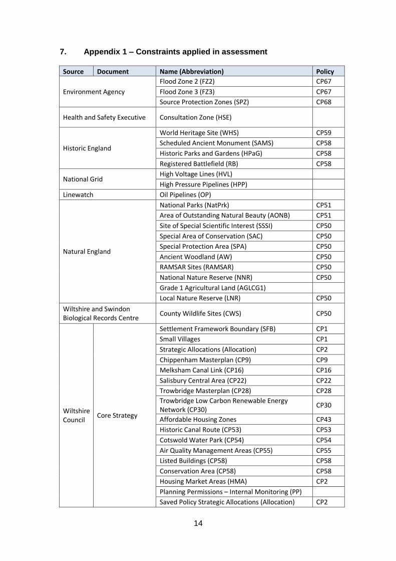
7. Appendix 1 – Constraints applied in assessment
Source Document Name (Abbreviation) Policy
Environment Agency
Flood Zone 2 (FZ2) CP67
Flood Zone 3 (FZ3) CP67
Source Protection Zones (SPZ) CP68
Health and Safety Executive Consultation Zone (HSE)
Historic England
World Heritage Site (WHS) CP59
Scheduled Ancient Monument (SAMS) CP58
Historic Parks and Gardens (HPaG) CP58
Registered Battlefield (RB) CP58
National Grid High Voltage Lines (HVL) High Pressure Pipelines (HPP)
Linewatch Oil Pipelines (OP)
Natural England
National Parks (NatPrk) CP51
Area of Outstanding Natural Beauty (AONB) CP51
Site of Special Scientific Interest (SSSI) CP50
Special Area of Conservation (SAC) CP50
Special Protection Area (SPA) CP50
Ancient Woodland (AW) CP50
RAMSAR Sites (RAMSAR) CP50
National Nature Reserve (NNR) CP50
Grade 1 Agricultural Land (AGLCG1)
Local Nature Reserve (LNR) CP50
Wiltshire and Swindon Biological Records Centre
County Wildlife Sites (CWS) CP50
Wiltshire Council
Core Strategy
Settlement Framework Boundary (SFB) CP1
Small Villages CP1
Strategic Allocations (Allocation) CP2
Chippenham Masterplan (CP9) CP9
Melksham Canal Link (CP16) CP16
Salisbury Central Area (CP22) CP22
Trowbridge Masterplan (CP28) CP28 Trowbridge Low Carbon Renewable Energy Network (CP30)
CP30
Affordable Housing Zones CP43
Historic Canal Route (CP53) CP53
Cotswold Water Park (CP54) CP54
Air Quality Management Areas (CP55) CP55
Listed Buildings (CP58) CP58
Conservation Area (CP58) CP58
Housing Market Areas (HMA) CP2
Planning Permissions – Internal Monitoring (PP)
Saved Policy Strategic Allocations (Allocation) CP2

15
Source Document Name (Abbreviation) Policy Green Belt (GB) CP51
Minerals Policy
Minerals Site Allocations (Allocation)
Minerals Resource Zones (MRZ)
Minerals Safeguarding Areas (MSA)
Waste Policy Waste Site Allocations (Allocation)

16
8. Appendix 2 – Exclusionary constraints applied in assessment
Constraint Abbreviation Interaction with Site
Extant planning permission
PP Area intersected by constraint
Core Strategy allocation
Allocation Area intersected by constraint
Special Protection Area
SPA Area intersected by constraint
Special Area of Conservation
SAC Area intersected by constraint
Site of Special Scientific Interest
SSSI Area intersected by constraint
RAMSAR
RAMSAR Area intersected by constraint
National Nature Reserve
NNR Area intersected by constraint
Green Belt
GB Area intersected by constraint
Flood Zone 3
FZ3 Area intersected by constraint
Flood Zone 2
FZ2 Area intersected by constraint
Health and Safety Executive Consultation Zones
HSE Area intersected by constraint
Settlement Framework Boundary
SFB
Site >100m from Settlement Framework Boundary, or; Site >100m from a Site <100m from Settlement Framework Boundary

9. Appendix 3 – Dwelling Mix and Density by Size Class and Housing Market Area
South HMA Dwelling Mix and Density by Site Size Class based on Completed / Commenced Permissions 2009/10-2014/15
South HMA Flat House Site Size Classes 1 2 3 4+ Total -2 3 4+ Total Grand Total Density
Class 1: 0-31 13% 17% 1% 0% 32% 18% 26% 24% 68% 100% 42.98
Class 2: 32-100 9% 12% 0% 0% 21% 16% 34% 29% 79% 100% 35.44
Class 3: 101-170 6% 4% 0% 0% 10% 22% 35% 32% 90% 100% 35.67
Class 4: 171+ 8% 7% 0% 0% 15% 19% 41% 25% 85% 100% 30.53 East HMA Dwelling Mix and Density by Site Size Class based on Completed / Commenced Permissions 2009/10-2014/15
East HMA Flat House Site Size Classes 1 2 3 4 Total -2 3 4+ Total Grand Total Density
Class 1: 0-19 12% 9% 0% 0% 21% 21% 26% 29% 79% 100% 37.02
Class 2: 20-67 8% 34% 1% 0% 44% 13% 24% 18% 56% 100% 62.85
Class 3: 68-160 8% 17% 0% 0% 25% 16% 25% 34% 75% 100% 36.46
Class 4: 161+ 2% 9% 0% 0% 11% 27% 41% 20% 89% 100% 32.32 North and West HMA Dwelling Mix and Density by Site Size Class based on Completed / Commenced Permissions 2009/10-2014/15
North and West HMA Flat House
Site Size Classes 1 2 3 4 Total -2 3 4+ Total Grand Total Density
Class 1: 0-19 14% 12% 1% 0% 27% 27% 26% 18% 73% 100% 47.83
Class 2: 20-62 7% 20% 0% 0% 27% 16% 28% 26% 73% 100% 47.67
Class 3: 63-129 7% 13% 0% 0% 20% 14% 36% 30% 80% 100% 37.53
Class 4: 130+ 10% 19% 0% 0% 29% 11% 34% 26% 71% 100% 39.51

Prior to 2009/10 completions were simply recorded as dwellings. From
2009/10 detail around bedroom number and dwelling type were also collected.
Site Size Classes were determined using Natural Breaks (Jenks) utilising
completion and commencement data within ArcGIS software.

19
10. Appendix 4 – Key Values and Assumptions for Viability Modelling
Costs
Build costs per sq m £950.00
Additional costs per sq m £95.00
S106 payments per unit £10,000.00
CIL Charges per sq m East £55.00
North and West £55.00
South £85.00
Developer return % GDV Private 20.00%
Affordable 20.00%
Fees % of build cost 12.00%
Marking costs % of sale value 3.00%
Legal fees % of land value 0.50%
Site acquisition costs % of land value 1.75%
Development Finance % of build and land cost 7.50%
Land values per hectare Greenfield £21,000.00
Brownfield £482,000.00
Existing use value premium % of land value
Greenfield 20.00%
Brownfield 20.00% Wiltshire Council operates two CIL charging zones, one lower zone at £55.00 per sq m and one higher zone at £85.00 per sq m. These charging zones also determine the level of affordable housing required at 30% and 40% respectively. For the HMA wide viability assessment the both values have been used, however the table above represents the zone which contained the greatest proportion of suitable sites. Land values were retrieved from Tables 2 and 3 from the 2015 DCLG guidance document: ‘Land value estimates for policy appraisal’6
Dwelling Sizes
Flat sq m
1-bed 46
2-bed 59
3-bed 90
4-bed 110
House sq m 2-bed 69
3-bed 92
4-bed 117 Dwelling sizes were retrieved from Gross Internal Area (GIA) column of Table 3.2 from the Dwelling size survey produced for CABE by Scott Wilson7
6 DCLG (2015) Land value estimates for policy appraisal
https://www.gov.uk/government/uploads/system/uploads/attachment_data/file/407155/February_2015_Land_value_publication_FINAL.pdf 7 Scott Wilson (2010) Dwelling size survey

20
Sales
Sale value per sq m East £2,978.00
North and West £2,283.00
South £3,070.00
Ground rents per annum £400.00 Sale values were determined using the median values for Land Registry Price Paid8 data for each HMA divided by the sq m of a 3-bed house.
Affordable Housing
Requirement % of units East 30.00%
North and West 30.00%
South 40.00%
Return per unit Social rent NBHB
Flat
1-bed £39,188.00 £56,000.00
2-bed £47,322.00 £79,000.00
3-bed £56,786.00 £120,000.00
4-bed £68,144.00 £160,000.00
House 2-bed £55,507.00 £79,000.00
3-bed £60,982.00 £107,000.00
4-bed £67,167.00 £140,000.00
Affordable mix % of affordable units 15.00% 85.00%
http://webarchive.nationalarchives.gov.uk/20110118095356/http:/www.cabe.org.uk/files/dwelling-size-survey.pdf 8 Land Registry Price Paid Data https://www.gov.uk/government/statistical-data-sets/price-
paid-data-downloads

21