wiltshire housing land supply statement 2015 housing land
TRANSCRIPT
Housing Land Supply Statement Base date: April 2015
Published: September 2015

2
Housing Land Supply Statement Base Date: April 2015
3
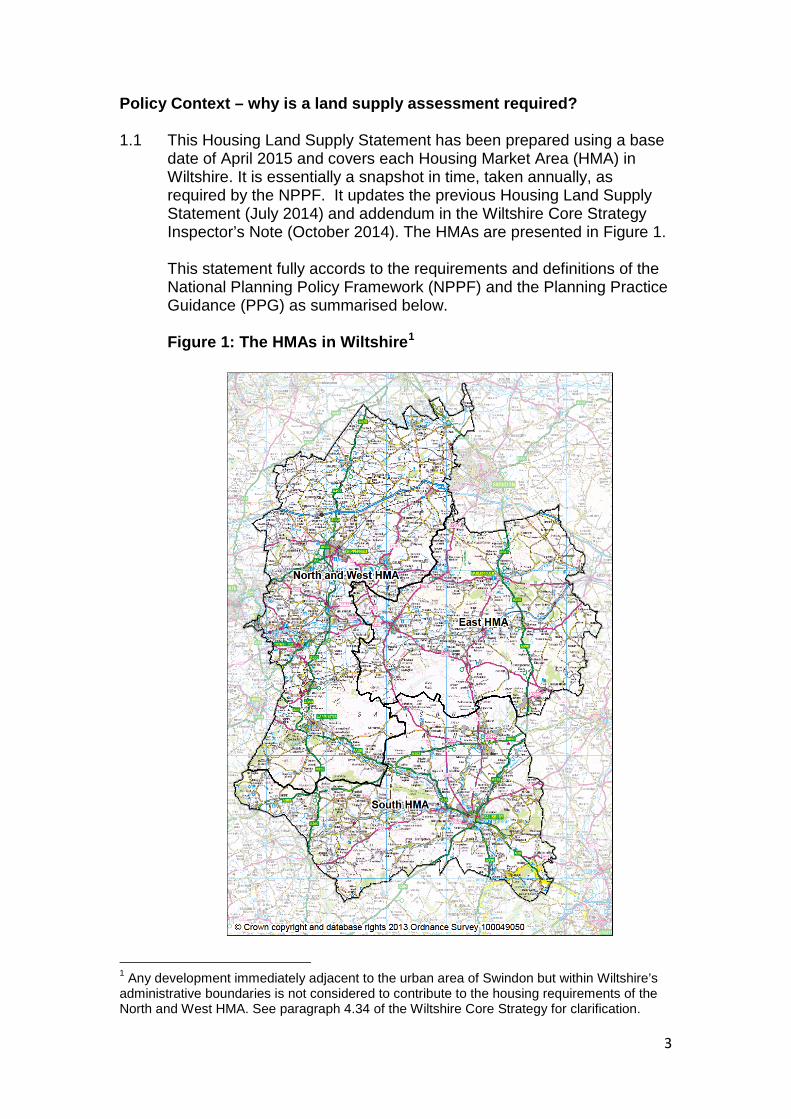
Policy Context – why is a land supply assessment required? 1.1 This Housing Land Supply Statement has been prepared using a base
date of April 2015 and covers each Housing Market Area (HMA) in Wiltshire. It is essentially a snapshot in time, taken annually, as required by the NPPF. It updates the previous Housing Land Supply Statement (July 2014) and addendum in the Wiltshire Core Strategy Inspector’s Note (October 2014). The HMAs are presented in Figure 1. This statement fully accords to the requirements and definitions of the National Planning Policy Framework (NPPF) and the Planning Practice Guidance (PPG) as summarised below. Figure 1: The HMAs in Wiltshire1
1 Any development immediately adjacent to the urban area of Swindon but within Wiltshire’s administrative boundaries is not considered to contribute to the housing requirements of the North and West HMA. See paragraph 4.34 of the Wiltshire Core Strategy for clarification.
4
1.2 Within the NPPF, the Government has set out its guidance to deliver
sustainable development. With regard to housing provision, paragraph 47 states that: “To boost significantly the supply of housing, local planning authorities (LPAs) should:
......identify and update annually a supply of specific deliverable sites sufficient to provide five years worth of housing against their housing requirements with an additional buffer of 5% (moved forward from later in the plan period) to ensure choice and competition in the market for land. Where there has been a record of persistent under delivery of housing, local planning authorities should increase the buffer to 20% (moved forward from later in the plan period) to provide a realistic prospect of achieving the planned supply and to ensure choice and competition in the market for land;....”
1.3 Furthermore, it goes on to define the deliverability of sites in footnote
11, as follows:
“To be considered deliverable, sites should be available now, offer a suitable location for development now, and be achievable with a realistic prospect that housing will be delivered on the site within five years and in particular that development of the site is viable. Sites with planning permission should be considered deliverable until permission expires, unless there is clear evidence that schemes will not be implemented within five years, for example they will not be viable, there is no longer a demand for the type of units or sites have long term phasing plans.”
1.4 The Planning Practice Guidance (PPG) was published in March 2014
with further amendments related to the housing land supply assessment published in March 2015. It sets out guidance on the methodology to be used in the assessment of housing land supply. This assessment follows the guidance, aside from two areas where the guidance has been departed from:
• The PPG requires that all sites considered are individually assessed. However, in an authority as large as Wiltshire, with circa 1000 sites with either planning permission or prior approval, with a resolution to grant subject to planning obligations, proposed or allocated in an emerging or adopted development plan, such an exercise is considered to be disproportionately onerous. Therefore, the assessment only assesses large sites (10 or more dwellings) individually.2
2 Both large and small sites in emerging and adopted Neighbourhood Plans are also assessed individually.
5
• The PPG requires that each site should be listed and cross-referenced
to a map. However, given the number of sites within the deliverable supply this would be impractical, and so a reference is included in the assessment which can be used to identify sites either within the development plan in which it is identified or on the Council’s online planning applications portal. The Housing Land Availability report will also provide maps of large permitted sites up to March 2015.
The housing requirement 2.1 The Wiltshire Core Strategy (WCS) was adopted on 20 January 2015.
The housing requirement contained in the WCS represents the only up to date housing requirement for Wiltshire. This is the requirement against which the land supply is assessed.
Housing completions 3.1 Wiltshire Council monitors housing completions annually. The number
of completions from April 2006 to March 2015 has been used in this assessment.
Buffer 4.1 Paragraph 47 of the NPPF (see paragraph 1.3) requires a buffer to be
added to the land supply. The size of this buffer is dependent on whether or not there is a record of persistent under-delivery.
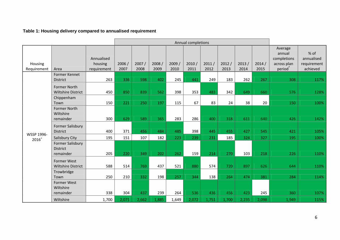
4.2 In order to assess whether or not there is a record of persistent under-
delivery, Table 1 presents the level of delivery over the last five years for which completion data is known. This is compared to the requirements set out in:
i. the Wiltshire and Swindon Structure Plan (WSSP) 2016 which was the adopted development plan for all areas for the majority of this period3,
ii. the South Wiltshire Core Strategy (SWCS) which was adopted in April 2011 and was the adopted plan for the South area of the authority from this date until the adoption of the Wiltshire Core Strategy, and
iii. the Wiltshire Core Strategy.
4.3 The Wiltshire Core Strategy Examining Inspector took into account the evidence sources listed above and concluded in paragraph 93 of his final report that a 5% buffer should be applied.
4.4 Those years in which the annualised delivery has been exceeded are shaded. Table 1 also provides the average annual level of completions across the respective plan periods.
3 The housing requirement for South Wiltshire in the Structure Plan was superseded by the South Wiltshire Core Strategy from April 2011 and was revoked for all areas in May 2013.
6
Table 1: Housing delivery compared to annualised requirement
Annual completions
Housing Requirement Area
Annualised housing
requirement 2006 / 2007
2007 / 2008
2008 / 2009
2009 / 2010
2010 / 2011
2011 / 2012
2012 / 2013
2013 / 2014
2014 / 2015
Average annual
completions across plan
period*
% of annualised
requirement achieved
WSSP 1996-2016+
Former Kennet District 263 336 598 402 245 441 249 183 262 267 308 117%
Former North Wiltshire District 450 850 839 562 398 353 483 342 649 660 576 128% Chippenham Town 150 221 250 197 115 67 83 24 38 20 150 100% Former North Wiltshire remainder 300 629 589 365 283 286 400 318 611 640 426 142%
Former Salisbury District 400 371 456 484 485 398 445 455 427 545 421 105% Salisbury City 195 151 107 182 223 239 231 185 324 327 195 100% Former Salisbury District remainder 205 220 349 202 262 159 214 270 103 218 226 110%
Former West Wiltshire District 588 514 769 437 521 880 574 720 897 626 644 110% Trowbridge Town 250 210 332 198 257 344 138 264 474 381 284 114% Former West Wiltshire remainder 338 304 437 239 264 536 436 456 423 245 360 107%
Wiltshire 1,700 2,071 2,662 1,885 1,649 2,072 1,751 1,700 2,235 2,098 1,949 115%
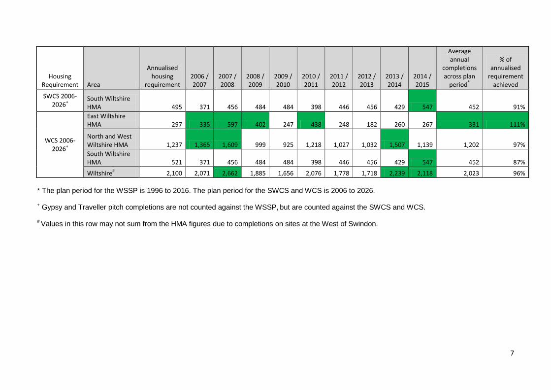
7
Housing Requirement Area
Annualised housing
requirement 2006 / 2007
2007 / 2008
2008 / 2009
2009 / 2010
2010 / 2011
2011 / 2012
2012 / 2013
2013 / 2014
2014 / 2015
Average annual
completions across plan
period*
% of annualised
requirement achieved
SWCS 2006-2026+
South Wiltshire HMA 495 371 456 484 484 398 446 456 429 547 452 91%
WCS 2006-2026+
East Wiltshire HMA 297 335 597 402 247 438 248 182 260 267 331 111%
North and West Wiltshire HMA 1,237 1,365 1,609 999 925 1,218 1,027 1,032 1,507 1,139 1,202 97% South Wiltshire HMA 521 371 456 484 484 398 446 456 429 547 452 87%
Wiltshire# 2,100 2,071 2,662 1,885 1,656 2,076 1,778 1,718 2,239 2,118 2,023 96% * The plan period for the WSSP is 1996 to 2016. The plan period for the SWCS and WCS is 2006 to 2026. + Gypsy and Traveller pitch completions are not counted against the WSSP, but are counted against the SWCS and WCS. # Values in this row may not sum from the HMA figures due to completions on sites at the West of Swindon.
8
Components of Supply 5.1 The supply of deliverable land includes:
• Sites with planning permission or prior approval, • Sites with planning permission subject to a section 106
agreement, • Saved Local Plan allocations (that have been reviewed and
carried forward as part of the Wiltshire Core Strategy), • Strategic Site allocations within the adopted Wiltshire Core
Strategy, • Site allocations identified within the submission draft of the
Chippenham Housing Site Allocations Development Plan Document,
• Adopted Neighbourhood Plan allocations • Emerging Neighbourhood Plan allocations (where the
Neighbourhood Plan has reached the formal consultation stage), • a windfall allowance (in accordance with paragraph 48 of the
NPPF).
5.2 A summary breakdown of all large sites which included in the deliverable supply is available in Appendix 1. The full list of small sites which contribute to the deliverable supply are presented in Appendix 2 (except Neighbourhood Plan allocations of less than 10 dwellings which are included in the large sites table).
5.3 For small sites (except for Neighbourhood Plan allocations) a standard development rate is applied based on historic levels of delivery across Wiltshire for such sites. Each large site (of 10 or more dwellings) and all Neighbourhood Plan allocations have been individually assessed to determine site specific delivery trajectories. The detailed assessment of each large site is presented in Appendix 3.
5.4 Paragraph 3-037 of the PPG states that Local Authorities should count housing provided for older people, including residential institutions in Use Class C2 against their housing requirement, with the approach taken to be clearly set out in the Local Plan. Wiltshire Council adhered to the guidance introduced in March 2014 and considered that policies within the Wiltshire Core Strategy set out the Council’s stance on development of such accommodation. As such, completions of residential care homes were included in the completions figures contributing to the housing requirement set out in the development plan, and large sites considered to be deliverable were included in the trajectory in the July 2014 Housing Land Supply Statement. The Council considered its approach to be sound and to comply with the PPG. However in a number of Section 78 appeal decisions Planning Inspectors have iterated how the Local Plan should set this out definitively in order to justify their inclusion. Decisions studied show that it should be based on an assessment of the need and provision of older persons housing, and set out the likely release of standard housing from persons moving into this type of accommodation. Without
9
such evidence, units should not contribute to the housing requirement or housing supply. The Council have reconsidered its position and removed non-self contained care units from the completions figures and housing trajectory.
5.5 The second bullet point to paragraph 47 of the NPPF, and paragraph 3-033 of the PPG requires that the deliverable supply should be updated annually. An updated housing trajectory, consistent with this analysis, is included in Appendix 4.
5.6 A number of sites at Chippenham were identified in the pre-submission draft of the Wiltshire Core Strategy, but later removed as the Examining Inspector considered these sites had not been assessed equitably. The Inspector recommended in his Final Report that a separate Site Allocations development plan be produced for Chippenham to allocate suitable sites, and this plan is now at an advanced stage. The Chippenham Site Allocations Plan has now reached Examination stage and the sites therefore continue to be included in the trajectory.
5.7 The Wiltshire Core Strategy Strategic Allocation sites form the most
sustainable options for delivering strategic housing developments across Wiltshire. They have been appraised using a site identification methodology and using the Sustainability Appraisal (SA). It is therefore necessary only to demonstrate the availability and achievability of each site to warrant its inclusion in the land supply.
5.8 A windfall allowance is also included in the deliverable supply set out in Table 3 in accordance with paragraph 48 of the NPPF. A full description of the calculation of the windfall allowance is included in Appendix 5.
5.9 The Strategic Housing Land Availability Assessment (SHLAA) identifies
a further pool of sites adjacent to settlement boundaries that could be brought forward in accordance with Development Plan policy, through the Neighbourhood Planning process, or the Housing Sites Allocation Development Plan Document (DPD). However, not all such sites will be suitable (and therefore developable) following further site specific assessments, such as landscape for those sites that lie in an AONB, and so are not included in the deliverable supply.
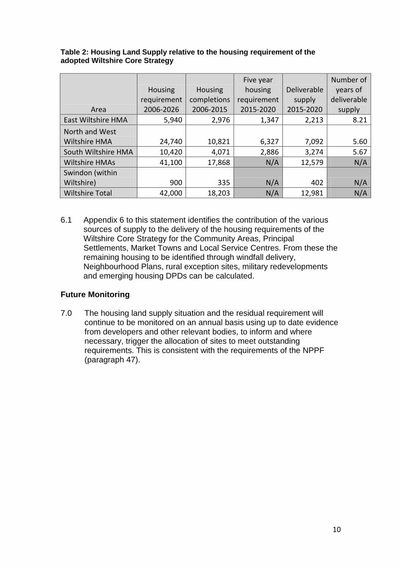
Housing Land Supply 6.0 The table below provides an overview of the five year land supply
against the housing requirements contained in the Wiltshire Core Strategy.
10
Table 2: Housing Land Supply relative to the housing requirement of the adopted Wiltshire Core Strategy
Area
Housing requirement 2006-2026
Housing completions 2006-2015
Five year housing
requirement 2015-2020
Deliverable supply
2015-2020
Number of years of
deliverable supply
East Wiltshire HMA 5,940 2,976 1,347 2,213 8.21 North and West Wiltshire HMA 24,740 10,821 6,327 7,092 5.60 South Wiltshire HMA 10,420 4,071 2,886 3,274 5.67 Wiltshire HMAs 41,100 17,868 N/A 12,579 N/A Swindon (within Wiltshire) 900 335 N/A 402 N/A Wiltshire Total 42,000 18,203 N/A 12,981 N/A
6.1 Appendix 6 to this statement identifies the contribution of the various
sources of supply to the delivery of the housing requirements of the Wiltshire Core Strategy for the Community Areas, Principal Settlements, Market Towns and Local Service Centres. From these the remaining housing to be identified through windfall delivery, Neighbourhood Plans, rural exception sites, military redevelopments and emerging housing DPDs can be calculated.
Future Monitoring 7.0 The housing land supply situation and the residual requirement will
continue to be monitored on an annual basis using up to date evidence from developers and other relevant bodies, to inform and where necessary, trigger the allocation of sites to meet outstanding requirements. This is consistent with the requirements of the NPPF (paragraph 47).
11
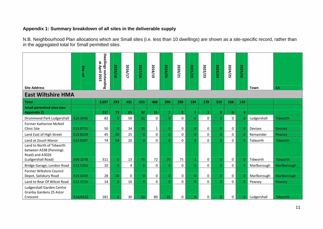
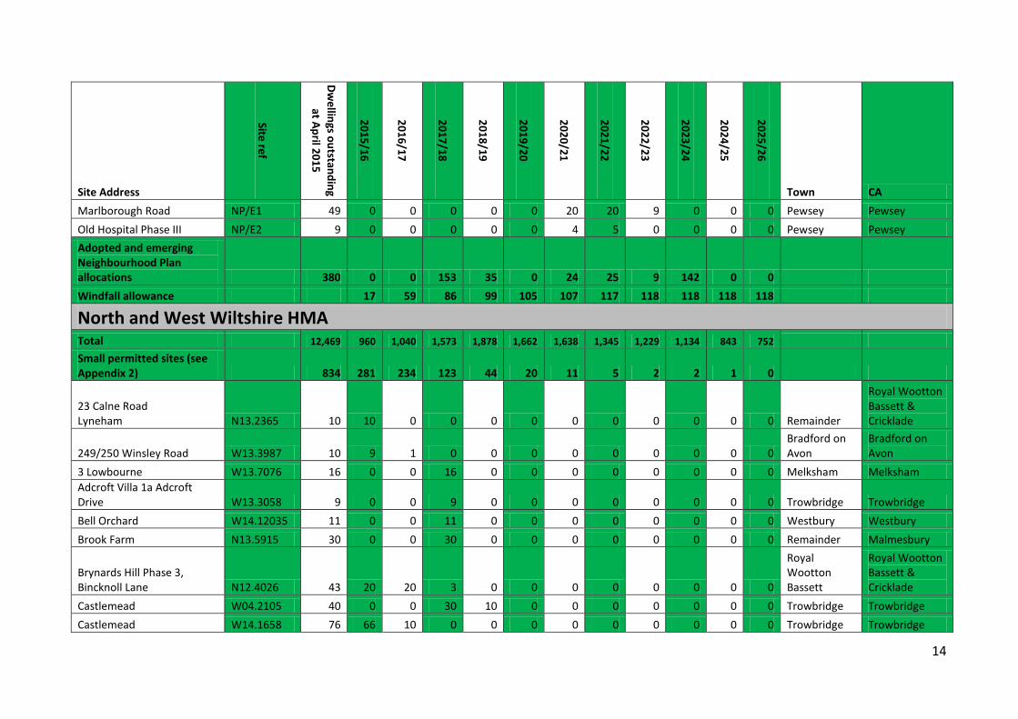
Appendix 1: Summary breakdown of all sites in the deliverable supply N.B. Neighbourhood Plan allocations which are Small sites (i.e. less than 10 dwellings) are shown as a site-specific record, rather than in the aggregated total for Small permitted sites.
Site Address
Site ref
Dwellings outstanding
at April 2015
2015/16
2016/17
2017/18
2018/19
2019/20
2020/21
2021/22
2022/23
2023/24
2024/25
2025/26
Town CA
East Wiltshire HMA Total 2,657 293 431 621 468 396 289 194 178 310 168 143 Small permitted sites (see Appendix 2) 217 73 61 32 11 5 3 1 1 0 0 0 Drummond Park Ludgershall E14.5846 82 0 50 32 0 0 0 0 0 0 0 0 Ludgershall Tidworth Former Katherine McNeil Clinic Site E13.0715 50 0 34 15 1 0 0 0 0 0 0 0 Devizes Devizes Land East of High Street E13.6529 45 20 25 0 0 0 0 0 0 0 0 0 Remainder Pewsey Land at Zouch Manor E13.0397 74 54 20 0 0 0 0 0 0 0 0 0 Tidworth Tidworth Land to North of Tidworth between A338 (Pennings Road) and A3026 (Ludgershall Road) E09.1078 311 0 13 75 72 75 75 1 0 0 0 0 Tidworth Tidworth Bridge Garage, London Road E13.5263 10 0 4 6 0 0 0 0 0 0 0 0 Marlborough Marlborough Former Wiltshire Council Depot, Salisbury Road E14.1649 28 28 0 0 0 0 0 0 0 0 0 0 Marlborough Marlborough Land to Rear Of Wilcot Road E12.1216 14 0 10 4 0 0 0 0 0 0 0 0 Pewsey Pewsey Ludgershall Garden Centre Granby Gardens 25 Astor Crescent E14/6522 181 0 30 50 80 21 0 0 0 0 0 0 Ludgershall Tidworth
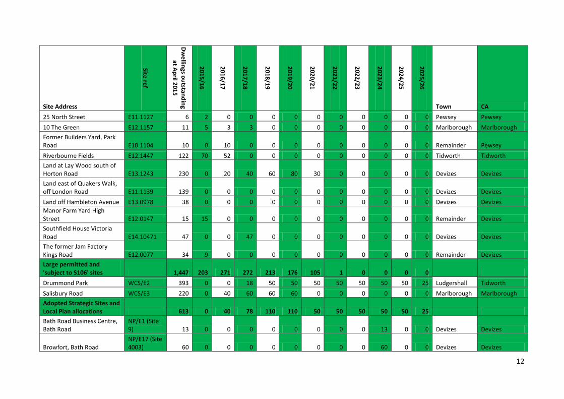
12
Site Address
Site ref
Dwellings outstanding
at April 2015
2015/16
2016/17
2017/18
2018/19
2019/20
2020/21
2021/22
2022/23
2023/24
2024/25
2025/26
Town CA 25 North Street E11.1127 6 2 0 0 0 0 0 0 0 0 0 0 Pewsey Pewsey 10 The Green E12.1157 11 5 3 3 0 0 0 0 0 0 0 0 Marlborough Marlborough Former Builders Yard, Park Road E10.1104 10 0 10 0 0 0 0 0 0 0 0 0 Remainder Pewsey Riverbourne Fields E12.1447 122 70 52 0 0 0 0 0 0 0 0 0 Tidworth Tidworth Land at Lay Wood south of Horton Road E13.1243 230 0 20 40 60 80 30 0 0 0 0 0 Devizes Devizes Land east of Quakers Walk, off London Road E11.1139 139 0 0 0 0 0 0 0 0 0 0 0 Devizes Devizes Land off Hambleton Avenue E13.0978 38 0 0 0 0 0 0 0 0 0 0 0 Devizes Devizes Manor Farm Yard High Street E12.0147 15 15 0 0 0 0 0 0 0 0 0 0 Remainder Devizes Southfield House Victoria Road E14.10471 47 0 0 47 0 0 0 0 0 0 0 0 Devizes Devizes The former Jam Factory Kings Road E12.0077 34 9 0 0 0 0 0 0 0 0 0 0 Remainder Devizes Large permitted and 'subject to S106' sites 1,447 203 271 272 213 176 105 1 0 0 0 0 Drummond Park WCS/E2 393 0 0 18 50 50 50 50 50 50 50 25 Ludgershall Tidworth Salisbury Road WCS/E3 220 0 40 60 60 60 0 0 0 0 0 0 Marlborough Marlborough Adopted Strategic Sites and Local Plan allocations 613 0 40 78 110 110 50 50 50 50 50 25 Bath Road Business Centre, Bath Road
NP/E1 (Site 9) 13 0 0 0 0 0 0 0 0 13 0 0 Devizes Devizes
Browfort, Bath Road NP/E17 (Site 4003) 60 0 0 0 0 0 0 0 0 60 0 0 Devizes Devizes
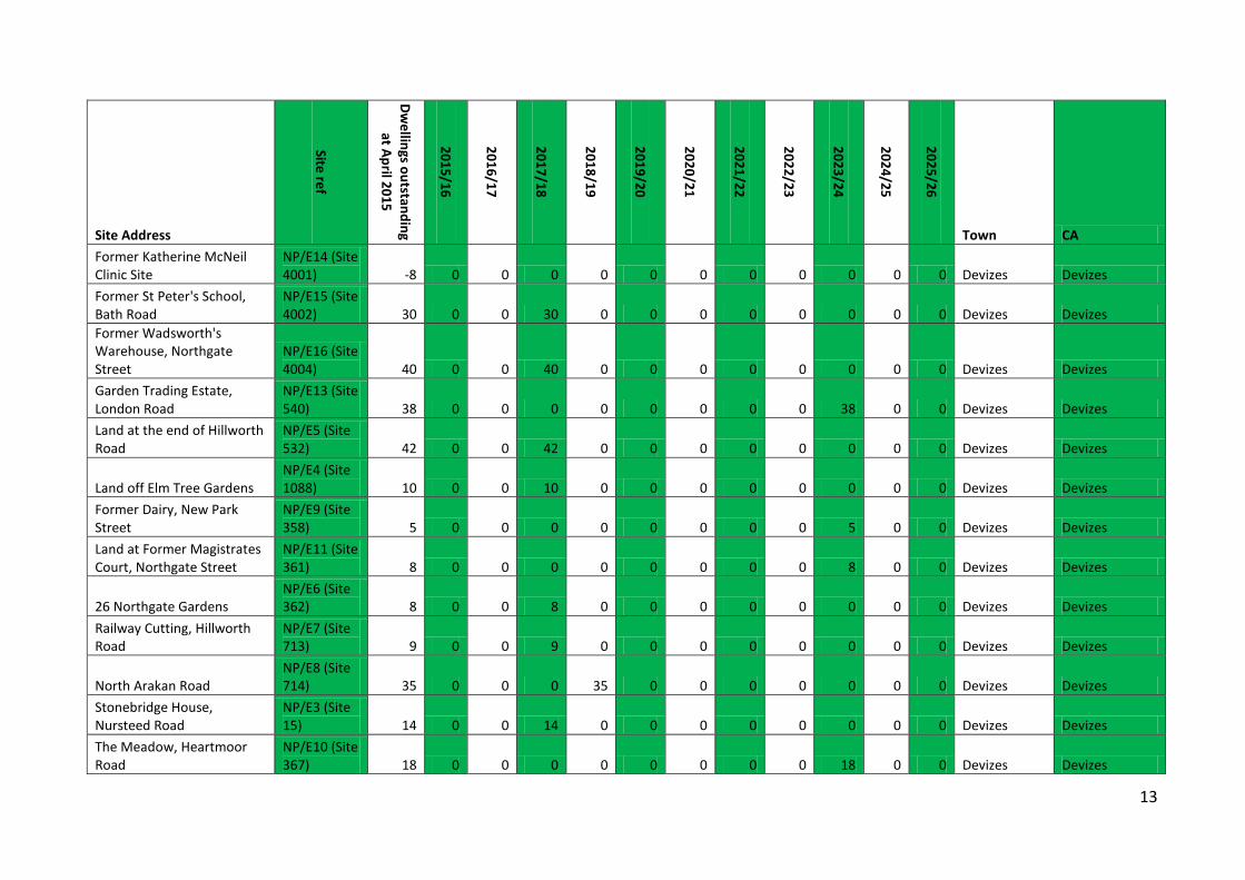
13
Site Address
Site ref
Dwellings outstanding
at April 2015
2015/16
2016/17
2017/18
2018/19
2019/20
2020/21
2021/22
2022/23
2023/24
2024/25
2025/26
Town CA Former Katherine McNeil Clinic Site
NP/E14 (Site 4001) -8 0 0 0 0 0 0 0 0 0 0 0 Devizes Devizes
Former St Peter's School, Bath Road
NP/E15 (Site 4002) 30 0 0 30 0 0 0 0 0 0 0 0 Devizes Devizes
Former Wadsworth's Warehouse, Northgate Street
NP/E16 (Site 4004) 40 0 0 40 0 0 0 0 0 0 0 0 Devizes Devizes
Garden Trading Estate, London Road
NP/E13 (Site 540) 38 0 0 0 0 0 0 0 0 38 0 0 Devizes Devizes
Land at the end of Hillworth Road
NP/E5 (Site 532) 42 0 0 42 0 0 0 0 0 0 0 0 Devizes Devizes
Land off Elm Tree Gardens NP/E4 (Site 1088) 10 0 0 10 0 0 0 0 0 0 0 0 Devizes Devizes
Former Dairy, New Park Street
NP/E9 (Site 358) 5 0 0 0 0 0 0 0 0 5 0 0 Devizes Devizes
Land at Former Magistrates Court, Northgate Street
NP/E11 (Site 361) 8 0 0 0 0 0 0 0 0 8 0 0 Devizes Devizes
26 Northgate Gardens NP/E6 (Site 362) 8 0 0 8 0 0 0 0 0 0 0 0 Devizes Devizes
Railway Cutting, Hillworth Road
NP/E7 (Site 713) 9 0 0 9 0 0 0 0 0 0 0 0 Devizes Devizes
North Arakan Road NP/E8 (Site 714) 35 0 0 0 35 0 0 0 0 0 0 0 Devizes Devizes
Stonebridge House, Nursteed Road
NP/E3 (Site 15) 14 0 0 14 0 0 0 0 0 0 0 0 Devizes Devizes
The Meadow, Heartmoor Road
NP/E10 (Site 367) 18 0 0 0 0 0 0 0 0 18 0 0 Devizes Devizes
14
Site Address
Site ref
Dwellings outstanding
at April 2015
2015/16
2016/17
2017/18
2018/19
2019/20
2020/21
2021/22
2022/23
2023/24
2024/25
2025/26
Town CA Marlborough Road NP/E1 49 0 0 0 0 0 20 20 9 0 0 0 Pewsey Pewsey Old Hospital Phase III NP/E2 9 0 0 0 0 0 4 5 0 0 0 0 Pewsey Pewsey Adopted and emerging Neighbourhood Plan allocations 380 0 0 153 35 0 24 25 9 142 0 0 Windfall allowance 17 59 86 99 105 107 117 118 118 118 118
North and West Wiltshire HMA Total 12,469 960 1,040 1,573 1,878 1,662 1,638 1,345 1,229 1,134 843 752 Small permitted sites (see Appendix 2) 834 281 234 123 44 20 11 5 2 2 1 0
23 Calne Road Lyneham N13.2365 10 10 0 0 0 0 0 0 0 0 0 0 Remainder
Royal Wootton Bassett & Cricklade
249/250 Winsley Road W13.3987 10 9 1 0 0 0 0 0 0 0 0 0 Bradford on Avon
Bradford on Avon
3 Lowbourne W13.7076 16 0 0 16 0 0 0 0 0 0 0 0 Melksham Melksham Adcroft Villa 1a Adcroft Drive W13.3058 9 0 0 9 0 0 0 0 0 0 0 0 Trowbridge Trowbridge Bell Orchard W14.12035 11 0 0 11 0 0 0 0 0 0 0 0 Westbury Westbury Brook Farm N13.5915 30 0 0 30 0 0 0 0 0 0 0 0 Remainder Malmesbury
Brynards Hill Phase 3, Bincknoll Lane N12.4026 43 20 20 3 0 0 0 0 0 0 0 0
Royal Wootton Bassett
Royal Wootton Bassett & Cricklade
Castlemead W04.2105 40 0 0 30 10 0 0 0 0 0 0 0 Trowbridge Trowbridge Castlemead W14.1658 76 66 10 0 0 0 0 0 0 0 0 0 Trowbridge Trowbridge
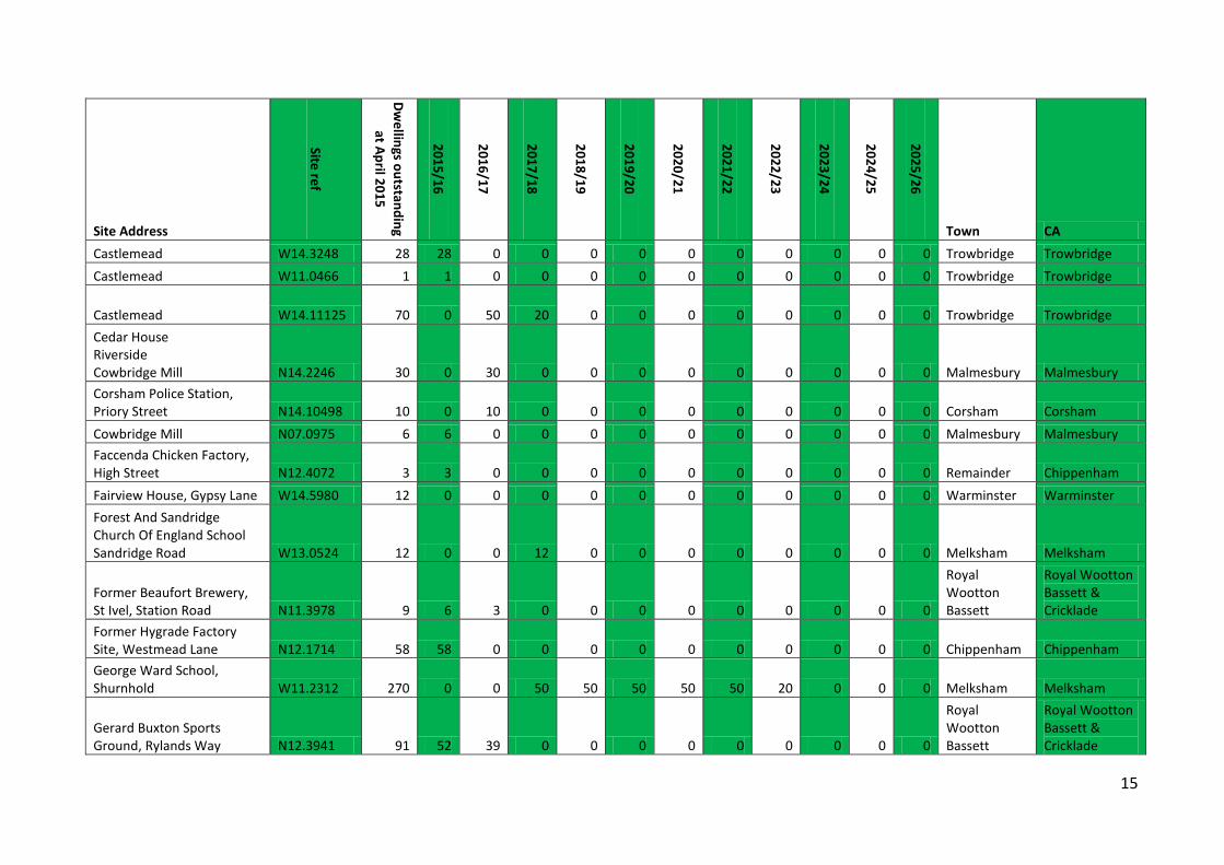
15
Site Address
Site ref
Dwellings outstanding
at April 2015
2015/16
2016/17
2017/18
2018/19
2019/20
2020/21
2021/22
2022/23
2023/24
2024/25
2025/26
Town CA Castlemead W14.3248 28 28 0 0 0 0 0 0 0 0 0 0 Trowbridge Trowbridge Castlemead W11.0466 1 1 0 0 0 0 0 0 0 0 0 0 Trowbridge Trowbridge
Castlemead W14.11125 70 0 50 20 0 0 0 0 0 0 0 0 Trowbridge Trowbridge Cedar House Riverside Cowbridge Mill N14.2246 30 0 30 0 0 0 0 0 0 0 0 0 Malmesbury Malmesbury Corsham Police Station, Priory Street N14.10498 10 0 10 0 0 0 0 0 0 0 0 0 Corsham Corsham Cowbridge Mill N07.0975 6 6 0 0 0 0 0 0 0 0 0 0 Malmesbury Malmesbury Faccenda Chicken Factory, High Street N12.4072 3 3 0 0 0 0 0 0 0 0 0 0 Remainder Chippenham Fairview House, Gypsy Lane W14.5980 12 0 0 0 0 0 0 0 0 0 0 0 Warminster Warminster Forest And Sandridge Church Of England School Sandridge Road W13.0524 12 0 0 12 0 0 0 0 0 0 0 0 Melksham Melksham
Former Beaufort Brewery, St Ivel, Station Road N11.3978 9 6 3 0 0 0 0 0 0 0 0 0
Royal Wootton Bassett
Royal Wootton Bassett & Cricklade
Former Hygrade Factory Site, Westmead Lane N12.1714 58 58 0 0 0 0 0 0 0 0 0 0 Chippenham Chippenham George Ward School, Shurnhold W11.2312 270 0 0 50 50 50 50 50 20 0 0 0 Melksham Melksham
Gerard Buxton Sports Ground, Rylands Way N12.3941 91 52 39 0 0 0 0 0 0 0 0 0
Royal Wootton Bassett
Royal Wootton Bassett & Cricklade
16
Site Address
Site ref
Dwellings outstanding
at April 2015
2015/16
2016/17
2017/18
2018/19
2019/20
2020/21
2021/22
2022/23
2023/24
2024/25
2025/26
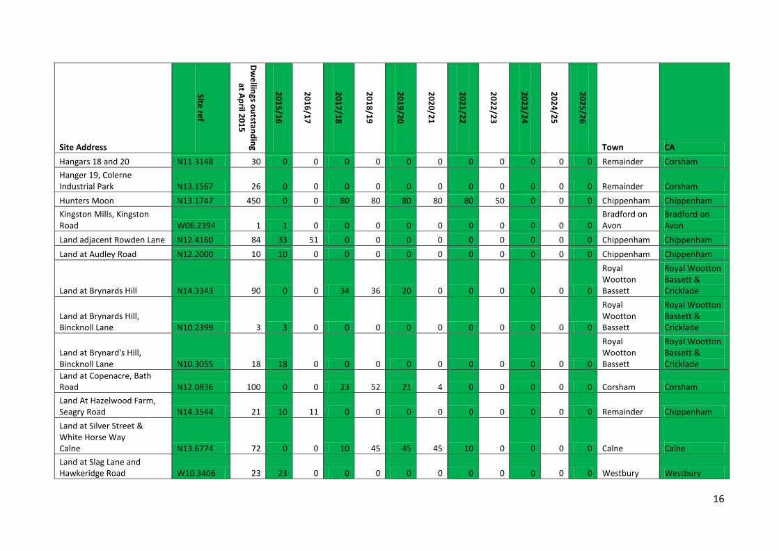
Town CA Hangars 18 and 20 N11.3148 30 0 0 0 0 0 0 0 0 0 0 0 Remainder Corsham Hanger 19, Colerne Industrial Park N13.1567 26 0 0 0 0 0 0 0 0 0 0 0 Remainder Corsham Hunters Moon N13.1747 450 0 0 80 80 80 80 80 50 0 0 0 Chippenham Chippenham Kingston Mills, Kingston Road W06.2394 1 1 0 0 0 0 0 0 0 0 0 0
Bradford on Avon
Bradford on Avon
Land adjacent Rowden Lane N12.4160 84 33 51 0 0 0 0 0 0 0 0 0 Chippenham Chippenham Land at Audley Road N12.2000 10 10 0 0 0 0 0 0 0 0 0 0 Chippenham Chippenham
Land at Brynards Hill N14.3343 90 0 0 34 36 20 0 0 0 0 0 0
Royal Wootton Bassett
Royal Wootton Bassett & Cricklade
Land at Brynards Hill, Bincknoll Lane N10.2399 3 3 0 0 0 0 0 0 0 0 0 0
Royal Wootton Bassett
Royal Wootton Bassett & Cricklade
Land at Brynard's Hill, Bincknoll Lane N10.3055 18 18 0 0 0 0 0 0 0 0 0 0
Royal Wootton Bassett
Royal Wootton Bassett & Cricklade
Land at Copenacre, Bath Road N12.0836 100 0 0 23 52 21 4 0 0 0 0 0 Corsham Corsham Land At Hazelwood Farm, Seagry Road N14.3544 21 10 11 0 0 0 0 0 0 0 0 0 Remainder Chippenham Land at Silver Street & White Horse Way Calne N13.6774 72 0 0 10 45 45 45 10 0 0 0 0 Calne Calne Land at Slag Lane and Hawkeridge Road W10.3406 23 23 0 0 0 0 0 0 0 0 0 0 Westbury Westbury
17
Site Address
Site ref
Dwellings outstanding
at April 2015
2015/16
2016/17
2017/18
2018/19
2019/20
2020/21
2021/22
2022/23
2023/24
2024/25
2025/26
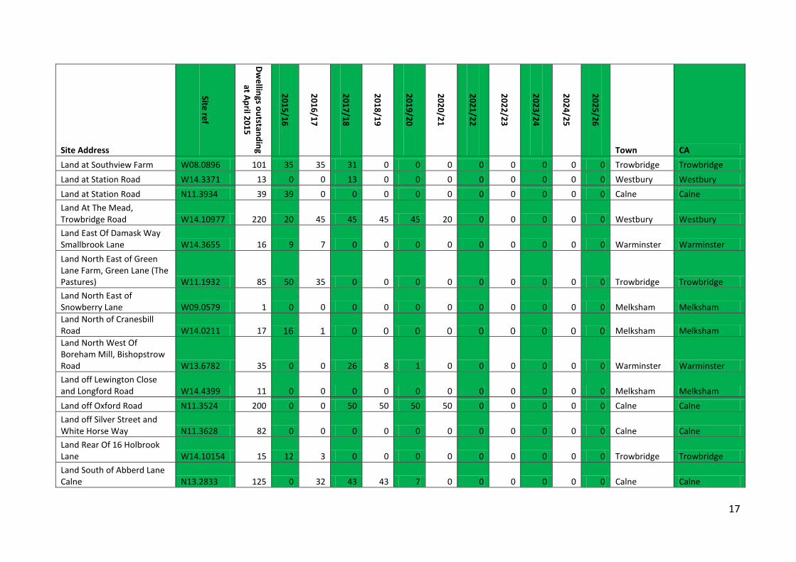
Town CA Land at Southview Farm W08.0896 101 35 35 31 0 0 0 0 0 0 0 0 Trowbridge Trowbridge Land at Station Road W14.3371 13 0 0 13 0 0 0 0 0 0 0 0 Westbury Westbury Land at Station Road N11.3934 39 39 0 0 0 0 0 0 0 0 0 0 Calne Calne Land At The Mead, Trowbridge Road W14.10977 220 20 45 45 45 45 20 0 0 0 0 0 Westbury Westbury Land East Of Damask Way Smallbrook Lane W14.3655 16 9 7 0 0 0 0 0 0 0 0 0 Warminster Warminster Land North East of Green Lane Farm, Green Lane (The Pastures) W11.1932 85 50 35 0 0 0 0 0 0 0 0 0 Trowbridge Trowbridge Land North East of Snowberry Lane W09.0579 1 0 0 0 0 0 0 0 0 0 0 0 Melksham Melksham Land North of Cranesbill Road W14.0211 17 16 1 0 0 0 0 0 0 0 0 0 Melksham Melksham Land North West Of Boreham Mill, Bishopstrow Road W13.6782 35 0 0 26 8 1 0 0 0 0 0 0 Warminster Warminster Land off Lewington Close and Longford Road W14.4399 11 0 0 0 0 0 0 0 0 0 0 0 Melksham Melksham Land off Oxford Road N11.3524 200 0 0 50 50 50 50 0 0 0 0 0 Calne Calne Land off Silver Street and White Horse Way N11.3628 82 0 0 0 0 0 0 0 0 0 0 0 Calne Calne Land Rear Of 16 Holbrook Lane W14.10154 15 12 3 0 0 0 0 0 0 0 0 0 Trowbridge Trowbridge Land South of Abberd Lane Calne N13.2833 125 0 32 43 43 7 0 0 0 0 0 0 Calne Calne
18
Site Address
Site ref
Dwellings outstanding
at April 2015
2015/16
2016/17
2017/18
2018/19
2019/20
2020/21
2021/22
2022/23
2023/24
2024/25
2025/26
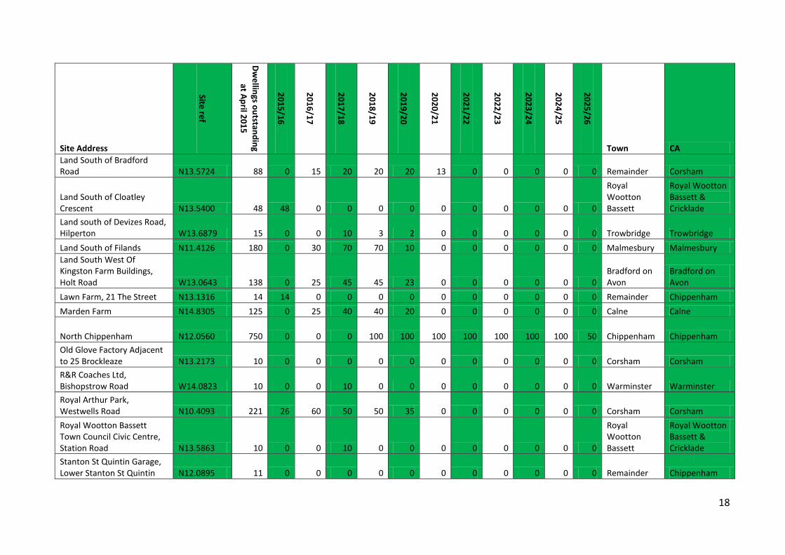
Town CA Land South of Bradford Road N13.5724 88 0 15 20 20 20 13 0 0 0 0 0 Remainder Corsham
Land South of Cloatley Crescent N13.5400 48 48 0 0 0 0 0 0 0 0 0 0
Royal Wootton Bassett
Royal Wootton Bassett & Cricklade
Land south of Devizes Road, Hilperton W13.6879 15 0 0 10 3 2 0 0 0 0 0 0 Trowbridge Trowbridge Land South of Filands N11.4126 180 0 30 70 70 10 0 0 0 0 0 0 Malmesbury Malmesbury Land South West Of Kingston Farm Buildings, Holt Road W13.0643 138 0 25 45 45 23 0 0 0 0 0 0
Bradford on Avon
Bradford on Avon
Lawn Farm, 21 The Street N13.1316 14 14 0 0 0 0 0 0 0 0 0 0 Remainder Chippenham Marden Farm N14.8305 125 0 25 40 40 20 0 0 0 0 0 0 Calne Calne
North Chippenham N12.0560 750 0 0 0 100 100 100 100 100 100 100 50 Chippenham Chippenham Old Glove Factory Adjacent to 25 Brockleaze N13.2173 10 0 0 0 0 0 0 0 0 0 0 0 Corsham Corsham R&R Coaches Ltd, Bishopstrow Road W14.0823 10 0 0 10 0 0 0 0 0 0 0 0 Warminster Warminster Royal Arthur Park, Westwells Road N10.4093 221 26 60 50 50 35 0 0 0 0 0 0 Corsham Corsham Royal Wootton Bassett Town Council Civic Centre, Station Road N13.5863 10 0 0 10 0 0 0 0 0 0 0 0
Royal Wootton Bassett
Royal Wootton Bassett & Cricklade
Stanton St Quintin Garage, Lower Stanton St Quintin N12.0895 11 0 0 0 0 0 0 0 0 0 0 0 Remainder Chippenham
19
Site Address
Site ref
Dwellings outstanding
at April 2015
2015/16
2016/17
2017/18
2018/19
2019/20
2020/21
2021/22
2022/23
2023/24
2024/25
2025/26
Town CA Terry's Social Club, Hill Street W09.2934 16 0 0 0 0 0 16 0 0 0 0 0 Trowbridge Trowbridge Trowbridge Rugby Football Club W05.0821 11 11 0 0 0 0 0 0 0 0 0 0 Trowbridge Trowbridge Warminster United Services Club 36 Imber Road W10.2407 12 0 0 0 0 0 0 0 0 0 0 0 Warminster Warminster Westbury North Junction Station Road W10.2479 102 0 40 40 22 0 0 0 0 0 0 0 Westbury Westbury Westinghouse Recreation Ground, Park Avenue N11.0134 74 0 0 0 0 0 0 0 0 0 0 0 Chippenham Chippenham RAF Yatesbury Jugglers Lane Yatesbury Wiltshire SN11 8YA N14.0153 46 0 0 28 16 2 0 0 0 0 0 0 Remainder Calne Land at Potley Lane N14.5686 64 0 0 20 30 14 0 0 0 0 0 0 Corsham Corsham Blounts Court N14.9769 28 0 0 10 12 8 0 0 0 0 0 0 Remainder Calne Large permitted and 'subject to S106' sites 4,706 637 578 889 827 553 378 240 170 100 100 50 AB Carter Haulage Contractors, 14 Happy Land 2/LPA/11 11 0 0 0 0 0 5 6 0 0 0 0 Remainder Malmesbury Cedar Grove 5/LPA/43 15 0 0 0 0 0 0 0 0 0 0 0 Trowbridge Trowbridge Court Street 5/LPA/21 112 0 0 0 0 0 0 0 0 0 0 0 Trowbridge Trowbridge East Chippenham CH3 800 0 0 0 0 0 80 100 100 100 150 150 Chippenham Chippenham Foundary Lane 2/LPA/18 250 0 0 0 25 50 40 0 0 0 0 0 Chippenham Chippenham Land adjacent to Westbury Hospital 5/LPA/64 25 0 30 30 0 0 0 0 0 0 0 0 Westbury Westbury
20
Site Address
Site ref
Dwellings outstanding
at April 2015
2015/16
2016/17
2017/18
2018/19
2019/20
2020/21
2021/22
2022/23
2023/24
2024/25
2025/26
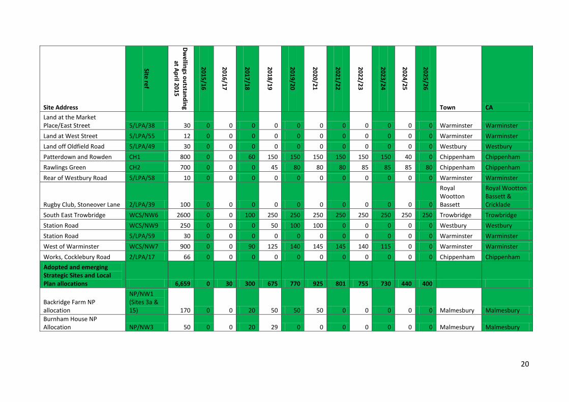
Town CA Land at the Market Place/East Street 5/LPA/38 30 0 0 0 0 0 0 0 0 0 0 0 Warminster Warminster Land at West Street 5/LPA/55 12 0 0 0 0 0 0 0 0 0 0 0 Warminster Warminster Land off Oldfield Road 5/LPA/49 30 0 0 0 0 0 0 0 0 0 0 0 Westbury Westbury Patterdown and Rowden CH1 800 0 0 60 150 150 150 150 150 150 40 0 Chippenham Chippenham Rawlings Green CH2 700 0 0 0 45 80 80 80 85 85 85 80 Chippenham Chippenham Rear of Westbury Road 5/LPA/58 10 0 0 0 0 0 0 0 0 0 0 0 Warminster Warminster
Rugby Club, Stoneover Lane 2/LPA/39 100 0 0 0 0 0 0 0 0 0 0 0
Royal Wootton Bassett
Royal Wootton Bassett & Cricklade
South East Trowbridge WCS/NW6 2600 0 0 100 250 250 250 250 250 250 250 250 Trowbridge Trowbridge Station Road WCS/NW9 250 0 0 0 50 100 100 0 0 0 0 0 Westbury Westbury Station Road 5/LPA/59 30 0 0 0 0 0 0 0 0 0 0 0 Warminster Warminster West of Warminster WCS/NW7 900 0 0 90 125 140 145 145 140 115 0 0 Warminster Warminster Works, Cocklebury Road 2/LPA/17 66 0 0 0 0 0 0 0 0 0 0 0 Chippenham Chippenham Adopted and emerging Strategic Sites and Local Plan allocations 6,659 0 30 300 675 770 925 801 755 730 440 400
Backridge Farm NP allocation
NP/NW1 (Sites 3a & 15) 170 0 0 20 50 50 50 0 0 0 0 0 Malmesbury Malmesbury
Burnham House NP Allocation NP/NW3 50 0 0 20 29 0 0 0 0 0 0 0 Malmesbury Malmesbury
21
Site Address
Site ref
Dwellings outstanding
at April 2015
2015/16
2016/17
2017/18
2018/19
2019/20
2020/21
2021/22
2022/23
2023/24
2024/25
2025/26
Town CA
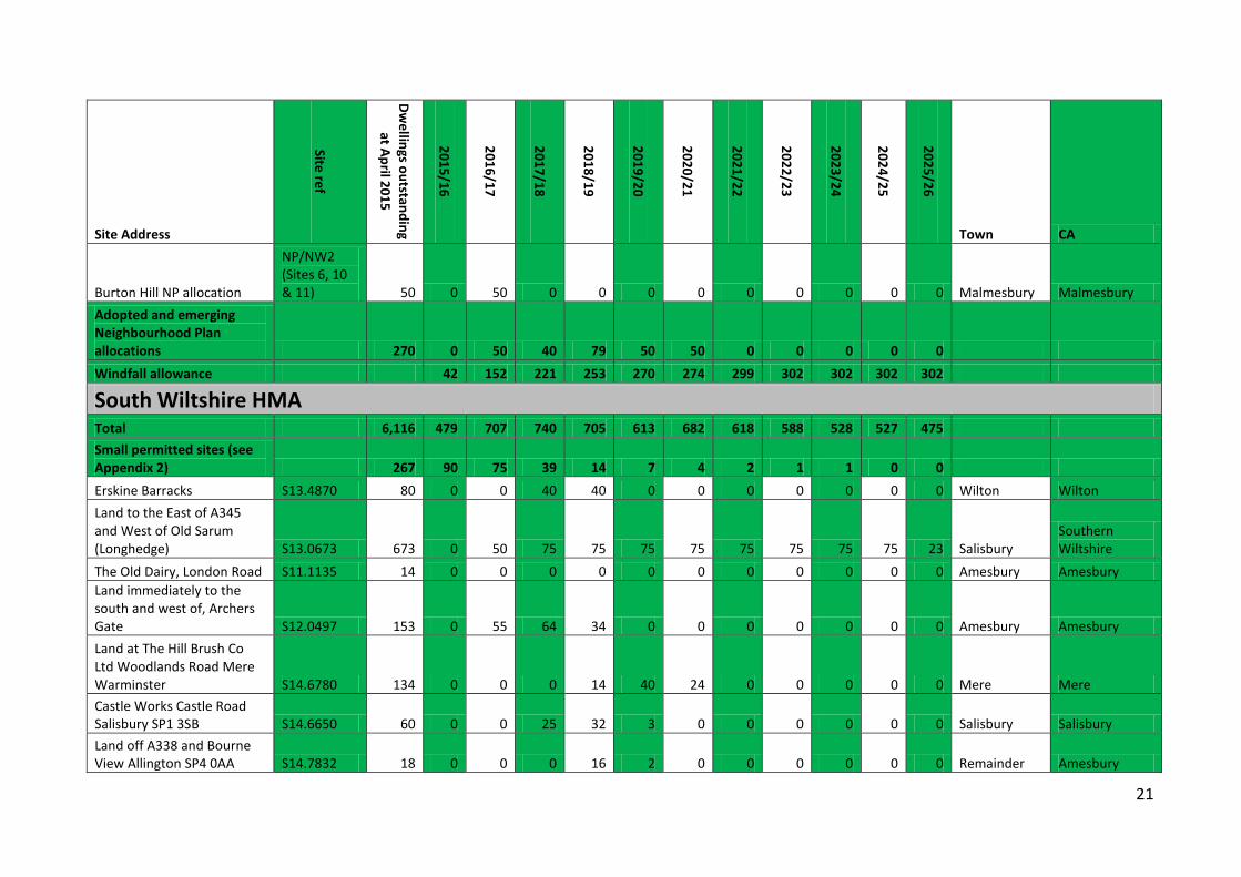
Burton Hill NP allocation
NP/NW2 (Sites 6, 10 & 11) 50 0 50 0 0 0 0 0 0 0 0 0 Malmesbury Malmesbury
Adopted and emerging Neighbourhood Plan allocations 270 0 50 40 79 50 50 0 0 0 0 0 Windfall allowance 42 152 221 253 270 274 299 302 302 302 302
South Wiltshire HMA Total 6,116 479 707 740 705 613 682 618 588 528 527 475 Small permitted sites (see Appendix 2) 267 90 75 39 14 7 4 2 1 1 0 0 Erskine Barracks S13.4870 80 0 0 40 40 0 0 0 0 0 0 0 Wilton Wilton Land to the East of A345 and West of Old Sarum (Longhedge) S13.0673 673 0 50 75 75 75 75 75 75 75 75 23 Salisbury
Southern Wiltshire
The Old Dairy, London Road S11.1135 14 0 0 0 0 0 0 0 0 0 0 0 Amesbury Amesbury Land immediately to the south and west of, Archers Gate S12.0497 153 0 55 64 34 0 0 0 0 0 0 0 Amesbury Amesbury Land at The Hill Brush Co Ltd Woodlands Road Mere Warminster S14.6780 134 0 0 0 14 40 24 0 0 0 0 0 Mere Mere Castle Works Castle Road Salisbury SP1 3SB S14.6650 60 0 0 25 32 3 0 0 0 0 0 0 Salisbury Salisbury Land off A338 and Bourne View Allington SP4 0AA S14.7832 18 0 0 0 16 2 0 0 0 0 0 0 Remainder Amesbury
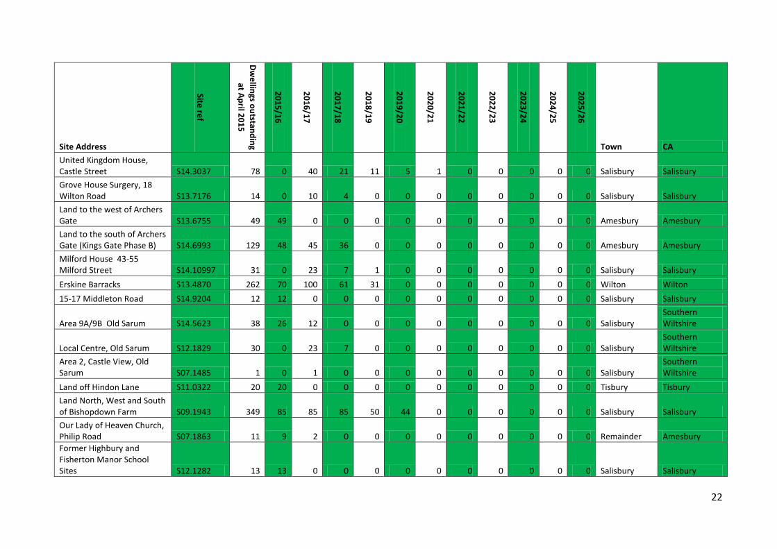
22
Site Address
Site ref
Dwellings outstanding
at April 2015
2015/16
2016/17
2017/18
2018/19
2019/20
2020/21
2021/22
2022/23
2023/24
2024/25
2025/26
Town CA United Kingdom House, Castle Street S14.3037 78 0 40 21 11 5 1 0 0 0 0 0 Salisbury Salisbury Grove House Surgery, 18 Wilton Road S13.7176 14 0 10 4 0 0 0 0 0 0 0 0 Salisbury Salisbury Land to the west of Archers Gate S13.6755 49 49 0 0 0 0 0 0 0 0 0 0 Amesbury Amesbury Land to the south of Archers Gate (Kings Gate Phase B) S14.6993 129 48 45 36 0 0 0 0 0 0 0 0 Amesbury Amesbury Milford House 43-55 Milford Street S14.10997 31 0 23 7 1 0 0 0 0 0 0 0 Salisbury Salisbury Erskine Barracks S13.4870 262 70 100 61 31 0 0 0 0 0 0 0 Wilton Wilton 15-17 Middleton Road S14.9204 12 12 0 0 0 0 0 0 0 0 0 0 Salisbury Salisbury
Area 9A/9B Old Sarum S14.5623 38 26 12 0 0 0 0 0 0 0 0 0 Salisbury Southern Wiltshire
Local Centre, Old Sarum S12.1829 30 0 23 7 0 0 0 0 0 0 0 0 Salisbury Southern Wiltshire
Area 2, Castle View, Old Sarum S07.1485 1 0 1 0 0 0 0 0 0 0 0 0 Salisbury
Southern Wiltshire
Land off Hindon Lane S11.0322 20 20 0 0 0 0 0 0 0 0 0 0 Tisbury Tisbury Land North, West and South of Bishopdown Farm S09.1943 349 85 85 85 50 44 0 0 0 0 0 0 Salisbury Salisbury Our Lady of Heaven Church, Philip Road S07.1863 11 9 2 0 0 0 0 0 0 0 0 0 Remainder Amesbury Former Highbury and Fisherton Manor School Sites S12.1282 13 13 0 0 0 0 0 0 0 0 0 0 Salisbury Salisbury
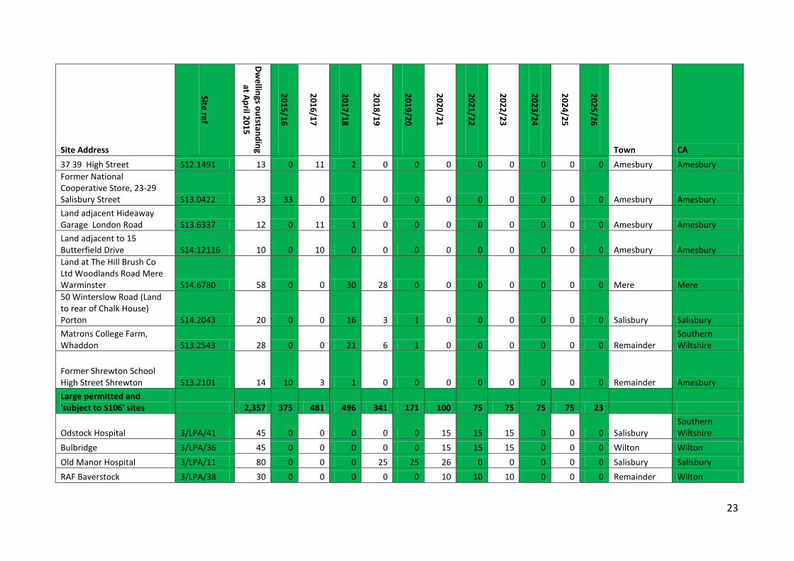
23
Site Address
Site ref
Dwellings outstanding
at April 2015
2015/16
2016/17
2017/18
2018/19
2019/20
2020/21
2021/22
2022/23
2023/24
2024/25
2025/26
Town CA 37 39 High Street S12.1491 13 0 11 2 0 0 0 0 0 0 0 0 Amesbury Amesbury Former National Cooperative Store, 23-29 Salisbury Street S13.0422 33 33 0 0 0 0 0 0 0 0 0 0 Amesbury Amesbury Land adjacent Hideaway Garage London Road S13.6337 12 0 11 1 0 0 0 0 0 0 0 0 Amesbury Amesbury Land adjacent to 15 Butterfield Drive S14.12116 10 0 10 0 0 0 0 0 0 0 0 0 Amesbury Amesbury Land at The Hill Brush Co Ltd Woodlands Road Mere Warminster S14.6780 58 0 0 30 28 0 0 0 0 0 0 0 Mere Mere 50 Winterslow Road (Land to rear of Chalk House) Porton S14.2043 20 0 0 16 3 1 0 0 0 0 0 0 Salisbury Salisbury Matrons College Farm, Whaddon S13.2543 28 0 0 21 6 1 0 0 0 0 0 0 Remainder
Southern Wiltshire
Former Shrewton School High Street Shrewton S13.2101 14 10 3 1 0 0 0 0 0 0 0 0 Remainder Amesbury Large permitted and 'subject to S106' sites 2,357 375 481 496 341 171 100 75 75 75 75 23
Odstock Hospital 3/LPA/41 45 0 0 0 0 0 15 15 15 0 0 0 Salisbury Southern Wiltshire
Bulbridge 3/LPA/36 45 0 0 0 0 0 15 15 15 0 0 0 Wilton Wilton Old Manor Hospital 3/LPA/11 80 0 0 0 25 25 26 0 0 0 0 0 Salisbury Salisbury RAF Baverstock 3/LPA/38 30 0 0 0 0 0 10 10 10 0 0 0 Remainder Wilton
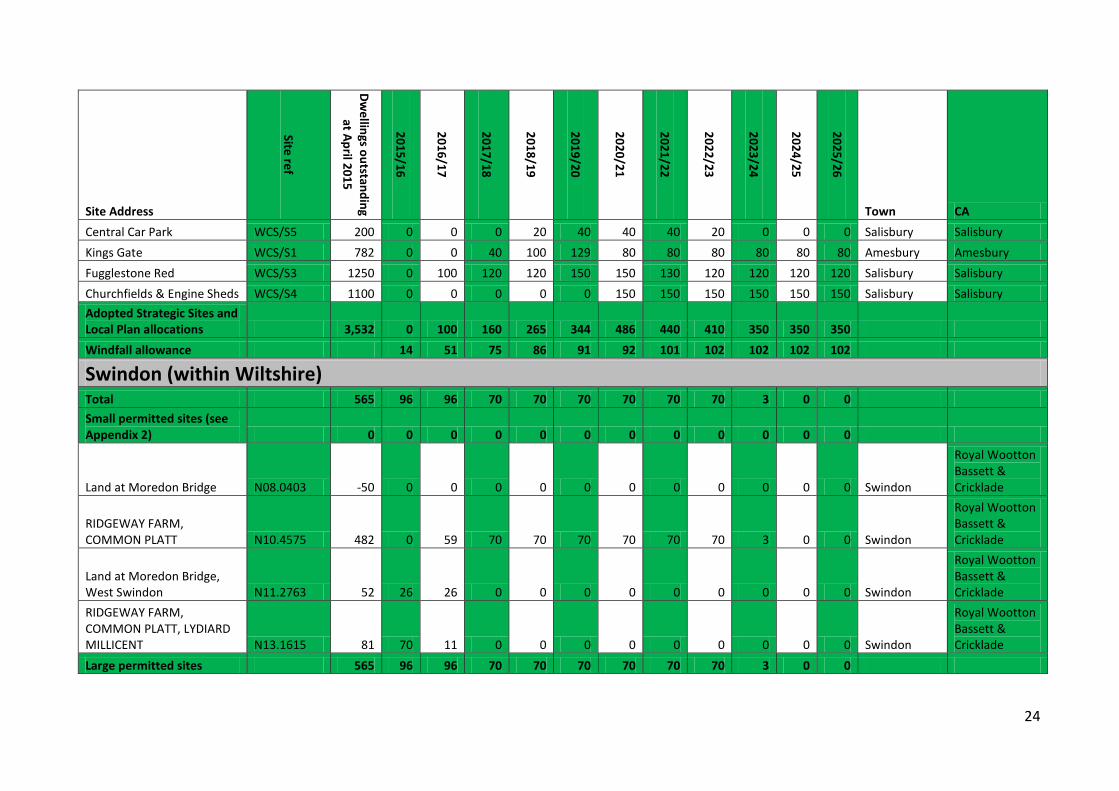
24
Site Address
Site ref
Dwellings outstanding
at April 2015
2015/16
2016/17
2017/18
2018/19
2019/20
2020/21
2021/22
2022/23
2023/24
2024/25
2025/26
Town CA Central Car Park WCS/S5 200 0 0 0 20 40 40 40 20 0 0 0 Salisbury Salisbury Kings Gate WCS/S1 782 0 0 40 100 129 80 80 80 80 80 80 Amesbury Amesbury Fugglestone Red WCS/S3 1250 0 100 120 120 150 150 130 120 120 120 120 Salisbury Salisbury Churchfields & Engine Sheds WCS/S4 1100 0 0 0 0 0 150 150 150 150 150 150 Salisbury Salisbury Adopted Strategic Sites and Local Plan allocations 3,532 0 100 160 265 344 486 440 410 350 350 350 Windfall allowance 14 51 75 86 91 92 101 102 102 102 102
Swindon (within Wiltshire) Total 565 96 96 70 70 70 70 70 70 3 0 0 Small permitted sites (see Appendix 2) 0 0 0 0 0 0 0 0 0 0 0 0
Land at Moredon Bridge N08.0403 -50 0 0 0 0 0 0 0 0 0 0 0 Swindon
Royal Wootton Bassett & Cricklade
RIDGEWAY FARM, COMMON PLATT N10.4575 482 0 59 70 70 70 70 70 70 3 0 0 Swindon
Royal Wootton Bassett & Cricklade
Land at Moredon Bridge, West Swindon N11.2763 52 26 26 0 0 0 0 0 0 0 0 0 Swindon
Royal Wootton Bassett & Cricklade
RIDGEWAY FARM, COMMON PLATT, LYDIARD MILLICENT N13.1615 81 70 11 0 0 0 0 0 0 0 0 0 Swindon
Royal Wootton Bassett & Cricklade
Large permitted sites 565 96 96 70 70 70 70 70 70 3 0 0
25
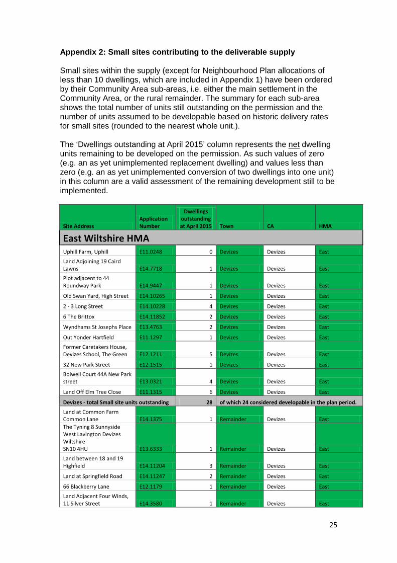
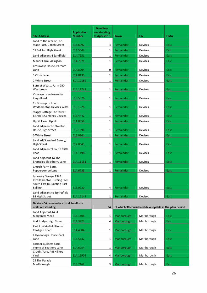
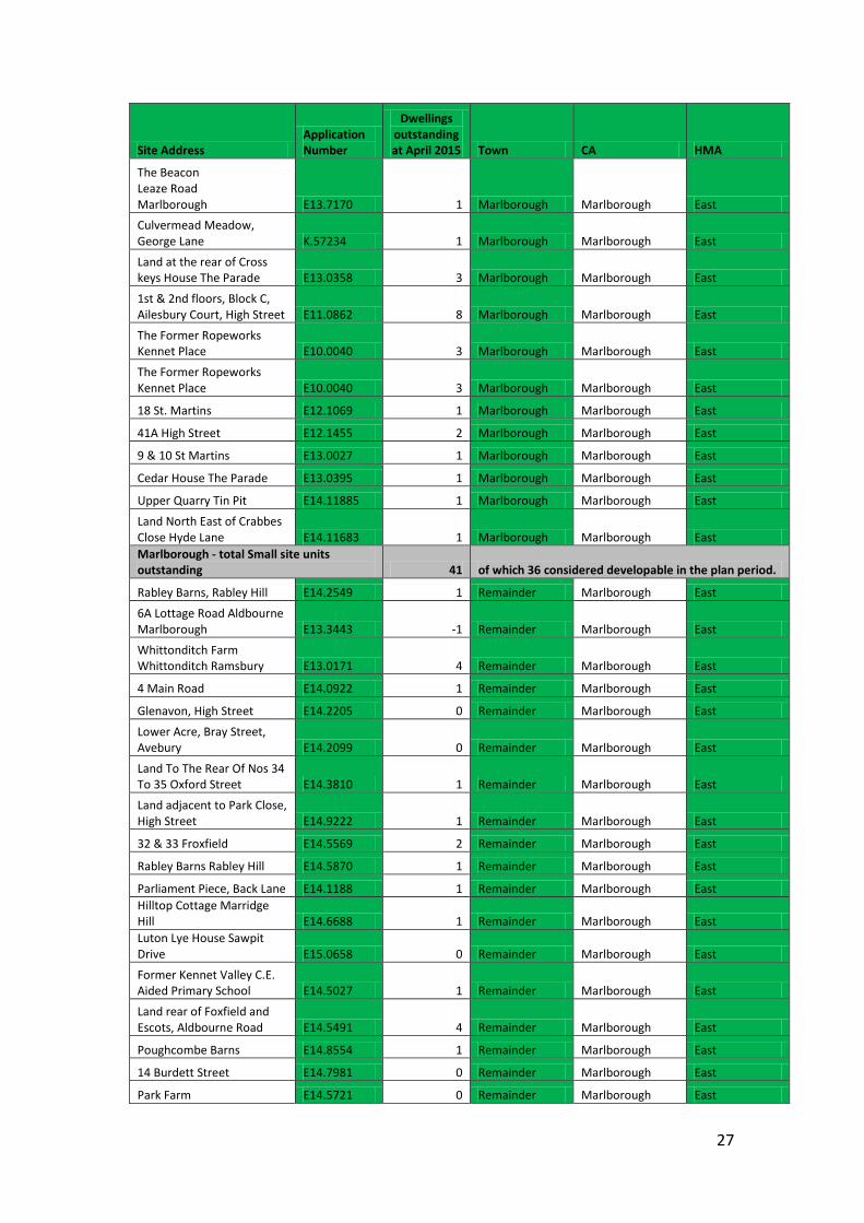
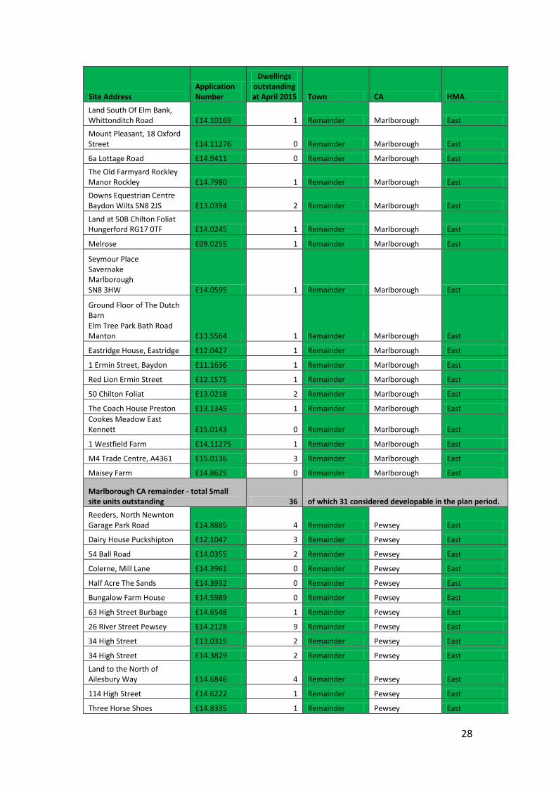
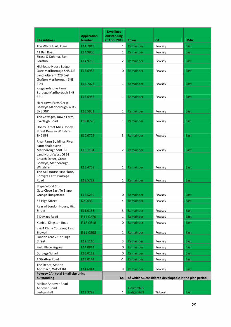
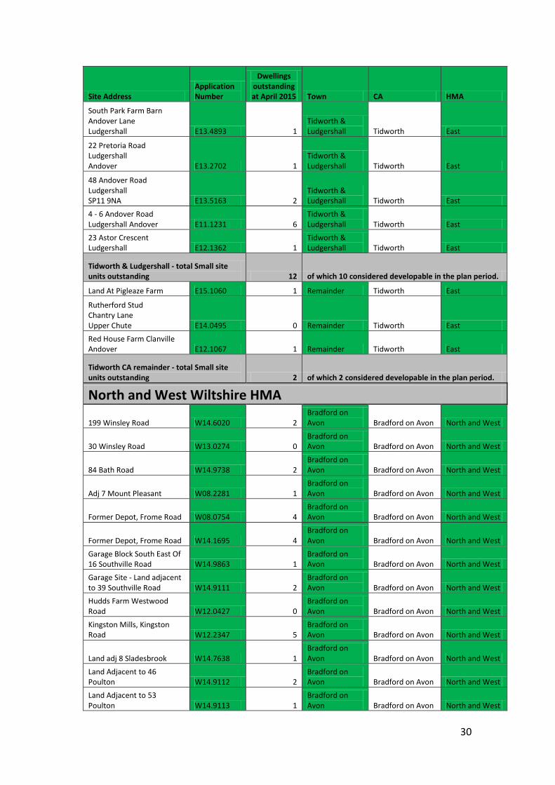
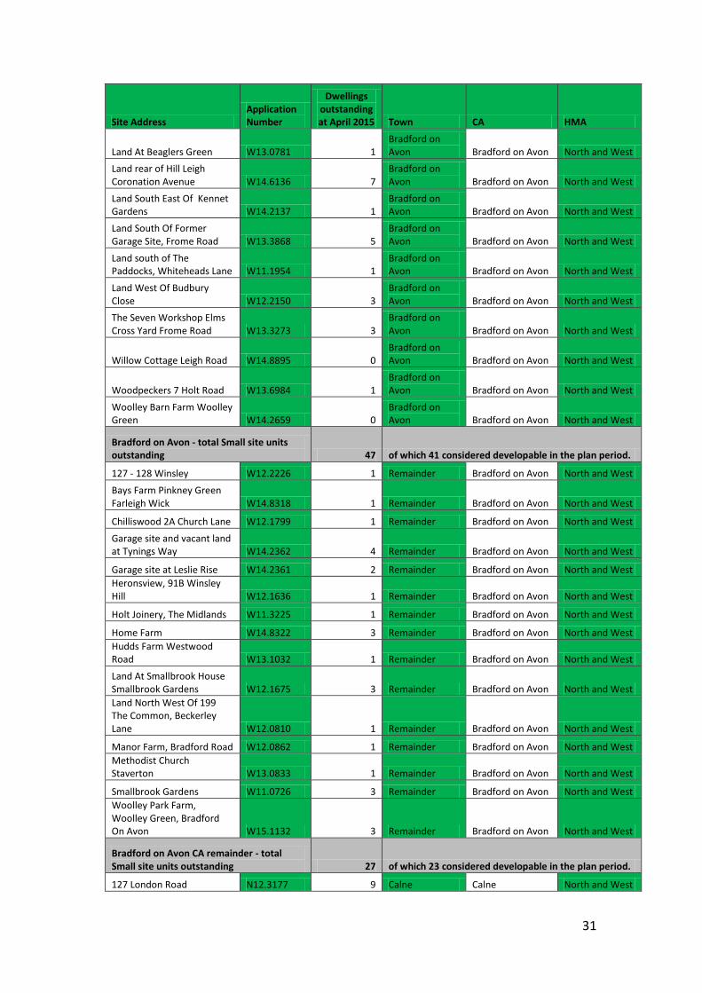
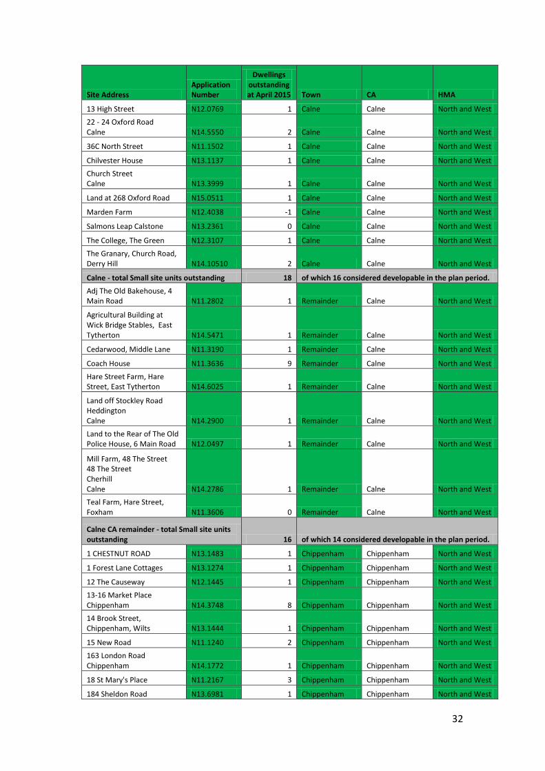
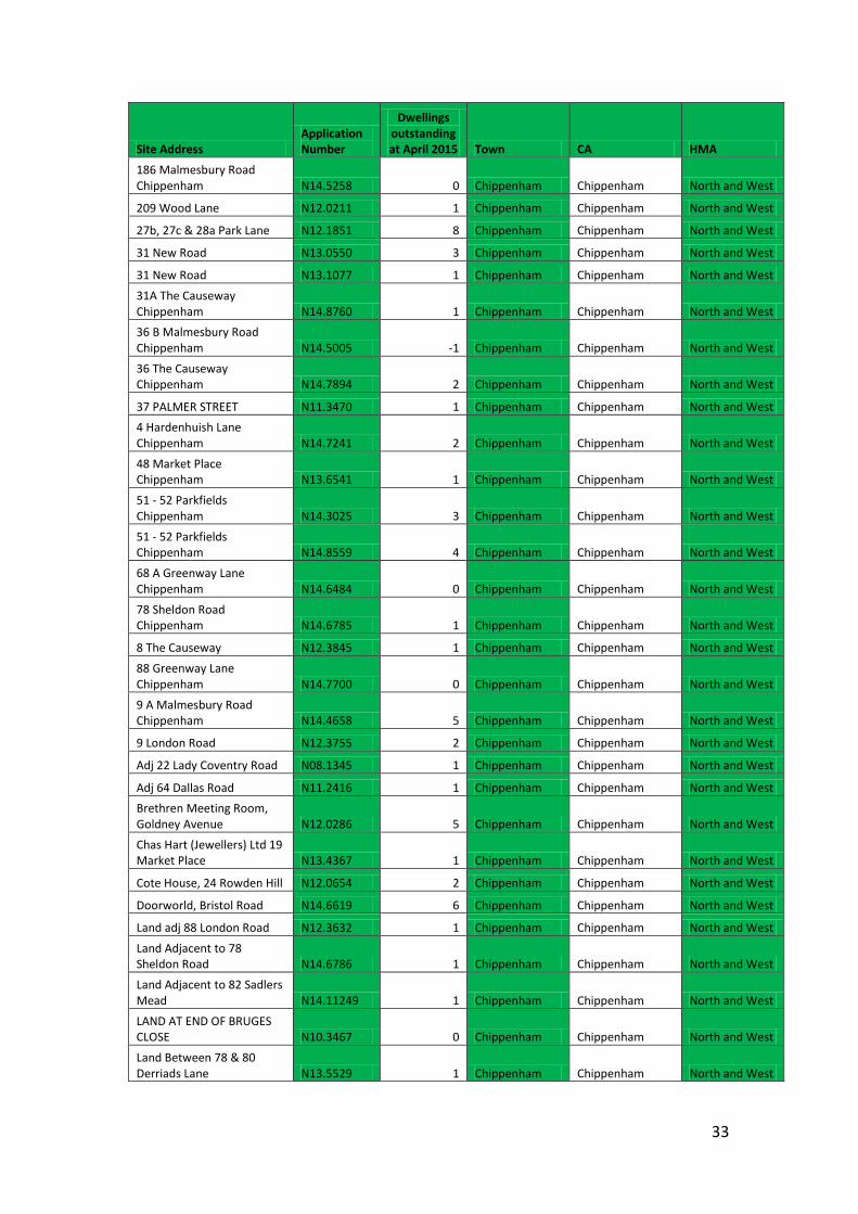
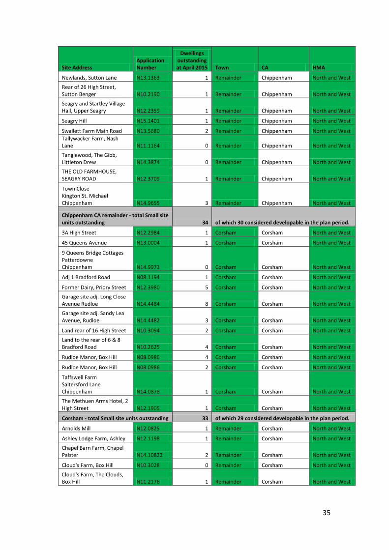
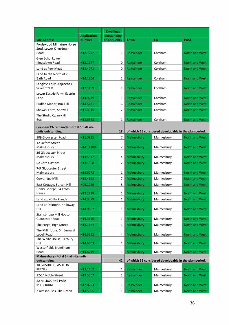
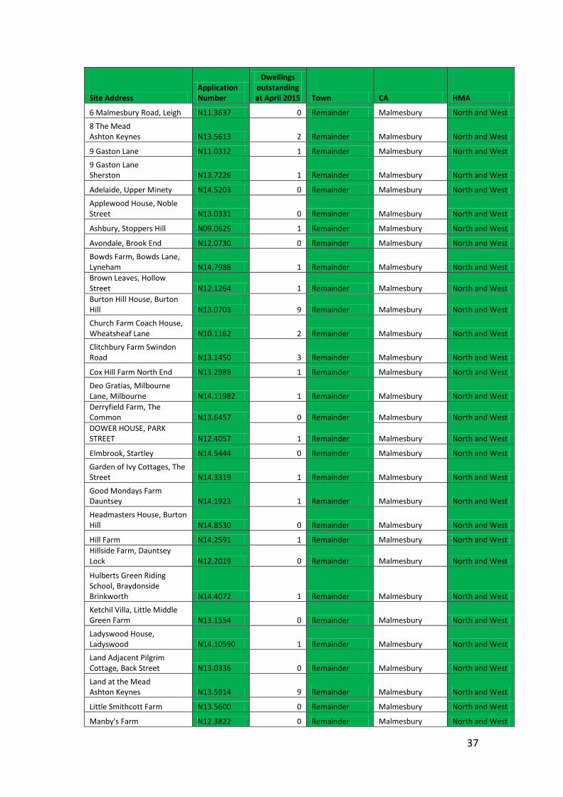
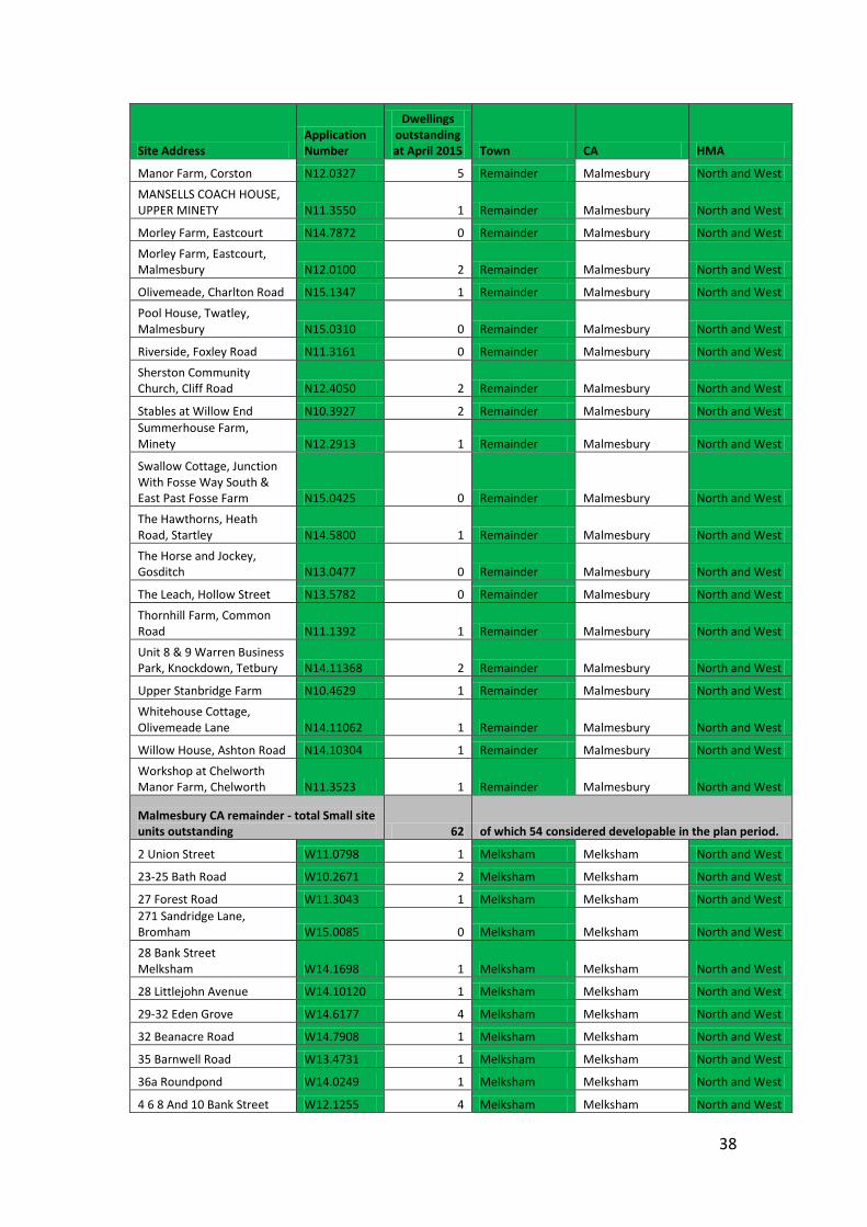
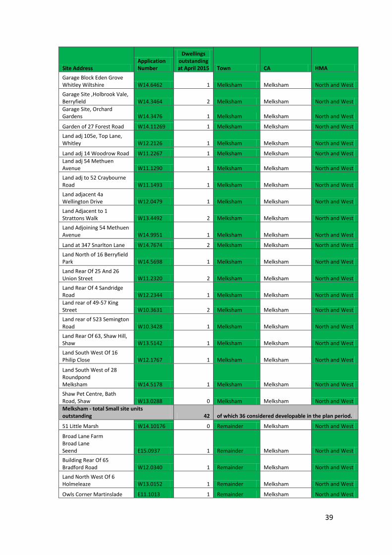
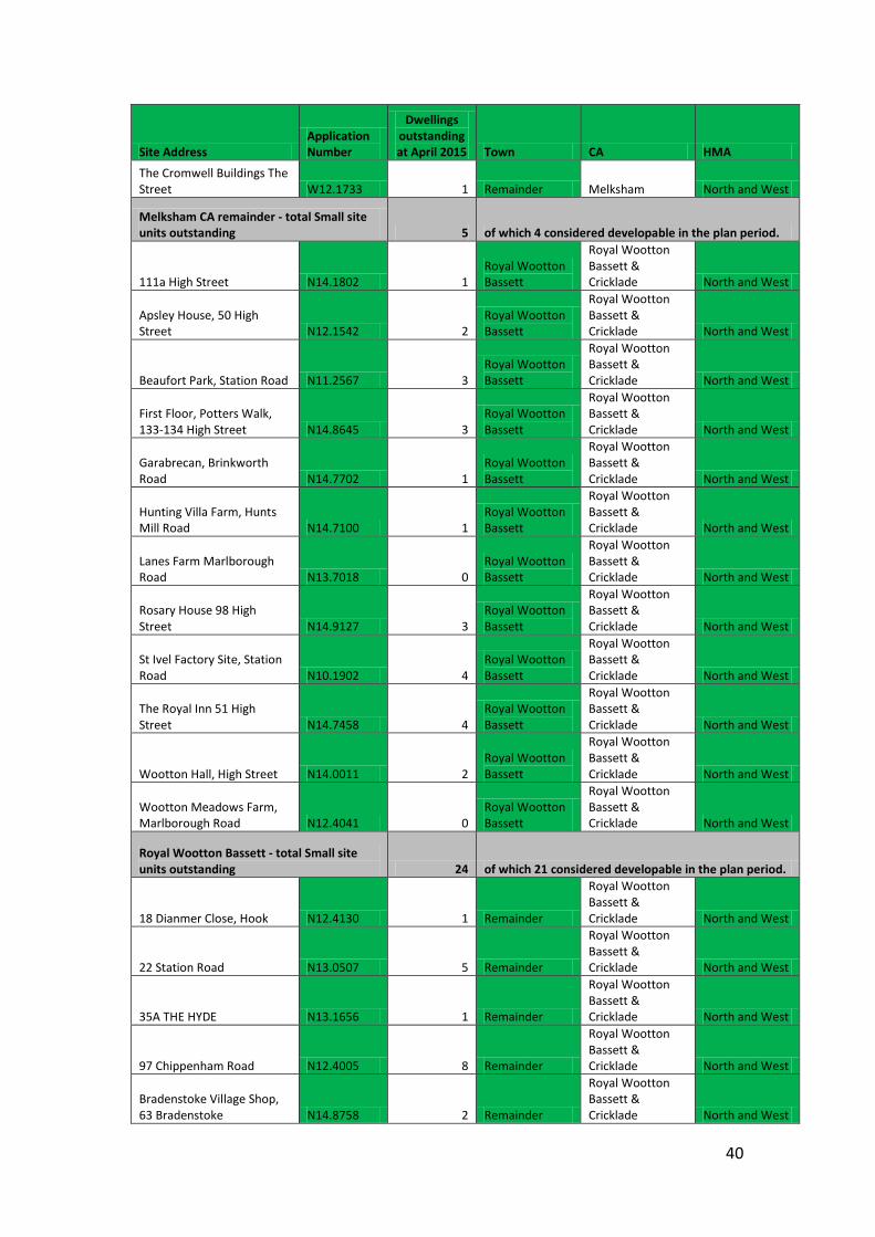
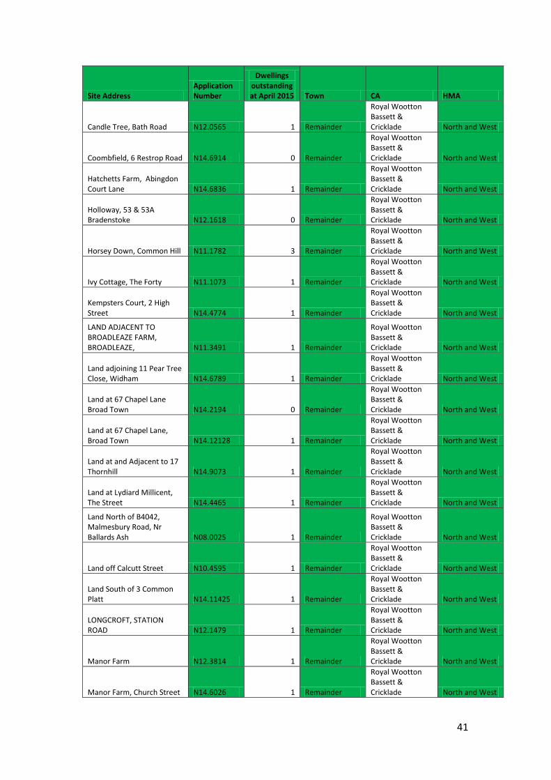
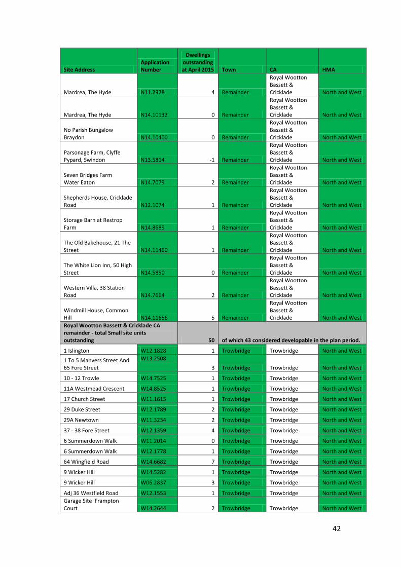
Appendix 2: Small sites contributing to the deliverable supply Small sites within the supply (except for Neighbourhood Plan allocations of less than 10 dwellings, which are included in Appendix 1) have been ordered by their Community Area sub-areas, i.e. either the main settlement in the Community Area, or the rural remainder. The summary for each sub-area shows the total number of units still outstanding on the permission and the number of units assumed to be developable based on historic delivery rates for small sites (rounded to the nearest whole unit.). The ‘Dwellings outstanding at April 2015’ column represents the net dwelling units remaining to be developed on the permission. As such values of zero (e.g. an as yet unimplemented replacement dwelling) and values less than zero (e.g. an as yet unimplemented conversion of two dwellings into one unit) in this column are a valid assessment of the remaining development still to be implemented.
Site Address Application Number
Dwellings outstanding at April 2015 Town CA HMA
East Wiltshire HMA Uphill Farm, Uphill E11.0248 0 Devizes Devizes East
Land Adjoining 19 Caird Lawns E14.7718 1 Devizes Devizes East
Plot adjacent to 44 Roundway Park E14.9447 1 Devizes Devizes East
Old Swan Yard, High Street E14.10265 1 Devizes Devizes East
2 - 3 Long Street E14.10228 4 Devizes Devizes East
6 The Brittox E14.11852 2 Devizes Devizes East
Wyndhams St Josephs Place E13.4763 2 Devizes Devizes East
Out Yonder Hartfield E11.1297 1 Devizes Devizes East
Former Caretakers House, Devizes School, The Green E12.1211 5 Devizes Devizes East
32 New Park Street E12.1515 1 Devizes Devizes East
Bolwell Court 44A New Park street E13.0321 4 Devizes Devizes East
Land Off Elm Tree Close E11.1315 6 Devizes Devizes East
Devizes - total Small site units outstanding 28 of which 24 considered developable in the plan period.
Land at Common Farm Common Lane E14.1375 1 Remainder Devizes East The Tyning 8 Sunnyside West Lavington Devizes Wiltshire SN10 4HU E13.6333 1 Remainder Devizes East
Land between 18 and 19 Highfield E14.11204 3 Remainder Devizes East
Land at Springfield Road E14.11247 2 Remainder Devizes East
66 Blackberry Lane E12.1179 1 Remainder Devizes East
Land Adjacent Four Winds, 11 Silver Street E14.3580 1 Remainder Devizes East
26
Site Address Application Number
Dwellings outstanding at April 2015 Town CA HMA
Land to the rear of The Stage Post, 9 High Street E14.6092 4 Remainder Devizes East
57 Bell Inn High Street E14.5544 1 Remainder Devizes East
Land adjacent 4 Sandfield E14.7251 1 Remainder Devizes East
Manor Farm, Allington E14.7671 1 Remainder Devizes East
Crossways House, Parham Lane E14.8004 0 Remainder Devizes East
5 Close Lane E14.8435 1 Remainder Devizes East
2 White Street E14.10189 1 Remainder Devizes East
Barn at Wyatts Farm 250 Westbrook E14.11743 1 Remainder Devizes East
Vicarage Lane Nurseries Kings Road E13.5576 1 Remainder Devizes East 15 Greengate Road Wedhampton Devizes Wilts E13.1926 1 Remainder Devizes East
Staggs Cottage The Street Bishop`s Cannings Devizes E13.4442 1 Remainder Devizes East
Uphill Farm, Uphill E11.0858 1 Remainder Devizes East Land adjacent to Overton House High Street E12.1396 1 Remainder Devizes East
6 White Street E13.0244 1 Remainder Devizes East
Land adj Standard Bakery, High Street E12.0643 1 Remainder Devizes East Land adjacent 9 South Cliffe Road E14.11986 1 Remainder Devizes East
Land Adjacent To The Brambles Blackberry Lane E14.11151 1 Remainder Devizes East
Church Farm Barn, Peppercombe Lane E14.6735 1 Remainder Devizes East
Lydeway Garage A342 Etchilhampton Turning C60 South East to Junction Past Bell Inn E15.0230 4 Remainder Devizes East
Land adjacant to Springfield 92 High Street E14.12143 1 Remainder Devizes East
Devizes CA remainder - total Small site units outstanding 34 of which 30 considered developable in the plan period.
Land Adjacent 44 St Margarets Mead E14.1408 1 Marlborough Marlborough East
York Lodge, High Street E14.3923 4 Marlborough Marlborough East
Plot 2 Wakefield House Cardigan Road E14.4084 1 Marlborough Marlborough East
Killycoonagh House Back Lane E14.5432 1 Marlborough Marlborough East
Former Builders Yard, Plume of Feathers Lane E14.6254 1 Marlborough Marlborough East Crooks Yard, Adj Hilliers Yard E14.11905 4 Marlborough Marlborough East
25 The Parade Marlborough E13.7162 3 Marlborough Marlborough East
27
Site Address Application Number
Dwellings outstanding at April 2015 Town CA HMA
The Beacon Leaze Road Marlborough E13.7170 1 Marlborough Marlborough East Culvermead Meadow, George Lane K.57234 1 Marlborough Marlborough East
Land at the rear of Cross keys House The Parade E13.0358 3 Marlborough Marlborough East
1st & 2nd floors, Block C, Ailesbury Court, High Street E11.0862 8 Marlborough Marlborough East
The Former Ropeworks Kennet Place E10.0040 3 Marlborough Marlborough East
The Former Ropeworks Kennet Place E10.0040 3 Marlborough Marlborough East
18 St. Martins E12.1069 1 Marlborough Marlborough East
41A High Street E12.1455 2 Marlborough Marlborough East
9 & 10 St Martins E13.0027 1 Marlborough Marlborough East
Cedar House The Parade E13.0395 1 Marlborough Marlborough East
Upper Quarry Tin Pit E14.11885 1 Marlborough Marlborough East
Land North East of Crabbes Close Hyde Lane E14.11683 1 Marlborough Marlborough East Marlborough - total Small site units outstanding 41 of which 36 considered developable in the plan period.
Rabley Barns, Rabley Hill E14.2549 1 Remainder Marlborough East
6A Lottage Road Aldbourne Marlborough E13.3443 -1 Remainder Marlborough East
Whittonditch Farm Whittonditch Ramsbury E13.0171 4 Remainder Marlborough East
4 Main Road E14.0922 1 Remainder Marlborough East
Glenavon, High Street E14.2205 0 Remainder Marlborough East
Lower Acre, Bray Street, Avebury E14.2099 0 Remainder Marlborough East
Land To The Rear Of Nos 34 To 35 Oxford Street E14.3810 1 Remainder Marlborough East
Land adjacent to Park Close, High Street E14.9222 1 Remainder Marlborough East
32 & 33 Froxfield E14.5569 2 Remainder Marlborough East
Rabley Barns Rabley Hill E14.5870 1 Remainder Marlborough East
Parliament Piece, Back Lane E14.1188 1 Remainder Marlborough East Hilltop Cottage Marridge Hill E14.6688 1 Remainder Marlborough East Luton Lye House Sawpit Drive E15.0658 0 Remainder Marlborough East
Former Kennet Valley C.E. Aided Primary School E14.5027 1 Remainder Marlborough East
Land rear of Foxfield and Escots, Aldbourne Road E14.5491 4 Remainder Marlborough East
Poughcombe Barns E14.8554 1 Remainder Marlborough East
14 Burdett Street E14.7981 0 Remainder Marlborough East
Park Farm E14.5721 0 Remainder Marlborough East
28
Site Address Application Number
Dwellings outstanding at April 2015 Town CA HMA
Land South Of Elm Bank, Whittonditch Road E14.10169 1 Remainder Marlborough East Mount Pleasant, 18 Oxford Street E14.11276 0 Remainder Marlborough East
6a Lottage Road E14.9411 0 Remainder Marlborough East
The Old Farmyard Rockley Manor Rockley E14.7980 1 Remainder Marlborough East Downs Equestrian Centre Baydon Wilts SN8 2JS E13.0394 2 Remainder Marlborough East
Land at 50B Chilton Foliat Hungerford RG17 0TF E14.0245 1 Remainder Marlborough East
Melrose E09.0255 1 Remainder Marlborough East
Seymour Place Savernake Marlborough SN8 3HW E14.0595 1 Remainder Marlborough East
Ground Floor of The Dutch Barn Elm Tree Park Bath Road Manton E13.5564 1 Remainder Marlborough East
Eastridge House, Eastridge E12.0427 1 Remainder Marlborough East
1 Ermin Street, Baydon E11.1636 1 Remainder Marlborough East
Red Lion Ermin Street E12.1575 1 Remainder Marlborough East
50 Chilton Foliat E13.0218 2 Remainder Marlborough East
The Coach House Preston E13.1345 1 Remainder Marlborough East Cookes Meadow East Kennett E15.0143 0 Remainder Marlborough East
1 Westfield Farm E14.11275 1 Remainder Marlborough East
M4 Trade Centre, A4361 E15.0136 3 Remainder Marlborough East
Maisey Farm E14.8625 0 Remainder Marlborough East
Marlborough CA remainder - total Small site units outstanding 36 of which 31 considered developable in the plan period.
Reeders, North Newnton Garage Park Road E14.8885 4 Remainder Pewsey East
Dairy House Puckshipton E12.1047 3 Remainder Pewsey East
54 Ball Road E14.0355 2 Remainder Pewsey East
Colerne, Mill Lane E14.3961 0 Remainder Pewsey East
Half Acre The Sands E14.3932 0 Remainder Pewsey East
Bungalow Farm House E14.5989 0 Remainder Pewsey East
63 High Street Burbage E14.6548 1 Remainder Pewsey East
26 River Street Pewsey E14.2128 9 Remainder Pewsey East
34 High Street E13.0315 2 Remainder Pewsey East
34 High Street E14.3829 2 Remainder Pewsey East
Land to the North of Ailesbury Way E14.6846 4 Remainder Pewsey East
114 High Street E14.6222 1 Remainder Pewsey East
Three Horse Shoes E14.8335 1 Remainder Pewsey East
29
Site Address Application Number
Dwellings outstanding at April 2015 Town CA HMA
The White Hart, Oare E14.7813 1 Remainder Pewsey East
41 Ball Road E14.9866 1 Remainder Pewsey East Sirosa & Kohima, East Grafton E14.9756 2 Remainder Pewsey East
Highleaze House Lodge Oare Marlborough SN8 4JE E13.6982 0 Remainder Pewsey East Land adjacent 229 East Grafton Marlborough SN8 3DH E13.7073 1 Remainder Pewsey East Kingwardstone Farm Burbage Marlborough SN8 3BU E13.6956 1 Remainder Pewsey East
Haredown Farm Great Bedwyn Marlborough Wilts SN8 3ND E13.5931 1 Remainder Pewsey East
The Cottages, Down Farm, Everleigh Road E09.0776 1 Remainder Pewsey East
Honey Street Mills Honey Street Pewsey Wiltshire SN9 5PS E10.0772 3 Remainder Pewsey East
Rivar Farm Buildings Rivar Farm Shalbourne Marlborough SN8 3RL E13.1104 2 Remainder Pewsey East Land North West Of 91 Church Street, Great Bedwyn, Marlborough, Wiltshire E13.4738 1 Remainder Pewsey East The Mill House First Floor, Conygre Farm Burbage Road E13.5729 1 Remainder Pewsey East
Stype Wood Stud Gate Close East To Stype Grange Hungerford E13.5250 0 Remainder Pewsey East
57 High Street K.59033 4 Remainder Pewsey East
Rear of London House, High Street E11.0133 3 Remainder Pewsey East
3 Devizes Road E11.0270 1 Remainder Pewsey East
Keeble, Kingston Road E13.0518 0 Remainder Pewsey East
3 & 4 China Cottages, East Stowell E11.0898 1 Remainder Pewsey East Land to rear 23-27 High Street E12.1110 3 Remainder Pewsey East
Field Place Firgreen E14.0814 0 Remainder Pewsey East
Burbage Wharf E13.0112 0 Remainder Pewsey East
1 Stratton Road E13.0144 -1 Remainder Pewsey East
The Depot, Station Approach, Wilcot Rd E14.6941 9 Remainder Pewsey East Pewsey CA - total Small site units outstanding 64 of which 56 considered developable in the plan period.
Malbar Andover Road Andover Road Ludgershall E13.3798 1
Tidworth & Ludgershall Tidworth East
30
Site Address Application Number
Dwellings outstanding at April 2015 Town CA HMA
South Park Farm Barn Andover Lane Ludgershall E13.4893 1
Tidworth & Ludgershall Tidworth East
22 Pretoria Road Ludgershall Andover E13.2702 1
Tidworth & Ludgershall Tidworth East
48 Andover Road Ludgershall SP11 9NA E13.5163 2
Tidworth & Ludgershall Tidworth East
4 - 6 Andover Road Ludgershall Andover E11.1231 6
Tidworth & Ludgershall Tidworth East
23 Astor Crescent Ludgershall E12.1362 1
Tidworth & Ludgershall Tidworth East
Tidworth & Ludgershall - total Small site units outstanding 12 of which 10 considered developable in the plan period.
Land At Pigleaze Farm E15.1060 1 Remainder Tidworth East
Rutherford Stud Chantry Lane Upper Chute E14.0495 0 Remainder Tidworth East
Red House Farm Clanville Andover E12.1067 1 Remainder Tidworth East
Tidworth CA remainder - total Small site units outstanding 2 of which 2 considered developable in the plan period.
North and West Wiltshire HMA
199 Winsley Road W14.6020 2 Bradford on Avon Bradford on Avon North and West
30 Winsley Road W13.0274 0 Bradford on Avon Bradford on Avon North and West
84 Bath Road W14.9738 2 Bradford on Avon Bradford on Avon North and West
Adj 7 Mount Pleasant W08.2281 1 Bradford on Avon Bradford on Avon North and West
Former Depot, Frome Road W08.0754 4 Bradford on Avon Bradford on Avon North and West
Former Depot, Frome Road W14.1695 4 Bradford on Avon Bradford on Avon North and West
Garage Block South East Of 16 Southville Road W14.9863 1
Bradford on Avon Bradford on Avon North and West
Garage Site - Land adjacent to 39 Southville Road W14.9111 2
Bradford on Avon Bradford on Avon North and West
Hudds Farm Westwood Road W12.0427 0
Bradford on Avon Bradford on Avon North and West
Kingston Mills, Kingston Road W12.2347 5
Bradford on Avon Bradford on Avon North and West
Land adj 8 Sladesbrook W14.7638 1 Bradford on Avon Bradford on Avon North and West
Land Adjacent to 46 Poulton W14.9112 2
Bradford on Avon Bradford on Avon North and West
Land Adjacent to 53 Poulton W14.9113 1
Bradford on Avon Bradford on Avon North and West
31
Site Address Application Number
Dwellings outstanding at April 2015 Town CA HMA
Land At Beaglers Green W13.0781 1 Bradford on Avon Bradford on Avon North and West
Land rear of Hill Leigh Coronation Avenue W14.6136 7
Bradford on Avon Bradford on Avon North and West
Land South East Of Kennet Gardens W14.2137 1
Bradford on Avon Bradford on Avon North and West
Land South Of Former Garage Site, Frome Road W13.3868 5
Bradford on Avon Bradford on Avon North and West
Land south of The Paddocks, Whiteheads Lane W11.1954 1
Bradford on Avon Bradford on Avon North and West
Land West Of Budbury Close W12.2150 3
Bradford on Avon Bradford on Avon North and West
The Seven Workshop Elms Cross Yard Frome Road W13.3273 3
Bradford on Avon Bradford on Avon North and West
Willow Cottage Leigh Road W14.8895 0 Bradford on Avon Bradford on Avon North and West
Woodpeckers 7 Holt Road W13.6984 1 Bradford on Avon Bradford on Avon North and West
Woolley Barn Farm Woolley Green W14.2659 0
Bradford on Avon Bradford on Avon North and West
Bradford on Avon - total Small site units outstanding 47 of which 41 considered developable in the plan period.
127 - 128 Winsley W12.2226 1 Remainder Bradford on Avon North and West
Bays Farm Pinkney Green Farleigh Wick W14.8318 1 Remainder Bradford on Avon North and West
Chilliswood 2A Church Lane W12.1799 1 Remainder Bradford on Avon North and West
Garage site and vacant land at Tynings Way W14.2362 4 Remainder Bradford on Avon North and West
Garage site at Leslie Rise W14.2361 2 Remainder Bradford on Avon North and West Heronsview, 91B Winsley Hill W12.1636 1 Remainder Bradford on Avon North and West
Holt Joinery, The Midlands W11.3225 1 Remainder Bradford on Avon North and West
Home Farm W14.8322 3 Remainder Bradford on Avon North and West Hudds Farm Westwood Road W13.1032 1 Remainder Bradford on Avon North and West
Land At Smallbrook House Smallbrook Gardens W12.1675 3 Remainder Bradford on Avon North and West Land North West Of 199 The Common, Beckerley Lane W12.0810 1 Remainder Bradford on Avon North and West
Manor Farm, Bradford Road W12.0862 1 Remainder Bradford on Avon North and West Methodist Church Staverton W13.0833 1 Remainder Bradford on Avon North and West
Smallbrook Gardens W11.0726 3 Remainder Bradford on Avon North and West Woolley Park Farm, Woolley Green, Bradford On Avon W15.1132 3 Remainder Bradford on Avon North and West
Bradford on Avon CA remainder - total Small site units outstanding 27 of which 23 considered developable in the plan period.
127 London Road N12.3177 9 Calne Calne North and West
32
Site Address Application Number
Dwellings outstanding at April 2015 Town CA HMA
13 High Street N12.0769 1 Calne Calne North and West
22 - 24 Oxford Road Calne N14.5550 2 Calne Calne North and West
36C North Street N11.1502 1 Calne Calne North and West
Chilvester House N13.1137 1 Calne Calne North and West
Church Street Calne N13.3999 1 Calne Calne North and West
Land at 268 Oxford Road N15.0511 1 Calne Calne North and West
Marden Farm N12.4038 -1 Calne Calne North and West
Salmons Leap Calstone N13.2361 0 Calne Calne North and West
The College, The Green N12.3107 1 Calne Calne North and West
The Granary, Church Road, Derry Hill N14.10510 2 Calne Calne North and West
Calne - total Small site units outstanding 18 of which 16 considered developable in the plan period.
Adj The Old Bakehouse, 4 Main Road N11.2802 1 Remainder Calne North and West
Agricultural Building at Wick Bridge Stables, East Tytherton N14.5471 1 Remainder Calne North and West
Cedarwood, Middle Lane N11.3190 1 Remainder Calne North and West
Coach House N11.3636 9 Remainder Calne North and West
Hare Street Farm, Hare Street, East Tytherton N14.6025 1 Remainder Calne North and West
Land off Stockley Road Heddington Calne N14.2900 1 Remainder Calne North and West
Land to the Rear of The Old Police House, 6 Main Road N12.0497 1 Remainder Calne North and West
Mill Farm, 48 The Street 48 The Street Cherhill Calne N14.2786 1 Remainder Calne North and West Teal Farm, Hare Street, Foxham N11.3606 0 Remainder Calne North and West
Calne CA remainder - total Small site units outstanding 16 of which 14 considered developable in the plan period.
1 CHESTNUT ROAD N13.1483 1 Chippenham Chippenham North and West
1 Forest Lane Cottages N13.1274 1 Chippenham Chippenham North and West
12 The Causeway N12.1445 1 Chippenham Chippenham North and West
13-16 Market Place Chippenham N14.3748 8 Chippenham Chippenham North and West
14 Brook Street, Chippenham, Wilts N13.1444 1 Chippenham Chippenham North and West
15 New Road N11.1240 2 Chippenham Chippenham North and West
163 London Road Chippenham N14.1772 1 Chippenham Chippenham North and West
18 St Mary's Place N11.2167 3 Chippenham Chippenham North and West
184 Sheldon Road N13.6981 1 Chippenham Chippenham North and West
33
Site Address Application Number
Dwellings outstanding at April 2015 Town CA HMA
186 Malmesbury Road Chippenham N14.5258 0 Chippenham Chippenham North and West
209 Wood Lane N12.0211 1 Chippenham Chippenham North and West
27b, 27c & 28a Park Lane N12.1851 8 Chippenham Chippenham North and West
31 New Road N13.0550 3 Chippenham Chippenham North and West
31 New Road N13.1077 1 Chippenham Chippenham North and West
31A The Causeway Chippenham N14.8760 1 Chippenham Chippenham North and West 36 B Malmesbury Road Chippenham N14.5005 -1 Chippenham Chippenham North and West
36 The Causeway Chippenham N14.7894 2 Chippenham Chippenham North and West
37 PALMER STREET N11.3470 1 Chippenham Chippenham North and West 4 Hardenhuish Lane Chippenham N14.7241 2 Chippenham Chippenham North and West
48 Market Place Chippenham N13.6541 1 Chippenham Chippenham North and West
51 - 52 Parkfields Chippenham N14.3025 3 Chippenham Chippenham North and West
51 - 52 Parkfields Chippenham N14.8559 4 Chippenham Chippenham North and West
68 A Greenway Lane Chippenham N14.6484 0 Chippenham Chippenham North and West
78 Sheldon Road Chippenham N14.6785 1 Chippenham Chippenham North and West
8 The Causeway N12.3845 1 Chippenham Chippenham North and West
88 Greenway Lane Chippenham N14.7700 0 Chippenham Chippenham North and West
9 A Malmesbury Road Chippenham N14.4658 5 Chippenham Chippenham North and West
9 London Road N12.3755 2 Chippenham Chippenham North and West
Adj 22 Lady Coventry Road N08.1345 1 Chippenham Chippenham North and West
Adj 64 Dallas Road N11.2416 1 Chippenham Chippenham North and West Brethren Meeting Room, Goldney Avenue N12.0286 5 Chippenham Chippenham North and West
Chas Hart (Jewellers) Ltd 19 Market Place N13.4367 1 Chippenham Chippenham North and West
Cote House, 24 Rowden Hill N12.0654 2 Chippenham Chippenham North and West
Doorworld, Bristol Road N14.6619 6 Chippenham Chippenham North and West
Land adj 88 London Road N12.3632 1 Chippenham Chippenham North and West
Land Adjacent to 78 Sheldon Road N14.6786 1 Chippenham Chippenham North and West
Land Adjacent to 82 Sadlers Mead N14.11249 1 Chippenham Chippenham North and West
LAND AT END OF BRUGES CLOSE N10.3467 0 Chippenham Chippenham North and West
Land Between 78 & 80 Derriads Lane N13.5529 1 Chippenham Chippenham North and West

34
Site Address Application Number
Dwellings outstanding at April 2015 Town CA HMA
Land rear of Hawthorn House, Hawthorn Road N11.1823 2 Chippenham Chippenham North and West Land to the Rear of 31 Rowden Hill N14.0746 1 Chippenham Chippenham North and West
Little George Hotel, 29 New Road N13.1501 5 Chippenham Chippenham North and West
Pew Hill House, Pew Hill N13.0611 9 Chippenham Chippenham North and West
R/O 88 Bristol Road N14.11708 2 Chippenham Chippenham North and West
Rear of 2-3 Market Place Chippenham N14.5479 2 Chippenham Chippenham North and West
Rear of 25 Market Place N10.3285 4 Chippenham Chippenham North and West
Rear of 36 Market Place N10.1747 1 Chippenham Chippenham North and West
The Embankment Site, Bath Road Bath Road Chippenham N13.3099 5 Chippenham Chippenham North and West Units 1-2 The Works The Butts N14.7107 2 Chippenham Chippenham North and West Chippenham - total Small site units outstanding 107 of which 93 considered developable in the plan period. 1 & 2 Nettleton Road, Burton N13.0086 0 Remainder Chippenham North and West
26 High Street Sutton Benger N14.4152 1 Remainder Chippenham North and West
49 Peckingell N14.0796 0 Remainder Chippenham North and West
57d Kington St Michael N14.1103 1 Remainder Chippenham North and West
8 Plough Lane N13.1836 1 Remainder Chippenham North and West
Arms Farm, 9 High Street N11.2233 2 Remainder Chippenham North and West
Former Chapel, Newtown N10.4250 1 Remainder Chippenham North and West
Garages at Stubbs Lane N13.1254 1 Remainder Chippenham North and West
Great Rideway Farm, Main Road N10.0958 1 Remainder Chippenham North and West Kington House, Kington St Michael N15.1009 2 Remainder Chippenham North and West Land Adjacent 9 Church View N14.9205 1 Remainder Chippenham North and West Land Adjoining 72 The Green Christian Malford N13.5580 1 Remainder Chippenham North and West
Land at Hill Hayes Lane Hullavington N14.5905 1 Remainder Chippenham North and West
Land at Honey Knob Hill N11.4132 2 Remainder Chippenham North and West Land off Nettleton Road, Burton N14.8698 7 Remainder Chippenham North and West
Land Rear of Bay Tree Cottage, The Butts N15.0267 1 Remainder Chippenham North and West
Lipgate Farm Kington Langley N13.5839 0 Remainder Chippenham North and West
New Homestead Farm Mountain Bower N13.4717 1 Remainder Chippenham North and West
35
Site Address Application Number
Dwellings outstanding at April 2015 Town CA HMA
Newlands, Sutton Lane N13.1363 1 Remainder Chippenham North and West
Rear of 26 High Street, Sutton Benger N10.2190 1 Remainder Chippenham North and West
Seagry and Startley Village Hall, Upper Seagry N12.2359 1 Remainder Chippenham North and West
Seagry Hill N15.1401 1 Remainder Chippenham North and West
Swallett Farm Main Road N13.5680 2 Remainder Chippenham North and West Tallywacker Farm, Nash Lane N11.1164 0 Remainder Chippenham North and West
Tanglewood, The Gibb, Littleton Drew N14.3874 0 Remainder Chippenham North and West
THE OLD FARMHOUSE, SEAGRY ROAD N12.3709 1 Remainder Chippenham North and West
Town Close Kington St. Michael Chippenham N14.9655 3 Remainder Chippenham North and West
Chippenham CA remainder - total Small site units outstanding 34 of which 30 considered developable in the plan period.
3A High Street N12.2984 1 Corsham Corsham North and West
45 Queens Avenue N13.0004 1 Corsham Corsham North and West
9 Queens Bridge Cottages Patterdowne Chippenham N14.9973 0 Corsham Corsham North and West
Adj 1 Bradford Road N08.1194 1 Corsham Corsham North and West
Former Dairy, Priory Street N12.3980 5 Corsham Corsham North and West
Garage site adj. Long Close Avenue Rudloe N14.4484 8 Corsham Corsham North and West
Garage site adj. Sandy Lea Avenue, Rudloe N14.4482 3 Corsham Corsham North and West
Land rear of 16 High Street N10.3094 2 Corsham Corsham North and West
Land to the rear of 6 & 8 Bradford Road N10.2625 4 Corsham Corsham North and West
Rudloe Manor, Box Hill N08.0986 4 Corsham Corsham North and West
Rudloe Manor, Box Hill N08.0986 2 Corsham Corsham North and West
Taffswell Farm Saltersford Lane Chippenham N14.0878 1 Corsham Corsham North and West
The Methuen Arms Hotel, 2 High Street N12.1905 1 Corsham Corsham North and West
Corsham - total Small site units outstanding 33 of which 29 considered developable in the plan period.
Arnolds Mill N12.0825 1 Remainder Corsham North and West
Ashley Lodge Farm, Ashley N12.1198 1 Remainder Corsham North and West
Chapel Barn Farm, Chapel Paister N14.10822 2 Remainder Corsham North and West
Cloud's Farm, Box Hill N10.3028 0 Remainder Corsham North and West
Cloud's Farm, The Clouds, Box Hill N11.2176 1 Remainder Corsham North and West
36
Site Address Application Number
Dwellings outstanding at April 2015 Town CA HMA
Fordswood Miniature Horse Stud, Lower Kingsdown Road N12.1252 1 Remainder Corsham North and West
Glen Echo, Lower Kingsdown Road N13.1147 0 Remainder Corsham North and West
Land at Pew Mead N12.4073 0 Remainder Corsham North and West Land to the North of 20 Bath Road N14.1904 1 Remainder Corsham North and West
Langleys Folly, Adjacent 4 Silver Street N12.1199 1 Remainder Corsham North and West
Lower Eastrip Farm, Eastrip Lane N14.9719 1 Remainder Corsham North and West
Rudloe Manor, Box Hill N14.5421 6 Remainder Corsham North and West
Showell Farm, Showell N11.3045 2 Remainder Corsham North and West
The Studio Quarry Hill Box N13.6368 1 Remainder Corsham North and West
Corsham CA remainder - total Small site units outstanding 18 of which 16 considered developable in the plan period.
109 Gloucester Road N11.0935 7 Malmesbury Malmesbury North and West
12 Oxford Street Malmesbury N14.11180 2 Malmesbury Malmesbury North and West
36 Gloucester Street Malmesbury N14.5617 4 Malmesbury Malmesbury North and West
52 Corn Gastons N13.1868 2 Malmesbury Malmesbury North and West
7-9 Gloucester Street Malmesbury N13.6278 1 Malmesbury Malmesbury North and West
Cowbridge Mill N13.4122 7 Malmesbury Malmesbury North and West
East Cottage, Burton Hill N09.2226 8 Malmesbury Malmesbury North and West Henry George, 34 Cross Hayes N13.2718 1 Malmesbury Malmesbury North and West
Land adj 45 Parklands N14.3079 1 Malmesbury Malmesbury North and West
Land at Delmont, Holloway Hill N14.9502 1 Malmesbury Malmesbury North and West
Stainsbridge Mill House, Gloucester Road N14.3616 1 Malmesbury Malmesbury North and West
The Forge, High Street N13.1174 1 Malmesbury Malmesbury North and West
The Mill House, Sir Bernard Lovell Road N14.5563 4 Malmesbury Malmesbury North and West The White House, Tetbury Hill N14.6803 1 Malmesbury Malmesbury North and West Westerfield, Bremilham Road N14.6719 1 Malmesbury Malmesbury North and West Malmesbury - total Small site units outstanding 42 of which 36 considered developable in the plan period. 10 GOSDITCH, ASHTON KEYNES N13.1462 1 Remainder Malmesbury North and West
12-14 Noble Street N13.5507 1 Remainder Malmesbury North and West
22 MILBOURNE PARK, MILBOURNE N12.0293 1 Remainder Malmesbury North and West
3 Almshouses, The Green N14.5505 -1 Remainder Malmesbury North and West
37
Site Address Application Number
Dwellings outstanding at April 2015 Town CA HMA
6 Malmesbury Road, Leigh N11.3637 0 Remainder Malmesbury North and West
8 The Mead Ashton Keynes N13.5613 2 Remainder Malmesbury North and West
9 Gaston Lane N11.0312 1 Remainder Malmesbury North and West
9 Gaston Lane Sherston N13.7226 1 Remainder Malmesbury North and West
Adelaide, Upper Minety N14.5203 0 Remainder Malmesbury North and West
Applewood House, Noble Street N13.0331 0 Remainder Malmesbury North and West
Ashbury, Stoppers Hill N09.0625 1 Remainder Malmesbury North and West
Avondale, Brook End N12.0730 0 Remainder Malmesbury North and West
Bowds Farm, Bowds Lane, Lyneham N14.7988 1 Remainder Malmesbury North and West Brown Leaves, Hollow Street N12.1264 1 Remainder Malmesbury North and West Burton Hill House, Burton Hill N13.0703 9 Remainder Malmesbury North and West
Church Farm Coach House, Wheatsheaf Lane N10.1162 2 Remainder Malmesbury North and West Clitchbury Farm Swindon Road N13.1450 3 Remainder Malmesbury North and West
Cox Hill Farm North End N13.2989 1 Remainder Malmesbury North and West
Deo Gratias, Milbourne Lane, Milbourne N14.11982 1 Remainder Malmesbury North and West Derryfield Farm, The Common N13.6457 0 Remainder Malmesbury North and West DOWER HOUSE, PARK STREET N12.4057 1 Remainder Malmesbury North and West
Elmbrook, Startley N14.5444 0 Remainder Malmesbury North and West
Garden of Ivy Cottages, The Street N14.3319 1 Remainder Malmesbury North and West
Good Mondays Farm Dauntsey N14.1923 1 Remainder Malmesbury North and West
Headmasters House, Burton Hill N14.8530 0 Remainder Malmesbury North and West
Hill Farm N14.2591 1 Remainder Malmesbury North and West Hillside Farm, Dauntsey Lock N12.2019 0 Remainder Malmesbury North and West
Hulberts Green Riding School, Braydonside Brinkworth N14.4072 1 Remainder Malmesbury North and West
Ketchil Villa, Little Middle Green Farm N13.1554 0 Remainder Malmesbury North and West
Ladyswood House, Ladyswood N14.10590 1 Remainder Malmesbury North and West
Land Adjacent Pilgrim Cottage, Back Street N13.0336 0 Remainder Malmesbury North and West
Land at the Mead Ashton Keynes N13.5914 9 Remainder Malmesbury North and West
Little Smithcott Farm N13.5600 0 Remainder Malmesbury North and West
Manby's Farm N12.3822 0 Remainder Malmesbury North and West
38
Site Address Application Number
Dwellings outstanding at April 2015 Town CA HMA
Manor Farm, Corston N12.0327 5 Remainder Malmesbury North and West
MANSELLS COACH HOUSE, UPPER MINETY N11.3550 1 Remainder Malmesbury North and West
Morley Farm, Eastcourt N14.7872 0 Remainder Malmesbury North and West
Morley Farm, Eastcourt, Malmesbury N12.0100 2 Remainder Malmesbury North and West
Olivemeade, Charlton Road N15.1347 1 Remainder Malmesbury North and West
Pool House, Twatley, Malmesbury N15.0310 0 Remainder Malmesbury North and West
Riverside, Foxley Road N11.3161 0 Remainder Malmesbury North and West
Sherston Community Church, Cliff Road N12.4050 2 Remainder Malmesbury North and West
Stables at Willow End N10.3927 2 Remainder Malmesbury North and West Summerhouse Farm, Minety N12.2913 1 Remainder Malmesbury North and West
Swallow Cottage, Junction With Fosse Way South & East Past Fosse Farm N15.0425 0 Remainder Malmesbury North and West
The Hawthorns, Heath Road, Startley N14.5800 1 Remainder Malmesbury North and West
The Horse and Jockey, Gosditch N13.0477 0 Remainder Malmesbury North and West
The Leach, Hollow Street N13.5782 0 Remainder Malmesbury North and West
Thornhill Farm, Common Road N11.1392 1 Remainder Malmesbury North and West
Unit 8 & 9 Warren Business Park, Knockdown, Tetbury N14.11368 2 Remainder Malmesbury North and West
Upper Stanbridge Farm N10.4629 1 Remainder Malmesbury North and West
Whitehouse Cottage, Olivemeade Lane N14.11062 1 Remainder Malmesbury North and West
Willow House, Ashton Road N14.10304 1 Remainder Malmesbury North and West
Workshop at Chelworth Manor Farm, Chelworth N11.3523 1 Remainder Malmesbury North and West
Malmesbury CA remainder - total Small site units outstanding 62 of which 54 considered developable in the plan period.
2 Union Street W11.0798 1 Melksham Melksham North and West
23-25 Bath Road W10.2671 2 Melksham Melksham North and West
27 Forest Road W11.3043 1 Melksham Melksham North and West 271 Sandridge Lane, Bromham W15.0085 0 Melksham Melksham North and West
28 Bank Street Melksham W14.1698 1 Melksham Melksham North and West
28 Littlejohn Avenue W14.10120 1 Melksham Melksham North and West
29-32 Eden Grove W14.6177 4 Melksham Melksham North and West
32 Beanacre Road W14.7908 1 Melksham Melksham North and West
35 Barnwell Road W13.4731 1 Melksham Melksham North and West
36a Roundpond W14.0249 1 Melksham Melksham North and West
4 6 8 And 10 Bank Street W12.1255 4 Melksham Melksham North and West
39
Site Address Application Number
Dwellings outstanding at April 2015 Town CA HMA
Garage Block Eden Grove Whitley Wiltshire W14.6462 1 Melksham Melksham North and West Garage Site ,Holbrook Vale, Berryfield W14.3464 2 Melksham Melksham North and West Garage Site, Orchard Gardens W14.3476 1 Melksham Melksham North and West
Garden of 27 Forest Road W14.11269 1 Melksham Melksham North and West
Land adj 105e, Top Lane, Whitley W12.2126 1 Melksham Melksham North and West
Land adj 14 Woodrow Road W11.2267 1 Melksham Melksham North and West Land adj 54 Methuen Avenue W11.1290 1 Melksham Melksham North and West
Land adj to 52 Craybourne Road W11.1493 1 Melksham Melksham North and West
Land adjacent 4a Wellington Drive W12.0479 1 Melksham Melksham North and West
Land Adjacent to 1 Strattons Walk W13.4492 2 Melksham Melksham North and West
Land Adjoining 54 Methuen Avenue W14.9951 1 Melksham Melksham North and West
Land at 347 Snarlton Lane W14.7674 2 Melksham Melksham North and West
Land North of 16 Berryfield Park W14.5698 1 Melksham Melksham North and West
Land Rear Of 25 And 26 Union Street W11.2320 2 Melksham Melksham North and West
Land Rear Of 4 Sandridge Road W12.2344 1 Melksham Melksham North and West Land rear of 49-57 King Street W10.3631 2 Melksham Melksham North and West Land rear of 523 Semington Road W10.3428 1 Melksham Melksham North and West
Land Rear Of 63, Shaw Hill, Shaw W13.5142 1 Melksham Melksham North and West
Land South West Of 16 Philip Close W12.1767 1 Melksham Melksham North and West
Land South West of 28 Roundpond Melksham W14.5178 1 Melksham Melksham North and West
Shaw Pet Centre, Bath Road, Shaw W13.0288 0 Melksham Melksham North and West Melksham - total Small site units outstanding 42 of which 36 considered developable in the plan period.
51 Little Marsh W14.10176 0 Remainder Melksham North and West
Broad Lane Farm Broad Lane Seend E15.0937 1 Remainder Melksham North and West Building Rear Of 65 Bradford Road W12.0340 1 Remainder Melksham North and West
Land North West Of 6 Holmeleaze W13.0152 1 Remainder Melksham North and West
Owls Corner Martinslade E11.1013 1 Remainder Melksham North and West
40
Site Address Application Number
Dwellings outstanding at April 2015 Town CA HMA
The Cromwell Buildings The Street W12.1733 1 Remainder Melksham North and West
Melksham CA remainder - total Small site units outstanding 5 of which 4 considered developable in the plan period.
111a High Street N14.1802 1 Royal Wootton Bassett
Royal Wootton Bassett & Cricklade North and West
Apsley House, 50 High Street N12.1542 2
Royal Wootton Bassett
Royal Wootton Bassett & Cricklade North and West
Beaufort Park, Station Road N11.2567 3 Royal Wootton Bassett
Royal Wootton Bassett & Cricklade North and West
First Floor, Potters Walk, 133-134 High Street N14.8645 3
Royal Wootton Bassett
Royal Wootton Bassett & Cricklade North and West
Garabrecan, Brinkworth Road N14.7702 1
Royal Wootton Bassett
Royal Wootton Bassett & Cricklade North and West
Hunting Villa Farm, Hunts Mill Road N14.7100 1
Royal Wootton Bassett
Royal Wootton Bassett & Cricklade North and West
Lanes Farm Marlborough Road N13.7018 0
Royal Wootton Bassett
Royal Wootton Bassett & Cricklade North and West
Rosary House 98 High Street N14.9127 3
Royal Wootton Bassett
Royal Wootton Bassett & Cricklade North and West
St Ivel Factory Site, Station Road N10.1902 4
Royal Wootton Bassett
Royal Wootton Bassett & Cricklade North and West
The Royal Inn 51 High Street N14.7458 4
Royal Wootton Bassett
Royal Wootton Bassett & Cricklade North and West
Wootton Hall, High Street N14.0011 2 Royal Wootton Bassett
Royal Wootton Bassett & Cricklade North and West
Wootton Meadows Farm, Marlborough Road N12.4041 0
Royal Wootton Bassett
Royal Wootton Bassett & Cricklade North and West
Royal Wootton Bassett - total Small site units outstanding 24 of which 21 considered developable in the plan period.
18 Dianmer Close, Hook N12.4130 1 Remainder
Royal Wootton Bassett & Cricklade North and West
22 Station Road N13.0507 5 Remainder
Royal Wootton Bassett & Cricklade North and West
35A THE HYDE N13.1656 1 Remainder
Royal Wootton Bassett & Cricklade North and West
97 Chippenham Road N12.4005 8 Remainder
Royal Wootton Bassett & Cricklade North and West
Bradenstoke Village Shop, 63 Bradenstoke N14.8758 2 Remainder
Royal Wootton Bassett & Cricklade North and West
41
Site Address Application Number
Dwellings outstanding at April 2015 Town CA HMA
Candle Tree, Bath Road N12.0565 1 Remainder
Royal Wootton Bassett & Cricklade North and West
Coombfield, 6 Restrop Road N14.6914 0 Remainder
Royal Wootton Bassett & Cricklade North and West
Hatchetts Farm, Abingdon Court Lane N14.6836 1 Remainder
Royal Wootton Bassett & Cricklade North and West
Holloway, 53 & 53A Bradenstoke N12.1618 0 Remainder
Royal Wootton Bassett & Cricklade North and West
Horsey Down, Common Hill N11.1782 3 Remainder
Royal Wootton Bassett & Cricklade North and West
Ivy Cottage, The Forty N11.1073 1 Remainder
Royal Wootton Bassett & Cricklade North and West
Kempsters Court, 2 High Street N14.4774 1 Remainder
Royal Wootton Bassett & Cricklade North and West
LAND ADJACENT TO BROADLEAZE FARM, BROADLEAZE, N11.3491 1 Remainder
Royal Wootton Bassett & Cricklade North and West
Land adjoining 11 Pear Tree Close, Widham N14.6789 1 Remainder
Royal Wootton Bassett & Cricklade North and West
Land at 67 Chapel Lane Broad Town N14.2194 0 Remainder
Royal Wootton Bassett & Cricklade North and West
Land at 67 Chapel Lane, Broad Town N14.12128 1 Remainder
Royal Wootton Bassett & Cricklade North and West
Land at and Adjacent to 17 Thornhill N14.9073 1 Remainder
Royal Wootton Bassett & Cricklade North and West
Land at Lydiard Millicent, The Street N14.4465 1 Remainder
Royal Wootton Bassett & Cricklade North and West
Land North of B4042, Malmesbury Road, Nr Ballards Ash N08.0025 1 Remainder
Royal Wootton Bassett & Cricklade North and West
Land off Calcutt Street N10.4595 1 Remainder
Royal Wootton Bassett & Cricklade North and West
Land South of 3 Common Platt N14.11425 1 Remainder
Royal Wootton Bassett & Cricklade North and West
LONGCROFT, STATION ROAD N12.1479 1 Remainder
Royal Wootton Bassett & Cricklade North and West
Manor Farm N12.3814 1 Remainder
Royal Wootton Bassett & Cricklade North and West
Manor Farm, Church Street N14.6026 1 Remainder
Royal Wootton Bassett & Cricklade North and West
42
Site Address Application Number
Dwellings outstanding at April 2015 Town CA HMA
Mardrea, The Hyde N11.2978 4 Remainder
Royal Wootton Bassett & Cricklade North and West
Mardrea, The Hyde N14.10132 0 Remainder
Royal Wootton Bassett & Cricklade North and West
No Parish Bungalow Braydon N14.10400 0 Remainder
Royal Wootton Bassett & Cricklade North and West
Parsonage Farm, Clyffe Pypard, Swindon N13.5814 -1 Remainder
Royal Wootton Bassett & Cricklade North and West
Seven Bridges Farm Water Eaton N14.7079 2 Remainder
Royal Wootton Bassett & Cricklade North and West
Shepherds House, Cricklade Road N12.1074 1 Remainder
Royal Wootton Bassett & Cricklade North and West
Storage Barn at Restrop Farm N14.8689 1 Remainder
Royal Wootton Bassett & Cricklade North and West
The Old Bakehouse, 21 The Street N14.11460 1 Remainder
Royal Wootton Bassett & Cricklade North and West
The White Lion Inn, 50 High Street N14.5850 0 Remainder
Royal Wootton Bassett & Cricklade North and West
Western Villa, 38 Station Road N14.7664 2 Remainder
Royal Wootton Bassett & Cricklade North and West
Windmill House, Common Hill N14.11656 5 Remainder
Royal Wootton Bassett & Cricklade North and West
Royal Wootton Bassett & Cricklade CA remainder - total Small site units outstanding 50 of which 43 considered developable in the plan period.
1 Islington W12.1828 1 Trowbridge Trowbridge North and West
1 To 5 Manvers Street And 65 Fore Street
W13.2508 3 Trowbridge Trowbridge North and West
10 - 12 Trowle W14.7525 1 Trowbridge Trowbridge North and West
11A Westmead Crescent W14.8525 1 Trowbridge Trowbridge North and West
17 Church Street W11.1615 1 Trowbridge Trowbridge North and West
29 Duke Street W12.1789 2 Trowbridge Trowbridge North and West
29A Newtown W11.3234 2 Trowbridge Trowbridge North and West
37 - 38 Fore Street W12.1359 4 Trowbridge Trowbridge North and West
6 Summerdown Walk W11.2014 0 Trowbridge Trowbridge North and West
6 Summerdown Walk W12.1778 1 Trowbridge Trowbridge North and West
64 Wingfield Road W14.6682 7 Trowbridge Trowbridge North and West
9 Wicker Hill W14.5282 1 Trowbridge Trowbridge North and West
9 Wicker Hill W06.2837 3 Trowbridge Trowbridge North and West
Adj 36 Westfield Road W12.1553 1 Trowbridge Trowbridge North and West Garage Site Frampton Court W14.2644 2 Trowbridge Trowbridge North and West
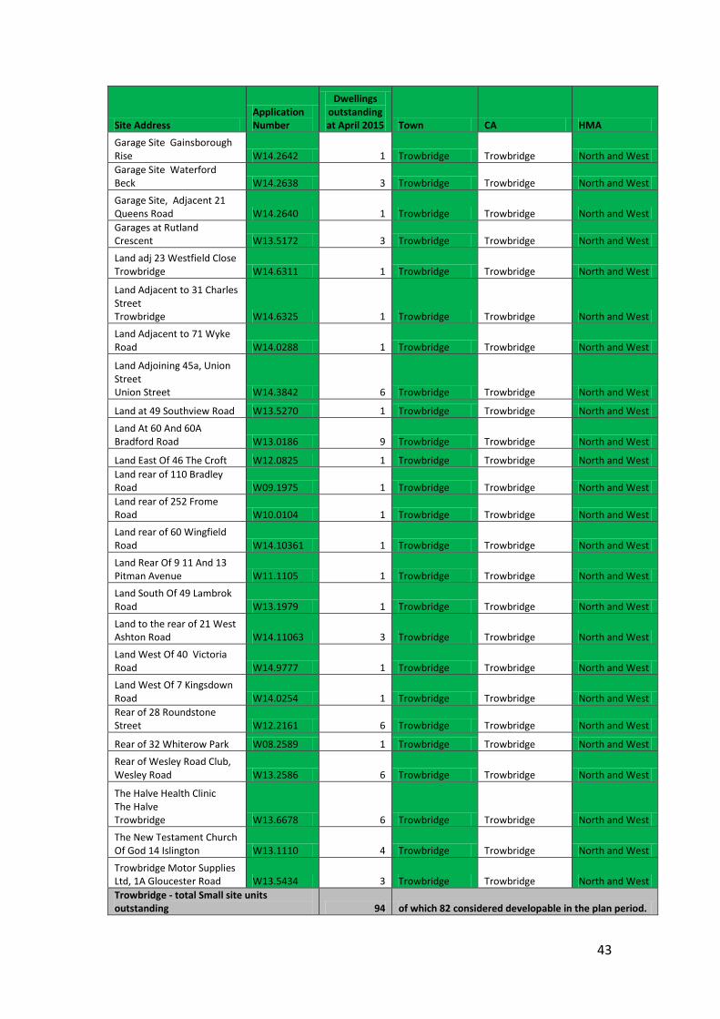
43
Site Address Application Number
Dwellings outstanding at April 2015 Town CA HMA
Garage Site Gainsborough Rise W14.2642 1 Trowbridge Trowbridge North and West Garage Site Waterford Beck W14.2638 3 Trowbridge Trowbridge North and West
Garage Site, Adjacent 21 Queens Road W14.2640 1 Trowbridge Trowbridge North and West Garages at Rutland Crescent W13.5172 3 Trowbridge Trowbridge North and West
Land adj 23 Westfield Close Trowbridge W14.6311 1 Trowbridge Trowbridge North and West
Land Adjacent to 31 Charles Street Trowbridge W14.6325 1 Trowbridge Trowbridge North and West
Land Adjacent to 71 Wyke Road W14.0288 1 Trowbridge Trowbridge North and West
Land Adjoining 45a, Union Street Union Street W14.3842 6 Trowbridge Trowbridge North and West
Land at 49 Southview Road W13.5270 1 Trowbridge Trowbridge North and West
Land At 60 And 60A Bradford Road W13.0186 9 Trowbridge Trowbridge North and West
Land East Of 46 The Croft W12.0825 1 Trowbridge Trowbridge North and West Land rear of 110 Bradley Road W09.1975 1 Trowbridge Trowbridge North and West Land rear of 252 Frome Road W10.0104 1 Trowbridge Trowbridge North and West
Land rear of 60 Wingfield Road W14.10361 1 Trowbridge Trowbridge North and West
Land Rear Of 9 11 And 13 Pitman Avenue W11.1105 1 Trowbridge Trowbridge North and West
Land South Of 49 Lambrok Road W13.1979 1 Trowbridge Trowbridge North and West
Land to the rear of 21 West Ashton Road W14.11063 3 Trowbridge Trowbridge North and West
Land West Of 40 Victoria Road W14.9777 1 Trowbridge Trowbridge North and West Land West Of 7 Kingsdown Road W14.0254 1 Trowbridge Trowbridge North and West Rear of 28 Roundstone Street W12.2161 6 Trowbridge Trowbridge North and West
Rear of 32 Whiterow Park W08.2589 1 Trowbridge Trowbridge North and West
Rear of Wesley Road Club, Wesley Road W13.2586 6 Trowbridge Trowbridge North and West
The Halve Health Clinic The Halve Trowbridge W13.6678 6 Trowbridge Trowbridge North and West
The New Testament Church Of God 14 Islington W13.1110 4 Trowbridge Trowbridge North and West
Trowbridge Motor Supplies Ltd, 1A Gloucester Road W13.5434 3 Trowbridge Trowbridge North and West Trowbridge - total Small site units outstanding 94 of which 82 considered developable in the plan period.
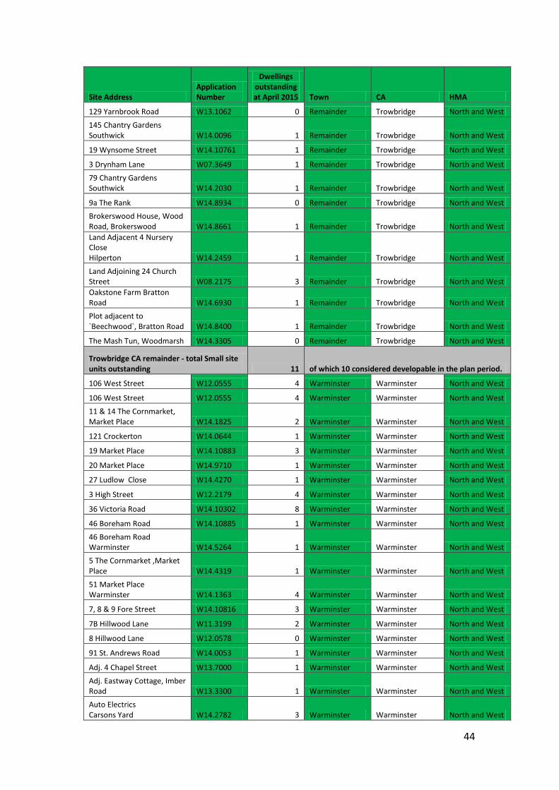
44
Site Address Application Number
Dwellings outstanding at April 2015 Town CA HMA
129 Yarnbrook Road W13.1062 0 Remainder Trowbridge North and West
145 Chantry Gardens Southwick W14.0096 1 Remainder Trowbridge North and West
19 Wynsome Street W14.10761 1 Remainder Trowbridge North and West
3 Drynham Lane W07.3649 1 Remainder Trowbridge North and West
79 Chantry Gardens Southwick W14.2030 1 Remainder Trowbridge North and West
9a The Rank W14.8934 0 Remainder Trowbridge North and West Brokerswood House, Wood Road, Brokerswood W14.8661 1 Remainder Trowbridge North and West Land Adjacent 4 Nursery Close Hilperton W14.2459 1 Remainder Trowbridge North and West
Land Adjoining 24 Church Street W08.2175 3 Remainder Trowbridge North and West Oakstone Farm Bratton Road W14.6930 1 Remainder Trowbridge North and West Plot adjacent to `Beechwood`, Bratton Road W14.8400 1 Remainder Trowbridge North and West
The Mash Tun, Woodmarsh W14.3305 0 Remainder Trowbridge North and West
Trowbridge CA remainder - total Small site units outstanding 11 of which 10 considered developable in the plan period.
106 West Street W12.0555 4 Warminster Warminster North and West
106 West Street W12.0555 4 Warminster Warminster North and West
11 & 14 The Cornmarket, Market Place W14.1825 2 Warminster Warminster North and West
121 Crockerton W14.0644 1 Warminster Warminster North and West
19 Market Place W14.10883 3 Warminster Warminster North and West
20 Market Place W14.9710 1 Warminster Warminster North and West
27 Ludlow Close W14.4270 1 Warminster Warminster North and West
3 High Street W12.2179 4 Warminster Warminster North and West
36 Victoria Road W14.10302 8 Warminster Warminster North and West
46 Boreham Road W14.10885 1 Warminster Warminster North and West
46 Boreham Road Warminster W14.5264 1 Warminster Warminster North and West
5 The Cornmarket ,Market Place W14.4319 1 Warminster Warminster North and West
51 Market Place Warminster W14.1363 4 Warminster Warminster North and West
7, 8 & 9 Fore Street W14.10816 3 Warminster Warminster North and West
7B Hillwood Lane W11.3199 2 Warminster Warminster North and West
8 Hillwood Lane W12.0578 0 Warminster Warminster North and West
91 St. Andrews Road W14.0053 1 Warminster Warminster North and West
Adj. 4 Chapel Street W13.7000 1 Warminster Warminster North and West
Adj. Eastway Cottage, Imber Road W13.3300 1 Warminster Warminster North and West
Auto Electrics Carsons Yard W14.2782 3 Warminster Warminster North and West
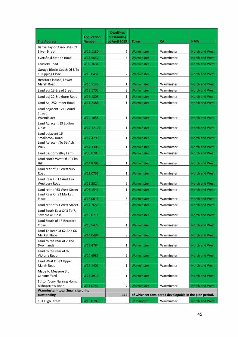
45
Site Address Application Number
Dwellings outstanding at April 2015 Town CA HMA
Barrie Taylor Associates 39 Silver Street W12.1180 2 Warminster Warminster North and West
Eversfield Station Road W13.5642 5 Warminster Warminster North and West
Fairfield Road W09.3634 8 Warminster Warminster North and West
Garage Blocks South Of 8 To 10 Epping Close W13.0451 2 Warminster Warminster North and West
Hensford House, Lower Marsh Road W13.5146 1 Warminster Warminster North and West
Land adj 13 Bread Sreet W12.1702 3 Warminster Warminster North and West
Land adj 22 Broxburn Road W12.1805 1 Warminster Warminster North and West
Land Adj 252 Imber Road W11.2488 1 Warminster Warminster North and West
Land adjacent 121 Pound Street Warminster W14.1055 1 Warminster Warminster North and West Land Adjacent 15 Ludlow Close W14.12104 1 Warminster Warminster North and West
Land adjacent 16 Smallbrook Road W14.4290 1 Warminster Warminster North and West Land Adjacent To 5b Ash Walk W14.3306 1 Warminster Warminster North and West
Land East of Valley Farm W08.0785 0 Warminster Warminster North and West
Land North West Of 10 Elm Hill W14.8790 1 Warminster Warminster North and West
Land rear of 11 Westbury Road W11.0755 1 Warminster Warminster North and West
Land Rear Of 12 And 12a Westbury Road W13.3824 2 Warminster Warminster North and West
Land rear of 63 West Street W08.1541 1 Warminster Warminster North and West Land Rear Of 82 Market Place W13.0015 6 Warminster Warminster North and West
Land rear of 93 West Street W14.2658 3 Warminster Warminster North and West
Land South East Of 3 To 7, Savernake Close W13.0711 6 Warminster Warminster North and West
Land South of 13 Beckford Close W13.5477 1 Warminster Warminster North and West Land To Rear Of 62 And 66 Market Place W14.0484 8 Warminster Warminster North and West
Land to the rear of 2 The Downlands W13.4784 1 Warminster Warminster North and West
Land to the rear of 92 Victoria Road W14.6985 2 Warminster Warminster North and West
Land West Of 83 Upper Marsh Road W13.1401 1 Warminster Warminster North and West
Made to Measure Ltd Carsons Yard W13.3919 1 Warminster Warminster North and West
Sutton Veny Nursing Home, Bishopstrow Road W11.0741 7 Warminster Warminster North and West Warminster - total Small site units outstanding 114 of which 99 considered developable in the plan period.
101 High Street W13.0789 0 Remainder Warminster North and West
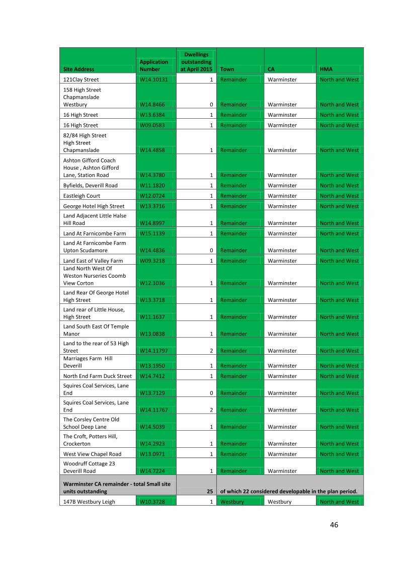
46
Site Address Application Number
Dwellings outstanding at April 2015 Town CA HMA
121Clay Street W14.10131 1 Remainder Warminster North and West
158 High Street Chapmanslade Westbury W14.8466 0 Remainder Warminster North and West
16 High Street W13.6384 1 Remainder Warminster North and West
16 High Street W09.0583 1 Remainder Warminster North and West
82/84 High Street High Street Chapmanslade W14.4858 1 Remainder Warminster North and West
Ashton Gifford Coach House , Ashton Gifford Lane, Station Road W14.3780 1 Remainder Warminster North and West
Byfields, Deverill Road W11.1820 1 Remainder Warminster North and West
Eastleigh Court W12.0724 1 Remainder Warminster North and West
George Hotel High Street W13.3716 1 Remainder Warminster North and West
Land Adjacent Little Halse Hill Road W14.8997 1 Remainder Warminster North and West
Land At Farnicombe Farm W15.1139 1 Remainder Warminster North and West
Land At Farnicombe Farm Upton Scudamore W14.4836 0 Remainder Warminster North and West
Land East of Valley Farm W09.3218 1 Remainder Warminster North and West Land North West Of Weston Nurseries Coomb View Corton W12.1036 1 Remainder Warminster North and West
Land Rear Of George Hotel High Street W13.3718 1 Remainder Warminster North and West
Land rear of Little House, High Street W11.1637 1 Remainder Warminster North and West
Land South East Of Temple Manor W13.0838 1 Remainder Warminster North and West Land to the rear of 53 High Street W14.11797 2 Remainder Warminster North and West Marriages Farm Hill Deverill W13.1950 1 Remainder Warminster North and West
North End Farm Duck Street W14.7412 1 Remainder Warminster North and West
Squires Coal Services, Lane End W13.7129 0 Remainder Warminster North and West
Squires Coal Services, Lane End W14.11767 2 Remainder Warminster North and West
The Corsley Centre Old School Deep Lane W14.5039 1 Remainder Warminster North and West
The Croft, Potters Hill, Crockerton W14.2923 1 Remainder Warminster North and West
West View Chapel Road W13.0971 1 Remainder Warminster North and West
Woodruff Cottage 23 Deverill Road W14.7224 1 Remainder Warminster North and West
Warminster CA remainder - total Small site units outstanding 25 of which 22 considered developable in the plan period.
147B Westbury Leigh W10.3728 1 Westbury Westbury North and West
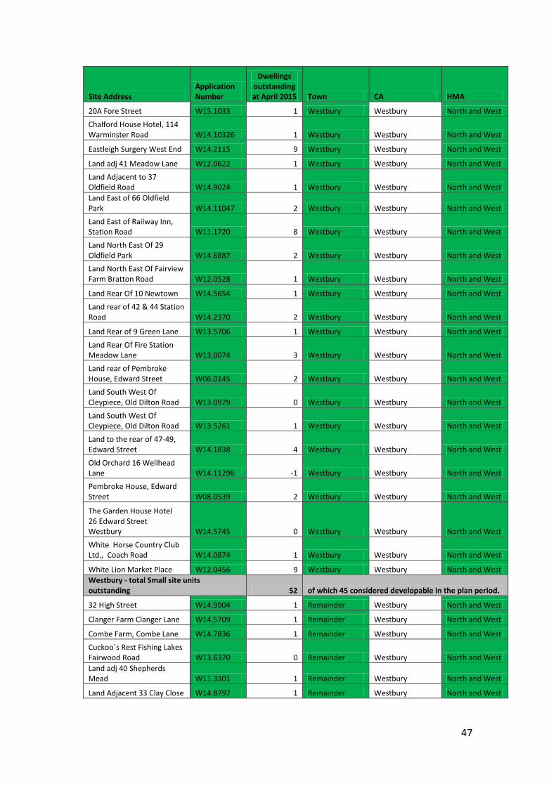
47
Site Address Application Number
Dwellings outstanding at April 2015 Town CA HMA
20A Fore Street W15.1033 1 Westbury Westbury North and West
Chalford House Hotel, 114 Warminster Road W14.10326 1 Westbury Westbury North and West
Eastleigh Surgery West End W14.2115 9 Westbury Westbury North and West
Land adj 41 Meadow Lane W12.0622 1 Westbury Westbury North and West
Land Adjacent to 37 Oldfield Road W14.9024 1 Westbury Westbury North and West Land East of 66 Oldfield Park W14.11047 2 Westbury Westbury North and West
Land East of Railway Inn, Station Road W11.1720 8 Westbury Westbury North and West
Land North East Of 29 Oldfield Park W14.6887 2 Westbury Westbury North and West Land North East Of Fairview Farm Bratton Road W12.0528 1 Westbury Westbury North and West
Land Rear Of 10 Newtown W14.5654 1 Westbury Westbury North and West
Land rear of 42 & 44 Station Road W14.2370 2 Westbury Westbury North and West
Land Rear of 9 Green Lane W13.5706 1 Westbury Westbury North and West
Land Rear Of Fire Station Meadow Lane W13.0074 3 Westbury Westbury North and West
Land rear of Pembroke House, Edward Street W06.0145 2 Westbury Westbury North and West Land South West Of Cleypiece, Old Dilton Road W13.0979 0 Westbury Westbury North and West
Land South West Of Cleypiece, Old Dilton Road W13.5261 1 Westbury Westbury North and West
Land to the rear of 47-49, Edward Street W14.1838 4 Westbury Westbury North and West
Old Orchard 16 Wellhead Lane W14.11296 -1 Westbury Westbury North and West
Pembroke House, Edward Street W08.0539 2 Westbury Westbury North and West
The Garden House Hotel 26 Edward Street Westbury W14.5745 0 Westbury Westbury North and West
White Horse Country Club Ltd., Coach Road W14.0874 1 Westbury Westbury North and West
White Lion Market Place W12.0456 9 Westbury Westbury North and West Westbury - total Small site units outstanding 52 of which 45 considered developable in the plan period.
32 High Street W14.9904 1 Remainder Westbury North and West
Clanger Farm Clanger Lane W14.5709 1 Remainder Westbury North and West
Combe Farm, Combe Lane W14.7836 1 Remainder Westbury North and West
Cuckoo`s Rest Fishing Lakes Fairwood Road W13.6370 0 Remainder Westbury North and West Land adj 40 Shepherds Mead W11.3301 1 Remainder Westbury North and West
Land Adjacent 33 Clay Close W14.8797 1 Remainder Westbury North and West
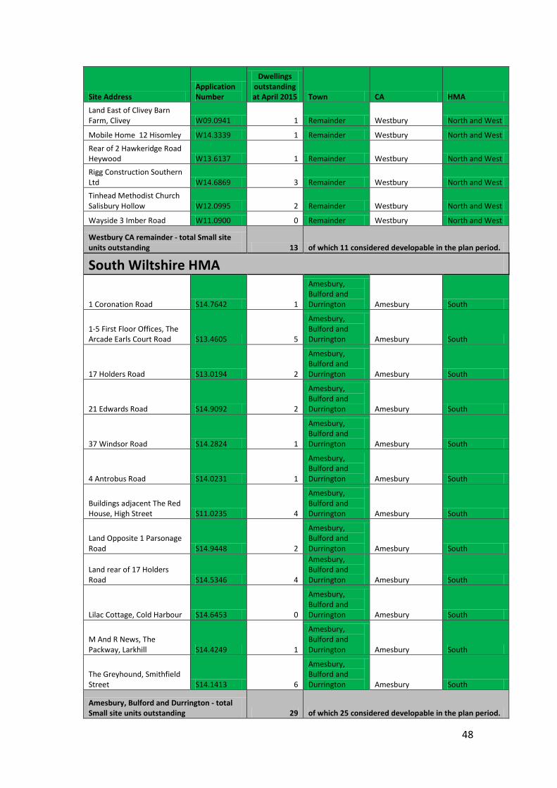
48
Site Address Application Number
Dwellings outstanding at April 2015 Town CA HMA
Land East of Clivey Barn Farm, Clivey W09.0941 1 Remainder Westbury North and West
Mobile Home 12 Hisomley W14.3339 1 Remainder Westbury North and West
Rear of 2 Hawkeridge Road Heywood W13.6137 1 Remainder Westbury North and West
Rigg Construction Southern Ltd W14.6869 3 Remainder Westbury North and West Tinhead Methodist Church Salisbury Hollow W12.0995 2 Remainder Westbury North and West
Wayside 3 Imber Road W11.0900 0 Remainder Westbury North and West
Westbury CA remainder - total Small site units outstanding 13 of which 11 considered developable in the plan period.
South Wiltshire HMA
1 Coronation Road S14.7642 1
Amesbury, Bulford and Durrington Amesbury South
1-5 First Floor Offices, The Arcade Earls Court Road S13.4605 5
Amesbury, Bulford and Durrington Amesbury South
17 Holders Road S13.0194 2
Amesbury, Bulford and Durrington Amesbury South
21 Edwards Road S14.9092 2
Amesbury, Bulford and Durrington Amesbury South
37 Windsor Road S14.2824 1
Amesbury, Bulford and Durrington Amesbury South
4 Antrobus Road S14.0231 1
Amesbury, Bulford and Durrington Amesbury South
Buildings adjacent The Red House, High Street S11.0235 4
Amesbury, Bulford and Durrington Amesbury South
Land Opposite 1 Parsonage Road S14.9448 2
Amesbury, Bulford and Durrington Amesbury South
Land rear of 17 Holders Road S14.5346 4
Amesbury, Bulford and Durrington Amesbury South
Lilac Cottage, Cold Harbour S14.6453 0
Amesbury, Bulford and Durrington Amesbury South
M And R News, The Packway, Larkhill S14.4249 1
Amesbury, Bulford and Durrington Amesbury South
The Greyhound, Smithfield Street S14.1413 6
Amesbury, Bulford and Durrington Amesbury South
Amesbury, Bulford and Durrington - total Small site units outstanding 29 of which 25 considered developable in the plan period.
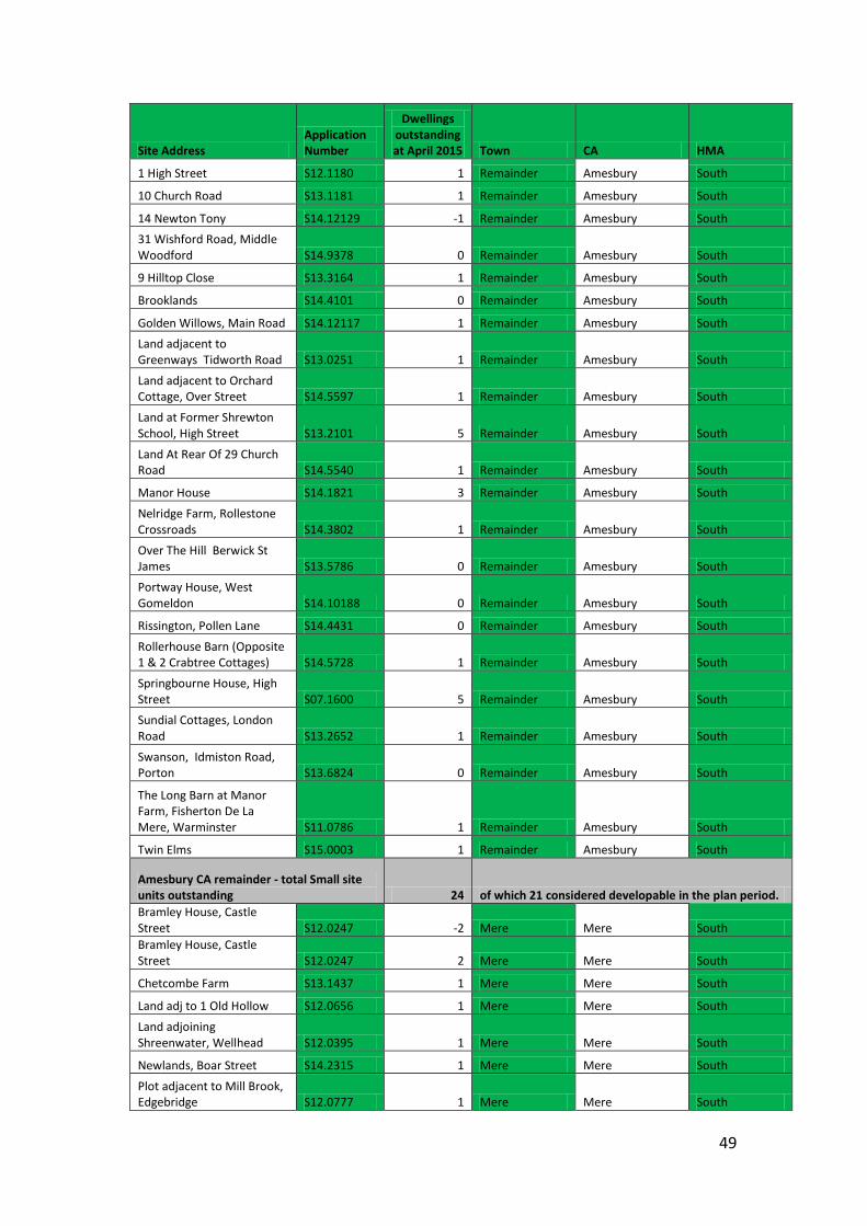
49
Site Address Application Number
Dwellings outstanding at April 2015 Town CA HMA
1 High Street S12.1180 1 Remainder Amesbury South
10 Church Road S13.1181 1 Remainder Amesbury South
14 Newton Tony S14.12129 -1 Remainder Amesbury South 31 Wishford Road, Middle Woodford S14.9378 0 Remainder Amesbury South
9 Hilltop Close S13.3164 1 Remainder Amesbury South
Brooklands S14.4101 0 Remainder Amesbury South
Golden Willows, Main Road S14.12117 1 Remainder Amesbury South Land adjacent to Greenways Tidworth Road S13.0251 1 Remainder Amesbury South
Land adjacent to Orchard Cottage, Over Street S14.5597 1 Remainder Amesbury South
Land at Former Shrewton School, High Street S13.2101 5 Remainder Amesbury South
Land At Rear Of 29 Church Road S14.5540 1 Remainder Amesbury South
Manor House S14.1821 3 Remainder Amesbury South
Nelridge Farm, Rollestone Crossroads S14.3802 1 Remainder Amesbury South
Over The Hill Berwick St James S13.5786 0 Remainder Amesbury South
Portway House, West Gomeldon S14.10188 0 Remainder Amesbury South
Rissington, Pollen Lane S14.4431 0 Remainder Amesbury South
Rollerhouse Barn (Opposite 1 & 2 Crabtree Cottages) S14.5728 1 Remainder Amesbury South
Springbourne House, High Street S07.1600 5 Remainder Amesbury South Sundial Cottages, London Road S13.2652 1 Remainder Amesbury South
Swanson, Idmiston Road, Porton S13.6824 0 Remainder Amesbury South
The Long Barn at Manor Farm, Fisherton De La Mere, Warminster S11.0786 1 Remainder Amesbury South
Twin Elms S15.0003 1 Remainder Amesbury South
Amesbury CA remainder - total Small site units outstanding 24 of which 21 considered developable in the plan period. Bramley House, Castle Street S12.0247 -2 Mere Mere South Bramley House, Castle Street S12.0247 2 Mere Mere South
Chetcombe Farm S13.1437 1 Mere Mere South
Land adj to 1 Old Hollow S12.0656 1 Mere Mere South
Land adjoining Shreenwater, Wellhead S12.0395 1 Mere Mere South
Newlands, Boar Street S14.2315 1 Mere Mere South
Plot adjacent to Mill Brook, Edgebridge S12.0777 1 Mere Mere South
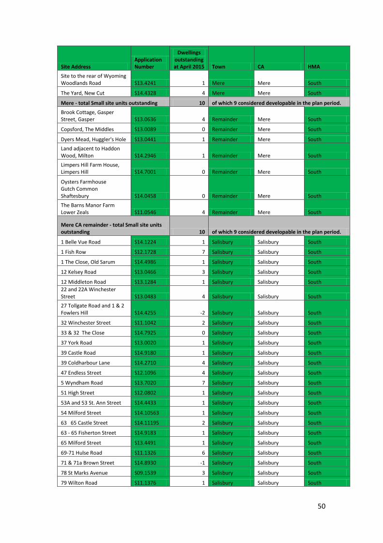
50
Site Address Application Number
Dwellings outstanding at April 2015 Town CA HMA
Site to the rear of Wyoming Woodlands Road S13.4241 1 Mere Mere South
The Yard, New Cut S14.4328 4 Mere Mere South
Mere - total Small site units outstanding 10 of which 9 considered developable in the plan period.
Brook Cottage, Gasper Street, Gasper S13.0636 4 Remainder Mere South
Copsford, The Middles S13.0089 0 Remainder Mere South
Dyers Mead, Huggler's Hole S13.0441 1 Remainder Mere South Land adjacent to Haddon Wood, Milton S14.2946 1 Remainder Mere South
Limpers Hill Farm House, Limpers Hill S14.7001 0 Remainder Mere South
Oysters Farmhouse Gutch Common Shaftesbury S14.0458 0 Remainder Mere South
The Barns Manor Farm Lower Zeals S11.0546 4 Remainder Mere South
Mere CA remainder - total Small site units outstanding 10 of which 9 considered developable in the plan period.
1 Belle Vue Road S14.1224 1 Salisbury Salisbury South
1 Fish Row S12.1728 7 Salisbury Salisbury South
1 The Close, Old Sarum S14.4986 1 Salisbury Salisbury South
12 Kelsey Road S13.0466 3 Salisbury Salisbury South
12 Middleton Road S13.1284 1 Salisbury Salisbury South 22 and 22A Winchester Street S13.0483 4 Salisbury Salisbury South 27 Tollgate Road and 1 & 2 Fowlers Hill S14.4255 -2 Salisbury Salisbury South
32 Winchester Street S11.1042 2 Salisbury Salisbury South
33 & 32 The Close S14.7925 0 Salisbury Salisbury South
37 York Road S13.0020 1 Salisbury Salisbury South
39 Castle Road S14.9180 1 Salisbury Salisbury South
39 Coldharbour Lane S14.2710 4 Salisbury Salisbury South
47 Endless Street S12.1096 4 Salisbury Salisbury South
5 Wyndham Road S13.7020 7 Salisbury Salisbury South
51 High Street S12.0802 1 Salisbury Salisbury South
53A and 53 St. Ann Street S14.4433 1 Salisbury Salisbury South
54 Milford Street S14.10563 1 Salisbury Salisbury South
63 65 Castle Street S14.11195 2 Salisbury Salisbury South
63 - 65 Fisherton Street S14.9183 1 Salisbury Salisbury South
65 Milford Street S13.4491 1 Salisbury Salisbury South
69-71 Hulse Road S11.1326 6 Salisbury Salisbury South
71 & 71a Brown Street S14.8930 -1 Salisbury Salisbury South
78 St Marks Avenue S09.1539 3 Salisbury Salisbury South
79 Wilton Road S11.1376 1 Salisbury Salisbury South
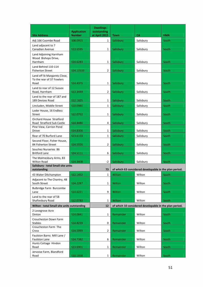
51
Site Address Application Number
Dwellings outstanding at April 2015 Town CA HMA
Adj 166 Coombe Road S08.0955 1 Salisbury Salisbury South
Land adjacent to 7 Canadian Avenue S13.6595 1 Salisbury Salisbury South
Land Adjoining Harnham Wood Bishops Drive, Harnham S14.6283 1 Salisbury Salisbury South
Land Behind 110-114 Fisherton Street S14.10533 2 Salisbury Salisbury South
Land off St Margarets Close, To the rear of 37 Fowlers Road S14.4376 1 Salisbury Salisbury South
Land to rear of 12 Sussex Road, Harnham S13.3449 2 Salisbury Salisbury South
Land to the rear of 187 and 189 Devizes Road S12.1825 1 Salisbury Salisbury South
Lincluden, Middle Street S10.0980 1 Salisbury Salisbury South
Loder House, 16 Endless Street S12.0762 1 Salisbury Salisbury South
Orchard House Stratford Road Stratford Sub Castle S14.4486 4 Salisbury Salisbury South Pine View, Carrion Pond Drove S14.8306 1 Salisbury Salisbury South
Rear of 70 Burford Lane S13.6103 1 Salisbury Salisbury South
Second Floor, Fisher House, 84 Fisherton Street S14.5926 2 Salisbury Salisbury South
Souchez Nurseries 86 Britford Lane S14.5111 6 Salisbury Salisbury South
The Malmesbury Arms, 83 Wilton Road S14.3408 -2 Salisbury Salisbury South Salisbury - total Small site units outstanding 73 of which 63 considered developable in the plan period.
43 Water Ditchampton S12.1452 1 Wilton Wilton South
Adjacent to The Chantry, 48 South Street S14.2287 1 Wilton Wilton South
Bulbridge Farm Burcombe Lane S14.6221 9 Wilton Wilton South
Land to the rear of 58 Shaftesbury Road S12.0783 1 Wilton Wilton South
Wilton - total Small site units outstanding 12 of which 10 considered developable in the plan period.
2 Lovegrove Acre Dinton S14.0841 1 Remainder Wilton South
Croucheston Down Farm Stables S14.8239 0 Remainder Wilton South Croucheston Farm The Cross S14.5999 2 Remainder Wilton South
Faulston Barns Mill Lane / Faulston Lane S14.7382 6 Remainder Wilton South Hunts Cottage Hindon Road S13.6901 1 Remainder Wilton South
Jervoise Farm, Blandford Road S10.1858 1 Remainder Wilton South
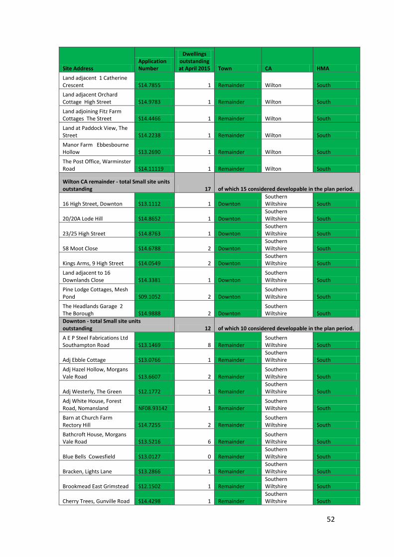
52
Site Address Application Number
Dwellings outstanding at April 2015 Town CA HMA
Land adjacent 1 Catherine Crescent S14.7855 1 Remainder Wilton South Land adjacent Orchard Cottage High Street S14.9783 1 Remainder Wilton South
Land adjoining Fitz Farm Cottages The Street S14.4466 1 Remainder Wilton South
Land at Paddock View, The Street S14.2238 1 Remainder Wilton South
Manor Farm Ebbesbourne Hollow S13.2690 1 Remainder Wilton South
The Post Office, Warminster Road S14.11119 1 Remainder Wilton South
Wilton CA remainder - total Small site units outstanding 17 of which 15 considered developable in the plan period.
16 High Street, Downton S13.1112 1 Downton Southern Wiltshire South
20/20A Lode Hill S14.8652 1 Downton Southern Wiltshire South
23/25 High Street S14.8763 1 Downton Southern Wiltshire South
58 Moot Close S14.6788 2 Downton Southern Wiltshire South
Kings Arms, 9 High Street S14.0549 2 Downton Southern Wiltshire South
Land adjacent to 16 Downlands Close S14.3381 1 Downton
Southern Wiltshire South
Pine Lodge Cottages, Mesh Pond S09.1052 2 Downton
Southern Wiltshire South
The Headlands Garage 2 The Borough S14.9888 2 Downton
Southern Wiltshire South
Downton - total Small site units outstanding 12 of which 10 considered developable in the plan period.
A E P Steel Fabrications Ltd Southampton Road S13.1469 8 Remainder
Southern Wiltshire South
Adj Ebble Cottage S13.0766 1 Remainder Southern Wiltshire South
Adj Hazel Hollow, Morgans Vale Road S13.6607 2 Remainder
Southern Wiltshire South
Adj Westerly, The Green S12.1772 1 Remainder Southern Wiltshire South
Adj White House, Forest Road, Nomansland NF08.93142 1 Remainder
Southern Wiltshire South
Barn at Church Farm Rectory Hill S14.7255 2 Remainder
Southern Wiltshire South
Bathcroft House, Morgans Vale Road S13.5216 6 Remainder
Southern Wiltshire South
Blue Bells Cowesfield S13.0127 0 Remainder Southern Wiltshire South
Bracken, Lights Lane S13.2866 1 Remainder Southern Wiltshire South
Brookmead East Grimstead S12.1502 1 Remainder Southern Wiltshire South
Cherry Trees, Gunville Road S14.4298 1 Remainder Southern Wiltshire South
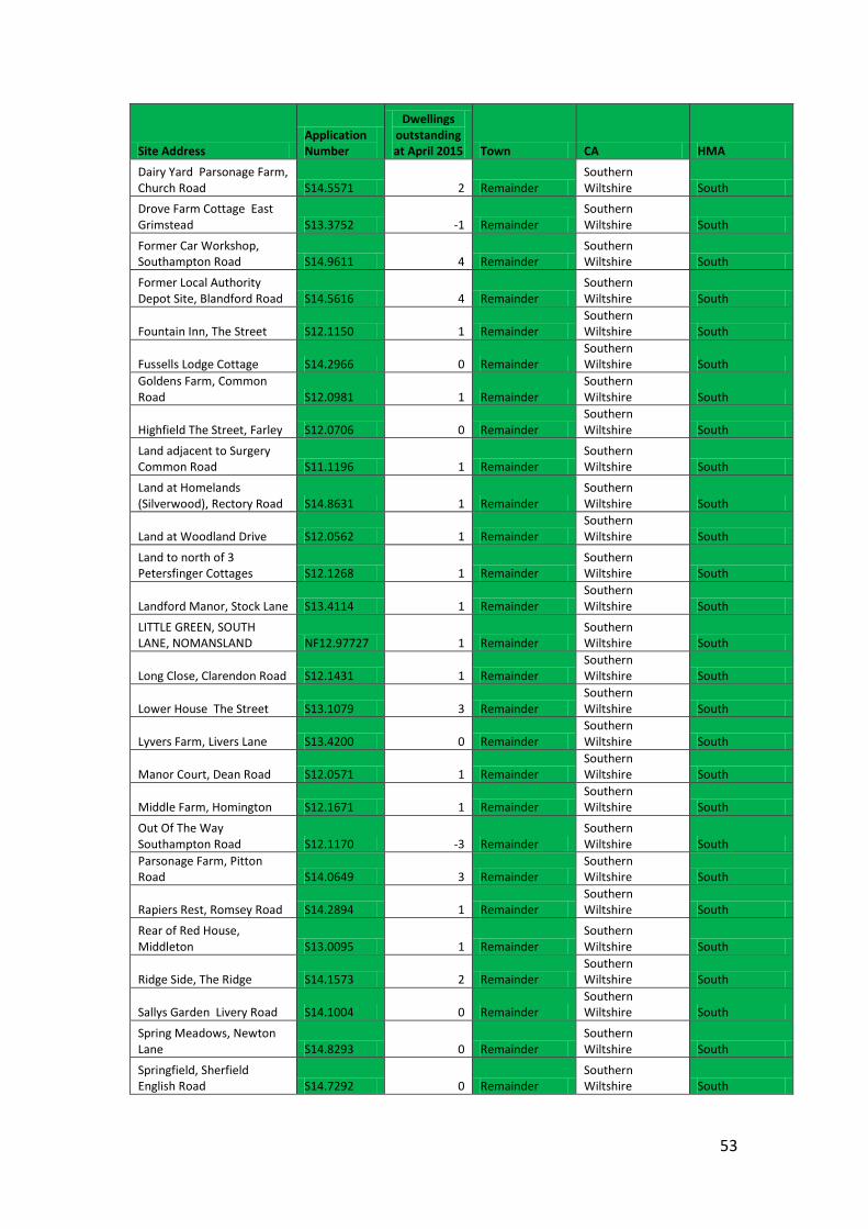
53
Site Address Application Number
Dwellings outstanding at April 2015 Town CA HMA
Dairy Yard Parsonage Farm, Church Road S14.5571 2 Remainder
Southern Wiltshire South
Drove Farm Cottage East Grimstead S13.3752 -1 Remainder
Southern Wiltshire South
Former Car Workshop, Southampton Road S14.9611 4 Remainder
Southern Wiltshire South
Former Local Authority Depot Site, Blandford Road S14.5616 4 Remainder
Southern Wiltshire South
Fountain Inn, The Street S12.1150 1 Remainder Southern Wiltshire South
Fussells Lodge Cottage S14.2966 0 Remainder Southern Wiltshire South
Goldens Farm, Common Road S12.0981 1 Remainder
Southern Wiltshire South
Highfield The Street, Farley S12.0706 0 Remainder Southern Wiltshire South
Land adjacent to Surgery Common Road S11.1196 1 Remainder
Southern Wiltshire South
Land at Homelands (Silverwood), Rectory Road S14.8631 1 Remainder
Southern Wiltshire South
Land at Woodland Drive S12.0562 1 Remainder Southern Wiltshire South
Land to north of 3 Petersfinger Cottages S12.1268 1 Remainder
Southern Wiltshire South
Landford Manor, Stock Lane S13.4114 1 Remainder Southern Wiltshire South
LITTLE GREEN, SOUTH LANE, NOMANSLAND NF12.97727 1 Remainder
Southern Wiltshire South
Long Close, Clarendon Road S12.1431 1 Remainder Southern Wiltshire South
Lower House The Street S13.1079 3 Remainder Southern Wiltshire South
Lyvers Farm, Livers Lane S13.4200 0 Remainder Southern Wiltshire South
Manor Court, Dean Road S12.0571 1 Remainder Southern Wiltshire South
Middle Farm, Homington S12.1671 1 Remainder Southern Wiltshire South
Out Of The Way Southampton Road S12.1170 -3 Remainder
Southern Wiltshire South
Parsonage Farm, Pitton Road S14.0649 3 Remainder
Southern Wiltshire South
Rapiers Rest, Romsey Road S14.2894 1 Remainder Southern Wiltshire South
Rear of Red House, Middleton S13.0095 1 Remainder
Southern Wiltshire South
Ridge Side, The Ridge S14.1573 2 Remainder Southern Wiltshire South
Sallys Garden Livery Road S14.1004 0 Remainder Southern Wiltshire South
Spring Meadows, Newton Lane S14.8293 0 Remainder
Southern Wiltshire South
Springfield, Sherfield English Road S14.7292 0 Remainder
Southern Wiltshire South
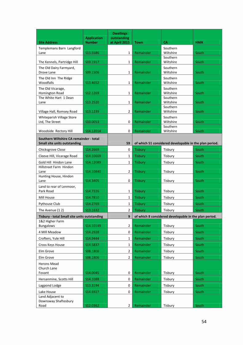
54
Site Address Application Number
Dwellings outstanding at April 2015 Town CA HMA
Templemans Barn Langford Lane S13.5586 1 Remainder
Southern Wiltshire South
The Kennels, Partridge Hill S10.1917 1 Remainder Southern Wiltshire South
The Old Dairy Farmyard, Drove Lane S09.1506 1 Remainder
Southern Wiltshire South
The Old Inn The Ridge Woodfalls S13.4652 1 Remainder
Southern Wiltshire South
The Old Vicarage, Homington Road S12.1269 1 Remainder
Southern Wiltshire South
The White Hart 1 Dean Lane S13.2520 1 Remainder
Southern Wiltshire South
Village Hall, Romsey Road S13.1239 2 Remainder Southern Wiltshire South
Whiteparish Village Store Ltd, The Street S10.0053 0 Remainder
Southern Wiltshire South
Woodside Rectory Hill S14.12014 0 Remainder Southern Wiltshire South
Southern Wiltshire CA remainder - total Small site units outstanding 59 of which 51 considered developable in the plan period.
Chicksgrove Close S14.2669 0 Tisbury Tisbury South
Cleeve Hill, Vicarage Road S14.10669 1 Tisbury Tisbury South
Gold Hill Hindon Lane S14.12089 1 Tisbury Tisbury South Hillstreet Farm Hindon Lane S14.10840 2 Tisbury Tisbury South Hunting House, Hindon Lane S14.3405 0 Tisbury Tisbury South
Land to rear of Lenmoor, Park Road S14.7226 1 Tisbury Tisbury South
Mill House S14.7810 1 Tisbury Tisbury South
Pythouse Club S14.2769 1 Tisbury Tisbury South
The Avenue (1 2) S13.1632 2 Tisbury Tisbury South
Tisbury - total Small site units outstanding 9 of which 8 considered developable in the plan period. 1&2 Higher Farm Bungalows S14.10149 2 Remainder Tisbury South
4 Mill Meadow S14.2928 0 Remainder Tisbury South
Crofters, Yule Hill S14.9444 1 Remainder Tisbury South
Cross Keys House S14.5837 1 Remainder Tisbury South
Elm Grove S08.1806 2 Remainder Tisbury South
Elm Grove S08.1806 2 Remainder Tisbury South
Herons Mead Church Lane Fovant S14.0045 0 Remainder Tisbury South
Hersanmine, Scotts Hill S14.1088 0 Remainder Tisbury South
Lagpond Lodge S13.3194 0 Remainder Tisbury South
Lake House S14.6927 0 Remainder Tisbury South Land Adjacent to Downsway Shaftesbury Road S12.0362 2 Remainder Tisbury South
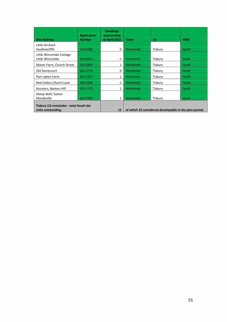
55
Site Address Application Number
Dwellings outstanding at April 2015 Town CA HMA
Little Orchard Swallowcliffe S14.4389 0 Remainder Tisbury South Little Wincombe Cottage Little Wincombe S14.6856 -1 Remainder Tisbury South
Manor Farm, Church Street S14.5804 1 Remainder Tisbury South
Old Stonecourt S14.2770 0 Remainder Tisbury South
Part Upton Farm S12.1557 1 Remainder Tisbury South
Red Cedars,Church Lane S14.1608 -1 Remainder Tisbury South
Roosters, Barkers Hill S13.1175 1 Remainder Tisbury South
Sheep Well, Sutton Mandeville S14.7990 1 Remainder Tisbury South
Tisbury CA remainder - total Small site units outstanding 12 of which 10 considered developable in the plan period.
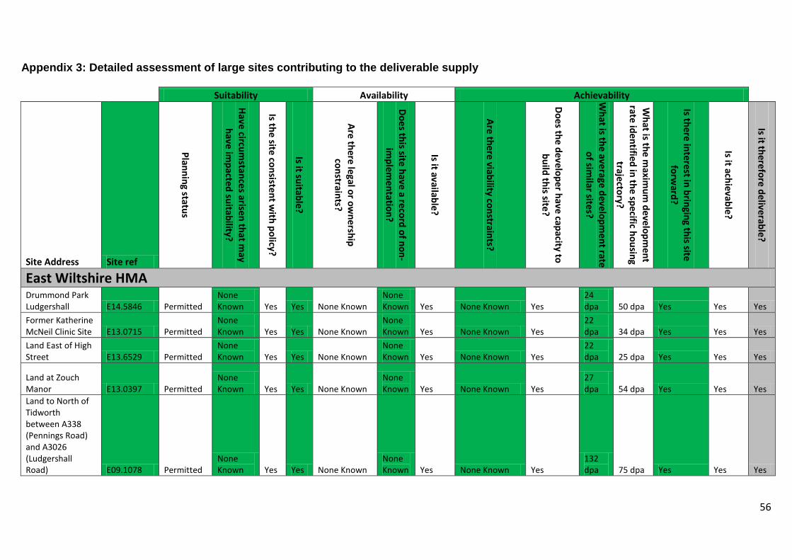
56
Appendix 3: Detailed assessment of large sites contributing to the deliverable supply
Suitability Availability Achievability
Site Address Site ref
Planning status
Have circumstances arisen that m
ay have im
pacted suitability?
Is the site consistent with policy?
Is it suitable?
Are there legal or ownership
constraints?
Does this site have a record of non-im
plementation?
Is it available?
Are there viability constraints?
Does the developer have capacity to build this site?
What is the average developm
ent rate of sim
ilar sites?
What is the m
aximum
development
rate identified in the specific housing trajectory?
Is there interest in bringing this site forw
ard?
Is it achievable?
Is it therefore deliverable?
East Wiltshire HMA Drummond Park Ludgershall E14.5846 Permitted
None Known Yes Yes None Known
None Known Yes None Known Yes
24 dpa 50 dpa Yes Yes Yes
Former Katherine McNeil Clinic Site E13.0715 Permitted
None Known Yes Yes None Known
None Known Yes None Known Yes
22 dpa 34 dpa Yes Yes Yes
Land East of High Street E13.6529 Permitted
None Known Yes Yes None Known
None Known Yes None Known Yes
22 dpa 25 dpa Yes Yes Yes
Land at Zouch Manor E13.0397 Permitted
None Known Yes Yes None Known
None Known Yes None Known Yes
27 dpa 54 dpa Yes Yes Yes
Land to North of Tidworth between A338 (Pennings Road) and A3026 (Ludgershall Road) E09.1078 Permitted
None Known Yes Yes None Known
None Known Yes None Known Yes
132 dpa 75 dpa Yes Yes Yes
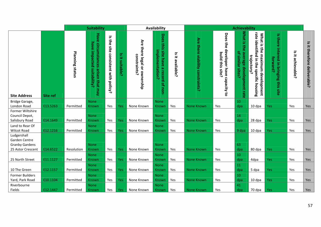
57
Suitability Availability Achievability
Site Address Site ref
Planning status
Have circumstances arisen that m
ay have im
pacted suitability?
Is the site consistent with policy?
Is it suitable?
Are there legal or ownership
constraints?
Does this site have a record of non-im
plementation?
Is it available?
Are there viability constraints?
Does the developer have capacity to build this site?
What is the average developm
ent rate of sim
ilar sites?
What is the m
aximum
development
rate identified in the specific housing trajectory?
Is there interest in bringing this site forw
ard?
Is it achievable?
Is it therefore deliverable?
Bridge Garage, London Road E13.5263 Permitted
None Known Yes Yes None Known
None Known Yes None Known Yes
10 dpa 10 dpa Yes Yes Yes
Former Wiltshire Council Depot, Salisbury Road E14.1649 Permitted
None Known Yes Yes None Known
None Known Yes None Known Yes
14 dpa 28 dpa Yes Yes Yes
Land to Rear Of Wilcot Road E12.1216 Permitted
None Known Yes Yes None Known
None Known Yes None Known Yes 9 dpa 10 dpa Yes Yes Yes
Ludgershall Garden Centre Granby Gardens 25 Astor Crescent E14.6522 Resolution
None Known Yes Yes None Known
None Known Yes None Known Yes
63 dpa 80 dpa Yes Yes Yes
25 North Street E11.1127 Permitted None Known Yes Yes None Known
None Known Yes None Known Yes
10 dpa 4dpa Yes Yes Yes
10 The Green E12.1157 Permitted None Known Yes Yes None Known
None Known Yes None Known Yes
11 dpa 5 dpa Yes Yes Yes
Former Builders Yard, Park Road E10.1104 Permitted
None Known Yes Yes None Known
None Known Yes None Known Yes
10 dpa 10 dpa Yes Yes Yes
Riverbourne Fields E12.1447 Permitted
None Known Yes Yes None Known
None Known Yes None Known Yes
41 dpa 70 dpa Yes Yes Yes
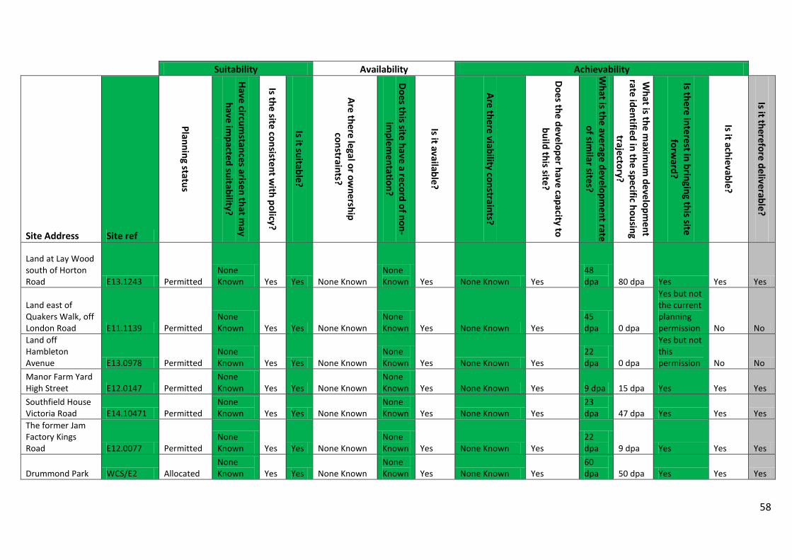
58
Suitability Availability Achievability
Site Address Site ref
Planning status
Have circumstances arisen that m
ay have im
pacted suitability?
Is the site consistent with policy?
Is it suitable?
Are there legal or ownership
constraints?
Does this site have a record of non-im
plementation?
Is it available?
Are there viability constraints?
Does the developer have capacity to build this site?
What is the average developm
ent rate of sim
ilar sites?
What is the m
aximum
development
rate identified in the specific housing trajectory?
Is there interest in bringing this site forw
ard?
Is it achievable?
Is it therefore deliverable?
Land at Lay Wood south of Horton Road E13.1243 Permitted
None Known Yes Yes None Known
None Known Yes None Known Yes
48 dpa 80 dpa Yes Yes Yes
Land east of Quakers Walk, off London Road E11.1139 Permitted
None Known Yes Yes None Known
None Known Yes None Known Yes
45 dpa 0 dpa
Yes but not the current planning permission No No
Land off Hambleton Avenue E13.0978 Permitted
None Known Yes Yes None Known
None Known Yes None Known Yes
22 dpa 0 dpa
Yes but not this permission No No
Manor Farm Yard High Street E12.0147 Permitted
None Known Yes Yes None Known
None Known Yes None Known Yes 9 dpa 15 dpa Yes Yes Yes
Southfield House Victoria Road E14.10471 Permitted
None Known Yes Yes None Known
None Known Yes None Known Yes
23 dpa 47 dpa Yes Yes Yes
The former Jam Factory Kings Road E12.0077 Permitted
None Known Yes Yes None Known
None Known Yes None Known Yes
22 dpa 9 dpa Yes Yes Yes
Drummond Park WCS/E2 Allocated None Known Yes Yes None Known
None Known Yes None Known Yes
60 dpa 50 dpa Yes Yes Yes
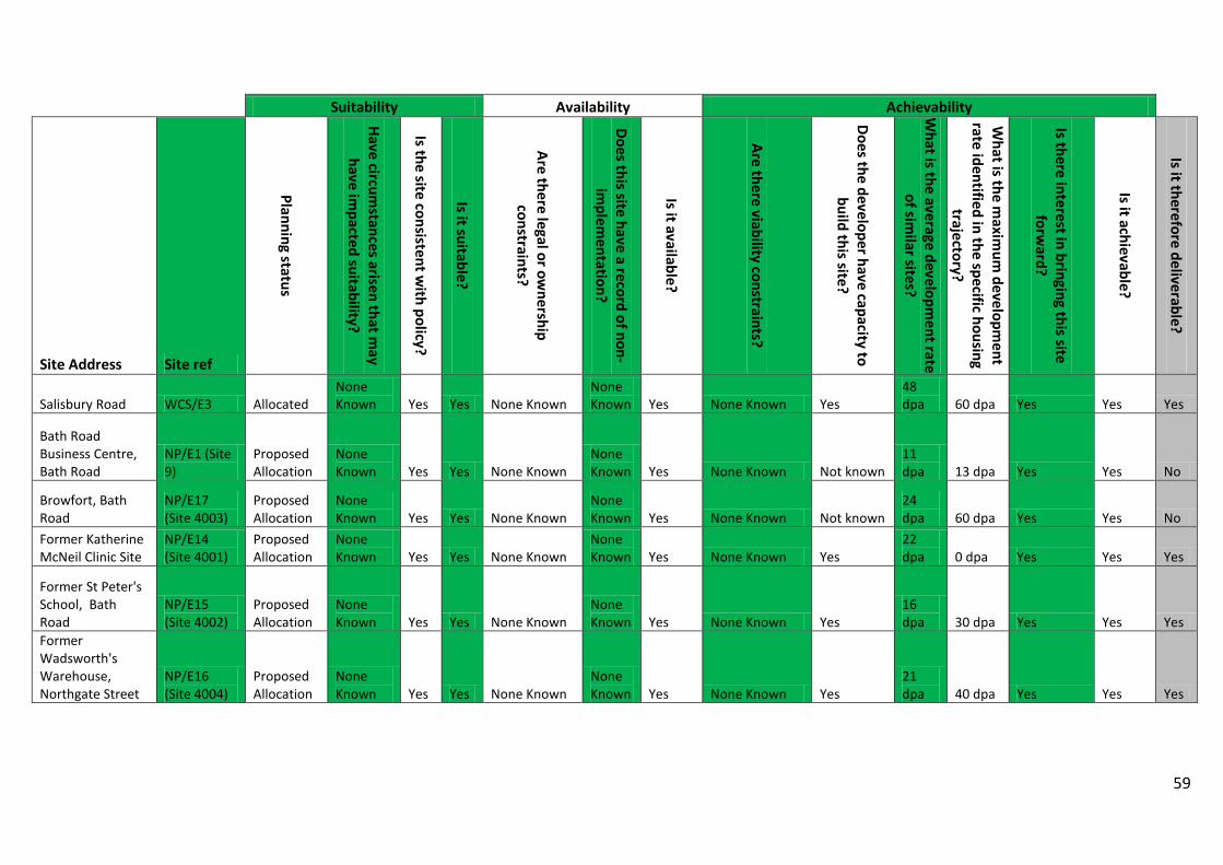
59
Suitability Availability Achievability
Site Address Site ref
Planning status
Have circumstances arisen that m
ay have im
pacted suitability?
Is the site consistent with policy?
Is it suitable?
Are there legal or ownership
constraints?
Does this site have a record of non-im
plementation?
Is it available?
Are there viability constraints?
Does the developer have capacity to build this site?
What is the average developm
ent rate of sim
ilar sites?
What is the m
aximum
development
rate identified in the specific housing trajectory?
Is there interest in bringing this site forw
ard?
Is it achievable?
Is it therefore deliverable?
Salisbury Road WCS/E3 Allocated None Known Yes Yes None Known
None Known Yes None Known Yes
48 dpa 60 dpa Yes Yes Yes
Bath Road Business Centre, Bath Road
NP/E1 (Site 9)
Proposed Allocation
None Known Yes Yes None Known
None Known Yes None Known Not known
11 dpa 13 dpa Yes Yes No
Browfort, Bath Road
NP/E17 (Site 4003)
Proposed Allocation
None Known Yes Yes None Known
None Known Yes None Known Not known
24 dpa 60 dpa Yes Yes No
Former Katherine McNeil Clinic Site
NP/E14 (Site 4001)
Proposed Allocation
None Known Yes Yes None Known
None Known Yes None Known Yes
22 dpa 0 dpa Yes Yes Yes
Former St Peter's School, Bath Road
NP/E15 (Site 4002)
Proposed Allocation
None Known Yes Yes None Known
None Known Yes None Known Yes
16 dpa 30 dpa Yes Yes Yes
Former Wadsworth's Warehouse, Northgate Street
NP/E16 (Site 4004)
Proposed Allocation
None Known Yes Yes None Known
None Known Yes None Known Yes
21 dpa 40 dpa Yes Yes Yes
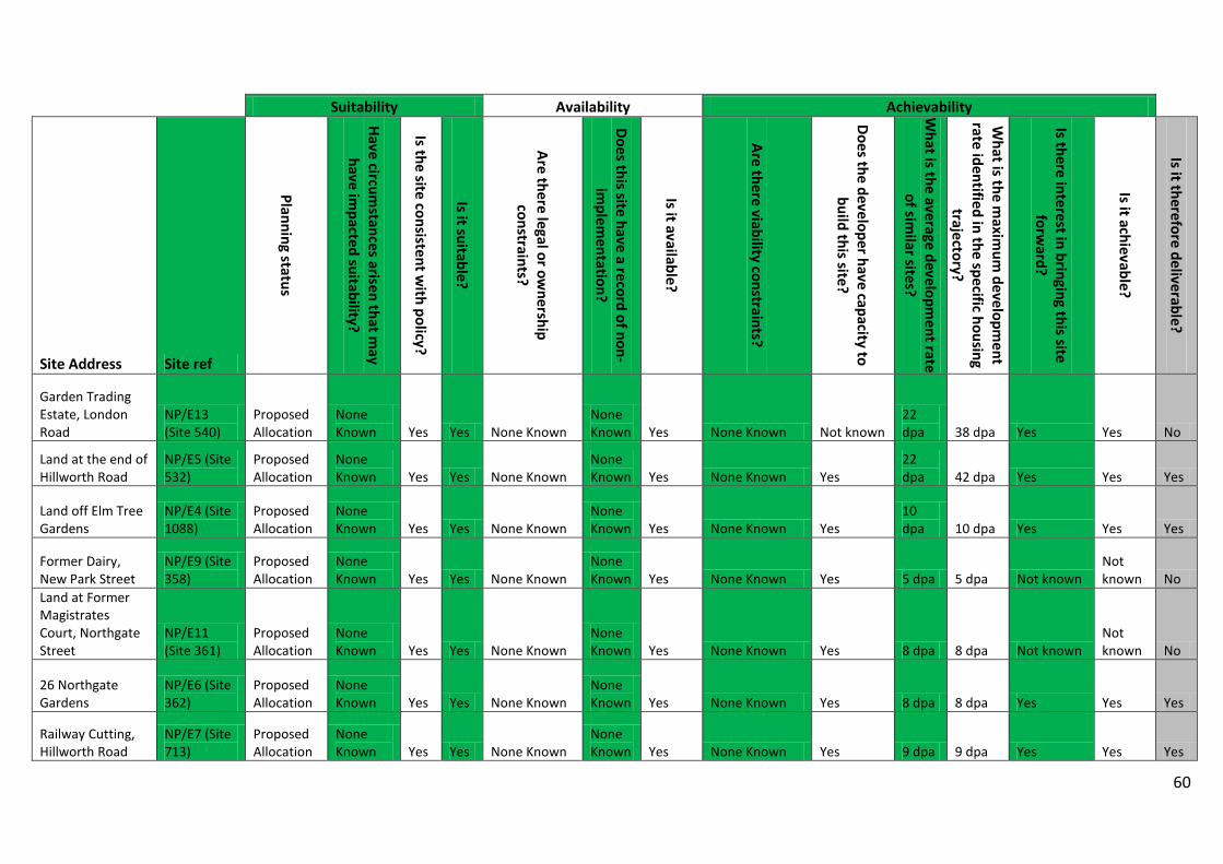
60
Suitability Availability Achievability
Site Address Site ref
Planning status
Have circumstances arisen that m
ay have im
pacted suitability?
Is the site consistent with policy?
Is it suitable?
Are there legal or ownership
constraints?
Does this site have a record of non-im
plementation?
Is it available?
Are there viability constraints?
Does the developer have capacity to build this site?
What is the average developm
ent rate of sim
ilar sites?
What is the m
aximum
development
rate identified in the specific housing trajectory?
Is there interest in bringing this site forw
ard?
Is it achievable?
Is it therefore deliverable?
Garden Trading Estate, London Road
NP/E13 (Site 540)
Proposed Allocation
None Known Yes Yes None Known
None Known Yes None Known Not known
22 dpa 38 dpa Yes Yes No
Land at the end of Hillworth Road
NP/E5 (Site 532)
Proposed Allocation
None Known Yes Yes None Known
None Known Yes None Known Yes
22 dpa 42 dpa Yes Yes Yes
Land off Elm Tree Gardens
NP/E4 (Site 1088)
Proposed Allocation
None Known Yes Yes None Known
None Known Yes None Known Yes
10 dpa 10 dpa Yes Yes Yes
Former Dairy, New Park Street
NP/E9 (Site 358)
Proposed Allocation
None Known Yes Yes None Known
None Known Yes None Known Yes 5 dpa 5 dpa Not known
Not known No
Land at Former Magistrates Court, Northgate Street
NP/E11 (Site 361)
Proposed Allocation
None Known Yes Yes None Known
None Known Yes None Known Yes 8 dpa 8 dpa Not known
Not known No
26 Northgate Gardens
NP/E6 (Site 362)
Proposed Allocation
None Known Yes Yes None Known
None Known Yes None Known Yes 8 dpa 8 dpa Yes Yes Yes
Railway Cutting, Hillworth Road
NP/E7 (Site 713)
Proposed Allocation
None Known Yes Yes None Known
None Known Yes None Known Yes 9 dpa 9 dpa Yes Yes Yes
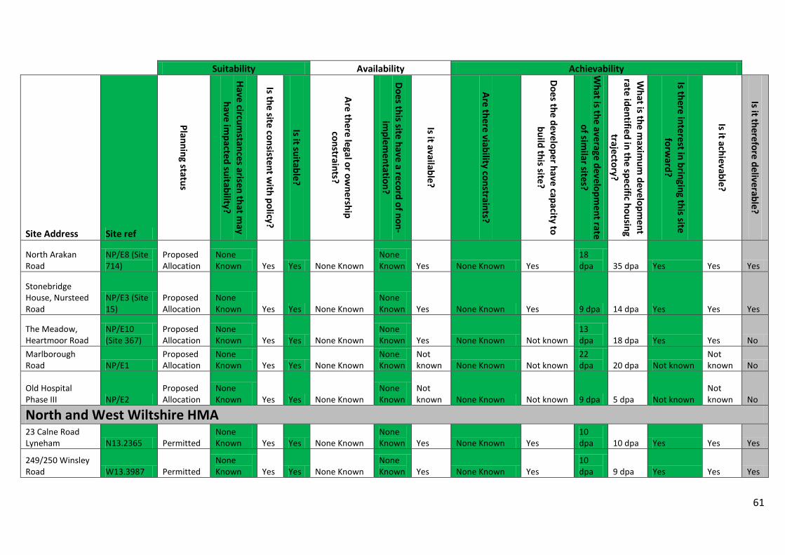
61
Suitability Availability Achievability
Site Address Site ref
Planning status
Have circumstances arisen that m
ay have im
pacted suitability?
Is the site consistent with policy?
Is it suitable?
Are there legal or ownership
constraints?
Does this site have a record of non-im
plementation?
Is it available?
Are there viability constraints?
Does the developer have capacity to build this site?
What is the average developm
ent rate of sim
ilar sites?
What is the m
aximum
development
rate identified in the specific housing trajectory?
Is there interest in bringing this site forw
ard?
Is it achievable?
Is it therefore deliverable?
North Arakan Road
NP/E8 (Site 714)
Proposed Allocation
None Known Yes Yes None Known
None Known Yes None Known Yes
18 dpa 35 dpa Yes Yes Yes
Stonebridge House, Nursteed Road
NP/E3 (Site 15)
Proposed Allocation
None Known Yes Yes None Known
None Known Yes None Known Yes 9 dpa 14 dpa Yes Yes Yes
The Meadow, Heartmoor Road
NP/E10 (Site 367)
Proposed Allocation
None Known Yes Yes None Known
None Known Yes None Known Not known
13 dpa 18 dpa Yes Yes No
Marlborough Road NP/E1
Proposed Allocation
None Known Yes Yes None Known
None Known
Not known None Known Not known
22 dpa 20 dpa Not known
Not known No
Old Hospital Phase III NP/E2
Proposed Allocation
None Known Yes Yes None Known
None Known
Not known None Known Not known 9 dpa 5 dpa Not known
Not known No
North and West Wiltshire HMA 23 Calne Road Lyneham N13.2365 Permitted
None Known Yes Yes None Known
None Known Yes None Known Yes
10 dpa 10 dpa Yes Yes Yes
249/250 Winsley Road W13.3987 Permitted
None Known Yes Yes None Known
None Known Yes None Known Yes
10 dpa 9 dpa Yes Yes Yes
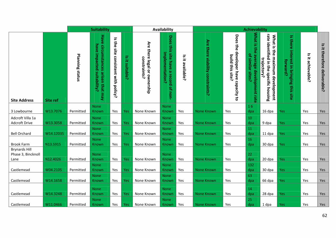
62
Suitability Availability Achievability
Site Address Site ref
Planning status
Have circumstances arisen that m
ay have im
pacted suitability?
Is the site consistent with policy?
Is it suitable?
Are there legal or ownership
constraints?
Does this site have a record of non-im
plementation?
Is it available?
Are there viability constraints?
Does the developer have capacity to build this site?
What is the average developm
ent rate of sim
ilar sites?
What is the m
aximum
development
rate identified in the specific housing trajectory?
Is there interest in bringing this site forw
ard?
Is it achievable?
Is it therefore deliverable?
3 Lowbourne W13.7076 Permitted None Known Yes Yes None Known
None Known Yes None Known Yes
1 6 dpa 16 dpa Yes Yes Yes
Adcroft Villa 1a Adcroft Drive W13.3058 Permitted
None Known Yes Yes None Known
None Known Yes None Known Yes
10 dpa 9 dpa Yes Yes Yes
Bell Orchard W14.12035 Permitted None Known Yes Yes None Known
None Known Yes None Known Yes
11 dpa 11 dpa Yes Yes Yes
Brook Farm N13.5915 Permitted None Known Yes Yes None Known
None Known Yes None Known Yes
16 dpa 30 dpa Yes Yes Yes
Brynards Hill Phase 3, Bincknoll Lane N12.4026 Permitted
None Known Yes Yes None Known
None Known Yes None Known Yes
22 dpa 20 dpa Yes Yes Yes
Castlemead W04.2105 Permitted None Known Yes Yes None Known
None Known Yes None Known Yes
132 dpa 30 dpa Yes Yes Yes
Castlemead W14.1658 Permitted None Known Yes Yes None Known
None Known Yes None Known Yes
63 dpa 66 dpa Yes Yes Yes
Castlemead W14.3248 Permitted None Known Yes Yes None Known
None Known Yes None Known Yes
14 dpa 28 dpa Yes Yes Yes
Castlemead W11.0466 Permitted None Known Yes Yes None Known
None Known Yes None Known Yes
25 dpa 1 dpa Yes Yes Yes
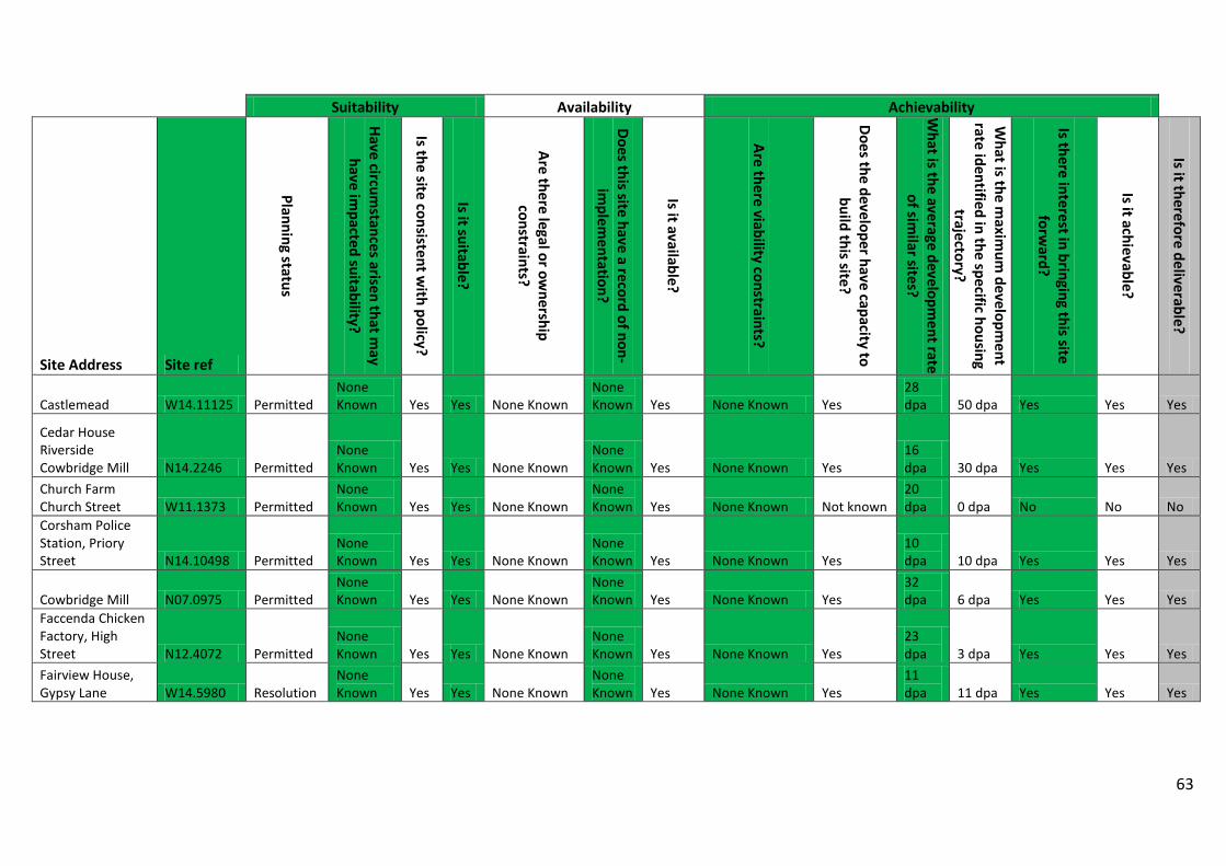
63
Suitability Availability Achievability
Site Address Site ref
Planning status
Have circumstances arisen that m
ay have im
pacted suitability?
Is the site consistent with policy?
Is it suitable?
Are there legal or ownership
constraints?
Does this site have a record of non-im
plementation?
Is it available?
Are there viability constraints?
Does the developer have capacity to build this site?
What is the average developm
ent rate of sim
ilar sites?
What is the m
aximum
development
rate identified in the specific housing trajectory?
Is there interest in bringing this site forw
ard?
Is it achievable?
Is it therefore deliverable?
Castlemead W14.11125 Permitted None Known Yes Yes None Known
None Known Yes None Known Yes
28 dpa 50 dpa Yes Yes Yes
Cedar House Riverside Cowbridge Mill N14.2246 Permitted
None Known Yes Yes None Known
None Known Yes None Known Yes
16 dpa 30 dpa Yes Yes Yes
Church Farm Church Street W11.1373 Permitted
None Known Yes Yes None Known
None Known Yes None Known Not known
20 dpa 0 dpa No No No
Corsham Police Station, Priory Street N14.10498 Permitted
None Known Yes Yes None Known
None Known Yes None Known Yes
10 dpa 10 dpa Yes Yes Yes
Cowbridge Mill N07.0975 Permitted None Known Yes Yes None Known
None Known Yes None Known Yes
32 dpa 6 dpa Yes Yes Yes
Faccenda Chicken Factory, High Street N12.4072 Permitted
None Known Yes Yes None Known
None Known Yes None Known Yes
23 dpa 3 dpa Yes Yes Yes
Fairview House, Gypsy Lane W14.5980 Resolution
None Known Yes Yes None Known
None Known Yes None Known Yes
11 dpa 11 dpa Yes Yes Yes
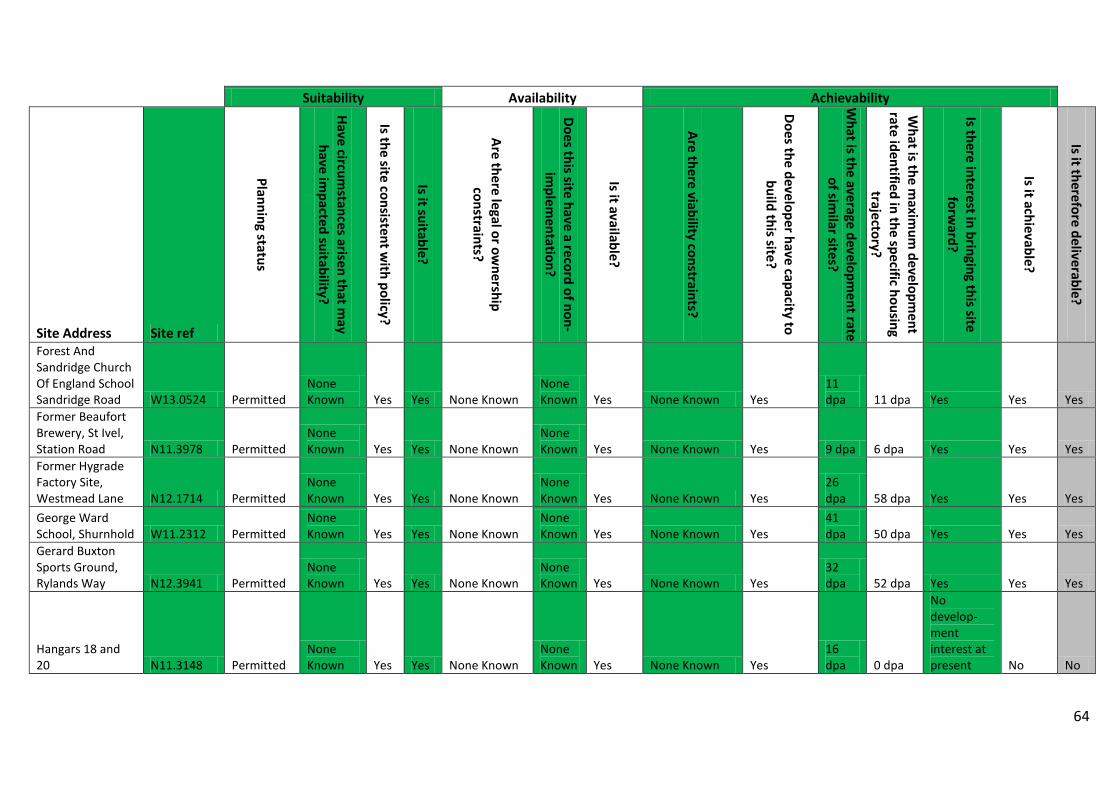
64
Suitability Availability Achievability
Site Address Site ref
Planning status
Have circumstances arisen that m
ay have im
pacted suitability?
Is the site consistent with policy?
Is it suitable?
Are there legal or ownership
constraints?
Does this site have a record of non-im
plementation?
Is it available?
Are there viability constraints?
Does the developer have capacity to build this site?
What is the average developm
ent rate of sim
ilar sites?
What is the m
aximum
development
rate identified in the specific housing trajectory?
Is there interest in bringing this site forw
ard?
Is it achievable?
Is it therefore deliverable?
Forest And Sandridge Church Of England School Sandridge Road W13.0524 Permitted
None Known Yes Yes None Known
None Known Yes None Known Yes
11 dpa 11 dpa Yes Yes Yes
Former Beaufort Brewery, St Ivel, Station Road N11.3978 Permitted
None Known Yes Yes None Known
None Known Yes None Known Yes 9 dpa 6 dpa Yes Yes Yes
Former Hygrade Factory Site, Westmead Lane N12.1714 Permitted
None Known Yes Yes None Known
None Known Yes None Known Yes
26 dpa 58 dpa Yes Yes Yes
George Ward School, Shurnhold W11.2312 Permitted
None Known Yes Yes None Known
None Known Yes None Known Yes
41 dpa 50 dpa Yes Yes Yes
Gerard Buxton Sports Ground, Rylands Way N12.3941 Permitted
None Known Yes Yes None Known
None Known Yes None Known Yes
32 dpa 52 dpa Yes Yes Yes
Hangars 18 and 20 N11.3148 Permitted
None Known Yes Yes None Known
None Known Yes None Known Yes
16 dpa 0 dpa
No develop- ment interest at present No No
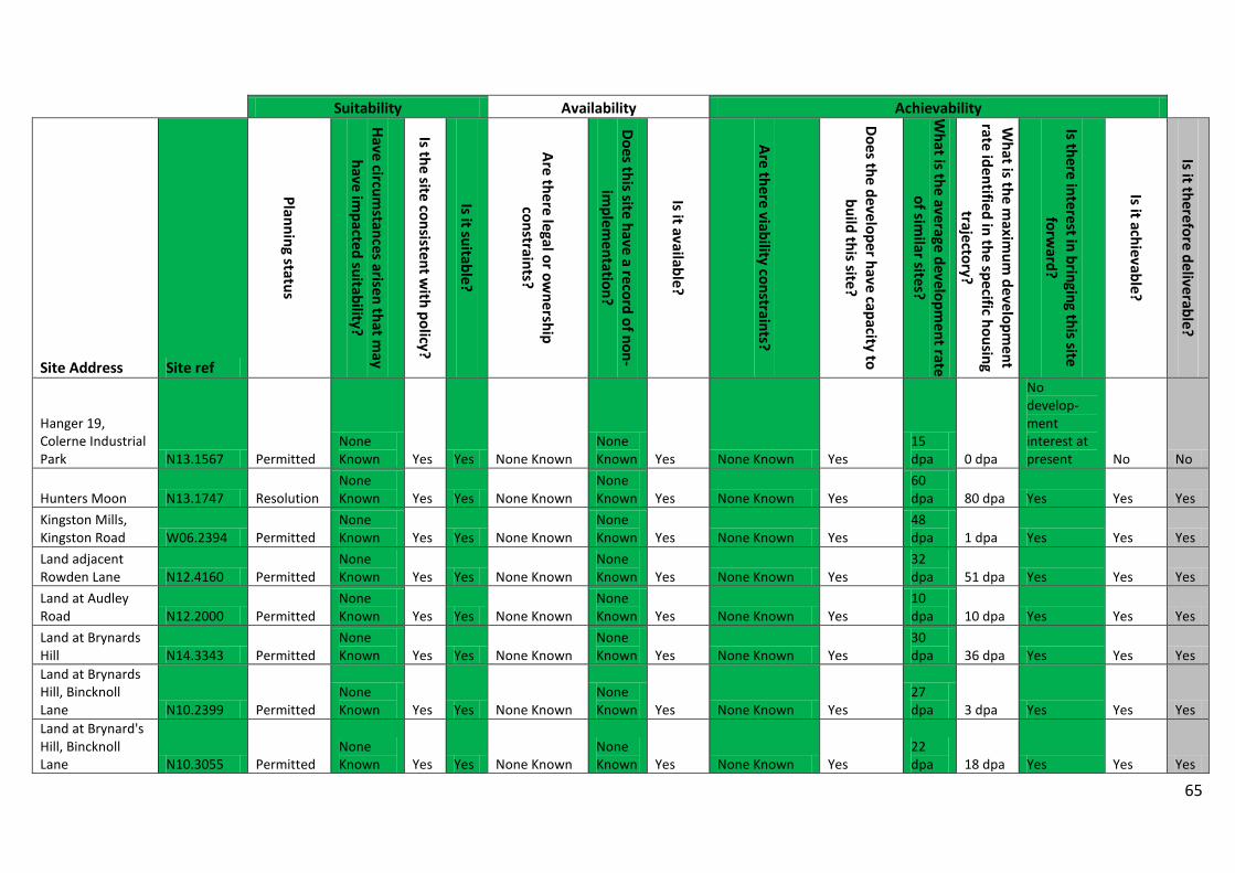
65
Suitability Availability Achievability
Site Address Site ref
Planning status
Have circumstances arisen that m
ay have im
pacted suitability?
Is the site consistent with policy?
Is it suitable?
Are there legal or ownership
constraints?
Does this site have a record of non-im
plementation?
Is it available?
Are there viability constraints?
Does the developer have capacity to build this site?
What is the average developm
ent rate of sim
ilar sites?
What is the m
aximum
development
rate identified in the specific housing trajectory?
Is there interest in bringing this site forw
ard?
Is it achievable?
Is it therefore deliverable?
Hanger 19, Colerne Industrial Park N13.1567 Permitted
None Known Yes Yes None Known
None Known Yes None Known Yes
15 dpa 0 dpa
No develop- ment interest at present No No
Hunters Moon N13.1747 Resolution None Known Yes Yes None Known
None Known Yes None Known Yes
60 dpa 80 dpa Yes Yes Yes
Kingston Mills, Kingston Road W06.2394 Permitted
None Known Yes Yes None Known
None Known Yes None Known Yes
48 dpa 1 dpa Yes Yes Yes
Land adjacent Rowden Lane N12.4160 Permitted
None Known Yes Yes None Known
None Known Yes None Known Yes
32 dpa 51 dpa Yes Yes Yes
Land at Audley Road N12.2000 Permitted
None Known Yes Yes None Known
None Known Yes None Known Yes
10 dpa 10 dpa Yes Yes Yes
Land at Brynards Hill N14.3343 Permitted
None Known Yes Yes None Known
None Known Yes None Known Yes
30 dpa 36 dpa Yes Yes Yes
Land at Brynards Hill, Bincknoll Lane N10.2399 Permitted
None Known Yes Yes None Known
None Known Yes None Known Yes
27 dpa 3 dpa Yes Yes Yes
Land at Brynard's Hill, Bincknoll Lane N10.3055 Permitted
None Known Yes Yes None Known
None Known Yes None Known Yes
22 dpa 18 dpa Yes Yes Yes
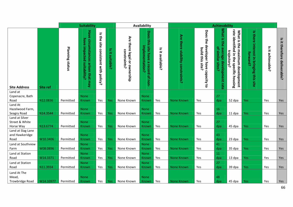
66
Suitability Availability Achievability
Site Address Site ref
Planning status
Have circumstances arisen that m
ay have im
pacted suitability?
Is the site consistent with policy?
Is it suitable?
Are there legal or ownership
constraints?
Does this site have a record of non-im
plementation?
Is it available?
Are there viability constraints?
Does the developer have capacity to build this site?
What is the average developm
ent rate of sim
ilar sites?
What is the m
aximum
development
rate identified in the specific housing trajectory?
Is there interest in bringing this site forw
ard?
Is it achievable?
Is it therefore deliverable?
Land at Copenacre, Bath Road N12.0836 Permitted
None Known Yes Yes None Known
None Known Yes None Known Yes
27 dpa 52 dpa Yes Yes Yes
Land At Hazelwood Farm, Seagry Road N14.3544 Permitted
None Known Yes Yes None Known
None Known Yes None Known Yes
16 dpa 11 dpa Yes Yes Yes
Land at Silver Street & White Horse Way N13.6774 Permitted
None Known Yes Yes None Known
None Known Yes None Known Yes
27 dpa 45 dpa Yes Yes Yes
Land at Slag Lane and Hawkeridge Road W10.3406 Permitted
None Known Yes Yes None Known
None Known Yes None Known Yes
43 dpa 23 dpa Yes Yes Yes
Land at Southview Farm W08.0896 Permitted
None Known Yes Yes None Known
None Known Yes None Known Yes
41 dpa 35 dpa Yes Yes Yes
Land at Station Road W14.3371 Permitted
None Known Yes Yes None Known
None Known Yes None Known Yes
11 dpa 13 dpa Yes Yes Yes
Land at Station Road N11.3934 Permitted
None Known Yes Yes None Known
None Known Yes None Known Yes
27 dpa 39 dpa Yes Yes Yes
Land At The Mead, Trowbridge Road W14.10977 Permitted
None Known Yes Yes None Known
None Known Yes None Known Yes
48 dpa 45 dpa Yes Yes Yes
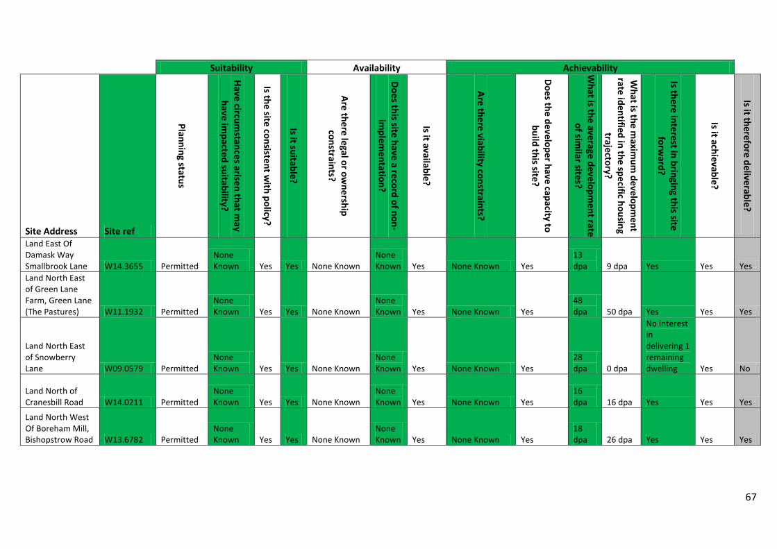
67
Suitability Availability Achievability
Site Address Site ref
Planning status
Have circumstances arisen that m
ay have im
pacted suitability?
Is the site consistent with policy?
Is it suitable?
Are there legal or ownership
constraints?
Does this site have a record of non-im
plementation?
Is it available?
Are there viability constraints?
Does the developer have capacity to build this site?
What is the average developm
ent rate of sim
ilar sites?
What is the m
aximum
development
rate identified in the specific housing trajectory?
Is there interest in bringing this site forw
ard?
Is it achievable?
Is it therefore deliverable?
Land East Of Damask Way Smallbrook Lane W14.3655 Permitted
None Known Yes Yes None Known
None Known Yes None Known Yes
13 dpa 9 dpa Yes Yes Yes
Land North East of Green Lane Farm, Green Lane (The Pastures) W11.1932 Permitted
None Known Yes Yes None Known
None Known Yes None Known Yes
48 dpa 50 dpa Yes Yes Yes
Land North East of Snowberry Lane W09.0579 Permitted
None Known Yes Yes None Known
None Known Yes None Known Yes
28 dpa 0 dpa
No interest in delivering 1 remaining dwelling Yes No
Land North of Cranesbill Road W14.0211 Permitted
None Known Yes Yes None Known
None Known Yes None Known Yes
16 dpa 16 dpa Yes Yes Yes
Land North West Of Boreham Mill, Bishopstrow Road W13.6782 Permitted
None Known Yes Yes None Known
None Known Yes None Known Yes
18 dpa 26 dpa Yes Yes Yes
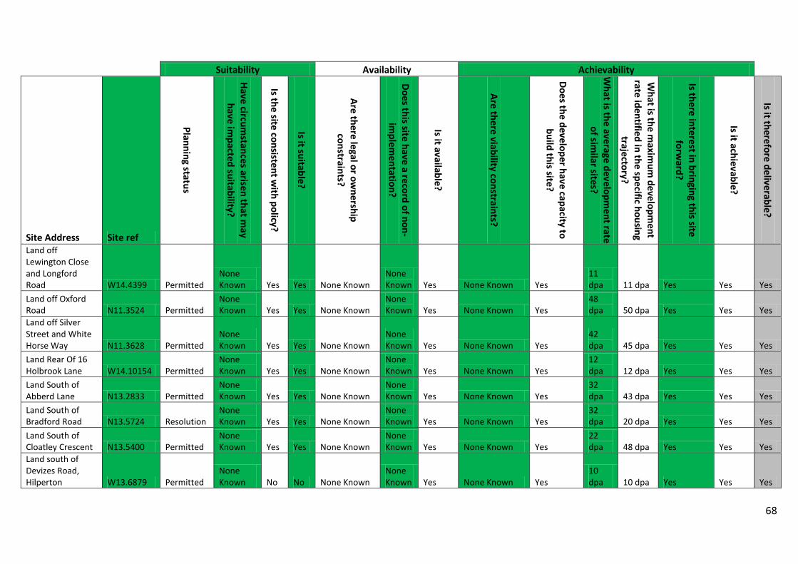
68
Suitability Availability Achievability
Site Address Site ref
Planning status
Have circumstances arisen that m
ay have im
pacted suitability?
Is the site consistent with policy?
Is it suitable?
Are there legal or ownership
constraints?
Does this site have a record of non-im
plementation?
Is it available?
Are there viability constraints?
Does the developer have capacity to build this site?
What is the average developm
ent rate of sim
ilar sites?
What is the m
aximum
development
rate identified in the specific housing trajectory?
Is there interest in bringing this site forw
ard?
Is it achievable?
Is it therefore deliverable?
Land off Lewington Close and Longford Road W14.4399 Permitted
None Known Yes Yes None Known
None Known Yes None Known Yes
11 dpa 11 dpa Yes Yes Yes
Land off Oxford Road N11.3524 Permitted
None Known Yes Yes None Known
None Known Yes None Known Yes
48 dpa 50 dpa Yes Yes Yes
Land off Silver Street and White Horse Way N11.3628 Permitted
None Known Yes Yes None Known
None Known Yes None Known Yes
42 dpa 45 dpa Yes Yes Yes
Land Rear Of 16 Holbrook Lane W14.10154 Permitted
None Known Yes Yes None Known
None Known Yes None Known Yes
12 dpa 12 dpa Yes Yes Yes
Land South of Abberd Lane N13.2833 Permitted
None Known Yes Yes None Known
None Known Yes None Known Yes
32 dpa 43 dpa Yes Yes Yes
Land South of Bradford Road N13.5724 Resolution
None Known Yes Yes None Known
None Known Yes None Known Yes
32 dpa 20 dpa Yes Yes Yes
Land South of Cloatley Crescent N13.5400 Permitted
None Known Yes Yes None Known
None Known Yes None Known Yes
22 dpa 48 dpa Yes Yes Yes
Land south of Devizes Road, Hilperton W13.6879 Permitted
None Known No No None Known
None Known Yes None Known Yes
10 dpa 10 dpa Yes Yes Yes
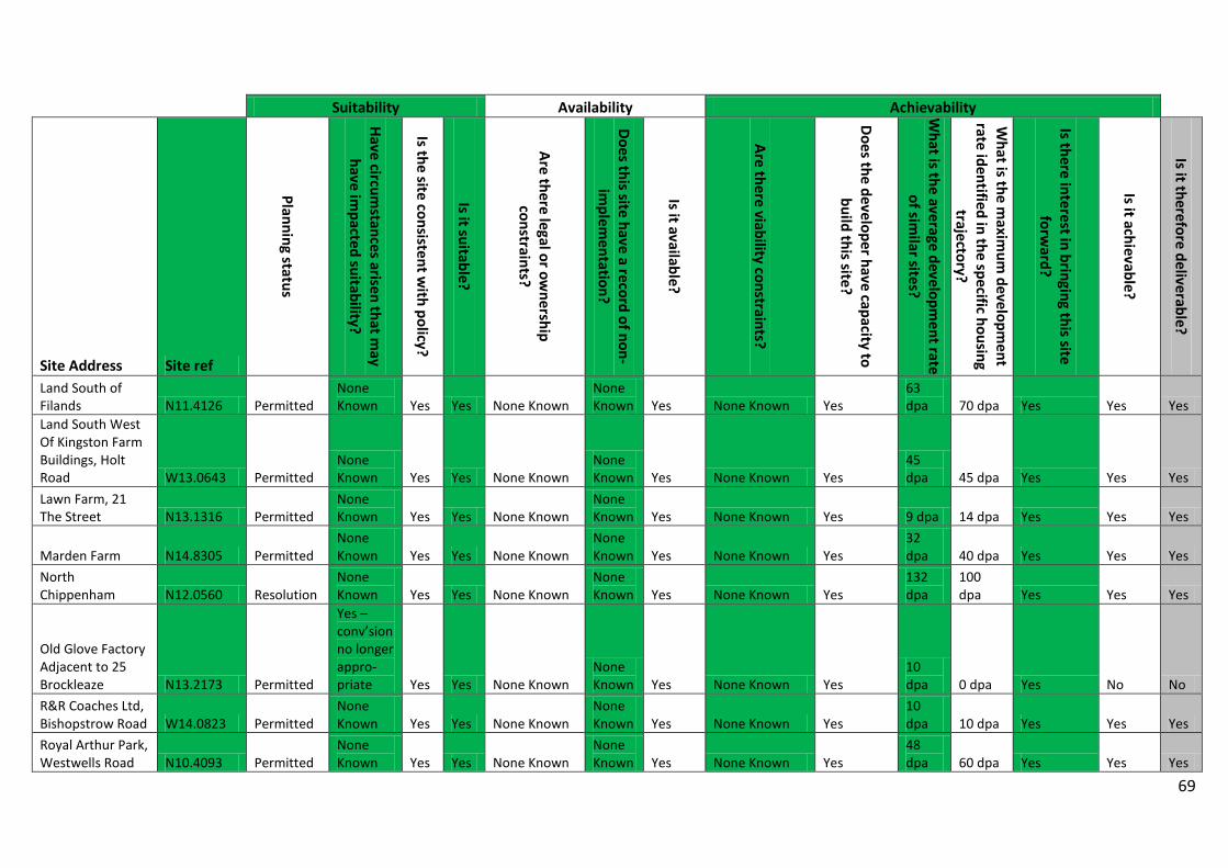
69
Suitability Availability Achievability
Site Address Site ref
Planning status
Have circumstances arisen that m
ay have im
pacted suitability?
Is the site consistent with policy?
Is it suitable?
Are there legal or ownership
constraints?
Does this site have a record of non-im
plementation?
Is it available?
Are there viability constraints?
Does the developer have capacity to build this site?
What is the average developm
ent rate of sim
ilar sites?
What is the m
aximum
development
rate identified in the specific housing trajectory?
Is there interest in bringing this site forw
ard?
Is it achievable?
Is it therefore deliverable?
Land South of Filands N11.4126 Permitted
None Known Yes Yes None Known
None Known Yes None Known Yes
63 dpa 70 dpa Yes Yes Yes
Land South West Of Kingston Farm Buildings, Holt Road W13.0643 Permitted
None Known Yes Yes None Known
None Known Yes None Known Yes
45 dpa 45 dpa Yes Yes Yes
Lawn Farm, 21 The Street N13.1316 Permitted
None Known Yes Yes None Known
None Known Yes None Known Yes 9 dpa 14 dpa Yes Yes Yes
Marden Farm N14.8305 Permitted None Known Yes Yes None Known
None Known Yes None Known Yes
32 dpa 40 dpa Yes Yes Yes
North Chippenham N12.0560 Resolution
None Known Yes Yes None Known
None Known Yes None Known Yes
132 dpa
100 dpa Yes Yes Yes
Old Glove Factory Adjacent to 25 Brockleaze N13.2173 Permitted
Yes – conv’sion no longer appro- priate Yes Yes None Known
None Known Yes None Known Yes
10 dpa 0 dpa Yes No No
R&R Coaches Ltd, Bishopstrow Road W14.0823 Permitted
None Known Yes Yes None Known
None Known Yes None Known Yes
10 dpa 10 dpa Yes Yes Yes
Royal Arthur Park, Westwells Road N10.4093 Permitted
None Known Yes Yes None Known
None Known Yes None Known Yes
48 dpa 60 dpa Yes Yes Yes
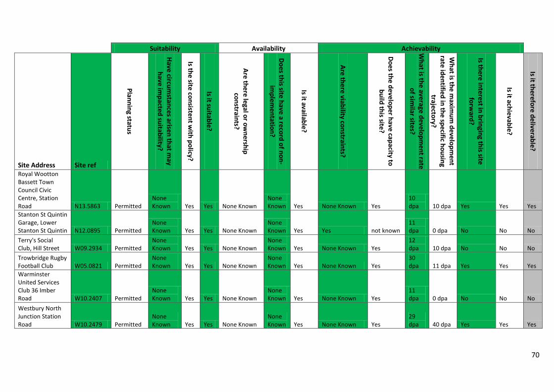
70
Suitability Availability Achievability
Site Address Site ref
Planning status
Have circumstances arisen that m
ay have im
pacted suitability?
Is the site consistent with policy?
Is it suitable?
Are there legal or ownership
constraints?
Does this site have a record of non-im
plementation?
Is it available?
Are there viability constraints?
Does the developer have capacity to build this site?
What is the average developm
ent rate of sim
ilar sites?
What is the m
aximum
development
rate identified in the specific housing trajectory?
Is there interest in bringing this site forw
ard?
Is it achievable?
Is it therefore deliverable?
Royal Wootton Bassett Town Council Civic Centre, Station Road N13.5863 Permitted
None Known Yes Yes None Known
None Known Yes None Known Yes
10 dpa 10 dpa Yes Yes Yes
Stanton St Quintin Garage, Lower Stanton St Quintin N12.0895 Permitted
None Known Yes Yes None Known
None Known Yes Yes not known
11 dpa 0 dpa No No No
Terry's Social Club, Hill Street W09.2934 Permitted
None Known Yes Yes None Known
None Known Yes None Known Yes
12 dpa 10 dpa No No No
Trowbridge Rugby Football Club W05.0821 Permitted
None Known Yes Yes None Known
None Known Yes None Known Yes
30 dpa 11 dpa Yes Yes Yes
Warminster United Services Club 36 Imber Road W10.2407 Permitted
None Known Yes Yes None Known
None Known Yes None Known Yes
11 dpa 0 dpa No No No
Westbury North Junction Station Road W10.2479 Permitted
None Known Yes Yes None Known
None Known Yes None Known Yes
29 dpa 40 dpa Yes Yes Yes
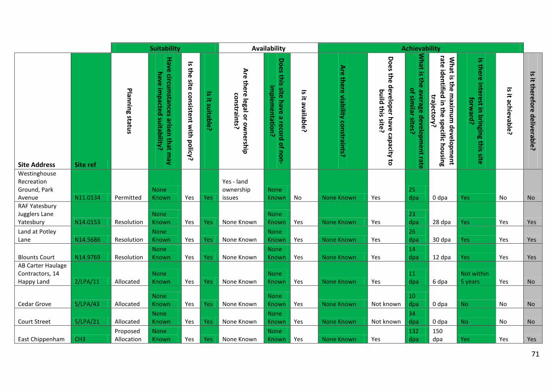
71
Suitability Availability Achievability
Site Address Site ref
Planning status
Have circumstances arisen that m
ay have im
pacted suitability?
Is the site consistent with policy?
Is it suitable?
Are there legal or ownership
constraints?
Does this site have a record of non-im
plementation?
Is it available?
Are there viability constraints?
Does the developer have capacity to build this site?
What is the average developm
ent rate of sim
ilar sites?
What is the m
aximum
development
rate identified in the specific housing trajectory?
Is there interest in bringing this site forw
ard?
Is it achievable?
Is it therefore deliverable?
Westinghouse Recreation Ground, Park Avenue N11.0134 Permitted
None Known Yes Yes
Yes - land ownership issues
None Known No None Known Yes
25 dpa 0 dpa Yes No No
RAF Yatesbury Jugglers Lane Yatesbury N14.0153 Resolution
None Known Yes Yes None Known
None Known Yes None Known Yes
23 dpa 28 dpa Yes Yes Yes
Land at Potley Lane N14.5686 Resolution
None Known Yes Yes None Known
None Known Yes None Known Yes
26 dpa 30 dpa Yes Yes Yes
Blounts Court N14.9769 Resolution None Known Yes Yes None Known
None Known Yes None Known Yes
14 dpa 12 dpa Yes Yes Yes
AB Carter Haulage Contractors, 14 Happy Land 2/LPA/11 Allocated
None Known Yes Yes None Known
None Known Yes None Known Yes
11 dpa 6 dpa
Not within 5 years Yes No
Cedar Grove 5/LPA/43 Allocated None Known Yes Yes None Known
None Known Yes None Known Not known
10 dpa 0 dpa No No No
Court Street 5/LPA/21 Allocated None Known Yes Yes None Known
None Known Yes None Known Not known
34 dpa 0 dpa No No No
East Chippenham CH3 Proposed Allocation
None Known Yes Yes None Known
None Known Yes None Known Yes
132 dpa
150 dpa Yes Yes Yes
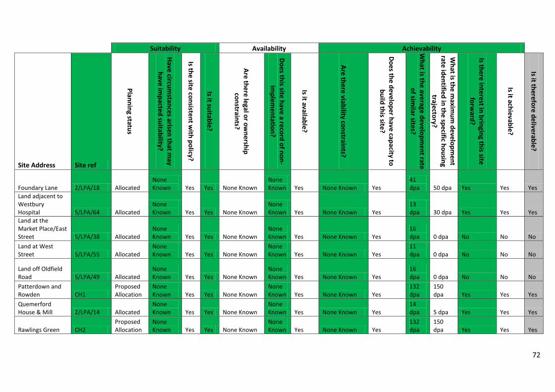
72
Suitability Availability Achievability
Site Address Site ref
Planning status
Have circumstances arisen that m
ay have im
pacted suitability?
Is the site consistent with policy?
Is it suitable?
Are there legal or ownership
constraints?
Does this site have a record of non-im
plementation?
Is it available?
Are there viability constraints?
Does the developer have capacity to build this site?
What is the average developm
ent rate of sim
ilar sites?
What is the m
aximum
development
rate identified in the specific housing trajectory?
Is there interest in bringing this site forw
ard?
Is it achievable?
Is it therefore deliverable?
Foundary Lane 2/LPA/18 Allocated None Known Yes Yes None Known
None Known Yes None Known Yes
41 dpa 50 dpa Yes Yes Yes
Land adjacent to Westbury Hospital 5/LPA/64 Allocated
None Known Yes Yes None Known
None Known Yes None Known Yes
13 dpa 30 dpa Yes Yes Yes
Land at the Market Place/East Street 5/LPA/38 Allocated
None Known Yes Yes None Known
None Known Yes None Known Yes
16 dpa 0 dpa No No No
Land at West Street 5/LPA/55 Allocated
None Known Yes Yes None Known
None Known Yes None Known Yes
11 dpa 0 dpa No No No
Land off Oldfield Road 5/LPA/49 Allocated
None Known Yes Yes None Known
None Known Yes None Known Yes
16 dpa 0 dpa No No No
Patterdown and Rowden CH1
Proposed Allocation
None Known Yes Yes None Known
None Known Yes None Known Yes
132 dpa
150 dpa Yes Yes Yes
Quemerford House & Mill 2/LPA/14 Allocated
None Known Yes Yes None Known
None Known Yes None Known Yes
14 dpa 5 dpa Yes Yes Yes
Rawlings Green CH2 Proposed Allocation
None Known Yes Yes None Known
None Known Yes None Known Yes
132 dpa
150 dpa Yes Yes Yes
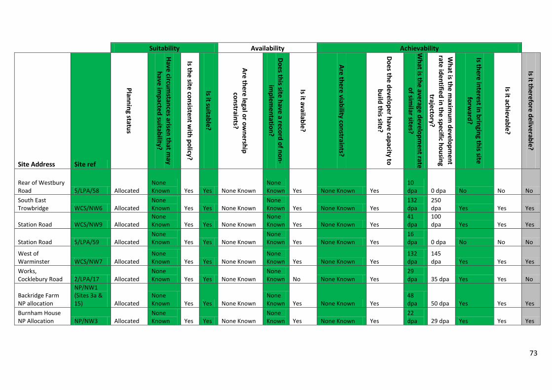
73
Suitability Availability Achievability
Site Address Site ref
Planning status
Have circumstances arisen that m
ay have im
pacted suitability?
Is the site consistent with policy?
Is it suitable?
Are there legal or ownership
constraints?
Does this site have a record of non-im
plementation?
Is it available?
Are there viability constraints?
Does the developer have capacity to build this site?
What is the average developm
ent rate of sim
ilar sites?
What is the m
aximum
development
rate identified in the specific housing trajectory?
Is there interest in bringing this site forw
ard?
Is it achievable?
Is it therefore deliverable?
Rear of Westbury Road 5/LPA/58 Allocated
None Known Yes Yes None Known
None Known Yes None Known Yes
10 dpa 0 dpa No No No
South East Trowbridge WCS/NW6 Allocated
None Known Yes Yes None Known
None Known Yes None Known Yes
132 dpa
250 dpa Yes Yes Yes
Station Road WCS/NW9 Allocated None Known Yes Yes None Known
None Known Yes None Known Yes
41 dpa
100 dpa Yes Yes Yes
Station Road 5/LPA/59 Allocated None Known Yes Yes None Known
None Known Yes None Known Yes
16 dpa 0 dpa No No No
West of Warminster WCS/NW7 Allocated
None Known Yes Yes None Known
None Known Yes None Known Yes
132 dpa
145 dpa Yes Yes Yes
Works, Cocklebury Road 2/LPA/17 Allocated
None Known Yes Yes None Known
None Known No None Known Yes
29 dpa 35 dpa Yes Yes No
Backridge Farm NP allocation
NP/NW1 (Sites 3a & 15) Allocated
None Known Yes Yes None Known
None Known Yes None Known Yes
48 dpa 50 dpa Yes Yes Yes
Burnham House NP Allocation NP/NW3 Allocated
None Known Yes Yes None Known
None Known Yes None Known Yes
22 dpa 29 dpa Yes Yes Yes
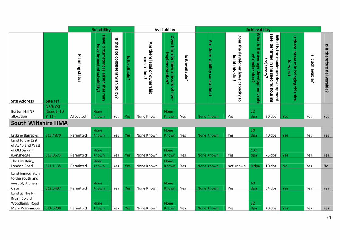
74
Suitability Availability Achievability
Site Address Site ref
Planning status
Have circumstances arisen that m
ay have im
pacted suitability?
Is the site consistent with policy?
Is it suitable?
Are there legal or ownership
constraints?
Does this site have a record of non-im
plementation?
Is it available?
Are there viability constraints?
Does the developer have capacity to build this site?
What is the average developm
ent rate of sim
ilar sites?
What is the m
aximum
development
rate identified in the specific housing trajectory?
Is there interest in bringing this site forw
ard?
Is it achievable?
Is it therefore deliverable?
Burton Hill NP allocation
NP/NW2 (Sites 6, 10 & 11) Allocated
None Known Yes Yes None Known
None Known Yes None Known Yes
22 dpa 50 dpa Yes Yes Yes
South Wiltshire HMA
Erskine Barracks S13.4870 Permitted None Known Yes Yes None Known
None Known Yes None Known Yes
30 dpa 40 dpa Yes Yes Yes
Land to the East of A345 and West of Old Sarum (Longhedge) S13.0673 Permitted
None Known Yes Yes None Known
None Known Yes None Known Yes
132 dpa 75 dpa Yes Yes Yes
The Old Dairy, London Road S11.1135 Permitted
None Known Yes Yes None Known
None Known Yes None Known not known 9 dpa 10 dpa No Yes No
Land immediately to the south and west of, Archers Gate S12.0497 Permitted
None Known Yes Yes None Known
None Known Yes None Known Yes
60 dpa 64 dpa Yes Yes Yes
Land at The Hill Brush Co Ltd Woodlands Road Mere Warminster S14.6780 Permitted
None Known Yes Yes None Known
None Known Yes None Known Yes
32 dpa 40 dpa Yes Yes Yes
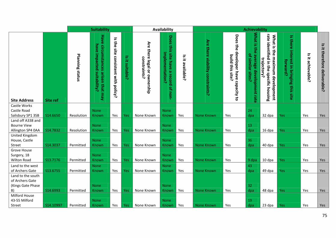
75
Suitability Availability Achievability
Site Address Site ref
Planning status
Have circumstances arisen that m
ay have im
pacted suitability?
Is the site consistent with policy?
Is it suitable?
Are there legal or ownership
constraints?
Does this site have a record of non-im
plementation?
Is it available?
Are there viability constraints?
Does the developer have capacity to build this site?
What is the average developm
ent rate of sim
ilar sites?
What is the m
aximum
development
rate identified in the specific housing trajectory?
Is there interest in bringing this site forw
ard?
Is it achievable?
Is it therefore deliverable?
Castle Works Castle Road Salisbury SP1 3SB S14.6650 Resolution
None Known Yes Yes None Known
None Known Yes None Known Yes
24 dpa 32 dpa Yes Yes Yes
Land off A338 and Bourne View Allington SP4 0AA S14.7832 Resolution
None Known Yes Yes None Known
None Known Yes None Known Yes
13 dpa 16 dpa Yes Yes Yes
United Kingdom House, Castle Street S14.3037 Permitted
None Known Yes Yes None Known
None Known Yes None Known Yes
36 dpa 40 dpa Yes Yes Yes
Grove House Surgery, 18 Wilton Road S13.7176 Permitted
None Known Yes Yes None Known
None Known Yes None Known Yes 9 dpa 10 dpa Yes Yes Yes
Land to the west of Archers Gate S13.6755 Permitted
None Known Yes Yes None Known
None Known Yes None Known Yes
43 dpa 49 dpa Yes Yes Yes
Land to the south of Archers Gate (Kings Gate Phase B) S14.6993 Permitted
None Known Yes Yes None Known
None Known Yes None Known Yes
32 dpa 48 dpa Yes Yes Yes
Milford House 43-55 Milford Street S14.10997 Permitted
None Known Yes Yes None Known
None Known Yes None Known Yes
19 dpa 23 dpa Yes Yes Yes
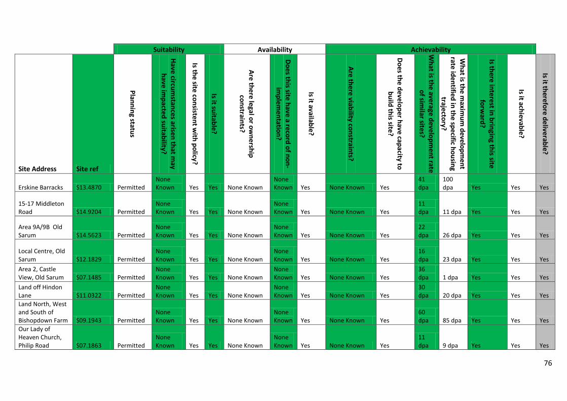
76
Suitability Availability Achievability
Site Address Site ref
Planning status
Have circumstances arisen that m
ay have im
pacted suitability?
Is the site consistent with policy?
Is it suitable?
Are there legal or ownership
constraints?
Does this site have a record of non-im
plementation?
Is it available?
Are there viability constraints?
Does the developer have capacity to build this site?
What is the average developm
ent rate of sim
ilar sites?
What is the m
aximum
development
rate identified in the specific housing trajectory?
Is there interest in bringing this site forw
ard?
Is it achievable?
Is it therefore deliverable?
Erskine Barracks S13.4870 Permitted None Known Yes Yes None Known
None Known Yes None Known Yes
41 dpa
100 dpa Yes Yes Yes
15-17 Middleton Road S14.9204 Permitted
None Known Yes Yes None Known
None Known Yes None Known Yes
11 dpa 11 dpa Yes Yes Yes
Area 9A/9B Old Sarum S14.5623 Permitted
None Known Yes Yes None Known
None Known Yes None Known Yes
22 dpa 26 dpa Yes Yes Yes
Local Centre, Old Sarum S12.1829 Permitted
None Known Yes Yes None Known
None Known Yes None Known Yes
16 dpa 23 dpa Yes Yes Yes
Area 2, Castle View, Old Sarum S07.1485 Permitted
None Known Yes Yes None Known
None Known Yes None Known Yes
36 dpa 1 dpa Yes Yes Yes
Land off Hindon Lane S11.0322 Permitted
None Known Yes Yes None Known
None Known Yes None Known Yes
30 dpa 20 dpa Yes Yes Yes
Land North, West and South of Bishopdown Farm S09.1943 Permitted
None Known Yes Yes None Known
None Known Yes None Known Yes
60 dpa 85 dpa Yes Yes Yes
Our Lady of Heaven Church, Philip Road S07.1863 Permitted
None Known Yes Yes None Known
None Known Yes None Known Yes
11 dpa 9 dpa Yes Yes Yes

77
Suitability Availability Achievability
Site Address Site ref
Planning status
Have circumstances arisen that m
ay have im
pacted suitability?
Is the site consistent with policy?
Is it suitable?
Are there legal or ownership
constraints?
Does this site have a record of non-im
plementation?
Is it available?
Are there viability constraints?
Does the developer have capacity to build this site?
What is the average developm
ent rate of sim
ilar sites?
What is the m
aximum
development
rate identified in the specific housing trajectory?
Is there interest in bringing this site forw
ard?
Is it achievable?
Is it therefore deliverable?
Former Highbury and Fisherton Manor School Sites S12.1282 Permitted
None Known Yes Yes None Known
None Known Yes None Known Yes
24 dpa 13 dpa Yes Yes Yes
37 39 High Street S12.1491 Permitted None Known Yes Yes None Known
None Known Yes None Known Yes
11 dpa 11 dpa Yes Yes Yes
Former National Cooperative Store, 23-29 Salisbury Street S13.0422 Permitted
None Known Yes Yes None Known
None Known Yes None Known Yes
18 dpa 33 dpa Yes Yes Yes
Land adjacent Hideaway Garage London Road S13.6337 Permitted
None Known Yes Yes None Known
None Known Yes None Known Yes
11 dpa 11 dpa Yes Yes Yes
Land adjacent to 15 Butterfield Drive S14.12116 Permitted
None Known Yes Yes None Known
None Known Yes None Known Yes
10 dpa 10 dpa Yes Yes Yes
Land at The Hill Brush Co Ltd Woodlands Road Mere Warminster S14.6780 Permitted
None Known Yes Yes None Known
None Known Yes None Known Yes
26 dpa 30 dpa Yes Yes Yes
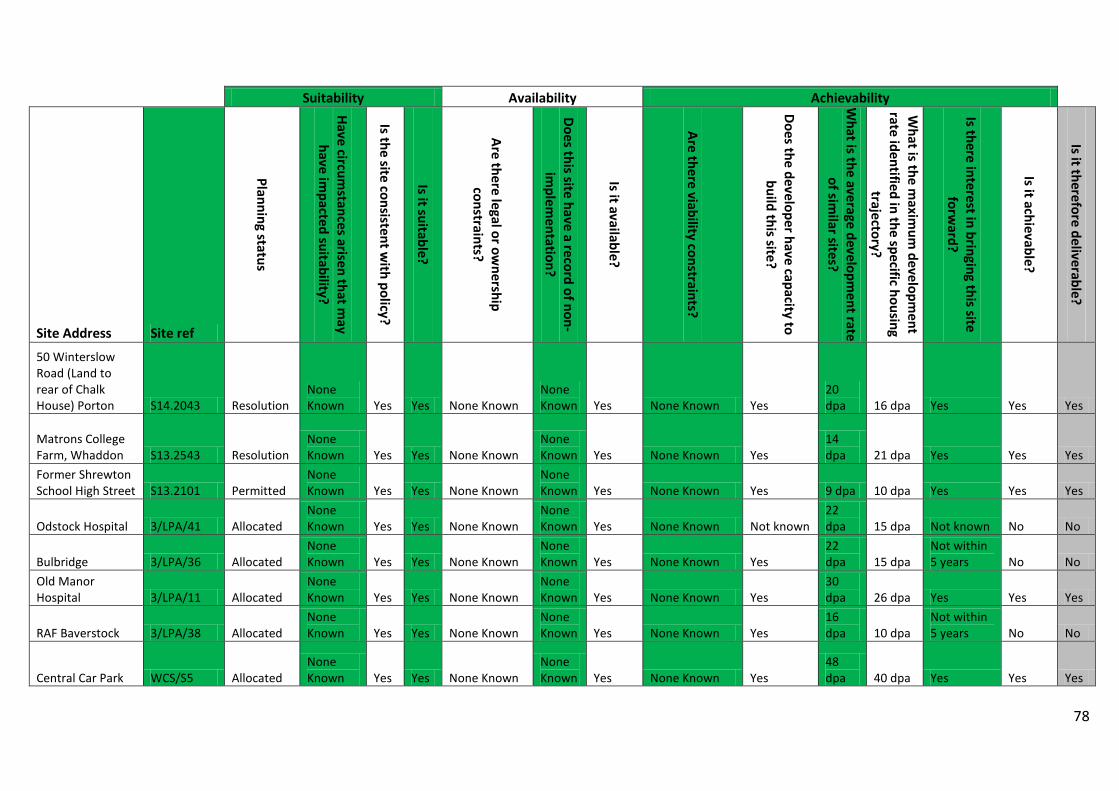
78
Suitability Availability Achievability
Site Address Site ref
Planning status
Have circumstances arisen that m
ay have im
pacted suitability?
Is the site consistent with policy?
Is it suitable?
Are there legal or ownership
constraints?
Does this site have a record of non-im
plementation?
Is it available?
Are there viability constraints?
Does the developer have capacity to build this site?
What is the average developm
ent rate of sim
ilar sites?
What is the m
aximum
development
rate identified in the specific housing trajectory?
Is there interest in bringing this site forw
ard?
Is it achievable?
Is it therefore deliverable?
50 Winterslow Road (Land to rear of Chalk House) Porton S14.2043 Resolution
None Known Yes Yes None Known
None Known Yes None Known Yes
20 dpa 16 dpa Yes Yes Yes
Matrons College Farm, Whaddon S13.2543 Resolution
None Known Yes Yes None Known
None Known Yes None Known Yes
14 dpa 21 dpa Yes Yes Yes
Former Shrewton School High Street S13.2101 Permitted
None Known Yes Yes None Known
None Known Yes None Known Yes 9 dpa 10 dpa Yes Yes Yes
Odstock Hospital 3/LPA/41 Allocated None Known Yes Yes None Known
None Known Yes None Known Not known
22 dpa 15 dpa Not known No No
Bulbridge 3/LPA/36 Allocated None Known Yes Yes None Known
None Known Yes None Known Yes
22 dpa 15 dpa
Not within 5 years No No
Old Manor Hospital 3/LPA/11 Allocated
None Known Yes Yes None Known
None Known Yes None Known Yes
30 dpa 26 dpa Yes Yes Yes
RAF Baverstock 3/LPA/38 Allocated None Known Yes Yes None Known
None Known Yes None Known Yes
16 dpa 10 dpa
Not within 5 years No No
Central Car Park WCS/S5 Allocated None Known Yes Yes None Known
None Known Yes None Known Yes
48 dpa 40 dpa Yes Yes Yes
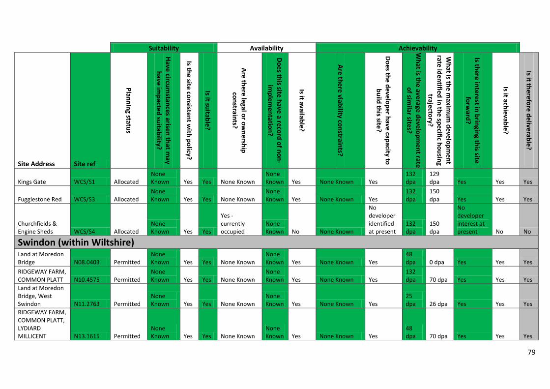
79
Suitability Availability Achievability
Site Address Site ref
Planning status
Have circumstances arisen that m
ay have im
pacted suitability?
Is the site consistent with policy?
Is it suitable?
Are there legal or ownership
constraints?
Does this site have a record of non-im
plementation?
Is it available?
Are there viability constraints?
Does the developer have capacity to build this site?
What is the average developm
ent rate of sim
ilar sites?
What is the m
aximum
development
rate identified in the specific housing trajectory?
Is there interest in bringing this site forw
ard?
Is it achievable?
Is it therefore deliverable?
Kings Gate WCS/S1 Allocated None Known Yes Yes None Known
None Known Yes None Known Yes
132 dpa
129 dpa Yes Yes Yes
Fugglestone Red WCS/S3 Allocated None Known Yes Yes None Known
None Known Yes None Known Yes
132 dpa
150 dpa Yes Yes Yes
Churchfields & Engine Sheds WCS/S4 Allocated
None Known Yes Yes
Yes - currently occupied
None Known No None Known
No developer identified at present
132 dpa
150 dpa
No developer interest at present No No
Swindon (within Wiltshire) Land at Moredon Bridge N08.0403 Permitted
None Known Yes Yes None Known
None Known Yes None Known Yes
48 dpa 0 dpa Yes Yes Yes
RIDGEWAY FARM, COMMON PLATT N10.4575 Permitted
None Known Yes Yes None Known
None Known Yes None Known Yes
132 dpa 70 dpa Yes Yes Yes
Land at Moredon Bridge, West Swindon N11.2763 Permitted
None Known Yes Yes None Known
None Known Yes None Known Yes
25 dpa 26 dpa Yes Yes Yes
RIDGEWAY FARM, COMMON PLATT, LYDIARD MILLICENT N13.1615 Permitted
None Known Yes Yes None Known
None Known Yes None Known Yes
48 dpa 70 dpa Yes Yes Yes
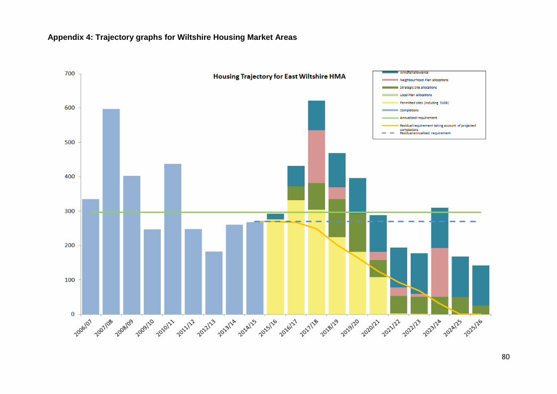
80
Appendix 4: Trajectory graphs for Wiltshire Housing Market Areas
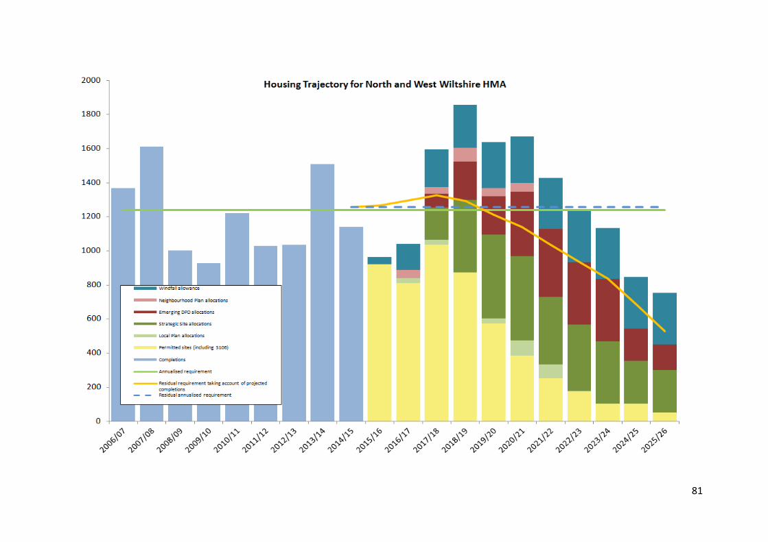
81
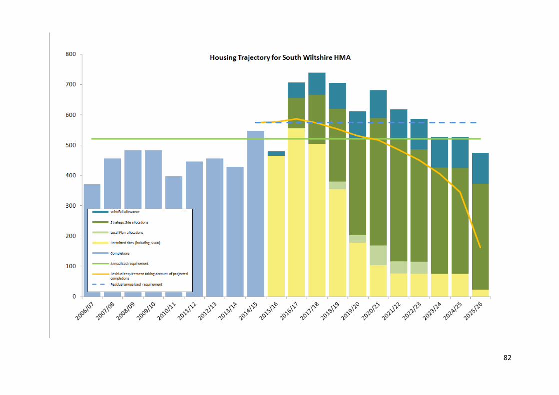
82
83
Appendix 5 - Windfall allowance for land supply calculations A1. The NPPF (paragraph 48) identifies that an allowance for windfall may
be made where appropriate. It states:
“Local planning authorities may make an allowance for windfall sites in the five-year supply if they have compelling evidence that such sites have consistently become available in the local area and will continue to provide a reliable source of supply. Any allowance should be realistic having regard to the Strategic Housing Land Availability Assessment, historic windfall delivery rates and expected future trends, and should not include residential gardens.”
A2. For clarification, the NPPF defines windfall development as:
“Sites which have not been specifically identified as available in the Local Plan process. They normally comprise previously-developed sites that have unexpectedly become available.”
A3. For the purposes of this assessment, windfall is defined as unallocated
development on previously developed land excluding residential gardens. This is considered to be a conservative approach as the NPPF definition states windfall sites are “normally” previously-developed land, but does not state that greenfield sites should be excluded. It is therefore assumed that greenfield development (other than in residential gardens) can also be counted as windfall; however it is not included in the windfall allowance for Wiltshire.
A4. This Appendix determines an appropriate windfall allowance for each of the Housing Market Areas (HMAs) within Wiltshire. It firstly analyses the trend of windfall permissions over the recent past in order to determine whether there has been consistent delivery from this source of supply. It also has regard to the Strategic Housing Land Availability Assessment (SHLAA) and potential supply from windfall sites in future years.
Historic windfall delivery rates A5. The number of new windfall permissions4 granted during the Wiltshire
Core Strategy period to date (2006 to 2015) is presented in Chart 1.
4 A large number of permissions take the form of renewals, amendments or reserved matters on existing permissions. In order that a permission of a single site is not double-counted as a result of multiple applications, only the first application is included. However, if a subsequent permission increases the capacity, the net increase will be included from this new permission.
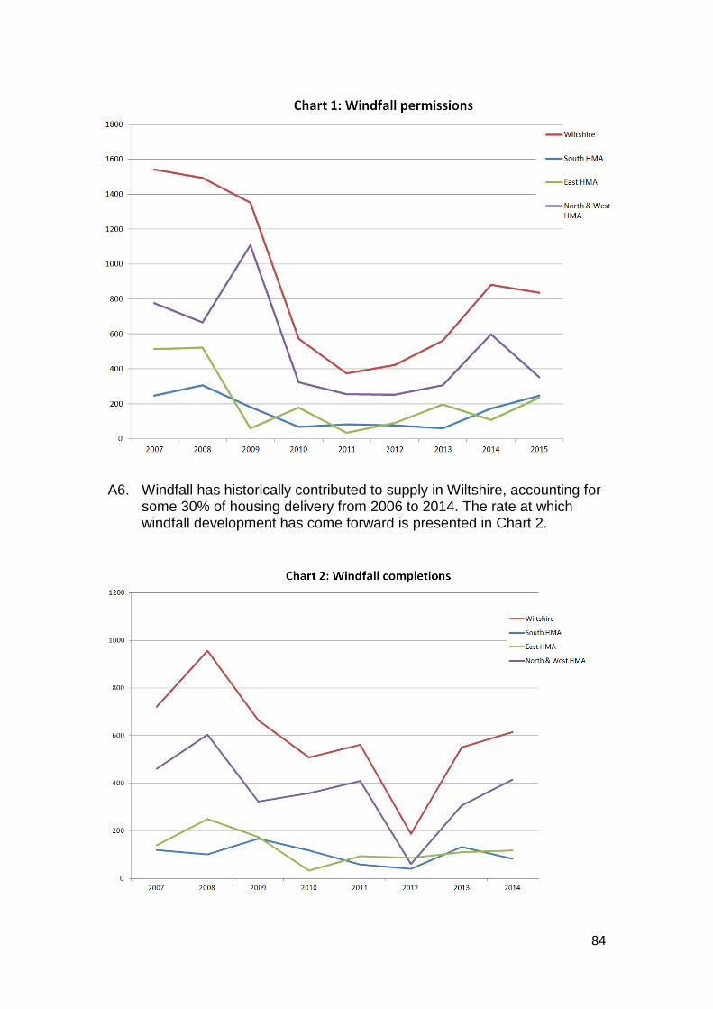
84
A6. Windfall has historically contributed to supply in Wiltshire, accounting for
some 30% of housing delivery from 2006 to 2014. The rate at which windfall development has come forward is presented in Chart 2.
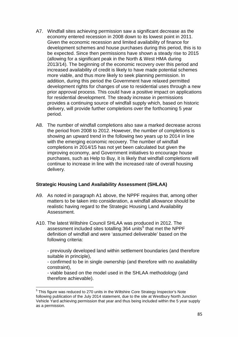
85
A7. Windfall sites achieving permission saw a significant decrease as the economy entered recession in 2008 down to its lowest point in 2011. Given the economic recession and limited availability of finance for development schemes and house purchases during this period, this is to be expected. Since then permissions have shown a steady rise to 2015 (allowing for a significant peak in the North & West HMA during 2013/14). The beginning of the economic recovery over this period and increased availability of credit is likely to have made potential schemes more viable, and thus more likely to seek planning permission. In addition, during this period the Government have relaxed permitted development rights for changes of use to residential uses through a new prior approval process. This could have a positive impact on applications for residential development. The steady increase in permissions provides a continuing source of windfall supply which, based on historic delivery, will provide further completions over the forthcoming 5 year period.
A8. The number of windfall completions also saw a marked decrease across the period from 2008 to 2012. However, the number of completions is showing an upward trend in the following two years up to 2014 in line with the emerging economic recovery. The number of windfall completions in 2014/15 has not yet been calculated but given the improving economy, and Government initiatives to encourage house purchases, such as Help to Buy, it is likely that windfall completions will continue to increase in line with the increased rate of overall housing delivery.
Strategic Housing Land Availability Assessment (SHLAA)
A9. As noted in paragraph A1 above, the NPPF requires that, among other matters to be taken into consideration, a windfall allowance should be realistic having regard to the Strategic Housing Land Availability Assessment.
A10. The latest Wiltshire Council SHLAA was produced in 2012. The
assessment included sites totalling 364 units5 that met the NPPF definition of windfall and were ‘assumed deliverable’ based on the following criteria: - previously developed land within settlement boundaries (and therefore suitable in principle), - confirmed to be in single ownership (and therefore with no availability constraint), - viable based on the model used in the SHLAA methodology (and therefore achievable).
5 This figure was reduced to 270 units in the Wiltshire Core Strategy Inspector’s Note following publication of the July 2014 statement, due to the site at Westbury North Junction Vehicle Yard achieving permission that year and thus being included within the 5 year supply as a permission.
86
A11. In previous Housing Land Supply Statements the Council based the
windfall allowance for large sites using this approach.
A12. Since the publication of the SHLAA the Council have carried out a proactive ‘Call for Sites’ as part of their emerging Housing Site Allocations DPD. As a result there have been a large number of new sites submitted to be considered in the forthcoming development plan and included in a future SHLAA, the majority of which are on Greenfield land outside settlement boundaries. However as acknowledged in previous Housing Land Supply Statements the Council does not rely on specific SHLAA sites within the 5-year supply as other non-SHLAA sites regularly come forward. To demonstrate this, the Council has carried out analysis of the contribution of SHLAA sites to windfall delivery during the Wiltshire Core Strategy period to date compared to overall windfall delivery.
During the Wiltshire Core Strategy period (up to and including 2014), 401 windfall units have been delivered on sites which were originally identified in the SHLAA (including sites identified prior to the concept of a SHLAA within a predecessor Urban Capacity Study or the National Land Use Database), compared with 5581 windfall completions overall. Delivery of such sites thus represents just 7.2% of total windfall in Wiltshire.
Demonstrating that SHLAA sites have historically made a very low contribution to windfall development is sufficient to meet the NPPF requirement to have regard to the SHLAA. Given the relatively low proportion of SHLAA sites submitted on brownfield land, this contribution is unlikely to change over time, whilst the overall numbers of windfall completions looks likely to increase, fed by the rising numbers of windfall permissions being granted.
In summary, although it is recognised that sites in the SHLAA do come forward, it can be shown that they form a very low proportion of overall windfall delivery.
Permitted development legislation changes
A13. A number of changes to the General Permitted Development Order have been introduced since May 2013 which have reduced the need to seek planning applications for certain changes of use. These concern the change of use from a number of use classes to residential under a prior approval process. The consolidated General Permitted Development Order 2015 details this, and includes the change of use from offices, shops, professional services, pay-day loan and betting shops, agricultural uses, casinos, and amusement arcades.
87
Since the first amendments came into effect (May 2013) until the end of the current monitoring period (March 2015) prior approval has been granted for a total of 190 residential units in Wiltshire.
Future potential supply
A14. In addition to the prevailing upward trend in windfall permissions and delivery and the effect of relaxing permitted development rights, the Government recently proposed initiatives to increase housing supply through a number of measures to be set out in the Housing Bill and detailed in the Productivity Plan. Local authorities will be required to have statutory registers of previously-developed land to help achieve a target of Local Development Orders in place on 90% of suitable brownfield sites by 2020. The Productivity Plan also sets out a commitment to deliver 200,000 “Starter Homes” by 2020 with a presumption in favour of such sites, starting with unviable or underused brownfield land. Such sites are planned to be exempt from planning obligations and CIL commitments which will improve viability for such sites. The Government have also announced that a one-off fund to assist local authorities in bringing such sites forward. Although these measures are national initiatives they have the potential to unlock brownfield sites and increase supply of windfall within Wiltshire in the future.
Method for identifying an allowance for future windfall delivery A15. Previous versions of the Housing Land Supply Statement have
calculated a windfall allowance based on two separate components: - For small sites (5 or fewer dwellings): historic permissions of such
sites from 2009 to 2012 with a delivery rate applied,
- For large sites (more than 5 dwellings): capacity of previously developed sites within settlement boundaries (therefore assumed to be suitable) and in single ownership (therefore assumed to be available) within the 2012 SHLAA.
A16. Paragraph 158 of the NPPF requires Local Planning Authorities to
ensure their local plan is based on adequate and up-to-date evidence. This should include the update of the authority’s Housing Land Supply position, and therefore the windfall allowance that forms a source of housing supply. The previous allowance for small windfall sites uses permissions from April 2009 to March 2012, and thus reflects applications during a period which is over 3 years old. In addition, as discussed in A12 above, using the capacity of ‘assumed deliverable’ SHLAA sites to establish a large site allowance significantly under-estimates the potential future supply when compared against actual historic permissions, and has also found to be difficult to understand.
88
A17. Since the July 2014 Housing Land Supply Statement was published the Wiltshire Core Strategy Inspector produced his Final Report confirming that the development plan passed the tests of soundness set out in the NPPF. The housing land supply was discussed in paragraphs 88-97 of the Final Report and included a discussion on the use of a windfall allowance at paragraph 97. It states
“...the Council promulgates three methods of calculating windfall allowances all of which have some credibility and which produce a county wide five year range of housing delivery between 940 and 2713 homes. The Council has elected to take a conservative estimate of likely windfalls yet the evidence is sufficiently compelling to suggest that the likely rate of housing delivery on such sites, both large and small, will be greater.”6
The Wiltshire Core Strategy was subsequently adopted by the Council in January 2015.
A18. Given the national and local policy context, the Council consider it appropriate to review and update the method for calculating windfall allowance from previous statements. The updated method is a model based purely on historic delivery as used in Method 3 portrayed in the July 2014 Housing Land Supply Statement and referenced in the Wiltshire Core Strategy Inspector’s Final Report. It uses the number of permissions across the period 2009-2015. It is considered that figures derived from this period represent a conservative estimate as it covers the low number of permissions granted during the recessionary period, with a gradual increase up to the present day (as shown in Chart 1 above), and also does not take into account windfall delivery on greenfield sites.
A19. To demonstrate the conservative nature of this method, a number of alternative methods and the allowance generated by each are set out in Table A6.
Windfall allowance calculation A20. As identified above, recent years have shown a slight increase in the
number of brownfield windfall sites achieving permission since the recession. Improving economic conditions suggest this is likely to continue in the future, however to ensure the allowance is based on a longer and more representative picture of the economic cycle, the average number of brownfield permissions across the period 2009-2015 will be assumed to be permitted each year for the following five years.
6 It is acknowledged that Methods 1 and 2 referenced in the July 2014 Statement use the capacity of Large sites in the SHLAA to calculate the large part of the allowance (as discussed in A14 above). Method 3 (which produced the largest allowance quoted in paragraph 97 above) is based exclusively on permissions during the period 2006-2012.
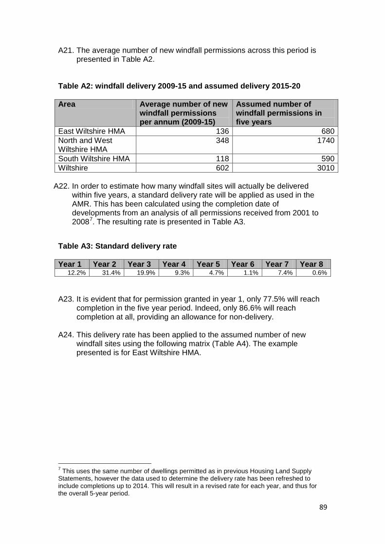
89
A21. The average number of new windfall permissions across this period is presented in Table A2.
Table A2: windfall delivery 2009-15 and assumed delivery 2015-20 Area Average number of new
windfall permissions per annum (2009-15)
Assumed number of windfall permissions in five years
East Wiltshire HMA 136 680 North and West Wiltshire HMA
348 1740
South Wiltshire HMA 118 590 Wiltshire 602 3010
A22. In order to estimate how many windfall sites will actually be delivered within five years, a standard delivery rate will be applied as used in the AMR. This has been calculated using the completion date of developments from an analysis of all permissions received from 2001 to 20087. The resulting rate is presented in Table A3.
Table A3: Standard delivery rate Year 1 Year 2 Year 3 Year 4 Year 5 Year 6 Year 7 Year 8
12.2% 31.4% 19.9% 9.3% 4.7% 1.1% 7.4% 0.6%
A23. It is evident that for permission granted in year 1, only 77.5% will reach
completion in the five year period. Indeed, only 86.6% will reach completion at all, providing an allowance for non-delivery.
A24. This delivery rate has been applied to the assumed number of new windfall sites using the following matrix (Table A4). The example presented is for East Wiltshire HMA.
7 This uses the same number of dwellings permitted as in previous Housing Land Supply Statements, however the data used to determine the delivery rate has been refreshed to include completions up to 2014. This will result in a revised rate for each year, and thus for the overall 5-year period.
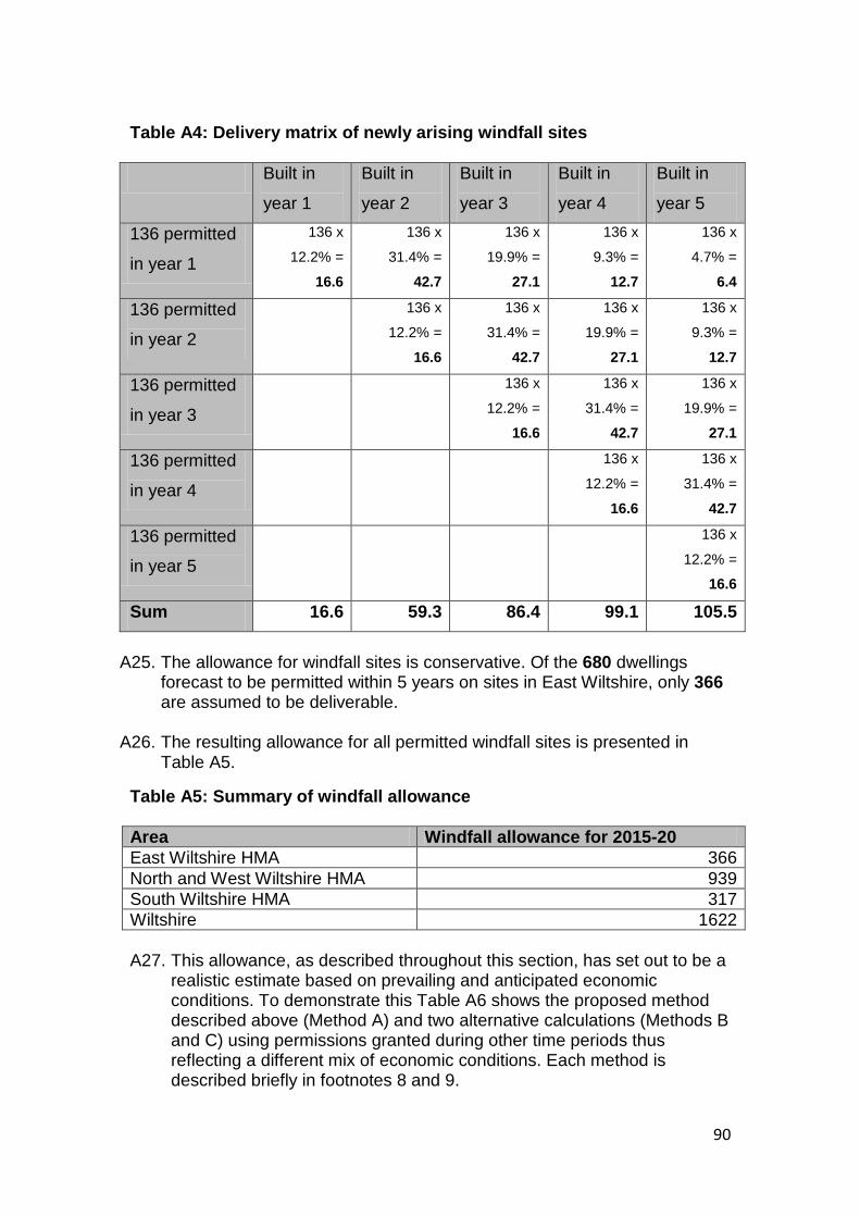
90
Table A4: Delivery matrix of newly arising windfall sites Built in
year 1
Built in
year 2
Built in
year 3
Built in
year 4
Built in
year 5
136 permitted
in year 1
136 x
12.2% =
16.6
136 x
31.4% =
42.7
136 x
19.9% =
27.1
136 x
9.3% =
12.7
136 x
4.7% =
6.4
136 permitted
in year 2
136 x
12.2% =
16.6
136 x
31.4% =
42.7
136 x
19.9% =
27.1
136 x
9.3% =
12.7
136 permitted
in year 3
136 x
12.2% =
16.6
136 x
31.4% =
42.7
136 x
19.9% =
27.1
136 permitted
in year 4
136 x
12.2% =
16.6
136 x
31.4% =
42.7
136 permitted
in year 5
136 x
12.2% =
16.6
Sum 16.6 59.3 86.4 99.1 105.5
A25. The allowance for windfall sites is conservative. Of the 680 dwellings
forecast to be permitted within 5 years on sites in East Wiltshire, only 366 are assumed to be deliverable.
A26. The resulting allowance for all permitted windfall sites is presented in Table A5.
Table A5: Summary of windfall allowance Area Windfall allowance for 2015-20 East Wiltshire HMA 366 North and West Wiltshire HMA 939 South Wiltshire HMA 317 Wiltshire 1622
A27. This allowance, as described throughout this section, has set out to be a
realistic estimate based on prevailing and anticipated economic conditions. To demonstrate this Table A6 shows the proposed method described above (Method A) and two alternative calculations (Methods B and C) using permissions granted during other time periods thus reflecting a different mix of economic conditions. Each method is described briefly in footnotes 8 and 9.
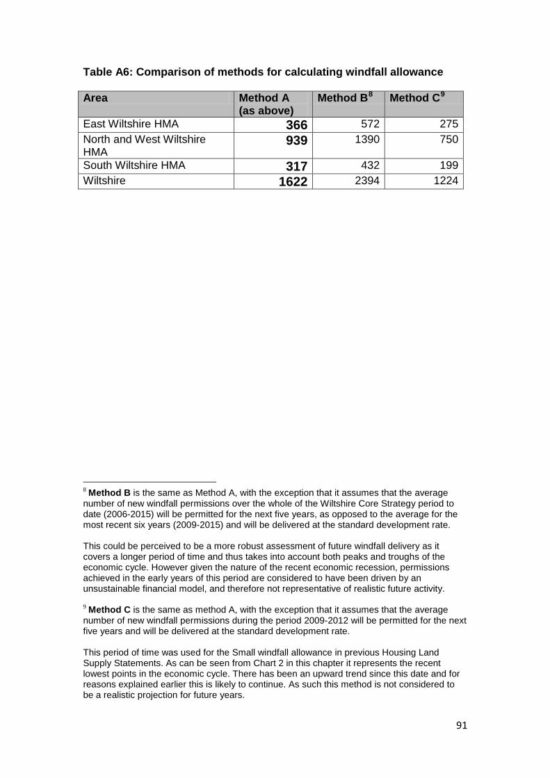
91
Table A6: Comparison of methods for calculating windfall allowance Area Method A
(as above) Method B8 Method C9
East Wiltshire HMA 366 572 275 North and West Wiltshire HMA
939 1390 750
South Wiltshire HMA 317 432 199 Wiltshire 1622 2394 1224 8 Method B is the same as Method A, with the exception that it assumes that the average number of new windfall permissions over the whole of the Wiltshire Core Strategy period to date (2006-2015) will be permitted for the next five years, as opposed to the average for the most recent six years (2009-2015) and will be delivered at the standard development rate. This could be perceived to be a more robust assessment of future windfall delivery as it covers a longer period of time and thus takes into account both peaks and troughs of the economic cycle. However given the nature of the recent economic recession, permissions achieved in the early years of this period are considered to have been driven by an unsustainable financial model, and therefore not representative of realistic future activity. 9 Method C is the same as method A, with the exception that it assumes that the average number of new windfall permissions during the period 2009-2012 will be permitted for the next five years and will be delivered at the standard development rate. This period of time was used for the Small windfall allowance in previous Housing Land Supply Statements. As can be seen from Chart 2 in this chapter it represents the recent lowest points in the economic cycle. There has been an upward trend since this date and for reasons explained earlier this is likely to continue. As such this method is not considered to be a realistic projection for future years.
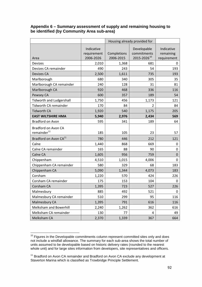
92
Appendix 6 – Summary assessment of supply and remaining housing to be identified (by Community Area sub-area) Housing already provided for
Area
Indicative requirement 2006-2026
Completions 2006-2015
Developable commitments 2015-202610
Indicative remaining
requirement Devizes 2,010 1,368 681 0 Devizes CA remainder 490 243 54 193 Devizes CA 2,500 1,611 735 193 Marlborough 680 340 305 35 Marlborough CA remainder 240 128 31 81 Marlborough CA 920 468 336 116 Pewsey CA 600 357 189 54 Tidworth and Ludgershall 1,750 456 1,173 121 Tidworth CA remainder 170 84 2 84 Tidworth CA 1,920 540 1,175 205 EAST WILTSHIRE HMA 5,940 2,976 2,434 569 Bradford on Avon 595 341 189 64
Bradford on Avon CA remainder11 185 105 23 57
Bradford on Avon CA11 780 446 212 121 Calne 1,440 868 669 0 Calne CA remainder 165 88 90 0 Calne CA 1,605 956 759 0 Chippenham 4,510 1,015 4,006 0 Chippenham CA remainder 580 329 68 183 Chippenham CA 5,090 1,344 4,073 183 Corsham 1,220 570 424 226 Corsham CA remainder 175 153 104 0 Corsham CA 1,395 723 527 226 Malmesbury 885 492 521 0 Malmesbury CA remainder 510 299 95 116 Malmesbury CA 1,395 791 616 116 Melksham and Bowerhill 2,240 1,262 362 616 Melksham CA remainder 130 77 4 49 Melksham CA 2,370 1,339 367 664
10 Figures in the Developable commitments column represent committed sites only and does not include a windfall allowance. The summary for each sub-area shows the total number of units assumed to be developable based on historic delivery rates (rounded to the nearest whole unit) and for large sites information from developers, site representatives and officers. 11 Bradford on Avon CA remainder and Bradford on Avon CA exclude any development at Staverton Marina which is classified as Trowbridge Principle Settlement.
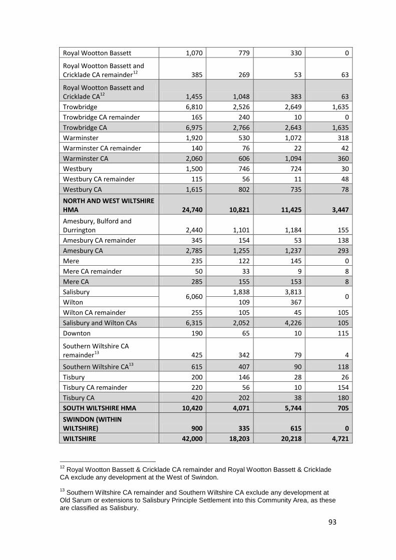
93
Royal Wootton Bassett 1,070 779 330 0
Royal Wootton Bassett and Cricklade CA remainder12 385 269 53 63
Royal Wootton Bassett and Cricklade CA12 1,455 1,048 383 63 Trowbridge 6,810 2,526 2,649 1,635 Trowbridge CA remainder 165 240 10 0 Trowbridge CA 6,975 2,766 2,643 1,635 Warminster 1,920 530 1,072 318 Warminster CA remainder 140 76 22 42 Warminster CA 2,060 606 1,094 360 Westbury 1,500 746 724 30 Westbury CA remainder 115 56 11 48 Westbury CA 1,615 802 735 78 NORTH AND WEST WILTSHIRE HMA 24,740 10,821 11,425 3,447 Amesbury, Bulford and Durrington 2,440 1,101 1,184 155 Amesbury CA remainder 345 154 53 138 Amesbury CA 2,785 1,255 1,237 293 Mere 235 122 145 0 Mere CA remainder 50 33 9 8 Mere CA 285 155 153 8 Salisbury 6,060 1,838 3,813 0 Wilton 109 367 Wilton CA remainder 255 105 45 105 Salisbury and Wilton CAs 6,315 2,052 4,226 105 Downton 190 65 10 115
Southern Wiltshire CA remainder13 425 342 79 4
Southern Wiltshire CA13 615 407 90 118 Tisbury 200 146 28 26 Tisbury CA remainder 220 56 10 154 Tisbury CA 420 202 38 180 SOUTH WILTSHIRE HMA 10,420 4,071 5,744 705 SWINDON (WITHIN WILTSHIRE) 900 335 615 0 WILTSHIRE 42,000 18,203 20,218 4,721
12 Royal Wootton Bassett & Cricklade CA remainder and Royal Wootton Bassett & Cricklade CA exclude any development at the West of Swindon. 13 Southern Wiltshire CA remainder and Southern Wiltshire CA exclude any development at Old Sarum or extensions to Salisbury Principle Settlement into this Community Area, as these are classified as Salisbury.