soils of saipan 2010 there are twelve soil orders according to the u.s. soil taxonomy classification...
TRANSCRIPT

1
Soils of Soils of SaipanSaipan
Properties and DiversityProperties and Diversity
Jonathan Deenik, PhDJonathan Deenik, PhDDepartment of Tropical Plant and Soil SciencesDepartment of Tropical Plant and Soil Sciences
University of HawaiiUniversity of Hawaii
SaipanSaipan Grazing and Livestock Management WorkshopGrazing and Livestock Management WorkshopFebruary 3February 3--5, 20105, 2010
Photo: J. Deenik
2
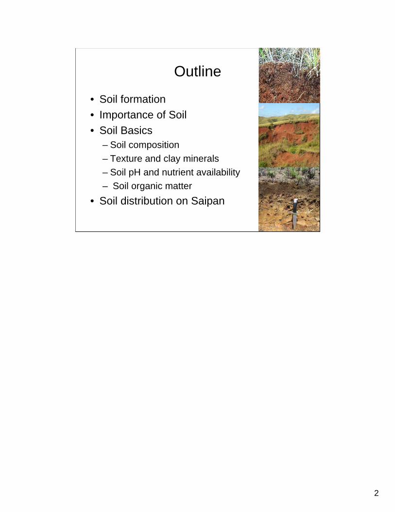
Outline
• Soil formation• Importance of Soil• Soil Basics
– Soil composition– Texture and clay minerals – Soil pH and nutrient availability– Soil organic matter
• Soil distribution on Saipan
3
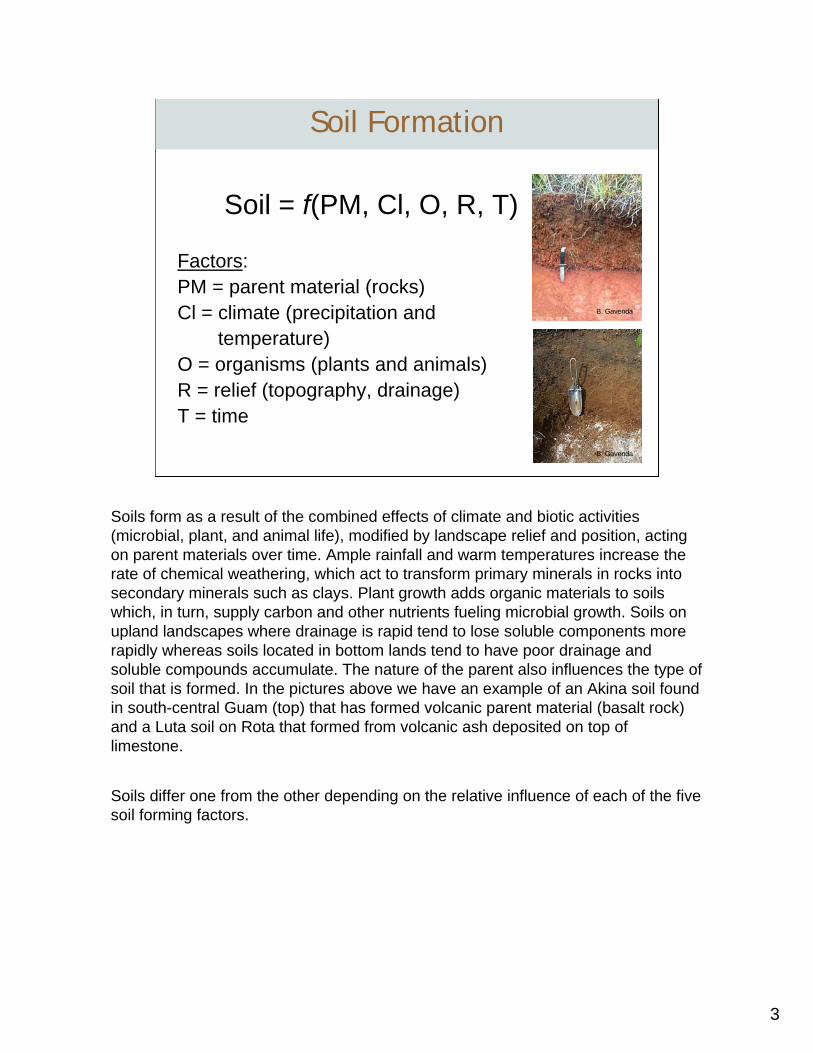
Soil = f(PM, Cl, O, R, T)
Factors:PM = parent material (rocks)Cl = climate (precipitation and
temperature)O = organisms (plants and animals)R = relief (topography, drainage)T = time
Soil Formation
B. Gavenda
B. Gavenda
Soils form as a result of the combined effects of climate and biotic activities (microbial, plant, and animal life), modified by landscape relief and position, acting on parent materials over time. Ample rainfall and warm temperatures increase the rate of chemical weathering, which act to transform primary minerals in rocks into secondary minerals such as clays. Plant growth adds organic materials to soils which, in turn, supply carbon and other nutrients fueling microbial growth. Soils on upland landscapes where drainage is rapid tend to lose soluble components more rapidly whereas soils located in bottom lands tend to have poor drainage and soluble compounds accumulate. The nature of the parent also influences the type of soil that is formed. In the pictures above we have an example of an Akina soil found in south-central Guam (top) that has formed volcanic parent material (basalt rock) and a Luta soil on Rota that formed from volcanic ash deposited on top of limestone.
Soils differ one from the other depending on the relative influence of each of the five soil forming factors.
4
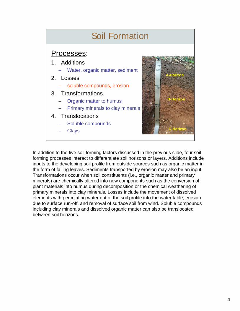
Processes:1. Additions
– Water, organic matter, sediment2. Losses
– soluble compounds, erosion3. Transformations
– Organic matter to humus– Primary minerals to clay minerals
4. Translocations– Soluble compounds– Clays
Soil Formation
B. Gavenda
A-Horizon
B-Horizon
C-Horizon
In addition to the five soil forming factors discussed in the previous slide, four soil forming processes interact to differentiate soil horizons or layers. Additions include inputs to the developing soil profile from outside sources such as organic matter in the form of falling leaves. Sediments transported by erosion may also be an input. Transformations occur when soil constituents (i.e., organic matter and primary minerals) are chemically altered into new components such as the conversion of plant materials into humus during decomposition or the chemical weathering of primary minerals into clay minerals. Losses include the movement of dissolved elements with percolating water out of the soil profile into the water table, erosion due to surface run-off, and removal of surface soil from wind. Soluble compounds including clay minerals and dissolved organic matter can also be translocatedbetween soil horizons.
5
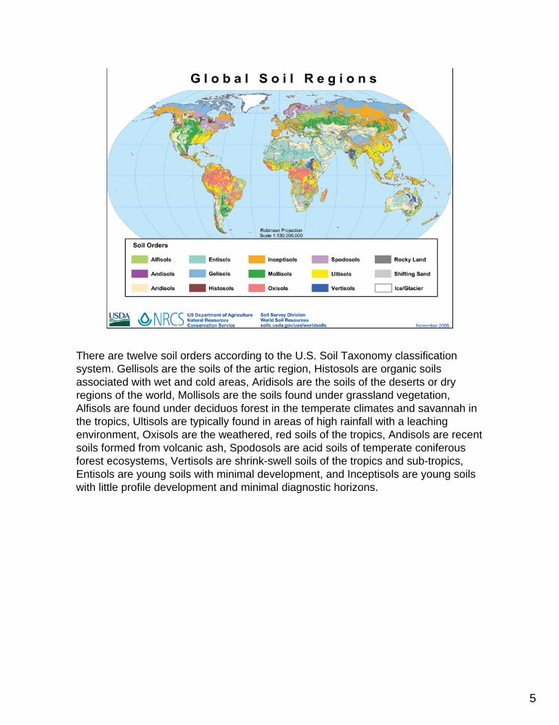
There are twelve soil orders according to the U.S. Soil Taxonomy classification system. Gellisols are the soils of the artic region, Histosols are organic soils associated with wet and cold areas, Aridisols are the soils of the deserts or dry regions of the world, Mollisols are the soils found under grassland vegetation, Alfisols are found under deciduos forest in the temperate climates and savannah in the tropics, Ultisols are typically found in areas of high rainfall with a leaching environment, Oxisols are the weathered, red soils of the tropics, Andisols are recent soils formed from volcanic ash, Spodosols are acid soils of temperate coniferous forest ecosystems, Vertisols are shrink-swell soils of the tropics and sub-tropics, Entisols are young soils with minimal development, and Inceptisols are young soils with little profile development and minimal diagnostic horizons.
6
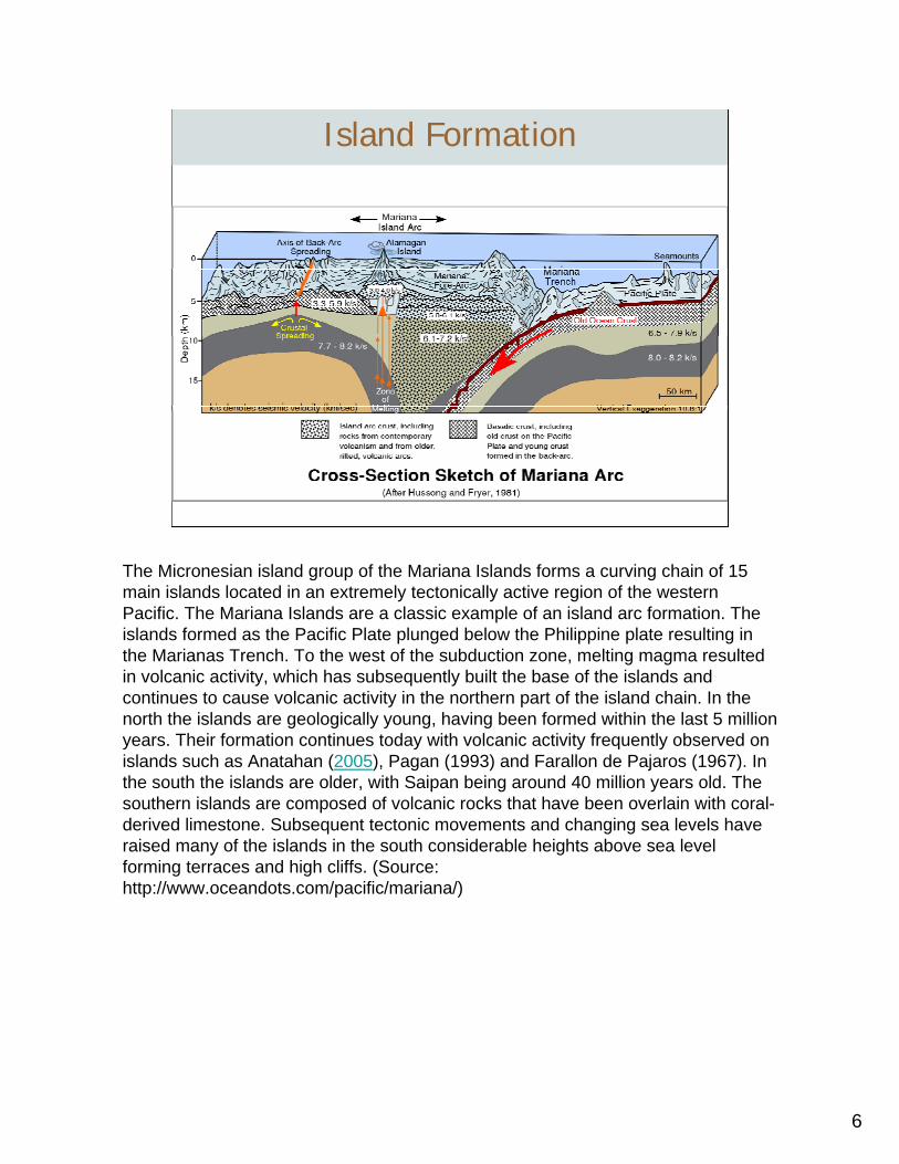
Island Formation
The Micronesian island group of the Mariana Islands forms a curving chain of 15 main islands located in an extremely tectonically active region of the western Pacific. The Mariana Islands are a classic example of an island arc formation. The islands formed as the Pacific Plate plunged below the Philippine plate resulting in the Marianas Trench. To the west of the subduction zone, melting magma resulted in volcanic activity, which has subsequently built the base of the islands and continues to cause volcanic activity in the northern part of the island chain. In the north the islands are geologically young, having been formed within the last 5 million years. Their formation continues today with volcanic activity frequently observed on islands such as Anatahan (2005), Pagan (1993) and Farallon de Pajaros (1967). In the south the islands are older, with Saipan being around 40 million years old. The southern islands are composed of volcanic rocks that have been overlain with coral-derived limestone. Subsequent tectonic movements and changing sea levels have raised many of the islands in the south considerable heights above sea level forming terraces and high cliffs. (Source: http://www.oceandots.com/pacific/mariana/)
7
Limestone Rock
Volcanic Rock
• Volcanic base approximately 41 to 13 million years old
• Limestone formed over volcanic base
• Limestone rock covers 90% of the land area
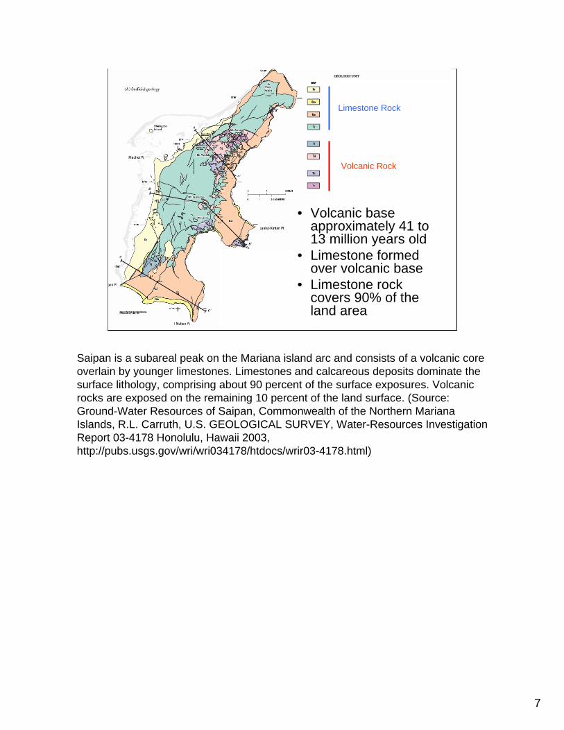
Saipan is a subareal peak on the Mariana island arc and consists of a volcanic core overlain by younger limestones. Limestones and calcareous deposits dominate the surface lithology, comprising about 90 percent of the surface exposures. Volcanicrocks are exposed on the remaining 10 percent of the land surface. (Source: Ground-Water Resources of Saipan, Commonwealth of the Northern Mariana Islands, R.L. Carruth, U.S. GEOLOGICAL SURVEY, Water-Resources Investigation Report 03-4178 Honolulu, Hawaii 2003, http://pubs.usgs.gov/wri/wri034178/htdocs/wrir03-4178.html)
8
Limestone rock
Volcanic rock
Volcanic rock
Limestone rock
9
B. Gavenda
Akina Series
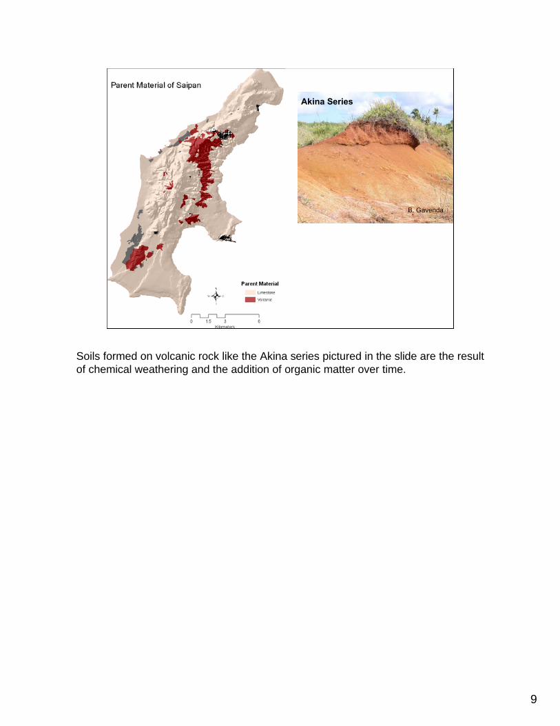
Soils formed on volcanic rock like the Akina series pictured in the slide are the result of chemical weathering and the addition of organic matter over time.
10
Soil Formation on Limestone
B. Gavenda
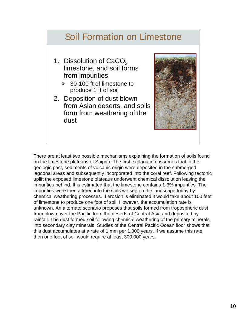
1. Dissolution of CaCO3limestone, and soil forms from impurities
30-100 ft of limestone to produce 1 ft of soil
2. Deposition of dust blown from Asian deserts, and soils form from weathering of the dust
There are at least two possible mechanisms explaining the formation of soils found on the limestone plateaus of Saipan. The first explanation assumes that in the geologic past, sediments of volcanic origin were deposited in the submerged lagoonal areas and subsequently incorporated into the coral reef. Following tectonic uplift the exposed limestone plateaus underwent chemical dissolution leaving the impurities behind. It is estimated that the limestone contains 1-3% impurities. The impurities were then altered into the soils we see on the landscape today by chemical weathering processes. If erosion is eliminated it would take about 100 feet of limestone to produce one foot of soil. However, the accumulation rate is unknown. An alternate scenario proposes that soils formed from tropospheric dust from blown over the Pacific from the deserts of Central Asia and deposited by rainfall. The dust formed soil following chemical weathering of the primary minerals into secondary clay minerals. Studies of the Central Pacific Ocean floor shows that this dust accumulates at a rate of 1 mm per 1,000 years. If we assume this rate, then one foot of soil would require at least 300,000 years.
11
B. Gavenda
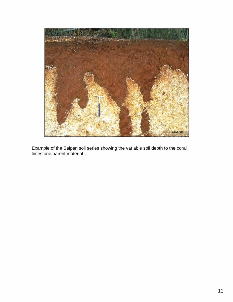
Example of the Saipan soil series showing the variable soil depth to the coral limestone parent material .
12
5 Functions
of Soil
Medium forPlant growth
Recyclingsystem
Habitat forSoil organisms
Water supplyand purification
Engineering Medium
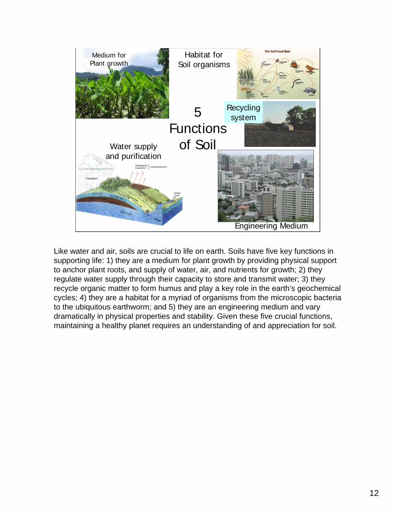
Like water and air, soils are crucial to life on earth. Soils have five key functions in supporting life: 1) they are a medium for plant growth by providing physical support to anchor plant roots, and supply of water, air, and nutrients for growth; 2) they regulate water supply through their capacity to store and transmit water; 3) they recycle organic matter to form humus and play a key role in the earth’s geochemical cycles; 4) they are a habitat for a myriad of organisms from the microscopic bacteria to the ubiquitous earthworm; and 5) they are an engineering medium and vary dramatically in physical properties and stability. Given these five crucial functions, maintaining a healthy planet requires an understanding of and appreciation for soil.
13
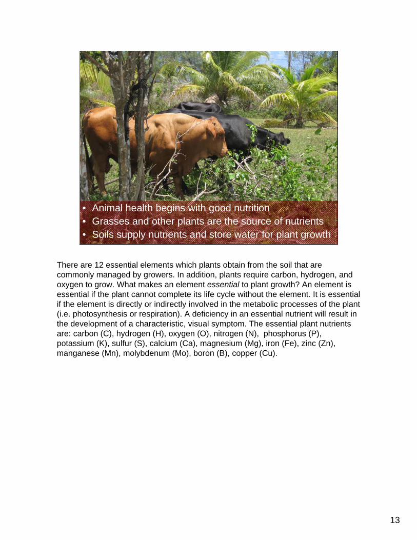
• Animal health begins with good nutrition• Grasses and other plants are the source of nutrients• Soils supply nutrients and store water for plant growth
There are 12 essential elements which plants obtain from the soil that are commonly managed by growers. In addition, plants require carbon, hydrogen, and oxygen to grow. What makes an element essential to plant growth? An element is essential if the plant cannot complete its life cycle without the element. It is essential if the element is directly or indirectly involved in the metabolic processes of the plant (i.e. photosynthesis or respiration). A deficiency in an essential nutrient will result in the development of a characteristic, visual symptom. The essential plant nutrients are: carbon (C), hydrogen (H), oxygen (O), nitrogen (N), phosphorus (P), potassium (K), sulfur (S), calcium (Ca), magnesium (Mg), iron (Fe), zinc (Zn), manganese (Mn), molybdenum (Mo), boron (B), copper (Cu).
14
Photos: B. Gavenda
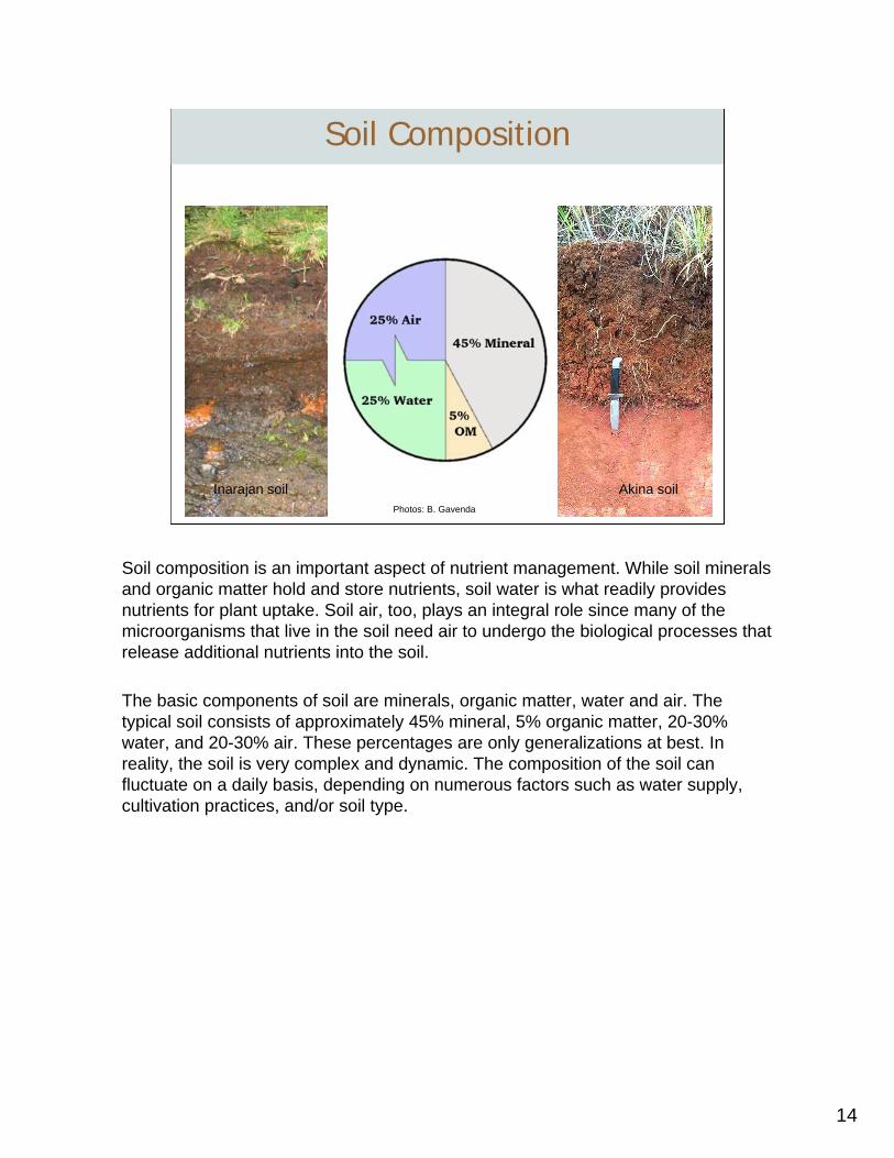
Inarajan soil Akina soil
Soil Composition
Soil composition is an important aspect of nutrient management. While soil minerals and organic matter hold and store nutrients, soil water is what readily provides nutrients for plant uptake. Soil air, too, plays an integral role since many of the microorganisms that live in the soil need air to undergo the biological processes that release additional nutrients into the soil.
The basic components of soil are minerals, organic matter, water and air. The typical soil consists of approximately 45% mineral, 5% organic matter, 20-30% water, and 20-30% air. These percentages are only generalizations at best. In reality, the soil is very complex and dynamic. The composition of the soil can fluctuate on a daily basis, depending on numerous factors such as water supply, cultivation practices, and/or soil type.
15
Soil Texture
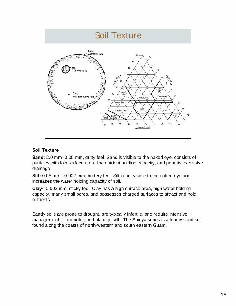
Soil TextureSand: 2.0 mm -0.05 mm, gritty feel. Sand is visible to the naked eye, consists of particles with low surface area, low nutrient holding capacity, and permits excessive drainage.Silt: 0.05 mm - 0.002 mm, buttery feel. Silt is not visible to the naked eye and increases the water holding capacity of soil.Clay< 0.002 mm, sticky feel. Clay has a high surface area, high water holding capacity, many small pores, and possesses charged surfaces to attract and hold nutrients.
Sandy soils are prone to drought, are typically infertile, and require intensive management to promote good plant growth. The Shioya series is a loamy sand soil found along the coasts of north-western and south eastern Guam.
16
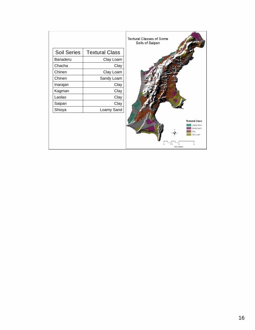
ClayLaolaoClaySaipan
Loamy SandShioya
ClayKagmanClayInarajan
Sandy LoamChinenClay LoamChinen
ClayChachaClay LoamBanaderu
Textural ClassSoil Series
17
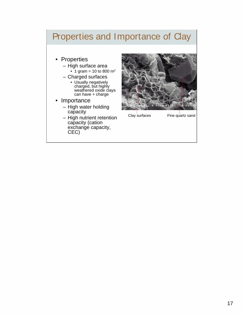
• Properties– High surface area
• 1 gram = 10 to 800 m2
– Charged surfaces • Usually negatively
charged, but highly weathered oxide clays can have + charge
• Importance– High water holding
capacity– High nutrient retention
capacity (cationexchange capacity, CEC)
Clay surfaces Fine quartz sand
Properties and Importance of Clay
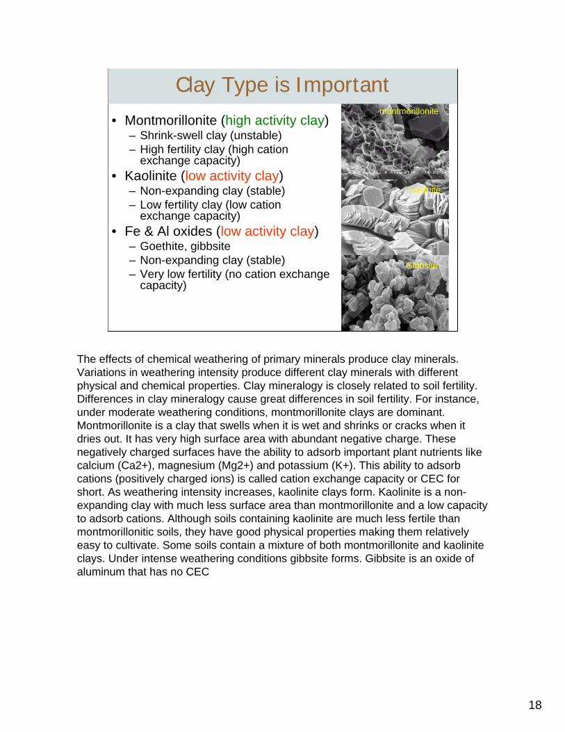
18
• Montmorillonite (high activity clay)– Shrink-swell clay (unstable)– High fertility clay (high cation
exchange capacity)• Kaolinite (low activity clay)
– Non-expanding clay (stable)– Low fertility clay (low cation
exchange capacity)• Fe & Al oxides (low activity clay)
– Goethite, gibbsite– Non-expanding clay (stable)– Very low fertility (no cation exchange
capacity)
montmorillonite
kaolinite
Gibbsite
Clay Type is Important
The effects of chemical weathering of primary minerals produce clay minerals. Variations in weathering intensity produce different clay minerals with different physical and chemical properties. Clay mineralogy is closely related to soil fertility. Differences in clay mineralogy cause great differences in soil fertility. For instance, under moderate weathering conditions, montmorillonite clays are dominant. Montmorillonite is a clay that swells when it is wet and shrinks or cracks when it dries out. It has very high surface area with abundant negative charge. These negatively charged surfaces have the ability to adsorb important plant nutrients like calcium (Ca2+), magnesium (Mg2+) and potassium (K+). This ability to adsorb cations (positively charged ions) is called cation exchange capacity or CEC for short. As weathering intensity increases, kaolinite clays form. Kaolinite is a non-expanding clay with much less surface area than montmorillonite and a low capacity to adsorb cations. Although soils containing kaolinite are much less fertile than montmorillonitic soils, they have good physical properties making them relatively easy to cultivate. Some soils contain a mixture of both montmorillonite and kaoliniteclays. Under intense weathering conditions gibbsite forms. Gibbsite is an oxide of aluminum that has no CEC

19
Negatively charged sites that adsorb cations: Ca2+, Mg2+, K+, NH4+
Cation Exchange Capacity (CEC)
20
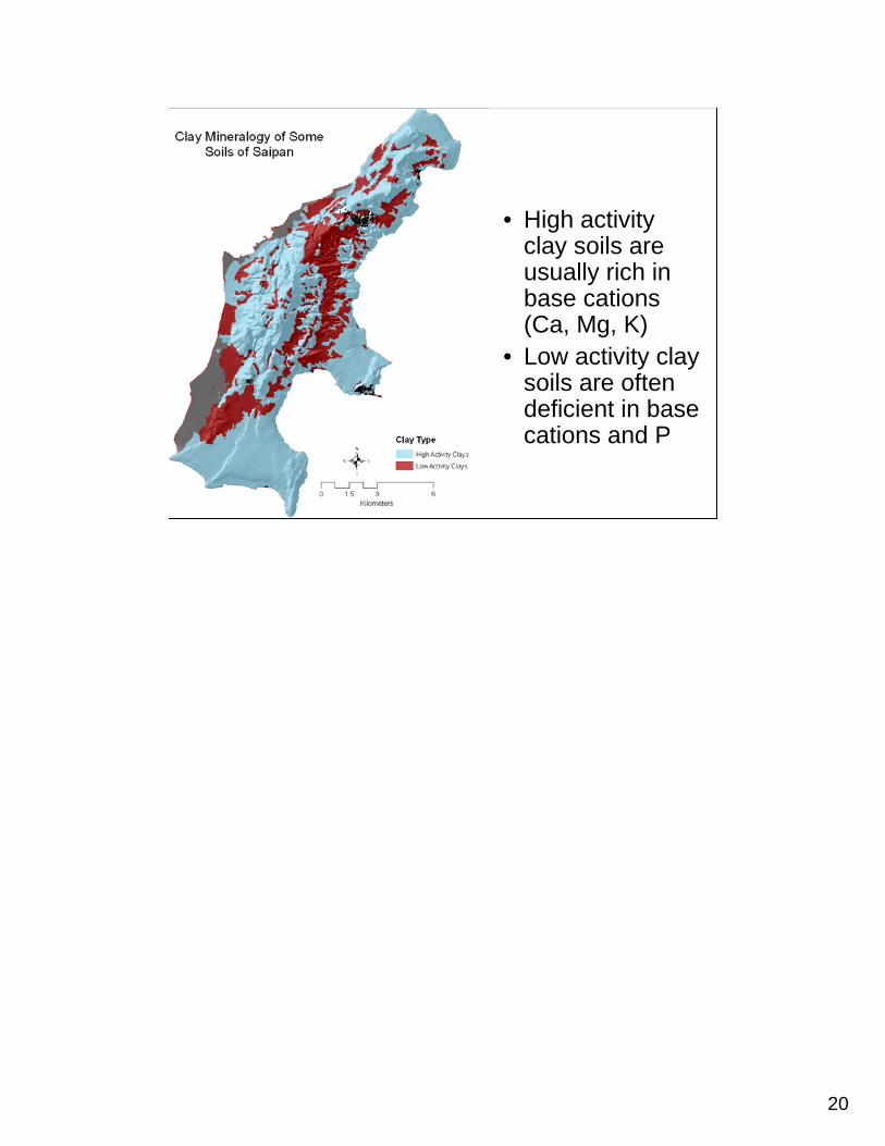
• High activity clay soils are usually rich in base cations (Ca, Mg, K)
• Low activity clay soils are often deficient in base cations and P
21
The pH Scale
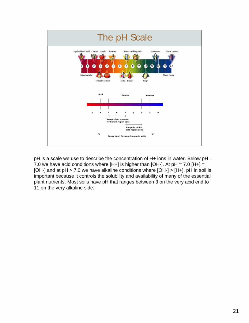
pH is a scale we use to describe the concentration of H+ ions in water. Below pH = 7.0 we have acid conditions where [H+] is higher than [OH-]. At pH = 7.0 [H+] = [OH-] and at pH > 7.0 we have alkaline conditions where [OH-] > [H+]. pH in soil is important because it controls the solubility and availability of many of the essential plant nutrients. Most soils have pH that ranges between 3 on the very acid end to 11 on the very alkaline side.

22
Soil Acidity and Nutrient Availability
Optimum pH
Soil pH is an important soil property, because it affects the chemical, biological, and physical processes of the soil. Thus, pH is often considered the “master variable” of soil. Its importance in nutrient management cannot be understated. Soil pH controls the availability of essential plant nutrients. As pH drops below 5.5, the availability of nitrogen, phosphorus, sulfur, calcium, magnesium, potassium, and molybdenum is limited and plants often show deficiency symptoms. On the other end of the spectrum, as pH increases above 7.0 the solubility of phosphorus, iron, manganese, copper, zinc, and boron decreases and plants become deficient in these nutrients. Phosphorus shows only a small pH window between 6.5 and 7.5 where it is available for plant uptake. As pH decreases below 5.5 Al toxicity becomes a severe constraint limiting plant growth to those plants adapted to acidic soil conditions. Many forage species do not grow well on strongly acidic soils. Soil pH for nutrient availability is optimal between 6.0 and 6.5.
23
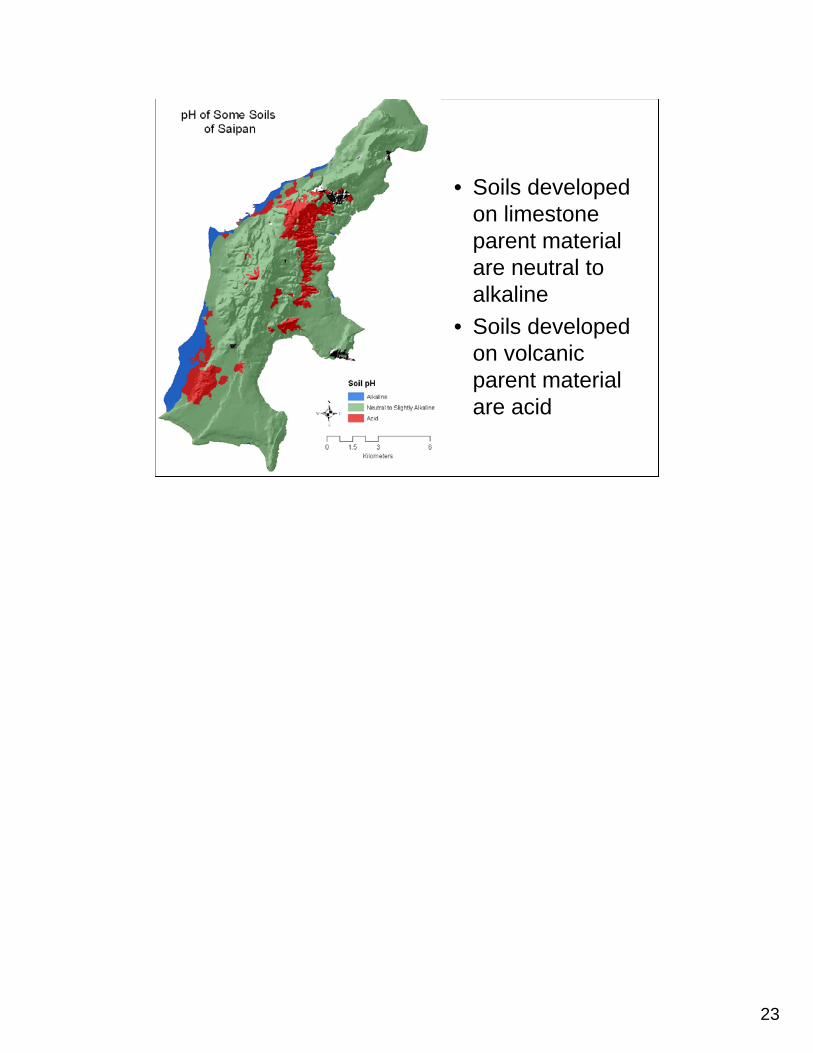
• Soils developed on limestone parent material are neutral to alkaline
• Soils developed on volcanic parent material are acid

24
B. Gavenda 51498.44.92.820-10
158512.45.050-10
%cmolc kg-1%
AlsatBasesatCECpHOMDepth (cm)
Some chemical properties of the Akina series
The Akina soil is found on volcanic uplands of central Saipan. It is a moderately deep, well-drained soil that is very acid throughout the profile. Aluminum toxicity is common in this soil and liming with calcium carbonate improves its fertility. This soil is susceptible to erosion. The Laolao soil also occurs on the volcanic uplands of central and southern Saipan. It is strongly acid in the surface horizons, but becomes only moderately acidic in the subsoil.
25
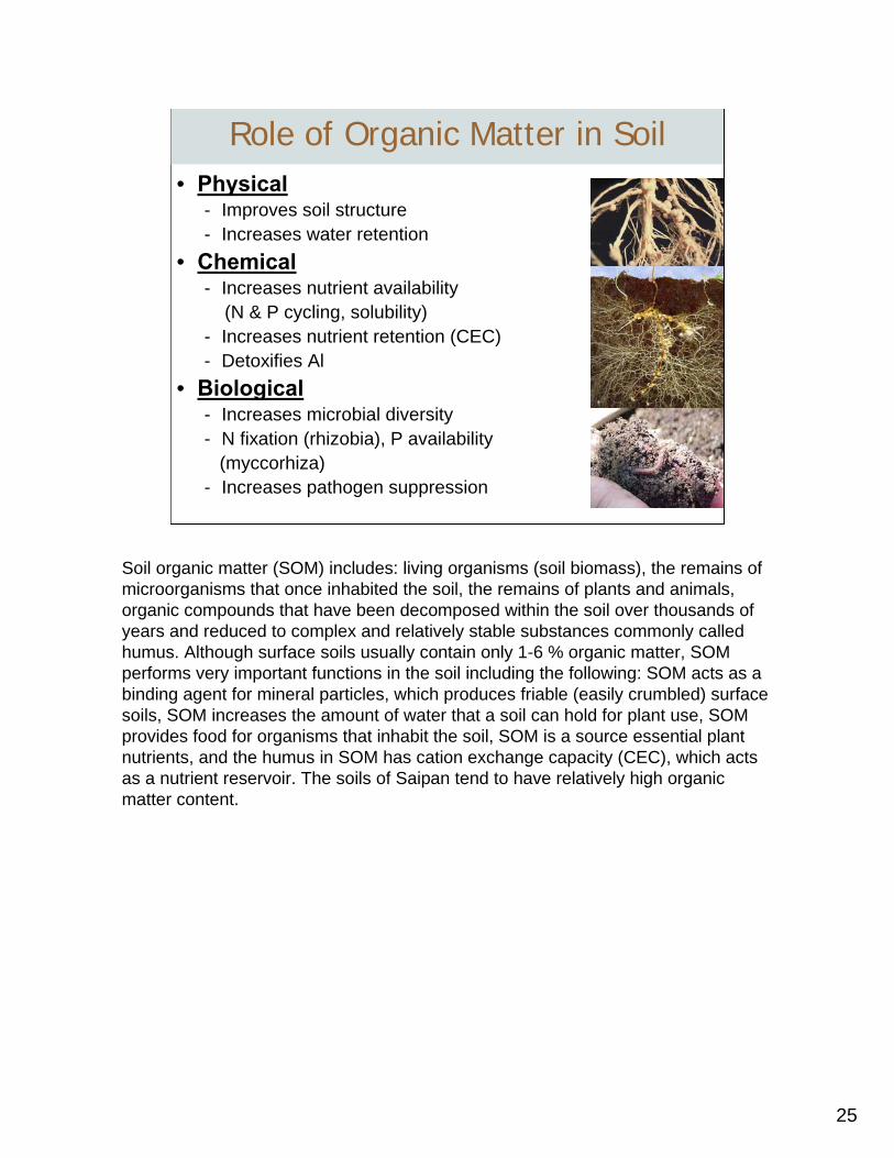
Role of Organic Matter in Soil• Physical
- Improves soil structure- Increases water retention
• Chemical- Increases nutrient availability
(N & P cycling, solubility)- Increases nutrient retention (CEC) - Detoxifies Al
• Biological- Increases microbial diversity- N fixation (rhizobia), P availability
(myccorhiza)- Increases pathogen suppression
Soil organic matter (SOM) includes: living organisms (soil biomass), the remains of microorganisms that once inhabited the soil, the remains of plants and animals, organic compounds that have been decomposed within the soil over thousands of years and reduced to complex and relatively stable substances commonly called humus. Although surface soils usually contain only 1-6 % organic matter, SOM performs very important functions in the soil including the following: SOM acts as a binding agent for mineral particles, which produces friable (easily crumbled) surface soils, SOM increases the amount of water that a soil can hold for plant use, SOM provides food for organisms that inhabit the soil, SOM is a source essential plant nutrients, and the humus in SOM has cation exchange capacity (CEC), which acts as a nutrient reservoir. The soils of Saipan tend to have relatively high organic matter content.

26
Organic C = 4.39%ΣBases = 13.4 cmolc kg-1
Al3+ = 1.0 cmolc kg-1
Organic C = 0.36%ΣBases = 4.9 cmolc kg-1
Al3+ = 9.0 cmolc kg-1
Organic C = 2.02%ΣBases = 4.6 cmolc kg-1
Al3+ = 5.2 cmolc kg-1
Organic C = 0.87%ΣBases = 4.4 cmolc kg-1
Al3+ = 9.2 cmolc kg-1
B. Gavenda
The Akina soil pictured above, is a good example of how SOM plays a key role in the fertility of many tropical soils. In the A-horizon organic carbon (C), which is a laboratory measure of organic matter (we multiply % organic C by 1.72 to get % organic matter), is high relative to the B and C-horizons. The high organic C in the A-horizon acts to retain the base cations (Ca, Mg, K), which are important plant nutrients. These nutrients are high in the organic rich A-horizon because the organic matter supplies CEC. At the same time, the high organic matter in the A-horizon reduces Al3+ toxicity, but as the organic matter decreases in the slower horizons, Al3+ toxicity becomes a serious obstacle to plant growth.

27
• 35 map units on the soil survey
• Map unit name provides no information on soil properties
• Soil Taxonomy is a classification system used to group soils based on measurable properties
28
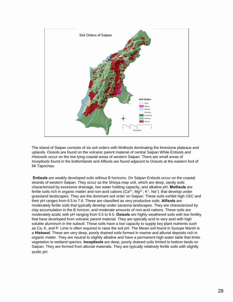
The island of Saipan consists of six soil orders with Mollisols dominating the limestone plateaus and uplands. Oxisols are found on the volcanic parent material of central Saipan While Entisols and Histosols occur on the low lying coastal areas of western Saipan. There are small areas of Inceptisols found in the bottomlands and Alfisols are found adjacent to Oxisols at the eastern foot of Mt Tapochao.
Entisols are weakly developed soils without B horizons. On Saipan Entisols occur on the coastal strands of western Saipan. They occur as the Shioya map unit, which are deep, sandy soils characterized by excessive drainage, low water holding capacity, and alkaline pH. Mollisols are fertile soils rich in organic matter and non-acid cations (Ca2+, Mg2+, K+, Na+). that develop under grassland landscapes. They are the dominant soil order on Saipan. These soils exhibit high CEC and their pH ranges from 6.5 to 7.6. These are classified as very productive soils. Alfisols are moderately fertile soils that typically develop under savanna landscapes. They are characterized by clay accumulation in the B horizon, and moderate amounts of non-acid cations. These soils are moderately acidic with pH ranging from 5.5 to 6.5. Oxisols are highly weathered soils with low fertility that have developed from volcanic parent material. They are typically acid to very acid with high soluble aluminum in the subsoil. These soils have a low capacity to supply key plant nutrients such as Ca, K, and P. Lime is often required to raise the soil pH. The Mesei soil found in Susupe Marsh is a Histosol. These are very deep, poorly drained soils formed in marine and alluvial deposits rich in organic matter. They are neutral to slightly alkaline and have a permanent high water table that limits vegetation to wetland species. Inceptisols are deep, poorly drained soils limited to bottom lands on Saipan. They are formed from alluvial materials. They are typically relatively fertile soils with slightly acidic pH.
29
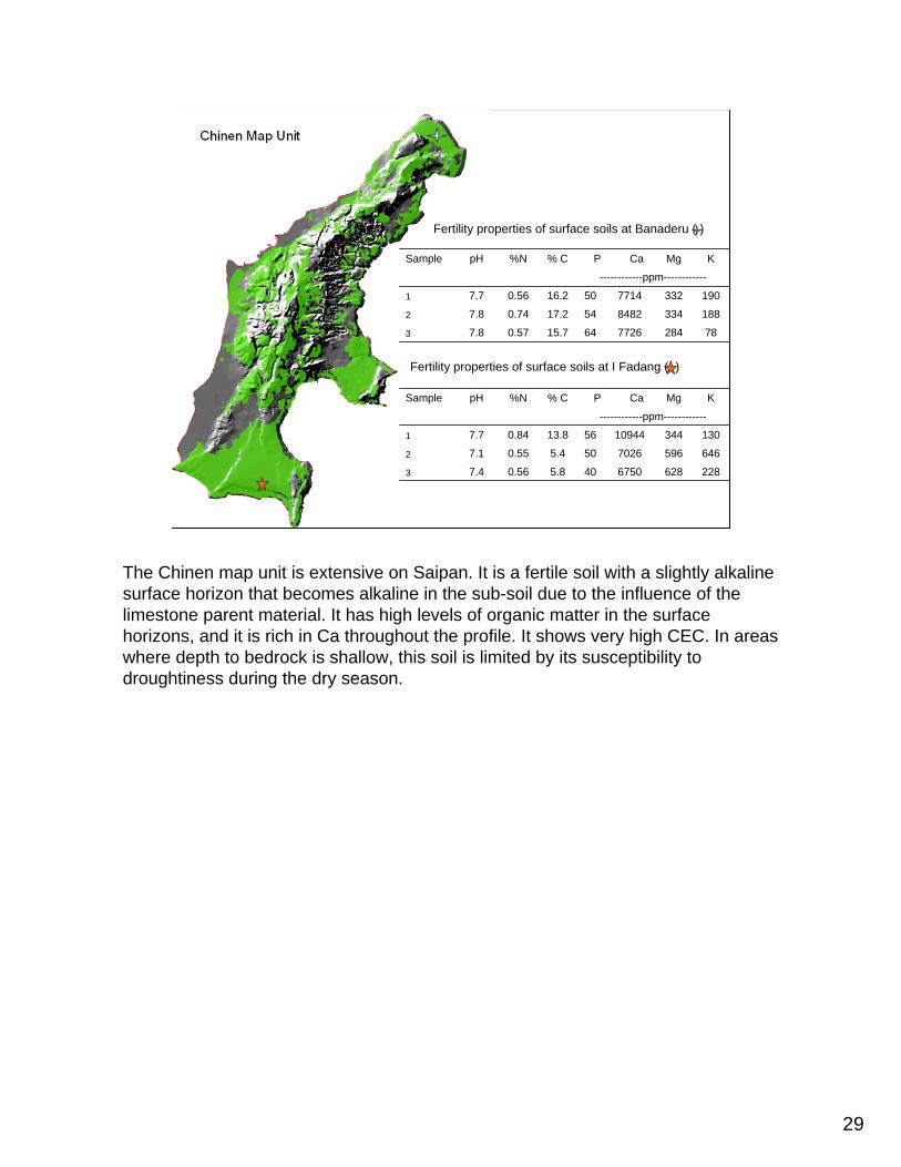
7828477266415.70.577.83
18833484825417.20.747.82
19033277145016.20.567.71
------------ppm------------
KMgCaP% C%NpHSample
Fertility properties of surface soils at Banaderu ( )
2286286750405.80.567.43
6465967026505.40.557.12
130344109445613.80.847.71
------------ppm------------
KMgCaP% C%NpHSample
Fertility properties of surface soils at I Fadang ( )
The Chinen map unit is extensive on Saipan. It is a fertile soil with a slightly alkaline surface horizon that becomes alkaline in the sub-soil due to the influence of the limestone parent material. It has high levels of organic matter in the surface horizons, and it is rich in Ca throughout the profile. It shows very high CEC. In areas where depth to bedrock is shallow, this soil is limited by its susceptibility to droughtiness during the dry season.
30
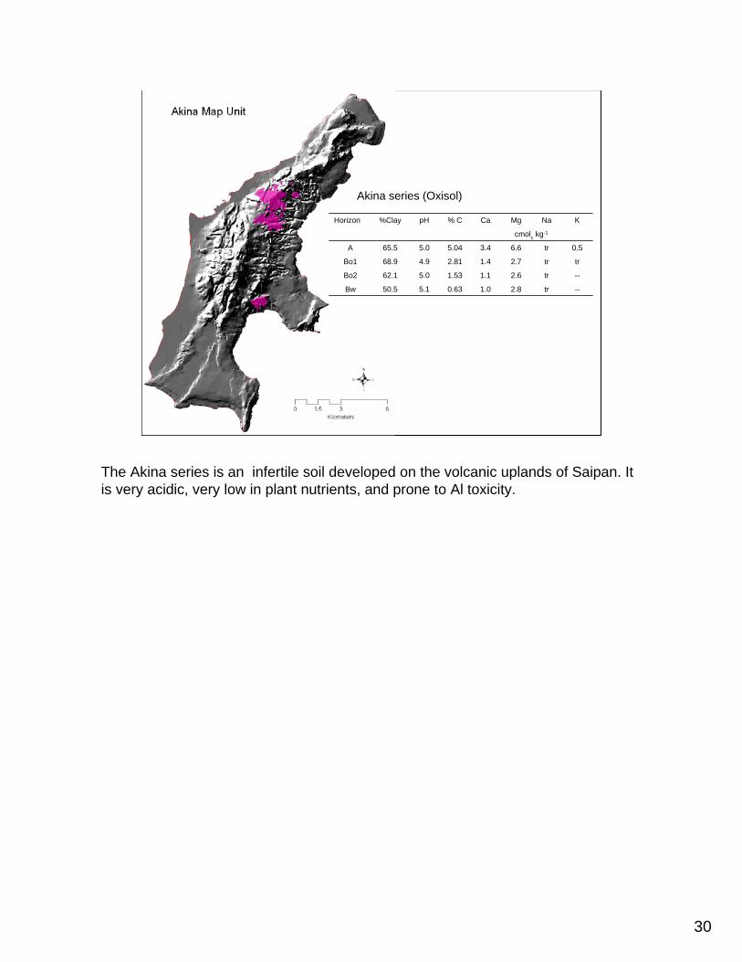
--tr2.81.00.635.150.5Bw
--tr2.61.11.535.062.1Bo2
trtr2.71.42.814.968.9Bo1
0.5tr6.63.45.045.065.5A
cmolc kg-1
KNaMgCa% CpH%ClayHorizon
Akina series (Oxisol)
The Akina series is an infertile soil developed on the volcanic uplands of Saipan. It is very acidic, very low in plant nutrients, and prone to Al toxicity.
31
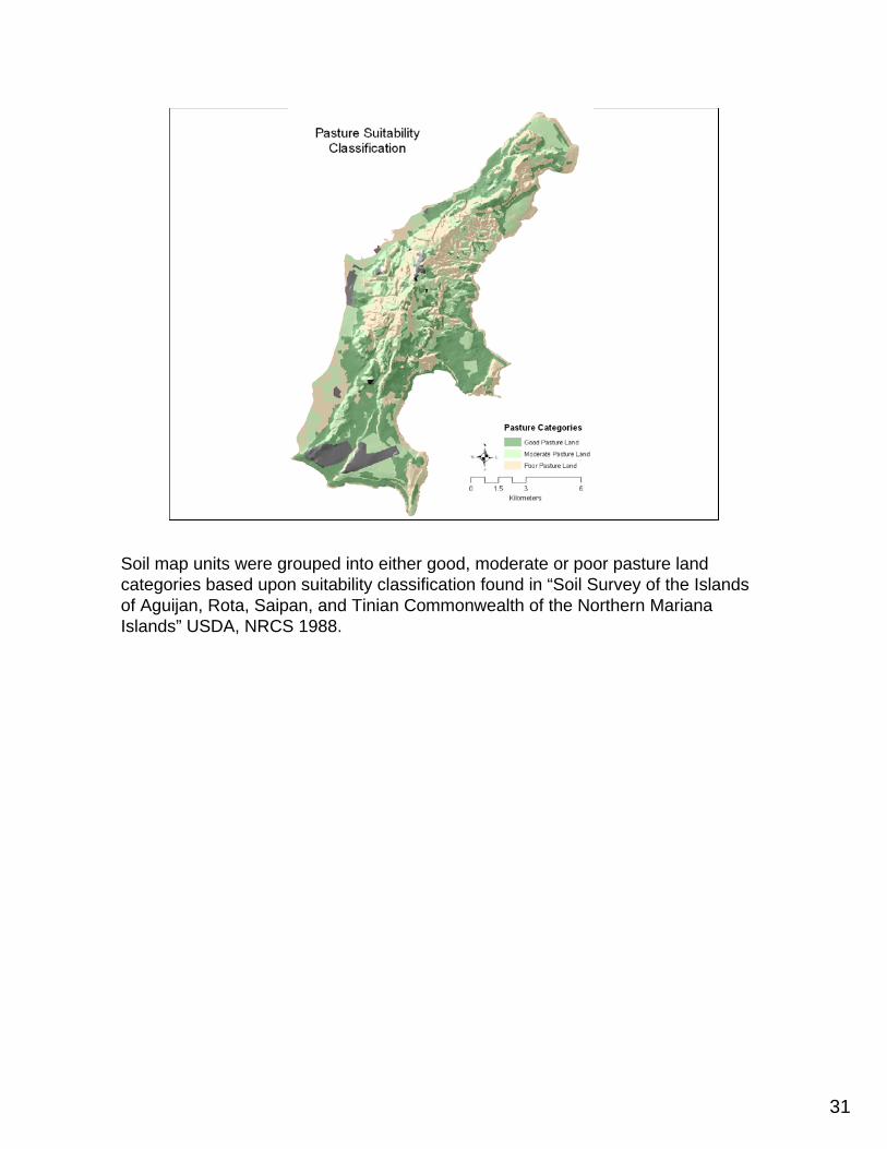
Soil map units were grouped into either good, moderate or poor pasture land categories based upon suitability classification found in “Soil Survey of the Islands of Aguijan, Rota, Saipan, and Tinian Commonwealth of the Northern Mariana Islands” USDA, NRCS 1988.
32
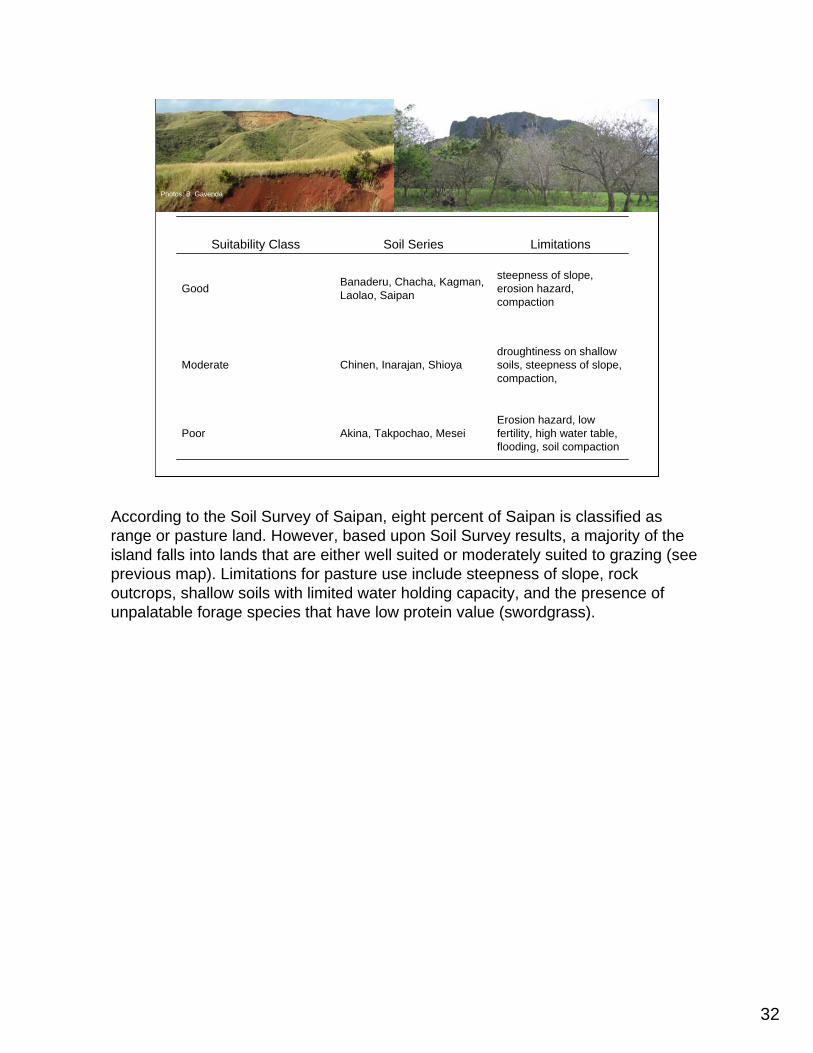
Photos: B. Gavenda
Erosion hazard, low fertility, high water table, flooding, soil compaction
Akina, Takpochao, MeseiPoor
droughtiness on shallow soils, steepness of slope, compaction,
Chinen, Inarajan, ShioyaModerate
steepness of slope, erosion hazard, compaction
Banaderu, Chacha, Kagman, Laolao, SaipanGood
LimitationsSoil SeriesSuitability Class
According to the Soil Survey of Saipan, eight percent of Saipan is classified as range or pasture land. However, based upon Soil Survey results, a majority of the island falls into lands that are either well suited or moderately suited to grazing (see previous map). Limitations for pasture use include steepness of slope, rock outcrops, shallow soils with limited water holding capacity, and the presence of unpalatable forage species that have low protein value (swordgrass).
33
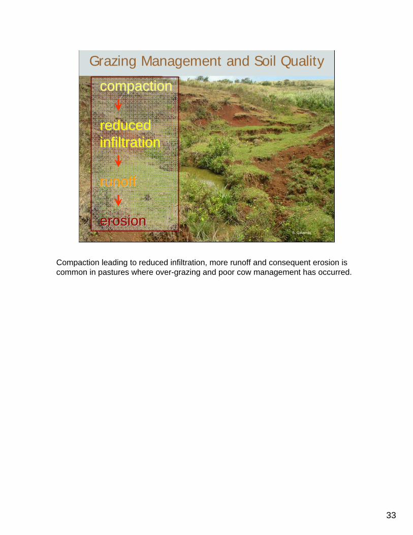
Grazing Management and Soil Quality
compactioncompaction
reduced reduced infiltrationinfiltration
runoffrunoff
erosionerosionB. Gavenda
Compaction leading to reduced infiltration, more runoff and consequent erosion is common in pastures where over-grazing and poor cow management has occurred.
34
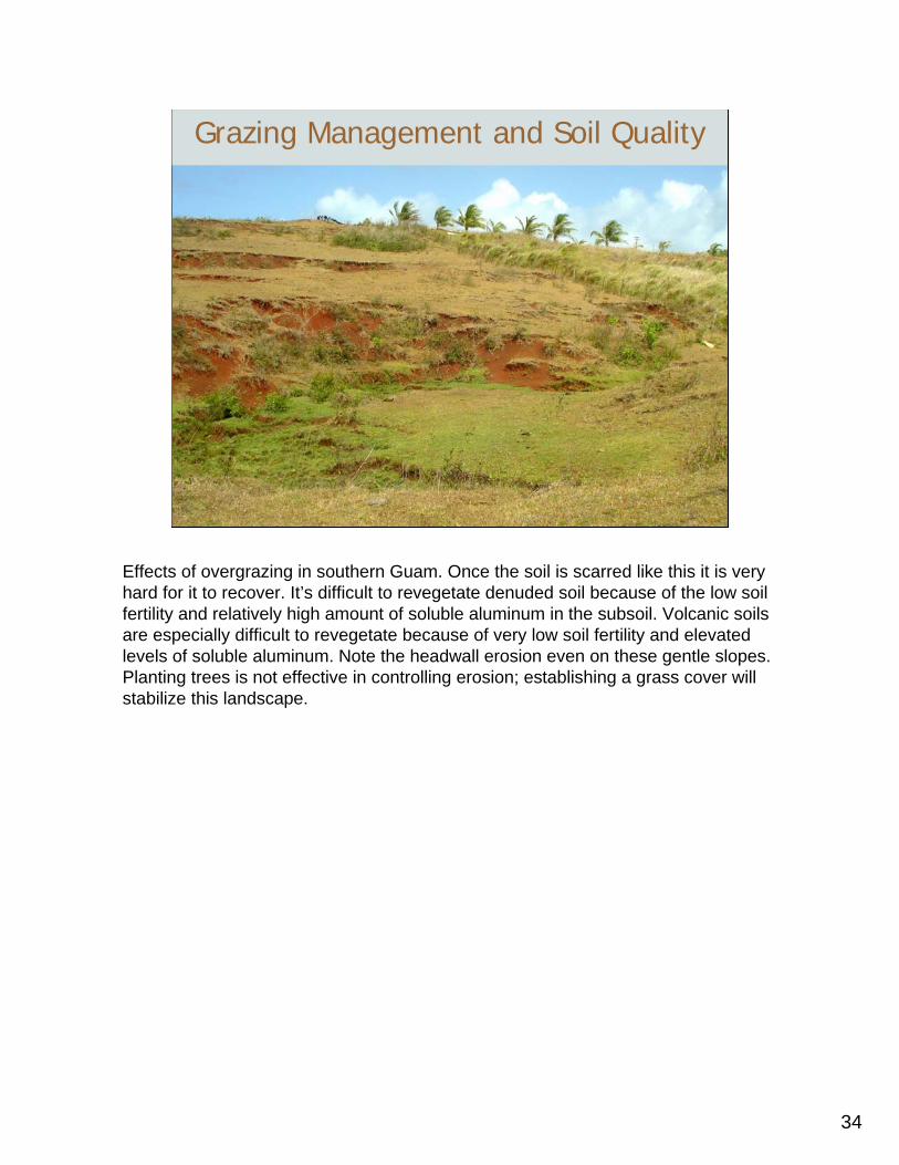
Grazing Management and Soil Quality
Effects of overgrazing in southern Guam. Once the soil is scarred like this it is very hard for it to recover. It’s difficult to revegetate denuded soil because of the low soil fertility and relatively high amount of soluble aluminum in the subsoil. Volcanic soils are especially difficult to revegetate because of very low soil fertility and elevated levels of soluble aluminum. Note the headwall erosion even on these gentle slopes. Planting trees is not effective in controlling erosion; establishing a grass cover will stabilize this landscape.

35
Soils are non-renewable!