physical characterization of a watershed through … · physical characterization of a watershed...
TRANSCRIPT

Braz J Biol 2015 vol 75 no 4 suppl 2 pp S16-S291616
httpdxdoiorg1015901519-698401313suppl Original Article
Physical characterization of a watershed through GIS a study in the Schmidt stream Brazil
D R Reisa R Plangga J G Tundisia and D M QuevedoaaPrograma de Poacutes-graduaccedilatildeo em Qualidade Ambiental Universidade Feevale
RS 239 2755 Bairro Vila Nova Novo Hamburgo RS Brazile-mail danielamqfeevalebr
Received January 17 2015 ndash Accepted May 20 2015 ndash Distributed November 30 2015(With 10 figures)
AbstractRemote sensing and geoprocessing are essential tools for obtaining and maintaining records of human actions on space over the course of time these tools offer the basis for diagnoses of land use environmental interference and local development The Schmidt stream watershed located in the Sinos River basin in southern Brazil has an environmental situation similar to that of the majority of small streams draining rural and urban areas in southern Brazil agricultural and urbanization practices do not recognize the riparian area and there is removal of original vegetation disregarding the suitability of land use removal of wetlands intensive water use for various activities and lack of control and monitoring in the discharge of wastewater among other factors deteriorate the quality of this important environmentThis article aims to achieve a physical characterization of the Schmidt stream watershed (Sinos river basin) identifying elements such as land use and occupation soil science geology climatology extent and location of watershed among others so as to serve as the basis for a tool that helps in the integrated environmental management of watersheds By applying geographic information system - GIS to the process of obtaining maps of land use and occupation pedologicaland geological and using climatological data from the Campo Bom meteorological station field visit review of literature and journals and publicly available data the physical characterization of the Schmidt stream watershed was performed with a view to the integrated environmental management of this watershed Out of the total area of the Schmidt stream watershed (2392 km2) in terms of geology it was observed that 237 consist of colluvial deposits 226 consist of grass facies and 537 consist of Botucatu formation Major soil types of the watershed 974 Argisols and only 26 Planosols Land use and occupation is characterized by wetland (05) Native Forest (1283) Native Forest + Rural Anthropic + Secondary Vegetation + Forestry (4381) Urban AnthropicUrban Area (3985) and also Urban AnthropicExpansion areas (301) Mean annual rainfall is 1337 mm maximum temperatures range from 105degC to 416degC and minimum temperatures range from ndash180degC and 26degC weak winds occasionally over 5 ms Conducting an environmental assessment in this watershed is essential for environmental and land management However these assessments are not conducted in all watersheds and when they are their frequency is not sufficiency to allow for continuous monitoring in order to model and predict scenarios with a view to adopt medium and long-term measures for environmental protection
Keywords land use mapping environmental management geographic information systems micro basin
Caracterizaccedilatildeo fiacutesica de microbacia hidrograacutefica atraveacutes de SIG como ferramenta de apoio a gestatildeo um estudo no Arroio Schmidt ndash RS
ResumoO sensoriamento remoto e geoprocessamento de imagens se constituem em ferramentas fundamentais para a obtenccedilatildeo e manutenccedilatildeo de registros das accedilotildees humanas no espaccedilo ao longo do tempo subsidiando diagnoacutesticos no uso do solo na interferecircncia ambiental e no desenvolvimento local A microbacia do Arroio Schmidt localizada na bacia do Rio dos Sinos no Rio Grande do Sul apresenta situaccedilatildeo ambiental semelhante a da maioria dos pequenos cursos drsquoagua que drenam aacutereas rurais e urbanas no sul do Brasil praacuteticas agriacutecolas e urbanizaccedilatildeo que natildeo reconhecem a aacuterea ciliar com a remoccedilatildeo da cobertura vegetal original desrespeitando a aptidatildeo do uso dos solos remoccedilatildeo de aacutereas uacutemidas uso intenso da aacutegua para diversas atividades e falta de controle e monitoramento no lanccedilamento de efluentes entre outros deterioram a qualidade deste importante ambiente O objetivo deste trabalho eacute a caracterizaccedilatildeo fiacutesica da Microbacia do Arroio Schmidt (Bacia do Rio dos Sinos) identificando elementos como uso e ocupaccedilatildeo do solo pedologia geologia climatologia extensatildeo e localizaccedilatildeo da Microbacia entre outros a fim de instrumentalizar uma ferramenta auxiliar de gestatildeo ambiental integrada de bacias hidrograacuteficas Atraveacutes da aplicaccedilatildeo do geoprocessamento no processo de obtenccedilatildeo dos mapas de uso e ocupaccedilatildeo do solo pedoloacutegico e geoloacutegico e uso de dados climatoloacutegicos da estaccedilatildeo climatoloacutegica
Braz J Biol 2015 vol 75 no 4 suppl 2 pp S16-S29 17
Physical characterization of the Schmidt stream ndash RS
17
1 Introduction
The way the relationship between humans and the environment has been taking place has caused a succession and variety of environmental problems causing rapid degradation such as soil and water contamination air pollution loss of soil productivity erosion which in turn causes overflowing landslides siltation of rivers floods and desertification among many others According to Tundisi (2003) anthropogenic actions that do not consider the dynamics of aquatic ecosystems affect the hydrological cycle thus reducing the infiltration capacity of water in the the soil changing the regime of rivers and precluding the recharging ability of reserves Therefore knowing the environment is essential for effectively planning ways to appropriate these territories and the activities that take place on them whether for environmental recovery or to foster the proper use of spaces in accordance with their capacities in new activities brought on by human activities Thus the necessary first step in the organization and planning process for the area is diagnosis and evaluation
The use of GIS in the definition assessment mapping and analysis of natural resources and human activities serves as the basis for the instruments of public policies related to the environment Parameters and processes integrated with other areas of science allow managers to make decisions based on data thus minimizing costs time and risks According to Donha et al (2006) GIS technology has been used by various sectors in environmental approaches as an environmental planning tool with advantages that include integrated assessment of a large number of variables in a simplified manner allowing for rapid generation of intermediate and final information as well as inclusion of variables not previously considered once it allows for new interactions and updates at any time
The ANINQAS proposal - Monitoring of Watersheds in Urban and Rural areas - Integrated Analysis of Water Quality and Socioeconomic Aspects (management of water quality and quantity - BAISINOS) submitted to public Call MCTFINEP CT-HIDRO 012010 is characterized by the proposition of a network of research partnerships between UFMA - Universidade Federal do Maranhatildeo
UTFPR - Universidade Federal Tecnoloacutegica do Paranaacute UEM - Universidade Estadual de Maringaacute e Universidade FEEVALE under the coordination of FEEVALEIIE This proposal consists of several subprojects and the subproject 5 - Water quality and quantity management of four urban and rural watersheds representative of the Sinos River Valley - BAISINOS motivated the choice of Schmidt stream for this research activity especially because it is one of the watersheds targeted by this project Still the fact that this watershed is located in a region of intense urbanization with strong industrial development characterized in several reports mainly from the National Water Agency - ANA as being problematic both in terms of qualitative and quantitative supply of water
The diagnosis of the environmental conditions of a particular area requires knowledge of environmental problems resulting from the occupation and use of the soil This information can be obtained by studying the strategies for the use of land water and biodiversity applied to defined geographical areas
According to Dalmolin and Pedron (2004) the diversity of the changes in soils from urban areas makes it difficult to classify the Brazilian System of Soil Classification - SiBCS (EMBRAPA 1999) which so far does not include a term for anthropic or urban soil The variety of effects in urban soils resulting from human activities such as probing and dredging foundations for construction sites and all operations of moving lands for the deployment of infrastructure systems both underground (sewerage water supply electric power telecommunications and gas distribution) and above ground (urban drainage) as well as deployment of roads hamper the establishment of an appropriate classification system
As for the terminology adopted as reference for the micro basin or watershed under study a few conceptual differences have been observed Once micro basins are drainage areas for tributaries of the main watercourse namely river basins different authors use different concepts Among these the classification of river basins into large and small under the Hydrology perspective is regarded as considering the effects of the dominant factors in the
de Campo Bom-RS visita a campo revisatildeo bibliograacutefica e de perioacutedicos dados puacuteblicos disponiacuteveis foi realizada a caracterizaccedilatildeo fiacutesica da microbacia hidrograacutefica do Arroio Schmidt visando a gestatildeo ambiental integrada desta microbacia Da aacuterea total da microbacia hidrograacutefica do Arroio Schmidt (2392 km2) observou-se quanto agrave geologia que 237 satildeo Coluacutevios Faacutecies Gramado 226 e Formaccedilatildeo Botucatu 537 Principais tipos de solos da microbacia Argissolos 974 e os Planossolos que ocupam apenas 26 O uso e ocupaccedilatildeo do solo eacute caracterizado por aacuterea uacutemida (05) Mata Nativa (1283) Mata Nativa + Antroacutepico Rural + Vegetaccedilatildeo Secundaacuteria + Silvicultura (4381) Antroacutepico UrbanoAacuterea Urbana (3985) e ainda Antroacutepico UrbanoAacutereas de expansatildeo (301) Precipitaccedilatildeo meacutedia anual de 1337 mm temperaturas maacuteximas entre 105degC e 416degC e as miacutenimas entre ndash18degC e 26degC Ventos fracos eventualmente passam de 5 ms A realizaccedilatildeo da avaliaccedilatildeo ambiental nesta microbacia eacute fundamental na gestatildeo ambiental e territorial No entanto estas avaliaccedilotildees natildeo ocorrem em todas as microbacias e quando ocorrem natildeo apresentam a frequecircncia adequada para permitir o monitoramento contiacutenuo a fim de modelar e prever cenaacuterios objetivando a adoccedilatildeo de medidas de meacutedio e longo prazo para a proteccedilatildeo ambiental
Palavras-chave mapeamento do uso do solo gestatildeo ambiental sistemas de informaccedilatildeo geograacutefica microbacia hidrograacutefica
Braz J Biol 2015 vol 75 no 4 suppl 2 pp S16-S2918
Reis D R et al
18
generation of runoff where watersheds are highly sensitive to both high-intensity rainfall and to land use (vegetation cover) This characteristic contributes to the distinction definition and spatial delineation of watersheds and river basins and its understanding is critical to structuring environmental monitoring programs thus allowing for the establishment of a spatial suitability of watersheds and river basins (Calijuri and Bubel 2006)
Another important concept attributed to watersheds is the ecological aspect which according to Leonardo (2003) considers the smallest unit of the ecosystem where the delicate interdependence between biotic and abiotic factors can be observed and disruptions may jeopardize the dynamics of its functioning This concept aims to identify and monitor environmental impacts in a guided manner
Also Guerra (1999) states that the area must be large enough to allow the interrelationships between the various elements of the characteristic environmental framework to be identified and small enough to be compatible with the available resources in order to respond positively to the objectives
This article aims to achieve a physical characterization of the Schmidt stream micro basin (Sinos river basin) identifying elements such as land use and occupation soil science geology climatology extent and location of watershed among others so as to serve as the basis for a tool that helps in the integrated environmental management of watersheds
2 Material and Methods
For this research GIS resources were used with vectorized data that helped create themed maps of the area under study The data collecting editing and analysis stages are important moments for the processing of the results in this article which aims to characterize the Schmidt watershed area with a view to the integrated environmental management of this watershed
21 Study siteThe Schmidt stream watershed is located primarily
in the municipality of Campo Bom in the Sinos River Valley state of Rio Grande do Sul Brazil and is a part of the Sinos river basin which is in turn part of the Guaiba river basin The municipality of Campo Bom has an area of 614 km2 and it is surrounded by the municipalities of Dois Irmatildeos and Sapiranga (north) Novo Hamburgo (south) Sapiranga (east) and once again Novo Hamburgo (west)
According to the IBGE census (IBGE 2010a) the rural population of Campo Bom was 2736 people and the urban population was 57345
The geographical area of the municipality of Campo Bom where Schmidt stream is located has a mean elevation of 20 m above sea level and a minimum of 38 m above the level of the Sinos River with a latitude of 29deg40rsquo54rdquo - South and a longitude of 51deg03rsquo25rdquo - West The climate is mesothermal subtropical (IBGE 2010b)
According to IBGE (2010c) the natural biome is Atlantic Forest and Pampa and the municipality of Campo
Bom (which translates as something along the lines of ldquoGood Fieldrdquo) gets its name from its good pastures and abundance of water which the drovers who passed by around 1800 encountered while returning from Satildeo Francisco and Vacaria toward the capital The town is also a pioneer in the manufacturing of shoes and was the first municipality to export shoes
The predominance of urban area is evident along the drainage area of Schmidt stream (Figure 1) and there is also a considerable presence of anthropogenic rural area A wide diversity of land use and occupation distributed in a heterogeneous and fragmented manner can be observed (Table 1)
22 Georeferenced systemsThe files needed to build the GIS environment were
the followingPlanialtimetric Data - Altimetric data referring to the
contours of the study area were identified based on the Continuous Vector Cartographic Base of Rio Grande do Sul available from Universidade Federal do Rio Grande do Sul (Hasenack and Weber 2010) This base was created through the digitization of topographic maps from the Board of Geographic Service (DSG) of the army and the level curves are in vector format in a scale of 150000 every 20 meters format Geocentric Rference System of the Americas - Datum SIRGAS 2000
Pedological and Geological Data - The pedological and geological maps were obtained from the Brazilian Institute of Geography and Statistics The maps are in vector format in a Scale of 1250000 and were prepared in 1980 and 1981 by the RADAMBRASIL project format South American Datum 1969 - Datum SAD 69 (Brasil 1982)
Land Use Data - The Land Use Map was also made available by the Brazilian Institute of Geography and Statistics (IBGE 2010d) The map is in vector format in
Table 1 Land use and occupation in the Schmidt stream watershed area
Classes Area (km2) 01 Water depth 006 02502 Native Forest 307 128303 Native Forest + Rural
Anthropic268 1120
04 Rural Anthropic + Secondary Vegetation
128 535
05 Forestry 023 09606 Urban AnthropicUrban
Area953 3985
07 WetlandsWet Grasslands 006 02508 Rural Anthropic 629 263009 Urbano AnthropicAreas
of expansion072 301
Total 2392Source Brazilian Institute of Geography and Statistics (IBGE 2010d)
Braz J Biol 2015 vol 75 no 4 suppl 2 pp S16-S29 19
Physical characterization of the Schmidt stream ndash RS
19
the same scale of 1100000 format Geocentric Reference System of the Americas - Datum SIRGAS 2000
Initially a compatibility effort was performed with all files in order to create a plan of information that could be associatiated Thus using the ArcGIS 101 software all files were georeferenced in Datum SAD 69 ie using the same system of coordinates allowing for the crossing of the files
Subsequently the study site was defined by the level curves in which it was possible to identify the tops of hills which correspond to the watershed thereby delimiting the area of contribution to Schmidt stream With the demarcation of the watershed themed maps were cut from vectorized data thus allowing for the identification of the characteristics of the region under scope
This research conducted a quantitative and qualitative approach involving three stages of work the first was bibliographic and document research about the theme proposed as well as about the study site Cartographic documents were pre-analyzed and later georeferenced and vectorized using the ArcView GIS software The second stage was the use of the processed data through techniques of digital image processing Finally we performed the analysis and description regarding geological and pedological aspects as well as land use and occupation In addition field visits were performed in order to achieve a visual recognition of the study site aid in the interpretation of
the images and record relevant points using the Global Position Sistem (GPS)
In order to conduct the climatological study data collected by conventional weather station 83961 - Auxiliary Climatological Station Campo Bom - during the operation period from April 2003 until March 2013 were used Data were summarized with descriptive statistics recorded relating to maximum and minimum temperatures precipitation intensity and direction of winds and relative humidity
3 Results
31 Physical characterization of the Schmidt stream watershed area
The Schmidt stream is one of the main tributaries of the Sinos river draining part of the town of Campo Bom a large urban center
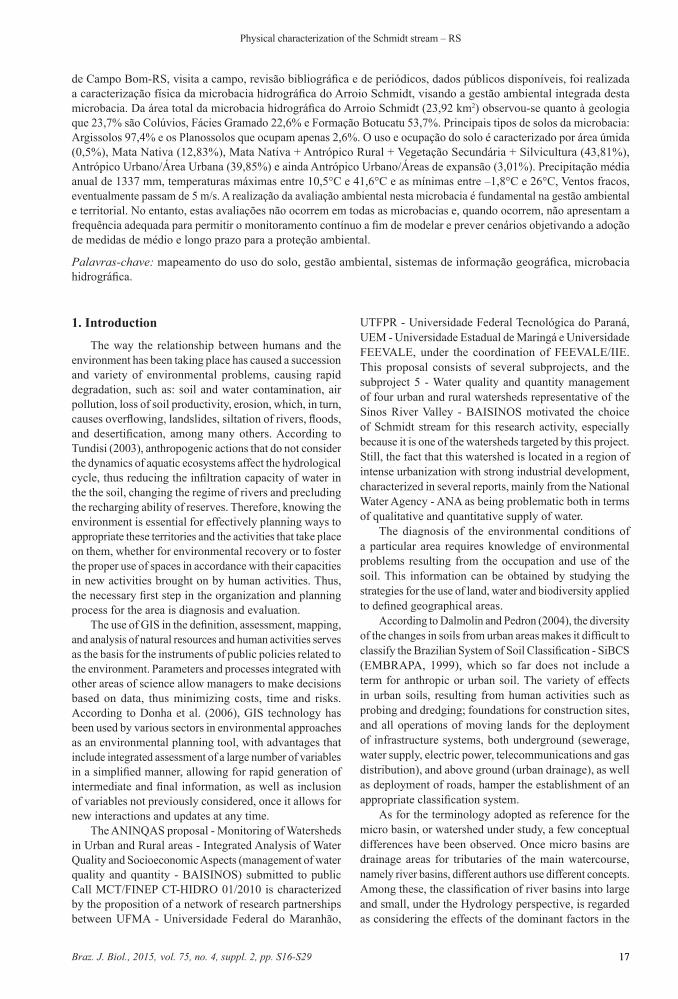
Throughout its drainage area (Figure 2) two other smaller streams flow into Schmidt stream Weidler stream and Quatro Colocircnias stream (Figure 1) Thus in all the characteristics described in the rest of this article especially in the physical characteristics of the study site land use and occupation the area will be regarded as including these two tributaries since Schmidt stream integrates this drainage area The total area of the Schmidt stream watershed is 2392 km2 approximately
Figure 1 Municipality of Campo Bom (state of Rio Grande do Sul Brazil) and the location of Schmidt creek Source Google Earth (2013) ndash Date of images 09092013
Braz J Biol 2015 vol 75 no 4 suppl 2 pp S16-S2920
Reis D R et al
20
In the highest region north the watershed has a good vegetation cover predominantly natural or with little anthropic action and various natural characteristics preserved
However in the stretch located downstream of the headwaters area with abundant forest cover the stream is already showing the formation of shoals that bar the flow of water (Figure 3a) As it moves into the urban area initially covering a stretch in which part of the industrial area of Campo Bom is located the stream follows a stretch of bike lane during which course it has a relatively consisten flow across the width of the stream with the formation of black sludge at the bottom and edges of the river bed an intense pungent and unpleasant smell with banks covered with short grass reforestation vegetation and landscaping beautification in a width of approximately 3 meters on each side with relatively stable banks In the stretch under the bridge in the 25 de Julho district (Figure 3b) the stream is channeled only under the bridge and the entry of industrial and domestic sewer wastewater is observed on both sides of the bed as well as deposits of industrial waste presence of flies and a very intense unpleasant smell extensive formation of white foam on the water
unstable banks and evidence of moderate erosion little vegetation and at this point the stream presents rock formations at the bottom of the bed At the mouth before the bridge the stream presents irregular housing shoals one of the banks shows moderate vegetation the water looks cleaner significant decrease of the mud found in the bike lane stretch which makes it possible to observe the presence of tadpoles Right after this the stream presents a major widening with very unstable banks where it meets the Sinos river
The drainage area is limited to the west by the city of Novo Hamburgo whose waters drain into the Satildeo Joseacute stream East of the watershed on the other hand it flows following the area of Campo Bom draining into the Campo Bom stream To the south the watershed meets the Sinos river ie the Schmidt stream flows into the Sinos river At the mouth of Schmidt stream it presents a widening (Figure 4) of approximately 10 m caused by the collapse of the bed which is totally devoid of riparian vegetation on both banks
Along its entire course the stream drains both industrialcommercial and residential areas
Figure 2 Area of the Schmidt stream watershed as determined by level curves Datum SIRGAS 2000 Source Hasenack and Weber (2010)
Braz J Biol 2015 vol 75 no 4 suppl 2 pp S16-S29 21
Physical characterization of the Schmidt stream ndash RS
21
32 Geological characterization of the study siteCovering an approximate area of 566 km2 (237)
of the Schmidt stream watershed the colluvial deposits consist of materials that are derived from the slopes usually settling near the base Colluvial soils were carried by gravity which causes masses of soil and rocks to fall
along sloping areas The watershed also contains a small fraction less than 001 km2 of alluvial deposits at the final region of the watershed (Figure 5)
Another geological formation present in the area of the Schmidt stream watershed grass facies which according to the the CPRM (2004) - Brazilian Geological Survey Service
Figure 3 (a) Point below the sources ndash August 2012 (b) Point after the bridge 25 de Julho district urban area ndash Campo Bom Brazil Source Baisinos Project (UNIVERSIDADE FEEVALE 2010)
Figure 4 Heads course of the Schmidt stream tributary streams and mouth Datum SIRGAS 2000 Source Hasenack and Weber (2010)
Braz J Biol 2015 vol 75 no 4 suppl 2 pp S16-S2922
Reis D R et al
22
is characterized by fine to medium granular basalt spills gray melanocratic vesicular horizons filled by zeolites carbonates apofilites and saponite structures of base flow interbedded with Botucatu sandstones It covers 54 km2 (226) of the Schmidt stream watershed at the northern stretch where the main sources of this stream are located
The Botucatu Formation underlies an area of approximately 1286 km2 (537) located in the middle part of the watershed in a now highly urbanized area of the region This geological formation usually consists of medium to fine sandstones with high sphericity and matte rosy appearance which present tangentially cross-bedded medium to large stratification In hydrogeological terms when incorporating the Guarani Aquifer this formation ensures excellent hydrodynamic values
33 Pedologic characterization of the Schmidt stream drainage area
According to the map of soil conditions (Figure 6) the Schmidt stream watershed basically presents three distinct formations in its drainage area described as follows
Sandy Dystrophic Red Argisol and Typical Dystrophic Red Argisol according to the old EMBRAPA (Santos and Zaroni 2013) classification are soils that were oncorporated
into the new Brazilian System of Soil Classification as of 2006 and are here characterized simply as argisols
The watershed under study an area of 2331 km2 (974) of pedological formation classified as argisols are divided into Sandy Dystrophic Red Argisols (1129 km2) and Typical Dystrophic Red Argisol (1202 km2)
The argisols are characterized by containing clay having a sandy texture and consisting of mineral material
On the other hand Planosols (a hydromorphic extinct in the new classification because this hydromorphism is only temporary and therefore difficult to distinguish in the field) in the watershed of the Schmidt stream account for only 061 km2 corresponding to the lower area ie the mouth near Sinos river
34 Land use and occupationThe watershed of Schmidt stream brings together a
variety of uses throughout its drainage area Some of them are overlapping urban and rural areas (Figure 7)
Nine types of land use were mapped in the Schmidt stream drainage area as described by the respective proportions of each land use and occupation (Table 1) Particularly noteworthy is the presence of native forest (1283) + rural anthropic (1120) and also rural anthropic
Figure 5 Geological characterization of the Schmidt stream watershed Datum SAD 69 Source Brasil (1982)
Braz J Biol 2015 vol 75 no 4 suppl 2 pp S16-S29 23
Physical characterization of the Schmidt stream ndash RS
23
Figure 6 Characterization of soil types in the Schmidt stream watershed Datum SAD 69 Source Brasil (1982)
Figure 7 Land use and occupation in the Schmidt stream drainage area Source Brazilian Institute of Geography and Statistics (IBGE 2010g)
Braz J Biol 2015 vol 75 no 4 suppl 2 pp S16-S2924
Reis D R et al
24
+ secondary vegetation (535) in the region where the sources are located Also agricultural occupation in the upper area of the watershed ie Rural Anthropic occupies 2630 of the area
Note the predominance of urbanization with categories Urban AnthropicUrban Area (3985) and Urban AnthropicAreas of expansion (301) shown along the middle and lower part of the watershed drainage area and also note the quite pronounced extent of the anthropic rural area (2630) A great diversity of fragments was observed characterizing a process of heterogeneous occupation
The area is characterized by intense industrial activity especially from the manufacturing industry including chemical industries especially targeted at footwear metalworking footwear and leather and byproducts among others (IBGE 2010e) Environmental problems resulting from these activities include the contamination of soil water and air due to emissions and effluent discharges among others
In agriculture the main cultures are garlic sweet potato sugar cane beans onions cassava banana persimmon lime orange mango watermelon cantaloupe corn and other fruits and vegetables Environmental problems related to these activities include the pollution of water resources and soil due to the improper use of pesticides inadequade washing and disposal of packaging and erosion and siltation caused by poor soil management (IBGE 2010f)
In terms of forestry which occupies only 096 of the watershed area products include firewood and logs for various purposes (IBGE 2010g)
Animal husbandry is also an economic activity developed in the watershed however on a smaller scale Poultry dairy cattle pigs sheep horses beekeeping and fish farming are the main activities in this sector (IBGE 2010h)
Regarding the flora according to the study of the forest vegetation published by Atlas of Forest Remnants of the Atlantic Forest (Fundaccedilatildeo SOS Mata Atlacircntica 2012) for the current survey (2011-2012) of the town of Campo Bom has maintained 3 of its natural area
35 Characterization of local biodiversityIn this case loss of biodiversity results from alterations
in land use and occupation When the original vegetation cover is removed the richness and diversity of species of an ecosystem is generally reduced drastically thus affecting the faunal composition of the area This information is verifiable through the images of land use and occupation
(Figure 7) which underwent anthropic activity with different uses replacing the natural biome Based on the study of various reports and on the field assessment a few possible environmental problems can be pointed out
In general it is possible to underscore aspects related to the management of soil water resources and local biodiversity management These aspects are related to human activities that cause environmental impacts Among these impacts it is possible to point out erosion along the bed lack of riparian vegetation and siltation of the streamrsquos bed alteration of lotic and lentic characteristics due to the removal of clay and inadequate waste disposal backfill and drainage of wetlands chemical pollution from industrial and domestic sewage loss of biodiversity (fauna and flora) among others
36 Climatology of the Schmidt stream watershedThe Campo Bom Auxiliary Climatological Station
located in Campo Bom Brazil has submitted the following location data 258 m altitude 29deg41rsquoS latitude and 51deg03rsquoW longitude relying on a historical series of more than 60 years of daily data collection Data used in this analysis were from April 2003 to March 2013
With an annual mean of 1337 mm minimum rainfall occurs in November although in the monthly mean for the 10 years the lowest average verified was in April Rainfall shows a very marked variability and it cannot be clearly established whether any period has more intense rainfall except for the month of September when rainfall intensifies (Table 2) (Figure 8)
The maximum temperatures range between 105degC and 416degC and the minimum temperatures range between ndash18degC and 26degC with lower temperatures generally recorded in early morning There is a great daily variation in temperature (Figure 9)
Between April and September from the end of fall through the winter and early spring the lowest temperatures of the year are recorded
The monthly mean relative humidity follows an upward trend in the final months of the fall and in the beginning of winter maintaining minimally lower values in summer (Table 3)
Regarding the winds considering three daily checks 1200 AM 1200 PM and 600 PM predominantly we observe almost no wind When winds blow their most frequent directions are southeast south southwest and west Also noteworthy is the manifestation of the north
Table 2 Characterization of rainfall (mm) in the period from 2003 to 2013Jan Feb Mar Apr May June July Aug Sept Oct Nov Dec
Total 12036 14806 12095 11231 12449 11625 16294 12927 18288 14057 12271 12389Mean 1204 1481 1210 1123 1245 1163 1629 1293 1829 1406 1227 1239S 559 701 360 757 556 588 668 715 887 648 861 674CV 464 473 297 674 446 506 410 553 485 461 702 544Max 2193 2664 1720 2968 2002 2407 2810 2458 3681 2402 3029 2665Min 500 317 581 250 428 373 823 451 663 411 164 436Source Campo Bom Climatological Station (INMET 2013)
Braz J Biol 2015 vol 75 no 4 suppl 2 pp S16-S29 25
Physical characterization of the Schmidt stream ndash RS
25
Figure 8 Mean annual variability of rainfall - 2003 to 2013 Source Campo Bom Climatological Station (INMET 2013)
Figure 9 Characterization of the temperature at the Schmidt stream watershed - 2003 to 2013 (a) Maximum mean temperature (b) Minimum mean temperature Source Campo Bom Climatological Station (INMET 2013)
Braz J Biol 2015 vol 75 no 4 suppl 2 pp S16-S2926
Reis D R et al
26
wind which generally leads to the formation of rainfall (Figure 10)
The analysis of wind speeds considering the classification adopted by the World Meteorological Organization (WMO 2008) showed that winds have low speed (Table 4) They are generally weak with speeds under 5 ms although there are short bursts that can reach up to 138 ms in some cases
4 Discussion
The Schmidt stream watershed presents various forms of land use and occupation as well as various levels of compromise Land use and occupation in the Schmidt stream drainage area play an important role in surface runoff and sediment delivery as well as in the chemical and organic pollution in the bed thus affecting the quality and availability of water
Because of the geological formation (Serra Geral Formation) with basalt outcrops and boulders along the northern drainage area there is exploitation and processing of basalt rocks which constitutes a particular land use in the watershed according to the Sinos River Basin Plan and the town of Campo Bom is rated as a ldquoMunicipality with High Criticalityrdquo in terms of mining The colluvial-alluvial plains found in the final stretch of the watershed (Figure 5) show a tendency to relatively minor erosion due to less steep slopes however there is a risk
Figure 10 Wind direction in the Schmidt stream watershed - Daily Observations 2003-2013 Source Campo Bom Climatological Station (INMET 2013)
Table 3 Relative humidity () - mean monthly values from 2003 to 2013Time Jan Feb Mar Apr May June July Aug Sept Oct Nov Dec
1200 AM 841 853 869 897 908 906 889 873 870 861 832 8191200 PM 776 820 875 919 941 923 913 888 859 795 736 721600 PM 571 596 590 610 649 674 656 619 621 593 559 551Source Campo Bom Climatological Station (INMET 2013)
of soil and surface water and groundwater contamination in the event of inadequate sewage discharges and leaks Colluvial deposits mostly mass movements cover the middle and lower sections of the slopes and increase in thickness as the steepness decreases coming in contact with the alluvion deposited by the body of water in the bottom of the valley (Bigarella et al 2008 p 203)
Botucatu sandstones in turn generally decompose in infertile sandy soils which can lead to extensive coverage of rosy reddish loose sand (Washburne 1930 apud Carneiro 2007) so the central area of the watershed (Figure 5) can present with sharp erosion due to neglected care involving the activities performed in the watershed associated with intense rainfall in the basin which has an annual mean rainfall index of 1337 mm helping the flow and transport of large amounts of organic and inorganic sediment loads into the bed of the stream These are deposited in areas of less steep slopes obstructing the stream with washed down sediment thus compromising the quality and quantity of surface water
The Brazilian agricultural development and the rapid growth of cities characterized by intensive use of natural resources usually with no planning and knowledge of soil characteristics has caused great losses of soil in agriculture and other various losses in urban areas whether economic environmental social and others As for the types of soils found in the watershed area argisols are responsible for the largest coverage area According to
Braz J Biol 2015 vol 75 no 4 suppl 2 pp S16-S29 27
Physical characterization of the Schmidt stream ndash RS
27
Pedron et al (2007) argisols have restricted potential for use in urban construction and are ideal for use in green and recreational areas due to limitations such as soil depth drainage and geologic material In the study area a predominance of urban and rural occupation was observed in the area corresponding to argisols (Figures 5 and 6) which reinforces the need for taking precautions in these occupations and justifies the various shoals observed along Schmidt stream Still according to Cunha and Guerra (2003) argisols are characterized by the B textural horizon (Bt) marked by an accumulation of clay illuviation inner lateral translocation or formation in the horizon itself In general there are significant differences in clay content between the A and B horizons going from a more sandy surface horizon to a more clayey subsurface horizon This feature may represent a barrier to water seepage along the profile decreasing its permeability and favoring the surface and subsurface flow in the contact zone between different materials Moreover the Schmidt stream watershed is characterized by intense urbanization with wide occurrence of soil sealing for driveways asphalt etc thus providing low water infiltration into the soil thereby enhancing the runoff process and causing erosion andor sedimentation in drainage networks downstream or flooding in the lower regions affecting riverside communities
According to Santos and Zaroni (2013) Planosols are characterized by loss of clay in the surface portion and intense accumulation of clay in the subsurface horizon a sandy surface texture slow permeability usually due to accumulation of clay sandy surface texture moisture retention nutrient deficiency high levels of sodium harmful levels of aluminum and requiring careful draining and liming Because of these characteristics areas with this type of formation should not undergo urbanization and should be conserved as wetlands or wet grassland areas instead
Another important aspect regarding land use and occupation and impacts on local biodiversity is chemical pollution from industrial and domestic sewage as pointed
out by Robaina et al (2002) whose study reported a moderate contamination by zinc and lead in Schmidt stream
The scope of the watershed is demographically dense and continues to increase in urbanization according to IBGE (2010i) In terms of housing this also involves an increases in irregular occupations with poor physical conditions and urban structure generating all form of environmental impacts
Research in the Sinos river basin also points to the importance of maintaining wetlands fragments even in small stretches since a study of macrophytes and macroinvertebrates has shown that the composition was not related to the size of the wetlands suggesting that ldquo[] environmental policies aimed at conserving biodiversity should also include management actions focused on protecting small wetland areas []rdquo (Maltchik et al 2010 p 1183) However a relatively large occupation of wetland is classified in the map (Figure 6 and 7) as an area of Urban Anthropic area of expansion
Considering the extent of the activities and urban soil interferences in the watershed in terms of to argisols caution must be exercised in relation to the possible damages from eroding processes against which the bed of the Schmidt stream must be protected Caution must also be exercised in agricultural practices and erosion of urban areas as well as in building constructions
Regarding the climatic factors analyzed temperature relative humidity wind speed and direction no extreme situations were observed and a homogeneous behavior was observed for the period of over 10 years of data under study The mean monthly rainfall remains at a relatively constant volume However it presents a high degree of variation (Table 2) Under the hydrologic concept the Schmidt stream watershed suffers the greatest interference at runoff with high sensitivity to the intense short rains causing the flooding of areas which are found and reported frequently by the local population However when the flow decreases substantially when rainfall stops Alterations resulting from improper land use and occupation especially in sensitive areas such as the illegal occupation of wetlands and
Table 4 Wind speed (ms) - Monthly percentage and daily checks 2003-2013ms Jan Feb Mar Apr May June July Aug Sept Oct Nov Dec
Cal 0-02 393 414 427 448 476 484 428 439 352 314 284 321Light air 03-15 148 121 152 125 144 124 164 156 150 158 190 160Light breeze 16-33 357 294 317 309 271 257 294 274 343 416 373 396Gentle breeze 34-54 28 20 26 13 28 28 36 44 45 35 40 49Moderate breeze 55-79 0 0 0 2 6 3 2 2 1 4 4 3Fresh breeze 08-107 1 0 2 3 5 4 6 13 9 3 6 1Strong breeze 108-138 0 0 0 0 0 0 0 2 0 0 3 0Near gale 139-171 0 0 0 0 0 0 0 0 0 0 0 0Gale 172-207 0 0 0 0 0 0 0 0 0 0 0 0Strong gale 208-244 0 0 0 0 0 0 0 0 0 0 0 0Storm 245-284 0 0 0 0 0 0 0 0 0 0 0 0Violent Storm 285-326 0 0 0 0 0 0 0 0 0 0 0 0Source Campo Bom Climatological Station (INMET 2013)
Braz J Biol 2015 vol 75 no 4 suppl 2 pp S16-S2928
Reis D R et al
28
removal of riparian vegetation for example are detected at several points across the watershed
Bieger et al (2010) in a study of biomonitoring via aquatic macroinvertebrates has observed that the water quality in the streams of the Sinos river basin has not varied from the winter to the summer suggesting that there would be no oscillations in the aspect of water quality associated with environmental temperature fluctuations However their study has detected a much worse quality of water in the lower basin which includes the Schmidt stream because of the heavily urbanized and industrialized area
The use of GIS was found to be critical in the process of assessment and characterization of river basins and watersheds However the use of aerial imagery for the purpose of monitoring and planning is limited mainly by the cost of acquiring the images The availability of research data and continuous monitoring and images from official bodies would certainly allow for very promising results
Acknowledgements
Special thanks to INMET - National Institute of Meteorology for providing the data from the climatological station of Campo Bom-RS which was required in order to develop this work
References
BIEGER L CARVALHO ABP STRIEDER MN MALTCHIK L and STENERT C 2010 Are the streams of the Sinos River basin of good water quality Aquatic macroinvertebrates may answer the question Brazilian Journal of Biology = Revista Brasileira de Biologia vol 70 no 4 suppl pp 1207-1215
BIGARELLA JJ BECKER RD and SANTOS GF 2008 Estrutura e origem das paisagens tropicais e subtropicais 2nd ed Florianoacutepolis Editora da UFSC
BRASIL Ministeacuterio das Minas e Energia Secretaria Geral 1982 Folha SD 23 Brasiacutelia geologia geomorfologia pedologia vegetaccedilatildeo uso potencial da terra - Projeto RADAMBRASIL Rio de Janeiro Ministeacuterio das Minas e Energia 660 p Levantamento de Recursos Naturais vol 29
CALIJURI MC and BUBEL APM 2006 Conceituaccedilatildeo de microbacias In WP LIMA and MJB ZAKIA orgs As florestas plantadas e a aacutegua implementando o conceito da microbacia hidrograacutefica como unidade de planejamento Satildeo Carlos Rima 226 p
CARNEIRO CDR 2007 Viagem virtual ao Aquumliacutefero Guarani em Botucatu (SP) formaccedilotildees Piramboacuteia e Botucatu Bacia do Paranaacute Terra e Didatica vol 30 no 1 pp 50-73
COMPANHIA DE PESQUISA DE RECURSOS MINERAIS ndash CPRM Serviccedilo Geoloacutegico do Brasil 2004 [viewed 4 December 2013] Aparados [online] Available from wwwcprmgovbr
CUNHA SB and GUERRA AJT 2003 Degradaccedilatildeo ambiental In AT GUERRA and SB CUNHA orgs Geomorfologia e meio ambiente Rio de Janeiro Bertrand Brasil pp 184-185
DALMOLIN RSD and PEDRON FA 2004 Distribuiccedilatildeo dos solos no ambiente In AC AZEVEDO RSD DALMOLIN
and FA PEDRON orgs Solos amp Ambiente I Foacuterum Solos amp Ambiente Santa Maria Editora Pallotti pp 23-39
DONHA AG SOUZA LCP and SUGAMOSTO ML 2006 Determinaccedilatildeo da fragilidade ambiental utilizando teacutecnicas de suporte agrave decisatildeo e SIG Revista Brasileira de Engenharia Agriacutecola e Ambiental vol 10 no 1 pp 175-181 httpdxdoiorg101590S1415-43662006000100026
EMPRESA BRASILEIRA DE PESQUISA AGROPECUAacuteRIA ndash EMBRAPA Centro Nacional de Pesquisa em Solos 1999 Sistema Brasileiro de Classificaccedilatildeo de solos Brasiacutelia Embrapa 412 p
FUNDACcedilAtildeO SOS MATA ATLAcircNTICA Instituto Nacional de Pesquisas Espaciais 2012 [viewed 3 March 2014] Lista do desmatamento periacuteodo 2011-2012 [online] Available from httpmapassosmaorgbrsite_mediadownloadestatisticaslista_municipios_desflorestamento_2011_2012pdf
GOOGLE EARTH 2013 [viewed 15 January 2014] Campo Bom ndash RS [online] Available from httpmapasgooglecom
GUERRA AJT 1999 O iniacutecio do processo erosivo In AJT GUERRA AS SILVA and RGM BOTELHO orgs Erosatildeo e conservaccedilatildeo dos solos conceitos temas e aplicaccedilotildees Rio de Janeiro Bertrand Brasil cap 1 pp 272-293
HASENACK H and WEBER E orgs 2010 Base cartograacutefica vetorial contiacutenua do Rio Grande do Sul - escala 150000 Porto Alegre UFRGS Seacuterie Geoprocessamento no 3 DVD-ROM
INSTITUTO BRASILEIRO DE GEOGRAFIA E ESTATIacuteSTICA ndash IBGE 2010a [viewed 4 January 2014] Cidades [online] Available from httpcidadesibgegovbrxtrasperfilphplang=ampcodmun=430390ampsearch=rio-grande-do-sul|campo-bom
INSTITUTO BRASILEIRO DE GEOGRAFIA E ESTATIacuteSTICA ndash IBGE 2010b [viewed 4 January 2014] Cidades - Histoacuterico [online] Available from httpcidadesibgegovbrpainelhistoricophplang=ampcodmun=430390ampsearch=rio-grande-do-sul|campo-bom|infograficos-historico
INSTITUTO BRASILEIRO DE GEOGRAFIA E ESTATIacuteSTICA ndash IBGE 2010c [viewed 4 January 2014] Cidades ndash Histoacuterico [online] Available from httpcidadesibgegovbrpainelhistoricophplang=ampcodmun=430390ampsearch=rio-grande-do-sul|campo-bom|infograficos-historico
INSTITUTO BRASILEIRO DE GEOGRAFIA E ESTATIacuteSTICA ndash IBGE 2010d [viewed 20 October 2013] Mapas da cobertura e uso da terra dos estados do Rio Grande do Sul [online] Available from httpgeoftpibgegovbrmapas_tematicosuso_da_terracartas_escala_250milestaduaisRS
INSTITUTO BRASILEIRO DE GEOGRAFIA E ESTATIacuteSTICA ndash IBGE 2010e [viewed 15 January 2014] CidadesCampo Bom [online] Available from httpcidadesibgegovbrxtrastemasphplang=ampcodmun=430390ampidtema=88ampsearch=rio-grande-do-sul|campo-bom|estatisticas-do-cadastro-central-de-empresas-2010
INSTITUTO BRASILEIRO DE GEOGRAFIA E ESTATIacuteSTICA ndash IBGE 2010f [viewed 15 January 2014] CidadesCampo Bom [online] Available from httpcidadesibgegovbrxtrastemasphplang=ampcodmun=430390ampidtema=18ampsearch=rio-grande-do-sul|campo-bom|producao-agricola-municipal-cereais-leguminosas-e-oleaginosas-2007
INSTITUTO BRASILEIRO DE GEOGRAFIA E ESTATIacuteSTICA ndash IBGE 2010g [viewed 20 October 2013] Mapas da cobertura e uso da terra dos estados do Rio Grande do Sul [online] Available from httpgeoftpibgegovbrmapas_tematicosuso_da_terracartas_escala_250milestaduaisRS
Braz J Biol 2015 vol 75 no 4 suppl 2 pp S16-S29 29
Physical characterization of the Schmidt stream ndash RS
29
INSTITUTO BRASILEIRO DE GEOGRAFIA E ESTATIacuteSTICA ndash IBGE 2010h [viewed 15 January 2014] Cidades Campo Bom [online] Available from httpcidadesibgegovbrxtrastemasphplang=ampcodmun=430390ampidtema=72ampsearch=rio-grande-do-sul|campo-bom|pecuaria-2010
INSTITUTO BRASILEIRO DE GEOGRAFIA E ESTATIacuteSTICA ndash IBGE 2010i [viewed 15 January 2014] CidadesCampo Bom [online] Available from httpcidadesibgegovbrxtrasperfilphplang=ampcodmun=430390ampsearch=rio-grande-do-sul|campo-bom
INSTITUTO NACIONAL DE METEOROLOGIA ndash INMET Banco de Dados Meteoroloacutegicos para Ensino e Pesquisa ndash BDMEP [online] 2013 [viewed 15 January 2014] Available from httpwwwinmetgovbrprojetosredepesquisa
LEONARDO HCL 2003 Indicadores de qualidade de solo e aacutegua para avaliaccedilatildeo do uso sustentaacutevel da microbacia hidrograacutefica do Rio Passo CUE regiatildeo oeste do Estado do Paranaacute Piracicaba Escola Superior de Agricultura Luiz de Queiroz Universidadede Satildeo Paulo 121 p Dissertaccedilatildeo de Mestrado em Recursos Florestais
MALTCHIK L ROLON AS and STENERT C 2010 Aquatic macrophyte and macroinvertebratediversity and conservation in wetlands of Sinos River basin Brazilian Journal of Biology = Revista Brasileira de Biologia vol 70 no 4 pp 1179-1184 httpdxdoiorg101590S1519-69842010000600007
PEDRON F A DALMOLIN RSD AZEVEDO AC BOTELHO MR and MENEZES FP (2007) Levantamento e classificaccedilatildeo de solos em aacutereas urbanas importacircncia limitaccedilotildees e aplicaccedilotildees Revista Brasileira de Agrociecircncia vol 13 no 2 pp 147-151
ROBAINA LES PIRES CAF and FORMOSO MLL 2002 Metais pesados nos sedimentos correntes como indicadores de risco ambiental - Vale dos Sinos RS Revista do Instituto Geoloacutegico vol 23 no 2 pp 35-47
SANTOS HG and ZARONI MJ 2013 Sistema Brasileiro de Classificaccedilatildeo de Solos 3rd ed Brasiacutelia Embrapa 353 p
TUNDISI JG 2003 Aacutegua no seacuteculo XXI enfrentando a escassez Satildeo Carlos RIMAIIE
UNIVERSIDADE FEEVALE 2010 Gestatildeo da qualidade e quantidade de aacutegua de quatro microbacias hidrograacuteficas representativas urbanas e rurais do vale do Rio dos Sinos-BAISINOS Novo Hamburgo FEEVALE
WORLD METEOROLOGICAL ORGANIZATION ndash WMO 2008 Publications board world meteorological organization (WMO)Geneva WMO
Braz J Biol 2015 vol 75 no 4 suppl 2 pp S16-S29 17
Physical characterization of the Schmidt stream ndash RS
17
1 Introduction
The way the relationship between humans and the environment has been taking place has caused a succession and variety of environmental problems causing rapid degradation such as soil and water contamination air pollution loss of soil productivity erosion which in turn causes overflowing landslides siltation of rivers floods and desertification among many others According to Tundisi (2003) anthropogenic actions that do not consider the dynamics of aquatic ecosystems affect the hydrological cycle thus reducing the infiltration capacity of water in the the soil changing the regime of rivers and precluding the recharging ability of reserves Therefore knowing the environment is essential for effectively planning ways to appropriate these territories and the activities that take place on them whether for environmental recovery or to foster the proper use of spaces in accordance with their capacities in new activities brought on by human activities Thus the necessary first step in the organization and planning process for the area is diagnosis and evaluation
The use of GIS in the definition assessment mapping and analysis of natural resources and human activities serves as the basis for the instruments of public policies related to the environment Parameters and processes integrated with other areas of science allow managers to make decisions based on data thus minimizing costs time and risks According to Donha et al (2006) GIS technology has been used by various sectors in environmental approaches as an environmental planning tool with advantages that include integrated assessment of a large number of variables in a simplified manner allowing for rapid generation of intermediate and final information as well as inclusion of variables not previously considered once it allows for new interactions and updates at any time
The ANINQAS proposal - Monitoring of Watersheds in Urban and Rural areas - Integrated Analysis of Water Quality and Socioeconomic Aspects (management of water quality and quantity - BAISINOS) submitted to public Call MCTFINEP CT-HIDRO 012010 is characterized by the proposition of a network of research partnerships between UFMA - Universidade Federal do Maranhatildeo
UTFPR - Universidade Federal Tecnoloacutegica do Paranaacute UEM - Universidade Estadual de Maringaacute e Universidade FEEVALE under the coordination of FEEVALEIIE This proposal consists of several subprojects and the subproject 5 - Water quality and quantity management of four urban and rural watersheds representative of the Sinos River Valley - BAISINOS motivated the choice of Schmidt stream for this research activity especially because it is one of the watersheds targeted by this project Still the fact that this watershed is located in a region of intense urbanization with strong industrial development characterized in several reports mainly from the National Water Agency - ANA as being problematic both in terms of qualitative and quantitative supply of water
The diagnosis of the environmental conditions of a particular area requires knowledge of environmental problems resulting from the occupation and use of the soil This information can be obtained by studying the strategies for the use of land water and biodiversity applied to defined geographical areas
According to Dalmolin and Pedron (2004) the diversity of the changes in soils from urban areas makes it difficult to classify the Brazilian System of Soil Classification - SiBCS (EMBRAPA 1999) which so far does not include a term for anthropic or urban soil The variety of effects in urban soils resulting from human activities such as probing and dredging foundations for construction sites and all operations of moving lands for the deployment of infrastructure systems both underground (sewerage water supply electric power telecommunications and gas distribution) and above ground (urban drainage) as well as deployment of roads hamper the establishment of an appropriate classification system
As for the terminology adopted as reference for the micro basin or watershed under study a few conceptual differences have been observed Once micro basins are drainage areas for tributaries of the main watercourse namely river basins different authors use different concepts Among these the classification of river basins into large and small under the Hydrology perspective is regarded as considering the effects of the dominant factors in the
de Campo Bom-RS visita a campo revisatildeo bibliograacutefica e de perioacutedicos dados puacuteblicos disponiacuteveis foi realizada a caracterizaccedilatildeo fiacutesica da microbacia hidrograacutefica do Arroio Schmidt visando a gestatildeo ambiental integrada desta microbacia Da aacuterea total da microbacia hidrograacutefica do Arroio Schmidt (2392 km2) observou-se quanto agrave geologia que 237 satildeo Coluacutevios Faacutecies Gramado 226 e Formaccedilatildeo Botucatu 537 Principais tipos de solos da microbacia Argissolos 974 e os Planossolos que ocupam apenas 26 O uso e ocupaccedilatildeo do solo eacute caracterizado por aacuterea uacutemida (05) Mata Nativa (1283) Mata Nativa + Antroacutepico Rural + Vegetaccedilatildeo Secundaacuteria + Silvicultura (4381) Antroacutepico UrbanoAacuterea Urbana (3985) e ainda Antroacutepico UrbanoAacutereas de expansatildeo (301) Precipitaccedilatildeo meacutedia anual de 1337 mm temperaturas maacuteximas entre 105degC e 416degC e as miacutenimas entre ndash18degC e 26degC Ventos fracos eventualmente passam de 5 ms A realizaccedilatildeo da avaliaccedilatildeo ambiental nesta microbacia eacute fundamental na gestatildeo ambiental e territorial No entanto estas avaliaccedilotildees natildeo ocorrem em todas as microbacias e quando ocorrem natildeo apresentam a frequecircncia adequada para permitir o monitoramento contiacutenuo a fim de modelar e prever cenaacuterios objetivando a adoccedilatildeo de medidas de meacutedio e longo prazo para a proteccedilatildeo ambiental
Palavras-chave mapeamento do uso do solo gestatildeo ambiental sistemas de informaccedilatildeo geograacutefica microbacia hidrograacutefica
Braz J Biol 2015 vol 75 no 4 suppl 2 pp S16-S2918
Reis D R et al
18
generation of runoff where watersheds are highly sensitive to both high-intensity rainfall and to land use (vegetation cover) This characteristic contributes to the distinction definition and spatial delineation of watersheds and river basins and its understanding is critical to structuring environmental monitoring programs thus allowing for the establishment of a spatial suitability of watersheds and river basins (Calijuri and Bubel 2006)
Another important concept attributed to watersheds is the ecological aspect which according to Leonardo (2003) considers the smallest unit of the ecosystem where the delicate interdependence between biotic and abiotic factors can be observed and disruptions may jeopardize the dynamics of its functioning This concept aims to identify and monitor environmental impacts in a guided manner
Also Guerra (1999) states that the area must be large enough to allow the interrelationships between the various elements of the characteristic environmental framework to be identified and small enough to be compatible with the available resources in order to respond positively to the objectives
This article aims to achieve a physical characterization of the Schmidt stream micro basin (Sinos river basin) identifying elements such as land use and occupation soil science geology climatology extent and location of watershed among others so as to serve as the basis for a tool that helps in the integrated environmental management of watersheds
2 Material and Methods
For this research GIS resources were used with vectorized data that helped create themed maps of the area under study The data collecting editing and analysis stages are important moments for the processing of the results in this article which aims to characterize the Schmidt watershed area with a view to the integrated environmental management of this watershed
21 Study siteThe Schmidt stream watershed is located primarily
in the municipality of Campo Bom in the Sinos River Valley state of Rio Grande do Sul Brazil and is a part of the Sinos river basin which is in turn part of the Guaiba river basin The municipality of Campo Bom has an area of 614 km2 and it is surrounded by the municipalities of Dois Irmatildeos and Sapiranga (north) Novo Hamburgo (south) Sapiranga (east) and once again Novo Hamburgo (west)
According to the IBGE census (IBGE 2010a) the rural population of Campo Bom was 2736 people and the urban population was 57345
The geographical area of the municipality of Campo Bom where Schmidt stream is located has a mean elevation of 20 m above sea level and a minimum of 38 m above the level of the Sinos River with a latitude of 29deg40rsquo54rdquo - South and a longitude of 51deg03rsquo25rdquo - West The climate is mesothermal subtropical (IBGE 2010b)
According to IBGE (2010c) the natural biome is Atlantic Forest and Pampa and the municipality of Campo
Bom (which translates as something along the lines of ldquoGood Fieldrdquo) gets its name from its good pastures and abundance of water which the drovers who passed by around 1800 encountered while returning from Satildeo Francisco and Vacaria toward the capital The town is also a pioneer in the manufacturing of shoes and was the first municipality to export shoes
The predominance of urban area is evident along the drainage area of Schmidt stream (Figure 1) and there is also a considerable presence of anthropogenic rural area A wide diversity of land use and occupation distributed in a heterogeneous and fragmented manner can be observed (Table 1)
22 Georeferenced systemsThe files needed to build the GIS environment were
the followingPlanialtimetric Data - Altimetric data referring to the
contours of the study area were identified based on the Continuous Vector Cartographic Base of Rio Grande do Sul available from Universidade Federal do Rio Grande do Sul (Hasenack and Weber 2010) This base was created through the digitization of topographic maps from the Board of Geographic Service (DSG) of the army and the level curves are in vector format in a scale of 150000 every 20 meters format Geocentric Rference System of the Americas - Datum SIRGAS 2000
Pedological and Geological Data - The pedological and geological maps were obtained from the Brazilian Institute of Geography and Statistics The maps are in vector format in a Scale of 1250000 and were prepared in 1980 and 1981 by the RADAMBRASIL project format South American Datum 1969 - Datum SAD 69 (Brasil 1982)
Land Use Data - The Land Use Map was also made available by the Brazilian Institute of Geography and Statistics (IBGE 2010d) The map is in vector format in
Table 1 Land use and occupation in the Schmidt stream watershed area
Classes Area (km2) 01 Water depth 006 02502 Native Forest 307 128303 Native Forest + Rural
Anthropic268 1120
04 Rural Anthropic + Secondary Vegetation
128 535
05 Forestry 023 09606 Urban AnthropicUrban
Area953 3985
07 WetlandsWet Grasslands 006 02508 Rural Anthropic 629 263009 Urbano AnthropicAreas
of expansion072 301
Total 2392Source Brazilian Institute of Geography and Statistics (IBGE 2010d)
Braz J Biol 2015 vol 75 no 4 suppl 2 pp S16-S29 19
Physical characterization of the Schmidt stream ndash RS
19
the same scale of 1100000 format Geocentric Reference System of the Americas - Datum SIRGAS 2000
Initially a compatibility effort was performed with all files in order to create a plan of information that could be associatiated Thus using the ArcGIS 101 software all files were georeferenced in Datum SAD 69 ie using the same system of coordinates allowing for the crossing of the files
Subsequently the study site was defined by the level curves in which it was possible to identify the tops of hills which correspond to the watershed thereby delimiting the area of contribution to Schmidt stream With the demarcation of the watershed themed maps were cut from vectorized data thus allowing for the identification of the characteristics of the region under scope
This research conducted a quantitative and qualitative approach involving three stages of work the first was bibliographic and document research about the theme proposed as well as about the study site Cartographic documents were pre-analyzed and later georeferenced and vectorized using the ArcView GIS software The second stage was the use of the processed data through techniques of digital image processing Finally we performed the analysis and description regarding geological and pedological aspects as well as land use and occupation In addition field visits were performed in order to achieve a visual recognition of the study site aid in the interpretation of
the images and record relevant points using the Global Position Sistem (GPS)
In order to conduct the climatological study data collected by conventional weather station 83961 - Auxiliary Climatological Station Campo Bom - during the operation period from April 2003 until March 2013 were used Data were summarized with descriptive statistics recorded relating to maximum and minimum temperatures precipitation intensity and direction of winds and relative humidity
3 Results
31 Physical characterization of the Schmidt stream watershed area
The Schmidt stream is one of the main tributaries of the Sinos river draining part of the town of Campo Bom a large urban center
Throughout its drainage area (Figure 2) two other smaller streams flow into Schmidt stream Weidler stream and Quatro Colocircnias stream (Figure 1) Thus in all the characteristics described in the rest of this article especially in the physical characteristics of the study site land use and occupation the area will be regarded as including these two tributaries since Schmidt stream integrates this drainage area The total area of the Schmidt stream watershed is 2392 km2 approximately
Figure 1 Municipality of Campo Bom (state of Rio Grande do Sul Brazil) and the location of Schmidt creek Source Google Earth (2013) ndash Date of images 09092013
Braz J Biol 2015 vol 75 no 4 suppl 2 pp S16-S2920
Reis D R et al
20
In the highest region north the watershed has a good vegetation cover predominantly natural or with little anthropic action and various natural characteristics preserved
However in the stretch located downstream of the headwaters area with abundant forest cover the stream is already showing the formation of shoals that bar the flow of water (Figure 3a) As it moves into the urban area initially covering a stretch in which part of the industrial area of Campo Bom is located the stream follows a stretch of bike lane during which course it has a relatively consisten flow across the width of the stream with the formation of black sludge at the bottom and edges of the river bed an intense pungent and unpleasant smell with banks covered with short grass reforestation vegetation and landscaping beautification in a width of approximately 3 meters on each side with relatively stable banks In the stretch under the bridge in the 25 de Julho district (Figure 3b) the stream is channeled only under the bridge and the entry of industrial and domestic sewer wastewater is observed on both sides of the bed as well as deposits of industrial waste presence of flies and a very intense unpleasant smell extensive formation of white foam on the water
unstable banks and evidence of moderate erosion little vegetation and at this point the stream presents rock formations at the bottom of the bed At the mouth before the bridge the stream presents irregular housing shoals one of the banks shows moderate vegetation the water looks cleaner significant decrease of the mud found in the bike lane stretch which makes it possible to observe the presence of tadpoles Right after this the stream presents a major widening with very unstable banks where it meets the Sinos river
The drainage area is limited to the west by the city of Novo Hamburgo whose waters drain into the Satildeo Joseacute stream East of the watershed on the other hand it flows following the area of Campo Bom draining into the Campo Bom stream To the south the watershed meets the Sinos river ie the Schmidt stream flows into the Sinos river At the mouth of Schmidt stream it presents a widening (Figure 4) of approximately 10 m caused by the collapse of the bed which is totally devoid of riparian vegetation on both banks
Along its entire course the stream drains both industrialcommercial and residential areas
Figure 2 Area of the Schmidt stream watershed as determined by level curves Datum SIRGAS 2000 Source Hasenack and Weber (2010)
Braz J Biol 2015 vol 75 no 4 suppl 2 pp S16-S29 21
Physical characterization of the Schmidt stream ndash RS
21
32 Geological characterization of the study siteCovering an approximate area of 566 km2 (237)
of the Schmidt stream watershed the colluvial deposits consist of materials that are derived from the slopes usually settling near the base Colluvial soils were carried by gravity which causes masses of soil and rocks to fall
along sloping areas The watershed also contains a small fraction less than 001 km2 of alluvial deposits at the final region of the watershed (Figure 5)
Another geological formation present in the area of the Schmidt stream watershed grass facies which according to the the CPRM (2004) - Brazilian Geological Survey Service
Figure 3 (a) Point below the sources ndash August 2012 (b) Point after the bridge 25 de Julho district urban area ndash Campo Bom Brazil Source Baisinos Project (UNIVERSIDADE FEEVALE 2010)
Figure 4 Heads course of the Schmidt stream tributary streams and mouth Datum SIRGAS 2000 Source Hasenack and Weber (2010)
Braz J Biol 2015 vol 75 no 4 suppl 2 pp S16-S2922
Reis D R et al
22
is characterized by fine to medium granular basalt spills gray melanocratic vesicular horizons filled by zeolites carbonates apofilites and saponite structures of base flow interbedded with Botucatu sandstones It covers 54 km2 (226) of the Schmidt stream watershed at the northern stretch where the main sources of this stream are located
The Botucatu Formation underlies an area of approximately 1286 km2 (537) located in the middle part of the watershed in a now highly urbanized area of the region This geological formation usually consists of medium to fine sandstones with high sphericity and matte rosy appearance which present tangentially cross-bedded medium to large stratification In hydrogeological terms when incorporating the Guarani Aquifer this formation ensures excellent hydrodynamic values
33 Pedologic characterization of the Schmidt stream drainage area
According to the map of soil conditions (Figure 6) the Schmidt stream watershed basically presents three distinct formations in its drainage area described as follows
Sandy Dystrophic Red Argisol and Typical Dystrophic Red Argisol according to the old EMBRAPA (Santos and Zaroni 2013) classification are soils that were oncorporated
into the new Brazilian System of Soil Classification as of 2006 and are here characterized simply as argisols
The watershed under study an area of 2331 km2 (974) of pedological formation classified as argisols are divided into Sandy Dystrophic Red Argisols (1129 km2) and Typical Dystrophic Red Argisol (1202 km2)
The argisols are characterized by containing clay having a sandy texture and consisting of mineral material
On the other hand Planosols (a hydromorphic extinct in the new classification because this hydromorphism is only temporary and therefore difficult to distinguish in the field) in the watershed of the Schmidt stream account for only 061 km2 corresponding to the lower area ie the mouth near Sinos river
34 Land use and occupationThe watershed of Schmidt stream brings together a
variety of uses throughout its drainage area Some of them are overlapping urban and rural areas (Figure 7)
Nine types of land use were mapped in the Schmidt stream drainage area as described by the respective proportions of each land use and occupation (Table 1) Particularly noteworthy is the presence of native forest (1283) + rural anthropic (1120) and also rural anthropic
Figure 5 Geological characterization of the Schmidt stream watershed Datum SAD 69 Source Brasil (1982)
Braz J Biol 2015 vol 75 no 4 suppl 2 pp S16-S29 23
Physical characterization of the Schmidt stream ndash RS
23
Figure 6 Characterization of soil types in the Schmidt stream watershed Datum SAD 69 Source Brasil (1982)
Figure 7 Land use and occupation in the Schmidt stream drainage area Source Brazilian Institute of Geography and Statistics (IBGE 2010g)
Braz J Biol 2015 vol 75 no 4 suppl 2 pp S16-S2924
Reis D R et al
24
+ secondary vegetation (535) in the region where the sources are located Also agricultural occupation in the upper area of the watershed ie Rural Anthropic occupies 2630 of the area
Note the predominance of urbanization with categories Urban AnthropicUrban Area (3985) and Urban AnthropicAreas of expansion (301) shown along the middle and lower part of the watershed drainage area and also note the quite pronounced extent of the anthropic rural area (2630) A great diversity of fragments was observed characterizing a process of heterogeneous occupation
The area is characterized by intense industrial activity especially from the manufacturing industry including chemical industries especially targeted at footwear metalworking footwear and leather and byproducts among others (IBGE 2010e) Environmental problems resulting from these activities include the contamination of soil water and air due to emissions and effluent discharges among others
In agriculture the main cultures are garlic sweet potato sugar cane beans onions cassava banana persimmon lime orange mango watermelon cantaloupe corn and other fruits and vegetables Environmental problems related to these activities include the pollution of water resources and soil due to the improper use of pesticides inadequade washing and disposal of packaging and erosion and siltation caused by poor soil management (IBGE 2010f)
In terms of forestry which occupies only 096 of the watershed area products include firewood and logs for various purposes (IBGE 2010g)
Animal husbandry is also an economic activity developed in the watershed however on a smaller scale Poultry dairy cattle pigs sheep horses beekeeping and fish farming are the main activities in this sector (IBGE 2010h)
Regarding the flora according to the study of the forest vegetation published by Atlas of Forest Remnants of the Atlantic Forest (Fundaccedilatildeo SOS Mata Atlacircntica 2012) for the current survey (2011-2012) of the town of Campo Bom has maintained 3 of its natural area
35 Characterization of local biodiversityIn this case loss of biodiversity results from alterations
in land use and occupation When the original vegetation cover is removed the richness and diversity of species of an ecosystem is generally reduced drastically thus affecting the faunal composition of the area This information is verifiable through the images of land use and occupation
(Figure 7) which underwent anthropic activity with different uses replacing the natural biome Based on the study of various reports and on the field assessment a few possible environmental problems can be pointed out
In general it is possible to underscore aspects related to the management of soil water resources and local biodiversity management These aspects are related to human activities that cause environmental impacts Among these impacts it is possible to point out erosion along the bed lack of riparian vegetation and siltation of the streamrsquos bed alteration of lotic and lentic characteristics due to the removal of clay and inadequate waste disposal backfill and drainage of wetlands chemical pollution from industrial and domestic sewage loss of biodiversity (fauna and flora) among others
36 Climatology of the Schmidt stream watershedThe Campo Bom Auxiliary Climatological Station
located in Campo Bom Brazil has submitted the following location data 258 m altitude 29deg41rsquoS latitude and 51deg03rsquoW longitude relying on a historical series of more than 60 years of daily data collection Data used in this analysis were from April 2003 to March 2013
With an annual mean of 1337 mm minimum rainfall occurs in November although in the monthly mean for the 10 years the lowest average verified was in April Rainfall shows a very marked variability and it cannot be clearly established whether any period has more intense rainfall except for the month of September when rainfall intensifies (Table 2) (Figure 8)
The maximum temperatures range between 105degC and 416degC and the minimum temperatures range between ndash18degC and 26degC with lower temperatures generally recorded in early morning There is a great daily variation in temperature (Figure 9)
Between April and September from the end of fall through the winter and early spring the lowest temperatures of the year are recorded
The monthly mean relative humidity follows an upward trend in the final months of the fall and in the beginning of winter maintaining minimally lower values in summer (Table 3)
Regarding the winds considering three daily checks 1200 AM 1200 PM and 600 PM predominantly we observe almost no wind When winds blow their most frequent directions are southeast south southwest and west Also noteworthy is the manifestation of the north
Table 2 Characterization of rainfall (mm) in the period from 2003 to 2013Jan Feb Mar Apr May June July Aug Sept Oct Nov Dec
Total 12036 14806 12095 11231 12449 11625 16294 12927 18288 14057 12271 12389Mean 1204 1481 1210 1123 1245 1163 1629 1293 1829 1406 1227 1239S 559 701 360 757 556 588 668 715 887 648 861 674CV 464 473 297 674 446 506 410 553 485 461 702 544Max 2193 2664 1720 2968 2002 2407 2810 2458 3681 2402 3029 2665Min 500 317 581 250 428 373 823 451 663 411 164 436Source Campo Bom Climatological Station (INMET 2013)
Braz J Biol 2015 vol 75 no 4 suppl 2 pp S16-S29 25
Physical characterization of the Schmidt stream ndash RS
25
Figure 8 Mean annual variability of rainfall - 2003 to 2013 Source Campo Bom Climatological Station (INMET 2013)
Figure 9 Characterization of the temperature at the Schmidt stream watershed - 2003 to 2013 (a) Maximum mean temperature (b) Minimum mean temperature Source Campo Bom Climatological Station (INMET 2013)
Braz J Biol 2015 vol 75 no 4 suppl 2 pp S16-S2926
Reis D R et al
26
wind which generally leads to the formation of rainfall (Figure 10)
The analysis of wind speeds considering the classification adopted by the World Meteorological Organization (WMO 2008) showed that winds have low speed (Table 4) They are generally weak with speeds under 5 ms although there are short bursts that can reach up to 138 ms in some cases
4 Discussion
The Schmidt stream watershed presents various forms of land use and occupation as well as various levels of compromise Land use and occupation in the Schmidt stream drainage area play an important role in surface runoff and sediment delivery as well as in the chemical and organic pollution in the bed thus affecting the quality and availability of water
Because of the geological formation (Serra Geral Formation) with basalt outcrops and boulders along the northern drainage area there is exploitation and processing of basalt rocks which constitutes a particular land use in the watershed according to the Sinos River Basin Plan and the town of Campo Bom is rated as a ldquoMunicipality with High Criticalityrdquo in terms of mining The colluvial-alluvial plains found in the final stretch of the watershed (Figure 5) show a tendency to relatively minor erosion due to less steep slopes however there is a risk
Figure 10 Wind direction in the Schmidt stream watershed - Daily Observations 2003-2013 Source Campo Bom Climatological Station (INMET 2013)
Table 3 Relative humidity () - mean monthly values from 2003 to 2013Time Jan Feb Mar Apr May June July Aug Sept Oct Nov Dec
1200 AM 841 853 869 897 908 906 889 873 870 861 832 8191200 PM 776 820 875 919 941 923 913 888 859 795 736 721600 PM 571 596 590 610 649 674 656 619 621 593 559 551Source Campo Bom Climatological Station (INMET 2013)
of soil and surface water and groundwater contamination in the event of inadequate sewage discharges and leaks Colluvial deposits mostly mass movements cover the middle and lower sections of the slopes and increase in thickness as the steepness decreases coming in contact with the alluvion deposited by the body of water in the bottom of the valley (Bigarella et al 2008 p 203)
Botucatu sandstones in turn generally decompose in infertile sandy soils which can lead to extensive coverage of rosy reddish loose sand (Washburne 1930 apud Carneiro 2007) so the central area of the watershed (Figure 5) can present with sharp erosion due to neglected care involving the activities performed in the watershed associated with intense rainfall in the basin which has an annual mean rainfall index of 1337 mm helping the flow and transport of large amounts of organic and inorganic sediment loads into the bed of the stream These are deposited in areas of less steep slopes obstructing the stream with washed down sediment thus compromising the quality and quantity of surface water
The Brazilian agricultural development and the rapid growth of cities characterized by intensive use of natural resources usually with no planning and knowledge of soil characteristics has caused great losses of soil in agriculture and other various losses in urban areas whether economic environmental social and others As for the types of soils found in the watershed area argisols are responsible for the largest coverage area According to
Braz J Biol 2015 vol 75 no 4 suppl 2 pp S16-S29 27
Physical characterization of the Schmidt stream ndash RS
27
Pedron et al (2007) argisols have restricted potential for use in urban construction and are ideal for use in green and recreational areas due to limitations such as soil depth drainage and geologic material In the study area a predominance of urban and rural occupation was observed in the area corresponding to argisols (Figures 5 and 6) which reinforces the need for taking precautions in these occupations and justifies the various shoals observed along Schmidt stream Still according to Cunha and Guerra (2003) argisols are characterized by the B textural horizon (Bt) marked by an accumulation of clay illuviation inner lateral translocation or formation in the horizon itself In general there are significant differences in clay content between the A and B horizons going from a more sandy surface horizon to a more clayey subsurface horizon This feature may represent a barrier to water seepage along the profile decreasing its permeability and favoring the surface and subsurface flow in the contact zone between different materials Moreover the Schmidt stream watershed is characterized by intense urbanization with wide occurrence of soil sealing for driveways asphalt etc thus providing low water infiltration into the soil thereby enhancing the runoff process and causing erosion andor sedimentation in drainage networks downstream or flooding in the lower regions affecting riverside communities
According to Santos and Zaroni (2013) Planosols are characterized by loss of clay in the surface portion and intense accumulation of clay in the subsurface horizon a sandy surface texture slow permeability usually due to accumulation of clay sandy surface texture moisture retention nutrient deficiency high levels of sodium harmful levels of aluminum and requiring careful draining and liming Because of these characteristics areas with this type of formation should not undergo urbanization and should be conserved as wetlands or wet grassland areas instead
Another important aspect regarding land use and occupation and impacts on local biodiversity is chemical pollution from industrial and domestic sewage as pointed
out by Robaina et al (2002) whose study reported a moderate contamination by zinc and lead in Schmidt stream
The scope of the watershed is demographically dense and continues to increase in urbanization according to IBGE (2010i) In terms of housing this also involves an increases in irregular occupations with poor physical conditions and urban structure generating all form of environmental impacts
Research in the Sinos river basin also points to the importance of maintaining wetlands fragments even in small stretches since a study of macrophytes and macroinvertebrates has shown that the composition was not related to the size of the wetlands suggesting that ldquo[] environmental policies aimed at conserving biodiversity should also include management actions focused on protecting small wetland areas []rdquo (Maltchik et al 2010 p 1183) However a relatively large occupation of wetland is classified in the map (Figure 6 and 7) as an area of Urban Anthropic area of expansion
Considering the extent of the activities and urban soil interferences in the watershed in terms of to argisols caution must be exercised in relation to the possible damages from eroding processes against which the bed of the Schmidt stream must be protected Caution must also be exercised in agricultural practices and erosion of urban areas as well as in building constructions
Regarding the climatic factors analyzed temperature relative humidity wind speed and direction no extreme situations were observed and a homogeneous behavior was observed for the period of over 10 years of data under study The mean monthly rainfall remains at a relatively constant volume However it presents a high degree of variation (Table 2) Under the hydrologic concept the Schmidt stream watershed suffers the greatest interference at runoff with high sensitivity to the intense short rains causing the flooding of areas which are found and reported frequently by the local population However when the flow decreases substantially when rainfall stops Alterations resulting from improper land use and occupation especially in sensitive areas such as the illegal occupation of wetlands and
Table 4 Wind speed (ms) - Monthly percentage and daily checks 2003-2013ms Jan Feb Mar Apr May June July Aug Sept Oct Nov Dec
Cal 0-02 393 414 427 448 476 484 428 439 352 314 284 321Light air 03-15 148 121 152 125 144 124 164 156 150 158 190 160Light breeze 16-33 357 294 317 309 271 257 294 274 343 416 373 396Gentle breeze 34-54 28 20 26 13 28 28 36 44 45 35 40 49Moderate breeze 55-79 0 0 0 2 6 3 2 2 1 4 4 3Fresh breeze 08-107 1 0 2 3 5 4 6 13 9 3 6 1Strong breeze 108-138 0 0 0 0 0 0 0 2 0 0 3 0Near gale 139-171 0 0 0 0 0 0 0 0 0 0 0 0Gale 172-207 0 0 0 0 0 0 0 0 0 0 0 0Strong gale 208-244 0 0 0 0 0 0 0 0 0 0 0 0Storm 245-284 0 0 0 0 0 0 0 0 0 0 0 0Violent Storm 285-326 0 0 0 0 0 0 0 0 0 0 0 0Source Campo Bom Climatological Station (INMET 2013)
Braz J Biol 2015 vol 75 no 4 suppl 2 pp S16-S2928
Reis D R et al
28
removal of riparian vegetation for example are detected at several points across the watershed
Bieger et al (2010) in a study of biomonitoring via aquatic macroinvertebrates has observed that the water quality in the streams of the Sinos river basin has not varied from the winter to the summer suggesting that there would be no oscillations in the aspect of water quality associated with environmental temperature fluctuations However their study has detected a much worse quality of water in the lower basin which includes the Schmidt stream because of the heavily urbanized and industrialized area
The use of GIS was found to be critical in the process of assessment and characterization of river basins and watersheds However the use of aerial imagery for the purpose of monitoring and planning is limited mainly by the cost of acquiring the images The availability of research data and continuous monitoring and images from official bodies would certainly allow for very promising results
Acknowledgements
Special thanks to INMET - National Institute of Meteorology for providing the data from the climatological station of Campo Bom-RS which was required in order to develop this work
References
BIEGER L CARVALHO ABP STRIEDER MN MALTCHIK L and STENERT C 2010 Are the streams of the Sinos River basin of good water quality Aquatic macroinvertebrates may answer the question Brazilian Journal of Biology = Revista Brasileira de Biologia vol 70 no 4 suppl pp 1207-1215
BIGARELLA JJ BECKER RD and SANTOS GF 2008 Estrutura e origem das paisagens tropicais e subtropicais 2nd ed Florianoacutepolis Editora da UFSC
BRASIL Ministeacuterio das Minas e Energia Secretaria Geral 1982 Folha SD 23 Brasiacutelia geologia geomorfologia pedologia vegetaccedilatildeo uso potencial da terra - Projeto RADAMBRASIL Rio de Janeiro Ministeacuterio das Minas e Energia 660 p Levantamento de Recursos Naturais vol 29
CALIJURI MC and BUBEL APM 2006 Conceituaccedilatildeo de microbacias In WP LIMA and MJB ZAKIA orgs As florestas plantadas e a aacutegua implementando o conceito da microbacia hidrograacutefica como unidade de planejamento Satildeo Carlos Rima 226 p
CARNEIRO CDR 2007 Viagem virtual ao Aquumliacutefero Guarani em Botucatu (SP) formaccedilotildees Piramboacuteia e Botucatu Bacia do Paranaacute Terra e Didatica vol 30 no 1 pp 50-73
COMPANHIA DE PESQUISA DE RECURSOS MINERAIS ndash CPRM Serviccedilo Geoloacutegico do Brasil 2004 [viewed 4 December 2013] Aparados [online] Available from wwwcprmgovbr
CUNHA SB and GUERRA AJT 2003 Degradaccedilatildeo ambiental In AT GUERRA and SB CUNHA orgs Geomorfologia e meio ambiente Rio de Janeiro Bertrand Brasil pp 184-185
DALMOLIN RSD and PEDRON FA 2004 Distribuiccedilatildeo dos solos no ambiente In AC AZEVEDO RSD DALMOLIN
and FA PEDRON orgs Solos amp Ambiente I Foacuterum Solos amp Ambiente Santa Maria Editora Pallotti pp 23-39
DONHA AG SOUZA LCP and SUGAMOSTO ML 2006 Determinaccedilatildeo da fragilidade ambiental utilizando teacutecnicas de suporte agrave decisatildeo e SIG Revista Brasileira de Engenharia Agriacutecola e Ambiental vol 10 no 1 pp 175-181 httpdxdoiorg101590S1415-43662006000100026
EMPRESA BRASILEIRA DE PESQUISA AGROPECUAacuteRIA ndash EMBRAPA Centro Nacional de Pesquisa em Solos 1999 Sistema Brasileiro de Classificaccedilatildeo de solos Brasiacutelia Embrapa 412 p
FUNDACcedilAtildeO SOS MATA ATLAcircNTICA Instituto Nacional de Pesquisas Espaciais 2012 [viewed 3 March 2014] Lista do desmatamento periacuteodo 2011-2012 [online] Available from httpmapassosmaorgbrsite_mediadownloadestatisticaslista_municipios_desflorestamento_2011_2012pdf
GOOGLE EARTH 2013 [viewed 15 January 2014] Campo Bom ndash RS [online] Available from httpmapasgooglecom
GUERRA AJT 1999 O iniacutecio do processo erosivo In AJT GUERRA AS SILVA and RGM BOTELHO orgs Erosatildeo e conservaccedilatildeo dos solos conceitos temas e aplicaccedilotildees Rio de Janeiro Bertrand Brasil cap 1 pp 272-293
HASENACK H and WEBER E orgs 2010 Base cartograacutefica vetorial contiacutenua do Rio Grande do Sul - escala 150000 Porto Alegre UFRGS Seacuterie Geoprocessamento no 3 DVD-ROM
INSTITUTO BRASILEIRO DE GEOGRAFIA E ESTATIacuteSTICA ndash IBGE 2010a [viewed 4 January 2014] Cidades [online] Available from httpcidadesibgegovbrxtrasperfilphplang=ampcodmun=430390ampsearch=rio-grande-do-sul|campo-bom
INSTITUTO BRASILEIRO DE GEOGRAFIA E ESTATIacuteSTICA ndash IBGE 2010b [viewed 4 January 2014] Cidades - Histoacuterico [online] Available from httpcidadesibgegovbrpainelhistoricophplang=ampcodmun=430390ampsearch=rio-grande-do-sul|campo-bom|infograficos-historico
INSTITUTO BRASILEIRO DE GEOGRAFIA E ESTATIacuteSTICA ndash IBGE 2010c [viewed 4 January 2014] Cidades ndash Histoacuterico [online] Available from httpcidadesibgegovbrpainelhistoricophplang=ampcodmun=430390ampsearch=rio-grande-do-sul|campo-bom|infograficos-historico
INSTITUTO BRASILEIRO DE GEOGRAFIA E ESTATIacuteSTICA ndash IBGE 2010d [viewed 20 October 2013] Mapas da cobertura e uso da terra dos estados do Rio Grande do Sul [online] Available from httpgeoftpibgegovbrmapas_tematicosuso_da_terracartas_escala_250milestaduaisRS
INSTITUTO BRASILEIRO DE GEOGRAFIA E ESTATIacuteSTICA ndash IBGE 2010e [viewed 15 January 2014] CidadesCampo Bom [online] Available from httpcidadesibgegovbrxtrastemasphplang=ampcodmun=430390ampidtema=88ampsearch=rio-grande-do-sul|campo-bom|estatisticas-do-cadastro-central-de-empresas-2010
INSTITUTO BRASILEIRO DE GEOGRAFIA E ESTATIacuteSTICA ndash IBGE 2010f [viewed 15 January 2014] CidadesCampo Bom [online] Available from httpcidadesibgegovbrxtrastemasphplang=ampcodmun=430390ampidtema=18ampsearch=rio-grande-do-sul|campo-bom|producao-agricola-municipal-cereais-leguminosas-e-oleaginosas-2007
INSTITUTO BRASILEIRO DE GEOGRAFIA E ESTATIacuteSTICA ndash IBGE 2010g [viewed 20 October 2013] Mapas da cobertura e uso da terra dos estados do Rio Grande do Sul [online] Available from httpgeoftpibgegovbrmapas_tematicosuso_da_terracartas_escala_250milestaduaisRS
Braz J Biol 2015 vol 75 no 4 suppl 2 pp S16-S29 29
Physical characterization of the Schmidt stream ndash RS
29
INSTITUTO BRASILEIRO DE GEOGRAFIA E ESTATIacuteSTICA ndash IBGE 2010h [viewed 15 January 2014] Cidades Campo Bom [online] Available from httpcidadesibgegovbrxtrastemasphplang=ampcodmun=430390ampidtema=72ampsearch=rio-grande-do-sul|campo-bom|pecuaria-2010
INSTITUTO BRASILEIRO DE GEOGRAFIA E ESTATIacuteSTICA ndash IBGE 2010i [viewed 15 January 2014] CidadesCampo Bom [online] Available from httpcidadesibgegovbrxtrasperfilphplang=ampcodmun=430390ampsearch=rio-grande-do-sul|campo-bom
INSTITUTO NACIONAL DE METEOROLOGIA ndash INMET Banco de Dados Meteoroloacutegicos para Ensino e Pesquisa ndash BDMEP [online] 2013 [viewed 15 January 2014] Available from httpwwwinmetgovbrprojetosredepesquisa
LEONARDO HCL 2003 Indicadores de qualidade de solo e aacutegua para avaliaccedilatildeo do uso sustentaacutevel da microbacia hidrograacutefica do Rio Passo CUE regiatildeo oeste do Estado do Paranaacute Piracicaba Escola Superior de Agricultura Luiz de Queiroz Universidadede Satildeo Paulo 121 p Dissertaccedilatildeo de Mestrado em Recursos Florestais
MALTCHIK L ROLON AS and STENERT C 2010 Aquatic macrophyte and macroinvertebratediversity and conservation in wetlands of Sinos River basin Brazilian Journal of Biology = Revista Brasileira de Biologia vol 70 no 4 pp 1179-1184 httpdxdoiorg101590S1519-69842010000600007
PEDRON F A DALMOLIN RSD AZEVEDO AC BOTELHO MR and MENEZES FP (2007) Levantamento e classificaccedilatildeo de solos em aacutereas urbanas importacircncia limitaccedilotildees e aplicaccedilotildees Revista Brasileira de Agrociecircncia vol 13 no 2 pp 147-151
ROBAINA LES PIRES CAF and FORMOSO MLL 2002 Metais pesados nos sedimentos correntes como indicadores de risco ambiental - Vale dos Sinos RS Revista do Instituto Geoloacutegico vol 23 no 2 pp 35-47
SANTOS HG and ZARONI MJ 2013 Sistema Brasileiro de Classificaccedilatildeo de Solos 3rd ed Brasiacutelia Embrapa 353 p
TUNDISI JG 2003 Aacutegua no seacuteculo XXI enfrentando a escassez Satildeo Carlos RIMAIIE
UNIVERSIDADE FEEVALE 2010 Gestatildeo da qualidade e quantidade de aacutegua de quatro microbacias hidrograacuteficas representativas urbanas e rurais do vale do Rio dos Sinos-BAISINOS Novo Hamburgo FEEVALE
WORLD METEOROLOGICAL ORGANIZATION ndash WMO 2008 Publications board world meteorological organization (WMO)Geneva WMO
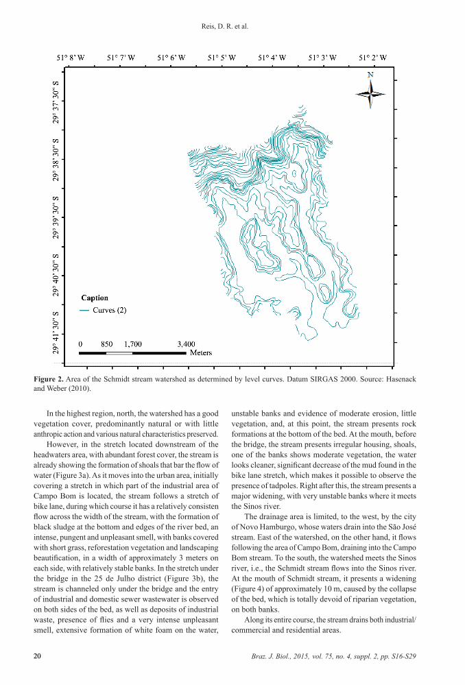
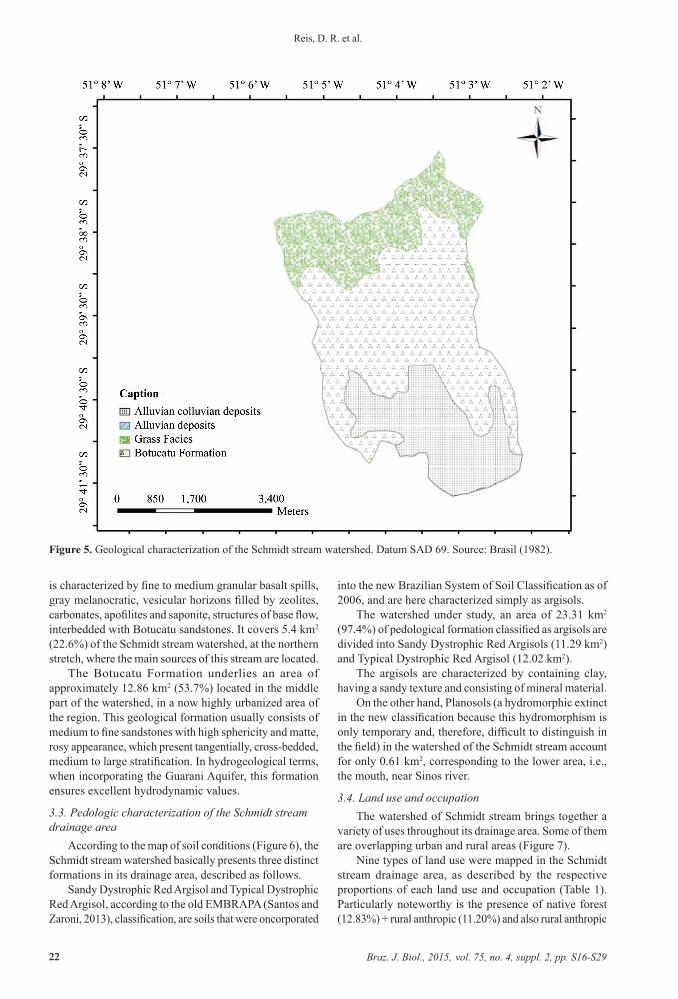
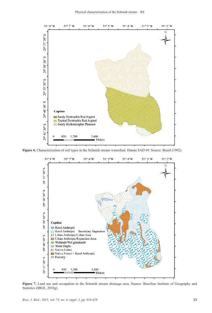
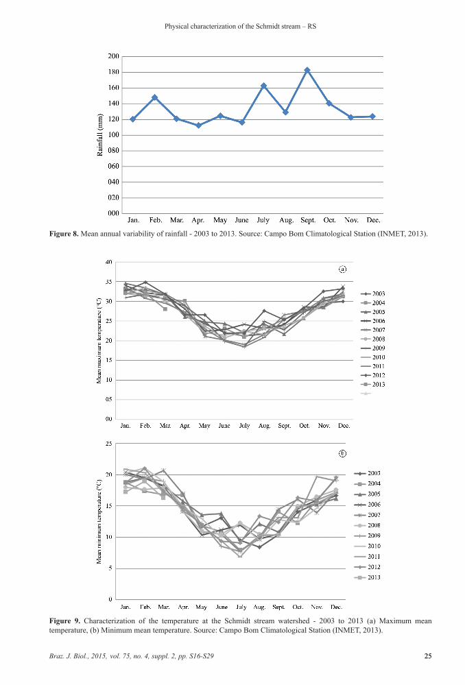