phase i environmental site assessment * undeveloped
TRANSCRIPT

CERES
Prospect Estates II, LLC
PHASE IENVIRONMENTAL SITE ASSESSMENT *
Undeveloped Property8600 Prospect Avenue
Santee, California
CERES, Corp.
4617 CALAVO DRIVELA MESA, CALIFORNIA 91941Phone (800) 258-1490
* Based on guidelines designated in ASTM E 1527-13 for the Phase I Environmental Site Assessment Process

CERES
To the user:
This Phase I Environmental Site Assessment (ESA) report is designed by CERES and is based onthe Standard Practice for Environmental Site Assessments: Phase I Environmental Site AssessmentProcess developed by the American Society for Testing and Materials (ASTM) Committee E-50 onEnvironmental Assessment, designated E 1527-13. The purpose of E 1527-13 is to define goodcommercial and customary practice in the United States of America for conducting an ESA of aparcel of commercial real estate with respect to the range of contaminants within the scope ofComprehensive Environmental Response, Compensation and Liability Act (CERCLA) andpetroleum products. As such, this practice is intended to permit a user to satisfy one of therequirements to qualify for the innocent landowner, contiguous property owner, or bona fideprospective purchaser limitations on CERCLA liability; that is, the practices that constitute “allappropriate inquiry into the previous ownership and uses of the property consistent with goodcommercial or customary practice” as defined in 42 USC Section 9601(35)(B). An evaluation ofbusiness environmental risk associated with a parcel of commercial real estate may necessitateinvestigation beyond that identified in this practice (ASTM E 1527-13, Section 1.1).
We declare that, to the best of our professional knowledge and belief, we meet the definition ofEnvironmental Professional as defined in Section 312.10 of 40 CFR 312 and we have the specificqualifications based on education, training, and experience to assess a property of the nature, history,and setting of the subject property. Unless otherwise indicated herein, we have developed andperformed the all appropriate inquiries in conformance with the standards and practices set forth in40 CFR Part 312 (ASTM E 1527-13, Sections 12.13.1 and 12.13.2). Qualifications of theindividuals who prepared this report are included in Appendix A - Professional Qualifications(ASTM E 1527-13, Section 12.14).
CERES
COVER: View of the Property looking northeastward from across Prospect Avenue

CERES
Prepared for:
Prospect Estates II, LLC110 Town Center ParkwaySantee, California 92071
PHASE I ENVIRONMENTAL SITE ASSESSMENTUndeveloped Property8600 Prospect AvenueSantee, California
Project C415-01
Prepared by:
______________________________
Scott W. GreenSenior Environmental Specialist
Reviewed by:
_______________________________Jeffrey B. Fleming, REPA #994321President
(E 1527-13, Section 12.12)
CERES, Corp.
4617 Calavo DriveLa Mesa, California 91941(800) 258-1490 / Fax (208) 765-1745
September 28, 2016

CERES
TABLE OF CONTENTS
Page
1.0 SUMMARY, CONCLUSIONS, AND RECOMMENDATIONS . . . . . . . . . . . . . 1
2.0 PHYSICAL SETTING . . . . . . . . . . . . . . . . . . . . . . . . . . . . . . . . . . . . . . . . . . . . . . . 22.1 UNITED STATES GEOLOGICAL SURVEY (USGS) MAP REVIEW2.2 PROPERTY ENVIRONMENTAL CONDITIONS
3.0 PROPERTY RECONNAISSANCE . . . . . . . . . . . . . . . . . . . . . . . . . . . . . . . . . . . . . 33.1 PROPERTY AND ADJOINING SITES DESCRIPTION3.2 HAZARDOUS MATERIALS
4.0 INTERVIEWS AND DATABASE REVIEW . . . . . . . . . . . . . . . . . . . . . . . . . . . . . 54.1 INTERVIEWS4.2 ENVIRONMENTAL DATABASE REVIEW
5.0 HISTORICAL REVIEW . . . . . . . . . . . . . . . . . . . . . . . . . . . . . . . . . . . . . . . . . . . . . 75.1 HISTORICAL AERIAL PHOTOGRAPHS AND TOPOGRAPHIC MAP5.2 BUILDING DEPARTMENT RECORDS5.3 ADDITIONAL HISTORICAL SOURCES5.4 SUMMARY OF HISTORICAL USE
6.0 LIMITATIONS . . . . . . . . . . . . . . . . . . . . . . . . . . . . . . . . . . . . . . . . . . . . . . . . . . . . 11
7.0 PROPERTY PHOTOGRAPHS . . . . . . . . . . . . . . . . . . . . . . . . . . . . . . . . . . . . . . . 12
FIGURES
Figure 1 - Property Location MapsFigure 2 - Property Map
APPENDICES
Appendix A - Professional QualificationsAppendix B - Additional RecordsAppendix C - Environmental Database Report

CERES
CERES, Corp. Project C415-01Prospect Estates II, LLC (Santee, CA) September 28, 20161
1.0 SUMMARY, CONCLUSIONS, AND RECOMMENDATIONS
At the request of Prospect Estates II, LLC, CERES, Corp., (CERES) completed a Phase IEnvironmental Site Assessment (ESA) of an undeveloped property located at 8600 Prospect Avenuewithin the city limits of Santee, San Diego County, California (Property) (refer to Figure 1 - PropertyLocation Maps). The Phase I ESA included: a Property and adjoining sites reconnaissance;interviews with informed persons; reviews of public records, historical topographic maps, aerialphotographs, and an environmental database report.
The reported 3.54-acre Property is located on the north side of Prospect Avenue, and about halfwaybetween Fanita Drive to the east and Mesa Road to the west. The Property has been assignedAssessor’s Parcel Number 383-112-55-00 and is owned by Prospect Estates II, LLC. The Propertyis undeveloped and at the time of the Property reconnaissance was mostly covered in grasses andweeds. Other notable features of the Property included a rough graded area in the approximatecenter of the Property and stockpiled soil located in the southeast portion of the Property (refer toFigure 2 - Property Map).
The Property appeared to have been used as a plant nursery from before 1953 to approximately thelate 1960s. This past use does not represent a significant environmental concern. Although smallunderground storage tanks/aboveground storage tanks (USTs/ASTs) for storing oil and/or diesel fuelare generally characteristic of past nursery use, CERES did not find documentation that wouldsuggest these features were present at the Property. Also, an historical aerial image indicated thatsubstantial grading/reworking of the Property had occurred in 2003 (presumably for an intendeddevelopment by Saint George Antiochian Orthodox Church). This activity would have likelyunearthed such features. It is CERES’ opinion that minor releases of hazardous materials/wastes thatmay have occurred during the past use of the Property as a nursery, if any, likely represent adispersed and de minimis condition to the Property subsurface. If “hot spots” are found during futureconstruction grading activities, mitigation should not be a costly endeavor.
CERES has performed a Phase I ESA in conformance with the scope and limitations of ASTM E1527-13 of the Property and to the limitations provided in Section 6.0 of this report. Any exceptionsto, or deletions from, this practice, if any, are described herein. This assessment has revealed noevidence of recognized environmental conditions (including historical and other controlled) inconnection with the Property (E 1527-13, Section 12.8.2). Based on the findings of this assessment,CERES does not recommend additional assessment at this time (E 1527-13, Sections 12.5. and 12.6).

CERES
CERES, Corp. Project C415-01Prospect Estates II, LLC (Santee, CA) September 28, 20162
2.0 PHYSICAL SETTING
2.1 UNITED STATES GEOLOGICAL SURVEY (USGS) MAP REVIEW (E 1527-13,Section 8.2.4)
The elevation of the Property ranges from approximately 355 to 370 feet above mean sea level(amsl). The immediate surrounding area of the Property generally slopes northward at a gradient of7.0 x 10 feet per foot. The nearest surface water is the San Diego River located approximately-2
1,500 feet north of the Property (United States Geological Survey [USGS], 1967, La MesaQuadrangle, California - San Diego County, 7.5 Minute Series (Topographic); photorevised 1975,scale 1:24,000).
2.2 PROPERTY ENVIRONMENTAL CONDITIONS (E 1527-13, Section 9.4.1.6)
3The Property is underlain by Mesozoic-age granitic rocks (gr ) characterized as light- to dark-coloredbiotite granite with abundant coarse pink to gray feldspar and biotite (California Division of Minesand Geology, 1992, Geologic Map of California, San Diego-El Centro Sheet). Soil underlying theProperty is described as Diablo clay, 2 to 9 percent slopes (DaC). This gently to moderately slopingsoil is 34 to 40 inches deep over rock. DaC has slow to medium runoff and its erosion hazard isslight to moderate. The Diablo series consists of well drained, moderately deep to deep clays derivedfrom soft calcareous sandstone and shale (United States Department of Agriculture, SoilConservation Service and Forest Service, 1973, Soil Survey, San Diego Area, California).
Depth to groundwater beneath the Property was not found. Groundwater reportedly ranged from13.97 to 14.98 feet below ground surface as measured from eleven groundwater monitoring wellsplaced at a gasoline station located about 3,000 feet northeast of the Property. These measurementswere made on November 5 and 6, 2015 (EnviroApplications, Inc., February 23, 2016, COD Gas &Oil Groundwater Monitoring Report, 9035 Mission Gorge Road, Santee, CA 92071). Groundwaterflow direction from this site was reported to be northwestward. Based on an interpretation ofelevation contours, groundwater is expected to flow approximately northward beneath the Property.
The Property is located in the Santee Hydrologic Subarea of the Lower San Diego Hydrologic Areaof the San Diego Hydrologic Unit of the San Diego Basin Planning Area (907.12). Groundwater inthe El Cajon Hydrologic Subarea is beneficial for municipal, agricultural, and industrialsupply/process uses (California Regional Water Quality Control Board, 1994, Water Quality ControlPlan for the San Diego Basin (9)).

CERES
CERES, Corp. Project C415-01Prospect Estates II, LLC (Santee, CA) September 28, 20163
3.0 PROPERTY RECONNAISSANCE
3.1 PROPERTY AND ADJOINING SITES DESCRIPTION
An unaccompanied walking reconnaissance of the Property was made by Mr. Scott Green onSeptember 23, 2016. Environmental irregularities, problems, and concerns, if noted, were markedon a map drawn by CERES in the field (E 1527-13, Section 9.2.3). The Property was observed forevidence of hazardous substances that may affect the environmental quality of the Property. CERESobserved the Property for evidence of aboveground and underground storage tanks (ASTs andUSTs), surface staining, hazardous materials, suspected polychlorinated biphenyls (PCBs)-containing devices, asbestos-containing building materials (ACBMs), and other indications ofenvironmental concern.
The reported 3.54-acre undeveloped Property is mostly overgrown with grasses and weeds. Aroughly graded area was observed in the approximate center of the Property. This area did notappear to have been graded recently. Stockpiled soil was located in the southeast portion of theProperty, near Prospect Avenue. Concrete conduits and what appeared to three storm drains wereobserved near the northwestern Property corner. Refer to Figure 2 and Photographs 1 through 10in Section 7.0 - Property Photographs (E 1527-13, Section 9).
POTABLE WATER (E 1527-13, Section 9.4.1.9)
Potable water is not currently provided to the Property. Padre Dam Municipal Water District willlikely be the supplier after development.
HEATING AND COOLING (E 1527-13, Section 9.4.3.1)
Heating and cooling energy is not currently provided to the Property. San Diego Gas and Electric(SDG&E) will likely be the source of heating, ventilation and air conditioning energy afterdevelopment.
SEWAGE DISPOSAL SYSTEM (E 1527-13, Sections 9.4.1.10 and 9.4.4.7)
Sewage disposal for the Property is not currently provided to the Property. Padre Dam MunicipalWater District’s municipal sewer system will likely provide this service after development.Evidence of septic systems and cesspools was not found.
INTERIOR--STAINS, CORROSION, DRAINS, AND SUMPS (E 1527-13, Sections 9.4.3.2 and9.4.3.3)
Interior areas are not present at the Property.

CERES
CERES, Corp. Project C415-01Prospect Estates II, LLC (Santee, CA) September 28, 20164
EXTERIOR–PITS, PONDS, LAGOONS, SURFACE STAINING, STRESSED VEGETATION, ANDWELLS (E 1527-13, Sections 9.4.4.1, 9.4.4.2, 9.4.4.3, and 9.4.4.6)
Pits, ponds, lagoons, significant surface staining, stressed vegetation, and wells were not observedon the Property.
SOLID WASTE AND WASTE WATER (E 1527-13, Sections 9.4.4.4 and 9.4.4.5).
Other than small quantities of discarded trash, solid waste and waste water were not observed on theProperty.
CURRENT AND PAST USES OF ADJOINING SITES AND SURROUNDING AREA (E 1527-13,Sections 9.4.1.3, 9.4.1.4, and 9.4.1.5)
A single-family residence (and associated outbuildings) on a large lot adjoins the northern Propertyborder. Single-family residences on small lots adjoin the Property to the south, across ProspectAvenue. Three single-family residences and a large undeveloped parcel of land adjoin the Propertyto the east. Mission Gorge Villa Mobile Home Park adjoins the Property to the west, across whatappeared to be an abandoned section of Marrokal Lane. The immediate surrounding area of theProperty is dominated by residential uses.
3.2 HAZARDOUS MATERIALS
HAZARDOUS MATERIALS (E 1527-13, Sections 9.4.2.3, 9.4.2.8 and 9.4.2.9)
Evidence of hazardous materials was not observed at the Property.
STORAGE TANKS (E 1527-13, Section 9.4.2.4)
Evidence of USTs, ASTs, clarifiers, and other hazardous materials storage tanks was not observedduring the Property reconnaissance.
ODORS, POOLS OF LIQUID, DRUMS (E 1527-13, Sections 9.4.2.5, 9.4.2.6 and 9.4.2.7)
Evidence of unusual odors, pools of liquid, or drums was not observed during the Propertyreconnaissance. POLYCHLORINATED BIPHENYLS (PCBs) (E 1527-13, Section 9.4.2.10)
PCBs were not observed at the Property.
ASBESTOS (E 1527-13, Section 13.1.5.1)
Suspect ACBMs were not observed at the Property.

CERES
CERES, Corp. Project C415-01Prospect Estates II, LLC (Santee, CA) September 28, 20165
4.0 INTERVIEWS AND DATABASE REVIEW
4.1 INTERVIEWS
P CERES interviewed Mr. Michael Grant, Managing Member of Prospect Estates, LLC, forinformation regarding past uses of the Property and the use, storage, or disposal of hazardousmaterials on the Property. Mr. Grant indicated that to the best of his knowledge, there hasnot been previous development of the Property. An old groundwater well was present on theProperty but has since been abandoned. He did not believe a septic system or USTs haveever been present on the Property. Mr. Grant was not aware of issues relating to the releaseof hazardous materials/wastes at the Property (E 1527-13, Section 10).
P Mr. Grant completed a User Questionnaire (UQ) provided by CERES. He indicated hisfamiliarity with the Property but did not indicate environmental issues regarding the Propertyon the UQ. Refer to Appendix B - Additional Records for a copy of the completed UQ (E1527-13, Section 10).
P CERES contacted the County of San Diego Department of Environmental Health (DEH)with a request to research UST and hazardous materials files for the Property address.According to Mr. Edwin C. Andrus of the DEH, records for the Property address were notfound (E 1527-13, Section 11).
All pertinent records may not have been available for this review. If a site is currently underlitigation, the file information will not be made available. In addition, some public records may befiled by information that was not given to CERES, i.e. incident date, and thus may not have beenaccessed.
4.2 ENVIRONMENTAL DATABASE REVIEW
CERES subcontracted the services of an environmental database search firm to provide a list of siteswithin designated distances of the Property that are listed by regulatory agencies as having potentialenvironmental concern (refer to Appendix C - Environmental Database Report). This is done toassess the potential for offsite contamination which may adversely affect the environmental qualityof the Property. A table is provided in Appendix C indicating referenced agency lists and thedistances from the Property for which searches are conducted (E 1527-13, Section 8.2.1.1).
The environmental database report was generated on September 16, 2016. Selected sites found onreferenced agency lists within the designated distances of the Property are discussed below. Siteswhich are listed as not requiring further action (NFA) or were deemed by CERES to be too distantto represent an environmental concern, are excluded from the discussion. Acronyms placed in boldletters, if any, refer to database lists and the bold number is the map identification number. TheProperty and its adjoining sites were not found on referenced agency lists. Sites with unauthorizedrelease cases (whether opened or closed) were not listed with 0.5 miles of the Property.

CERES
CERES, Corp. Project C415-01Prospect Estates II, LLC (Santee, CA) September 28, 20166
The nearest listed site to the Property is Terry Allen’s Auto Body, addressed 8665 Mission GorgeRoad, and located 0.231 miles north-northeast of the Property. This facility is listed on HAZNETfor generating 0.2293 tons of paint sludge in 1993. Santee Limited Volume Transfer Operation, nearthe Mission Gorge Road and Highway 52/125 intersection, is listed on SWF/LF as a closed transferstation located 0.342 miles northeast of the Property. Based on distance and/or case status, the siteslisted in the database report are not considered by CERES to represent a significant environmentalconcern to the Property.
Munger Map Book, California-Alaska Oil and Gas Fields, 1994, is a compilation of maps producedby the State of California Department of Natural Resources - Division of Oil and Gas, Oil Operators,Munger Oilogram, and other journals of present or past drilling locations for oil and gas exploration.CERES reviewed the map book to assess if oil wells were located on the Property. Wells were notdepicted on the Property or on its adjoining sites.

CERES
CERES, Corp. Project C415-01Prospect Estates II, LLC (Santee, CA) September 28, 20167
5.0 HISTORICAL REVIEW
5.1 HISTORICAL AERIAL PHOTOGRAPHS AND TOPOGRAPHIC MAP
Historical aerial photographs were reviewed by CERES using an Abrams Instrument Corporationstereoscope, model CB-1, with a built-in 2-power magnifier, and 4-power binoculars. Duringreview, CERES looked for evidence of hazardous materials and features that might affect theenvironmental quality of the Property, such as sumps, pits, ponds, lagoons, ASTs, landfills, outsidestorage of hazardous materials, and general land use (E 1527-13, Section 8.3.4.1).
This review has been supplemented by geographic place names and other data obtained in otherassessment activities of this ESA. Thirteen single aerial photographs, two stereoscopic aerialphotographs, and one topographic map were reviewed as follows.
SOURCE YEAR/DATE PRINTED SCALE MEDIUM
County of San Diego 1928 1 inch equals 1,000 feet Stereoscopic Aerial Photographs
historicaerials.com 1953 not printed Single Aerial Photograph
CERES Archives (XI-
SD-12-40/41)
March 4, 1958 1 inch equal 3,250 feet Stereoscopic Aerial Photographs
historicaerials.com 1964 not printed Single Aerial Photograph
historicaerials.com 1966 not printed Single Aerial Photograph
historicaerials.com 1968 not printed Single Aerial Photograph
historicaerials.com 1971 not printed Single Aerial Photograph
historicaerials.com 1980 not printed Single Aerial Photograph
historicaerials.com 1989 not printed Single Aerial Photograph
Google Earth October 1, 1995 not printed Single Aerial Photograph
Google Earth June 27, 2002 not printed Single Aerial Photograph
Google Earth March 10, 2003 not printed Single Aerial Photograph
Google Earth May 15, 2005 not printed Single Aerial Photograph
Google Earth January 31, 2008 not printed Single Aerial Photograph
Google Earth November 13, 2013 not printed Single Aerial Photograph
United States
Geological Survey
1967, Photorevised
1975
1 inch equals 2,000 feet La Mesa Quadrangle
Topographic Map

CERES
CERES, Corp. Project C415-01Prospect Estates II, LLC (Santee, CA) September 28, 20168
Aerial Photographs
1928 - The Property and its adjoining sites were cleared of natural vegetation and appeared to befallow agricultural land. Prospect Avenue was present along the southern Property borderand appeared to be unpaved.
1953 - The Property appeared to be developed with a small structure located near Prospect Avenue.What appeared to be about two dozen greenhouses and numerous planter boxes characterizedmost of the rest of the Property. Thus, the Property appeared to be used as a plant nursery.Except for one single-family residence, the area adjoining the Property to the north wasundeveloped land. What appeared to be a couple of single-family residences adjoined theProperty to the south, across Prospect Avenue. A house or small commercial buildingadjoined the southeast portion of the Property. A large area adjoining the Property to the eastwas an undeveloped field. A large undeveloped field adjoined the Property to the west,across unpaved Marrokal Lane.
1958 - Although difficult to discern due to scale, the Property appeared to be developed with thesmall structure observed in the 1953 photograph, and a small warehouse-type structurelocated near the southwest corner of Property. Greenhouses and planters appeared to bepresent as well. Significant discernible changes to the Property’s adjoining sites were notobserved from what was noted in the 1953 photograph.
1964 - Significant discernible changes to the Property were not observed from what was noted inthe 1958 photographs. The adjoining site to the north was in residential use on a large lot.What appeared to be existing single-family residences adjoined the southeast portion of theProperty. Additional single-family residences were apparent south of the Property, acrossProspect Avenue. Except for a few unidentified features, the adjoining area to the west,across unpaved Marrokal Lane, was an undeveloped field.
1966 - Mission Gorge Villa Mobile Home Park adjoined the Property to the west, across MarrokalLane. Significant discernible changes to the Property and its other adjoining sites were notobserved from what was noted in the 1964 photograph.
1968 - Significant discernible changes to the Property and its adjoining sites were not observed fromwhat was noted in the 1966 photograph.
1971 - The Property was developed with the two structures noted in previous photographs.Greenhouses and planters had been removed. The Property did not appear to be in use.Additional single-family residences were apparent south of the Property, across ProspectAvenue. Significant discernible changes to the Property’s other adjoining sites were notobserved from what was noted in the 1966 photograph.
1980- The Property was developed with the smaller structure observed in previous photographs.The warehouse-style structure had been removed. The area of the Property between theProperty structure and the adjoining residences near the southeast portion of the Property,appeared to have been cleared of vegetation and an open-air enclosure was apparent. The

CERES
CERES, Corp. Project C415-01Prospect Estates II, LLC (Santee, CA) September 28, 20169
use of this portion of the Property was not apparent. Significant discernible changes to theProperty’s adjoining sites were not observed from what was noted in the 1971 photograph.
1989 - The Property was mostly covered in grasses and weeds and did not appear to be in use. Thesmall structure was apparent but the suspect Property enclosure observed in the 1980photograph was not apparent. A baseball field adjoined the Property to the east. Significantdiscernible changes to the Property’s other adjoining sites were not observed from what wasnoted in the 1980 photograph.
1995 - Significant discernible changes to the Property and its adjoining sites were not observed fromwhat was noted in the 1989 photograph.
2002 - Significant discernible changes to the Property and its adjoining sites were not observed fromwhat was noted in the 1995 photograph.
2003 - The Property was undergoing extensive clearing and grading activities, including MarrokalLane along the western Property border. Construction equipment was apparent. Thenortheasternmost portion of the Property was not affected by these activities. Significantdiscernible changes to the Property and its adjoining sites were not observed from what wasnoted in the 2002 photograph.
2005 - The Property was undeveloped and mostly bare of vegetation. The result of the clearing andgrading in 2003 was apparent. The baseball field adjoining the Property to the east appearedto have been abandoned. Significant discernible changes to the Property’s other adjoiningsites were not observed from what was noted in the 2003 photograph.
2008 - Grasses and weeds covered the undeveloped Property. A few newer homes had beenconstructed on the adjoining residential area to the south, across Prospect Avenue.Significant discernible changes to the Property’s other adjoining sites were not observedfrom what was noted in the 2005 photograph.
2013 - Significant discernible changes to the Property and its adjoining sites were not observed fromwhat was noted in the 2008 photograph.
Topographic Map (E 1527-13, Section 8.3.4.5)
CERES reviewed La Mesa Quadrangle, California - San Diego County, 7.5 Minute Series(Topographic) map printed at a scale of one inch equals 2,000 feet (USGS, 1967, photorevised1975). This map depicts features from 1967 and 1975 as photorevisions, as follows:
1967 - The Property was depicted with two small structures located near its southwesternmostcorner. A single small structure was depicted on the adjoining site to the north and threesmall structures were depicted on the adjoining site to the east. Two small structures weredepicted on the adjoining site to the south, across Prospect Avenue. The adjoining area tothe west, across Marrokal Lane, was labeled “trailer park”.

CERES
CERES, Corp. Project C415-01Prospect Estates II, LLC (Santee, CA) September 28, 201610
1975 - Photorevised features were not depicted on the Property or on its adjoining sites. 5.2 BUILDING DEPARTMENT RECORDS
CERES requested a review of building department records for the Property at the City of SanteeBuilding Department. Building permits indicating previous use and occupants of the Property werefound as follows:
YEAR DOCUMENT
1991 Conditional use permit issued to Saint George Antiochian Orthodox Church
2003 Expired permit applications by Saint George Antiochian Orthodox Church for the constructionof a church building
Information regarding uses of the Property prior to 1991, was not found at the City of SanteeBuilding Department (E 1527-13, Section 8.3.4.7).
5.3 ADDITIONAL HISTORICAL SOURCES
The aforementioned sources of historical information provided historical information of the Propertyuse pursuant to Section 8.3 of E 1527-13; thus, additional information and reports were not reviewedfor this ESA.
5.4 SUMMARY OF HISTORICAL USE
The Property was undeveloped and possibly fallow agricultural land in 1928. From as early as 1953to 1968, the Property appeared to be used as a plant nursery. The nursery appeared to have beenclosed by 1971, as greenhouses and planters observed in earlier aerial photographs were notapparent. However, two structures associated with the nursery remained in 1971. The Property didnot have a discernible use in this year and in 1980, when only one structure remained on theProperty. This condition remained until 2003, when in an aerial photograph collected in this yearrevealed the Property was undergoing extensive clearing and grading activities. City of SanteeBuilding Department records indicated that Saint George Antiochian Orthodox Church intended toconstruct a church at that time. The northeasternmost portion of the Property was not affected bythese activities. The Property remained undeveloped after the grading. Reasonably ascertainablehistorical information dated prior to 1928, was not found during the assessment activities of thisPhase I ESA (E 1527-13, Section 8.3.2).
CERES
CERES, Corp. Project C415-01Prospect Estates II, LLC (Santee, CA) September 28, 201611
6.0 LIMITATIONS
The scope of work described herein is designed to meet the minimum requirements of ASTMdocument E 1527-13. However, it is not intended to be all inclusive, identify all potential concerns,or eliminate the possibility of the Property having some degree of environmental problems. It ispossible that variations in soil or groundwater conditions or unpermitted, undocumented, orconcealed improvements or alterations to the Property could exist beyond what was found duringthis ESA. Changes in observed conditions could also occur in the future due to variations inenvironmental and physical conditions.
Any geologic and hydrogeologic data are gathered for drawing conclusions, by CERES, within thecontext and timing of this report only.
No ESA can wholly eliminate uncertainty regarding the potential for recognized environmentalconditions in connection with a property. Performance of Practice E 1527-13 is intended to reduce,but not eliminate, uncertainty regarding the potential for recognized environmental conditions inconnection with a property, and this practice recognizes reasonable limits of time and cost (E 1527-13, Section 4.5.1).
All appropriate inquiry does not mean an exhaustive assessment of a clean property. There is a pointat which the cost of information obtained or the time required to gather it outweighs the usefulnessof the information and, in fact, may be a material detriment to the orderly completion of transactions.One of the purposes of E 1527-13 is to identify a balance between the competing goals of limitingthe costs and time demands inherent in performing an ESA and the reduction of uncertainty aboutunknown conditions resulting from additional information (E 1527-13, Section 4.5.2). Not everyproperty will warrant the same level of assessment (E 1527-13, Section 4.5.3).
Much of the information on which the conclusions and recommendations of this ESA are basedcomes from data provided by others. CERES is not responsible for the accuracy or completenessof this information. CERES is not required to verify independently the information provided [fromothers] but may rely on information provided (E 1527-13, Section 7.5.2.1). Inaccurate data orinformation that was not found or made available to CERES may result in a modification of thepresented conclusions and recommendations.
REPORT USE
This report was prepared for the sole use and benefit of Prospect Estates II, LLC. This report is nota legal opinion and does not offer warranties or guarantees.
CERES would like to thank Prospect Estates II, LLC, for the opportunity to work on this project.We look forward to working together on future projects.

CERES, Corp. Project C415-01Prospect Estates II, LLC (Santee, CA) September 28, 201612
7.0 PROPERTY PHOTOGRAPHS

CERES, Corp. Project C415-01Prospect Estates II, LLC (Santee, CA) September 28, 2016
Photograph 1: View of the Property looking northeastward from across Prospect Avenue
Photograph 2: View of the western portion of the Property looking northward from near thesouthwesternmost Property corner
CERES, Corp. Project C415-01Prospect Estates II, LLC (Santee, CA) September 28, 2016
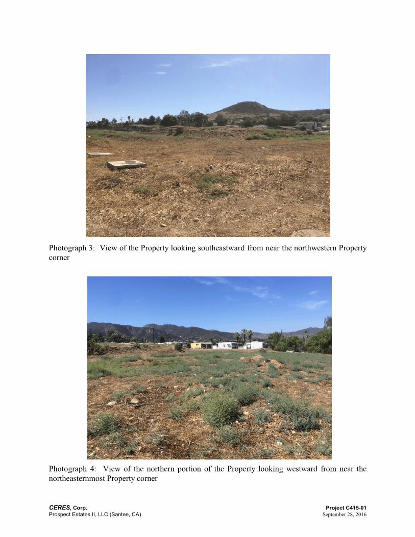
Photograph 3: View of the Property looking southeastward from near the northwestern Propertycorner
Photograph 4: View of the northern portion of the Property looking westward from near thenortheasternmost Property corner
CERES, Corp. Project C415-01Prospect Estates II, LLC (Santee, CA) September 28, 2016
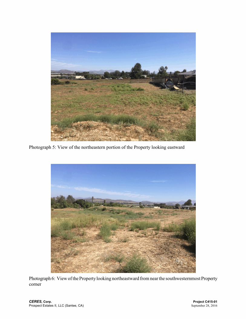
Photograph 5: View of the northeastern portion of the Property looking eastward
Photograph 6: View of the Property looking northeastward from near the southwesternmost Propertycorner

CERES, Corp. Project C415-01Prospect Estates II, LLC (Santee, CA) September 28, 2016
Photograph 7: View of the southern border area of the Property looking eastward from near thesouthwesternmost Property corner
Photograph 8: View of the central, roughly graded portion of the Property, looking northwestward

CERES, Corp. Project C415-01Prospect Estates II, LLC (Santee, CA) September 28, 2016
Photograph 9: View of concrete conduits near the northwestern Property corner
Photograph 10: View of stockpiled soil near Prospect Avenue

CERES, Corp. Project C415-01Prospect Estates II, LLC (Santee, CA) September 28, 2016
FIGURES

CERES, Corp. Project C415-01Prospect Estates II, LLC (Santee, CA) September 28, 2016

CERES, Corp. Project C415-01Prospect Estates II, LLC (Santee, CA) September 28, 2016

CERES, Corp. Project C415-01Prospect Estates II, LLC (Santee, CA) September 28, 2016
APPENDIX APROFESSIONAL QUALIFICATIONS

CERES, Corp. Project C415-01Prospect Estates II, LLC (Santee, CA) September 28, 2016
SCOTT W. GREEN
SENIOR ENVIRONMENTAL SPECIALIST
Education
Degree
Bachelor of Science, Environmental Science, University of California, Santa Barbara, California
Certification
OSHA, Hazardous Waste Operators and Emergency Response (HAZWOPER) Standard, 29 CFR1910.120(e) and 8 CCR 5192(e), Environmental Training and Compliance
Registration
State of Nevada, Certified Environmental Manager
Summary of Experience
Mr. Green has twenty-two years experience in conducting and managing environmentalinvestigations. His experience includes supervision of assessment and remediation projectsassociated with contaminated soil and groundwater sites, including underground storage tankremovals, groundwater and vadose zone well completions, and soil and groundwater qualityassessment and mitigation. He is experienced in interfacing with clients and regulatory agencies.Mr. Green is also experienced in conducting and managing Phase I, II, and III Environmental SiteAssessments (ESAs) and Transaction Screen Assessments (TSAs) for property transfers. He hasconducted these assessments and surveys at a large variety of sites, including commercial,residential, agricultural, and undeveloped properties throughout California, Arizona, and Nevada.

CERES, Corp. Project C415-01Prospect Estates II, LLC (Santee, CA) September 28, 2016
JEFFREY B. FLEMINGPRESIDENT/ENVIRONMENTAL SPECIALIST
Education
Degrees
Bachelor of Science, Physics/Scientific and Technical Communication, University of Washington,Seattle, Washington
Master of Arts, Physical Geography, San Diego State University, San Diego, California
Registrations
National Registry of Environmental Professions, Registered Environmental Property Assessor(REPA) #994321
Mr. Fleming was a State of California Registered Environmental Assessor (#7055) from 1997through 2012. The State of California discontinued this program in 2012.
Summary of ExperienceMr. Fleming has twenty-six years experience conducting and managing environmentalinvestigations, teaching environmental science, and managing environmental risk. Hisenvironmental work experience includes private consulting, County government, banking, andcollege-level instruction. He has conducted or managed Phase I, II, and III Environmental SiteAssessments (ESAs), Transaction Screens, Second Level Reviews, asbestos surveys, and lead-in-paint sampling. He has conducted these assessments and surveys at a large variety of sites, includingcommercial, residential, agricultural, and undeveloped properties. His fieldwork experience includesborehole drilling; underground storage tank removal; groundwater, surface water, soil, and soil vaporsampling; and geophysical surveys.
As an Environmental Resources Specialist III with the Orange County Environmental ManagementAgency, California, Mr. Fleming was tasked with the management of Phase I ESAs, conducted stormwater sampling and gauging, and assisted in the development of Best Management Practices in thecontrol of storm water runoff quality. As an Environmental Analyst with a major bank in the Stateof California, Mr. Fleming assessed and managed environmental risk associated with collateralizedloans and foreclosures. He was active in the supervision of Phase II assessments and Phase IIIcharacterization activities. His teaching experience at San Diego State University and the Universityof Wisconsin - Madison included undergraduate instruction in physiography, hydrology, andclimatology.

CERES, Corp. Project C415-01Prospect Estates II, LLC (Santee, CA) September 28, 2016
APPENDIX BADDITIONAL RECORDS

CERES, Corp. Project C415-01Prospect Estates II, LLC (Santee, CA) September 28, 2016
CERES, Corp. Project C415-01Prospect Estates II, LLC (Santee, CA) September 28, 2016
APPENDIX CENVIRONMENTAL DATABASE REPORT