modified phase i environmental site assessment
TRANSCRIPT

Modified Phase I Environmental Site Assessment
Trunk Highway 15 / 33rd Street South
(CSAH 74) Interchange
St. Cloud, Minnesota
State Project No. SP 7303-48
State Aid Project No. SAP 073-684-004,
SAP 073-674-002, SAP 162-151-002
SEH No. STCLD 123585
June 2013
Short Elliott Hendrickson Inc. | 3535 Vadnais Center Drive | Saint Paul, MN 55110-5196
SEH is an equal opportunity employer | www.sehinc.com | 651.490.2000 | 800.325.2055 | 888.908.8166 fax
June 10, 2013 RE: TH 15 / 33rd Street South Interchange Modified Phase I Environmental Site Assessment City of St. Cloud, Minnesota State Project No. SP 7303-48 State Aid Project No. SAP 073-684-004, SAP 073-674-002, SAP 162-151-002 SEH No. STCLD 123585
Mr. Steve Foss, PE City Engineer City of Saint Cloud 400 Second Street South St. Cloud, MN 56301 Dear Mr. Foss: Please find enclosed the Modified Phase I Environmental Site Assessment (ESA) for the Trunk Highway (TH) 15 and 33rd Street South (CSAH 84) Interchange project located at the intersection of TH 15 and 33rd Street South in St. Cloud, Minnesota. We have included a copy of the full report on CD. Please feel free to contact me directly at 651. 490. 2135 if you have any questions or comments. Sincerely, Allen H. Sunderman, PG Project Manager gca c: Bret Johnson - SEH Jeff Miller - Stearns County Claudia Dumont - MnDOT S:\PT\S\Stcld\123585\3-env-stdy-regs\14 Phase I ESA\STCLD 123585_Phase I ESA_20130220

TH 15 / 33rd Street South Interchange
Modified Phase I Environmental Site Assessment St. Cloud, Minnesota
State Project No. SP 7303-48 State Aid Project No. SAP 073-684-004,
SAP 073-674-002, SAP 162-151-002 SEH No. STCLD 123585
June 2013
__________________________________ Allen H. Sunderman, PG Project Manager __________________________________ Erin E. Borgschatz Environmental Geologist __________________________________ Greg Ahl Environmental Scientist Short Elliott Hendrickson Inc. 3535 Vadnais Center Drive Saint Paul, MN 55110-5196 651.490.2000

Distribution List
No. of Copies Sent to
1 Steve Foss City of St. Cloud 400 Second Street South St. Cloud, MN 56301 1 Jeff Miller Stearns County 705 Courthouse Square St. Cloud, MN 56303-4701
1 Claudia Dumont Minnesota Department of Transportation 395 John Ireland Boulevard Saint Paul, MN 55155
1 digital Carolyn Boben
MnDOT OES 395 John Ireland Boulevard Saint Paul, MN 55155

Modified Phase I Environmental Site Assessment STCLD 123585 City of Saint Cloud, Minnesota
Executive Summary
Short Elliott Hendrickson Inc. (SEH) performed a Modified Phase I Environmental Site Assessment of the TH 15 / 33rd Street South Interchange project in St. Cloud, Minnesota. This study identifies potential risk that site contaminants could be encountered during construction activities, or has the potential to migrate through the soil or groundwater from nearby sites to the project corridor. It does not measure the impacts at known or suspected contaminated sites. A “contaminated site” is defined as a location where a substance that creates a risk to human health or natural ecosystems has been released into the environment. The purpose of this modified Phase I ESA is to identify environmental concerns associated with the Trunk Highway (TH) 15 / 33rd Street South Interchange project (State Project No. SP 7303-48, State Aid Project No. SAP 073-684-004, SAP 073-674-002, SAP 162-151-002). Summary information and conclusions from this report may be used to develop contingency planning for environmental issues associated with construction planning and execution.
SEH followed MnDOT Office of Environmental Stewardship (OES) guidelines for completion of the Phase I ESA using a modified version of the American Society of Testing and Materials (ASTM) methodology E 1527-05. The purpose of the ASTM standard Phase I ESA is to identify, to the extent feasible pursuant to the processes described in E 1527-05 and in a manner consistent with good commercial or customary practice, Recognized Environmental Conditions (RECs) and Historic RECs (HRECs) in connection with the project corridor. Specifically, sites are identified as “high,” “medium,” and “low” risk sites.
Four (4) sites were identified for the project corridor; one high, and three medium risk sites. These are summarized below by site identification number (Site ID). A list of abbreviations is included, following this summary.
Site ID Site Name Rank Rationale for Ranking
1 Kellys Excavating Inc M Removed diesel UST and an AST observed on-site.
2 Finski Properties M Active diesel and gasoline AST’s observed on-site.
Mechanic shop observed on-site.
3 Ralph’s Car & Tractor Service H Vehicle maintenance and recycling facility.
RCRAGN SQG of used oil and residues/sludges. 4 Olmscheid Body Shop M Former body shop that transported hazardous waste.

Modified Phase I Environmental Site Assessment STCLD 123585 City of Saint Cloud, Minnesota
List of Abbreviations
AMSL Above Mean Sea Level
AST Above -ground Storage Tank
ASTM American Society for Testing and Materials
bgs Below Ground Surface
CERCLIS Comprehensive Environmental Response, Compensation and Liability Information System
CSAH County State Aid Highway
CWI County Well Index
DPLP De-listed Permanent List of Priorities
EPA (USEPA) Environmental Protection Agency (USEPA)
ERNS Emergency Response Notification System
ERS Environmental Record Search
ESA Environmental Site Assessment
FED BF Federal Brownfield
FED IC/EC Federal Institutional Controls and Engineering Controls
GIS Geographical Information System
LUST Leaking Underground Storage Tank
MDA Minnesota Department of Agriculture
MDH Minnesota Department of Health
MERLA Minnesota Environmental Response & Liability Act
MGS Minnesota Geological Survey
MN Minnesota
MnDOT Minnesota Department of Transportation
MPCA Minnesota Pollution Control Agency
NFRAP No Further Remedial Action Planned
NPL National Priority List
PLP Permanent List of Priorities
RCRA Resource Conservation and Recovery Act
RCRA COR ACT Resource Conservation and Recovery Act Corrective Action Report
RCRAGN Resource Conservation and Recovery Act Generators
RCRIS Resource Conservation and Recovery Information System
SEH Short Elliott Hendrickson Inc.
SQG Small Quantity Generator
SRS Site Remediation Section
SW Solid Waste
SWL Permitted Solid Waste Management Facilities
TH Trunk Highway
USGS United States Geological Survey
UST Underground Storage Tank
VIC Voluntary Investigation and Cleanup

SEH is a registered trademark of Short Elliott Hendrickson Inc. Modified Phase I Environmental Site Assessment STCLD 123585 Trunk Highway 15 / 33rd Street South (CSAH 74) Interchange Page i
Table of Contents
Transmittal Letter Certification Page Distribution Page Executive Summary List of Abbreviations Table of Contents
Page
1.0 Introduction ................................................................................................................1 1.1 Purpose ............................................................................................................... 1 1.2 Reason for Performing the Phase I ESA ............................................................ 1 1.3 Scope of Services ............................................................................................... 1 1.4 Significant Assumptions ...................................................................................... 3 1.5 Definitions ........................................................................................................... 3
1.5.1 American Society of Testing & Materials E1527-05 ................................ 3 1.5.2 Minnesota Department of Transportation ................................................ 3
1.6 Limitations and Exceptions ................................................................................. 4 1.7 Special Terms and Conditions ............................................................................ 4 1.8 User Reliance ..................................................................................................... 4
2.0 Site Description .........................................................................................................5 2.1 Location and Legal Description ........................................................................... 5 2.2 Current Use of the Project Corridor .................................................................... 5
2.2.1 Reconnaissance ...................................................................................... 5 2.3 Physical Setting .................................................................................................. 5
2.3.1 Topography ............................................................................................. 5 2.3.2 Geology ................................................................................................... 5 2.3.3 Hydrogeology .......................................................................................... 5
3.0 Historical Land Use Review ......................................................................................6 3.1 Sources ............................................................................................................... 6
3.1.1.1 Aerial photographs .................................................................. 6 3.1.1.2 Topographic Maps .................................................................. 6 3.1.1.3 Sanborn® Fire Insurance Maps ............................................... 6 3.1.1.4 City Directories ........................................................................ 6
3.2 Historical Land Use Summary ............................................................................ 6
4.0 Regulatory Database Review ....................................................................................7 4.1 MPCA Identified Sites ......................................................................................... 7
4.1.1 Tank Sites ............................................................................................... 7 4.1.2 RCRA Generator Sites ............................................................................ 7
5.0 Additional Records Review ......................................................................................7 5.1 Prior Assessments .............................................................................................. 7 5.2 Well Records Review .......................................................................................... 8
5.2.1 Wellhead Protection Areas ...................................................................... 8 5.3 Title Records, Environmental Liens, or Activity and Use Limitations .................. 8
Table of Contents (continued)
Modified Phase I Environmental Site Assessment STCLD 123585 City of Saint Cloud, Minnesota Page ii
5.4 Parcel-specific Information .................................................................................. 8 5.5 ERS Identified Sites ............................................................................................ 8
5.5.1 Additional ERS Database Listings ........................................................... 9 5.5.2 Occurrences Not Mapped ....................................................................... 9
5.6 Additional Environmental Record Sources ......................................................... 9
6.0 Interviews ...................................................................................................................9 6.1 Interview with Stearns County Environmental Services ...................................... 9 6.2 Interview with St. Cloud Fire Department ......................................................... 10 6.3 Interview with MnDOT ....................................................................................... 10
7.0 Findings and Opinions ............................................................................................10
8.0 Conclusions .............................................................................................................11
9.0 Significant Data Gaps ..............................................................................................11
10.0 Deviations .................................................................................................................11
11.0 Limitations and Standard of Care ..........................................................................11
12.0 References ...............................................................................................................13
List of Figures
Figure 1 Site Location Figure 2 Site Features
List of Appendices
Appendix A Site Specific Data Sheets Appendix B Aerial photographs Appendix C Topographic and Historic Maps Appendix D Water Well Data Appendix E Environmental Database Report

STCLD 123585 Page 1
Modified Phase I Environmental Site Assessment
Trunk Highway 15 / 33rd Street South (CSAH 74) Interchange
Prepared for the City of Saint Cloud, Minnesota, Stearns County and MnDOT
1.0 Introduction
Short Elliott Hendrickson Inc. (SEH®) was retained by the City of St. Cloud to conduct a Phase I Environmental Site Assessment (ESA) of the T.H. 15 / 33rd Street South Road Improvements located in the City of St. Cloud. The area of interest will herein be referred to as “site” or “project corridor” and includes everything within 500-feet of the proposed alignment’s centerline and 1250-feet from effected intersections. The site location and project corridor are depicted on Figure 1, “Site Location.” SEH identified sites within the project corridor with a numeric identification number which corresponds to the sites referenced in the report, tables, figures and data sheets. Figure 2, “Site Features” depicts sites identified during the completion of this assessment. This report summarizes the findings of the modified Phase I ESA.
1.1 Purpose
This modified Phase I ESA is being performed to identify Recognized Environmental Conditions (RECs) and Historic RECs (HRECs) associated with the TH 15 / 33rd Street South Interchange project corridor. Summary information and conclusions from this report may be used to develop contingency planning for the proposed improvements.
SEH followed MnDOT Office of Environmental Services (OES) guidelines for completion of the Phase I ESA using a modified version of the American Society of Testing and Materials (ASTM) methodology E 1527-05. The purpose of the Phase I ESA is to identify, to the extent feasible pursuant to the processes described in E 1527-05 and in a manner consistent with good commercial or customary practice, RECs and HRECs in connection with the project corridor. Specifically, sites are identified as “high,” “medium,” and “low” risk sites as defined in Section 1.5.2 of this report.
1.2 Reason for Performing the Phase I ESA
This modified Phase I ESA is being performed to identify environmental concerns, using the MnDOT OES guidelines (as defined in Section 1.5.2), in general accordance with the processes described in E 1527-05, and in a manner consistent with good commercial and customary practice. Please reference Section 10.0 regarding deviations from ASTM Standard E 1527-05.
1.3 Scope of Services
The standard Phase I ESA consists of the following four general tasks. Modifications to this standard are listed in Section 10.0.
Records Review – The purpose of the records review is to obtain and review reasonably ascertainable records from standard sources (including government records, physical setting sources, and historical use records) to assist in identifying RECs or HRECs in

Modified Phase I Environmental Site Assessment STCLD 123585 City of Saint Cloud, Minnesota Page 2
connection with the project corridor. Publicly-available federal, tribal, state, county and/or city records are reviewed as appropriate to determine if the property has had a history of spills, leaks, hazardous waste storage, regulatory compliance and improper waste disposal practices. Reasonably obtainable standard historical sources are reviewed as necessary to identify prior uses of the property from the time the property was first developed or 1940, whichever is earlier. Significant data gaps of greater than 5 years in property historical information are identified and discussed.
Reconnaissance – The objective of the reconnaissance is to observe the project corridor to obtain information indicating the likelihood of RECs or HRECs in connection with the project corridor. As part of the reconnaissance, SEH observes the property and any structures located on the property for indications of RECs or HRECs to the extent not obstructed by thick vegetation, bodies of water, stored materials or product, equipment, or other obstacles. Potential environmental concerns on the project corridor and observable environmental concerns on adjoining properties that relate to improper waste storage and disposal and hazardous materials are noted.
Interviews – The purpose of conducting interviews is to obtain information indicating RECs or HRECs in connection with the project corridor. Interviews of past and present owner/manager/occupant for individual properties are not required for this modified Phase I ESA.
Technical Report – SEH prepares the technical report summarizing the compiled information, and offers findings, opinions and conclusions based on the available data. Significant data gaps are identified and discussed in the report. RECs and/or HRECs, if any, identified during performance of the Phase I ESA are described in the report.
For the tasks listed above, records reviewed were limited to information that was publicly available, obtainable from its source within reasonable time and cost constraints, was practically reviewable, and determined by the environmental professional to be useful in evaluating the condition of the property.
The Phase I ESA was conducted in accordance with the Agreement between SEH and the City of St. Cloud. The Phase I ESA does not include testing or sampling of materials (for example, soil, water, air or building materials) or any of the other following non-scope considerations specified in Section 13.1.5 of ASTM E 1527-05:
1. Asbestos-containing materials;
2. Radon;
3. Lead-based paint;
4. Lead in drinking water;
5. Wetlands;
6. Regulatory compliance;
7. Cultural and historic resources;
8. Industrial hygiene;
9. Health and safety;
10. Ecological resources;
11. Endangered species;
12. Indoor air quality; or
13. High voltage power lines.

Modified Phase I Environmental Site Assessment STCLD 123585 City of Saint Cloud, Minnesota Page 3
1.4 Significant Assumptions
The following significant assumption has been incorporated into this report:
The local groundwater flow at the project corridor and in the vicinity of the project corridor is expected to be to the east towards the Mississippi River.
1.5 Definitions
Proposed Alignment – The area that includes proposed improvements on cross-streets, intersections, and roadways that may result from the TH 15 / 33rd Street South Interchange project.
Project Corridor – The area that includes the proposed alignment and a buffer area. The buffer area is everything within 500-feet of the proposed alignment’s centerlines, and 1250-feet from intersections in the project corridor.
1.5.1 American Society of Testing & Materials E1527-05
Recognized Environmental Condition (REC) - By ASTM definition, REC means “the presence or likely presence of any hazardous substances or petroleum products on a property under conditions that indicate an existing release, a past release, or a material threat of a release of any hazardous substances or petroleum products into structures on the property or into the ground, ground water, or surface water of the property. The term includes hazardous substances or petroleum products even under conditions in compliance with laws. The term is not intended to include de minimus conditions that generally do not present a material risk of harm to public health or the environment, and conditions that generally would not be the subject of an enforcement action if brought to the attention of appropriate governmental agencies.”
Historic REC (HREC) - The term HREC is defined by ASTM to mean “an environmental condition which would have been considered a REC in the past, but which may or may not be considered a REC currently.”
1.5.2 Minnesota Department of Transportation
The following definitions of “low,” “medium” and “high” environmental risk are standard categories utilized by MnDOT to rank sites within the project corridor.
Low Environmental Risk – Hazardous and/or petroleum substances are known or inferred to have been, or are being used, stored or generate on these sites; however, there appear to be “good housekeeping” practices conducted on the site. Good housekeeping practices are defined as proper handling and/or storage of hazardous or petroleum substances. There is also no record or evidence of spills, releases, surface contamination and/or subsurface contamination at the site.
Medium Environmental Risk – Hazardous substances are known or inferred to have been, or are being used, stored, or generated on these sites, and there appears to be “poor housekeeping” practices conducted at the site. Poor housekeeping practices are defined as improper handling and/or storage of hazardous or petroleum substances. All properties that have underground storage tanks (USTs) or above ground storage tanks (ASTs) and leaking underground storage tank (LUST) sites that have received closure from the Minnesota Pollution Control Agency (MPCA) and vehicle repair and maintenance facilities are also considered medium environmental risks.
High Environmental Risk – These are sites where hazardous and/or petroleum substances are known or inferred to have been, or are being used, stored, or generated, and there is a

Modified Phase I Environmental Site Assessment STCLD 123585 City of Saint Cloud, Minnesota Page 4
record or evidence that a spill, release, surface contamination and/or subsurface contamination has occurred. These sites include all active Voluntary Investigative and Cleanup (VIC), Minnesota Environmental Response & Liability Act (MERLA), active LUST sites and all active and inactive dump sites.
1.6 Limitations and Exceptions
This Phase I ESA is in general accordance with ASTM E 1527-05, but has been modified to fit the user’s project specific needs. Variations from the standard are listed in Section 9.0.
The reconnaissance of the project corridor was conducted under limited access conditions. SEH personnel made observations from public road right-of-ways, parking lots and other publicly-accessible properties. None of the buildings on the project corridor were inspected by SEH, as it was not within the scope of this Phase I ESA. Contaminant sources and/or environmentally hazardous materials/substances may potentially exist within any structure. Limiting conditions were also observed where topographic divides prevented observation of areas distant from public right-of-ways.
Due to winter climate at the time of reconnaissance, vegetation was dormant. Observations for stressed vegetation could not be made.
Observations of the ground surface were obstructed by snow cover at the time of reconnaissance.
1.7 Special Terms and Conditions
SEH performed a modified Phase I ESA in general accordance with ASTM E 1527-05 and the Agreement between SEH and the City of St. Cloud. Performance of the Phase I ESA in general accordance with ASTM E 1527-05 is intended to reduce, but not eliminate, uncertainty regarding the existence of RECs or HRECs in connection with the project corridor.
When reasonably ascertainable, data was obtained and reviewed; however, the accuracy of the collected data is not the responsibility of SEH. Information provided to SEH by client representatives and site contacts has been accepted in good faith and is assumed to be accurate unless written documentation, available within the scope of this Phase I ESA, or visual observations contradicted it.
The Phase I ESA is not a comprehensive site characterization and should not be construed as such. The findings and conclusions of the Phase I ESA are based on information collected and observed at the time of the Phase I ESA and are not scientific certainties, but probabilities based on professional judgment regarding the significance and accuracy of the collected data. Because professional judgments incorporated into the report are based on limited evidence, there is inherent uncertainty in the conclusions drawn and reported. The client has determined that the level of effort and corresponding degree of uncertainty are acceptable for the client’s purpose. The Phase I ESA may not include all environmental conditions that can materially impact the property and a finding of no RECs or HRECs is not a warranty or guarantee that a property remains free from contamination.
Laws and regulations, if referenced in this report, are provided for information purpose and should not be construed as legal opinion or recommendation.
1.8 User Reliance
The Phase I ESA and all reports, verbal and written, are solely for the use of the City of St. Cloud, Stearns County and Minnesota Department of Transportation (MnDOT). Any third party

Modified Phase I Environmental Site Assessment STCLD 123585 City of Saint Cloud, Minnesota Page 5
may have different interests, purposes, and motives than the City of St. Cloud, Stearns County and MnDOT with regard to this assessment and report. Any reliance on the Phase I ESA by any other party shall be at such party’s sole risk, unless that party has written authorization from SEH and the City of St. Cloud and is a party to the Agreement between SEH and the City of St. Cloud.
2.0 Site Description 2.1 Location and Legal Description
Figure 1 illustrates the extent of the project corridor for TH 15 / 33rd Street South. The project corridor is located in parts of St. Cloud and Waite Park, in Stearns County, Minnesota. The project corridor is located in Township 124N, Range 28W, Sections 28, 29, 32, and 33.
2.2 Current Use of the Project Corridor
The project corridor primarily contains commercial and residential properties with wooded areas and open grassland. The approximate boundary and site features are shown on Figure 2.
2.2.1 Reconnaissance
An SEH representative visited the site on March 6, 2013. During the reconnaissance, existing conditions were noted. Select photographs of the project corridor and significant observations are discussed in detail within site specific data sheets in Appendix A, “Site Specific Data Sheets.”
2.3 Physical Setting
SEH reviewed the physical setting of the project corridor from United States Geological Survey (USGS) 2010 and 1974 Saint Cloud, Minnesota, 7.5 minute quadrangle topographic map.
2.3.1 Topography
The project corridor and surrounding area is generally flat with an elevation of approximately 1090-1100 feet above mean sea level (amsl). A pond is located adjacent on the eastern side of TH 15 and north of 33rd Street South (USGS 2010). Marshy area is located in the central portion of the corridor. A quarry was located in the project corridor in the southern portion of the site (USGS 1974). Another quarry is located adjacent to the project corridor to the southeast (USGS 1974). Topography is depicted on Figure 1.
2.3.2 Geology
Surficial geology in the project corridor is characterized by outwash deposits and some igneous and metamorphic rocks. The outwash deposits include sand, gravelly sand, and cobbly gravel. The igneous and metamorphic include granite or schist at or near the land surface. (MGS 1995)
Bedrock geology in the vicinity of the project corridor west of TH 15 contains grayish-pink, coarse-grained, moderately trachytic hornblende-biotite granite. Bedrock geology in the vicinity of the project corridor east of TH15 contains gray to pinkish-gray, medium-grained, weakly porphyritic and trachytic hornblende-biotite granodiorite (MGS 1995). Bedrock is approximately less than 50 feet below the ground surface (bgs) throughout the project corridor. Bedrock outcrops also exist on the land surface in the project corridor (MGS 1995).
2.3.3 Hydrogeology
Based on local surface features and topography, groundwater in the vicinity of the project corridor is expected to flow east towards the Mississippi River. According to groundwater elevations recorded on well logs in the MDH CWI, groundwater is expected to be encountered between approximately 2-7 ft bgs.

Modified Phase I Environmental Site Assessment STCLD 123585 City of Saint Cloud, Minnesota Page 6
3.0 Historical Land Use Review A historical review was conducted to identify historical land uses in order to assess whether past uses may have impacted the project corridor. The historical review is completed by examining available historical topographic maps, plat maps, aerial photographs, Sanborn Fire Insurance Maps, and city directories. Available resources are identified in Section 3.1. The Historic Land Use Summary provided in Section 3.2 is a general overview of the project corridor history. Site specific historical summaries are presented in Appendix A.
3.1 Sources
The historical review was completed by examining available historical aerial photographs, topographic maps, city directories and conducting interviews (Section 6.0). Sanborn® Fire Insurance Maps were not available for the project.
3.1.1.1 Aerial photographs
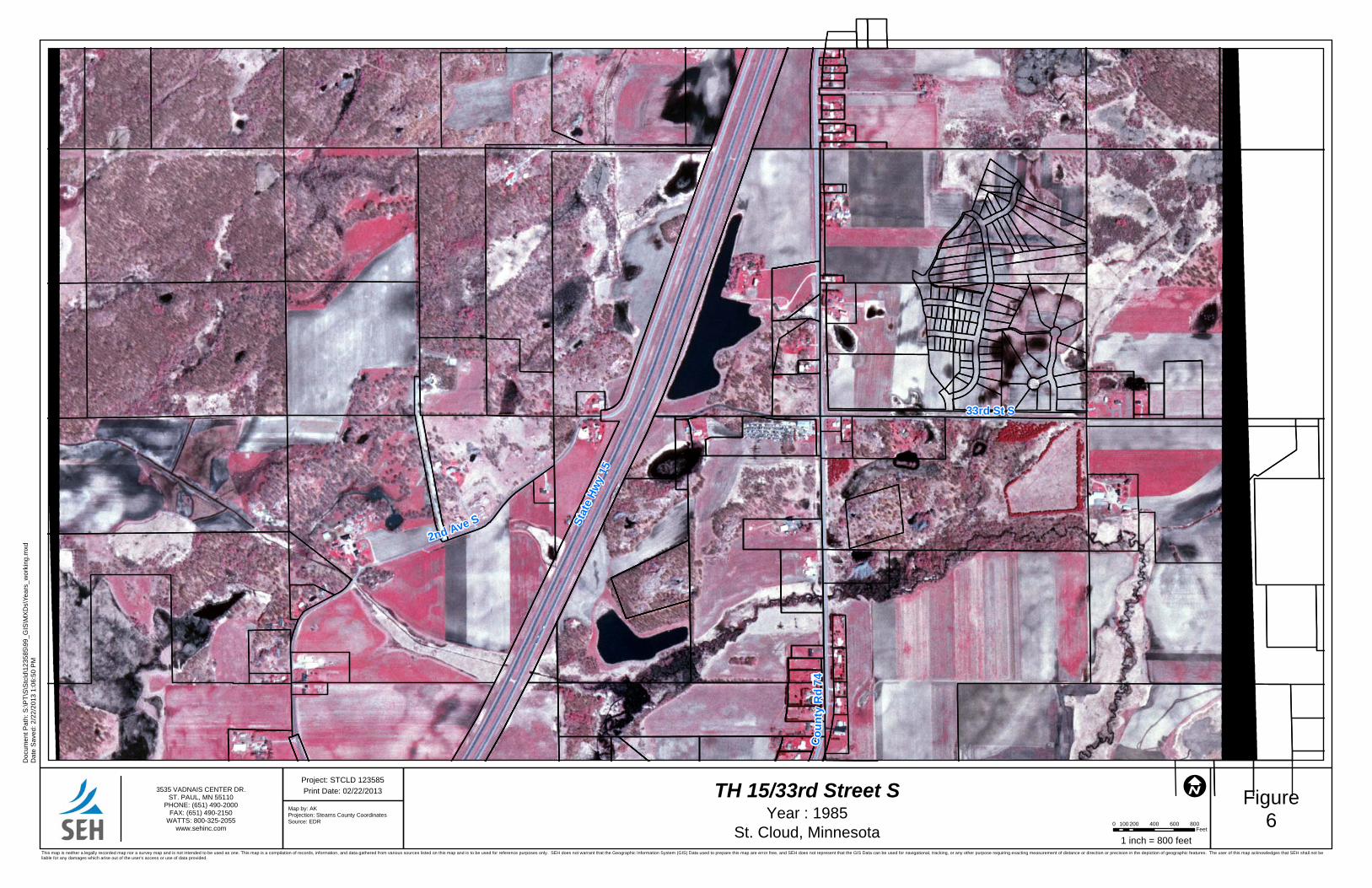
Reasonably ascertainable historic aerial photographs showing the project corridor and surrounding areas were obtained for review from the years 1938, 1951, 1958, 1965, 1977, 1985, 1991, 2003, and 2010. Due to the scale and quality of some of the photographs, it is difficult to determine minor activities that may have occurred on the project corridor. Copies of photographs reviewed are included as Appendix B, “Aerial Photographs.”
3.1.1.2 Topographic Maps
The United States Geological Survey (USGS), 1950, 1974, 1974 (Revised 1993), and 2010 “Saint Cloud, MN,” 7.5 Minute Series Topographic Maps were reviewed. Copies of topographic maps reviewed are included as Appendix C, “Topographic and Historic Maps.”
3.1.1.3 Sanborn® Fire Insurance Maps
Sanborn® Fire Insurance maps consist of a uniform series of large-scale detailed maps, dating from 1867 through 1969 and depict the commercial, industrial, and residential sections of urban areas. The maps were designed to assist fire insurance agents in determining the degree of hazard associated with a particular property. Sanborn® maps illustrate, in outline form, the size, shape, construction and building material of dwellings, commercial buildings, and factories. SEH retained ERS to provide the maps for the project. Sanborn® Fire Insurance maps were not available for the project corridor.
3.1.1.4 City Directories
City directories provide a means to investigate the past use of a site by reviewing information for a specific address in incorporated areas. City directories were not reviewed for this Phase I ESA.
3.2 Historical Land Use Summary
This section provides a general overview of the history of the project corridor. Site specific histories are detailed on data sheets provided as Appendix A.
The area that contains TH 15 and 33rd Street South was primarily used for agricultural purposes with scattered groves of trees from 1938 through sometime after 1977. TH 15 first appears in the 1985 historic aerial photograph with a pond existing in the northeast corner of TH 15 and 33rd Street South. Small businesses, farms, and residential areas are scattered throughout the project corridor since the 1938 historic aerial photograph. Grading activities are visible prior to sites being developed. Piles of cut stones are visible at several locations throughout the corridor which are still present today. According to interviews (Section 5.0), these stone piles were left from a nearby quarry operation.

Modified Phase I Environmental Site Assessment STCLD 123585 City of Saint Cloud, Minnesota Page 7
4.0 Regulatory Database Review SEH reviewed reasonably ascertainable records from standard sources such as publicly-available federal, tribal, state, county and/or city records as appropriate to assist in identifying environmental concerns in connection with the project corridor. Listings identified during the database review are summarized in this section and detailed on site specific data sheets provided as Appendix A.
4.1 MPCA Identified Sites
SEH used the MPCA “What’s in My Neighborhood” website, the EPA “Enviromapper” website, and associated databases as the primary source of environmental site information. Environmental information was downloaded directly from MPCA databases into a SEH database and Geographical Information System (GIS). MPCA site locations were field verified and locations were assigned to the correct property parcel if necessary. Four listings were identified within the project corridor.
4.1.1 Tank Sites
Two UST/AST sites are identified. Kellys Excavating Inc. has a removed UST. Finski Properties has two active ASTs on-site.
Site ID MPCA ID Site Name Status
1 18323 Kellys Excavating Inc UST (Removed)
2 124454 Finski Properties AST (Active)
4.1.2 RCRA Generator Sites
Two Resource Conservation and Recovery Act Generators (RCRAGN) listing were identified. The Ralph’s Car & Tractor Service site is active. The Olmscheid Body Shop site is a transporter of hazardous waste of and is active as of September 15, 2000. However, the property is currently occupied by a residence. The Ralph’s Car & Tractor Service site is active.
Site ID MPCA ID Site Name Status
3 MND023018997 Ralph’s Car & Tractor Service SQG (Active)
4 MND981527351 Olmscheid Body Shop Transporter
5.0 Additional Records Review SEH reviewed environmental record sources including the Minnesota Department of Agriculture (MDA) County Spill Records and “What’s in my Neighborhood” interactive mapping program, as well as the MPCA Petroleum Remediation Program (PRP) online maps. SEH also retained Environmental Record Search (ERS) to perform an electronic database search of documents published by Environmental Protection Agency (EPA) and the MPCA. Other information addressed in this section includes, prior assessments, well records, property liens and limitations, and parcel data. Listings identified during the database review are summarized in this section and detailed on site specific data sheets provided as Appendix A.
5.1 Prior Assessments
SEH reviewed the Limited Phase I Environmental Site Assessment for the 33rd Street South Corridor conducted in July 2007 for Stearns County by Bonestroo (Boonestroo, 2007). No additional sites were identified during the review of Bonestroo report.

Modified Phase I Environmental Site Assessment STCLD 123585 City of Saint Cloud, Minnesota Page 8
5.2 Well Records Review
A review of wells listed in the Minnesota Department of Health (MDH) County Well Index (CWI) was conducted. Six wells; five domestic and one fire protection well are located in the project corridor. Twenty seven unmapped wells have location descriptions which are too generic to determine if they are located within the project corridor.
Wells with mapped locations from the MDH CWI are depicted on Figure 2. A list of CWI wells located in the Township, Section, and Range for the project area can be viewed in Appendix D, “Well Data.”
5.2.1 Wellhead Protection Areas
According to MPCA PRP and MDH CWI online mapping programs, the project corridor does not fall within a wellhead protection area. One source water assessment area for EMR Innovations falls within the project corridor. No formal wellhead protection plan is being prepared for this area.
5.3 Title Records, Environmental Liens, or Activity and Use Limitations
SEH did not review title records or records pertaining to environmental liens against properties within the project corridor because it was beyond the scope of work for this modified Phase I ESA.
5.4 Parcel-specific Information
Parcel-specific information including property name, address and photos are included in the site specific data sheets in Appendix A. The parcels are outlined in Figure 2.
5.5 ERS Identified Sites
SEH retained ERS to perform an electronic database search of documents published by the EPA and the MPCA. The information searched by ERS includes sites with identified or potential contamination, facilities that generate hazardous wastes and sites that contain or have contained registered ASTs or USTs. SEH reviewed the document package provided by ERS to identify sites which are a potential concern for the project corridor.
A summary of all records retrieved by the search, the minimum search distances, and the date that source information was last updated is included in the search report in Appendix E, “Environmental Database Report.” The ERS database report did not include a comprehensive, exhaustive review of all records. The following federal and state databases were searched in preparing the database report:
National Priority List (NPL);
Comprehensive Environmental Response, Compensation, and Liability Information System (CERCLIS);
CERCLIS No Further Remedial Action Planned (NFRAP);
Resource Conservation and Recovery Act Corrective Action Report (RCRA COR ACT);
Resource Conservation and Recovery Information System (RCRIS)-Treatment, Storage, and Disposal (TSD) sites;
RCRA Large and Small Quantity Generator (RCRA GEN) sites;
Federal Institutional Controls and Engineering Controls (FED IC/EC);
Federal Brownfield (FED BF);
Emergency Response Notification System (ERNS);

Modified Phase I Environmental Site Assessment STCLD 123585 City of Saint Cloud, Minnesota Page 9
Tribal Lands: MnDOT database of Indian Reservations;
State/Tribal Sites: MPCA SUPERFUND Permanent List of Priorities (PLP) and De-listed Permanent List of Priorities (DPLP) sites;
State Spills-1980/1990;
Permitted Solid Waste Management Facilities (SWL);
Leaking Underground Storage Tank (LUST) site;
Registered Underground Storage Tank (UST) and Aboveground Storage Tank (AST) sites;
MPCA Voluntary Investigation and Cleanup (VIC) Program;
State Brownfields;
State/Tribal IC: Site Remediation Section (SRS) Subset ;
State Other: National Clandestine Laboratory Register; and
MPCA Superfund Permanent List of Priorities (PLP) sites and de-listed Permanent List of Priorities (DPLP) sites (OTHER).
5.5.1 Additional ERS Database Listings
One additional listing was identified during review of the ERS Environmental database report.
ERS ID Site Name Address Database
3 CSI Construction Co 4515 33rd Street S RCRA SQG
This RCRA small to minimal quantity generator (SQG) listing was identified to be located outside the project corridor and is not considered significant for the completion of the Phase I ESA. SEH did not identify any other sites in the ERS database report that were not included in the MPCA “What’s In My Neighborhood” database summary.
5.5.2 Occurrences Not Mapped
SEH reviewed the “Occurrences Not Mapped” section of the ERS report for identifiable sites within the project corridor. SEH determined that 44 unmapped occurrences were outside the project corridor or were not identifiable due to inaccurate address information. The unmapped occurrences are summarized in Appendix B.
5.6 Additional Environmental Record Sources
SEH reviewed additional environmental record sources, including the MDA County Spill Records and “What’s in my Neighborhood” interactive mapping program, as well as the MPCA “Petroleum Remediation Program Maps Online.” No additional sites were presented.
6.0 Interviews Interviews were conducted with persons familiar with the area to obtain information regarding the presence or possible presence of RECs or HRECs in connection with the proposed corridor.
6.1 Interview with Stearns County Environmental Services
SEH conducted an interview with Dave Knafla of Stearns County Environmental Services on March 14, 2013, Mr. Knafla indicated that there are granite quarries located near the project corridor, but have not been active since the 1960’s. The quarries have since filled with ground and surface water. Mr. Knafla also stated that the piles of cut stone slabs located in areas of the project corridor are leftover from the quarrying process.

Modified Phase I Environmental Site Assessment STCLD 123585 City of Saint Cloud, Minnesota Page 10
6.2 Interview with St. Cloud Fire Department
In an interview with Lynn Cook of the St. Cloud Fire Department on March 15, 2013, Mr. Cook indicated that in a records search of the project area, nothing of environmental concern was evident. Mr. Cook stated that it is an old area and used to be located in a township that was not covered by the St. Cloud Fire Department.
6.3 Interview with MnDOT
In an interview with Claudia Dumont of MnDOT on March 7, 2013, Ms. Dumont indicated that MnDOT had no additional knowledge of environmental concerns located on the project corridor.
7.0 Findings and Opinions SEH has completed this Modified Phase I ESA, and based on the information presented above, the following known or suspected environmental concerns were identified for the project corridor. SEH identified that areas near the project corridor had been used as granite quarries and have left piles of cut rock in locations on the project corridor. The quarries have not been active since the 1960’s and have since filled with ground and surface water. The site ID’s in the following table corresponds to the site identification numbers on Figure 2 and the site specific data sheets available as Appendix A. The following ranked sites were identified:
Site ID
Site Name Rank Rationale for Ranking
1 Kellys Excavating Inc M
There was a removed 2,000 gallon diesel UST from the site. One AST was observed on-site adjacent to the main facility. It is unknown if the AST contains any material. Empty steel shipping containers and
portable toilets were observed on the property.
2 Finski Properties M There are two 1,000 gallon ASTs containing diesel and regular gasoline on-site. One building on the
property was observed to be a mechanic shop.
3 Ralph’s Car & Tractor
Service H
The site is used primarily as a vehicle maintenance and recycling facility. It is a RCRAGN SQG of used
oil and residues/sludges. Poor housekeeping was observed on-site.
4 Olmscheid Body Shop M The site was a former body shop that transported
hazardous waste.
Modified Phase I Environmental Site Assessment STCLD 123585 City of Saint Cloud, Minnesota Page 11
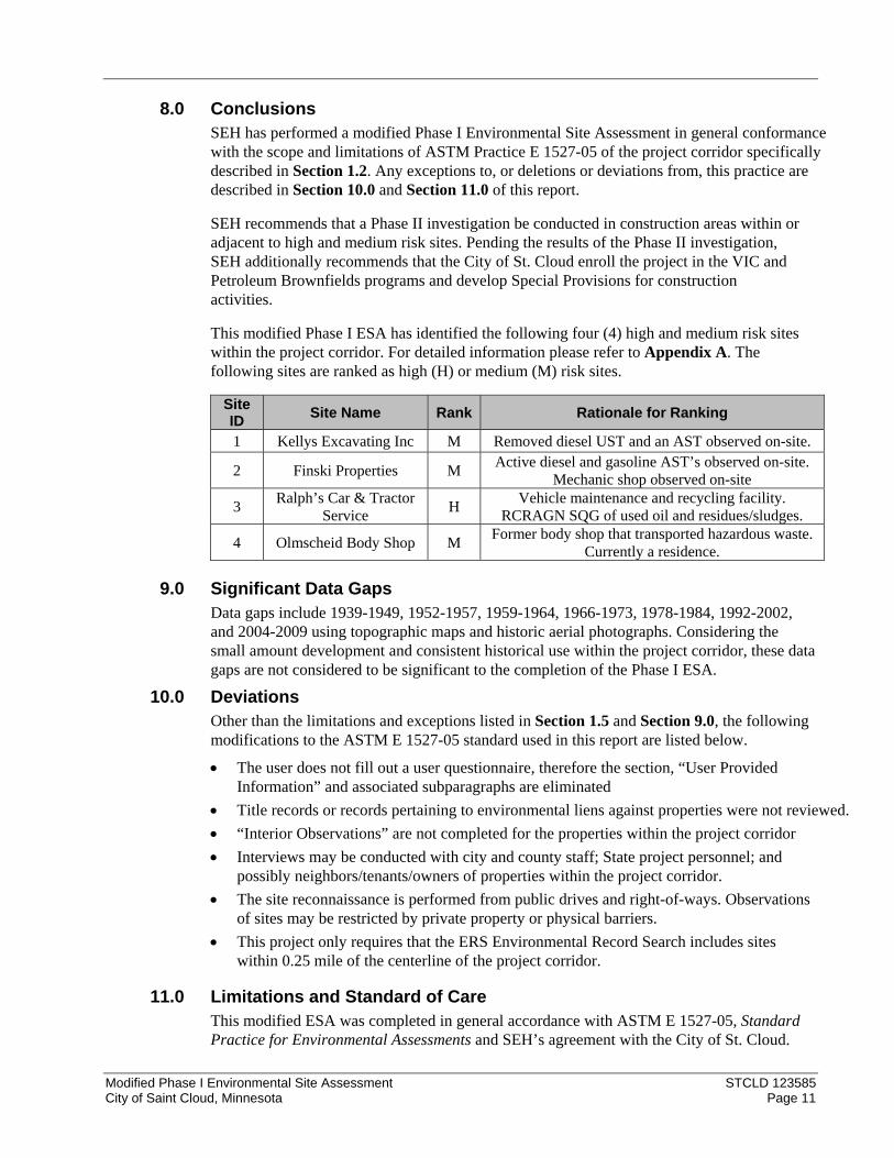
8.0 Conclusions SEH has performed a modified Phase I Environmental Site Assessment in general conformance with the scope and limitations of ASTM Practice E 1527-05 of the project corridor specifically described in Section 1.2. Any exceptions to, or deletions or deviations from, this practice are described in Section 10.0 and Section 11.0 of this report.
SEH recommends that a Phase II investigation be conducted in construction areas within or adjacent to high and medium risk sites. Pending the results of the Phase II investigation, SEH additionally recommends that the City of St. Cloud enroll the project in the VIC and Petroleum Brownfields programs and develop Special Provisions for construction activities.
This modified Phase I ESA has identified the following four (4) high and medium risk sites within the project corridor. For detailed information please refer to Appendix A. The following sites are ranked as high (H) or medium (M) risk sites.
Site ID
Site Name Rank Rationale for Ranking
1 Kellys Excavating Inc M Removed diesel UST and an AST observed on-site.
2 Finski Properties M Active diesel and gasoline AST’s observed on-site.
Mechanic shop observed on-site
3 Ralph’s Car & Tractor
Service H
Vehicle maintenance and recycling facility. RCRAGN SQG of used oil and residues/sludges.
4 Olmscheid Body Shop M Former body shop that transported hazardous waste.
Currently a residence.
9.0 Significant Data Gaps Data gaps include 1939-1949, 1952-1957, 1959-1964, 1966-1973, 1978-1984, 1992-2002, and 2004-2009 using topographic maps and historic aerial photographs. Considering the small amount development and consistent historical use within the project corridor, these data gaps are not considered to be significant to the completion of the Phase I ESA.
10.0 Deviations Other than the limitations and exceptions listed in Section 1.5 and Section 9.0, the following modifications to the ASTM E 1527-05 standard used in this report are listed below.
The user does not fill out a user questionnaire, therefore the section, “User Provided Information” and associated subparagraphs are eliminated
Title records or records pertaining to environmental liens against properties were not reviewed.
“Interior Observations” are not completed for the properties within the project corridor
Interviews may be conducted with city and county staff; State project personnel; and possibly neighbors/tenants/owners of properties within the project corridor.
The site reconnaissance is performed from public drives and right-of-ways. Observations of sites may be restricted by private property or physical barriers.
This project only requires that the ERS Environmental Record Search includes sites within 0.25 mile of the centerline of the project corridor.
11.0 Limitations and Standard of Care This modified ESA was completed in general accordance with ASTM E 1527-05, Standard Practice for Environmental Assessments and SEH’s agreement with the City of St. Cloud.

Modified Phase I Environmental Site Assessment STCLD 123585 City of Saint Cloud, Minnesota Page 12
The findings and conclusions of this report are not scientific certainties, but probabilities based on professional judgment regarding the significance and accuracy of the collected data. When reasonably ascertainable, environmental data was obtained and reviewed. However, the accuracy of the sources and collected data is not the responsibility of SEH.
When a Phase I ESA is completed without subsurface exploration or chemical analyses of the soil and/or groundwater at the site, no statement of scientific certainty can be made regarding the environmental or subsurface conditions resulting from either onsite or offsite pollutant sources. The possibility always exists for contaminants to migrate from one property to another via surface water, groundwater or soil. The ability to accurately assess the environmental risk associated with the transport of pollutants through these media to the site is beyond the scope of this Phase I ESA.
This Phase I ESA report was prepared for the exclusive use of the City of St. Cloud, Stearns County, and MnDOT. The negotiated scope of work imposed limitations on the collection and interpretation of evidence, consistent with the ASTM Standard, resulting in a commensurate uncertainty as to the conclusions drawn. The degree of uncertainty was deemed acceptable by the City of St. Cloud. Any third party interested in using or relying upon this report must first secure written authorization from the City of St. Cloud and SEH, and agrees to accept SEH’s terms and conditions respecting indemnification and agreed upon limitations of liability.
SEH’s services were conducted in a manner consistent with the level of care and skill standard to the industry. The conclusions and recommendations contained in this report were arrived at in accordance with generally accepted professional practice at this time and location. Other than this, no warranty is implied or intended.

Modified Phase I Environmental Site Assessment STCLD 123585 City of Saint Cloud, Minnesota Page 13
12.0 References Boerboom, J. Terrence, Setterholm, R. Dale, and Chandler, W. Val, Minnesota Geological
Survey (MGS), 1995, Geologic Atlas of Stearns County, Minnesota, County Atlas Series, Atlas C-10, Part A, Plate 2- Bedrock Geology
Environmental Record Search (ERS), February 25, 2013, “RecCheck” – Site Location: Highway 15 and 33rd Street S St. Cloud, MN 56301”
Minnesota Department of Agriculture (MDA) County Spill Reports for Stearns, MN, www.mda.state.mn.us/chemicals/spills/incidentresponse/countyspills.htm
MDA What’s in my neighborhood, interactive online mapping, www.mda.state.mn.us/chemicals/spills/incidentresponse/disclaimer.htm
Minnesota Department of Health (MDH), County Well Index, www.health.state.mn.us/divs/eh/cwi/
Meyer, N. Gary and Knaeble, R. Alan. MGS, 1995, Geologic Atlas of Stearns County, Minnesota, County Atlas Series, Atlas C-10, Part A, Plate 3- Surficial Geology
Minnesota Pollution Control Agency (MPCA) What’s in my neighborhood, online database, www.pca.state.mn.us/backyard/neighborhood.html
MPCA Abovegound/Underground Storage Tank Site Search online database, www.pca.state.mn.us/index.php/waste/waste-and-cleanup/waste-management/tank-compliance-and-assistance/minnesota-aboveground-/-underground-storage-tank-site-search-data.html
MPCA Petroleum Remediation Program Maps online, http://pca-gis02.pca.state.mn.us/prp/index.html
Setterholm, Dale. R, MGS, 1995, Geologic Atlas of Stearns County, Minnesota, County Atlas Series, Atlas C-10, Part A, Plate 5- Depth to Bedrock
United States Geological Survey (USGS), 2010 “Saint Cloud, Minnesota” 7.5 Minute Topographic Map

List of Figures
Figure 1 – Site Location
Figure 2 – Site Features

Site Location Map
Saint Cloud
Waite Park
Copyright:© 2011 National Geographic Society, i-cubed
Project: STCLD 123585
Figure1
3535 VADNAIS CENTER DR.ST. PAUL, MN 55110
PHONE: (651) 490-2000FAX: (888) 908-8166TF: (800) 325-2055www.sehinc.com
Pa
th:
S:\
PT
\S\S
tcld
\123
58
5\99
_G
IS\M
XD
s\F
ig01
_S
iteLo
catio
nM
ap.
mxd
Map by: SrHProjection: UTM, Zone 15, NAD 83, mSource: USGS 7.5 Min. Topo, MnDOT, and SEH Inc.
Print Date: 05/30/2013TH15 and 33rd Street South Interchange Phase I ESA
STCLD 123585 (SP-7303-48, SAP 073-684-004,SAP 073-674-002, SAP 162-151-002)
Saint Cloud, MinnesotaThis map is neither a legally recorded map nor a survey map and is not intended to be used as one. This map is a compilation of records, information, and data gathered from various sources listed on this map and is to be used for reference purposes only. SEH does not warrant that the GeographicInformation System (GIS) Data used to prepare are error free, and SEH does not represent that the GIS Data can be used for navigational, tracking, or any other purpose requiring exacting measurement of distance or direction or precision in the depiction of geographic features. The user of this mapacknowledges that SEH shall not be liable for any damages which arise out of the user's access or use of data provided.
Legend
Site Buffer O2,000 0 2,0001,000
Feet
StearnsCounty
Stearns County
SaintCloud

Figure
2
Legend
!H Wells
Project Corridor
Parcels
Site Feature Parcels
Proposed Design File
Environmental Risk Level
") High
!( Medium
0 1,000 2,000500Feet
SiteFeatures
!H
!H
!H
!H
!H
!H
!H
!H
!H
!H
!H
!H
!H
!H
!H
!H
!(
!(
") !(33rd St SUV74
?A15
190548
610588
762243
743074
711432
131086
424995
145029
632474
135573
131087
440740
757470
145375
536897
745571
1
2
34
3535 VADNAIS CENTER DR.ST. PAUL, MN 55110
PHONE: (651) 490-2000FAX: (651) 490-2150
WATTS: 800-325-2055www.sehinc.com
OThis map is neither a legally recorded map nor a survey map and is not intended to be used as one. This map is acompilation of records, information, and data gathered from various sources listed on this map and is to be used forreference purposes only. SEH does not warrant that the Geographic Information System (GIS) Data used to prepare thismap are error free, and SEH does not represent that the GIS Data can be used for navigational, tracking, or any otherpurpose requiring exacting measurement of distance or direction or precision in the depiction of geographic features. Theuser of this map acknowledges that SEH shall not be liable for any damages which arise out of the user's access or use ofdata provided.
Map by: srhProjection: Stearns County NAD 83 FtSource: MnGEO Aerial 2010, MnDNR, MnDOT, and SEH Inc.
Project: STCLD 123585
Print Date: 06/03/2013
Pa
th: S
:\P
T\S
\Stc
ld\1
23
58
5\9
9_
GIS
\MX
Ds\
Fig
02
_S
iteF
ea
ture
s.m
xd
TH15 and 33rd Street South Interchange Phase I ESASTCLD 123585 (SP-7303-48, SAP 073-684-004, SAP 073-674-002, SAP 162-151-002)
Saint Cloud, Minnesota
- Resource Conservation and Recovery Act Generator of Hazardous Waste- Aboveground Storage Tank- Underground Storage Tank
RCRAGN
ASTUST
Site ID Site Name Risk Ranking Rationale1 Kellys Excavating Inc Medium Removed diesel UST and an AST observed on‐site.2 Finski Properties Medium Active diesel and gasoline ASTs observed on‐site. A mechanic shop is observed on‐site.3 Ralph’s Car & Tractor Service High Vehicle maintenance and recycling facility. Poor housekeeping and a RCRAGN small quantity generator of used oil and residues/sludges.4 Former Olmscheid Body Shop Medium Former body shop that transported hazardous waste.

Appendix A
Site Specific Data Sheets

Modified Phase I Environmental Site Assessment Site Data SheetsTrunk Highway 15/33rd Street South (CSAH 84) Interchange
SP 7303-48, SAP 073-684-004, SAP 073-674-002, and SAP 162-151-002
WI01SITE ID: 1Current Site Use: Kellys Excavating Inc
RANK:Medium
Ranking Rationale:
The site is identified to contain a removed 2,000 gallon diesel UST. The site was observed to have an AST adjacent to the main building. It is unknown what is contained in the AST. Storage Trailers and portable toilets are observed on-site.
Petroleum Non-Petroleum Regulated WasteContaminants of Concern
Parcels1PARCEL INFORMATION:Parcel House Number Street Type Direction
82.44152.0618 4966 33RD ST S
Date History Source
SITE HISTORY:
1938-1985 The site appears to be undeveloped throughout this time period. 33rd Street South exists adjacent along the northern boundary of the site. A marshy area is located on the southeastern portion of the site. Topographic maps show no changes to elevation throughout this time period.
Aerial photographs and topographic maps
1991 Grading activities appear to have taken place. One building exists on the western portion of the site. The marshy area appears to have spread along the eastern portion of the site.
Aerial photographs
2003 The building appears to remain on-site with additional grading activities near the building. Equipment or vehicles appear to the north and east of the building.
Aerial photographs
2010 Site activities appear to be augmented and have spread farther north and south of the building on-site. No topographic changes are observed.
Aerial photographs and topographic maps
Tank(s)
Well(s)
Petroleum/Hazardous Product Use
Evidence of Spill or Release
Comments:
Several empty steel shipping containers are located on-site. One AST approximately 500 gallons in relatively good condition is located adjacent to the main building. It is unknown what is contained in the AST. The building appears to be vacant.
SITE RECONAISSANCE:
Observed On Site?
MPCA WIMN DATABASE LISTINGS: NoneActivityNameSite ID Active?
MPCA WIMN DATABASE LISTINGS:
Tank SiteKellys Excavating Inc18323 N
ADDITIONAL ERS DATABASE LISTINGS: None
MPCA REGISTERED TANKS: NoneMPCA REGISTERED TANKS:MPCA_Tank ID Above/Underground Stored Product Capacity (gallons) Status Registration Date
001 Under Ground Diesel 2000 Removed 9/27/1993
CWI REGISTERED WELLS: None
End of Record for Site 1
Short Elliott Hendrickson Inc.STCLD
SEH ID: 1 Medium

Modified Phase I Environmental Site Assessment Site Data SheetsTrunk Highway 15/33rd Street South (CSAH 84) Interchange
SP 7303-48, SAP 073-684-004, SAP 073-674-002, and SAP 162-151-002
WI02SITE ID: 2Current Site Use: Finski Properties
RANK:Medium
Ranking Rationale:
The site is identified as having two active 1,000 gallon ASTs of gasoline and diesel fuel. The site was developed into its current orientation in the 2003 historic aerial photograph. One of the structures observed on-site was a mechanic shop.
Petroleum Non-Petroleum Regulated WasteContaminants of Concern
Parcels1PARCEL INFORMATION:Parcel House Number Street Type Direction
82.44152.0602 3423 COUNTY ROAD 74
Date History Source
SITE HISTORY:
1938 Several structures and grading activities appear on the northern portion of the site. Aerial photographs
1950-2010 Topographic conditions appear to remain unchanged throughout this time period. Topographic maps
1951-1965 Additional grading activities and structures appear on the northern portion of the site. The remaining property appears to contain grassland or farmland.
Aerial photographs
1977 The site appears similar throughout this time period. One main building appears on-site. Structures or possible trailers appear in the northwestern portion of the site.
Aerial photographs
1985-1991 The site appears similar throughout this time period. Aerial photographs
2003-2010 Four large, rectangular buildings appear to the west and south of the existing building. Grading activities appear on the remaining property to the east of the buildings.
Aerial photographs
Tank(s)
Well(s)
Petroleum/Hazardous Product Use
Evidence of Spill or Release
Comments:
Several buildings were observed on-site. One building was observed to be a mechanic shop. Two 1,000 gallon ASTs in good condition existed on-site with diesel and unleaded regular fuel. The facility is named Finski Properties. No wells were observed.
SITE RECONAISSANCE:
Observed On Site?
MPCA WIMN DATABASE LISTINGS: NoneActivityNameSite ID Active?
MPCA WIMN DATABASE LISTINGS:
Tank SiteFinski Properties124454 Y
ADDITIONAL ERS DATABASE LISTINGS: None
MPCA REGISTERED TANKS: NoneMPCA REGISTERED TANKS:MPCA_Tank ID Above/Underground Stored Product Capacity (gallons) Status Registration Date
`1 Above Ground Gasoline 1000 Active 11/22/2006
`2 Above Ground Diesel 1000 Active 11/22/2006
Short Elliott Hendrickson Inc.STCLD
SEH ID: 2 Medium

Modified Phase I Environmental Site Assessment Site Data SheetsTrunk Highway 15/33rd Street South (CSAH 84) Interchange
SP 7303-48, SAP 073-684-004, SAP 073-674-002, and SAP 162-151-002
WI02SITE ID: 2Current Site Use: Finski Properties
RANK:Medium
Ranking Rationale:
The site is identified as having two active 1,000 gallon ASTs of gasoline and diesel fuel. The site was developed into its current orientation in the 2003 historic aerial photograph. One of the structures observed on-site was a mechanic shop.
Petroleum Non-Petroleum Regulated WasteContaminants of Concern
CWI REGISTERED WELLS: None
End of Record for Site 2
Unique No. Well Name Use Depth (ft) Aquifer
COUNTY WELL INDEX REGISTERED WELLS:
00424995 THOMETZ, GENEVIEVE DO 30 QWTA
00536897 BECKERS, HARRY PN 35 QWTA
Short Elliott Hendrickson Inc.STCLD
SEH ID: 2 Medium
Modified Phase I Environmental Site Assessment Site Data SheetsTrunk Highway 15/33rd Street South (CSAH 84) Interchange
SP 7303-48, SAP 073-684-004, SAP 073-674-002, and SAP 162-151-002
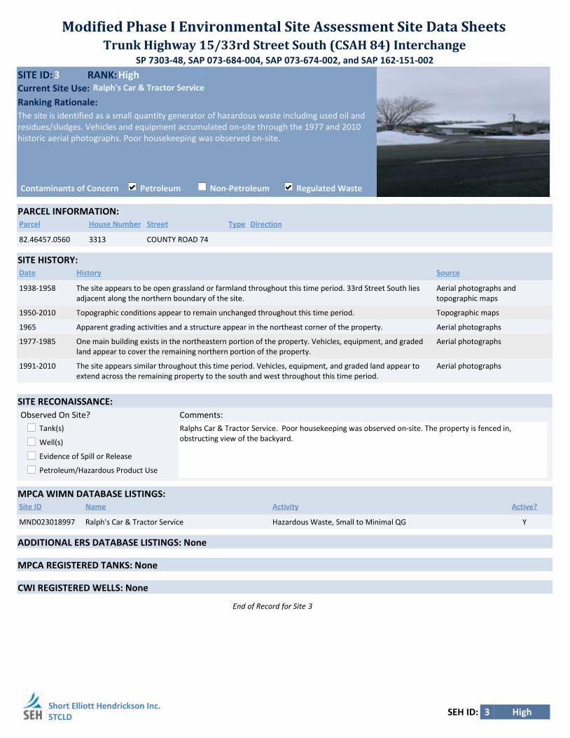
WI03SITE ID: 3Current Site Use: Ralph's Car & Tractor Service
RANK:High
Ranking Rationale:
The site is identified as a small quantity generator of hazardous waste including used oil and residues/sludges. Vehicles and equipment accumulated on-site through the 1977 and 2010 historic aerial photographs. Poor housekeeping was observed on-site.
Petroleum Non-Petroleum Regulated WasteContaminants of Concern
Parcels1PARCEL INFORMATION:Parcel House Number Street Type Direction
82.46457.0560 3313 COUNTY ROAD 74
Date History Source
SITE HISTORY:
1938-1958 The site appears to be open grassland or farmland throughout this time period. 33rd Street South lies adjacent along the northern boundary of the site.
Aerial photographs and topographic maps
1950-2010 Topographic conditions appear to remain unchanged throughout this time period. Topographic maps
1965 Apparent grading activities and a structure appear in the northeast corner of the property. Aerial photographs
1977-1985 One main building exists in the northeastern portion of the property. Vehicles, equipment, and graded land appear to cover the remaining northern portion of the property.
Aerial photographs
1991-2010 The site appears similar throughout this time period. Vehicles, equipment, and graded land appear to extend across the remaining property to the south and west throughout this time period.
Aerial photographs
Tank(s)
Well(s)
Petroleum/Hazardous Product Use
Evidence of Spill or Release
Comments:
Ralphs Car & Tractor Service. Poor housekeeping was observed on-site. The property is fenced in, obstructing view of the backyard.
SITE RECONAISSANCE:
Observed On Site?
MPCA WIMN DATABASE LISTINGS: NoneActivityNameSite ID Active?
MPCA WIMN DATABASE LISTINGS:
Hazardous Waste, Small to Minimal QGRalph's Car & Tractor ServiceMND023018997 Y
ADDITIONAL ERS DATABASE LISTINGS: None
MPCA REGISTERED TANKS: None
CWI REGISTERED WELLS: None
End of Record for Site 3
Short Elliott Hendrickson Inc.STCLD
SEH ID: 3 High

Modified Phase I Environmental Site Assessment Site Data SheetsTrunk Highway 15/33rd Street South (CSAH 84) Interchange
SP 7303-48, SAP 073-684-004, SAP 073-674-002, and SAP 162-151-002
EPA01SITE ID: 4Current Site Use: Olmscheid Body Shop
RANK:Medium
Ranking Rationale:
The site is identified as a generator and transporter of hazardous waste. The site was previously used as a body shop and the building on-site has existed since around 1958. The site is currently occuppied by a residence and contains a detached garage.
Petroleum Non-Petroleum Regulated WasteContaminants of Concern
Parcels1PARCEL INFORMATION:Parcel House Number Street Type Direction
82.44152.0718 4634 33RD ST S
Date History Source
SITE HISTORY:
1938-1951 The site appears to be open grassland or farmland throughout this time period. 33rd Street South appears adjacent to the northern boundary of the site.
Aerial photographs and topographic maps
1958 One building appears on the eastern boundary of the property with grading activities appearing from 33rd Street South to the building.
Aerial photographs
1965-1977 The site appears similar throughout this time period. The remaining property to the west of the building appears to remain undeveloped.
Aerial photographs
1985-1991 One additional building appears adjacent to building on-site in the 1985 historic aerial photograph. Site activities appear to remain unchanged.
Aerial photographs
2003-2010 Tree cover appears to obstruct direct observation of the property. It appears that site activities have remained unchanged.
Aerial photographs
Tank(s)
Well(s)
Petroleum/Hazardous Product Use
Evidence of Spill or Release
Comments:
Two structures appearing to be a residence and a detached, two-car garage were observed on-site.
SITE RECONAISSANCE:
Observed On Site?
MPCA WIMN DATABASE LISTINGS: None
ADDITIONAL ERS DATABASE LISTINGS: None
MPCA REGISTERED TANKS: None
CWI REGISTERED WELLS: None
End of Record for Site 4
Short Elliott Hendrickson Inc.STCLD
SEH ID: 4 Medium

Appendix B
Aerial Photographs

33rd St S
Co
un
tyR
d7
4
Sta
te H
wy
15
2nd Ave S
3535 VADNAIS CENTER DR.ST. PAUL, MN 55110
PHONE: (651) 490-2000FAX: (651) 490-2150
WATTS: 800-325-2055www.sehinc.com
TH 15/33rd Street S Figure1Year : 1938
St. Cloud, MinnesotaThis map is neither a legally recorded map nor a survey map and is not intended to be used as one. This map is a compilation of records, information, and data gathered from various sources listed on this map and is to be used for reference purposes only. SEH does not warrant that the Geographic Information System (GIS) Data used to prepare this map are error free, and SEH does not represent that the GIS Data can be used for navigational, tracking, or any other purpose requiring exacting measurement of distance or direction or precision in the depiction of geographic features. The user of this map acknowledges that SEH shall not beliable for any damages which arise out of the user's access or use of data provided.
Project: STCLD 123585
Print Date: 02/22/2013
Map by: AKProjection: Stearns County CoordinatesSource: EDR
Do
cum
ent
Pa
th:
S:\P
T\S
\Stc
ld\1
23
58
5\9
9_G
IS\M
XD
s\Y
ea
rs_
wo
rkin
g.m
xdD
ate
Sa
ved:
2/2
2/2
013
1:0
6:5
0 P
M
I0 200 400 600 800100
Feet
1 inch = 800 feet

33rd St S
Co
un
tyR
d7
4
Sta
te H
wy
15
2nd Ave S
3535 VADNAIS CENTER DR.ST. PAUL, MN 55110
PHONE: (651) 490-2000FAX: (651) 490-2150
WATTS: 800-325-2055www.sehinc.com
TH 15/33rd Street S Figure2Year : 1951
St. Cloud, MinnesotaThis map is neither a legally recorded map nor a survey map and is not intended to be used as one. This map is a compilation of records, information, and data gathered from various sources listed on this map and is to be used for reference purposes only. SEH does not warrant that the Geographic Information System (GIS) Data used to prepare this map are error free, and SEH does not represent that the GIS Data can be used for navigational, tracking, or any other purpose requiring exacting measurement of distance or direction or precision in the depiction of geographic features. The user of this map acknowledges that SEH shall not beliable for any damages which arise out of the user's access or use of data provided.
Project: STCLD 123585
Print Date: 02/22/2013
Map by: AKProjection: Stearns County CoordinatesSource: EDR
Do
cum
ent
Pa
th:
S:\P
T\S
\Stc
ld\1
23
58
5\9
9_G
IS\M
XD
s\Y
ea
rs_
wo
rkin
g.m
xdD
ate
Sa
ved:
2/2
2/2
013
1:0
6:5
0 P
M
I0 200 400 600 800100
Feet
1 inch = 800 feet

33rd St S
Co
un
tyR
d7
4
Sta
te H
wy
15
2nd Ave S
3535 VADNAIS CENTER DR.ST. PAUL, MN 55110
PHONE: (651) 490-2000FAX: (651) 490-2150
WATTS: 800-325-2055www.sehinc.com
TH 15/33rd Street S Figure3Year : 1958
St. Cloud, MinnesotaThis map is neither a legally recorded map nor a survey map and is not intended to be used as one. This map is a compilation of records, information, and data gathered from various sources listed on this map and is to be used for reference purposes only. SEH does not warrant that the Geographic Information System (GIS) Data used to prepare this map are error free, and SEH does not represent that the GIS Data can be used for navigational, tracking, or any other purpose requiring exacting measurement of distance or direction or precision in the depiction of geographic features. The user of this map acknowledges that SEH shall not beliable for any damages which arise out of the user's access or use of data provided.
Project: STCLD 123585
Print Date: 02/22/2013
Map by: AKProjection: Stearns County CoordinatesSource: EDR
Do
cum
ent
Pa
th:
S:\P
T\S
\Stc
ld\1
23
58
5\9
9_G
IS\M
XD
s\Y
ea
rs_
wo
rkin
g.m
xdD
ate
Sa
ved:
2/2
2/2
013
1:0
6:5
0 P
M
I0 200 400 600 800100
Feet
1 inch = 800 feet

33rd St S
Co
un
tyR
d7
4
Sta
te H
wy
15
2nd Ave S
3535 VADNAIS CENTER DR.ST. PAUL, MN 55110
PHONE: (651) 490-2000FAX: (651) 490-2150
WATTS: 800-325-2055www.sehinc.com
TH 15/33rd Street S Figure4Year : 1965
St. Cloud, MinnesotaThis map is neither a legally recorded map nor a survey map and is not intended to be used as one. This map is a compilation of records, information, and data gathered from various sources listed on this map and is to be used for reference purposes only. SEH does not warrant that the Geographic Information System (GIS) Data used to prepare this map are error free, and SEH does not represent that the GIS Data can be used for navigational, tracking, or any other purpose requiring exacting measurement of distance or direction or precision in the depiction of geographic features. The user of this map acknowledges that SEH shall not beliable for any damages which arise out of the user's access or use of data provided.
Project: STCLD 123585
Print Date: 02/22/2013
Map by: AKProjection: Stearns County CoordinatesSource: EDR
Do
cum
ent
Pa
th:
S:\P
T\S
\Stc
ld\1
23
58
5\9
9_G
IS\M
XD
s\Y
ea
rs_
wo
rkin
g.m
xdD
ate
Sa
ved:
2/2
2/2
013
1:0
6:5
0 P
M
I0 200 400 600 800100
Feet
1 inch = 800 feet

33rd St S
Co
un
tyR
d7
4
Sta
te H
wy
15
2nd Ave S
3535 VADNAIS CENTER DR.ST. PAUL, MN 55110
PHONE: (651) 490-2000FAX: (651) 490-2150
WATTS: 800-325-2055www.sehinc.com
TH 15/33rd Street S Figure5Year : 1977
St. Cloud, MinnesotaThis map is neither a legally recorded map nor a survey map and is not intended to be used as one. This map is a compilation of records, information, and data gathered from various sources listed on this map and is to be used for reference purposes only. SEH does not warrant that the Geographic Information System (GIS) Data used to prepare this map are error free, and SEH does not represent that the GIS Data can be used for navigational, tracking, or any other purpose requiring exacting measurement of distance or direction or precision in the depiction of geographic features. The user of this map acknowledges that SEH shall not beliable for any damages which arise out of the user's access or use of data provided.
Project: STCLD 123585
Print Date: 02/22/2013
Map by: AKProjection: Stearns County CoordinatesSource: EDR
Do
cum
ent
Pa
th:
S:\P
T\S
\Stc
ld\1
23
58
5\9
9_G
IS\M
XD
s\Y
ea
rs_
wo
rkin
g.m
xdD
ate
Sa
ved:
2/2
2/2
013
1:0
6:5
0 P
M
I0 200 400 600 800100
Feet
1 inch = 800 feet
33rd St S
Co
un
tyR
d7
4
Sta
te H
wy
15
2nd Ave S
3535 VADNAIS CENTER DR.ST. PAUL, MN 55110
PHONE: (651) 490-2000FAX: (651) 490-2150
WATTS: 800-325-2055www.sehinc.com
TH 15/33rd Street S Figure6Year : 1985
St. Cloud, MinnesotaThis map is neither a legally recorded map nor a survey map and is not intended to be used as one. This map is a compilation of records, information, and data gathered from various sources listed on this map and is to be used for reference purposes only. SEH does not warrant that the Geographic Information System (GIS) Data used to prepare this map are error free, and SEH does not represent that the GIS Data can be used for navigational, tracking, or any other purpose requiring exacting measurement of distance or direction or precision in the depiction of geographic features. The user of this map acknowledges that SEH shall not beliable for any damages which arise out of the user's access or use of data provided.
Project: STCLD 123585
Print Date: 02/22/2013
Map by: AKProjection: Stearns County CoordinatesSource: EDR
Do
cum
ent
Pa
th:
S:\P
T\S
\Stc
ld\1
23
58
5\9
9_G
IS\M
XD
s\Y
ea
rs_
wo
rkin
g.m
xdD
ate
Sa
ved:
2/2
2/2
013
1:0
6:5
0 P
M
I0 200 400 600 800100
Feet
1 inch = 800 feet

33rd St S
Co
un
tyR
d7
4
Sta
te H
wy
15
2nd Ave S
3535 VADNAIS CENTER DR.ST. PAUL, MN 55110
PHONE: (651) 490-2000FAX: (651) 490-2150
WATTS: 800-325-2055www.sehinc.com
TH 15/33rd Street S Figure7Year : 1991
St. Cloud, MinnesotaThis map is neither a legally recorded map nor a survey map and is not intended to be used as one. This map is a compilation of records, information, and data gathered from various sources listed on this map and is to be used for reference purposes only. SEH does not warrant that the Geographic Information System (GIS) Data used to prepare this map are error free, and SEH does not represent that the GIS Data can be used for navigational, tracking, or any other purpose requiring exacting measurement of distance or direction or precision in the depiction of geographic features. The user of this map acknowledges that SEH shall not beliable for any damages which arise out of the user's access or use of data provided.
Project: STCLD 123585
Print Date: 02/22/2013
Map by: AKProjection: Stearns County CoordinatesSource: EDR
Do
cum
ent
Pa
th:
S:\P
T\S
\Stc
ld\1
23
58
5\9
9_G
IS\M
XD
s\Y
ea
rs_
wo
rkin
g.m
xdD
ate
Sa
ved:
2/2
2/2
013
1:0
6:5
0 P
M
I0 200 400 600 800100
Feet
1 inch = 800 feet

33rd St S
Co
un
tyR
d74
Sta
te H
wy
15
2nd Ave S
3535 VADNAIS CENTER DR.ST. PAUL, MN 55110
PHONE: (651) 490-2000FAX: (651) 490-2150
WATTS: 800-325-2055www.sehinc.com
TH 15/33rd Street S Figure8Year : 2003
St. Cloud, MinnesotaThis map is neither a legally recorded map nor a survey map and is not intended to be used as one. This map is a compilation of records, information, and data gathered from various sources listed on this map and is to be used for reference purposes only. SEH does not warrant that the Geographic Information System (GIS) Data used to prepare this map are error free, and SEH does not represent that the GIS Data can be used for navigational, tracking, or any other purpose requiring exacting measurement of distance or direction or precision in the depiction of geographic features. The user of this map acknowledges that SEH shall not beliable for any damages which arise out of the user's access or use of data provided.
Project: STCLD 123585
Print Date: 02/22/2013
Map by: AKProjection: Stearns County CoordinatesSource: EDR
Do
cum
en
t P
ath
: S
:\P
T\S
\Stc
ld\1
2358
5\99
_G
IS\M
XD
s\Y
ears
_wo
rkin
g.m
xdD
ate
Sa
ved:
2/2
2/2
013
1:0
6:5
0 P
M
I0 200 400 600 800100
Feet
1 inch = 800 feet

33rd St S
Co
un
tyR
d74
Sta
te H
wy
15
2nd Ave S
3535 VADNAIS CENTER DR.ST. PAUL, MN 55110
PHONE: (651) 490-2000FAX: (651) 490-2150
WATTS: 800-325-2055www.sehinc.com
TH 15/33rd Street S Figure9Year : 2010
St. Cloud, MinnesotaThis map is neither a legally recorded map nor a survey map and is not intended to be used as one. This map is a compilation of records, information, and data gathered from various sources listed on this map and is to be used for reference purposes only. SEH does not warrant that the Geographic Information System (GIS) Data used to prepare this map are error free, and SEH does not represent that the GIS Data can be used for navigational, tracking, or any other purpose requiring exacting measurement of distance or direction or precision in the depiction of geographic features. The user of this map acknowledges that SEH shall not beliable for any damages which arise out of the user's access or use of data provided.
Project: STCLD 123585
Print Date: 02/22/2013
Map by: AKProjection: Stearns County CoordinatesSource: EDR
Do
cum
en
t P
ath
: S
:\P
T\S
\Stc
ld\1
2358
5\99
_G
IS\M
XD
s\Y
ears
_wo
rkin
g.m
xdD
ate
Sa
ved:
2/2
2/2
013
1:0
6:5
0 P
M
I0 200 400 600 800100
Feet
1 inch = 800 feet

Appendix C
Topographic and Historic Maps

Copyright 2012, All rights reserved
800-377-2430 FAX (714) 669-8025
ENVIRONMENTAL RECORD SEARCH
Page 1 of 5 Page 1 of 5
USGS Topographic Maps
Subject Site: ERS Order #:
Client’s Project#: N/A 2104627323
Address: Highway 15 and 33rd Street South
City, State: St.Cloud, MN
Prepared for: Date:
Greg Ahl
SEH February 27, 2013 3535 Vadnais Center Drive
St. Paul, MN 55110
Enclosed are the results of our USGS Topographic map research.
Thank you for selecting Environmental Record Search!
All terms, conditions, and limitations normally associated with work contracted by ERS and presented or associated with aerial photography are in effect at all times. This letter summary, all its information, and content have been derived from and rely upon the
reviewed aerial photographs. ERS’s research has only been based on these images; ERS did not perform any type of independent
investigation of any type, including as to the accuracy and/or completeness of the information derived or otherwise obtained from the secondary source or sources.
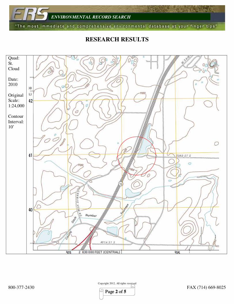
Copyright 2012, All rights reserved
800-377-2430 FAX (714) 669-8025
ENVIRONMENTAL RECORD SEARCH
Page 2 of 5 Page 2 of 5
RESEARCH RESULTS
Quad:
St.
Cloud
Date: 2010
Original Scale:
1:24,000
Contour
Interval: 10’

Copyright 2012, All rights reserved
800-377-2430 FAX (714) 669-8025
ENVIRONMENTAL RECORD SEARCH
Page 3 of 5 Page 3 of 5
Quad:
St. Cloud
Date: 1974
Photo-
revised
Date: 1993
Original
Scale:
1:24,000
Contour Interval:
10’

Copyright 2012, All rights reserved
800-377-2430 FAX (714) 669-8025
ENVIRONMENTAL RECORD SEARCH
Page 4 of 5 Page 4 of 5
Quad:
St. Cloud
Date: 1974
Original
Scale: 1:24,000
Contour
Interval:
10’

Copyright 2012, All rights reserved
800-377-2430 FAX (714) 669-8025
ENVIRONMENTAL RECORD SEARCH
Page 5 of 5 Page 5 of 5
Quad:
St. Cloud
Date: 1950
Original
Scale: 1:62500
Contour
Interval:
10’

Appendix D
Water Well Data


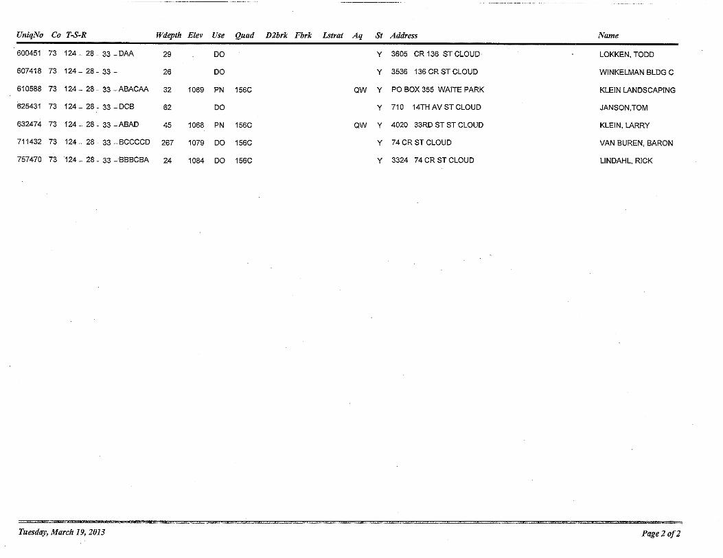

Appendix E
Environmental Database Report
(Available on CD)

Prepared by:
ERS – Environmental Record Search
(800) 377-2430
Site Location:
Highway 15 And 33Rd Street S
St. Cloud, MN 56301 (N 45-30-56, W 94-13-32) NAD83
RecCheck
The Standard for ASTM/AAI Radius Searches (One Mile Environmental Records Search, Exceeds ASTM 1527/1528 and EPA All Appropriate Inquiry)

(800) 524-8877 FAX (714) 669-8025 Page 1 of 1
HISTORICAL FIRE INSURANCE
MAP SEARCH RESULT
Subject Site: ERS Order #:
Client’s Project#: N/A 2104637251
Address: Highway 15 and 33rd Street S
City, State: St. Cloud, MN
Prepared for: Date:
Greg Ahl February 25, 2013
SEH
3535 Vadnais Center Drive
St. Paul, MN 55110
Results:
A search of our in-house collection of historical fire insurance maps was conducted for the above referenced site address. The review of our holdings has determined that no historical fire insurance maps are available within our collection for the referenced site; therefore they are not "reasonably ascertainable" according to ASTM standards. Environmental Record Search (ERS) certifies that a thorough search of our holdings has been completed.
Thank you for selecting ERS. Researched by:
Eric Charles Exton
ENVIRONMENTAL RECORD SEARCH

CONTENTS
EXECUTIVE SUMMARY .............................................................................................. 1
LISTED OCCURRENCE SUMMARY .......................................................................... 3
SITE LOCATION TOPOGRAPHIC MAP ................................................................... 5
SITE LOCATION STREET MAP .................................................................................. 6
1-MILE RADIUS STREET MAP W/OCCURENCES ................................................. 7
1/4-MILE RADIUS STREET MAP W/OCCURRENCES ........................................... 8
1-MILE TOPOGRAPHIC MAP W/OCCURRENCES ................................................ 9
LISTED OCCURRENCE DETAILS ............................................................................ 10
RECORD SOURCES SEARCHED .............................................................................. 12
OCCURRENCES NOT MAPPED ................................................................................ 21
DISCLAIMER, LIMITS AND LIABILITIES ............................................................. 25

Copyright 2013, Environmental Record Search, All rights reserved. www.RecCheck.com
(800) 377-2430 1
EXECUTIVE SUMMARY
INFORMATION ON THE REQUESTED LOCATION
Site Address: Highway 15 And 33Rd Street S
St. Cloud, MN 56301
Client Project Number:
Coordinates: N 45-30-56, W 94-13-32 (NAD 83)
45.515458, -94.225647
ERS Project Number: 2104637251
Subject Site Listed on the following lists: RCRA
Subject Site Listed as Map ID#: 1
USGS 7.5 Minute Quad Map: Saint Cloud
Township, Section and Range: Township: 124 Range: 28W Section: 29
Site Elevation:
(feet above mean sea level)
1076
Flood Zone:
(FEMA Q3 Digital Data)
Panel: Not available
Fire Insurance Map Coverage: Unknown: Area Not Digitally Indexed
Date of Report February 25, 2013
LISTED OCCURRENCE EXECUTIVE SUMMARY
MAP ID
#
ID/NAME ADDRESS LIST STATUS DIST ELEV
DIFF
1 MND023018997
RALPH'S CAR &
TRACTOR
SERVICE
3313 COUNTY
ROAD 74
RCRA Listed Subje
ct
19 ft
2 498109
Kellys Excavating
Inc
4515 33rd St S Tanks-MN Listed 0.05
miles
E
13 ft
3 MND982426884
CSI
CONSTRUCTION
CO
1265 2ND AVE S RCRA Listed 0.05
miles
NE
-7 ft

Copyright 2013, Environmental Record Search, All rights reserved. www.RecCheck.com
(800) 377-2430 2
Soil Type: (USGS STATSGO Data)
HUBBARD 0% to 2% slopes, 35% of total HUBBARD 2% to 6% slopes, 13% of total
HUBBARD 6% to 12% slopes, 5% of total DICKMAN 0% to 2% slopes, 4% of total
DICKMAN 2% to 6% slopes, 2% of total DUELM 0% to 2% slopes, 10% of total
ISAN 0% to 1% slopes, 14% of total SARTELL 2% to 6% slopes, 4% of total
LINO 0% to 2% slopes, 2% of total ISANTI 0% to 2% slopes, 3% of total
BECKER 0% to 2% slopes, 2% of total ESTHERVILLE 0% to 2% slopes, 1% of total
ESTHERVILLE 2% to 6% slopes, 2% of total BISCAY 0% to 2% slopes, 1% of total
FORDUM 0% to 2% slopes, 1% of total WATER % to % slopes, 1% of total
In-House Aerial Photos or Historical Topo Maps
1994 Aerial File:FSXL3124 Rank: 4
KEY TO AERIAL RANK OR HISTORICAL TOPO MAPS
Rank: Description:
4 The subject site located near center of Aerial or Topographical map.
3 The subject site located towards edge of Aerial or Topographical map.
2 The subject site is likely covered and located near outer edge of Aerial or Topographical map.
1 The subject site is likely covered and located near outer corner of Aerial or Topographical map.
Radon
The average Radon measurement is greater than 4 pCi/L for the county.

Copyright 2013, Environmental Record Search, All rights reserved. www.RecCheck.com
(800) 377-2430 3
HIGH RISK* OCCURRENCES FOUND IN REQUESTED SEARCH RADIUS
LIST SEARCHED
DISTANCE SEARCHED
(IN MILES)
OCCURRENCES FOUND
CERCLIS 0.5 0
Hist-LUST-Open-MN 0.5 0
LUST-MN 0.5 0
MES-HighRisk-MN 0.5 0
NPL 1 0
Tribal-LUST-Open 0.5 0 * For the purposes of this report, “high risk” occurrences are those that have known contamination and have not received a “case
closed” or “no further action” status from the agency that maintains the records.
LISTED OCCURRENCE SUMMARY
LIST
SEARCHED
DISTANCE
SEARCHED
SUBJECT 0.125 0.25 0.5 1.0 TOTAL
FEDERAL ASTM/AAI DATABASES
CERCLIS 0.5 0 0 0 0 - 0
Cerclis-
Archived
0.5 0 0 0 0 - 0
Controls-ZZ 0.5 0 0 0 0 - 0
ERNS 0.125 0 0 - - - 0
Hist-US-EC 0.5 0 0 0 0 - 0
Hist-US-IC 0.5 0 0 0 0 - 0
NPL 1 0 0 0 0 0 0
RCRA 0.125 1 1 - - - 2
RCRA-COR 1 0 0 0 0 0 0
RCRA-TSD 0.5 0 0 0 0 - 0
Tribal-LUST-
Closed
0.5 0 0 0 0 - 0
Tribal-LUST-
Open
0.5 0 0 0 0 - 0
Tribal-UST 0.125 0 0 - - - 0
US-BF 0.5 0 0 0 0 - 0
STATE ASTM/AAI DATABASES
Hist-LUST-
Closed-MN
0.5 0 0 0 0 - 0
Hist-LUST-
Open-MN
0.5 0 0 0 0 - 0
Hist-UST-MN 0.125 0 0 - - - 0
Landfills-MN 0.5 0 0 0 0 - 0
LUST-MN 0.5 0 0 0 0 - 0
MES-HighRisk-
MN
0.5 0 0 0 0 - 0
MES-LowRisk-
MN
0.5 0 0 0 0 - 0
MES-MedRisk-
MN
0.5 0 0 0 0 - 0
Tanks-MN 0.125 0 1 - - - 1

Copyright 2013, Environmental Record Search, All rights reserved. www.RecCheck.com
(800) 377-2430 4
SUPPLEMENTAL DATABASES
Not Searched
PROPRIETARY HISTORIC DATABASES
Not Searched

SITE LOCATION TOPOGRAPHIC MAP
U.S. Geological Survey. Saint Cloud Quadrangle
7.5 Minute Series, Approximate Scale: 1: 24000
SEH Highway 15 And 33Rd Street S
St. Cloud, MN 56301
FIGURE: 1
JOB:
DATE: 2/25/2013
N

SITE LOCATION STREET MAP Approximate Scale: 1: 24000
SEH Highway 15 And 33Rd Street S
St. Cloud, MN 56301
FIGURE:
JOB:
DATE: 2/25/2013
N

1-MILE RADIUS STREET MAP W/OCCURENCES
All plotted occurrences represent approximate locations based on geographic information provided by the respective agency. Actual locations may vary due to numerous reasons such as: the
size of the property, accuracy of the provided location, accuracy of the software used to determine the location, etc. Occurrences are shown in three colors to give a visual indication of the
potential risk of the listed occurrence based on the type of list and the current status of the occurrence. Occurrences shown in RED are locations with known contamination that have not
received a “case closed” or “no further action” status. Occurrences shown in YELLOW have been listed by the respective agency, but do not always represent an environmental risk. The
detailed status information and description of the list should be reviewed for further information. Occurrences shown in GREEN are occurrences that have active permits or have had
contamination in the past but have received a “case closed” or “no further action” status and therefore do not likely present an environmental risk.

1/4-MILE RADIUS STREET MAP W/OCCURRENCES
All plotted occurrences represent approximate locations based on geographic information provided by the respective agency. Actual locations may vary due to numerous reasons such as: the
size of the property, accuracy of the provided location, accuracy of the software used to determine the location, etc. Occurrences are shown in three colors to give a visual indication of the
potential risk of the listed occurrence based on the type of list and the current status of the occurrence. Occurrences shown in RED are locations with known contamination that have not
received a “case closed” or “no further action” status. Occurrences shown in YELLOW have been listed by the respective agency, but do not always represent an environmental risk. The
detailed status information and description of the list should be reviewed for further information. Occurrences shown in GREEN are occurrences that have active permits or have had
contamination in the past but have received a “case closed” or “no further action” status and therefore do not likely present an environmental risk.

1-MILE TOPOGRAPHIC MAP W/OCCURRENCES
All plotted occurrences represent approximate locations based on geographic information provided by the respective agency. Actual locations may vary due to numerous reasons such as: the
size of the property, accuracy of the provided location, accuracy of the software used to determine the location, etc. Occurrences are shown in three colors to give a visual indication of the
potential risk of the listed occurrence based on the type of list and the current status of the occurrence. Occurrences shown in RED are locations with known contamination that have not
received a “case closed” or “no further action” status. Occurrences shown in YELLOW have been listed by the respective agency, but do not always represent an environmental risk. The
detailed status information and description of the list should be reviewed for further information. Occurrences shown in GREEN are occurrences that have active permits or have had
contamination in the past but have received a “case closed” or “no further action” status and therefore do not likely present an environmental risk.

Copyright 2013, Environmental Record Search, All rights reserved. www.RecCheck.com
(800) 377-2430 10
LISTED OCCURRENCE DETAILS
LIST STATUS DISTANCE ELEVATION MAP ID
RCRA Listed Subject 1095 ft
(19 ft higher than site) 1 SITE NAME AGENCY ID#
RALPH'S CAR & TRACTOR SERVICE MND023018997
ADDRESS CITY ZIP
3313 COUNTY ROAD 74 ST. CLOUD 563018832
DETAILS
Additional details may be found online using the following link:
http://oaspub.epa.gov/enviro/fii_query_dtl.disp_program_facility?pgm_sys_id_in=MND023018997&pgm_sys_acrnm_in=RCRAINFO
;
NAICS1: GENERAL AUTOMOTIVE REPAIR
NAICS2: GENERAL AUTOMOTIVE REPAIR
Operator Name: RALPH'S CAR & TRACTOR SERVICE
Receive Date: 19840220
Current Site Name: RALPH'S CAR & TRACTOR SERVICE
LIST STATUS DISTANCE ELEVATION MAP ID
Tanks-MN Listed 0.05 miles E 1089 ft
(13 ft higher than site) 2 SITE NAME AGENCY ID#
Kellys Excavating Inc 498109
ADDRESS CITY ZIP
4515 33rd St S St. Cloud 56301
DETAILS
SITE_URL: http://cf.pca.state.mn.us/wimn/siteInfo.cfm?siteid=225919
MPCA_ID: 18323
ACTIVITY: Tank Site
MAJ_WSHED: Mississippi River - St. Cloud
STATUS: Inactive
COUNTY: Stearns

Copyright 2013, Environmental Record Search, All rights reserved. www.RecCheck.com
(800) 377-2430 11
LIST STATUS DISTANCE ELEVATION MAP ID
RCRA Listed 0.05 miles NE 1069 ft
(7 ft lower than site) 3 SITE NAME AGENCY ID#
CSI CONSTRUCTION CO MND982426884
ADDRESS CITY ZIP
1265 2ND AVE S WAITE PARK 563872063
DETAILS
Additional details may be found online using the following link:
http://oaspub.epa.gov/enviro/fii_query_dtl.disp_program_facility?pgm_sys_id_in=MND982426884&pgm_sys_acrnm_in=RCRAINFO
;
Owner Name: CSI CONSTRUCTION CO
Operator Name: NAME NOT REPORTED
Receive Date: 19880222
Current Site Name: CSI CONSTRUCTION CO
Waste Code Description: IGNITABLE WASTE
Waste Code Description: DESCRIPTION

Copyright 2013, Environmental Record Search, All rights reserved. www.RecCheck.com
(800) 377-2430 12
RECORD SOURCES SEARCHED
CERCLIS
Comprehensive Environmental Response, Compensation, and Liability Information
System
ASTM/AAI Category: Federal CERCLIS
Description: CERCLIS is the Comprehensive Environmental Response, Compensation,
and Liability Information System. CERCLIS contains information on hazardous waste
sites, potential hazardous waste sites, and remedial activities across the nation, including
sites that are on the National Priorities List (NPL) or being considered for the NPL.
Agency: United States Environmental Protection Agency
Phone Number: 8004249346
Date last updated: 1/2/2013
Date last checked: 10/3/2012
Distance searched: 0.5 miles
Sites:
None Found
Cerclis-Archived
CERCLIS sites that have been archived
ASTM/AAI Category: Federal CERCLIS NFRAP
Description: The Archive designation means that assessment at a site has been
completed and EPA has determined no steps will be taken to designate the site as a
priority by listing it on the National Priorities List (NPL). No further remedial action is
planned for these sites under the Superfund Program.
Agency: United States Environmental Protection Agency
Phone Number: 8004249346
Date last updated: 1/2/2013
Date last checked: 10/3/2012
Distance searched: 0.5 miles
Sites:
None Found
Controls-ZZ
Controls List
ASTM/AAI Category: Federal Inst/Eng Controls
Description: Voluntary Action Program Sites with Engineering Controls and/or
Institutional Controls placed on them and were identified by the Environmental
Protection Agency.
Agency: Environmental Protection Agency
Phone Number: 8004249346
Date last updated: 1/2/2013
Date last checked: 10/3/2012
Distance searched: 0.5 miles

Copyright 2013, Environmental Record Search, All rights reserved. www.RecCheck.com
(800) 377-2430 13
Sites:
None Found
ERNS
Emergency Response Notification System
ASTM/AAI Category: Federal ERNS
Description: The primary function of the National Response Center is to serve as the
sole national point of contact for reporting all oil, chemical, radiological, biological, and
etiological discharges into the environment anywhere in the United States and its
territories.
Agency: National Response Center
Phone Number: 8004248802
Date last updated: 10/3/2012
Date last checked: 10/3/2012
Distance searched: 0.125 miles
Sites:
None Found
Hist-LUST-Closed-MN
Leaking Underground Storage Tanks, Closed Cases
ASTM/AAI Category: State/Tribal LUST
Description: All closed Leaking Underground Storage Tanks in Minnesota. This
database no longer gets updated.
Agency: Minnesota Pollution Control Agency
Phone Number: 6512972274
Date last updated: Historical Database
Date last checked: N/A
Distance searched: 0.5 miles
Sites:
None Found
Hist-LUST-Open-MN
Leaking Underground Storage Tanks, Open Cases
ASTM/AAI Category: State/Tribal LUST
Description: All open Leaking Undergound Storage Tanks in Minnesota. This database
no longer gets updated.
Agency: Minnesota Pollution Control Agency
Phone Number: 6512972274
Date last updated: Historical Database
Date last checked: N/A
Distance searched: 0.5 miles
Sites:
None Found

Copyright 2013, Environmental Record Search, All rights reserved. www.RecCheck.com
(800) 377-2430 14
Hist-US-EC
Engineering Controls Sites List
ASTM/AAI Category: Federal Inst/Eng Controls
Description: Voluntary Action Program Sites with Engineering Controls placed on them
and were identified by the Environmental Protection Agency.
Agency: Environmental Protection Agency
Phone Number: 8004249346
Date last updated: Historical Database
Date last checked: N/A
Distance searched: 0.5 miles
Sites:
None Found
Hist-US-IC
Sites with Institutional Controls
ASTM/AAI Category: Federal Inst/Eng Controls
Description: Voluntary Action Program Sites with Institutional Controls placed on them
and were identified by the Environmental Protection Agency.
Agency: Environmental Protection Agency
Phone Number: 8004249346
Date last updated: Historical Database
Date last checked: N/A
Distance searched: 0.5 miles
Sites:
None Found
Hist-UST-MN
Underground Storage Tanks
ASTM/AAI Category: State/Tribal UST
Description: All registered Underground Storage Tanks. This database no longer gets
updated.
Agency: Minnesota Pollution Control Agency
Phone Number: 6512972274
Date last updated: Historical Database
Date last checked: N/A
Distance searched: 0.125 miles
Sites:
None Found
HMIS-ZZ
Hazardous Materials Information System
ASTM/AA Category: Emergency Release Reports
Description: Data includes spills, releases, or other incidents involving hazardous
materials in commerce during the course of transportation. All modes of transportation
are included except pipeline and bulk marine transportation. Data represent a census of

Copyright 2013, Environmental Record Search, All rights reserved. www.RecCheck.com
(800) 377-2430 15
all incidents reportable to the U.S. Department of Transportation (DOT). U.S. federal
regulations require all spills meeting the following criteria to be reported, in writing, to
DOT's Office of Hazardous Materials Safety:
As a direct result of hazardous materials:
a person is killed or receives injuries requiring hospitalization; or estimated property
damage exceeds $50,000; or an evacuation of the general public lasts for one or more
hours; or a major transportation artery or facility is closed for one or more hours; or the
operational flight pattern or routing of an aircraft is altered; or Fire, breakage, spillage, or
suspected contamination occurs involving shipment of radioactive materials or infectious
substances; or There as been a release of a marine pollutant exceeding 450 L or 400 kg;
or Any unintentional release of a hazardous material from a package or any quantity of
hazardous waste discharged during transportation.
Agency: US Department of Transportation Pipeline and Hazardous Materials Safety
Administration
Phone Number: 2023664433
Date last updated: 1/2/2013
Date last checked: 10/3/2012
Distance searched: 0.125 miles
Sites:
None Found
Landfills-MN
Asbestos Landfill
ASTM/AAI Category: State/Tribal Landfill/Solid Waste
Description: This database contains the list of Landfills Accepting Asbestos.
Agency: Minnesota Polution Control Agency
Phone Number: 6517572536
Date last updated: 2/13/2013
Date last checked: 2/13/2013
Distance searched: 0.5 miles
Sites:
None Found
LUST-MN
Leaking Underground Storage Tanks
ASTM/AAI Category: State/Tribal LUST
Description: All Leak Sites under Minnesota Polution Control Agency. This database
does not state whether the leak has been cleaned up. The status on the details section
relates to the facility status.
Agency: Minnesota Polution Control Agency
Phone Number: 6512972274
Date last updated: 2/14/2013
Date last checked: 2/8/2013
Distance searched: 0.5 miles
Sites:

Copyright 2013, Environmental Record Search, All rights reserved. www.RecCheck.com
(800) 377-2430 16
None Found
MES-HighRisk-MN
What's In My Neighborhood Sites
ASTM/AAI Category: State/Tribal Cerclis Equivalent
Description: Minnesota What's In My Neighborhood Sites from the following
categories: Cerclis Site, Petroleum Brownfield, RCRA Cleanup, State Assessment Site,
Superfund Project, Voluntary Investigation & Cleanup, and Multiple Activities.
Agency: Minnesota Pollution Control Agency
Phone Number: 6512966139
Date last updated: 2/14/2013
Date last checked: 2/8/2013
Distance searched: 0.5 miles
Sites:
None Found
MES-LowRisk-MN
What's In My Neighborhood Sites
ASTM/AAI Category: State/Tribal RCRA
Description: Minnesota What's In My Neighborhood Sites from the following
categories: Hazardous Waste, LQG, Hazardous Waste, Small to Minimal QG, and MS4
Project.
Agency: Minnesota Pollution Control Agency
Phone Number: 6512966139
Date last updated: 2/14/2013
Date last checked: 2/8/2013
Distance searched: 0.5 miles
Sites:
None Found
MES-MedRisk-MN
What's In My Neighborhood Sites
ASTM/AAI Category: State/Tribal Solid Waste
Description: Minnesota What's In My Neighborhood Sites from the following
categories: Hazardous Waste, TSD, Landfill Open/Closed, Landfill Permitted by Rule,
and Unpermitted Dump Site.
Agency: Minnesota Pollution Control Agency
Phone Number: 6512966139
Date last updated: 2/14/2013
Date last checked: 2/8/2013
Distance searched: 0.5 miles
Sites:
None Found

Copyright 2013, Environmental Record Search, All rights reserved. www.RecCheck.com
(800) 377-2430 17
NPL
National Priorities List
ASTM/AAI Category: Federal NPL
Description: The National Priorities List is the list of national priorities among the
known releases or threatened releases of hazardous substances, pollutants, or
contaminants throughout the United States and its territories. The NPL is intended
primarily to guide the EPA in determining which sites warrant further investigation.
Agency: United States Environmental Protection Agency
Phone Number: 8004249346
Date last updated: 1/2/2013
Date last checked: 10/3/2012
Distance searched: 1 mile
Sites:
None Found
RCRA
Resource Conservation and Recovery Act
ASTM/AAI Category: Federal RCRA Generators
Description: The primary goals of RCRA are to: Protect human health and the
environment from the potential hazards of waste disposal. Conserve energy and natural
resources. Reduce the amount of waste generated. Ensure that wastes are managed in an
environmentally sound manner.
Agency: United States Environmental Protection Agency
Phone Number: 8004249346
Date last updated: 1/3/2013
Date last checked: 10/3/2012
Distance searched: 0.125 miles
Sites:
RALPH'S CAR & TRACTOR SERVICE MapID: 1 Listed
CSI CONSTRUCTION CO MapID: 3 Listed
RCRA-COR
Resource Conservation and Recovery Act - Corrective Actions
ASTM/AAI Category: Federal RCRA CORRACTS
Description: The primary goals of RCRA are to: Protect human health and the
environment from the potential hazards of waste disposal. Conserve energy and natural
resources. Reduce the amount of waste generated. Ensure that wastes are managed in an
environmentally sound manner.
EPA estimates that between 50 and 70 percent of all TSDFs have some degree of
environmental contamination requiring detailed investigation and perhaps cleanup. Under
a program entitled Corrective Action, EPA has the statutory authority to require
permitted and interim status TSDFs to clean up hazardous waste contamination.
Agency: United States Environmental Protection Agency
Phone Number: 8004249346
Date last updated: 1/3/2013
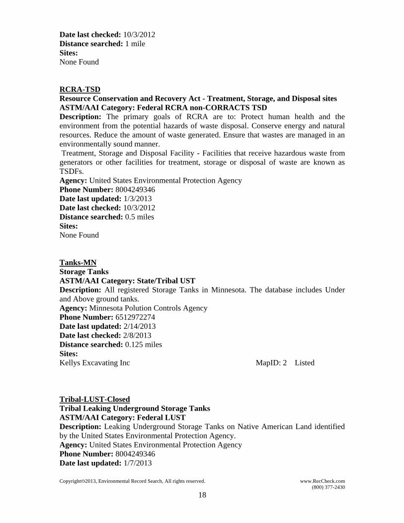
Copyright 2013, Environmental Record Search, All rights reserved. www.RecCheck.com
(800) 377-2430 18
Date last checked: 10/3/2012
Distance searched: 1 mile
Sites:
None Found
RCRA-TSD
Resource Conservation and Recovery Act - Treatment, Storage, and Disposal sites
ASTM/AAI Category: Federal RCRA non-CORRACTS TSD
Description: The primary goals of RCRA are to: Protect human health and the
environment from the potential hazards of waste disposal. Conserve energy and natural
resources. Reduce the amount of waste generated. Ensure that wastes are managed in an
environmentally sound manner.
Treatment, Storage and Disposal Facility - Facilities that receive hazardous waste from
generators or other facilities for treatment, storage or disposal of waste are known as
TSDFs.
Agency: United States Environmental Protection Agency
Phone Number: 8004249346
Date last updated: 1/3/2013
Date last checked: 10/3/2012
Distance searched: 0.5 miles
Sites:
None Found
Tanks-MN
Storage Tanks
ASTM/AAI Category: State/Tribal UST
Description: All registered Storage Tanks in Minnesota. The database includes Under
and Above ground tanks.
Agency: Minnesota Polution Controls Agency
Phone Number: 6512972274
Date last updated: 2/14/2013
Date last checked: 2/8/2013
Distance searched: 0.125 miles
Sites:
Kellys Excavating Inc MapID: 2 Listed
Tribal-LUST-Closed
Tribal Leaking Underground Storage Tanks
ASTM/AAI Category: Federal LUST
Description: Leaking Underground Storage Tanks on Native American Land identified
by the United States Environmental Protection Agency.
Agency: United States Environmental Protection Agency
Phone Number: 8004249346
Date last updated: 1/7/2013

Copyright 2013, Environmental Record Search, All rights reserved. www.RecCheck.com
(800) 377-2430 19
Date last checked: 10/3/2012
Distance searched: 0.5 miles
Sites:
None Found
Tribal-LUST-Open
Tribal Leaking Underground Storage Tanks
ASTM/AAI Category: Federal LUST
Description: Leaking Underground Storage Tanks on Native American Land identified
by the United States Environmental Protection Agency.
Agency: United States Environmental Protection Agency
Phone Number: 8004249346
Date last updated: 1/7/2013
Date last checked: 10/3/2012
Distance searched: 0.5 miles
Sites:
None Found
Tribal-UST
Tribal Underground Storage Tanks
ASTM/AAI Category: Federal UST
Description: Underground Storage Tanks on Native American Land identified by the
United States Environmental Protection Agency.
Agency: United States Environmental Protection Agency
Phone Number: 8004249346
Date last updated: 1/7/2013
Date last checked: 10/3/2012
Distance searched: 0.125 miles
Sites:
None Found
US-BF
A Listing of Brownfields Sites
ASTM/AAI Category: Federal Brownfield
Description: Brownfields sites listed under the "Cleanups in My Community" program
maintained by EPA.
Agency: U.S. Environmental Protective Agency
Phone Number: 2025662777
Date last updated: 1/2/2013
Date last checked: 10/3/2012
Distance searched: 0.5 miles
Sites:
None Found

Copyright 2013, Environmental Record Search, All rights reserved. www.RecCheck.com
(800) 377-2430 20

Copyright 2013, Environmental Record Search, All rights reserved. www.RecCheck.com
(800) 377-2430 21
OCCURRENCES NOT MAPPED
The following occurrences were not mapped due to various reasons mostly resulting from
incomplete or inaccurate address information. All of the following occurrences were
determined to share the same zip code as the subject site. General status information is
given with each occurrence along with any address information entered by the agency
responsible for the list.
Requested all unplottable sites.
WCI FREEZER DIVISION RCRA-COR
701 33RD AVE N Listed
ST CLOUD, MN 56301
__________
WCI FREEZER DIVISION RCRA-TSD
701 33RD AVE N Listed
ST CLOUD, MN 56301
__________
ALBERS FEED SERVICE INC Hist-UST-MN
RR 8 Listed
St. Cloud, MN 56301
__________
ARTHUR J BENOIT Hist-UST-MN
PO Box 322 Listed
St. Cloud, MN 56301
__________
BERNICKS PEPSI COLA Hist-UST-MN
PO Box 1184 Listed
St. Cloud, MN 56301
__________
BESSERS INC Hist-UST-MN
E Highway 23 Listed
St. Cloud, MN 56301
__________
EICH MOTOR CO Hist-UST-MN
PO Box 396 Listed
St. Cloud, MN 56301
__________
FINGERHUT CORP Hist-UST-MN
11 Mcleland Rd Listed
St. Cloud, MN 56301
__________
HOUSING & REDEVELOPMENT AUTHORITY Hist-UST-MN
619 Mall Germain Ste 212 Listed
St. Cloud, MN 56301
__________
NIC J SPANIER Hist-UST-MN
RR 8 Listed
St. Cloud, MN 56301
__________
OVERHEAD DOOR CO OF SAINT CLOUD INC Hist-UST-MN
RR 2 Listed
St. Cloud, MN 56301
__________

Copyright 2013, Environmental Record Search, All rights reserved. www.RecCheck.com
(800) 377-2430 22
SAINT CLOUD DIOCESE Hist-UST-MN
PO Box 1248 Listed
St. Cloud, MN 56301
__________
SAINT CLOUD HOUSING & REDEVELOPMENT Hist-UST-MN
619 Mall Germain Listed
St. Cloud, MN 56301
__________
STEARNS COUNTY HWY DEPT Hist-UST-MN
425 S 72nd Ave Listed
St. Cloud, MN 56301
__________
STEMM TRANSFER & STORAGE INC Hist-UST-MN
PO Box 397 Listed
St. Cloud, MN 56301
__________
SY KILLEEN Hist-UST-MN
RR 2 Listed
Sauk Rapids, MN 56301
__________
THOMAS R MILLER Hist-UST-MN
PO Box 7188 Listed
St. Cloud, MN 56301
__________
DON FORCIER Hist-UST-MN
PO Box 1184 Listed
St. Cloud, MN 56301
__________
Housing & Redevelopment Authority Hist-UST-MN
619 Mall Germain Ste 212 Listed
St. Cloud, MN 56301
__________
Clara Witte Hist-UST-MN
24500th State Highway 15 Listed
St. Cloud, MN 56301
__________
Stearns County Hwy Dept Hist-UST-MN
425 S 72nd Ave Listed
St. Cloud, MN 56301
__________
Overhead Door Co Of Saint Cloud Inc Hist-UST-MN
RR 2 Listed
St. Cloud, MN 56301
__________
Nic J Spanier Hist-UST-MN
RR 8 Listed
St. Cloud, MN 56301
__________
Saint Cloud Diocese Hist-UST-MN
PO Box 1248 Listed
St. Cloud, MN 56301
__________
Saint Cloud Housing & Redevelopment Hist-UST-MN
619 Mall Germain Listed
St. Cloud, MN 56301
__________
Don Forcier Hist-UST-MN
PO Box 1184 Listed

Copyright 2013, Environmental Record Search, All rights reserved. www.RecCheck.com
(800) 377-2430 23
St. Cloud, MN 56301
__________
Paul Faga Hist-UST-MN
511 54th Ave S Listed
St. Cloud, MN 56301
__________
BURLINGTON NORTHERN ST CLOUD SHOP CERCLIS-Archived
10TH AVE & THIRD ST NFR
WAITE PARK, MN 56301
__________
WHITNEY COURT SITE CERCLIS-Archived
WHITNEY COURT & 15TH STREET NORTH NFR
ST. CLOUD, MN 56301
__________
ST CLOUD GAS MFG SITE CERCLIS-Archived
1ST ST & 5TH AVE N NFR
ST. CLOUD, MN 56301
__________
SOUTH ELEMENTARY SCHOOL RCRA
1120 S 15TH AVE Listed
ST CLOUD, MN 56301
__________
HOUR GLASS CLEANERS - ST CLOUD RCRA
125 7TH AVE S Listed
ST. CLOUD, MN 56301
__________
JM OIL CO INC RCRA
162 72ND AVE S Listed
ST CLOUD, MN 56301
__________
ERIC GRUNEWALD/INDENPENDENT TANNING SPLY RCRA
1835 36TH ST S Listed
ST. CLOUD, MN 56301
__________
O3 INDUSTRIES INC RCRA
2205 251ST ST Listed
ST. CLOUD, MN 56301
__________
MAY PRINTING CO RCRA
221 LINCOLN AVE SE Listed
ST CLOUD, MN 56301
__________
KURILLA GRAPHICS INC RCRA
24247 COUNTY ROAD 7 Listed
ST. CLOUD, MN 56301
__________
CUSTOM STAINING & FINISHING INC RCRA
301 34TH AVE S Listed
WELLE PARK, MN 56301
__________
XCEL ENERGY - ST CLOUD SERVICE CENTER RCRA
3515 N 3RD ST Listed
ST. CLOUD, MN 56301
__________
MACY'S NORTH - ST CLOUD RCRA
4201 W DIVISION ST STORE 43 Listed
ST. CLOUD, MN 56301
__________

Copyright 2013, Environmental Record Search, All rights reserved. www.RecCheck.com
(800) 377-2430 24
TARGET STORES T215 ST CLOUD RCRA
4201 W DIVISION/STE C Listed
ST CLOUD, MN 56301
__________
STOMMES CONSTRUCTION INC RCRA
8137 OLD HIGHWAY RD N Listed
ST. CLOUD, MN 56301
__________
EYE KRAFT OPTICAL INC RCRA
INDUSTRIAL PARK Listed
ST CLOUD, MN 56301
__________
NORTHSTAR COMMUTER RAIL ST CLOUD E STATI RCRA
NW QUADRANT OF LINCOLN AVE & T Listed
ST. CLOUD, MN 56301
__________

Copyright 2013, Environmental Record Search, All rights reserved. www.RecCheck.com
(800) 377-2430 25
DISCLAIMER, LIMITS AND LIABILITIES All of the data presented in this report was garnered from public information maintained by governmental
agencies. Environmental Record Search (ERS) cannot ensure that the data, which has been entered and
maintained by others, is complete or accurate. Any, and all omissions, errors, negligence, accidentally or
otherwise within the data received by ERS is assumed to be caused by others and ERS cannot and does not
assume, take, or acknowledge any liability whatsoever for data. The extrapolation of the mapped locations
is based solely on the accuracy of the data provided by others. Prior to relying completely on any mapped
location within this report, its accuracy should be verified using other means such as further documentation
or a field visit. ERS makes no representation, warranty or guaranty, express or implied regarding the accuracy
of the data entered and maintained by others or the suitability of this report for a certain task.
The data presented in this report should only be interpreted by an experienced environmental professional that
completely understands the potential inaccuracy of the data, the possible existence of contaminated occurrences
that have not been listed, and the possibility that the governmental database misrepresents the actual status of an
occurrence. Prior to relying completely on any of the data within this report, an environmental professional
should verify the accuracy of the information presented.
It is important that the reader and/or end user of this information realize that the data gathered has not been
verified for accuracy or completeness in any way by ERS. As much as possible, the data is presented
unchanged to represent the actual data produced by these agencies.
ERS does however stand behind its representation of the data, any manually plotted occurrences, and all other
items directly under its control. This report does comply (as far as the data is reasonably ascertainable as
outlined in both the following standards) with section 8.2.1 of ASTM 1527-05 – Standard Environmental
Record Sources and EPA’s 40 CFR Part 312, All Appropriate Inquiries. ERS does ensure that the data is
accurately reproduced from the original source. ERS backs the reporting of the data with $2,000,000 of
insurance.
The ERS logo, name, report design, presentation, maps, tables, etc., are the exclusive property of ERS and its
parent company and affiliates. Except as provided below, information or images contained in this report may
not be reproduced or distributed in whole or in part by any means without the prior written permission from
ERS. United States and international copyright laws protect any and all reports produced by ERS.
The person or entity that purchased this report may make up to five (5) copies of the entire report or any part
of it for archival purposes or to include as part of another report. All copyright information must remain intact
and not be modified in any way.
Environmental Record Search (ERS) and Phase One, Inc. (POI) and their respective products/reports
(i.e. RecCheck, LenderCheck, etc.) as well as their respective business operations, are NOT associated in
any way with nor related to, First American Commercial Real Estate, Inc. (FACRES) and/or the First
American Family of Companies.
Maps throughout this report were created using ArcGIS® software by Esri. ArcGIS® and ArcMap™ are the
intellectual property of Esri and are used herein under license. Copyright © Esri. All rights reserved. For more
information about Esri® software, please visit www.esri.com. Topographic imagery used in maps throughout
this report are Copyright © 2011 National Geographic Society. Street and aerial “hybrid” imagery used in
maps throughout this report are Copyright © 2010 Microsoft Corporation and its data suppliers.
