phase i and limited phase ii environmental site assessment ... · phase i and limited phase ii...
TRANSCRIPT
Phase I and Limited Phase II Environmental Site Assessment
Report
Meadowood Project Pankey Ranch Property
Approximately 388.5 Acres Fallbrook, California
PREPARED FOR
Pardee Homes 12626 High Bluff, Suite 100
San Diego, California 92130
Converse Project No. 02-41-220-01 October 2, 2007
Converse Project No. 02-41-220-00
i
Table of Contents
Page
EXECUTIVE SUMMARY................................................................................................... IV
1.0 INTRODUCTION.................................................................................................... 1
1.1 Purpose and Scope of Services................................................................... 1
1.2 Non-Scope Considerations .......................................................................... 2
1.3 Significant Assumptions............................................................................... 2
1.4 Limitations and Exceptions .......................................................................... 2
1.5 Special Terms and Conditions ..................................................................... 3
1.6 Reliance....................................................................................................... 3
2.0 PROPERTY DESCRIPTION .................................................................................. 4
2.1 Current Use(s) of the Property..................................................................... 4
2.2 Location and Legal Description.................................................................... 4
2.3 Zoning Information....................................................................................... 5
2.4 Property Characteristics............................................................................... 5
2.5 Description of Property Structure(s)............................................................. 5
3.0 USER/OWNER PROVIDED INFORMATION & RESPONSIBILITIES .................... 7
3.1 Requested Documents and Information....................................................... 7
3.2 User Provided Information ........................................................................... 9 3.2.1 Environmental Cleanup Liens...................................................................... 9 3.2.2 Activity and Use Limitations (AULs)............................................................. 10 3.2.3 Specialized Knowledge or Experience ........................................................ 10 3.2.4 Reason for Significantly Lower Purchase Price........................................... 10 3.2.5 Commonly Known or Reasonably Ascertainable Information...................... 10 3.2.6 Obviousness of Contamination.................................................................... 10
3.3 Continuing Obligations................................................................................. 10
4.0 RECORDS REVIEW .............................................................................................. 12
4.1 Physical Setting ........................................................................................... 12 4.1.1 Geology ....................................................................................................... 12 4.1.2 Groundwater ................................................................................................ 13
Converse Project No. 02-41-220-00
ii
4.1.3 Potable Water Supplier................................................................................ 13 4.1.4 Fault Zones.................................................................................................. 13 4.1.5 Flood Zone .................................................................................................. 13
4.2 Historical Review ......................................................................................... 14 4.2.1. Aerial Photograph and Map Review ............................................................ 14 4.2.2 Building Permit Review................................................................................ 15 4.2.3 City Directories ............................................................................................ 16 4.2.4 Data Failure ................................................................................................. 16 4.2.5 Summary of Historical Property Use............................................................ 16 4.2.6 Summary of Past Uses of Adjoining Properties........................................... 16 4.2.7 Summary of Past Uses of the Surrounding Area......................................... 16
4.3 Results of Environmental Records Sources Review.................................... 17 4.3.1 Property Listings.......................................................................................... 17 4.3.2 Adjoining Properties .................................................................................... 17 4.3.3 Other Offsite Locations of Concern ............................................................. 17 4.3.4 Orphan Listings ........................................................................................... 17
4.4 Additional Environmental Record Sources................................................... 18 4.4.1 California Environmental Protection Agency (Cal/EPA), Department of
Toxic Substances Control (DTSC)............................................................... 18 4.4.2 Cal/EPA, Regional Water Quality Control Board (RWQCB)........................ 18 4.4.3 California Department of Conservation, Division of Oil, Gas and
Geothermal Resources (DOGGR)............................................................... 18 4.4.4 California State Fire Marshall (CSFM), Pipeline Safety Division ................. 18 4.4.5 San Diego County Air Pollution Control District (SDCAPCD)...................... 18 4.4.6 County of San Diego, Department of Environmental Health (DEH) ............ 18 4.4.7 San Diego County, Agriculture, Weights, and Measures (SDCAWM)......... 18
5.0 PROPERTY RECONNAISSANCE ......................................................................... 19
5.1 Methodology ................................................................................................ 19
5.2 Limiting Conditions....................................................................................... 19
5.3 Observations of Property ............................................................................. 19
5.4 Current Uses of Adjoining Properties........................................................... 23
5.5 Current Uses of Surrounding Area............................................................... 23
6.0 LIMITED PHASE II ENVIRONMENTAL SITE......................................................... 24
ASSESSMENT.................................................................................................................. 24
6.1 Scope of Work ............................................................................................. 24 6.1.1 Project Set-up and Management.................................................................... 24
Converse Project No. 02-41-220-00
iii
6.1.2 Areas of Concern (AOC) ................................................................................ 24 6.2 Field Activities and Analysis......................................................................... 26
6.3 Sample Collection Protocol and Analytical Methodology ............................. 29
7.0 INTERVIEWS ......................................................................................................... 35
7.1 Property Owner............................................................................................ 35
7.2 Tenant/Occupant ......................................................................................... 35
7.3 State or Local Government Officials ............................................................ 35
8.0 FINDINGS .............................................................................................................. 36
9.0 OPINION ................................................................................................................ 41
10.0 CONCLUSIONS AND RECOMMENDATIONS...................................................... 42
11.0 DEVIATIONS AND LIMITATIONS......................................................................... 45
12.0 ADDITIONAL NON-SCOPE SERVICES ............................................................... 46
12.1 Asbestos and Lead-Base Paint (LBP).......................................................... 46
12.2 Radon Information ....................................................................................... 46
13.0 SIGNATURE OF ENVIRONMENTAL PROFESSIONAL ....................................... 47
14.0 LIST OF PREPARERS.......................................................................................... 48
15.0 REFERENCES ...................................................................................................... 50 APPENDICES Appendix A – Property Plans Appendix B – Pertinent Property Photographs Appendix C – FirstSearch - Environmental FirstSearch Report Appendix D – DEH Records Appendix E – SDCAWM Records Appendix F – Sampling Rationale and Analytical Tables Appendix G – Boring Logs Appendix H – Analytical Report and Chain of Custody Documentation Appendix I – Asbestos and Lead-Base Paint, Analytical Report and Chain of Custody Documentation
Converse Project No. 02-41-220-00
iv
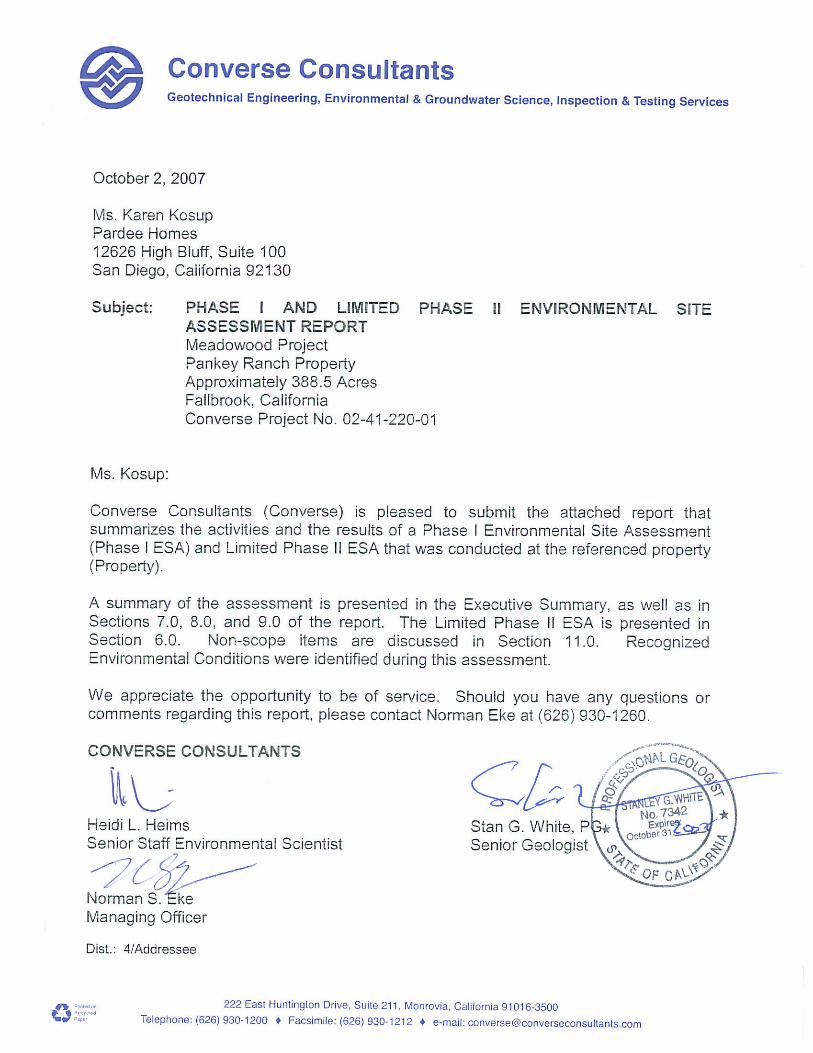
Executive Summary The following is an Executive Summary of the Phase I Environmental Site Assessment and Limited Phase II Environmental Site Assessment that was conducted by Converse Consultants (Converse). Please refer to the appropriate sections of the report for a complete discussion of these issues. In the event of a conflict between this Executive Summary and the report, or an omission in the Executive Summary, the report shall prevail. This report presents the results of the Converse Consultants (Converse) Phase I Environmental Site Assessment (ESA) performed at the Pankey Ranch property in the Fallbrook area of San Diego County, California, referred to as the Property in this report. Converse was retained by Pardee Homes to conduct this assessment. Our study has been conducted in order to identify, to the extent feasible, Recognized Environmental Conditions (RECs) in connection with the Property and to conduct supplemental Phase II assessment. Converse has compiled and reviewed information that was obtained from interviews, document research, and onsite and area reconnaissance to identify potential environmental conditions at the Property, in conformance with the ASTM Standard E: 1527-05 Environmental Site Assessment Standard Practice (ASTM Standard: E1527-05). This Phase I ESA was conducted during the period of September 11, 2007 through October 2, 2007. The Property is currently Pankey Ranch, which consists of approximately 388.5-acres in area. The Property is primarily agricultural land composed of citrus and avocado orchards, with a ranch office and storage area, and single-family residential properties. The Property is located approximately 500-feet of the northeast of Pankey Road, and approximately 1/3-mile north of the San Luis Rey River. The Property is approximately ½-mile east of Interstate 15 (I-15). This assessment has revealed no evidence of recognized environmental conditions in connection with the Property, except for the following:
• The Property has been used for agricultural purposes since at least 1928. According to San Diego County, Agriculture, Weights, and Measurement (SDCAWM) records reviewed, the Property appears to utilize herbicides, miticides, and insecticides permitted by the SDCAWM. Analytical results obtained during the Limited Phase II ESA conducted in 2002 indicated no detectable or low concentrations of agricultural chemical residues onsite, including organophosphorous pesticides, organochlorine pesticides, and chlorinated acid herbicides in onsite soils. Based on these analytical results, there appears to be a low potential for environmental impact to the Property from current or historical agricultural operations. However, upon acquisition of the Property and subsequent removal of the irrigation water from the two (2) onsite
Converse Project No. 02-41-220-00
v
irrigation ponds, Converse recommends collecting soil samples from the bottom of the ponds in order to address the potential for agricultural chemical residues in subsurface sediments in the ponds.
• Smudge pots were observed at several locations on the Property. Staining and
hydrocarbon odors were observed and detected in the vicinity of the smudge pots during the assessment in 2002. Based on the results of the Limited Phase II ESA, the surficial soil in the immediate vicinity of the smudge pots appears to have been impacted by total petroleum hydrocarbons (TPH).
The concentrations of TPH detected in the limited number of samples in the vicinity of the smudge pots are considered a low risk due to:
• The TPH was detected only in the surficial soil. • The concentrations detected were generally in the heavier
hydrocarbon range and represent a low order of toxicity. • The concentrations of TPH do not pose a fire or explosion hazard.
Converse recommends excavation and disposal of the surficial soil in the vicinity of the smudge pots.
• The Property stores and uses pesticides, miticides and bioxides in the current
agricultural operations. These chemicals are stored in ASTs and plastic containers on the central portion of the Property. Converse performed subsurface sampling in the vicinity of the aboveground storage tanks (ASTs) and plastic containers as a part of the Limited Phase II ESA in 2002. Analytical results indicated no detectable concentrations above the method detection limits of organophosphorus pesticides. Analytical results indicated no detectable concentrations above the method detection limits of organochlorine pesticides in all the samples except for GP-18 at a depth of 3-feet bgs. However, the concentration detected in boring GP-18 is below the Total Threshold Limit Concentrations (TTLC) and less than ten times the (Soluble Threshold Limit Concentration) STLC and applicable PRG. The concentrations of TPH detected in the limited number of samples near the pesticide/nutrient storage area are considered insignificant due to:
• The relatively low concentrations detected. • The TPH was detected only in the surficial soil and decreased
significantly with depth. • The concentrations detected were generally in the heavier
hydrocarbon range and represent a low order of toxicity. • The concentrations of TPH do not pose a fire or explosion hazard.
Converse Project No. 02-41-220-00
vi
Prior to the redevelopment of the Property, Converse recommends proper removal and disposal of all chemical ASTs and containers.
• Six (6) gasoline ASTs and two (2) 500-gallon fuel tanker trailers were observed
on the Property. Converse performed subsurface sampling in the vicinity of the ASTs and tanker trailers. Analytical results indicated no or low detectable concentrations of TPH, total lead, metals, and VOCs. Prior to the redevelopment of the Property, Converse recommends removal and disposal of all fuel ASTs according to local regulations.
• Arsenic was detected in onsite soils during the Limited Phase II ESA, however,
based on the average concentration of arsenic below the average concentration established by the Kearney Foundation for California soils and the close distribution of the analytical results, the arsenic concentrations appear to be naturally occurring rather than anthropogenic.
• Minor surficial staining was observed on soil throughout the Property. The
stained soils should be removed from the Property and properly disposed of.
In addition the above, Converse has the following recommendations:
• Historical records indicate that the residential properties on the Property were constructed between the early 1970’s and mid-1980s. Prior to redevelopment/demolition of the residential properties, Converse recommends an asbestos and lead-based paint survey of the buildings on the Property.
In addition, Converse observed several large construction debris piles on the Property. Samples of a black mastic/tar on concrete, as well as a gray and white coating on concrete analyzed for asbestos were non-detect. Peeling white paint observed on concrete was also sampled for lead content, and was reported as non-detect. Several ceramic tiles observed in the construction debris pile were analyzed for lead utilizing a XRF device and tested positive (i.e., over 1 milligrams per centimeter squared). Converse recommends that all floor tiles in the construction debris piles onsite be removed from the Property with as little disturbance as possible to minimize the generation of lead-containing dust. The waste must be characterized in order to determine proper disposal procedures.
• According to a representative of the Property owner, Mr. William Pankey, septic
tank systems are utilized onsite in connection with the residential properties. Upon redevelopment, Converse recommends that all onsite septic tank systems be properly abandoned and removed from the Property according to all applicable regulations.
• According to Mr. Pankey, there is a potential that a historic water well is on the
Property; however, Mr. Pankey is not aware of the location. The water well
Converse Project No. 02-41-220-00
vii
should be located and properly abandoned according to all applicable regulations.
Converse Project No. 02-41-220-01 1
1.0 Introduction
1.1 Purpose and Scope of Services
This report presents the results of the Converse Consultants (Converse) Phase I Environmental Site Assessment (Phase I ESA) and Limited Phase II ESA performed at the Pankey Ranch property in the Fallbrook area of San Diego County, California, referred to as the Property in this report. Converse was retained by Pardee Homes to conduct this Phase I ESA. Our Phase I ESA has been conducted in order to identify, to the extent feasible, Recognized Environmental Conditions (RECs) in connection with the Property. The term Recognized Environmental Conditions is defined in Section 1.1.1 of the American Society of Testing and Materials (ASTM) Standard Practice as the presence or likely presence of any hazardous substances or petroleum products on a property under Conditions that indicate an existing release, past release, or material threat of a release… into structures on the property or into the ground, ground water or surface water of the property. On January 11, 2002, Public Law 107-118 was signed. The Small Business Liability Relief and Brownfields Revitalization Act (SBLRBRA) directed the United States Environmental Protection Agency (EPA) to promulgate a rule defining due diligence for compliance with the Comprehensive Environmental Response, Compensation and Liability Act (CERCLA). This rule, which is generally referred to as All Appropriate Inquiry (AAI) was adopted on November 1, 2005. The AAI rule states that ASTM E1527-05 complies with the EPA requirements for AAI. In some cases the ASTM 1527-05 is more stringent than AAI. This Phase I ESA and Limited Phase II ESA were completed in accordance with our revised work order dated September 18, 2007, and also to address County of San Diego, Department of Planning and Land Use comments. Our ESA consisted of the following and was completed in general conformance with the scope and limitations of the ASTM Practice E1527-05 and complies with standards and practices set forth in 40 Code of Federal Regulations (CFR) Part 312 for AAI.
• Interviews with the Property owner representatives • Property and vicinity reconnaissance • Review of regulatory agency records • Description of physical setting • Historical review • Interviews with public agency personnel • Preparation of this report
The Limited Phase II ESA is presented in Section 6 of this report, as well as Sections 7, 9, and 10.
Converse Project No. 02-41-220-01 2
1.2 Non-Scope Considerations There are a number of non-scope issues which are sometimes assessed concurrently with a Phase I ESA. Unless specifically agreed in the contract proposal documents, these non-scope considerations are not included as part of the Phase I assessment. Examples of non-scope issues include:
• Asbestos-containing building material • Radon • Lead-base Paint • Lead in Drinking Water • Wetlands • Regulatory Compliance • Cultural & Historic Resources • Ecological Resources • Industrial Hygiene • Endangered Species • Health & Safety • Indoor Air Quality • Mold • Biological Agents
Asbestos-containing building materials, lead-base paint, and radon were non-scope issues that were considered part of this assessment and are discussed in Section 11.0 of this report.
1.3 Significant Assumptions
Converse made the following assumptions for this assessment:
• The subject Property was not covered on currently published
groundwater contour maps. Therefore, the direction of regional groundwater is inferred to follow surface topography to the south.
1.4 Limitations and Exceptions
There were limitations or exceptions during this assessment:
• Converse did not physically walk the sloping terrain at the northwestern, southwestern and western boundaries of the Property; however, these portions of the Property were viewed from other interior areas of the Property.
• Converse did not access the residential properties onsite.
Residential properties were viewed from unimproved roads or adjoining common areas and agricultural groves.
Converse Project No. 02-41-220-01 3
1.5 Special Terms and Conditions
Pardee Homes was responsible for providing Attachment A of the Work Order to those identified. Converse received a completed Attachment A from Pardee Homes, summarized in Section 3.1. Converse completed this new Phase I ESA to update the existing Phase I ESA completed in 2002 in order to address County of San Diego, Department of Planning and Land Use comments. In addition to completing this ASTM 2005 version Phase I ESA, Converse has addressed the County comments on the Limited Phase II Environmental Site Assessment (ESA), also completed in 2002 (See Section 6).
1.6 Reliance
This report is for the sole benefit and exclusive use of Pardee Homes in accordance with our Master Services Agreement under which these services have been provided. Its preparation has been in accordance with generally accepted environmental practices. No other warranty, either expressed or implied, is made. This report should not be regarded as a guarantee that no further contamination beyond that which could be detected within the scope of this assessment is present at the Property. The conclusions and recommendations presented in this report are based on the agreed upon scope of work. Converse makes no warranties or guarantees as to the accuracy or completeness of information provided or compiled by others. It is possible that information exists beyond the scope of this assessment. It is not possible to absolutely confirm that no hazardous materials and/or substances exist at the subject Property. If none are identified as part of a limited scope of work, such a conclusion should not be construed as a guaranteed absence of such materials, but merely the results of the evaluation. Events may also occur after the Property visit, which may result in contamination of the Property. Additional information, which was not found or available to Converse at the time of report preparation, may result in a modification of the conclusions and recommendations presented. Any reliance on this report by Third Parties shall be at the Third Party’s sole risk.
Converse Project No. 02-41-220-01 4
2.0 Property Description
2.1 Current Use(s) of the Property
The Property consists of approximately 388.5-acres. The Property is primarily agricultural land composed of citrus and avocado orchards, with a ranch office and storage area, and single-family residential dwellings.
A Property location map and a Property plan are provided in Appendix A. Pertinent Property photographs are provided in Appendix B.
2.2 Location and Legal Description
The Property consists of 11 irregularly shaped parcels. Pala Road/Highway 76 traverses east to west through the southern portion of the Property. The Property is located approximately 500-feet to the northeast of Pankey Road, and approximately 1/3-mile north of the San Luis Rey River. The Property is approximately ½-mile east of Interstate 15 (I-15). The addresses for the Property were reported as 5326, 5328, 5338 and 5606 Pala Road/Highway 76. The following is a brief description of the Assessors Parcel Numbers (APNs) for the Property: Parcel 1081205200: This parcel is approximately 11-acres in area and is
composed of scrubs and chaparral. Parcel 1081220800: This parcel is approximately 30-acres in area and
composed of mixed scrubs, chaparral, citrus orchards and non-native grassland.
Parcel 1081221100: This parcel is approximately 100-acres in area. The
parcel is composed of scrubs, chaparral, citrus and avocado orchards.
Parcel 1081205300: This parcel is approximately 13-acres in area and is
composed primarily of citrus orchards. Parcel 1081220900: This parcel is approximately 31-acres in area and is
composed of citrus orchards and non-native grasslands.
Parcel 1081220300: This parcel is approximately 22.5-acres in area and is
composed of citrus orchards. Parcel 1081205400: This parcel is approximately 35-acres in area and is
primarily composed of citrus orchards.
Converse Project No. 02-41-220-01 5
Parcel 1081221000: This parcel is approximately 85-acres in area and is composed of citrus and avocado orchards. This parcel also contains an irrigation pond.
Parcel 1081211100: This parcel is approximately 25-acres in area and is
occupied by citrus orchards and an irrigation pond.
Parcel 1250610400: This parcel is approximately 26-acres in area and is
currently undeveloped. Parcel 1250610600: This parcel is approximately 3-acres in area and is
currently occupied by citrus orchards. Parcel 1250610500: This parcel is approximately 7-acres in area and is
currently undeveloped.
2.3 Zoning Information
According to the San Diego County, Planning Department, the zoning for the Property is for agriculture. 2.4 Property Characteristics
The Property is approximately 388.5-acres in area and is primarily agricultural land composed of citrus and avocado orchards. Undeveloped areas of Diegan Coastal Sage Scrub and Southern Mixed Chaparral are located at the northeastern and eastern boundaries of the Property. The Property is primarily flat low-lying land with sloping terrain (ridge/hill) at the northwestern, southwestern and western boundaries of the Property. The south-southwestern portion of the Property appeared to be used for the storage of tractor transmission/parts and agricultural equipment. The western-northwestern portion of the Property is used for the storage of pesticides, nutrients and insecticides. 2.5 Description of Property Structure(s) Several single-family residential properties with associated garages or sheds were observed at various locations throughout the Property. A metal hanger/shed with associated metal enclosures was observed near the south-southwestern portion of the Property. The metal hanger/shed also served as the ranch office. A single-story office/storage shed was observed near the pesticide storage area. Several wind machines are located throughout the Property.
Converse Project No. 02-41-220-01 6
The following services were present in the general area of the Property, at the time of the assessment. The name of the provider, as applicable, is indicated below:
• Electricity: San Diego Gas and Electric Company • Gas: San Diego Gas and Electric Company, onsite Propane
aboveground storage tanks • Potable Water: Rainbow Municipal Water District, private and
domestic water wells • Sanitary Sewer: Onsite septic tank systems associated with the
residential development • Heating, Ventilation, Air Conditioning (HVAC): Not observed • Solid Waste: Fallbrook Waste and Recycling Services
Converse Project No. 02-41-220-01 7
3.0 User/Owner Provided Information & Responsibilities
3.1 Requested Documents and Information
The ASTM E1527 specifies that the Property owner, key site manager and the User provide any helpful documents that may be available. In order to facilitate, and document, the collection of this information, Converse prepared a form titled Owner Interview and Helpful Information. Converse requested that Pardee Homes complete the form. The Property Owner response is provided in Section 7.0. The following documents and information were requested from Pardee Homes. No new information (i.e., since 2002) was provided to Converse.
• Environmental site assessment or environmental compliance audit
reports • Environmental permits or hazardous waste generator notices/reports • Registrations for aboveground and underground storage tanks • Septic systems, oil wells, or water wells • Registrations for underground injection systems • Material Safety Data Sheets; Community Right to Know Plans; or
Safety, Preparedness and prevention Plans; Spill Protection Countermeasures and Control Plans
• Reports regarding hydrologic conditions on the Property or surrounding area
• Notices or other correspondence form any government agency relating to past or current violations of environmental laws with respect to the Property or relating to environmental liens encumbering the Property.
• Hazardous waste generator notices or reports • Geotechnical studies • Risk assessments • Recorded Activity Use Limitations (AULs) • Proceedings regarding hazardous substances and petroleum products
including any pending, threatened or past: litigation; administrative proceedings; or notices from any governmental entity regarding possible violations of environmental laws or other possible liability related to hazardous substances or petroleum products.
The following were provided to Converse during the 2002 Phase I ESA.
Biological Constraints Survey for the Approximate 1000-acre Shapell Industries Northeast Quadrant I-15 and Route 76 Project Site, San Diego County, California, by BonTerra Consulting (BTC), dated July 26, 2000. The biological survey was conducted for a larger parcel of land, which included the Property. According to the report, the habitat at the Property
Converse Project No. 02-41-220-01 8
supported species such as the coastal California gnatcatcher, least Bell’s vireo, southwestern willow flycatcher, arroyo southwestern toad, Quino checkerspot butterfly and special status plant species. BTC recommended focused surveys be conducted for the resources on the Property prior to habitat disturbance on the Property. The species of flora and fauna on the Property were reported to be protected under the federal and state Endangered Species Act. Additionally, the report indicated that the removal of the species of flora and fauna on the Property could occur only after written authorization from the resource regulatory agencies. Geotechnical Due Diligence Study, Rottman/Pankey 1000-Acre Parcel, County of San Diego, Ca, by Pacific Soils Engineering, Inc (PSE), dated August 15, 2000. The study by PSE was conducted for a larger parcel of land, which included the Property. This geotechnical study was conducted for determining the geotechnical feasibility of developing the Property for residential, recreational and commercial/retail usage. Active and abandoned water wells were reported to be present on the Property. The past land uses were reported to be agricultural (citrus and avocado groves). The study identified three bedrock and three surficial units beneath the Property. The units were identified as artificial fill; Holocene alluvium; Quaternary terrace deposits; gabbroic rocks; granite rocks with gneissic texture and granite rocks. Groundwater was reported to be present at depths varying from eight (8) to 56-feet beneath the Property. The study reported that the development of the Property was feasible from a geotechnical standpoint. Environmental Site Assessment (ESA) of the Property East of I-15 and North of SR-76 Fallbrook, California, dated July 25, 2000, by Carlin Environmental Consulting (CEC). The ESA was conducted for a larger parcel of land, which included the Property. The purpose of the CEC investigation was to evaluate the general environmental conditions on the Property by researching documents and inspecting the Property for possible usage, past or present, of potentially hazardous materials for a Phase I ESA. The ESA was reported to be prepared as per the American Standard of Testing and Materials (ASTM) Standards E1527 and E 1528 for Phase I ESA and Transaction Screen Process. According to the ESA, the Property was comprised of regions of citrus/avocado groves, undeveloped land and residences. Soils beneath the Property were reported to consist of unconsolidated stream, river channel and alluvial fan deposits of quaternary age. The depth to the uppermost groundwater aquifer was reported to be approximately 50-feet below ground surface (bgs). The direction of groundwater flow was reported to be towards
Converse Project No. 02-41-220-01 9
the south. The closest active fault zone to the Property was reported to be approximately 7-miles to the east. According to the ESA report, aboveground storage tanks (ASTs) and a 500-gallon tanker trailer were located on the Property. The type of petroleum products used on the Property was reported as diesel and gasoline. The report also indicated that a 500-gallon diesel underground storage tank (UST) was reported from the Rottman Property (adjacent property to the west) in 1987. This UST case was reported to have received closure from the regulatory agencies. Pesticides and nutrients were reported to be stored in 55-gallon drums on the Property. No evidence of spills, stained soil or contamination was reported.
The ESA recommended the disposal of chemicals, pesticides and nutrients stored on the Property. CEC reported the possibility of prior spillage and leakage of chemicals being found during future development of the Property. Additionally, the ESA also recommended the soil beneath the ASTs and chemical storage areas be assessed for contamination.
3.2 User Provided Information
The ASTM E1527 outlines specific User responsibilities. This information will help identify the possibility of RECs in connection with the Property. These tasks do not require the technical expertise of an Environmental Professional and are generally not performed by environmental professionals performing a Phase I ESA. The User may perform them. In general, the User should make Converse aware of information they have regarding the following:
• Environmental cleanup Liens filed or recorded against the Property • Activity and land use limitations that are in place on the Property or
have been filed or recorded in a registry. • Specialized knowledge or experience of the person seeking to qualify
for the Legal Liability Protections (LLP) • Relationship of the purchase price to fair market value of the Property
if it were not contaminated • Commonly known or reasonably ascertainable information about the
Property • The degree or obviousness of the presence or likely presence of
contamination at the Property, and the ability to detect this contamination by appropriate investigation.
3.2.1 Environmental Cleanup Liens
The User and Property owner representative stated no environmental cleanup liens are filed or recorded against the Property.
Converse Project No. 02-41-220-01 10
3.2.2 Activity and Use Limitations (AULs)
The User and Property owner representative stated no AULs are in place onsite or have been filed or recorded against the Property.
3.2.3 Specialized Knowledge or Experience
The User had no specialized knowledge or experience related to the Property or nearby properties. 3.2.4 Reason for Significantly Lower Purchase Price The User stated that the purchase price being paid for the Property reasonably reflects fair market value. 3.2.5 Commonly Known or Reasonably Ascertainable Information
The User stated that the past use of the Property was for agriculture, and the chemicals related to the agricultural business are utilized onsite. The User was not aware of any spills or chemical releases, or environmental cleanups onsite. 3.2.6 Obviousness of Contamination The User stated that there are storage sheds and maintenance areas for farm equipment onsite that could be a potential site of contamination. The User provided no other information. These storage and maintenance areas were a part of the Limited Phase II ESA conducted in 2002. See Section 11.0 for a summary of the Limited Phase II ESA.
Unless specifically stated otherwise in the Scope of Services, the purpose of this Phase I ESA was to qualify for the landowner liability protections to CERCLA Liability as described in ASTM E1527-05. Business risk unrelated to the CERCLA innocent landowners defense are only assessed as specifically agreed in the Scope of Services and discussed in Section 11.0, Additional Non-Scope Services, of this report.
3.3 Continuing Obligations
In order to exert an LLP, the User must satisfy a number of statutory requirements that are generally referred to as Continuing Obligations, which are outside the Scope of Services of the Phase I ESA. Examples of Continuing Obligations include providing legally required notices stopping continuing releases and complying with land use restrictions. Failure to
Converse Project No. 02-41-220-01 11
comply with these and other statutory post-acquisition requirements will jeopardize liability protection. It is the responsibility of the User to comply with the Continuing Obligations requirements of ASTM E1527-05 and AAI.
Converse Project No. 02-41-220-01 12
4.0 Records Review
4.1 Physical Setting
4.1.1 Geology The Property is generally located in Sections 35 and 36 of Township 9 South, Range 3 West in the U.S. Geological Survey (USGS) Bonsall Quadrangle (1968). The Property is located in the Peninsular Ranges Geomorphic province that extends south from Los Angeles County through Baja California. This province is characterized by a series of northwest-trending basins and mountain ranges bounded in the northern portion of the province by zones that include the Newport/Inglewood, Rose Canyon, Elsinore and the San Jacinto faults (Oakeshott 1971). The province is bounded by the Pacific Ocean to the west, and the Colorado Desert to the east.
Metasedimentary basement rocks, ranging in age from possibly the Paleozoic to the early Cretaceous, are intruded by Cretaceous age granitic and gabbroic rocks of the southern California batholith (Weber 1963). Cretaceous to Pliocene age sedimentary rocks occur along the costal plain and along the fault zones within the province.
The Property is characterized by hilly knobs on the southern flank of Monserate Mountain that moderately slopes toward the floodplain of an intermittent stream west of the Property. This stream is a tributary that drains into the San Luis Rey River immediately south of the Property.
During the Limited Phase II ESA conducted by Converse in 2002, medium to dark brown silty sands, sandy silts, and some clayey sands were encountered to a depth of approximately 20-feet bgs, the maximum depth drilled. These soils represent alluvial material derived from the surrounding mountains. Boring logs indicating soil conditions encountered during drilling activities are included as Appendix G. A prior geotechnical study by PSE was conducted for a larger parcel of land, which included the Property. The study identified three bedrock and three surficial units beneath the Property. The units were identified as artificial fill; Holocene alluvium; Quaternary terrace deposits; gabbroic rocks; granite rocks with gneissic texture and granite rocks.
Converse Project No. 02-41-220-01 13
4.1.2 Groundwater
According to the prior ESA (CEC, 2000), conducted for a larger parcel of land, which included the Property, the depth to the uppermost groundwater aquifer was reported to be approximately 50-feet below ground surface (bgs). The direction of groundwater flow was reported to be towards the south. No groundwater was encountered during this Limited Phase II ESA conducted by Converse in 2002. However, based on the topography and the location of an intermittent stream immediately west of the Property, shallow groundwater conditions are expected to occur along the western property line of the Property. The direction of groundwater flow is expected to follow surface topography towards the south.
Pacific Soils Engineering (August 2000) identified several water wells at the Property that served both residential and ranching operations. Based on their interview with the Property owner, the wells located adjacent to the San Luis Rey River were significant producers and the wells within the tributary drainage to the north were generally low producers of poorer quality water.
4.1.3 Potable Water Supplier
Potable water to the Property vicinity is supplied by the Rainbow Municipal Water District, and private and domestic wells. The district obtains their water primarily from the Rocky Mountains and Colorado River.
4.1.4 Fault Zones
According to the CEC Environmental Site Assessment, the Property is not on or adjacent to an earthquake fault considered active by the California Division of Mines & Geology (CDMG). The Elsinore Fault Zone, located approximately 8-miles to the east, is the closest active fault zone to the Property. According to the fault maps reviewed, the Property is not located within an Alquist-Priolo Special Study Zone.
4.1.5 Flood Zone
The Property is located within an area of minimal flooding, Flood Zone X. Zone X are areas of minimal to moderate flood hazard and are outside the 500 year flood plain (Federal Emergency Management Agency [FEMA], Flood Insurance Rate Map # 484, June 19, 1997).
Converse Project No. 02-41-220-01 14
4.2 Historical Review
4.2.1. Aerial Photograph and Map Review
Available historical aerial photographs were reviewed at the County of San Diego, Department of Public Works, Cartography Section. The years of the photographs reviewed are as follows: 1928, 12-14-60, 10-9-70, 12-3-74 and 1989. Historical Sanborn Fire Insurance (Sanborn) map coverage of the Property was requested from FirstSearch. According to FirstSearch, there is no Sanborn coverage of the Property. United States Geological Survey (USGS) 7.5-minute topographic maps were reviewed as a part of this assessment. The topographic maps for the Bonsall Quadrangle were dated 1949, 1968, and 1965 photorevised 1981. A chronological summary of the aerial photograph and map review is provided below. 1928 photograph The Property appeared to be a portion of a larger agricultural parcel. The two current irrigation ponds were visible on the Property. However, they appeared to be in a different configuration than present day conditions. Ranch type structures and sheds were visible in the vicinity of the irrigation ponds. Crop farming was observed on the northern portion of the Property. Residential structures appeared to occupy the southern parcel of the Property. Pala Road appeared to be developed. The adjacent properties to the north and south, beyond Pala Road, appeared to be undeveloped land. The adjacent property to the east, beyond the ridge area, appeared to be agricultural land. The adjacent property to the west appeared to be mixed agricultural and undeveloped land.
The general vicinity appeared to be mixed agricultural and undeveloped land. 1949 USGS map The Property and adjacent properties were depicted as undeveloped land. 12-14-60 photograph No apparent changes were observed from the previous photograph. An empty pit/catch basin was observed on the northwest corner of the Property boundary. The southern parcel of the Property appeared to be tilled land (row crop farming).
Converse Project No. 02-41-220-01 15
No apparent changes were observed to the adjacent properties to the north, east and west. The adjacent property to the south, beyond Pala Road, appeared to be agricultural land.
The general vicinity appeared to be agricultural land. 10-9-70 and 12-3-74 photographs, 1965 photorevised 1981 and 1968 USGS maps No apparent changes were observed from the previous photograph. In addition to the two current irrigation ponds on the Property, a irrigation pond appeared to occupy the northwestern corner of the Property. The south-central portion of the Property appeared to be tilled land. Three residential/shed type structures were evident on the eastern, and western portions of the Property. Three additional residential structures were evident on the southernmost portion (towards Pala Road) of the Property. The south-central portion of the Property appeared to be occupied by the present day residential structures.
No apparent changes were observed on the adjacent properties. The ranch office was not visible on the adjacent property to the east. The current reservoir was not visible on the eastern property. The general vicinity appeared to be mixed vacant and agricultural land. 10-9-70 photograph The present day conditions were observed on the Property and adjacent properties.
4.2.2 Building Permit Review
Building permits for the Property were requested from the County of San Diego, Department of Building and Safety. There were no building permits issued for 5326 and 5338 Pala Road. The following is a summary of the building permits reviewed: 5328 Pala Road (Highway 76) Between 1974 and 1975, various electrical and building permits were issued to the owner, Pankey Ranch, for pump installations and other miscellaneous fixtures. In 1979, three building permits were issued to the owner, Mr. Robert Pankey for the construction of a dwelling. Between 1981 and 1983, various building and electrical permits were issued to the owner, Pankey Ranch, for the installation of pumps, construction of agricultural buildings and detached garages on the Property.
Converse Project No. 02-41-220-01 16
In 1987, a building permit was issued for the construction of two wind machines on the Property. In 1990, a building permit was issued for the construction of a private pool and spa heater for a single family dwelling on the Property. 5606 Pala Road (Highway 76) In 1987, various building, electrical and plumbing permits were issued to the owner, Mr. William H. Pankey, related to the construction of a new dwelling on the Property. 4.2.3 City Directories A city directory search was completed on the Property by FirstSearch. The Property was not listed in city directories researched between 1971 and 2000. In 2005, the Property addresses of 5326, 5328, 5338 and 5606 Pala Road/Highway 76 were listed under the residential names of Pankey, Pagett, and Galan. Adjacent properties were not listed in the city directory search. Other properties within the greater surrounding area appeared to be a fuel service station, residential listings, a water district, and “service center”. 4.2.4 Data Failure Historical information regarding the Property was dated as early as 1928; therefore, there is no historical data failure for this assessment. 4.2.5 Summary of Historical Property Use The historical use of the Property has been agricultural land, with associated ranch operations and residential development since at least 1928. 4.2.6 Summary of Past Uses of Adjoining Properties
The adjoining properties appeared to have been either undeveloped land or agricultural land with associated ranch operations and residential development since 1928. 4.2.7 Summary of Past Uses of the Surrounding Area The surrounding area of the Property appeared to have been a mix of undeveloped and agricultural land in a rural area of San Diego County since 1928.
Converse Project No. 02-41-220-01 17
4.3 Results of Environmental Records Sources Review An environmental database report (Environmental FirstSearch Report) was prepared specifically for the Property by FirstSearch. The search included queries to the following databases for cases within specified ASTM search distances. The standard search radii were increased by ½-mile in order to have coverage of the Property. A copy of the FirstSearch report is provided in Appendix C.
4.3.1 Property Listings
The Property was identified in the orphan sites summary (i.e., un-mappable sites) on the PERMITS (San Diego County Permits) database as Pankey Ranch, at the Property address of 5328 Highway 76. Details to this database listing were not provided in the report. In addition, Pankey Farms was identified in the orphan sites summary in the report at two (2) offsite locations (3264 Shearer Crossing and 4881 Highway 76). These listings do not appear to be related to the Property. 4.3.2 Adjoining Properties
The adjoining properties were not identified on the databases in the FirstSearch report.
4.3.3 Other Offsite Locations of Concern
Two offsite locations of concern were reported on the PERMITS database within a maximum 1½-mile radius from the Property. The potential for environmental impact to the Property from these offsite locations of concern appears to be low due to the type of regulatory listing. 4.3.4 Orphan Listings The regulatory database frequently contains information on sites that can not be plotted because of insufficient address information. The FirstSearch database report identified several orphan listings. The locations of sites that were identified by address were found to be in the general vicinity of the Property (generally within the Fallbrook area of San Diego County), however, due to the distance and type of regulatory listing, were determined to have a low potential for environmental impact to the Property.
Converse Project No. 02-41-220-01 18
4.4 Additional Environmental Record Sources 4.4.1 California Environmental Protection Agency (Cal/EPA),
Department of Toxic Substances Control (DTSC) No information regarding the Property was on file with DTSC. 4.4.2 Cal/EPA, Regional Water Quality Control Board (RWQCB) No information regarding the Property was on file with RWQCB.
4.4.3 California Department of Conservation, Division of Oil, Gas
and Geothermal Resources (DOGGR)
Wildcat Map W1-7, San Diego and Riverside Counties, August 9, 2003, was reviewed. No oil or gas wells are located on the Property or adjacent properties. 4.4.4 California State Fire Marshall (CSFM), Pipeline Safety Division According to CSFM, pipelines jurisdictional to the CSFM are not located in the Property vicinity. 4.4.5 San Diego County Air Pollution Control District (SDCAPCD)
No information regarding the Property was on file with SDCAPCD.
4.4.6 County of San Diego, Department of Environmental Health
(DEH) The DEH provided Converse with inspections conducted by the DEH from 2000 to 2006. Violations noted in the inspection reports included properly labeling waste oil drums with a hazardous waste label, not maintaining hazardous materials handling and training records, not certifying a waste oil tank for tank integrity. The inspector noted that if waste oil was placed in drums instead of the tank, the test would not be needed. No other records were provided by the DEH. A copy of the DEH records is provided in Appendix D. 4.4.7 San Diego County, Agriculture, Weights, and Measures
(SDCAWM) The SDCAWM provided Converse with a list of agricultural chemicals that have been permitted for application on the Property from 2002 until 2007. The chemicals were primarily herbicides, insecticides, and miticides which were applied to lemon, avocado, orange, and grapefruit crops on the Property. The amount of these chemicals applied appeared to have been greatly reduced since 2002. A copy of the SDCAWM records is provided in Appendix E.
Converse Project No. 02-41-220-01 19
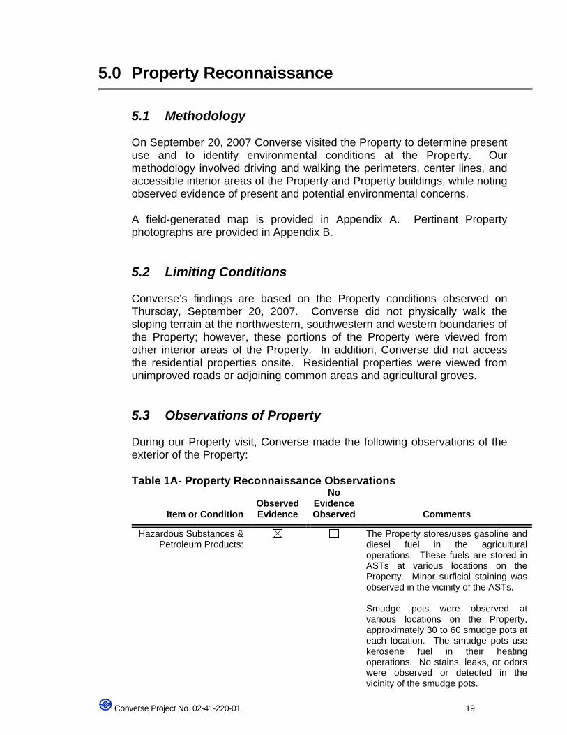
5.0 Property Reconnaissance
5.1 Methodology
On September 20, 2007 Converse visited the Property to determine present use and to identify environmental conditions at the Property. Our methodology involved driving and walking the perimeters, center lines, and accessible interior areas of the Property and Property buildings, while noting observed evidence of present and potential environmental concerns. A field-generated map is provided in Appendix A. Pertinent Property photographs are provided in Appendix B.
5.2 Limiting Conditions Converse’s findings are based on the Property conditions observed on Thursday, September 20, 2007. Converse did not physically walk the sloping terrain at the northwestern, southwestern and western boundaries of the Property; however, these portions of the Property were viewed from other interior areas of the Property. In addition, Converse did not access the residential properties onsite. Residential properties were viewed from unimproved roads or adjoining common areas and agricultural groves.
5.3 Observations of Property During our Property visit, Converse made the following observations of the exterior of the Property:
Table 1A- Property Reconnaissance Observations
Item or Condition
Observed Evidence
No Evidence Observed
Comments
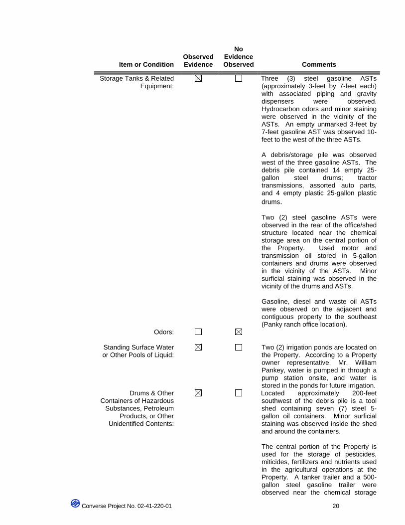
Hazardous Substances & Petroleum Products:
The Property stores/uses gasoline and diesel fuel in the agricultural operations. These fuels are stored in ASTs at various locations on the Property. Minor surficial staining was observed in the vicinity of the ASTs. Smudge pots were observed at various locations on the Property, approximately 30 to 60 smudge pots at each location. The smudge pots use kerosene fuel in their heating operations. No stains, leaks, or odors were observed or detected in the vicinity of the smudge pots.
Converse Project No. 02-41-220-01 20
Item or Condition
Observed Evidence
No Evidence Observed
Comments
Storage Tanks & Related Equipment:
Three (3) steel gasoline ASTs (approximately 3-feet by 7-feet each) with associated piping and gravity dispensers were observed. Hydrocarbon odors and minor staining were observed in the vicinity of the ASTs. An empty unmarked 3-feet by 7-feet gasoline AST was observed 10-feet to the west of the three ASTs. A debris/storage pile was observed west of the three gasoline ASTs. The debris pile contained 14 empty 25-gallon steel drums; tractor transmissions, assorted auto parts, and 4 empty plastic 25-gallon plastic drums. Two (2) steel gasoline ASTs were observed in the rear of the office/shed structure located near the chemical storage area on the central portion of the Property. Used motor and transmission oil stored in 5-gallon containers and drums were observed in the vicinity of the ASTs. Minor surficial staining was observed in the vicinity of the drums and ASTs. Gasoline, diesel and waste oil ASTs were observed on the adjacent and contiguous property to the southeast (Panky ranch office location).
Odors:
Standing Surface Water or Other Pools of Liquid:
Two (2) irrigation ponds are located on the Property. According to a Property owner representative, Mr. William Pankey, water is pumped in through a pump station onsite, and water is stored in the ponds for future irrigation.
Drums & Other Containers of Hazardous
Substances, Petroleum Products, or Other
Unidentified Contents:
Located approximately 200-feet southwest of the debris pile is a tool shed containing seven (7) steel 5-gallon oil containers. Minor surficial staining was observed inside the shed and around the containers. The central portion of the Property is used for the storage of pesticides, miticides, fertilizers and nutrients used in the agricultural operations at the Property. A tanker trailer and a 500-gallon steel gasoline trailer were observed near the chemical storage
Converse Project No. 02-41-220-01 21
Item or Condition
Observed Evidence
No Evidence Observed
Comments
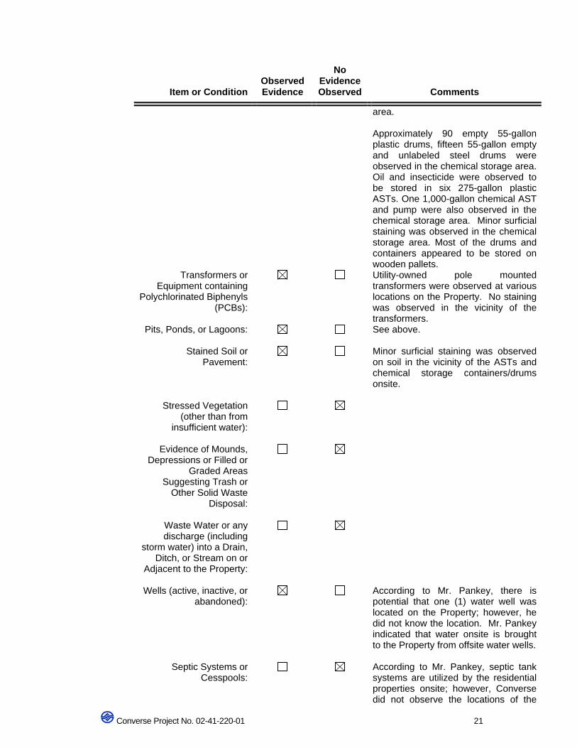
area. Approximately 90 empty 55-gallon plastic drums, fifteen 55-gallon empty and unlabeled steel drums were observed in the chemical storage area. Oil and insecticide were observed to be stored in six 275-gallon plastic ASTs. One 1,000-gallon chemical AST and pump were also observed in the chemical storage area. Minor surficial staining was observed in the chemical storage area. Most of the drums and containers appeared to be stored on wooden pallets.
Transformers or Equipment containing
Polychlorinated Biphenyls (PCBs):
Utility-owned pole mounted transformers were observed at various locations on the Property. No staining was observed in the vicinity of the transformers.
Pits, Ponds, or Lagoons: See above.
Stained Soil or Pavement:
Minor surficial staining was observed on soil in the vicinity of the ASTs and chemical storage containers/drums onsite.
Stressed Vegetation (other than from
insufficient water):
Evidence of Mounds, Depressions or Filled or
Graded Areas Suggesting Trash or
Other Solid Waste Disposal:
Waste Water or any discharge (including
storm water) into a Drain, Ditch, or Stream on or
Adjacent to the Property:
Wells (active, inactive, or abandoned):
According to Mr. Pankey, there is potential that one (1) water well was located on the Property; however, he did not know the location. Mr. Pankey indicated that water onsite is brought to the Property from offsite water wells.
Septic Systems or Cesspools:
According to Mr. Pankey, septic tank systems are utilized by the residential properties onsite; however, Converse did not observe the locations of the
Converse Project No. 02-41-220-01 22
Item or Condition
Observed Evidence
No Evidence Observed
Comments
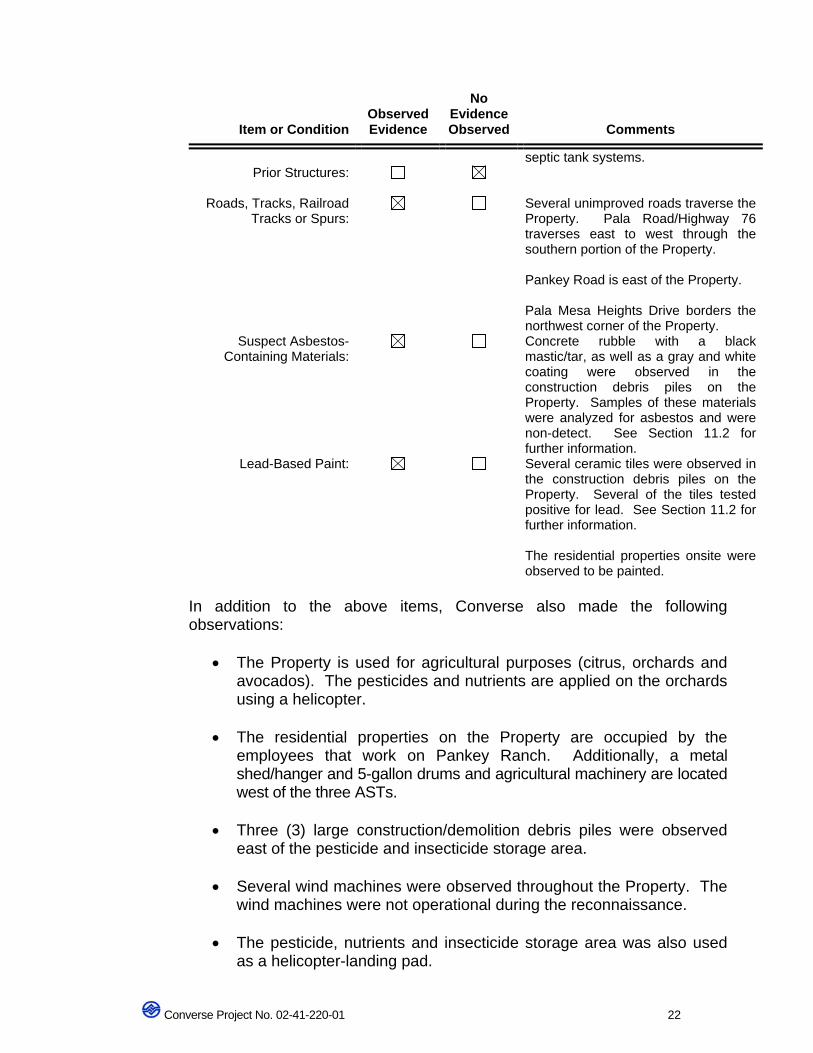
septic tank systems. Prior Structures:
Roads, Tracks, Railroad Tracks or Spurs:
Several unimproved roads traverse the Property. Pala Road/Highway 76 traverses east to west through the southern portion of the Property. Pankey Road is east of the Property. Pala Mesa Heights Drive borders the northwest corner of the Property.
Suspect Asbestos-Containing Materials:
Concrete rubble with a black mastic/tar, as well as a gray and white coating were observed in the construction debris piles on the Property. Samples of these materials were analyzed for asbestos and were non-detect. See Section 11.2 for further information.
Lead-Based Paint: Several ceramic tiles were observed in the construction debris piles on the Property. Several of the tiles tested positive for lead. See Section 11.2 for further information. The residential properties onsite were observed to be painted.
In addition to the above items, Converse also made the following observations:
• The Property is used for agricultural purposes (citrus, orchards and avocados). The pesticides and nutrients are applied on the orchards using a helicopter.
• The residential properties on the Property are occupied by the
employees that work on Pankey Ranch. Additionally, a metal shed/hanger and 5-gallon drums and agricultural machinery are located west of the three ASTs.
• Three (3) large construction/demolition debris piles were observed
east of the pesticide and insecticide storage area.
• Several wind machines were observed throughout the Property. The wind machines were not operational during the reconnaissance.
• The pesticide, nutrients and insecticide storage area was also used
as a helicopter-landing pad.
Converse Project No. 02-41-220-01 23
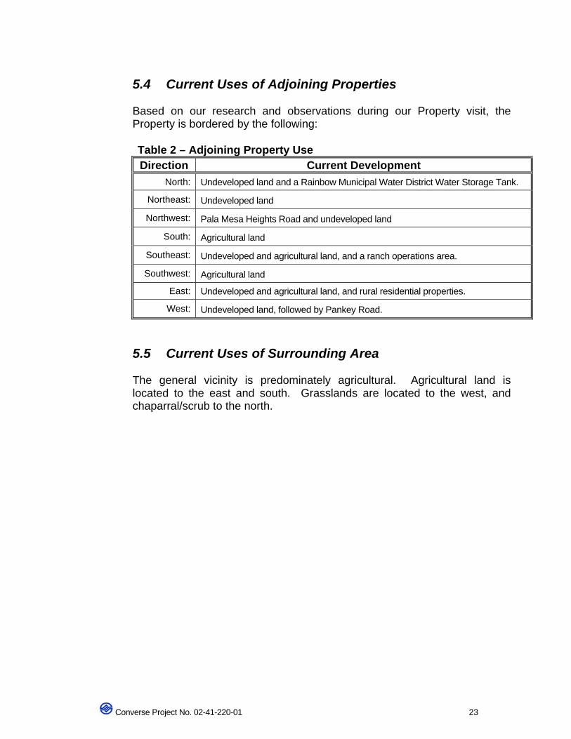
5.4 Current Uses of Adjoining Properties Based on our research and observations during our Property visit, the Property is bordered by the following: Table 2 – Adjoining Property Use Direction Current Development
North: Undeveloped land and a Rainbow Municipal Water District Water Storage Tank.
Northeast: Undeveloped land
Northwest: Pala Mesa Heights Road and undeveloped land
South: Agricultural land
Southeast: Undeveloped and agricultural land, and a ranch operations area.
Southwest: Agricultural land
East: Undeveloped and agricultural land, and rural residential properties.
West: Undeveloped land, followed by Pankey Road.
5.5 Current Uses of Surrounding Area The general vicinity is predominately agricultural. Agricultural land is located to the east and south. Grasslands are located to the west, and chaparral/scrub to the north.
Converse Project No. 02-41-220-01 24
6.0 Limited Phase II Environmental Site Assessment
Converse performed a Limited Phase II Environmental Site Assessment (ESA) for the Property on July 2 and 3, 2002. The objective of this assessment was to screen the Property for potential impact to the surface and subsurface soils from the current and historical activities on the Property.
6.1 Scope of Work
6.1.1 Project Set-up and Management
Converse personnel coordinated and scheduled Property access with the Property owner and marked boring locations during the Phase l reconnaissance of the Property. Project management included project oversight and management, health and safety monitoring of field activities, verbal project updates and communication(s) with Client.
Converse notified Underground Service Alert (ticket # A893549) prior to commencement of field activities.
Grab samples from ponds and soil samples were collected using a hand auger and Geoprobe (direct push technique).
6.1.2 Areas of Concern (AOC)
The Property was subdivided into areas of potential environmental concern as part of the Limited Phase II ESA. Refer to Figure 3 in Appendix A for the subdivided AOCs and boring locations. The following is a brief description of the AOCs assessed.
AOC1 The area of the three (3) onsite gasoline ASTs in which hydrocarbon odor and surface staining were observed and detected. This area was located on the southeast portion of the Property.
AOC 2 The area of the empty gasoline AST which is adjacent to the three ASTs in AOC1 near the southeast portion of the Property.
AOC 3 The area containing the agricultural equipment debris pile; fourteen (14) 25-gallon drums; tractor transmission parts pile and four (4) plastic 25-gallon drums located near the southeast portion of the Property. AOC4
Converse Project No. 02-41-220-01 25
The area of the metal shed/hanger, 5-gallon drums and agricultural machinery located west of the three ASTs in AOC1.
AOC5 The area of the metal enclosure containing 5-gallon waste oil drums and containers located south of the hanger in AOC4. Minor straining was observed in the vicinity of the enclosure.
AOC 7, 10, 22 and 25 H i l o heater (smudge pot) storage areas, were observed in the western, central, northwestern and northern portions of the Property. Staining and hydrocarbon odors were observed and noted in the vicinity of these heaters.
AOC 9 The area of the two (2) 500-gallon diesel steel ASTs; 10-gallon and 30-gallon waste oil/hydraulic fluid containers. Staining was observed in the vicinity of the drums.
AOC 12 The area of the pesticide, nutrient, insecticide and fertilizer storage observed on the central portion of the Property. This area also includes several 1,000-gallon ASTs and plastic containers containing miticides and bioxides. Staining was observed in the vicinity of the various plastic ASTs and used containers in this area. Two (2) gasoline tanker trailers were also observed in this area.
AOC 15 and 16 These areas include the immediate vicinity of the irrigation ponds located on the central portion of the Property. There is a potential for irrigation and agricultural run-off to the basins.
AOC 26 Off-site diesel and waste oil ASTs located near the Pankey ranch office. This AOC is located adjacent to the eastern boundary of the Property.
Agricultural samples In addition to the above AOCs, the Property was sub-divided into four major quadrants for agricultural pesticides/herbicides screening purposes only. The following is a brief description of the four quadrants: - Northwest Quadrant -- approximately 100 acres The Northwest Quadrant is comprised primarily of citrus orchards. The northwest portion of the quadrant is covered by non-native grassland. The northeast portion is covered by mixed scrub and chaparral. The southeast portion of the quadrant is primarily avocado orchards. - Southwest Quadrant -- approximately 110 acres
Converse Project No. 02-41-220-01 26
The northern portion of the Southwest Quadrant is composed of citrus orchards; the southern portion is currently undeveloped tilled land. Approximately 3 acres of citrus orchard are located at the southeast corner of the Southwest Quadrant. - Southeast Quadrant -- approximately 90 acres The Southeast Quadrant is composed primarily of citrus and avocado orchards. An undeveloped hilltop region composed of mixed scrub and chaparral is located in the southeast portion of the quadrant. - Southwest Quadrant -- approximately 110 acres The northern portion of the Southwest Quadrant is composed of citrus orchards; the southern portion is currently undeveloped tilled land. Approximately 3 acres of citrus orchard are located at the southeast corner of the Southwest Quadrant.
6.2 Field Activities and Analysis
The limited soil sampling activities completed for each AOC are summarized below:
AOC1
Two (2) Geoprobe borings (GP-1 and GP-2) were advanced to a maximum depth of 20-feet in the vicinity of the ASTs and associated gravity-pump dispensers. Soil samples were collected at 0.5-foot, 5-feet, 10-feet, 15-feet and 20-feet below ground surface (bgs).
The 0.5-foot samples from each boring were analyzed for total petroleum hydrocarbons (TPH) as carbon chain (TPH c-c) and total lead. The 5-foot, 10-foot, 15-foot and 20-foot samples were analyzed for volatile organic compounds (VOCs), TPH-c-c, total lead and TPH as gasoline (TPH-g).
AOC2 One (1) Geoprobe boring (GP-4) was advanced to a maximum depth of 20-feet in the vicinity of the AST. Samples were collected at depths of 0.5-feet, 5-feet, 10-feet, 15-feet and 20-feet bgs.
The 0.5-foot sample was analyzed for TPH c-c and total lead. The 5-foot, 10-foot, 15-foot and 20-foot samples were analyzed for VOCs; TPH-c-c; total lead and TPH-g.
AOC 3 Two (2) Geoprobe borings (GP-5 and GP-6) were advanced to a maximum depth of 10-feet in the vicinity of the debris pile. Samples were collected at 0.5-feet, 5-feet and 10-feet bgs.
The 0.5-foot samples from each boring were analyzed for chlorinated pesticides; organophosphorus pesticides; chlorinated acid herbicides; metals, TPH c-c and total lead. The 5-foot samples from each boring were
Converse Project No. 02-41-220-01 27
analyzed for VOCs; chlorinated pesticides organophosphorus pesticides; chlorinated acid herbicides; metals and TPH c-c. The 10-foot samples from each boring were analyzed for VOCs and TPH c-c,
AOC 4 One (1) Geoprobe boring (GP-8) was advanced to a maximum depth of 10-feet south of the metal shed/hanger. Samples were collected at 0.5-feet, 5-feet and 10-feet bgs.
The 0.5-foot sample was analyzed for metals and TPH c-c. The 5-foot sample was analyzed for VOCs, metals and TPH c-c. The 10-foot sample was analyzed for VOCs and TPH c-c.
AOC 5 One (1) Geoprobe boring (GP-7) was advanced to a maximum depth of 10-feet approximately 2-feet south of the metal enclosure. Samples were collected from this boring depths of 0.5-feet, 5-feet and 10-feet bgs.
The 0.5-foot sample was analyzed for chlorinated pesticides; organophosphorus pesticides; chlorinated acid herbicides; metals; and TPH c-c. The 5-foot sample was analyzed for chlorinated pesticides; organophosphorus pesticides; chlorinated acid herbicides; VOCs; metals and TPH c-c. The 10-foot sample was analyzed for VOCs and TPH c-c.
AOC 7, 10, 22 and 25 Two (2) Geoprobe borings each were advanced in the four areas of the smudge pots (GP-10, -11, -12, -13, -14, -15, -16 and -17) to a maximum depth of 10-feet bgs.
Soil samples were collected at depths of 0.5-feet, 5-feet and 10-feet bgs in borings, GP-10, GP-11, GP-15, GP-16, and GP-17.
Samples were only collected at 0.5-foot and 5-feet in borings GP-12, GP-13 and GP-14. The 10-foot samples from these borings could not be collected due to refusal (adverse soil conditions).
All of the soil samples collected from the borings in these AOCs were analyzed for TPH c-c.
AOC 9 One (1) Geoprobe boring (GP-9) was advanced in the vicinity of the ASTs and storage containers to a maximum depth of 5-feet bgs. Deeper samples could not be collected due to refusal.
Soil samples were collected at 0.5-foot and 5-feet bgs. The 0.5-foot sample was analyzed for metals and TPH c-c. The 5-foot sample was analyzed for VOCs, metals and TPH c-c.
AOC12
Converse Project No. 02-41-220-01 28
Four (4) Geoprobe borings (GP-18, -19, -20 and -21) were advanced in the vicinity of the pesticides and chemical AST storage containers to a maximum depth of 5-feet bgs.
Soil samples were collected at 0.5-foot, 3-feet and 5-feet bgs in borings GP-18, GP-19 and GP-21.
Soil samples were collected at depths of 0.5-feett and 3-feet in boring GP-20. The 5-foot sample could not be collected due to refusal.
The 0.5-foot samples were analyzed for chlorinated pesticides; organophosphorus pesticides; chlorinated acid herbicides; metals and TPH c-c. The 3-foot samples were analyzed for chlorinated pesticides; organophosphorus pesticides; chlorinated acid herbicides; VOCs; metals and TPH c-c. All of the 5-foot samples were analyzed for VOCs. The 0.5-foot, 3-foot and 5-foot samples collected from boring GP-21 were also analyzed for TPH-g.
AOC 15 and 16 Four (4) grab samples were collected from two sample locations (GP-22, GP-23). The samples were collected from the sediment located at the water's edge in the lower elevation irrigation pond (AOC 15). Four (4) grab samples were collected from two sample locations (GP-24, GP-25). These samples were collected from the sediment located at the water's edge in the lower elevation irrigation pond (AOC 16).
Soil samples GP-22 through GP-25 were analyzed for chlorinated pesticides; organophosphorus pesticides; chlorinated acid herbicides, TPH c-c, and metals.
Surface water samples from the irrigation ponds at AOC 15 (W-1) and AOC 16 (W-2) were also collected. The irrigation pond water samples were analyzed for chlorinated pesticides; organophosphorus pesticides; chlorinated acid herbicides; metals and TPH c-c.
AOC 26 One (1) Geoprobe boring (GP-3) was advanced in the vicinity of the off-site ASTs to a maximum depth of 10-feet bgs. Additional deeper samples could not be collected due to refusal.
Samples were collected at 0.5-foot, 5-feet and 10-feet bgs. The 0.5-foot sample was analyzed for total lead and TPH c-c. Both the 5-foot and 10-foot samples were analyzed for VOCs, TPH-g, total lead and TPH c-c.
Agricultural samples Seven (7) hand auger borings (AG-1, -2, -3, -4, -6, -7, and -8) were advanced in the southwest quadrant of the site to a maximum depth of 3-feet bgs. Soil samples were collected at depths of 0.5-feet and 3-feet bgs.
Converse Project No. 02-41-220-01 29
Seven (7) hand auger borings (AG-5, -9, -10, -11, -12, -14, and -15) were advanced in the southeast quadrant of the site to a maximum depth of 3-feet bgs. Soil samples were collected at 0.5-feet and 3-feet bgs.
One (1) hand auger boring (AG-13) was advanced in the northeast quadrant of the Property to a maximum depth of 3-feet bgs. Soil samples were collected at 0.5-feet and 3-feet bgs.
Two (2) hand auger borings (AG-16 and AG-17) were advanced in the northwest quadrant of the Property to a maximum depth of 3-feet bgs. Soil samples were collected at 0.5-feet and 3-feet bgs.
All soil samples were analyzed for chlorinated pesticides; organophosphorus pesticides; chlorinated acid herbicides and TPH c-c.
Please refer to Appendix A, Figures 3, 4, 5 and 6 for boring location maps and Appendix F, Table 1 for the sampling rationale.
6.3 Sample Collection Protocol and Analytical Methodology
A total of 104 samples were collected and analyzed during this assessment. With the exception of the smudge pot areas (AOC 7, 10, 22 and 25) no odors or discoloration of the soil were observed in the samples collected. Groundwater was not encountered during this subsurface assessment; therefore, no groundwater samples were collected.
All of the soil samples collected were logged by a California Registered Geologist (RG) who described the lithology of the soils and classified the soil per the Unified Soils Classification System (USCS).
The description and classification of the soils were recorded on the boring log for each boring. Boring Logs accompany this report in Appendix G. Please refer to Section 4.1.1 for a brief description of the lithology encountered beneath the Property. Converse used standard Environmental Protection Agency (EPA) chain of custody documentation protocol during handling and transporting the samples to the laboratory for analysis. The soil sampling equipment was cleaned with a phosphate-free detergent prior to sampling, between sample intervals, and between borings to minimize the potential for cross-contamination. During the completion of borings using hand auger equipment, soil samples were collected in 1-liter glass jars and capped with polyethylene caps. During the completion of soil borings using Geoprobe equipment, soil samples were recovered from the appropriate sample depths in acetate sleeves. Soil samples to be analyzed for VOC were collected from
Converse Project No. 02-41-220-01 30
the recovered soil and prepared using USEPA Method 5035. The remaining sample in the sleeve was capped, labeled and placed in an ice chest for transport, under chain of custody documentation, to B. C. Labs, a State of California certified laboratory for analysis.
Selected soil and water samples were analyzed in accordance with the following EPA test methods on a rush, 2-day turnaround time.
• EPA method 8015 for Total Petroleum Hydrocarbons (TPH) as gasoline (g)
• EPA method 8015 for TPH carbon chains (cc)
• EPA method 8260 for Volatile Organic Compounds (VOCs)
• EPA method 8081 for organochlorine pesticides
• EPA method 8141 for chlorinated herbicides
• EPA method 8151 for organophosphorous pesticides
• EPA method 6010 for Total Lead
• CAM 17 metals
AOC 1 The soil sample analytical results indicated no detectable concentrations of TPH and total lead above the method detection limits.
With the exception of one sample, GP-1 at 10 feet bgs, no concentrations of VOCs above the method detection limits were identified in any of the soil samples collected from this area. A toluene concentration of 0.0048 milligrams per kilogram (mg/kg) was identified in GP-1 at a depth of 10 feet bgs.
AOC 2 The analytical results of soil samples collected from boring GP-4 indicated no concentrations of TPH, VOCs or lead above the method detection limits. AOC 3 The analytical results indicated no detectable concentrations above the method detection limits of chlorinated pesticides, organophosphorus
Converse Project No. 02-41-220-01 31
pesticides; chlorinated acid herbicides VOCs or TPH in soil samples collected from borings GP-5 and GP-6.
Concentrations of various metals, ranged from less than the method detection limit (ND) to a maximum of 130 mg/kg, in samples collected from borings GP-5 and GP-6. With the exception of arsenic, all of the detected concentrations of metals were below their respective PRGs-r and the California Human Health Screening Levels (CHHSLs) for residential property. Arsenic concentrations in borings GP-5 and GP-6 ranged from 2 mg/kg to 2.8 mg/kg in borings GP-5 and GP-6.
AOC4 The analytical results indicated no detectable concentrations of VOCs above the method detection limits. Concentrations of TPH in boring GP-8 at a depth of 5-feet ranged from 1.7 mg/kg in the C8-C12 range to 11.9 mg/kg in C23-36 range. No detectable concentrations above the method detection limits of TPH were detected in the 10-foot sample.
Concentrations of metals ranged from 1 mg/kg to 120 mg/kg in GP-8 at a depth of 0.5-feet bgs and from 2 mg/kg to 160 mg/kg at a depth of 5-feet bgs. With the exception of arsenic, all of the detected concentrations of metals were below their respective PRGs-r and the CHHSLs-r. Arsenic concentrations of 2.7 and 3 mg/kg were identified in boring GP-8 at depths of 0.5 and 5-feet respectively.
AOC5 The analytical results indicated no detectable concentrations above the method detection limits of VOCs, chlorinated pesticides; organophosphorus pesticides; chlorinated acid herbicides and TPH c-c.
Concentrations of metals ranged from 1 mg/kg to 96 mg/kg, in boring GP-7 at a depth of 0.5-feet and from 1 mg/kg to 120 mg/kg at a depth of 5-feet. With the exception of arsenic, all of the detected concentrations of metals were below their respective PRGs-r and the CHHSLs-r. Arsenic concentrations of 1 and 2 mg/kg were identified in boring GP-7 at depths of 0.5 and 5-feet respectively.
AOC 7, 10, 22 and 25 The highest TPH concentrations in these areas were 7,700 mg/kg in the C12-C22 range and 1,630 mg/kg in the C23-C32 range. These concentrations were detected in boring GP-14 at a depth of 0.5 feet (AOC 22). However, no concentrations of TPH were detected in boring GP-14 at a depth of 5 feet bgs.
Concentrations of TPH, 2.7 mg/kg and 9.4 mg/kg in the C12-C22 and C23-C32 carbon chain ranges respectively, were identified in the 10-foot sample from boring GP-15 (AOC 22).
Converse Project No. 02-41-220-01 32
AOC 9 The analytical results indicated no detectable concentrations above the method detection limits of VOCs. Concentrations of TPH, 3.0 mg/kg and 15 mg/kg in the carbon chain ranges respectively were reported in the 0.5-foot sample from boring GP-9. No detectable concentrations above the method detection limits of TPH were detected in the 5-foot sample.
Concentrations of various metals were detected in the 0.5 and 5-foot samples from boring GP-9 in this area. With the exception of arsenic, all of the detected concentrations of metals were below their respective PRGs-r and the CHHSLs-r. Arsenic concentrations of 2 and 1 mg/kg were identified in boring GP-9 at depths of 0.5 and 5-feet respectively.
AOC 12 The analytical results indicated no detectable concentrations above the method detection limits of organophosphorus pesticides and chlorinated acid herbicides.
Concentrations of various metals were detected in the 0.5 and 3-foot samples from borings GP-18 GP-19, GP-20 and GP-21 in this area. With the exception of arsenic, all of the detected concentrations of metals were below their respective PRGs-r and CHHSLs-r. Arsenic concentrations from 0.8 mg/kg (GP-21 at 3 feet bgs) to a maximum of 4 mg/kg (GP-20 at 3 feet bgs) were identified in the samples from this area.
The analytical results indicated no detectable concentrations, above the method detection limits, of VOCs in any the samples except for GP-18 at a depth of 3-feet bgs and GP-21 also a depth of 3-feet bgs.
A naphthalene concentration of 0.018 mg/kg was detected in GP-18 at a depth of 3 feet bgs and a benzene concentration of 0.0072 mg/kg was detected in GP-21 at a depth of 3 feet bgs. No detectable concentrations of above the method detection limits of VOCs were detected in the 5-foot sample at GP-18 or GP-21.
TPH concentrations were reported in the shallow (0.5 foot) samples from all four of the soil borings in this area. A maximum TPH concentration of 382 mg/kg, in the C12-C22 carbon chain range, was reported in boring GP-18 at a depth of 0.5 feet bgs. The analytical results indicated no detectable concentrations above the method detection limits of organochiorine pesticides in any of the samples except for the sample collected from the boring location GP-18 at a depth of 3-feet bgs. A concentration of Endrin Aldehyde at 0.034 mg/kg was detected in this sample.
Converse Project No. 02-41-220-01 33
AOC 15 and 16 The analytical results indicated no detectable concentrations above the method detection limits of organophosphorus pesticides, chlorinated acid herbicides, organochlorine pesticides and TPH c-c any of the soil or irrigation pond water samples analyzed from this area.
Concentrations of various metals were detected in the 0.5 and 3-foot samples from borings GP-22 GP-23, GP-24 and GP-25 in this area. With the exception of arsenic, all of the detected concentrations of metals were below their respective PRGs-r and CHHSLs-r. An arsenic concentration of 1 mg/kg was reported in each of the four borings at a depth of 0.5 foot bgs.
The analytical results of the two irrigation pond water samples reported barium to be the only metal detected above the method detection limit. Barium concentrations of 88 micrograms per liter (µ/l) and 110 µ/l were reported in samples W1 and W2 respectively.
AOC 26 Analytical results of soil samples collected from boring GP-3, indicated no detectable concentrations of VOCs and TPH concentrations in the gasoline carbon chain range (C8-C1) of 1.7 mg/kg, diesel (C12-C22) 3.8 mg/kg and oil (C23-C32) 11.9 mg/kg at a depth of 0.5 feet bgs. No concentrations of TPH above the method detection limit were reported in soil samples from depths of 5 and 10 feet in boring GP-3.
Lead concentrations in the soil samples from boring GP-3 ranged from 2.6 mg/kg to 2.9 mg/kg.
Agricultural samples Analytical results indicated no detectable concentrations above the method detection limits of organophosphorus pesticides and chlorinated acid herbicides.
Analytical results indicated no detectable concentrations above the method detection limits of organochlorine pesticides in all samples analyzed except for the samples collected from boring locations AG7 and AG15.
A 4,4-DDE concentration of 0.009 mg/kg and an endrin concentration of 0.0052 mg/kg was reported GP-7 at depths of 0.5 feet and 3 feet bgs respectively. A 4,4-DDE concentration of 0.033 mg/kg was also reported boring AG 15 at a depth of 0.5 feet bgs. No detectable concentrations above the method detection limits of organochlorine pesticides were detected in boring AG15 at a depth of 3-feet bgs.
Concentrations of TPH-c-c were reported in the 0.5 foot samples from five of the thirty-four soil samples collected and analyzed from this area. The TPH concentrations ranged from 1.2 mg/kg to a maximum of 10 mg/kg. No detectable concentrations above the method detection limits of TPH c-c were detected in the 3-foot samples.
Converse Project No. 02-41-220-01 34
The analytical results are summarized in Table 2 (Total Petroleum Hydrocarbons-TPH Carbon Chain) Table 3 (Metals) and Table 4 (organochlorine and organophosphorus pesticides and chlorinated herbicides). The tables are presented in Appendix F.
The analytical report and the chains of custody are provided in Appendix H.
The Limited Phase II ESA Findings are presented in Section 8.0.
Converse Project No. 02-41-220-01 35
7.0 Interviews During the interviews, the owners and occupants were asked if they had any available documents that would be helpful. The documents that were requested are detailed in Section 3.1 of this report:
7.1 Property Owner Converse interviewed a Property owner representative, Mr. William Pankey during the Property reconnaissance. Mr. Pankey has owned the Property since at least 1946, and the Property was already in use for agriculture during the time of the purchase. Currently, the main crops are lemons, grapefruit, oranges, and avocado. Mr. Pankey stated that agricultural chemicals permitted by the SDCAWM are applied to onsite crops. Mr. Pankey stated that there are no underground storage tanks (USTs) onsite, and that all fuel, waste oil, and other agricultural chemicals are stored onsite in ASTs, drums, or other approved containers. Mr. Pankey stated that all the residential properties onsite have utilize septic tanks systems, and utilize onsite propane tanks for a source of heating. Mr. Pankey stated that there are no active water wells onsite, and that onsite water is provided from offsite water wells. Mr. Pankey did state that there is one (1) potential historic water well onsite; however, Mr. Pankey did not know the location. Mr. Pankey stated that he was aware of a sewer spill on the west adjacent property in early September 2007; however, Mr. Pankey indicated that this spill did not impact the Property. 7.2 Tenant/Occupant
Mr. Pankey represented the Property tenants/occupants during the interview. Refer to Section 6.1 for further information. 7.3 State or Local Government Officials Converse contacted the DEH and SDCAWM regarding the use of agricultural chemicals onsite and associated operating permits. See Sections 4.4.6 and 4.4.7 for further information.
Converse Project No. 02-41-220-01 36
8.0 Findings
A cursory summary of findings is provided below. Details are not included or fully developed in this section, and the report must be read in its entirety for a comprehensive understanding of the items contained herein. Phase I ESA
• The Property has been used for agricultural purposes since at least 1928. The Property is currently Pankey Ranch, which consists of approximately 388.5-acres in area. The Property is primarily agricultural land composed of citrus and avocado orchards, with a ranch office and storage area, and single-family residential properties. The Property is located approximately 500-feet to the northeast of Pankey Road, and approximately 1/3-mile north of the San Luis Rey River. The Property is approximately ½-mile east of Interstate 15 (I-15).
• The User and Property owner representative stated no environmental cleanup
liens are filed or recorded against the Property.
• The Property was identified in the orphan sites summary on the PERMITS database as Pankey Ranch, at the Property address of 5328 Highway 76. Details to this database listing were not provided in the report. The Property owner representative, Mr. William Pankey, stated that agricultural chemicals permitted by the SDCAWM are applied to onsite crops. The SDCAWM provided Converse with a list of agricultural chemicals that have been permitted for application on the Property from 2002 until 2007. The chemicals were primarily herbicides, insecticides, and miticides which were applied to lemon, avocado, orange, and grapefruit crops on the Property. The amount of these chemicals applied appeared to have been greatly reduced since 2002.
• The DEH provided Converse with inspections conducted by the DEH from 2000
to 2006. Violations noted in the inspection reports included properly labeling waste oil drums with a hazardous waste label, not maintaining hazardous materials handling and training records, not certifying a waste oil tank for tank integrity. The inspector noted that if waste oil was placed in drums instead of the tank, the test would not be needed.
• Several ceramic tiles observed in the construction debris pile were analyzed for lead
utilizing a XRF device and tested positive (i.e., over 1 milligrams per centimeter squared).
• A septic spill on an adjacent site is not of concern to the Property.
Limited Phase II ESA
Converse Project No. 02-41-220-01 37
The detected concentrations of metals and pesticides were evaluated for potential classification as a hazardous waste by comparing them to the Total Threshold Limit Concentrations (TTLCs) and ten times the Soluble Threshold Limit Concentration (STLC) for the individual constituent (where applicable). The potential health risk of the detected concentrations of metals, pesticides and VOCs (where applicable) were evaluated with respect to guidance levels presented in the residential CHHSLs and PRGs. Both the residential and industrial CHHLS and PRGs are presented on the attached tables of analytical results. However the more conservative residential values were used for the evaluation. Concentrations of TPH were evaluated using the Los Angeles Regional Water Quality Boards (LARWQCB) Maximum Soil Screening Levels (MSSL). Although the MSSLs were created to evaluate the potential for hydrocarbons to leach into groundwater, the MSSLs were used to evaluate the hydrocarbon concentrations at the site as there are currently no PRGs or CHHSLs established for TPH. . The analytical results for all of the samples analyzed indicated no detected concentrations of organophosphorus pesticides and chlorinated acid herbicides above the method detection limit. The analytical results indicated detected concentrations of organochlorine pesticides in four of fifty-six samples analyzed. These concentrations are less than the respective regulatory levels (TTLC and ten times the STLC) and guidance levels (CHHLs and PRGs). No concentrations of metals were reported above the TTLC or ten times the STLC in the samples analyzed. With the exception of arsenic, concentrations of metals in the areas of concern were less than their respective PRG-r and CHHSL-r. A concentration of endrin aldehyde was detected in one sample in AOC 12. No PRG or CHHSLs value for this constituent was available, therefore, the PRG and CHHSLs values for endrin was used as an evaluation criteria.
A naphthalene concentration of 0.018 mg/kg was detected in GP-18 at a depth of 3 feet bgs and a benzene concentration of 0.0072 mg/kg was detected in GP-21 at a depth of 3 feet bgs. No detectable concentrations of above the method detection limits of VOCs were detected in the 5-foot sample at GP-18 or GP-21. There are no CHHSLs or PRGs established for naphthalene. However, the benzene concentration is below the PRG-r of 0.64 mg/kg. A total of 21 soil samples from seven AOCs were analyzed for arsenic. These analytical results were above the PRG-r and the CHHSL-r for arsenic. These concentrations ranged from 0.80 mg/kg to a maximum of 4 mg/kg and averaged 1.83 mg/kg. This concentration is below the average background concentration of 3.5 mg/kg established in the Kearney Foundation Special Report Background Concentrations of Trace and Major Elements in California Soils by the Kearney
Converse Project No. 02-41-220-01 38
Foundation of Soil Science Division of Agricultural and Natural Resources University of California, March 1996. The TPH analytical results indicated concentrations above the MSSLs in one area, AOC 22 in the vicinity of boring GP-14 to a maximum depth less than 5 feet bgs.
The following section presents the findings of each area:
AOC 1 The toluene concentration of 0.0048 mg/kg detected in sample GP-1 at 10 feet is less than the PRG-r for toluene of 520 mg/kg.
AOC 2 Analytical results indicated no detectable concentrations above the method detection limits of total petroleum hydrocarbons, VOCs and total lead.
AOC 3 The concentrations of the metals detected did not exceed the TTLC or ten times the STLC for the individual metal. With the exception of arsenic, the detected concentrations of metals were less than the PRG-r. AOC 4 The concentrations of TPH detected are below the MSSLs (500 to 10,000 mg/kg).
With the exception of arsenic, the concentrations of the metals detected did not exceed the CHHLS, PRGs, TTLCs or ten times the STLC.
AOC 5
The analytical results indicated no detectable concentrations above the method detection limits of VOCs, chlorinated pesticides; organophosphorus pesticides; chlorinated acid herbicides and TPH c-c.
The concentrations of the metals detected did not exceed the PRGs or TTLCs. The concentration of metals in the samples is less than ten times the STLC.
With the exception of arsenic, all of the detected concentrations of metals were below their respective PRGs-r and the CHHSLs-r.
AOC 7, 10, 22 and 25 The analytical results indicate that the shallow surface soils (<5 feet bgs) in the vicinity of GP-14 (AOC 22) are impacted by concentrations of TPH exceeding the MSSLs.
The concentrations of TPH detected in AOC 7, 10 and 25 are below the respective MSSL.
Converse Project No. 02-41-220-01 39
AOC 9 The analytical results indicated no detectable concentrations above the method detection limits of VOCs.
The concentrations of TPH detected in this area are below the MSSLs.
Concentrations of the metals detected in this area did not exceed the TTLCs or ten times the STLC. However, with the exception of arsenic, the metal concentrations did not exceed the respective PRG-R or the CHHSLs-r
AOC 12 The analytical results indicated a naphthalene and benzene concentration well below the respective PRG-r and TPH concentrations less than the respective MSSLs.
An endrin aldehyde concentration of 0.034 mg/kg was reported in boring GP-18 at a depth of 3 feet bgs. This concentration is less than the PRG-r (18 mg/kg), the CHHSL-r (0.21 mg/kg) and less than the TTLC (0.2) or ten times the STLC (0.2) for endrin.
Concentrations of the metals detected in this area did not exceed the TTLCs or ten times the STLC. However, with the exception of arsenic, the metal concentrations did not exceed the respective PRG-R or the CHHSLs-r
AOC 15 and 16 The concentrations of the metals detected in the soil samples did not exceed the TTLCs. and ten times the STLC. With the exception of arsenic, the concentrations of metals detected were less than the PRGs and CHHLs.
Barium concentrations of 88 micrograms per liter (µ/l) and 110 µ/l were reported in the irrigation pond water samples W1 and W2 respectively are below the primary maximum contaminant levels (MCL) of 1.0 mg/l.
AOC 26 The concentrations of the lead detected in samples from this area did not exceed the PRGs, CHHSL, TTLC or ten times the STLC.
Agricultural samples Analytical results indicated no detectable concentrations above the method detection limits of organophosphorus pesticides and chlorinated acid herbicides.
The 4,4-DDE concentration of 0.009 mg/kg in the 0.5-foot and the Endrin concentration of 0.0052 mg/kg in the 3-foot sample, both from boring AG7, are below the PRG-r (4,4-DDE 2 mg/kg and Endrin 18 mg/kg) and CHHSL-r (4,4-DDE 1.6 mg/kg and Endrin 0.21 mg/kg). The concentrations of the pesticides detected did not exceed TTLCs and or ten times the STLC.
Converse Project No. 02-41-220-01 40
The 4,4-DDE concentration of 0.033 mg/kg in the 0.5-foot sample from boring AG15 is also less than the CHHSL-r and PRG-r.
The concentrations of TPH detected in the soil samples analyzed are below the MSSLs.
Converse Project No. 02-41-220-01 41
9.0 Opinion • The historical and current use of the Property for agriculture is an REC. • No significant data gaps were identified that affect the ability to the Environmental
Professional (EP) to identify RECs.
• There are no unusual circumstances where greater certainty is required regarding RECs. No additional assessment is recommended at this time.
• Based on the findings of this 2007 Phase I ESA, no new areas or concerns were
noted that were not already addressed in the 2002 Limited Phase II ESA.
Converse Project No. 02-41-220-01 42
10.0 Conclusions and Recommendations Converse has performed a Phase I Environmental Site Assessment and in general conformance with the scope and limitations of ASTM Practice E1527 for the Pankey Ranch property in the Fallbrook area of San Diego County, California. In addition, Converse completed a Limited Phase II ESA. Any exceptions to or deletions from this practice are described in the Limitations and Exceptions of Assessment section of this report. This assessment has revealed no evidence of recognized environmental conditions in connection with the Property, except for the following:
• The Property has been used for agricultural purposes since at least 1928. According to SDCAWM records reviewed, the Property appears to utilize herbicides, miticides, and insecticides permitted by the SDCAWM. Analytical results obtained during the Limited Phase II ESA conducted in 2002 indicated no detectable or low concentrations of agricultural chemical residues onsite, including organophosphorous pesticides, organochlorine pesticides, and chlorinated acid herbicides in onsite soils. Based on these analytical results, there appears to be a low potential for environmental impact to the Property from current or historical agricultural operations. However, upon acquisition of the Property and subsequent removal of the irrigation water from the two (2) onsite irrigation ponds, Converse recommends collecting soil samples from the bottom of the ponds in order to address the potential for agricultural chemical residues in subsurface sediments in the ponds.
• Smudge pots were observed at several locations on the Property. Staining and
hydrocarbon odors were observed and detected in the vicinity of the smudge pots during the assessment in 2002. Based on the results of the Limited Phase II ESA, the surficial soil in the immediate vicinity of the smudge pots appears to have been impacted by TPH.
The concentrations of TPH detected in the limited number of samples in the vicinity of the smudge pots are considered a low risk due to:
• The TPH was detected only in the surficial soil. • The concentrations detected were generally in the heavier
hydrocarbon range and represent a low order of toxicity. • The concentrations of TPH do not pose a fire or explosion hazard.
Converse recommends excavation and disposal of the surficial soil in the vicinity of the smudge pots.
• The Property stores and uses pesticides, miticides and bioxides in the current
agricultural operations. These chemicals are stored in ASTs and plastic containers on the central portion of the Property. Converse performed
Converse Project No. 02-41-220-01 43
subsurface sampling in the vicinity of the ASTs and plastic containers as a part of the Limited Phase II ESA in 2002. Analytical results indicated no detectable concentrations above the method detection limits of organophosphorus pesticides. Analytical results indicated no detectable concentrations above the method detection limits of organochlorine pesticides in all the samples except for GP-18 at a depth of 3-feet bgs. However, the concentration detected in boring GP-18 is below the TTLC and less than ten times the STLC and PRG. The concentrations of TPH detected in the limited number of samples near the pesticide/nutrient storage area are considered insignificant due to:
• The relatively low concentrations detected. • The TPH was detected only in the surficial soil and decreased
significantly with depth. • The concentrations detected were generally in the heavier
hydrocarbon range and represent a low order of toxicity. • The concentrations of TPH do not pose a fire or explosion hazard.
Prior to the redevelopment of the Property, Converse recommends proper removal and disposal of all chemical ASTs and containers.
• Six (6) gasoline ASTs and two (2) 500-gallon fuel tanker trailers were observed
on the Property. Converse performed subsurface sampling in the vicinity of the ASTs and tanker trailers. Analytical results indicated no or low detectable concentrations of TPH, total lead, metals, and VOCs. Prior to the redevelopment of the Property, Converse recommends removal and disposal of all fuel ASTs according to local regulations.
• Arsenic was detected in onsite soils during the Limited Phase II ESA, however,
based on the average concentration of arsenic below the average concentration established by the Kearney Foundation for California soils and the close distribution of the analytical results, the arsenic concentrations appear to be naturally occurring rather than anthropogenic.
• Minor surficial staining was observed on soil throughout the Property. The
stained soils should be removed from the Property and properly disposed of.
In addition the above, Converse has the following recommendations:
• Historical records indicate that the residential properties on the Property were constructed between the early 1970’s and mid-1980s. Prior to redevelopment/demolition of the residential properties, Converse recommends an asbestos and lead-based paint survey of the buildings on the Property.
In addition, Converse observed several large construction debris piles on the Property. Samples of a black mastic/tar on concrete, as well as a gray and white
Converse Project No. 02-41-220-01 44
coating on concrete analyzed for asbestos were non-detect. Peeling white paint observed on concrete was also sampled for lead content, and was reported as non-detect. Several ceramic tiles observed in the construction debris pile were analyzed for lead utilizing a XRF device and tested positive (i.e., over 1 milligrams per centimeter squared). Converse recommends that all floor tiles in the construction debris piles onsite be removed from the Property with as little disturbance as possible to minimize the generation of lead-containing dust. The waste must be characterized in order to determine proper disposal procedures.
• According to a representative of the Property owner, Mr. William Pankey, septic
tank systems are utilized onsite in connection with the residential properties. Upon redevelopment, Converse recommends that all onsite septic tank systems be properly abandoned and removed from the Property according to all applicable regulations.
• According to Mr. Pankey, there is a potential that a historic water well is on the
Property; however, Mr. Pankey is not aware of the location. The water well should be located and properly abandoned according to all applicable regulations.
Converse Project No. 02-41-220-01 45
11.0 Deviations and Limitations There were no deviations from the ASTM Standard Practice in conducting this Phase I ESA. The following were limitations encountered during this assessment:
• Converse did not physically walk the sloping terrain at the northwestern, southwestern and western boundaries of the Property; however, these portions of the Property were viewed from other interior areas of the Property.
• Converse did not access the residential properties onsite. Residential
properties were viewed from unimproved roads or adjoining common areas and agricultural groves.
Converse Project No. 02-41-220-01 46
12.0 Additional Non-Scope Services There are environmental issues outside the scope of the ASTM E1527-05 that can be assessed in connection with a commercial real estate transaction. These are dealt with as non-scope considerations since they do not typically present a Superfund Liability. The specific level of inquiry (if any) is defined in the Proposal which contains a Scope of Work. These non-scope services are very client specific and not covered by the ASTM standard. They are frequently related to the business environmental risk which is defined in the standard as “risk which can have a material environmental or environmentally-driven impact on the business associated with the current or planned use of a parcel of commercial real estate…” The following non-scope issues were addressed during our assessment: 12.1 Asbestos and Lead-Base Paint (LBP)
Converse observed several large construction debris piles on the Property. Converse observed a black mastic/tar, as well as a gray and white coating on several pieces of concrete rubble. Samples of these materials (S1 to S6) were collected and submitted to EMS Laboratories, in Pasadena, California. The asbestos samples were analyzed by polarized light microscopy (PLM) by EPA Test Method 600/R-93/116 to analyze asbestos content. No asbestos was detected in these materials. In addition, Converse observed several ceramic tiles in the construction debris pile. The five (5) different tiles observed were screened with an x-ray fluorescence (XRF) device to measure lead content. Four (4) of the five (5) ceramic tiles tested positive (i.e., over 1 milligrams per centimeter squared) for lead. Converse recommends that all floor tiles in the construction debris piles onsite be removed from the Property with as little disturbance as possible to minimize the generation of lead-containing dust. The waste must be characterized in order to determine proper disposal procedures. Copies of the analytical results and chain of custody documentation (as applicable) are provided in Appendix I. Conducting an asbestos and lead-base paint survey on all current Property buildings was not a part of this assessment.
12.2 Radon Information The Property is located in San Diego County, which is classified as Zone 3 by the United States, Environmental Protection Agency (EPA). Zone 3 is defined as having a predicted average screening level of less than 2 pCi/L (EPA Map of Radon Zones, accessed online, September 2007).
Converse Project No. 02-41-220-01 48
14.0 List of Preparers Norman S. Eke Managing Officer B.A., Liberal Studies, Environmental Studies Emphasis, University of California, Santa Barbara, 1988. Cal-EPA Registered Environmental Assessor, #05654 Cal-OSHA Certified Asbestos Consultant, #96-2093 Managing Officer of the California environmental offices of Converse Consultants. Mr. Eke has 18 years of experience with Phase I & II Environmental Site Assessments, remediation, asbestos surveys, emergency response, hazardous waste transportation, hazardous materials management, compliance and permitting. Current duties include business development, client maintenance, technical review and approval of proposals and reports. Principal area of responsibility for this ESA report: Project Management, Client Point of Contact, Quality Assurance/Quality Control and Technical Review. Stanley G. White Senior Geologist B.A. Geology, Humboldt State University, Arcadia, California California State Registered Geologist (R.G.) Mr. White has over ten years experience managing environmental projects, conducting Phase I and Phase II ESAs, managing asbestos and lead-base paint abatement, soil and groundwater sampling, installing groundwater monitoring wells, representing a PRP in the San Gabriel Valley Superfund Area, and completion of PEAs. Principal area of Responsibility for this ESA report:: Oversight of Limited Phase II ESA, Boring Logs (including soil classification), and Report Review and Preparation.
Converse Project No. 02-41-220-01 49
Heidi L. Heims Senior Staff Environmental Scientist B.A., Environmental Studies, Minor Concentration Geography, California State University San Bernardino, San Bernardino, 2002 Ms. Heims has 4 years of environmental experience. Ms. Heims has conducted Phase I and II Environmental Site Assessments and Transaction Screen Process Reports on undeveloped land to industrial facilities throughout northern and southern California, as well as in western Nevada and Arizona. In addition, Ms. Heims has supervised various hazardous waste remediation projects. Principal area of responsibility for this ESA report: Property Reconnaissance and Report Generation. Lisa Walldez Staff Environmental Scientist B.S., Environmental Toxicology, University of California, Davis, 2005 DHS Lead Inspector/Assessor No. 17343 Ms. Walldez has performed Transaction Screen Process Reports, Phase I and Phase II ESAs on undeveloped land, commercial, industrial, and residential sites. Ms. Walldez has also complied analytical data for metals, volatile organic compounds, and semi-volatile compounds to be used in risk assessments and Preliminary Endangerment Assessments. Principal area of responsibility for this ESA report: Property Reconnaissance and XRF Operator.
Converse Project No. 02-41-220-01 50
15.0 References Biological Constraints Survey for the approximate 1000-acre Shapell Industries Northeast
Quadrant I-15 and Route 76 Project Site, San Diego County, California, by BonTerra Consulting (BTC), dated July 26, 2000.
California Department of Conservation, Division of Oil, Gas, and Geothermal
Resources, Regional Wildcat Map W1-7, San Diego and Riverside Counties, August 18, 2001.
California State Fire Marshall, Request for Information, September 2007. Environmental Protection Agency (EPA), Map of Radon Zones, accessed online,
September 2007. Environmental Site Assessment of Property East of I-15 and North of SR-76, Fallbrook,
California, prepared by Carlin Environmental Consulting, dated July 25, 2000. FirstSearch, Environmental FirstSearch Report, September 2007. FirstSearch, City Directory Report, September 2007. Geotechnical Due Diligence Study for Rottman/Pankey 1000+ Acre Parcel, San Diego
County, California, by Pacific Soils Engineering, Inc., dated August 15, 2000. Oakeshott Gordon B., 1971, California’s Changing Landscape, 388 p. Pankey, William, Personal Communication, September 2007. San Diego, County of, Department of Environmental Health, Hazardous Materials
Management Division, Request for Information, September 2007. United States Geological Survey, 1949, 1968, 1965 Photorevised 1981, 7.5 Minute Series
Topographic Map, Bonsall Quadrangle Weber, Harold F., 1963 Geology and Mineral Resources of San Diego County,
California, California Division on Mines and Geology, County report No. 3. San Diego, County of, Department of Public Works, Cartography Section, Aerial
Photograph Review, June 2002. San Diego, County of, Building Department, Building Permit Review, June 2002.