phase i environmental site assessment report · 2012-11-10 · phase i environmental site...
TRANSCRIPT

PHASE I ENVIRONMENTAL SITE ASSESSMENT REPORT
ASSET NO. 104290009 7953 Woodlawn Avenue Chicago, Illinois 60619 August 7, 2012 Partner Project No. 12-89012.5 FDIC Asset No. 104290009 Prepared for THE FDIC AS RECEIVER FOR NEW CITY BANK (FIN# 10429) Chicago, Illinois

2154 Torrance Blvd., Suite 200, Torrance, CA 90501 ◊ Phone 800-419-4923 ◊ Fax 866-928-7418
August 7, 2012 The FDIC As Receiver For New City Bank (FIN# 10429) Chicago, Illinois Subject: Phase I Environmental Site Assessment
7953 Woodlawn Avenue Chicago, Illinois 60619 Partner Project No. 12-89012.5
Partner Engineering and Science, Inc. (Partner) is pleased to provide the results of the Phase I Environmental Site Assessment (Phase I ESA) report of the abovementioned address (the “subject property”). This assessment was performed in general conformance with the scope and limitations as detailed in the ASTM Practice E1527-05 Standard Practice for Environmental Site Assessments: Phase I Environmental Site Assessment Process and the Statement of Work: Federal Deposit Insurance Corporation (FDIC) Phase I Environmental Site Assessment.
This assessment included a site reconnaissance as well as research and interviews with representatives of the public, property ownership, site manager, and regulatory agencies. An assessment was made, conclusions stated, and recommendations outlined.
We appreciate the opportunity to provide environmental services to Federal Deposit Insurance Corporation. If you have any questions concerning this report, or if we can assist you in any other matter, please contact me at (310) 615-4500.
Sincerely, Jenny Redlin Relationship Manager

Phase I Environmental Site Assessment Project No. 12-89012.5 August 7, 2012 Page i
EXECUTIVE SUMMARY
Partner Engineering and Science, Inc. (Partner) has performed a Phase I Environmental Site Assessment (ESA) in general accordance with the scope of work and limitations of ASTM Standard Practice E1527-05, the Environmental Protection Agency Standards and Practices for All Appropriate Inquiries (AAI) (40 CFR Part 312) and set forth by and the Statement of Work: FDIC Phase I Environmental Site Assessment for the property located at 7953 Woodlawn Avenue in the City of Chicago, Cook County, Illinois (the “subject property”). The Phase I Environmental Site Assessment is designed to provide Federal Deposit Insurance Corporation with an assessment concerning environmental conditions (limited to those issues identified in the report) as they exist at the subject property.
Property Description
The subject property is located on the east side of Woodlawn Avenue within a residential area of Chicago, Illinois. Please refer to the table below for further description of the subject property:
Address: 7953 Woodlawn Avenue
Assessor’s Parcel Number (APN): 20-35-200-045-0000
Nature of Use: Residential
Number of Buildings: One
Number of Floors: Two And a Basement Level
Type of Construction: Wood frame construction on basement, intermediate floor supports provided by wood floor joists, sloped asphalt-shingle roof supported by wood roof trusses
Building Square Footage (SF): 2,655 SF
Land Acreage (Ac): 0.07 Ac
Date of Construction: 2007
Current Tenants: Vacant
The subject property is currently vacant. In addition to the current structure, the subject property is also improved with a concrete-paved parking area and associated landscaping.
According to available historical sources, the subject property was undeveloped since 1897 and the current residential building was constructed in 2007.
The immediately surrounding properties consist of residential dwellings to the north, to the south, to the east along South Avalon Avenue, and to the west beyond Woodlawn Avenue.

Phase I Environmental Site Assessment Project No. 12-89012.5 August 7, 2012 Page ii
According to Illinois State Geological Survey Water and Related Wells and topographic map interpretation, the depth and direction of groundwater in the vicinity of the subject property is inferred to be present at approximately 50 feet below ground surface (bgs) and flow toward the east.
Findings
A recognized environmental condition (REC) refers to the presence or likely presence of any hazardous substance or petroleum product on a property under conditions that indicate an existing release, a past release, or a material threat of a release of any hazardous substances or petroleum products into structures on the property or into the ground, groundwater, or surface water of the property. The term REC includes hazardous substances and petroleum products even under conditions that might be in compliance with laws. The term is not intended to include "de minimis" conditions that do not present a threat to human health and/or the environment and that would not be subject to an enforcement action if brought to the attention of appropriate governmental agencies. The following was identified during the course of this assessment:
Partner did not identify any recognized environmental conditions during the course of this assessment.
A historical recognized environmental condition (HREC) refers to an environmental condition which would have been considered a REC in the past, but which is no longer considered a REC based on subsequent assessment or regulatory closure. The following was identified during the course of this assessment:
Partner did not identify any historical recognized environmental conditions during the course of this assessment.
Special Resources are defined by Statement of Work: FDIC Phase I Environmental Site Assessment (ESA), dated February 2006, as resources with natural, cultural, recreational, or scientific value of special significance.
Partner did not identify the presence or likely presence of any Special Resource that may restrict the use of or affect the marketability or value of the subject property.
An environmental issue refers to environmental concerns identified by Partner, which do not qualify as RECs; however, require discussion. The following was identified during the course of this assessment:
Partner did not identify any environmental issues during the course of this assessment.

Phase I Environmental Site Assessment Project No. 12-89012.5 August 7, 2012 Page iii
Conclusions, Opinions and Recommendations
Partner has performed a Phase I Environmental Site Assessment in conformance with the scope and limitations of ASTM Practice E1527-05, AAI, and the Statement of Work: FDIC Phase I ESA of 7953 Woodlawn Avenue in the City of Chicago, Cook County, Illinois (the “subject property”). Any exceptions to or deletions from this practice are described in Section 1.5 of this report.
This assessment has revealed no evidence of recognized environmental conditions or environmental issues in connection with the subject property. Based on the conclusions of this assessment, Partner recommends no further investigation of the subject property at this time.

Phase I Environmental Site Assessment Project No. 12-89012.5 August 7, 2012 Page iv
TABLE OF CONTENTS
1.0 INTRODUCTION ......................................................................................................................... 1
1.1 Purpose .......................................................................................................................................... 1 1.2 Scope of Work .............................................................................................................................. 1 1.3 Limitations .................................................................................................................................... 2 1.4 User Reliance ................................................................................................................................ 2 1.5 Limiting Conditions ...................................................................................................................... 3
2.0 SITE DESCRIPTION .................................................................................................................... 4
2.1 Site Location and Legal Description ............................................................................................. 4 2.2 Current Property Use .................................................................................................................... 4 2.3 Current Use of Adjoining Properties ............................................................................................ 5 2.4 Physical Setting Sources ............................................................................................................... 5
2.4.1 Topography ........................................................................................................................... 5 2.4.2 Hydrology ............................................................................................................................. 5 2.4.3 Geology/Soils ........................................................................................................................ 6 2.4.4 Flood Zone Information ........................................................................................................ 6 2.4.5 Undeveloped Coastal Zones / Coastal Barrier Units ............................................................. 6 2.4.6 Covered Property (Coastal Barrier Improvement Act of 1990) ............................................ 6 2.4.7 Undeveloped Sole Source Aquifers ...................................................................................... 6
3.0 HISTORICAL INFORMATION ................................................................................................. 7
3.1 Aerial Photograph Review ............................................................................................................ 7 3.2 Sanborn Fire Insurance Maps ....................................................................................................... 8 3.3 City Directories ............................................................................................................................. 8 3.4 Historical Topographic Maps ........................................................................................................ 8
4.0 REGULATORY RECORDS REVIEW ..................................................................................... 10
4.1 Regulatory Agencies ................................................................................................................... 10 4.1.1 Environmental Protection Agency ...................................................................................... 10 4.1.2 Health Department .............................................................................................................. 10 4.1.3 Fire Department .................................................................................................................. 10 4.1.4 Building and Zoning Department........................................................................................ 11 4.1.5 Oil & Gas Exploration ........................................................................................................ 11 4.1.6 Archeological Resources/Historic Sites and Structures ...................................................... 11 4.1.7 National Natural Landmarks ............................................................................................... 11
4.2 Mapped Database Records Search .............................................................................................. 11
5.0 USER PROVIDED INFORMATION AND INTERVIEWS ................................................... 17
5.1 Interviews .................................................................................................................................... 18 5.1.1 Interview with Owner ......................................................................................................... 18 5.1.2 Interview with Report User ................................................................................................. 18 5.1.3 Interview with Key Site Manager ....................................................................................... 18 5.1.4 Interviews with Past Owners, Operators and Occupants .................................................... 18 5.1.5 Interview with Others .......................................................................................................... 18
5.2 User Provided Information .......................................................................................................... 18 5.2.1 Title Records ....................................................................................................................... 18

Phase I Environmental Site Assessment Project No. 12-89012.5 August 7, 2012 Page v
5.2.2 Environmental Liens or Activity and Use Limitation ......................................................... 19 5.2.3 Specialized Knowledge ....................................................................................................... 19 5.2.4 Commonly Known or Reasonably Ascertainable Information ........................................... 19 5.2.5 Valuation Reduction for Environmental Issues .................................................................. 19 5.2.6 Previous Reports and Other Provided Documentation ....................................................... 19
6.0 SITE RECONNAISSANCE ........................................................................................................ 20
6.1 General Site Characteristics ........................................................................................................ 20 6.2 Potential Environmental Hazards ................................................................................................ 21 6.3 Non-ASTM Services ................................................................................................................... 22
6.3.1 Asbestos-Containing Materials (ACMs) ............................................................................. 22 6.3.2 Lead-Based Paint (LBP) ..................................................................................................... 23 6.3.3 Radon .................................................................................................................................. 23 6.3.4 Lead in Drinking Water ...................................................................................................... 24 6.3.5 Wetlands ............................................................................................................................. 24 6.3.6 Endangered or Threatened Species or Habitats .................................................................. 24 6.3.7 Undeveloped Floodplains/Wild and Scenic Rivers ............................................................. 24 6.3.8 Areas of Scientific Significance .......................................................................................... 25 6.3.9 Wilderness Area .................................................................................................................. 25 6.3.10 Recreational Areas .............................................................................................................. 25 6.3.11 Additional Hazards and Nuisances ..................................................................................... 25
6.4 Adjacent Property Reconnaissance ............................................................................................. 25
7.0 FINDINGS AND CONCLUSIONS ............................................................................................ 26
8.0 SIGNATURES OF ENVIRONMENTAL PROFESSIONALS ............................................... 28
9.0 REFERENCES ............................................................................................................................. 29
FIGURES Figure 1 Site Location Map Figure 2 Topographic Map Figure 3 Site Plan APPENDICES Appendix A Site Photographs Appendix B Historical/Regulatory Documentation B1 Aerial Photographs B2 Fire Insurance Maps B3 Regulatory Agency Responses B4 Title Search Records B5 Record of Communication Appendix C Regulatory Database Report Appendix D Qualifications

Phase I Environmental Site Assessment Project No. 12-89012.5 August 7, 2012 Page 1
1.0 INTRODUCTION
Partner has performed a Phase I ESA in general conformance with the scope and limitations of ASTM Standard Practice E1527-05, AAI, and the Statement of Work: FDIC Phase I ESA for the property located at 7953 Woodlawn Avenue in the City of Chicago, Cook County, Illinois (the “subject property”). Any exceptions to, or deletions from, this scope of work are described in the report.
1.1 Purpose
The purpose of this ESA is to identify existing or potential Recognized Environmental Conditions (as defined by ASTM Standard E-1527-05) affecting the subject property that: 1) constitute or result in a material violation or a potential material violation of any applicable environmental law; 2) impose any material constraints on the operation of the subject property or require a material change in the use thereof; 3) require clean-up, remedial action or other response with respect to Hazardous Substances or Petroleum Products on or affecting the subject property under any applicable environmental law; 4) may affect the value of the subject property; and 5) may require specific actions to be performed with regard to such conditions and circumstances. The information contained in the ESA Report will be used by Client to: 1) evaluate its legal and financial liabilities for transactions related to foreclosure, purchase, sale, loan origination, loan workout or seller financing; 2) evaluate the subject property’s overall development potential, the associated market value and the impact of applicable laws that restrict financial and other types of assistance for the future development of the subject property; and/or 3) determine whether specific actions are required to be performed prior to the foreclosure, purchase, sale, loan origination, loan workout or seller financing of the subject property.
This ESA was performed to permit the User to satisfy one of the requirements to qualify for the innocent landowner, contiguous property owner, or bona fide prospective purchaser limitations on scope of Comprehensive Environmental Response, Compensation and Liability Act (CERCLA) (42 U.S.C. §9601) liability (hereinafter, the “landowner liability protections,” or “LLPs”). ASTM Standard E-1527-05 constitutes “all appropriate inquiry into the previous ownership and uses of the property consistent with good commercial or customary practice” as defined at 42 U.S.C. §9601(35) (B).
1.2 Scope of Work
The scope of work for this ESA is in general accordance with the requirements of ASTM Standard E 1527-05, AAI, and the Statement of Work: FDIC Phase I ESA. This assessment included: 1) a property and adjacent site reconnaissance; 2) interviews with key personnel; 3) a review of historical sources; 4) a review of regulatory agency records; and 5) a review of a regulatory database report provided by a third-party vendor.

Phase I Environmental Site Assessment Project No. 12-89012.5 August 7, 2012 Page 2
If requested by Client, this report may also include the identification, discussion of, and/or limited sampling of asbestos-containing materials (ACMs), lead-based paint (LBP), and/or radon.
1.3 Limitations
Partner warrants that the findings and conclusions contained herein were accomplished in accordance with the methodologies set forth in the Scope of Work. These methodologies are described as representing good commercial and customary practice for conducting an ESA of a property for the purpose of identifying recognized environmental conditions. There is a possibility that even with the proper application of these methodologies there may exist on the subject property conditions that could not be identified within the scope of the assessment or which were not reasonably identifiable from the available information. Partner believes that the information obtained from the record review and the interviews concerning the subject property is reliable. However, Partner cannot and does not warrant or guarantee that the information provided by these other sources is accurate or complete. The conclusions and findings set forth in this report are strictly limited in time and scope to the date of the evaluations. The conclusions presented in the report are based solely on the services described therein, and not on scientific tasks or procedures beyond the scope of agreed-upon services or the time and budgeting restraints imposed by the Client. No other warranties are implied or expressed.
Some of the information provided in this report is based upon personal interviews, and research of available documents, records, and maps held by the appropriate government and private agencies. This report is subject to the limitations of historical documentation, availability, and accuracy of pertinent records and the personal recollections of those persons contacted.
This practice does not address requirements of any state or local laws or of any federal laws other than the all appropriate inquiry provisions of the LLPs. Further, this report does not intend to address all of the safety concerns, if any, associated with the subject property.
Environmental concerns, which are beyond the scope of a Phase I ESA as defined by ASTM include the following: ACMs, LBP, radon, and lead in drinking water. These issues may affect environmental risk at the subject property and may warrant discussion and/or assessment; however, are considered non-scope issues. If specifically requested by the Client, these non-scope issues are discussed in Section 6.3.
1.4 User Reliance
All reports, both verbal and written, are for the sole use and benefit of Federal Deposit Insurance Corporation as receiver for New City Bank (FIN# 10429). This report has no other purpose and may not be relied upon by any other person or entity.

Phase I Environmental Site Assessment Project No. 12-89012.5 August 7, 2012 Page 3
1.5 Limiting Conditions
The findings and conclusions contain all of the limitations inherent in these methodologies that are referred to in ASTM E1527-05.
Specific limitations and exceptions to this ESA are more specifically set forth below:
Partner requested the completion of a pre-survey questionnaire from the Report User. This information was not provided at the time of the assessment.
Interviews with past or current owners, operators and occupants were not reasonably ascertainable and thus constitute a data gap. Based on information obtained from other historical sources (as discussed in Section 3.0), this data gap is not expected to alter the findings of this assessment.
Partner submitted Freedom of Information Act (FOIA) requests to local and state agencies for information pertaining to hazardous substances, underground storage tanks, releases, inspection records, etc. for the subject property. As of this writing, the Illinois Environmental Protection Agency and the Cook County Building and Zoning Department have not responded to Partner’s requests. Based on information obtained from other historical sources, this limitation is not expected to alter the overall findings of this assessment.

Phase I Environmental Site Assessment Project No. 12-89012.5 August 7, 2012 Page 4
2.0 SITE DESCRIPTION
2.1 Site Location and Legal Description
The subject property is located on the east side of Woodlawn Avenue within a residential area of Chicago, Illinois. Please refer to the table below for further description of the subject property:
Address: 7953 Woodlawn Avenue
Assessor’s Parcel Number (APN): 20-35-200-045-0000
Nature of Use: Residential
Number of Buildings: One
Number of Floors: Two And a Basement Level
Type of Construction: Wood frame construction on basement, intermediate floor supports provided by wood floor joists, sloped asphalt-shingle roof supported by wood roof trusses
Building Square Footage (SF): 2,655 SF
Land Acreage (Ac): 0.07 Ac
Date of Construction: 2002
Current Tenants: Vacant
In addition to the current structure, the subject property is also improved with a concrete-paved parking area and associated landscaping.
According to the chain of title, the subject property is legally described as “Lot 26 in Block 107 in Cronell in the West 1/2 of Section 26, the Section 26, the North 1/2 of the Northwest 1/4, the South 1/2 of the Northwest 1/4 and the northwest 1/4 of the Northeast 1/4 of Section 35, Township 38 North, Range 14, East of the Third Principal Meridian, Cook County, Illinois.” Ownership is currently vested in Great Lake Property Development Corporation.
Please refer to Figure 1: Site Location Map, Figure 2: Topographic Map, Figure 3: Site Plan, and Appendix A: Site Photographs for the location and site characteristics of the subject property.
2.2 Current Property Use
The subject property is currently vacant.
The subject property is designated for residential development by the City of Chicago and is considered a legal use in its current configuration.
The subject property was not identified in the regulatory database report of Section 4.2.

Phase I Environmental Site Assessment Project No. 12-89012.5 August 7, 2012 Page 5
2.3 Current Use of Adjoining Properties
The subject property is located within a residential area of Chicago, Illinois. During the vicinity reconnaissance, Partner observed the following land use on properties in the immediate vicinity of the subject property:
Immediately surrounding properties North: Single-family residential dwelling (7949 Woodlawn Avenue)
South: Single-family residential dwelling (7955 Woodlawn Avenue)
East: Single-family residential dwellings (7948-7952 South Avalon Avenue) West: Single-family residential dwellings (7948-7954 Woodlawn Avenue)
No adjacent properties were identified in the regulatory database report of Section 4.2.
2.4 Physical Setting Sources
2.4.1 Topography
The United States Geological Survey (USGS), Lake Calumet Quadrangle and Jackson Park Quadrangle 7.5-minute series topographic maps were reviewed for this ESA. According to the contour lines on the topographic maps, the subject property is located at approximately 600 feet above mean sea level (MSL). The contour lines in the area of the subject property indicate the area is sloping gently toward the east. The subject property is depicted as densely developed and bordered to the west by Woodlawn Avenue.
Please refer to Figure 2: Topographic Map.
2.4.2 Hydrology
According to topographic map interpretation, the direction of groundwater in the vicinity of the subject property is inferred to flow toward the east. The nearest surface water in the vicinity of the subject property is Lake Michigan located approximately three miles east of the subject property. No settling ponds, lagoons, surface impoundments, wetlands or natural catch basins were observed at the subject property during this assessment.
According to available information, a public water system operated by the Chicago Department of Water Management (CDWM) serves the subject property vicinity. According to a representative of the CDWM, shallow groundwater directly beneath the subject property is not utilized for domestic purposes. The source of public water for the City of Chicago is Lake Michigan via two water treatment plants.
According to Illinois State Geological Survey, the depth of groundwater in the vicinity of the subject property is inferred to be present at approximately 50 feet below ground surface (bgs).

Phase I Environmental Site Assessment Project No. 12-89012.5 August 7, 2012 Page 6
2.4.3 Geology/Soils
The subject property is situated within the Chicago Lake plain of the Central Lowland physiographic province of the State of Illinois. The subject property is located in a region containing Silurian-age bedrock and Wisconsin episode silt and clay deposits.
Based on information obtained from the USDA Natural Resources Conservation Service Web Soil Survey online database, the subject property is mapped as Urban land-Orthents, which consist of very deep, poorly drained soils and Urban land, which includes areas covered by paved or gaveled roads, parking lots, walkways, and buildings. Slopes are described as nearly level.
2.4.4 Flood Zone Information
Partner performed a review of Flood Insurance Rate Maps, published by the Federal Emergency Management Agency (FEMA). According to Community Panel Numbers 17031C0540J and 17301C0655J, dated August 19, 2008, the subject property appears to be located in Zone X, an area located outside of the 100-year and 500-year flood plains.
2.4.5 Undeveloped Coastal Zones / Coastal Barrier Units
According to online mapping systems, the subject property is not located within a coastal barrier as designated by FEMA, the Department of the Interior (DOI) or the State Coastal Area Management Program.
2.4.6 Covered Property (Coastal Barrier Improvement Act of 1990)
According to online mapping systems, the subject property is not located within a coastal barrier as designated by FEMA, the Department of the Interior (DOI) or the State Coastal Area Management Program.
Based on observations noted during the onsite reconnaissance and aerial photographs, the subject property is not greater than 50 acres in size and does not appear to possess areas of scientific significance or wilderness areas as indicated by the National Wilderness Preservation System map. Therefore, no further action is required regarding covered property.
2.4.7 Undeveloped Sole Source Aquifers
Based on a review of the Designated Sole Source Aquifers National Map published by the USEPA, the subject property is not located in a sole source aquifer recharge area.

Phase I Environmental Site Assessment Project No. 12-89012.5 August 7, 2012 Page 7
3.0 HISTORICAL INFORMATION
Partner obtained historical use information about the subject property from a variety of sources. A chronological listing of the historical data found is summarized in the table below:
Historical Use Information Period/Date Source Description/Use
1897-2005 Aerial Photographs, Topographic Maps, Sanborn Maps Undeveloped 2007-Present Aerial Photographs, Interviews, Onsite Observations,
Assessor Records Residential
No potential environmental concerns were identified in association with the current or historic use of the subject property.
3.1 Aerial Photograph Review
On May 9, 2012, Partner obtained available aerial photographs of the subject property and surrounding area from Environmental Data Resources (EDR). The aerial photographs were reviewed for indications of previous uses, as discussed below:
Date: 1952 Scale: 1”=500’
The subject property appears to be undeveloped land.
The adjacent properties appear to be undeveloped beyond Woodlawn Avenue to the west, and developed with residential structures to the north, south, and east.
Date: 1963, 1973, 1983, 1988, 1998 Scale: varies
The subject property appears to be undeveloped land.
The adjacent properties appear to be developed with residential structures to the north, south, and east and beyond Woodlawn Avenue to the west.
Date: 2005 & 2007 Scale: 1”=500’
The subject property appears to be developed with a residential structure.
The adjacent properties appear to be developed with residential structures to the north, south, and east and beyond Woodlawn Avenue to the west.
Copies of select aerial photographs are included in Appendix B of this report.

Phase I Environmental Site Assessment Project No. 12-89012.5 August 7, 2012 Page 8
3.2 Sanborn Fire Insurance Maps
Sanborn maps were originally created in the late 1800s and early 1900s for assessing fire insurance liability in urbanized areas of the United States. These maps include detailed town and building information.
Partner reviewed Sanborn Fire insurance maps obtained from EDR’s collection on May 9, 2012. Sanborn maps were available and reviewed for the years 1897 to 2004, as discussed below:
Date: 1897, 1910
The subject property is depicted as undeveloped land.
The adjacent properties are depicted as developed with residential dwellings to the north and south along Woodlawn Avenue, and to the east along Chauncey Avenue (now South Avalon Avenue). The adjacent property beyond Woodlawn Avenue to the west is depicted as undeveloped.
Date: 1923, 1951
The subject property is depicted as undeveloped land.
The adjacent properties are depicted as developed with residential dwellings to the north and south along Woodlawn Avenue, and to the east along Avalon Avenue (now South Avalon Avenue). The adjacent property beyond Woodlawn Avenue to the west is depicted as undeveloped.
Date: 1975, 1987, 1989, 1992, 2002, 2004
The subject property is depicted as undeveloped land.
The adjacent properties are depicted as developed with residential dwellings to the north and south along Woodlawn Avenue, to the east along South Avalon Avenue, and to the west beyond Woodlawn Avenue.
Copies of reviewed Sanborn Maps are included in Appendix B of this report.
3.3 City Directories
City directories have been produced for most urban and some rural areas since the late 1800s. The directories are generally not comprehensive and may contain gaps in time periods.
Partner attempted to review historical city directories for the subject property and adjacent properties. However, historical city directories were not available for the subject property and vicinity.
3.4 Historical Topographic Maps
Partner reviewed historical topographic maps obtained from USGS’s collection on July 13, 2012. Topographic maps were available and reviewed for the years 1901 to 1929, as discussed below:

Phase I Environmental Site Assessment Project No. 12-89012.5 August 7, 2012 Page 9
Date: 1901
The subject property is depicted as vacant land.
The adjacent properties are depicted as developed with a structure beyond Woodlawn Avenue to the west, and depicted as densely developed to the north, to the east, and to the south.
Date: 1929
The subject property is depicted as vacant land.
The adjacent properties are depicted as undeveloped to the east, developed with structures to the north and to the south, and undeveloped beyond Woodlawn Avenue to the west.
Copies of reviewed topographic maps are included in Appendix B of this report.

Phase I Environmental Site Assessment Project No. 12-89012.5 August 7, 2012 Page 10
4.0 REGULATORY RECORDS REVIEW
4.1 Regulatory Agencies
Partner contacted local agencies, such as environmental health departments, fire departments and building departments in order to determine any current and/or historic hazardous materials usage, storage and/or releases of hazardous substances on the subject property. Additionally, Partner researched information on the presence of activity and use limitations (AULs) at these agencies. As defined by ASTM E1527-05, AULs are the legal or physical restrictions or limitations on the use of, or access to, a site or facility: 1) to reduce or eliminate potential exposure to hazardous substances or petroleum products in the soil or groundwater on the subject property; or 2) to prevent activities that could interfere with the effectiveness of a response action, in order to ensure maintenance of a condition of no significant risk to public health or the environment. These legal or physical restrictions, which may include institutional and/or engineering controls (IC/ECs), are intended to prevent adverse impacts to individuals or populations that may be exposed to hazardous substances and petroleum products in the soil or groundwater on the property.
4.1.1 Environmental Protection Agency
Partner requested records from the Illinois Environmental Protection Agency (Illinois EPA) on July 31, 2012 for the subject property. These records may contain evidence indicating current and/or historical hazardous materials usage, storage or releases, as well as the presence of underground storage tanks (USTs).
As of the date of this report, Partner has not received a response from the Illinois EPA for inclusion in this report.
4.1.2 Health Department
Partner requested records from the Cook County Department of Public Health (CCDPH) on August 1, 2012 for the subject property. These records may contain evidence indicating current and/or historical hazardous materials usage, storage or releases, as well as the presence of USTs.
According to a representative of the CCDPH, the department has no records concerning the subject property.
4.1.3 Fire Department
Partner requested records from the Chicago Fire Department (CFD) on July 31, 2012 for the subject property. These records may contain evidence indicating current and/or historical hazardous materials usage, storage or releases, as well as the presence of USTs.

Phase I Environmental Site Assessment Project No. 12-89012.5 August 7, 2012 Page 11
According to a representative of the CFD, the department does not inspect residential properties; therefore, there are no records concerning the subject property.
4.1.4 Building and Zoning Department
Partner contacted the Cook County Building and Zoning Department (CCBZD) on July 31, 2012 for information regarding historical tenants and property use of the subject property and in order to identify AULs associated with the subject property as well as identify the historic preservation of the subject property.
As of the date of this report, Partner has not received a response from the CCBZD for inclusion in this report.
4.1.5 Oil & Gas Exploration
The Illinois Oil and Gas Resources (ILOIL) Internet Map Service contains information regarding oil and gas development. According to ILOIL, no oil or gas wells are located on or adjacent to the subject property.
4.1.6 Archeological Resources/Historic Sites and Structures
According to the online National Register Information System (NRIS) database, the subject property is not listed on or eligible for listing on the National Register of Historic Places. Based on the historical review, the subject property is not improved with a structure 50 years or more in age.
4.1.7 National Natural Landmarks
Partner researched the National Registry of Natural Landmarks online database on July 31, 2012 for evidence of National Natural Landmarks on the subject property.
The subject property does not possess National Natural Landmarks, as defined by the National Registry of Natural Landmarks June 2009. According to this registry, Busse Forest Nature Preserve is the only natural landmark that is identified within Cook County.
4.2 Mapped Database Records Search
Information from standard federal, state, county, and city environmental record sources was provided by Environmental Data Resources, Inc. (EDR). Data from governmental agency lists are updated and integrated into one database, which is updated as these data are released. The information contained in this report was compiled from publicly available sources and the locations of the sites are plotted utilizing a geographic information system, which geocodes the site addresses. The accuracy of the geocoded locations is approximately +/-300 feet. Please refer to the radius map for a complete listing (Appendix C).
The subject property was not identified in the regulatory database report.

Phase I Environmental Site Assessment Project No. 12-89012.5 August 7, 2012 Page 12
The adjacent properties were not identified in the regulatory database report.
Federal NPL
The National Priorities List (NPL) is the Environmental Protection Agency (EPA) database of uncontrolled or abandoned hazardous waste sites identified for priority remedial actions under the Superfund Program.
No NPL sites are located within 1-mile of the subject property.
Federal CERCLIS List
The Comprehensive Environmental Response, Compensation and Liability Information System (CERCLIS) list is a compilation of sites that the EPA has investigated or is currently investigating for a release or threatened release of hazardous substances.
One CERCLIS site is listed within ½-mile of the subject property. This site is located more than ¼-mile from the subject property. Based on the relative distance and the inferred direction of groundwater flow, this site is not expected to represent a significant environmental concern.
Federal CERCLIS-NFRAP Sites List
The CERCLIS No Further Remedial Action Planned (NFRAP) List is a compilation of sites that the EPA has investigated, and has determined that the facility does not pose a threat to human health or the environment, under the CERCLA framework.
No CERCLIS-NFRAP sites are listed within 1/2-mile of the subject property.
Federal RCRA Generator List
The EPA Resource Conservation and Recovery Act (RCRA) Program RCRA program identifies and tracks hazardous waste from the point of generation to the point of disposal. The RCRA Generators database is a compilation by the EPA of reporting facilities that generate hazardous waste.
Four RCRA Generator and three RCRA Non-Generator facilities are listed within ¼-mile of the subject property. These sites are located more than 1/
8-mile from the subject property. Based on the relative distance, regulatory status, and/or the inferred direction of groundwater flow, these sites are not expected to represent a significant environmental concern.
Federal RCRA CORRACTS Facilities List
The RCRA CORRACTS database is the EPA’s list of TSD facilities subject to corrective action under RCRA.
No RCRA CORRACTS facilities are listed within 1-mile of the subject property.

Phase I Environmental Site Assessment Project No. 12-89012.5 August 7, 2012 Page 13
Federal Resource Conservation and Recovery Act (RCRA) TSD Facilities List
The RCRA Treatment, Storage and Disposal (TSD) database is a compilation by the EPA of reporting facilities that treat, store or dispose of hazardous waste.
No RCRA TSD sites are listed within ½-mile of the subject property.
Federal Institutional Controls/Engineering Controls (IC/EC)
The Federal IC/EC database is designed to assist the EPA in collecting, tracking, and updating information, as well as reporting on the major activities and accomplishments of the various Brownfield grant programs. The IC/EC sites are superfund sites that have either engineering or an institutional control in place. The data includes the control and the media contaminated.
No Federal IC/EC sites are listed within ½-mile of the subject property.
Federal Emergency Notification System (ERNS)
The Emergency Response Notification System (ERNS) is a national database used to collect information or reported release of oil or hazardous substances.
No ERNS sites are listed on or adjacent to the subject property.
State/Tribal Sites (SPL)
The Illinois EPA maintains a State Priority List (SPL) of sites considered to be actually or potentially contaminated and a State CERCLIS-equivalent list (SCL) of sites under investigation that could be actually or potentially contaminated and presenting a possible threat to human health and the environment.
No SPL sites are listed within 1-mile of the subject property.
State/Tribal Equivalent CERCLIS (SHWS) Sites
The Illinois Environmental Protection Agency compiles a list of state hazardous waste sites equivalent to CERCLIS. These sites may or may not already be listed on the federal CERCLIS list.
Two CERCLIS-equivalent sites are listed within 1-mile of the subject property. These sites are located more than 1/
8-mile from the subject property. Based on the relative distance, regulatory status, and/or the inferred direction of groundwater flow, these sites are not expected to represent a significant environmental concern.

Phase I Environmental Site Assessment Project No. 12-89012.5 August 7, 2012 Page 14
Solid Waste/Landfill Facilities (SWLF)
A database of SWLF is prepared by the Illinois Environmental Protection Agency.
No SWLF facilities are listed within ½-mile of the subject property.
State Leaking Underground Storage Tank List (LUST)
The Illinois Environmental Protection Agency compiles lists of all leaks of hazardous substances from underground storage tanks.
Six LUST sites are listed within ½-mile of the subject property.
City of Chicago Department of Environment (7905 South Woodlawn Avenue) is located approximately 510 feet north-northwest and hydrologically cross-gradient of the subject property. The site is identified as having a gasoline leak in 2001. A Non-LUST determination letter was issued in 2001 and a No Further Action letter was issued in 2007. Based on the regulatory status and inferred direction of groundwater flow, this inactive LUST site is not considered to represent an environmental concern.
The remaining sites are located more than 1/8-mile from the subject property. Based on the
relative distance, regulatory status, and/or the inferred direction of groundwater flow, these sites are not expected to represent a significant environmental concern.
State Underground Storage Tank/Aboveground Storage Tank List (UST/AST)
The Illinois Environmental Protection Agency compiles a list of UST and AST locations.
Seven registered UST/AST facilities are listed within ¼-mile of the subject property. These sites are not located on or adjacent to the subject property. Based on the relative distance, regulatory status, and/or the inferred direction of groundwater flow, these sites are not expected to represent a significant environmental concern.
State/Tribal Institutional Controls/Engineering Controls (IC/EC)
The IEPA maintains a database of sites where engineering and/or institutional controls remain in place as part of a remedial action to address soil and/or groundwater contamination. These restrictions ensure protection of human health and the environment as long as they are maintained.
Four State IC/EC sites are listed within ½-mile of the subject property. These sites are located more than 1/
8-mile from the subject property. Based on the relative distance, regulatory status, and/or the inferred direction of groundwater flow, these sites are not expected to represent a significant environmental concern.

Phase I Environmental Site Assessment Project No. 12-89012.5 August 7, 2012 Page 15
State/Tribal Site Remediation Program (SRP) Sites
The Illinois Environmental Protection Agency compiles a list of Site Remediation Program (SRP) sites.
Six State/Tribal VCP sites are listed within ½-mile of the subject property. These sites are located more than 1/
8-mile from the subject property. Based on the relative distance, regulatory status, and/or the inferred direction of groundwater flow, these sites are not expected to represent a significant environmental concern.
State/Tribal Brownfield Sites
The Illinois Environmental Protection Agency has developed an electronic database system with information about sites that are known to be contaminated with hazardous substances as well as information on uncharacterized properties where further studies may reveal problems.
No State/Tribal Brownfield sites are listed within ½-mile of the subject property.
US Brownfield Sites
The EPA Brownfield database was reviewed to identify facilities that qualify for federal remediation funding under the Small Business Liability Relief and Brownfield Revitalization Act (the “Brownfield” amendment to CERCLA).
No US Brownfield sites are listed within ½-mile of the subject property.
State Spills Sites (SPILLS)
The Illinois Environmental Protection Agency maintains reports of sites that have records of spills, leaks, investigations and cleanups.
No SPILLS sites are listed on or adjacent to the subject property.
Tribal Records
The EPA maintains a database of Indian administered lands of the United States that total 640 acres or more.
No Tribal sites are listed within 1-mile of the subject property.
MANIFEST Sites
The Illinois Environmental Protection Agency maintains a Manifest database, which lists and tracks hazardous waste from the generator through transporters to a TSD facility.
No Manifest sites are listed on or adjacent to the subject property.

Phase I Environmental Site Assessment Project No. 12-89012.5 August 7, 2012 Page 16
DRYCLEANERS
Any business interested in operating a dry cleaning facility in Illinois needs to apply for a license through the Illinois Drycleaner Environmental Response trust Fund.
One Drycleaners is listed within ¼-mile of the subject property. This site is located more than 1/8-
mile from the subject property. Based on the relative distance, this site is not expected to represent a significant environmental concern.
EDR Manufactured Gas Plants
EDR maintains a list of registered coal gas plants (manufactured gas plants).
One EDR Manufactured Gas Plant is listed within 1-mile of the subject property. This site is located more than ½-mile from the subject property. Based on the relative distance, this site is not expected to represent a significant environmental concern.
EDR Historical Auto Stations
EDR has searched selected national collections of business directories and has collected listings of potential gas station/filling station/service station sites that were available to EDR researchers. EDR’s review was limited to those categories of sources that might, in EDR’s opinion, include gas station/filling station/service station establishments. The categories reviewed included, but were not limited to gas, gas station, gasoline station, filling station, auto, automobile repair, auto service station, service station, etc.
Four EDR Historical Auto Stations are listed within ¼-mile of the subject property. These sites are not located on or adjacent to the subject property. Based on the relative distance, regulatory status, and/or the inferred direction of groundwater flow, these sites are not expected to represent a significant environmental concern.
EDR Historical Cleaners
EDR has searched selected national collections of business directories and has collected listings of potential dry cleaner sites that were available to EDR researchers. EDR’s review was limited to those categories of sources that might, in EDR’s opinion, include dry cleaning establishments. The categories reviewed included, but were not limited to dry cleaners, cleaners, laundry, Laundromat, cleaning/laundry, wash & dry etc.
Three EDR Historical Cleaners are listed within ¼-mile of the subject property. These sites are not located on or adjacent to the subject property. Based on the relative distance, regulatory status, and/or the inferred direction of groundwater flow, these sites are not expected to represent a significant environmental concern.

Phase I Environmental Site Assessment Project No. 12-89012.5 August 7, 2012 Page 17
5.0 USER PROVIDED INFORMATION AND INTERVIEWS
In order to qualify for one of the Landowner Liability Protections (LLPs) offered by the Small Business Liability Relief and Brownfields Revitalization Act of 2001 (the Brownfields Amendments), the User must provide the following information (if available) to the environmental professional. Failure to provide this information could result in a determination that all appropriate inquiry is not complete. The user is asked to provide information or knowledge of the following:
Environmental cleanup liens that are filed or recorded against the site.
Activity and land use limitations that are in place on the site or that have been filed or recorded in a registry.
Specialized knowledge or experience of the person seeking to qualify for the LLPs.
Relationship of the purchase price to the fair market value of the property if it were not contaminated.
Commonly known or reasonably ascertainable information about the property.
The degree of obviousness of the presence or likely presence of contamination at the property, and the ability to detect the contamination by appropriate investigation.
The reason for preparation of this Phase I ESA.
Fulfillment of these user responsibilities is key to qualification for the identified defenses to CERCLA liability. Partner requested our Client to provide information to satisfy User Responsibilities as identified in Section 6 of the ASTM guidance.
Pursuant to ASTM E 1527-05, Partner requested the following site information from Federal Deposit Insurance Corporation (User of this report).
Item Provided By User
Not Provided By User
Discussed Below
Does Not Apply
Environmental Pre-Survey Questionnaire X
Title Records X
Environmental Liens or Activity and Use Limitation
X
Specialized Knowledge X
Valuation Reduction for Environmental Issues X
Identification of Key Site Manager X
Reason for Performing Phase I ESA Yes, See
Section 1.1
Prior Environmental Reports X
Other X

Phase I Environmental Site Assessment Project No. 12-89012.5 August 7, 2012 Page 18
5.1 Interviews
5.1.1 Interview with Owner
The owner of the subject property was not available to be interviewed at the time of the assessment.
5.1.2 Interview with Report User
Please refer to Section 5.2 below for information requested from the Report User. The information requested was not received prior to the issuance of this report. Because the Report User (Client) is a lender, it is understood that the Report User would not have knowledge of the property that would significantly impact our ability to satisfy the objectives of this assessment. The lack of this information is not considered to represent a significant data gap.
5.1.3 Interview with Key Site Manager
The subject property is a residential dwelling with no key site manager.
5.1.4 Interviews with Past Owners, Operators and Occupants
Ms. Latrice Collier, occupant of the residential dwelling, indicated that she had no information pertaining to any pending, threatened, or past litigation relevant to hazardous substances or petroleum products in, on, or from the subject property; any pending, threatened, or past administrative proceedings relevant to hazardous substances or petroleum products in, on, or from the subject property; or any notices from a governmental entity regarding any possible violation of environmental laws or possible liability relating to hazardous substances or petroleum products.
5.1.5 Interview with Others
As the subject property is not an abandoned property as defined in ASTM 1527-05, interview with others were not performed.
5.2 User Provided Information
5.2.1 Title Records
At the request of the User, Partner contacted EDR to perform a chain of title for the subject property. Please refer to the table below for a summary of the chain of title:
Title Vested In Date Recorded Earsel Frinch 4/17/41 Effie Shumpert 3/9/72 North Star Trust Company Tr 58082 3/16/05 Royal Property Development LLC 10/28/05 Great Lakes Property Development Corporation 11/16/07

Phase I Environmental Site Assessment Project No. 12-89012.5 August 7, 2012 Page 19
No environmentally significant information was discovered from the review of the Chain of Title records for the subject property.
5.2.2 Environmental Liens or Activity and Use Limitation
Partner requested information from the User regarding knowledge of environmental liens and activity and use limitations (AULs) for the subject property.
At the request of the User, Partner contacted EDR to perform an environmental lien search for the subject property. No environmental lien or AULs were found for the subject property.
5.2.3 Specialized Knowledge
Partner inquired with the User regarding any specialized knowledge of environmental conditions associated with the subject property. No specialized knowledge was provided by the User at the time of the assessment.
5.2.4 Commonly Known or Reasonably Ascertainable Information
Partner inquired with the User regarding any commonly known or reasonably ascertainable information within the local community about the subject property that is material to recognized environmental conditions in connection with the subject property. Commonly known or reasonably ascertainable information associated with the subject property was not provided by the User at the time of the assessment.
5.2.5 Valuation Reduction for Environmental Issues
Partner inquired with the User regarding any knowledge of reductions in property value due to environmental issues. Knowledge of valuation reductions associated with the subject property was not provided by the User at the time of the assessment.
5.2.6 Previous Reports and Other Provided Documentation
No previous reports or other pertinent documentation was provided to Partner for review during the course of this assessment.

Phase I Environmental Site Assessment Project No. 12-89012.5 August 7, 2012 Page 20
6.0 SITE RECONNAISSANCE
The subject property was inspected by John Boujaoude of Partner on July 17, 2012. The weather at the time of the site visit was sunny and clear. The current occupant was identified as Ms. Latrice Collier. Ms. Collier accompanied Partner during field reconnaissance activities and provided information pertaining to the current operations and maintenance of the subject property.
All areas of the subject property were accessible at the time of the site inspection. There were no physical or visual obstructions of the subject property.
The subject property is currently occupied by a residential dwelling. No potential environmental concerns were identified during the onsite reconnaissance. Non-ASTM issues are discussed in Section 6.3.
6.1 General Site Characteristics
6.1.1 Solid Waste Disposal
Solid waste generated at the subject property is disposed of in individual waste containers located in the back yard of the subject property. The City of Chicago removes solid waste from the subject property. According to Ms. Collier, only household trash is collected in the waste containers.
6.1.2 Sewage Discharge and Disposal
Sanitary discharges on the subject property are directed into the municipal sanitary sewer system. The City of Chicago services the subject property vicinity. No wastewater treatment facilities or septic systems are located on the subject property.
6.1.3 Surface Water Drainage
Surface water drainage is removed from the subject property primarily by sheet flow action across the paved surfaces towards storm water drains located in the public right of way. Site storm water from roof and paved areas is directed to landscaped areas and the public right of way. The subject property is connected to a municipal owned and maintained sewer system.
The subject property does not appear to be a designated wetland area, based on information obtained from the United States Department of Agriculture; however, a comprehensive wetlands survey would be required in order to formally determine actual wetlands on the subject property. No surface impoundments, wetlands, natural catch basins, settling ponds, or lagoons are located on the subject property. No drywells were identified on the subject property.

Phase I Environmental Site Assessment Project No. 12-89012.5 August 7, 2012 Page 21
6.1.4 Source of Heating and Cooling
Heating and cooling systems as well as domestic hot water equipment are fueled by electricity and natural gas provided by Commonwealth Edison Company (ComEd) and Nicor Gas, respectively. The mechanical system is comprised of a split system with a central unit and two exterior condenser units. Hot water is provided by an individual natural gas water heater.
6.1.5 Wells and Cisterns
No aboveground evidence of wells or cisterns was observed during the site reconnaissance.
6.1.6 Wastewater
Domestic wastewater generated at the subject property is disposed by means of the sanitary sewer system. No industrial process is currently performed at the subject property.
6.1.7 Septic Systems
No septic systems were observed or reported on the subject property.
6.1.8 Additional Site Observations
No additional general site characteristics were observed.
6.2 Potential Environmental Hazards
6.2.1 Hazardous Materials and Petroleum Products Used or Stored at the Site
No hazardous materials or petroleum products were observed on the subject property.
6.2.2 Aboveground & Underground Hazardous Substance or Petroleum Product Storage Tanks (ASTs/USTs)
No evidence of current or former ASTs or USTs was observed during the site reconnaissance.
6.2.3 Evidence of Releases
No spills, stains or other indications that a surficial release has occurred at the subject property were observed.
6.2.4 Polychlorinated Biphenyls (PCBs)
No potential PCB-containing equipment (transformers, oil-filled switches, hoists, lifts, dock levelers, hydraulic elevators, etc.) was observed on the subject property during Partner’s reconnaissance.

Phase I Environmental Site Assessment Project No. 12-89012.5 August 7, 2012 Page 22
6.2.5 Strong, Pungent or Noxious Odors
No strong, pungent or noxious odors were evident during the site reconnaissance.
6.2.6 Pools of Liquid
No pools of liquid were observed on the subject property.
6.2.7 Drains, Sumps and Clarifiers
No drains, sumps or clarifiers, other than those associated with storm water removal, were observed on the subject property.
6.2.8 Pits, Ponds and Lagoons
No pits, ponds or lagoons were observed on the subject property.
6.2.9 Stressed Vegetation
No stressed vegetation was observed on the subject property.
6.2.10 Additional Potential Environmental Hazards
No additional environmental hazards, including landfill activities or radiological hazards, were observed.
6.3 Non-ASTM Services
6.3.1 Asbestos-Containing Materials (ACMs)
Asbestos is the name given to a number of naturally occurring, fibrous silicate minerals mined for their useful properties such as thermal insulation, chemical and thermal stability, and high tensile strength. Asbestos is commonly used as an acoustic insulator, thermal insulation, fire proofing and in other building materials. Exposure to airborne friable asbestos may result in a potential health risk because persons breathing the air may breathe in asbestos fibers. Continued exposure can increase the amount of fibers that remain in the lung. Fibers embedded in lung tissue over time may cause serious lung diseases including: asbestosis, lung cancer, or mesothelioma.
The Occupational Safety and Health Administration (OSHA) regulation 29 CFR 1926.1101 requires certain construction materials to be presumed to contain asbestos, for purposes of this regulation. All thermal system insulation (TSI), surfacing material, and asphalt/vinyl flooring that are present in a building constructed prior to 1980 and have not been appropriately tested are “presumed asbestos-containing material” (PACM).
The subject property building was constructed in 2007. As such, an asbestos evaluation was not required by the scope of services.

Phase I Environmental Site Assessment Project No. 12-89012.5 August 7, 2012 Page 23
Suspect ACMs
Suspect ACM Location Friable Yes/No
Physical Condition
Drywall Systems Throughout Building Interior No Good Blown-in Insulation Attic No Good
The limited visual survey consisted of noting observable materials (materials which were readily accessible and visible during the course of the site reconnaissance) that are commonly known to potentially contain asbestos. This activity was not designed to discover all sources of suspect ACM, PACM, or asbestos at the site; or to comply with any regulations and/or laws relative to planned disturbance of building materials such as renovation or demolition, or any other regulatory purpose. Rather, it is intended to give the User an indication if significant (significant due to quantity, accessibility, or condition) potential sources of ACM or PACM are present at the subject property. Additional sampling, inspection, and evaluation will be warranted for any other use.
Partner was not provided building plans or specifications for review, which may have been useful in determining areas likely to have used ACM.
6.3.2 Lead-Based Paint (LBP)
Lead is a highly toxic metal that affects virtually every system of the body. While adults can suffer from excessive lead exposures, the groups most at risk are fetuses, infants and children under 6. Congress passed the Residential Lead-Based Paint Hazard Reduction Act of 1992, also known as “Title X”, to protect families from exposure to lead from paint, dust, and soil. Section 1018 of this law directed the Housing and Urban Development (HUD) and the US EPA to require the disclosure of known information on lead-based paint (LBP) and LBP hazards before the sale or lease of most housing built before 1978. Sellers, landlords, and their agents are responsible for providing this information to the buyer or renter before sale or lease.
According to Section 1017 of Title X, “LBP hazard is any condition that causes exposure to lead from lead-contaminated dust; bare, lead-contaminated soil; or LBP that is deteriorated or intact LBP present on accessible surfaces, friction surfaces, or impact surfaces that would result in adverse human health effects.” Therefore, under Title X intact lead-based paint on most walls and ceilings is not considered a “hazard,” although the condition of the paint should be monitored and maintained to ensure that it does not become deteriorated. LBP is defined as any paint, varnish, stain, or other applied coating that has 1 mg/cm2 (or 5,000 ug/g by weight) or more of lead.
It is unlikely that lead-based paint is present in buildings constructed after 1978. Therefore, due to the age of the subject property building, it is unlikely that LBP is present.
6.3.3 Radon
Radon is a colorless, odorless, naturally occurring, radioactive, inert, gaseous element formed by radioactive decay of radium (Ra) atoms. The US EPA has prepared a map to assist National, State, and local organizations to target their resources and to implement radon-resistant building

Phase I Environmental Site Assessment Project No. 12-89012.5 August 7, 2012 Page 24
codes. The map divides the country into three Radon Zones; Zone 1 being those areas with the average predicted indoor radon concentration in residential dwellings exceeding the US EPA Action Limit of 4.0 picoCuries per Liter (pCi/L). It is important to note that the EPA has found homes with elevated levels of radon in all three zones, and the US EPA recommends site-specific testing in order to determine radon levels at a specific location. However, the map does give a valuable indication of the propensity of radon gas accumulation in structures.
Radon sampling was not conducted as part of this assessment. Review of the US EPA Map of Radon Zones places the subject property in Zone 2, where average predicted radon levels are between 2.0 and 4.0 pCi/L.
Based upon the radon zone classification, radon is not considered to be a significant environmental concern.
6.3.4 Lead in Drinking Water
According to available information, a public water system operated by the Chicago Department of Water Management (CDWM) serves the subject property vicinity. According to a representative of the CDWM, shallow groundwater directly beneath the subject property is not utilized for domestic purposes. The source of public water for the City of Chicago is Lake Michigan via two water treatment plants. According to the City of Chicago 2011 Annual Water Quality Report, water supplied to the subject property is in compliance with all State and Federal regulations pertaining to drinking water standards, including lead and copper. Water sampling was not conducted to verify water quality.
6.3.5 Wetlands
Partner did not observe vegetation characteristic of wetlands, such as drainage ways, streams, rivers, ponds, marshes, bogs, swamps, or other wetlands on the subject property during the onsite observations. According to the U.S. Fish & Wildlife Service National Wetlands Inventory website, there are no federally regulated wetlands located on or adjacent to the subject property.
6.3.6 Endangered or Threatened Species or Habitats
The subject property is currently developed with a residential home and landscaped areas. Based on the development, there are no endangered or threatened species of habitats located onsite. Additionally, the subject property is located in an urban area which has been developed with residential properties for over 100 years, and it is not located in the vicinity of a waterway or wetland. Therefore, Partner does not anticipate that the subject property would impact an endangered or threatened species or habitat.
6.3.7 Undeveloped Floodplains/Wild and Scenic Rivers
During the onsite reconnaissance, Partner did not observe areas that are considered to be natural areas. No portions of the subject property are designated as recreational or with scenic river(s). Additionally, Partner searched the National Wild and Scenic Rivers database and no nearby waterways were listed.

Phase I Environmental Site Assessment Project No. 12-89012.5 August 7, 2012 Page 25
6.3.8 Areas of Scientific Significance
Based on observations noted during the onsite reconnaissance and aerial photographs, the subject property is not greater than 50 acres in size and does not appear to possess areas of scientific significance or wilderness areas as indicated by the National Wilderness Preservation System map.
6.3.9 Wilderness Area
Based on Partners site reconnaissance and review of historical sources the property is not part of, contiguous with or adjacent to federally-owned lands, or lands legally designated for acquisition by a federal agency that are designated or proposed for designation as a part of the National Wilderness Preservation System.
6.3.10 Recreational Areas
During the onsite reconnaissance, Partner did not observe areas that are considered to be natural areas. No recreational areas, used for potential public outdoor recreational value such as, a park or other outdoor recreational activity were identified.
6.3.11 Additional Hazards and Nuisances
Partner did not observe any high pressure natural gas or petroleum pipelines or pipeline easements on or adjacent to the subject property. According to the site contact, there are no natural gas or petroleum high pressure pipelines or easements located on or adjacent to the subject property.
The subject property is not located within the fall distance of a high voltage power transmission tower, or any other tower.
6.4 Adjacent Property Reconnaissance
The adjacent property reconnaissance consisted of observing the adjacent properties from the subject property premises. No items of environmental concern were identified on the adjacent properties during the site inspection, including hazardous materials, petroleum products, ASTs, USTs, evidence of releases, PCBs, strong or noxious odors, pools of liquids, sumps or clarifiers, pits or lagoons, stressed vegetation, or any other potential environmental hazards.

Phase I Environmental Site Assessment Project No. 12-89012.5 August 7, 2012 Page 26
7.0 FINDINGS AND CONCLUSIONS
Findings
A REC refers to the presence or likely presence of any hazardous substance or petroleum product on a property under conditions that indicate an existing release, a past release, or a material threat of a release of any hazardous substances or petroleum products into structures on the property or into the ground, groundwater, or surface water of the property. The term REC includes hazardous substances and petroleum products even under conditions that might be in compliance with laws. The term is not intended to include "de minimis" conditions that do not present a threat to human health and/or the environment and that would not be subject to an enforcement action if brought to the attention of appropriate governmental agencies. The following was identified during the course of this assessment:
Partner did not identify any recognized environmental conditions during the course of this assessment.
A HREC refers to an environmental condition which would have been considered a REC in the past, but which is no longer considered a REC based on subsequent assessment or regulatory closure. The following was identified during the course of this assessment:
Partner did not identify any historical recognized environmental conditions during the course of this assessment.
Special Resources are defined by Statement of Work: FDIC Phase I Environmental Site Assessment (ESA), dated February 2006, as resources with natural, cultural, recreational, or scientific value of special significance.
Partner did not identify the presence or likely presence of any Special Resource that may restrict the use of or affect the marketability or value of the subject property.
An environmental issue refers to environmental concerns identified by Partner, which do not qualify as RECs; however, require discussion. The following was identified during the course of this assessment:
Partner did not identify any environmental issues during the course of this assessment.

Phase I Environmental Site Assessment Project No. 12-89012.5 August 7, 2012 Page 27
Conclusions, Opinions and Recommendations
Partner has performed a Phase I Environmental Site Assessment in conformance with the scope and limitations of ASTM Practice E1527-05, AAI, and the Statement of Work: FDIC Phase I ESA of 7953 Woodlawn Avenue in the City of Chicago, Cook County, Illinois (the “subject property”). Any exceptions to or deletions from this practice are described in Section 1.5 of this report.
This assessment has revealed no evidence of recognized environmental conditions or environmental issues in connection with the subject property. Based on the conclusions of this assessment, Partner recommends no further investigation of the subject property at this time.

Phase I Environmental Site Assessment Project No. 12-89012.5 August 7, 2012 Page 28
8.0 SIGNATURES OF ENVIRONMENTAL PROFESSIONALS
Partner has performed a Phase I Environmental Site Assessment of the property located at 7953 Woodlawn Avenue in the City of Chicago, Cook County, Illinois in general conformance with the scope and limitations of the protocol and the limitations stated earlier in this report. Exceptions to or deletions from this protocol are discussed earlier in this report.
By signing below, Partner declares that, to the best of our professional knowledge and belief, the undersigned meet the definition of an Environmental Professional as defined in §312.10 of 40 CFR 312 and have the specific qualifications based on education, training, and experience to assess a property of the nature, history, and setting of the subject property. Partner has developed and performed the all appropriate inquiries in conformance with the standards and practices set forth in 40 CFR Part 312.
Prepared By:
Nicole C. Walker Senior Author

Phase I Environmental Site Assessment Project No. 12-89012.5 August 7, 2012 Page 29
9.0 REFERENCES
Contact List
Commonwealth Edison Company, Customer Service, (800) 334-7661.
Chicago Fire Department, 3510 S Michigan Ave, Chicago, Illinois 60616, (312) 745-4173
Cook County Building and Zoning Department, 69 W Washington Street, Suite 2830, Chicago, Illinois 60602, (312) 603-0500
Cook County Department of Public Health, 15900 S. Cicero Avenue, Chicago, Illinois 60452, (708) 633-4037
Cook County Assessor, 118 North Clark Street, Chicago, Illinois 60602, (312) 443-5100
Cook County, Soil and Water Conservation District, P.O. Box, Springfield, Illinois 62794, (217) 782-2172
Illinois Environmental Protection Agency, 1021 North Grand Avenue East, Springfield, Illinois 62794, (217) 782-3397
United States Environmental Protection Agency – Region 5, 77 West Jackson Boulevard, Chicago, Illinois 60604, (800) 621-8431
United States Geological Survey, accessed via the Internet, July 2012
Reference Documents
American Society for Testing and Materials, Standard Practice for Environmental Site Assessments: Phase I Environmental Site Assessment Process, ASTM Designation: E 1527-05.
Federal Emergency Management Agency, Federal Insurance Administration, National Flood Insurance Program, Flood Insurance Map, Community Number 17031C0540J, dated August 19, 2008.
United States Department of Agriculture, Natural Resources Conservation Service, Web Soil Survey, accessed via the Internet, July, 2012
United States Environmental Protection Agency, EPA Map of Radon Zones (Document EPA-402-R-93-071), accessed via the Internet, July, 2012
United States Geological Survey Topographic Map 1995, 7.5 minute series, Burbank, Cook County, Illinois, NIMA 3467 II NE-Series V863, scale 1:24,000, U.S. Geological Survey

Phase I Environmental Site Assessment Project No. 12-89012.5 August 7, 2012 Page 30
United States Fish and Wildlife Service (USFWS), Coastal Barrier Resources Act (CBRA), accessed via the Internet, July, 2012
USEPA, Designated Sole Source Aquifers National Map, accessed via the Internet, July, 2012
USFWS, National Wetlands Inventory, Wetlands Mapper, accessed via the Internet, July, 2012
USFWS, National Wild & Scenic Rivers System, Designated National Wild and Scenic Rivers, accessed via the Internet, July, 2012
United States National Park Service (USNPS), National Natural Landmarks Map, accessed via the Internet, July, 2012
Wilderness.net, United States National Wilderness Preservation System Map, accessed via the Internet, July, 2012

FIGURES
1- SITE LOCATION MAP
2- TOPOGRAPHIC MAP
3- SITE PLAN

FIGURE 1: SITE LOCATION MAP
Drawing Not To Scale
Site Address:
www.PARTNEResi.com (800) 419-4923
Project No. 12-89012.5
Asset No. 104290009 7953 Woodlawn Ave Chicago, Illinois 60619

FIGURE 2: TOPOGRAPHIC MAP USGS 7.5 Minute Lake Camulet and
Jackson Park, Illinois Quadrangles
Created: 1997/1998
Site Address:
www.PARTNEResi.com (800) 419-4923
Project No. 12-89012.5
Asset No. 104290009 7953 Woodlawn Ave Chicago, Illinois 60619

FIGURE 3: SITE PLAN
Site Address:
www.PARTNEResi.com (800) 419-4923
Project No. 12-89012.5
Asset No. 104290009 7953 Woodlawn Avenue Chicago, Illinois 60619
KEY:
Subject Site
GROUNDWATERFLOW
Subject Property*
* All adjacent properties are residences

APPENDIX A: SITE PHOTOGRAPHS

1. View of west property elevation
2. View of property entrance
3. View of east property elevation 4. View of rear property entrance
5. View of unnamed alley east of the subject
6. View of living room
APPENDIX A: SITE PHOTOGRAPHS
Site Address:
www.PARTNEResi.com (800) 419-4923
Project No. 12-89012.5
Asset No. 104290009 7953 Woodlawn Avenue Chicago, Illinois 60619

7. View of kitchen
8. View of bedroom
9. View of basement
10. View of condenser units
11. View of electric meter 12 View of gas meter
APPENDIX A: SITE PHOTOGRAPHS
Site Address:
www.PARTNEResi.com (800) 419-4923
Project No. 12-89012.5
Asset No. 104290009 7953 Woodlawn Avenue Chicago, Illinois 60619

13. View of furnace 14. View of trash containers
15. View of adjacent property to north 16. View of adjacent property to east
17. View of adjacent property to south
18. View of adjacent property to west
APPENDIX A: SITE PHOTOGRAPHS
Site Address:
www.PARTNEResi.com (800) 419-4923
Project No. 12-89012.5
Asset No. 104290009 7953 Woodlawn Avenue Chicago, Illinois 60619
APPENDIX B: HISTORICAL/REGULATORY DOCUMENTATION

APPENDIX B: AERIAL PHOTOGRAPHS
Date: 1952
Site Address:
www.PARTNEResi.com (800) 419-4923
Project No. 12-89012.5
Asset No. 104290009 7953 Woodlawn Ave Chicago, Illinois 60619

APPENDIX B: AERIAL PHOTOGRAPHS
Date: 1963
Site Address:
www.PARTNEResi.com (800) 419-4923
Project No. 12-89012.5
Asset No. 104290009 7953 Woodlawn Ave Chicago, Illinois 60619

APPENDIX B: AERIAL PHOTOGRAPHS
Date: 1973
Site Address:
www.PARTNEResi.com (800) 419-4923
Project No. 12-89012.5
Asset No. 104290009 7953 Woodlawn Ave Chicago, Illinois 60619

APPENDIX B: AERIAL PHOTOGRAPHS
Date: 1983
Site Address:
www.PARTNEResi.com (800) 419-4923
Project No. 12-89012.5
Asset No. 104290009 7953 Woodlawn Ave Chicago, Illinois 60619

APPENDIX B: AERIAL PHOTOGRAPHS
Date: 1988
Site Address:
www.PARTNEResi.com (800) 419-4923
Project No. 12-89012.5
Asset No. 104290009 7953 Woodlawn Ave Chicago, Illinois 60619

APPENDIX B: AERIAL PHOTOGRAPHS
Date: 1998
Site Address:
www.PARTNEResi.com (800) 419-4923
Project No. 12-89012.5
Asset No. 104290009 7953 Woodlawn Ave Chicago, Illinois 60619

APPENDIX B: AERIAL PHOTOGRAPHS
Date: 2005
Site Address:
www.PARTNEResi.com (800) 419-4923
Project No. 12-89012.5
Asset No. 104290009 7953 Woodlawn Ave Chicago, Illinois 60619

APPENDIX B: AERIAL PHOTOGRAPHS
Date: 2007
Site Address:
www.PARTNEResi.com (800) 419-4923
Project No. 12-89012.5
Asset No. 104290009 7953 Woodlawn Ave Chicago, Illinois 60619

APPENDIX B: FIRE INSURANCE MAPS
Date: 1897
Site Address:
www.PARTNEResi.com (800) 419-4923
Project No. 12-89012.5
Asset No. 104290009 7953 Woodlawn Avenue Chicago, Illinois 60619

APPENDIX B: FIRE INSURANCE MAPS
Date: 1910
Site Address:
www.PARTNEResi.com (800) 419-4923
Project No. 12-89012.5
Asset No. 104290009 7953 Woodlawn Avenue Chicago, Illinois 60619

APPENDIX B: FIRE INSURANCE MAPS
Date: 1923
Site Address:
www.PARTNEResi.com (800) 419-4923
Project No. 12-89012.5
Asset No. 104290009 7953 Woodlawn Avenue Chicago, Illinois 60619

APPENDIX B: FIRE INSURANCE MAPS
Date: 1951
Site Address:
www.PARTNEResi.com (800) 419-4923
Project No. 12-89012.5
Asset No. 104290009 7953 Woodlawn Avenue Chicago, Illinois 60619

APPENDIX B: FIRE INSURANCE MAPS
Date: 1975
Site Address:
www.PARTNEResi.com (800) 419-4923
Project No. 12-89012.5
Asset No. 104290009 7953 Woodlawn Avenue Chicago, Illinois 60619

APPENDIX B: FIRE INSURANCE MAPS
Date: 1987
Site Address:
www.PARTNEResi.com (800) 419-4923
Project No. 12-89012.5
Asset No. 104290009 7953 Woodlawn Avenue Chicago, Illinois 60619

APPENDIX B: FIRE INSURANCE MAPS
Date: 1989
Site Address:
www.PARTNEResi.com (800) 419-4923
Project No. 12-89012.5
Asset No. 104290009 7953 Woodlawn Avenue Chicago, Illinois 60619

APPENDIX B: FIRE INSURANCE MAPS
Date: 1992
Site Address:
www.PARTNEResi.com (800) 419-4923
Project No. 12-89012.5
Asset No. 104290009 7953 Woodlawn Avenue Chicago, Illinois 60619

APPENDIX B: FIRE INSURANCE MAPS
Date: 2002
Site Address:
www.PARTNEResi.com (800) 419-4923
Project No. 12-89012.5
Asset No. 104290009 7953 Woodlawn Avenue Chicago, Illinois 60619

APPENDIX B: FIRE INSURANCE MAPS
Date: 2004
Site Address:
www.PARTNEResi.com (800) 419-4923
Project No. 12-89012.5
Asset No. 104290009 7953 Woodlawn Avenue Chicago, Illinois 60619
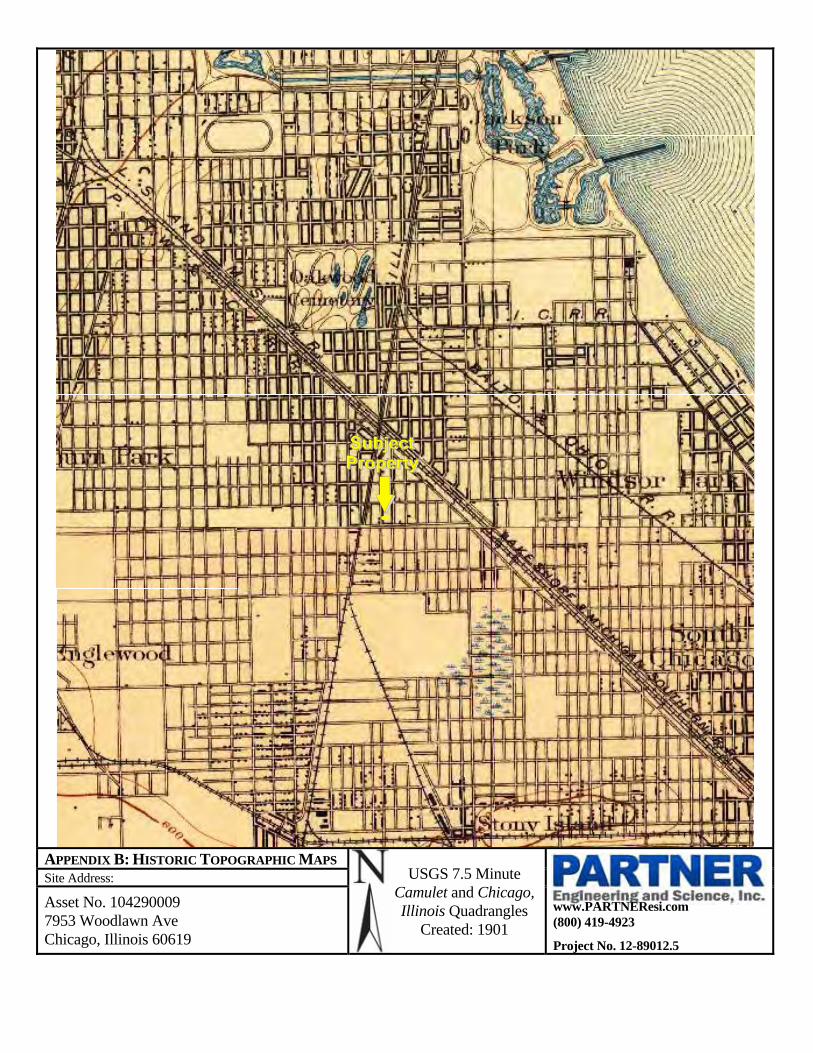
APPENDIX B: HISTORIC TOPOGRAPHIC MAPS USGS 7.5 Minute
Camulet and Chicago, Illinois Quadrangles
Created: 1901
Site Address:
www.PARTNEResi.com (800) 419-4923
Project No. 12-89012.5
Asset No. 104290009 7953 Woodlawn Ave Chicago, Illinois 60619

APPENDIX B: HISTORIC TOPOGRAPHIC MAPS USGS 7.5 Minute Lake Camulet and
Jackson Park, Illinois Quadrangles
Created: 1929
Site Address:
www.PARTNEResi.com (800) 419-4923
Project No. 12-89012.5
Asset No. 104290009 7953 Woodlawn Ave Chicago, Illinois 60619

1
Connie Morris
From: Sean McDermott <[email protected]>Sent: Thursday, August 02, 2012 4:50 PMTo: Connie MorrisSubject: RE: FOIA - County Health - Parcel #20-35-200-045-0000
No records.
Sean McDermott Director, Policy Development and Communications Cook County Department of Public Health Oak Forest Health Center 15900 S. Cicero Avenue, Building E Oak Forest, IL 60452 708 633‐4037(office) 312 231‐3358 (cell) 708 633‐4405 (fax) www.cookcountypublichealth.org
From: Connie Morris [mailto:[email protected]] Sent: Wednesday, August 01, 2012 12:04 PM To: Sean McDermott Subject: FW: FOIA - County Health - Parcel #20-35-200-045-0000 Sean McDermott Cook County Department of Public Health Oak Forest Hospital ‐ Building E 15900 S. Cicero Avenue 4th Floor, Room 405 Oak Forest, IL 60452 Phone: 708‐633‐4037 Fax: 708‐633‐4405 Email: [email protected] My company is conducting an environmental site assessment on the property located at 7953 S. Woodlawn, Chicago, IL 60619, in conjunction with a lending transaction. I am requesting information from your department pertaining to the following list below. If another governing body should be contacted, please indicate that this is the case, as it varies fromcounty to county. We do not need anything official or certificates, so please provide what correspondence you can that is readily available for no extra charge.

2
Could you please inform me of any of the following within the last two years: 1. Citizen‐Complaints 2. Outstanding inspection violations 3. Environmental Health Code Violations 4. Property currently or previously on septic (If so, when?) Connie Morris 7991 Cincinnati‐ Dayton Rd. West Chester, OH 45069 Phone: (513) 755‐9012 Fax: 1‐866‐910‐2968

1
Connie Morris
From: Connie Morris <[email protected]>Sent: Wednesday, August 01, 2012 1:04 PMTo: '[email protected]'Subject: FW: FOIA - County Health - Parcel #20-35-200-045-0000
Sean McDermott Cook County Department of Public Health Oak Forest Hospital ‐ Building E 15900 S. Cicero Avenue 4th Floor, Room 405 Oak Forest, IL 60452 Phone: 708‐633‐4037 Fax: 708‐633‐4405 Email: [email protected] My company is conducting an environmental site assessment on the property located at 7953 S. Woodlawn, Chicago, IL 60619, in conjunction with a lending transaction. I am requesting information from your department pertaining to the following list below. If another governing body should be contacted, please indicate that this is the case, as it varies fromcounty to county. We do not need anything official or certificates, so please provide what correspondence you can that is readily available for no extra charge. Could you please inform me of any of the following within the last two years: 1. Citizen‐Complaints 2. Outstanding inspection violations 3. Environmental Health Code Violations 4. Property currently or previously on septic (If so, when?) Connie Morris 7991 Cincinnati‐ Dayton Rd. West Chester, OH 45069 Phone: (513) 755‐9012 Fax: 1‐866‐910‐2968

1
Connie Morris
From: Connie Morris <[email protected]>Sent: Tuesday, July 31, 2012 4:13 PMTo: '[email protected]'Subject: FOIA - Fire - Parcel #20-35-200-045-0000
Chicago Fire Dept. 3510 S Michigan Av Chicago, IL 60653 312.745.3705 ‐ Phone 312.745.4189 ‐ Fax Attn: Fire Marshall My company is conducting a property condition and Environmental Site Assessment 7953 S. Woodlawn Ave., Chicago, IL property in conjunction with a lending transaction. I am requesting information from your department pertaining to the following list below. If another governing body should be contacted, please indicate that this is the case, as it varies from county to county. We do not need anything official or certificates, so please provide what correspondence you can that is readily available for no extra charge. Could you please verify or inform me of any of the following information that you have on file pertaining to your department? 1.) Fire code or Hazmat violations within the past two years; 2.) Any Outstanding inspection issues/violations; 3.) Fire runs that you may have on file; 4.) Last Inspection Date; Next Inspection Date. 5.) Please provide any records that you have locally for any underground storage tanks and hazardous chemicals that may exist at the referenced property, and any hazmat spill incidences that you may have on file. Thank you in advance for your assistance in this matter. Respectfully. Connie Morris 7991 Cincinnati‐ Dayton Rd. West Chester, OH 45069 Phone: (513) 755‐9012 Fax: 1‐866‐910‐2968

1
Connie Morris
From: Connie Morris <[email protected]>Sent: Tuesday, July 31, 2012 11:12 AMTo: Connie MorrisSubject: FOIA Request - Connie Morris 7/31/2012 10:12:27 AM
The following is a summary of your request: Requester: Mr. Connie Morris Organization: Partner Engineering Organization Type: Technical Consultant/Contractor Location: 7991 Cincinnati‐Dayton Road West Chester, OH. 45069 Butler Phone: (513) 755‐9012 Fax: (866) 910‐2968 cm@cse‐eng.com Facility Address: 7953 S. Woodlawn Ave Facility City: Hyde Park County: Cook Illinois EPA, Division of Records Mgmt/FOIA ‐ [email protected] ‐ 217/782‐9290(FAX) Date From: Jan 1 2008 To: Jul 31 2012 Other Information: Other Information: Our company is conducting an assessment on 7953 S. Woodlawn Avenue, Chicago, IL. Can you please provide us with all the information that the Illinois EPA has on this property and all documentation that you on file available for our review? Fee Waiver/Reduction Justification: Preparing a Phase I for the FDIC ‐‐end of automated response‐‐ Thank you! ***DO NOT reply to this message***

1
Connie Morris
From: Connie Morris <[email protected]>Sent: Tuesday, July 31, 2012 9:27 PMTo: '[email protected]'Subject: FOIA - Building and Zoning Parcel #20-35-200-045-0000
Cook County Building and Zoning Dept. 69 W Washington St. Ste. 2830 Chicago, IL 60602 (312) 603‐0500 ‐ Phone (312) 603‐9940 – Fax Attn: Timothy P. Bleuher, Commissioner My company is conducting a property condition and Environmental Site Assessment on the property located at 7953 S. Woodlawn Ave., Chicago, IL in conjunction with a lending transaction. I am requesting information from your department pertaining to the following list below. If another governing body should be contacted, please indicate that this is the case, as it varies from county to county. We do not need anything official or certificates, so please provide what correspondence you can that is readily available for no extra charge. Could you please verify or inform me of any of the following information that you have on file pertaining to your department? 1. Any significant building or zoning violations; 2. Verify Zoning classification; 3. Verify Date of construction as; 4. Verify Square footage of improvements (buildings) on premises that you may have on file for this property; 5. Verify Acreage of parcel. Thank you in advance for your assistance in this matter. Respectfully. Connie Morris 7991 Cincinnati‐ Dayton Rd. West Chester, OH 45069 Phone: (513) 755‐9012 Fax: 1‐866‐910‐2968

Asset No. 104290009 7953 Woodlawn Chicago, Illinois 60619 Inquiry Number: 3318352.2 May 13, 2012
440 Wheelers Farms Road
Milford, CT 06461
800.352.0050
www.edrnet.com

EDR Environmental LienSearch™ Report
The EDR Environmental LienSearch Report provides results from a search of available current land title records for environmental cleanup liens and other activity and use limitations, such as engineering controls and institutional controls. A network of professional, trained researchers, following established procedures, uses client supplied address information to:
search for parcel information and/or legal description; search for ownership information; research official land title documents recorded at jurisdictional agencies such as recorders' offices,
registries of deeds, county clerks' offices, etc.; access a copy of the deed; search for environmental encumbering instrument(s) associated with the deed; provide a copy of any environmental encumbrance(s) based upon a review of key words in the
instrument(s) (title, parties involved, and description); and provide a copy of the deed or cite documents reviewed.
Thank you for your business. Please contact EDR at 1-800-352-0050
with any questions or comments.
Disclaimer - Copyright and Trademark Notice
This report was prepared for the use of Environmental Data Resources, Inc., and Advanced Searches, a Division of D.L.R. Consulting, Inc., exclusively. This report is neither a guarantee of title, a commitment to insure, or a policy of title insurance. NO WARRANTY, EXPRESSED OR IMPLIED, IS MADE WHATSOEVER IN CONNECTION WTH THIS REPORT. Environmental Data Resources, Inc. (EDR) and INSERT LIENSEARCH COMPANY NAME specifically disclaim the making of any such warranties, including without limitation, merchantability or fitness for a particular use or purpose. The information contained in this report is retrieved as it is recorded from the various agencies that make it available. The total liability is limited to the fee paid for this report. Copyright 2010 by Environmental Data Resources, Inc. All rights reserved. Reproduction in any media or format, in whole or in part, of any report or map of Environmental Data Resources, Inc., or its affiliates, is prohibited without prior written permission.
EDR and its logos are trademarks of Environmental Data Resources, Inc. or its affiliates. All other trademarks used herein are the property of their respective owners.

EDR Environmental LienSearch™ Report
TARGET PROPERTY INFORMATION ADDRESS ASSET NO. 104290009 7953 WOODLAWN CHICAGO, ILLINOIS 60619 RESEARCH SOURCE Source 1: Cook County Recorder of Deeds Chicago, Illinois Source 2: PROPERTY INFORMATION Deed 1: Type of Deed: Quit Claim Title is vested in: Great Lakes Property Development Corporation Title received from: Royal Property Development LLC
Deed Recorded: 11-1-07
Instrument: 0732034001
Land Record Comments:
Legal Description:
Lot 26 in Block 107 in Cronell in the West 1/2 of Section 26, the Section 26, the North 1/2 of the Northwest 1/4, the South 1/2 of the Northwest 1/4 and the northwest 1/4 of the Northeast 1/4 of Section 35, Township 38 North, Range 14, East of the Third Principal Meridian, Cook County, Illinois.
Legal Current Owner: Great Lakes Property Development Corporation
Property Identifiers: 20 35 200 045
Comments:
ENVIRONMENTAL LIEN Environmental Lien: Found Not Found
OTHER ACTIVITY AND USE LIMITATIONS (AULs) Other AUL's: Found Not Found

EDR Environmental LienSearch™ Report
DEED EXHIBIT

EDR Environmental LienSearch™ Report

EDR Environmental LienSearch™ Report

EDR Environmental LienSearch™ Report

Asset No. 104290009 7953 Woodlawn Chicago, Illinois 60619 Inquiry Number: 33318352.1 May 11, 2012
440 Wheelers Farms Road
Milford, CT 06461
800.352.0050
www.edrnet.com

EDR Chain of Title
The EDR Chain of Title Report tracks a line of successive owners from the present back to1940 of a particular parcel of property, linked together by recorded transactions which pass title. Available nationwide, this report provides a summary of a property’s ownership history and is a valuable source for determining the prior uses of a property
A network of professional abstractors following established procedures, uses client supplied address information to locate:
Historical Chain of Title research Leases and Miscellaneous
Thank you for your business.
Please contact EDR at 1-800-352-0050 with any questions or comments
Disclaimer – Copyright and Trademark Notice This report was prepared for the use of Environmental Data Resources, Inc., and Advanced Searches, a Division of D.L.R. Consulting, Inc. exclusively. This report is neither a guarantee of title, a commitment to insure, nor a policy of title insurance. NO WARRANTY, EXPRESSED OR IMPLIED, IS MADE WHATSOEVER IN CONNECTION WITH THIS REPORT. Environmental Data Resources, Inc. (EDR) and National Real Estate Information Services specifically disclaim the making of any such warranties, including without limitation, merchantability or fitness for a particular use or purpose. The information contained in this report is retrieved as it is recorded from the various agencies that make it available. The total liability is limited to the fee paid for this report. Copyright 2009 by Environmental Data Resources, Inc. All rights reserved. Reproduction in any media or format, in whole or in part, of any report or map of Environmental Data Resources, Inc., or its affiliates, is prohibited without prior written permission. EDR and its logos are trademarks of Environmental Data Resources, Inc. or its affiliates. All other trademarks used herein are the property of their respective owners.

EDR Chain of Title
TARGET PROPERTY INFORMATION ADDRESS ASSET NO. 104290009 7953 WOODLAWN CHICAGO, ILLINOIS 60619 RESEARCH SOURCE Source 1: Cook County Recorder of Deeds Chicago, Illinois Source 2: Examiner’s Note: Public records of Cook County, Illinois were searched from January 1, 1940 to May 11, 2012, and no other
deeds vesting title in the subject property were found of record during the period scheduled.
PROPERTY DESCRITION Current Owner: Great Lake Property Development Corporation Legal Description: Lot 26 in Block 107 in Cronell in the West 1/2 of Section 26, the Section 26, the North 1/2 of the
Northwest 1/4, the South 1/2 of the Northwest 1/4 and the northwest 1/4 of the Northeast 1/4 of Section 35, Township 38 North, Range 14, East of the Third Principal Meridian, Cook County, Illinois.
Property Identifiers: 20 35 200 045 General Comments:
HISTORICAL CHAIN OF TITLE
See Exhibit “A”

EDR Chain of Title
CHAIN OF TITLE
Exhibit “A”

EDR Chain of Title
HISTORICAL CHAIN OF TITLE Type of Deed: Quit Claim
Title is vested in: Great Lakes Property Development Corporation
Title received from: Royal Property Development LLC
Date Recorded: 11-16-07
Document No. 0732034001
Land Record Comments:
Type of Deed: Trustee's Deed
Title is vested in: Royal Property Development LLC
Title received from: North Star Trust Company Tr 58082
Date Recorded: 10-28-05
Document No. 0530103092
Land Record Comments:
Type of Deed: Deed
Title is vested in: North Star Trust Company Tr 58082
Title received from: Cook County Clerk
Date Recorded: 3-16-05
Document No. 0507539082
Land Record Comments:
Type of Deed: Warranty Deed
Title is vested in: Effie Shumpert
Title received from: Earsel Frich
Date Recorded: 3-9-72
Document No. 2611718T
Land Record Comments:
Type of Deed: Warranty Deed
Title is vested in: Earsel Frich
Title received from: Thomas Collins
Date Recorded: 4-17-41
Document No. 911778T
Land Record Comments:

EDR Chain of Title

EDR Chain of Title

EDR Chain of Title

EDR Chain of Title

RECORD OF COMMUNICATION
Site Name: Asset No. 104290009 Location: Chicago, Illinois
Communication with: Customer Service Rep Of: Department of Zoning
Location: 121 N. LaSalle Phone: (312) 744-3416
Communication via:
Internet
Recorded By:
John Boujaoude
Of:
Partner
At: 8:28am On: July 27, 2012
Re: Subject Property
Summary of Communication:
Partner contacted the City of Chicago Zoning Department (CCZD) for information regarding any significant zoning violations and zoning classifications. As of the date of this report, Partner has not received a response from the CCZD for inclusion in this report.
Conclusions/Required:
None
RECORD OF COMMUNICATION
Site Name: Asset No. 104290009 Location: Chicago, Illinois
Communication with: Christopher Lynch Of: Department of Buildings
Location: 121 N. LaSalle Phone: (312) 744-3416
Communication via:
Internet
Recorded By:
John Boujaoude
Of:
Partner
At: 10:00am On: July 26, 2012
Re: Subject Property
Summary of Communication:
No environmentally significant information was discovered from records reviewed at the CCBD.
Conclusions/Required:
None

RECORD OF COMMUNICATION
Site Name: Asset No. 104290009 Location: Chicago, Illinois
Communication with: Ed Doherty Of: Chicago Fire Department
Location: 3510 S Michigan Ave Phone: (800) 332-7143
Communication via:
Internet
Recorded By:
John Boujaoude
Of:
Partner
At: 10:00am On: July 26, 2012
Re: Subject Property
Summary of Communication:
No environmentally significant information was discovered from records reviewed at the CFD.
Conclusions/Required:
None
RECORD OF COMMUNICATION
Site Name: Asset No. 104290009 Location: Chicago, Illinois
Communication with: Jennifer Hesse Of: Department of Public Health
Location: 333 S. State Street Phone: (312) 744-3416
Communication via:
Internet
Recorded By:
John Boujaoude
Of:
Partner
At: 10:00am On: July 28, 2012
Re: Subject Property
Summary of Communication:
According to records reviewed, City of Chicago Department of Public Health neither maintains nor possesses any records of the subject property.
Conclusions/Required:
None

RECORD OF COMMUNICATION
Site Name: Asset No. 104290009 Location: Chicago, Illinois
Communication with: History Librarian Of: Chicago Public Library
Location: 400 South State Street Phone: (312) 747-4300
Communication via:
In Person
Recorded By:
John Boujaoude
Of:
Partner
At: 5 p.m. On: July 28, 2012
Re: Subject Property
Summary of Communication:
Obtained information pertaining to the historical development of the subject property and vicinity. The City directories were not available prior to 1988.
Conclusions/Required:
No issues
RECORD OF COMMUNICATION
Site Name: Asset No. 104290009 Location: Chicago, Illinois
Communication with: Latrice Collier Of: Subject Property Tenant
Location: 7953 Woodlawn Phone: (773) 952-9694
Communication via:
Phone, In-Person
Recorded By:
John Boujaoude
Of:
Partner
At: Various On: July 18, 2012
Re: Subject Property
Summary of Communication:
Ms. Collier provided Partner access to inspect within the subject property.
Conclusions/Required:
None


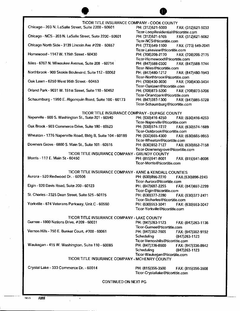


CookViewer Parcel Information
PARCEL PIN: 20-35-200-045-0000
Address: 7953 S WOODLAWN AVE
Township: Hyde Park
Neighborhood: 80
Construction Type: Frame
Age: 4
Estimated Building Sq Ft: 2,655
Land Square Footage: 3,075
Building Assessed Value: $19,733.00
Land Assessed Value: $2,767.00
Total Assessed Value: $22,500.00

Cook County CookViewer Output
1:1200


392A
450500
450500
450505
450505
450510
450510
450515
450515
450520
450520
450525
450525
450530
450530
450535
450535
450540
450540
450545
450545
450550
450550
4622
165
4622
165
4622
170
4622
170
4622
175
4622
175
4622
180
4622
180
4622
185
4622
185
4622
190
4622
190
4622
195
4622
195
0 20 40 6010Feet
0 6 12 183Meters
±
41° 45' 0''
87°
35' 4
1''
41° 44' 59''
87°
35' 4
1''
41° 44' 59''
41° 45' 0''87
° 35
' 43'
'87
° 35
' 43'
'
Map Scale: 1:251 if printed on A size (8.5" x 11") sheet.
Soil Map—Cook County, Illinois
Natural ResourcesNatural ResourcesNatural ResourcesNatural ResourcesConservation ServiceConservation ServiceConservation ServiceConservation Service
Web Soil SurveyNational Cooperative Soil Survey
7/25/2012Page 1 of 3

MAP LEGEND MAP INFORMATION
Area of Interest (AOI)Area of Interest (AOI)
SoilsSoil Map Units
Special Point FeaturesBlowout
Borrow Pit
Clay Spot
Closed Depression
Gravel Pit
Gravelly Spot
Landfill
Lava Flow
Marsh or swamp
Mine or Quarry
Miscellaneous Water
Perennial Water
Rock Outcrop
Saline Spot
Sandy Spot
Severely Eroded Spot
Sinkhole
Slide or Slip
Sodic Spot
Spoil Area
Stony Spot
Very Stony Spot
Wet Spot
Other
Special Line FeaturesGully
Short Steep Slope
Other
Political FeaturesCities
Water FeaturesStreams and Canals
TransportationRails
Interstate Highways
US Routes
Major Roads
Local Roads
Map Scale: 1:251 if printed on A size (8.5" × 11") sheet.
The soil surveys that comprise your AOI were mapped at 1:12,000.
Warning: Soil Map may not be valid at this scale.
Enlargement of maps beyond the scale of mapping can causemisunderstanding of the detail of mapping and accuracy of soil lineplacement. The maps do not show the small areas of contrastingsoils that could have been shown at a more detailed scale.
Please rely on the bar scale on each map sheet for accurate mapmeasurements.
Source of Map: Natural Resources Conservation ServiceWeb Soil Survey URL: http://websoilsurvey.nrcs.usda.govCoordinate System: UTM Zone 16N NAD83
This product is generated from the USDA-NRCS certified data as ofthe version date(s) listed below.
Soil Survey Area: Cook County, IllinoisSurvey Area Data: Version 6, Nov 2, 2011
Date(s) aerial images were photographed: 7/30/2007
The orthophoto or other base map on which the soil lines werecompiled and digitized probably differs from the backgroundimagery displayed on these maps. As a result, some minor shiftingof map unit boundaries may be evident.
Soil Map–Cook County, Illinois
Natural ResourcesConservation Service
Web Soil SurveyNational Cooperative Soil Survey
7/25/2012Page 2 of 3

Map Unit Legend
Cook County, Illinois (IL031)
Map Unit Symbol Map Unit Name Acres in AOI Percent of AOI
392A Urban land-Orthents, loamy, complex,nearly level
0.1 100.1%
Totals for Area of Interest 0.1 100.0%
Soil Map–Cook County, Illinois
Natural ResourcesConservation Service
Web Soil SurveyNational Cooperative Soil Survey
7/25/2012Page 3 of 3

COUNTY Cook 35 - 38N - 14E
FARM
June 24, 1975DATE DRILLED
Bottom
Stinnett, James R.COMPANY
ILLINOIS STATE GEOLOGICAL SURVEY
Top
Swanson, Thomas A.
1
584GLELEVATION
LOCATION
1
Page
COUNTY NO.
NO.
29783
June 16, 1975 38534Permit Date:
Total Depth
Casing:
385
5" STEEL 15# from 0' to 76'
Size hole below casing: 4.75"
Water from limestone at 76' to 385'.
Static level 78' below casing top which is 1' above GL
Pumping level 280' when pumping at 9 gpm for 2 hours
Permanent pump installed at 315' on July 31, 1975, with a capacity
of 9 gpm
Lot: 1 Subdivision: Morton'sBlock #2
Additional
location info:
Location source: Location from permit
Permit #:
sand & black dirt
cl & smll strks of s
slty cl & smll rocks
brkn lime grvl & slt
bedrock
0
2
7
73
76
2
7
73
76
76
LATITUDE LONGITUDE -87.59046241.740413
120312978300API
Private Water Well
SE
Silurian 76

2011Quality Report
Water
City of Chicago ■ Rahm Emanuel, MayorDepartment of Water Management ■ �omas H. Powers, P.E. , Commissioner
City of Chicago

TURBIDITY: Turbidity is a measure of the cloudiness of water. We monitor it because it is a good indicator of water quality and the effectiveness of our filtration system and disinfectants.
UNREGULATED CONTAMINANTS: A maximum contaminant level (MCL) for this contaminant has not been established by either state or federal regulations, nor has mandatory health effects language. The purpose for monitoring this contaminant is to assist USEPA in determining the occurrence of unregulated contaminants in drinking water, and whether future regulation is warranted.
Water Quality Data Table Footnotes
PlEaSE VISIT OUR WEbSITEFOR MORE INFORMaTION
www.cityofchicago.org/watermanagement
When e-mailing always include your name, account number & call back number.
CITY OF CHICaGODEPaRTMENT OFWaTER MaNaGEMENTThis year, as in years past, your tap water met all USEPA and state drinking water health standards. Our system vigilantly safeguards its source water supply, and we are able to report that the Department of Water Management, City of Chicago had no violation of a contaminant level or of any other water quality standard in the previous year. This report summarizes the quality of water that we provided last year, including details about where your water comes from, what it contains, and how it compares to standards set by regulatory agencies. We are committed to providing you with this information because informed customers are our best allies.
Source Water Assessment Summary The Illinois EPA implemented a Source Water Assessment Program (SWAP) to assist with watershed protection of public drinking water supplies. The SWAP inventories potential sources of contamination and determined the susceptibility of the source water to contamina-tion. The Illinois EPA has completed the Source Water Assessment Program for our supply.
Source Water Location
The City of Chicago utilizes Lake Michigan as its source water via two water treatment plants. The Jardine Water Purification Plant serves the northern areas of the City and suburbs, while the South Water Purification Plant serves the southern areas of the City and sub-urbs. Lake Michigan is the only Great Lake that is entirely contained within the United States. It borders Illinois, Indiana, Michigan, and Wisconsin, and is the second largest Great lake by volume with 1,180 cubic miles of water and third largest by area.
Susceptibility to Contamination
The Illinois EPA considers all surface water sources of community water supply to be susceptible to potential pollution problems. The very nature of surface water allows contaminants to migrate into the intake with no protection only dilution. This is the reason for mandatory treatment for all surface water supplies in Illinois. Chicago’s offshore intakes are located at a distance that shoreline impacts are not usually considered a factor on water quality. At certain times of the year, however, the potential for contamination exists due to wet-weather flows and river reversals. In addition, the placement of the crib structures may serve to attract waterfowl, gulls and terns that frequent the Great Lakes area, thereby concentrating fecal deposits at the intake and thus compromising the source water quality. Conversely, the shore intakes are highly susceptible to storm water runoff, marinas and shoreline point sources due to the influx of groundwater to the lake.
Further information on our community water supply’s Source Water Assessment Program is available by calling the State of Illinois at 217-785-4787.
City of Chicago Emerging Contaminant Study analysis of Endocrine Disrupting Chemicals, Pharmaceuticals, and Personal Care Products
The City of Chicago Department of Water Management (CDWM) has completed a water quality study to monitor some compounds that have not historically been considered to be contaminants of concern, but have been recently documented at trace concentrations in our nation’s waterbodies. This study, completed in the years 2009-2011, includes compounds known as Endocrine Disrupting Chemicals (EDCs) and Pharmaceuticals & Personal Care Products (PPCPs), which are considered to be emerging contaminants. EDCs are compounds with potential to interfere with natural hormone systems. PPCPs are a group of compounds consisting of prescription or over-the-counter therapeutic drugs, veterinary drugs, and consumer products such as sun-screen, lotions, insect repellent, and fragrances. The reader is encouraged to visit the United States Environmental Protection Agency (USEPA) website to learn more about EDCs (http://www.epa.gov/ncer/science/endocrine/) and PPCPs (http://www.epa.gov/ppcp/).
In 2011, CDWM has also monitored for hexavalent chromium, also known as chromium-6, and continues to do so quarterly. USEPA has not yet established a standard for chromium-6, a contaminant of concern which has both natural and industrial sources. Please address any questions or concerns to DWM’s Water Quality Division at 312-742-7499. A list of detected contaminants from the Emerging Contaminant Study and additional information, including chromium-6 monitoring data, are posted on the City’s website which can be accessed at following address below:
h t tp : / /www.c i t yo fch icago .o rg /c i t y /en /dep ts /wa te r / supp_in fo /wa te r_qua l i t y_ resu l t sand repo r t s / c i t y_o f_ch i cago_emerg incon taminan ts tudy .h tm l
Water in the Street or Basement Call 311
Water Quality Questions (312) 744-8190
Department of Finance Water Bill Questions (312) 744-4H2O TTY (312) 744-2968
E-mail and Internet E-mail: [email protected] www.cityofchicago.org/watermanagement
IEPA’s Regional Offices (Illinois) (847) 608-3131
EPA’s Safe Drinking Water Hotline (800) 426-4791
EPA’s Water Resource Center (800) 832-7828
EPA’s General Information Line (312) 353-2000 TTY (312) 886-4658
If you have any questions about this report please contact Alan Stark at: (312) 742-7499

n/a n/a 6.64 6.63 - 6.64SODIUM (ppm)Erosion of naturally occurring deposits; Used as water softener.
– –
0
n/a
2
1.3
0
10
n/a
n/a
4.0
10
80
60
4.0
5%
TT=1NTUmax
2
AL=1.3
AL=15
0.2%
0.86
0.0208
0.032**(90th percentile)
6.07**(90th percentile)
0.44
19.6*
10.5*
0.80
n/a
n/a
0.0201 - 0.0208
0.39 - 0.44
9.40 - 32.9
5.30 - 14.5
0.702 - 0.8177
0 sites exceeding AL
1 site exceeding AL
TOTAL COLIFORM BACTERIA (% pos/mo)Human and animal fecal waste.
TURBIDITY (NTU)
Soil runoff. Highest single measurement.
Inorganic ContaminantsBARIUM (ppm)Discharge of drilling wastes; Discharge from metal refineries; Erosion of natural deposits.
COPPER (ppm)Corrosion of household plumbing systems: Erosion of natural deposits.
LEAD (ppb)Corrosion of household plumbing systems;Erosion of natural deposits.
NITRATE (AS NITROGEN) (ppm)Runoff from fertilizer use; Leaching from septic tanks,sewage; Erosion of natural deposits.
10 10 0.44 0.39 - 0.44TOTAL NITRATE & NITRITE (AS NITROGEN) (ppm)Runoff from fertilizer use; Leaching from septic tanks,sewage; Erosion of natural deposits.
Disinfectant\Disinfection By-Products
TTHMs [TOTAL TRIHALOMETHANES] (ppb)By-product of drinking water disinfection.
HAA5 [HALOACETIC ACIDS] (ppb)By-product of drinking water disinfection.
CHLORINE (as Cl2) (ppm)Drinking water disinfectant.
TOC [TOTAL ORGANIC CARBON]The precentage of Total Organic Carbon (TOC) removal was measured each month and the system met all TOC removal requirements set by the IEPA.
MCLG MCLHighest LevelDetected Violation
Date ofSample
Range of Detections
Contaminant (unit of measure)Typical Source of Contaminant
Microbial Contaminants– –
n/a TT 99.50% 99.50% - 100.00%TURBIDITY (%<0.3 NTU)
Soil runoff. Lowest monthly percent meeting limit.
– –
– –
–
6/1/09 to9/30/09
6/1/09 to9/30/09
–
–
–
– –
– –
– –
– –
n/a n/a 16.1 14.4 - 16.1SULFATE (ppm)Erosion of naturally occurring deposits.
– –
0 5 1.38** 1.300 - 1.380COMBINED RADIUM (226/228) (pCi/L)Decay of natural and man-made deposits. –
Start Finish
4 4 0.92 0.81 - 0.92
State Regulated Contaminants
FLUORIDE (ppm)Water additive which promotes strong teeth.
– –
0 15 0.88** 0.090 - 0.880GROSS ALPHA excluding radon and uranium (pCi/L)Decay of natural and man-made deposits. –
0 0 1 n/aFECAL COLIFORM AND E. COLI (# pos/mo)Human and animal fecal waste.
– –
–
–
TTHMs, HAA5, and Chlorine are for the Chicago distribution system. * Highest Running Annual Average Computed.
**The state requires us to monitor for certain contaminants less than once per year because the concentrations of these contaminants do not change frequently. Some of our data, though accurate, is more than one year old. Some contaminants are sampled less frequently than once a year; as a result, not all contaminants were sampled for during the CCR calendar year. If any of these contaminants were detected the last time they were sampled for, they are included in the table along with the date that the detection occurred. Compliance monitoring for lead and copper is conducted every 3 years. Radiochemical contaminant monitoring is conducted every 6 years.
03-17-2008
03-17-2008
Unregulated Contaminants
Radioactive Contaminants
FLUORIDE: Fluoride is added to the water supply to help promote strong teeth. The Illinois Department of Public Health recommends an optimal fluoride range of 0.9 mg/l to 1.2 mg/l.
SODIUM: There is not a state or federal MCL for sodium. Monitoring is required to provide information to consumers and health officials that are concerned about sodium intake due to dietary precautions. If you are on a sodium-restricted diet, you should consult a physician about this level of sodium in the water.
LEAD:If present, elevated levels of lead can cause serious health problems, especially for pregnant women and young children. Lead in drinking water is primarily from materials and components associated with service lines and home plumbing. We cannot control the variety of materials used in plumbing components. When your water has been sitting for several hours, you can minimize the potential for lead exposure by flushing your tap for 30 seconds to 2 minutes before using water for drinking or cooking. If you are concerned about lead in your water, you may wish to have your water tested. Information on lead in drinking water, testing methods, and steps you can take to minimize exposure is available from the Safe Drinking Water Hotline or at http://www.epa.gov/safewater/lead.
2011 Water Quality Data: Detected Contaminants
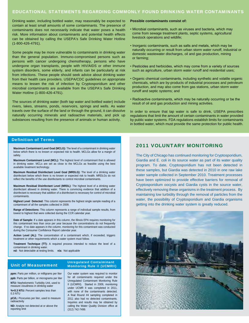
Maximum Contaminant Level Goal (MCLG): The level of a contaminant in drinking water below which there is no known or expected risk to health. MCLGs allow for a margin of safety.
Maximum Contaminant Level (MCL): The highest level of contaminant that is allowed in drinking water. MCLs are set as close to the MCLGs as feasible using the best available treatment technology.
Maximum Residual Disinfectant Level Goal (MRDLG): The level of a drinking water disinfectant below which there is no known or expected risk to health. MRDLGs do not reflect the benefits of the use disinfectants to control microbial contaminants.
Maximum Residual Disinfectant Level (MRDL): The highest level of a drinking water disinfectant allowed in drinking water. There is convincing evidence that addition of a disinfectant is necessary that addition of a disinfectant is necessary for control of microbial contaminants.
Highest Level Detected: This column represents the highest single sample reading of a contaminant of all the samples collected in 2009.
Range of Detections: This column represents a range of individual sample results, from lowest to highest that were collected during the CCR calendar year.
Date of Sample: If a date appears in this column, the Illinois EPA requires monitoring for this contaminant less than once per year because the concentrations do not frequently change. If no date appears in the column, monitoring for this contaminant was conducted during the Consumer Confidence Report calendar year.
Action Level (AL): The concentration of a contaminant which, if exceeded, triggers treatment or other requirements which a water system must follow.
Treatment Technique (TT): A required process intended to reduce the level of a contaminant in drinking water.nd: Not detectable at testing limits. n/a: Not applicable
Definition of Terms
ppm: Parts per million, or milligrams per liter
ppb: Parts per billion, or micrograms per liter
NTU: Nephelometric Turbidity Unit, used to measure cloudiness in drinking water
%<0.3 NTU: Percent samples less than 0.3 NTU
pCi/L: Picocuries per liter, used to measure radioactivity
ND: Analyte not detected at or above the reporting limit
Unit of Measurement
Our water system was required to monitor for all contaminants required under the Unregulated Contaminant Monitoring Rule II (UCMRII). Started in 2009, monitoring under UCMR II was completed in 2011, with none of the contaminants detected. A final Round #4 sampling completed in 2011 also had no detected contaminants. Inquiries and results may be obtained by calling the Water Quality Division office at (312) 742-7499.
Unregulated Contaiminant Monitoring Rule II (UCMRII)
2011 VOlUNTaRY MONITORING
The City of Chicago has continued monitoring for Cryptosporidium, Giardia and E. coli in its source water as part of its water quality program. To date, Cryptosporidium has not been detected in these samples, but Giardia was detected in 2010 in one raw lake water sample collected in September 2010. Treatment processes have been optimized to provide effective barriers for removal of Cryptosporidium oocysts and Giardia cysts in the source water, effectively removing these organisms in the treatment process. By maintaining low turbidity through the removal of particles from the water, the possibility of Cryptosporidium and Giardia organisms getting into the drinking water system is greatly reduced.
Drinking water, including bottled water, may reasonably be expected to contain at least small amounts of some contaminants. The presence of contaminants does not necessarily indicate that water poses a health risk. More information about contaminants and potential health effects can be obtained by calling the USEPA’s Safe Drinking Water Hotline (1-800-426-4791).
Some people may be more vulnerable to contaminants in drinking water than the general population. Immuno-compromised persons such as persons with cancer undergoing chemotherapy, persons who have undergone organ transplants, people with HIV/AIDS or other immune system disorders, some elderly, and infants can be particularly at risk from infections. These people should seek advice about drinking water from their health care providers. USEPA/CDC guidelines on appropriate means to lessen the risk of infection by Cryptosporidium and other microbial contaminants are available from the USEPA’s Safe Drinking Water Hotline (1-800-426-4791).
The sources of drinking water (both tap water and bottled water) include rivers, lakes, streams, ponds, reservoirs, springs and wells. As water travels over the surface of the land or through the ground, it can dissolve naturally occurring minerals and radioactive materials, and pick up substances resulting from the presence of animals or human activity.
Possible contaminants consist of:
• Microbial contaminants, such as viruses and bacteria, which may come from sewage treatment plants, septic systems, agricultural livestock operations and wildlife;
• Inorganic contaminants, such as salts and metals, which may be naturally occurring or result from urban storm water runoff, industrial or domestic wastewater discharges, oil and gas production, mining or farming;
• Pesticides and herbicides, which may come from a variety of sources such as agriculture, urban storm water runoff and residential uses;
• Organic chemical contaminants, including synthetic and volatile organic chemicals, which are by-products of industrial processes and petroleum production, and may also come from gas stations, urban storm water runoff and septic systems; and
• Radioactive contaminants, which may be naturally occurring or be the result of oil and gas production and mining activities.
In order to ensure that tap water is safe to drink, USEPA prescribes regulations that limit the amount of certain contaminants in water provided by public water systems. FDA regulations establish limits for contaminants in bottled water, which must provide the same protection for public health.
EDUCaTIONal STaTEMENTS REGaRDING COMMONlY FOUND DRINKING WaTER CONTaMINaNTS

By now you have probably heard the good news–from a neighbor, family member, or a friend-who has had a FREE water meter installed in their home through the MeterSave Program. The current average water and sewer bill savings for MeterSave customers is over 50%!
In 2011, we installed more than twice the meters installed in 2010. This year MeterSave volunteers are increasing and we are on track to install even more water meters!
MeterSave is available to all eligible single family or two-flat non-metered homeowners in Chicago that volunteer to have a FREE water meter installed. With your FREE installation you receive our 7-year guarantee that your water and sewer bill will not exceed what you would have paid as a non-metered customer, so long as you stay current on your bill. If you move, the guarantee does not transfer to the new owner.
By installing a water meter you become more aware of your water use. By making small changes in your everyday water habits you can easily save water and money. In addition to the installation of FREE water meter and the 7-year guarantee, MeterSave participants may choose from one of the following FREE water conservation tools (and two if a whole block volunteers!): rain barrel, outdoor water conservation kit, or indoor water conservation kit.
The water meter and installation are FREE!
Signing up is easyYou can visit our web site at www.metersave.org and complete the online registration or simply call 3-1-1 or 312-744-4H20 at any time. Visit our on-line calendar to schedule your installation at www.metersave.org.
To volunteer for a FREE water meter1) Be the owner or have approval from the owner of • Singlefamilyresidence • Two-flatresidence2)Becurrentonwaterbill • Activepaymentplaniscurrent • Currentwaterbillisnotdelinquent
Do you have a Water Meter?What to expectThe water shut-off valve must be accessible and clear of clutter. Be prepared to answer the following questions:• Doyouhaveabasement?• Isthewatershut-offvalveinyourbasementandistheareaun-finished oristheshut-offvalveinamechanicalroom?Iftheanswerisyes, thisistheoptimalscenariotoinstallameter.Unfortunately,somefully- finishedorremodeledbasementshavehiddenwatershut-offvalves. Withaminimalamountofworkourcrewcancreateanaccessdoor.
Installationstakeapproximatelytwohours,usuallyless.Crewsarescheduledbyareasandcurrentlyappointmentsarebeingmadeabout4-6weeksfromregistration.
Meter or Non-MeteredNon-Metered water bills are billed every 6 months and are based on a flat rate assessment including such factors as lot size and the number of water fixtures installed. Typically, a detail of the assessment is provided on the front of the water bill.
Residential metered water bills are billed every 2 months and are based on the actual water usage. The number of gallons that pass through the meter is multiplied by the water rate. The 2012 water rate is $2.51 per 1,000 gallons and is one of the lowest in the nation. The water rate charged is the same for all metered accounts.
The sewer charge is 89% of the water charge (metered or non-metered) and is also listed on the water bills. For metered customers, if the water usage decreases so does the sewer charge allowing the customer to save more money.
Visit www.metersave.org to volunteer today for your FREE water meter and FREE installation!
DOWNSPOUT DISCONNECTSThere is a big challenge we all face together: stormwater management and the basement floods that sometimes accompany heavy storms.
Climate change is a reality, and the rain storms of the warmer months have been known to dump as many as 2-3 inches of water per hour on various neighborhoods. Sewers fill up, and water still pours in. The result can be flooded basements, and the loss of property ranging from appliances to sentimental family heirlooms.
While we are renewing the infrastructure, that is a long process, and won’t solve the problem.
We need to divert as much water as possible from entering the sewers during the heaviest storms. We need to do it on a neighborhood basis. Steps include downspout disconnection, green design, rain gardens, and other collective action.
The Department of Water Management has been leading a pilot project called the Basement Flooding Partnership. Community leaders, aldermen, and City of Chicago experts work in unison to understand the problem and take practical steps to address it.
Please visit www.cityofchicago.org/watermanagment for more details.
Save Water, Save Money
Please note: Some meter installations may require more than one visit for completion.

City of ChicagoRahm Emanuel, Mayor
The Department of Water ManagementJardine Water Purification Plant1000 East Ohio StreetChicago, Illinois 60611
PRESORTED STANDARD
U.S. POSTAGEPAID
CHICAGO, ILPERMIT #412
Message fromMayor Rahm EmanuelDear Chicago Water Customer,
This Water Quality Report meets a formal obligation to report to every customer on the
drinking water we purify and deliver. I am pleased to report our water is safe and meets or exceeds every standard established by the US Environmental Protection Agency and the Illinois Environmental Protection Agency.
This report, of course, does not tell the full story of our water system. We face challenges of infrastructure renewal. More than a quarter of our 4,300 miles of water main are beyond their one hundred year life expectancies. It is imperative that we renew our system and we have launched an ambitious program to triple the rate of main replacement. This is essential to have a system that efficiently and safely serves our city and suburban customers.
In the next ten years, we will replace 880 miles of water mains, and lining or replacing over 700 miles of sewers, all of which are 100 years old or more.
We can take pride in the water we have and both the system that produces it. There is much to be done, and I look forward to working together to improve and protect this valuable resource.
Sincerely,
Rahm EmanuelMayor
Este informe contiene información muy importante. Tradúscalo ó hable con alguien que lo entienda bien.

APPENDIX C: REGULATORY DATABASE REPORT

FORM-BPK-ROM
tropeR ™paM suidaR RDE ehT
440 Wheelers Farms RoadMilford, CT 06461Toll Free: 800.352.0050www.edrnet.com
Asset No. 1042900097953 WoodlawnChicago, IL 60619
Inquiry Number: 3318087.2sMay 07, 2012

SECTION PAGE
Executive Summary ES1
Overview Map 2
Detail Map 3
Map Findings Summary 4
Map Findings 7
Orphan Summary 49
Government Records Searched/Data Currency Tracking GR-1
GEOCHECK ADDENDUM
GeoCheck - Not Requested
TC3318087.2s Page 1
Thank you for your business.Please contact EDR at 1-800-352-0050
with any questions or comments.
Disclaimer - Copyright and Trademark Notice
This Report contains certain information obtained from a variety of public and other sources reasonably available to Environmental DataResources, Inc. It cannot be concluded from this Report that coverage information for the target and surrounding properties does not exist fromother sources. NO WARRANTY EXPRESSED OR IMPLIED, IS MADE WHATSOEVER IN CONNECTION WITH THIS REPORT. ENVIRONMENTALDATA RESOURCES, INC. SPECIFICALLY DISCLAIMS THE MAKING OF ANY SUCH WARRANTIES, INCLUDING WITHOUT LIMITATION,MERCHANTABILITY OR FITNESS FOR A PARTICULAR USE OR PURPOSE. ALL RISK IS ASSUMED BY THE USER. IN NO EVENT SHALLENVIRONMENTAL DATA RESOURCES, INC. BE LIABLE TO ANYONE, WHETHER ARISING OUT OF ERRORS OR OMISSIONS, NEGLIGENCE,ACCIDENT OR ANY OTHER CAUSE, FOR ANY LOSS OF DAMAGE, INCLUDING, WITHOUT LIMITATION, SPECIAL, INCIDENTAL,CONSEQUENTIAL, OR EXEMPLARY DAMAGES. ANY LIABILITY ON THE PART OF ENVIRONMENTAL DATA RESOURCES, INC. IS STRICTLYLIMITED TO A REFUND OF THE AMOUNT PAID FOR THIS REPORT. Purchaser accepts this Report "AS IS". Any analyses, estimates, ratings,environmental risk levels or risk codes provided in this Report are provided for illustrative purposes only, and are not intended to provide, norshould they be interpreted as providing any facts regarding, or prediction or forecast of, any environmental risk for any property. Only a Phase IEnvironmental Site Assessment performed by an environmental professional can provide information regarding the environmental risk for anyproperty. Additionally, the information provided in this Report is not to be construed as legal advice.
Copyright 2012 by Environmental Data Resources, Inc. All rights reserved. Reproduction in any media or format, in wholeor in part, of any report or map of Environmental Data Resources, Inc., or its affiliates, is prohibited without prior written permission.
EDR and its logos (including Sanborn and Sanborn Map) are trademarks of Environmental Data Resources, Inc. or its affiliates. All othertrademarks used herein are the property of their respective owners.
TABLE OF CONTENTS

EXECUTIVE SUMMARY
TC3318087.2s EXECUTIVE SUMMARY 1
A search of available environmental records was conducted by Environmental Data Resources, Inc (EDR).The report was designed to assist parties seeking to meet the search requirements of EPA’s Standardsand Practices for All Appropriate Inquiries (40 CFR Part 312), the ASTM Standard Practice forEnvironmental Site Assessments (E 1527-05) or custom requirements developed for the evaluation ofenvironmental risk associated with a parcel of real estate.
TARGET PROPERTY INFORMATION
ADDRESS
7953 WOODLAWNCHICAGO, IL 60619
COORDINATES
41.7499000 - 41˚ 44’ 59.64’’Latitude (North): 87.5951000 - 87˚ 35’ 42.36’’Longitude (West): Zone 16Universal Tranverse Mercator: 450521.2UTM X (Meters): 4621966.5UTM Y (Meters): 594 ft. above sea levelElevation:
USGS TOPOGRAPHIC MAP ASSOCIATED WITH TARGET PROPERTY
41087-F5 LAKE CALUMET, ILTarget Property Map:1997Most Recent Revision:
41087-G5 JACKSON PARK, ILNorth Map:1998Most Recent Revision:
AERIAL PHOTOGRAPHY IN THIS REPORT
2009, 2010Portions of Photo from:USDASource:
TARGET PROPERTY SEARCH RESULTS
The target property was not listed in any of the databases searched by EDR.
DATABASES WITH NO MAPPED SITES
No mapped sites were found in EDR’s search of available ("reasonably ascertainable ") governmentrecords either on the target property or within the search radius around the target property for thefollowing databases:
STANDARD ENVIRONMENTAL RECORDS
Federal NPL site list
NPL National Priority List

EXECUTIVE SUMMARY
TC3318087.2s EXECUTIVE SUMMARY 2
Proposed NPL Proposed National Priority List SitesNPL LIENS Federal Superfund Liens
Federal Delisted NPL site list
Delisted NPL National Priority List Deletions
Federal CERCLIS list
FEDERAL FACILITY Federal Facility Site Information listing
Federal CERCLIS NFRAP site List
CERC-NFRAP CERCLIS No Further Remedial Action Planned
Federal RCRA CORRACTS facilities list
CORRACTS Corrective Action Report
Federal RCRA non-CORRACTS TSD facilities list
RCRA-TSDF RCRA - Treatment, Storage and Disposal
Federal RCRA generators list
RCRA-LQG RCRA - Large Quantity Generators
Federal institutional controls / engineering controls registries
US ENG CONTROLS Engineering Controls Sites ListUS INST CONTROL Sites with Institutional Controls
Federal ERNS list
ERNS Emergency Response Notification System
State and tribal landfill and/or solid waste disposal site lists
SWF/LF Available Disposal for Solid Waste in Illinois - Solid Waste Landfills Subject to State SurchargeLF SPECIAL WASTE Special Waste Site ListIL NIPC Solid Waste Landfill InventoryCCDD Clean Construction or Demolition Debris
State and tribal leaking storage tank lists
LUST TRUST Underground Storage Tank Fund Payment Priority ListINDIAN LUST Leaking Underground Storage Tanks on Indian Land
State and tribal registered storage tank lists
INDIAN UST Underground Storage Tanks on Indian LandFEMA UST Underground Storage Tank Listing
State and tribal voluntary cleanup sites
INDIAN VCP Voluntary Cleanup Priority Listing

EXECUTIVE SUMMARY
TC3318087.2s EXECUTIVE SUMMARY 3
State and tribal Brownfields sites
BROWNFIELDS Municipal Brownfields Redevelopment Grant Program Project Descriptions
ADDITIONAL ENVIRONMENTAL RECORDS
Local Brownfield lists
US BROWNFIELDS A Listing of Brownfields Sites
Local Lists of Landfill / Solid Waste Disposal Sites
ODI Open Dump InventoryDEBRIS REGION 9 Torres Martinez Reservation Illegal Dump Site LocationsINDIAN ODI Report on the Status of Open Dumps on Indian Lands
Local Lists of Hazardous waste / Contaminated Sites
US CDL Clandestine Drug LabsCDL Meth Drug Lab Site ListingUS HIST CDL National Clandestine Laboratory Register
Local Land Records
LIENS 2 CERCLA Lien InformationLUCIS Land Use Control Information System
Records of Emergency Release Reports
HMIRS Hazardous Materials Information Reporting SystemSPILLS State spills
Other Ascertainable Records
DOT OPS Incident and Accident DataDOD Department of Defense SitesFUDS Formerly Used Defense SitesCONSENT Superfund (CERCLA) Consent DecreesROD Records Of DecisionUMTRA Uranium Mill Tailings SitesMINES Mines Master Index FileTRIS Toxic Chemical Release Inventory SystemTSCA Toxic Substances Control ActFTTS FIFRA/ TSCA Tracking System - FIFRA (Federal Insecticide, Fungicide, & Rodenticide Act)/TSCA (Toxic Substances Control Act)HIST FTTS FIFRA/TSCA Tracking System Administrative Case ListingSSTS Section 7 Tracking SystemsICIS Integrated Compliance Information SystemPADS PCB Activity Database SystemMLTS Material Licensing Tracking SystemRADINFO Radiation Information DatabaseFINDS Facility Index System/Facility Registry SystemRAATS RCRA Administrative Action Tracking System

EXECUTIVE SUMMARY
TC3318087.2s EXECUTIVE SUMMARY 4
UIC Underground Injection WellsNPDES A Listing of Active PermitsHWAR Hazard Waste Annual ReportIMPDMENT Surface Impoundment InventoryAIRS AIRSTIER 2 Tier 2 Information ListingINDIAN RESERV Indian ReservationsSCRD DRYCLEANERS State Coalition for Remediation of Drycleaners ListingPCB TRANSFORMER PCB Transformer Registration DatabaseCOAL ASH EPA Coal Combustion Residues Surface Impoundments ListCOAL ASH DOE Sleam-Electric Plan Operation DataPIMW Potentially Infectious Medical WasteFINANCIAL ASSURANCE Financial Assurance Information Listing
SURROUNDING SITES: SEARCH RESULTS
Surrounding sites were identified in the following databases.
Elevations have been determined from the USGS Digital Elevation Model and should be evaluated ona relative (not an absolute) basis. Relative elevation information between sites of close proximityshould be field verified. Sites with an elevation equal to or higher than the target property have beendifferentiated below from sites with an elevation lower than the target property.Page numbers and map identification numbers refer to the EDR Radius Map report where detaileddata on individual sites can be reviewed.
Sites listed in bold italics are in multiple databases.
Unmappable (orphan) sites are not considered in the foregoing analysis.
STANDARD ENVIRONMENTAL RECORDS
Federal CERCLIS list
CERCLIS: The Comprehensive Environmental Response, Compensation and Liability Information Systemcontains data on potentially hazardous waste sites that have been reported to the USEPA by states,municipalities, private companies and private persons, pursuant to Section 103 of the ComprehensiveEnvironmental Response, Compensation and Liability Act (CERCLA). CERCLIS contains sites which are eitherproposed to or on the National Priorities List (NPL) and sites which are in the screening and assessment phasefor possible inclusion on the NPL.
A review of the CERCLIS list, as provided by EDR, and dated 12/27/2011 has revealed that there is 1 CERCLIS site within approximately 0.5 miles of the target property.
PageMap IDDirection / Distance Address Lower Elevation ____________________ ________ ___________________ _____ _____
AVALON AVENUE DUMP SITE NEAR 7701 AVALON AVENUE N 1/4 - 1/2 (0.349 mi.) 28 39
Federal RCRA generators list
RCRA-SQG: RCRAInfo is EPA’s comprehensive information system, providing access to data supportingthe Resource Conservation and Recovery Act (RCRA) of 1976 and the Hazardous and Solid Waste Amendments (HSWA)of 1984. The database includes selective information on sites which generate, transport, store, treat and/or

EXECUTIVE SUMMARY
TC3318087.2s EXECUTIVE SUMMARY 5
dispose of hazardous waste as defined by the Resource Conservation and Recovery Act (RCRA). Small quantitygenerators (SQGs) generate between 100 kg and 1,000 kg of hazardous waste per month.
A review of the RCRA-SQG list, as provided by EDR, and dated 11/10/2011 has revealed that there are 3 RCRA-SQG sites within approximately 0.25 miles of the target property.
PageMap IDDirection / Distance Address Lower Elevation ____________________ ________ ___________________ _____ _____
STAR CLEANERS 1311 EAST 79TH STREET NE 1/8 - 1/4 (0.171 mi.) D12 20 SEARS ROEBUCK & CO 1334 E 79TH ST ENE 1/8 - 1/4 (0.208 mi.) E16 25 STEWART BUS CO INC 1050 E 81ST ST SW 1/8 - 1/4 (0.247 mi.) H25 35
RCRA-CESQG: RCRAInfo is EPA’s comprehensive information system, providing access to data supportingthe Resource Conservation and Recovery Act (RCRA) of 1976 and the Hazardous and Solid Waste Amendments (HSWA)of 1984. The database includes selective information on sites which generate, transport, store, treat and/ordispose of hazardous waste as defined by the Resource Conservation and Recovery Act (RCRA). Conditionallyexempt small quantity generators (CESQGs) generate less than 100 kg of hazardous waste, or less than 1 kg ofacutely hazardous waste per month.
A review of the RCRA-CESQG list, as provided by EDR, and dated 11/10/2011 has revealed that there is 1 RCRA-CESQG site within approximately 0.25 miles of the target property.
PageMap IDDirection / Distance Address Equal/Higher Elevation ____________________ ________ ___________________ _____ _____
AVALON PARK SCHOOL 8045 S KENWOOD ESE 1/8 - 1/4 (0.191 mi.) 15 23
State- and tribal - equivalent CERCLIS
SSU: The State Response Action Program database identifies the status of all sites under theresponsibility of the Illinois EPA’s State Sites Unit.
A review of the SSU list, as provided by EDR, and dated 03/09/2012 has revealed that there are 2 SSU sites within approximately 1 mile of the target property.
PageMap IDDirection / Distance Address Lower Elevation ____________________ ________ ___________________ _____ _____
SPECIALTY SEALANT IEPA 7800 S WOODLAWN AVE N 1/8 - 1/4 (0.167 mi.) C11 16 CHATHAM COIN LAUNDRY AND DRY C 724 E 83RD ST SW 1/2 - 1 (0.708 mi.) 33 46
State and tribal leaking storage tank lists
LUST: The Leaking Underground Storage Tank Incident Reports contain an inventory of reportedleaking underground storage tank incidents. The data come from the Illinois Environmental Protection Agency’sLUST Incident Report.
A review of the LUST list, as provided by EDR, and dated 01/26/2012 has revealed that there are 6 LUST sites within approximately 0.5 miles of the target property.
PageMap IDDirection / Distance Address Equal/Higher Elevation ____________________ ________ ___________________ _____ _____
FRANK MANTA INC. 7757 SOUTH CHICAGO AVE. NE 1/4 - 1/2 (0.402 mi.) I30 41 DOWNTOWN OIL CO 7600 SOUTH CHICAGO NNE 1/4 - 1/2 (0.496 mi.) 32 43
PageMap IDDirection / Distance Address Lower Elevation ____________________ ________ ___________________ _____ _____
CHICAGO, CITY OF DEPT. OF ENVI 7905 SOUTH WOODLAWN NNW 0 - 1/8 (0.096 mi.) A2 7NFA/NFR Letter: 11/14/2007

EXECUTIVE SUMMARY
TC3318087.2s EXECUTIVE SUMMARY 6
PageMap IDDirection / Distance Address Lower Elevation ____________________ ________ ___________________ _____ _____
SEARS ROEBUCK & CO 1334 E 79TH ST ENE 1/8 - 1/4 (0.208 mi.) E16 25 URBAN EQUITIES, INC. 78TH & WOODLAWN ST. N 1/8 - 1/4 (0.219 mi.) G19 29 UNITED PARCEL SERVICE 8133 SOUTH DOBSON SW 1/4 - 1/2 (0.283 mi.) 27 37
NFA/NFR Letter: 10/05/2006
State and tribal registered storage tank lists
UST: The Underground Storage Tank database contains registered USTs. USTs are regulated underSubtitle I of the Resource Conservation and Recovery Act (RCRA). The data come from the Illinois State FireMarshal’s STC Facility List.
A review of the UST list, as provided by EDR, and dated 01/30/2012 has revealed that there are 7 UST sites within approximately 0.25 miles of the target property.
PageMap IDDirection / Distance Address Lower Elevation ____________________ ________ ___________________ _____ _____
ABANDONED SERVICE STATION 7905 S WOODLAWN AVE NNW 0 - 1/8 (0.096 mi.) A1 7 BODY MAGIC AUTO REPAIR 7901 S AVALON NNE 0 - 1/8 (0.108 mi.) B5 8 RENAISSANCE ADULT DAY SERVICES 7920 S. GREENWOOD WNW 1/8 - 1/4 (0.162 mi.) 8 10 SPECIALTY SEALANT TAPES INC 7800 S WOODLAWN AVE N 1/8 - 1/4 (0.167 mi.) C10 12 SEARS ROEBUCK & CO 1334 E 79TH ST ENE 1/8 - 1/4 (0.208 mi.) E17 27 FUTURE SENIOR CITIZEN HOUSING 1200 E. 78TH STREET N 1/8 - 1/4 (0.229 mi.) G21 30 COMMERCIAL BUILDING 1048-1050 E. 81ST STREE SW 1/8 - 1/4 (0.248 mi.) H26 36
State and tribal institutional control / engineering control registries
ENG CONTROLS: Sites with Engineering Controls.
A review of the ENG CONTROLS list, as provided by EDR, and dated 02/24/2012 has revealed that there are 2 ENG CONTROLS sites within approximately 0.5 miles of the target property.
PageMap IDDirection / Distance Address Equal/Higher Elevation ____________________ ________ ___________________ _____ _____
MALL TOOL COMPANY 7800 SOUTH CHICAGO AVEN NE 1/4 - 1/2 (0.414 mi.) I31 42
PageMap IDDirection / Distance Address Lower Elevation ____________________ ________ ___________________ _____ _____
MONTCLARE OF AVALON PARK 1200 EAST 78TH STREET N 1/8 - 1/4 (0.229 mi.) G23 33
INST CONTROL: Legal or administrative restrictions on land use and/or other activities (e.g.,groundwater use restrictions) which effectively limit exposure to contamination may be employed asalternatives to removal or treatment of contamination.
A review of the INST CONTROL list, as provided by EDR, and dated 02/24/2012 has revealed that there are 2 INST CONTROL sites within approximately 0.5 miles of the target property.
PageMap IDDirection / Distance Address Equal/Higher Elevation ____________________ ________ ___________________ _____ _____
MALL TOOL COMPANY 7800 SOUTH CHICAGO AVEN NE 1/4 - 1/2 (0.414 mi.) I31 42
PageMap IDDirection / Distance Address Lower Elevation ____________________ ________ ___________________ _____ _____
MONTCLARE OF AVALON PARK 1200 EAST 78TH STREET N 1/8 - 1/4 (0.229 mi.) G23 33

EXECUTIVE SUMMARY
TC3318087.2s EXECUTIVE SUMMARY 7
State and tribal voluntary cleanup sites
SRP: Illinois Environmental Protection Agency, Site Remediation Program Database
A review of the SRP list, as provided by EDR, and dated 02/24/2012 has revealed that there are 6 SRP sites within approximately 0.5 miles of the target property.
PageMap IDDirection / Distance Address Equal/Higher Elevation ____________________ ________ ___________________ _____ _____
MONTCLARE OF AVALON PARK 1201 EAST 77TH STREET N 1/4 - 1/2 (0.351 mi.) 29 41 MALL TOOL COMPANY 7800 SOUTH CHICAGO AVEN NE 1/4 - 1/2 (0.414 mi.) I31 42
PageMap IDDirection / Distance Address Lower Elevation ____________________ ________ ___________________ _____ _____
SPECIALTY SEALANT 7812-7830 SOUTH WOODLAW N 1/8 - 1/4 (0.160 mi.) C7 10 SPECIALTY SEALANT IEPA 7800 S WOODLAWN AVE N 1/8 - 1/4 (0.167 mi.) C11 16 NEW STAR CLEANER 1311 EAST 79TH STREET NE 1/8 - 1/4 (0.171 mi.) D14 22 MONTCLARE OF AVALON PARK 1200 EAST 78TH STREET N 1/8 - 1/4 (0.229 mi.) G23 33
ADDITIONAL ENVIRONMENTAL RECORDS
Other Ascertainable Records
RCRA-NonGen: RCRAInfo is EPA’s comprehensive information system, providing access to data supportingthe Resource Conservation and Recovery Act (RCRA) of 1976 and the Hazardous and Solid Waste Amendments (HSWA)of 1984. The database includes selective information on sites which generate, transport, store, treat and/ordispose of hazardous waste as defined by the Resource Conservation and Recovery Act (RCRA). Non-Generators donot presently generate hazardous waste.
A review of the RCRA-NonGen list, as provided by EDR, and dated 11/10/2011 has revealed that there are 3 RCRA-NonGen sites within approximately 0.25 miles of the target property.
PageMap IDDirection / Distance Address Lower Elevation ____________________ ________ ___________________ _____ _____
AZTEC EXPRESS CO 7800 S WOODLAWN N 1/8 - 1/4 (0.167 mi.) C9 11 SPECIALTY SEALANT IEPA 7800 S WOODLAWN AVE N 1/8 - 1/4 (0.167 mi.) C11 16 MONTCLARE OF AVALON PARK 1200 E 78TH ST N 1/8 - 1/4 (0.229 mi.) G22 32
DRYCLEANERS: Any business interested in operating a drycleaning facility in Illinois needs to apply fora license through the Illinois Drycleaner Environmental Response trust Fund.
A review of the DRYCLEANERS list, as provided by EDR, and dated 02/26/2012 has revealed that there is 1 DRYCLEANERS site within approximately 0.25 miles of the target property.
PageMap IDDirection / Distance Address Lower Elevation ____________________ ________ ___________________ _____ _____
NEW STAR CLEANER 1311 EAST 79TH STREET NE 1/8 - 1/4 (0.171 mi.) D14 22

EXECUTIVE SUMMARY
TC3318087.2s EXECUTIVE SUMMARY 8
EDR PROPRIETARY RECORDS
EDR Proprietary Records
Manufactured Gas Plants: The EDR Proprietary Manufactured Gas Plant Database includes records of coal gas plants(manufactured gas plants) compiled by EDR’s researchers. Manufactured gas sites were used in the United Statesfrom the 1800’s to 1950’s to produce a gas that could be distributed and used as fuel. These plants usedwhale oil, rosin, coal, or a mixture of coal, oil, and water that also produced a significant amount of waste.Many of the byproducts of the gas production, such as coal tar (oily waste containing volatile andnon-volatile chemicals), sludges, oils and other compounds are potentially hazardous to human health and theenvironment. The byproduct from this process was frequently disposed of directly at the plant site and canremain or spread slowly, serving as a continuous source of soil and groundwater contamination.
A review of the Manufactured Gas Plants list, as provided by EDR, has revealed that there is 1 Manufactured Gas Plants site within approximately 1 mile of the target property.
PageMap IDDirection / Distance Address Lower Elevation ____________________ ________ ___________________ _____ _____
PEOPLES GAS AND LIGHT 7300-7399 SOUTH CHICAGO NNW 1/2 - 1 (0.890 mi.) 34 48
EDR Historical Auto Stations: EDR has searched selected national collections of business directories and has collectedlistings of potential gas station/filling station/service station sites that were available to EDRresearchers. EDR’s review was limited to those categories of sources that might, in EDR’s opinion, includegas station/filling station/service station establishments. The categories reviewed included, but were notlimited to gas, gas station, gasoline station, filling station, auto, automobile repair, auto service station,service station, etc.
A review of the EDR Historical Auto Stations list, as provided by EDR, has revealed that there are 4 EDR Historical Auto Stations sites within approximately 0.25 miles of the target property.
PageMap IDDirection / Distance Address Lower Elevation ____________________ ________ ___________________ _____ _____
CHEKER OIL CO 1201 E 79TH ST N 0 - 1/8 (0.103 mi.) A3 8 DIAMOND AUTO CENTER 7901 S AVALON AVE NNE 0 - 1/8 (0.108 mi.) B4 8 STANDARD OIL DELL S STANDARD S 1030 E 79TH ST WNW 1/8 - 1/4 (0.228 mi.) F20 30 SOUTH PARK SERVICE STA 1416 E 79TH ENE 1/8 - 1/4 (0.238 mi.) 24 35
EDR Historical Cleaners: EDR has searched selected national collections of business directories and has collectedlistings of potential dry cleaner sites that were available to EDR researchers. EDR’s review was limited tothose categories of sources that might, in EDR’s opinion, include dry cleaning establishments. The categoriesreviewed included, but were not limited to dry cleaners, cleaners, laundry, laundromat, cleaning/laundry, wash& dry etc.
A review of the EDR Historical Cleaners list, as provided by EDR, has revealed that there are 3 EDR Historical Cleaners sites within approximately 0.25 miles of the target property.
PageMap IDDirection / Distance Address Lower Elevation ____________________ ________ ___________________ _____ _____
AVALON LAUNDRY 1234 E 79TH ST NNE 0 - 1/8 (0.113 mi.) B6 9 OAK CLEANERS AND DYERS OFCS AN 1311 E 79TH ST NE 1/8 - 1/4 (0.171 mi.) D13 21 FRANCIS TRINEN CLNRS DYERS 1040 E 79TH WNW 1/8 - 1/4 (0.215 mi.) F18 29

EXECUTIVE SUMMARY
TC3318087.2s EXECUTIVE SUMMARY 9
Due to poor or inadequate address information, the following sites were not mapped. Count: 21 records.
Site Name Database(s)____________ ____________
PENN CENTRAL SSUVAN VLISSINGEN PROPERTY SSUUSX REALTY DEVELOPMENT PBR SWF/LF, FINANCIAL ASSURANCECHICAGO REGIONAL PORT DISTRICT SWF/LFPAXTON LANDFILL CORP #2 SWF/LFCHICAGO MSD #4 SWF/LFENVIROTHERM SWF/LFPAXTON LANDFILL CORP FINDS, SWF/LF
LUST, SPILLS LUST, SPILLS LUST, SPILLS
SHELL OIL PRODUCTS US LUST, SPILLSCHICAGO DEPT OF ENVIRONMENT RCRA-LQGPUBLIC STORAGE RCRA-CESQG, FINDSMETRA RCRA-CESQG, FINDSRR CAR NO.GATX22983 2040 E. 106TH ERNSPROPERTY TAX NO. PIN 26- 07-157-00 ERNSRR TANK CAR NO.NATX 29908, RR MILE ERNSUNITED AIRLINES OHARE TERMINAL NO. ERNSUSAFR AND AIR GUARD BASE O’HARE AI ERNSROSELAND COMMUNITY US BROWNFIELDS

EDR Inc.EDR Inc.EDR Inc.EDR Inc.EDR Inc.EDR Inc.EDR Inc.EDR Inc.EDR Inc.EDR Inc.EDR Inc.EDR Inc.EDR Inc.EDR Inc.EDR Inc.EDR Inc.EDR Inc.EDR Inc.EDR Inc.EDR Inc.EDR Inc.EDR Inc.EDR Inc.EDR Inc.EDR Inc.EDR Inc.EDR Inc.EDR Inc.EDR Inc.EDR Inc.EDR Inc.EDR Inc.EDR Inc.EDR Inc.EDR Inc.EDR Inc.EDR Inc.EDR Inc.EDR Inc.EDR Inc.
345 kV
138
kV13
8 kV
138 kV
138 kV
138
kV13
8 kV
138 kV
138 kV
600
6 0 0
600
600
600
600
6 0 0
600
60
0
60
0
6 0 0
6 00
6

EDR Inc.EDR Inc.EDR Inc.EDR Inc.EDR Inc.EDR Inc.EDR Inc.EDR Inc.EDR Inc.EDR Inc.EDR Inc.EDR Inc.EDR Inc.EDR Inc.EDR Inc.EDR Inc.EDR Inc.EDR Inc.EDR Inc.EDR Inc.EDR Inc.EDR Inc.EDR Inc.EDR Inc.EDR Inc.EDR Inc.EDR Inc.EDR Inc.EDR Inc.EDR Inc.EDR Inc.EDR Inc.EDR Inc.EDR Inc.EDR Inc.EDR Inc.EDR Inc.EDR Inc.EDR Inc.EDR Inc.

MAP FINDINGS SUMMARY
SearchTargetDistance Total
Database Property(Miles) < 1/8 1/8 - 1/4 1/4 - 1/2 1/2 - 1 > 1 Plotted
STANDARD ENVIRONMENTAL RECORDS
Federal NPL site list
0 NR 0 0 0 0 1.000NPL 0 NR 0 0 0 0 1.000Proposed NPL 0 NR NR NR NR NR TPNPL LIENS
Federal Delisted NPL site list
0 NR 0 0 0 0 1.000Delisted NPL
Federal CERCLIS list
1 NR NR 1 0 0 0.500CERCLIS 0 NR 0 0 0 0 1.000FEDERAL FACILITY
Federal CERCLIS NFRAP site List
0 NR NR 0 0 0 0.500CERC-NFRAP
Federal RCRA CORRACTS facilities list
0 NR 0 0 0 0 1.000CORRACTS
Federal RCRA non-CORRACTS TSD facilities list
0 NR NR 0 0 0 0.500RCRA-TSDF
Federal RCRA generators list
0 NR NR NR 0 0 0.250RCRA-LQG 3 NR NR NR 3 0 0.250RCRA-SQG 1 NR NR NR 1 0 0.250RCRA-CESQG
Federal institutional controls /engineering controls registries
0 NR NR 0 0 0 0.500US ENG CONTROLS 0 NR NR 0 0 0 0.500US INST CONTROL
Federal ERNS list
0 NR NR NR NR NR TPERNS
State- and tribal - equivalent CERCLIS
2 NR 1 0 1 0 1.000SSU
State and tribal landfill and/orsolid waste disposal site lists
0 NR NR 0 0 0 0.500SWF/LF 0 NR NR 0 0 0 0.500LF SPECIAL WASTE 0 NR NR 0 0 0 0.500IL NIPC 0 NR NR 0 0 0 0.500CCDD
State and tribal leaking storage tank lists
6 NR NR 3 2 1 0.500LUST 0 NR NR 0 0 0 0.500LUST TRUST
TC3318087.2s Page 4

MAP FINDINGS SUMMARY
SearchTargetDistance Total
Database Property(Miles) < 1/8 1/8 - 1/4 1/4 - 1/2 1/2 - 1 > 1 Plotted
0 NR NR 0 0 0 0.500INDIAN LUST
State and tribal registered storage tank lists
7 NR NR NR 5 2 0.250UST 0 NR NR NR 0 0 0.250INDIAN UST 0 NR NR NR 0 0 0.250FEMA UST
State and tribal institutionalcontrol / engineering control registries
2 NR NR 1 1 0 0.500ENG CONTROLS 2 NR NR 1 1 0 0.500INST CONTROL
State and tribal voluntary cleanup sites
6 NR NR 2 4 0 0.500SRP 0 NR NR 0 0 0 0.500INDIAN VCP
State and tribal Brownfields sites
0 NR NR 0 0 0 0.500BROWNFIELDS
ADDITIONAL ENVIRONMENTAL RECORDS
Local Brownfield lists
0 NR NR 0 0 0 0.500US BROWNFIELDS
Local Lists of Landfill / SolidWaste Disposal Sites
0 NR NR 0 0 0 0.500ODI 0 NR NR 0 0 0 0.500DEBRIS REGION 9 0 NR NR 0 0 0 0.500INDIAN ODI
Local Lists of Hazardous waste /Contaminated Sites
0 NR NR NR NR NR TPUS CDL 0 NR NR NR NR NR TPCDL 0 NR NR NR NR NR TPUS HIST CDL
Local Land Records
0 NR NR NR NR NR TPLIENS 2 0 NR NR 0 0 0 0.500LUCIS
Records of Emergency Release Reports
0 NR NR NR NR NR TPHMIRS 0 NR NR NR NR NR TPSPILLS
Other Ascertainable Records
3 NR NR NR 3 0 0.250RCRA-NonGen 0 NR NR NR NR NR TPDOT OPS 0 NR 0 0 0 0 1.000DOD 0 NR 0 0 0 0 1.000FUDS 0 NR 0 0 0 0 1.000CONSENT
TC3318087.2s Page 5

MAP FINDINGS SUMMARY
SearchTargetDistance Total
Database Property(Miles) < 1/8 1/8 - 1/4 1/4 - 1/2 1/2 - 1 > 1 Plotted
0 NR 0 0 0 0 1.000ROD 0 NR NR 0 0 0 0.500UMTRA 0 NR NR NR 0 0 0.250MINES 0 NR NR NR NR NR TPTRIS 0 NR NR NR NR NR TPTSCA 0 NR NR NR NR NR TPFTTS 0 NR NR NR NR NR TPHIST FTTS 0 NR NR NR NR NR TPSSTS 0 NR NR NR NR NR TPICIS 0 NR NR NR NR NR TPPADS 0 NR NR NR NR NR TPMLTS 0 NR NR NR NR NR TPRADINFO 0 NR NR NR NR NR TPFINDS 0 NR NR NR NR NR TPRAATS 0 NR NR NR NR NR TPUIC 0 NR NR NR NR NR TPNPDES 0 NR NR NR NR NR TPHWAR 1 NR NR NR 1 0 0.250DRYCLEANERS 0 NR NR 0 0 0 0.500IMPDMENT 0 NR NR NR NR NR TPAIRS 0 NR NR NR NR NR TPTIER 2 0 NR 0 0 0 0 1.000INDIAN RESERV 0 NR NR 0 0 0 0.500SCRD DRYCLEANERS 0 NR NR NR NR NR TPPCB TRANSFORMER 0 NR NR 0 0 0 0.500COAL ASH EPA 0 NR NR NR NR NR TPCOAL ASH DOE 0 NR NR NR 0 0 0.250PIMW 0 NR NR NR NR NR TPFINANCIAL ASSURANCE
EDR PROPRIETARY RECORDS
EDR Proprietary Records
1 NR 1 0 0 0 1.000Manufactured Gas Plants 4 NR NR NR 2 2 0.250EDR Historical Auto Stations 3 NR NR NR 2 1 0.250EDR Historical Cleaners
NOTES:
TP = Target Property
NR = Not Requested at this Search Distance
Sites may be listed in more than one database
TC3318087.2s Page 6

MAP FINDINGSMap IDDirection
EDR ID NumberDistanceEPA ID NumberDatabase(s)SiteElevation
Not reportedFee Due: Not reportedSelf Service Permit Expire Date: Not reportedSelf Service Permit Inspection Date: Not reportedGreen Tag Expire Date: Not reportedGreen Tag Issue Date: Not reportedGreen Tag Decal: Not reportedInstall Date: Not reportedRed Tag Issue Date: Exempt from registrationTank Status: Not reportedOSFM First Notify Date: 12/31/1973Last Used Date: GasolineTank Substance: 6000Tank Capacity: 2Tank Number:
Not reportedFee Due: Not reportedSelf Service Permit Expire Date: Not reportedSelf Service Permit Inspection Date: Not reportedGreen Tag Expire Date: Not reportedGreen Tag Issue Date: Not reportedGreen Tag Decal: Not reportedInstall Date: Not reportedRed Tag Issue Date: Exempt from registrationTank Status: Not reportedOSFM First Notify Date: 12/31/1973Last Used Date: GasolineTank Substance: 6000Tank Capacity: 1Tank Number:
Chicago, IL 60602Owner City,St,Zip: 30 North LaSalle Street, 25th FloorOwner Address: U0002865Owner Id: City of Chicago/Dept Of EnvironmentOwner Name: NONEFacility Type: EXEMPTFacility Status: 2040372Facility ID:
UST:
506 ft. Site 1 of 3 in cluster A0.096 mi.
Relative:Lower
Actual:588 ft.
< 1/8 CHICAGO, IL 60619NNW 7905 S WOODLAWN AVE N/AA1 USTABANDONED SERVICE STATION U003769748
[email protected]: (217) 785-7492Project Manager Phone: DavisProject Manager: 01/31/2001IEMA Date: GasolineProduct: 0316695097IL EPA Id: 20010176Incident Num:
LUST:
506 ft. Site 2 of 3 in cluster A0.096 mi.
Relative:Lower
Actual:588 ft.
< 1/8 CHICAGO, IL 60619NNW 7905 SOUTH WOODLAWN N/AA2 LUSTCHICAGO, CITY OF DEPT. OF ENVIRONMENT S105815308
TC3318087.2s Page 7

MAP FINDINGSMap IDDirection
EDR ID NumberDistanceEPA ID NumberDatabase(s)SiteElevation
12/03/2007NFR Date Recorded: 11/14/2007NFA/NFR Letter: Not reported45 Report Received: Not reported20 Report Received: 2001-05-02Non LUST Determination Letter: Not reportedDate Section 57.5(g) Letter: 732Section 57.5(g) Letter: Not reportedSite Classification: 3127443639PRP Phone: Chicago, IL 60602PRP City,St,Zip: 30 North LaSalle St., 25th Fl.PRP Address: David GrahamPRP Contact: City of Chicago, Dept. of EnviornmentPRP Name:
CHICAGO, CITY OF DEPT. OF ENVIRONMENT (Continued) S105815308
SERVICE STATIONS GASOLINE AND OILType: 1981Year: CHEKER OIL COName:
EDR Historical Auto Stations:
544 ft. Site 3 of 3 in cluster A0.103 mi.
Relative:Lower
Actual:588 ft.
< 1/8 CHICAGO, IL North 1201 E 79TH ST N/AA3 EDR Historical Auto StationsCHEKER OIL CO 1009075093
AUTOMOBILE REPAIR AND SERVICEType: 2003Year: DIAMOND AUTO CENTERName:
EDR Historical Auto Stations:
572 ft. Site 1 of 3 in cluster B0.108 mi.
Relative:Lower
Actual:587 ft.
< 1/8 CHICAGO, IL NNE 7901 S AVALON AVE N/AB4 EDR Historical Auto StationsDIAMOND AUTO CENTER 1009073202
01/01/1965Last Used Date: GasolineTank Substance: 6000Tank Capacity: 1Tank Number:
Chicago, IL 60619Owner City,St,Zip: 7901 S AvalonOwner Address: U0024216Owner Id: Body Magic Auto RepairOwner Name: NONEFacility Type: EXEMPTFacility Status: 2034303Facility ID:
UST:
572 ft. Site 2 of 3 in cluster B0.108 mi.
Relative:Lower
Actual:587 ft.
< 1/8 CHICAGO, IL 60619NNE 7901 S AVALON N/AB5 USTBODY MAGIC AUTO REPAIR U003042096
TC3318087.2s Page 8

MAP FINDINGSMap IDDirection
EDR ID NumberDistanceEPA ID NumberDatabase(s)SiteElevation
Not reportedFee Due: Not reportedSelf Service Permit Expire Date: Not reportedSelf Service Permit Inspection Date: Not reportedGreen Tag Expire Date: Not reportedGreen Tag Issue Date: Not reportedGreen Tag Decal: 01/01/1901Install Date: Not reportedRed Tag Issue Date: Exempt from registrationTank Status: 12/30/1994OSFM First Notify Date: 01/01/1965Last Used Date: Used OilTank Substance: 1000Tank Capacity: 3Tank Number:
Not reportedFee Due: Not reportedSelf Service Permit Expire Date: Not reportedSelf Service Permit Inspection Date: Not reportedGreen Tag Expire Date: Not reportedGreen Tag Issue Date: Not reportedGreen Tag Decal: 01/01/1901Install Date: Not reportedRed Tag Issue Date: Exempt from registrationTank Status: 12/30/1994OSFM First Notify Date: 01/01/1965Last Used Date: GasolineTank Substance: 6000Tank Capacity: 2Tank Number:
Not reportedFee Due: Not reportedSelf Service Permit Expire Date: Not reportedSelf Service Permit Inspection Date: Not reportedGreen Tag Expire Date: Not reportedGreen Tag Issue Date: Not reportedGreen Tag Decal: 01/01/1901Install Date: Not reportedRed Tag Issue Date: Exempt from registrationTank Status: 12/30/1994OSFM First Notify Date:
BODY MAGIC AUTO REPAIR (Continued) U003042096
LAUNDRIESType: 2003Year: AVALON LAUNDRYName:
EDR Historical Cleaners:
595 ft. Site 3 of 3 in cluster B0.113 mi.
Relative:Lower
Actual:587 ft.
< 1/8 CHICAGO, IL NNE 1234 E 79TH ST N/AB6 EDR Historical CleanersAVALON LAUNDRY 1009184462
TC3318087.2s Page 9

MAP FINDINGSMap IDDirection
EDR ID NumberDistanceEPA ID NumberDatabase(s)SiteElevation
Not reportedAcres: Not reportedWorker Caution: Not reportedBarrier: Not reportedInstitutional Controls: Not reportedComprehensive/Focused: Not reportedSite Type: Not reportedNFR Letter Date Recorded: Not reportedNFR Letter: Not reportedSite Name: Not reportedIllinois EPA: Not reportedRemediation Applicant City,St,Zip: Not reportedRemediation Applicant Address 2: Not reportedRemediation Applicant Address: Not reportedRemediation Applicant Company: Not reportedRemediation Applicant Name: Mr.Remediation Applicant Title: City of Chicago, Department of EnvironmentRemediation Applicant Co: Not reportedNo Further Remediation Letter Dt: 0.699Total Acres: TrueActive: Not reportedNFR Recorded: Not reportedSec. 4 Letter Date: SmithProj Mgr Assigned: (630) 268-8555Consultant Phone: Lombard, IL 60148-Consultant City,St,Zip: Suite 250Consultant Address2: 200 West 22nd StreetConsultant Address: Versar, Inc.Consultant Company: Harvey D. PokornyPoint Of Contact: 2001-06-11Date Enrolled: (312) 744-7606Contact Phone: Chicago, IL 60602-2575Contact City,St,Zip: 25th FloorContact Address2: 30 North LaSalle StreetContact Address: David ReynoldsContact Name: 41.75254Latitude: -87.59575Longitude: Not reportedUS EPA Id: 0316435090IL EPA Id:
SRP:
845 ft. Site 1 of 4 in cluster C0.160 mi.
Relative:Lower
Actual:587 ft.
1/8-1/4 CHICAGO, IL 60649North 7812-7830 SOUTH WOODLAWN AVENUE N/AC7 SRPSPECIALTY SEALANT S106635180
U0032458Owner Id: Renaissance Adult Day ServicesOwner Name: NONEFacility Type: EXEMPTFacility Status: 2042612Facility ID:
UST:
858 ft.0.162 mi.
Relative:Lower
Actual:590 ft.
1/8-1/4 CHICAGO, IL 60619WNW 7920 S. GREENWOOD N/A8 USTRENAISSANCE ADULT DAY SERVICES U003987957
TC3318087.2s Page 10

MAP FINDINGSMap IDDirection
EDR ID NumberDistanceEPA ID NumberDatabase(s)SiteElevation
Not reportedFee Due: Not reportedSelf Service Permit Expire Date: Not reportedSelf Service Permit Inspection Date: Not reportedGreen Tag Expire Date: Not reportedGreen Tag Issue Date: Not reportedGreen Tag Decal: 01/01/1901Install Date: Not reportedRed Tag Issue Date: Exempt from registrationTank Status: 02/22/2005OSFM First Notify Date: 12/31/1973Last Used Date: Heating OilTank Substance: 8000Tank Capacity: 1Tank Number:
Chicago, IL 60619Owner City,St,Zip: 7920 S. GreenwoodOwner Address:
RENAISSANCE ADULT DAY SERVICES (Continued) U003987957
Not reportedOwner/operator country: CITY NOT REPORTED, AK 99998 ADDRESS NOT REPORTEDOwner/operator address: NAME NOT REPORTEDOwner/operator name:
Not reportedOwner/Op end date: Not reportedOwner/Op start date: OperatorOwner/Operator Type: PrivateLegal status: (312) 555-1212Owner/operator telephone: Not reportedOwner/operator country: CITY NOT REPORTED, AK 99998 ADDRESS NOT REPORTEDOwner/operator address: NAME NOT REPORTEDOwner/operator name:
Owner/Operator Summary:
Handler: Non-Generators do not presently generate hazardous wasteDescription: Non-GeneratorClassification: 05EPA Region: Not reportedContact email: (312) 735-8428Contact telephone: USContact country: CHICAGO, IL 60629 3627 WEST 58TH STContact address: EULALIO MATAContact: CHICAGO, IL 60629 3627 WEST 58TH STMailing address: ILD980617047EPA ID: CHICAGO, IL 60619 7800 S WOODLAWNFacility address: AZTEC EXPRESS COFacility name: 08/18/2009Date form received by agency:
RCRA-NonGen:
882 ft. Site 2 of 4 in cluster C0.167 mi.
Relative:Lower
Actual:587 ft.
1/8-1/4 CHICAGO, IL 60619North FINDS7800 S WOODLAWN ILD980617047C9 RCRA-NonGenAZTEC EXPRESS CO 1000200592
TC3318087.2s Page 11

MAP FINDINGSMap IDDirection
EDR ID NumberDistanceEPA ID NumberDatabase(s)SiteElevation
corrective action activities required under RCRA.program staff to track the notification, permit, compliance, andand treat, store, or dispose of hazardous waste. RCRAInfo allows RCRAevents and activities related to facilities that generate, transport,Conservation and Recovery Act (RCRA) program through the tracking ofRCRAInfo is a national information system that supports the Resource Environmental Interest/Information System
110009373070Registry ID:
FINDS:
No violations foundViolation Status:
Not a generator, verifiedClassification: AZTEC EXPRESS COFacility name: 04/07/1982Date form received by agency:
Historical Generators:
NoUsed oil transporter: NoUsed oil transfer facility: NoUsed oil Specification marketer: NoUsed oil fuel marketer to burner: NoUser oil refiner: NoUsed oil processor: NoUsed oil fuel burner: NoFurnace exemption: NoOn-site burner exemption: NoUnderground injection activity: NoTreater, storer or disposer of HW: NoTransporter of hazardous waste: NoRecycler of hazardous waste: NoMixed waste (haz. and radioactive): NoU.S. importer of hazardous waste:
Handler Activities Summary:
Not reportedOwner/Op end date: Not reportedOwner/Op start date: OwnerOwner/Operator Type: PrivateLegal status: (312) 555-1212Owner/operator telephone:
AZTEC EXPRESS CO (Continued) 1000200592
Chicago, IL 60619Owner City,St,Zip: 7800 S Woodlawn AveOwner Address: U0014249Owner Id: Specialty Sealant Tapes IncOwner Name: COMMERCIAL / RETAILFacility Type: ACTIVEFacility Status: 2010655Facility ID:
UST:
882 ft. Site 3 of 4 in cluster C0.167 mi.
Relative:Lower
Actual:587 ft.
1/8-1/4 CHICAGO, IL 60619North 7800 S WOODLAWN AVE N/AC10 USTSPECIALTY SEALANT TAPES INC U000865889
TC3318087.2s Page 12

MAP FINDINGSMap IDDirection
EDR ID NumberDistanceEPA ID NumberDatabase(s)SiteElevation
Not reportedGreen Tag Decal: Not reportedInstall Date: Not reportedRed Tag Issue Date: RemovedTank Status: 09/09/2000OSFM First Notify Date: Not reportedLast Used Date: Heating OilTank Substance: 20000Tank Capacity: 12Tank Number:
$0.00Fee Due: Not reportedSelf Service Permit Expire Date: Not reportedSelf Service Permit Inspection Date: Not reportedGreen Tag Expire Date: Not reportedGreen Tag Issue Date: Not reportedGreen Tag Decal: Not reportedInstall Date: Not reportedRed Tag Issue Date: RemovedTank Status: 09/09/2000OSFM First Notify Date: Not reportedLast Used Date: Heating OilTank Substance: 20000Tank Capacity: 11Tank Number:
$0.00Fee Due: Not reportedSelf Service Permit Expire Date: Not reportedSelf Service Permit Inspection Date: Not reportedGreen Tag Expire Date: Not reportedGreen Tag Issue Date: Not reportedGreen Tag Decal: Not reportedInstall Date: Not reportedRed Tag Issue Date: RemovedTank Status: 09/09/2000OSFM First Notify Date: Not reportedLast Used Date: Heating OilTank Substance: 20000Tank Capacity: 10Tank Number:
Not reportedFee Due: Not reportedSelf Service Permit Expire Date: Not reportedSelf Service Permit Inspection Date: Not reportedGreen Tag Expire Date: Not reportedGreen Tag Issue Date: Not reportedGreen Tag Decal: Not reportedInstall Date: Not reportedRed Tag Issue Date: Currently in useTank Status: 05/02/1986OSFM First Notify Date: Not reportedLast Used Date: Hazardous SubstanceTank Substance: 6000Tank Capacity: 1Tank Number:
SPECIALTY SEALANT TAPES INC (Continued) U000865889
TC3318087.2s Page 13

MAP FINDINGSMap IDDirection
EDR ID NumberDistanceEPA ID NumberDatabase(s)SiteElevation
6000Tank Capacity: 5Tank Number:
Not reportedFee Due: Not reportedSelf Service Permit Expire Date: Not reportedSelf Service Permit Inspection Date: Not reportedGreen Tag Expire Date: Not reportedGreen Tag Issue Date: Not reportedGreen Tag Decal: Not reportedInstall Date: Not reportedRed Tag Issue Date: Currently in useTank Status: 05/02/1986OSFM First Notify Date: Not reportedLast Used Date: Hazardous SubstanceTank Substance: 6000Tank Capacity: 4Tank Number:
Not reportedFee Due: Not reportedSelf Service Permit Expire Date: Not reportedSelf Service Permit Inspection Date: Not reportedGreen Tag Expire Date: Not reportedGreen Tag Issue Date: Not reportedGreen Tag Decal: Not reportedInstall Date: Not reportedRed Tag Issue Date: Currently in useTank Status: 05/02/1986OSFM First Notify Date: Not reportedLast Used Date: Hazardous SubstanceTank Substance: 6000Tank Capacity: 3Tank Number:
Not reportedFee Due: Not reportedSelf Service Permit Expire Date: Not reportedSelf Service Permit Inspection Date: Not reportedGreen Tag Expire Date: Not reportedGreen Tag Issue Date: Not reportedGreen Tag Decal: Not reportedInstall Date: Not reportedRed Tag Issue Date: Currently in useTank Status: 05/02/1986OSFM First Notify Date: Not reportedLast Used Date: Hazardous SubstanceTank Substance: 6000Tank Capacity: 2Tank Number:
$0.00Fee Due: Not reportedSelf Service Permit Expire Date: Not reportedSelf Service Permit Inspection Date: Not reportedGreen Tag Expire Date: Not reportedGreen Tag Issue Date:
SPECIALTY SEALANT TAPES INC (Continued) U000865889
TC3318087.2s Page 14

MAP FINDINGSMap IDDirection
EDR ID NumberDistanceEPA ID NumberDatabase(s)SiteElevation
Not reportedGreen Tag Expire Date: Not reportedGreen Tag Issue Date: Not reportedGreen Tag Decal: Not reportedInstall Date: Not reportedRed Tag Issue Date: Currently in useTank Status: 05/02/1986OSFM First Notify Date: Not reportedLast Used Date: Hazardous SubstanceTank Substance: 10000Tank Capacity: 8Tank Number:
Not reportedFee Due: Not reportedSelf Service Permit Expire Date: Not reportedSelf Service Permit Inspection Date: Not reportedGreen Tag Expire Date: Not reportedGreen Tag Issue Date: Not reportedGreen Tag Decal: Not reportedInstall Date: Not reportedRed Tag Issue Date: Currently in useTank Status: 05/02/1986OSFM First Notify Date: Not reportedLast Used Date: Hazardous SubstanceTank Substance: 10000Tank Capacity: 7Tank Number:
Not reportedFee Due: Not reportedSelf Service Permit Expire Date: Not reportedSelf Service Permit Inspection Date: Not reportedGreen Tag Expire Date: Not reportedGreen Tag Issue Date: Not reportedGreen Tag Decal: Not reportedInstall Date: Not reportedRed Tag Issue Date: Out of serviceTank Status: 05/02/1986OSFM First Notify Date: Not reportedLast Used Date: Hazardous SubstanceTank Substance: 3000Tank Capacity: 6Tank Number:
Not reportedFee Due: Not reportedSelf Service Permit Expire Date: Not reportedSelf Service Permit Inspection Date: Not reportedGreen Tag Expire Date: Not reportedGreen Tag Issue Date: Not reportedGreen Tag Decal: Not reportedInstall Date: Not reportedRed Tag Issue Date: Currently in useTank Status: 05/02/1986OSFM First Notify Date: Not reportedLast Used Date: Hazardous SubstanceTank Substance:
SPECIALTY SEALANT TAPES INC (Continued) U000865889
TC3318087.2s Page 15

MAP FINDINGSMap IDDirection
EDR ID NumberDistanceEPA ID NumberDatabase(s)SiteElevation
$0.00Fee Due: Not reportedSelf Service Permit Expire Date: Not reportedSelf Service Permit Inspection Date: Not reportedGreen Tag Expire Date: Not reportedGreen Tag Issue Date: Not reportedGreen Tag Decal: Not reportedInstall Date: Not reportedRed Tag Issue Date: RemovedTank Status: 09/09/2000OSFM First Notify Date: Not reportedLast Used Date: Heating OilTank Substance: 20000Tank Capacity: 9Tank Number:
Not reportedFee Due: Not reportedSelf Service Permit Expire Date: Not reportedSelf Service Permit Inspection Date:
SPECIALTY SEALANT TAPES INC (Continued) U000865889
Not reportedOwner/operator country: CHICAGO, IL 60619 7800 S WOODLAWNOwner/operator address: SPECILATY SEALANTOwner/operator name:
Not reportedOwner/Op end date: Not reportedOwner/Op start date: OperatorOwner/Operator Type: PrivateLegal status: (312) 555-1212Owner/operator telephone: Not reportedOwner/operator country: CITY NOT REPORTED, AK 99998 ADDRESS NOT REPORTEDOwner/operator address: NAME NOT REPORTEDOwner/operator name:
Owner/Operator Summary:
Handler: Non-Generators do not presently generate hazardous wasteDescription: Non-GeneratorClassification: 05EPA Region: Not reportedContact email: (773) 933-8900Contact telephone: Not reportedContact country: Not reported Not reportedContact address: ENV COORDINATORContact: ILD062472329EPA ID: CHICAGO, IL 60649 7800 S WOODLAWN AVEFacility address: SPECIALTY SEALANT IEPAFacility name: 11/01/2007Date form received by agency:
RCRA-NonGen:
882 ft. SRPSite 4 of 4 in cluster C0.167 mi. SSU
Relative:Lower
Actual:587 ft.
1/8-1/4 FINDSCHICAGO, IL 60649North PADS7800 S WOODLAWN AVE ILD062472329C11 RCRA-NonGenSPECIALTY SEALANT IEPA 1000171457
TC3318087.2s Page 16

MAP FINDINGSMap IDDirection
EDR ID NumberDistanceEPA ID NumberDatabase(s)SiteElevation
YesGenerator: USFacility country: CHICAGO, IL 60619 7800 S. WOODLAWNFacility Address: ILLINOIS ENVIRONMENTAL PROT AGFacility name: ILD062472329EPAID:
PADS:
No violations foundViolation Status:
DISPOSED, THE WASTE WOULD BE A CORROSIVE HAZARDOUS WASTE. THESE CAUSTIC OR ACID SOLUTIONS BECOME CONTAMINATED AND MUST BE USED BY MANY INDUSTRIES TO CLEAN METAL PARTS PRIOR TO PAINTING. WHEN OR DEGREASE PARTS. HYDROCHLORIC ACID, A SOLUTION WITH A LOW PH, IS CAUSTIC SOLUTION WITH A HIGH PH, IS OFTEN USED BY INDUSTRIES TO CLEAN CONSIDERED TO BE A CORROSIVE HAZARDOUS WASTE. SODIUM HYDROXIDE, A A WASTE WHICH HAS A PH OF LESS THAN 2 OR GREATER THAN 12.5 ISWaste name: D002Waste code:
WHICH WOULD BE CONSIDERED AS IGNITABLE HAZARDOUS WASTE. MATERIAL. LACQUER THINNER IS AN EXAMPLE OF A COMMONLY USED SOLVENT WHICH CAN BE OBTAINED FROM THE MANUFACTURER OR DISTRIBUTOR OF THE FLASH POINT OF A WASTE IS TO REVIEW THE MATERIAL SAFETY DATA SHEET, CLOSED CUP FLASH POINT TESTER. ANOTHER METHOD OF DETERMINING THE LESS THAN 140 DEGREES FAHRENHEIT AS DETERMINED BY A PENSKY-MARTENS IGNITABLE HAZARDOUS WASTES ARE THOSE WASTES WHICH HAVE A FLASHPOINT OFWaste name: D001Waste code:
Hazardous Waste Summary:
Large Quantity GeneratorClassification: SPECIALTY SEALANT IEPAFacility name: 08/11/1980Date form received by agency:
Historical Generators:
NoUsed oil transporter: NoUsed oil transfer facility: NoUsed oil Specification marketer: NoUsed oil fuel marketer to burner: NoUser oil refiner: NoUsed oil processor: NoUsed oil fuel burner: NoFurnace exemption: NoOn-site burner exemption: NoUnderground injection activity: NoTreater, storer or disposer of HW: NoTransporter of hazardous waste: NoRecycler of hazardous waste: NoMixed waste (haz. and radioactive): NoU.S. importer of hazardous waste:
Handler Activities Summary:
Not reportedOwner/Op end date: Not reportedOwner/Op start date: OwnerOwner/Operator Type: FederalLegal status: (217) 782-5504Owner/operator telephone:
SPECIALTY SEALANT IEPA (Continued) 1000171457
TC3318087.2s Page 17

MAP FINDINGSMap IDDirection
EDR ID NumberDistanceEPA ID NumberDatabase(s)SiteElevation
BrittonCommunity Relations: KomperdaProject Manager: SSUCurrent Program: Des PlainesRegion: north. The site is at Woodlawn and 78th. Take I-55 North to I-80 E to I-94 North to 79th Street. Take WoodlawnDirections: 41.7528991 / -87.595832Lat/Long: Manufacturer - SealantFacility Type: 0316695002Facility ID:
SSU:
corrective action activities required under RCRA.program staff to track the notification, permit, compliance, andand treat, store, or dispose of hazardous waste. RCRAInfo allows RCRAevents and activities related to facilities that generate, transport,Conservation and Recovery Act (RCRA) program through the tracking ofRCRAInfo is a national information system that supports the Resource
Illinois EPA Project to facilitate the permitting operationsACES (Illinois - Agency Compliance And Enforcement System) is the
of the Clean Air Act.redesign to support facility operating permits required under Title Vestimation of total national emissions. AFS is undergoing a majorto comply with regulatory programs and by EPA as an input for theAFS data are utilized by states to prepare State Implementation Plansused to track emissions and compliance data from industrial plants.information concerning airborne pollution in the United States. AFS isAerometric Data (SAROAD). AIRS is the national repository forNational Emission Data System (NEDS), and the Storage and Retrieval ofSubsystem) replaces the former Compliance Data System (CDS), theAFS (Aerometric Information Retrieval System (AIRS) Facility Environmental Interest/Information System
110001812343Registry ID:
FINDS:
1/7/1994Date received: 12/28/1993Cert. date: Not reportedCert. name: Not reportedCert. title: USMailing country: SPRINGFIELD, IL 2200 CHURCHILL ROAD, BUREAU OF LANDMailing address: Not reportedContact extension: (217)782-5504Contact tel: KOMPERDA, STANContact name: Not reportedContact title: SPECIALTY SEALANTFacility owner name: NoSmelter: NoResearch facility: NoDisposer: NoTransporter: NoStorer:
SPECIALTY SEALANT IEPA (Continued) 1000171457
TC3318087.2s Page 18

MAP FINDINGSMap IDDirection
EDR ID NumberDistanceEPA ID NumberDatabase(s)SiteElevation
0.330Acres: FalseWorker Caution: Not reportedBarrier: Not reportedInstitutional Controls: ComprehensiveComprehensive/Focused: ResidentialSite Type: Not reportedNFR Letter Date Recorded: 2001-08-15NFR Letter: Specialty Sealant TapeSite Name: 0316695002Illinois EPA: Chicago, IL 60649-Remediation Applicant City,St,Zip: Suite DRemediation Applicant Address 2: 1809 East 71st StreetRemediation Applicant Address: Urban Equities, Inc.Remediation Applicant Company: Mr. Lennox JacksonRemediation Applicant Name: Mr.Remediation Applicant Title: Avalon Park Limited PartnershipRemediation Applicant Co: 2001-08-15No Further Remediation Letter Dt: 0.330Total Acres: FalseActive: Not reportedNFR Recorded: Not reportedSec. 4 Letter Date: SmithProj Mgr Assigned: (312) 356-5400Consultant Phone: Chicago, IL 60604-Consultant City,St,Zip: Suite 700Consultant Address2: 200 South Michigan AvenueConsultant Address: Environmental Design International, Inc.Consultant Company: Scott DiletoPoint Of Contact: 1999-12-01Date Enrolled: (773) 955-0812Contact Phone: Chicago, IL 60649-Contact City,St,Zip: Suite DContact Address2: 1809 East 71st StreetContact Address: Lennox JacksonContact Name: 41.75296Latitude: -87.59584Longitude: ILD062472329US EPA Id: 0316695002IL EPA Id:
SRP:
5Site Size: Not reportedYear Entered: 1993Year Completed: NAFOS: ILD062472329US EPA Id: ArchivedSSU Status:
SPECIALTY SEALANT IEPA (Continued) 1000171457
TC3318087.2s Page 19

MAP FINDINGSMap IDDirection
EDR ID NumberDistanceEPA ID NumberDatabase(s)SiteElevation
NoUsed oil processor: NoUsed oil fuel burner: NoFurnace exemption: NoOn-site burner exemption: NoUnderground injection activity: NoTreater, storer or disposer of HW: NoTransporter of hazardous waste: NoRecycler of hazardous waste: NoMixed waste (haz. and radioactive): NoU.S. importer of hazardous waste:
Handler Activities Summary:
Not reportedOwner/Op end date: 01/04/2005Owner/Op start date: OwnerOwner/Operator Type: PrivateLegal status: (773) 731-2040Owner/operator telephone: USOwner/operator country: CHICAGO, IL 60619 1311 E 79TH STOwner/operator address: STAR CLEANERSOwner/operator name:
Not reportedOwner/Op end date: 01/04/2005Owner/Op start date: OperatorOwner/Operator Type: PrivateLegal status: (773) 731-2040Owner/operator telephone: USOwner/operator country: CHICAGO, IL 60619 1311 E 79TH STOwner/operator address: STAR CLEANERSOwner/operator name:
Owner/Operator Summary:
hazardous waste at any time waste during any calendar month, and accumulates more than 1000 kg of hazardous waste at any time; or generates 100 kg or less of hazardous waste during any calendar month and accumulates less than 6000 kg of Handler: generates more than 100 and less than 1000 kg of hazardousDescription: Small Small Quantity GeneratorClassification: 05EPA Region: Not reportedContact email: (773) 731-2040Contact telephone: USContact country: CHICAGO, IL 60619 1311 E 79TH STContact address: ERIC KIMContact: ILD025250911EPA ID: CHICAGO, IL 60619 1311 E 79TH STFacility address: STAR CLEANERSFacility name: 01/04/2005Date form received by agency:
RCRA-SQG:
901 ft. Site 1 of 3 in cluster D0.171 mi.
Relative:Lower
Actual:587 ft.
1/8-1/4 CHICAGO, IL 60619NE FINDS1311 EAST 79TH STREET ILD025250911D12 RCRA-SQGSTAR CLEANERS 1000107578
TC3318087.2s Page 20

MAP FINDINGSMap IDDirection
EDR ID NumberDistanceEPA ID NumberDatabase(s)SiteElevation
corrective action activities required under RCRA.program staff to track the notification, permit, compliance, andand treat, store, or dispose of hazardous waste. RCRAInfo allows RCRAevents and activities related to facilities that generate, transport,Conservation and Recovery Act (RCRA) program through the tracking ofRCRAInfo is a national information system that supports the Resource
Illinois EPA Project to facilitate the permitting operationsACES (Illinois - Agency Compliance And Enforcement System) is the
of the Clean Air Act.redesign to support facility operating permits required under Title Vestimation of total national emissions. AFS is undergoing a majorto comply with regulatory programs and by EPA as an input for theAFS data are utilized by states to prepare State Implementation Plansused to track emissions and compliance data from industrial plants.information concerning airborne pollution in the United States. AFS isAerometric Data (SAROAD). AIRS is the national repository forNational Emission Data System (NEDS), and the Storage and Retrieval ofSubsystem) replaces the former Compliance Data System (CDS), theAFS (Aerometric Information Retrieval System (AIRS) Facility Environmental Interest/Information System
110001683973Registry ID:
FINDS:
No violations foundViolation Status:
TETRACHLOROETHYLENEWaste name: D039Waste code:
Hazardous Waste Summary:
Small Quantity GeneratorClassification: OAK CLEANERS INCSite name: STAR CLEANERSFacility name: 12/29/1986Date form received by agency:
Historical Generators:
NoUsed oil transporter: NoUsed oil transfer facility: NoUsed oil Specification marketer: NoUsed oil fuel marketer to burner: NoUser oil refiner:
STAR CLEANERS (Continued) 1000107578
CLEANERSType: 1981Year: OAK CLEANERS AND DYERS OFCS AND PLTSName:
EDR Historical Cleaners:
901 ft. Site 2 of 3 in cluster D0.171 mi.
Relative:Lower
Actual:587 ft.
1/8-1/4 CHICAGO, IL NE 1311 E 79TH ST N/AD13 EDR Historical CleanersOAK CLEANERS AND DYERS OFCS AND PLTS 1009187115
TC3318087.2s Page 21

MAP FINDINGSMap IDDirection
EDR ID NumberDistanceEPA ID NumberDatabase(s)SiteElevation
12/31/2012License Expires: SOUNG GEUN LEEFacility Contact: DC-01055DC No: 3550-7225-01Facility Id:
DRYCLEANERS:
Not reportedAcres: Not reportedWorker Caution: Not reportedBarrier: Not reportedInstitutional Controls: Not reportedComprehensive/Focused: Not reportedSite Type: Not reportedNFR Letter Date Recorded: Not reportedNFR Letter: Not reportedSite Name: Not reportedIllinois EPA: Not reportedRemediation Applicant City,St,Zip: Not reportedRemediation Applicant Address 2: Not reportedRemediation Applicant Address: Not reportedRemediation Applicant Company: Not reportedRemediation Applicant Name: Mr.Remediation Applicant Title: Not reportedRemediation Applicant Co: Not reportedNo Further Remediation Letter Dt: 0.340Total Acres: TrueActive: Not reportedNFR Recorded: Not reportedSec. 4 Letter Date: ConnerProj Mgr Assigned: (630) 724-0098Consultant Phone: Lisle, IL 60532-Consultant City,St,Zip: #215Consultant Address2: 5403 Patton DriveConsultant Address: Hydrodynamics Consultants, Inc.Consultant Company: Yong H. YuPoint Of Contact: 2006-11-08Date Enrolled: (773) 731-2040Contact Phone: Chicago, IL 60619-Contact City,St,Zip: Not reportedContact Address2: 1311 East 79th StreetContact Address: Soung Geun LeeContact Name: 41.75115Latitude: -87.59265Longitude: ILD025250911US EPA Id: 0316445005IL EPA Id:
SRP:
901 ft. Site 3 of 3 in cluster D0.171 mi.
Relative:Lower
Actual:587 ft.
1/8-1/4 CHICAGO, IL 60619NE DRYCLEANERS1311 EAST 79TH STREET N/AD14 SRPNEW STAR CLEANER S106541535
TC3318087.2s Page 22

MAP FINDINGSMap IDDirection
EDR ID NumberDistanceEPA ID NumberDatabase(s)SiteElevation
NoUsed oil fuel burner: NoFurnace exemption: NoOn-site burner exemption: NoUnderground injection activity: NoTreater, storer or disposer of HW: NoTransporter of hazardous waste: NoRecycler of hazardous waste: NoMixed waste (haz. and radioactive): NoU.S. importer of hazardous waste:
Handler Activities Summary:
Not reportedOwner/Op end date: Not reportedOwner/Op start date: OwnerOwner/Operator Type: DistrictLegal status: (773) 535-7038Owner/operator telephone: Not reportedOwner/operator country: CHICAGO, IL 60609 1819 W PERSHING RD 6WWOwner/operator address: CHICAGO PUBLIC SCHOOLSOwner/operator name:
Owner/Operator Summary:
hazardous waste the cleanup of a spill, into or on any land or water, of acutely any residue or contaminated soil, waste or other debris resulting from time: 1 kg or less of acutely hazardous waste; or 100 kg or less of hazardous waste during any calendar month, and accumulates at any from the cleanup of a spill, into or on any land or water, of acutely of any residue or contaminated soil, waste or other debris resulting land or water, of acutely hazardous waste; or generates 100 kg or less other debris resulting from the cleanup of a spill, into or on any waste; or 100 kg or less of any residue or contaminated soil, waste or month, and accumulates at any time: 1 kg or less of acutely hazardous or generates 1 kg or less of acutely hazardous waste per calendar month, and accumulates 1000 kg or less of hazardous waste at any time; Handler: generates 100 kg or less of hazardous waste per calendarDescription: Conditionally Exempt Small Quantity GeneratorClassification: 05EPA Region: Not reportedContact email: (708) 923-0202Contact telephone: USContact country: MOKENA, IL 60448 8501 W 191ST ST BOX 10Contact address: THOMAS CONNELLYContact: MOKENA, IL 60448 8501 W 191ST ST BOX 10Mailing address: ILR000031914EPA ID: CHICAGO, IL 60619 8045 S KENWOODFacility address: AVALON PARK SCHOOLFacility name: 10/15/1998Date form received by agency:
RCRA-CESQG:
1009 ft.0.191 mi.
Relative:Higher
Actual:596 ft.
1/8-1/4 CHICAGO, IL 60619ESE FINDS8045 S KENWOOD ILR00003191415 RCRA-CESQGAVALON PARK SCHOOL 1004695922
TC3318087.2s Page 23

MAP FINDINGSMap IDDirection
EDR ID NumberDistanceEPA ID NumberDatabase(s)SiteElevation
RCRAInfo is a national information system that supports the Resource
Illinois EPA Project to facilitate the permitting operationsACES (Illinois - Agency Compliance And Enforcement System) is the
sciences.United States and other nations and the institute of educationentity for collecting and analyzing data related to education in theNCES (National Center for Education Statistics) is the primary federal
their precursors, as well as hazardous air pollutants (HAPs).on stationary and mobile sources that emit criteria air pollutants andThe NEI (National Emissions Inventory) database contains information
of the Clean Air Act.redesign to support facility operating permits required under Title Vestimation of total national emissions. AFS is undergoing a majorto comply with regulatory programs and by EPA as an input for theAFS data are utilized by states to prepare State Implementation Plansused to track emissions and compliance data from industrial plants.information concerning airborne pollution in the United States. AFS isAerometric Data (SAROAD). AIRS is the national repository forNational Emission Data System (NEDS), and the Storage and Retrieval ofSubsystem) replaces the former Compliance Data System (CDS), theAFS (Aerometric Information Retrieval System (AIRS) Facility
electronic documents.applying geographic names to federal maps and other printed andfor geographic names used by the federal government and the source forUS Geographic Names Information System (GNIS) is the official vehicle Environmental Interest/Information System
110001851292Registry ID:
FINDS:
No violations foundViolation Status:
POLYCHLORINATED BIPHENOLS (PCBs)Waste name: X002Waste code:
MERCURYWaste name: D009Waste code:
LEADWaste name: D008Waste code:
CADMIUMWaste name: D006Waste code:
Hazardous Waste Summary:
NoUsed oil transporter: NoUsed oil transfer facility: NoUsed oil Specification marketer: NoUsed oil fuel marketer to burner: NoUser oil refiner: NoUsed oil processor:
AVALON PARK SCHOOL (Continued) 1004695922
TC3318087.2s Page 24

MAP FINDINGSMap IDDirection
EDR ID NumberDistanceEPA ID NumberDatabase(s)SiteElevation
corrective action activities required under RCRA.program staff to track the notification, permit, compliance, andand treat, store, or dispose of hazardous waste. RCRAInfo allows RCRAevents and activities related to facilities that generate, transport,Conservation and Recovery Act (RCRA) program through the tracking of
AVALON PARK SCHOOL (Continued) 1004695922
NoMixed waste (haz. and radioactive): NoU.S. importer of hazardous waste:
Handler Activities Summary:
Not reportedOwner/Op end date: Not reportedOwner/Op start date: OwnerOwner/Operator Type: PrivateLegal status: (312) 555-1212Owner/operator telephone: Not reportedOwner/operator country: CITY NOT REPORTED, AK 99998 ADDRESS NOT REPORTEDOwner/operator address: SEARS ROEBUCK AND COOwner/operator name:
Not reportedOwner/Op end date: Not reportedOwner/Op start date: OperatorOwner/Operator Type: PrivateLegal status: (312) 555-1212Owner/operator telephone: Not reportedOwner/operator country: CITY NOT REPORTED, AK 99998 ADDRESS NOT REPORTEDOwner/operator address: NAME NOT REPORTEDOwner/operator name:
Owner/Operator Summary:
hazardous waste at any time waste during any calendar month, and accumulates more than 1000 kg of hazardous waste at any time; or generates 100 kg or less of hazardous waste during any calendar month and accumulates less than 6000 kg of Handler: generates more than 100 and less than 1000 kg of hazardousDescription: Small Small Quantity GeneratorClassification: 05EPA Region: Not reportedContact email: (312) 962-2113Contact telephone: USContact country: CHICAGO, IL 60619 1334 E 79TH STContact address: KEITH ANDERSONContact: ILD113610240EPA ID: CHICAGO, IL 60619 1334 E 79TH STFacility address: SEARS ROEBUCK AND COFacility name: 11/28/1988Date form received by agency:
RCRA-SQG:
1100 ft. Site 1 of 2 in cluster E0.208 mi.
Relative:Lower
Actual:587 ft.
1/8-1/4 LUSTCHICAGO, IL 60619ENE FINDS1334 E 79TH ST ILD113610240E16 RCRA-SQGSEARS ROEBUCK & CO 1000369241
TC3318087.2s Page 25

MAP FINDINGSMap IDDirection
EDR ID NumberDistanceEPA ID NumberDatabase(s)SiteElevation
731Section 57.5(g) Letter: Not reportedSite Classification: Not reportedPRP Phone: Chicago, IL 60606PRP City,St,Zip: Sears TowersPRP Address: Bernadine PalkaPRP Contact: Sears, Roebuck & Co.PRP Name: [email protected]: (217) 782-9285Project Manager Phone: RossiProject Manager: 11/16/1988IEMA Date: GasolineProduct: 0316695007IL EPA Id: 881527Incident Num:
LUST:
corrective action activities required under RCRA.program staff to track the notification, permit, compliance, andand treat, store, or dispose of hazardous waste. RCRAInfo allows RCRAevents and activities related to facilities that generate, transport,Conservation and Recovery Act (RCRA) program through the tracking ofRCRAInfo is a national information system that supports the Resource
Illinois EPA Project to facilitate the permitting operationsACES (Illinois - Agency Compliance And Enforcement System) is the Environmental Interest/Information System
110005846068Registry ID:
FINDS:
No violations foundViolation Status:
WHICH WOULD BE CONSIDERED AS IGNITABLE HAZARDOUS WASTE. MATERIAL. LACQUER THINNER IS AN EXAMPLE OF A COMMONLY USED SOLVENT WHICH CAN BE OBTAINED FROM THE MANUFACTURER OR DISTRIBUTOR OF THE FLASH POINT OF A WASTE IS TO REVIEW THE MATERIAL SAFETY DATA SHEET, CLOSED CUP FLASH POINT TESTER. ANOTHER METHOD OF DETERMINING THE LESS THAN 140 DEGREES FAHRENHEIT AS DETERMINED BY A PENSKY-MARTENS IGNITABLE HAZARDOUS WASTES ARE THOSE WASTES WHICH HAVE A FLASHPOINT OFWaste name: D001Waste code:
Hazardous Waste Summary:
NoUsed oil transporter: NoUsed oil transfer facility: NoUsed oil Specification marketer: NoUsed oil fuel marketer to burner: NoUser oil refiner: NoUsed oil processor: NoUsed oil fuel burner: NoFurnace exemption: NoOn-site burner exemption: NoUnderground injection activity: NoTreater, storer or disposer of HW: NoTransporter of hazardous waste: NoRecycler of hazardous waste:
SEARS ROEBUCK & CO (Continued) 1000369241
TC3318087.2s Page 26

MAP FINDINGSMap IDDirection
EDR ID NumberDistanceEPA ID NumberDatabase(s)SiteElevation
Not reportedNFR Date Recorded: Not reportedNFA/NFR Letter: 01/30/199845 Report Received: 12/01/199720 Report Received: Not reportedNon LUST Determination Letter: Not reportedDate Section 57.5(g) Letter: 732Section 57.5(g) Letter: HighSite Classification: 8472865530PRP Phone: Hoffman Estates, IL 60179PRP City,St,Zip: 3333 Beverly Rd.PRP Address: Scott DeMuthPRP Contact: Sears, Roebuck & Co.PRP Name: [email protected]: (217) 782-9285Project Manager Phone: RossiProject Manager: 10/30/1997IEMA Date: Other PetroProduct: 0316695007IL EPA Id: 972082Incident Num:
Not reportedNFR Date Recorded: Not reportedNFA/NFR Letter: Not reported45 Report Received: Not reported20 Report Received: Not reportedNon LUST Determination Letter: Not reportedDate Section 57.5(g) Letter:
SEARS ROEBUCK & CO (Continued) 1000369241
$0.00Fee Due: Not reportedSelf Service Permit Expire Date: Not reportedSelf Service Permit Inspection Date: Not reportedGreen Tag Expire Date: Not reportedGreen Tag Issue Date: Not reportedGreen Tag Decal: Not reportedInstall Date: Not reportedRed Tag Issue Date: RemovedTank Status: 05/08/1986OSFM First Notify Date: Not reportedLast Used Date: Used OilTank Substance: 500Tank Capacity: 1Tank Number:
Hoffman Estates, IL 601923322Owner City,St,Zip: 3333 Beverly Road, A2-236AOwner Address: U0013695Owner Id: Sears Roebuck & CompanyOwner Name: COMMERCIAL / RETAILFacility Type: ACTIVEFacility Status: 2010974Facility ID:
UST:
1100 ft. Site 2 of 2 in cluster E0.208 mi.
Relative:Lower
Actual:587 ft.
1/8-1/4 CHICAGO, IL 60619ENE 1334 E 79TH ST N/AE17 USTSEARS ROEBUCK & CO U001143055
TC3318087.2s Page 27

MAP FINDINGSMap IDDirection
EDR ID NumberDistanceEPA ID NumberDatabase(s)SiteElevation
Not reportedGreen Tag Decal: Not reportedInstall Date: Not reportedRed Tag Issue Date: Currently in useTank Status: 05/08/1986OSFM First Notify Date: Not reportedLast Used Date: GasolineTank Substance: 4000Tank Capacity: 5Tank Number:
$0.00Fee Due: Not reportedSelf Service Permit Expire Date: Not reportedSelf Service Permit Inspection Date: Not reportedGreen Tag Expire Date: Not reportedGreen Tag Issue Date: Not reportedGreen Tag Decal: Not reportedInstall Date: Not reportedRed Tag Issue Date: Currently in useTank Status: 05/08/1986OSFM First Notify Date: Not reportedLast Used Date: GasolineTank Substance: 4000Tank Capacity: 4Tank Number:
$0.00Fee Due: Not reportedSelf Service Permit Expire Date: Not reportedSelf Service Permit Inspection Date: Not reportedGreen Tag Expire Date: Not reportedGreen Tag Issue Date: Not reportedGreen Tag Decal: Not reportedInstall Date: Not reportedRed Tag Issue Date: Currently in useTank Status: 05/08/1986OSFM First Notify Date: Not reportedLast Used Date: GasolineTank Substance: 8000Tank Capacity: 3Tank Number:
$0.00Fee Due: Not reportedSelf Service Permit Expire Date: Not reportedSelf Service Permit Inspection Date: Not reportedGreen Tag Expire Date: Not reportedGreen Tag Issue Date: Not reportedGreen Tag Decal: Not reportedInstall Date: Not reportedRed Tag Issue Date: Currently in useTank Status: 05/08/1986OSFM First Notify Date: Not reportedLast Used Date: GasolineTank Substance: 8000Tank Capacity: 2Tank Number:
SEARS ROEBUCK & CO (Continued) U001143055
TC3318087.2s Page 28

MAP FINDINGSMap IDDirection
EDR ID NumberDistanceEPA ID NumberDatabase(s)SiteElevation
$0.00Fee Due: Not reportedSelf Service Permit Expire Date: Not reportedSelf Service Permit Inspection Date: Not reportedGreen Tag Expire Date: Not reportedGreen Tag Issue Date: Not reportedGreen Tag Decal: Not reportedInstall Date: Not reportedRed Tag Issue Date: RemovedTank Status: 06/30/1992OSFM First Notify Date: 01/01/1902Last Used Date: Heating OilTank Substance: 10000Tank Capacity: 6Tank Number:
$0.00Fee Due: Not reportedSelf Service Permit Expire Date: Not reportedSelf Service Permit Inspection Date: Not reportedGreen Tag Expire Date: Not reportedGreen Tag Issue Date:
SEARS ROEBUCK & CO (Continued) U001143055
CLEANERS GARMENTS CURTAINS AND DRAPERIESType: 1928Year: FRANCIS TRINEN CLNRS DYERSName:
EDR Historical Cleaners:
1134 ft. Site 1 of 2 in cluster F0.215 mi.
Relative:Lower
Actual:589 ft.
1/8-1/4 CHICAGO, IL WNW 1040 E 79TH N/AF18 EDR Historical CleanersFRANCIS TRINEN CLNRS DYERS 1009206611
Not reportedNon LUST Determination Letter: Not reportedDate Section 57.5(g) Letter: 732Section 57.5(g) Letter: Not reportedSite Classification: 7739550812PRP Phone: Chicago, IL 60649PRP City,St,Zip: 1809 East 71st St., Suite DPRP Address: Lennox JacksonPRP Contact: Urban Equities, Inc.PRP Name: [email protected]: (217) 524-4649Project Manager Phone: BenantiProject Manager: 07/26/2000IEMA Date: Non Petro, Other PetroProduct: 0316695095IL EPA Id: 20001404Incident Num:
LUST:
1154 ft. Site 1 of 4 in cluster G0.219 mi.
Relative:Lower
Actual:587 ft.
1/8-1/4 CHICAGO, IL 60649North 78TH & WOODLAWN ST. N/AG19 LUSTURBAN EQUITIES, INC. S104564512
TC3318087.2s Page 29

MAP FINDINGSMap IDDirection
EDR ID NumberDistanceEPA ID NumberDatabase(s)SiteElevation
Not reportedNFR Date Recorded: Not reportedNFA/NFR Letter: 12/21/200045 Report Received: 08/31/200020 Report Received:
URBAN EQUITIES, INC. (Continued) S104564512
SERVICE STATIONS GASOLINE AND OILType: 1981Year: DELL S STANDARD SERVName:
SERVICE STATIONS GASOLINE AND OILType: 1981Year: STANDARD OIL DELL S STANDARD SERVName:
SERVICE STATIONS GASOLINE AND OILType: 1981Year: DELL S STANDARD SERVName:
EDR Historical Auto Stations:
1205 ft. Site 2 of 2 in cluster F0.228 mi.
Relative:Lower
Actual:589 ft.
1/8-1/4 CHICAGO, IL WNW 1030 E 79TH ST N/AF20 EDR Historical Auto StationsSTANDARD OIL DELL S STANDARD SERV 1009074030
2Tank Number:
Not reportedFee Due: Not reportedSelf Service Permit Expire Date: Not reportedSelf Service Permit Inspection Date: Not reportedGreen Tag Expire Date: Not reportedGreen Tag Issue Date: Not reportedGreen Tag Decal: Not reportedInstall Date: Not reportedRed Tag Issue Date: Exempt from registrationTank Status: Not reportedOSFM First Notify Date: 12/31/1973Last Used Date: Heating OilTank Substance: 4000Tank Capacity: 1Tank Number:
Des Plaines, IL 60018Owner City,St,Zip: 1350 E. Touhy Ave.Owner Address: U0035393Owner Id: MR Properties, LLCOwner Name: COMMERCIAL / RETAILFacility Type: EXEMPTFacility Status: 2044432Facility ID:
UST:
1211 ft. Site 2 of 4 in cluster G0.229 mi.
Relative:Lower
Actual:587 ft.
1/8-1/4 CHICAGO, IL 60619North HWAR1200 E. 78TH STREET N/AG21 USTFUTURE SENIOR CITIZEN HOUSING U004138048
TC3318087.2s Page 30

MAP FINDINGSMap IDDirection
EDR ID NumberDistanceEPA ID NumberDatabase(s)SiteElevation
00/00/00Previous Change Date: 00/00/00Last Change Date: 04/29/10Entry Date: Not reportedError Flag: NComment Indicator Comments Not Part Of File: 10312008Date Company Became Operator: 1Operator Type [1-9 & Blank - See Book]: 10312008Date Company Became Owner: 1Owner Type [1-9 & Blank - See Book]: 1Site Land Type [1-9 & Blank - See Book]: Not reportedNorth American Industrial Classification System Code 4: Not reportedNorth American Industrial Classification System Code 3: Not reportedNorth American Industrial Classification System Code 2: 236116North American Industrial Classification System Code 1: NCompany Is Marketer 1st Claims Used Oil Meets The Spaces: NCompany Is Marketer Who Directs Shipment Of Off-Spec Use Oil: NCompany Is An Off-Specification Used Oil Burner: NCompany Is A Used Oil Re-Refiner: NCompany Is A Used Oil Processor: NCompany Is A Used Oil Transfer Facility: NCompany Is A Used Oil Transporter: NDestination Facility For Universal Waste: NCompany Involvement With Underground Injection Control: NCompany Has A Smelting, Melting, Refining Furnace Exemption: NCompany Has A Small Quantity On-Site Burner Exemption: NCompany Is A Recycler Of Hazardous Waste: NCompany Is A Treater, Storer Or Disposer Of Hazardous Waste: NCompany Is A Transporter Of Hazardous Waste: NCompany Is A Mixed Waster Generator: NCompany Is Importer Of Hazardous Waste: Not reportedLQG Status Is For Current Year Only: 4RCRA Generator Status 1=Lqg,2=Sqg,3=Cesqg,4=Nongenerator: 0316455023BOL Inventory Number Of Company Submitting Report: ILR000158642USEPA Identification Number Of Company Submitting Report:
HWAR:
Not reportedFee Due: Not reportedSelf Service Permit Expire Date: Not reportedSelf Service Permit Inspection Date: Not reportedGreen Tag Expire Date: Not reportedGreen Tag Issue Date: Not reportedGreen Tag Decal: Not reportedInstall Date: Not reportedRed Tag Issue Date: Exempt from registrationTank Status: Not reportedOSFM First Notify Date: 12/31/1973Last Used Date: Heating OilTank Substance: 4000Tank Capacity:
FUTURE SENIOR CITIZEN HOUSING (Continued) U004138048
TC3318087.2s Page 31

MAP FINDINGSMap IDDirection
EDR ID NumberDistanceEPA ID NumberDatabase(s)SiteElevation
USOwner/operator country: DES PLAINES, IL 60019 1350 E TOUHY AVE STE 370WOwner/operator address: MONTCLARE OF AVALON PARK LLCOwner/operator name:
Not reportedOwner/Op end date: 10/31/2008Owner/Op start date: OwnerOwner/Operator Type: PrivateLegal status: Not reportedOwner/operator telephone: Not reportedOwner/operator country: Not reported Not reportedOwner/operator address: MONTCLARE SENIOR RESIDENCE AVALON PARKOwner/operator name:
Not reportedOwner/Op end date: 10/31/2008Owner/Op start date: OwnerOwner/Operator Type: PrivateLegal status: Not reportedOwner/operator telephone: USOwner/operator country: DES PLAINES, IL 60019 1350 E TOUHY AVE STE 370WOwner/operator address: MONTCLARE OF AVALON PARK LLCOwner/operator name:
Not reportedOwner/Op end date: 10/31/2008Owner/Op start date: OperatorOwner/Operator Type: PrivateLegal status: Not reportedOwner/operator telephone: Not reportedOwner/operator country: Not reported Not reportedOwner/operator address: MONTCLARE OF AVALON PARK PHASE I LLCOwner/operator name:
Owner/Operator Summary:
Handler: Non-Generators do not presently generate hazardous wasteDescription: Non-GeneratorClassification: 05EPA Region: Not reportedContact email: (847) 699-6615Contact telephone: Not reportedContact country: Not reported Not reportedContact address: COLIN REGANContact: DES PLAINES, IL 60019 1350 E TOUHY AVE STE 370WMailing address: ILR000158642EPA ID: CHICAGO, IL 60619 1200 E 78TH STFacility address: MONTCLARE OF AVALON PARKFacility name: 03/01/2010Date form received by agency:
RCRA-NonGen:
1211 ft. Site 3 of 4 in cluster G0.229 mi.
Relative:Lower
Actual:587 ft.
1/8-1/4 CHICAGO, IL 60619North 1200 E 78TH ST ILR000158642G22 RCRA-NonGenMONTCLARE OF AVALON PARK 1012178788
TC3318087.2s Page 32

MAP FINDINGSMap IDDirection
EDR ID NumberDistanceEPA ID NumberDatabase(s)SiteElevation
No violations foundViolation Status:
Large Quantity GeneratorClassification: MONTCLARE OF AVALON PARKFacility name: 07/14/2009Date form received by agency:
Historical Generators:
NoUsed oil transporter: NoUsed oil transfer facility: NoUsed oil Specification marketer: NoUsed oil fuel marketer to burner: NoUser oil refiner: NoUsed oil processor: NoUsed oil fuel burner: NoFurnace exemption: NoOn-site burner exemption: NoUnderground injection activity: NoTreater, storer or disposer of HW: NoTransporter of hazardous waste: NoRecycler of hazardous waste: NoMixed waste (haz. and radioactive): NoU.S. importer of hazardous waste:
Handler Activities Summary:
Not reportedOwner/Op end date: 10/31/2008Owner/Op start date: OperatorOwner/Operator Type: PrivateLegal status: Not reportedOwner/operator telephone:
MONTCLARE OF AVALON PARK (Continued) 1012178788
2010-03-29Date NFR Recorded: 2010-03-19NFR Letter: 0316455023Illinois EPA Id:
IL INSTUTIONAL CONTROL:
1.8Acres: TrueWorker Caution: Asphalt barrier/Concrete barrier/Clean soil barrierEngineered Barriers: Groundwater use restrictionInstitutional Controls: Des Plaines, IL 60018-RA City,St,Zip: Not reportedRA Secondary Address: 1350 East Touhy AvenueRA Address: Montclare of Avalon Park Phase I LLCRA Company: Colin ReganRemediation Applicant Name: Mr.Remediation Applicant Title: ComprehensiveComprehensive / Focused: ResidentialType Of Site: 2010-03-29Date NFR Recorded: 2010-03-19NFR Letter: 0316455023Illinois Epa Id:
ENGINEERING CONTROLS:
1211 ft. Site 4 of 4 in cluster G0.229 mi.
Relative:Lower
Actual:587 ft.
1/8-1/4 SRPCHICAGO, IL 60619North INST CONTROL1200 EAST 78TH STREET N/AG23 ENG CONTROLSMONTCLARE OF AVALON PARK S110122353
TC3318087.2s Page 33

MAP FINDINGSMap IDDirection
EDR ID NumberDistanceEPA ID NumberDatabase(s)SiteElevation
1.8Acres: TrueWorker Caution: Asphalt barrier/Concrete barrier/Clean soil barrierBarrier: Groundwater use restrictionInstitutional Controls: ComprehensiveComprehensive/Focused: ResidentialSite Type: 2010-03-29NFR Letter Date Recorded: 2010-03-19NFR Letter: Montclare of Avalon ParkSite Name: 0316455023Illinois EPA: Des Plaines, IL 60018-Remediation Applicant City,St,Zip: Not reportedRemediation Applicant Address 2: 1350 East Touhy AvenueRemediation Applicant Address: Montclare of Avalon Park Phase I LLCRemediation Applicant Company: Mr. Colin ReganRemediation Applicant Name: Mr.Remediation Applicant Title: Montclare of Avalon Park Phase I LLCRemediation Applicant Co: 2010-03-19No Further Remediation Letter Dt: 1.8Total Acres: FalseActive: 2010-03-29NFR Recorded: Not reportedSec. 4 Letter Date: SmithProj Mgr Assigned: (630) 268-8555Consultant Phone: Lombard, IL 60148-Consultant City,St,Zip: Suite 151Consultant Address2: 100 West 22nd StreetConsultant Address: Versar, Inc.Consultant Company: Harvey D. PokornyPoint Of Contact: 2010-01-14Date Enrolled: (847) 699-6600Contact Phone: Des Plaines, IL 60018-Contact City,St,Zip: Not reportedContact Address2: 1350 East Touhy AvenueContact Address: Colin ReganContact Name: 41.75348Latitude: -87.59519Longitude: ILR000158642US EPA Id: 0316455023IL EPA Id:
SRP:
1.8Acres: TrueWorker Caution: Asphalt barrier/Concrete barrier/Clean soil barrierEngineered Barriers: Groundwater use restrictionInstitutional Controls: Des Plaines, IL 60018-RA City,St,Zip: Not reportedRA Secondary Address: 1350 East Touhy AvenueRA Address: Montclare of Avalon Park Phase I LLCRA Company: Colin ReganRemediation Applicant Name: Mr.Remediation Applicant Title: ComprehensiveComprehensive / Focused: ResidentialType Of Site:
MONTCLARE OF AVALON PARK (Continued) S110122353
TC3318087.2s Page 34

MAP FINDINGSMap IDDirection
EDR ID NumberDistanceEPA ID NumberDatabase(s)SiteElevation
GASOLINE AND OIL SERVICE STATIONSType: 1928Year: SOUTH PARK SERVICE STAName:
EDR Historical Auto Stations:
1257 ft.0.238 mi.
Relative:Lower
Actual:587 ft.
1/8-1/4 CHICAGO, IL ENE 1416 E 79TH N/A24 EDR Historical Auto StationsSOUTH PARK SERVICE STA 1009098079
NoFurnace exemption: NoOn-site burner exemption: NoUnderground injection activity: NoTreater, storer or disposer of HW: NoTransporter of hazardous waste: NoRecycler of hazardous waste: NoMixed waste (haz. and radioactive): NoU.S. importer of hazardous waste:
Handler Activities Summary:
Not reportedOwner/Op end date: Not reportedOwner/Op start date: OwnerOwner/Operator Type: PrivateLegal status: (773) 792-1235Owner/operator telephone: Not reportedOwner/operator country: PARK RIDGE, IL 60068 PO BOX 442Owner/operator address: STEWART BUS CO INCOwner/operator name:
Owner/Operator Summary:
hazardous waste at any time waste during any calendar month, and accumulates more than 1000 kg of hazardous waste at any time; or generates 100 kg or less of hazardous waste during any calendar month and accumulates less than 6000 kg of Handler: generates more than 100 and less than 1000 kg of hazardousDescription: Small Small Quantity GeneratorClassification: 05EPA Region: Not reportedContact email: (773) 792-1235Contact telephone: USContact country: PARK RIDGE, IL 60068 PO BOX 442Contact address: STEWART PRIZANTContact: PARK RIDGE, IL 60068 PO BOX 442Mailing address: ILR000064741EPA ID: CHICAGO, IL 60619 1050 E 81ST STFacility address: STEWART BUS CO INCFacility name: 05/28/1999Date form received by agency:
RCRA-SQG:
1306 ft. Site 1 of 2 in cluster H0.247 mi.
Relative:Lower
Actual:591 ft.
1/8-1/4 CHICAGO, IL 60619SW FINDS1050 E 81ST ST ILR000064741H25 RCRA-SQGSTEWART BUS CO INC 1001487525
TC3318087.2s Page 35

MAP FINDINGSMap IDDirection
EDR ID NumberDistanceEPA ID NumberDatabase(s)SiteElevation
corrective action activities required under RCRA.program staff to track the notification, permit, compliance, andand treat, store, or dispose of hazardous waste. RCRAInfo allows RCRAevents and activities related to facilities that generate, transport,Conservation and Recovery Act (RCRA) program through the tracking ofRCRAInfo is a national information system that supports the Resource
Illinois EPA Project to facilitate the permitting operationsACES (Illinois - Agency Compliance And Enforcement System) is the Environmental Interest/Information System
110003051223Registry ID:
FINDS:
No violations foundViolation Status:
WHICH WOULD BE CONSIDERED AS IGNITABLE HAZARDOUS WASTE. MATERIAL. LACQUER THINNER IS AN EXAMPLE OF A COMMONLY USED SOLVENT WHICH CAN BE OBTAINED FROM THE MANUFACTURER OR DISTRIBUTOR OF THE FLASH POINT OF A WASTE IS TO REVIEW THE MATERIAL SAFETY DATA SHEET, CLOSED CUP FLASH POINT TESTER. ANOTHER METHOD OF DETERMINING THE LESS THAN 140 DEGREES FAHRENHEIT AS DETERMINED BY A PENSKY-MARTENS IGNITABLE HAZARDOUS WASTES ARE THOSE WASTES WHICH HAVE A FLASHPOINT OFWaste name: D001Waste code:
Hazardous Waste Summary:
NoUsed oil transporter: NoUsed oil transfer facility: NoUsed oil Specification marketer: NoUsed oil fuel marketer to burner: NoUser oil refiner: NoUsed oil processor: NoUsed oil fuel burner:
STEWART BUS CO INC (Continued) 1001487525
Not reportedRed Tag Issue Date: Exempt from registrationTank Status: Not reportedOSFM First Notify Date: 12/31/1973Last Used Date: GasolineTank Substance: 10000Tank Capacity: 1Tank Number:
Chicago, IL 60638Owner City,St,Zip: 4825 South LeClaire AvenueOwner Address: U0032107Owner Id: Giorango, MikeOwner Name: NONEFacility Type: EXEMPTFacility Status: 2042285Facility ID:
UST:
1310 ft. Site 2 of 2 in cluster H0.248 mi.
Relative:Lower
Actual:591 ft.
1/8-1/4 CHICAGO, IL 60638SW 1048-1050 E. 81ST STREET N/AH26 USTCOMMERCIAL BUILDING U003975110
TC3318087.2s Page 36

MAP FINDINGSMap IDDirection
EDR ID NumberDistanceEPA ID NumberDatabase(s)SiteElevation
Not reportedFee Due: Not reportedSelf Service Permit Expire Date: Not reportedSelf Service Permit Inspection Date: Not reportedGreen Tag Expire Date: Not reportedGreen Tag Issue Date: Not reportedGreen Tag Decal: Not reportedInstall Date: Not reportedRed Tag Issue Date: Exempt from registrationTank Status: Not reportedOSFM First Notify Date: 12/31/1973Last Used Date: GasolineTank Substance: 4000Tank Capacity: 3Tank Number:
Not reportedFee Due: Not reportedSelf Service Permit Expire Date: Not reportedSelf Service Permit Inspection Date: Not reportedGreen Tag Expire Date: Not reportedGreen Tag Issue Date: Not reportedGreen Tag Decal: Not reportedInstall Date: Not reportedRed Tag Issue Date: Exempt from registrationTank Status: Not reportedOSFM First Notify Date: 12/31/1973Last Used Date: Used OilTank Substance: 275Tank Capacity: 2Tank Number:
Not reportedFee Due: Not reportedSelf Service Permit Expire Date: Not reportedSelf Service Permit Inspection Date: Not reportedGreen Tag Expire Date: Not reportedGreen Tag Issue Date: Not reportedGreen Tag Decal: Not reportedInstall Date:
COMMERCIAL BUILDING (Continued) U003975110
Northbrook, IL 60062PRP City,St,Zip: 2525 Shermer Rd.PRP Address: Gary GraczykPRP Contact: United Parcel ServicePRP Name: [email protected]: (217) 524-4647Project Manager Phone: WellerProject Manager: 12/13/1991IEMA Date: GasolineProduct: 0316690005IL EPA Id: 913601Incident Num:
LUST:
1494 ft.0.283 mi.
Relative:Lower
Actual:591 ft.
1/4-1/2 CHICAGO, IL 60619SW UST8133 SOUTH DOBSON N/A27 LUSTUNITED PARCEL SERVICE U000864777
TC3318087.2s Page 37

MAP FINDINGSMap IDDirection
EDR ID NumberDistanceEPA ID NumberDatabase(s)SiteElevation
10/16/1995OSFM First Notify Date: 03/01/1975Last Used Date: Used OilTank Substance: 250Tank Capacity: 3Tank Number:
$0.00Fee Due: Not reportedSelf Service Permit Expire Date: Not reportedSelf Service Permit Inspection Date: 12/31/2012Green Tag Expire Date: 3/8/2010Green Tag Issue Date: L007704Green Tag Decal: 01/01/1980Install Date: Not reportedRed Tag Issue Date: RemovedTank Status: 10/16/1995OSFM First Notify Date: 03/01/1992Last Used Date: GasolineTank Substance: 550Tank Capacity: 2Tank Number:
$0.00Fee Due: Not reportedSelf Service Permit Expire Date: Not reportedSelf Service Permit Inspection Date: 12/31/2012Green Tag Expire Date: 3/8/2010Green Tag Issue Date: L007704Green Tag Decal: 01/01/1980Install Date: Not reportedRed Tag Issue Date: RemovedTank Status: 04/03/1986OSFM First Notify Date: 03/01/1992Last Used Date: GasolineTank Substance: 10000Tank Capacity: 1Tank Number:
Atlanta, GA 30346Owner City,St,Zip: Corporation 55 Glenlake Parkway, NE Formerly United Parcel Service/BookindOwner Address: U0002003Owner Id: BT-OH, LLCOwner Name: TRUCKING COMPANYFacility Type: ACTIVEFacility Status: 2016095Facility ID:
UST:
12/21/2006NFR Date Recorded: 10/05/2006NFA/NFR Letter: 07/24/199545 Report Received: 07/24/199520 Report Received: Not reportedNon LUST Determination Letter: Not reportedDate Section 57.5(g) Letter: 731Section 57.5(g) Letter: Not reportedSite Classification: Not reportedPRP Phone:
UNITED PARCEL SERVICE (Continued) U000864777
TC3318087.2s Page 38

MAP FINDINGSMap IDDirection
EDR ID NumberDistanceEPA ID NumberDatabase(s)SiteElevation
$0.00Fee Due: Not reportedSelf Service Permit Expire Date: Not reportedSelf Service Permit Inspection Date: 12/31/2012Green Tag Expire Date: 3/8/2010Green Tag Issue Date: L007704Green Tag Decal: 04/21/1992Install Date: Not reportedRed Tag Issue Date: Currently in useTank Status: 10/16/1995OSFM First Notify Date: Not reportedLast Used Date: GasolineTank Substance: 12000Tank Capacity: 4Tank Number:
$0.00Fee Due: Not reportedSelf Service Permit Expire Date: Not reportedSelf Service Permit Inspection Date: 12/31/2012Green Tag Expire Date: 3/8/2010Green Tag Issue Date: L007704Green Tag Decal: 01/01/1902Install Date: Not reportedRed Tag Issue Date: RemovedTank Status:
UNITED PARCEL SERVICE (Continued) U000864777
Removal Only Site (No Site Assessment Work Needed)Non NPL Status: Not reportedRResp Fed Agency Code: Not reportedRBRAC Code: Not reportedDMNSN Unit Code: Not on the NPLNPL Status: Not reportedSite Settings Code: Not reportedClassification: 05EPA Region: Not reportedRST Code: Not reportedParent ID: Not reportedNFRAP Flag: Not reportedSite Init By Prog: Not reportedUSGS Quadrangle: Not reportedRCRA ID: NSite Orphan Flag: Not reportedDMNSN Number: Not a Federal FacilityFederal Facility: 07120003USGC Hydro Unit: 1600SMSA Number: 05PWIFMS ID: 01Congressional District: AVALON AVENUE DUMP SITEShort Name: COOKFacility County: ILD984904227EPA ID: 0506869Site ID:
CERCLIS:
1841 ft.0.349 mi.
Relative:Lower
Actual:587 ft.
1/4-1/2 CHICAGO, IL 60619North FINDSNEAR 7701 AVALON AVENUE ILD98490422728 CERCLISAVALON AVENUE DUMP SITE 1000707302
TC3318087.2s Page 39

MAP FINDINGSMap IDDirection
EDR ID NumberDistanceEPA ID NumberDatabase(s)SiteElevation
and financial information.including an inventory of sites, planned and actual site activities,system contains information on all aspects of hazardous waste sites,to support management in all phases of the Superfund program. TheLiability Information System) is the Superfund database that is usedCERCLIS (Comprehensive Environmental Response, Compensation, and Environmental Interest/Information System
110009326568Registry ID:
FINDS:
For detailed financial records, contact EDR for a Site Report.:
Not reportedAction Anomaly: Not reportedUrgency Indicator: Not reportedPlanning Status: Federal EnforcementPrimary Responsibility: SITEWIDEOperable Unit: Not reportedPriority Level: 08/17/1992Date Completed: Not reportedDate Started: ISSUE REQUEST LETTERS (104E)Action: 002Action Code:
For detailed financial records, contact EDR for a Site Report.:
Not reportedAction Anomaly: Not reportedUrgency Indicator: Not reportedPlanning Status: Federal EnforcementPrimary Responsibility: SITEWIDEOperable Unit: Not reportedPriority Level: 07/01/1992Date Completed: Not reportedDate Started: ISSUE REQUEST LETTERS (104E)Action: 001Action Code:
CERCLIS Assessment History:
SUBSTANCE ARE FLAMMABLE, CAUSTIC AND METALS.CAUSTIC AND METALS.APPROXIMATELY 100 DRUMS ON SITE. POSSIBLE HAZARDOUSAPPROXIMATELY 100 DRUMS ON SITE. POSSIBLE HAZARDOUS SUBSTANCE ARE FLAMMABLE,Site Description: Not reportedAlias Comments:
Not reportedSite FUDS Flag: Not reportedAlias EPA ID: Not reportedCC Concurrence FY: Not reportedCC Concurrence Date: 17031Site Fips Code: 19991105Non NPL Status Date:
AVALON AVENUE DUMP SITE (Continued) 1000707302
TC3318087.2s Page 40

MAP FINDINGSMap IDDirection
EDR ID NumberDistanceEPA ID NumberDatabase(s)SiteElevation
Not reportedAcres: Not reportedWorker Caution: Not reportedBarrier: Not reportedInstitutional Controls: Not reportedComprehensive/Focused: Not reportedSite Type: Not reportedNFR Letter Date Recorded: Not reportedNFR Letter: Not reportedSite Name: Not reportedIllinois EPA: Not reportedRemediation Applicant City,St,Zip: Not reportedRemediation Applicant Address 2: Not reportedRemediation Applicant Address: Not reportedRemediation Applicant Company: Not reportedRemediation Applicant Name: Ms.Remediation Applicant Title: City of Chicago Department of EnvironmentRemediation Applicant Co: Not reportedNo Further Remediation Letter Dt: 2.200Total Acres: TrueActive: Not reportedNFR Recorded: Not reportedSec. 4 Letter Date: SmithProj Mgr Assigned: Not reportedConsultant Phone: Not reportedConsultant City,St,Zip: Not reportedConsultant Address2: Not reportedConsultant Address: Not reportedConsultant Company: Not reportedPoint Of Contact: 2008-04-18Date Enrolled: (312) 744-9139Contact Phone: Chicago, IL 60602-Contact City,St,Zip: Suite 2500Contact Address2: 30 North LaSalle StreetContact Address: Kimberly WorthingtonContact Name: 41.75468Latitude: -87.59525Longitude: Not reportedUS EPA Id: 0316445060IL EPA Id:
SRP:
1852 ft.0.351 mi.
Relative:Higher
Actual:597 ft.
1/4-1/2 CHICAGO, IL 60619North 1201 EAST 77TH STREET N/A29 SRPMONTCLARE OF AVALON PARK S110278304
NOT ASSIGNEDProject Manager: 08/16/1996IEMA Date: DeiselProduct: 0316005474IL EPA Id: 961476Incident Num:
LUST:
2120 ft. Site 1 of 2 in cluster I0.402 mi.
Relative:Higher
Actual:599 ft.
1/4-1/2 CHICAGO, IL 60619NE 7757 SOUTH CHICAGO AVE. N/AI30 LUSTFRANK MANTA INC. S104521929
TC3318087.2s Page 41

MAP FINDINGSMap IDDirection
EDR ID NumberDistanceEPA ID NumberDatabase(s)SiteElevation
Not reportedNFR Date Recorded: Not reportedNFA/NFR Letter: Not reported45 Report Received: Not reported20 Report Received: Not reportedNon LUST Determination Letter: Not reportedDate Section 57.5(g) Letter: 732Section 57.5(g) Letter: Not reportedSite Classification: Not reportedPRP Phone: Hammond, IN 46320PRP City,St,Zip: 5233 Hohman Ave.PRP Address: Frank MantaPRP Contact: Frank Manta Inc.PRP Name: Not reportedEmail: Not reportedProject Manager Phone:
FRANK MANTA INC. (Continued) S104521929
1.669Acres: TrueWorker Caution: Asphalt barrierClean soil barrier/Building foundationEngineered Barriers: Groundwater use restrictionInstitutional Controls: Valparaiso, IN 46383-RA City,St,Zip: Not reportedRA Secondary Address: 197 East Division RoadRA Address: Aldi, Inc.RA Company: Robert JanesRemediation Applicant Name: Mr.Remediation Applicant Title: ComprehensiveComprehensive / Focused: Industrial/CommercialType Of Site: 2006-01-20Date NFR Recorded: 2006-01-06NFR Letter: 0316695107Illinois EPA Id:
IL INSTUTIONAL CONTROL:
1.669Acres: TrueWorker Caution: Asphalt barrierClean soil barrier/Building foundationEngineered Barriers: Groundwater use restrictionInstitutional Controls: Valparaiso, IN 46383-RA City,St,Zip: Not reportedRA Secondary Address: 197 East Division RoadRA Address: Aldi, Inc.RA Company: Robert JanesRemediation Applicant Name: Mr.Remediation Applicant Title: ComprehensiveComprehensive / Focused: Industrial/CommercialType Of Site: 2006-01-20Date NFR Recorded: 2006-01-06NFR Letter: 0316695107Illinois Epa Id:
ENGINEERING CONTROLS:
2187 ft. Site 2 of 2 in cluster I0.414 mi.
Relative:Higher
Actual:599 ft.
1/4-1/2 SRPCHICAGO, IL 60619NE INST CONTROL7800 SOUTH CHICAGO AVENUE N/AI31 ENG CONTROLSMALL TOOL COMPANY S105600645
TC3318087.2s Page 42

MAP FINDINGSMap IDDirection
EDR ID NumberDistanceEPA ID NumberDatabase(s)SiteElevation
1.669Acres: TrueWorker Caution: Asphalt barrierClean soil barrier/Building foundationBarrier: Groundwater use restrictionInstitutional Controls: ComprehensiveComprehensive/Focused: Industrial/CommercialSite Type: 2006-01-20NFR Letter Date Recorded: 2006-01-06NFR Letter: Mall Tool CompanySite Name: 0316695107Illinois EPA: Valparaiso, IN 46383-Remediation Applicant City,St,Zip: Not reportedRemediation Applicant Address 2: 197 East Division RoadRemediation Applicant Address: Aldi, Inc.Remediation Applicant Company: Mr. Robert JanesRemediation Applicant Name: Mr.Remediation Applicant Title: Aldi, Inc.Remediation Applicant Co: 2006-01-06No Further Remediation Letter Dt: 1.669Total Acres: FalseActive: 2006-01-20NFR Recorded: Not reportedSec. 4 Letter Date: IrwinProj Mgr Assigned: (217) 787-0290Consultant Phone: Springfield, IL 62702-Consultant City,St,Zip: Not reportedConsultant Address2: 2021 Timberbrook LaneConsultant Address: Weaver, Boos & Gordon, Inc.Consultant Company: Esward B. StefanekPoint Of Contact: 2002-08-16Date Enrolled: (219) 464-2500Contact Phone: Valparaiso, IN 46383-Contact City,St,Zip: Not reportedContact Address2: 197 East Division RoadContact Address: Robert JanesContact Name: 41.75253Latitude: -87.58754Longitude: ILR000115246US EPA Id: 0316695107IL EPA Id:
SRP:
MALL TOOL COMPANY (Continued) S105600645
MICHAEL EISERMANContact: LAGRANGE, IL 605250000 6438 JOLIET ROAD, SUITE 204Mailing address: ILR000007070EPA ID: CHICAGO, IL 606250000 7600 S SOUTH CHICAGO AVEFacility address: DOWNTOWN OIL COFacility name: 03/01/1996Date form received by agency:
RCRA-NonGen:
2618 ft.0.496 mi.
Relative:Higher
Actual:599 ft.
1/4-1/2 LUSTCHICAGO, IL 60649NNE FINDS7600 SOUTH CHICAGO ILR00000707032 RCRA-NonGenDOWNTOWN OIL CO 1001024733
TC3318087.2s Page 43
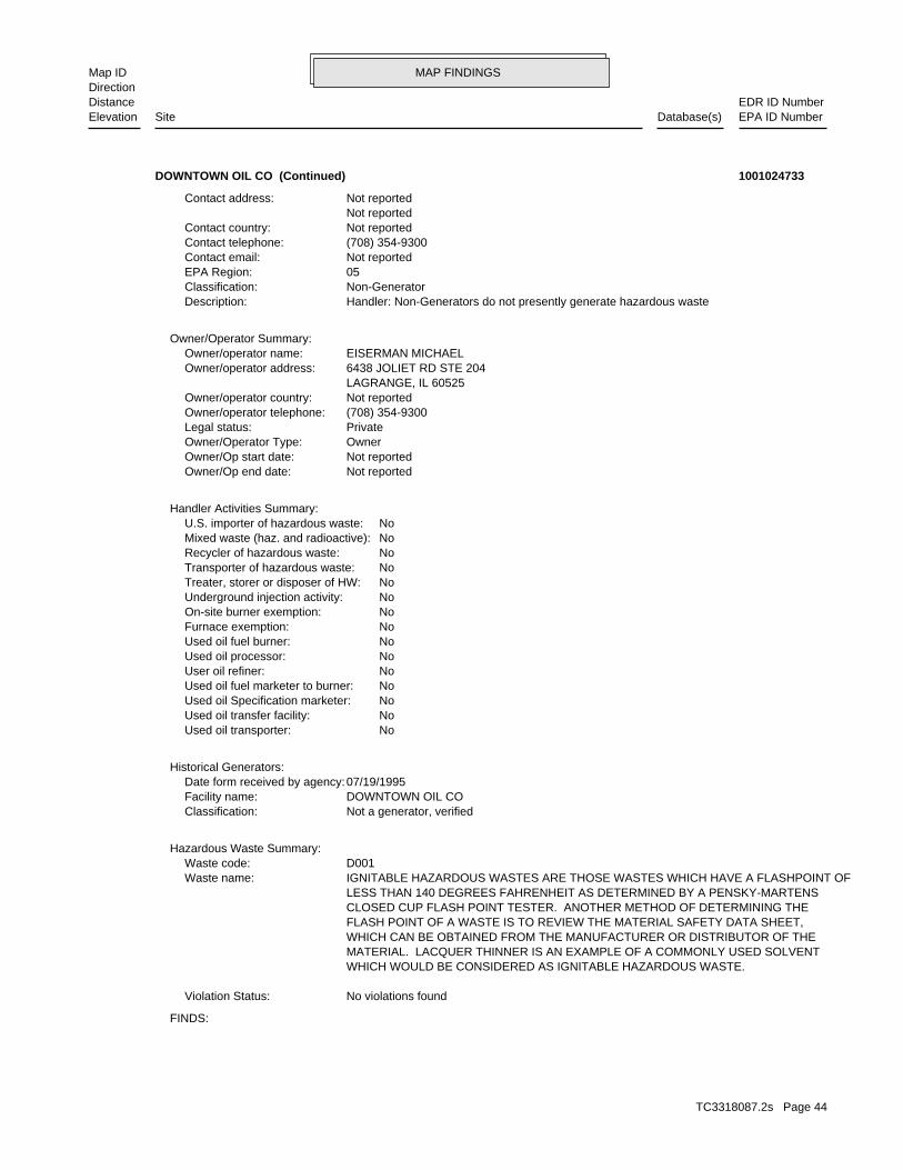
MAP FINDINGSMap IDDirection
EDR ID NumberDistanceEPA ID NumberDatabase(s)SiteElevation
FINDS:
No violations foundViolation Status:
WHICH WOULD BE CONSIDERED AS IGNITABLE HAZARDOUS WASTE. MATERIAL. LACQUER THINNER IS AN EXAMPLE OF A COMMONLY USED SOLVENT WHICH CAN BE OBTAINED FROM THE MANUFACTURER OR DISTRIBUTOR OF THE FLASH POINT OF A WASTE IS TO REVIEW THE MATERIAL SAFETY DATA SHEET, CLOSED CUP FLASH POINT TESTER. ANOTHER METHOD OF DETERMINING THE LESS THAN 140 DEGREES FAHRENHEIT AS DETERMINED BY A PENSKY-MARTENS IGNITABLE HAZARDOUS WASTES ARE THOSE WASTES WHICH HAVE A FLASHPOINT OFWaste name: D001Waste code:
Hazardous Waste Summary:
Not a generator, verifiedClassification: DOWNTOWN OIL COFacility name: 07/19/1995Date form received by agency:
Historical Generators:
NoUsed oil transporter: NoUsed oil transfer facility: NoUsed oil Specification marketer: NoUsed oil fuel marketer to burner: NoUser oil refiner: NoUsed oil processor: NoUsed oil fuel burner: NoFurnace exemption: NoOn-site burner exemption: NoUnderground injection activity: NoTreater, storer or disposer of HW: NoTransporter of hazardous waste: NoRecycler of hazardous waste: NoMixed waste (haz. and radioactive): NoU.S. importer of hazardous waste:
Handler Activities Summary:
Not reportedOwner/Op end date: Not reportedOwner/Op start date: OwnerOwner/Operator Type: PrivateLegal status: (708) 354-9300Owner/operator telephone: Not reportedOwner/operator country: LAGRANGE, IL 60525 6438 JOLIET RD STE 204Owner/operator address: EISERMAN MICHAELOwner/operator name:
Owner/Operator Summary:
Handler: Non-Generators do not presently generate hazardous wasteDescription: Non-GeneratorClassification: 05EPA Region: Not reportedContact email: (708) 354-9300Contact telephone: Not reportedContact country: Not reported Not reportedContact address:
DOWNTOWN OIL CO (Continued) 1001024733
TC3318087.2s Page 44

MAP FINDINGSMap IDDirection
EDR ID NumberDistanceEPA ID NumberDatabase(s)SiteElevation
Not reportedNFR Date Recorded: Not reportedNFA/NFR Letter: 06/13/199545 Report Received: 06/13/199520 Report Received: Not reportedNon LUST Determination Letter: Not reportedDate Section 57.5(g) Letter: 732Section 57.5(g) Letter: Not reportedSite Classification: Not reportedPRP Phone: Chicago, IL 60606PRP City,St,Zip: 7600 South Chicago Ave.PRP Address: Mark EisermanPRP Contact: Downtown OilPRP Name: [email protected]: (217) 524-4649Project Manager Phone: BenantiProject Manager: 05/03/1995IEMA Date: Unleaded GasProduct: 0316045046IL EPA Id: 950919Incident Num:
Not reportedNFR Date Recorded: Not reportedNFA/NFR Letter: 06/22/200545 Report Received: 06/22/200520 Report Received: Not reportedNon LUST Determination Letter: Not reportedDate Section 57.5(g) Letter: P.A.Section 57.5(g) Letter: Not reportedSite Classification: Not reportedPRP Phone: Not reportedPRP City,St,Zip: Not reportedPRP Address: Not reportedPRP Contact: Not reportedPRP Name: [email protected]: (217) 524-4649Project Manager Phone: BenantiProject Manager: 03/23/2005IEMA Date: GasolineProduct: 0316045046IL EPA Id: 20050404Incident Num:
LUST:
corrective action activities required under RCRA.program staff to track the notification, permit, compliance, andand treat, store, or dispose of hazardous waste. RCRAInfo allows RCRAevents and activities related to facilities that generate, transport,Conservation and Recovery Act (RCRA) program through the tracking ofRCRAInfo is a national information system that supports the Resource
Illinois EPA Project to facilitate the permitting operationsACES (Illinois - Agency Compliance And Enforcement System) is the Environmental Interest/Information System
110000858064Registry ID:
DOWNTOWN OIL CO (Continued) 1001024733
TC3318087.2s Page 45

MAP FINDINGSMap IDDirection
EDR ID NumberDistanceEPA ID NumberDatabase(s)SiteElevation
NoUsed oil processor: NoUsed oil fuel burner: NoFurnace exemption: NoOn-site burner exemption: NoUnderground injection activity: NoTreater, storer or disposer of HW: NoTransporter of hazardous waste: NoRecycler of hazardous waste: NoMixed waste (haz. and radioactive): NoU.S. importer of hazardous waste:
Handler Activities Summary:
Not reportedOwner/Op end date: Not reportedOwner/Op start date: OwnerOwner/Operator Type: PrivateLegal status: (312) 555-1212Owner/operator telephone: Not reportedOwner/operator country: CITY NOT REPORTED, AK 99998 ADDRESS NOT REPORTEDOwner/operator address: STOBART KENNETHOwner/operator name:
Not reportedOwner/Op end date: Not reportedOwner/Op start date: OperatorOwner/Operator Type: PrivateLegal status: (312) 555-1212Owner/operator telephone: Not reportedOwner/operator country: CITY NOT REPORTED, AK 99998 ADDRESS NOT REPORTEDOwner/operator address: NAME NOT REPORTEDOwner/operator name:
Owner/Operator Summary:
hazardous waste at any time waste during any calendar month, and accumulates more than 1000 kg of hazardous waste at any time; or generates 100 kg or less of hazardous waste during any calendar month and accumulates less than 6000 kg of Handler: generates more than 100 and less than 1000 kg of hazardousDescription: Small Small Quantity GeneratorClassification: 05EPA Region: Not reportedContact email: (312) 873-6872Contact telephone: USContact country: CHICAGO, IL 60619 724 E 83RD STContact address: KENNETH STOBARTContact: ILD155176068EPA ID: CHICAGO, IL 60619 724 E 83RD STFacility address: CHATHAM COIN LAUNDRY AND DRY CLNGFacility name: 01/17/1989Date form received by agency:
RCRA-SQG:
3739 ft.0.708 mi. LUST
Relative:Lower
Actual:587 ft.
1/2-1 SSUCHICAGO, IL 60619SW FINDS724 E 83RD ST ILD15517606833 RCRA-SQGCHATHAM COIN LAUNDRY AND DRY CLNG 1000407141
TC3318087.2s Page 46

MAP FINDINGSMap IDDirection
EDR ID NumberDistanceEPA ID NumberDatabase(s)SiteElevation
ILD155176068US EPA Id: BacklogSSU Status: NACommunity Relations: HolyProject Manager: SSUCurrent Program: Des PlainesRegion: Take I-55 North.Directions: 41.7441329 / -87.606796Lat/Long: Drums - Waste-oil recyclerFacility Type: 0316690008Facility ID:
SSU:
corrective action activities required under RCRA.program staff to track the notification, permit, compliance, andand treat, store, or dispose of hazardous waste. RCRAInfo allows RCRAevents and activities related to facilities that generate, transport,Conservation and Recovery Act (RCRA) program through the tracking ofRCRAInfo is a national information system that supports the Resource
Illinois EPA Project to facilitate the permitting operationsACES (Illinois - Agency Compliance And Enforcement System) is the Environmental Interest/Information System
110005850659Registry ID:
FINDS:
No violations foundViolation Status:
SPENT SOLVENT MIXTURES. F005, AND STILL BOTTOMS FROM THE RECOVERY OF THESE SPENT SOLVENTS AND OF THE ABOVE HALOGENATED SOLVENTS OR THOSE LISTED IN F001, F004, OR BEFORE USE, A TOTAL OF TEN PERCENT OR MORE (BY VOLUME) OF ONE OR MORE 1,1,2-TRICHLOROETHANE; ALL SPENT SOLVENT MIXTURES/BLENDS CONTAINING, ORTHO-DICHLOROBENZENE, TRICHLOROFLUOROMETHANE, AND CHLOROBENZENE, 1,1,2-TRICHLORO-1,2,2-TRIFLUOROETHANE, METHYLENE CHLORIDE, TRICHLOROETHYLENE, 1,1,1-TRICHLOROETHANE, THE FOLLOWING SPENT HALOGENATED SOLVENTS: TETRACHLOROETHYLENE,Waste name: F002Waste code:
SPENT SOLVENTS AND SPENT SOLVENT MIXTURES. IN F002, F004, AND F005, AND STILL BOTTOMS FROM THE RECOVERY OF THESE ONE OR MORE OF THE ABOVE HALOGENATED SOLVENTS OR THOSE SOLVENTS LISTED CONTAINING, BEFORE USE, A TOTAL OF TEN PERCENT OR MORE (BY VOLUME) OF FLUOROCARBONS; ALL SPENT SOLVENT MIXTURES/BLENDS USED IN DEGREASING 1,1,1-TRICHLOROETHANE, CARBON TETRACHLORIDE, AND CHLORINATED TETRACHLOROETHYLENE, TRICHLOROETHYLENE, METHYLENE CHLORIDE, THE FOLLOWING SPENT HALOGENATED SOLVENTS USED IN DEGREASING:Waste name: F001Waste code:
Hazardous Waste Summary:
NoUsed oil transporter: NoUsed oil transfer facility: NoUsed oil Specification marketer: NoUsed oil fuel marketer to burner: NoUser oil refiner:
CHATHAM COIN LAUNDRY AND DRY CLNG (Continued) 1000407141
TC3318087.2s Page 47

MAP FINDINGSMap IDDirection
EDR ID NumberDistanceEPA ID NumberDatabase(s)SiteElevation
09/09/2009NFR Date Recorded: 07/22/2008NFA/NFR Letter: 05/19/200845 Report Received: 05/19/200820 Report Received: Not reportedNon LUST Determination Letter: Not reportedDate Section 57.5(g) Letter: 734Section 57.5(g) Letter: Not reportedSite Classification: Not reportedPRP Phone: Not reportedPRP City,St,Zip: Not reportedPRP Address: Not reportedPRP Contact: Not reportedPRP Name: [email protected]: (217) 557-6937Project Manager Phone: ZuehlkeProject Manager: 01/16/2008IEMA Date: GasolineProduct: 0316690008IL EPA Id: 20080065Incident Num:
LUST:
Not reportedSite Size: Not reportedYear Entered: N/AYear Completed: NAFOS:
CHATHAM COIN LAUNDRY AND DRY CLNG (Continued) 1000407141
No additional information availableManufactured Gas Plants:
4701 ft.0.890 mi.
Relative:Lower
Actual:590 ft.
1/2-1 CHICAGO, IL 60619NNW 7300-7399 SOUTH CHICAGO AVENUE N/A34 Manufactured Gas PlantsPEOPLES GAS AND LIGHT 1008407345
TC3318087.2s Page 48

ORPHAN SUMMARY
City EDR ID Site Name Site Address Zip Database(s)
Count: 21 records.
CHICAGO 1012172115 ROSELAND COMMUNITY 110TH PLACE AND MICHIGAN, EAST US BROWNFIELDSCHICAGO S108111043 CHICAGO REGIONAL PORT DISTRICT 111TH & CALUMET EXPY 60617 SWF/LFCHICAGO S109167302 549 115TH ST LUST, SPILLSCHICAGO S108112646 PAXTON LANDFILL CORP #2 116TH & OGELSBY 60617 SWF/LFCHICAGO S108111042 CHICAGO MSD #4 124TH & OGELSBY 60617 SWF/LFCHICAGO S101467236 PENN CENTRAL 810 E 124TH ST SSUCHICAGO 1012210776 CHICAGO DEPT OF ENVIRONMENT 76TH ST & AVALON 60619 RCRA-LQGCHICAGO 1004696268 PUBLIC STORAGE 2640 W 79TH RCRA-CESQG, FINDSCHICAGO S108939041 USX REALTY DEVELOPMENT PBR 3426 89TH ST E 60617 SWF/LF, FINANCIAL ASSURANCECHICAGO S107926345 VAN VLISSINGEN PROPERTY 96TH & VAN VLISSINGEN RD 60617 SSUCHICAGO 99647114 RR CAR NO.GATX22983 2040 E. 106TH RR CAR NO.GATX22983 2040 E. 10 ERNSCHICAGO 1004694949 METRA 9000 S GREENWOOD 60617 RCRA-CESQG, FINDSCHICAGO S109366427 6700 JEFFREY BLVD LUST, SPILLSCHICAGO S108891646 11900 LOOMIS LUST, SPILLSCHICAGO S111218390 SHELL OIL PRODUCTS US 45 NORTHWESTERN LUST, SPILLSCHICAGO 91223529 PROPERTY TAX NO. PIN 26- 07-157-00 PROPERTY TAX NO. PIN 26- 07-15 ERNSCHICAGO S108111350 ENVIROTHERM 11700 STONY IS 60617 SWF/LFCHICAGO 879839 RR TANK CAR NO.NATX 29908, RR MILE RR TANK CAR NO.NATX 29908, RR ERNSCHICAGO 1008150443 PAXTON LANDFILL CORP TORRENCE AVE 60617 FINDS, SWF/LFCHICAGO 91201187 UNITED AIRLINES OHARE TERMINAL NO. UNITED AIRLINES OHARE TERMINAL ERNSCHICAGO 91226485 USAFR AND AIR GUARD BASE O’HARE AI USAFR AND AIR GUARD BASE O’HAR ERNS
TC3318087.2s Page 49

To maintain currency of the following federal and state databases, EDR contacts the appropriate governmental agencyon a monthly or quarterly basis, as required.
Number of Days to Update: Provides confirmation that EDR is reporting records that have been updated within 90 daysfrom the date the government agency made the information available to the public.
STANDARD ENVIRONMENTAL RECORDS
Federal NPL site list
NPL: National Priority ListNational Priorities List (Superfund). The NPL is a subset of CERCLIS and identifies over 1,200 sites for prioritycleanup under the Superfund Program. NPL sites may encompass relatively large areas. As such, EDR provides polygoncoverage for over 1,000 NPL site boundaries produced by EPA’s Environmental Photographic Interpretation Center(EPIC) and regional EPA offices.
Date of Government Version: 09/07/2011Date Data Arrived at EDR: 10/12/2011Date Made Active in Reports: 03/01/2012Number of Days to Update: 141
Source: EPATelephone: N/ALast EDR Contact: 04/05/2012Next Scheduled EDR Contact: 07/23/2012Data Release Frequency: Quarterly
NPL Site Boundaries
Sources:
EPA’s Environmental Photographic Interpretation Center (EPIC)Telephone: 202-564-7333
EPA Region 1 EPA Region 6Telephone 617-918-1143 Telephone: 214-655-6659
EPA Region 3 EPA Region 7Telephone 215-814-5418 Telephone: 913-551-7247
EPA Region 4 EPA Region 8Telephone 404-562-8033 Telephone: 303-312-6774
EPA Region 5 EPA Region 9Telephone 312-886-6686 Telephone: 415-947-4246
EPA Region 10Telephone 206-553-8665
Proposed NPL: Proposed National Priority List SitesA site that has been proposed for listing on the National Priorities List through the issuance of a proposed rulein the Federal Register. EPA then accepts public comments on the site, responds to the comments, and places onthe NPL those sites that continue to meet the requirements for listing.
Date of Government Version: 09/07/2011Date Data Arrived at EDR: 10/12/2011Date Made Active in Reports: 03/01/2012Number of Days to Update: 141
Source: EPATelephone: N/ALast EDR Contact: 04/05/2012Next Scheduled EDR Contact: 07/23/2012Data Release Frequency: Quarterly
NPL LIENS: Federal Superfund LiensFederal Superfund Liens. Under the authority granted the USEPA by CERCLA of 1980, the USEPA has the authorityto file liens against real property in order to recover remedial action expenditures or when the property ownerreceived notification of potential liability. USEPA compiles a listing of filed notices of Superfund Liens.
Date of Government Version: 10/15/1991Date Data Arrived at EDR: 02/02/1994Date Made Active in Reports: 03/30/1994Number of Days to Update: 56
Source: EPATelephone: 202-564-4267Last EDR Contact: 08/15/2011Next Scheduled EDR Contact: 11/28/2011Data Release Frequency: No Update Planned
TC3318087.2s Page GR-1
GOVERNMENT RECORDS SEARCHED / DATA CURRENCY TRACKING

Federal Delisted NPL site list
DELISTED NPL: National Priority List DeletionsThe National Oil and Hazardous Substances Pollution Contingency Plan (NCP) establishes the criteria that theEPA uses to delete sites from the NPL. In accordance with 40 CFR 300.425.(e), sites may be deleted from theNPL where no further response is appropriate.
Date of Government Version: 09/07/2011Date Data Arrived at EDR: 10/12/2011Date Made Active in Reports: 03/01/2012Number of Days to Update: 141
Source: EPATelephone: N/ALast EDR Contact: 04/05/2012Next Scheduled EDR Contact: 07/23/2012Data Release Frequency: Quarterly
Federal CERCLIS list
CERCLIS: Comprehensive Environmental Response, Compensation, and Liability Information SystemCERCLIS contains data on potentially hazardous waste sites that have been reported to the USEPA by states, municipalities,private companies and private persons, pursuant to Section 103 of the Comprehensive Environmental Response, Compensation,and Liability Act (CERCLA). CERCLIS contains sites which are either proposed to or on the National PrioritiesList (NPL) and sites which are in the screening and assessment phase for possible inclusion on the NPL.
Date of Government Version: 12/27/2011Date Data Arrived at EDR: 02/27/2012Date Made Active in Reports: 03/12/2012Number of Days to Update: 14
Source: EPATelephone: 703-412-9810Last EDR Contact: 04/05/2012Next Scheduled EDR Contact: 06/11/2012Data Release Frequency: Quarterly
FEDERAL FACILITY: Federal Facility Site Information listingA listing of National Priority List (NPL) and Base Realignment and Closure (BRAC) sites found in the ComprehensiveEnvironmental Response, Compensation and Liability Information System (CERCLIS) Database where EPA Federal FacilitiesRestoration and Reuse Office is involved in cleanup activities.
Date of Government Version: 12/10/2010Date Data Arrived at EDR: 01/11/2011Date Made Active in Reports: 02/16/2011Number of Days to Update: 36
Source: Environmental Protection AgencyTelephone: 703-603-8704Last EDR Contact: 04/12/2012Next Scheduled EDR Contact: 07/23/2012Data Release Frequency: Varies
Federal CERCLIS NFRAP site List
CERCLIS-NFRAP: CERCLIS No Further Remedial Action PlannedArchived sites are sites that have been removed and archived from the inventory of CERCLIS sites. Archived statusindicates that, to the best of EPA’s knowledge, assessment at a site has been completed and that EPA has determinedno further steps will be taken to list this site on the National Priorities List (NPL), unless information indicatesthis decision was not appropriate or other considerations require a recommendation for listing at a later time.This decision does not necessarily mean that there is no hazard associated with a given site; it only means that,based upon available information, the location is not judged to be a potential NPL site.
Date of Government Version: 12/28/2011Date Data Arrived at EDR: 02/27/2012Date Made Active in Reports: 03/12/2012Number of Days to Update: 14
Source: EPATelephone: 703-412-9810Last EDR Contact: 04/05/2012Next Scheduled EDR Contact: 06/11/2012Data Release Frequency: Quarterly
Federal RCRA CORRACTS facilities list
CORRACTS: Corrective Action ReportCORRACTS identifies hazardous waste handlers with RCRA corrective action activity.
TC3318087.2s Page GR-2
GOVERNMENT RECORDS SEARCHED / DATA CURRENCY TRACKING

Date of Government Version: 08/19/2011Date Data Arrived at EDR: 08/31/2011Date Made Active in Reports: 01/10/2012Number of Days to Update: 132
Source: EPATelephone: 800-424-9346Last EDR Contact: 02/13/2012Next Scheduled EDR Contact: 05/28/2012Data Release Frequency: Quarterly
Federal RCRA non-CORRACTS TSD facilities list
RCRA-TSDF: RCRA - Treatment, Storage and DisposalRCRAInfo is EPA’s comprehensive information system, providing access to data supporting the Resource Conservationand Recovery Act (RCRA) of 1976 and the Hazardous and Solid Waste Amendments (HSWA) of 1984. The databaseincludes selective information on sites which generate, transport, store, treat and/or dispose of hazardous wasteas defined by the Resource Conservation and Recovery Act (RCRA). Transporters are individuals or entities thatmove hazardous waste from the generator offsite to a facility that can recycle, treat, store, or dispose of thewaste. TSDFs treat, store, or dispose of the waste.
Date of Government Version: 11/10/2011Date Data Arrived at EDR: 01/05/2012Date Made Active in Reports: 03/12/2012Number of Days to Update: 67
Source: Environmental Protection AgencyTelephone: 312-886-6186Last EDR Contact: 04/04/2012Next Scheduled EDR Contact: 07/16/2012Data Release Frequency: Quarterly
Federal RCRA generators list
RCRA-LQG: RCRA - Large Quantity GeneratorsRCRAInfo is EPA’s comprehensive information system, providing access to data supporting the Resource Conservationand Recovery Act (RCRA) of 1976 and the Hazardous and Solid Waste Amendments (HSWA) of 1984. The databaseincludes selective information on sites which generate, transport, store, treat and/or dispose of hazardous wasteas defined by the Resource Conservation and Recovery Act (RCRA). Large quantity generators (LQGs) generateover 1,000 kilograms (kg) of hazardous waste, or over 1 kg of acutely hazardous waste per month.
Date of Government Version: 11/10/2011Date Data Arrived at EDR: 01/05/2012Date Made Active in Reports: 03/12/2012Number of Days to Update: 67
Source: Environmental Protection AgencyTelephone: 312-886-6186Last EDR Contact: 04/04/2012Next Scheduled EDR Contact: 07/16/2012Data Release Frequency: Quarterly
RCRA-SQG: RCRA - Small Quantity GeneratorsRCRAInfo is EPA’s comprehensive information system, providing access to data supporting the Resource Conservationand Recovery Act (RCRA) of 1976 and the Hazardous and Solid Waste Amendments (HSWA) of 1984. The databaseincludes selective information on sites which generate, transport, store, treat and/or dispose of hazardous wasteas defined by the Resource Conservation and Recovery Act (RCRA). Small quantity generators (SQGs) generatebetween 100 kg and 1,000 kg of hazardous waste per month.
Date of Government Version: 11/10/2011Date Data Arrived at EDR: 01/05/2012Date Made Active in Reports: 03/12/2012Number of Days to Update: 67
Source: Environmental Protection AgencyTelephone: 312-886-6186Last EDR Contact: 04/04/2012Next Scheduled EDR Contact: 07/16/2012Data Release Frequency: Quarterly
RCRA-CESQG: RCRA - Conditionally Exempt Small Quantity GeneratorsRCRAInfo is EPA’s comprehensive information system, providing access to data supporting the Resource Conservationand Recovery Act (RCRA) of 1976 and the Hazardous and Solid Waste Amendments (HSWA) of 1984. The databaseincludes selective information on sites which generate, transport, store, treat and/or dispose of hazardous wasteas defined by the Resource Conservation and Recovery Act (RCRA). Conditionally exempt small quantity generators(CESQGs) generate less than 100 kg of hazardous waste, or less than 1 kg of acutely hazardous waste per month.
Date of Government Version: 11/10/2011Date Data Arrived at EDR: 01/05/2012Date Made Active in Reports: 03/12/2012Number of Days to Update: 67
Source: Environmental Protection AgencyTelephone: 312-886-6186Last EDR Contact: 04/04/2012Next Scheduled EDR Contact: 07/16/2012Data Release Frequency: Varies
TC3318087.2s Page GR-3
GOVERNMENT RECORDS SEARCHED / DATA CURRENCY TRACKING

Federal institutional controls / engineering controls registries
US ENG CONTROLS: Engineering Controls Sites ListA listing of sites with engineering controls in place. Engineering controls include various forms of caps, buildingfoundations, liners, and treatment methods to create pathway elimination for regulated substances to enter environmentalmedia or effect human health.
Date of Government Version: 12/30/2011Date Data Arrived at EDR: 12/30/2011Date Made Active in Reports: 01/10/2012Number of Days to Update: 11
Source: Environmental Protection AgencyTelephone: 703-603-0695Last EDR Contact: 03/12/2012Next Scheduled EDR Contact: 06/25/2012Data Release Frequency: Varies
US INST CONTROL: Sites with Institutional ControlsA listing of sites with institutional controls in place. Institutional controls include administrative measures,such as groundwater use restrictions, construction restrictions, property use restrictions, and post remediationcare requirements intended to prevent exposure to contaminants remaining on site. Deed restrictions are generallyrequired as part of the institutional controls.
Date of Government Version: 12/30/2011Date Data Arrived at EDR: 12/30/2011Date Made Active in Reports: 01/10/2012Number of Days to Update: 11
Source: Environmental Protection AgencyTelephone: 703-603-0695Last EDR Contact: 03/12/2012Next Scheduled EDR Contact: 06/25/2012Data Release Frequency: Varies
Federal ERNS list
ERNS: Emergency Response Notification SystemEmergency Response Notification System. ERNS records and stores information on reported releases of oil and hazardoussubstances.
Date of Government Version: 10/03/2011Date Data Arrived at EDR: 10/04/2011Date Made Active in Reports: 11/11/2011Number of Days to Update: 38
Source: National Response Center, United States Coast GuardTelephone: 202-267-2180Last EDR Contact: 04/03/2012Next Scheduled EDR Contact: 07/16/2012Data Release Frequency: Annually
State- and tribal - equivalent CERCLIS
SSU: State Sites Unit ListingThe State Response Action Program database identifies the status of all sites under the responsibility of theIllinois EPA’s State Sites Unit.
Date of Government Version: 03/09/2012Date Data Arrived at EDR: 03/09/2012Date Made Active in Reports: 04/05/2012Number of Days to Update: 27
Source: Illinois Environmental Protection AgencyTelephone: 217-524-4826Last EDR Contact: 05/01/2012Next Scheduled EDR Contact: 08/13/2012Data Release Frequency: Semi-Annually
State and tribal landfill and/or solid waste disposal site lists
LF WMRC: Waste Management & Research Center Landfill DatabaseThe Waste Management & Research Center Landfill Database includes records from the Department of Public Health,Department of Mines & Minerals, Illinois Environmental Protection Agency, State Geological Survey, NortheasternIllinois Planning Commission and Pollution Control Board.
Date of Government Version: 12/31/2001Date Data Arrived at EDR: 10/06/2006Date Made Active in Reports: 11/06/2006Number of Days to Update: 31
Source: Department of Natural ResourcesTelephone: 217-333-8940Last EDR Contact: 09/18/2009Next Scheduled EDR Contact: 12/28/2009Data Release Frequency: No Update Planned
TC3318087.2s Page GR-4
GOVERNMENT RECORDS SEARCHED / DATA CURRENCY TRACKING

SWF/LF: Available Disposal for Solid Waste in Illinois - Solid Waste Landfills Subject to State SurchargeSolid Waste Facilities/Landfill Sites. SWF/LF type records typically contain an inventory of solid waste disposalfacilities or landfills in a particular state. Depending on the state, these may be active or inactive facilitiesor open dumps that failed to meet RCRA Subtitle D Section 4004 criteria for solid waste landfills or disposalsites.
Date of Government Version: 12/31/2010Date Data Arrived at EDR: 12/21/2011Date Made Active in Reports: 12/23/2011Number of Days to Update: 2
Source: Illinois Environmental Protection AgencyTelephone: 217-785-8604Last EDR Contact: 05/04/2012Next Scheduled EDR Contact: 08/13/2012Data Release Frequency: Annually
LF SPECIAL WASTE: Special Waste Site ListThese landfills, as of January 1, 1990, accept non-hazardous special waste pursuant to the Illinois EPA Non-HazardousSpecial Waste Definition. List A includes landfills that may receive any non-hazardous waste, Non-Regional PollutionControl Facilities are so noted. List B includes landfills designed to receive specific non-hazardous wastes.List B landfills are designated as a Regional Pollution Control Facility by RPCF, or Non-Regional Pollution ControlFacility by Non-RPCF.
Date of Government Version: 01/01/1990Date Data Arrived at EDR: 06/17/2009Date Made Active in Reports: 07/15/2009Number of Days to Update: 28
Source: Illinois EPATelephone: 217-782-9288Last EDR Contact: 06/10/2009Next Scheduled EDR Contact: N/AData Release Frequency: No Update Planned
IL NIPC: Solid Waste Landfill InventorySolid Waste Landfill Inventory. NIPC is an inventory of active and inactive solid waste disposal sites, basedon state, local government and historical archive data. Included are numerous sites which previously had neverbeen identified largely because there was no obligation to register such sites prior to 1971.
Date of Government Version: 08/01/1988Date Data Arrived at EDR: 08/01/1994Date Made Active in Reports: 08/12/1994Number of Days to Update: 11
Source: Northeastern Illinois Planning CommissionTelephone: 312-454-0400Last EDR Contact: 05/23/2006Next Scheduled EDR Contact: N/AData Release Frequency: No Update Planned
CCDD: Clean Construction or Demolition DebrisConstruction and demolition (C and D) debris is nonhazardous, uncontaminated material resulting from construction,remodeling, repair, or demolition of utilities, structures, and roads.
Date of Government Version: 01/30/2012Date Data Arrived at EDR: 01/31/2012Date Made Active in Reports: 02/27/2012Number of Days to Update: 27
Source: Illinois EPATelephone: 217-524-3300Last EDR Contact: 05/01/2012Next Scheduled EDR Contact: 08/13/2012Data Release Frequency: Varies
State and tribal leaking storage tank lists
LUST: Leaking Underground Storage Tank SitesLeaking Underground Storage Tank Incident Reports. LUST records contain an inventory of reported leaking undergroundstorage tank incidents. Not all states maintain these records, and the information stored varies by state.
Date of Government Version: 01/26/2012Date Data Arrived at EDR: 01/31/2012Date Made Active in Reports: 02/27/2012Number of Days to Update: 27
Source: Illinois Environmental Protection AgencyTelephone: 217-782-6762Last EDR Contact: 05/01/2012Next Scheduled EDR Contact: 08/13/2012Data Release Frequency: Semi-Annually
LUST TRUST: Underground Storage Tank Fund Payment Prioirty ListIn case sufficient funds are not available in the Underground Storage Tank Fund, requests for payment are enteredon the Payment Priority List by "queue date" order. As required by the Environmental Protection Act, the queuedate is the date that a complete request for partial or final payment was received by the Agency. The queue dateis "officially" confirmed at the end of the payment review process when a Final Decision Letter is sent to thesite owner.
TC3318087.2s Page GR-5
GOVERNMENT RECORDS SEARCHED / DATA CURRENCY TRACKING
Date of Government Version: 01/17/2012Date Data Arrived at EDR: 01/31/2012Date Made Active in Reports: 02/27/2012Number of Days to Update: 27
Source: Illinois EPATelephone: 217-782-6762Last EDR Contact: 05/01/2012Next Scheduled EDR Contact: 08/13/2012Data Release Frequency: Varies
INDIAN LUST R9: Leaking Underground Storage Tanks on Indian LandLUSTs on Indian land in Arizona, California, New Mexico and Nevada
Date of Government Version: 12/05/2011Date Data Arrived at EDR: 12/07/2011Date Made Active in Reports: 01/10/2012Number of Days to Update: 34
Source: Environmental Protection AgencyTelephone: 415-972-3372Last EDR Contact: 04/30/2012Next Scheduled EDR Contact: 08/13/2012Data Release Frequency: Quarterly
INDIAN LUST R4: Leaking Underground Storage Tanks on Indian LandLUSTs on Indian land in Florida, Mississippi and North Carolina.
Date of Government Version: 12/14/2011Date Data Arrived at EDR: 12/15/2011Date Made Active in Reports: 01/10/2012Number of Days to Update: 26
Source: EPA Region 4Telephone: 404-562-8677Last EDR Contact: 04/30/2012Next Scheduled EDR Contact: 08/13/2012Data Release Frequency: Semi-Annually
INDIAN LUST R10: Leaking Underground Storage Tanks on Indian LandLUSTs on Indian land in Alaska, Idaho, Oregon and Washington.
Date of Government Version: 11/02/2011Date Data Arrived at EDR: 11/04/2011Date Made Active in Reports: 11/11/2011Number of Days to Update: 7
Source: EPA Region 10Telephone: 206-553-2857Last EDR Contact: 04/30/2012Next Scheduled EDR Contact: 08/13/2012Data Release Frequency: Quarterly
INDIAN LUST R1: Leaking Underground Storage Tanks on Indian LandA listing of leaking underground storage tank locations on Indian Land.
Date of Government Version: 10/01/2011Date Data Arrived at EDR: 11/01/2011Date Made Active in Reports: 11/11/2011Number of Days to Update: 10
Source: EPA Region 1Telephone: 617-918-1313Last EDR Contact: 05/01/2012Next Scheduled EDR Contact: 08/13/2012Data Release Frequency: Varies
INDIAN LUST R6: Leaking Underground Storage Tanks on Indian LandLUSTs on Indian land in New Mexico and Oklahoma.
Date of Government Version: 09/12/2011Date Data Arrived at EDR: 09/13/2011Date Made Active in Reports: 11/11/2011Number of Days to Update: 59
Source: EPA Region 6Telephone: 214-665-6597Last EDR Contact: 04/23/2012Next Scheduled EDR Contact: 08/13/2012Data Release Frequency: Varies
INDIAN LUST R7: Leaking Underground Storage Tanks on Indian LandLUSTs on Indian land in Iowa, Kansas, and Nebraska
Date of Government Version: 11/01/2011Date Data Arrived at EDR: 11/21/2011Date Made Active in Reports: 01/10/2012Number of Days to Update: 50
Source: EPA Region 7Telephone: 913-551-7003Last EDR Contact: 04/30/2012Next Scheduled EDR Contact: 08/13/2012Data Release Frequency: Varies
TC3318087.2s Page GR-6
GOVERNMENT RECORDS SEARCHED / DATA CURRENCY TRACKING

INDIAN LUST R8: Leaking Underground Storage Tanks on Indian LandLUSTs on Indian land in Colorado, Montana, North Dakota, South Dakota, Utah and Wyoming.
Date of Government Version: 08/18/2011Date Data Arrived at EDR: 08/19/2011Date Made Active in Reports: 09/13/2011Number of Days to Update: 25
Source: EPA Region 8Telephone: 303-312-6271Last EDR Contact: 04/30/2012Next Scheduled EDR Contact: 08/13/2012Data Release Frequency: Quarterly
State and tribal registered storage tank lists
UST: Underground Storage Tank Facility ListRegistered Underground Storage Tanks. UST’s are regulated under Subtitle I of the Resource Conservation and RecoveryAct (RCRA) and must be registered with the state department responsible for administering the UST program. Availableinformation varies by state program.
Date of Government Version: 01/30/2012Date Data Arrived at EDR: 01/31/2012Date Made Active in Reports: 02/28/2012Number of Days to Update: 28
Source: Illinois State Fire MarshalTelephone: 217-785-0969Last EDR Contact: 05/01/2012Next Scheduled EDR Contact: 08/13/2012Data Release Frequency: Quarterly
INDIAN UST R4: Underground Storage Tanks on Indian LandThe Indian Underground Storage Tank (UST) database provides information about underground storage tanks on Indianland in EPA Region 4 (Alabama, Florida, Georgia, Kentucky, Mississippi, North Carolina, South Carolina, Tennesseeand Tribal Nations)
Date of Government Version: 12/14/2011Date Data Arrived at EDR: 12/15/2011Date Made Active in Reports: 01/10/2012Number of Days to Update: 26
Source: EPA Region 4Telephone: 404-562-9424Last EDR Contact: 04/30/2012Next Scheduled EDR Contact: 08/13/2012Data Release Frequency: Semi-Annually
INDIAN UST R9: Underground Storage Tanks on Indian LandThe Indian Underground Storage Tank (UST) database provides information about underground storage tanks on Indianland in EPA Region 9 (Arizona, California, Hawaii, Nevada, the Pacific Islands, and Tribal Nations).
Date of Government Version: 11/28/2011Date Data Arrived at EDR: 11/29/2011Date Made Active in Reports: 01/10/2012Number of Days to Update: 42
Source: EPA Region 9Telephone: 415-972-3368Last EDR Contact: 04/30/2012Next Scheduled EDR Contact: 08/13/2012Data Release Frequency: Quarterly
INDIAN UST R8: Underground Storage Tanks on Indian LandThe Indian Underground Storage Tank (UST) database provides information about underground storage tanks on Indianland in EPA Region 8 (Colorado, Montana, North Dakota, South Dakota, Utah, Wyoming and 27 Tribal Nations).
Date of Government Version: 08/18/2011Date Data Arrived at EDR: 08/19/2011Date Made Active in Reports: 09/13/2011Number of Days to Update: 25
Source: EPA Region 8Telephone: 303-312-6137Last EDR Contact: 04/30/2012Next Scheduled EDR Contact: 08/13/2012Data Release Frequency: Quarterly
INDIAN UST R5: Underground Storage Tanks on Indian LandThe Indian Underground Storage Tank (UST) database provides information about underground storage tanks on Indianland in EPA Region 5 (Michigan, Minnesota and Wisconsin and Tribal Nations).
Date of Government Version: 07/01/2011Date Data Arrived at EDR: 08/26/2011Date Made Active in Reports: 09/13/2011Number of Days to Update: 18
Source: EPA Region 5Telephone: 312-886-6136Last EDR Contact: 04/30/2012Next Scheduled EDR Contact: 08/13/2012Data Release Frequency: Varies
TC3318087.2s Page GR-7
GOVERNMENT RECORDS SEARCHED / DATA CURRENCY TRACKING

INDIAN UST R7: Underground Storage Tanks on Indian LandThe Indian Underground Storage Tank (UST) database provides information about underground storage tanks on Indianland in EPA Region 7 (Iowa, Kansas, Missouri, Nebraska, and 9 Tribal Nations).
Date of Government Version: 11/01/2011Date Data Arrived at EDR: 11/21/2011Date Made Active in Reports: 01/10/2012Number of Days to Update: 50
Source: EPA Region 7Telephone: 913-551-7003Last EDR Contact: 04/30/2012Next Scheduled EDR Contact: 08/13/2012Data Release Frequency: Varies
INDIAN UST R6: Underground Storage Tanks on Indian LandThe Indian Underground Storage Tank (UST) database provides information about underground storage tanks on Indianland in EPA Region 6 (Louisiana, Arkansas, Oklahoma, New Mexico, Texas and 65 Tribes).
Date of Government Version: 05/10/2011Date Data Arrived at EDR: 05/11/2011Date Made Active in Reports: 06/14/2011Number of Days to Update: 34
Source: EPA Region 6Telephone: 214-665-7591Last EDR Contact: 04/23/2012Next Scheduled EDR Contact: 08/13/2012Data Release Frequency: Semi-Annually
INDIAN UST R1: Underground Storage Tanks on Indian LandThe Indian Underground Storage Tank (UST) database provides information about underground storage tanks on Indianland in EPA Region 1 (Connecticut, Maine, Massachusetts, New Hampshire, Rhode Island, Vermont and ten TribalNations).
Date of Government Version: 10/01/2011Date Data Arrived at EDR: 11/01/2011Date Made Active in Reports: 11/11/2011Number of Days to Update: 10
Source: EPA, Region 1Telephone: 617-918-1313Last EDR Contact: 05/01/2012Next Scheduled EDR Contact: 08/13/2012Data Release Frequency: Varies
INDIAN UST R10: Underground Storage Tanks on Indian LandThe Indian Underground Storage Tank (UST) database provides information about underground storage tanks on Indianland in EPA Region 10 (Alaska, Idaho, Oregon, Washington, and Tribal Nations).
Date of Government Version: 11/02/2011Date Data Arrived at EDR: 11/04/2011Date Made Active in Reports: 11/11/2011Number of Days to Update: 7
Source: EPA Region 10Telephone: 206-553-2857Last EDR Contact: 04/30/2012Next Scheduled EDR Contact: 08/13/2012Data Release Frequency: Quarterly
FEMA UST: Underground Storage Tank ListingA listing of all FEMA owned underground storage tanks.
Date of Government Version: 01/01/2010Date Data Arrived at EDR: 02/16/2010Date Made Active in Reports: 04/12/2010Number of Days to Update: 55
Source: FEMATelephone: 202-646-5797Last EDR Contact: 04/10/2012Next Scheduled EDR Contact: 07/30/2012Data Release Frequency: Varies
State and tribal institutional control / engineering control registries
ENG CONTROLS: Sites with Engineering ControlsSites using of engineered barriers (e.g., asphalt or concrete paving).
Date of Government Version: 02/24/2012Date Data Arrived at EDR: 02/29/2012Date Made Active in Reports: 04/05/2012Number of Days to Update: 36
Source: Illinois Environmental Protection AgencyTelephone: 217-782-6761Last EDR Contact: 04/24/2012Next Scheduled EDR Contact: 08/06/2012Data Release Frequency: Quarterly
TC3318087.2s Page GR-8
GOVERNMENT RECORDS SEARCHED / DATA CURRENCY TRACKING

Inst Control: Institutional ControlsLegal or administrative restrictions on land use and/or other activities (e.g., groundwater use restrictions)which effectively limit exposure to contamination may be employed as alternatives to removal or treatment of contamination.
Date of Government Version: 02/24/2012Date Data Arrived at EDR: 02/29/2012Date Made Active in Reports: 04/05/2012Number of Days to Update: 36
Source: Illinois Environmental Protection AgencyTelephone: 217-782-6761Last EDR Contact: 04/24/2012Next Scheduled EDR Contact: 08/06/2012Data Release Frequency: Quarterly
State and tribal voluntary cleanup sites
INDIAN VCP R1: Voluntary Cleanup Priority ListingA listing of voluntary cleanup priority sites located on Indian Land located in Region 1.
Date of Government Version: 08/04/2011Date Data Arrived at EDR: 10/04/2011Date Made Active in Reports: 11/11/2011Number of Days to Update: 38
Source: EPA, Region 1Telephone: 617-918-1102Last EDR Contact: 04/03/2012Next Scheduled EDR Contact: 07/16/2012Data Release Frequency: Varies
INDIAN VCP R7: Voluntary Cleanup Priority LisitngA listing of voluntary cleanup priority sites located on Indian Land located in Region 7.
Date of Government Version: 03/20/2008Date Data Arrived at EDR: 04/22/2008Date Made Active in Reports: 05/19/2008Number of Days to Update: 27
Source: EPA, Region 7Telephone: 913-551-7365Last EDR Contact: 04/20/2009Next Scheduled EDR Contact: 07/20/2009Data Release Frequency: Varies
SRP: Site Remediation Program DatabaseThe database identifies the status of all voluntary remediation projects administered through the pre-notice sitecleanup program (1989 to 1995) and the site remediation program (1996 to the present).
Date of Government Version: 02/24/2012Date Data Arrived at EDR: 02/29/2012Date Made Active in Reports: 04/05/2012Number of Days to Update: 36
Source: Illinois Environmental Protection AgencyTelephone: 217-785-9407Last EDR Contact: 04/24/2012Next Scheduled EDR Contact: 08/06/2012Data Release Frequency: Semi-Annually
State and tribal Brownfields sites
BROWNFIELDS: Municipal Brownfields Redevelopment Grant Program Project DescriptionsThe Illinois Municipal Brownfields Redevelopment Grant Program (MBRGP) offers grants worth a maximum of $240,000each to municipalities to assist in site investigation activities, development of cleanup objectives, and performanceof cleanup activities. Brownfields are abandoned or underused industrial and/or commercial properties that arecontaminated (or thought to be contaminated) and have an active potential for redevelopment.
Date of Government Version: 12/20/2011Date Data Arrived at EDR: 12/20/2011Date Made Active in Reports: 01/20/2012Number of Days to Update: 31
Source: Illinois Environmental Protection AgencyTelephone: 217-785-3486Last EDR Contact: 04/30/2012Next Scheduled EDR Contact: 08/13/2012Data Release Frequency: Varies
BROWNFIELDS: Redevelopment Assessment DatabaseThe Office of Site Evaluations Redevelopment Assessment database identifies the status of all properties withinthe State in which the Illinois EPA’s Office of Site Evaluation has conducted a municipal Brownfield RedevelopmentAssessment.
TC3318087.2s Page GR-9
GOVERNMENT RECORDS SEARCHED / DATA CURRENCY TRACKING

Date of Government Version: 01/30/2012Date Data Arrived at EDR: 01/31/2012Date Made Active in Reports: 02/21/2012Number of Days to Update: 21
Source: Illinois Environmental Protection AgencyTelephone: 217-524-1658Last EDR Contact: 05/01/2012Next Scheduled EDR Contact: 08/13/2012Data Release Frequency: Varies
ADDITIONAL ENVIRONMENTAL RECORDS
Local Brownfield lists
US BROWNFIELDS: A Listing of Brownfields SitesBrownfields are real property, the expansion, redevelopment, or reuse of which may be complicated by the presenceor potential presence of a hazardous substance, pollutant, or contaminant. Cleaning up and reinvesting in theseproperties takes development pressures off of undeveloped, open land, and both improves and protects the environment.Assessment, Cleanup and Redevelopment Exchange System (ACRES) stores information reported by EPA Brownfieldsgrant recipients on brownfields properties assessed or cleaned up with grant funding as well as information onTargeted Brownfields Assessments performed by EPA Regions. A listing of ACRES Brownfield sites is obtained fromCleanups in My Community. Cleanups in My Community provides information on Brownfields properties for which informationis reported back to EPA, as well as areas served by Brownfields grant programs.
Date of Government Version: 06/27/2011Date Data Arrived at EDR: 06/27/2011Date Made Active in Reports: 09/13/2011Number of Days to Update: 78
Source: Environmental Protection AgencyTelephone: 202-566-2777Last EDR Contact: 04/03/2012Next Scheduled EDR Contact: 07/09/2012Data Release Frequency: Semi-Annually
Local Lists of Landfill / Solid Waste Disposal Sites
ODI: Open Dump InventoryAn open dump is defined as a disposal facility that does not comply with one or more of the Part 257 or Part 258Subtitle D Criteria.
Date of Government Version: 06/30/1985Date Data Arrived at EDR: 08/09/2004Date Made Active in Reports: 09/17/2004Number of Days to Update: 39
Source: Environmental Protection AgencyTelephone: 800-424-9346Last EDR Contact: 06/09/2004Next Scheduled EDR Contact: N/AData Release Frequency: No Update Planned
DEBRIS REGION 9: Torres Martinez Reservation Illegal Dump Site LocationsA listing of illegal dump sites location on the Torres Martinez Indian Reservation located in eastern RiversideCounty and northern Imperial County, California.
Date of Government Version: 01/12/2009Date Data Arrived at EDR: 05/07/2009Date Made Active in Reports: 09/21/2009Number of Days to Update: 137
Source: EPA, Region 9Telephone: 415-947-4219Last EDR Contact: 03/26/2012Next Scheduled EDR Contact: 07/09/2012Data Release Frequency: No Update Planned
INDIAN ODI: Report on the Status of Open Dumps on Indian LandsLocation of open dumps on Indian land.
Date of Government Version: 12/31/1998Date Data Arrived at EDR: 12/03/2007Date Made Active in Reports: 01/24/2008Number of Days to Update: 52
Source: Environmental Protection AgencyTelephone: 703-308-8245Last EDR Contact: 05/07/2012Next Scheduled EDR Contact: 08/20/2012Data Release Frequency: Varies
Local Lists of Hazardous waste / Contaminated Sites
TC3318087.2s Page GR-10
GOVERNMENT RECORDS SEARCHED / DATA CURRENCY TRACKING

US CDL: Clandestine Drug LabsA listing of clandestine drug lab locations. The U.S. Department of Justice ("the Department") provides thisweb site as a public service. It contains addresses of some locations where law enforcement agencies reportedthey found chemicals or other items that indicated the presence of either clandestine drug laboratories or dumpsites.In most cases, the source of the entries is not the Department, and the Department has not verified the entryand does not guarantee its accuracy. Members of the public must verify the accuracy of all entries by, for example,contacting local law enforcement and local health departments.
Date of Government Version: 10/07/2011Date Data Arrived at EDR: 12/09/2011Date Made Active in Reports: 01/10/2012Number of Days to Update: 32
Source: Drug Enforcement AdministrationTelephone: 202-307-1000Last EDR Contact: 03/06/2012Next Scheduled EDR Contact: 06/18/2012Data Release Frequency: Quarterly
CDL: Meth Drug Lab Site ListingA listing of clandestine/meth drug lab locations.
Date of Government Version: 01/18/2012Date Data Arrived at EDR: 01/18/2012Date Made Active in Reports: 02/27/2012Number of Days to Update: 40
Source: Department of Public HealthTelephone: 217-782-5750Last EDR Contact: 04/11/2012Next Scheduled EDR Contact: 07/30/2012Data Release Frequency: Varies
US HIST CDL: National Clandestine Laboratory RegisterA listing of clandestine drug lab locations. The U.S. Department of Justice ("the Department") provides thisweb site as a public service. It contains addresses of some locations where law enforcement agencies reportedthey found chemicals or other items that indicated the presence of either clandestine drug laboratories or dumpsites.In most cases, the source of the entries is not the Department, and the Department has not verified the entryand does not guarantee its accuracy. Members of the public must verify the accuracy of all entries by, for example,contacting local law enforcement and local health departments.
Date of Government Version: 09/01/2007Date Data Arrived at EDR: 11/19/2008Date Made Active in Reports: 03/30/2009Number of Days to Update: 131
Source: Drug Enforcement AdministrationTelephone: 202-307-1000Last EDR Contact: 03/23/2009Next Scheduled EDR Contact: 06/22/2009Data Release Frequency: No Update Planned
Local Land Records
LIENS 2: CERCLA Lien InformationA Federal CERCLA (’Superfund’) lien can exist by operation of law at any site or property at which EPA has spentSuperfund monies. These monies are spent to investigate and address releases and threatened releases of contamination.CERCLIS provides information as to the identity of these sites and properties.
Date of Government Version: 09/09/2011Date Data Arrived at EDR: 09/16/2011Date Made Active in Reports: 09/29/2011Number of Days to Update: 13
Source: Environmental Protection AgencyTelephone: 202-564-6023Last EDR Contact: 04/30/2012Next Scheduled EDR Contact: 08/13/2012Data Release Frequency: Varies
LUCIS: Land Use Control Information SystemLUCIS contains records of land use control information pertaining to the former Navy Base Realignment and Closureproperties.
Date of Government Version: 12/09/2005Date Data Arrived at EDR: 12/11/2006Date Made Active in Reports: 01/11/2007Number of Days to Update: 31
Source: Department of the NavyTelephone: 843-820-7326Last EDR Contact: 04/03/2012Next Scheduled EDR Contact: 06/04/2012Data Release Frequency: Varies
Records of Emergency Release Reports
TC3318087.2s Page GR-11
GOVERNMENT RECORDS SEARCHED / DATA CURRENCY TRACKING

HMIRS: Hazardous Materials Information Reporting SystemHazardous Materials Incident Report System. HMIRS contains hazardous material spill incidents reported to DOT.
Date of Government Version: 10/04/2011Date Data Arrived at EDR: 10/04/2011Date Made Active in Reports: 11/11/2011Number of Days to Update: 38
Source: U.S. Department of TransportationTelephone: 202-366-4555Last EDR Contact: 04/03/2012Next Scheduled EDR Contact: 07/16/2012Data Release Frequency: Annually
SPILLS: State spillsA listing of incidents reported to the Office of Emergency Response.
Date of Government Version: 12/31/2011Date Data Arrived at EDR: 01/20/2012Date Made Active in Reports: 02/27/2012Number of Days to Update: 38
Source: Illinois EPATelephone: 217-558-1677Last EDR Contact: 04/11/2012Next Scheduled EDR Contact: 07/30/2012Data Release Frequency: Varies
Other Ascertainable Records
RCRA-NonGen: RCRA - Non GeneratorsRCRAInfo is EPA’s comprehensive information system, providing access to data supporting the Resource Conservationand Recovery Act (RCRA) of 1976 and the Hazardous and Solid Waste Amendments (HSWA) of 1984. The databaseincludes selective information on sites which generate, transport, store, treat and/or dispose of hazardous wasteas defined by the Resource Conservation and Recovery Act (RCRA). Non-Generators do not presently generate hazardouswaste.
Date of Government Version: 11/10/2011Date Data Arrived at EDR: 01/05/2012Date Made Active in Reports: 03/12/2012Number of Days to Update: 67
Source: Environmental Protection AgencyTelephone: 312-886-6186Last EDR Contact: 04/04/2012Next Scheduled EDR Contact: 07/16/2012Data Release Frequency: Varies
DOT OPS: Incident and Accident DataDepartment of Transporation, Office of Pipeline Safety Incident and Accident data.
Date of Government Version: 07/29/2011Date Data Arrived at EDR: 08/09/2011Date Made Active in Reports: 11/11/2011Number of Days to Update: 94
Source: Department of Transporation, Office of Pipeline SafetyTelephone: 202-366-4595Last EDR Contact: 02/07/2012Next Scheduled EDR Contact: 05/21/2012Data Release Frequency: Varies
DOD: Department of Defense SitesThis data set consists of federally owned or administered lands, administered by the Department of Defense, thathave any area equal to or greater than 640 acres of the United States, Puerto Rico, and the U.S. Virgin Islands.
Date of Government Version: 12/31/2005Date Data Arrived at EDR: 11/10/2006Date Made Active in Reports: 01/11/2007Number of Days to Update: 62
Source: USGSTelephone: 888-275-8747Last EDR Contact: 04/16/2012Next Scheduled EDR Contact: 07/30/2012Data Release Frequency: Semi-Annually
FUDS: Formerly Used Defense SitesThe listing includes locations of Formerly Used Defense Sites properties where the US Army Corps of Engineersis actively working or will take necessary cleanup actions.
Date of Government Version: 12/31/2009Date Data Arrived at EDR: 08/12/2010Date Made Active in Reports: 12/02/2010Number of Days to Update: 112
Source: U.S. Army Corps of EngineersTelephone: 202-528-4285Last EDR Contact: 03/12/2012Next Scheduled EDR Contact: 06/25/2012Data Release Frequency: Varies
TC3318087.2s Page GR-12
GOVERNMENT RECORDS SEARCHED / DATA CURRENCY TRACKING

CONSENT: Superfund (CERCLA) Consent DecreesMajor legal settlements that establish responsibility and standards for cleanup at NPL (Superfund) sites. Releasedperiodically by United States District Courts after settlement by parties to litigation matters.
Date of Government Version: 12/01/2011Date Data Arrived at EDR: 01/25/2012Date Made Active in Reports: 03/01/2012Number of Days to Update: 36
Source: Department of Justice, Consent Decree LibraryTelephone: VariesLast EDR Contact: 04/02/2012Next Scheduled EDR Contact: 07/16/2012Data Release Frequency: Varies
ROD: Records Of DecisionRecord of Decision. ROD documents mandate a permanent remedy at an NPL (Superfund) site containing technicaland health information to aid in the cleanup.
Date of Government Version: 09/28/2011Date Data Arrived at EDR: 12/14/2011Date Made Active in Reports: 01/10/2012Number of Days to Update: 27
Source: EPATelephone: 703-416-0223Last EDR Contact: 03/14/2012Next Scheduled EDR Contact: 06/25/2012Data Release Frequency: Annually
UMTRA: Uranium Mill Tailings SitesUranium ore was mined by private companies for federal government use in national defense programs. When the millsshut down, large piles of the sand-like material (mill tailings) remain after uranium has been extracted fromthe ore. Levels of human exposure to radioactive materials from the piles are low; however, in some cases tailingswere used as construction materials before the potential health hazards of the tailings were recognized.
Date of Government Version: 09/14/2010Date Data Arrived at EDR: 10/07/2011Date Made Active in Reports: 03/01/2012Number of Days to Update: 146
Source: Department of EnergyTelephone: 505-845-0011Last EDR Contact: 02/28/2012Next Scheduled EDR Contact: 06/11/2012Data Release Frequency: Varies
MINES: Mines Master Index FileContains all mine identification numbers issued for mines active or opened since 1971. The data also includesviolation information.
Date of Government Version: 08/18/2011Date Data Arrived at EDR: 09/08/2011Date Made Active in Reports: 09/29/2011Number of Days to Update: 21
Source: Department of Labor, Mine Safety and Health AdministrationTelephone: 303-231-5959Last EDR Contact: 03/07/2012Next Scheduled EDR Contact: 06/18/2012Data Release Frequency: Semi-Annually
TRIS: Toxic Chemical Release Inventory SystemToxic Release Inventory System. TRIS identifies facilities which release toxic chemicals to the air, water andland in reportable quantities under SARA Title III Section 313.
Date of Government Version: 12/31/2009Date Data Arrived at EDR: 09/01/2011Date Made Active in Reports: 01/10/2012Number of Days to Update: 131
Source: EPATelephone: 202-566-0250Last EDR Contact: 02/28/2012Next Scheduled EDR Contact: 06/11/2012Data Release Frequency: Annually
TSCA: Toxic Substances Control ActToxic Substances Control Act. TSCA identifies manufacturers and importers of chemical substances included on theTSCA Chemical Substance Inventory list. It includes data on the production volume of these substances by plantsite.
Date of Government Version: 12/31/2006Date Data Arrived at EDR: 09/29/2010Date Made Active in Reports: 12/02/2010Number of Days to Update: 64
Source: EPATelephone: 202-260-5521Last EDR Contact: 03/28/2012Next Scheduled EDR Contact: 07/09/2012Data Release Frequency: Every 4 Years
TC3318087.2s Page GR-13
GOVERNMENT RECORDS SEARCHED / DATA CURRENCY TRACKING

FTTS: FIFRA/ TSCA Tracking System - FIFRA (Federal Insecticide, Fungicide, & Rodenticide Act)/TSCA (Toxic Substances Control Act)FTTS tracks administrative cases and pesticide enforcement actions and compliance activities related to FIFRA,TSCA and EPCRA (Emergency Planning and Community Right-to-Know Act). To maintain currency, EDR contacts theAgency on a quarterly basis.
Date of Government Version: 04/09/2009Date Data Arrived at EDR: 04/16/2009Date Made Active in Reports: 05/11/2009Number of Days to Update: 25
Source: EPA/Office of Prevention, Pesticides and Toxic SubstancesTelephone: 202-566-1667Last EDR Contact: 02/27/2012Next Scheduled EDR Contact: 06/11/2012Data Release Frequency: Quarterly
FTTS INSP: FIFRA/ TSCA Tracking System - FIFRA (Federal Insecticide, Fungicide, & Rodenticide Act)/TSCA (Toxic Substances Control Act)A listing of FIFRA/TSCA Tracking System (FTTS) inspections and enforcements.
Date of Government Version: 04/09/2009Date Data Arrived at EDR: 04/16/2009Date Made Active in Reports: 05/11/2009Number of Days to Update: 25
Source: EPATelephone: 202-566-1667Last EDR Contact: 02/27/2012Next Scheduled EDR Contact: 06/11/2012Data Release Frequency: Quarterly
HIST FTTS: FIFRA/TSCA Tracking System Administrative Case ListingA complete administrative case listing from the FIFRA/TSCA Tracking System (FTTS) for all ten EPA regions. Theinformation was obtained from the National Compliance Database (NCDB). NCDB supports the implementation of FIFRA(Federal Insecticide, Fungicide, and Rodenticide Act) and TSCA (Toxic Substances Control Act). Some EPA regionsare now closing out records. Because of that, and the fact that some EPA regions are not providing EPA Headquarterswith updated records, it was decided to create a HIST FTTS database. It included records that may not be includedin the newer FTTS database updates. This database is no longer updated.
Date of Government Version: 10/19/2006Date Data Arrived at EDR: 03/01/2007Date Made Active in Reports: 04/10/2007Number of Days to Update: 40
Source: Environmental Protection AgencyTelephone: 202-564-2501Last EDR Contact: 12/17/2007Next Scheduled EDR Contact: 03/17/2008Data Release Frequency: No Update Planned
HIST FTTS INSP: FIFRA/TSCA Tracking System Inspection & Enforcement Case ListingA complete inspection and enforcement case listing from the FIFRA/TSCA Tracking System (FTTS) for all ten EPAregions. The information was obtained from the National Compliance Database (NCDB). NCDB supports the implementationof FIFRA (Federal Insecticide, Fungicide, and Rodenticide Act) and TSCA (Toxic Substances Control Act). SomeEPA regions are now closing out records. Because of that, and the fact that some EPA regions are not providingEPA Headquarters with updated records, it was decided to create a HIST FTTS database. It included records thatmay not be included in the newer FTTS database updates. This database is no longer updated.
Date of Government Version: 10/19/2006Date Data Arrived at EDR: 03/01/2007Date Made Active in Reports: 04/10/2007Number of Days to Update: 40
Source: Environmental Protection AgencyTelephone: 202-564-2501Last EDR Contact: 12/17/2008Next Scheduled EDR Contact: 03/17/2008Data Release Frequency: No Update Planned
SSTS: Section 7 Tracking SystemsSection 7 of the Federal Insecticide, Fungicide and Rodenticide Act, as amended (92 Stat. 829) requires allregistered pesticide-producing establishments to submit a report to the Environmental Protection Agency by March1st each year. Each establishment must report the types and amounts of pesticides, active ingredients and devicesbeing produced, and those having been produced and sold or distributed in the past year.
Date of Government Version: 12/31/2009Date Data Arrived at EDR: 12/10/2010Date Made Active in Reports: 02/25/2011Number of Days to Update: 77
Source: EPATelephone: 202-564-4203Last EDR Contact: 04/30/2012Next Scheduled EDR Contact: 08/13/2012Data Release Frequency: Annually
TC3318087.2s Page GR-14
GOVERNMENT RECORDS SEARCHED / DATA CURRENCY TRACKING

ICIS: Integrated Compliance Information SystemThe Integrated Compliance Information System (ICIS) supports the information needs of the national enforcementand compliance program as well as the unique needs of the National Pollutant Discharge Elimination System (NPDES)program.
Date of Government Version: 07/20/2011Date Data Arrived at EDR: 11/10/2011Date Made Active in Reports: 01/10/2012Number of Days to Update: 61
Source: Environmental Protection AgencyTelephone: 202-564-5088Last EDR Contact: 03/26/2012Next Scheduled EDR Contact: 07/09/2012Data Release Frequency: Quarterly
PADS: PCB Activity Database SystemPCB Activity Database. PADS Identifies generators, transporters, commercial storers and/or brokers and disposersof PCB’s who are required to notify the EPA of such activities.
Date of Government Version: 11/01/2010Date Data Arrived at EDR: 11/10/2010Date Made Active in Reports: 02/16/2011Number of Days to Update: 98
Source: EPATelephone: 202-566-0500Last EDR Contact: 04/17/2012Next Scheduled EDR Contact: 07/30/2012Data Release Frequency: Annually
MLTS: Material Licensing Tracking SystemMLTS is maintained by the Nuclear Regulatory Commission and contains a list of approximately 8,100 sites whichpossess or use radioactive materials and which are subject to NRC licensing requirements. To maintain currency,EDR contacts the Agency on a quarterly basis.
Date of Government Version: 06/21/2011Date Data Arrived at EDR: 07/15/2011Date Made Active in Reports: 09/13/2011Number of Days to Update: 60
Source: Nuclear Regulatory CommissionTelephone: 301-415-7169Last EDR Contact: 03/12/2012Next Scheduled EDR Contact: 06/25/2012Data Release Frequency: Quarterly
RADINFO: Radiation Information DatabaseThe Radiation Information Database (RADINFO) contains information about facilities that are regulated by U.S.Environmental Protection Agency (EPA) regulations for radiation and radioactivity.
Date of Government Version: 01/10/2012Date Data Arrived at EDR: 01/12/2012Date Made Active in Reports: 03/01/2012Number of Days to Update: 49
Source: Environmental Protection AgencyTelephone: 202-343-9775Last EDR Contact: 04/10/2012Next Scheduled EDR Contact: 07/23/2012Data Release Frequency: Quarterly
FINDS: Facility Index System/Facility Registry SystemFacility Index System. FINDS contains both facility information and ’pointers’ to other sources that contain moredetail. EDR includes the following FINDS databases in this report: PCS (Permit Compliance System), AIRS (AerometricInformation Retrieval System), DOCKET (Enforcement Docket used to manage and track information on civil judicialenforcement cases for all environmental statutes), FURS (Federal Underground Injection Control), C-DOCKET (CriminalDocket System used to track criminal enforcement actions for all environmental statutes), FFIS (Federal FacilitiesInformation System), STATE (State Environmental Laws and Statutes), and PADS (PCB Activity Data System).
Date of Government Version: 10/23/2011Date Data Arrived at EDR: 12/13/2011Date Made Active in Reports: 03/01/2012Number of Days to Update: 79
Source: EPATelephone: (312) 353-2000Last EDR Contact: 03/13/2012Next Scheduled EDR Contact: 06/25/2012Data Release Frequency: Quarterly
RAATS: RCRA Administrative Action Tracking SystemRCRA Administration Action Tracking System. RAATS contains records based on enforcement actions issued under RCRApertaining to major violators and includes administrative and civil actions brought by the EPA. For administrationactions after September 30, 1995, data entry in the RAATS database was discontinued. EPA will retain a copy ofthe database for historical records. It was necessary to terminate RAATS because a decrease in agency resourcesmade it impossible to continue to update the information contained in the database.
TC3318087.2s Page GR-15
GOVERNMENT RECORDS SEARCHED / DATA CURRENCY TRACKING

Date of Government Version: 04/17/1995Date Data Arrived at EDR: 07/03/1995Date Made Active in Reports: 08/07/1995Number of Days to Update: 35
Source: EPATelephone: 202-564-4104Last EDR Contact: 06/02/2008Next Scheduled EDR Contact: 09/01/2008Data Release Frequency: No Update Planned
BRS: Biennial Reporting SystemThe Biennial Reporting System is a national system administered by the EPA that collects data on the generationand management of hazardous waste. BRS captures detailed data from two groups: Large Quantity Generators (LQG)and Treatment, Storage, and Disposal Facilities.
Date of Government Version: 12/31/2009Date Data Arrived at EDR: 03/01/2011Date Made Active in Reports: 05/02/2011Number of Days to Update: 62
Source: EPA/NTISTelephone: 800-424-9346Last EDR Contact: 02/27/2012Next Scheduled EDR Contact: 06/11/2012Data Release Frequency: Biennially
UIC: Underground Injection WellsInjection wells are used for disposal of fluids by "injection" into the subsurface. The construction of injectionwells range from very technical designs with twenty-four hour monitoring to simply a hole dug in the ground tocontrol runoff. As a result of this diversity, the UIC Program divides injection wells into five different classes.
Date of Government Version: 03/21/2012Date Data Arrived at EDR: 03/22/2012Date Made Active in Reports: 04/10/2012Number of Days to Update: 19
Source: Illinois EPATelephone: 217-782-9878Last EDR Contact: 02/27/2012Next Scheduled EDR Contact: 06/11/2012Data Release Frequency: Varies
NPDES: A Listing of Active PermitsA listing of facilities currently active in the state. The types of permits are public, private, federal and state.
Date of Government Version: 07/12/2011Date Data Arrived at EDR: 07/12/2011Date Made Active in Reports: 08/05/2011Number of Days to Update: 24
Source: Illinois EPATelephone: 217-782-0610Last EDR Contact: 04/09/2012Next Scheduled EDR Contact: 07/23/2012Data Release Frequency: Varies
HWAR: Hazard Waste Annual ReportEach year, Illinois hazardous-waste generators tell the Illinois EPA the amounts and kinds of hazardous wastethey produced during the previous year. Generators indicate by code the types of wastes produced and the stepsthey took to manage these wastes. If some or all of these wastes were sent to commercial treatment, storage, anddisposal facilities (TSDFs), that information and the identity of each receiving facility also are submitted.Illinois TSDFs likewise report the types and quantities of wastes received from in-state and out-of-state generators;they also report the procedures they used to manage these wastes.
Date of Government Version: 12/31/2009Date Data Arrived at EDR: 05/19/2011Date Made Active in Reports: 06/06/2011Number of Days to Update: 18
Source: Illinois EPATelephone: 217-524-3300Last EDR Contact: 02/13/2012Next Scheduled EDR Contact: 05/28/2012Data Release Frequency: Annually
DRYCLEANERS: Illinois Licensed DrycleanersAny retail drycleaning facility in Illinois must apply for a license through the Illinois Drycleaner EnvironmentalResponse Trust Fund. Drycleaner Environmental Response Trust Fund of Illinois.
Date of Government Version: 02/26/2012Date Data Arrived at EDR: 02/28/2012Date Made Active in Reports: 04/05/2012Number of Days to Update: 37
Source: Drycleaner Environmental Response Trust Fund of IllinoisTelephone: 800-765-4041Last EDR Contact: 02/28/2012Next Scheduled EDR Contact: 06/11/2012Data Release Frequency: Varies
TC3318087.2s Page GR-16
GOVERNMENT RECORDS SEARCHED / DATA CURRENCY TRACKING

IMPDMENT: Surface Impoundment InventoryStatewide inventory of industrial, municipal, mining, oil & gas , and large agricultural impoundment. This studywas conducted by the Illinois EPA to assess potentail for contamination of shallow aquifers. This was a one-timestudy. Although many of the impoundments may no longer be present, the sites may be contaminated.
Date of Government Version: 12/31/1980Date Data Arrived at EDR: 03/08/2002Date Made Active in Reports: 06/03/2002Number of Days to Update: 87
Source: Illinois Waste Management & Research CenterTelephone: 217-333-8940Last EDR Contact: 02/20/2002Next Scheduled EDR Contact: N/AData Release Frequency: No Update Planned
AIRS: AIRSA listing of air permits and emissions information.
Date of Government Version: 12/31/2010Date Data Arrived at EDR: 04/15/2011Date Made Active in Reports: 04/26/2011Number of Days to Update: 11
Source: Illinois EPATelephone: 217-557-0314Last EDR Contact: 04/09/2012Next Scheduled EDR Contact: 07/23/2012Data Release Frequency: Varies
TIER 2: Tier 2 Information ListingA listing of facilities which store or manufacture hazardous materials and submit a chemical inventory report.
Date of Government Version: 12/31/2010Date Data Arrived at EDR: 05/24/2011Date Made Active in Reports: 05/27/2011Number of Days to Update: 3
Source: Illinois Emergency Management AgencyTelephone: 217-785-9860Last EDR Contact: 02/20/2012Next Scheduled EDR Contact: 06/04/2012Data Release Frequency: Annually
INDIAN RESERV: Indian ReservationsThis map layer portrays Indian administered lands of the United States that have any area equal to or greaterthan 640 acres.
Date of Government Version: 12/31/2005Date Data Arrived at EDR: 12/08/2006Date Made Active in Reports: 01/11/2007Number of Days to Update: 34
Source: USGSTelephone: 202-208-3710Last EDR Contact: 04/16/2012Next Scheduled EDR Contact: 07/30/2012Data Release Frequency: Semi-Annually
SCRD DRYCLEANERS: State Coalition for Remediation of Drycleaners ListingThe State Coalition for Remediation of Drycleaners was established in 1998, with support from the U.S. EPA Officeof Superfund Remediation and Technology Innovation. It is comprised of representatives of states with establisheddrycleaner remediation programs. Currently the member states are Alabama, Connecticut, Florida, Illinois, Kansas,Minnesota, Missouri, North Carolina, Oregon, South Carolina, Tennessee, Texas, and Wisconsin.
Date of Government Version: 03/07/2011Date Data Arrived at EDR: 03/09/2011Date Made Active in Reports: 05/02/2011Number of Days to Update: 54
Source: Environmental Protection AgencyTelephone: 615-532-8599Last EDR Contact: 04/23/2012Next Scheduled EDR Contact: 08/06/2012Data Release Frequency: Varies
PIMW: Potentially Infectious Medical WastePotentially Infectious Medical Waste (PIMW) is waste generated in connection with the diagnosis, treatment (i.e.,provision of medical services), or immunization of human beings or animals; research pertaining to the provisionof medical services; or the provision or testing of biologicals.
Date of Government Version: 03/28/2012Date Data Arrived at EDR: 03/29/2012Date Made Active in Reports: 04/10/2012Number of Days to Update: 12
Source: Illinois EPATelephone: 217-524-3289Last EDR Contact: 03/28/2012Next Scheduled EDR Contact: 07/09/2012Data Release Frequency: Varies
TC3318087.2s Page GR-17
GOVERNMENT RECORDS SEARCHED / DATA CURRENCY TRACKING

FINANCIAL ASSURANCE: Financial Assurance Information ListingInformation for hazardous waste facilities. Financial assurance is intended to ensure that resources are availableto pay for the cost of closure, post-closure care, and corrective measures if the owner or operator of a regulatedfacility is unable or unwilling to pay.
Date of Government Version: 06/01/2010Date Data Arrived at EDR: 06/03/2010Date Made Active in Reports: 07/14/2010Number of Days to Update: 41
Source: Illinois Environmental Protection AgencyTelephone: 217-782-9887Last EDR Contact: 06/02/2010Next Scheduled EDR Contact: 09/13/2010Data Release Frequency: Varies
COAL ASH DOE: Sleam-Electric Plan Operation DataA listing of power plants that store ash in surface ponds.
Date of Government Version: 12/31/2005Date Data Arrived at EDR: 08/07/2009Date Made Active in Reports: 10/22/2009Number of Days to Update: 76
Source: Department of EnergyTelephone: 202-586-8719Last EDR Contact: 04/16/2012Next Scheduled EDR Contact: 07/30/2012Data Release Frequency: Varies
COAL ASH EPA: Coal Combustion Residues Surface Impoundments ListA listing of coal combustion residues surface impoundments with high hazard potential ratings.
Date of Government Version: 08/17/2010Date Data Arrived at EDR: 01/03/2011Date Made Active in Reports: 03/21/2011Number of Days to Update: 77
Source: Environmental Protection AgencyTelephone: N/ALast EDR Contact: 03/16/2012Next Scheduled EDR Contact: 06/25/2012Data Release Frequency: Varies
PCB TRANSFORMER: PCB Transformer Registration DatabaseThe database of PCB transformer registrations that includes all PCB registration submittals.
Date of Government Version: 02/01/2011Date Data Arrived at EDR: 10/19/2011Date Made Active in Reports: 01/10/2012Number of Days to Update: 83
Source: Environmental Protection AgencyTelephone: 202-566-0517Last EDR Contact: 05/04/2012Next Scheduled EDR Contact: 08/13/2012Data Release Frequency: Varies
FEDLAND: Federal and Indian LandsFederally and Indian administrated lands of the United States. Lands included are administrated by: Army Corpsof Engineers, Bureau of Reclamation, National Wild and Scenic River, National Wildlife Refuge, Public Domain Land,Wilderness, Wilderness Study Area, Wildlife Management Area, Bureau of Indian Affairs, Bureau of Land Management,Department of Justice, Forest Service, Fish and Wildlife Service, National Park Service.
Date of Government Version: 12/31/2005Date Data Arrived at EDR: 02/06/2006Date Made Active in Reports: 01/11/2007Number of Days to Update: 339
Source: U.S. Geological SurveyTelephone: 888-275-8747Last EDR Contact: 04/16/2012Next Scheduled EDR Contact: 07/30/2012Data Release Frequency: N/A
EDR PROPRIETARY RECORDS
EDR Proprietary Records
Manufactured Gas Plants: EDR Proprietary Manufactured Gas PlantsThe EDR Proprietary Manufactured Gas Plant Database includes records of coal gas plants (manufactured gas plants)compiled by EDR’s researchers. Manufactured gas sites were used in the United States from the 1800’s to 1950’sto produce a gas that could be distributed and used as fuel. These plants used whale oil, rosin, coal, or a mixtureof coal, oil, and water that also produced a significant amount of waste. Many of the byproducts of the gas production,such as coal tar (oily waste containing volatile and non-volatile chemicals), sludges, oils and other compoundsare potentially hazardous to human health and the environment. The byproduct from this process was frequentlydisposed of directly at the plant site and can remain or spread slowly, serving as a continuous source of soiland groundwater contamination.
TC3318087.2s Page GR-18
GOVERNMENT RECORDS SEARCHED / DATA CURRENCY TRACKING

Date of Government Version: N/ADate Data Arrived at EDR: N/ADate Made Active in Reports: N/ANumber of Days to Update: N/A
Source: EDR, Inc.Telephone: N/ALast EDR Contact: N/ANext Scheduled EDR Contact: N/AData Release Frequency: No Update Planned
EDR Historical Auto Stations: EDR Proprietary Historic Gas StationsEDR has searched selected national collections of business directories and has collected listings of potentialgas station/filling station/service station sites that were available to EDR researchers. EDR’s review was limitedto those categories of sources that might, in EDR’s opinion, include gas station/filling station/service stationestablishments. The categories reviewed included, but were not limited to gas, gas station, gasoline station,filling station, auto, automobile repair, auto service station, service station, etc.
Date of Government Version: N/ADate Data Arrived at EDR: N/ADate Made Active in Reports: N/ANumber of Days to Update: N/A
Source: EDR, Inc.Telephone: N/ALast EDR Contact: N/ANext Scheduled EDR Contact: N/AData Release Frequency: Varies
EDR Historical Cleaners: EDR Proprietary Historic Dry CleanersEDR has searched selected national collections of business directories and has collected listings of potentialdry cleaner sites that were available to EDR researchers. EDR’s review was limited to those categories of sourcesthat might, in EDR’s opinion, include dry cleaning establishments. The categories reviewed included, but werenot limited to dry cleaners, cleaners, laundry, laundromat, cleaning/laundry, wash & dry etc.
Date of Government Version: N/ADate Data Arrived at EDR: N/ADate Made Active in Reports: N/ANumber of Days to Update: N/A
Source: EDR, Inc.Telephone: N/ALast EDR Contact: N/ANext Scheduled EDR Contact: N/AData Release Frequency: Varies
OTHER DATABASE(S)
Depending on the geographic area covered by this report, the data provided in these specialty databases may or may not becomplete. For example, the existence of wetlands information data in a specific report does not mean that all wetlands in thearea covered by the report are included. Moreover, the absence of any reported wetlands information does not necessarilymean that wetlands do not exist in the area covered by the report.
CT MANIFEST: Hazardous Waste Manifest DataFacility and manifest data. Manifest is a document that lists and tracks hazardous waste from the generator throughtransporters to a tsd facility.
Date of Government Version: 02/20/2012Date Data Arrived at EDR: 02/20/2012Date Made Active in Reports: 03/15/2012Number of Days to Update: 24
Source: Department of Energy & Environmental ProtectionTelephone: 860-424-3375Last EDR Contact: 02/20/2012Next Scheduled EDR Contact: 06/04/2012Data Release Frequency: Annually
NJ MANIFEST: Manifest InformationHazardous waste manifest information.
Date of Government Version: 12/31/2010Date Data Arrived at EDR: 07/20/2011Date Made Active in Reports: 08/11/2011Number of Days to Update: 22
Source: Department of Environmental ProtectionTelephone: N/ALast EDR Contact: 04/17/2012Next Scheduled EDR Contact: 07/30/2012Data Release Frequency: Annually
TC3318087.2s Page GR-19
GOVERNMENT RECORDS SEARCHED / DATA CURRENCY TRACKING

NY MANIFEST: Facility and Manifest DataManifest is a document that lists and tracks hazardous waste from the generator through transporters to a TSDfacility.
Date of Government Version: 01/10/2012Date Data Arrived at EDR: 02/09/2012Date Made Active in Reports: 03/09/2012Number of Days to Update: 29
Source: Department of Environmental ConservationTelephone: 518-402-8651Last EDR Contact: 02/09/2012Next Scheduled EDR Contact: 05/21/2012Data Release Frequency: Annually
PA MANIFEST: Manifest InformationHazardous waste manifest information.
Date of Government Version: 12/31/2009Date Data Arrived at EDR: 01/26/2012Date Made Active in Reports: 03/06/2012Number of Days to Update: 40
Source: Department of Environmental ProtectionTelephone: 717-783-8990Last EDR Contact: 04/23/2012Next Scheduled EDR Contact: 08/06/2012Data Release Frequency: Annually
RI MANIFEST: Manifest informationHazardous waste manifest information
Date of Government Version: 12/31/2010Date Data Arrived at EDR: 06/24/2011Date Made Active in Reports: 06/30/2011Number of Days to Update: 6
Source: Department of Environmental ManagementTelephone: 401-222-2797Last EDR Contact: 02/27/2012Next Scheduled EDR Contact: 06/11/2012Data Release Frequency: Annually
WI MANIFEST: Manifest InformationHazardous waste manifest information.
Date of Government Version: 12/31/2010Date Data Arrived at EDR: 08/19/2011Date Made Active in Reports: 09/15/2011Number of Days to Update: 27
Source: Department of Natural ResourcesTelephone: N/ALast EDR Contact: 03/19/2012Next Scheduled EDR Contact: 07/02/2012Data Release Frequency: Annually
Oil/Gas Pipelines: This data was obtained by EDR from the USGS in 1994. It is referred to by USGS as GeoData Digital Line Graphsfrom 1:100,000-Scale Maps. It was extracted from the transportation category including some oil, but primarilygas pipelines.
Electric Power Transmission Line DataSource: Rextag Strategies Corp.Telephone: (281) 769-2247U.S. Electric Transmission and Power Plants Systems Digital GIS Data
Sensitive Receptors: There are individuals deemed sensitive receptors due to their fragile immune systems and special sensitivityto environmental discharges. These sensitive receptors typically include the elderly, the sick, and children. While the location of allsensitive receptors cannot be determined, EDR indicates those buildings and facilities - schools, daycares, hospitals, medical centers,and nursing homes - where individuals who are sensitive receptors are likely to be located.
AHA Hospitals:Source: American Hospital Association, Inc.Telephone: 312-280-5991The database includes a listing of hospitals based on the American Hospital Association’s annual survey of hospitals.
Medical Centers: Provider of Services ListingSource: Centers for Medicare & Medicaid ServicesTelephone: 410-786-3000A listing of hospitals with Medicare provider number, produced by Centers of Medicare & Medicaid Services,a federal agency within the U.S. Department of Health and Human Services.
Nursing HomesSource: National Institutes of HealthTelephone: 301-594-6248Information on Medicare and Medicaid certified nursing homes in the United States.
TC3318087.2s Page GR-20
GOVERNMENT RECORDS SEARCHED / DATA CURRENCY TRACKING

Public SchoolsSource: National Center for Education StatisticsTelephone: 202-502-7300The National Center for Education Statistics’ primary database on elementaryand secondary public education in the United States. It is a comprehensive, annual, national statisticaldatabase of all public elementary and secondary schools and school districts, which contains data that arecomparable across all states.
Private SchoolsSource: National Center for Education StatisticsTelephone: 202-502-7300The National Center for Education Statistics’ primary database on private school locations in the United States.
Daycare Centers: Homes & Centers ListingSource: Department of Children & Family ServicesTelephone: 312-814-4150
Flood Zone Data: This data, available in select counties across the country, was obtained by EDR in 2003 & 2011 from the FederalEmergency Management Agency (FEMA). Data depicts 100-year and 500-year flood zones as defined by FEMA.
NWI: National Wetlands Inventory. This data, available in select counties across the country, was obtained by EDRin 2002 and 2005 from the U.S. Fish and Wildlife Service.
Scanned Digital USGS 7.5’ Topographic Map (DRG)Source: United States Geologic SurveyA digital raster graphic (DRG) is a scanned image of a U.S. Geological Survey topographic map. The map imagesare made by scanning published paper maps on high-resolution scanners. The raster imageis georeferenced and fit to the Universal Transverse Mercator (UTM) projection.
STREET AND ADDRESS INFORMATION
© 2010 Tele Atlas North America, Inc. All rights reserved. This material is proprietary and the subject of copyright protectionand other intellectual property rights owned by or licensed to Tele Atlas North America, Inc. The use of this material is subjectto the terms of a license agreement. You will be held liable for any unauthorized copying or disclosure of this material.
TC3318087.2s Page GR-21
GOVERNMENT RECORDS SEARCHED / DATA CURRENCY TRACKING

APPENDIX D: QUALIFICATIONS/INSURANCE

John Boujaoude, PE, MLE
Partner Associate Education Completed the graduate course requirement toward M.S. in Structural Engineering, University of Cincinnati, 1988 B.S., Civil Engineering (High Distinction), Ohio Northern University, 1987, (Minor Math) Registrations Registered Professional Engineer (Ohio) Model Law Engineer, National Council of Examiners for Engineering and Land Surveying (NCEES). Summary of Professional Experience Mr. Boujaoude has been practicing Structural Engineering/Forensic engineering for over 20 years. He is experienced in conducting due diligence studies for the banking industry including Property Condition Assessment and Phase I Environmental Site Assessment of industrial, commercial, and multi-family residential properties. Property assessed range from the high rise 30-story building to the single tenanted 5,000 square feet retail building. He received his Ohio Professional Engineer license in 1995. In addition to the state of Ohio, Mr. Boujaoude had been involved in engineering projects throughout the United States. In addition, Mr. Boujaoude has extensive experience in designing building structures including commercial, industrial and residential. For a global engineering firm, Mr. Boujaoude served as Lead engineer, where he performed construction progress monitoring, construction cost analysis and quality control site inspections. He was also responsible for ensuring that the project conformed to OSHA safety regulations. Finally, Mr. Boujaoude’s diversity across residential, industrial, and commercial environments is a major contribution to Partner Engineering and Science’s Associate team in the Great Lakes region of the United States.

Nicole C. Walker Senior Project Manager Education B.S in Environmental Health, University of Georgia Registrations EPA Accredited AHERA Asbestos Inspector and Management Planner Summary of Professional Experience Ms. Walker has over ten years of progressive work experience in real estate due diligence consulting, specializing in the management of Phase I environmental site assessments and related services. She began her career as a staff environmental scientist and field associate, worked up to technical report reviewer, environmental project manager, technical relationship manager, and then senior environmental consultant. Currently, Ms. Walker serves as southeast regional manager in Partner’s Atlanta office, national project manager for Partner’s Equity Advisory Group, and senior project manager for Partner’s highly specialized team of professionals providing due diligence services on Small Business Administration (SBA) projects. She provides senior review expertise to ensure ASTM and AAI compliance and satisfaction of client requirements for Phase I Environmental site assessments, transaction screens and other product types. Furthermore, Ms. Walker is responsible for ensuring consistency and quality of due diligence services. Partner’s review process provides for customization of reports to client needs, as well as strict conformance to ASTM and AAI standards. Her day-to-day responsibilities include project oversight, staff supervision, employee training, report review, and client management. She also represents Partner at regional commercial real estate conferences as a subject matter expert, including speaker at the National Association of Development Companies (NADCO) 2010 Annual Meeting. Over the past ten years, Ms. Walker has successfully performed, reviewed or managed due diligence projects for thousands of properties throughout the United States and in Europe, including military, industrial, multi-family, office, retail, healthcare, hotel/motel, manufactured home, and raw land sites. She also has managed the environmental due diligence of some of the largest and highest profile real estate transactions in the past few years, including the Old National Bank, Colonial Bank, Genuine Auto Parts, Del Taco, Aaron Rents, and Flowers Bakery portfolios. Ms. Walker is familiar with due diligence requirements of varied number of reporting standards including ASTM E 1527-05, EPA’s All Appropriate Inquiry (AAI), Fannie Mae, Freddie Mac, Housing and Urban Development (HUD), and SBA. As a result, she understands the specific needs and scopes of work required for the different parties involved in the transaction.

Nicole C. Walker (Continued)
Ms. Walker has worked with national and regional lenders, banks, investors and property owners, including:
• Bank of America • JPMorgan • Lehman Brothers • Morgan Stanley • Merrill Lynch • Prudential • Nationwide Life • John Hancock • Principal Financial • Countrywide • Grubb & Ellis • Ashford Hospitality • Capmark Finance • Wachovia • HIG Capital • McRoberts, Roberts & Rainer, L.L.P. • PNC Bank • Verizon Wireless • SunTrust
Her due diligence resume includes experience in the following product types:
• Phase I Environmental Site Assessments • Limited Environmental Assessments • Environmental Transaction Screens • Database and Historical Record Reviews • SBA Record Search with Risk Assessment (RSRA) • Asbestos Surveys • Lead Based Paint Surveys • Radon Surveys • Mold/Moisture Screenings • Domestic Water Sampling
Prior to joining Partner, Ms. Walker was a Project Manager for a Fortune 500 company and was responsible for managing due diligence projects throughout the United States, including project initiation, selection of qualified staff, prioritizing, tracking of the various services and portfolios, while providing senior quality control review and high quality products to clients. Ms. Walker also served as Lead Environmental Project Manager for a specialized team servicing equity customers, and was responsible for developing client specific report templates for Phase I Environmental site assessments and limited environmental screens for both debt and equity projects.

Nicole C. Walker (Continued)
In addition, Ms. Walker previously served as Senior Environmental Consultant and Technical Relationship Manager for a national environmental and engineering consulting firm. Her duties included managing all environmental consulting work for the company’s Southeastern/Southwestern and Northeastern regions, and the Inside Sales team, assisting clients in developing environmental scopes of work, communicating with clients to develop appropriate strategies for resolving identified environmental concerns, and advising clients on environmental compliance issues, risk and liability concerns. Other responsibilities included project cost estimating and providing technical direction and guidance to field observers and managing field observers in completion of a variety of real estate due diligence services. With more than ten years in the environmental field, Ms. Walker is a dedicated professional who takes pride and pleasure in meeting her client’s needs. Ms. Walker is able to offer the most efficient and cost-effective means of regulatory compliance due to her background in environmental science and direct experience in environmental auditing and compliance, in addition to her knowledge of current environmental and health and safety regulations.

Jenny Redlin, REA Principal Education B.S. in Biological Sciences, University of California Santa Barbara, Distinction in Major Registrations Registered Environmental Assessor (REA) OSHA 40-Hour Health and Safety Training Affiliations Member, Environmental Bankers Association Member, Mortgage Banker’s Association Member, All Star Group, Income Property Lending Summary of Professional Experience Ms. Redlin has more than 11 years of experience in the environmental consulting industry. Her background in environmental science, in addition to her knowledge of current environmental regulations, allows her to offer the most efficient and cost-effective means of regulatory compliance. Ms. Redlin has extensive experience managing all aspects of due diligence, specializing in environmental due diligence, for nationwide and local clients such as:
• Residential Developers • Commercial Developers • Mortgage Brokers • Real Estate Brokers • Individual Property Owners and Buyers • Financial Institutions including: Portfolio Lenders SBA Lenders HUD Lenders Fannie Mae Lenders Freddie Mac Lenders Private Equity Funds Insurance Lenders
Ms. Redlin has gained valuable knowledge and know-how from having been personally involved in the details of thousands of real estate transactions for various client types, and therefore understands the specific needs and scopes of work required for all parties involved in a transaction.

Jenny Redlin (Continued)
Ms. Redlin has served as an environmental scientist, project manager, or executive senior author on over 5,000 real estate transactions. Ms. Redlin’s due diligence resume includes experience at all levels, advising lenders and real estate investors through the following product types:
• Phase I Environmental Site Assessments • Phase II Subsurface Investigations • Phase III Site Characterizations • Remedial Cost Estimates • Remediation Design and Implementation • Environmental Transaction Screens • Property Condition Assessments • Probable Maximum Loss Assessments • Property Condition Evaluations
Ms. Redlin has extensive experience in testing soil, soil gas, and groundwater in the context of a real estate transaction, as well as under the supervision of state and federal regulators. Among her specialties is guiding landowners and prospective purchasers through the process of selling or acquiring an environmentally challenged site. Ms. Redlin has participated in the characterization of groundwater and soil contamination; quarterly groundwater monitoring; implementation of various systems such as soil vapor extraction systems, dual phase extraction systems, ozone sparging, air sparging, pump and treat; and soil excavation projects such as tank removals at several clean-up sites in Los Angeles and Orange County. Real estate investors, redevelopment agencies, financial institutions, insurance lenders, and real estate equity funds have come to rely on her advice and judgment to help them with their real estate business decisions. Ms. Redlin also has extensive experience in environmental compliance monitoring and biological consulting. She has extensive experience working as an independent contractor for and in conjunction with state and local agencies such as Santa Barbara County Parks, California Department of Fish and Game, California Public Utilities Commission, Los Angeles Water and Sanitation and others. This included monitoring construction activities near sensitive biological receptors; containing, quantifying and reporting any hazardous material spills that occurred; working with construction crews to ensure compliance with environmental permit regulations as well as reporting to interested parties on the progress and compliance of the project. Ms. Redlin is a dedicated professional who takes pride and pleasure in meeting her client’s needs. Distinctions Ms. Redlin was named Real Estate Southern California Woman of Influence in 2008 for her role in the area’s commercial real estate transactions.

Jenny Redlin (Continued)
Ms. Redlin has been designated a 2009 California Mortgage Bankers Association (CMBA) Future Leader. Ms. Redlin was one of only two consultants asked to sit on the Risk Managers Association (RMA) Credit Committee roundtable which discussed the effects of the new Federal All Appropriate Inquiries (AAI) standard on Phase I Environmental Site Assessments. Distinction in Brownfield Profile Publications Granite Distributor Sponsors Radon Granite Testing Project, Stone World, December 2008
Presenter Income Property Lending Conferences- Regular Presenter