living with typhoons: disaster management in rural taiwan
TRANSCRIPT

Living with typhoons: Disastermanagement in rural Taiwan
Final Report to the Royal Geographical Society (with IBG)
Authors: Christopher L. Knight (University of Portsmouth), Glen Burgin (University of Portsmouth), Yung-Fang Chen (Coventry University)
1

Christopher Knight
Christopher is a graduate student from The University of Portsmouth, where he passed the MSc. Crisis and Disaster Management programme with merit. He is a student of hazards, vulnerability, risk assessment, emergency planning and disaster resilience. Email - [email protected]
Yung-Fang Chen
Dr Yung-Fang Chen is Senior Lecturer at Coventry University. She is also Director of the Centre forDisaster Management Applied Research Group. She has worked in the field of emergency planningand disaster management for many years. Her current projects include tasks for post disasterassistance, in particular, shelter and housing and community reconstruction. Email [email protected]
Glen Burgin
Glen is a recent graduate of Portsmouth University's, Geological and Environmental Hazards Masters programme. His primary focus is landslide modelling and geological risks. E-mail - [email protected]
2

Acknowledgements
The authors would like to thank the following individuals for their help in compiling this report.
Dr. Richard Teeuw (University of Portsmouth), Dr. Carmen Solana, (University of Portsmouth), Dr.
Andy Gibson (University of Portsmouth), Dr Derek Rust (University of Portsmouth), Dr Malcolm
Whitworth (University of Portsmouth), Joanne Sharpe (Royal Geographical Society London), The
Jeremy Wilson Charitable Trust, Torbors Chyuan (World Vision-Taiwan), Wu Jung Hui (Chiayi
County Government), You Jaw Chang (Chiayi County Government), Hung Chi Chen (Chiayi
County Government) Yeu Woo Lin (Central Weather Bureau- Taiwan), Roger Chen (Morakot post-
disaster Reconstruction Association) Richard John Matheson, Ta Nivu and family (Namasia
residents), John Harrison (NCKU) Dr. Chih-Hua Chang (NCKU) Wei-Sen Li (APEC Emergency
Preparedness Working Group), Chang Herng Yuh (Morakot Post-disaster Reconstruction Council –
Executive Yuan), Wu Jyun-De (National Fire Agency – Disaster Management Division) Dr Jia-
Ming Chao, and all interview participants and the inhabitants of Namasia and Maolin valleys
Taiwan.
3

Table of Contents
Title Page..............................................................................................................................................1
Author information...............................................................................................................................2
Acknowledgements ….........................................................................................................................3
Table of Contents..............................................................................................................................4-5
Table of Illustrations..........................................................................................................................6-8
Abstract.................................................................................................................................................9
Aims and Objectives...........................................................................................................................10
Chapter 1 – 1.1 Introduction.............................................................................................................11
1.2 Typhoons and precipitation.....................................................................................................11-12
1.3 Typhoon Morakot....................................................................................................................12-14
1.4 Increase in intensity of typhoons over The North Pacific.......................................................14-15
1.5 Report location - Namasia and Maolin Valleys, Taiwan........................................................16-17
1.6 Fields and mountain slopes...........................................................................................................17
Chapter 2 – 2.1 Methodology Introduction.......................................................................................18
2.2 Questionnaire surveys.............................................................................................................18-19
2.3 Interviews.....................................................................................................................................19
2.4 Geo-hazards mapping..............................................................................................................20-22
2.5 Landslides - Definitions...............................................................................................................22
Chapter 3 - Instances of hazards within Maolin valley....................................................................23
3.1 Landslide inventory for the Maolin valley...................................................................................25
3.2 Wanshan debris flow...............................................................................................................26-27
3.3 Maolin entrance landslide.......................................................................................................28-29
3.4 Duona debris flow........................................................................................................................29
3.5 Chuokuo River Landslide.............................................................................................................30
3.6 River erosion / flooding................................................................................................................30
Chapter 4 - Instances of hazard events within Namasia valley........................................................31
4.1 Debris flow No 1 – Nangisalu Village.........................................................................................31
4.2 Debris flow Number 2 Sanmin Junior High School..............................................................33-34
4.3 Debris flow Number 3 – Maya Village, Sanmin Elementary School..........................................35
4.4 Landslide near Dakanua, Namasia Township...............................................................................36
4.5 Xiaolin landslide No 5...........................................................................................................37-39
4

Chapter 5 -Chapter 5 - An analysis of Taiwan's emergency management system and reconstruction
strategies ............................................................................................................................................43
5.1 Organisational Structure...............................................................................................................43
5.2 Analysis of the Xiaolin landslides...........................................................................................44-45
5.3 Reconstruction strategies after typhoon Morakot …..............................................................45-46
5.3.2 A change in policy to a permanent housing policy..............................................................46-47
5.3.3 Relocation or reconstruction in Namasia.............................................................................48-51
5.4 The use of NGOs to work with the governments.........................................................................52
5.4.2 The resources of NGOs determined the scale of service they could provide......................50-51
5.4.3 Previous experience and already established networks influences the effectiveness of
reconstruction work............................................................................................................................52
5.4.4Risk awareness and training exercises for affected populations...........................................52-54
5.5 Risk communication and evacuation......................................................................................54-55
5.6 Hazard risk maps.....................................................................................................................55-56
Chapter 6 - Analysis of results.........................................................................................................57
6.1 Analysis of questionnaires.......................................................................................................57-65
Chapter 7 - Recommendations .........................................................................................................66
7.1 Key recommendations (bullet points).....................................................................................66-67
7.2 National recommendations......................................................................................................68-70
7.3.1 Local recommendations for the Namasia valley..................................................................70-75
7.3.2 Local recommendations for the Maolin valley.....................................................................75-76
Chapter 8 Discussion and Conclusions........................................................................................75-77
Bibliography..................................................................................................................................77-87
Appendix............................................................................................................................ …,,88-193
9.1 Interview 1..............................................................................................................................88-94
9.2 Interview 2............................................................................................................................95-102
9.3 Interview 3..........................................................................................................................103-107
9.4 Interview 4...........................................................................................................................108-112
9.5 Interview 5...........................................................................................................................113-121
9.6 Interview 6..........................................................................................................................122-129
9.7 Interview 7..........................................................................................................................130-140
9.8 Interview 8..........................................................................................................................141-147
9,9. Interview 9.........................................................................................................................148-159
9.10 Interview 10......................................................................................................................160-166
5

9.11 Interview 11.......................................................................................................................167-168
9.12 Interview 12......................................................................................................................170-175
9.13 Interview 13......................................................................................................................176-179
9.14 Interview 14......................................................................................................................180-182
9.15 Interview 15.....................................................................................................................183- 188
9.16 Trans–Basin Water Diversion Project.......................................................................................189
9.17 Report Survey....................................................................................................................190-192
9.18 Budget.......................................................................................................................................193
Table of Illustrations
Fig. 1. List of strongest tropical typhoons in Taiwan.........................................................................11
Fig. 2. Annual precipitation in Taiwan...............................................................................................12
Fig. 3. Precipitation levels in The Namasia valley during Typhoon Morakot...................................13
Fig. 4. Range of typhoon activity over The North Pacific.................................................................14
Fig. 5. Tracks of North Pacific typhoons between 1970-201.............................................................15
Fig. 6. Google Earth Image of Taiwan with Namasia and Maolin highlighted..................................16
Fig. 7. List of interviews.....................................................................................................................20
Fig. 8. Ruined house near Wanshan, Maolin valley...........................................................................23
Fig. 9. Natural hazards in populated areas of Maolin.........................................................................24
Fig. 10. Landslide inventory for the Maolin Valley............................................................................25
Fig. 11. G.I.S. Imagery of Wanshan village.......................................................................................26
Fig. 12. Debris-flow protective barriers near Wanshan, Maolin........................................................27
Fig. 13. The village of Wanshan was threatened by a significant landslide.......................................27
Fig. 14. G.I.S. Imagery of Maolin village with Maolin entrance landslide detailed..........................27
Fig. 15. Maolin entrance landslide.....................................................................................................29
Fig. 16. The remains of Duona hotspring...........................................................................................29
Fig. 17. The remains of Duona hotspring...........................................................................................29
Fig. 18 Chuokuo River Landslide......................................................................................................30
Fig. 19. Debris flow lower deposition area. Nangisalu village.........................................................31
Fig. 20. Damage from a Typhoon Morakot induced debris-flow. Nangisalu village.........................31
Fig. 21. Damage to Sanmin Elementary School from a Typhoon Morakot induced debris flow.....32
6

Fig. 22. Damage to Nangisalu Village from a Typhoon Morakot induced debris flow......................32
Fig. 23. Debris flow at Sanmin Elementary School...........................................................................33
Fig. 24. Upper deposition area. Debris-flow at Sanmin Elementary School....................................34
Fig. 26. Sanmin Elementary School, debris slide deposition area.....................................................35
Fig. 27. Source of the Dakanua landslide..........................................................................................36
Fig. 28. Destruction of Highway 21 from Dakanua landslide...........................................................36
Fig. 29. Destruction of Highway 21 from Dakanua landslide............................................................36
Fig 30. Google earth Image of Xiaolin Village 2001........................................................................38
Fig. 31. Google earth Image of Xiaolin Village 2009.......................................................................38
Fig.32. Site of the Xiaolin landslides. 2009.......................................................................................39
Fig.33. Site of the Xiaolin landslides. 2012.......................................................................................39
Fig. 34. Google Earth Image with a Taiwan Central Geological Survey overlay of the site of Xiaolin
village landslides................................................................................................................................40
Fig. 35. Google Earth Image with a Taiwan Central Geological Survey overlay of central Namasia
incorporating the villages of Nangisalu and Maya.............................................................................41
Fig. 36. Google Earth Image with a Taiwan Central Geological Survey overlay of upper Namasia
incorporating the village of Dakanua.................................................................................................42
Fig. 37. Resettlement strategies and implementation after Typhoon Morakot...................................47
Fig. 38. Reconstruction plan framework............................................................................................48
Fig. 39. Map of reconstructed communities.......................................................................................49
Fig. 40. Wu's Risk Communication framework.................................................................................55
Fig. 41. Gender distribution of participants in questionnaire survey.................................................57
Fig. 42. Age range of participants in questionnaire survey...............................................................58
Fig. 43. Bar Chart detailing which features local residents feel are vulnerable to typhoons.............59
Fig. 44. Knowledge of local typhoon response measures from questionnaire participants...............60
Fig. 45. Number of participants from questionnaire survey who answered whether their local
community had typhoon response measures......................................................................................61
Fig. 46. Number of participants from questionnaire survey who were asked whether their local
government had typhoon response measures....................................................................................62
Fig. 47. Number of participants from questionnaire survey who were asked how much they knew
about local government's typhoon response measures.......................................................................63
Fig. 48. Nangisalu Elementary School. Evacuation Centre for Namisalu village during Typhoon
Morakot..............................................................................................................................................64
7

Fig. 49. The road to the evacuation centre has fallen into disrepair and crosses a landslide site.......70
Fig. 50. The road to the evacuation centre has fallen into disrepair and crosses a landslide site.......70
Fig. 51. The entrance of the road to the evacuation centre could be blocked if this debris flow is
reactivated...........................................................................................................................................71
Fig. 52. Maya village evacuation centre.............................................................................................72
Fig. 53. Dakanua Elementary school acts as the local evacuation centre..........................................72
Fig. 54. Nangisalu evacuation centre.................................................................................................73
Fig. 55. Maya village Emergency Response Centre...........................................................................74
Fig. 56. The new skybridge in Maolin...............................................................................................76
8

Abstract
Typhoon Morakot was an extreme meteorological event that affected The Philippines, Taiwan and
China in August 2009. A primary lesson from Typhoon Morakot was that isolated mountain
communities such as those in The Namasia and Maolin valleys were unprepared for major
typhoons. The pre-disaster hazard mitigation plans were disjointed and piecemeal. Human
vulnerability to typhoons was not given due consideration as there was a lack of understanding of
how the physical features would interact with the human population during a major typhoon.
This research assesses, maps and determines the cause of the natural hazards and vulnerable
features of The Namasia and Maolin valleys and analyses reconstruction housing projects and the
organisational structure of the Taiwanese disaster management system. Shelter and settlement
strategies emerged as key factors to determine the satisfaction rates of affected residents after a
disaster. Taiwanese typhoon mitigation plans, response methods and the likely impacts of typhoons
on rural communities in mountainous southern Taiwan are analysed in detail. It also records through
one to one interviews, questionnaires and conversations the perceptions of some of those who
remain in the valleys during typhoons and those whose responsibility it is to develop and apply
typhoon mitigation plans in the area.
During events such as Typhoon Morakot there was a long term and significant breakdown of
communication between central authorities and local inhabitants and this impacted severely on local
inhabitants ability to prepare for and mitigate against a typhoon of Morakot's magnitude. It also
opines geographical, religious, ethnic and political fractures within the area accentuate differences
which then in turn heightens vulnerability of local residents in the region.
9

AIMS:1. To examine the likely impacts of typhoons on rural communities in mountainous southern
Taiwan
2. To assess the effectiveness of associated disaster preparedness and crisis response measures.
OBJECTIVES:
1. Assess and map geo-hazards, physical vulnerability and risk of disaster in the Maolin and Namasia Valleys. (Burgin and Knight)
2. Garner a better understanding of emergency planning and disaster response strategies and evaluate government policies for post disaster reconstruction in the Maolin and Namasia Valleys.(Fang and Knight)
3. Share and extend our studies and to disseminate our findings through workshops conferences and local meetings etc. (Fang, Burgin and Knight)
4. Provide an assessment of post-typhoon perceptions by examining the public's opinions towards risk mitigation strategies and reconstruction. (Fang and Knight)
10

Chapter 1
Introduction
1.1 Introduction
According to a report commissioned by The World Bank (2005) Taiwan leads the world in the
percentage of people exposed to the number of natural hazards. 73% of Taiwan's population are
exposed to three or more natural hazards annually. Taiwan's population, especially its mountain
communities, are thus increasingly vulnerable due to frequent typhoons, intensive rainfall, steep
mountain slopes, fast flowing rivers that have a propensity to flood, extremely fragile geology and
loose surface soil.
Taiwan is tectonically very active being situated on the edges of the Eurasian and Philippine Sea
plate. Compression from the Philippine plate not only creates new mountains but also lifts the
surface of Taiwan.
1.2 Typhoons and precipitation
The summer climate of Taiwan is dominated by (3 or 4 annually) typhoons that originate from the
north-west Pacific area and frequently strike Taiwan (Fig. 4, Fig. 5.) . Over the last 12 years Taiwan
has seen six of the biggest ten typhoons ever recorded. (CWB 2012) (Fig. 1.)
Wettest tropical cyclones and their remnants in
Taiwan
Highest known recorded totalsPrecipitation
Storm LocationRank mm Inches1 3060 120.5 Morakot 2009 Alishan, Chaiyi2 2319 91.3 Nari 2001 Wulai, New Taipei3 2162 85.1 Flossie 1969 Beitou, New Taipei4 1987 78.2 Herb 1996 Alishan, Chiayi5 1774 69.8 Saola 2012 Yilan City6 1672 65.8 Carla 1967 Dongshan, Yilan7 1611 63.4 Sinlaku 2008 Heping, Taichung8 1561 61.5 Haitang 2005 Sandiman, Pingtung9 1546 60.9 Aere 2004 Miaoli County10 1500 59.1 Parma 2009 Yilan County Fig.1. List of strongest tropical typhoons in Taiwan
11

The Central Mountain Range of Taiwan, (the highest mountain range in East Asia) heavily
influences precipitation distribution. Likewise the course of typhoons is also influenced by the
topography of the island. The annual mean precipitation in Taiwan is 2550 millimetres and reaches
up to 4000 millimetres in most mountain areas. (Fig. 2.)
Fig. 2. Annual precipitation in Taiwan (Water Resources Agency 2012)
1.3 Typhoon Morakot
Typhoon Morakot was the most destructive typhoon to impact on Taiwan in recorded history. It
formed early on August 2, 2009 and gradually intensified as it tracked westward towards Taiwan.
By August 5th Morakot was upgraded to a typhoon. Early on August 7th, the storm attained its peak
intensity (the equivalent of a Category 1 hurricane on the Saffir - Simpson Hurricane Scale) making
landfall in central Taiwan later that day. Over the next three days it offloaded record amounts of
rainfall over southern Taiwan before departing into The Taiwan Strait. After making landfall in
Mainland China it eventually weakened and was downgraded to a severe tropical storm before
eventually dissipating by August 11th.
12

Typhoon Morakot wrought catastrophic damage in Taiwan, leaving nearly 800 dead NT110 billion
($3.3 billion USD) in damages. The storm produced record amounts of rainfall, peaking at 2,777
mm (109.3 in). Asia News (2009) reported that after Morakot landed almost the entire southern
region of Taiwan was flooded. The rainfall in the area of study exceeded 2,600 millimetres (100 in),
breaking all rainfall records of any single place in Taiwan induced by a single typhoon (Fig. 3.). The
extreme amount of rain triggered enormous mudslides and severe flooding throughout southern
Taiwan.
In the wake of the storm, Taiwan's government faced extreme criticism for the slow response to the
disaster and having only initially deployed roughly 2,100 soldiers to the affected regions and having
had existing evacuation procedures overwhelmed by the size of the storm and the scale of the
disaster. Days later, Taiwan's president publicly apologized for the government's slow response. On
August 19th, the Taiwan government announced that they would start a NT$100 billion ($3 billion
USD) reconstruction plan (Huang 2012) that would take place over a three year span in the
devastated regions of southern Taiwan.
Fig. 3. Precipitation levels in The Namasia valley during Typhoon Morakot
13

Typhoon Morakot was of such destructive power that some academics and disaster management
experts argue that Morakot was a unique event that produced a spike in data and can be seen as an
unparalleled catastrophic event rather a commonly occurring one. It has been further suggested that
because of its size and precipitation levels of Typhoon Morakot, any analysis of data gathered is
sullied somewhat by 'the freak factor' and any perceptions garnered as a result of the storm are
unreliable.
It is difficult to talk about typhoons generally because many local residents’ central point of
reference is Morakot – so firmly is it lodged in their minds. It is undeniable that Typhoon Morakot
has because of the extreme swath of destruction entered the consciousness of local people far more
than any recent natural disaster. It also profoundly affected the physical environment of southern
Taiwan. Much of the physical evidence of past disasters that is evident today came about as a result
of Typhoon Morakot.
1.4 Increase in intensity of typhoons over The North Pacific
Jien et al (2011) have noted an abrupt increase of intense typhoon activity over The North Pacific
within the last 20 years. The Central Weather Bureau of Taiwan also reports (2011) that six out of
ten of the wettest typhoons to hit Taiwan since records began have occurred within the last 12 years.
Fig.4. Range of typhoon activity over The North Pacific (CWB 2011)
14

Jien et al (2011) point to an increase in sea surface temperatures which they suggest may affect the
size and number of extreme typhoons in the region. These prolonged differences in Pacific Ocean
sea surface temperature occur during 'El Nino' years, which are defined (NOAA 2012) as an
increase of 0.5C (0.9F) averaged over the east central tropical Pacific Ocean. Typically this
phenomenon occurs at irregular intervals of 3-7 years and lasts between 9 months and 2 years. It is
countered by the 'La Nina' phenomenon which sees a similar drop in ocean temperature. However a
rudimentary analysis of figure 1 shows no correlation between 'El Nino' years and the strongest
typhoons to hit Taiwan (although typhoon activity in other locations has not been analysed) so this
particular report (or the reasoning behind it) might be inaccurate. Other studies (Watson 2001)
indicate a link between human induced climate change and increased typhoon intensity in the
region. Regardless, Taiwan should expand its disaster preparedness system to properly account for
the possibility of bigger and more destructive typhoons that produce larger amounts of precipitation.
Fig. 5. Tracks of North Pacific typhoons between 1970-2010
15

1.5 Namasia and Maolin Valleys, Taiwan
Fig. 6. Google Earth Image of Taiwan with Namasia (red) and Maolin (blue) highlighted
The location of this research project is The Namasia and Maolin valleys of southern Taiwan (Fig.6.)
They are both located in the north-eastern part of Kaoshiung Municipality, Taiwan. Both valleys are
located in the Central Mountain Range. This range, consisting primarily of metamorphic rock, is
boarded by the Western Foothills on the west and the Eastern Coastal Range to the east. Both of
which are composed of Neogene sedimentary units (Lee & Tsai 2008). Both valleys are deeply
incised into the Central Mountain Range and consist of a large geological unit named the Lushan
Formation (Ho, 1988). The valleys are mountainous and populated mainly by Taiwanese
Aboriginals of which the majority belong to the Bunan tribe (with a substantial Tsou minority).
Most residents are Christian.
Houses are predominantly either single or double story. Very few buildings in the area are higher
than 2 stories on account of frequent earthquake activity. Older structures are often built in
accordance with Aboriginal custom, with many being built from wood, stone or layered slate.
Newer buildings are often built from an amalgamation of corrugated iron, cement and other
building materials.
The national census data of Taiwan 2012 states that as from December 2011, 3252 people lived
within Namasia Valley down from 3491, 5 years previously. Maolin Valley is home to 1,850 people.
16

Records referring to gender distribution, age distribution or wealth distribution are incomplete and
so have not been included.
Whilst some families are undoubtedly more affluent than others no great divergence within the
valleys of social wealth, social class, age, or gender have been noted. Trends that show any form of
disparity in social wealth or class are not immediately apparent within either valley. It has however
been pointed out (Interview 3) that Namasia is a poorer financially than other areas of Taiwan. The
destruction of Highway 21 and failure to quickly reconstruct it hinders development of the local
economy, isolating the valley and affecting local residents further.
1.6 Fields and mountain slopes
Although the valleys are predominantly agrarian in nature, the lack of flat landscape means that
there are very few flat fields where cash crops can be grown. To counter this, mountain slopes are
widely used for agricultural purposes. Betel nut, fruit farming and bamboo are the main crops. On
occasion local inhabitants have been known to plant crops on the river banks or on the flood plain to
supplement personal income.
Of particular concern is excessive use of betel nut farming on steep mountain slopes surrounding
villages. The crop is particularly bad for soil conservation. The betel palm’s shallow root system is
believed to contribute to soil erosion, flooding, and the increased possibility of severe landslides.
Vulnerabilities in areas where betel nut farming is common increase as a result. The cultivation of
betel nuts was originally encouraged as a way of increasing the local economy. However after
excessive typhoon damage in areas where betel nut was widely grown betel nut farming became
less widespread. Local communities have became less financially dependent on betel nut and
cultivation has decreased as a result.
Proper land management is a pressing issue in Taiwan because improper land use can compound the
effects of heavy typhoon rain. One of the environmental features that could have contributed to
local problems is development on steep mountain slopes. Clearing the slopes and replacing them
with other vegetation without strong root systems destabilizes slopes. Reported in (Taiwan Review
2009) CEPD (Council for Economic Planning and Development) minister Tsai Hsung-hsiung says,
“ (improper) road construction in the mountains is the most harmful thing because it leads to
extensive development activities along the road.”
17

Chapter 2 - Methodology
2.1 Methodology introduction
Taiwan’s disaster management strategy comes under increasing scrutiny as a consequence of the
large number of extreme events that regularly occur on the island. There is a shortage of reliable
independent research concerning the effect of typhoon based disasters on mountain communities in
southern Taiwan. Although there have been a number of studies concerning the Xiaolin landslides,
(primarily because of the significant loss of life) most of these studies have been concerned with
determining the cause of the landslides themselves (Tsai 2010, Tsutsumi 2012) with very little
research on the effect on major typhoons on resident mountain communities. Very few studies have
been conducted by overseas researchers from outside organisations.
This research will assess how successful on-going attempts at local and national disaster mitigation
are and whether or not disaster response is adequate considering the high amount of obvious hazard
risks faced by local people in Taiwan. Through semi structured interviews and questionnaires it will
assess some of the perceptions of the local inhabitants of the Namasia valley. We will also look at
hazard mapping of the area and how successful it is in conveying the information needed for local
people in the midst of a serious meteorological event. These perceptions and analysis from other
forms of data enable us to make recommendations to both local and national bodies responsible in
designing Taiwanese disaster management strategy.
2.2 Questionnaire surveys
Questionnaire surveys were carried out between July – October 2012. As two researchers were
working together but on two different projects research questions for this research project were
combined so as not to inundate local participants.
All participants of the questionnaires all live within the boundaries of The Namasia Valley as
previously defined, primarily within the villages of Maya and Nangisalu. During the time when
questionnaires were disseminated the central road (Highway 21) was closed between Jiashan and
approximately 2 kilometres south of Nangisalu. Although data was collected in the other areas of
the Namasia and Maolin valleys especially in regard to mapping the many natural hazards,
18

questionnaires were not disseminated in the other villages of either valley.
Although the religious community of Holy Mount Zion is sufficiently populated and located
centrally within the research area and full access was granted to researcher,s questionnaires were
not disseminated amongst the community as it was feared that the extremity of opinion and unique
perception of natural events would sully results. A full copy of the conducted interview however is
included in the appendix.
2.3 Interviews
Semi structured interviews were carried out by the researchers with a number of individuals
representing a number of different organisations. In order to obtain a better understanding of the
issues at hand and residents’ opinions on local and national strategies, semi-structured interviews
were conducted with NGO workers, government officers and local community leaders from those
who stayed in the same location, and those who relocated to a new community. A small scale
questionnaire was also introduced to explore residents’ risk perception and post disaster
development within the local community. The research team contacted strategists who were
involved in local and national reconstruction, relocation and mitigation efforts. These included
national and local government emergency planning officers and emergency responders. Interviews
were conducted with representatives from central government in Taipei, various disaster
management and preparedness officials, Central Weather Bureau officials, N.G.O. or charity
officials and other members of communities that live in the mountains of southern Taiwan. Where
the researcher has quoted these interviews within this research project, a full transcript of the
interview appears in the appendix and the reference is highlighted. When the researcher was
interviewing official persons from government or those responsible in some way for policy
decisions a series of questions were sent in advance so that the interviewee could prepare his/her
answers. All participants agreed to be recorded except in one instance, because of an on-going legal
dispute with central government. The participant requested that the researchers not record the
conversation. In regards to this part of the project a total of 15 people were interviewed.
An extensive literature review was done before the field-trip. Both academic literature and
government reports relating to disaster management and post-disaster-reconstruction strategies
taken in Maolin and Namasia Valleys in Kaoshiung County were reviewed.
19

Categories of
Organisation
Institute No° of
intervieweePrivate sector National Science and Technology centre
for Disaster Reduction
1
Religious
Organisation
Holy Mount Zion 2
Local Inhabitant Private Citizen 3
Government
Organisation
Fire Department 4
Government
Organisation
Morakot Post-disaster Reconstruction
Council
5
Government
organisation
Fire Department 6
NGO/ Government
organisation
Red Cross / County council 7*
NGO The World Vision 8
NGO Tzu-Chi Foundation 9
NGO Tzu-Chi Foundation 10
NGO Dharma Drum Humanities and Social
Improvement Foundation
11
Community leader Reconstruction committee in the
reconstructed community
12
Community leader Reconstruction committee in the
reconstructed community
13
Community leader Reconstruction committee in the
reconstructed community
14
Community leader Reconstruction committee in the
reconstructed community
15
*Interviewee No 7 works both in the county council and Red Cross..
Fig. 7. List of interviewees
2.4 Geo-hazards mapping
In regards to mapping and assessing geo-hazards a landslide inventory is considered to be the most
simplistic method for documenting and mapping landslides (Hansen, 1984; Malamud, 2004b).
20

Aerial photography interpretation is the most widely used method for doing so (Li et al 2011).
These methods offer a generic approach to gathering data for a large areas with enough detail to
achieve significant statistical results from data analysis. Burgin used G.I.S. software to assess and
map geo-hazards within the Maolin valley whilst Knight primarily used Google Earth to assess and
map geo-hazards within the Namasia valley.
Burgin writes “for this project a landslide inventory was produced using recent Bing aerial
photography and satellite imagery taken from before and shortly after typhoon Morakot. These
images were taken between 04.02.09 and 24.08.09 from the Formosa Satellite at a 2 m pixel
resolution. Using this data a historical landslide inventory was produced but with additional
geomorphological mapping factors. In particular, the recording of those landslides triggered by
Typhoon Morakot. In addition to this, additional information such as classification, and vegetation
growth, were recorded. Furthermore, with the use of multi temporal data sets, reactivation of
typhoon Morakot triggered landslides could be recorded along with post typhoon event landslide
events.
Landslide inventory mapping is a very subjective process. Defining boarders of landslides can
become difficult when they overwrite one another. In this case what may be a cluster of small
landslides may be interpreted as a single failure or vice versa. It is possible that the geological
conditions of the valley, primarily the shallow soil depths and dramatically weak bedrock, could
induce any number of landslides of differing severity. Similarly, clustering and overwriting of
landslides can also occur over a relatively short period of time. Uncertainties can arise from this
when multiple smaller landslide events may occur over a short period, even as a result of a single
triggering mechanism, to form what appears to be a single large failure where as in reality it is in
fact a cluster of small individual failures. This is particular common where shallow failures occur in
weak or loose soils (Malamud et al 2004b)
Landslide events associated with a single triggering mechanism such as an earthquake, volcano,
rapid thawing, or a typhoon can occur over vast areas over a periods as short as seconds up to weeks
and even months for others. The scale and additional temporal constraints make complete and
accurate mapping of landslides to produce a full inventory very difficult. Here a statistical analysis
of the data can be made and compared to a model best fit for multiple landslide inventories. From
this a degree of completeness can be inferred and areas of incompleteness can be defined. For
21

example it is common for the smallest landslides to go unrecorded in some cases due to
shortcomings in image resolution or from subsequent processes such as erosion, overwriting or
human activity. The effect of these processes could be reduced with improved temporal resolution.
2.5 Landslides – Definitions
An early example of a full definition of a landslide is given by Terzaghi (1950) as a “…rapid
displacement of a mass of rock, residual soil or sediments adjoining a slope in which the centre of
gravity of the moving mass advances in a downward and outward direction”. Subsequent definitions
include “The outward and downward gravitational movement of earth material without the aid of
running water as a transporting agent” (Crozier, 1986) and “the downslope transport under
gravitational influence of soils and rock materials or masses. Usually the displaced material movers
over a relatively confined zone or surface of shear” (Bates & Jackson, 1987).
22

Chapter 3 - Instances of hazards within Maolin val l ey
Maolin valley is an enclosed mountain valley in southern Taiwan and has been allocated National
Park status by the government. A single road connects the valley entrance with the villages of
Maolin. Wanshan and Duona. Typhoon Morakot seriously impacted on the valley causing
significant structural damage to housing, buildings, roads and bridges. There was major landslide
activity and the River Chuokou burst its banks at a number of locations, causing significant flooding
in the area. Due in part to successful pre-evacuation there were no human casualties in the Maolin
valley during Typhoon Morakot.
Fig. 8. Ruined house near Wanshan, Maolin valley
23

Attributes All landslides (Historical)
Typhoon Morakot trigger
Study area (km2) 111.220814 111.220814Total number of landslides, Nlt 916 740Mean area of landslides, Ált (km2) 0.013644 0.015025Total area of landslides, Alt (km2) 12.498131 11.118412Largest Landslide area, Alt max (km2) 0.931495 0.931495Smallest Recognised landslide area, Alt min (km2)
2.133E-05 2.586E-05
Mean volume of landslides, Vlt (km3) 1.678E-05 1.634E-05Total volume of landslides, Vlt (km3) 0.0153663 0.0120949Landslide-event magnitude ml 2.962 2.869Landslide-event magnitude ml (b) 3.6068450799827 3.5560427643202
Fig. 9 Natural hazards in populated areas of the Maolin Valley
24

AttributesAll landslides (Historical)
Typhoon Morakot trigger
Study area (km2) 111.220814 111.220814Total number of landslides, Nlt 916 740Mean area of landslides, Ált (km2) 0.013644 0.015025Total area of landslides, Alt (km2) 12.498131 11.118412Largest Landslide area, Alt max (km2) 0.931495 0.931495Smallest Recognised landslide area, Alt min (km2) 2.133E-05 2.586E-05Mean volume of landslides, Vlt (km3) 1.678E-05 1.634E-05Total volume of landslides, Vlt (km3) 0.0153663 0.0120949Landslide-event magnitude ml 2.962 2.869Landslide-event magnitude ml (b) 3.6068450799827 3.5560427643202
Fig. 10. Landslide inventory for the Maolin valley
25

3.2 Wanshan Debris-flow
During Typhoon Morakot a large scale debris flow narrowly avoided the village of Wanshan. Due to
successful pre-evacuation there were no human casualties. One house and 120 metres of road were
destroyed. As a consequence large scale debris flow prevention barriers (Fig. 12.) were installed on
a slope directly overlooking the village
Fig. 11. G.I.S. Image of Wanshan village
26

Fig. 12. Debris-flow protective barriers near Wanshan, Maolin
Fig. 13. The village of Wanshan was threatened by a significant landslide
27

3.3 Maolin entrance landslide
A large landslide occurred on the main road close to the entrance of Maolin National Park and 2km.
from Maolin village. No casualties were reported although over 100 metres of road was destroyed
(Fig. 15.). The main road into the valley was moved away from the mountain slopes and on the
river plain using a newly built skybridge.
Fig. 14 G.I.S. Imagery of Maolin village with Maolin entrance landslide detailed
28

Fig. 15. Maolin entrance landslide
3.4 Duona Debris Flow
A major debris-flow occurred east of the village of Duona during Typhoon Morakot. The hot spring
resort and other related structures were completely destroyed (Fig. 16. / 17). There were no reported
fatalities from Duona village or the hot-spring area due in part to successful pre-evacuation.
Fig. 16 and 17. The remains of Duona hotspring
29

3.5 Chuokuo River Landslide
A significant landslide occurred 2 k/m west of Duona destroying approximately 500 metres of road
with debris falling into the already swollen Chuokou River (Fig. 18.). A road building and slope
strengthening plan was implemented into the area as a result.
Fig. 18. Chuokuo River Landslide
3.6 River erosion / flooding
The Chuokou River travels through the steep mountainous terrain of the Maolin Valley. The steep
gradient of the surrounding landscape coupled with high levels of precipitation make for a powerful
erosive force.
High levels of run off make for a dramatically high peak flow which become even more pronounced
during high precipitation events such as typhoons. During Typhoon Morakot precipitation levels
reached a record high of 2777mm over a period of 3 days as the typhoon stalled over the central
mountain range (CWB 2009, Huang 2012)
A total of 10 out of 13 of the bridges in the valley were destroyed. This was primarily due to erosion
of the riverbanks on which the foundations stood. Figure 14 clearly shows considerable erosion
on both banks of The Chuokou River.
30
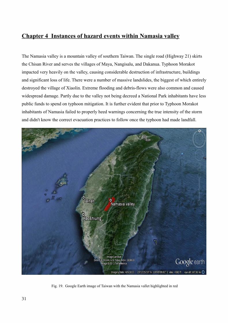
Chapter 4 Instances of hazard events within Namasia valley
The Namasia valley is a mountain valley of southern Taiwan. The single road (Highway 21) skirts
the Chisan River and serves the villages of Maya, Nangisalu, and Dakanua. Typhoon Morakot
impacted very heavily on the valley, causing considerable destruction of infrastructure, buildings
and significant loss of life. There were a number of massive landslides, the biggest of which entirely
destroyed the village of Xiaolin. Extreme flooding and debris-flows were also common and caused
widespread damage. Partly due to the valley not being decreed a National Park inhabitants have less
public funds to spend on typhoon mitigation. It is further evident that prior to Typhoon Morakot
inhabitants of Namasia failed to properly heed warnings concerning the true intensity of the storm
and didn't know the correct evacuation practices to follow once the typhoon had made landfall.
Fig. 19. Google Earth image of Taiwan with the Namasia vallet highlighted in red
31

4.1 Debris Flow No 1 – Nangisalu Village
A major debris flow took place in Nangisalu Village at 5pm on August 9 2009 during typhoon
Morakot; the debris flow buried over 80 houses killing 41 people. Approximately 1000 metres of
road was also destroyed.
Fig. 20. Debris flow lower deposition area. Nangisalu village. 2009.
Fig. 21. Damage from a Typhoon Morakot induced debris-flow. Nangisalu village. 2009
32

Fig. 22. Damage to Sanmin Elementary School from a Typhoon Morakot induced debris flow.
Fig. 23. Damage to Nangisalu Village from a Typhoon Morakot induced debris flow.
33

4.2 Debris Flow Number 2 Sanmin Junior High School
Fig. 24. Debris flow at Sanmin Elementary School
A significant debris flow took place in a debris-flow-prone stream on August 8 in Maya village. The
debris washed into houses and Sanmin Junior High School which was destroyed. No casualties
were reported due to the successful pre-evacuation, although 500 metres of road and up to 20
houses were reported damaged.
Fig. 25. Downstream Deposition Area at Sanmin Elementary School.
34

4.3 Debris Flow Number 3 – Maya Village, Sanmin Elementary School
Fig. 26. Sanmin Elementary School, debris slide deposition area.
On August 8, a large debris flow occurred in Maya Village during typhoon Morakot. Although the
debris washed into the village there were no casualties due to the successful pre-evacuation.
4.4 Landslide near Dakanua, Namasia Township
15 metres of road was destroyed near Dakanua, when a major landslide hit on August 9th during
typhoon Morakot. There were no casualties and no damaged houses in the disaster area. The
landslide area is approximately 18 hectares long.
35

Fig. 27 Source of the Dakanua landslide
Fig. 28 and 29. Destruction of Highway 21 from Dakanua landslide.
4.5 Xiaolin Landslides
A large-scale landslide took place on Xiandu Mountain behind the village of Xiaolin on August 9.
Scientists concluded that more than 30 million tonnes of mud and debris washed down from Mount
Xiandu burying half of Xiaolin Village in just 110 seconds, while a second mudslide that came
36

between 30 – 50 minutes later buried the rest of the village during the height of Typhoon Morakot
in August 2009.
The Taipei Times (2010) reported a team of geologists from several universities commissioned by
the National Science Council released the results of their research. It stated that more than 30
million tonnes of mud rushed down from nearby Mount Xiandu at a speed of 180kph when the
mountain collapsed. Chen Chien-chih a professor at National Central University’s Graduate
Institute of Geophysics concluded, “The massive mudslide was divided into two. The larger
mudslide continued on until it hit the Cishan River destroying the northern part of Xiaolin. The
smaller mudslide went down the valley of a smaller, unnamed creek and formed a barrier lake”.
Chen said. “As the mud, sand, stones and rain built up, the barrier lake eventually collapsed 30 to
50 minutes later, destroying the southern part of the village.” There were 490 confirmed casualties
with over 200 damaged houses, 3 km of damaged road and 4 bridges destroyed.
Field research found the geological composition of Mount Xiandu to be unstable as it was located
on the border between shale and sandstone composition. Hongey Chen a National Taiwan
University geosciences professor stated, “Many geological layers there are actually leftover debris
from ancient mountain collapses that occurred thousands of years ago, if exceptionally heavy
rainfall occurs, unstable layers can be washed down at any time.”
Although the research team attributed the mudslides to unstable geological composition and heavy
rainfall, they could not rule out the possibility that the large amount of explosives used in illegal
gravel operations and construction of the Trans-basin water diversion tunnel in the area (appendix
9.16) had contributed to the mountain collapse or other landslides or debris-flows in the area.
37

Fig 30. Google earth Image of Xiaolin Village 2001
Fig. 31. Google Earth Image of the Site of the Xiaolin landslide 2009
38

Fig.32. Site of the Xiaolin landslides. 2009.
Fig.33. Site of the Xiaolin landslides. 2012.
39

Fig. 34. Google Earth Image with a Taiwan Central Geological Survey overlay of the site of Xiaolin village landslides.
Highlights in brown are pre 2005 landslide sites, highlights in yellow are Typhoon Morakot (2009) landslides.
40

Fig. 35. Google Earth Image with a Taiwan Central Geological Survey overlay of central Namasia incorporating the
villages of Nangisalu and Maya. Highlights in brown are pre 2005 landslide sites, highlights in yellow are Typhoon
Morakot (2009) landslides.
41

Fig. 36. Google Earth Image with a Taiwan Central Geological Survey overlay of upper Namasia incorporating the
village of Dakanua. Highlights in brown are pre 2005 landslide sites, highlights in yellow are Typhoon Morakot (2009)
landslides.
42

Chapter 5 - An analysis of Taiwan's emergency management system
and reconstruction strategies
5.1 Organisational Structure
Tsai (2012) points out that the “Taiwan government plays a rather passive but dominant role in
Taiwan's emergency management system because of its capacity to mobilize a great amount of
resources. As a consequence the government's role is irreplaceable in disaster scenarios, in
particular under a centralized political system”. Nevertheless, critics have pointed out (Britton,
2007) that disaster management coordination in bureaucratic organizations (i.e. the government) is
a persisting issue.
The organizational structure of the Taiwanese emergency system is hierarchical and overtly
complicated, closely duplicating the structure of government. This bureaucratic system is
designed to produce and sustain a high level of internal discipline. Responsiveness is impeded as a
result.
Lipset (1962) argued that when decision making control is centralized at the top of the hierarchical
structure without due input from its lower levels, it becomes an enduring problem. He also notes
the more complicated the set of rules that exist the more likely those members of the organisation
will fail from seeing its overall objectives. These findings can be directly translated to the
emergency management system in Taiwan.
March and Simon (1958) noted that organizational performance is suppressed by unthinking
compliance to the rules which eventually causes rigidity. Over time this lack of flexibility makes it
difficult for a single individual to challenge or revise organisational structure and adapt it to
disaster situations which are often unique and pertinent.
Only a few of the many governmental agencies possess the required resources and have the
necessary capability for rescue actions. A lack of effective delegation in the system further
complicates the issues involved. Tsai (2011) argues that 'the emergency system in Taiwan has at its
heart confusing chains of command, a fragmented information flow and a lack of authority and
resources. His arguments are supported by a number of local academics (Cheng, 2002; Shan et al.,
2006; Kuo, 2009).
43

5.2 Analysis of the Xiaolin landslides
The problems with the Taiwanese disaster management system can be dissected with an analysis
of the unfolding disaster in Xiaolin during Typhoon Morakot. Despite assurances to the contrary
(Interview 5) Taiwan's disaster management system demonstrated complete dysfunction in the
challenges caused by Typhoon Morakot. Initially it took nearly 26 hours after the Xiaolin
landslides before emergency services responded.
The Vice Director General of the National Fire Agency stated in disaster response reports and
public statements that it was not until the first survivor was successfully rescued at 9.45am on 10
August (nearly 28 hours later) that the seriousness of the situation was brought to the attention of
the relevant authorities. These reports also attest that emergency services were only fully
mobilized on the 11th August.
It can be concluded that the alarming failure of the emergency system in relation to the Xiaolin
village disaster came about as a direct result of a failure of the chain of command which led to a
fragmented flow of information during the critical hours following the disaster. Tsai (2010)
writes , 'a senior official recalled, 'The first information of the incident was a text message sent to
a local councillor by one trapped survivor using a cell phone'. This message attracted the attention
of the media if not the attention of local emergency managers. A TV interview was broadcast
nationwide that evening with a local villager who had lost contact with his family. This interview
still did not induce a response from the emergency system.
More damningly senior disaster management officials at the top of the hierarchical structure
showed little understanding of disaster operations and failed to succinctly understand the
objectives or the procedures of the emergency operations. High priority requests for help were
rejected because of a lack of clear instruction. The seriousness of the situation underplayed from
those higher up in the chain of command. The emergency response was consequently delayed
with public statements using the excuse of bad weather as the reason for delay in effective
response. Kuo, (2009) notes that emergency managers decisions are often affected by public
opinions and criticism from the media. When making public statements disaster officials rarely
acknowledge inconsistencies or errors for fear of being blamed for them.
Tsai (2011) documents an exchange between the Jiashan Mayor and disaster responders showing
44

how local authority was bypassed. Tsai writes, “The Jiashan Mayor eager to survey the situation
had a request of boarding a helicopter turned down by the pilot sent to assist the rescue. The
Mayor complained that,
'He [the helicopter pilot] asked me to comply with the rules and get an approval from the central
government first'. Very soon, he became a complete outsider when the army took over control of
the site”.
At the very top of hierarchy in such a disaster scenario is the President whose intercession in
disaster operations reflected his concern for being blamed or the disaster being attributed to him.
'I will find out if there is anything wrong with the system or with the actions. Certainly we will
find out, not only to correct these mistakes, but also to punish the people who are responsible'
(CNN interview, 16 August 2009). The Mayor of Jiashan was later to be impeached and
subsequently punished with a number of high ranking officials including the Premier also being
compelled to resign. Despite almost universal condemnation however the President was not. There
can be no more pertinent example of the head of an organisational hierarchy avoiding punitive
action by attributing blame on to others so as not to accept any onto himself.
5.3 Reconstruction strategies after typhoon Morakot
When the disaster management system is broken down and individual sectors are analysed we can
see the confusing and over complicated nature of the Taiwanese disaster management system need
not affect all areas detrimentally. The problems of where to put people in need of long term
emergency shelter for example were bypassed somewhat by using NGOs in the planning and
financing of reconstructed communities.
In the case of Typhoon Morakot short term emergency shelters were utilised straight away after the
typhoon hit the island. 158 emergency shelters were opened after typhoon Morakot, including
temples, churches, schools, community centres and farms. In total, 8189 members from affected
communities used these facilities (Morakot Post-Disaster Reconstruction Council 2012). These
were also supported by several NGOs and voluntary groups.
Medium and long term strategies of emergency shelter were also utilised. Medium-term
arrangements started on the 15 August, inclusive of temporary pre-fabricated housing, government
45

re-settlement, and the establishment of private rental agreements. The mid-term settlement phase
started from 15th August. Affected people were provided with relief funds, they also received
subsidies for renting houses, purchasing houses, or staying in the government organised pre-
fabricated housing or military barracks / veterans homes. In total, over 4600 people were placed in
military barracks.
The relevant strategies for long term reconstruction plans were included in The Morakot Typhoon
Post-Disaster Reconstruction Special Act which was approved by the Legislative Yuan on 28
August, and was in action by 29 August 2009. The permanent re-housing policy as determined by
central government was approved on 6 September. (Morakot Post-Disaster Reconstruction Council
2011). NGOs such as Red Cross and World Vision also built 312 pre-fabricated houses for use after
Typhoon Morakot. (Morakot Post-Disaster Reconstruction Council 2012).
5.3.2. A change in policy to a permanent housing policy
As with the 9/21 Earthquake in 1999, the Government planned to use temporary pre-fabricated
houses after Typhoon Morakot. However, a large amount of refugees, (in total 19,191 people) lived
in high risk areas. 72.5% of them were aboriginal people and this proved particularly challenging.
(Chern 2012). The Tzu-Chi Foundation suggested that a permanent housing policy could be
introduced to reduce the cost of building pre-fabricated houses and this would allow displaced
people to have a place to stay before (Chinese) New Year. (Morakot Post-Disaster Reconstruction
Council 2011) This view was supported by policy makers from Central Government.
“For the medium to long- term, disaster survivors should in principle resettle in permanent housing.
Only in special circumstances should they be resettled in pre-fabricated housing” (Morakot Post-
Disaster Reconstruction Council 2011).
The Government worked with NGOs to speed up the construction of permanent houses. NGOs such
as Tzu-Chi Foundation, Taiwan World Vision, Taiwan Red Cross, and Dharma Drum Mountain,
were responsible for building the houses while the Government was responsible for the
establishment of key infrastructures in these new built communities. In total, 38 communities, with
more than 3200 houses were built by June 2012 (Morakot Post-Disaster Reconstruction Council
2012).
46

It was believed that “the building of permanent housing avoided the problems associated with
interim/pre-fabricated housing" (Morakot Post-Disaster Reconstruction Council 2011). Former
Premier Liu said, "The original decision to build permanent housing instead of pre-fabricated now
looks to be correct. In my opinion, your execution has been even better than what was originally
planned." (Morakot Post-Disaster Reconstruction Council 2011).
Fig. 37. Resettlement strategies and implementation after Typhoon Morakot
47

Fig. 38. Reconstruction plan framework
5.3.3 Relocation or reconstruction in Namasia
The issue of relocation away from Namasia was (and continues to be) extremely politically
sensitive. At the heart of the issue is (because of ancestral connections) the desire of many local
residents to remain in the area. This is countered by many in central government who point to
incredibly fragile nature of the landscape and the excessively large cost of reconstruction in affected
areas. Some affected communities originally from Namasia Valley were evacuated to military
barracks after Typhoon Morakot had hit the island. After the permanent housing approach was
promoted, some of these affected communities were persuaded to relocate to Da-Ai Community,
which was built by the Tzu-Chi Foundation. The new built community comprises of 1540
households who were originally from Namasia, Maolin, and Jia-Xian, Liu-Gui and Tao-yuan. (Fig.
39.)
48

Fig. 39 Google Earth Image of location of affected communities and the Da Ai reconstructed community
Initially residents were provided with basic essentials and facilities when they moved into the newly
built community. To maintain sustainable community development, a series of programmes to
support residents community integration, employability, education, cultural preservation, and
industry development were provided. (Yan 2012). A community management committee was also
formulated to ensure public participation (Morakot Post-Disaster Reconstruction Council 2010).
Most of residents of Namasia however preferred to stay in their original village rather than moving
to the Da-Ai Community. Only one in ten of residents from Maya village agreed to be relocated to
Da-Ai (Interviewee No 9). Primarily this was because many residents did not feel fully informed
and consulted about the new housing policy and were distrustful of government intentions in
regards to relocation. The Government agreed to make concessions with their relocation policy and
in 2010 announced that affected communities could choose to rebuild their houses near their
original villages. Taiwan Red Cross and Taiwan World Vision have subsequently been helping
reconstruct houses but only after locations have been approved by Central Government (Interview
9).
49

Although it was agreed that locations for relocated communities should be as close to the original
sites as possible, due to the difficulties of gaining land, and finding a safe area, not all communities
could meet this criteria. The distance between Da-Ai and Namasia for example is about 50 km; and
due to frequent road closures it could take up to 4 hours to travel. Subsequently it took some time
for aboriginal tribes to agree on a relocation plan as local tribes were not distributed to the relocated
areas as planned. This was particularly evident with affected residents from the Xiaolin disaster who
were eventually distributed to three sites. Community integration, and the preservation of aboriginal
culture have thus become major challenges for policy makers concerned with resettlement.
As suggested in Namasia, many local residents worried, “if the whole community has been moved
to urban areas, the Government will restrict the access to our homeland, then residents will never
be able to return to this area" (Interview No. 13). In addition, "as some of the tribe leaders stayed in
the mountain areas, some members of affected communities did not want to return to the mountains
to hold a tribal meeting, so no discussion could be made" (Interviewee No. 10). In addition most of
the affected communities were aboriginal Christians. The involvement of Buddhist and Daoist
organisations did not always gain approval or agreement from the local communities. A central
finding of our report is that religious disunity and local differences between villages and prominent
families in the area accentuated post typhoon Morakot problems in the area. This was particularly
noticeable within the fields of resettlement and reconstruction.
From the non-aboriginal view, the relocation issue is more related to political and economic issues
than cultural ones. Interviewee No 1 said, “It is a problem of democracy, because every 4 years
there is an election, if the problem is not solved before the next election, the election will be lost. So
moving out is a simple political issue.” He continued, “the other thing is we spend billions dollars to
build their roads, in economic considerations, it is not worth it, because every time if there is a
typhoon, we need to rebuild the roads. We have spent billions of dollars to rebuild the roads, rebuild
the bridges, but it happens again and again.” In addition, (Interview No 15) stated "we have wasted
so much money on these temporary bridges in the mountains. We need to fix them every year after a
typhoon, and each time it costs us billions of dollars. We wanted to ensure the traffic returns to
normal as soon as possible, so we used culvert pipes (for bridges); but they are not resistant to
floods. If we used a proper way to build the roads, it will take us about 20 years to complete and it
would costs more than 50 billion". Here the political constraints of disaster management impede on
what is best for affected communities and inhabitants of vulnerable areas.
50

Debates and conflicts in culture and heritage preservation can also be seen. Challenges and issues
are also raised in the area of cultural continuation, lifestyle, economics and education. (Interviewee
No 9) stated, "From the social ethnics and cultural continuity, relocation is destructive. However we
also need to consider the social and economic cost if we do not choose to be relocated. Staying in
an improper location is actually staying in a relative high risk area." In Nagasalu for example 80%
of affected villagers chose to relocate to the reconstructed community at Da-Ai. Yet only one in ten
villagers from the neighboring village of Maya agreed to be relocated despite the vilage being
declared by the government 'a high risk area.' After extensive negotiations between village leaders
and central government it was decided that Maya village could be relocated on 'Maya Platform' on
terraces above the site of the original village.
5.3.4 The use of NGOs to work with the governments
Central government used a variety of NGOs to help raise funds for the rapidly growing financial
costs of Typhoon Morakot. NGOs were invited to help build the reconstructed communities.
Although regular meetings were held between government institutes and NGOs certain problems
arose. Each NGO has a different relationship with the government, in turn influencing the speed of
decision making and funding opportunities. “Government projects normally last about 3 or 4 years,
so we are asked to spend the funds during this period; however reconstruction work can take up to
ten years.” It is evident therefore that Central Government and NGOs have a different agenda with
different priorities. The Government want to have rapid results, while NGOs paid more attention to
residents needs and the long term post disaster issues and the psychological impact. (Interviewee
No. 14). Interviewee No.5 added, “NGOs' practice is not limited by funded projects, we will
continue to provide a service even without the Government funding.” The inference is then that the
strategic differences in approach prevent consistent growth and continued sustainable development.
NGOs also have a different scale of human resource, financial and material resources, and different
priorities to those of the government.
They also have at times a strained relationship with government institutes, and the construction of
permanent houses became increasingly fraught. This impacted on local residents in these
communities. Interviewee No. 11 said, “we need a centralised decision making model to make sure
projects are operated effectively.” The authors of this report concur with this view.
51

5.3.5 The resources of NGOs determines the scale of service they can provide
NGO's utilised different methods to help reconstruction and received a different welcome from
impacted villagers due to past experiences. For example, Tzu-Chi has a specialised human resource
management system to mobilise volunteers. “During the major flood in 1988, we activated the
disaster response network. The main mission was to complete a list of the volunteers who would get
involved, because volunteers who get involved change all the time.” (Interviewee No 14). The
transportation, accommodation, and logistic supply were also key to missions. (Interviewee No 11)
said, “If the affected community is located in the higher mountain areas, the length of construction
is longer, and it is more difficult to dispatch workers”, whilst (Interviewee No 14) noted “The
challenge of using volunteers is that they do not live and sleep in the disaster sites, they might want
to go home at the end of a day, so it is different from military or government operations.” Other
NGOs might not have comparable resources to Tzu-Chi, and thus “running out of budget is also one
of the key issues”. (Interviewee 11)
5.3.6 Previous experience and already established networks influence the effectiveness of
reconstruction work
Social trust has played an important factor in the reconstruction of affected communities. Previous
experience and established networks with the affected communities has influenced the effectiveness
of the reconstruction work. “World Vision has been working in the aboriginal communities for a
very long time, so we are familiar with the aboriginal culture, society, and living styles. The
affected population welcomed us.” “At the same time, if any disaster occurred in the aboriginal
communities, the government would ask World Vision to help co-ordinate operations, if a disaster
occurred in non-aboriginal areas, it would be Red Cross or Tzu-chi who would be asked to help. It
became an ‘official regulation’.” (Interviewee No 8).
5.4 Risk awareness and training exercising for affected populations
The Sphere Project (2012) indicated that the construction of permanent houses should take into
considerations of the future risks, “Construction resilience should be consistent with known climatic
conditions and natural hazards and should consider adaptations to address the local impact of
climate change (The Sphere Project 2012). Thus post disaster reconstruction/relocation projects
should not only consider the economic, financial, social networks, and cultural heritage issues but
52

also resilience and environment sustainability.
Before construction, an environmental impact assessment should be conducted. (Interviewee No 7)
detailed what Taiwan Red Cross do to ensure that land is suitable for construction “We asked the
District Council to provide satellite imagery to find possible sites, and then we asked experts in
water and land conservation, geology and government officers to conduct an environment impact
assessment. Normally it is about a group of 17 to 20 people. We took everything into consideration
after the experts qualified it as a safe land. If they did not think it safe, we would abandon our plan,
so it took some time for us to look for sites for reconstruction.”
In an attempt to speed up the reconstruction process, the government bypassed many of these
special regulations and requirements for site selection were diluted as a consequence. Although
several relocation sites could be used within one month it is questionable whether appropriate
attention has been made to environmental risk assessment. “The Post Morakot community
reconstruction plan has excluded several environment impact assessment requirements, so there is
less consideration as to what is recognised and determined as ‘safe’ land ”(Interviewee No 3). In
addition, attention should be given to the impact of the newly built community to the environment,
as new construction can generate new damages to the environment.
New constructed communities are still located in mountainous areas, and are still subject to
earthquakes, landslides and flood hazards. Although communities are designed to be
environmentally friendly and self-sustainable little attention has been paid to potential risks.
Although newly built communities have disaster prevention and risk management strategies, “what
worries me is that residents see these communities as risk free areas; hence there is no need for
evacuation“(Interviewee No.3). This theme is continued by (Interviewee No. 15) ”During a hazard,
residents will not leave their houses because they don’t think it is possible for disasters to take place
in these new built permanent houses; only those people who live in their old houses in mountainous
areas need to be evacuated.” .
Under these circumstances, it is necessary to inform the residents of the potential hazards/disasters
so residents will be prepared and that disaster communication is clear, concise and repeated
frequently. One way to increase the resilience is to make sure the community residents have the
ability and capacity to deal with disasters. “For example, in high mountain areas, we will need to
input more search and rescue resources, as it takes one hour for fire engines to arrive at the
53

scene.”(Interviewee No 3).
Training exercises have been widely used for raising awareness of risks and educating the public on
how to prepare for and respond to disasters. Although the Fire Department has run regular annual
exercises for these communities, most of the exercises focus only on fire hazards, only a few
communities would address the need of preparing and responding to disasters. Only those who live
in the high risk areas have exercise scenarios such as evacuation etc. The Government tends to use
large-scale scripted exercises, more for political purposes than educational purposes (Chen 2008).
Even if an exercise was ran, the fidelity and validity is questionable. Interviewee No 9 said, “they
have emergency plans but they have not implemented them. The exercises were performed for the
managers at higher levels in the government not for local people with vulnerabilities. ”(Interviewee
No 13).
The other issue relates to the ability to transfer the skills and knowledge learned from exercises to
reality. Interviewee No.1 said: “The participation rate for annual disaster prevention exercises is
normally high. Normally the Fire Department is invited to local communities to help them train for
evacuation. However, how would the residents respond to a hazard that is different from the
scenarios ran in the exercises?” There is a lack of regularity and repetition in training. Consequently
“It might take 10 or 20 years to see the impact and effectiveness of the Disaster Education.”
(Interviewee No. 6).
5.5 Risk Communication and Evacuation
After Typhoon Morakot in 2009 legislation was upgraded to make evacuation a compulsory practice
rather than a voluntary one. Unfortunately there is little empirical research of evacuation procedures
in Taiwan. Much of the current research is located within The United States where organizational
behaviour, disaster management strategy, geography, engineering models and local perception of
the risks are different (Wolshon et al 2001) (Baker 1991). Within The United States previous studies
has shown that the decision to evacuate is influenced by several factors including social
characteristics, economic constraints, storm characteristics and planned evacuation destination and
cost (Czajkowski 2007); (Whitehead et al., 2001).
One study (Wu 2012) of the practices of a mountain valley next to Namasia in southern Taiwan
concluded that many residents had very little knowledge of preparedness, hazard mapping,
54

evacuation protocol or risk communication.
He found that
•62.7% of people decided to stay in an area vulnerable to debris-flows during a period of excessive
precipitation.
•Only 34.9% of people understand the contents of a risk map.
•Only 51.9% of people understand the evacuation plan of their residential area.
•A warning source from public authorities has the highest degree of trustworthiness with
information disseminated by the mainstream media or the internet the lowest degree of
trustworthiness.
•Environmental cues are the main reason for evacuation decision making.
•83.5% of people will evacuate if rainfall exceeds precaution rainfall levels.
•85.9% of people will evacuate after seeing the actions of neighbours.
Wu concludes that effective risk communication should cover characteristics of the households,
social context and the environmental conditions. He correctly notes that the authorities, the media,
peers, family will influence decision the most and that people judge the source credible by looking
at its trustworthiness. However he further notes that it is environmental cues such as weather
conditions that tend to do the most to prompt people to evacuate. Wu's report stresses that for
maximum effectiveness the evacuation message should infer immediacy, seriousness, precision and
repetition. To enforce the message, it must be easily understood, easily believed and have a level of
personalization behind it.
Fig. 40. Wu's Risk Communication framework
55
Message
Repetition
Immediacy
Precision
Seriousness
Effectiveness
Easily believed
Personalization
Easily Understood Maximum Effectiveness

5.6 Hazard risk maps
In Taiwan the Soil and Water Conservation Bureau (SWCB) decide which area is most susceptible
to debris flows and issues hazard risk maps and hold training courses teaching local residents the
difference between the red (compulsory) and yellow (non-compulsory) evacuation alerts.
(Mandatory evacuation is only enforced when the current precipitation levels surpass precaution
levels. The precaution levels in Namasia and Maolin is 250mm). Creating hazard maps can be an
effective form of risk communication but only if the population they are designed to assist can read
them. The marking of high risk areas, assembly points, rest centres, and critical infrastructures are
required to make the hazard map effective. At the national level, hazard maps are produced by a
variety of different departments in charge of each individual hazard. As noted the SWCB is
responsible for debris flows, the Ministry of Agriculture is responsible for landslides and the
Ministry of Economics is responsible for flood hazard maps etc. Under The Disaster Prevention and
Protection Act, local authorities are also required to produce hazard maps. (Radio Taiwan
International 2012) reported that a number of criticisms of some of these maps which include (1)
the indicators were not clear on the maps; (2) no clear road names, evacuation routes and directions.
However by far the greatest problem, despite being an overtly complicated system of disseminating
information there is also a distinct lack of a sharing mechanism between organisations. (Community
hazard maps were only shared by the National Fire Agency since June 2012) (Ministry of the
Interior 2012). Here it is evident that if a universal disaster management body was in place with the
responsibility of producing all disaster related mapping, the processes for disseminating information
would infinitely clearer, finances and resources would be saved and a greater number of affected
residents would be assisted.
Wu's conclusions that residents living in debris flow areas do not prepare enough in the face of
major disasters should be noted as should findings in our report that more should be done to allow
them to help themselves. Risk communication should no longer be a one way message from public
authorities to local residents but a two way process involving affected communities and regional
authorities. The results from this research would also suggest that for risk communication to be
truly effective a two way communication process should be incorporated into any training
programme or hazard map making process.
56

Chapter 6 - Analysis of results
6.1 Analysis of questionnaires
There is no great disparity in the difference of sex of questionnaire participants. In terms of age
groups, almost half of all participants were over the age of 50. This could possibly affect results as
older people are less likely to be familiar with new technologies used to disseminate information.
Furthermore they could be more potentially adversely affected by late evacuation or unfamiliar
patterns of behaviour such as contingency plans for the elderly. Perry (1979) found that participants
who stated a reluctance to leave their homes during a time of crisis were of an older generation.
This conclusion is supported by these findings.
Fig. 41. Gender distribution of participants in questionnaire survey
Due to increased access to educational tools and development of educational resources younger
people could have a higher knowledge of the natural processes affecting the community but could
also have a higher perception of their own individual or communities capacity to withstand a
typhoon. Whether or not this is true or not depends on the individual and the community in question
but younger generations by nature are physically fitter and respond quicker to natural hazards that
occur within the community.
57

Fig. 42. Age range of participants in questionnaire survey
One notable feature of the findings of this questionnaire is the perception that the road is the most
vulnerable feature of the local environment. 48 of the 50 participants of this survey noted the
vulnerability of the road to typhoons compared to only 15 people who noted mountain slopes and
12 people who noted the river. No one responded that houses were vulnerable to typhoons, despite
there being considerable damage to houses in the area from typhoon induced landslides and debris
flows.
58

Fig. 43. Bar Chart detailing which features local residents feel are vulnerable to typhoons.
Although there are two back roads that lead to and from Namasia valley, the main road (Highway
21) is the central route to and from Namasia. Prior to Typhoon Morakot in 2009 the road remained
almost continually open. Typhoon Morakot washed away large sections of the road and made some
areas of the valley inaccessible. The temporary road (with temporary bridges) was seen as stop gap
measure until funds could be generated to pay for a safer, stronger and less vulnerable road.
However floods (not typhoon induced) in May 2012 washed out the temporary road forcing
inhabitants of Namasia to use the back roads once again. A new temporary road opened in
September 2012. As the questionnaires were conducted at a time when the main road was not open
this feature could well be at the forefront of local peoples considerations.
59

Fig. 44. Knowledge of local typhoon response measures from questionnaire participants
A comparison between what is known about local community typhoon response measures (centred
in participants villages) and what is known about local government response measures, (centred in
the regional capital of Kaoshiung) is made possible of analysis of questions 2, 3, 4 and 5. Based
solely on the answers to these questions it seems evident that community efforts to respond to
typhoons are held in higher regard than (local) government ones. This could be due to prevalent
negative attitudes towards central government being extended to local government. It could also
show that local people are far more likely to believe (or do when asked) something from someone
who they know (such as a community leader or village elder) rather than an unknown source from
local government. This supports Wu's (2012) findings that a level of personalization is needed for
the most effective forms of crisis communication.
60

Fig. 45. Number of participants from questionnaire survey who answered whether their local community had typhoon
response measures
In some cases local government typhoon response measures and community based typhoon
response measures are essentially the same measures but promoted differently. In the case of
evacuation for example the order to mandatory evacuate is passed down from central government to
local government and onto the local communities. Schneider (2008) analysed the (mis) perceptions
of citizen’s attitudes towards governmental responsibilities during Hurricane Katrina. She deduced
that there was a gulf in what government agencies actually did during a disaster and what citizens
expected them to do. It is not hard to imagine in such an environment a successful evacuation
accredited to local community leaders, and an unsuccessful evacuation being blamed upon local or
central government authorities.
Increased numbers of participants stating that they have a high or medium knowledge of community
based typhoon response measures could also be related to the fact that often this is due to a high
percentage of local people working for charities or N.G.O.s (such as World Vision or Tzu Chi) who
61

are able to disseminate local information quicker, more effectively and in a manner that actually
builds community resources (Shklovski 2008).
Fig. 46. Number of participants from questionnaire survey who were asked whether their local government had
typhoon response measures
62

Fig. 47. Number of participants from questionnaire survey who were asked how much they knew about local
government's typhoon response measures.
A surprisingly high number of participants (20) only found about Typhoon Morakot between 12-24
hours prior to its onset. Although the typhoon was well reported prior to its arrival in Taiwan due to
the regularity of summer typhoons in Taiwan it can be assumed that these local inhabitants did not
pay sufficient attention to the severity of the storm. Perhaps it was believed that as its course was
somewhat irregular Namasia would be spared.
The questionnaire also provides some indicators into participants views on the meaning of
evacuation with 70% of people (35) stating that they evacuated from Namasia Valley prior to the
onset of Typhoon Morakot. Further analysis of the answers given however shows that this is not the
case. Of the 35 people who answered the question, 'Did you evacuate from Namasia Valley before
Morakot?' and answered in the affirmative, 30 stayed in the valley and in most cases never left their
villages, choosing instead to evacuate to local evacuation centres.
63

Four participants (and numerous others who did not participate in the questionnaire survey)
recorded that they sought shelter in two separate evacuation centres meaning that they would have
changed location in the middle of the storm. The allocated evacuation centres during the time of
Morakot were the Sanmin Junior High School and the Sanmin Elementary School. In the instance
of the former the evacuation centre was almost entirely inundated by a debris flow which hit and
badly affected the village. In the case of the later a debris flow passed through the village and the
evacuation centre leaving the structure intact but causing untold problems on the road between the
two venues. Although 34 of 50 people questioned stated that they were given accurate information
regarding evacuation, the overall impression from other first-hand accounts with villagers is of local
inhabitants doing everything they can to survive a storm that they were unprepared for. In regards to
evacuation perhaps it is more accurate to regard the 14 people who were not happy with the
information regarding evacuation than the 34 who were. Not recorded here is also the fact that most
participants in this questionnaire were from the village of Maya and were thus mostly spared from
the problems their neighbours in Nangisalu faced.
Fig. 48. Nangisalu Elementary School. Evacuation Centre for Namisalu village during Typhoon Morakot.
For those participants who did not leave their houses responses indicated that participants were
reluctant to leave their homes and/or didn't think the storm would be so heavy. In one instance the
participant stated that he was not told about evacuation procedures (it can be concluded that the
64

participant possibly lived in an isolated dwelling away from the main body of the other villages).
These intransigent actions can probably be related to the fact that the 6 participants were all aged
over 50 years of age and as Perry (1979) argued held opinions or views of particular traditional
stock. Of the 50 people asked 28 did not answer or stated that they were not aware of any
contingency plan for vulnerable persons during Morakot. Of the 23 people who replied in the
affirmative that they were aware of contingency plans for vulnerable people it is unknown whether
or not these contingency plans were in place during Morakot or have been subsequently put in
place.
The communities of Namasia are not particularly understanding of hazard maps (and one would
assume the associated hazard risks) with only 5 participants of the 50 fully understanding a hazard
map. Again these findings support Wu's conclusions. In relation to question 14, 'what changes
would you like to see?' the participant’s answers were varied encompassing a variety of different
viewpoints. Answers centred on establishing more co-operation between local people and
government authorities, a greater understanding of the dangerous features and increased awareness
of how to prepare in advance for major typhoons and improved evacuation procedures.
In the face of such destruction because of Typhoon Morakot there seems a willingness of some local
people to embrace more co-operation between themselves and central government, although a
feature of regular conversations and interviews with local people is their desire to remain semi -
autonomous from central government. There also seems to be some understanding that local
community divisions can also be potentially damaging especially in the face of major events such as
typhoons with 4 people wanting improved relationships and greater co-operation within their
communities.
Answers that indicated a willingness to understand the local environment were also evident. These
answers were found with younger members of the community with all five of participants
answering 'what changes would you like to see?' with improvements in understanding local risks
and ability to withstand them, being under 40 years of age. Likewise participants who wanted
improvements in evacuation routes, evacuation centre and evacuation procedures all noted that they
were living in rebuilt houses, ones that had presumably been destroyed in Morakot. Rosenkoetter
(2007) studied attitudes of victims of Hurricane Katrina and found a 70% increase of those who
would evacuate in the future because of a past negative experience. The issue of evacuation would
be more pertinent to a participant if he/she has already seen their home destroyed once.
65

Chapter 7 – Recommendations
7.1 Key recommendations
The key recommendations from this report are as follows:
• The dissolution of the Disaster Prevention and Protection Act and the
creation of a disaster management agency that oversees all aspects of
disaster management in Taiwan.
• Greater awareness of land use, including a comprehensive national plan
for slope management.
• Greater access to hazard maps for people living in vulnerable areas and
programs to make sure that the aforesaid mentioned people receive the
necessary education to read them correctly.
• The number of weather stations and monitoring sites to be increased
throughout Taiwan.
• Roads in mountainous areas that act as emergency response routes to be
fully funded and maintained.
• A national policy of evacuation implemented before and not during
typhoons.
66

• Universal access to hazard risk/disaster awareness data, software and
research.
• The development of a universal reconstruction policy and complete
vulnerability assessments for high risk areas.
• A full, independent geological survey should be carried out to determine
the causes of the Xiaolin landslides, the results of which should be made
public. Current engineering projects that are located in high risk areas be
reassessed to determine the effect they might have on the environment
and if necessary halted.
• The wishes and opinions of local aboriginal people in mountainous
communities to be respected, especially in regards (but not exclusive to)
relocation.
• Public amenities, such as evacuation centres and information regarding
hazard risks to be made accessible to everyone regardless, of affiliation
with village, religion or family.
• The creation of the Namasia valley as a national park.
67

7.2 National Recommendations
There is an urgent need to constitute a full national disaster management agency, with
representation at the highest levels in government, to coordinate both disaster risk reduction and
disaster response. The current system whereupon central government responds to a disaster by
allocating funds to local governments who then allocate funds to a series of outside bodies, such as
NGOs or private contractors is piecemeal, fragmented and unnecessarily complicated. There is
currently no centralised body that oversees all aspects of disaster management in Taiwan. Petley
(2009) points out that “the establishment in the US of the Federal Emergency Management Agency
in 1979 has done much to reduce disaster risk there, although the events during and in the
immediate aftermath of Hurricane Katrina in 2005 has served to emphasize the importance of risk
reduction efforts as well as preparing for disaster events themselves.”
Taiwan should develop and implement a comprehensive national plan for managing slopes,
covering hazard and risk assessment. Greater awareness of land use particularly the location of
shallow rooted crops (such as betel nut) should also be encouraged. The number of weather stations
and monitoring sites throughout the mountain areas should be extended. People living in vulnerable
areas should have universal access to hazard maps. Hazard maps are currently provided but are
done so by a variety of organizations. Some areas receive hazard maps separately from central
government, local government, NGOs, and private academics. On occasion the information
provided varies depending on which hazard map the individual is looking at and what the purpose
of the map is (evacuation, location of emergency services, road transport etc.). Training should also
be given to read these hazard maps effectively.
Cogent emergency response and communication routes must not be allowed to fall into disrepair.
Safe and accessible evacuation centres (and routes) must be made clearly available to every person
who chooses to live in the mountain areas. Efforts to disseminate evacuation information to those
living in isolated settlements should be extended. In the event of oncoming typhoons evacuation
should be compulsory and should be if necessary enforced. Evacuation should be implemented
before and not during the onset of any major storm or typhoon.
There is a need to develop a balanced, well-resourced and universal research program to understand
the natural processes occurring in the mountain areas of Taiwan. A proper understanding of the
68

processes that create hazards, especially during typhoons could be hugely beneficial. The outcomes
of this research should be accessible to everyone. Whilst it is perhaps understandable that academics
and government bodies protect their research, ultimately it is self-defeating and damaging to the
very people to whom they are trying to protect. Universal access of data or software which could
improve understanding of the hazard risks faced must be given to those who ask for it. Progressive
disaster awareness training should also be implemented as a matter of importance in all
mountainside communities.
There is a need to evaluate the safety and well-being of all mountain communities and not simply
expect them to relocate at the government’s behest. Where it is deemed the risk is high the policy
should be, to identify the best mechanism to bring this to an acceptable level without destroying the
environment or the aboriginal way of life. A properly coordinated program that takes account of
aboriginal sensitivities and includes education programs, warning systems and environmentally
aware engineering works would be of huge benefit to those living in affected areas. The
development of an universal reconstruction policy, and complete vulnerability assessments for
mountainous communities should also be considered. The long term impact on the relocated
residents and those from nearby communities should also be analysed. It remains vitally important
to track the changes and interactions between these two communities.
The issue of relocation from areas deemed to be of high risk to safer lowland areas is extremely
politically, socially and culturally sensitive. In extreme cases where relocation may be required it is
vitally important that the views, wishes and opinions of the relocated people are respected. In a
number of relocation sites this has not always been the case and the process has been hindered as a
result. In some instances the poorly planned houses and sites have encouraged some residents of
mountain communities not to leave vulnerable areas further exposing them to numerous hazards.
Whilst there are some sites where cultural sensitivities have been adhered to, sometimes relocation
sites have been planned with vested interests (often religious NGOs) undermining them.
A full, independent geological survey must be carried out to determine the causes of the Xiaolin
landslides. If engineering projects that were carried out in the immediate vicinity of Xiaolin were
found to have facilitated in any way the collapse of the mountain current engineering projects
should be immediately halted and further investigations to determine liability should be carried out.
69
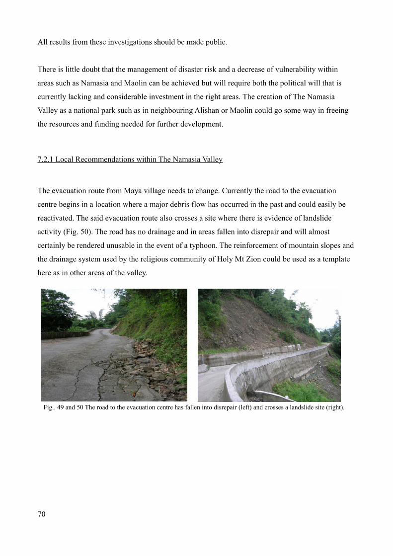
All results from these investigations should be made public.
There is little doubt that the management of disaster risk and a decrease of vulnerability within
areas such as Namasia and Maolin can be achieved but will require both the political will that is
currently lacking and considerable investment in the right areas. The creation of The Namasia
Valley as a national park such as in neighbouring Alishan or Maolin could go some way in freeing
the resources and funding needed for further development.
7.2.1 Local Recommendations within The Namasia Valley
The evacuation route from Maya village needs to change. Currently the road to the evacuation
centre begins in a location where a major debris flow has occurred in the past and could easily be
reactivated. The said evacuation route also crosses a site where there is evidence of landslide
activity (Fig. 50). The road has no drainage and in areas fallen into disrepair and will almost
certainly be rendered unusable in the event of a typhoon. The reinforcement of mountain slopes and
the drainage system used by the religious community of Holy Mt Zion could be used as a template
here as in other areas of the valley.
Fig.. 49 and 50 The road to the evacuation centre has fallen into disrepair (left) and crosses a landslide site (right).
70

Fig. 51 The entrance of the road to the evacuation centre could be blocked if this debris flow is reactivated.
Evacuation is currently only ordered after 250 mm of precipitation. Considerable difficulties may
arise if local residents don't evacuate the area until after 250mm of rainfall has fallen. Roads which
at night will be in darkness may be blocked or washed away, and any body of people moving
through the valley, or up the mountain to the evacuation centre in the midst of a typhoon would be
more vulnerable and exposed to danger as a result. It is integral if a successful evacuation of local
resident's is to succeed that all areas of human habitation are evacuated before the onset of any
typhoon activity and not after.
The evacuation centre (a school) for Maya village consists of two buildings (Fig. 52). The first
building has large glass windows on four sides which would render it extremely dangerous in the
event of a major typhoon. As it is unlikely that another suitable evacuation centre could be found
within the area it is a recommendation that the majority of human evacuation activity should be
conducted in the second building and not the first. The evacuation centre in Dakanua is at the
bottom of extremely steep slopes that is prone to landslides (Fig. 53.). Land above the evacuation
centre is undermined further by the planting of betel nut trees on the slopes directly above the
evacuation centre. Subsequently it is recommended that a new evacuation centre is found.
71

Fig. 52. Maya village evacuation centre
Fig.53. Dakanua Elementary school acts as the local evacuation centre.
72

Fig. 54. Nangisalu evacuation centre
The fire station / emergency response centre (ERC) (Fig. 55.) has been moved away from the centre
of Maya village. Its new location is 1k/m outside of the village and has been built on the banks of
the Chisan River. The site which is already showing signs of river erosion would be seriously
vulnerable to flooding and/or erosion in the event of a major typhoon. It is recommended that a new
site be found for the valley ERC as a matter of urgency.
73

Fig. 55. Maya village Emergency Response Centre on the rapidly eroding banks of the Chisan River
After recent major flooding the main road connecting the valley to Jiashan and the outside world
was washed away with a number of temporary bridges also destroyed. The road itself was only a
temporary road. The original was completely destroyed by Typhoon Morakot in 2009. The
allocation of funds to grant a new permanent road has not been granted and the issue is due to be
debated in Taiwan's legislature. As can be seen from interviews (see appendix) there is very little
political will to spend finances on a road in what is considered an inherently vulnerable area. The
road not only links village to village and provides a link to the valley with the rest of Taiwan. It is
an integral tool in emergency response, evacuation, plus a series or other processes related to
disaster response. The absence of a main road considerably hinders local resident’s capacity to
prepare for and respond effectively to major disasters. It is a recommendation that funding for the
main road (and bridges) is immediately allocated so it may be repaired and if necessary replaced
with a more resilient permanent one.
The religious community of Holy Mount Zion (HMZ) can provide a valuable template for other
inhabitants of the valley especially in regards to strengthening the mountain slopes, drainage and
possible evacuation. With a population of over 300 (Interview 2 October 20th 2012) it should be of
sufficient size for the current government to take the needs of the community seriously especially
during disasters in the area. During Typhoon Morakot the community was completely ignored
74

(Interview 2), before, during and after the typhoon. Regardless of the current relationship between
the government and HMZ, the government has an ethical and legal responsibility to warn of
incoming typhoons, provide them aid after disasters and accept responsibility for the well-being of
the community during typhoons.
Consideration should also be given to the fact that there is a degree of local discord amongst some
of the villages within Namasia. There is evidence of polarisation and a lack of co-operation between
villages. Family disputes have hindered effective and unified mitigation and preparedness as has
failure of individual villages to combine resources with other villages (Interview 3). Evidently the
valley is split not only on ancestral or tribal grounds (and in some cases religious) but also amongst
those with alignment to certain prominent families. In the day to day life of the valley this is no
more than a hindrance. Yet in a disaster scenario this is potentially fatal. During a time of crisis it
would be apt to share resources (such as evacuation centres) rather than stay divided because of
long held grudges or differences.
7.2.2. Local Recommendations within The Maolin Valley
All slopes around the settlements of Maolin, Wanshan and Duona should be reassessed to discover
the possibility of collapse. This is particularly pertinent in the case of Wanshan (Fig. 13.) which is
directly threatened if a previous debris-flow is reactivated. Vulnerability assessments of these sites
should also be conducted. Debris-flow and landslide protective measures should be maintained and
not allow to fall into disrepair.
Local inhabitants should be consulted fully before major engineering works take place. This year
has seen the construction and completion of a major sky bridge near the entrance of Maolin
National Park (see Fig 64.). Whilst the (relatively) quick construction of the sky bridge is a positive
sign that major rebuilding programmes and engineering projects can be quickly built, some
academics have pointed out that there was very little local consultation prior to building.
75

Fig. 56. The new skybridge in Maolin
76

Chapter 8 - Discussion and Conclusions
The bodies who officially deal with disaster management in Taiwan face incredible challenges to
maintain the population at large remain safe and Taiwan is adequately prepared for major typhoons.
Many of those bodies deserve great credit for ensuring that many communities do not suffer greater
loss of life, loss of infrastructure and are able to maintain traditional life style choices in the face of
increasingly intense and powerful typhoons. Taiwan is an incredibly fragile island, with an
exceptionally weak geological structure that when combined with massive precipitation events and
frequent seismic activity has to remain resilient and increasingly vigilant to tackle the many
problems that are faced. Although many mountainous communities have become increasingly
vulnerable, many local NGOs, charities and local communities work to ensure that typhoons do not
impact on them to the extent that causes their ultimate demise or relocation.
The problems arise primarily because disaster management in Taiwan has become increasingly
polarised and politicised. The disaster management system requires individuals to demonstrate
complete compliance to a rigid and entrenched form of bureaucratic control. This form of
procedural compliance unintentionally discourages empowerment and responsive actions. As a
consequence the organizational structure of the disaster management system in Taiwan, and the
legislation that backs it up (The Disaster Prevention and Protection Act) is fundamentally flawed
and increasingly out of touch with reality. Disaster response in Taiwan has to adopt a more fluid
approach. Compliance to rules and regulations may well protect an organization and its personnel
from criticism but it does not necessarily help to respond to a situation in the most effective manner.
Generic response methods in some instances actually hinder those who have to cope with a unique
situation that by nature requires a unique response.
It is a central finding of this report that central disaster agency (similar to FEMA in the United
States) must be formed. To do so would immediately depoliticize disaster management in Taiwan
ensuring that the right people in the right locations get the right type of assistance at the right time.
Too many crucial decisions are made with the political landscape in mind. In some instances this
means that projects in some areas do not get the proper funding because they are not located in the
right area and the people there are not affiliated with the correct political personnel or parties.
In relation to Namasia and Maolin it is evident is that the landscape of both the valleys go through
77

periodic changes that flip between uniformitarianism (processes operating continuously at a steady
rate through time) and catastrophism (sudden change due to infrequent sudden events). In this
context Typhoon Morakot can be seen as a catastrophic event with significant change occurring in a
number of locations throughout the valleys. There is plenty of evidence of historic catastrophic
occurrences in the valleys, some of which can still be seen today. Although much of the evidence is
from Typhoon Morakot previous typhoons have also left an indelible mark on the landscape.
Degradative land management practices, such as the planting of betel nut trees and illegal quarrying
still exist as do reports of villagers in Namasia disregarding evacuation warnings and/or returning to
their homes during typhoons. Deterioration of local relationships have in some instances polarised
villages and individual families. During a time of crisis this can be potentially fatal as a number of
individuals found to their cost during Morakot. Debris flows, landslides, flooding, erosion and
excessive rainfall from typhoons are strikingly democratic in effectiveness, hitting everyone in
range regardless of their location within the valley or allegiance to family, tribe or God.
The local landscape does however have an amazing capacity to regenerate itself. Indelible and clear
imprints on the landscape are not always evident especially years after the event. Existing
preventative measures such as debris-flow channels or debris-flow barriers which are common
throughout the valleys will work sufficiently if existing debris-flows are reactivated and follow
exactly the same path as they did in previous typhoons. Yet the environment is always changing.
Mountains in the valley are growing at a rate of between 5-8mm a year (Peng 1977) (Central
Geological Survey 2008). Significant amounts of loose material are dislodged by the numerous
earthquakes and no one with any certainty can say where the next debris-flow will occur or the path
it will follow. Dr. Huei-long Wu, the director general of the Soil and Water Conservation Bureau is
cited in Commonwealth Magazine (2010) as estimating that Morakot induced flooding created
about 1.2 billion cubic meters of debris in southern Taiwan. But only about a third of that, or 400
million cubic meters, actually made its way into rivers, with the rest remaining upstream or at
midstream. Of the 260 million cubic meters of debris that washed into the Gaoping River (the
tributary of The Chishan River) only about 1 million cubic meters, or less than 1 per cent of the
total, has been delivered to the river's estuary. Thus, the next big storm could trigger even bigger
debris flows and cause even more damage to vulnerable areas. Because typhoons and resultant
typhoon damage is in some ways inevitable, there is a very real danger of the true ferocity of a
storm and the effect it had on the local environment being forgotten about by local residents. Such a
collective memory failure will only increase vulnerability and weaken resilience to the many natural
hazards in the area. Only three years after Typhoon Morakot local and central government were
78

receiving extensive criticism for ordering evacuation too early during recent typhoons.
It is a simple reality that when there is too much precipitation, the environment's capacity to absorb
it becomes overwhelmed. When this occurs, inhabitants of Taiwanese mountain valleys face life
threatening vulnerabilities. Even those who have safely evacuated prior to a typhoon, face a simple
reality that upon their return their very existence is threatened. Not only by the effects of ever
increasingly intense typhoons but also by an absence of repaired infrastructure, a lack of financial
resources, an absence of political will to accept the rights of aboriginal people to live where they
wish and an increasingly complicated and dysfunctional system of disaster management. Unlike the
typhoons however, these processes need not be endlessly repeated. Even in mountain valleys such
as Maolin and Namasia, Taiwan has the capability to manage the response to these typhoons even if
it can't control the typhoons themselves. The success of which is dependent on whether or not it
adheres to the recommendations in this and other reports and views disaster management as a
social, ethical, financial and political priority.
79

Bibliography
Arnold, M. Dilly, M. et al (2005) Natural Disaster Hotspots: A Global Risk Analysis. New York.
World Bank Publications.
Asia News (2009). Billions allocated for reconstruction in wake of typhoon Morakot" (Electronic
version). Retrieved from: http://www.asianews.it/index.php?l=en&art=16097&size=A.
Bates, R. L., Jackson, J. A. (1987) Glossary of Geology (third edition). American Geological
institute. Washington D. C.
Blaikie, P., Cannon, T.,Davis, I., Wisner, B. (1994) At Risk – natural hazards, peoples vulnerability,
and disasters. New York. Routledge Press.
Blos, M and Thow, A. (2008) Climate Change and Vulnerability: Mapping emerging trends and
risk hotspots for humanitarian actors. Retrieved from:
http://www.careclimatechange.org/files/reports/Human_Implications_TechnologyBrief.pdf
Britton, N.R. (2007) National planning and response; national systems. Handbooks of disaster
research. New York. Springer, pp. 347-67
Census Data of Taiwan (2012) Population of Namasia District Taiwan. Retrieved from:
http://www.citypopulation.de/php/taiwan-admin.php?adm2id=1001227
Central Geological Survey (2008) Integrated Geological Data Inquiry System. Retrieved from:
http://gis.moeacgs.gov.tw/gwh/gsb97-1/sys8/index.cfm
Chen, L. C., Liu, Y. C. and Chen, H. L. (2008) Handbook for Disaster Prevention in the
Community. Taipei: National Disaster Prevention and Protection Centre.
80

CNN (2009) Taiwan's leader takes blame for typhoon response (electronic version). Retrieved from:
http://www.cnn.com/2009/WORLD/asiapcf/08/16/taiwan.president.typhoon/index.html#cnnSTCTe
xt
Chern, C. C. (2011) Morakot post-disaster reconstruction in Taiwan. Presentation. Available at
http://download-88flood.www.gov.tw/HopeRevival/PDF/01/1000623_Morakot%20Post-Disaster
%20Reconstruction%20In%20Taiwan.pdf.
Chern, J. C. (2102) An innovative approach for post-disaster reconstruction of typhoon Morakot in
Taiwan. Presentation. The 8th International Symposium on Social Management Systems 2012
Kaohsiung,Taiwan . Available at
http://download 88flood.www.gov.tw/International_Conference/SSMS_Page/pdf/1010504_SSMS20
12_CEO.pdf.
Cheng, W. T. (2002) The study of disaster response centres. A case study of Typhoon Nali. Taipei.
National Taipei University.
Central Weather Bureau (2012) Typhoon Historical Data 1960-2011. Retrieved from:
http://photino.cwb.gov.tw/tyweb/hazards/r-top10-total.htm
Chiesad, C. et al. (2003) Geospatial Modeling to Identify Populations Vulnerable to Natural
Hazards (electronic version). Retrieved from: http://www.isciences.com/assets/pdfs/Populations
%20Vulnerable%20to%20Natural%20Hazards.BW.pdf
Crozier, M. J. (1986). Landslides-causes, consequences and environment. Croom Helm, London.
Czajkowski, C. (2007) Is it Time to Go Yet? Dynamically Modeling Hurricane Evacuation
Decisions (Electronic version). Retrieved from: http://www.ihc.fiu.edu/technical_reports/docs
%5CTech_Report_Czajkowski.pdf
Dash, N. Gladwin, H. (2007) Evacuation Decision Making and Behavioural Responses: Individual
and Household. Natural Hazards Review. Vol. 71 pp 69-75
81

Department for International Development (DFID) (2004) Disaster risk reduction: a development
concern. A scoping study on links between disaster risk reduction, poverty and development
(Electronic version). Retrieved from: http://www.preventionweb.net/files/1070_drrscopingstudy.pdf
Demotix (2009) Indigenous people protest relocation plan. Retrieved from:
http://www.demotix.com/news/128209/indigenous-people-protest-reconstruction-plan#media-
128200
Fourmosa (2009) Criticism of government over Morakot. Retrieved from:
http://www.forumosa.com/taiwan/viewtopic.php?f=89&t=81063
Global Times (2009) Typhoon Morakot kills 67, injures 45 in Taiwan (Electronic version). Retrieved
from:
http://www.globaltimes.cn/china/society/2009-08/457119.html
Hansen, A. (1984) Landslide hazard analysis. Slope Instability. Brunsden D, Prior DB (eds). John
Wiley and Sons: New York; 523-602.
Heijmans, A. (2001) 'Vulnerability. A matter of perception. London. University College London.
Retrieved from: http://abuhc.org/Publications/Working%20Paper%204.pdf
Ho, C. S., (1986). A synthesis of the geologic evolution of Taiwan. Energy and Mining Research
and Service Organization.
Huang, T. et al. (2012) A generic framework for synthesizing the societal disturbance of Typhoon
Morakot. (Electronic version). Retrieved from: http://start.org/download/2012/ai-irdr/concepts/ncdr-
concept.pdf
Jien,Y.T. et al (2011) An abrupt increase of intense typhoons over the western North Pacific in
early summer. Environmental Research Letters. IOP Science. Vol. 6. (3), p1-7
Kelman, I. (ed) (2009) Understanding Vulnerability to Understand Disasters. Version 3
(Electronic version). Retrieved from: www.islandvulnerability.org/docs/vulnres.pdf
82

Kitamoto Asanobu National Institute of Informatics (2012) Digital images of typhoons. Retrieved
from: http://agora.ex.nii.ac.jp/~kitamoto/
Kuo. Y.C. (2009) A study on the framework of central emergency operation centre – A case study in
multi-hazards of typhoons and floods, urban planning and disaster management. Minchuen.
Minchuen University.
Lee, C., Tsai, B. (2008). Mapping Vs30 in Taiwan. Terrestrial, Atmospheric and Oceanic Sciences.
19, 6. 671-682.
Lewis, J. (1999) Development in Disaster-prone Places: Studies of Vulnerability. London.
Intermediate Technology Publications.
Li, C., Ma, T., Zhu, X., Li, W. (2011). The Power-law relationship between landslide occurrence
and rainfall level. Geomorphology. 130, 221-229.
Lindell, M. K. et. al. (2007) Hazard Mitigation: Reducing Risk. Introduction to Emergency
Management. New Jersey. Wiley. pp. 192 – 223.
Lindell, M.K. and Perry, R.W. (2000) Household Adjustment to Earthquake Hazard: A Review of
Research. Environment and Behaviour. Vol. 32, pp590-630.
Lindell, M. K. and Perry, R.W. (2012) The Protective Action Decision Model: Theoretical
Modifications and Additional Evidence. Risk Analysis, Vol. 32, (4) 2012
Lipset, S.M. (1962) Introduction in political parties. The Crowell-Collier Publishing Company,
New York. pp. 15-39.
83

Ma, L. (2010) Aborigines plan protest to highlight plight after Typhoon Morakot. Indigenous
Peoples Issues and Resources. Retrieved from:
http://indigenouspeoplesissues.com/index.php?
option=com_content&view=article&id=6129:aborigines-in-taiwan-plan-protest-to-highlight-plight-
after-typhoon-morakot&catid=31&Itemid=64
Ma, Y., J. (2012) Welcome address to the Research Centre for Social Management Systems. Kochi
University, Japan. Retrieved from:
http://management.kochi-tech.ac.jp/?content=ssms2012%2Fspeech2&lng=e
March, J. G. and Simon, H. (1958), Organizations. Hoboken, N.J. John Wiley & Sons, Inc.
Malamud, B. D., Turcotte, D. L., Guzetti, F., & Reichenbach, P. (2004b). Landslide inventories and
their statistical properties. Earth Surface Processes and Landforms, 29, 687-711
McEntire, D, A. Tso, Y,E., (2007) Disciplines, Disasters and Emergency Management: The
convergence and divergence of concepts, issues and trends from the research literature. Springfield,
Il. Charles C. Thomas Publishing House.
Ministry of the Interior (2012) 主動索取防災地圖-村里簡易疏散避難圖,全民強化防災整備工作. Available
at http://www.moi.gov.tw/chi/chi_news/news_detail.aspx?sn=6400&type_code=01
Morakot Post-Disaster Reconstruction Council (2011) Rebuilding a sustainable homeland with
innovation and united efforts. Kaohsiung City: Morakot Post-Disaster Reconstruction Council.
Kaohsiung: Morakot Post-Disaster Reconstruction Council. Available at http://download-
88flood.www.gov.tw/MorakotPublications/%E6%9B%B8%E6%9C%AC%E9%A1%9E%E6%AA
%94%E6%A1%88/%E5%A3%93%E7%B8%AE%E5%BE%8C_
%E5%89%B5%E6%96%B0%E5%8D%94%E5%8A%9B%E9%87%8D%E5%BB%BA
%E6%B0%B8%E7%BA%8C%E5%AE%B6%E5%9C%92%E8%8B
%B1%E6%96%87%E7%89%88.pdf.
84

Morakot Post-Disaster Reconstruction Council (2012a) 莫拉克颱風災後救助與安置[Post Morakot
Disaster Relief and Settlement]. Kaohsiung City: Morakot Post-Disaster Reconstruction Council.
Kaohsiung: Morakot Post-Disaster Reconstruction Council. Available at http://download-
88flood.www.gov.tw/MorakotPublications/%E6%9B%B8%E6%9C%AC%E9%A1%9E%E6%AA
%94%E6%A1%88/%E8%8E%AB%E6%8B%89%E5%85%8B
%E9%A2%B1%E9%A2%A8%E7%81%BD%E5%BE%8C%E6%95%91%E5%8A
%A9%E8%88%87%E5%AE%89%E7%BD%AE.pdf.
Morakot Post-Disaster Reconstruction Council (2012b) 愛與希望耀動生命力:莫拉客颱風災後重建3週
年成果彙編(上)[Love and hope to bright up lives: 3 years on after Typhoon Morakot (1)]. Kaohsiung
City: Morakot Post-Disaster Reconstruction Council. Kaohsiung: Morakot Post-Disaster
Reconstruction Council. Available at http://download-
88flood.www.gov.tw/ThreeYearResults/3%E5%91%A8%E5%B9%B4%E4%B8%8A
%E5%86%8A.pdf.
Morakot Post-Disaster Reconstruction Council (2012b) 愛與希望耀動生命力:莫拉客颱風災後重建3週
年成果彙編(下)[Love and hope to bright up lives: 3 years on after Typoon Morakot (2)]. Kaohsiung
City: Morakot Post-Disaster Reconstruction Council. Kaohsiung: Morakot Post-Disaster
Reconstruction Council. Available at http://download-88flood.www.gov.tw/MorakotPublications/
%E6%9B%B8%E6%9C%AC%E9%A1%9E%E6%AA
%94%E6%A1%88/3%E5%91%A8%E5%B9%B4%E4%B8%8B%E5%86%8A.pdf.
Morakot Post-Disaster Reconstruction Council (2010) 莫拉克颱風災後家園重建計畫[Post Morakot
reconstruction plan]. Kaohsiung City: Morakot Post-Disaster Reconstruction Council. Kaohsiung:
Morakot Post-Disaster Reconstruction Council. Available at
http://88flood.www.gov.tw/files/committee_plan2/5.pdf.
National Oceanic and Atmospheric Administration – (2012) El Nino Climatic Monitoring. Retrieved
from: http://www.ncdc.noaa.gov/teleconnections/enso/index.php
Pearson, C.M. Clair, J. A. (1998) Reframing Crisis Management. The Academy of Management
Review. Vol 23 (1) pp56-76.
85

Peng, T. H., Li, Y.H. and Wu, F.T. (1977) Tectonic uplift rates of the Taiwan island since the early
Holocene. Memoir of the Geological Society of China. No 2 pp. 57-69.
Perry, R.W. (1979) Evacuation Decision Making in Natural Disasters- Mass Emergencies 4
Amsterdam. Elsevier Scientific Publishing Company, pp25-38.
Petley, D. (2009) Debris flow damage from Typhoon Morakot (Electronic version). Retrieved from:
http://www.landslideblog.org/
Petley, D, (2009) Management of Disaster risk is feasible. Taipei Times (Electronic version).
Retrieved from: http://www.taipeitimes.com/News/editorials/archives/2009/08/28/2003452185
Radio Taiwan International (2012) 政府推防災地圖內政部:若有錯盡快修正. Available at:
http://news.rti.org.tw/index_newsContent.aspx?nid=361087&id=1&id2=1.
Rosenkoetter (2007) Disaster evacuation: An exploratory study of older men of Georgia and North
Carolina. Journal of Gerontological Nursing. Issue 12. Vol. 33. pp 46-54.
Schneider, S. (2008) Who's to blame? (Mis) perceptions of the Intergovernmental Response to
Disasters. The Journal of Federalism, Vol. 38. pp715- 738
Shan, H. Y., Chen, J. L., Lin, Y. J. and Mars, S. Y. (2006) A study on the
improvement of Emergency Operation Centres efficiency. Taipei. National Disaster Prevention and
Protection Commission, Taiwan.
Shieh, C-L. et al. (2010) An overview of disasters resulted from Typhoon Morakot in Taiwan.
Journal of Disaster ResearchVol.5, (3), pp236-244.
Shklovski, I., Palen, L., Sutton, J. (2008) Finding community through Information and community
technology during disaster events (electronic version). Retrieved from:
http://jeannettesutton.com/uploads/cscw460-shklovski.pdf
86

Sphere Project (2011) The Sphere handbook: Humanitarian Charter and Minimum Standards in
Humanitarian Response. UK: Practical Action Publishing. Available at
http://www.sphereproject.org/resources/download-publications/?
search=1&keywords=&language=English&category=22.
Smith, K (1992) Environmental Hazards. Assessing Risk and Reducing Disaster. New York.
Routledge Press.
Soil and Water Conservation Bureau (2011) Debris Flow disaster prevention information.
(Electronic version). Retrieved from:
http://246eng.swcb.gov.tw/Information/DebrisFlowDistribution.aspx
Taiwan Review (2009) After Morakot (Electronic version). Retrieved from:
http://taiwanreview.nat.gov.tw/ct.asp?xItem=70383&CtNode=1337
Taipei Times (2004) Aborigines protest plan to divert water from Bunun villages.
Retrieved from: http://www.taipeitimes.com/News/taiwan/archives/2004/06/25/2003176416
Taipei Times (2009) MORAKOT: THE AFTERMATH: Victims blame reservoir project. Retrieved
from: http://www.taipeitimes.com/News/front/archives/2009/08/18/2003451435
Taipei Times (2010) Morakot victims to file UN complaint against government. Retrieved from:
http://www.taipeitimes.com/News/taiwan/archives/2010/08/09/2003479955
Taipei Times (2010) Scientists complete Siaolin probe. Retrieved from
http://www.taipeitimes.com/News/taiwan/archives/2010/04/15/2003470630
Terzaghi, K. (1950). Mechanisms of Landslides. Geological Society of America, Berkley. 83-123.
Tsai, F. et al (2010) Post-disaster assessment of landslides in southern Taiwan after 2009 Typhoon
Morakot using remote sensing and spatial analysis. Natural Hazards and Earth Systems Sciences
(Electronic version). Retrieved from: http://www.nat-hazards-earth-syst-
sci.net/10/2179/2010/nhess-10-2179-2010.pdf pp1-12.
87

Tsai, J. and Chi, C. (2011): Dysfunction of governmental emergency management system for natural
disaster: a case study of Taiwan Xiaolin village. Engineering Project Organization Journal 1(2),
pp107-119.
Tso and McEntire (2011) Emergency Management in Taiwan: Learning from past and current
experiences. FEMA training paper (electronic version). Retrieved from:
http://training.fema.gov/EMIWeb/edu/Comparative%20EM%20Book%20-%20EM%20in
%20Taiwan.pdf
Tsutsumi, D. et al (2012). Analysis on the deep seated landslide occurrence in Siaolin village,
Kaoshiung County, Taiwan. Journal of Japan Society of Civil Engineers. Volume 67, (4), pp.721-
726.
Turton, M. (2009) Hsiaolin village: Act of God, or men acting like Gods? (Electronic version).
Retrieved from: http://michaelturton.blogspot.com/2009/08/hsiaolin-village-act-of-god-or-men.html
Water Resources Agency (2012) Precipitation in Taiwan. Retrieved from
http://eng.wra.gov.tw/ct.asp?xItem=48142&CtNode=7674
Watson, R.T. (2001) Climate Change 2001: Synthesis Report. Cambridge, Cambridge University
Press. pp298
Wikipedia (2012) Wettest tropical cyclones and their remnants in Taiwan. Highest known recorded
totals. Retrieved from: http://en.wikipedia.org/wiki/Typhoon_Morakot
World Bank (2005) Natural Disaster Hotspots – A Global Risk Analysis Report commissioned by
The World Bank. Retrieved from:
http://unfccc.epa.gov.tw/unfccc/english/_uploads/downloads/01_Extreme_Events_and_Disasters_fr
om_Typhoon_Morakot-the_Biggest_Threat_ever_to_Taiwan.pdf
Wu, J. Y. (2012) Risk Communication and Evacuation Decision Making: The case of residents in
Debris Flow Vulnerable Areas in Taiwan. Minchuen. Minchuen University.
88
Yan, Syue-Yin (2011) The study of the satisfaction of living quality and the improvement needs to
the resident who live in the permanent supportive house – in the case of Da Ai Village, Shan Lin
District. Master Dissertation. Institute of Public Affair Management, National Sun Yat-Sen
University.
89

Appendix
9.1 Interview 1
Interview between (participant wished to remain anonymous) of The National Science and
Technology Centre for Disaster Reduction (NCDR) and Mr Christopher Knight (CK) from The
University of Portsmouth) and Yung Fang Chen (YFC) from Coventry University @ The NCDR
offices in Taipei on Wednesday 18th July 2012. Also present was Glen Burgin from The University
of Portsmouth.
NCDR: I will answer weather or not the torrential rain during Typhoon Morakot (TM) can be used
as a model for future study. Actually we think Typhoon Morakot is an extreme case. It is impossible
to base our system on that data. Because you know TM is record breaking. In one station in Mt
Alishan one station received 9000mm in 3 days. We can’t base our system on that kind of criteria.
There were several considerations to take account of during TM. First there was sufficiently high
levels of water moisture that came from SE Asia that supplied TM. Secondly the rain clouds were
unsiligable (??) mostly on the southern part and we have the central reach (??) so with these
different conditions, it moved very slowly. In other areas of Taiwan we don't think we have such big
rainfall.
CK: Because of the movement of the depression?
NCDR: Yes. Because first the typhoon moved very slow because of several meteorological
conditions...
CK: Sorry which were....?
NCDR: At that time there was no guiding current to guide the typhoon. So it stopped at Taiwan.
This year we had one typhoon that moved at a rate of 42 kph, but TM moved only at a rate of 6kph.
It was very slow. Slowing increases precipitation opportunity. Especially as SE Asia monsoon
currents provide lots of moisture for TM.
90

CK: TM came from the east. Were these conditions recorded in other locations or did these
conditions only occur when TM hit Taiwan.
NCDR: When it first formed it was very fast, when it hit Taiwan it was very slow. There was
guiding force. Like a centre-point. When a typhoon hits a centre-point it means it will be very slow,
no guiding principle. I know many scholars say what would happen if such an event would hit
Taipei City. Could Taipei City get flooded like the south? In my opinion this is not possible …..
CK: Our field of study is exclusively in the south. In Namasia Valley in Kaoshiung County. Taipei
City is beyond our scope of study.
NCDR: Namasia Valley? Xiaolin village, honestly speaking, there were no accidents within the last
3 years. Although we know the area has potential risk for massive landslide, but people don't want
to listen to warning.
CK: I just want to go back to what you said before, about how you weren't going to use TM as a
model because it was such an extreme event. Even though this was clearly an extreme event,
Taiwan is susceptible to a high number of extremely large typhoons. Even if you don't get another
Typhoon Morakot, it’s pretty much guaranteed that you will get something similar of an extreme
nature. Does that not indicate a lack of preparation?
NCDR: I would like to explain the problems we had during TM and the improvements that we have
made. Actually we need to improve our warnings of incoming torrential rain to the people in the
south of Taiwan. Because we read the satellite imagery, even before TM hit Taiwan we thought it
would be very dangerous. On Aug 7th in the afternoon we did send a warning to the local
government in the south. We said, 'please evacuate people before it gets dark' but lots of people
believed in their own risk perception. Lots of people, who had experienced other typhoons before,
didn't realise that this would be their last one. They didn't want to leave. We did expect this
problem. On Aug 7th we issued a warning, On Aug 8th we were starting to receive reports of low
lying areas, flooding in Kaoshiung, Pingtung, Tainan – urban areas, but no messages from the
mountain areas. This made us very nervous. We knew that it would only take 3 or 4 hours for that
water in the mountains to get in the low lying areas. In the low lying areas there were big floods.
We thought in the mountains there could be big devastation. But no message. So although we tried
91

to find out the real situation, electricity was down, no internet, no telephones, no TV. We even tried
to get a helicopter, but the weather was too bad. After TM the recovery process was very different to
the recovery process of the Chi Chi earthquake 13 year before. During the Chi Chi earthquake most
affected people were urban residents, for urban residents you can relocate them anywhere. However
with TM most people were aboriginal. Even if you move an aboriginal family to the next hillside,
there culture, their heritage, their way of life is threatened.
CK: There does seem to be a policy, especially amongst this current administration to get people
who live in the mountains to go and live on the plains...
NCDR: So we have a policy now – early evacuation. Never evacuate during the event because it is
dangerous and with traffic, no interruption with traffic, because we want to ensure the emergency
responder and the evacuee's safety. This is the first policy we have had, especially for the people
who live in the mountain areas. We don't think we can raise our engineering standards to meet …..
CK: If a major typhoon comes tomorrow, when do you issue a warning to evacuate?
NCDR: It depends on the path, on past models, based on past experience. We know some disaster
hot spots. We know with accumulated rainfall 200-300mm rainfall, there could be a landslide. In
case of isolated villages, we will try with military assistance.
CK: One of the biggest problems in a place such as Namasia, one of the first things to go, were the
bridges. And as soon as the bridges go, then it means that the valley is isolated.
NCDR: This is why, before a typhoon hits, we evacuate early. Even if a landslide hits, zero
causalities. No traffic problem, all the bridges are still safe and accessible and we do it in the day
time. We don't want to do it and evacuate people at night. But things change. It evolves. The process
changes. To city people it seems like the right thing to do. But some people in the mountains, it
means that they carry everything that they have, there livestock sometimes needs to be left for a
week. So it can damage their lifestyle. If you visit Namasia recently there is a new concept. A
public emergency shelter where all people can use. I think this is a evolving process. Some villages
now are equipped with diesel generators and solar panels and emergency centres that mean they
don't have to leave their villages for a long time. We keep a balancing act. According to our
estimates 1.4 billion cubic tons is on the hillsides or in the channels. TM only bought 0.4 billion to
92

the forefront. There is still a lot left then. If you see some people they live on the platforms , still in
the river channel. It means in the future their homes will be washed away.
CK: You say the process is always evolving. Do you also evolve your hazard maps, your
vulnerability maps accordingly?
NCDR: Yes. Of course. We try to think of the demand and risk impact. How well can the land cope
with new buildings.
CK: In Taiwan the policy towards disaster reduction, the dissemination of information seems very
fragmented. Why?
NCDR: If you understand the political situation in Taiwan you will realise that there are 2 parties
who are always fighting. So people don't know who to trust. This is why, during recovery process,
we rely on NGOs because people trust them, as they are not political.
CK: Going back to your hazard mapping. We were in a village yesterday where the local
representative of the NGO showed us their hazard map, and they were saying that local government
also has a hazard map, as presumably central government as perhaps does the local town council
Do you as central government have hazard maps for every mountain village and every area in
Taiwan? How are they used within these villages?
NCDR: If you visit our website, you can see hazard maps for all of Taiwan. But many people say
that this is useless. I agree. Most people who see a hazard map don't see what stands behind a
hazard map. There are many types of hazard map. Is it for policy making or for the community?
Here the resolution is different. The major items are also different. For the government sites they
want to identify the hazard source. For the people its about safety. For the community, they wanted
to be hand guided, what to do, where to go that type of thing. Its very important that local people
learn to participate in making their own hazard maps. The hazard maps can be produced very
quickly. But it has include the local people to tell the people their needs in a way that they will
understand. I know our Minister of the Interior has produced over 7000 hazard maps for mountain
communities. But we need people in local villages to examine the official risk maps. Maybe they
are not correct, because they are produced by experts. We need a social movement to examine the
93

risk maps produced by our government. Only people in the villages can correctly assess these risk
maps. The government has produced the model. Now after TM central government will work with
local and national NGOs to provide risk maps. But at the same time we will provide technology to
the NGOs.
CK: One of the problems that I've found is that, being a foreigner, it is actually very difficult to get
hold off satellite imagery which is needed when making detailed hazard maps.
NCDR: Maybe people are still in the shadow of TM so they don't have trust in others.
CK: With Namasia, it seems that people and I mean the government want them to move a long way
away from Namasia
NCDR: That is the big issue of Namasia, because local people still want to live there, but you can
imagine the size of the debris flows when they hit the valley. After typhoon Morakot, the
government did a quick evaluation of mountain communities. I'm not sure about Namasia, but if it
was seen as being unsafe then our government would suggest relocating to move to other areas. But
the problem is the cultural issue. This is not just a simple geological problem. You must also think
about the social and economic and cultural problems as well. All the local peoples ancestory is
located there. It is irreplaceable.
CK: That said then, why are people so keen to move them out of these valleys? Because it seems to
me that these people are the very heart of what Taiwan actually is.
NCDR: Why? This is kind of a problem with democracy. Every 4 years there is an election. Moving
people out of the valley is a simple answer for politicians. It is a political problem. We need to slow
down the process. Compared with the Chi Chi earthquake in 1999 the process is very fast. In two
and a half years nearly 99% of affected households have been rebuilt. But compared with Japan
nearly one year after the disaster they are still in the discussion stage. The other reason is that these
people live in the mountain areas. We spend billions of dollars to build the roads to and from these
valleys. For an economic consideration, it's not worth it. Every time we have a typhoon or torrential
rain, we have to rebuild the roads, rebuild the bridges. If we collected all the money, and forgive me
for saying so, but it would be easier to 'buy them out' For a risk operation, we could buy them out.
We would have no need to rebuild the roads or the bridges again. But they say, we have a right to
94

live here, and the government must pay.
CK: I understand the economic considerations, yet in Namasia what was recently washed away
were temporary bridges going over a temporary road. The concern is that soon The Government
will say 'No more. We are going to spend our money on different things in effect then completely
isolating the valley. I'm curious therefore as to what engineering projects you decide to give money
to and what engineering projects you decide not to support.
NCDR: I explained before just after TM there were many different types of evaluation, If they can
still live there, what type of construction is needed? How can we rebuild the infrastructure. Usually
we build the big bridges and try to build straight roads and fewer foundations in the river channel,
which solves the problem of erosion. But in Namasia we need to wait for one or two years, to see if
the area is stable. Otherwise we waste our investment. We need time to make consensus. We need to
respect peoples civil rights, but like I say things get too political, and politics often gets in the way.
YFC: I have a question. In Namasia, there is a temporary evacuation centre. Has an environmental
assessment been done? Because it's not very far away and because of landslides and other threats
they are still at high risk.
NCDR: This is one thing I want my colleagues to check because as I said, there is an evolution of
people, because they want to find a balancing point, not always to be evacuated to shelters in their
village. I have to agree this is a reasonable idea but in truth I don't know if this particular site is safe
or not. According to a statement I made 2 weeks ago in the other villages, The Red Cross helped
them to evaluate the safety of the construction site. I always want to stress that there is no absolute
safe site, only relative safety. If people choose to stay in the public evacuation shelter then people
must understand the criteria and design of the shelter. If for example you have a seat belt and an air
bag during a car crash it doesn't mean you won't die during a car accident. If you have a shelter you
must understand what kind of condition your shelter is safe. We need interaction. If you propose an
idea I would tell you the safety limits and if you accept the limits I'm sure then they will stay there
safely. The problem is the risk perception of the local people. If after 2 or 3 years nothing happens,
maybe they will think it is OK to go back to there normal lives. This year we received a lot of
criticism about early evacuation because people think it is not a good idea.
CK: What piece of legislation was it that enforces mandatory evacuation?
95

NCDR: We don't think forcible evacuation is a good idea but recently The Disaster Prevention and
Protection Act was passed which was initially announced in the year 2000 and was revised in 2010
after Typhoon Morakot. We combine the jurisdiction of different Ministries. For example The
Ministry of the Interior is responsible for typhoons, major floods and fires etc. It is a unique design.
Like this centre is also unique. Many people actually think that I am government servant but I'm
actually not. I and all my colleagues are civilians to help for risk analysis before and after disasters.
That is our job.
96

9.2 Interview 2
Interview between Christopher Knight (CK) (University of Portsmouth) and Lee Min Wei
spokesperson of the religious community of Holy Mount Zion (HMZ) on October 20th 2012. The
interview was assisted by Sheh Pi Eng (HMZ).
CK: Firstly may I ask what your role is within this community?
HMZ: The main role of my job is to tell any visitors the story of Mount Zion.
CK: How many people live within this community?
HMZ: We have over 300 full time residents.
CK: If you could be very brief, what is the story of the development of this community? How did
you come to be here.
HMZ: About 50 years ago, God moved The Prophet (Rev Elijah Hong) to come up to Mount Zion.
At the time Mount Zion was a wild mountain. Even the people in Xiaolin (village) thought that
Mount Zion was a hopeless place. They would not come. But God directed the Prophet to come. It
was chosen by God. Nobody knew that this mountain would become famous later. The Prophet was
very faithful to the Lords motivation and he came in. He started to clear the mountain. Later The
former KMT Government found it to be a wonderful place. They wanted to take it by force. But
according to the law we have leased this land. They are not allowed to take it away from us. They
used very crafty means to snatch it away from us. They even drove us down the mountain
unlawfully, with nowhere to go. That's why there was a lot of conflicts between the church and the
Government. The Government even sent thugs to beat us up, but the Prophet told us not to bow in.
This is our homestead. It is out inheritance that God gave us. It is our duty to hold fast to it. But
then we were driven down the mountain. We were not allowed to come back. The Prophet said, God
97

will lead us back. That was how God promised the people of Israel. At that time no one believed
him. Judging from the outside no one thought that we would return. Because Ja Jing Gwor (former
Interior Minister) would not let us return. But God changed the circumstances and brought us back
later. We went through many battles. No one thought we would return but The Prophet said we
would return and later the words of the Prophet came true. In 1986 we returned to Zion. All the
structures you see on the mountain were put up after our return in 1986. All the former structures
were all torn down by the KMT Government in our absence. When we returned we strongly
believed that the words of God spoken by the Prophet would come true. On the mountain we
engage in organic farming, we don't use any pesticides, we don't use any growth hormones in our
animal husbandry. 100% organic and poison free. In 1997 our children left schools because we
discovered that the KMT educational system is rotten. We want to have a better education for our
children, so The Prophet brought our children out of school. To depart so they could go to the
Garden of Eden, to receive God based education. Up to today our children grow up in a gospel
education. We follow the bible. The will of God. The Prophet tells us Gods will so we abide by it.
God is pleased with us and he blesses us. Nothing can stop God from blessing us.
CK: You mentioned that you leased the land?
HMZ: Yes. In 1964 it used to be called the public slope land. Now it is not state owned land. The
government at that time was afraid that people would come in at random and open up the land.
Because it was a public slope land, they carried out the water conservation project. They don't care
what you did in the past. You apply to the government for this land and the government will lease it
to you and you can cultivate the land. We applied in 1964. We paid the fees and we were allowed to
develop the land. In 1973 the government issued another law. If you work on the land for 5 years,
you have not broken the law, you have not breached the contract then the land is given to the
leaseholder. Unconditionally without compensation.
CK: So there is no time limit on your lease? It's actually your land now?
HMZ: Yes. According to the law, this land now belongs to us. But in order to snatch this land away
from us, they breached the contract. Later they drove us down the mountain. So now the title deed
of Mount Zion is suspended. According to law it is ours. But they have ignored this. Right now, it's
not settled.
98

CK: I'm guessing that your relationship with central government isn't very good.
HMZ: (laughing) They snatched the land from us. This is a land issue. The other issue is household
registration. Do you know about this? It is a conspiracy of the government. In Taiwan every
member of the household needs to be registered with the Household Registrar. To become a
registered domicile in a certain place this is to facilitate their census. They know who you are,
where you are, where you come from etc. Every year when they have a census, they ask every man
to go back to his house. Every member of the family has to go back to his own domicile.
CK: How was your relationship with the previous government? (DPP)
HMZ: The DPP knew of our condition. We are not political. It is because of our faith that we came
to this mountain. The DPP government did not try to interfere. They didn't persecute our faith. The
KMT however tried to nullify our leasehold. When we were driven down the mountain and we were
living in the riverbed in Xiaolin, The government sent people down to tell us. If you want houses,
we will give you houses. If you want money, we'll give you money. If you want land, we'll give you
land.
CK: Why would the government do that?
HMZ: Fengshui. The belief that the laws of both Heaven and Earth will combine to help one
improve life by receiving positive energy. The river on this side. The mountain range on that side.
Good Feng Shui. The government likes the land. It means that that it will guarantee longevity and
eternal rule.
CK: What about your relationship with other villages of the valley. How is that?
HMZ: Now the location of our community has been rezoned under Namasia. It was originally under
99

the jurisdiction of Jiashan Township. Because the KMT wanted this land, they deliberately rezoned
it under the jurisdiction of Namasia – Sanmin Township. But the villagers there are very kind to us.
Everytime there is a landslide or the road is broken, they will use our road to go down. The Prophet
will be willing to open the gate so that they may open the gate so that they may go down. (note the
entrance of HMZ is on the main road – Highway 21. Villagers of neighbouring villages wouldn't
need to use the HMZ road). Xiaolin village liked us but they were afraid of the KMT. They didn't
dare to have anything to do with us. When we were expelled by the KMT we had nowhere to go so
we took shelter under umbrellas in the riverbed of Xiaolin. The shopkeepers of Xiaolin didn't dare
to sell things to us because the President warned them. 'Don't sell them anything.' That's why they
call us the 'anti-government people'.
CK: I'm just curious, before Morakot, was this site, the buildings that you have,,,was this mooted as
a possible evacuation centre?
HMZ: No. Not as an evacuation centre.
CK: How badly were you hit by Morakot and other typhoons?
HMZ: When Morakot struck, the road in front of us was destroyed. Our stone marker was washed
away. It used to be a huge rock. Gone. It was 20 metres below the water level now. What you see
now is actually a duplicate. On the eastern side of the mountain, one part of our road collapsed. On
the western side, part of the mountain collapsed. The side of our food processing house was
destroyed because of the flood. But that was the limit that God measured. No more beyond that.
CK: Any fatalities?
HMZ: No. None whatsoever.
CK: None?
100

HMZ: There were seven of us, who went down from the mountain. They went to land lot 2. It's in
the middle of the stream now. It was a sandbar. We had some cultivation there. We had some fruit
trees there. We raised some animals. They tried to come back to the mountain. But the rain was so
heavy and the road was blocked because of landslides and falling rocks. They couldn't return. They
had to go back to the tent over there. Then when the barrier lake broke they were washed away.
CK: How do you hear about incoming typhoons? By radio or TV….?
HMZ: We have internet access.
CK: How long in advance did you know about Morakot?
HMZ: We saw the weather changing. We have wireless. We have TV. From all these news sources.
There is no problem for us to get news.
CK: So you knew about it, a long time in advance. Did you take any particular precaution? Did you
have any particular plans?
HMZ: We have precautionary measures on the mountain. But at that time the rain was too heavy. It
was torrential. The torrential downpour didn't do much harm to the mountain. But the sides of the
mountain collapsed. Under the leadership of the Prophet we try to maintain the landscape of the
mountain. We don't do any deforestation. We have a very good drainage system. In case of torrential
downpour, the rainwater will not turn into a massive run off. So when typhoons hit there is no major
harm. But this time when the landslides hit they were so severe. A lot of people who visit us on
Mount Zion say that Mount Zion is truly the mountain of God. During the disaster (Morakot) we
were classified under the disaster zone. There was a major general who flew over the disaster site.
He came and said Mount Zion is truly the mountain of God. He said the surrounding mountains
were completely devastated but only Mount Zion remains intact. If this had happened in other
places, then there would have been major landslides. But God protected us. Because under the
101

guidance of The Prophet we built on the mountain according to its topography. We do not ruin its
natural landscape. Before Typhoon Morakot, lots of engineers, involved in landscaping, hydrology
etc. they saw the retaining walls and said if all the government projects did what we did, there
would be no landslides all over Taiwan. They really adored our project.
CK: So when typhoons hit, everyone in the community stays on site? Is there any evacuation plan?
Do you go from one building to another building? What do you do?
HMZ: When Typhoon Morakot struck it became impossible for us to make an announcement
because we lost electricity. Every time when a typhoon hits our construction team, we have a
construction team to check out every part of the mountain. On the date of Morakot, the rain was
really heavy. The Prophet found that the water on the upper part of the mountain was too heavy and
there was too much run off. So all of us on the mountain tried to make sandbags so the run off could
directed down the mountain. But the rain was too heavy and the side of the mountain slipped. The
water was so heavy that the buildings along the border were shaking. Our brothers went to the top
of the mountain to tell The Prophet about it. We moved our senior brothers and sisters who were
living on the boarders out of their homes. From house to house. From door to door. Some of them
were bed ridden. We had to carry them out.
CK: Do you use things like hazard maps to assess your risk?
HMZ: Of course we do. We have maps.
CK: Or is it a case of your prophet deciding on where you go and what you do?
HMZ: We are all very familiar with Holy Mount Zion. We know the structures. We know the terrain
very well. In times of emergencies our engineer brothers will go to the vulnerable areas and check it
out. The fault line runs through Holy Mount Zion all the way to Sanmin Township. Before we put
up any structures on the mountain we have to see if it stands on the faultline.
102

CK: In times of emergency, do you gather in one building?
HMZ: In times of emergency. Such as Typhoon Morakot, after we have rescued our elderly brothers
and sisters we put them in a safe place. The same with children. Young adults and adults go to help
make the sand bags as directed by our Prophet.
CK: Do you have any interaction with either local government or central government in a time of an
emergency?
HMZ: No. They ignore us.
CK: They completely ignore you? They have nothing to do with you?
HMZ: They deliberately forget us. We are deliberately forgotten. At that time there was no
electricity, no telecommunications, no internet access. We had 300 people living on the mountain
yet the government completely ignored us. In Namisalu village more than 20 people died (Note: the
actual figure was 41), the helicopters had to bring people out. The helicopters flew in during the
day. At first we were surprised to see so many helicopters flying in. Later we were told that the
government sent aid to them. There are more than 300 people here and we were given nothing.
Later when we learned about it we used our wireless to call the village chief, because we are under
their jurisdiction. The helicopters brought us some diesel. A little bit. We used our own diesel to run
our own engines and we had electricity for three hours a day. Later when the helicopters stopped
coming a civilian support team, not the government bought diesel into the neighbouring villages.
When they passed by our land they were very surprised. They didn't understand why they weren't
told not to help Mount Zion. We were deliberately or politically forgotten. The support team were
very shocked, they said, 'we were very shocked that the government would do such a thing to you.
CK: Just to confirm then, the government don't tell you about incoming typhoons, they don't tell
you to evacuate, they have no interaction with you whatsoever?
103

HMZ: No. (Laughs)
CK: You mentioned on my last visit the water diversion projects....?
HMZ: Yes, the water diversion project. They call it the tunnel engineering project. The Jade
Mountain Range -Yushan and The Alishan Mountain Range on the other side. They tried to get
water from the Lanong River to go to the other side. But it has to go through two mountain ranges.
They tried to divert water through these mountain ranges. They measure 9 kilometres wide. This
side is 4 kilometres wide. So to make a tunnel they have to blow up the mountain. Actually they
started this project more than ten years ago but because of the opposition, it was repeatedly
suspended. In 2008 when Ma Ying Jeou beacame President he allowed the project to go on. They
blew up the mountain on both sides of the mountain ranges. They would blow up the mountain 2 or
3 times a day. Namisalu village is on this side and the village is about 200-300 metres away from
the project centre. The villagers said, they felt the shake and the tremors at home. We are 3
kilometres are away we don't feel it although sometimes we hear the sound of the explosions. The
torrential rain is one thing but because they were making explosions on the mountain so often, the
foundation is loose. As a result of the explosions, the loose sand, the loose debris on the mountains
was washed downstream. In Minzu village more than 20 people died. The centres of their
community, the township office, the police station were all buried. Now even the entrance was
buried. The landslides hit in three directions. Cheng Shieh Shen the head of the water resources
department claimed there were no major landslides in the area; he didn't know what he was talking
about. Wherever you find landslides you find disaster. In Xiaolin, less than 5 kilometres away they
dynamited the mountain and the loose debris came down the mountain during the torrential
downpour.
CK: It was suggested by central authorities that the greatest amount of explosive that they used in
one time was 18 kilograms. They never used more than 18 kilograms at one time.
HMZ: Of course they tried to shift responsibility. They used government employed academics to
speak of this nonsense to evade responsibility. Because you are not a local you don't understand
what is happening in this area.
104

9.3 Interview 3
Interview between Richard John Matheson. (Resident of Minsheng village, Namasia valley) and
Christopher Knight (University of Portsmouth) on 20th November 2012.
CK: Firstly, are these the right names of the villages? Minzu, Mingchuan, and Minsheng 1 and 2?
RJM: Yes, but they were renamed in 2008. Minzu has become Nangisalu, Mingchuan has become
Maya and Mingshen 1 and 2 has become Dakanua. Previously they were considered very KMT so
they wanted something a little less political, so they've reverted to aboriginal names. My wife voted.
They gave her a free teapot for voting. It used to be considered Sanming County, now it's Namasia
District. That changed as well.
CK: When I was in Holy Mount Zion they told me that they now belonged to another county.
RJM: Yeah, now they belong to Namasia. The government, in the sixties, moved the border of
Sanming county, an aboriginal area, so they could say they are squatting on aboriginal land. A pretty
sneaky thing to do. The government leaves them alone these days.
CK: They're not very impressed with the government are they?
RJM: No they're not. But they're stuck in the past those people. I read your interview with them and
you must have the same opinion. They should forget the politics. Just stick with the living. They
have a great lifestyle. Stick with that.
CK: In terms of typhoon response, what things do your local government do when a typhoon
approaches?
RJM: Now Namasia falls under Kaoshiung City rules. It's become a lot more complicated. I don't
really know about typhoon responses as such but for little things it is very different now. For
example, if they want a road fixed, they have to go to Kaoshiung City rather than their own people.
They used to have mayors in the valley. The mayors were quite powerful, they could get things
done. Now everything has to go through city government. The people say that city government
105
doesn't really care about them so much.
CK: What about the local structure?
RJM: There is influence and power but it's limited.
CK: Do you think the valley is becoming more isolated?
RJM: Not necessarily because of the government. We don't get tourists up there, simply because the
road is so bad. There is more isolation but not because of the government.
CK: One thing that I've noticed is that the valley appears to be incredibly polarised.
RJM: Yes. Very much so. It's always been that way. It's hard doing evacuations together for sure, but
even when they try and sell their produce, they're always fighting. In contrast to the village of
Smangus who do a really good job of co-operating with each other. Essentially up north it's a
commune. They pool their resources. It works great. In Namasia, it will never happen. There is so
much infighting and ancient feuds. My wife's family – Sun and the Lin family are ancient enemies.
Initially I thought my wife was joking, but it's serious stuff.
CK: But they are all of the same tribe?
RJM: Sun and Lin families are both Bunun. The tribal factor is there as well.
CK: I was talking to someone else and she suggested that during typhoons the village of Minchuan
went to their evacuation centre whilst Minzu went somewhere else. Where, she didn't know.
RJM: Now. That's the procedure. That makes sense to me.
CK: Where do they go?
RJM: I've never been there. I've never seen it. It's here (points to map). Here is one of the ancient
settlements. There used to be 800 people here. There are so many rivers so many people, you can
only get the warning so early. If the rain has started and the rivers are high, you should go straight
106

up to the safest place. They are pretty far apart the villages. During Morakot there was a lot of
arguing about where to go. They started down below in the church until the rock flows got pretty
bad. Then they kind of scattered. My second brother wanted to take refuge in the elementary school
in Minchuan, which is usually safe. Most went there. The fourth brother took another group to the
government building in Minzu because it is usually safe. They were up on the third floor and all
night the boulders were crashing into the walls of the building. Everything around them was washed
away. The school was badly damaged as well; all the cars parked there were buried... I don't know if
the school was an actual pre-planned evacuation procedure or they just decided to all go there.
CK: It doesn't strike me that before Morakot that there were any set of evacuation procedures in
place. It seems as though people got together amongst themselves and decided to go wherever. That
really strikes a chord with me, that lack of co-ordination. I think that might change. I would also be
concerned about the polarisation of the villages in the valley....
RJM: Yeah, it's a concern. Even with regards to the economics of the place. When they're selling
their produce, they are almost fist fighting amongst themselves. It's the same with elections. During
the elections they do have fist fights.
CK: It's a DPP area?
RJM: No (shocked). It's all KMT. It's like 98% KMT. If you ask why, and I've asked why many
times....I'm not political so take this for what it's worth...It seems the KMT did a lot more footwork
up there. Gave them a lot more things. That's why they are Christians too, because back in the day
the Christians went up there and gave them milk powder and rice. This is my own view here and the
KMT were always bribing and they still do. 2 years ago you would get NT$2000 (approx £40) for a
(vote in a) mayoral election, about 4 years ago it was $5000 for a single vote. Now the people
complain that they only get NT$500 and in the last vote for the Kaoshiung mayor they didn't get
anything. This was the first time that many people voted DPP as well.
CK: I want to go back to the water diversion project that they are working on. Are you familiar with
it? Essentially they are trying to blow a way through two mountain ranges so they can feed the
Tsengwen Reservoir from neighbouring rivers. Lots of the engineering work goes through Minzu,
which of course was hit very hard during Morakot.
107

RJM: You know that tunnel near Minchuan. That's where the water comes out. You can walk up into
the tunnel. After the typhoon, a hot spring came out of there. Then they said that it just dried up.
They didn't want attention brought to it. It was going to follow the river for a while then head back
into the mountain near Xiaolin then go towards the Tsengwen dam.
CK: What's the feeling with local people regarding this project? Do they see it as a good thing, a
positive thing? Do they relate the recent disasters to it?
RJM: I did at first. That was my first thought because there was some really bad damage. In areas
where there has never been damage before. Namisalu...Xiaolin they were blasting away there. But
the main cause was the rainfall. It totally saturated the mountains. But of course it had an effect. The
blasting was incredible. People were saying that the earth was shaking through the explosives.
CK: I'm curious as to why more of a stink wasn't kicked up about this?
RJM: I'm sure some money went around. I signed a local petition to stop the project before it had
begun, it didn't seem right to me.
CK: It's still going ahead is it?
RJM: It stopped but I'm sure it will continue. In Namisalu they have cleared all the houses away so
they don't have to pay rent. I think they've been allowed to continue. Lots of people in Namasia
have said it's not our river....I don't know why the people down river with the ecological concerns
mentioned, aren't fighting tooth and nail to stop it. I'm curious how much money was passed
around. Do you know anything about that?
CK: I think the Public Procurement Act states that for any major engineering works they have to go
to the lowest tender...
RJM: They have to? Wow. What does that serve?
CK: It saves money. That simple. But you can see where there is a large capacity for corrupt
practices to rear their head. Do you think this area is particularly corrupt?
108

RJM: It's a poor area. They'll take all the money they can get. It's behind the rest of Taiwan. It's just
because they need the money and they're easier to take advantage of I guess.
109

9.4 Interview 4
Interview between Christopher Knight (University of Portsmouth) and Ilan* 2nd in command of
Maya Fire Station and Emergency Response Centre. Also present were Richard John Matheson
(Namasia resident) Wu Chen Wei (fireman) Biung* (soldier) and Wei Chang Run (fireman).
Richard John Matheson and Wei Chan Run acted as interpreters. (* Aboriginals often only have one
name)
CK: In regards to typhoons, what particular preventative measures take place here in Namasia?
MFS: Before the typhoons come, we make sure that inhabitants evacuate to a safe place. From this
area the citizens go to the elementary school up there (points), maybe 100 metres up the mountain.
This place is safer.
CK: What about the other villages? Minzu and Mingsheng?
MFS: We have three villages. Each village has a specific safe location to evacuate to. Three
different villages. Three different evacuation areas.
CK: Do you alone take care of this or are there other stations in the valley?
MFS: No. Only one. We take care of everything. We take care of all three villages. If a typhoon is
coming then maybe we will send three or four fire fighters to that village so that they may evacuate.
CK: How many fire fighters do you have in total here?
MFS: 14.
CK: Only 14 for the entire valley?
MFS: Yes. It's not enough (laughs).
CK: Where does the warning to evacuate come from? Does it come from central government, local
110

government, Central Weather Bureau......?
MFS: All of them. Mainly from central government but also from our city government. Even from
other fire stations.
CK: Do you also send information back? Is it a two way process?
MFS: Excuse me, I don't understand.
CK: You get information concerning the path of the typhoon and receive the order to evacuate but
when the typhoon is here do you send information back, concerning rain levels, what problems you
are facing, what hazards you are being threatened by?
MFS: Yes. We don't have a weather station here. We let others know of what kind of situation has
occurred here.
CK: How do you do that?
MFS: We have a satellite phone. We also have a small radio where we can to talk to others from.
When we still have electricity and cell phone coverage we also use the internet and cell phones.
CK: During evacuation, do you ever have the situation where villagers just don't want to go?
MFS: (Laughs) We have to co-operate with the police; So that the police will enforce them to
evacuate. Sometimes we have arguments with the villagers. But we have to co-operate with the
police.
CK: Sure. Do you ever get the situation whereupon villagers go to the evacuation centre but then in
the middle of the typhoon they want to return home?
MFS: Sometimes. A military force is sometimes sent in to co-operate with us. They have a
temporary base where villagers can be sent to if need be.
CK: If you had a particularly vulnerable group of residents, such as children, elderly people etc.
111

would you consider taking them actually out of the valley?
MFS: Yes. These people and pregnant women as well, we would evacuate these people outside of
the area. Out of the valley.
CK: Do you have any other problems with evacuation?
MFS: Any other problems?
CK: Well I would guess that if any of the roads were blocked due to landslides, you would have a
problem there?
MFS: Yes (conferring with the others in Chinese).
RJM: He's saying that people are pretty co-operative....
CK: Are there any other logistical problems?
MFS: If there are any other problems we would call in the military or perhaps other firefighters.
CK: When is it that you enforce evacuation? Am I right in thinking that it is after 250mm of rain
MFS: Yes. 200 mm of rainfall. That's a lot of rainfall.
CK: Do you encourage everyone to move before a typhoon hits?
MFS: No. Normally we'll only start evacuation after 200 mm of rainfall, but if the central
government announce that this is a strong typhoon, then we'll evacuate first.
CK: During a typhoon what physical features around here are vulnerable?
MFS: Physical features...? (Laughs ...discusses with other people present)
RJM: He says, 'that they pay attention to when a landslide dams the river. They pay attention to that.
112

They know which areas to look out for. If they can drive they will drive but if not they'll walk. If the
river gets low in a typhoon, that would be a concern.'
CK: When are people allowed back into their homes during a typhoon?
MFS: When central government say that it is ok for them to return.
CK: Do local people have any particular training or education to withstand typhoons?
MFS: Yes each village during dry season has training procedures and receives some education about
typhoons. Not just us, but the local government will train the civic (?) as well.
CK: A question regarding this particular fire station. Why is it that you moved from the centre of
Maya village to this current location?
MFS: (much discussion) The old station is very old and decrepit. The police station has the same
problem. It was on someone's land. Not government land.
RJM: He said, that they moved here, just because their was land here.
CK: Would it not be a concern to you, that you've moved to a location which is in itself quite
vulnerable because you're on a river bank that is eroding. Quite quickly. You would worry that the
next big typhoon might wash you down the river.
MFS: Yes...yes...we know this. We are worried about this (laughs).
CK: Is anything you could do about this?
MFS: That's why we go up there! (Laughs – points to evacuation centre)
CK: Could you get finances from somewhere to get a new fire station built in the valley?
MFS: We have informed city government of this problem, but the answer is no. Everyone notices
this problem but the supervisor doesn't notice it.
113

CK: Final question. There are lots of engineering projects down the road at Minzu. Do you have
any information about how they could affect the local environment during a typhoon? I'm thinking
in particular the water diversion project that comes through the mountains and out near Minzu.
MFS: It's been temporarily stopped. We don't receive much information about it.
CK: Sorry, one last question. When Typhoon Morakot swept in, it seemed that the valley was very
unprepared for a typhoon of that size. What changes have occurred since Morakot? What changes
could occur in the future?
RJM: He says he's heard that the engineering projects were washed away. The road was washed
away. Now they're just taking a wait and see approach. What is it going to be like in 5 years? There
is a proposed project to build a massive road that won't wash away. A sky road. I'm putting my own
words in now. The amount of money that they put in building these temporary roads and little
bridges that are getting washed away. They might as well just start a big one.
CK: Are there any other things that would make your job easier?
MFS: Easier? Things are getting tough. Tougher than before. Climate change means bigger
typhoons. We can predict it. Things will just get tougher.
114

9.5 Interview 5
Interview conducted via e-mail by Christopher Knight (University of Portsmouth) with Mr Chang
Herng Yuh (Chief Secretary of the Morakot Post-disaster Reconstruction Council – Executive Yuan)
received on August 3rd 2012.
CK: How soon into Typhoon Morakot did you realise that this was a special event
demanding a special response?
CHY: At 8:30PM on August, 5, 2009, the Central Weather Bureau (CWB) issued a sea
warning for Typhoon Morakot. The National Disasters Prevention and Protection Commission
(NDPPC) moved to readiness level 2 at 9:30PM then level 1 at 8:30AM on August 6 when the land
warning for typhoon was issued. The former Minister of the Interior Liao, Liou-yi became the
commander of the NDPPC while Chiayi County, Taitung County, Nantou County, Kaohsiung
County, Pingtung County and Tainan County all went to readiness level 1 as well. The Armed
Forces and defence districts also set up disaster response centres at the same time in preparation for
full-scale disaster response operations. On August 9, 2009, former Premier Liu Chao-shiuan
announced that the "Typhoon Morakot South Taiwan Disaster Relief Center" would be set up and
headed by the Minister of the Interior Liao, Liou-yi. (Former Minister without Portfolio Fan, Liang-
shiow was assigned to head the NDPPC in Taipei in his place before being succeeded by Minister of
Transportation and Communications Mao, Chi-kuo on August 14). The South Taiwan Disaster
Center would operate out of the Pingtung County Police Bureau to be better positioned to command
disaster relief operations in southern Taiwan. Due to the urgent need for assistance from Kaohsiung
County, a forward command post was also set up at the Cishan Substation of the Kaohsiung County
Police Department headed by Deputy Minister of the Interior Chien, Tai-lang to strengthen
communication and coordination.
CK: How quickly can you get weather prediction patterns or when needed an effective
response to affected communities ?
CHY: Central Weather Bureau (CWB) records indicated that Morakot was upgraded to
a typhoon at 8PM on August 5, 2009. Typhoon Morakot made landfall near Hualien City at
11:50PM on August 7 and then left Taiwan near Taoyuan at 2PM on August 8. The asymmetric
115

nature of Typhoon Morakot meant that northern Taiwan around the eye of the typhoon saw only
limited rain. In the south however, Typhoon Morakot coupled with the south westerly air flow
produced cumulative rainfall approaching 80% of the annual total. The Alishan region in particular
received 1,623.5mm, 2,361mm and 2,747mm of rain over a 24, 48 and 72-hour period, respectively.
This was a record for Taiwan and approached the world record for extreme rainfall.
CK: The UN has rated Taiwan as No 1 of all nations in the amount of hazards faced
with the 73% of people affected by 3 or more annually. Surely this is justification of having a
Central Disaster Bureau (similar to FEMA) that oversee all aspects of a national disaster?
CHY: After the Chi-Chi earthquake of 1999, the Disaster Prevention and Protection Act
was passed by the Legislative Yuan in 2000. By the Act, and also in its following revision, the
Central Disasters Prevention and Protection Council under the Executive Yuan is top of the central
authorities who are in charge of prevention, response and recovery for all types of the disasters. The
central regulating authorities for the disaster prevention and protection shall be in charge of disaster
prevention and protection business in following missions: 1. Command, supervision, and
coordination of the central regulating authorities and municipal government, county (city)
government for disaster prevention and protection. 2. Draft and implementation of amended disaster
prevention and protection operation plan. 3. Support and deal with disaster prevention and
protection works. 4. Deal with command or coordination of the affairs of disaster prevention and
protection, and non-compliance of Act in non-local administrative areas. 5. Where the disaster
region involves the sea area and crosses over two municipal governments or county (city)
governments, or where the disaster situation is significant and the municipal government or the
county (city) government is unable to coordinate and process in due time.
Upon encountering such a major disaster, the government immediately processed each disaster
rescue mission, emergency repair and supply in accordance to the mechanism outlined in the
Disaster Prevention and Protection Act. The reconstruction council was formed 7 days after the
disaster and NT$22 billion from the annual budget allotted to deal with the pressing matter of
disaster rescue and reconstruction.
CK: What limitations does your office have?
CHY: By the article one of Special Act for Post-Typhoon Morakot Disaster
116

Reconstruction, this Special Act is duly enacted in an attempt to help proceed with Post-Typhoon
Morakot disaster reconstruction in a safe, effective and prompt manner. Any matters insufficiently
provided for herein shall be subject to the Disaster Prevention and Protection Act and other laws
and ordinances concerned. Where other laws and ordinances concerned prove more optimal than
this Special Act in the post-Morakot disaster reconstruction, those optimal laws and regulations
shall apply. In the event that a region under reconstruction lies in an area where indigenous people
reside, the reconstruction shall be, in addition to the aforementioned act, duly handled in accordance
with provisions concerned as set forth under the Basic Law for Indigenous Peoples.
By article four of the Special Act, to implement the post-Morakot disaster reconstruction, the Post-
Morakot Disaster Reconstruction Council shall be duly established under the Executive Yuan to be
responsible for coordination, review, policy making, implementation and supervision of the post-
Morakot disaster reconstruction issues. The Council has one convener and one deputy convener
who shall be concurrently served by the Premier and Vice Premier. The Council has 33~37 Council
members to be named by the Convener from among the Executive Yuan (Cabinet) ministers without
portfolio, heads of the relevant authorities, municipal or county (city) governments, scholars and
experts to serve the post either on a full-time or concurrent basis. Among the Council members, the
representatives appointed among victims and aboriginal people shall not be less than one-fifth.
By article six of the Special Act, extra funds may be duly budgeted within the limit of NT$120
billion. Then the Legislative Yuan passed the NT$ 116.5 billion Reconstruction Special Budget Bill
in November 2009.
By article thirty of the Special Act, this Special Act goes into effect on the date of promulgation and
remains in effect for three years. For the part not yet implemented upon expiry of the Special Act,
the period of implementation may be extended as deemed appropriate by the Executive Yuan (the
Cabinet). The period of extension shall not exceed the maximum limit of two years.
CK: The government was criticised for the slow response to Typhoon Morakot. Was
this criticism justified?
CHY: Despite the public criticism of the Armed Forces' slow response at the time, these factors
showed that the criticism was unfair. Records from August 8, 2009, showed that the Lt. General
Yan, De-fa, the former commanding officer of the 8th Corps, had travelled to Checheng in Pingtung
117

at 5AM that morning. The Armed Forces had also swung into action at 7AM without waiting for
orders. The levees at Linbian had been breached by then causing flooding between 2 to 3 meters in
depth. Wheeled vehicles could not get through so combat boats, rubber boats from the Naval
Underwater Operation Unit and even the Marine Corps' AAV7 amphibious assault vehicles were
deployed. On the first day, the Armed Forces mobilized 1,250 troops and rescued 1,364 people.
Poor weather forced the National Airborne Service Corps to abort its first three take-offs but the
situation was so critical that sorties were still made despite the risks. Within 60 minutes, 24 people
were hoisted and evacuated to safety from the mouth of the Taimali River in Taitung. Between
August and September, 2009, the Armed Forces deployed 564,000 troops, made 5,578 helicopter
sorties and evacuated 13,374 people. This was the greatest mobilization of manpower and
helicopters ever in the history of the Armed Forces.
Post-Morakot Reconstruction was far faster than 921 earthquake in 1999 and even sooner than other
countries in their response to major disasters. The immense scale of destruction wreaked by
Typhoon Morakot led many people to feel that President Ma, Ying-jeou should have declared a
State of Emergency like President Lee Teng-hui in order to mobilize the maximum the amount of
manpower and resources for disaster response. In reality, while a State Emergency was indeed
declared for the 921 Earthquake the relevant measures were incorporated into the Disaster
Prevention and Response Act 9 years ago for peacetime use. The new legislation was even more
comprehensive than the State of Emergency declaration used in the 921 Earthquake. President Ma
stated that "in the past everything has to go through the President to the Legislative Yuan, it takes
one or two days. But now with Disaster Prevention Act, we have everything in place." In the
opening remark delivered to the International Conference on Post-Morakot Homeland
Reconstruction with Sustainable Development at National Sun Yat-sen University in Kaohsiung
July 30, 2011. According to the Disaster Prevention and Response Act, the government may activate
the disaster response and support mechanisms without waiting for the President to declare a State of
Emergency. The Reconstruction Council was created 7 days after Morakot to support disaster
response and reconstruction efforts at the same time. Taiwan has been struck by two major natural
disasters in recent years. One was the 921 Chi-Chi Earthquake and the other was Typhoon Morakot.
There were significant differences between the two disasters in terms of their nature, type of
response, difficulty of response, response time, information on disaster areas and disaster
persistence. Nevertheless, the mobilization of government resources, manpower and machinery as
well as the resettlement of survivors for post-Morakot reconstruction all moved at a faster pace than
post-921 reconstruction.
118

Table 1 Personnel and machinery mobilization
Mobilization Typhoon Morakot 921 Earthquake
Volunteers 150,000 people 130,000 people
Firefighting 100,000 people No information
Police 310,000 people No information
Military 560,000 people 300,000 people
Total 1,120,000 people 300,000 people
Helicopters 5,578 sorties 3,069 sorties
Source: Rebuilding a sustainable homeland with innovation and united efforts, by
Morakot Post-Disaster Reconstruction Council, Executive Yuan, 2011,
http://download-88flood.www.gov.tw.
CK: What is the government doing to protect vulnerable people in mountain
communities?
CHY: Typhoon Morakot produced massive erosion on river banks flooding, landslides and debris
flows in Taiwan's mountainous regions. The final figures for Typhoon Morakot were 699 people
dead or missing in Taiwan with 4 people seriously wounded and 1,766 houses rendered
uninhabitable. The Executive Yuan designated 175 townships (townships, cities, districts) in 11
counties/cities as disaster areas. Household registrations from August 2009 indicated 2,875,000
households and 9,166,000 people in these areas. A total of 510,668 people in 146,739 households in
Taiwan were affected by flooding, hilly land or river hazards. 491,477 people in 140,423
households experienced flooding to a height of more than 50cm. As for hilly land and river hazards,
19,191 people in 6,316 households were designated to be in the disaster area or as unsafe.
By article 20 of Special Act For Post-Typhoon Morakot Disaster Reconstruction, or the land in a
affected area which is endangered or unlawfully used for construction, the Central Government,
municipal or county (city) governments may, after reaching an accord with the original residents,
classify such land as a special zone to restrict residences or may order that the local residents
relocate their residences, or relocate entire villages, and may grant appropriate accommodation. The
119

"Regional Reconstruction Master Plan prioritizing homeland conservation" passed by the 3rd
committee meeting of the Reconstruction Council on September 6, 2009, explicitly defined the
village relocation site selection principles as follows: (1) "Safety" is the most important
consideration. (2) Priority: The principle "continuation of livelihood" should be followed.
Preference is to be given to "Moving within the village", "Moving within the township", and finally
"Move to the nearest proper location". At the 11th committee meeting of the Reconstruction
Council on February 24, 2010, Premier Wu specified that the conditions that permanent housing
sites must meet. These in order of importance were "absolute safety", "nearby infrastructure is
relatively complete", "ease of land acquisition" and "ease of construction".
Between September 2009 and June 2010, Reconstruction Council coordinated with related agencies
carried out safety assessments at 291 locations in Taichung County, Nantou County, Yunlin County,
Chiayi County, Tainan County, Tainan City, Kaohsiung County, Pingtung County and Taitung
County. The results indicated that 136 locations were safe (including the conditional safe) while 155
locations were unsafe.
To accelerate the designation of special areas in the disaster areas so assistance
and resettlement of disaster survivors can be initiated in accordance with the regulation, the
Reconstruction Council defined the "Operating Guidelines for the Disaster Special Area Task
Force" on November 6, 2009. A multi-agency task force and working group for defining special
areas was set up with Deputy CEO Chern as the task force convener and Reconstruction Council
Department Chief Chang, Heng-Yuh as the working group convener. The 1st task force meeting was
immediately convened. Between November 6, 2009 and July 14, 2010, a total of 12 task force
meetings (including 1 extraordinary meeting) and 16 working group meetings were convened.
During this period, the Reconstruction Council and the relevant agencies organized 115 special area
information sessions, 160 on-site surveys and reviews, consultations for 160 locations and
completed the defining process for 160 locations. These included 98 special areas and 62 unsafe
areas.
As the defining of special areas must respect the free will of the original residents, those who refuse
to move were permitted to remain in their original place of residence on the condition that they will
be forcibly evacuated to safe locations by assigned personnel before the typhoons arrive. Cross-
referencing by the Reconstruction Council indicated that there were a total of 19,191 people in
6,316 households within the special zones and unsafe areas among those were approximately
13,911 indigenous people, or 72.5% of all disaster survivors.
120

(Among those who live in special zones and unsafe areas, 3,346 households had applied for
permanent housing while 11,703 people had accepted government resettlement. The other 2,970
households or 7,488 people chose to remain in their original location. )
CK: On the subject of relocation, many mountain communities don't want to leave
their original sites. How do you solve this problem?
CHY: The government respect their willingness to stay or leave even if their homeland is assessed
as a special zone or unsafe area. For those who did not apply for relocation and are unwilling to
leave their homeland, the government still invests in infrastructure to protect their basic requirement
to live in their homeland. Moreover, the government will still help them in the Regional
Reconstruction Master Plan prioritizing homeland conservation.
CK: Many of the relocation sites including the government sanctioned site @ Shang Lin
don't take account aboriginal sensitivities. Can you comment on this?
CHY: To help the residents of permanent housing sites resume a normal life as soon as
possible in their new social space, Reconstruction Council's Deputy CEO Chern, Jenn-chuan,
hosted the "A Holistic Approach to Homeland Reconstruction - Development of a Sustainable
Community" seminar on October 1, 2010 and proposed the "Colorful Sustainable Community" for
the first time in the spirit of the Special Act. The Colorful Sustainable Community would
encompass everything such as residential, living, educational, employment, industry and cultural
heritage needs. Local governments were encouraged to take an all-aspect approach to homeland
reconstruction by helping to develop the basic amenities and infrastructure for the new communities
as well as recreate the tribal environment, landscape and cultural motifs. Comprehensive planning
will be used to deal with the various problems faced at the new site to construct a sustainable
blueprint for the community's self-directed development in the future.
Phased execution and planning was used to create sustainable communities at permanent housing
sites. Using the regional planning concept as a guide, the hinterland and neighbouring industries
around the permanent housing site were incorporated into the overall regional development plan to
meet the cultural, industry, living and employment needs of the permanent housing site and realize
the vision of "environmental protection, economic development and social equity" in sustainable
community development. Apart from recruiting private businesses to assist with cultural and
industry reconstruction at the sites, the Reconstruction Council also coordinated the government
121

resources of the various ministries as well so each can complement the other. The goal was to
realize an efficient local government working circle and strengthen the living functions of the new
permanent housing communities so they are not just houses to live in but homes.
The sustainable communities at the permanent housing sites followed a people-oriented planning
approach based around living needs and respect for multiculturalism. The "Colourful Sustainable
Community" encompassed seven key aspects: Industry, Employment, Community development,
Education, Culture, Ethnic group and Living. The central-local government partnership saw the
central government assisted with development of the basic community functions while the local
government proposed the development plan and infrastructure requirements. By establishing the
basic community functions and satisfying the basic living needs of the community residents, a safer
and more unique living environment can be built. In the sustainable community vision, the
permanent housing site is not just "houses" but "homes" with warmth. The creation of a sound
development environment with comprehensive amenities both in and outside of the site will enable
the permanent housing sites to become colourful sustainable communities with great diversity, a
multicultural heritage and generational development.
CK: Does not the fragmented nature of disaster response in Taiwan, with Central Government,
giving local government, who in turn give private organizations and NGOs mean the response is
slowed and there is a great opportunity of misuse of funds?
CHY: As stated in Welcome Address by President Ma at the 8th International Symposium on Social
Management Systems-Disaster Prevention and Reconstruction Management,
"Upon encountering such a major disaster, the government immediately processed each disaster
rescue mission, emergency repair and supply in accordance to the mechanism outlined in the
Disaster Prevention and Protection Act. The reconstruction council was formed 7 days after the
disaster and NT$22 billion from the annual budget allotted to deal with the pressing matter of
disaster rescue and reconstruction. 12 days after the disaster, a draft of the Reconstruction Special
Act was delivered to the Legislative Yuan for review. 20 days after the disaster, the Legislative Yuan
passed the Special Act after the third reading. A special budget of NT$116.5 billion was passed
within 3 months so that disaster reconstruction efforts could continue on a solid legal and financial
basis.
122

Allowing disaster survivors to live and work in peace is the resolute promise of the government.
From the beginning, one of the key policies in the work of rebuilding homes was the construction of
"permanent housing" for the placement of disaster survivors. Land was acquired quickly and
provided to reconstruction teams to build permanent housing through funds allocated by the
government and special statutes that simplified relevant administrative procedures. A new
homestead for disaster survivors was forged by the central government, local government, and
private organizations and a reconstruction model was established between the government and the
private sector.
This public-private partnership model for the construction of permanent housing was the first in our
nation's history of reconstruction and is also an important achievement that merits an exchange of
experience with the international community. We hope that Taiwan is not only able to take care of
itself, but also to provide assistance overseas when we have the necessary resources. Humanitarian
aid is Taiwan's most important platform for contributing to the international community. The
Republic of China hopes to play the role of "humanitarian aid provider" in the international
community and this is also the direction we have always worked hard towards."
CK: Namasia Valley is somehow surviving despite having its main road in disrepair and a number
of bridges out of use. There is some talk in the valley that the government has no plans to rebuild
the road. Is this true? If so is this an attempt to force relocation?
CHY: Namasia is one of those 160 areas were assessed as unsafe areas. In these villages, 80% to
90% of households chose to apply for the relocation assistance from government and NGO by their
will. Highway number 21, the main road, to this area was totally destroyed to Typhoon Morakot.
More specifically, there were 12 kilometres of Highway number 21 from kilometre number 213 to
225 totally destroyed, gone. The land is still unstable and the road cannot be reconstructed
arbitrarily. The reconstruction plan for a permanent road has been drafted and is still on the way for
approval. However, before the completion of a new permanent road, which is extremely vulnerable,
uncomfortable, and uneasy for a safe road home for Namasia people the government is dedicated to
provide two alternative roads and prepared the temporary riverbed road for them.
123

9.6. Interview 6
Interview between Yung Fang Chen and representative of Taiwan Fire Department held on 11th July 2012.
Q:您的相關職責和業務
A:那時候我是擔任嘉義縣消防局第三大隊的大隊長,嘉義縣第三大隊負責的區域就是山區的
部分。轄區的部分就是包括梅山、竹崎、番路、中普還有阿里山、奮起湖根大___等六個鄉
鎮。
Q:那你門負責的災害是包括風災水災等等嗎?目前我們災害的部分就是火災、山難救助以及車禍救助。那我們現在最大宗山山區因為發展
觀光之後,整個大阿里山區整個觀光景點,另外人員從事登山活動滿頻繁的, 所以山域的
救助是我們的一個重點。所以三大隊的話,不只是平地的災害,如工廠的災害,另外我們特
殊的部分就是對於車禍的救助跟那個山難救助。
Q:我等一下再來問山難救助的部分,請問救 88 風災水災來說,您主要負責的部分為
A: 風災發生的時候我所負責的是整個山域的人員生命的搶救;人員救助跟人員的疏散,還
有整個山區的一些緊急狀況的處理。那個時候有負責到的就是阿里山山區梅山鄉的太和村,
那是一個重災區。另外一個重災區就是阿里山鄉的山美和七美、還有來吉的部分。那這個地
方政府是有做預防性撤離,所以當時的來吉村還有山美村還有七美村受災嚴重性是比太和村
還嚴重,但是是完全沒有人員的傷亡。
Q:那麼這幾個村都有疏散圖和疏散路線?A:那這個圖的部分是 88 風災之後我們行政院的深耕計畫,深根計畫之後我們就把這些災害
潛勢地區人員作預防性撤離做一個統籌的規劃。那 88 風災之後我們就根據這些深耕計畫裡
面的這個去做一個著墨,或是做事先的撤離。我們在整個救災的過程當中,從 88 風災之後
我們認為預防性的撤離事實是比現場搶救來的重要。
Q:這樣說是沒有錯。那請問在 88 風災的時候是沒有疏散地圖的?A:是有簡易的疏散圖,那個時候是由行政院農業委員會,納當時是因為有很多單位在做,所
以就是多頭馬車。
Q:她們是針對土石流
A:是,但是民眾因為沒有碰到大災害,所以就沒有很深切的去琢磨那個部分。但是嘉義縣有
一個太和村,也就是在民國 97 年左右,由我們中央試辦一個,由行政院災害委員會是辦一
個防災社區,他在 96 97 連續辦了兩年。98 就發生了 88 風災,民眾就是因為有這個防災社
區,所以人們就知道當災害發生的時候要怎樣去避難。
Q:也就是說有演練過有訓練過,她們就知道了
A:對。另外一個部分就是人員的編制,通報組 救護組 疏散組 避難組 警戒組整個五組的部
分做一個統合。那當時社區有一個郭理事長,他對這個社區的著墨式蠻用心的,所以說當時
在整個太和村可以說是天翻地覆,整個山坡都是走山,而且整個路都不通。當時我們在前進
到災區的那種狀況是非常險惡的。但是因為有這個防災社區的部分就可以講說,太和村民遇
到這麼大的災害,那因為經過 921 的震災,還有賀伯,因為有這兩個災害,所以這個社區的
防災意識算是蠻高的。所以在 96 年的時候參加防災社區的評選,經過這個部分之後,可以
看到的部分是為什麼這麼大的一個災害只有 4 位死亡。那幾位是可以逃,但是因為其中有一
位是去救人,去叫人,結果回來的時候就來不及了。因為他們知道山上再錯動,所以他們都
124

沒有睡覺,所以到山底下去叫人,但是一上來的時候,就來不及了。罹難者的先生則是帶著
女兒往上跑,結果就沒有事。他太太是帶著兒子,結果先走之後就往下走,結果就被沖走。
結果就造成兩個人罹難。另外就是他的叔叔,兩個是在裡面沒有動作,所已死亡。所以太和
村這麼大一個村只有四個人死亡,所以說這個防災社區給人們在災中的自救性、自覺性都非
常的高。
Q:所以您剛說到的五個編組都是村民自行編制?A:沒有,那個時候行政院災防會在辦防災社區的時候,本身社區裡面就有一個通報組,比如
講你是通報組的,那災害發生的時候你要做怎樣的通報。要跟誰通報,跟 119 110 通報,跟
社區的理事長或者是跟村長通報。
Q:所以這個是全國上下都一樣的?A:沒有,這是他門社區自己的編制
Q:所以當初因為有這個通報組,所以他們做了通報,村民就知道應該要撤離?
A:是的
Q:但是撤離的時候他們知道要撤離到哪一個收容所或者甚麼地方
A:那時候他們的收容所本身被淹掉了,也就是太和國小。太和國小本身也是一個災區,因為
與下太多了,所以整個,但是他們有第二救難駐所跟第三救難駐所,所以比如說第一個是太
和國小,第二個是村的活動中心,第三個是高處的茶場,因為他們是以茶為主,那茶廠的好
處就是他有發電機,就有了維生物品。所以那時候他們就已經認為較低窪的地區已經有可能
發生災害,所以全部的村民都往第三的部分,也就是茶廠的部分避難。
Q:所以他們自行決定要到哪裡避難?
A:那時候在規劃的時候就已經有跟她們講了,所以說專家會告訴他們第一個地方要選哪裡,
假如他們覺得已經不安全了,那就要換到別的地方。小林村的話,小林國小也是避難場所,
但是因為整個都沒有了,那是因為他門滅村,但是當災害沒有到達那麼嚴重的時候,他們有
幾個選擇性,所以他們就選擇地勢比較高的茶場。所以災害發生後第 2 3 4天到達一個禮拜,
或者到第 10天到我們能夠進去的時候,全部的村民都集結在茶場那邊,所以從那裏可以看
到一個村民社區的凝聚力,因為村民就是在那邊生活、共同的生活,所以由茶場那邊來提供,
現有鄉公所的部分做的怎樣、還有包括我們的國軍全部都是到茶場那邊
Q:剛剛正好友碰到太和國小的校長,他說太和村那邊就有 300 多戶,所以這 300 多戶都在茶
場?A:沒有,他的茶場有好幾區,
Q:所以他是分別在好幾區
A:對對對,所以說就是事前已經有規劃了。所以現在以災前跟災後我們就是用兩個村,一個
就是梅山鄉的太和村,另外一個就是行政院災防會就要辦一個防災社區,那他們就選擇我們
阿,那以前現在俗民叫做奮起湖,但是行政區名是叫做竹崎鄉的中和村,那當時在辦的時候,
人民的參與程度感受程度就更不一樣,為什麼?因為人民已經感受到大地的威脅,已經知道
災害發生的時候的那個狀況,所以參與程度就更加熱烈,所以我們原來只收 40 個,到最後
收了 50 多個。爆滿
Q:所以你是說整個村
A:不是,不論是以戶來講或者是以居民來講,我們訓練都是以 40 人為主,那就有可能是甲
戶出一個乙戶出一個,但是到最後來報到的是 50 幾個人來。所以是爆滿,快要到 60 個
Q:所以他們就是要了解這個狀況
A:對就是要了解住的地方到底是安不安全。萬一要是真有,奮起湖要是有湖的時候,奮起湖
是不能有湖,但是當時奮起湖真的是有湖,那都有照片為證。那時候他們要怎樣做避難逃生,
或是做一個災前的撤離的時候,那就要先知道哪些地方是安全的,所以就要做地質調查。專
125

家學者就會去看,你這個地區幾個危險的地方,包括土石流的地區、崩塌的地區、那就是要
做地質調查。調查的話就是現有的農委會的資料或者是災防會的資料,那些資料就要用來讓
民眾知道,但是藉由這個訓練,這個防災社區的推動,專家學可以以拿這些東西跟居民講說
你這個地方是不是安全的,是不是災害潛勢地區,是不是有安全之虞,要不然就會有些人就
會想我住了 50 年也是這樣還會有甚麼危險。
Q:就您來說就是災後也有協助他們進行安置?A:就是只有我們災害防救重建的部分
Q: 那您是以中和還是太和為主呢?A:我兩個都有
Q:那我是否可以先問中和的再來問太和的?救太和村的部分您是說他們在災前就已經有防災
社區的規劃,但是我剛剛有聽到災後居民都已經被分到不同的地方。那您的角色為合?A:因為在 96 年的時候我已經在第三大隊服務了,所以當時在辦理太和村的防災社區的時候
實際上居民的參與度也不是那麼的踴躍,但是他們為什麼會參予? 第一個,因為受到 921 跟
賀伯的影響,之後又有一個敏督利颱風 612,造成整個山區的雨量都相當大,而且都有一些
小災害,但是因為有理事長去推,所以居民比較會參予這個,但是比較美中不足的部分是,
因為他們種茶,所以一個班級的人很難全體到達,到整個成果驗收的時候,在太和村,村長
跟我們講包括那些救難人員還有鄰長跟我們講,當時上課的時候有交簡易的雨量統計,大概
就是用寶特瓶自己去做,當時災害的時候,他們就知道有這個概念,有些人就有去做,看一
個小時下多少雨量,但是假如說我家剛好沒有寶特瓶,他門居民更聰明的做法是用那種唧筒
那家家戶戶都有再噴農藥,所以都有唧筒,所以就放那個桶子去量。然後折算去看下了多少
雨。那他們就會知道甚麼時候要去避難了。所以在事前就已經有很密集的訓練,所以甲組,
比如說避難通報組,他們就會知道有誰,然後救護組的都是誰,然後組頭是誰,所以他們知
道這個架構存在,所以在這個太和村是以這個架構,當災害來的時候,包括隔天,理事長會
去巡視,消防局也會去看,事實上因為消防局也是一個督導單位,所以有些資訊都是要通報
給我們,我們才知道沒有講出來不是因為沒有事,而是事情很大條。是這樣過來的。
Q:後來災後將這些居民分配到臨時住所,收容所或永久屋,所以整個村都被打散了?A:沒有,這個部份我們可以這樣講,第一個部分就是一個他本身的居住地方已經被沖走,整
個部落都沒有,都沒有房子的,這個政府有做永久村。那這個部份我要跟你說明一下,因為
我本身也是嘉義縣的紅十字會的理事,所以,等一下也會問到我們的吳會長,他會講到這一
塊,所以他比較清楚。但是我們的部分的話就是大概分成兩個層面:第一個還能住的部分就
是修理,那真的房子被沖走的不能住的部分政府就給你永久屋。那永久屋這一塊的話我是比
較不熟。所以我們有一塊就是在番路,轆子腳,另外一部份就是日滿,日安社區,這就在我
們的這一區,所以在這邊的住民就是住民沒有辦法住的時候救到這個地方來,起先在第一個
月的時候,雖然已經受到颱風的打擊,但是他們還是願意留在山上,他們留在山上有一個原
因,他們跟我們講,我是山上人家,我只要在山上種一些小小的農作物,我有一些筍乾、筍
片、一碗飯我就可以度過一天了。但是我到山下的話,我甚麼都沒有了。我眼睛張開就是要
錢,你說在山上他能有甚麼工作能力,除了做粗工,所以他的生活還是需要轉型,所以最後
他還是想要回到山上去。所以說政府的重建的部份我們是有這樣的想法,是不是這些居民你
給他永久屋,你還想到他以後的生活,怎麼去生活。像我們常常都會去山上看整個復建狀況,
還有一個災害危險的狀況,我們在消防救災上面我們要知道我們要怎麼去,要上哪一條路,
已經修復了嗎?八八風災到現在為止,太和到瑞里做一個隧道還沒有完工,居民的話還是要
翻山越嶺,不然的話路還是不通。所以說這一些狀況我們都會到山上去,所以大概一些居民
的生活我們都會聽得到。
126

Q:所以說永久屋已經興建好了,紅十字會已經幫他們蓋好了,但是他們的經濟方面還是有一
個相當大的...A: 他們居民是這樣,對於漢人來說,這個是 ok喔,對原住民來說他的生活衝擊就更大了,
Q: 漢人的生活跟平地人的生活就不會相差太遠?A: 對阿,那些原住民你叫他們來住這邊他整個生活習慣都要改變,他也沒辦法改,那是本
性,他們本來就比較樂天,本身就喜歡住在山上,另外一方面,因為他們的農作物都在山上,
你叫他下來,教他們住在永久屋,這個部分政府就需要考量,事實上,這幾次碰到風災的運
作,這個永久屋的作用,在預防性撤離的時候,他們第一個跑第一,為什麼因為他們在山下
有房子,他們會樂意被疏散。
Q:所以說這是預防上的一個好處?
A:對阿,他們知道我可以去哪裡避難,但是那些沒有發到永久屋的,這樣就有兩個問題了:
沒有發到永久屋的就要去睡軍營,在那邊生活又非常不便
Q:軍營的話是在哪裡?A:中莊營區阿。我們目前是這樣,預防政策,那有一部分的話是投靠親友,
Q:所以說倒是當時房屋全倒的現在比較有保障?居民可以回到平地來避難,那當初半倒的、
房子沒有修理的都到哪裡去了?A:這個我就不清楚了,這個就牽涉到社會資源了,只是說居民跟我反應是這樣子的,但是是
不是這樣子我不做評論。
Q:好。另外來說,您寫了這篇文章,包括這個中和村的部分,請問一下您對中和村的涉入包
括了哪些方面?A:中和村的話,從評選開始我們就開始積極輔導了。他們的村長叫做李治順,他的父親本身
是奮起湖,中和村裡面的,救是地方上比較有名望的人,第二個部分就是因為村長很用心,
他說觀光要做起來,本身要做自救,你沒有做自救你的觀光一定發展不起來,另外一個部分
就是說,奮起湖曾經發生過大火災,把整個奮起湖老街燒掉一半,所以民眾的防災自主性非
常非常的高,他們這種沒有萬一,只有萬無一失,就是全部只能有一百分,不能有 99 分,
所以他們的居民在村長的號召之下就來積極的做防災社區。當防災社區成立的時候,當我們
第一次去的時候,我剛剛也有提到我們辦防災訓練的時候都有 50 多個,他們來這裡幹甚麼,
我們可以幫他們編組,我們就是按照中央就是由雲科大做一個主導,雲林科技大學的老師來
做一個統合,統合之後就教導居民涉獵認識,有些人住在那裏五十多年也不知道那裏是土石
流的潛勢區,但是經過這一次的訓練,他們知道原來我家後面哪裡是順向坡,假如下雨的話
可能那個坡會留下來,是因為那個時候的地盤夾緊,非常的緊湊,但是災害說哪時候來,我
們不知道,所以經過這個步驟居民能夠知道,原來我住的地方哪裡有危險,這是第一個部分,
認識當地,再來就是,他們要做通報,要做組織,由比較長老的做一個橫向的通報順序。其
實防災社區並不只限於大災害來的時候才使用,在小災害的時候、發生事故的時候大家都可
以運用這個密集的聯絡法,做橫向縱向的聯絡,橫向部分就是居民與居民之間的聯繫,甲乙
丙丁的一個加入聯盟,縱向的話就是說災害發生的時候我應該要怎樣進行災情的查報,以前
的話他們知道災害發生的時候就要撥 119,其實他們可以跟很多機關報告,比如說他可以跟
林務局講、跟縣政府獎、跟消防局講,另外一個部分他們可能可以透過他們的無線電網絡,
因為當甚麼都不通的時候,一個小小的無線電就可以救你一命。只要頻道相通就行了。我在
這一篇文章當中我就有寫到說,有些東西可以藉這一些網絡來強化
Q:防災社區是否有一定的工作才能叫做防災社區?A:這個部份的話,在我的文章跟研究報告中就有講到,政府花了這麼多的錢在救災上,但是
對於這個人,事實上花了小錢可以教導民眾對於防災的推廣。我個人的話就是推廣 10次,
400萬,我就感覺到說,政府花錢花這麼多為什麼這個小錢他不花。比如講我就規定每個縣
127

市要有幾個社區,效益大不大我們不講,但是民眾有來就是有組織,有了組織就是有了網絡,
這樣民眾的感情就會好,陳亮全陳教授有講,做社區,我辦一次社區 4000萬,如果我有一
半,2000萬,有多少做多少,因為我們防災社區的經費滿少的,第一次 40萬,第 2、3次20萬,兩年 65萬,兩年耶,所以,目前來講的話,當然評選的社區都是佼佼者,就是社會
凝聚力很大的,但是社會凝聚力不大的政府應當設法去組織他們。
Q:防災社區就是利用訓練的方式去加強居民的災防觀念?A: 防災社區的部分,第一個就是建立網絡的部分,還有一個部分就是教導居民逃生避難,
一個預防的方式,這些觀念是要給他們的,日本的災害未甚麼他們的傷亡少? 因為他們知道
災害來的時候我怎麼走,我是要從東邊還是西邊。但是政府一直在辦一些大型的演練活動,
一天一千萬,就燒光了,民眾看不到甚麼,但是你一千萬的話,可以做幾個社區?真的耶,
1000萬,然後一個社區 65萬,兩年喔,可以做 15 個社區耶。一個社區如果是 200 人,這樣,
就有多少人受益?Q:全台灣目前有多少防災社區?A:目前的話他是一年做 10 個。他從 921 之後一直在推,一年他才做 10 個社區,那今年的話
我們嘉義縣有幾個社區要去評選,他們跟我們說妳們這個參與度不高,哪一個社區參與度會
高?要是政府半強制性、辦輔導性
Q:所以這是由政府選定社區而非社區志願成為防災社區?A:有些社區志願要做他也不能做因為政府沒有選到\Q:那麼就變成政治性的活動
A:不是政治性拉,只是我們政府會認為說,我這個投資,花了 40萬做了一個這個活動,就
要有成效,事實上,辦這個活動最主要的是要民眾的參與。居民的參與程度,所以我在我的
研究報告裡面就講說,花小錢可以成就一些比較弱勢的社區做一些連絡網絡。
Q:政府在選這 10 個社區他是怎麼選的
A:這個部分當然有他們的想法,這個跟我們災管科那裏比較知道,接到命令要我們寫資料,
我現在有多少人,你們要怎樣的資料,積極參與程度有多少,那大概怎麼樣。這樣就會有一
群專家來評選說,ㄟ ˊ 這個社區可以來辦,所以他們來選的話一定是選好的,但是不能只選
好的阿,除非說是沒有意願,但是沒有意願的話我們要慢慢跟他們講,所以我現在是 10 個
蛋是我們可以推到 50 個,因為 50 個的話你給我多少經費,但是這 50 個的話,台灣有這麼
多個社區,這些社區就去辦,但是不是辦完之後就算了喔,最好是還有第二次,辦複訓,之
前他辦過的,也許只要 10萬塊,我在把之前的東西再 re-run 一次,他一年辦一梯 40萬總共是要上 60 多個小時,因為他有課程,還有一些研討會,或許如果我八小時,兩天就好,一
天 4 個小時,第一天,實務的看,看環境,另外的四小時從事實際的網絡聯絡,所以這就成
為一個複訓的內容。
Q: 可是就你這樣講第一二三次都還有補助,但是之後呢?A:目前來說的話,像我們就是這樣,訓練完之後就沒有了。你訓練完之後,他們就變成防災
社區,變成防災社區之後他們就必須要自行去運作
Q: 所以就是說示範完畢之後他們就要自行決定是否比照辦理
A:如果沒有的話就忘光光了。所以說我們先求有,每個社區都要先受訓,參與完畢之後,是
實上防災這種東西是不可能重複辦的拉,因為防災這種工作跟教育是一樣的,不可能立即看
到成效,尤其要到 10 年 15 年後才能看到原來我們防災社區做得這麼好。那教導的民眾怎麼
去做,所以才能夠像日本一樣遇到大災難的時候可以知道要怎樣去避難或是進行一個事前的
預防。所以呢像我們中和社區,颱風來的時候,大家都是專家,災害來的時候,通報都很順
遂所以我們都會知道,我們也會知道太和村哪一組有哪些還沒做,這一組的組民有哪些問題,
他們就會說我們這邊大概有甚麼問題,比如說甲戶乙戶丙戶有甚麼問題,假如有甚麼問題的
128

時候,我們就會先到這邊去看有甚麼問題。我們會做事先的提醒,這比甚麼都還 ok 阿因為
他願意去做,自救自保,那是最有效的。所以說為什麼說這個防災社區一定要推,我們就拿
兩個社區來做比較,一個是太和災前和災後,一個民眾的參與度和民眾的接受度,民眾對政
府的那個參與再做復健的那個部分,我是有深刻的感受。所以說這個防災社區的建構,除了
一般的聯絡,還可以做垂直性的
Q:您剛有說要被選定為防災社區得先看社區的參與,你們在平時就會跟他們做溝通和訓練
A:我們平常對於社區就有一些業務,我們就會去跟他們溝通,去跟他們說,一個防災社區要
有幾個部分要做,那其實一個社區都有一個理事長,還有理監事,你只要跟這些人講好,當
災害發生的時候或者災害發生之前,你要怎麼樣去做,以我們消防單位的話,就要利用簡易
的救護,包括 CPR 的訓練、簡易的包渣,那山上的人我們也教他們如何做簡易的擔架,那
做繩結,怎麼去綁東西怎麼去做自救,那 CPR 要教學,每個人來我們就教他們,也許學完
之後,甚麼都不用,但是至少心裡知道可以使用,那就救了一命,這是對於居民。那因為我
們所謂的社區是地區性的人,民眾共同的意識、共同做的決定,那這樣就叫座社區,我們做
了訓練,他們的凝聚力就會比較高,那我們請理事長代表,這樣的話大家就會跟著理事長一
起做,那後面如果政府再稍為推一下,那就是一個社區出來了。
Q:如果我們再轉回來說 88 風災後重建社區永久屋社區的部分他們對於防災的觀念如何?A:這個我們有看到日滿社區,事實上這個部分是這樣來說,他們有一個定期的訓練,他們有
定期的災民或社區大會,有時候他們會請我們消防單位的人去看,以我們來講拉,在日安社
區裡面曾經辦過一次中型的防災避難疏散的演習,參與度是非常非常的高,而且我們用很務
實的方式去做,比如講,你發生災害之後,你選定的地方是否安全?如果你的社區,我這個
看法是,你是由 30 年水災還是 50 年水災,降雨量如果超過這個 50 年,那有這個狀況的時
候你要怎麼去因應? 第一個他們這個社區,紅十字會的都會跟他們講,如果雨來了,你這一
戶要怎樣做,他們就會有一個自我的編組,當然這個編組的概念,他們社區就必須要自己決
定的,那假如說這個社區 (電話鈴響)
Q:88 風災後整個消防隊的因應等等行動,您認為那一些是最有效率的
A:第一個我們可以講到,我們在第一時間我們就組織一個救難隊,我們在 8月 8號下午的時
候先遣部隊就已經前進了,那個時候因為道路中斷,所以我們到八月十號那一天的晚上我們
還沒有會和,但是八月九號那一天我們就有另外一支,就是由我們局長帶隊進去,我們都是
用步行的方式進到重災地區,進到很危險的地方,到了晚上才到太和本地,我們知道災情很
重的時候我們也請求新竹縣的協助,那效率之高可以讓他們知道消防單位是第一個單位進到
災區,將災區,居民那種恐懼因為七號八號之間都沒有人道路都中斷,通訊也沒有,通訊事
陸陸續續拉,有時候有有時候沒有,所以那時候就會有一個,他們之後他們就會認為我們進
去之後就會把災情傳區來,之後資源就會來了。那另外一個部分就是我們空中救援的部分,
空中救援我們是請海鷗部隊,我們可以形容當初海鷗部隊是空中的計程車。那位甚麼,因為
我們在 11號 12號的時候,我們要撤下來的時候我們有跟海鷗他們講,我們一定,我們搶救
人員一定最慢走,為什麼,因為還要有人留守在這邊,(電話響)
A: 所以說當時我們做搜救的時候 8月 11號 12號的時候我們是做搜救的工作,第一天就是 8月 10號 11號的時候所以那時候新竹是派了 40 個人,還有我們嘉義縣派了 20 幾個人全部都
投入在這個重災區,一部分就是把急需送醫的,重傷的或某些醫療的部分我們先行利用吊掛
或直升機的方式把他們帶出,那第二個部分就是那些已經斷糧的,我們請地方政府進行空投,
那空投需要甚麼樣的物資我們在來做協調。第三個部分就是,沒有安全之虞,但是他們認為
我們要到山下比較平安的,我們把名冊造出來,看看多少人,我們請中央在破曉之前我們就
129

把人員帶下山去,就是從這三個部份來做。那另外一部分就是國軍的特種搜救部隊,他們前
進的速度也是很快的喔,我們碰到的一個部分是比較不一樣的。因為當地的居民跟我講,等
一下要坐飛機的時候要有一個順序,要不然等一下有那個肚子痛的,甚麼狀況都會給你,我
那時候當那個指揮官,我真的看到那個老人給你晃一下晃一下,等一下那個飛機還沒有一下
來的時候本來大家都排的好好的,一看到飛機進場之後,就整個都亂了,結果那時候我們身
為指揮官就開始請他們出去,因為警察只有一個沒有辦法執行職務,消防人員則有 2、30 個,
然後把他們都趕回去,昨天下午應該先坐第一班的,還沒有走的,就是那幾個是優先的,再
來的部份我們就發機票,這個就很有意思了,你排第一位的,第一班寫 1-1,等一下上飛機
的時候任票不認人,然後由我簽名,我們用這種方式管制,也就是說當時應變要很快,這個
給當地的居民有一個正確的決定,要不然連坐飛機都會打架。我要先來,大家都會搶,要不
然等一下雨下來了,飛機又不能來了,因為那兩天我們有在那邊,我不知道,但是一定會很
恐懼,下那麼大的雨。那另外一個部分,哪幾個單位,另外一個部分就是我們紅十字會,在
第一時間進行心靈支持,然後慰問金的發放,讓他們心理上有一個安慰,他們知道政府和民
間單位在第一時間裡就看到你們,你隨雖然家沒有了財產沒有了但是我們都有看到了,所以
給他們心裡的支持。第三個就是我們政府搜救完之後,對於罹難者的搶救,從八號發生到二
十六號全部把人員挖出來,我們只有輪替一班而已,全部的人員都在那裏,動用任何的機具
來挖掘,到了最後一天的時候,到八月十四號十五號的時候,重機進來之後我們才開始挖,
總共挖了六天,才把罹難者挖出來,當時來說這些路不通的時候我們都要從嘉義繞到雲林去
再從草嶺那裏進去,因為嘉義所有的路都斷了,上太和、瑞里、豐山的路通通都斷了,都不
能進去,那唯一能進去的就是從草嶺那裏,這些的部分就是我們救難團體和紅十字會有效的
回應
A:那講完救難之後在整個搜救搶救過程中最困難的部分為合
Q:最困難的部分就是我們在挖掘的時候屍體的部分是沒有重機械,那因為民眾,罹難者的家
屬會著急,會想要看到,而且那個地形又非常險惡,那都是大的坡地,都是土石流地,我們
也不知道人員是否有被沖下去,所以我們是大海撈針,當然在第 21 22號的時候我們挖到第
一具屍體的時候我們就信心大增因為我們知道媽媽被挖到,小孩應該也會被挖到,那叔叔那
裏是絕對能挖到,因為整個產除之後就發現整個房子是完好的,所以那兩個是比較好找,比
較擔心的是布在裡面的。那另外一個點是,第一天我們要進去的時候,整個是泥濘地,我們
在進去的時候走了六點走到八點兩個小時才走了 200公尺,因為是天暗的,我們走的第是土
石流的崩塌地,我們事隔天早上回來才看到阿 原來是這樣,我們去的時候就是說,你有沒
有看到 11 點鐘方向有一個車燈在亮,你就往上走就好了,我們就 200公尺走到那個茶園上
面。如果那個時候再下雨,土石崩塌的話,整隊人員就...Q:天阿
A:所以說這是救災當中比較冒險困難之處。之後因為有國軍的大力配合,加上消防人員以及
重機械的進駐,到了 27號就把罹難人員全部找出來了
Q:您有說明搜救和山難也是你們大隊的工作重點,我想請問大隊經過怎樣的訓練
A:以前我們是每年度都會辦理一次山難訓練,但是今年開始是一年有四季,山難搜救,以前
半的時候會找天氣好的時候,但是因為災害不知道甚麼時候會來,所以我們選擇四次,對於
車禍救助的部份我們會一年辦兩次的救助,包括人員下降還有那個部分,我們大隊的特色,
兩次的機動測試,這個都是現場進行機動搶救,能夠迅速的反應,跟臨場怎麼樣去克服,運
用地形和地物來進行搶救。
Q:請問山難訓練是否有特定主題
A:目前來說我們有高山的部分,因為我們有東南亞第一高山,另外就是負重訓練,也就是你
到山上去搜救,你要帶這麼多東西都要自己背,所以是負重訓練,那另外一個部分就是 GPS
130

的使用跟衛星電話的使用還有一些登山裝備的使用保養等。因為沒有裝備就等於沒有工具沒
有工具就等於沒有辦法搶救。
Q:如何測試臨場反應?A:我們災害組比如說去年十二月二十八號,我們在阿里山的一個山區進行山難搜救,我們就
會講人員掉在一個山腳下,那到達現場的時候救有幾個分類,模擬狀況的時候救會下達指令,
有一個人夾在那裏,你要用任何方式從山谷吊上來,另外一個部分就是我們只看到一個人在
那邊叫,是否還有其他人,我們必須要看
Q:那這些是否有評分
A:這些是由我們大隊來主辦,自己來看,因為我們的時間是自己定的地點是我們自己選的,
所以考核官是我,我救會跟同仁講,實際災害現場救是這樣,因為指令下達下去狀況會怎樣,
我們也有角色扮演,當地的民眾在圍觀,有記者來攝影,你要如何去做反應,還有家屬,你
找不到家屬的話他們會較,你要如何應付家屬,救一大堆狀況在那裏,必須測試。那麼車禍
的部份我們就是利用一個廢棄的修車廠把狀況模擬,比如說兩個車子撞在一起,我們要如何
將兩個車子剪斷,這個是每半年一次由我們的教官,EMTP 的教官擔任評核官進行評核。計
的上一次我們在做訓練的時候那個指揮人員救下指令,局限空間的搶救,比如說這個是在一
個山上的公路上,我們有 18號公路,因為公路下面就是斷崖,那我們就畫兩條線,你的東
西掉到紅線下面東西就掉下去了,所以我們要訓練同仁在侷限的空間內因應災害。你東西掉
出去教官就給他撿起來,最後看我給你多少工具你剩下多少,所以那是我們訓練很紮實的部
分。
Q:最後請問您還有甚麼意見
A:這個部份的話就是我們防災社區,務實的推動,所謂物實的推動,救是不要打高空,或許
我們的經費可以在濃縮,政府的預算或許很少但是我可以,有意願的社區,不是我去選,而
是有意願的社區來報名我們就去給他輔導。那這些教官我們法沒有明定,但是我們有一個社
區宣導的工作,可以用這來作宣導。防災教育的工作今天辦的或許不是明天而是十年二十年
才可看到成效。消防的工作有一個例子,公共場所災害為何會減少到這麼低,救是因為十幾
年前衛而康事件還有嘉年華事件之後政府大力推廣消防教育,那民眾到了公共場所就知道要
怎麼做,防災社區也是一樣,就是說社區民眾哪裡報名,政府就收了,收了之後我可以分五
年三年去做,做了之後還有複訓,不論哪個政府主政都沒有做到這一個部分,但是唯有做複
訓才有辦法強化,因為救災經驗必須承襲,今天是我爺爺去訓練,但是之後可能是孫子來作,
如果我們告訴居民這是我們居住的土地,我們必須保護它,其實這個部分也可以結合到社區
的發展,當社區發展的時候防災的觀念就要放進來了。兩個環環相扣之後,防災跟觀光結合
之後就可以變成很長久的一個方法。那假如這個社區可以,那我們現在政府是把永續社區與
防災社區結合,那當居民知道我們的社區是在做甚麼的時候,我家那邊是一個永久的稻香郡,
那生命的源頭,就可以帶出去,那山地的部分可以做到預防性撤離,而平地就做到平時災害
的房救,很簡單的舅是一個防災包,時間到了就大家互相提醒,是否有防災包,雖然很平凡,但是如果一直做下去就會不平凡。
131

9.7 Interview 7
Interview between Yung Fang Chen (University of Coventry) and a representative from Taiwan Red
Cross and Jaiyi County Council held on July 23rd 2012. Also present was Christopher Knight
(University of Portsmouth) .
Q:您的職責
A:在嘉義縣政府莫拉克颱風發生以後各縣市政府都會成立一個重建的推動委員會,我是擔任
嘉義縣莫拉克颱風重建委員會召集委員會的副主任委員。也是家園重建專案小組的召集人,
嘉義縣重建委員會分了幾個部分,第一個,是家園重建、一個是基礎重建,一個是產業重建,
大概是這三部分,產業基礎還有家園,這三部分有一個專案小組,我是召集人。但是對嘉義
縣來講重建有一個專門的委員會,我是副召集人,縣長是召集人。那我本質是嘉義縣政府秘
書長,這個過程當中我還有一個身分就是中華民國紅十字會嘉義支會的會長,那位什麼會講
紅十字會,那是因為重建過程中紅十字會是有參與。
Q:那你有兩個身分一個政府一個民間我們是否可以分開講?[可以]那麼請問一下政府當時的
因應策略為何?
A:在莫拉克颱風發生之後,救災部份歸救災,那災害發生之後進到重建大概可以分幾個部分:
開始當然是災民的案子,那是最重要的因為人你要先去解決,因為有很多地方的房子也倒了。
有很多地方即使房子沒有倒但是那個區域已經變成危險的區域,不適合人在繼續住在那個地
方。我們在重建的方式,先是臨時安置,因為你不可能一開始馬上就蓋永久屋。不可能速度
那麼快,所以先蓋組合屋,組裝起來的,這個部分是由民間來協助,由中華民國紅十字總會,
那這些組合屋的來源絕大部分來自於中國大陸。他們那邊來協助。所以剛開始有很多地方是
用組合屋的。先把這些人安置,然後再去慢慢去找,再去戡定要蓋永久屋的基地,作為蓋永
久屋的基地,那在選擇過程當中,選定、勘查這些安全的地方來蓋永久屋,過程非常繁瑣,
因為在阿里山鄉再山區是不容易找到安全的地區的,那尤其特別是山區的土地,有大部分都
是林班地,是種樹林的地方,那你要把林班地當作安全的地方其實也不容易,所以在過程當
中我們最後選定八個基地,陸陸續續到現在為止將近三年,這些永久屋也慢慢入住了,那現
在還剩下三的地方還沒有蓋完成,總的來講我們就是預計在明年,也就是 102 年的 2月底之
前整個嘉義縣的永久屋會改完,總共蓋了 515棟房子,我不能說戶因為那是棟,515棟,[這樣大概有幾戶]515棟不可能是 515戶,所以大概有 480戶左右,因為它是有,如果你超過六
個人以上,就會發兩棟,因為人多,
Q:一戶大概幾坪?A:我們有分 28 跟 34坪。6 個人以上的就是 34坪,6 個人以下的就是 28坪。10 個以上的就
再加一戶。
Q:所以嘉義縣的災民大部分屬於平地或者是原住民?
A:都有,[比例上面來說?]原住民比較多,因為光是 3期的原住民就已經有 270,超過一半以
上,
Q:你說永久屋的基地很難找,那請問你們當初是怎麼找,未什麼會最後確定在這些地方
A:我們現在找地點是請公所會者是從衛星地圖去找可能的地點,然後我們會請專家,有水土
保持的、地質的、還有政府機關一起來勘查,所以大概將近有 17 到 20 個人左右,那出去看
如果專家看完認為這個地點安全了之後,我們才會列入永久屋基地的考量。如果他不是一個
安全的地點,我們也會放棄,所以在找永久屋地點的時候其實我們也花了一些時間。
132

0700Q:我聽說 88 水災之後有比較快速的評定方式
A:有ㄧ些莫拉克特別條例的環評等等都已經排除掉了,所以以前以較限制的法令這一次都給
他排除掉,但是重點還是載於安全性,所以我們雖然是八個基地,但是我們看了十幾個地方
Q:那麼探看的時候甚麼是最重要的安全因素
A:水土保持跟地質,這兩項會比較優先,因為他可能有ㄧ些屬於順向坡的,崩塌地的這些都
要排除掉。
Q:所以也是針對土石流跟水災
A:對Q:你說原住民有將近 500戶的住民,你們如何安排誰住在哪一個社區
A:他們自己選的,中央的政策就是離災不離村,離村不離鄉,但是這是一個理想,這是一個
原則,當然到最後也有原住民因為地實在是太難找了所以到山下來,到平民區,向是轆子腳
原民三期,這個原民區有 150戶,那這個變成又離村又離鄉,他們把它稱為逐鹿社區,所以
這是他們以前的一個文化。
Q:所以這些人沒有辦法住在他們原來住宅附近
A:那沒有辦法因為在山區沒有那麼大的地,那基於安全因素也沒有那麼容易找的到,而且山
區有一個很麻煩的地方就是私有地,如果是安全的地方他不願意拿出來當作永久屋的基地,
因為他好不容易經過六年變成私人用地,因為山上大部分都是原住民保留地,他好不容易搞
了六年以後才取得那個土地他怎麼可能願意把它捐出來他也不願意。那要蓋房子他就認為最
好找公有地來蓋,公有地都是林班地很不容易找到安全的地點。很多山坡地都是很陡峭的。
所以你看看我們整個阿里山鄉,我們也只找到三個地方是離災不離村跟不離鄉。一個是樂野
一個是山美一個是白其,這算是他們阿里山鄉,其他向轆子腳三期那個已經算是番路鄉,不
過番路鄉跟阿里山算是有淵源的,番路就是他們祖先走的路,所以叫逐鹿,以前我們講原住
民就是番仔,所以番路就是原住民的路,
Q:在這些永久屋的社區有哪些原住民族
A:原住民在阿里山鄉只有鄒族。你說的文化衝擊大概就是在搬遷的過程中會有一兩戶,就是
說會有一兩戶想要跟平民住在一起,平民也有想要選擇跟原住民住在一起,你說文化衝擊,
其實阿里山鄉有很多平地人上去住,文化上的隔閡算是不大,而且是少數一兩位算是 ok。所以不是整個民族或者是一半一半,所以大概就是這一戶平常跟平地人或原住民就處得不好
了,所以在嘉義縣不會有這種衝突,就是說不會有不同種族跟不同文化的衝突。
Q:那他們下來的時候可以自己選擇,但是他們如何選擇我住第一戶,
A:公平抽籤,所以就是靠你的運氣
Q:永久屋入住的居民們你們有給他們甚麼樣子的配套措施比如說產業的協助
A:有所以我剛講除了基礎重建,所謂基礎重建就是道路拉等等,另外兩個部分就是家安然後
就是生計阿,要先給你有地方住,因為你以前山上的地方搞不好以經塌掉拉不見拉幹甚麼的,
那現在我們在生技方面也就是產業的方面也要幫他們考慮,所以大概在每個社區裡面的產業
投資,我們現在也再考慮這一點,一個是他以前在山上的產業,種茶的拉、種菜的拉、還有
其他農特產品的,那在山下每一個社區我們都有一個活動中心,也大概都搭配一個展售中心,
另外我們也塑造他們的農業品牌,也都有輔導他去做這些工作,到現在都還有在做。一個通
路的建立,行銷通路的建立,另外一個是品牌的建立,那我們這裡線在有一個案子,就是山
奇我們要協調台糖,提供有機的,來做有機的園區,就是讓他們能夠種樹,就跟高雄永齡那
個有機園區一樣。現在跟台糖在談,那因為三期那個地方原住民的地方有 9.2公頃,很大,
有 150戶,我們希望要是旁邊有一個有機園區的話讓他們能夠在那邊耕種,他們直接就可以
跟永齡一樣。那這一部分跟台糖在談,那其他部分像 12期的部分,1期的都是平地人,他本
133

身在山區可能都是種茶的,或其他農特產品的,他所欠缺的可能就是行銷管道或者是品牌,
這一部份我們是有案子在協助他。
Q:所以他們雖然現在住在山下,他們還是回去山上去工作
A:會會會,但是當初有一個規定就是說他的房子沒倒的話,在山上,因為你已經分配到一動
這個永久屋,所以山上那個原來沒有倒的房子雖然沒有倒但是已經被劃定為不安全的地區。
理論上你已經不能回去住了,你只能當工寮使用,不過這個限制不太可能,因為你回去住我
們也不知道,我們也沒有那個人力去查你到你有沒有回去住,
Q:我是有聽說慈濟會挨家挨戶拜訪,每個月會有姐妹會那種去考察住宿的人
A:這以後會有很大的困難。你住一個晚上就不行還是住兩個晚上,如果上去剛好下雨下不來
你要讓他住在哪裡?這執行上都是有困難的。那當初在定這個規定的時候並沒有想到後面可
能衍生的問題,所以我相信以後會衍生的問題就是說,當我跟你感情沒有很好的時候,我就
會去給你檢舉,然後當初是規定這樣子的話永久屋會收回來,當然現在我們還沒有發現這個
問題,但是久了之後會不會有這些問題,我預期會有
Chao: 有沒有說他家有房子,
A:沒有排除,這一次整個永久屋分配永久屋是沒有排戶條款,所以我們就發現有ㄧ些以前在
山上種茶的人,家裡也很有錢,其實他在嘉義縣或其他地方都有房子,所以雖然他山上的房
子倒塌,我們還是沒有排除條款,所以只要你山上有房子倒了我底下就配一個房子給你
Q:所以他就多了一間屋子
A:不過永久屋不能轉賣,不能承租,他最多只能繼承,一直繼承一直繼承,那繼承到你這個
家裡都沒了,政府再把這個房子收回來,因為在怎樣還是要生一個孩子來繼承,在外面偷生
也要生一個來繼承,為了這一個房子鼓勵生育
Q:所以你說這個不能承租,那要是有些人就做成 B&B拉民宿拉,那不算是營業行為?
A:就是你講的盲點之一,他就是不能營利就對了,不過你講這個以後一定會發生,在山區裡
面的比如說山美基地,或樂野基地一定會做成民宿,不過這個問題來了,在他講說做民宿,
是一個模糊的點,是不是違規這可以檢討,為什麼,因為當初我們希望他們的房子也可以當
店面來使用,就是生計,為了他的生計他是可以的,期實這是一個模糊的,[路人:所以就可
以當作觀光村]現在我們在規劃他們的道路我們希望他們周六周日可以擺攤,這是一個觀光
的景點,可以作為夜市,他家裡的產業拿出來,這裡以後會變成觀光的聖地。這是一期而以
喔,二期的也跟著來,這個看起來也有一公里,[我們那天也有去看]他們並在一起的時候是
有一公里,這跟美國的社區是一樣的。
Q:嘉義縣政府對於永久屋興建過程中與其他組織討論的時候有甚麼困難
A:困難是沒有啦,因為中華民國紅十字會總會認養我們嘉義縣所有的永久屋的興建,所以除
了 152林班地之外,位甚麼會由世展會來認養,因為世展會跟來吉村老早就常接觸。在災害
還沒有發生平常他們在那邊就有經營了,所以來吉村要求要給世展會,要不然的話還是紅十
字會整個給他蓋,那你在講在重建過程中跟 NGO 有沒有甚麼其他意見衝突甚麼的,其實不
是沒有,比如說他要蓋房子,他要怎麼蓋,其實都是由他們來主導,因為都是他們發包去蓋,
然後蓋的好不好,我們大概比較沒有著力點,因為他整個是因為紅十字會他委託一個台灣營
建研究院來做他的PCA,然後做這些專案管理,所以地方政府在這方面介入的不太多,我
們只能說你蓋好了送給我們,把產權移給嘉義縣政府,嘉義縣政府來分配給這些災民,就是
這樣而已,
Q:你們在蓋的時候是否有做什麼監督的工作,比如說他蓋的時候一定要符合什麼標準,你
們怎麼去驗收查收?
A:那個都是他們的部分。我們只是就他們的申請建照使用執照這部分,這個是由地方政府,
還有那個公共設施的部分是由縣政府來施工,所以
134

Q:房子有多安全你們也沒有辦法去管理?
A:理論上他們能取得建照就應該算是安全,因為有建築師認證,其實基本上都沒有問題,
但是蓋出來的房子會不會漏水,who knows?
Q:所以我們沒有辦法去做那個
A:因為我們自己民間蓋的都會漏水了
Dr Chao:他那個有沒有在管理
A:有,他那個蓋完了之後,都會輔導他成立社區委員會,
Chao:因為有幾會喔,那個他們的房子面對阿里山公路,內衣內褲都掛在外面
A:你講的那個就是當初設計的問題,當初我們爲什麼地方著力不深就是因為他有縮進去,
理論上來講他應該市面對阿里山公路,但是他們當初的想法就是說要做成一個社區,所以就
是屁股對著阿里山公路,你知道這個就有一個問題。他蓋房子他沒辦法給你蓋的十全十美,
他沒辦法在你後面弄一個牆,弄一個房間什麼的,因為他的造型價錢就是這麼多,所以他也
沒有做屋簷,說下雨可能會淋到裡面去,這些東西他蓋的時候不可能給你這樣子蓋,因為他
如果給你這樣子蓋的話,一棟就要一千萬阿,所以比如說我只有五百萬要蓋房子,那有一些
基本的設施他是沒辦法蓋的,所以他就變成以後再拿錢出來蓋,那現在問題就來了,有一些
的災民想法就是說,這些是你們幫我們蓋好的,他好還要更好,NGO團體就認為我的錢就
只有這麼多,捐款就是有限,我不可能去蓋一棟一千萬的豪宅給你,我只是蓋一個讓你能夠
安身,暫時安置的地方,我怎麼可能蓋一個豪宅給你,這是說不過去的,所以現在才會有一
些房子你要自己去加蓋後面一些合理合法的空間出來。但是後面的問題來了,有些有錢的人
沒有問題阿,那沒錢的就沒辦法蓋阿,那以後社區的管理就會發生問題,我房子交給你,你
要怎麼蓋我們當然要要求你要有整體的外觀,一起就請建築師來設計,你要蓋的話就按照這
個模式來蓋,但是你沒有辦法管到裡面,所以已經有違章蓋出來了,居民就偷偷蓋違章,所
以以後政府還要加人力去給他管理,
Q:像一般民宅的話違章都有管理規定,那他們的話也有規定?
A:都有都有,[沒辦法管?]永久屋,有辦法管,不是沒辦法管,只是台灣的違章從來都
沒有拆完過。意思就是講說你違章通通都蓋完才知道是違章阿,在蓋的過程當中都不知道是
違章,知道的話也沒有人去取締,所以蓋完之後要出來處理就更困難了。這是台灣的亂象,
所以我們才會發展出合法的違章跟非法的違章。都已經違章了還有合法跟非法。所以現在我
們發現到一期的就已經有違章出來了,他為了要增加空間,所以他後面就給他多蓋一個空間
出來,那其實這是違法的,因為法令規定本來就已經不足了,你怎麼可以把後面蓋空間蓋房
間起來?現在我們就是查報,那這個一定會拆,我們是希望維持整個社區是非常漂亮的,因
為如果說每個大家都亂蓋的話,整個社區就會亂掉,那你剛剛講的議題就是說,他一期的時
候是背面面對阿里山公路,這一部分有很多的反應,因為他沒地方曬衣服,所以我們當初就
有在講說是不是後面再給他加蓋,可是設計出來還要好幾十萬,三十幾萬,他們就在唉唉叫,
要NGO幫他們蓋,但是哪有NGO在幫他們蓋這個東西,所以現在就會有的會有蓋有的沒
有蓋。但是這也是習慣上的問題拉,台灣人就喜歡曬衣服給人家看,所以他沒辦法,其實他
也沒地方曬,坦白講,他能夠曬的地方也只有樓上,那樓上的空間很小
Q:那在整個永久屋社區的設計,你們怎麼跟NGO協調哪裡蓋房子哪裡蓋公共設施?
A:這個由他們設計給我們,我這塊基地比如說我這塊基地取得五公頃,紅十字會就會請建
築師來做設計,來規劃,你要申請建照你整個圖都要進來,我們建管單位要審查,審查之後
才會同意你怎麼配置,那公共工程的部分就市裡面的道路施工、污水廠等等是縣政府來施工,
那NGO只要在上面蓋房子
Q:所以建築師就必須把整個社區都設計完畢?
A:對對對,要話出來、設計出來,送給我們審查。
135

Q:整著災後重建的部分中央跟地方政府如何進行協調?
A:因為他每個月都會召集會議,由中央重建委員會,行政院有一個莫拉克重建委員會,[
在高雄]那也是由他主導。其實要怎摩講,這次重建過程中,中央也比較緊張,因為他剛好
涉及到總統選舉,所以他野蠻緊張,所以這一次中央他也著力很深,所以列管都是由中央來
直接列管,其實也還不錯拉,這是中央政府對於重建也是著力很深,跟地方政府的配合也很
高啦,坦白講。重建的速度我們這樣看,我們除了能夠現在到八月七號正好滿三年,莫拉克
特別條例是到八月二十七號,那三年當中嚴格講起來,我們是因為找地有困難,否則的話除
了來吉村的152林班基地這一塊基地,其他都可以在今年年底全部結束,沒有問題的。如
果今天早一點找到的話,早一點滿三年內通通都可以給他蓋完安置完畢。
Q:所以還沒進駐的災民都住在哪裡
A:一個就是組合屋,一個就是我們有補助他們在外面租房子。所以政府有給他房租補貼,
Q:那組合屋以後要怎麼辦?
A:拆掉,那些都是由中國提供的組合屋,[那拆掉之後要環給中國?]拆掉就拆掉拉,我
會擔心就是有些不拆,南投的921有些到現在都還沒拆,所以中央政府這一次他就特別要
求,只要分配到永久屋,組合屋這一部分一定要拆,那我們也一定要拆,為什麼,因為你不
拆你就要多人力去管理那些多餘的空間,那這些空間都有可能是在山區比較不是精華的地帶,
那有可能變成犯罪的溫床,比如說吸毒的拉什麼的,所以我們一定會把他拆掉。你只要進駐
完了我們就拆,
Q:那這些組合屋的材料都以什麼為主
A:都是一些甲板拉,隔音設備也不好,但是他是可以遮風避雨的拉。
Q:可以在利用嗎?
A:可以,他的壽命聽他們講壽命大概在十年左右。建材拉,但是也有人住到20年還在住,
要看
Q:那拆掉要如何再利用,是不是趙博士來做下一個研究?
A:他不會說拆掉以後再拿到其他地方重蓋,成本太高,才蓋一個當初成本也要幾十萬,
Q:但是這些房子拆掉了,那這些材料要丟到哪裡也是一個問題
A:我們都放到廢棄營區,像是放在民雄那個地方。
Q:你覺得在整著執行過程當中最有效率的是哪一個部分
A:最有效率喔,蓋房子最有效率,四個月就可以蓋好了,四個月就可以蓋完一個基地
Q:通常蓋房子你要等水泥乾等等,要如何達到四個月蓋好房子?A:我不曉得,我看到的就是每一個基地都是四個月就蓋完成了。四個月,像有些都是四十棟,
差不多四十棟左右,也是四個月,很快,我只要把公共設施做完,其實蓋那個房子是很快的,
因為他沒有地下室,他是兩層樓的,
路人甲:其實向日滿的話就一百多天,政府規定的啦,只要天氣能夠配合,
A:因為主要是他永久屋有時效的關係,大家搶時間,因為中央政府希望把重建的時間縮短,
所以他現在蓋房子都很快,所以發生了一個問題,就好像有的地方蓋一蓋,有的地基不是很
好,斜斜的,不是紅十字會蓋的,別的 NGO蓋的,好像南投也有,因為他搶的太快了,那
嘉義縣是蓋永久屋最好的,到現在都還沒倒,用鋼筋水泥
路人甲:南投的還會傾斜
A:那可能是地質的關係[您是說張榮發基金會那一個社區嗎]不曉得啦,紅十字會蓋的還不錯。
我聽各縣市在談,其實紅十字會是做的不錯的,
Q:那現在我們轉成以紅十字會的身分來說的話,你在紅十字會扮演什麼樣子的腳色
A:因為我們地方政府在重建部分希望從 NGO 那裏取得一些資源,利用民間協助重建,那我
本身又是紅十字會之會的會長,所以在溝通上比較快,從總會那裏拿資源會比較容易,特別
136

是像原住民,各位都曉得,原住民其實他沒有分配到永久屋,其實他們在山上住的房子都非
常簡單,所以一下雨裡面通通會漏水,所以都拿桶子在那邊接水,他們的屋頂都隨便搭一搭,
所以這一次我們這樣子,也因為我雙重身分的關係,所以從總會那裡去拿了一千萬左右,然
後我們就幫原住民,總共兩百多戶,230戶左右,全部幫他們整個整修掉,就是幫他們原來
房舍的屋頂全部翻新,他都不會漏水,200 多戶,所以 1千零多少萬,所以這個是永久屋的
其他的部分,雖然他們沒有辦法分配到永久屋,但是我們整個把他們的屋頂都翻新,所以每
一戶大概都是 30萬塊錢左右,我們就把屋頂弄成新的屋瓦,
Q:那麼紅十字會在嘉義的永久屋興建過程扮演什麼角色?只有蓋房子還是重建部分
A:重建的部分紅十字會也有介入,我們現在也有輔導他們,有一些心靈的成長,小孩子的獎
學金,辦一些活動,所以在永久屋的基地,像一期這邊我們就有工作站,不但有工作站,每
一個基地都設有中心,都把備災的物資放在裡面,因為我們這一次災害發生一個問題,我們
以前的物資因為山區很容易斷掉,所以不要說村跟村之間,部落跟部落之間,鄰跟鄰之間就
不通,所以那時候,88 風災最長的時候是 21天,到最後才搶通,最遠的地方是 21天才搶通,
那當初災害發生的時候是飛機起降空投的最高的。那我就想到一個問題,因為每飛一次的成
本太高,如果我們能夠在裡面廣設備災中心,他可以自己在這一個部落,即使困了一個禮拜
兩個禮拜三個禮拜,都沒有問題,其實路斷了沒有物資進來了,他還是可以自給自足,所以
我們現在在山區多設了 30 幾個備災中心。大概每一個部落
Q:所以這個備災中心跟永久屋的,他是在山上的
A:不是那是在山上的,但是每個永久屋都有一間房子,都有一個 34坪的備災中心,這個大
的中心在那裡,然後每個部落都有用那個貨櫃屋做成的備災中心,然後廣設在各部落,這些
都是由紅十字會在管,紅十字會有協助備災中心的建立,那以後就是所有備災物資放在裡面,
什麼時候過期,什麼時候要去替換都是由紅十字會來負責處理。建立這個管道,當初紅十字
會本來是要跟全聯社去結合簽約,就由全聯社來負責更換,你只要在電腦上面建立每一個物
品的有效期限,那現在紅十字會是要求在半年前就要替換,因為還有半年所以他可以拿出來
給弱勢族群或者是其他使用,你不能等到最後一天才拿出來換,因為就壞掉了就沒有用了,
如果半年之後到期,至少半年的期間我們還可以吃阿,我們可以拿出來冬令救濟啦,其他需
要的人,所以現在我們在電腦上 database給他建立,建立起來以後沒有問題,因為電腦太方
便了,而且我們要的是同批號,同一個梯次的產品,我們要換也比較容易,什麼時候到期就
一次更換,
Q:永久屋設計的時候紅會是否有跟災民討論?A:有,每一個都要開三次,每一個基地都要開三次說明會,都要取得災民的共識才能去蓋,
怎麼去蓋,他們有什麼意見,這個社區應該增加什麼設施,都要跟災民溝通
Q:所以如果我是災民,我就知道以後我要被分配到日安社區,也知道我要被分配到哪一間了,
然後我去討論我這一間要怎麼去做
A:不是不是,這個倒還沒有,這個哪一間事要等到他快要蓋好的時候才會去抽籤,
Q:所以至少我知道我要去住日安了,我可以跟你討論我希望我的社區變成什麼樣子
A:對,這個他們都會加意見進去,所以我們有三次說明會去了解他們的意見。所以像我們原
住民的轆子腳三期他還有一個表演的空間,一個運動表演的場所,一個展售中心,還有一個
工廠,一個加工廠,就是產業的部分把他放進去。因為原住民在山上都沒有合法的加工廠,
所以變成說他們的加工是有問題,變成他們要跟山下跟人家借一個合法的工廠來登記證,原
住民在山上有一個問題就是說他沒有標示,他連有效期限都是亂標一通,所以現在我們利用
這一次把他們的產品從衛生檢驗、到品牌的標示、有效期限等等這些把他建立起來,那等於
是品質的提升。然後在幫他們建立行銷管道,到愛買啦這些超市,然後捕貨上架,我們這一
次都有幫忙,在產業重建的部分這是一個輔導的部分。
137

Q:就紅會來說,重建過程最大的挑戰為何?
A:最大的挑戰喔,就是人性。因為在研究原住民的文化,在我們過程當中跟原住民產生一些
誤解,像是來吉村,他們就很堅持一定要離災不離村,或不離鄉,他們不願意離開他們阿里
山鄉,但是再過程當中要找永久屋基地是非常非常困難的,所以說來吉村爲什麼到最後會這
麼慢。他們當初也曾經圍路過,因為他們很急阿。我們不斷的跟他們說明,但是原住民就會
有一些人去傳播不同的、不實的謠言,那倒是在我們溝通過程當中會產生一些困難。不過還
好我們也很有耐性的去溝通,所以在這個過程中我們也體會到訊息的公開是非常重要的,因
為可以避免不必要的誤解而影響重建的進度,所以資訊的公開是非常重要的。那當然大家是
希望是最好的,不過還是有些人,有一兩戶他還是放棄,放棄分配永久屋,
Q:他放棄的話就是說他要住在山上了?A:他也許像我們講的他可能在山下就已經有房子了,他不需要政府在補助了,但是對大部分
來講,他當然希望你政府蓋一個房子給我,蓋越豪華越好,就我們來講的話這些都是民間的
善心人士,其實我們要珍惜。但是我們看到這一次,其實重建到現在快要三年了,給我的感
覺是,我們這一次的善款,用得太,沒有 100%用在刀口上。因為當初沒有去排戶,我覺得
對於善款來講就不是一個很妥善的方式,因為太多,你看民間募到的款項是多少錢?紅十字
會總會就大概 40 來億,慈濟也少一點但是也差不多這個數字,所以加起來大概有 100 多億,
法鼓山、世展會、還有政府接收到的善款也不少,不過我們對於這些災民就是基於同情,所
以就把所有資金都投進去,包括產業重建、人力訓練還有培力方案等等這些,但是我們要去
檢是說,當這些善款資金投進去之後,他的效益是多少,這恐怕是我們後續要去追蹤的。否
則的話投入這麼多錢其實形同一種浪費。所以我講一定要做後測,後面要去追蹤他的效益是
不是真的有,追蹤後面的效益這樣才能作為下一次發生相同情形的時候,我們是不是應該需
要投資這樣的錢進去,這是大家的錢,大家的善心,愛心被濫用其實這也是一種浪費。
Q:因為我們是災害防就系,專門指導災害防就的,那你們在這個新蓋的社區當中是否有防災
的考量,你們在硬體和教育的方面有什麼措施?
A:這個就轆子腳 1期 2期這種平地來講,他比較沒什麼關係因為他本身就到平地了。所以在
災害的預防上,這些著力大概跟我們一般在平地的安排是一樣,但是重要的像你剛剛講到向
來吉村,像原住民在山上,因為他們的地理本來就不像平地一樣這麼安全,他其實是相對安
全不是絕對安全,這些相對安全的地點,我們在救災救護的投入會比平地更多,因為像來吉
村他要出來的道路,我們算一算,如果他裡面發生火災,最近的消防隊要一個鐘頭才能到,
等你一個鍾頭進來之後就都燒完了,所以就變成你要把這些移動式的消防設施要放到裡面去。
第一個我要有停機坪,第二個我需要有一般基本的消防救護設施在裡面,比如說一般的移動
式消防車,小型消防車,相對的有這些設備我們在社區裡就要訓練一組類似我們的義消,他
懂得去操作這些消防措施。萬一發生火災他可以自給自救,所以現在我們有把這些概念放到
這些社區裡面來。
Q:是否有針對未來水災地震土石流進行相關訓練
A:這些都有,包括如何撤退、防災地圖等等都有。基本上沒有問題,經過八八風災之後,每
個社區的安全、災害的預防,或者警戒或者撤離等等這些都有一套的 SOP,A:我們有上去那瑪夏那邊,有看到他們的防災地圖,可能製作的人了解,但是要如何教導給
社區的居民知道
Q:這些都有說明會,都會訓練,就是說每個防災地圖,什麼地方是避難所,要直接撤到哪個
地方其實都沒有問題。現在有一個問題,永久屋沒有問題了,其實當初蓋永久屋,危險區域
像來吉村,他原本就是一個危險的地方,像內來吉外來吉這兩個部落,現在如果本來我們理
想上是把這兩個村都遷村,但是他分兩邊,一邊是抵死不從,絕對不離開,一部分是希望離
開,我們就給他們 152號林班地,正好一半一半,那劉在那個地方怎麼半呢,他遲早會被瓜
138

掉阿,所以只要一有颱風天就一定要撤離,這個以前都撤離到中庄營區,或者撤離到佩玲宮,
可是這些原住民又不信媽祖,他們不願意看到媽祖,他們要看到耶穌,所以他們不喜歡到那
裡去,所以縣在阿里山鄉公所有蓋一個避難屋在那邊,可以容納不少人,所以以後撤退就比
較方便,就撤到阿里山區公所那邊,那個是獅子會蓋的一個空間,蠻大的一個會議場所。所
以以後他就撤退到那個地方,
Q:就這個撤退的方式你門是否有演習
A:有這個都要,現在很快,因為大家都怕死,以前叫你出來他都不願意出來,現在他們都會
自動出來
Q:那政府會派車子去接他門出來?A:會,政府會派車
Q:所以實際狀況的時候也會派車去
A:會,但是我門每一次派車的時候派給 40 個人實際上都只有 6 個人,爲什麼,因為他門自
己都會開車,因為他們都怕自己的車被沖掉阿,所以他們會自己開車下來,然後家當也帶一
些下來,但是這個都不用政府派車,因為他跑的比誰都還快,因為他們也擔心說如果我車子
放在那裡,要是備埋了那該怎麼半,而且比較方便,比撘軍車舒服,軍車搖到山下都搖昏了,
所以每次我門派車子出去,派兩部都只有帶 6 個人下來。不太符合效益但是我們還是要做。
除了這個,我們連小孩子的教育都設想好了。你一移到山下來的時候該到哪個學校我們都規
劃好了,你一下來那所有的醫療衛生通通都投入,社會福利如何協助都有一套標準,NGO如何介入進來協助他,這個都有都沒問題,然後備災中心,假設說他們到收容所,收容所怎
麼把物資放到裡面去,只要你撤退,這個都會有,這套標準作業都會啟動
CHAO:像現在颱風這麼頻繁,如果一個禮拜來一次,那災民每次都在撤退,這樣以後會不會
是很大的問題,那現在梅雨季,也是要做這個動作
A:因為我們有一個,也是因為 88 風災,所以我們永久屋蓋了,你看減少了多少人,你看以
前這些人理論上都是應該要撤離的,那現在這些人都不用撤離了,如果以 500戶來講,一戶
4 個人的話,那就 2000 人,2000 人是不需要再撤離的,那現在真正在危險區域的,坦白講
也不是很多,因為我們都有建立名冊,我們每一個部落都有建立名冊,那些是在危險地區,
那在颱風天的時候這些公所的人就會去勸離他。還有甚至這些部落哪些人有慢性病,比如說
要洗腎,這些都有建立名冊,所以颱風天的時候這些人要先撤離下來。像這一次 88 風災有
很多人好幾天都沒有洗腎,臉都變黑了,所以他們一定要趕快出來,那因為這一次 88 風災
我們得到這一個經驗,所以這些名冊我們都有建立名冊,這些人哪些有慢性病、要洗腎的、
我們都把名冊建立起來。所以這一次有不足的地方我們都把他們建立起來。(chat)Chris: can you give me an overview of your position?A:我現在是擔任重建小組的副召集人,也是家園重建的召集人,重建可以分成三個部分,一
個是家園重建、產業重建還有一個是基礎重建。這三個是專案小組,我是這個專案小組的召
集人。
Chris:你的工作如何又是政府的官員又是紅十字會的之會的會長
A:因為這是臨時性的編組,NGO 的部分是民間團體,可以自由參加,沒有法定的職位。[所以你白天的工作就是在嘉義縣政府]Chris:你管轄的區域很大,如何進行管理?
A:我只是去做一些決策,那實際執行有下面的單位去執行,Chris: can you give me an example of how you distribute the funds, when a disaster hits? In Taiwan, central government give money to local govt, and then distribute to viliages, A:再重建過程當中有三種經費來源,一個是中央補助,一個是 NGO捐助,另外一個是地方
政府本身的經費,所以一個是中央款、一個是善款、一個是地方的錢這三種。那這是一個組
139

織結構,中央補助我縣市政府,我在補助給鄉鎮市公所,那村裡面的需求鄉鎮公所就會會診,
那另外也有可能由政府直接執行這些鄉鎮公所的需求,Chris: It seems this process of the funding, how are you guarantee the funding goes to the most needed areas; if you have a fragmented system like this where central government gives money to local government, then to other people and other people, [那這麼多層級,錢要如何到達最需要
的人的手上?]A:這要怎麼講呢,我們現在錢不是一次就給,你要執行到某一個程度的時候我們才會分段撥
給你錢,所以不會說你不做的時候錢就已經被你拿去做其他用途,不會,甚至如果你沒有完
成執行那錢還會被收回來。Chris: So you can see the problem there; if you still have money you are going to say you have spend it all, or you are going to spend it all, so you don’t have to give it back to central government.A: MaybeChris: Can you guarantee that the money is not going to go to the wrong hands?A: 應該這麼講,難免都會有這種情形,但是在嘉義縣很少是因為我們是透過一些社區,嘉
義縣有公所、社區,所以查報的管道是非常綿密的,所以他這個機制回報回來的會非常廣泛,
所以比較不會漏掉這些東西,就是說回報的管道是非常暢通的,基本上不會發生說他有需要
結果他沒有辦法有管道反映出來,所以需求的反應管道是暢通的,沒有問題,Chris: Taiwan seems to be a very polarize groups, you have green or blue, this seems to be a problem if you have a disaster, if you are pan blue camp and if you need to give money to pan greengroup, this seems to be a big problem,A:多多少少,從一個政黨他可能比較支持度會比較高,不同政黨的話他的支持度可能就會比
較低,這個感覺上是有的
Q:嘉義 88 的時候是綠的瑪
A:綠的,那中央政府是藍的
路人乙:可是高雄也是綠的
A:都是綠的拉,所以這一次沒有問題,因為通通都是綠的,所以沒有給或不給的問題,只有
給多給少的問題,
Chris:你覺得他們給的夠不夠
A:永遠是不夠的,本身我們的財政也是不好,那永遠都是不夠,災害沒有發生也是不夠,災
害發生那是更不夠,
路人乙:災民會不會把錢拿去亂花
A:我覺得會,他們會拿去喝酒,
路人乙:他們就喜歡那種在地的喝酒文化
A:我們應該講一種現象,我們台灣有一種現象,這一次大部分的款項都是來自大陸,涵蓋整
個中國來講,整個東方人,都是很有愛心的,這一次的錢你看募集,短期間募集到這麼多錢,
除了政府給他補貼,災害發生之後每個月給他的補貼之外,我們的 NGO 這些慈善團體每到
一個地方就給錢,所以他的銀行帳戶拿出來以後 3, 4十萬 5,6十萬,突然之間就比我們還有
錢,所以有時候災害發生的時候愛心是被濫用的,所以有時候本來沒有錢現在存摺突然多了
很多錢,所以房子有了錢也有了,
路人乙:所以大家想要當災民
A:你講對了,當時的時候我們有一個感慨,災害發生的時候爲什麼我是災民,災害發生之後,
我爲什麼不是災民。是不是差別很多Chris: Is not one group of people prioritized over another group?A:都市的災害預防跟山區是完全不一樣的,是完全不同型態的。但是你說我們著重都市而忽
略山區那是相反的,因為都市的防災實在是太容易了,不難,他應該是比較容易看的到,但
是山區的災害跟預防是比較不容易看的到的,困難度比較高的,就嘉義縣來講,其實反而我
140

們比較重視山區的預防跟救災,我們投入的經費跟心力是比較高的,平地的話實在是很簡單,
因為可及性高,速度也快,但是山區你說阿里山鄉,只要台 18 一斷掉,你車子根本就進不
去阿,以往你只能靠空投,那如果你沒有事先撤出來,你就成為孤島馬,所以阿里山重建委
員會有一次我去開會的時候,行政院吳敦義問,你這個路下一次會不會斷掉,我說會,只要
有颱風,路就會斷掉,爲什麼,因為是地質的關係,那除非整個通通都簽下來,否則只要有
人還在裡面就會形成孤島效應,路會斷掉,所以這是位什麼我們在預防災害的時候要把所有
災害預防所有因素放到裡面去,也就是說當你成為孤島的時候你可以自給自足,起碼一個月
的時間你是不會有問題的,等到一個月的時間,外面會搶修進來,那另外我們在這些山區也
設立救災的設備,比如說怪手 堆土機等等,所以以後救災的時候一方面可以搶通進去,另
依方面也可以從裡面修復出去,所以一起,Chris: Do you have a list of hazard vulnerability maps?A:有這些都有Chris: Morakot is an extreme event, how did it affect policy making? A:應該這麼講因為莫拉克颱風這一次的教訓,讓我們感覺到以前準備的不夠充分,做的不夠
多,很多就是一位這一次的教訓,我們才能是先做好更多的防備,比如說一些措施、一些機
器設備、醫療設備、空中救護,讓我們知道在山區地質的條件是非常脆弱,我們現在在回來
看,環境已經變得非常脆弱,那我們要他休養生息,除非把他路整個封掉,但是這是不可能
的事情,所以現在我們只能說就現有的部分我們不能在去開發,那就現有地質已經受到破壞
的地方,如何能夠復原、如何能夠利用人力的方式去改善的,我們盡量去做。我們只能做這
樣而已。因為每開一條路他所做的破壞是很大的,所以我們現在已經不贊成在山上開路,
Q:莫拉克之後在山上的部落已經不多了,如果山上還有不落的話,那政府的態度為何?
A:原路重建的話只會給他一個簡單的維生系統,就是說他這一條道路我不會再把他修路或拓
寬,所以就是簡單的修復,所以不會像以前一樣鋪設柏油路等等,
Q:所以你說每一次有災害就會修路那現在你們就不休了?A:我是說簡易修路,我們現在也發現斷過的以後能不斷的是很少的,那你每一次都去修復,
我門這樣算下來,這個救災的錢如果每年都花一千萬兩千萬,Chris: in Namasia and Maolin, we have two distinct cases, in Namasia there is nothing done but there is big construction project in Maolin. 為何兩個災區所受到的救援就不同
A:這一次所投入的災區資源本來就不太一樣,比如說以嘉義縣來講,企業投入在嘉義縣的不
多,但是企業資源投資到高雄或其他地方的多,比如說郭台銘鴻海佛光山等等在南部都有投
資,幾乎他們的資源都投資在高雄地區,嘉義的企業只有台積電投資,台積電也只投資里佳
部落,1億多而已,那馬夏的話就是鄒族的,就是有一部分沒有跑到阿里山就跑到那馬下那
裡去,他那個地方跟阿里山差不多,文化也差不多。他這個問題問的很好,但是他應該問政
府對於原住民跟漢民的補助有什麼差別,因為會投入這個資源,要看當地有沒有提出這個需
求,這個也有差別,那茂林那個地方如果沒有提出需求,那還有當地的民意代表會幫他爭取
這些經費,這也有關係,
Q:會不會是因為那馬夏
A:中央單位會有一個政策,我需不需要用大筆錢在地質不穩定的地方,這也是說這些道路我
是要做簡易修復或者是常態修復,
Q:所以說茂林是地質比較穩定?
A:應該要這樣講,那馬夏本來就是比較不穩定,政府本來就是要你遷村,可是你又不願意,
那政府講說你不願意遷村我不能鼓勵你不遷村阿,所以我投資就變成一個變相的逞罰,好既
然你不遷村我也不能投資太多經費浪費在這裡,所以也有含意在這裡,所以你趕快搬家吧 ,
政府不會投資太多在那裡。
Q:那馬夏的人不願意遷村
141

A:這就是文化的問題,阿里山的鄒族不願意離開他們的地方,不要說鄒族,就說我們平地人,
要你搬離開是相當感傷的,這是人性不會願意要離開,
Chris:茂林跟那馬夏的地質有不一樣嗎
A:其實只要是山區地質都是應該差不多的,
路人假:
A:政府的政策就是如果這裡不是一個安全的地方,但是當地居民不願意離開的話,那政府是
不會對他們做太多的建設,因為他還是希望居民總有一天能夠搬離這個地方,所以他就用經
費來控制你,所以如果這個地方很好,那居民何必要班
Q:他現在就是在幫那馬夏抱不平,你看茂林的地質跟那馬夏差不多,餵什麼接受的建設就差
這麼多
A:這不能這樣比阿,這就好像我阿里山鄉爲什麼里佳,餵什麼企業會去幫忙李家,而不去幫
忙其他的村,是一樣的。但是政府的態度就是如果這個地方不是何人居住,那他是不會在投
資經費在這個地方,
Q:所以在某種程度上茂林還是比較安全的?A:還是會有差別,沒辦法說都是這個樣子,其實這個也有政治的問題,比如說那個地方出了
一個很有力的立法委員,那投資就會都在那裡了,其實不會減易修,他還是會花很多前去修
Q:你對於原住民遷出山區有什麼看法
A:站在我的立場我認為他不出來是沒有錯,因為你不能強迫一個當地有這麼深的文化去離開,
所以政府後來也有體認,所以才會有離災不離村,離村不離鄉的政策,一開始沒有這個政策,
所以才會高雄說稿了一個山林大園區,本來大家也不願意般下去,本來的想法就是在平地搞
一個安全的地區然後大家班下來住,到最後政府總算學聰明,你要尊重當地的居民,你要尊
重他的文化他的生活,所以政府現在只能投資經費讓他再稍微安全,但是政府也很矛盾,他
也希望他們搬到安全的地方,這樣政府就不用每年都要投入經費,每次災害來經費就像丟到
水裡面一樣東的一聲就沒有了,一年投資一億,明年投資一億,然後還要投資,其實政府是
有衝突的,因為一方面他要你離開,但是又害怕破壞你文化,成為文化罪人,所以只好讓你
們在那裡,但是平常我可能投資兩億,那現在我就投資一億,讓你們繼續呆在那裡,就是這
樣子。不過我認為你應該要尊重當地居民文化,他已經長期住在那裡,不是說要班就班,生
活就是文化,所以不是一個房子,政府的角度是住的地方安全,而不是政府把你強迫搬到一
個安全的地方,安全的地方並不見得有文化,所以我們要做的是在一個有文化的地方建立安
全的居住環境。
142

9.8 Interview 8
Interview between Yung Fang Chen (University of Coventry) and a representative from World
Vision Taiwan held on Saturday July 14th 2012. Also present was Christopher Knight (University of
Portsmouth)
Q:您的名字A:Q:所以您的工作是莫拉克颱風重建協調(看名片)A:是所有政府公告的受災區,莫拉克有公告他的受災區,所以從南投、嘉義、台東高雄屏東,
然後是展望會的工作,Q:How long have you been working in the World VisionA: Almost 26 years. Actually I was a sponsored student by the world vision when I was youngQ: What is the philosophy of the World Vision?A: Its a Christian organisation so we try to use Christian philosophy to provide service to our clientsor our community, but we are not priests we are only social workers.我們不是來傳教的。Q:What happens if your organisation has to deal with non Christians?A:還好台灣是一個沒有宗教迫害、沒有宗教歧視的一個地方,所以台灣的基督教才百分之五,
但是台灣的道教跟佛教的包容性其實是很高的,所以在台灣我們不會告訴人家說我們是基督
教,不需要,但是他們知道我們是基督教的組織,像我們的贊助者(doners)百分之九十都不
是基督教的,他們認同我們的 Social work 跟我們的方式Q:How are you funded?A:我們會用一般媒體做募款電視或 Event 活動,飢餓 30,這就是展望會做的,已經做了 24年,幾乎所有的台灣人都知道這是展望會做的。只要這個活動出來他們就之到展望會在放一
些工作出來,Q: It's a world wide thing? World Vision is not just Taiwan is it?A: 我們在世界各地有 109 個國家。0500Q: When a disaster like Morakot hits, how do you decide to help?A:因為台灣展望會在台灣已經有四十五年了,要五十年了,當時展望會成立的時候我們都是
在最偏遠的地方做服務,所以我們都是在原鄉做工作,包括這個好茶你可以看得到,他們部
落在三十年遷村的時候我們也幫他們遷,所以當原住民發生災難的時候,政府第一個找到的
就是展望會,跟他們當火半,所以政府的決定就是原住民的災民就交給展望會,非原住民的
就交給慈濟或是紅十字會,所以這已經是官方的 regulation習慣了。Q: Going back to typhoon Morakot, where were you?A: 台北總會Q:When did you realise typhoon Morakot was a special typhoon? Was there any platform or something in place so that you knew it was going to be big?A: Our organisation has a system to collect information from the disaster areas in the mountain, so Ican collect them from the Taipei office; I saw the rainfall record was going to be more than 2000 mm per day, that was when I realised something would happen. So I left Taipei to go to these areas, I saw many people moved from the mountain to the military base, that was how I thought some disasters would happen.Q: I was in Tainan, and when it was still raining in the third day, you realised it was certainly something big i. There were a lot of other typhoons, but just the amount of rainfall
143

A: It is impossible to imagine, because it was Sunday in Taipei; it never happened in southern Taiwan with such a heavy rain, so they did not know how to escape how to respond to this type of rain.Q: What was your relationship with the government, central government?A: I think it was a good relationship, our members are also members of the government, so our experiences were heard by the central government, like the Aboriginal bureau, and ministry of interior, Q: The current one or the old one?A: We are in good relationship with both the old and the new ministers. We sometimes got some funding for projects from the government, such as child protection, women development programmes in the mountain areas, so we have some collaborative programmes.Q: The government received a lot of criticisms at the time, the press the media, about their responseA:中央的長官那時候都不認為會是一個大災難,還記得那個時候我們秘書長還跑去吃飯,所
以出差錯,our central government did not realise it was a big disaster,Q: If you were the central government, you would go to the scene, and responded quickly, but it seems to be delayed, did you find the government response was a little slow?A: They are slow because they use the information 10 years ago to see this storm, so.....Q: And it was an extreme storm so it was very difficult to predict....Q: When you relocated here, was there a lot of resistance from the local population, in general?A: 有前面的半年都不願意遷村。他們甚至還拿傳統的刀去政府甚至還遊行,
Q:為什麼當初不願意呢?A:當時是沒有遷村的計畫,只是說你不可以再回到那個村了,所以我把它畫定為危險區,
Q:那它變成沒有前景所以他就不願意走
A:對,所以就是沒有想到我不讓你回去那你要去哪裡,那個不讓回去的配套沒有出來
Q:可是我有看到政府報告說,災後馬上就有補助措施等等,他沒有跟災民講好有哪些措施嗎?A:因為災民希望回到原鄉,可是政府說不要因為這樣太危險了
Q:如果有機會看,在災民收容所的時候,聯合國的標準,都不及格,聯合國有一個標準的,
我們都達不到,我們是一個軍營,你看過軍營都是好大的通鋪,大家都是睡在那邊,年輕夫
婦,老人夫婦,小孩都在那邊,通鋪這樣睡,一天兩天還可以,你要住一個月、一年,
Q:我看我住一個禮拜我就要瘋了Q: so how did it changed?A: 他們首先就是把安置中心稍微改成小房子,一個一個小房間,比較有私人生活的感覺,
然後第二個是帶他們回到原來受災的部落,告訴他們說,從他們參加的學者,那是不安全的,
或是你們的部落有沒有找到一個新的地方,如果找到一個新的地方,而我們專家學者認為是
安全的,那我們就可以討論你們家是不是可以搬到一個相對比較安全的地方,他們有看到政
府開始願意討論,就是搬家的安全的時候,他們部落的人就開始願意談這個遷村的議題,因
為政府一開始就把那塊地劃成永遠不能再回去住了,不可以蓋房子,不可以回去住,住的話
警察會去抓你
Q: 那為什麼會有像慈濟這種的,災後 70 多天就蓋好了
A: 我不是慈濟的,但是他們是不理災民,我是幫政府做,我先蓋好了,所以房子沒有跟你
討論,誰是災民,我都不認識,然後我就全部把它隨便塞塞塞塞塞,所以他們那邊就是弄得
很亂,然後房子也不是他們挑的。所以現在住在慈濟房子的人開始要跑回去,所以政府得要
求他們簽一個放棄永久屋的文件,因為越來越少人住在那邊,Q: So they don’t want to come back to the reconstructed village / [yes because in that village they have 3000 more houses; they did not really care about who are the residence, which church they belong to, they also have Chinese, aboriginal people living in the village] where was that [shan lin]. What were the problems you faced?
144

A:就是政府希望快,但是居民希望他們 authorised,這是 NGO夾在中間的困難,但是這也是
要展現溝通的能力,這是最大的問題,....還有慈濟去蓋房子,新聞媒體都會講話,可是新聞
媒體從來都不罵我們,應該是整個災民是重建的重點,而非政黨政治,
A: 還有一個特色其他兩個 NGO 沒有做到的就是我們讓災民也成為工人,他們就知道我在蓋
我的房子,我就不希望我的房子蓋的太快了,而造成潛在的危險Q: The whole process of disaster management system in Taiwan is very fragmented. Some NGOs were looked after, some areas of Government took responsibility, certain tribes in certain sections ofthe society, you know it is a great shame, A:就是發生災難之後的前半年是這樣,後半年政府,就是重建會的理事長也意識到這樣的話
災民會是最大的受害者,所以他們開始做整合,Q:Obviously Taiwan has so many disasters so frequently, you just recover from one and the next year something else happens, so you have to change your attention to another one, so you build the roads in the mountain so by the time when you get to the top of the mountain you have to go back tothe mountain start to build it again, for you guys it must be like a never ending job. Q:比較九二一跟八八水災之後應變的方式
A:九二一的時候我故鄉是在中部,九二一的時候受災的族群比較多的是漢人和台灣人,那他
們的房子都破損,相對來講這兩個族群的經濟都蠻強的,所以他們在復原層面上面只要政府
補助個百分之七十到六十,他們就可以,那個能力很快,所以九二一災民是有一半居民是自
己負擔的,九二一他麻煩是因為他傷亡比較多,那個震撼很大,那個時候原住民的部落,因
為原住民的房子都比較小,要壞掉殺傷人是很難的所以傷亡非常低,不到十個,所以原住民
沒有意識到地震的嚴重性,也沒有發生遷村,因為原住民部落沒有壞掉,所以這兩個截然不
同,那八八是因為水災,部落壞掉了,他們必須面臨到遷村的議題。遷村對原住民來說,要
看甚麼樣子的遷村,其實台灣原住民在台灣這三百年五百年他的習慣是一直不斷在移動的,
比如說這個山頭的山豬打完了,或者是農地沒有肥力了,他們就搬到另外一個山頭,對他們
來說,遷村不是一個不好的事情,但是遷村一定是要集體討論的,他們講究的是集體移動的,
整個家族或整個部落的傳統領袖要跟著,這個部分展望會有看到所以我們在遷村的時候非常
重是跟這些 leaders 的意見關係,其他兩個就是政府要遷村就不管部落的組織,就是聽政府
的,所以這個就是不太一樣的,那八八比較是原住民受災害,那這一次八八對原住民在遷村
的議題上,對跨文化的認同還有尊重還有很多要學習的地方。我是覺得比較在這個地方,Q: Did you get involved in the village evacuation?A:就好茶來說,幾年前他們的部落即將被河床埋沒,因為部落是我們幫他們蓋的,三十年前,
我們先承認那一次的遷村沒有很深的環境地理評估,也沒有做鑽探,[那個時候也沒有這個
技術],所以讓他們住在比較河床,就是離河床才五六十公尺,那因為現在全球暖化,水氣
會越來越多,所以災害會越來越多,那我們在四年前的颱風其實就已經意識到他們的部落一
直被切割,所以我們三年前就跟他們討論,可不可以先搬到山下,在山下的一個廢棄的營區,
我們在那邊給你們照顧,所以這是三年前就有的一個安排,那另外這兩個部落在有災難的時
候我們會讓他們撤退到附近國小的體育館,他們已經有練習撤退一個禮拜兩個禮拜的那個經
驗了,他們過去常常這樣,現在像上個月的六月十號他們就撤退在那邊阿。住了一個禮拜。
只要有颱風不管大小他們就會撤退,因為他們覺得生命比財產重要,[所以這個也是從兩三
年前就有的]對,[那之前沒有說有颱風就撤退,那是甚麼改變他們的想法]我們有把中部九二
一之後,九二一雖然原鄉沒有甚麼大災難,但是九二一之後到莫拉克之前有三次的大颱風,
那也是造成很嚴重的土石流,部落的人就跟展望會跟部落組織成為一個防災 evacuation system出來,告訴他們撤退撤退撤退,我們把這樣的消息透過我們跟教會的經驗,我們也會
透過教會來傳揚這種防備災的觀念,跟我們在一起他們意識到這個很重要,他們那種教會不
會聽我們的拉,所以我們必須去找他們教會的 headoffice,headquarter 在台北,跟他們簽一
145

個 agreement 就是以後我們救災的時候要合作,我們要把我們的經驗傳給你們,你們要把這
些重要的訊息告訴你的信徒,讓你去履行這樣,所以這幾年風雨的時候他們就會按照我們期
待看到的 evacuation 方法去做3000Q: So it is World Vision people who go around the village to say that you have to evacuate?A:有跟政府官員(屏東縣政府)一起,我們有那個照片就是挨家挨戶
Q:世界展望會沒有照顧到的地方是由誰來進行疏散的勸導?A:應該會,但是要看居民會不會接受,比如說上次小林就很可惜了,他們就是太信任
Evacuation plan,他們最終的 plan 是跑到小學的三樓,不像我們的撤退是逃到外面去,他們
選擇的是他們演習好幾次的那種撤退到國小的三樓,整個村都在國小三樓。
Q:所以小林村也算是你們的管轄區嗎
A:我們是有很少數的管轄服務區,但是他們不是我們主要的服務區。
Q: 在整個重建過程當中,您的職責包含了哪些?A:地理環境就是剛才描述的從南投信義鄉到嘉義的阿里山鄉,高雄的茂林、那瑪夏,你們說
你們明天要去那瑪夏?然後屏東的四個山地鄉,然後台東,所以我都是以山地鄉為責任。所
以我的職責就是最後決策的,我看到重建的需求,然後其實有很多的,所以我們必須拒絕掉
一些不成熟的,我必須決定說是否要 involve,Q:所以你們在做重建的時候你們沒有區分說,這是營建的,這是生活重建,是產業的,沒有
特別去區分?A:有有有,當我們看到需求的時候,我們就會區分,先從他們的生活照顧,先開始社工服務,
然後再來就是在營區裡面的安置服務,在裡面談他們的永久屋,所以才會有所謂的營建的部
分,那還有他們生產重建的部分,所以這四個面向在我被要求成立這個 team 的時候,我有
四個小 group,本來是有 30 個 social worker 在我這裡,第一年營區服務完他們就解散回去了,
第二個就是在營區服務的,第三個就是營建工程,營建工程他一直都還在,所以營建工程會
跟我們是最後離開的,當我們任務結束的時候我們就會離開
Q:所以你們明年年底就不會在回來看他們的發展?A:慢慢的我們就不會再常來了,但是我們這裡會設一個常設的展望會的最老本行的業務就是
做那個貧困兒童的照顧,這其實才是展望會的本業,我們看到那些經濟有困難的家庭,展望
會就長期贊助那些兒童,所以就是從這種照顧來
Q:在整個重建計畫中,你們如何跟政府還有其他 NGO協調跟分派任務?A:他們有召開好幾次會議,發生風災的第五天,在台北,我們臨時被叫去行政院開會,然後
政府告訴我們哪裡有災區,誰願意 Support哪些,因為才第四天我們不太可能答應因為手上
沒有資金,那個時候募款要到三個多月之後才能看到成果,所以我們就先表達說如果原鄉的
部分你們願意交給我們,當成我們壓力的責任,這是我們跟政府 promise 的,之後的第三個
月第四個月他們才願意,因為全省有差不多,重建會有告訴我們有四十五個基地吧,那我們
可以負責照顧的就是這邊,[35 個],我們好像負責將近 15 個,但是都是小的,都是小範圍
小範圍,都是交通不便,比較深山的,所以有做分工,那個時候每個禮拜都要去開會,
Q:您剛有提到設計房屋的方式不一樣,你們會怎樣處理民眾的抱怨,比如說怎麼都蓋的不一
樣,然後不同的組織會有不同的
A: 我們先去找頭目說,你去介紹部落比較會蓋房子的,比較會有部落房子的特色的,你去
設計然後交給我們討論,然後我們會找大社的也會找好茶的,也會找瑪家的,那我們就在想
既然大家都住在一起,可不可以一次一起開,不要說我開完會了然後再,既然都住在一起,
我們就一起來開,大家就開開開,吵吵鬧鬧,但是吵鬧的好處就是大家把意見表達出來了,
重要的是那未主持人,是不是願意把它化異為同,這個時候我們就把頭目都教出來,我們每
個村子都有大頭目跟次頭目,那我們就把三個大頭目擺在我們的旁邊,供養他,如果有比較
146

搞怪的就由頭目去,他們也看到我們把它們的頭目看重,他們也不好意思再他們的頭目面前
丟他頭目的面子,因為這個大頭目,這個地是他的,就是那個許頭目,所以如果有很多意見
不合的時候,我們就眼神往他那邊漂,他就起來講話,地是我的,我說這樣可以就是可以。
本來是有八個村要進來這裡,[那這樣部就變成太擠]對對對,太擠,我們說這樣以後就會像
台北市的接到那樣,所以最後就是用選的來管,
Q:重建過程中最有效率的部分4000A: 就像我再教堂裡面說的,我們有頒布一個重建條例,他在第十九條第二十條裡面規定有
一些法規全部都要簡化,有些審查他就ㄧ次審查,那有ㄧ些法規可以跳過,在台灣本來如果
是一個山坡地要開發,如果他原來是一個農林地,如果要建築的話,這段過程叫做土地變更,
這個他平常要花五年到六年的時間,要寫 proposal,要請專家來檢定,還要鑽探,經過專家
評論之後,政府才能通過,但是我們這一次整個過程只要一個月,
Q:所以所有步驟都做到了但是比較簡化?A:對,所以效率就好了,那因為這個地方也是部落選出來的,那我們就跟他們說,你們告訴
我們你們喜歡哪一個地,他們就通通只這裡,那好茶很不高興因為他們在三年前撤退的時候
政府告訴他們這是你們獨有的,現在告訴他們有兩個鄰居要跟你們在一起,
Q:為什麼他們覺得這一塊地好?A:這塊地算是安全地,[所以不是因為祖靈]對因為這不是魯凱族的地,這是排灣族的地,再
傳統要處理這個,他們曾經為了,他們曾經兩個拿起刀槍要,好像是要交戰的那個停火協定
的那個,那個很精采。那時候是很緊張的,這是排灣族的祖靈地,所以不可以在這邊蓋房子。
Q:所以那個時候政府是說 ok,魯凱族是 ok, 那排灣族是否有說什麼話?
A:有,
Q:那是在 88 之前馬,
A:所以已經吵了,就說他們評什麼到我們的地,那我們排灣族的是不是也要進來,所以吵了
很多,也就是因為炒太久了,他們本來三年前就要搬到這邊來,然後就只好先搬到營區,那
就是在吵的過程中,又要經過正常的土地變更法規,要等三到五年,然後這邊的居民也反對,
如果你敢動土的話,我們就一天到晚要燒這一片森林。工程要來的時候我們就會堵住這個馬
路,
Q:那麼後來知道有兩個族三個村要進來,本來好茶就已經獲得這塊地,那不是又要開始打
A:我們是跟他們講,你們好茶,霧台鄉其實,好茶是屬於霧台鄉的,他們的鄉長是反對他門
來這裡,霧台鄉有七個村被遷村,鄉長是希望他們在下面那個長治百合,是慈濟蓋的,比較
靠近屏東市,鄉長是看上跟都市很近,可是好茶建議說不要,因為跟展望會有關係,他們 30
年前有幫忙,我們比較信任跟他們互動,
Q:那鄉長在部落是否有什麼地位
A:有有,他決定另外六個跟他去,本來那六個希望跟我們簽訂合約,但是我們估量說我們資
金不夠,我們最後決定要不要幫忙,可是我回頭看看我們的財務,我們的資金不多的時候我
們必須要選擇重點式的,沒辦法面面都做,做執行長的困難就是要說 no 的時候就必須要說
no。
Q:你認為重建的過程中哪些事情可以做得更快?
A:你說的任務是指 reconstruction 或全部
Q:分不同的階段的話你有什麼樣的建議
A:我有給你一個 paper 裡面那一個圖案,在不同的時間要求的重點不一樣,如果是再這個地
方的時候,應該是整個撤退的預警系統,雖然是有做,但是其十還是有一些居民、政府,不
是所有的原鄉都有做到這樣的一個預警就對了,最近好起來了,因為政府採用的是軍方強制
147

的方式,但是如果可以比較軟性一點的話,居民會比較高興。那例如在安置營區,安置營區
談的是個人家庭的隱私權,目前我看到的隱私權還是沒有,就是把他們放在學校的活動中心,
就大家都聚在那邊,衛生安全都不,這個部分政府是認為短期安置沒問題只要隨隨便變就好
了,那紅會做的很好,他們在高雄接收了一個營區,可以容納三百多個,但難在離家太遠了
Q:所以他們是是前就蓋好了各個安置收容所
A:對,他平常也有在那邊做服務,所以算是五星級的安置服務。那提到永久屋這一部分,我
覺得就是說要讓部落的人能夠參與是蠻重要的,千萬不要有那個時效性。
Q:時效性是指?
A:就是說大家政府首長都希望三個月蓋完然後宣布多有效率,那裡面其實一個房子的,那個
安全,其實他水泥什麼時候乾他有一定的時間,他不是說還沒乾下一個工作就開始了,那個
潛在的危險都有。千萬不要放那個時效性,那我也有到日本去看,因為日本展望會也有在那
邊做,老實說日本永久屋到現在一個都還沒出來。他們要談永久屋安全性,這都要花很多時
間去做,為了預防未來九級以上的大地震,他們還要花很多的時間去看那個房子要怎麼蓋,
老百姓都知道政府在做一個更好的 design,
Q:日本人不抱怨但是台灣人很會抱怨
A:對對 這個是我們台灣人的特性,媒體一報導官員就要下臺
Q:你們現在有幫他們做重建跟發展嗎
A:有,社區培力,其實展望會的特色除了兒童的照顧之外,我們在別的國家做的就是
community development,我們希望部落的人自己發展自己的特色,然後培養部落自己的自理
觀念,一旦看到他們人才出來的話我們就撤退了。
Q:原住民在山上原來有的文化,展望會在協助他們重建生活的時候是否有考慮到這些問題,
或是有希望協助他們改變
A:我們不會想要改變他們的生活方式,只是去告訴他們,分享他們還有哪些選擇,你們可以
用原有的方式,或者是可以參考新的方式,那你們自己去決定要擷取多少、要融入多少,那
應該是你們自己的決定,利用社區自覺的方式
Q:有一個問題沒有列在裡面,但是是從剛剛討論的時候發出的問題,就整個原鄉互動方面,
是否有注重防災教育的執行\
A:有,本身我們社工人員就要參加訓練,每年三到五月就要有防備災的進階訓練,另外我們
有跟政府叫做災防會的,就是NCDR,他們把他們蒐集到的資料,放在部落李作一些防災地
圖,防備災路線或者是顯示危險地區的一些message把他做成月曆,放在家裡,這樣就知道
這個部落有哪些潛在的危險。
Q:你們有沒有這樣的月曆?
A:在我辦公室裡面有,NCDR那邊也有,
Q:變成月曆就很厲害了,每天都可以看
A:對阿所以紅線的就是不要走以後颱風會到那邊去,那邊就是災害潛視區,就是不要去,那
綠色的地方就是可以逃亡的路線
Q:你們有跟民眾一起訓練嗎
A:有,儲糧的安置訓練或者是撤退到安全地方的訓練,
Q:儲糧安置訓練要怎麼做
A:我們在一般比較容易斷路的地方,我們會放我們的,像是學校我們就會放置一些儲糧,像
是罐頭啦,泡麵拉等等,然後要跟部落的人簽合約,就是不是隨時隨地可以拿的,就是必須
政府宣布部落已經斷路 3 天以後那才能夠打開,有一些發放的 sop,因為到時候我們 social
worker 可能不會在那邊,所以他們部落的人必須自己來發,那這個工作就要再平常的時候先
跟他們有一些 training有一些共識,
148

Q:請問您認為未來研究方向有哪些?
A:我也在暨南大學上課,我要進入二年級了,…(chat)
1. 這三個村在這理會形成一個新的文化,這裡面有排灣族的兩大傳統文化,排灣有四大
古老的族群,瑪家也是,所以本身就有很複雜,很傳統的特殊的文化,從哪裡表現呢,
他們有活動中心,每一個活動中心造型都不一樣,就是這個原因,像瑪家就是百歩蛇,
所以他們的造型就是百歩蛇,這個地方的話就是穿山甲,所以以後活動中心就會像是
穿山甲,然後我們就是在肚子底下這邊活動。至於不同族群在這邊融合之後會產生出
哪一些新的,他們認為禮納里,他們認為這個文化直得去做這個文化趨勢的研究。
2. 他們的政治意識形態都是會調整的。他們以前在山上的十後通常都是支持國民黨,
[他們下來之後會支持民進黨嗎]開始有鬆動[有這麼快?是為什麼?是受到平地影響或者
是因為安置措施?]他們會考慮哪一個政黨會幫他們做事的時候[那是因為現在縣政府這
裡都是綠的瑪]對阿,所以他們政黨的動向會變。
3. 他們的老人的部落權力結構,本來是頭目,但是漸漸的頭目或許會勢微,取而代之的
是比較年輕的人,那這些人部落的人怎麼來看待他們成為部落的新的領袖,這倒是一
個題目,比如說我是年輕的知識份子,我是某某學校的老師,或教授或許部落的人會
比較廳我的,所以這裡面其實有社會結構的轉變,[其實我有看到的在社區裡因為房
舍都已經平等了,所以社會階級已經會重新改變]對除了前面一些不一樣,其實房子
都已經很像,
4. 外來NGO是否過度搶了政府的腳色和權力變化,兩年三年之後的狀況都需要來看,
5. 最後一個,九二一和八八災害之後的比較
九二一的時候的 team我們就消失了,但是這一次我們進一步是想說,要怎樣把他整理出來,
留給展望會,然後成立一個專門常設的委員會,所以就有防備災的處。那邊有 10 位左右。
我們希望早點訓練相關的志工。
(end)
149

9.9 Interview 9
Interview between Yung Fang Chen (University of Coventry) and a representative from the Tzu Chi
Foundation Taiwan held on Friday July 20th 2012.
Q: 請您簡述您在貴單位的職稱及職責
A:我是重建中心的主任。因為我們是比較大型的重建中心,所以我們有六個人。除了內政部
的六個人之外,本會又另外聘了兩個人,因為杉林大愛園區本身就有三千七百九十四位住民,
我們現在是入住九百九十一戶,所以我們的服務工作是比其他的重建中心來得沉重一點,除
了我跟其他另外一位同仁之外,其他全部都是原民,而且全部都住在當地大愛園區裡面,所
以他們都是災民。所以兩位是本會薪資聘任,其他都是原民,都是內政部的計畫案,因為他
們有分大中小三種重建中心,那因為我們是大型重建計畫所以可以分到六個。
Q:所以這個計畫是由內政部跟妳們共同合作的?A:對,本會比較特別的部分是,因為我們是先前的援建,是 NGO 的部分,那另外一個部分
是我們九十九年二月開始因為內政部的計畫他有 27 個重建中心,又這樣的標案,而當時也
是當時___院長他拜託慈濟這邊希望慈濟可以繼續援助重建中心,這也是我們第一次跨足到
社區服務的部分,所以雖然在高雄,向高雄以前我們也有老人關懷服務的方案,但是這是我
們第一次接政府的大合作案。因為我們 NGO本身的部分,不像其他 NGO 長期跟政府合作使
用政府的研究案的經費,我們一向是自己的經費在作計畫案。
Q:所以這一次就是有經費上面的分配
A:對就是有一些政府的經費。但是政府給我們的經費比例額上基本上都用在人事費,因為他
幾乎都是人事費,我們就得支付其他方案的經費,一年四十萬,各中心都一樣,所以在向我
們每個中心的做法不同,他不會去設計說怎樣的中心需要這樣的經費,向我們中心來講目標
比較一致,向是積極性的福利跟照顧性福利就一定要做,所以我們在這兩個面向都是持續發
展,這就是福利的部分,老人關懷跟兒童關懷,這方面是我們在方案裡一定會用到的計畫,
另外一塊是積極服力這一塊,也就是產業面,產業面這一塊佔掉我們一半的經費。那我們比
較不會用職訓費,其他中心你看他就會有很多是職訓費,我們不用的原因是我們認為一次是
不夠的,所以我們的做法是合作政府的既有預算,向我們這邊就會直接跟勞委會跟原民會文
建會直接跟他談,然後他兩個計畫沿用進來做職訓,那我們的費用會用在相關的費用項活動
費,他會缺乏活動費用,那還有就是設備費,耗材費,其實我們用在跟政府互補的這一塊,
但是這一塊的資源也是不夠,因為通常我們通常分三個方案馬,向我們的產業用 20萬,可
是本會的預算就已經編了兩百萬左右,所以政府預算只是因為根政府合作的關係,增加了督
導的業務,可是整個執行的人力包括志工的人力投入是很多,這個部份的話不是這樣的計畫
就可以補助的。
Q:就細部產業來說,慈濟是支持怎樣的產業
A:我想要問你你是只問我或者是你已經有去本會問過陳主任
Q:還沒有因為我要到下星期才會去
A:因為產業面有很多是本會直接支持,所以要直接問他們。只是說我們產業會發展在前端是
因為當時風災出來的時後,因為大批的案子是在營區,在軍營裡,那很多人在軍營裡會慌,
所以那時候原委會他先起步,因為他們是原住民,所以原住民他就會把傳統的手工藝放在園
區的部分,希望他們透過職訓津貼有事做,所以當初不是創作者的住戶就接受手工藝的訓練,
150
像木雕,串珠、編織、這個在每個地方其實都有做,然後我們就有發現,其實確實,如果有
遇到要遷村的狀況他就會失去原來的農耕地維生,因為大部分的住戶,八成以上都是務農,
要不然就是農零工,依賴他們可能有些人有地,他自己種果樹,那有些人是讓別人聘雇成為
農零工甚至是除草工,所以一下來的時候他們就變成原來的工作權就沒有了,那麼必須要有
替代的部分,所以一方面也是不能離住家太遠,雖然杉林離市區只有一個小時車程,因為一
定要開車,經過高速公路,那甚至回鄉也不容易,從那裏回Namibia,現在要四個半小時,
從嘉義大埔,如果你有去,從嘉義大埔進山,
Q:我們星期天也要去
A:路況很糟,桃源路況也很糟,你應該是要從嘉義進去
Q:我們要從南化進去....A:那瑪夏重建中心七月二十三日評鑑,因為他們本來跟我們同一天,我把位置讓給他因為他
出入山至少要八個小時,ChatA: 在那邊的話,他們有一半的人口已經外移,因為那瑪夏總共才兩千多人,然後他分三個
里,南沙鹿 700 多人,裡面其實只剩下十一戶,其他人都已經搬下來了,然後都是在我那邊
Q:他可以選擇麼?A:不是,那是因為當初被安置之後因為他們的家園也已經不見了,大部分的房子是被沖刷走,
所以回家不容易,那回去就有可能住親友家,所以他們就住在永久屋,那有些人就有工寮,
他們去採收之後再回來,所以我們也必須去想到他們的產業出路,這一塊中高齡,因為蠻多
都是中高齡的,年輕人比較沒關係,他直接就下來市區工作,他們以前其實就這樣,租房子
工作,小林人也是,他們就住在台南,高雄台北,因為在我們的救災名單裡面就可以看到,
這樣子在這個過程中,我們就把他們比較精緻化的產業,或者是創作者部分,第二年的部分
也是著重在原住民但是也引進企業主,包括我們自己志工的企業,你去訪問的話也會聽到很
多,因為有很多是我們主任自己去,本身我們主任自己也有企業在經營,所以他本身的商場
概念很強,所以主任進場的時候他把很多商場的概念也都引進,包括怎麼定價、怎麼銷售、
然後我的通路怎麼做,他會一直教,因為畢竟他務農的人你要他接受這一塊有時候你講十次
他還聽不懂。這是我們最大的為難。有些事情在國語的溝通並不會很順利,其實你們去那瑪
夏就會發生這樣的問題。
Q:所以他們是否聽得懂國語?A:這是沒問題,但是他在理解事情上不像我們在市區,他們比較是以工換工的方式,而且家
族性是很重的,所有東西在家族裡面共享,他不太懂得突破家族以外去做互動,可是向我們
現在主任要做的就是合作社,可是合作社不可能只有家族的人,他需要很多人進去裡面共同
共生,對他們來講裡面要如何突破家族以外,這是他們很大的問題。像我們跟漢人區辦理的
縫紉班,這個問題就很小,幾乎是沒甚麼問題,他們會覺得非常感恩你提供這些資源給他,
他們自己內部就會自己討論怎麼去分工,他們薪資怎麼去分,他們做的是很小,成衣的代工,
所以薪資很小,就是算幾塊錢幾塊錢那一種,當然一開始他的縫紉機全部都是來自我們的企
業主所捐獻,也就是因為那個因緣所以縫紉班就開始了,可是他們是蠻自主的一群,就是你
給他們甚麼他們就會自己把事情弄好,可是在原民區就是比較被動的那一塊,然後他們也常
有紛爭,
Q:可是不都是家族為何會紛爭
A:就是因為跨家族,他們所謂的家族就是親友關係,他們是因親,因為如果你們沒有關係就
是在溝通上他們就會吵架,即使是同一個家族的也會吵架,他們就會把這個吵架帶進來影響
他們的溝通,他們就會忘記,像我們漢人在做商業這一塊,他們一定會趕快去看我們要趕快
做出作品去外面銷售,他們是還在裡面爭,誰要做多少,漢人已經賣完了,所以縫紉班的就
151

會很高興,像是上課,趕快上玩打版課,像今年就是說,增進我們的技術,因為他們的裁縫
技術跟外面的比起來已經好很多,甚至有很多人都會回來看這一部分。他們想要知道前端的
作業去改變他們的自己要製作的東西。所以他們對於每個資源都會很珍惜。那那種感覺就會
比較出來,會很不一樣。就會發現資源都是丟進去,成長速度很不一樣,前後段就有差。不
是資源沒進來,資源都已經到位了,資源都是一個接一個,現在網路點都要接起來了,因為
原民會這一次的經費進來除了包裝行銷之外,包括包裝代理給他,他們自己討論 logo 的設
計,也已經要架網站,我們也幫他們收集拍照,照理來說這個他們可以自己做但是他們做不
出來,要找專業性的來幫他們拍照,然後幫他們做 DM,作名片然後幫他們架上去行銷,後
面就是經濟發展局的計畫,是整個架到高雄市政府的網站,成為一個杉林區產業行銷,所以
我們在做這個比較不會是為了一個方案,去把它執行完,因為我們覺得方案是為了來支持這
個產業,讓他整個價值鏈走出來,我們還無法講出價值鏈的狀態因為畢竟需要就業的態度,
但是我們園區每個月至少都有一千人的觀光客,其他地方沒有,我們交通方便,另外我們不
像其他山區,高速公路接省道就到,然後第二塊是因為慈濟人是非常護持,自己建設的地方,
很多慈濟的師兄師姐會從不同的地方來做參訪,甚至也有國外的,包括大陸的也都來,他進
來也體驗了 DIY 的情形,我們現在很多都是讓他們自力營生,他就會發展很多的 DIY,包
括傳統的民俗,包括他們的文化藝術也都加在 DIY 裡面,這塊以外本來他們有加工製作這
一塊,他進來就會去市集採買,像愛玉這種普遍的涼飲,在裡面銷售就很好,梅子、水蜜桃
也是,像我們那邊就成為一個行銷點,像是用餐,所以我們加值面的發展是比較容易,那這
一塊本會也有注意到,所以幫我們發展出好幾塊的導覽手冊,Q:chatA:我們並不是不想整合杉林區的 DM,但是就是因為政府的動作太慢,(這個不能講),但是
就是說他們在思考一件事情要跨部門合作的時候,很不容易,尤其他用到很多善款,尤其是
風災的時候,他們利用善款進行救濟,那個過程非常的冗長,因為本會提案速度很快,我們
討論完,主管決議就匯到財務,編制,然後我們志工就轉業不同的功能,像是外語志工,外
語團就是跟他們直接接,就是看他語言方面 ok 不 okA:chatA: 像我昨天跟杉林國中和民族國小談,他們直接來跟我們談志工,因為他們期待學生透過
志工學習去改變家裡面的習慣,就是倒垃圾的習慣,因為台灣現在是非常的環保分類,那我
們也是環保做的最好的團體,他現在就發現人們在園區跟在山上一樣,有甚麼東西就丟,生
活習慣是落差,差別很大,他們跟我們講的時候,其實我們就有志工本來就會做環保,訓練
的種子志工,他配合教材然後教學,所以我們會設計前面兩個小時是 DV帶跟老師現場操作,
然後後面才是整個為未分類的回收東西,讓小孩去體驗,你怎麼讓他
Q:在回到重建區的問題,您在這裡待了多久
A:我是從九十年就到母會到現在,風災一開始,開始處理風災的救援,其實我們母會的一個
很大的功能就是在每一個風災都跟志工下去協助,台灣這兩年政府才開始,應該說九二之後
才開始發展協助地方的災情的功能,其實之前慈濟協助的比較多。那這一次向我們講的因為
第一次接受這個政府的大的方案以後,其實前端我也沒有參加,前端是我們組長參加,跟我
們另外一個同仁,因為那個時候我在屏東處理長治百合部落。
Q:你們是第一期,二三期就換人了
A:你講的是來義拉,長治百合那邊我們蓋 150戶,那是我陪伴屏東的同仁一起去完成。所以
在 99 年三月到八月我人在屏東,十月以後我就回這裡處理這邊的事情。
Q:所以你在長治百合的時候
A:長治百合是不一樣的,他們是排灣族,其實我們的主管都是一樣的,只是因為我們的轄區
是依高雄的分會來講,我們慈濟本身就根據北中南區跟東區,我們分類的每個功能都是這樣,
南區慈發的部分就是從屏東到雲林,那高雄的話就是組長一定會在這邊,所以調動的話就是
152

看本會的想法是甚麼,那時候是我們組長調我跟另外一個同仁去屏東市議院,那時候處理也
是因為,排灣族走永久屋,要不要蓋這一件事情都討論很久。他們的部落會議在開的時候都
開很久,那我們就去中間處理一些過程,他們跟我們這邊布農族很不一樣,我們這邊布農族
部向他們開會那樣有秩序可以感覺出來他們的階級制度比較具體,真得就看得出來,族長講
話的話下面就不會發言,他們真的比較看得出來階級的部分,但是布農族就是永肆,他就沒
有族長,只有耆老,就是年紀比較大的人,可是這邊就會有一個斷層,因為有些耆老就在山
上,所以我們要開部落會議就開不成,照理說部落會議是要回去原籍去開,回那瑪夏去開,
但是他們又不願意上去,那麼兩邊又是因為教會上的不同,或是說個人利益的不同,因為不
只是只有一間教會,有很多很多的教會,他們很小的地方就一間教會,同樣一個教派就不同
教會,我們後來才發現,只是他們會,只是我們目標比較大所以會攻擊我們,但是因為媒體
不懂他們的文化方式,所以
Q:那麼以一個佛教團體的立場協助他們基督教的,他們的宗教感覺
A:我是感覺說,要從哪一個方面來講,依慈濟來講,因為本會同仁都很清楚,當然了我們是
一群有佛教想法的人為主成的志工,可是後來也有很多教派認同慈濟的想法而成為志工。當
然我們的想法就是因為他是依服務的理念在做,他在傳達佛教的理念,但是並不見得要你入
佛教,所以一開始我們在談的時候是有衝突,我就覺得我會有衝突,那那個衝突是來自於有
些人一直很刻意去說這件事情,因為像裡面我們會有一個衝突是來自於上人指示的,救援的
時候是以工代賑,因為我們要考量的點是他們來這邊他們沒有收入,政府並沒有處理這一端,
所以像我們在泰國也是這樣,我去雇用當地的人,僱用你去做適當的工作,我不是因為你有
專業我才請你,你可能只是一個倒茶水的但是你也領到一萬八。但是他們在山上的習慣是,
我在涼爽的時候才工作,所以我很早起來工作個三四個小時,然後回去,所以他沒有辦法做
長期的工作,另外就是他又因為喝酒,喝酒習慣又帶進來,在這個部份的時候,因為我們對
工地有一定的要求,所以當時也不希望他們把酒的文化給帶進來,因為工地工程安全方面是
無法接受的。所以那時候有跟政府說志工要先進行一些輔導。做輔導的時候他們就一直透過
媒體去攻擊說,不讓他們吃肉、不讓他們喝酒,可以我們都一直沒有禁過,我們只是一直跟
他們說,因為他們肝硬化也非常頻繁,我們在處理的個案,他們的平均壽命為三十到四十歲,
很可惜,因為家裡面會有斷層,就是那一批,而且大概處理半年他就往生,我們就是一直在
處理他們的健保跟醫藥費,重建中心也都有一直在做個案服務,去幫他們到醫院去溝通,因
為醫院也發現家屬很難溝通,除非一個人跑掉,,跟我沒關係,一講到錢就沒有辦法,他們
沒有儲蓄觀念,錢就可能一群好朋友,一群親友,因為永久屋現在更方便,隨便聚一聚救把
錢喝掉,講好聽是因為風災影響,有很多是本來就已經有的習慣難以戒斷的部分。那山區是
把酒當沒關係,但是我們就會把它分為你喝適量跟過量,不一樣,
A: 他們本來習慣就是很愛喝酒
Q:有沒有工作還是有差,我們覺得有上工,這是我們輔導裡面有幾個個案算是特例,他真的
是找到長期的工作,到外面工作,他就遠離了這一群人,因為同儕壓力對他們來講有很大的
影響,他約你你沒去,他們會用言語攻擊自己家裡面的人,所以在我們本會也有這個壓力,
因為我們志工是很單純的,如果你認為你要進佛教他會很高興他會推,另外他們會覺得你這
些習慣影響健康,所以他也要教你這部分,那 88新聞網,是 88資源整合平台,他上來就會
一直攻擊這一塊,那我們也沒有辦法去澄清,總會比較不會喜歡去對外作爭辯。像我們現在
跟住戶的默契就很好,因為他們會覺得,會發現,媒體怎麼講,只有慈濟人會留下來陪他們,
不管發生甚麼事情,那包括我們自己補助的個案也都是志工評估完了之後就直接進行補助,
那個數量也很大,助學補助也是,明年補 300件高中大學的學費,這個是他們在山區是遇不
倒。而且我們評估都很直接,我這一條巷子就這一個志工,他直接給你評估,就直接現金補
助,我們也不會只用學費,包括車子到制服,我們不會指考量到一點,因為我們希望他們能
153

夠藉由這個部分找到一份脫離原來只能做農工的一個生活狀態。畢竟園區有其他更多的孩子
可以有更高的學歷,有一個比較好的工作。
Q:目前園區有三千多人,原住民與漢人之間?A:我們現在原住民與漢人差不多。戶數差很多,漢民的戶數是 581戶,原民 410戶,數據上
看起來差不多,我自己在看數據看起來也很驚訝,因為原民的孩子數量高,你去那瑪夏區看
他們的狀況,他們很年輕就結婚,大概 20 到 20 幾歲,然後就當媽媽,像我們在園區看他們
都很年輕,所以他們的小孩子也很小,我就可能看到一家有四個小孩,2345歲,是隔年生,
一直生,他們是這種狀態。那漢民的部分有兩個我們就給他拍手了。而且我們園區又沒有甚
麼外籍的,外籍的不到 20戶。因為原籍看不到外籍配偶,那漢民那邊看到的外籍配偶數量
也不多,因為漢民那邊老人家比較多。不像他們這邊都是三代同堂。
A:所以他們都是幾在一起。
Q:對而且他們吃飯也是跑來跑去。小孩可能都集中到某一家吃大鍋飯,因為有些家長會回那
瑪夏桃源那裏去做工,這也是原來本來在原鄉他們本來就有的家族共同幫忙的觀念。他們的
老人家人數也很少,他們的老人家是 55歲喔。我們通常看到的都是小孩,我們通常在民族
大愛國小,以前在山上是 88 個人,我們現在才第一學期已經 175 人,還有孩子還沒有回來,
我們是有限制,只有大愛園區的人可以進來讀。而且限定只有四歲以上的才能讀喔。他還沒
有收 0 到 3歲。要不然就會有好幾百個。
Q:因為你比較後面才到園區,所以您負責的部分主要為哪些
A: 我自己工作很大的一塊在同仁的督導,還有社區職訓。因為我們同仁有很大部分不是社
工系,而且第二個他們前端進行入住的已經做太久,因為分批入住,所以職訓的時間很少。
我這邊一開始先強化個案服務,就是所有個案建立單一窗口流程,把每個同仁都分窗口,包
括身心障礙,因為身心障礙在我進去後才開始做。我們總共做了 102戶的無障礙的空間施作
的轉介,那也是政府標案給平安基金會,我們幫他做前端,這個住戶只要來我們中心,我們
幫他們寫好資料,幫他做好資料送出去,
Q:如何去評定這些身心障礙的人?A:他會有那個平安基金會的人來評估,主要是加強家裡面的無障礙設施,我們在做單一窗口
的時後發現這樣子在結果上對同仁或外界會比較好做,尤其是對住民。因為我們每一個同仁
都負責一個案子,也就是說你就負責這幾戶,所以我們讓你們習慣每個星期至少有一天要去
那邊聊天,而且我們每一戶都做家訪,都做調查,所以我們才有實際的人數,做調查的時候
我們就給生活手冊,裡面有福利也有地圖介紹,
Q:請問一下,這樣聽起來整個組織非常的繁密,請問是否有相關的組織結構圖
A:志工網的組織圖,我沒有,我只知道要跟志工團隊提出需求,他們就會想出辦法,那個是
宗教處,你去花蓮總會的時候就可以問了。
Q:你在這裡做督導,那是怎樣的督導
A:我會去了解,我會去談,我去看個人的需求,代同仁去了解如何去完成需求面,第二塊就
是怎麼執行,我們怎麼去分工把個案、方案等分工,其實我都有分窗口,那這樣分出來以後
對方就會很清楚,我以後就是去找他,像我們這個課輔,他們就知道要找這一個同仁,只要
我找到這個同仁,我就會找到這個資源。外界支援也是一樣,由同仁去傳達。指是他們付本
都會給我,因為我就會去看這個事情是否可以做得更大一點、更遠一點,因為有的時候我會
覺得原民的想法比較被限制住,我給你這句話他們就會覺得做這句話就對了。
Q: 所以您所為的個案就是特別需要被幫忙的?A:我們先做第一段就是第一次家訪,然後我們就會過篩,然後主動去確認他們家有沒有需求,
可能是對方提出來或者是我們提出來,後來他們也會習慣因為我們有流程手冊,習慣到中心
求助,通常他們會提出這樣的需求也就是經濟和就醫的需求,或就學的,這樣我們才會開立
154

成為個案。我們從去年七月到現在開一百一十六件,
Q:政府重建也有幾個生活重建指標,慈濟在經營社區的時候是否也有根據這些指標進行?
A: 指標來自於之前他就有假定要提供哪些服務,我們目前提供的服務都比預期的還要來多
一點,因為我們也會覺得弱勢也是,但是你怎麼去跨出平台,
Q:也就是說您的業務以社會福利為主
A:對,但是產業那一塊也就不是我們志工這麼專業了。現在我們會跟很多外界去連結,然後
就是平台整合,就是內部整合,像我們重建中心常被邀請去參加政府的會議,跟行政院重建
會。那個部門如果要執行方案他們也會先跟我們討論。可是有些當然也不會,但是他如果先
跟我們討論我們就會把它們帶進園區,先做一個確認說這樣怎麼樣運做比較適合在地性,因
為它畢竟有跨文化的需求。
Q:重建過程中如何去重是他們原來的文化
A:我們在做社區培育的時候這一塊是比較不容易的地方,每一個組織都有他一個建立感情的
方式,那我的做法是讓他們知道我們是以誠信的方式在做,所以我所有的訊息一定是公開的,
第二個是能不能給資源我們會很明確的告訴你,也鼓勵你去成長出來,我們或許也會邀請他
們去參加公部門會議。讓你直接了解,也可以直接向政府表達意見。雖然說這一塊政府在園
區都會說開會有我們會邀請,但是通常他們都會要求單一窗口,比如說他們指會要管委會,
但是管委會只跟生活住民有關,但是他跟其他人就沒有關係,那有一些訊息就會沒有出去,
所以我們一直在做的是訊息我一定開放出去,只要發生我一定讓大家知道,如果你要表達意
見,我們就蒐集意見或是就帶你們整批人去投入在裡面。
Q:所以你們沒有特別利用祭典或特別的活動來
A:那個部分有,但是會偏向兩個部分,第一個是入住典禮,因為在這一部分政府就會有經費
預算來辦活動,那他們喜歡的就是辦桌,可是在我們園區就不是,像我們今年二月二十六日
我們就幫第二批入住的辦園遊會。那一次我也是跟園區所有的組織結合起來去談,談出來的,
因為他本來也是講要辦桌,讓政府官員可以來那邊拍個照,幹甚麼的,可是我們會覺得,他
那個是叫二期入住,去年跟前年都辦一期入住,其實二期跟一期也需要有感情的建立,那我
們辦園遊會會比較合適,不能說二期的人在吃飯而一期的人不能去,那我們如果在園區辦我
們會覺得有隔閡,而且我們覺得園區各個團體都能夠出入,從老到小都能出入活動。所以我
們就去爭取改變模式,我們就自己承接那個方案,跟____把那個預算拿進來做,我們常會去
做這樣的處理
Q:也就是積極的討論可行的方案
A:那當然也會讓某些團體或政府部門去想,為什麼你重建中心要弄出這些,因為他們只是想
只要消化這個方案就行了,不需要這麼麻煩,為什麼還要經過一個在地組織的一個部分,但
是我們會覺得如果我們不這樣做,有些部門就會形成單純消耗預算,也有這樣的狀況。他完
全不溝通,在園區執行完就走,在每個地方都有,但有沒有落實成果,沒有,也沒有培養出
任何的種子,我就會覺得很可惜
Q:是有一些
A: 因為都是善款,
Q: 善款結束之後就很麻煩了
A:因為像我這樣的做法讓總會也有壓力,因為政府部門有些他不期待,有些承辦人原想省麻
煩,不期待你這麼的機極,他會覺得我們這樣是強勢,但是我們這樣的作法有實質的效果出
來,所以向重建會他就會很認同,他會覺得有我們在,事情很好做,因為這件事情他就不會
變成一個抗爭。他就會變成兩邊都很不高興,常常就是這樣子明明就是好事怎麼會做到兩邊
不高興。然後錢就浪費掉,我們就會覺得這樣在培力上他到底事怎麼做,可是像我們在地組
織就做了很多,組織就會比較見習化,比如說老人的,他們之前也不知道要怎麼做,他們在
155

原鄉沒有老人活動,那我們慈濟的團體帶著他做,我們是共同合作然後也跟我們志工分享經
驗給他知道。然後我們經費支持他,帶著他,告訴他,其實漢民有這些活動,其實原漢可以
一起辦,不用每一次都辦運動會,他們原民都辦運動會,什麼節都是運動會,然後就是發獎
品
Q:不過他們以前在山上的時候也都是運動會阿
A:我就覺得很神奇,其實我就跟他說原漢應該要一起做,開始把一些活動類型帶給他,他們
就開始學,他們也覺得不錯,我們就跟他們說你們可以做一些走路運動,因為這個對老人家
來講防止老化,另一方面你可以講故事,他在講以前他在家鄉的事,(傳承文化),那其實也
是他們的情感交流,因為他們都是 70 多歲,都有共同的背景,一方面也是紓解心理的壓力,
所以我們就開始辦這種比較細緻化的活動傳承,當時要講解給各個團體聽的時候要講很久,
Q:所以你們都多久辦一次活動
A:我們現在每一個月都有一個老人活動
(接下一個)Q:因為我們老人家很多,我們裡面老人家有 619 人,所以他在扶養比上是很吃重的,之前的
撫養比是 52.9,我們園區 53.4,這是很嚇人的因為他之前縣市合併,高雄縣有山區的問題,
山區都一樣,就是年輕人比較看不到,所以中間在地組織在培養的時候,我們一直在培養人
才,因為沒有人才就沒有辦法做計畫案跟行政,然後人才他還沒有收入,這是很大的問題,
怎麼樣從勞委會從這些部門拿到支持的預算,就是像這一次我們透過一個輔導的方案,就找
到老師幫他們去寫公藝彩繪的計畫,要拿明年的行政費,因為我們會去討論這一塊就是這一
群人都學會工藝了,可是沒有人會幫他做行政的時候他的東西沒有辦法真的去做好管理規劃
的行銷,這是很大的問題。所以這是我們中心跟別的中心做法不太一樣,因為我們比較在意
他們怎麼樣結合到市場,因為畢竟還是要自立。
Q:慈濟是否有決定要在這些重建社區待多久?A:其實應該這樣說,我們跟政府的想法也不同,因為政府一直覺得持部持續都在我的標案,
如果有我的標案他才會接受,但是在我們 NGO 的概念我們都比較自由,對我們來講,不拿
你們的錢我們一樣可以做,所以我們本來就已經預計在那裏要成立聯絡點,今年就會成立,
也就是我們現在活動中心那個地方。那是我們自己的地方,所以我們本來就有自己的辦公室,
一開始就有,跟其他不同,所以我們有自己的活動空間,比這邊小,我們那一間有超過三百
坪,我們有六個教室,也有佛堂,所以我們社區要做大團體的都在我們那裏。所以我們在那
裏成立聯絡點,而且我們在那裏的志工最近也在密集的討論,為甚麼當時就是用分區志工,
一方面就是裡面已經有三百多戶的會員,就是他願意捐款,100塊的會費給我們,所以會員
制在我們裡面比較特別,你是否有接觸過慈濟的系統?成為會員和委員的這一個部分(沒有)。像我也是,我是會員,我會有每個月幫我收款的委員,但是來收款的委員並不是只有來跟我
收錢,他可能會拿個雜誌來給我看,我有甚麼狀況其實我可以跟他討論,因為我們是做募心
的動作,就是說你要淨化人家,你把慈濟的資源都可以讓大家知道分享,然後環保這一塊或
是說教育的部分,所以你會去關心他們家的狀況,包括他們家有一些經濟上的問題你就會提
出來,所以我們這個系統是很快,像每個地方都是這樣做,不是像以前在山區,因為以前在
山區很少有志工,都是基督教的天下馬,那也是,另外也是山上的人真的也很少,一山隔依
山,就很遠,所以志工要養成就很不容易,像現在這樣以後那邊的志工就已經開始增加了,
我們的委員數在那邊有長大,特別是園區現在竟然有委員出來了,他就會成為裡面關心的人。
所以我們的據點就有關心的人,那在來就是我們的活動也就增加了,所以這邊就會成為像這
邊的分會一樣,我這邊有據點,所以發生甚麼事情我們都知道。因為像產業推動也是長期性
的,像個案依樣,個案就會通報到高雄,一樣進到我們個案系統去作業,所以這個對我們來
講並不是大的問題,另外我們中心一直在做的是,因為我們個案轉介一定是要跟對方先談好,
156
才會有合作的關係。所以我們在進行的時候也會跟他做一個確認,就是說,因為帶領他進入
大愛園區之後,以後這邊有狀況他也會直接進場,因為他們大部分都來自於醫院體系,或是
我們講的社工中心,可是我們那邊現在跟很多團體都有這樣的合作關係,也是帶他們用這種
方式進來了解住戶的狀況,就不是像外界所講的那麼複雜。
Q:那因為剛開始是做社區的建築的時候,是由政府來主導,由慈濟主導或者是
A:這個你可能要去本會問,因為那一端我沒有參與,我只能說他們有討論我們的意見,而是
實上政府的規劃跟之前的想法已經差很多了,如果你有去開重建會議你會覺得就像永寧農場
那一塊,他之前是說為了園區的生計著想,那現在也已經成為一個財團企業化經營,那邊只
雇用了 88 個園區的人,其他的人怎麼辦,所以他就變成要園區,工期不是很穩定,像園區
住戶他們一直之前想要我有一塊農地可以耕作這件事,結果就變成只有 20坪,一個人分 20坪,然後 100 多人去分這個樣子。所以這個讓以農維生的人會很難以接受,如果去永寧工作,
我會變成一個被雇用的人,而且是沒有辦法像他在山上工作的方法,因為他一天要做八小時,
非常工廠管理的方式,所以農夫的樂趣跟之前就已經完全不一樣了,
Q:那麼各種活動訓練是否有以防災為主的?A:有,我們一定要做,因為每一個重建中心都一定要做防災的,其實這個在內政部的規章裡
面就看得出來,要求同仁一定要做。那我們比較不一樣,因為我們的區域是安全區,他們有
重建的地方都不會像我們這樣那麼安全,除非像屏東林邊或萬丹那邊他們還算跟我們差不多
我們一直在做的反而是一般,因為我們的房屋很密集,所以我們做的是各區火災的演練,其
實我們從去年就有跟消防局合作,麻煩他們進來做火災演練,那我們就會幫他們邀集,比如
說結合幾個教會,或是結合當區的組織,然後就靶那個區的人都找出來,然後找到在哪裡辦,
在戶外場地演練,然後演練怎麼跑,另外一個我跟同仁做比較密集的訓練就是,我們要先拉
警報,所以要請同仁去巡災,哪個地方淹水同仁都去看看,然後就回報,這也是訓練的一個
重點,因為已經習慣,所以你要告訴我淹水幾公分,然後每一區的狀況,這一次是比較特別,
就是 610 的時候也發生一個狀況,也幸好我們之前有做,我們都有習慣把自己當作是備災的
地點,因為我們那邊就有很多教室,然後我們園區裡面也有很多地方可以進行安置,就像這
一次 610豪雨的時候那瑪夏跟桃源就有很多人跑進來住,(他們跑去你們的教室住?),沒有他
們跑去他們的親友家,然後社會局也沒有給我們任何的訊息,雖然我們有跟他們要,但是他
們沒有給我們訊息,其實他們是由遊覽車載上來的,下飛機坐遊覽車就直接到了,然後後來
我們就跟管委會跟部門同仁,還有其他組織就是一起合作,就是在桃源那瑪夏區,挨家挨戶
去敲門問,哪些人就是睡客廳,一看就知道,因為跟他們太熟,然後我們就編名冊,然後去
討論,去看有沒有需要幫助,後來就發現他們實在是太會吃飯,然後我們就提供物資,(所以你們是主動而非被動),跟住戶的關係也是在這邊,跟外界想的都不一樣,好像園區不歡
迎慈濟的人,可是慈濟的人每天都跑來跑去,而且他們最喜歡跟慈濟的人聊天,因為如果你
有需求,他不可能不回應你,我們回應並不一定是完全協助,不行他會直接跟你說不行,他
不會向政府官員那樣就直接跑掉,所以他至少知道會有管道可以使用,因為對他們來說這是
友善的,
Q:就你整個活動,你還需要跟哪些部門互動?
A: 就是開會,每個星期都在開會,我可以一天高達四個會在開,
Q:開會的主要目的是
A:通常會有幾個,通常政府會一直在問,比如說重建會他們就有例行會議,要求各部會都進
來開,那就邀我們在地組織進來開,然後大家就進來報告目前的進行方向,然後可以提出來
還有甚麼需求。但是高雄市重建會也有例行會議,然後各部會會進來開例行會議,比如說如
果他想辦一個活動他想要我們幫忙,最近重建會辦的 NBA 的活動跟體育處那就請我們中心
協辦,他們也就幫我們提供外語人才,我們就有一些展覽的布板可以讓NBA 的球星到那邊
157

去了解,然後就是導覽手冊,所以他就會找我們去開會,然後這種在我們園區辦的大小活動
非常的多,像禮拜三就有一個就醫專車,所以我們可能做的蠻多的部分可能是在幫政府部門
接軌,所以還會有很多小會,也就是我們講的聊天會議,我們跟園區跟園區外,其實我們現
在已經在園區外面做聊天會議了,通常我會去,就是包括圖書館,區公所,然後還有其他的
社團組織,然後主婦聯盟的人阿,就是小小的小小的一圈,然後我們會開吃飯會議,就是我
們會去拋主題,比如說我們討論出來下個月要開讀書會,就設定一個主題,比如說這個產業、
比如說旅遊、生態,或這個福利面,他需不需要再調整,我們剛開始推老人共食就是這樣,
我們先訂定題目,就是老人共食,然後我們就蒐集訊息給相關的組織,甚至找來示範片,讓
他們知道就是要這樣做,買材料就是買這些,鍋碗瓢盆我們都準備齊了,他就在派一組探勘
組先出去了,然後再帶回來辦給大家看,然後我這邊就報出計畫,因為政府計畫沒有補助那
麼多,報回本會去協助採買前面的部分,因為每一關他們都會怕,就是沒有經驗,其實福利
在山區並沒有照顧的很好。
Q:所以這些會議是跟居民一起開的?A:因為我們也在做資源培力,我們會在那邊溝通很多事情,然後去完成分工,比如說二月二
十六號那一天的園遊會也是這樣,這個攤位比如說服務台,我們重建中心的來做,那舞台誰
去拿麥克風,重建會可能會說那我去做,誰出小朋友,就是在這種聊天會議裡面把這些事情
完成,計畫案就會出來,所以我們會分工,那也是提出議題的一個空間,以前比較正式,都
是屬於平台會議,邀請長官來,我們主任也會參加,可是現在我們都不會,我們就開聊天會
議,(是不是因為你說的比較熟),也是拉,但是我們也不希望因為形式上的會議造成有些人
沒辦法參加,我們希望更多年輕人,甚至老人家也沒關係,只要你願意,大家去完成這件事
情,因為我們想建立一些資源庫,人力庫,哪一些協會是可以分享,然後大家可以一起去完
成這件事情,包括我們九月還有做後端生態調查,就是完那個杉林步道,所以本會規劃也不
知道我們可以玩到這種程度,這就變成一種導遊,因為本會沒有要求我們做那麼多,
Q:那麼你們在那邊已經快三年了
A:其實我也沒有那麼主動去做這些,只是就是像這樣聊天聊一聊,突然就一個想法出來了,
那另外一個人就講了,然後我們就完成這一件事。像志工媽媽培訓也是這樣完成的,這個剛
結訓,禮拜一結訓,他們那時候也在問我,這到底是怎麼形成的,很簡單阿,我跟圖書館主
任在聊天,後來課輔班誰又進來聊天,結果共識就達成了,就要辦杉林區說故事媽媽培訓班,
然後我就發了訊息出去,甲仙也來插一腳,然後社會局就醫直硬要這個業績,所以他就給他
一定要強制去做這個經費,好我們就隨他,反正有上課才是重點,也沒花到錢,然後也培育
了 26 個人,裡面還有 70 多歲的老人家來受訓,70歲的阿公,成果展自己就演故事,因為我
們成果要發表,他們就演土地公土地婆的故事,我就覺得好好笑,
Q:所以整個社區的溝通,重建的活動
A:我就會覺得比較順
Q:所以比較困難的地方在哪裡?A:以前比較困難就是因為訊息不暢通,其實有很多事就是因為政府訊息不暢通,他不會告訴
你,然後他就是以一個很專業性的角度,像我們文建會就是很愛資料,所以他們就很愛進場
幫你做這個,標案之前他也不會跟你討論,就進來園區,就進來享用資源,然後到執行結束
也不知道他們到底在做甚麼,然後園區的人就很憤怒,因為他就有牽涉到裡面可能有幾個工
作機會,訓練年輕人也是,但是他就變成被壟斷,他就是找外面的人來,那就是跟永寧的狀
況一樣,那園區就會有很多憤怒在裡面,漢民跟原民中間也會有一點憤怒,因為漢民一直不
能理解為甚麼原民他有很多是原民會給的資源,他們就會覺得為甚麼原民會不給漢民資源,
事實上我是覺得他頭有問題,是因為住大愛住久了,他也忘記他住在山上的時候他也是給原
民的,而不是給漢民的。然後這些人就會去攻擊鄰居,那因為我們辦活動我們會讓所有的人
158

參加,他們就會有一點被同化但是自己又不知道,可是又嫌鄰居吵,因為喝酒又很大聲,可
是習性已經越來越近,
Q:所以經過磨合之後現在就變得相進了
A:對,可是又會對外去說,因為要爭利益,但是有些組織以前是從山上下來的,他也想爭一
些利益,所以他要蓋廟,他就故意用蓋廟的藉口想要成立董事會,就有兩派不同的漢民去吵
架,但是檯面上他會去一直講一些語言是不同的,我們就會覺得這些人很麻煩,我寧願不去
理他,我寧願去照顧好這些願意工作的人,我們就讓他們自己去爭,因為本會也很能撐,再
多的負面訊息我們還是能撐,
Q:所以目前在園區裡,原來有工作的,跟你們增加工作的有多少
A:我們沒有辦法這樣算,因為官方說法也不同,我們也不能牴觸勞委會的說法,他也要讓他
的業績數字好看,他當然要把無工作意願的人撇除掉,他的意思就是有就業意願的他已經輔
導百分之九十四,那我這個數據給你馬,所以我們要尊重他因為他有他的壓力,所以就我們
看,你回去山上做零工的,務農的他都算你有工作,因為那個有季節性
Q:所以你說這個 94A:有就業意願的他已經輔導百分之九十四,所以你看這樣很漂亮,他才一千多人,怎麼可能,
我們裡面成年人,我們中心這樣算,超過 18歲的,55歲以下,這算是工作人口吧,雖然說
我們有一些讀高中大學,這也不超過 50 人,所以照這樣講的話,我們成年人還有 1700 人左
右,都是可以工作的,那你怎麼只會有 1000 人左右再看工作意願,那其他人去哪裡了?就
會有落差,但是就我們工坊來講,因為我們現在有三個合作社,合作社裡有三個小工坊,再
加縫紉班、婦女班、再加,就是這樣光是這些產業我們自己服務的,還有旅遊的部分有導覽
員,我們就會去幫他們接,回去觀光協會讓他自費聘請導覽員。讓他做整程的導覽解說,只
是說他用的資料是我們給他的,我們給他 DVD借他場地,反正能幫他的就幫他,其他的他
自己去安排,這樣加一加超過兩百人,但是他們的工資都不高,因為都是評手工賺錢的,
Q: 你們也有幫他們做行銷、logo 等
A: 對然後還有伴手禮,像是政府官員進來參訪我們都會給他們伴手禮,增加曝光度,媒體
的部分,所以我們現在剩下最後一關就是網站要掛到高雄市政府,因為要進去的話就從高雄
市那邊進去,因為網站一個就是維護的問題,那邊維護比較安全,就大家連貫掛上去,
Q:你剛有說他們做 B&B/民宿A:我沒有說民宿。裡面我們有發展,有些部落有發展裡面民家可以提供借宿,我們這裡也有,
但是我們沒有刻意把它講出來,應該沒有像禮納里那邊數量這麼多。我們這邊有時候小團體
進來他就付一個簡單的清潔費 200塊,可以在裡面住,那其實這邊晚上風景也不錯,那現在
發展是外圍,有一些風光點的連結,跟我們一起連起來,所以觀光客可以到園區,但是到外
面去進行觀光等。
A:對,因為其實到我們那邊要一個小時,那很多人都很可惜,我們以前接觀光客他都是這樣,
他只是幫我們當做一個路過的點,然後去美濃旗山,你是哪裡人?Q:台北,但是我在樹德工作兩年
A:所以你懂我講的,對我來講旗山美濃本來就會有賺到觀光客的錢,所以我一直跟重建會的
說推杉林甲仙兩日一夜遊,為什麼,因為甲仙自從風災後一直沒辦法,他整個社區的社交做
的並不好,他的住戶都是漢民,另外他們有心想要改造整個社區,他們甲仙安祥協會有做起
來,其實不錯我們看的都蠻感動的,跟他們有合作關係,可是他們沒有觀光客,因為六龜完
全斷了,六龜也沒有觀光客,六龜一沒有甲仙也沒有,
A: 我們以前都會去六龜泡溫泉然後去甲仙吃貢丸,這是蠻典型的甲仙的旅遊方式。他不可
能單獨為了甲仙而上去,可是我們結合程旅遊盟點的話他就有可能會進去,可是他必須住,
他才有可能路過,要不然他就會趕快要繞過美濃然後到高雄住,因為有六合夜市。他就經過
159

這條線再出去,那我們大愛園區有賺到錢,可是其他點沒賺到錢,永寧也有賺到錢,
Q:所以要看如何去協助這些人
A:對,他要賺錢他年輕人才有辦法回來。
Q:到現在是三年,學術文獻上有寫他們搬遷之後民心會渙散,目前的狀況如何
A:我是覺得你要去看一個對照,因為你要看他原來在山上的生活,這是一個很重要的東西,
我進去以後沒有這麼快就接進團體,我會去問他們,像我常會問的兩個問題,他們在山上是
怎樣,他後來是怎樣,我一定會問這個話,去比較說倒底,那另外一個我也會問說他們在山
上的風評是怎樣,還有他的家族在哪裡,像漢民我也會問他有什鄰居,像老人共食也是這樣,
我們要製造新鄰居給他,不是為了他們沒飯吃,其實不是,我們只是借聊天吃飯,我們漢人
最愛吃飯,是藉著吃飯這件事情讓他坐下來交朋友,然後才這樣子約會每個星期參加小活動,
所以每個星期的活動都 30 幾個 30 幾個,一區一區辦,輪來輪去,那也是一件事情,要打破
教會組織,事實上他們也跟我講一點,他們有一點怨的是,教會做的好跟教會做不好差很多,
做的好的會去兼顧他們的社會福利,不會說為了搶業績,因為那都來自貢獻,就不准跟別的
教會,他們在一個地方比如說那瑪夏他們就有超過十個教會,他們才兩千多人,這個在我們
市區是不太可能的,一個教室就一個教會,我輔大畢業我就會覺得那個邏輯很怪,因為我也
去參加過一些教會活動,我聽他們講我才懂他們在做甚麼,因為他們有很多教會都變成社區
化了,就是被社區原來的長老,長老也選議員也選里長,所以他已經把它扭曲化了,所以他
慈濟進來對抗最大的是教會,因為他很擔心他會失掉這份收入,因為當這些住戶變成佛教的
時候他收入在哪裡,可是他也沒有建設他的原鄉,有沒有建設就會差很多,那下來的時候他
們說渙散,也是在這一塊,當然有一塊是我講的部落會議被割斷一半,那另外一塊是很多人
會選擇老人跟小孩放在這裡,我回去山上工作,那他假日就會回來,
Q:像這樣的話教會怎麼辦?繼續運做嗎?A:就會很瞎,因為我們教會只有蓋兩家,事實上也沒有那麼多土地跟經費來蓋教會,就像當
初長治百合要蓋的時候,很好笑,154戶要蓋 3間教會,所以後來我們就拒絕幫他們蓋教會,
然後我們就跟他們講請屏東縣給你們地,你們自己去募款蓋教會,其實宗教組織應該是來自
於自己的發心,因為這樣你的運作才會自立,然後我們就拒絕他,然後就會覺得他們自己的
運作為甚麼會狹隘到這麼小圈圈的範圍,然後就限制自己的住戶,然後限制你不能參加他的
活動,不可以參加誰的活動,然後就限制自己住戶的成長性,
Q:那你們蓋了兩間教會再那邊,那他們怎麼去協調使用?A:他們就只有自己的,自己的,事實上他們的牧師也有換過,但是上次派下來就跟居民起衝
突,那除了這個教會之外沒有教會的他們會自己去借教室,他們完全沒有協商空間,就乾脆
不要用教堂,而且他們的教會只開放給他們的教友進去,其他人是不讓他們進去,像安養教
會他們自己又有自己的營利性社團,牧師跟裡面的住民又有狀況,因為做營利性的互動。然
後他又把教會借給營利性的人,可是這個外面的記者不會提,其實他們知道,但是他們不會
去寫,因為他們不會去得罪這些人,他們不會願意變成自己宗教攻擊的人。他們會透過麥克
風罵人耶,聖誕節活動多好笑,他們的牧師是透過麥克風廣播系統,他們很愛裝廣播系統,
我們都傻眼了,要裝不裝是他家的事。
Q:可能是他們在山上已經習慣麥克風了
A:然後又大嗓門,然後又因為他們沒有族長,所以教會的牧師就取代了那個地位做這些掌控
的部分。所以他有限制發展。
Q:那麼這幾年來你認為最有效率的地方在?A: 重建?效率?想不出來!其實做的最沒問題的是個案,因為外面都有連接點,是我們同人本
身需要的訓練不足,所以在訓練做個案的時間是最少,但是有效性是最高,但是在推活動要
做到社區那一塊就做很久,其實最大困難是在同仁,
160

Q:是位甚麼
A:是本身的限制。因為我們用整批都是原民的時候,他們都不是本科系的人,他是來自士農
工商或者本身就沒有就過業,他本來的狀況就不是在做社區發展,或是說他跟裡面的互動也
不好,或許他的習性是先做好然後 10 點吃早餐,12 點休息就一定要休息,可是這個在原民
的觀感是 ok 的,在我的想法裡面就是很頭痛,難以溝通,
Q:那你們也給他們訓練告訴他們要做哪些事情
A:對,我們會引進專業的培力課程,就像我們 7月 14日最近有兩個培力課程,相關的研習
課程也是這樣,像是工研院請南投工藝中心那邊的老師來這邊吃飯,兩天技藝的傳承提升,
那另外一部分就是七月十四那天我們請了一個彭老師,他本身織染部分也先跟我們工廠溝通。
那我會開放給所有的人去上課,因為像社區組織這種議題,請一個老師來讓大家去,甲仙如
果有課我們也會去上,這樣會給社區一個空間,同仁願不願意去,用甚麼心態去,因為在巡
迴輔導那一塊,在我還沒進來之前巡迴輔導這一塊並不順利,因為老師有心,兩個老師都蠻
專業的,可是同仁會覺得他是來監視我的,他就是給我很多專業批評而已,沒辦法跟他坐在
一起談事情。
Q:所以就會有一個這樣的
A:所以我看了也會很驚訝,為甚麼每次在代他們執行的時候都會有落差,那也必須一直自己
去調整心態,我不能要求他們到達一班我們都市化的水準,因為我們這一群人是沒有經過訓
練的人。可能他有一些背景比如說有旅遊導覽的背景,可是因為他之前是做導覽,就不是發
展觀光業,可是他就會覺得,我很會講,
A:最後就是因為我是災害防救系的,大愛社區是否有做防災地圖,或者政府是否有分享災害
的潛勢圖
Q:他沒有主動,其實是我們主動參加區公所都有防災,他每年本來就有防災中心,他有製做
相關的防災地圖,像這一次 610 他會在上面即時的顯示該區的豪雨量是到多少。那個豪雨量
我大概看了就知道水位會到哪裡,我就會跟同仁講。他其實一開始一預防就會開起災情會議,
他會請我們參加,所以防災地圖我們並沒有做,因為我們並不需要再去做這一塊,事實上他
們之前就已經做了。對我們來講那個地圖不實用,因為不夠簡易化,而且事實上普遍性不高,
所以我們還是比較會去做防災演習,像是疏散演習,就是這一條動線你一定要跑,帶誰跑,
有訓練有差,就像防備物資也是,定期更換其實是責任制的問題,在慈濟我們實做是沒問題
的,因為我們常年性在做的,那怎麼反映,包括這個訊息要怎麼傳遞,用怎樣的訊息出去,
多久回報,我們這個部分都是很清楚在做執行
Q:所以這個災時要怎樣跑帶誰跑,這種疏散圖你們是否有繪製?A:沒有他本來就有。只是我們自己沒有劃園區裡面的。因為我們本身就有人文地圖,我們之
前就有製作,每一個巷道,就是棋盤式的,所以就是很好做,我們就是拿我們已經園區給的
圖然後自己畫,怎麼去疏散,哪些區低窪,我們本來就知道。因為我們每個禮拜都會開中心
會報,這是我的習慣,那麼跟同仁討論防災,他們會反映哪裡有狀況,因為他們自己就會去
分析,我們跟本就不管,我只要聽回報,我是認為不需要每件事情都去下命令這樣會很累,
反而會覺得我做輔導,責任給你,我就只要告訴你哪裡可以調,太複雜的他們不能接受,因
為他們把它定位為社工人員,但是我稱他們為同仁,
Q:是否有其他心得願意分享
A:不知道,因為你有提我才發現。
A: 我不知道為什麼我們主任把我調到這裡。因為原本我們以為只有一年,所以我沒有預估
想法或任何願景,
Q:那會不會一到五年就把你調到哪裡
161

9.10. Interview 10
Interview between Yung Fang Chen (University of Coventry) and a representative from the Tzu Chi
Foundation Taiwan held on Monday July 23rd 2012.
Q: 請您簡述您在貴單位的職稱及職責
A:我是重建中心的主任。因為我們是比較大型的重建中心,所以我們有六個人。除了內政部
的六個人之外,本會又另外聘了兩個人,因為杉林大愛園區本身就有三千七百九十四位住民,
我們現在是入住九百九十一戶,所以我們的服務工作是比其他的重建中心來得沉重一點,除
了我跟其他另外一位同仁之外,其他全部都是原民,而且全部都住在當地大愛園區裡面,所
以他們都是災民。所以兩位是本會薪資聘任,其他都是原民,都是內政部的計畫案,因為他
們有分大中小三種重建中心,那因為我們是大型重建計畫所以可以分到六個。
Q:所以這個計畫是由內政部跟妳們共同合作的?A:對,本會比較特別的部分是,因為我們是先前的援建,是 NGO 的部分,那另外一個部分
是我們九十九年二月開始因為內政部的計畫他有 27 個重建中心,又這樣的標案,而當時也
是當時___院長他拜託慈濟這邊希望慈濟可以繼續援助重建中心,這也是我們第一次跨足到
社區服務的部分,所以雖然在高雄,向高雄以前我們也有老人關懷服務的方案,但是這是我
們第一次接政府的大合作案。因為我們 NGO本身的部分,不像其他 NGO 長期跟政府合作使
用政府的研究案的經費,我們一向是自己的經費在作計畫案。
Q:所以這一次就是有經費上面的分配
A:對就是有一些政府的經費。但是政府給我們的經費比例額上基本上都用在人事費,因為他
幾乎都是人事費,我們就得支付其他方案的經費,一年四十萬,各中心都一樣,所以在向我
們每個中心的做法不同,他不會去設計說怎樣的中心需要這樣的經費,向我們中心來講目標
比較一致,向是積極性的福利跟照顧性福利就一定要做,所以我們在這兩個面向都是持續發
展,這就是福利的部分,老人關懷跟兒童關懷,這方面是我們在方案裡一定會用到的計畫,
另外一塊是積極服力這一塊,也就是產業面,產業面這一塊佔掉我們一半的經費。那我們比
較不會用職訓費,其他中心你看他就會有很多是職訓費,我們不用的原因是我們認為一次是
不夠的,所以我們的做法是合作政府的既有預算,向我們這邊就會直接跟勞委會跟原民會文
建會直接跟他談,然後他兩個計畫沿用進來做職訓,那我們的費用會用在相關的費用項活動
費,他會缺乏活動費用,那還有就是設備費,耗材費,其實我們用在跟政府互補的這一塊,
但是這一塊的資源也是不夠,因為通常我們通常分三個方案馬,向我們的產業用 20萬,可
是本會的預算就已經編了兩百萬左右,所以政府預算只是因為根政府合作的關係,增加了督
導的業務,可是整個執行的人力包括志工的人力投入是很多,這個部份的話不是這樣的計畫
就可以補助的。
Q:就細部產業來說,慈濟是支持怎樣的產業
A:我想要問你你是只問我或者是你已經有去本會問過陳主任
Q:還沒有因為我要到下星期才會去
A:因為產業面有很多是本會直接支持,所以要直接問他們。只是說我們產業會發展在前端是
因為當時風災出來的時後,因為大批的案子是在營區,在軍營裡,那很多人在軍營裡會慌,
所以那時候原委會他先起步,因為他們是原住民,所以原住民他就會把傳統的手工藝放在園
區的部分,希望他們透過職訓津貼有事做,所以當初不是創作者的住戶就接受手工藝的訓練,
像木雕,串珠、編織、這個在每個地方其實都有做,然後我們就有發現,其實確實,如果有
162

遇到要遷村的狀況他就會失去原來的農耕地維生,因為大部分的住戶,八成以上都是務農,
要不然就是農零工,依賴他們可能有些人有地,他自己種果樹,那有些人是讓別人聘雇成為
農零工甚至是除草工,所以一下來的時候他們就變成原來的工作權就沒有了,那麼必須要有
替代的部分,所以一方面也是不能離住家太遠,雖然杉林離市區只有一個小時車程,因為一
定要開車,經過高速公路,那甚至回鄉也不容易,從那裏回Namibia,現在要四個半小時,
從嘉義大埔,如果你有去,從嘉義大埔進山,
Q:我們星期天也要去
A:路況很糟,桃源路況也很糟,你應該是要從嘉義進去
Q:我們要從南化進去....A:那瑪夏重建中心七月二十三日評鑑,因為他們本來跟我們同一天,我把位置讓給他因為他
出入山至少要八個小時,ChatA: 在那邊的話,他們有一半的人口已經外移,因為那瑪夏總共才兩千多人,然後他分三個
里,南沙鹿 700 多人,裡面其實只剩下十一戶,其他人都已經搬下來了,然後都是在我那邊
Q:他可以選擇麼?A:不是,那是因為當初被安置之後因為他們的家園也已經不見了,大部分的房子是被沖刷走,
所以回家不容易,那回去就有可能住親友家,所以他們就住在永久屋,那有些人就有工寮,
他們去採收之後再回來,所以我們也必須去想到他們的產業出路,這一塊中高齡,因為蠻多
都是中高齡的,年輕人比較沒關係,他直接就下來市區工作,他們以前其實就這樣,租房子
工作,小林人也是,他們就住在台南,高雄台北,因為在我們的救災名單裡面就可以看到,
這樣子在這個過程中,我們就把他們比較精緻化的產業,或者是創作者部分,第二年的部分
也是著重在原住民但是也引進企業主,包括我們自己志工的企業,你去訪問的話也會聽到很
多,因為有很多是我們主任自己去,本身我們主任自己也有企業在經營,所以他本身的商場
概念很強,所以主任進場的時候他把很多商場的概念也都引進,包括怎麼定價、怎麼銷售、
然後我的通路怎麼做,他會一直教,因為畢竟他務農的人你要他接受這一塊有時候你講十次
他還聽不懂。這是我們最大的為難。有些事情在國語的溝通並不會很順利,其實你們去那瑪
夏就會發生這樣的問題。
Q:所以他們是否聽得懂國語?A:這是沒問題,但是他在理解事情上不像我們在市區,他們比較是以工換工的方式,而且家
族性是很重的,所有東西在家族裡面共享,他不太懂得突破家族以外去做互動,可是向我們
現在主任要做的就是合作社,可是合作社不可能只有家族的人,他需要很多人進去裡面共同
共生,對他們來講裡面要如何突破家族以外,這是他們很大的問題。像我們跟漢人區辦理的
縫紉班,這個問題就很小,幾乎是沒甚麼問題,他們會覺得非常感恩你提供這些資源給他,
他們自己內部就會自己討論怎麼去分工,他們薪資怎麼去分,他們做的是很小,成衣的代工,
所以薪資很小,就是算幾塊錢幾塊錢那一種,當然一開始他的縫紉機全部都是來自我們的企
業主所捐獻,也就是因為那個因緣所以縫紉班就開始了,可是他們是蠻自主的一群,就是你
給他們甚麼他們就會自己把事情弄好,可是在原民區就是比較被動的那一塊,然後他們也常
有紛爭,
Q:可是不都是家族為何會紛爭
A:就是因為跨家族,他們所謂的家族就是親友關係,他們是因親,因為如果你們沒有關係就
是在溝通上他們就會吵架,即使是同一個家族的也會吵架,他們就會把這個吵架帶進來影響
他們的溝通,他們就會忘記,像我們漢人在做商業這一塊,他們一定會趕快去看我們要趕快
做出作品去外面銷售,他們是還在裡面爭,誰要做多少,漢人已經賣完了,所以縫紉班的就
會很高興,像是上課,趕快上玩打版課,像今年就是說,增進我們的技術,因為他們的裁縫
163

技術跟外面的比起來已經好很多,甚至有很多人都會回來看這一部分。他們想要知道前端的
作業去改變他們的自己要製作的東西。所以他們對於每個資源都會很珍惜。那那種感覺就會
比較出來,會很不一樣。就會發現資源都是丟進去,成長速度很不一樣,前後段就有差。不
是資源沒進來,資源都已經到位了,資源都是一個接一個,現在網路點都要接起來了,因為
原民會這一次的經費進來除了包裝行銷之外,包括包裝代理給他,他們自己討論 logo 的設
計,也已經要架網站,我們也幫他們收集拍照,照理來說這個他們可以自己做但是他們做不
出來,要找專業性的來幫他們拍照,然後幫他們做 DM,作名片然後幫他們架上去行銷,後
面就是經濟發展局的計畫,是整個架到高雄市政府的網站,成為一個杉林區產業行銷,所以
我們在做這個比較不會是為了一個方案,去把它執行完,因為我們覺得方案是為了來支持這
個產業,讓他整個價值鏈走出來,我們還無法講出價值鏈的狀態因為畢竟需要就業的態度,
但是我們園區每個月至少都有一千人的觀光客,其他地方沒有,我們交通方便,另外我們不
像其他山區,高速公路接省道就到,然後第二塊是因為慈濟人是非常護持,自己建設的地方,
很多慈濟的師兄師姐會從不同的地方來做參訪,甚至也有國外的,包括大陸的也都來,他進
來也體驗了 DIY 的情形,我們現在很多都是讓他們自力營生,他就會發展很多的 DIY,包
括傳統的民俗,包括他們的文化藝術也都加在 DIY 裡面,這塊以外本來他們有加工製作這
一塊,他進來就會去市集採買,像愛玉這種普遍的涼飲,在裡面銷售就很好,梅子、水蜜桃
也是,像我們那邊就成為一個行銷點,像是用餐,所以我們加值面的發展是比較容易,那這
一塊本會也有注意到,所以幫我們發展出好幾塊的導覽手冊,Q:chatA:我們並不是不想整合杉林區的 DM,但是就是因為政府的動作太慢,(這個不能講),但是
就是說他們在思考一件事情要跨部門合作的時候,很不容易,尤其他用到很多善款,尤其是
風災的時候,他們利用善款進行救濟,那個過程非常的冗長,因為本會提案速度很快,我們
討論完,主管決議就匯到財務,編制,然後我們志工就轉業不同的功能,像是外語志工,外
語團就是跟他們直接接,就是看他語言方面 ok 不 okA:chatA: 像我昨天跟杉林國中和民族國小談,他們直接來跟我們談志工,因為他們期待學生透過
志工學習去改變家裡面的習慣,就是倒垃圾的習慣,因為台灣現在是非常的環保分類,那我
們也是環保做的最好的團體,他現在就發現人們在園區跟在山上一樣,有甚麼東西就丟,生
活習慣是落差,差別很大,他們跟我們講的時候,其實我們就有志工本來就會做環保,訓練
的種子志工,他配合教材然後教學,所以我們會設計前面兩個小時是 DV帶跟老師現場操作,
然後後面才是整個為未分類的回收東西,讓小孩去體驗,你怎麼讓他
Q:在回到重建區的問題,您在這裡待了多久
A:我是從九十年就到母會到現在,風災一開始,開始處理風災的救援,其實我們母會的一個
很大的功能就是在每一個風災都跟志工下去協助,台灣這兩年政府才開始,應該說九二之後
才開始發展協助地方的災情的功能,其實之前慈濟協助的比較多。那這一次向我們講的因為
第一次接受這個政府的大的方案以後,其實前端我也沒有參加,前端是我們組長參加,跟我
們另外一個同仁,因為那個時候我在屏東處理長治百合部落。
Q:你們是第一期,二三期就換人了
A:你講的是來義拉,長治百合那邊我們蓋 150戶,那是我陪伴屏東的同仁一起去完成。所以
在 99 年三月到八月我人在屏東,十月以後我就回這裡處理這邊的事情。
Q:所以你在長治百合的時候
A:長治百合是不一樣的,他們是排灣族,其實我們的主管都是一樣的,只是因為我們的轄區
是依高雄的分會來講,我們慈濟本身就根據北中南區跟東區,我們分類的每個功能都是這樣,
南區慈發的部分就是從屏東到雲林,那高雄的話就是組長一定會在這邊,所以調動的話就是
看本會的想法是甚麼,那時候是我們組長調我跟另外一個同仁去屏東市議院,那時候處理也
164

是因為,排灣族走永久屋,要不要蓋這一件事情都討論很久。他們的部落會議在開的時候都
開很久,那我們就去中間處理一些過程,他們跟我們這邊布農族很不一樣,我們這邊布農族
部向他們開會那樣有秩序可以感覺出來他們的階級制度比較具體,真得就看得出來,族長講
話的話下面就不會發言,他們真的比較看得出來階級的部分,但是布農族就是永肆,他就沒
有族長,只有耆老,就是年紀比較大的人,可是這邊就會有一個斷層,因為有些耆老就在山
上,所以我們要開部落會議就開不成,照理說部落會議是要回去原籍去開,回那瑪夏去開,
但是他們又不願意上去,那麼兩邊又是因為教會上的不同,或是說個人利益的不同,因為不
只是只有一間教會,有很多很多的教會,他們很小的地方就一間教會,同樣一個教派就不同
教會,我們後來才發現,只是他們會,只是我們目標比較大所以會攻擊我們,但是因為媒體
不懂他們的文化方式,所以
Q:那麼以一個佛教團體的立場協助他們基督教的,他們的宗教感覺
A:我是感覺說,要從哪一個方面來講,依慈濟來講,因為本會同仁都很清楚,當然了我們是
一群有佛教想法的人為主成的志工,可是後來也有很多教派認同慈濟的想法而成為志工。當
然我們的想法就是因為他是依服務的理念在做,他在傳達佛教的理念,但是並不見得要你入
佛教,所以一開始我們在談的時候是有衝突,我就覺得我會有衝突,那那個衝突是來自於有
些人一直很刻意去說這件事情,因為像裡面我們會有一個衝突是來自於上人指示的,救援的
時候是以工代賑,因為我們要考量的點是他們來這邊他們沒有收入,政府並沒有處理這一端,
所以像我們在泰國也是這樣,我去雇用當地的人,僱用你去做適當的工作,我不是因為你有
專業我才請你,你可能只是一個倒茶水的但是你也領到一萬八。但是他們在山上的習慣是,
我在涼爽的時候才工作,所以我很早起來工作個三四個小時,然後回去,所以他沒有辦法做
長期的工作,另外就是他又因為喝酒,喝酒習慣又帶進來,在這個部份的時候,因為我們對
工地有一定的要求,所以當時也不希望他們把酒的文化給帶進來,因為工地工程安全方面是
無法接受的。所以那時候有跟政府說志工要先進行一些輔導。做輔導的時候他們就一直透過
媒體去攻擊說,不讓他們吃肉、不讓他們喝酒,可以我們都一直沒有禁過,我們只是一直跟
他們說,因為他們肝硬化也非常頻繁,我們在處理的個案,他們的平均壽命為三十到四十歲,
很可惜,因為家裡面會有斷層,就是那一批,而且大概處理半年他就往生,我們就是一直在
處理他們的健保跟醫藥費,重建中心也都有一直在做個案服務,去幫他們到醫院去溝通,因
為醫院也發現家屬很難溝通,除非一個人跑掉,,跟我沒關係,一講到錢就沒有辦法,他們
沒有儲蓄觀念,錢就可能一群好朋友,一群親友,因為永久屋現在更方便,隨便聚一聚救把
錢喝掉,講好聽是因為風災影響,有很多是本來就已經有的習慣難以戒斷的部分。那山區是
把酒當沒關係,但是我們就會把它分為你喝適量跟過量,不一樣,
A: 他們本來習慣就是很愛喝酒
Q:有沒有工作還是有差,我們覺得有上工,這是我們輔導裡面有幾個個案算是特例,他真的
是找到長期的工作,到外面工作,他就遠離了這一群人,因為同儕壓力對他們來講有很大的
影響,他約你你沒去,他們會用言語攻擊自己家裡面的人,所以在我們本會也有這個壓力,
因為我們志工是很單純的,如果你認為你要進佛教他會很高興他會推,另外他們會覺得你這
些習慣影響健康,所以他也要教你這部分,那 88新聞網,是 88資源整合平台,他上來就會
一直攻擊這一塊,那我們也沒有辦法去澄清,總會比較不會喜歡去對外作爭辯。像我們現在
跟住戶的默契就很好,因為他們會覺得,會發現,媒體怎麼講,只有慈濟人會留下來陪他們,
不管發生甚麼事情,那包括我們自己補助的個案也都是志工評估完了之後就直接進行補助,
那個數量也很大,助學補助也是,明年補 300件高中大學的學費,這個是他們在山區是遇不
倒。而且我們評估都很直接,我這一條巷子就這一個志工,他直接給你評估,就直接現金補
助,我們也不會只用學費,包括車子到制服,我們不會指考量到一點,因為我們希望他們能
夠藉由這個部分找到一份脫離原來只能做農工的一個生活狀態。畢竟園區有其他更多的孩子
165

可以有更高的學歷,有一個比較好的工作。
Q:目前園區有三千多人,原住民與漢人之間?A:我們現在原住民與漢人差不多。戶數差很多,漢民的戶數是 581戶,原民 410戶,數據上
看起來差不多,我自己在看數據看起來也很驚訝,因為原民的孩子數量高,你去那瑪夏區看
他們的狀況,他們很年輕就結婚,大概 20 到 20 幾歲,然後就當媽媽,像我們在園區看他們
都很年輕,所以他們的小孩子也很小,我就可能看到一家有四個小孩,2345歲,是隔年生,
一直生,他們是這種狀態。那漢民的部分有兩個我們就給他拍手了。而且我們園區又沒有甚
麼外籍的,外籍的不到 20戶。因為原籍看不到外籍配偶,那漢民那邊看到的外籍配偶數量
也不多,因為漢民那邊老人家比較多。不像他們這邊都是三代同堂。
A:所以他們都是幾在一起。
Q:對而且他們吃飯也是跑來跑去。小孩可能都集中到某一家吃大鍋飯,因為有些家長會回那
瑪夏桃源那裏去做工,這也是原來本來在原鄉他們本來就有的家族共同幫忙的觀念。他們的
老人家人數也很少,他們的老人家是 55歲喔。我們通常看到的都是小孩,我們通常在民族
大愛國小,以前在山上是 88 個人,我們現在才第一學期已經 175 人,還有孩子還沒有回來,
我們是有限制,只有大愛園區的人可以進來讀。而且限定只有四歲以上的才能讀喔。他還沒
有收 0 到 3歲。要不然就會有好幾百個。
Q:因為你比較後面才到園區,所以您負責的部分主要為哪些
A: 我自己工作很大的一塊在同仁的督導,還有社區職訓。因為我們同仁有很大部分不是社
工系,而且第二個他們前端進行入住的已經做太久,因為分批入住,所以職訓的時間很少。
我這邊一開始先強化個案服務,就是所有個案建立單一窗口流程,把每個同仁都分窗口,包
括身心障礙,因為身心障礙在我進去後才開始做。我們總共做了 102戶的無障礙的空間施作
的轉介,那也是政府標案給平安基金會,我們幫他做前端,這個住戶只要來我們中心,我們
幫他們寫好資料,幫他做好資料送出去,
Q:如何去評定這些身心障礙的人?A:他會有那個平安基金會的人來評估,主要是加強家裡面的無障礙設施,我們在做單一窗口
的時後發現這樣子在結果上對同仁或外界會比較好做,尤其是對住民。因為我們每一個同仁
都負責一個案子,也就是說你就負責這幾戶,所以我們讓你們習慣每個星期至少有一天要去
那邊聊天,而且我們每一戶都做家訪,都做調查,所以我們才有實際的人數,做調查的時候
我們就給生活手冊,裡面有福利也有地圖介紹,
Q:請問一下,這樣聽起來整個組織非常的繁密,請問是否有相關的組織結構圖
A:志工網的組織圖,我沒有,我只知道要跟志工團隊提出需求,他們就會想出辦法,那個是
宗教處,你去花蓮總會的時候就可以問了。
Q:你在這裡做督導,那是怎樣的督導
A:我會去了解,我會去談,我去看個人的需求,代同仁去了解如何去完成需求面,第二塊就
是怎麼執行,我們怎麼去分工把個案、方案等分工,其實我都有分窗口,那這樣分出來以後
對方就會很清楚,我以後就是去找他,像我們這個課輔,他們就知道要找這一個同仁,只要
我找到這個同仁,我就會找到這個資源。外界支援也是一樣,由同仁去傳達。指是他們付本
都會給我,因為我就會去看這個事情是否可以做得更大一點、更遠一點,因為有的時候我會
覺得原民的想法比較被限制住,我給你這句話他們就會覺得做這句話就對了。
Q: 所以您所為的個案就是特別需要被幫忙的?A:我們先做第一段就是第一次家訪,然後我們就會過篩,然後主動去確認他們家有沒有需求,
可能是對方提出來或者是我們提出來,後來他們也會習慣因為我們有流程手冊,習慣到中心
求助,通常他們會提出這樣的需求也就是經濟和就醫的需求,或就學的,這樣我們才會開立
成為個案。我們從去年七月到現在開一百一十六件,
166

Q:政府重建也有幾個生活重建指標,慈濟在經營社區的時候是否也有根據這些指標進行?
A: 指標來自於之前他就有假定要提供哪些服務,我們目前提供的服務都比預期的還要來多
一點,因為我們也會覺得弱勢也是,但是你怎麼去跨出平台,
Q:也就是說您的業務以社會福利為主
A:對,但是產業那一塊也就不是我們志工這麼專業了。現在我們會跟很多外界去連結,然後
就是平台整合,就是內部整合,像我們重建中心常被邀請去參加政府的會議,跟行政院重建
會。那個部門如果要執行方案他們也會先跟我們討論。可是有些當然也不會,但是他如果先
跟我們討論我們就會把它們帶進園區,先做一個確認說這樣怎麼樣運做比較適合在地性,因
為它畢竟有跨文化的需求。
Q:重建過程中如何去重是他們原來的文化
A:我們在做社區培育的時候這一塊是比較不容易的地方,每一個組織都有他一個建立感情的
方式,那我的做法是讓他們知道我們是以誠信的方式在做,所以我所有的訊息一定是公開的,
第二個是能不能給資源我們會很明確的告訴你,也鼓勵你去成長出來,我們或許也會邀請他
們去參加公部門會議。讓你直接了解,也可以直接向政府表達意見。雖然說這一塊政府在園
區都會說開會有我們會邀請,但是通常他們都會要求單一窗口,比如說他們指會要管委會,
但是管委會只跟生活住民有關,但是他跟其他人就沒有關係,那有一些訊息就會沒有出去,
所以我們一直在做的是訊息我一定開放出去,只要發生我一定讓大家知道,如果你要表達意
見,我們就蒐集意見或是就帶你們整批人去投入在裡面。
Q:所以你們沒有特別利用祭典或特別的活動來
A:那個部分有,但是會偏向兩個部分,第一個是入住典禮,因為在這一部分政府就會有經費
預算來辦活動,那他們喜歡的就是辦桌,可是在我們園區就不是,像我們今年二月二十六日
我們就幫第二批入住的辦園遊會。那一次我也是跟園區所有的組織結合起來去談,談出來的,
因為他本來也是講要辦桌,讓政府官員可以來那邊拍個照,幹甚麼的,可是我們會覺得,他
那個是叫二期入住,去年跟前年都辦一期入住,其實二期跟一期也需要有感情的建立,那我
們辦園遊會會比較合適,不能說二期的人在吃飯而一期的人不能去,那我們如果在園區辦我
們會覺得有隔閡,而且我們覺得園區各個團體都能夠出入,從老到小都能出入活動。所以我
們就去爭取改變模式,我們就自己承接那個方案,跟____把那個預算拿進來做,我們常會去
做這樣的處理
Q:也就是積極的討論可行的方案
A:那當然也會讓某些團體或政府部門去想,為什麼你重建中心要弄出這些,因為他們只是想
只要消化這個方案就行了,不需要這麼麻煩,為什麼還要經過一個在地組織的一個部分,但
是我們會覺得如果我們不這樣做,有些部門就會形成單純消耗預算,也有這樣的狀況。他完
全不溝通,在園區執行完就走,在每個地方都有,但有沒有落實成果,沒有,也沒有培養出
任何的種子,我就會覺得很可惜
Q:是有一些
A: 因為都是善款,
Q: 善款結束之後就很麻煩了
A:因為像我這樣的做法讓總會也有壓力,因為政府部門有些他不期待,有些承辦人原想省麻
煩,不期待你這麼的機極,他會覺得我們這樣是強勢,但是我們這樣的作法有實質的效果出
來,所以向重建會他就會很認同,他會覺得有我們在,事情很好做,因為這件事情他就不會
變成一個抗爭。他就會變成兩邊都很不高興,常常就是這樣子明明就是好事怎麼會做到兩邊
不高興。然後錢就浪費掉,我們就會覺得這樣在培力上他到底事怎麼做,可是像我們在地組
織就做了很多,組織就會比較見習化,比如說老人的,他們之前也不知道要怎麼做,他們在
原鄉沒有老人活動,那我們慈濟的團體帶著他做,我們是共同合作然後也跟我們志工分享經
167

驗給他知道。然後我們經費支持他,帶著他,告訴他,其實漢民有這些活動,其實原漢可以
一起辦,不用每一次都辦運動會,他們原民都辦運動會,什麼節都是運動會,然後就是發獎
品
Q:不過他們以前在山上的時候也都是運動會阿
A:我就覺得很神奇,其實我就跟他說原漢應該要一起做,開始把一些活動類型帶給他,他們
就開始學,他們也覺得不錯,我們就跟他們說你們可以做一些走路運動,因為這個對老人家
來講防止老化,另一方面你可以講故事,他在講以前他在家鄉的事,(傳承文化),那其實也
是他們的情感交流,因為他們都是 70 多歲,都有共同的背景,一方面也是紓解心理的壓力,
所以我們就開始辦這種比較細緻化的活動傳承,當時要講解給各個團體聽的時候要講很久,
Q:所以你們都多久辦一次活動
A:我們現在每一個月都有一個老人活動
(接下一個)
168

9.11. Interview 11
Interview between Yung Fang Chen (University of Coventry) and a representative from the Dharma
Drum Humanities and Social Improvements Foundation Taiwan held on Friday July 20th 2012.
慈基會
秘書長 + 總幹事
-協助尚未揪受援助之處
哪些還可以做
聖嚴師父以四安為主要協助階段:安身、安心、安家、安業
安心市貫穿四個階段的主要元素,隨著時間的拉長比重會更加重
-所以主要的協助為確保基本物質之滿足
-心靈的重建:所以在災區停留時間比較久,提供安心服務站,對象以學童為主,接下來為
婦女及老人
-心靈重建的工作從 921 就開始有進行
-硬體建設,剛開始的時候並沒有加入,因為社會需求,所以開始參與公共建除的援建,社
會活動中心、學校等等
-在莫拉克後,由於政府的政策,法鼓山開始興建學校,並因應公部門的要求援建永久屋
-營建由專業單位參與,但是同時也尊重當地文化、居民的需求來辦理
-必須是安全無虞的基地,是公部門同意的
-經費來源充足
安置受災居民—由公部門認定資格
雲林最大的基地,高雄則是樂樂段(布農族、平埔族)和原住民之間的溝通則是尊重其信仰、文化、秉持關懷的立場
建築設計上並沒有法鼓山的標誌,在溝通過程中,與居民有設計上的溝通。關鍵為總是無法
完全滿足,所以希望居民諒解
平埔族是比較居於漢族和原住民族之間的族群,他們經歷比較長的時間的等待協助,
而布農族比較偏遠,所以工期比較長,尋找營造工人也有相當的困難度,但是結果圓滿。
屋舍的建築(1)居民的想法(2)建築師再設計草案(3)在討論修正房舍的討論 – 布農族的設計是不同的
布農族的基地,居民希望有廣場,雖然有空間,但是沒有經費,後來高雄市政府體諒,所以
公部門再尋找廠商協助廣場的部分。
雖說援建,但是後續仍然有關懷,安心服務主要設在高雄以及屏東林邊。保持慰問關懷,六
龜
最大的挑戰是
**不能以莫拉克來看,只要有大型災害,公司部分會有資源整合的問題,很多團體都會舉辦
研討會。資源整合
-橫向的公部門之間的溝通
169

-縣是鄉鎮之間的縱向溝通
-民間整合部分的話,有些地區會有太多的 NGO進入,反而造成很大的負擔
所以針對資源整合現在有演習的工作
政府出動國軍幫助很大
成立行政院重建委員會進行資源整合
可以做的很好的
本身自己資源整合上面可以進一步加強,因為這一次災區是在六龜、甲仙,這些地方比較沒
有我們的信眾,(所以沒有資源在這些地方),如何針對內部資源,再平十就有好的機制、演
練〞餓個部分就防災而言可以努力加強。
六龜、荖蕽—從報告中知道這個地區一個星期是孤立無援的,後來是靠著國軍運送物資度過。
我們就想說可以做什麼,讓他們在發生災情時可以如何安好度過,我們就發現有一個資志工
間,我們就提供就地空間再利用,做出當地社區的防災教育中心,鄉公所也同一了,所以我
們就重新做了一個整理,重新再利用,成為社區防災教育中心,前一陣子發生的超大豪雨就
有發生功能。把居民安置到那裏我們也發現有這些功能
6. 社區活動:法鼓山曾經辦理一些活動(觀念上),由社區自行規劃
7. 臨時備災倉庫:包括棉被等等,由當地居民自行照顧
8. 住宿空間:提供臨時安置
9. 外地要來進社區服務的居住空間
農委會—土地流:針對荖濃溪計畫請民間調查,法鼓山也有互動,是否可把空間納入計畫
NGO 的討論
-紅十字會主導策略聯盟
因為法鼓山與紅十字會有互動,所以也被邀請到這個聯盟
另外紅十字會在嘉義縣蕃路區計畫,在經費上已經超過原先的經費,所以請法鼓山協助認養
社區活動中心部份法鼓山有協助日安小林兩個社區活動中心的建制
小林村這方面法鼓山在過年期間有進行陪伴,在第一年的十後避免災民心情滴落
170

9.12. Interview 12
Interview between Yung Fang Chen (University of Coventry) and a community representative from
a reconstructed community held on Saturday July 14th 2012. Also present was Christopher Knight
(University of Portsmouth)
Q:請說明您在重建工作當中的職位和職責
A: 好茶村遷建推動委員會的主任委員。
Q:請問您的工作從災後到現在是否有變更?A:好茶村遷村是由 96 年開始,到 98 年 88 水災發生,96 年的時候就有 0813森怕颱風,就開
始這一坡所位的遷村了,一直到 97 年底,遷村的案子一直沒有辦法進展,98 年\97 年底的時
候我們就說我們遷村一直沒有辦法進展,我們才成立一個好茶村遷建委員會,那個時候就有
興被推選為委員,然後委員當中又把我推選為主任委員,因此我才開始正式參加好茶的遷村
的工作,98 年我開始參與好茶遷村的工做我就開始調查,位甚麼好茶遷村一直沒有進展,
是甚麼原因,有甚麼困擾,到了四月的時候我就寫了一個好茶遷村的規劃案。然後就到這個
民間機構或 NGO 或災防會去請求支援,98 年的 7月分我們遷村就受到政府的核定,說我們
好茶的遷村被核定可以遷村到這個地方來,可是八月份 1234號都是毛毛細雨,然後到了 8月 8號發生了莫拉克颱風,8月 8號莫拉克颱風一來,我們遷村就整著併入遷建條例裡面去
了,因為太多的人受害,所以就變成大家一起遷村了。所以我們當初的遷村計畫完全歸零,
Q:所以本來的 30公頃也不在這邊
A:就是在這邊,本來這個區域全部都是好茶的,那後來因為還有別的部落來了,所以變成現
在這個形態,
Q:96 年勝怕颱風的時候對於整個村莊有甚麼衝擊而讓你們想到要遷村?A:96 年的時候我們的村莊就可以分為四個里,那前面第一個里就被沖掉了,被淹沒了,所
以這個部分(第一里)被淹沒了五分之四,其實山上我們還有很多人,所以在這個時候我們的
村落就終於警覺到一定要遷村了,那時候就開始看到隘寮營區,就這些被淹沒的住家就被安
置到隘寮營區,別的部落也被安置到隘寮營區,
Q:所以這是軍營?A:對,是軍營,所以從 96 年的 8月就開始安置在那邊,
Q:所以到甚麼時候才遷過來
A:就到 99 年 12月的時候 25號Q:所以你們在這裡已經住了三年?A:沒有,現在 101 年阿,
Q:我是說在營區
A:對阿,我們就在那裏住了三年
Q:所以你們是受軍方管理?A:沒有我們是自己管理,那個營區是已經報廢的營區,沒有住人了
Q:所以你們就進去
A:我們就自己管理自己
Q:那麼因為你們之前已經有被安置,所以過去的經驗是否有助於在這裡的安排
A:在那個地區是過渡期,那個時候部落已經被淹沒了馬,完全沒有地方住,所以才會到隘寮
營區,那有的人在都市沒有房子,有的人變成強迫要去租房子,甚至去買房子都要被罰錢,
然後沒有經濟能力的人就分配到那個營區,那營區裡面切割,一戶就大概是 3.7坪,
171

Q:那挺小的
A:對,差不多這邊的一半,這樣就是一戶,
Q:在那個營區的時候是怎麼樣子的管理呢?A:其實跟部落自主式管理是一樣的。只是說他的生活方式比較痛苦一點,住的很小,然後他
最大的問題是因為他就只有這麼大,只有床鋪,沒有廚房或者衛浴設備,煮飯是不能主,那
衛浴設備是要走到很遠的地方,要走 3、40公尺,最可憐是那個老人家,7、80歲,七十多
歲的老阿嬤,他們的生理機能就比較不好了,到了晚上的時候,有時候颱風天、下雨天,他
一個晚上要跑廁所三、四次,非常痛苦,那個時候又是下雨天,非常痛苦,我那個時候就在
講,快點遷村快點遷村,因為住在那裏實在是太可憐了
Q:那為何會找到這個地點?A:那是當初我們在民國六十七年遷村的時候,六十七、六十八,那時候,我們好茶是這樣子
的,我們過去是在舊好茶,就是 六十七、六十八的時候從舊好茶搬到新好茶,然後九十八
年莫拉克颱風來的時候,一來的時候我們搬到現在的好茶,所以我們算是遷了第二次,因為
他這個地方是淹沒了,所以你現在看到這個地方的風景(牆上)是這個地方的風景(舊好茶)。所以我們想念是想念這個地方(舊好茶)。Q:那麼當初為何會搬到新好茶呢?A:因為從那個地方到都市、求學、就醫、生活都非常不方便,所以我們為了求學方便,就醫
方便、生活方便,所以我們在六十七年六十八年部落會議的時候就討論要遷下山,遷下山就
遷到這個地方,因為這個地方就是機車、摩托車可以到,車輛都可以通行的地方。這個地方
是爬坡,因為是大車子,
Q:所以對你們村子來說,遷村是有歷史的,
A:是的,所以在遠古時代還有比舊好茶更遠的地方Q: translationQ:至從您搬到愛寮營區到這裡,您所主管的工作
A:我是從當初開始遷村的時候就開始了,我最大的目標是如何把這個村子成功的遷出去,因
為當初就困擾很多,然後內部又分兩派,有的是贊成,有的是反對,贊成的是想到離開然後
到這邊來,那反對的是不要離開,所以這個問題非常大,我很大的一個工作是要說服大家共
同一致,然後完成遷村,因為有很多反對的人不是很了解我們所生存的危險的環境,但是經
過我們一直不斷的說服他們,告訴他們我們目前真正面對的問題,我們不是因為不喜歡這個
而要去尋找比較好的,我們完全是為了安全考量,他們現在了解到我們所處的位置是危險環
境,然後才有可能產生共識,至於遷到甚麼地方又是一個問題。那我們就提供了幾個選擇,
那我們就選到這個環境來,選到這裡有幾個特殊的意義,除了說安全是我們最大的考量,因
為我們過去從這個地方到這個地方,到 98 年正好 30 年,30 年他淹沒了,所以我希望遷村到
這邊來,不希望看到 30 年又淹沒了,也不希望 300 年再淹沒。所以我希望遷到這邊來是永
久的安全的。我們也想到現在全球暖化,氣候異常變化,南北極的冰山會溶化掉,所以我們
就想到要住在高地,安全,而當初為了不希望 30 年或 300 年有在一次被淹沒的可能性,然
後呢我們在文化上的理解也有,要跟山上連結,生活不要斷掉,所以文化要有連結,生活不
要斷掉,我們過去到下山到都會這個是必經之地,所以我們都會到這邊來不會感覺到不一樣,
所以就只有少了這麼一段九公里而已,所以我們感覺到跟部落還是有連結的。就是說從我們
現在這個位置一直到都市區剛好是中間點,從這個地方回到我們山區,跟回到都市區中間,
所以我們回到山上去打獵,去工作,或做任何儀式,我們仍然沒有問題。這邊到都是求學工
作就醫上班都很方便,到屏東是只要 30 分鐘,那高雄市 4、50 分鐘就到達。就沒有問題,
所以我們除了考慮到過去文化的連結,現代的接觸也很重要,所以我選擇這個地方,也是產
業發展最好的地方。
172

Q:所以你們這樣是整個村都遷下來了?A:對,是整個村都遷下來了,因為我們不允許分兩個,而且九十八年之後被淹沒之後也沒有
辦法不遷,沒有選擇的餘地了,其實在之前都已經同意了,都已經整合完畢了,結果沒有想
到我們是在九十八年的七月被核定,然後沒有幾天就莫拉克,
Q:所以來到這邊從蓋房子到遷入不是馬上就完成,所以你們是如何進行協調,其他部落的進
住,然後還有協調居民的住處
A:進入這邊之後首先就是討論哪些部落要進來,這邊就由縣政府來做協調,這邊就是一個瑪
家村、好茶村、大社村、加上一個北邊的,然後中間一個學校,這個區域就四個部落,當初
在協調這個位置呢,也是經過內部的許多協商,我堅持好茶到這裡來,因為我本身是做土地
業務的,對土地的環境比較懂一些些,我必須很現實的站在好茶的立場去想,我沒有辦法已
大愛的方式去想,只能站在好茶的立場,就我認為這個地方是可以好的,所以我經過許多的
協商跟努力,把大家帶到我認為是最好的地方,第一個就是談到安全的部分。
Q:在好茶的話有四個教會,你們是如何協調哪個住民住在哪裡,然後受教會掌管?A:我們部落進來的時候就有分,我們部落有 177戶,加上四間教堂,教堂我們當初就是協商,
因為教堂,我們這邊算是 99吧,百分之九十九都是基督徒,那既然我們都是基督教,所以
就有四間教堂,這是原來在部落裡面就有四間教堂,我們就原始把它搬過來,那當初他放在
哪個位置也是經過協商,既然教會是大家的信仰中心,不如我們就把教會搬到我們部落的四
周,四周的原因就是他們來保護部落,
Q:那我不知道這裡是否跟歐洲的一樣,歐洲的話是說 如果教堂在這裡,那教徒就會住在教
堂的附近,那你們部落是否也有這樣的考量
A:沒有,因為我們這個教堂是自由去,所以我們沒有辦法做到,當初是有這個聲音,但是就
是因為這個地不是平的,如果是平的或許就可以做到,但是他就是斜坡,那大家就是喜歡好
的,高的,所以為了公平起見,所有住家都是抽籤的,抽籤最公平,沒有選擇的餘地。這個
事情我特別謹慎,因為我們做的每一件事情,我都交代每一個人說,我們現在所開的會議,
因為每個決定都會成為未來歷史的存檔,歷史會看見我們那個時候做的對不對,所以不能夠
有偏私,那麼在平時的問題,也就是抽籤的問題,這個規矩是由我來決定,但是執行絕對不
能由我們去做,因為執行如果碰到我們的手就會有問題,所以我們定規矩,然後依照執行,
我們在來去監督他們執行,這樣就沒有任何作弊的事情,即使你想也作不到。
Q:那麼重建會跟頭目的關係是如何?A:重建會就是我們的委員之一,我們重建會的委員總共 11 位,頭目是其中一個,(chat)2000Q: 到現在三年,除了世界展望會的補助之外,還有哪些補助?A:在這邊來講,整個基礎建設都是政府,展望會只是蓋這個房子,其餘都是政府做,所以其
實基礎建設的經費非常龐大,要是我記的沒有錯的話,光是自來水就已經花了一億多,然後
地下管線,電力,全部都是地下化,政府這個部分是,對我們來講,因為我是做土地業務的
所以要居住在這種環境,如果你在都市,如果你身價沒有上億的話是住不到,所以我說大家
要珍惜,我說各位都是善意富翁,真的如果要在高雄市要住到這種環境,那是不可能的,所
以我們要好好珍惜這一塊土地,要感謝來捐助這邊的每一個人,你現在出去看到每一個人其
實都是捐助者,所以大家都要懷著感恩的心,所以我也跟大家說,在十二月二十五號那天,
入住那天,那天入住之後,我們就不是災民了,十二月二十五號之前我們還沒有完全進來,
所以我們是住在隘寮營區,我們都是災民,我們就被很多人來關心,可是我跟大家講,十二
月二十五日那一天開始,我們就有家了,我們從此以後就不是災民了,我們就是一搬的正常
人,我們要用雙手來建造我們的房子,去規畫我們的房子,然後最大的目標就是下一部能夠
成為幫助別人的人。我們昨天被人家幫助,今天被人家幫助,下一步我們要幫助別人。我是
173

這樣鼓勵大家,朝這個方向去努力。
Q:就重建會來說,就居民的生活和產業方面來說有做哪些活動跟輔導?A:其時內政部也做了很多心靈重建的工作,其實這是政府跟 NGO 就是世界展望會,包括慈
濟也有在內,這個地方其實是世界展望會在認養,所以就是世界展望會跟內政部在做一些心
靈的輔導,這個社區的中心也是內政部的計畫案交給展望會在做,所以這方面也做了很多,
包括社區媽媽的,你看就是部落媽媽的工藝,他們做的這些東西,他們做的其實很多,所以
我們就把它們搬到這邊來賣,增加他們的收入,不知道的就不會去買,那因為來我這邊的人
多,所以我就把它們拿來這邊幫忙賣,然後收入就給他們,所以產業方面有,然後那邊也有
一個小小的工作地點,可以種一點小小的農產,
A:這邊的基本作物有哪些
Q:這邊的基本作物就是小米,玉米,地瓜,芋頭,
Q:您剛有說,這個學校放中間,所以所有的小朋友都去那邊上學,
A:所以這個學校放在中間就是很棒,所以現在已經在上學了,第一屆畢業的學生已經畢業了,
今年六月畢業第一屆學生,
Q:那學校是張榮發基金會做了
A:對的,他捐助的錢,然後蓋這個學校,其實學校放在這邊也有好處,因為過去那是兩個族
群,但是其實好處才多,就像你們現在會講英文會講中文,像我們魯凱族到這個地方來,就
會學習到排灣族語言,彼此學習,所以就有雙語的機會,雙語的能力自然形成,[了解對方
文化]然後語言很重要,像魯凱族是比較小的民族,屏東縣有八個鄉,八個裡面有七個是排
灣族,所以我們要學習他們語言,其實不容易,但是到了學校的話呢,增加他們的接觸,小
朋友在這邊,排灣族在這邊,就變成同學,同學會互相講話,在這邊學習就建立了關係,自
然而然就變成,他們在這邊一方面是學會對方的語言,排灣族的語言,第二個是學會台語,
我們沒有限制族群,我們歡迎,一次是可以學兩種語言,運氣好的可以一次學到三種語言,
英文老師教的好的話就又會講英文,現在爸爸媽媽還要送到外面英文補習班,像有的小學還
要學客家語,(chat)Q:災後政府對住民有甚麼補助
A:比較明顯的是這個屋子外面,展望會是蓋了這個房子,但是展望會呢就是蓋了草皮,後來
就是行政院原委會就是每一家撥了十萬塊,叫我們自己規劃,按照本身文化的背景,然後家
庭背景
Q:就是每個房子都有不同的特色\A:對,就是每個家庭的歷史文化就把它表現在屋子前面,所以你看到每個加前面都不太一樣,
所以就有很多次文化跑出來,
Q:那麼入住之前是否有相關的貸款等等
A:因為這個房子都是展望會完全免費給我們的,所以沒有貸款的問題,
Q:所以入住之前你們在營區也就是中繼屋的時候,你們就已經有自己生活的能力了?A:那個時候有的人是沒有問題,那有些有問題的人政府也做了一些短期的就業工作,輔導工
作有些是說半年的,一年的,就是即時銜接他們的工作
Q:那我們是以災害防救\管理為主的,請問一下在社區重建的過程當中,你們是否有做任何
防災的措施,防災概念的教育和演習
A:有做一些防災的演習,
Q:訓練的主題為合
A:通常就是土石流,因為我們這里土石流常伴著水災發生,所以對所有的居民都有這樣子做,
消防局會派人來,
Q:會常常做嗎
174

A:我的印象是一年一次 兩次
Q:請問你們社區裡是否有防災地圖
A:一般現在來講我知道的恐怕還是以,應該還是沒有正式的拉,但是一般所謂講的就是教會,
然後旁邊有一個大的行政中心,然後學校3100Q:你們是否有做編組,比如說地震土石流,哪幾戶要協助哪幾戶,互相照顧等等
A:因為上次也是在營區演習,那到這邊來了之後,我們還沒有這樣去做,恐怕有但是我沒有
參加,
Q:政府的報告中有許多永久屋的設計,轉業,教育貸款等等,是否還有其他相關的補助?A:補助是有,重建會網站上都有,然後看個人家戶的需求,那一般就業貸款其實都有
Q:所以你們這邊不會去幫忙
A:看你個人需求,如果有需求就有幫忙,我知道的是做一些宣導,如果你有這個需要,我們
就去運作,如果沒有需要就沒關係
Q:那剛剛展望會在蓋房子的時候是否有跟居民討論房舍型態?A:有阿有討論一些怎樣去蓋怎樣去弄,也感謝展望會能聽我們的意見,
Q:在遷村的過程中您認為最有挑戰性的工作為
A:應該是我們內部的問題,展望會是在前面幫助,我們內部的意見整合,因為我們這邊住了
177戶,但是當初的需求量有超過,但是政府的遷村是以八八那一天戶籍地為主,就只有這
個可以依據馬,所以那天的訊息就是 177戶,但是本身就有一些本身是好茶的,在過去遷出
去的,想要再回來的等等因素,變成真正有需求的超過這個數字,造成許多內部的掙扎,第
一我們也希望他回來,我在莫拉克之前重建就已經通過了,我們規劃是 300 到 500戶,因為
這 30公頃都是好茶的,那在舊部落新部落當中都有一些零零星星遷出去了,但是這些人都
一直自認為是好茶的人,想要回鄉。到如今就沒有了,因為資源分配的問題。如果說莫拉克
沒有來,那我們遷村那三十公頃,我想那 500戶是沒有問題。可惜就是莫拉克來了,那就是
天災,無法怪任何人,
Q:那麼是哪方面是做的比較順利的
A:當初這個房子本來是按照戶數,人數有大中小,房子也有大中小,按照家裡面的人數,最
感到安慰的,也最感謝展望會的是說,他們接受了我們的意見,不要分大中小,全部蓋一樣
大,這樣的話就不會有批評,因為大中小很難去鑑定,像一些人可能他還沒有結婚,可是他
未來會結婚,你蓋那麼小的房子就是限制他這麼小了,所以我說如果大家都一樣,這樣也沒
有大小之分,甚麼都好,比較就不好了,
Q:但是這麼一來頭目貴族和平民之間不會有隔閡
A:不會,後來大家都平等,因為這就是救災馬,這個資源也是展望會贊助,如果我們再來分
彼此分大小的話那就辜負人家的好意,如果願意出錢增加還可以,但是那個時候是為了大家
公平,所以大家都一樣,那未來數十年後做甚麼改變那就沒關係啦。
Q:是否提供未來研究的方向
A:我們很難界定這一次的遷存成敗如何,成敗要交給時間慢慢去看,去觀察未來的變化,那
我們不管任何環境都有正負面,不要一直期待別人來捐助,我想我們也要站起來去協助別人,
這是我對我們自己的一個期待。對於我們的族人,過去數十年、上百年在山上生活也不是沒
有發生過災難,百年前也不是沒有颱風,有,但是從來沒有得到任何一塊錢的協助我們也活
到了今天,那個時候大家看到都會很尊敬,因為,挖,你可以生活在這麼惡劣的環境當中,
才有今天的形勢,不管高低,就是你馬,所以我們要的是那種自助的價值,不要對我們部落
的年輕的小孩子跟老人不要時常搬出那種____,這數十年來好茶的災難那麼多次,確實許多
人的心靈受到傷害,最大的傷害就是產生出那種被幫助的心,其實我們最大的災難是那一點,
175

那這個要靠時間教育來慢慢恢復起來,振作起來,站起來,Chris: Where were you in 2009 when typhoon Morokot hit Taiwan?A:我們就在新好茶Chris: When during typhoon Morakot did you realise this was a special typhoon?A: 颱風來的前一天我們全部都撤出來了,Chris: Where were you re-located to?A:隘寮營區,我們從九十六年開始就有安排到隘寮營區去安置了,九十六年到九十八年中間
發生了很多的颱風,每一次我們都會撤離,颱風一來就會撤離,因為九十六年他就淹沒這個
小部分,但是天氣好的時候我們都還是回來,
Chris: 所以在沒有颱風的時候你們都會回到這邊
A:對,天氣好的時候就會待在這裡,只有颱風警報的時候就會撤離,Chris, During Typhoon Morakot, what did you see in the military camp? What did you see and when did you realise that it was a special event?A:因為從過去九十六年到九十八年,每次颱風來我們都會撤離,因為怕危險,可是每一次撤
離都不可能百分之百撤離,總是有十幾個二十幾個不願意下來,那為什麼在九十八年八月八
號那一天會那麼成功?全部都撤下來有很大的原因是,在九十八年七月二十幾號的時候我們
就得到行政院的核定讓我們遷村,所以那時候八月初颱風要來的時候我就帶頭帶領村莊的人
說,我們絕對不可以再上報紙了,因為每次颱風一來報紙就會來報好茶又有甚麼災難,展望
會又有甚麼協助,消防隊又要來甚麼救災,弄得大家本來是同情,然後變成是反對。就是你
太多被幫助了,每次都是你這個部落,消防隊都會不舒服了,請你們撤離出來我們就沒有事
了,所以那個時候八月六號我就要求大家說,我們這一次行政院好不容易核定遷村案,我們
第一個兩件事情要做,第一個不准上報紙,第二個不准上電視,因為報紙跟電是絕對是負面
的。又有問題又有問題,我們為了堅持這個好茶村的遷村案好不容易能夠順利的走過去,所
以我們決定所有村莊的人,拜託拜託全部都要下來,一定都要下來
Q:這樣反而救到大家
A:所以第一次成功,也幸好,感謝Chris: So when they realised it was a big event?Q: 您剛剛說兩天前就將大家疏散,是不是因為之到莫拉克會變成一個大颱風所以才撤離?A:只是因為颱風,不曉得會變得這麼大,只是因為一般正常颱風我們都會撤下來。\Chris: So there is no indication about the scale of the typhoon; how long was it after you could get back to the village?A: 颱風八月八號之後大約兩三天,我去到好茶對面那個瑪家村,去找一個點去照像好茶,
才發現好茶淹沒了,(為何你會去照相)因為我很擔心那個部落還在不在。我一直說好茶會淹
沒,我要跟大家說我們要遷村,因為好茶會淹沒,大家不要在這邊存幻想,因為我們看的出
來好茶所面臨的大環境,
Q:從這個照片看來,好像你們再遷村之前就有被沖刷過的感覺,
A:其實這個是河床地,但是我們不會怪過去的遷到這邊,他們不懂,因為老的一輩沒有讀過
書,他們認位這邊離平地比較近,可以直接騎單車,而且離河床又近
Q:您認為政府因應莫拉克颱風之後安置作業的效率
A:效率是非常好,因為我常常接觸到這些來的人,我可以感覺到他們的善念,想要把事情做
好,當然小細節的部分會有一些那個,但是大家都想把事情完成。
Q: 你認為這是因為他們成功的疏散、安置所以才會比較有效率,而非像其他村莊有的人員
傷亡
A:我沒有辦法了解全部的事情但是我的感覺是溝通協調很重要,然後是我們要去怎麼面對,
176

就好像我們好茶,人家就說好茶沒有問題不必遷村,已經是這個樣子了還是反對遷村,我們
那時後弄了兩三年,其實政府有責任,我們也有責任,我們當初為什麼要遷村,我這裡面就
講得很清楚,(念他的 proposal).....政府裡面也有、部落裡面也有,睜眼說瞎話,我是覺得應
該要放開,有些是政治意圖,有些是個人意圖,
Q:就您所之,是否有其他村莊本來就想遷村,然後在莫拉克的時候也被滅掉了
A:就是隔壁那兩個,下面的大社村,可是也是內部的問題,後來他們就遷到一個小小的地方,
遷村的議題也在他們村莊講了幾十年,這次莫拉克就變成一個機會,在莫拉克過後政府就講,
只要你感覺你的部落是危險的,就可以做討論然後集體來遷村,像瑪家村他們部落好好的,
但是他們認為有危險的疑慮,就下來了,他們過去也是一樣,很想遷到這邊來,過去要講就
是要有龐大的經費,那他們下不來馬因為沒有任何的資源,
Q:之後你的工作重點將會為何?A:我們希望在這裡可以自立自主的,那遷村之後我就變成一般的人民了,我還是有參加部落
的重要的議題,我們還是有這個責任要去照顧這個部落,
Q:這是我個人的問題,原住民的精神還有生活跟產業是否喪失,有什麼方法可以傳承
A:所謂不能做生意其實大家都在做了,都看到了,那邊也有一個大賣場,有藝品店有鹽酥雞,
都在做,都是自由開放的,手工藝編織等,如果你有本事就開工廠公司,那是大家慢慢去學
習,所以我就不斷的鼓勵大家去做產業的學習,像我本身就是在做專利的開發,明天會去台
北做一個專利的說明,這樣不斷的再做產業的學習,當然我們部落是比較慢接觸教育的部落,
所以我常跟人家講我們是比較純真的人,因為還沒有接觸過現代化的洗禮,都市的生活還沒
那麼深,所以這一塊是我們的弱點,我們的優點也是我們的弱點,我們要進步就是要把教育
做好,所以教育一定要提升,所以我們在這邊可以受到很好的教育,環境可以教育,過去我
們很大的痛苦是每一個人要有兩個家,所以他要負擔很大,要背兩個家,現在一個人背一個
家就好了,這兩個家就是山上跟山下,以前為了孩子要去外面給他們讀書,去買房子或租房
子,一個瓦斯桶一個電冰箱一個洗衣機,但是假日回家還要到山上去又是電冰箱又是瓦斯桶,
一次養兩個家負擔很重,所以生活品質當然降低,可是現在我們到這邊的時候就是一個家,
一個瓦斯桶一個電冰箱,專心供這個家裡,多這個力量就可以讓孩子多學習,提升生活品質,
這是生活產業上,還有文化的學習,我們的文化是怎麼來的,是人活著就是文化,我今天穿
這樣的衣服,說這樣的話,做這個事情其實就是文化在,其實文化不是學習來的而是自然而
然來的,所以這個樣子就是我的文化,別人說要去學習要去成長才是文化,我說不需要這樣,
你這樣順著大家的生活就行,而且我們過去祖先留下來的規矩習俗我們在這個地方一樣在傳
授,我也強調一點,好的文化要延續,你不可否認一些過去舊的文化是不符於現在的生活,
那些東西我們要去改良,所以產業的問題我不擔心,自己要去努力,文化的文題的話就大家
活著就有了,過去為什麼我們文化會越來越少,是因為這個人通通都到都市去了,有的住高
雄有的住屏東有的住台北,所以明義雖然是好茶人但是其實是各分東西,孩子在這裡十歲的
都是同學,但是以前在好茶 10歲的都不是同學因為有的在屏東有的在高雄,到這邊來見面
了都沒有感情,所以回到這邊之後就會產生共識,才會有文化起來語言才會延續下去。
Q: 那為什麼要遷到這邊來
A:我們以前已經召開好幾次部落會議,安全、文化發展、產業發展、環境等等。那原來就是
我們可以從四個地方選擇,那是政府開放給我們,那個時候全台灣只有一個村在辦理遷村,
面臨災難,所以那個時候政府說你想去哪裡就去哪裡,我們也是爭取許多
177

9.13. Interview 13
Interview between Yung Fang Chen (University of Coventry) and a community representative from
a reconstructed community held on Saturday July 21st 2012. Also present was Christopher Knight
(University of Portsmouth)
Q:因為您是重建社區的會長,所以有幾個問題會環繞在這個方面,第一個問題是請您說明您
的職責
A:起出八八風災在發生之後,因為整個社區都分散了,當初政府是要求說把我們瑪雅這個部
分要遷到大愛那邊,很多的意見,那當初在這個大概有半年的時間這個部落變成人很少,因
為幾乎都被撤離,
Q:強制撤離?A:對,強制撤離。當初是遷到營區,到後面他們是計畫裡面是撤到杉林大愛園區,那當初我
們這邊這邊社區有一個村長,村長本身因為他本身因為沒有度過很大的災難,所以不知道要
怎麼去做。那部落比較有知識的份子跟比較關心部落的就一直關心說要不要成立一個所謂的
自救會或是重建會,那這個組織是這個樣子的,在建立之初成立這個主要是跟政府有一個對
話的窗口,
Q:風災對你們村子的影響為何
A:我們瑪雅這個影響很大,你說這個部落的這些意見看法發生這麼大的災難要何去何從,那
當中我是唯一在這邊五六十年,大部分都是被遷到外面,那我是堅持留在這個部落
Q:所以你是說大部分的村民已經都移到大愛去了?A:那我們瑪雅這邊是部份,事後就是說將近大概要一年的時間被分散。一年當中我們不知道
部落要何去何從,這樣的一個情形
Q:所以你是說災後一年內有五、六十人待在部落在想辦法要如何把部落重建回來,那現在已
經快三年了,你們是否有做什麼活動把居民吸引回來
A:那當初跟政府對抗,而政府要強制撤離,要搬到大愛,那我們當初在談的時候要看到政府
的配套措施,不光是把遷村這個部分蓋一個房子就 ok,當然啦後面的後續動作,你的生活
你的文化配套措施都沒有做,所以當初我們就成立這個自救會,這個重建委員會就跟政府公
部門開始對抗[很辛苦]對,剛開始他就一直說這是不安全,因為土石流,那我們要求說我們
要遷村 ok 但是我們要自己找一個安全的地方,變成就是我們要求要到舊平台那邊,大概有
40公頃的土地,那我們要求是要到這個地方。
Q:所以你們找到這個舊平台他們有答應讓你們遷移了嗎?A:政府的觀念就是說要遷到大愛。
Q:為什麼你們不想遷到大愛?A:第一個就是我講的政府沒有給我們承諾,就是說不能光是在大愛那邊蓋一棟房子,我們後
續的這些經濟的來源生活來源政府是否有配套措施,主要是考慮往後我們遷到那邊之後生活
要怎麼過
Q:就跟這邊完全不一樣了
A:所以我們的經濟來源都是在山上原鄉
Q:到了大愛之後就沒辦法上山工作了?A:我們有一個疑慮,萬一整個村整個人都千到底下了,政府會不會強制我們變成這個地方不
能進進出出,我們就變成沒有辦法再回來了
178

M:就是有一些少數部分堅持在這裡,所以他們一定要開通這一條道路。我們完全離開了,
這裡就變成完全沒有辦法。沒有人在這邊怎麼可能幫你開路
A:光這個台 21 線我們都走了,政府怎麼可能會花這麼大筆的錢將近五十億去幫我們開這一
調路,所以我們是擔心這一個部分
Q:你們已經爭取了很久,你們都是找到哪些部會協助
A:那我們是還好,瑪雅這個部落說來話長,這個是因為我做一個小的分享,我是基督徒,八
八風災以後,發生八八風災的第一個月神親自帶我到上面去看….舊平台是馬雅神署的預備
地,學校啦機關拉在什麼地方。這是我們在發生前一個月,
M:那我們很納悶神給我們這樣的意旨,就因為這一點點的信心,就去爭取很多很多的
A:後續再跟政府對談的時候都是不可能,都是要遷到大愛,或許是神的保護,我們的堅持,
所以現在中央的那個重建會,陳振川,就是看到我們的堅持,那我們就幫你們找NGO幫忙協助。是這樣而來的。
Q:這樣的討論過程當中,是否有吸引更多的人回來?A:有。變成就是說所有的人都回來,那剩下好像我們這邊遷村的只有 2,30 戶Q:你們原來有多少戶
A:218戶Q:1/10遷村。政府同意你們的計畫後,如何讓世界展望會作為協助你們的 NGOA:政府承諾這樣,但是我們瑪雅算是比較特殊,在台灣發生八八風災後的比較特例的案例,
因為又不適用莫拉克條例,而且是公部門也想幫助,那 NGO 也想幫助,所以紅十字會就開
了內部的這些理監事,為了這樣的案件想要協助,又不適用莫拉克條例
Q:是因為你們不同意政府的遷村所以才變成不適用嗎
A:也可以這樣說。因為他比較特例的就是,你到大愛那邊要去跟政府簽約,要放棄這邊的家,
Q:政府是否原來有什麼計畫,舊利用這一次機會來進行遷村
A:他有遷到大愛的話他這邊的家不能變成合法的家,變成是農舍,只能放農具,而且不能住
人
Q:所以他是有目的的將這邊變更地目在變回農地/山林地
M:對,而且颱風期間也不可以住人
A:但是瑪雅這邊政府沒辦法干涉,像我們遷到上面安全的部落,是紅十字會、展望會協助提
供 112萬的經費,叫我們自己去建這個家,公部門也不插手管這個事情,
Q:我有聽說再上面一點有臨時避難所
M:就是在國小那邊,因為我們這邊還沒有完成
Q:所以現在就是那個平台已經同意,你們也開始動工了?A:但是你的建照、使用執照、都要符合政府的標準
Q:目前你是說紅十字會幫你們建造這個平台
M:大部分是,展望會只有 10 幾戶
Q:這樣還是沒有辦法把所有的居民移到這邊去
A:政府有條件答應你們可以住在上面是因為舊部落以前是我們的建地,所以政府才不得以答
應 ok 請 NGO協助提供這些前去蓋。如果沒有建地那也不可能,那就有可能跟其他部落一樣,
到現在都還找不到地方,沒有著落。
Q:所以你們是因為地目 ok 所以才有機會,那你們線再有社區跟臨時避難所。那蓋完之後你
們都會搬過去了?A:當初我們這個部分沒有強制說要遷到上面,那就是個人,上面有的話你可以遷上去,你這
邊有的話你也可以作息的時間,但是碰到訊期的時候就要遷到上面。我的打算就是說上面是
以後變成我們的民宿,提供觀光,再訊期未到的十後可以提供觀光,也可以提供我們部落的
179

經濟來源,
Q:你這個計畫大概在幾年之後完成
A:到明年三月,但是現在又碰到訊期,所以看能不能看到明年七八月
Q:那你們如何調配誰住哪裡
A:這個都已經分配好了,
Q:你是如何考量分配M:A:我們就是有姻親等等到時候就是請他們到我們家
Q:就是用非正式的協商方式。那麼你們在興建建築上面是否有相關考量
A:第一個就是我們這個社區是請高雄式建築師公會幫我們協助,我看他們的結構是比較五里
埔那個小林村的設計去做一個設計。適用鋼筋水泥
Q:屋涉外的環境是否有對於災害進行防治,是否舉例說明
A:因為他們設計都是把我們這邊社區都提高所以不但可以防地震可以防火都有考慮到這個部
分,對於土石流他就用鋼筋水泥所以就比較不容易被侵蝕掉。
Q:對於水災是否有相關的防治
A:因為那個平台對我們就是比較高所以不會有水災的影響。那個地方我們開挖的時候裡面的
地質有找到兩千八百年的遺址,所以這個地方將近三千年都通過災害的,就是比較安全
M:那我們就是跟大家說在山坡地的救比較不要開發。就是保持原森林這樣
Q:因為你們市特別案例你們是否有接受政府補助
A:像災難房屋補助還是有,像其他的可能我們原鄉的話比較少,可能在大愛的話對象比較多,
我發覺到整個政府的重心都在大愛。在我們的認為是說我們就是被冷落了,被偏心了。
Q:我沒有辦法做批評,那他們是否為重點示範區?
M:大部分都在那裡
A:我們算是新成部落,我們要求公部門說公共設施都應該去做到現在都沒有做
Q:以後你們經濟來源是民宿,就學的方面你們有國中國小
A:所以我們也很納悶,當初災害整個國中是土石流,我們這個部落整個都是土石流
M:現在是清乾淨了
A:國中是已經清乾淨了,我們一直很納悶,你說這個地方危險,當初台達電也提供經費就把
國中建到那個最安全的地方,那因為以前是高雄縣,他那時候是 ok可以遷到上面,縣市合
併之後好像很多法令都失效,變成很多危險的都變安全了,整個都
Q:是你們自己清潔的
A:我們有請一些阿兵哥跟包商
Q: 你們現在不走了,政府政策有在修路,以前你們有三條路,一條沒有了,勝兩條,那政
府是否要把這三條修起來?A:大埔應該就是這樣子了,因為他整個走山,但是那一條路是難走,我們是一直要求說稍微
寬一點,可以會車
Q:不能會車很恐怖
A:所以變成開車的人技術要相當好。但是這兩條對我們經濟來源相當大,我們還是要考慮到
台 21 線,政府應當盡快,我的估算是如果政府有新要做的話應該是 10 年
Q:這樣很久。如果你要蓋民宿,人民也應當要可以上來
A:台 21 線從 10月就開始做,搭變橋,這只能維持到明年 6月這條路又要重做,因為 6 7 月訊期又來了。[也不能每年都這樣蓋]我們的想法是內部裡面自己要先整理,自己要先準備好,
要不然我們什麼都沒有動作沒有準備,如果人家準備好了我們也沒有東西,這是我們異想天
開的方法。
180

Q:會不會你們繼續堅持就會發生?我不了解政府所以沒辦法幫他們講。轉移到新社區之後,
成功吸引居民到這裡來,平常是否有做防災教育,你們是怎麼進行的
A:公部門辦這個演習,我不是說批評,我到覺得說演習跟實際發生的事情南轅北轍。那演習
當然是樣樣都唯美,實際做災害應變中心的時候就完全走了樣,連續三年每次都跟他們講說
每年訊期發生你碰到的應該可以改進的還是一樣的步驟,
Q:所以你們村里也有應變中心?A:我們是有,有一些還是需要改進,公部門指揮官是在我們區公所這個部分,看不到指揮官
在指揮調度這個整個災變中心的,好像還是在狀況外的處理方式
Q:區公所是在第還是外來的
A:有的是外面有的是在地。我比方說政府規定紅色黃色警戒分三個步驟,比如說 200毫米黃色警戒,300毫米紅色警戒。88 水災就是說沒發生過這樣的情形。那我們跟民族,河床一下
水變少了,我們都很好奇沒有水了,也不知道說上面都已經被堵住了,我們都沒有經驗,所
以民族救就死了很多人。那我們有這樣的經驗,災變中心就應該要重視,有碰到過了就應該
借鏡這樣的方式。像我們這邊紅色警戒就要強制撤離,我看公部門就廣播說要撤離就沒了
Q:我以為會有軍隊撤離
M:因為這裡要調動很多人,[有很多老人等]A:要撤離就什麼動作也沒有,人員要怎樣上去,車輛要怎樣調度,每一排或每一個村有幾部
車子可以動用。演習是這樣演習阿,實際要做的時候,就什麼都沒有動作
Q:就變成區公所這邊沒有一個疏散的計畫
A:他們是有計畫啦但是沒有執行。演習是做的很漂亮,長官來了,做的很漂亮,幾部車,幾
個人,那比如說政府發布了豪雨特報,幾個有病的要下去的,幾個村有幾個小孩都需要統計
的
Q:所以你是說他並沒有做全村的演習?A:他是整個村莊,演習是沒有話講,做的票漂亮量,市政府的長官來的時候都沒有這樣做,
所以我說演習跟實際處理方式就很不一樣
Q:我很好奇全村做演習的時候居民要做什麼。當居民聽到廣播,要做什麼動作‧A:居民應該是聽指揮官的調度,比如說幾點幾分到教會要撤離,車子就應該要在那里等,那
我們這裡廣播是說今天紅色警戒已經達到,居民要準備撤離,請自己上去。
Q:所以就是說演習的時候他們有派車,那實際的時候沒有派車,那這樣就是做一半而已馬,
要不然實際狀況會怎麼半
M:所以有的人就在路邊等,上去在撘便車
A:就是看到車子的時候就說載我載我
Q:那這樣不是很凌亂?如果車子不上來,那演習的時候就應該做成這樣馬。我問完了。Chris: Regarding those, I found some useful information from a university in Tainan.A:我是問他說外國人看到 88 風災中這樣的情形,國外的看法是怎麼樣,我主要是要了解這
一點。Chris: I got some national data on the slope risk assessment. You talked about the relocation to Da-Ai. Where is it?Q:高雄縣Chris: Who decided to move those residents to Da-AiA:政府指定大家移到大愛Chris: I was shown the satellite map about the river which had been damaged upstream, and sometime in the past 8 months the water was broken.A:他是林務局有開邊邊讓水流出來。他是 88 水災的時候楠梓仙溪造成天然的掩塞湖,但是
後來林務局打開的。
181

9.14. Interview 14
Interview between Yung Fang Chen (University of Coventry) and a community representative from
a reconstructed community held on Saturday July 21st 2012. Also present was Christopher Knight
(University of Portsmouth)
Chris: Last week you were telling me how the residents of Min Chuan was evacuated in the mountain, but not the other village. Why?A:因為對我門來說,以前颱風就是在家裡就可以了,過去都沒有土石流等等災害,所以對民
族民生的人來說,並沒有什麼。Q:So there was no evacuation plan?A:就民權來說的話為什麼會被疏散?我們是因為自主的,我們就是有看到,其中就是有我爸,
我們就是看到國中那里不是有做一個疏到嗎?那就是土石流沖下來,衝到第一排,所以他們
就開始警覺到不對。Chris: Directly in Min Zhu they also had landslides?A:他們比較特殊,因為我們是白天,他們的是村長有請大家跑到安全的地方,有些人可能覺
得過去又沒什麼,所以有的人就跑回去洗澡,結果土石流就一下子下來了,
Q:他們是晚上?A:不是他們也是白天,可是他們的比較迅速,我們這裡的是比較緩慢,還可以看到,上面那
時候還有重機具在疏浚,Chris: So there was no compulsory evacuation in place?Q:所以那個時候並沒有強制疏散
A:不是,莫拉克之後才有強制執行的規定
Q:莫拉克之前是否有疏散計畫?A:沒有,現在才有Chris: Last time you showed me the hazard map of Min Chuan, does the other village have the same map?A:有,那一個圖示我們展望會辦一些活動,有一個是防災活動,也就是要製作那一個圖,Chris: what software do you use?A: Google mapQ:因為展望會給你們,你們才有那個圖,那麼民族的話呢?
A:其實我們是有一個地理專家,就是博士提供我們這個空照圖,提供給我們使用,那這個圖
是我們展望會的方案才有的,至於區公所跟各里的就比較沒有做這樣子的東西。Chris: I would like to see how the maps correlate?Q:你有沒有認識區公所的人?chris想看這兩個地圖的差異,想要比較差異性
A:下個星期的話應該是可以,像上一次,611 不是還有上去避難,我是不知道有沒有圖,里
長就是有一張類似的地圖,那就是我們有受過訓練的人有去畫
Q:所以下星期大概要跟我爸或其他資料就先跟我講一下我就準備這些東西
Chris:我可以回饋就是幫你們整區做一個安全圖,因為他跟成功大學跟老師有做一個研究,
可以拿到國家的防災地圖,那他可以幫忙把相關資料輸入到你們的圖上
A:可能要從頭開始吧Chris: Because different maps would have different things, when … it is very important to have one
182

map that is shared among people.A:就目前到現在我有看到各樣子的地圖,就像是展望會和區公所的地圖就不一樣。或許區公
所有什麼地圖沒有公開。Chris: They make their own maps in any way that they can.Fang: The Central Government has the holistic vulnerability maps in Taiwan but sometimes in the rural places do not have the facilities to print or read those maps.Q:是不是每個村都有被要求製作防災地圖?就我的了解是災害防治委員會是有一個中心製作
地圖然後分享給各縣市區。那我的發現就是說偏遠地區的機關常常無法解讀這些地圖。Chris: It is … the data base that I was given on Friday I have been granted in one month so Fang: Can you share with other people? As this could be a national security issue?Chris: Were you here during Morakot?A:我在外面,我在鳳山。Chris:Were you aware of what was happening in Ming Zue and Ming Chuan, Xiao LinA: 事後,因為當天我們是 8號出事,我有先跟我爸聯絡,我爸就是說上面下很大雨,然後土
石流,後來就好幾個星期沒有聯絡,然後我就變得很消瘦,每天都一直看新聞報導看有沒有
消息。Chris: How long after the typhoon were the electricity and telephone recovered?A:恢復通訊嗎?實際上有一個月以上。手機他的通訊是兩個星期沒有,兩個禮拜厚如果你的
手機還有電才可以通。Chris: During typhoon Morakot, was everything cut?A:當天就已經斷了。因為 8號的時候就是禁止員工放假,節慶不行放假。那時候我在咖啡店
上班,[那時候你弟弟在當兵]小的那時候還在這裡Chris:Who do you listen at first during the typhoon with regards where to go and what to do? Is it your father, church, council or the government during typhoon Morakot?A:因為我線再有一點不清楚的是以當時 88 風災,當時 88 風災雖然我未參與在當中,我會跟
我爸爸因為你會跟家人走。就 88 風災那時候的狀況,我爸跟我口述,那我爸是跟我講說他
們在上面在看那個地方後來就發現不對勁,開始聚集大家達成共識要往哪裡逃,那時有些人
就跑去他有看到被沖毀的民權國小,後來他們就發現那裡水勢太大,好像有土石開始進來,
又撤回來到民權教會。Chris:Why church?A:因為教會那時候 88 風災土石流是上面第一排全部被淹的,就是說上面成為一個黨土的地
方,那我們民族又不能去,民生也不能去,那我們就想到教會那是比較安全的地方又可以容
納很多人。Chris:is it because they were not able to go or they were worrying about the land lide?A:那時候路都斷掉,
Q: 那他們是如何討論並且把全村的人聚集在那裡?A:因為都認識,所以年輕人就背行動不方便的阿公阿媽去避難,那當天也沒有到 200 多戶,
因為當天是父親節,所以下山的下山,劉在這裡的可能就是沒有比平常來的多。Chris: With regards to the fire department station, why did they change the location from the main street to the outside the village.A:他有看過,我們在吊橋的時候,溪水往那裡沖刷,那消防隊就在那裡。Chris: That is something that I notice from the hazard map, that location is really, really, vulnerable,and there is one building being washed away.A:他們是想說在那邊觀測吧。就目前為止,就是現在我們防災的步驟就是把大家撤上去,那
我們那瑪夏的區公所跟消防隊還都會在這裡,他們會一直到雨勢下很大,然後溪水暴漲的時
候才會撤退吧。 Chris: Do you have internet access?
183

A:可以。
Q:他可以幫忙做一個更精準的地圖
A:可是地圖製作是要幹麻
Q:他的目的是要幫你做更精準的判讀
184
9.15. Interview 15
Interview between Yung Fang Chen (University of Coventry) and a community representative from
a reconstructed community held on Sunday 15th July 2012. Also present was Christopher Knight
(University of Portsmouth)
Q:請說明您的職稱及作業內容
A:目前為大愛園區管理委員會的主任委員。那這個單位是針對我們這一次莫拉克園區內重建
的組織
Q:災前的話您的工作內容為何
A:我擔任過鄉長,主任秘書,16 年[那很久]等於是 8 年鄉長 8 年秘書。
Q:災後政府有遷移的計畫,那您當時的任務
A:當時我還是秘書,那這個完成之後我就退休了,到了這邊的時候,他們又推崇我當秘書
Q:當您擔任秘書的時候,就是有協助遷村安置
A:安置,當時先協助安置到寺廟、佛光山等民間團體,然後慢慢歸類到部隊營區
Q:那您當時是在那馬夏鄉公所
A:是當時是鄉鄰合併,
Q:那時居民有多少人,
A:我們全部嗎?大概有 3000 人
Q:安置到這邊來的有
A:其實是有分階段拉,其實我們都已經有遷移下來,還有一部分大概 1000 多人還留在那邊,
比較嚴重的是,我先講當時發生的事情,南沙魯,那是當時比較嚴重的地區,就是從民權國
小那邊衝出來馬,然後就是馬雅里,然後____算是還好,但是幾乎村與村、鄰與鄰之間通訊
完全中斷,所以南沙魯那邊大概有 26 個往生,錫安山那邊大概有 40 幾個人往生,那個時候
8月 8號的時候馬亞里是先馬,是早上,然後南沙魯是晚上,8月 9號,
Q:所以是晚一天囉?A:對,南沙魯是晚一天,
Q:在這樣的過程當中,因為民生跟民權是先發生的,他們是否有往下通報?
A:沒辦法,當時通訊整個中斷,我先舉一個例子,衛生所公所在南沙路這邊,第一個村馬,
因為我小孩媳婦要待產,所以我把他們放到衛生所附近要待產,因為那裡有一個醫護士馬,
他們簽到上面有一個平台,那時候是傍晚,很慘那邊也沒有什麼設備,所以臨時搭一個棚子,
Q:災後所參與的?A:我們都是搶修搶救,我們本來就有這樣的一個機制,包括重機械、怪手拉,我們都有這樣
的機制,習慣性的,但是還是沒辦法,原來小的溪流我們以往比如說賀伯颱風,我們都可以
自己處理,但是這一次就沒辦法,雨量太大,怪手怎麼樣處理都沒有辦法,通不過來
Q:什麼時候開始進行臨時安置?
A:其實像我們區公所都有臨時安置的地方,但是像小林,他全村都安置在國小,但是國小都
全部遭殃,我們本來也是想每一個地方都有,像我們馬雅里都有撤離到民權國小,但是民權
國小就是那天第一個被沖掉,那每個地方都有教會、學校,那個都有,我們水保局都有專門
監控,當時就有一個紅色警戒,但是我們當時就有鄉長指揮,但是我們原住民比較了解這邊
的環境,所以也不用設什麼警戒,要怎模樣逃,都可以直接去做,那我一直跟政府部門建議,
因為他們也派部隊,雖然他們都有受過訓練,但是還是比不上我們原住民,畢竟我們在這邊
土生土長,那他們來在這邊搭一個橋要到附進的一個步落,搭了一天也搭不起來,我一看不
185

對,我就趕快叫幾個山青,不到兩個小時就搭好了,那個營長就嚇一跳,所以我想這個部分
我跟內政部建議,以後不用動用到部隊,你在原區,原住民地區利用這些山青馬,平常你儲
備一些裝備,然後幫他們做一點基本的訓練,到時就可以直接使用了。
Q:災後你有協助整個安置的作業
A:都有,因為我是秘書,災後因為鄉長還留在那邊,因為還有一些人,我是先做直升機,我
們的辦公室全部都摧毀了,所以我們到旗山鎮公所去借他們的設備去辦公,跟他們借電腦去
整理一些資料,
Q:您說鄉民有被分配到不同的地方,您是如何指揮調度
A:這個我們就是有先分配好了以後,然後去找民意代表拉,或者是耆老拉,我們就再那邊做
一些義工,自己管理自己,民間組織馬上就辦起來,到那邊去我就請他們幫忙,我要了解什
麼資料我就直接請民間組織處理,因為如果只靠公部門,那就會很亂,
Q:那後來是如何決定安置?A:那當時是由我們縣長,梁秋興,他當時是我們縣的指揮部的指揮官,我們那時也跟他溝通,
那時也知道能見度,直昇機什麼都看不到,一直到一個多禮拜之後才過來,過來我們這邊我
們就有準備,所以我們就看那些人比較嚴重就先撤哪些人。我們那時候是這樣的,我們公所
裡面的編組,也有衛生所的拉,警界的、消防的,本來各里各村就有鄰長,就分配,我們都
調查好了,等直昇機來了我們就直接做運送,到旗山國中之後就有縣政府的社會局消防局去
做安置,就是說這個村在哪個地方,我全部都運送完了之後我才下來,就是在剛剛說的旗山
鎮公所,那邊再來找他們的園區
Q:所以是如何找到這個地方
A:本來大家是說要做組合屋,紅十字會還有很多人都說要做組合屋,那這一次瞞慘的,不能
說這種臨時性的,因為那個又熱,所以討論到最後就是找這個慈善團體,也就是慈濟,來跟
我們縣長梁秋興討論之後規劃,找到台糖這片土地,大概 30公頃,
Q:在整個溝通的過程中有什麼挑戰
A:說實在的因為他比較特殊,有莫拉克風災條例,所以很多整個過程等等環保水保都要做會
報,那當時縣長就很強勢,就要求大家要做下來,有什麼問題就馬上瓣,不像以前行政程序
就要辦好久,一年或半年都有可能,但是這一次不到一個月的時間就敲定,就開始動工,那
動工因為慈濟人也蠻多的,那軍隊也有幫忙,我們這邊人也有幫忙,所以動作很快的
Q:我有聽說永久屋蓋出來的成果並非居民所想要的
A:因為慈濟他們有一些堅持,我是認為很好了,但是還是有些人認為蓋成這種顏色拉,當時
宗教也有關係,那我們是基督教馬,他們是佛教,那當時牧師跟他們就有一些衝突點,這部
分社會局跟相關單位就一直不斷出面協調,要不然沒有辦法妥協,當時展望會也很想插手,
但是展望會的能力不管是財力或人力都沒有辦法跟慈濟比
Q:那如果當時展望會有插手你認為會有怎樣的結果
A:我到是比較希望紅會,你有去過小林、五里埔,那個就是尊重我們要住的,那慈濟的話,
也不能說不尊重,他們也有他們的堅持,那彩繪的部分,那還好他們後來就接受原委會的補
助,我們也可以做一些彩繪拉、圖騰拉,文化的傳承,我們也要求做一個原住民文化的公園,
還好啦,這一個部分都是有上層建構之後再來
Q:那麼在重建過程中,由縣長來主持,不同的不會來協助,那麼您認為哪一個部分算是最友
效率的
A:還是要中央的介入,中央的營建署拉,內政部的這些長官們,真的也都投入許多,但是後
續也有一些問題,等一下我要來講,畢竟我們台灣人最近有一個通病,就是黨與黨之間的互
動關係,就造成我現在在這邊當主委,中央是國民黨,地方是民進黨,我們就夾在中間,其
實如果大家都放開,尊重我們的話,那就會比較好做事情
186

Q:夾在中間的話具體實力
A:就是搶功馬,中央提他的理念,經費要撥到地方實行,那地方否決掉中央的意見,那如果
他們能聽我們的意見,然後再來幫我們協調,開會好幾次都沒有達成這種觀念,
Q:所以在這邊的話,你們希望做的改變為何
A:就業,現在也已經顯露出來了,他們有一直再做這方面的努力,包括慈濟剛開始也有幫忙,
我們這裡分三批馬,第一批我絕得浪費了兩年,可能是因為經驗上,還有因為他們才剛下來,
還沒安定,大家都互不信,園區里的組織沒有凝聚起來做整合,所以造成我剛講一些上面政
府公部門的大餅到這邊來,就被這邊所謂的米老鼠慢慢慢慢就吃光了。就是沒有花費在刀口
上。我覺得這個就浪費了,沒有做一個整合,
Q:目前就學跟產業你們有做什麼安排
A:就學還算是 ok,主要是產業的部分,因為我們這邊大部分都是務農為主,百分之八十,
我最盡也在努力,因為這邊跟杉林區我也大致了解,跟這邊的居民也碰過面,畢竟我們也要
尊重這邊住民,畢竟我們是新來這邊的人,所以這邊有所謂的土地都荒廢掉了,因為這邊也
是老化,很多年輕人都到外面去了,所以如果我們可以跟他們借那一塊地,然後從事我們原
來的行業,就是務農,那當然務農的話就不是像以前那種老式的,所以現在的就要精緻、要
有通路、行銷,所以我也在建議說要做一個期貨場或農場,但是礙在法令上,因為法令有規
定要農民團體拉,要我們其他的配合款,我們這裡沒有配合款,都是用特殊條例去補助,
Q:你們這裡有 3 區
A:ABC 三區,原先縣府梁秋興縣長規定,A 區是六龜、甲仙、B 區是桃源區,C 區是我們那
馬夏,可能是有些還不了解,對政府的不信任,所以不敢簽下來,上次不是 611 嗎,611 的
時候就瞞後悔了,他們就考慮到我們有小孩,要就學,如果說萬一這個路不通,像我們那馬
夏,現在路不通,[四個小時],因為這個部分說實在公部門應該有責任好好告訴他們,有時
候他們就沒有好好告訴鄉民,那鄉民就有這種不信任感,你是不是把我簽下來有什麼目的拉,
想把那邊做什麼拉,把我們的土地沒收,其實那是不可能
Q:他們現在其實還有這種想法,你只要離開家路就不會開
A:那當然會有一些考量,他的必要性,那馬夏那邊我老實講,越域引水經濟部還是會做,畢
竟道路要弄好馬,
Q:我的觀察是說山上的話很多既定產業都在那邊
A:對阿,我的財產土地都在那邊,我這裡沒有任何財產或土地,我們那時候縣長來到這邊,
跟中央去協調,就是每一個住戶都分兩分地,去讓你去耕作,但是這方面沒有處理好,你對
永寧的概念如何
Q:我不清楚
A:其實我本身一直希望外界了解永寧的概念,永寧本來是郭台銘針對我們這邊的災民提供一
些務農的就業的機會,他們也知道我們務農馬,農業在山的意識,但是大概做了兩年多,就
慢慢跟我們這邊疏離,整個概念,當然因為也許是因為他們是基金會,郭台銘交代一些場去
處理的時候,他們的概念並不是郭台銘的那個概念,所以變成處理的時候
Q:原來你說的永寧是說他們會給你們地
A:他們會協助我們做有機的不管是蔬菜水果的技術的訓練,然後慢慢六年以後就交給我們經
營,
Q:但是現在還沒有 6 年
A:對阿但是他們已經改變觀念,我那天也去找他們得執行長,執行長說這個部分他們會朝向
南部有機訓練所的廠所,那等於是跟我們大愛園區是完全不相關,我們本來是蠻期待的,
[因為這等於是一個產業轉移],是的,那這個部分我們以前務農的也在那邊做一個耕種
Q:在這邊的居民還有做那些是
187

A:他們還有做一些工坊拉,手工拉,但是那個都有限,當時他們沒有考慮到永續,有時候那
邊有一些教室,那都是臨時性的,找老師來指導,會了,那就要找一個場地阿,總不能在家
裡自己燒,會燒壞房子,總是要有一個工坊,我現在很努力試圖在跟市府要求一定要做,我
現在做的原住民的文化公園那邊能夠有一個手工品試做的一個環境
Q:那麼目前居民就業的方向為何
A:目前都是未知數
Q:有沒有回到山上的
A:回到山上也有,也有是在附近找工作,勞委會職訓中心也介紹了一些工作,但問題是都蠻
遠的,
Q:比如說從高雄是來我們也要開車開一小時
A:來回事蠻久的,他們也是想要就近,我也是跟市長建議,比照以前那個,眷村,做一些小
小的代工,晚上小孩子沒事大家就做一做,補貼家用,我們以前山上用水是不用錢阿,來這
邊洗澡,喔,西哩花拉水費那麼高,慢慢我們要習慣,那電是差不多,就是水的部分,那就
受不了。
Q:那當時有些居民部願意下山,你的態度為何
A:其實我目前只管理這邊,我的概念項上次,原住民的電台,原地發生,現在的內政部長李
鴻源,他的概念我也蠻贊成的,其實我們已經浪費了那麼多的錢,向那些戰備橋,每年都再
修,那都是上億的。我們的想法是趕快通車阿,所以用函管做,但是水一來,等於就是把那
個錢白白浪費掉了,我想當然是有那個必要性,長期正常的路要做,但是要考慮到這條路要
通冠,我們想要將進 20 年的時間才能夠完成,50 幾億。
Q:上星期我們上去的時候,就看到這些路,那就再想要怎樣蓋那個路才不會每次蓋每次段
A:因為現在就是土石,這種情況跟我們的經驗,河道是不固定的,要一段時間,兩岸慢慢沖
刷,兩邊這邊有一些樹長了,硬起來了才會固定,但是就像我們祖先所說的,這個河流曾經
走過這邊,雖然不知道什麼時候,但是他一定會再回來,所以祖先給我們一個概念,所以不
管你蓋房子拉或做什麼事情,就有這樣的概念
Q:你們目前有 ABC 區,都來自不同的地區,向原住民的話你們有不同的族群嗎
A:有,那馬夏是布農族,還有那叫曹族,蘭州叫曹族,排灣族,還有少數泰雅族,大部分就
是 3 個族,那桃源區呢,也是布農跟殺魯瓦,
Q:所以在文化上如何融合
A:我們總共有 15 個委員,因為 A 區人比較多,所以委員比較多 6 個,C 區 5 個,我們這邊 4個,然後選出來的委員就溝通,具有代表性,有什麼問題就代表討論,去反應做了解
Q:你們在分配房舍的時候並沒有說同一個族的就放在同一個地方
A:本來是這樣,但是因為當初有一些不願意遷村,當然我們不能__,當時包含六龜那邊蠻多
的,所以後來我們這邊有六龜的,也有茂林的,所以沒辦法[所以即使有 ABC 但是還是沒辦
法清楚劃分]對,但是當然是以那個區為中心點拉,A 區為甲仙六龜,桃源是 B 區。那我剛
剛有講到的部分是,要有產業的部分,才能夠安居樂業馬,最主要是原鄉,蠻可憐的,桃源
區的,美蘭跟梅山兩個,最近又有兩個才掉下去又往生,我們之前也有 10 幾個,那個路是
很難走的,這個部分公部門應該要考量,沒有路的話就要先準備儲備糧食,像錫安山,他們
是共產制,應該朝那個方向,應該說他有芬養殖班,蔬菜班,養諸班,這個是大家共同所用
的,現在南沙路也是這樣推的。那一起吃飯,人少還可以,人多就比較複雜,當時我們跟台
電借了一個大型的發電機,他都煤有動阿,至少部落可以使用,晚上不用點蠟燭,有些東西
可以冷凍、冷藏。
Q:在這個區的話,社區興建過程是否有加入防災的概念
A:有,但是慈濟的概念就是生態,你去看他的工坊,一些磚拉,他都沒有排水溝,所以排水
188

溝都是生態水溝,
Q:生態水溝的意思是
A:用草而不是用那種水泥,刻意去做一個大的排水溝那一種,所以那不是[就是軟性的]對,
就是比較自然的方式,也有好也有壞,萬一水是太急的時候,還是沒有辦法吸釋下去,
Q:在防災教育上面是否有做相關的動作
A:這邊有,消防隊那邊每三個月會到這邊來做基本的訓練跟宣導。不是防火,所以就是萬一
發生什麼,我們還是有一部分要上山阿,所以如果發生地震或者是水災土石流,他都有做這
樣的訓練
Q:是用上課的方式還是演習的方式
A:演習的方式,包含防火也有,怎麼樣用滅火器等等
Q:自己社區防災的就比較沒有了?A:山上有,我們這邊比較特殊,不像那邊有村辦公室,就一個管委會,管委會也不是公部門
的系統,
Q:有防災地圖那是否有疏散地圖?A:都有,他們那個消防隊都有做
Q:如果要撤離的話要撤到哪裡
A:不會撤離,因為他做這個就是認為不可能發生所以不用撤離,要撤離的話只有山上要撤離。
台達電有幫他們做民權國小,那個就是做撤離的,上面有太陽能,風力發電機,所以不管怎
麼樣都會有電。那個就是我們的一個避難所,
Q:最後一個問題,整個重建問題最困難的地方在哪裡
A:產業。
Q:未來的話是否有任何看法
A:政府的話也有想法。就是要做一個商圈,但是政府不了解我們的需求,他也不太信任我們
會不會經營,所以就委外、招商,我是一直認為不管你是否認為我們有沒有能力,至少你讓
我們在地的居民了解或表達我們的聲音,至少保障我們的權益,要不然政府花那麼多錢,那
就等於是圖利了那些廠商,[所以本地的居民仍然沒有就業的機會]所以我這段期間就一直跟
杉林區的區公所當地的既定產業開始做一個結盟。
Q:杉林的產業為何
A:當然有一些農產品,葫蘆雕刻,我一直強調杉林這邊還有山瓜。還有木瓜、絲瓜、苦瓜,
這些都是北部搶手的,但是他們這邊並沒有做一個好個產銷的規劃,如果能夠有做一些改善,
那馬下現在在做的也不錯,不一定是有機拉,但是無毒,當然這三種東西都還是會用一些農
藥,但是要符合政府規定,至少不會殘留在蔬果上面,也就是做一個檢驗跟認證,這個東西
送到北部就不一樣,最近我有跟他們的總幹部接觸
Q:那這個部分你們沒有跟慈濟合作?A:沒有,慈濟他們大概要離開,
Q:因為我們知道他們有生活重建的部分
A:他們還是說陪伴,但是他們唯一讓人家不能接受的地方是他們蠻強勢的,有的事情要跟居
民協調,那一定是站在他們的立場,所以這邊的居民比較不喜歡被束縛。有一段時間我還沒
進來…他們還蠻爭議的,他們有一個山堆在那邊,那時我還沒接主委,這邊的人一直堅決要
把他拆掉,那些慈濟的師兄師姐一直找我拜託,那我的立場,畢竟他們也有付出過,這個東
西不只是慈濟,其他的都有,出錢出力,你把他們拆掉,會給他們打擊,我捐了錢,看到慈
濟那個象徵,畢竟我捐了錢,也受到尊重,
Q:要拆的理由是否為因為你們是基督教而慈濟是佛教,所以你們一進門就看到佛教的關係?A:不是,反對的不一定是基督教,只是因為他們處理的問題。他們沒有先去考慮了解要去拜
189

訪人的感受,以前我們剛進來的時候,十幾個人在吃飯,他們就衝進來了,他們連吃飯也不
管,所以我們只好趕快收一收,連鍋子都弄掉了,所以就是比較唐突,就是這個他們處理事
情的方式。
A:有需要的話要跟我講,因為我有做過鄉長、做過秘書,所以比較了解怎麼去做,我蠻後悔
的就是比較慢進來,那個時間點,
Q:去年,所以你不是第一批的
A:因為我那時候還在忙,我還在租房子,因為那時候都還有爭議,都有不同的意見,畢竟我
是公部門,所以如果先搬進來會給人不好的感覺,所以我只好等比較晚的時候才搬進來。end
190

9.16 The Trans-Basin Water Diversion Project
In 2003 construction began on the Tsengwen Reservoir Water Diversion Project, a tunnel cutting
through two mountain ranges (Yushan and Alishan) to feed the Tsengwen Reservoir. The
government has earmarked NT$21.29 billion since 2004 to divert water from the Laonung River to
the reservoir, a move that has attracted extreme criticism from environmentalists and many local
residents alike. The proposed tunnel goes through Namasia Valley, being very close to Nangisalu
village. Villagers often reported hearing loud explosions as nearby tunnelling was carried out.
It is however shortly after Typhoon Morakot where local residents voiced their suspicion (Taipei
Times 2009) that the water diversion project facilitated destruction of their villages. A significant
debris flow near the village of Nangisalu killed 41 residents (the village is only 500 yards from the
construction site of the water diversion project). Xiaolin Village Self-help Association spokesperson
Hsu Wan Su said, “Though the government said that this project did not cause Xiaolin Village to be
completely wiped out, we find it hard to believe. Since construction began two years ago, the
townships have suffered several major floods.” Hsu said. “The Morakot flood took 500 lives in our
village … Such floods never occurred in the past century, ever since our ancestors arrived, so our
suspicions are completely logical.”
It is a moot point as to exactly how much of the devastation in Namasia previously blamed on
excessive amounts of precipitation which fell during Typhoon Morakot was in some way facilitated
by the water diversion project. For one, reliable information concerning progress of the project is
difficult to attain. For two, no geological survey has been carried out determining the effect of the
large amount of explosives used during the construction of the tunnel on the stability of the slopes
of Mount Xiandu which collapsed on the village of Xiaolin. It is evident however that many local
residents feel there is a connection between the water diversion project and recent disasters. This is
precisely the type of engineering project that Petley (2009) and Turton (2009) et al warned could
potentially threaten the fragile stability of Taiwanese mountain areas
9.17 Questionnaire Form
191

問卷調查: 研究主題:與颱風共存:台
灣偏遠地區之災害管理
Age 18-30 - 4 31-40 - 6 41-50 - 12 51-60 - 9 60+ 14 no answer - 5
生日 年 月 日 性別male 20 female 24 unknown 61.您認為當地居住環境特色中最容易受
到颱風影響者為下列哪一項? What features of the local environment do you consider vulnerable in the event of typhoons?
河流 river 12 道路 road 48房舍 houses 山坡 mountain slopes 15
2.您的社區是否有因應颱風的措施? Doesyour community have typhoon response measures?
有 yes 47 無(請至第 4題) no 没有答案 no answer 3
3.您對社區因應颱風的措施的了解度為
何? How much do you know about local typhoon response measures? High/medium/low高 High 10 中 medium 314. 你所居住地之縣(市)政府是否有因應
颱風的措施? Does your local government have typhoon measures?
有 yes - 44 無 (請至第 6題) no - 1 没有答案 no answer - 5
5.您對縣(市)政府因應颱風的措施的了解
度為何? How much do you know about local government's response measures? 高 High - 8 中 Medium - 246.您何時得知莫拉克颱風的消息? When did you first find out about typhoon Morakot?
2-5天前 2-5 days before - 271天前 1 day before3 12-24小時之前 12-24 hours before 20
7.您如何得知莫拉克颱風的消息? How did you first find out about Typhoon Morakot?
收音機 radio 電視機 TV - 47 報紙 Neighbours - 38.您是否在颱風來之前就已經被疏散到
其他地方 Did you evacuate from NamasiaValley before Morakot? Yes or no?是(請跳到第 10題) yes 35 否 no - 14 没有答案 no answer 19.請問您為什麼沒有被疏散? (請跳到第
11題) If no, why? Answer below 8答:no answer 110.請問您被疏散到哪裡? If yes where to? Minchuen El School - 24 Sanmin Junior/Minchuen - 4
192

答:no answer
Da Ai - 3 Other relatives – 2 Echuen –(neighbouring village 2
11.您是否獲得正確的疏散資訊? Were you given accurate information regarding possible evacuation?是 yes - 34 否 no - 14 No answer - 212.您從何處獲得疏散資訊? Where did this information come from?中央政府機關 Central Government - 1 Bureau
地方政府 Local Government - 12 村落或社區 village organizations - 35
13.就因應災害的措施,在莫拉克颱風之
後是否有任何改變? In terms of response measures, has anything changed after Typhoon Morakot?是 yes 49 否 no 没有答案 no answer 114.您希望看見哪些改變? What changes would you like to see?答 no answer 29 Answer below 21
15.是否有任何相關身心障礙、年長者、
孕婦及嬰幼兒的災害應變計畫?Were you aware any contingency plan for children/the elderly etc答:no answer 25 yes 22 now yes but not then 316.您目前居住的房屋為 What kind of
house do you live?
原來房舍 original house 33整修後房舍 rebuilt house 17 臨時收容所 temp dwelling
17.您的社區舉辦防災教育訓練(演習)的
情形 How often do you run (disaster prevention) training and exercises in the community?定期經常舉辦 regularly 16 經常舉辦 often 18 偶而舉辦 sometimes 2018.您對社區防災地圖的使用情形 Are you
familiar with hazard maps of your
community?
非常了解 understand fully 5 了解 understand 33 還算了解 a little 1219.您對社區(臨時)收容所的設置使用情
形 Are you satisfied with the rest centre in your community? 非常滿意 Very satisfied 5 滿意 Satisfied 37 還算滿意 ok 4 不满 dissatisfied 220.您對社區災害預警系統的使用情形 Are you happy with the early warning
193

system in your community?
非常滿意 Very Satisfied 3 滿意 Satisfied 40 還算滿意 ok 5 不满 dissatisfied 221.您對目前居住的房舍滿不滿意? Are you satisfied with your house?非常滿意 Very Satisfied 11 滿意 Satisfied 38 還算滿意 ok 1 不满 dissatisfied 122.您對政府與民間採取合作模式推動安
置計畫的作業效率滿不滿意? Are you happy with the way that the governments work with NGOs to promote reconstructionand settlement projects非常滿意 Very Satisfied 滿意 Satisfied 32 還算滿意 ok -3 不满 dissatisfied 15
23.您是哪一族人? ______________族 Which ethnic group do you belong to?
Bunun 40Jo Tsou 5 Paiwan 6
24.您會說哪些語言?What languages do you speak 中文 Chinese 50 台語 Taiwanese 14
14.您希望看見哪些改變? What changes would you like to see?1. Village people should be more aware to reduce risk and increase prepardeness/ x32. More co-operation between local people and government x33. A change in people4. Correct evacuation and location procedures5. Fixed roads6. A wish that the community leader/ community centre could guide them more clearly x27. No more typhoons8. Not present in Namasia x 39. Didn't know the rainfall would be so big x210. Co-operation between village people x211. Local Disaster Centre should be improved/enhanced + Vulnerable people should be moved
first12. Evacuation roads should be established x2
Why did you not leave?
1. Nobody told participant2. Didn't want to leave home x3 3. Wasn't present x24. Didn't think it would be so bad x2
194

9.18. Budget
EXPENDITURE
Pre-fieldwork / preparation £ 100International travel (flights: £800 x 3) £ 2,400Subsistence (accommodation and food) £ 1000In-country travel £ 500Field equipment (SEES GPS kit, augers,slope inclinometres, hard hats) £ Provided freeInsurance £ Provided free(Insurance provider: AXA)Medical / health & safety training £ 110Film / photography £ 50Preparation of project report £ 140Dissemination of findings £ 40
Sub – total £ 4340Contingency (usually 10% of sub-total) £ 434TOTAL £ 4644
INCOMEGrant giving trusts £ 1500Individuals donations (£500 x 3 UK members) £ 3644SEES Field equipment £ FreeTOTAL £ 4644
195