hagler bailly pakistan - home - mol pakistan · pdf filethe result is a volume or cube of...
TRANSCRIPT

Hagler Bailly Pakistan
3D Seismic Survey in the Mamikhel Area
Project Initiation Report Final Report
HBP Ref.: R9V01MPS
April 15, 2009
MOL Pakistan Oil and Gas Co. B.V. Islamabad

Project Initiation Report for 3D Seismic Survey in the Mamikhel Area
Hagler Bailly Pakistan Contents R9V01MPS: 04/15/09 ii
Contents
Part A: Project Initiation Report
1. Introduction ...................................................................................... 1-1
2. The Seismic Survey Program ......................................................... 2-1 2.1 3D Seismic Survey ..................................................................................... 2-1 2.2 Seismic Survey Methods ........................................................................... 2-1 2.3 Camps ......................................................................................................... 2-1
3. Description of the Environment ..................................................... 3-1 3.1 Overview ..................................................................................................... 3-1 3.2 Physical Environment ............................................................................... 3-2
3.2.1 Geology ............................................................................................ 3-2 3.2.2 Topography ...................................................................................... 3-4 3.2.3 Soil ................................................................................................... 3-4
3.3 Hydrology ................................................................................................... 3-4 3.3.1 Project Area Catchment ................................................................... 3-4 3.3.2 Dams ................................................................................................ 3-5 3.3.3 Talabs (Ponds) ................................................................................. 3-6 3.3.4 Springs ............................................................................................. 3-6 3.3.5 Groundwater .................................................................................... 3-6 3.3.6 Water Quality ................................................................................... 3-6
3.4 Climate and Air Quality ............................................................................. 3-7 3.4.1 Meteorology ..................................................................................... 3-7 3.4.2 Climate ............................................................................................. 3-7 3.4.3 Ambient Air Quality .......................................................................... 3-8
3.5 Biological Environment ............................................................................. 3-8 3.6 Protected Areas ......................................................................................... 3-8 3.7 Flora ............................................................................................................ 3-9
3.7.1 Rare and Endemic Species ............................................................ 3-11
3.8 Wildlife ...................................................................................................... 3-11 3.9 Socioeconomic and Cultural Environment ........................................... 3-12
3.9.1 Roads and Transportation .............................................................. 3-13 3.9.2 Housing .......................................................................................... 3-13

Project Initiation Report for 3D Seismic Survey in the Mamikhel Area
Hagler Bailly Pakistan Contents R9V01MPS: 04/15/09 iii
3.9.3 Tribes and Language ..................................................................... 3-13 3.9.4 Education System .......................................................................... 3-13 3.9.5 Health Facilities .............................................................................. 3-14 3.9.6 Water Reources ............................................................................. 3-14 3.9.7 Agriculture ...................................................................................... 3-15 3.9.8 Livelihood ....................................................................................... 3-15 3.9.9 Livestock ........................................................................................ 3-15 3.9.10 Infrastructure .................................................................................. 3-16 3.9.11 Migrant Communities ..................................................................... 3-16 3.9.12 Dress Code .................................................................................... 3-16 3.9.13 Culture and Customs ..................................................................... 3-16 3.9.14 Conflict Resolution ......................................................................... 3-16 3.9.15 Status of NGO’s in the Project Area ............................................... 3-16
4. Conclusion ....................................................................................... 4-1
Part B: Environmental Management Plan
5. Introduction to the EMP .................................................................. 5-1 5.1 Purpose and Objectives of the Environmental Management Plan ........ 5-1 5.2 Components of the EMP ........................................................................... 5-1
6. Organizational Structure and Responsibilities ............................ 6-1 6.1 Management Approach ............................................................................. 6-1 6.2 Organizational Structure and Responsibilities ....................................... 6-1 6.3 Appointment of IMC ................................................................................... 6-2
7. Mitigation Plan ................................................................................. 7-1
8. Environmental Monitoring .............................................................. 8-1 8.1 Monitoring Approach ................................................................................. 8-1 8.2 Monitoring by Seismic Contractor ........................................................... 8-1 8.3 Activity Monitoring by Independent Monitoring Consultant .................. 8-2 8.4 Wildlife and Vegetation Monitoring .......................................................... 8-2 8.5 Post-Survey Monitoring ............................................................................ 8-2
9. Communication and Documentation ............................................. 9-1 9.1 Data Recording and Maintenance ............................................................ 9-1 9.2 Storage of Information .............................................................................. 9-1 9.3 Meetings ..................................................................................................... 9-2
Project Initiation Report for 3D Seismic Survey in the Mamikhel Area
Hagler Bailly Pakistan Contents R9V01MPS: 04/15/09 iv
9.3.1 Kick-off Meeting ............................................................................... 9-2 9.3.2 Daily Meetings .................................................................................. 9-2
9.4 Reports ....................................................................................................... 9-2 9.5 Photographic Record of the Project Area ............................................... 9-3 9.6 Social Complaint Register ........................................................................ 9-3
10. Change Management .................................................................... 10-1 10.1 Changes to the Operation ....................................................................... 10-1
10.1.1 First-Order Change ........................................................................ 10-1 10.1.2 Second-Order Change ................................................................... 10-1 10.1.3 Third-Order Change ....................................................................... 10-2
10.2 Changes to the EMP ................................................................................ 10-2
11. Environmental Training ................................................................ 11-1
12. Waste Disposal Plan ..................................................................... 12-1 12.1 Effluents and Solid Waste ....................................................................... 12-1 12.2 Fuels, Oils, and Chemicals ..................................................................... 12-1 12.3 Garage Waste ........................................................................................... 12-1 12.4 Sewage ...................................................................................................... 12-1 12.5 Camp Waste ............................................................................................. 12-2 12.6 Medical Waste .......................................................................................... 12-2 12.7 Demolition Waste ..................................................................................... 12-2 12.8 Packing Waste .......................................................................................... 12-2 12.9 Excess Construction Material ................................................................. 12-2
13. Restoration and Rehabilitation .................................................... 13-1

Project Initiation Report for 3D Seismic Survey in the Mamikhel Area
Hagler Bailly Pakistan Exhibits R9V01MPS: 04/15/09 v
Exhibits
Exhibit 2.1: 3D Seismic Survey Area ........................................................................ 2-2 Exhibit 3.1: Results of Soil Analysis ........................................................................ 3-18 Exhibit 3.2: The Soil and Water samplings locations of the Project Area ............... 3-19 Exhibit 3.3: Water Resources of the Project Area ................................................... 3-20 Exhibit 3.4: Water Quality Analysis of the Project Area .......................................... 3-21 Exhibit 3.5: Mean Monthly Temperature, Precipitation, and Relative Humidity
Recorded at Kohat Station ................................................................... 3-22 Exhibit 3.6: Protected Area Found in the Study Area ............................................. 3-23 Exhibit 3.7: Views of Different Habitats in the Study Area ...................................... 3-24 Exhibit 3.8: Vegetation and Wildlife Sampling Locations ........................................ 3-25 Exhibit 3.9: List of Vegetation Species Found within the Project Area ................... 3-26 Exhibit 3.10: Birds Found in Project Area ................................................................. 3-30 Exhibit 3.11: Mammals Found in Project Area .......................................................... 3-34 Exhibit 3.12: Reptiles Found in Project Area ............................................................ 3-35 Exhibit 3.13: Socioeconomic Feature of the Project Area ......................................... 3-36 Exhibit 3.14: Housing in the Surveyed Villages/Settlements of the Project Area ...... 3-37 Exhibit 3.15: Literacy and Enrollment in the Surveyed Villages/Settlements ............ 3-38 Exhibit 3.16: Schools in the Surveyed Villages/Settlements ..................................... 3-39 Exhibit 3.17: Health Facilities in the Surveyed Villages/Settlements ........................ 3-40 Exhibit 3.18: Livestock Holdings of the Surveyed Villages/Settlements ................... 3-41 Exhibit 3.19: Infrastructure in the Surveyed Villages/Settlements ............................ 3-42 Exhibit 3.20: List of Respondents in the Study Area ................................................. 3-43 Exhibit 6.1: Organizational Structure for Environmental Management ..................... 6-3 Exhibit 7.1: Specific Design Requirements ............................................................... 7-1 Exhibit 7.2: Responsibilities for Environmental Management ................................... 7-2 Exhibit 7.3: Environmental Mitigation Plan ................................................................ 7-3 Exhibit 8.1: Checklist for Campsite Establishment .................................................... 8-3

Project Initiation Report for 3D Seismic Survey in the Mamikhel Area
Hagler Bailly Pakistan Exhibits R9V01MPS: 04/15/09 vi
Exhibit 8.2: Checklist for Camp Operation ................................................................ 8-4 Exhibit 8.3: Checklist for Road Travel ....................................................................... 8-5 Exhibit 8.4: Checklist for Survey Lines ...................................................................... 8-6 Exhibit 8.5: Checklist for Shooting and Recording .................................................... 8-7 Exhibit 8.6: Checklist for Vehicles ............................................................................. 8-8 Exhibit 8.7: Checklist for Fuels, Oils, and Chemicals ................................................ 8-9 Exhibit 8.8: General Checklist ................................................................................. 8-10 Exhibit 8.9: Restoration and Rehabilitation Checklist ............................................. 8-11 Exhibit 9.1: Tentative Sources of Environmental Data .............................................. 9-4 Exhibit 9.2: Periodic Reports..................................................................................... 9-4 Exhibit 9.3: Sample Daily Report .............................................................................. 9-5 Exhibit 11.1: Training Program ................................................................................. 11-1 Exhibit 12.1: Waste Disposal Summary .................................................................... 12-3

Part A: Project Initiation Report
Project Initiation Report for 3D Seismic Survey in the Mamikhel Area
Hagler Bailly Pakistan Introduction R9V01MPS: 04/15/09 1-1
1. Introduction
The Government of Pakistan (GoP) granted MOL Pakistan the Tal Block (3370-3) in 1999 for the purpose of oil and gas exploration. The block covers an area of 3,688.83 km2 in the Northwest Frontier Province (NWFP) and the Federally Administered Tribal Area (FATA), and includes parts of the Kohat, Karak, Hangu, and Bannu districts as well as the North Waziristan and Orakzai agencies. An EIA for the proposed activities in the block was submitted to the NWFP Environmental Protection Agency for which the approval was granted on June 2005. The EIA required that prior to commencement any project, a project initiation report (PIR) will be submitted.
MOL Pakistan now plans to undertake three-dimensional (3D) seismic survey over an area of 509.58 km2 in the block. MOL Pakistan conducted a 2D and 3D seismic survey in the same area in 2005 and 2007. Project Initiation Report (HBP: R5P02TSM) and change management statement (HBP: R7L02MFI) were submitted to the NWFP EPA for the project in 2005 and 2007 respectively. MOL Pakistan conducted third party independent environmental monitoring of the projects and monitoring reports were submitted to NWFP EPA. This report, prepared by Hagler Bailly Pakistan (Pvt.) Ltd. (HBP), documents the PIR process and presents its findings. The environmental management plan (EMP) for the proposed project is included as Part B of this report.
MOL Pakistan will hire a third party independent environmental monitoring consultant for the environmental monitoring of the proposed survey plan (please see Part B of the report for details).

Project Initiation Report for 3D Seismic Survey in the Mamikhel Area
Hagler Bailly Pakistan The Seismic Survey Program R9V01MPS: 04/15/09 2-1
2. The Seismic Survey Program
The objective of the proposed seismic surveys in the Mamikhel area is to identify the optimum drilling locations for its future wells. The seismic survey program consists of three-dimensional (3D) seismic data acquisition within the project area. The location of the seismic survey program is presented in Exhibit 2.1.
2.1 3D Seismic Survey A three-dimensional seismic survey utilizes multiple points of observation. This is accomplished by deploying a grid of geophones and seismic source impact points along the surface of the area being studied. The result is a volume or cube of seismic data sampled from a range of different angles and distances. The proposed 3DD plan covers an area of 509.58 km2 in the block.
2.2 Seismic Survey Methods Seismic surveys can be conducted using a number of methods, including deep holes, shallow holes (also referred to as the pop-shot method), surface shots, and truck-mounted vibrators (vibroseis).
Factors that influence the selection of a particular method include land type (e.g., cultivated or non-cultivated), economics, and environmental concerns. Great care must be exercised in selecting the method to ensure collection of geophysical data of the highest possible quality.
Seismic data of the proposed plan will be acquired using the following methods:
Shallow shot hole survey
Deep shot hole survey (truck mounted rigs)
Vibrating energy sources.
Combination of these three methods will be used in the project area for the seismic survey.
2.3 Camps One base camp and six fly camps will be established for the proposed survey plan.

Project Initiation Report for 3D Seismic Survey in the Mamikhel Area
Hagler Bailly Pakistan Description of the Environment R9V01MPS: 04/15/09 3-1
3. Description of the Environment
The proposed project area includes different valleys of the Kohat, Hangu and Karak districts. An overview of the environmental settings in the project area is presented below.
3.1 Overview The project area includes the villages along three main streams (Toi); Lilan algad, Ghurzandai algad Moramzai toi (which ultimately meets the Ghurzandai algad) and Star toi, and Aspari toi in the Kohat and Karak districts. These streams serve as the main source of water. Chanda Fateh Khan is the only dam in the area.
Mountains and hills dominate the topography of the project area with plain cultivable fields in the valleys. Soils in the project area vary from silty loamy to silty clay and clay.
Broadly speaking, the climate of the project area can be described as hot and sub-humid, with harsh winters.
Most of the villages do not have black top roads instead they have kaccha roads. Regular transportation is not available to majority of the population.
In all of the rural areas, apart from few houses which are pakka (made from bricks and cement), rest are kaccha houses (made from clay and stones). While in the urban settlements pakka houses dominate. Most of the houses have sanitation system, but no covered drainage systems in the project area.
The main clans are Bangash and Khattak, with Pashto spoken in the area. Sunnis are the predominant ethnic group.
Literacy rate in the area is very low because of lesser number of educational institutions and poverty. Almost every child attends madrassah or is taught reading Quran at home.
Majority of the population is deprived of proper health facilities. Major diseases include malaria, respiratory tract infections, joint pains and children mostly suffer from cough and fever.
Main source of drinking water are the streams and dug wells, along with natural springs, and tube wells in few villages.
Agriculture is mainly rain fed and only half of the total cultivable land is used. Almost all men and women engage in agriculture. Wheat and peanut are the major crops.
A large number of people serve in the armed forces, frontier constabulary or Police. While some go to other cities and also to other countries in search of jobs.
Livestock mainly consists of goats, cows, donkeys, sheep, and camels. Some animals are lost to predators.
All the villages, except one, have electric supply with some villages having PTCL landlines and V-wireless while the rest use mobile phones.
Project Initiation Report for 3D Seismic Survey in the Mamikhel Area
Hagler Bailly Pakistan Description of the Environment R9V01MPS: 04/15/09 3-2
Customs and culture are under the influence of Islamic ideology and Pukhtun traditions. All decisions are made by the elders. Most of the conflicts are resolved by the village elders in the Jirgah. Police are used as a last resort conflict resolution mechanism.
There are no migratory communities.
At the moment there are no NGOs or other civil society organizations working in the area.
3.2 Physical Environment
3.2.1 Geology
Geologically the project area falls in the Upper Indus Basin, which the Indus River subdivides into Potwar on the east and Kohat on the west. Sediments from the Precambrian to Quaternary age are preserved in the Potwar sub-Basin’s subsurface. The trans-Indus ranges to the south of the Kohat sub-Basin expose sediments from the Cambrian to Paleocene age. Both the Kohat and Potwar sub-Basins are characterized by an unconformity between the Cambrian and Permian ages. Mesozoic sediments are also exposed on the basin rim. However, their presence is governed by Pre-Paleocene erosion that progressively cut into the older sequence from the trans-Indus ranges in the west to East Potwar through the Salt Range. The Western Boundary of the basin is marked by an uplift of Pre-Eocene sediments and eastward directed trusting to the west of Bannu (Kadri, 1994).
Most of the project area is located in the Kohat and Karak Districts. Geological formations found in these districts are described below.
Bahadur Khel Salt: white to blackish vitreous rock salt; coarsely crystalline massive, usually bonded, with black stringers in the dip direction; lower contact not exposed; overlain conformably by jatta gypsum, changing to Panoba shale faces in the north.
Important exposures are at Bahadur Khel, Jatta, Karak salt quarries, and Nari Panos.
Jatta Gypsum: white to gray color; massive to thick bedded; in places red, purple and greenish layering developed where argillaceous; weathered surface spiny; changes to Sheikhan limestone in the north; overlain conformably by kuldana formation.
Kuldana Formation: red to brownish-red color clay, interbedded with sandstone lenses of red to brown color; coarse- to medium-grained and cross-bedded, contains gypsum crystals; soft formation forming gullies between underlying jatta gypsum and overlying Kohat limestone; both contacts conformable.
Kohat Formation: shale and limestone formation; shale dominant in the lower part and limestone in the upper part.
Shale: yellowish, greenish, and gray in color; calcareous, fine-grained, and rich in formation fossils

Project Initiation Report for 3D Seismic Survey in the Mamikhel Area
Hagler Bailly Pakistan Description of the Environment R9V01MPS: 04/15/09 3-3
Limestone: white to yellowish; pebbly, thick-bedded to massive, and rich in fossils
Formation overlain disconformably by kamllal formation
Kamllal Formation: sandstone with few clay and silt stone beds; sandstone greenish gray in color, thick-bedded, medium- to coarse-grained, and cross bedded; contains conglomerate lenses and silicified wood trunks; has well-preserved vascular structure; dark-colored minerals and mica flakes dominate formation’s composition; clay and siltstone light red in color and thin-bedded.
Chinji Formation: interbedded sandstone, silty clay and siltstone.
Sandstone: brownish gray color; fine- to coarse-grained; weathers to spheroid pieces
Siltstone: brown to reddish color; nodular, lenticular and valley forming formation
Nagri Formation: grayish-green in color; fine- to medium-grained; consists of medium- to thick-bedded well jointed sandstone, interbedded with dull red silt, clay, and silty sandstone;. clay forms gullies, sandstone forms walls.
The formation is found at Totaki.
Dhok Pathan Formation: sandstone inter-bedded clay.
Sandstone: gray, greenish color; soft, coarse-grained; thick bedded, contains layers of conglomerate
Clay: reddish color with siltstone beds.
Soan Formation: interbedded conglomerate, sandstone, and clay; conglomerate dominant in upper part, sandstone and clay in lower part; soft with poor bedding.
Terrace: composed of gravel to boulder-size fragments with clay, unconsolidated; fragments well rounded, composed of metamorphic rocks, quartzite, and limestone; formation lies unconformably over older rocks found in small patches in higher plain areas.
Alluvium: found in valleys on either side of main streams; composed of clay and sand, embedded gravel form agricultural land.
Channel Deposits: found in streambeds, composed of sand in lower areas and sand, gravel, etc. in higher areas.
Murree Formation (Recent to Sub-recent): formation consists of dark red, purple, gray, and dark brick-red stones with subordinate interbeds of hard, purple shale, and purple and yellow interformational conglomerate.
Shinawari Formation: composed predominantly of marine shales, occasional sandstones, and thin-bedded limestones;these limestones range from cross-bedded oolitic calcarenites to lutaceous bioclastic calcarenites
Samana Suck Formation: mainly consists of thin-bedded limestones and intercalated shales/marlstones; limestones range from dense calcillutites to fine

Project Initiation Report for 3D Seismic Survey in the Mamikhel Area
Hagler Bailly Pakistan Description of the Environment R9V01MPS: 04/15/09 3-4
pelletal calcarenites containing occasional thin dolomites; cross-beddings also common in calcirudites and calcarenites; upper contact with chickali formation is disconformable.
Chickali Formation: dark green, greenish gray, glauconitic, and fossiliferous sandstone; and dark gray, bluish gray, greenish gray, sandy silty, and glauconitic shale.
Lumshiwal Formation: light gray, thick-bedded to massive, current-bedded, feldspathic, ferruginous sandstone; containing carbonaceous material in upper part; subordinate shale silty, sandy, and glauconitic.
The Hangu, Lockhart, Patala, Panoba, Darsmand and Quaternary formations are also located in the area (Kadri, 1994; Karak and Hangu DCRs, 2000).
3.2.2 Topography
Mountains and hills dominate the topography of the project area. The general elevation of the area is from 500 to 1,500 meters above sea level. The intervening open valleys between the hills are seldom more than 8 km in width.
3.2.3 Soil
Soils in the project area vary from silty loam to silty clay and clay (Atlas of Pakistan, 1997). Soil is used for dry farming and torrent water cultivation.
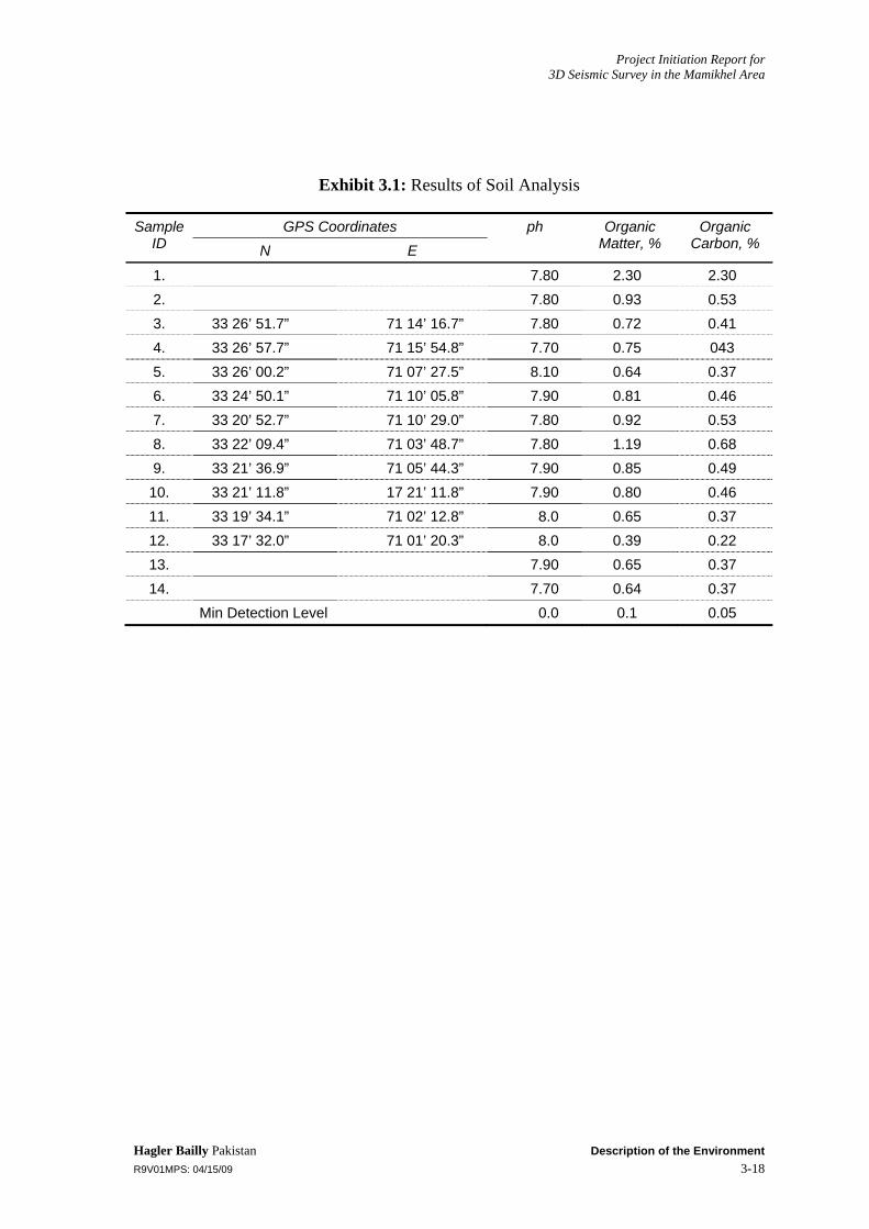
Soil samples were collected in the project area using the grab sampling method. These samples were then tested at HBP’s laboratory in Islamabad for texture classification, organic carbon content and pH. The result of the analysis is shown in Exhibit 3.1. With an average value of 0.76%, the soil is not so rich in organic matter and has a pH value ranging from 7.70 to 8.10. These pH values show that soil of the project area is slightly alkaline. The samplings location of soil collection are shown in Exhibit 3.2
3.3 Hydrology The water resources of the project area are shown in Exhibit 3.3 and samplings location are given in Exhibit 3.2.
3.3.1 Project Area Catchment
Based on the presence of four major streams in the project area, the following catchment areas exist in the area:
Catchment area of Sumari Toi and Star Toi
Catchment area of Aspari Toi
Catchment area of Ghurzandai Algad
Catchment area of Moramzai Toi
Project Initiation Report for 3D Seismic Survey in the Mamikhel Area
Hagler Bailly Pakistan Description of the Environment R9V01MPS: 04/15/09 3-5
According to Survey of Pakistan Atlas, the area consists mostly of hills that consist predominantly of sedimentary rocks belonging to the tertiary and quaternary periods. The percentage of plain area in these catchments is small (Atlas of Pakistan, 1997).
Streams
There are five principal streams that flow in the project area.
Moramzai Toi
Ghurzandai Algad
Sumari Toi (later called Star Toi as it passes through Sumari Payan)
Aspari Toi
Lilan Algad
Moramzai toi and Ghurzandai algad meet at some point between Hindki Banda and Sanda Fateh Khan.
Moramzai Toi
The Moramzai toi flows from north-west to south-east. This stream drains a small area between Walai and Hindki banda in the Kohat district.
Ghurzandai Algad
The Ghurzandai algad, flowing in the west to southeast direction, meeting the Moramzai toi further downstream and disappears after passing through the Hindki banda in the Kohat district.
Sumari Toi
This stream drains the upper part of the project area in the Kohat district passing through large settlements like Sumari bala and Sumari payan flowing in the north-west to east direction and ultimately falls into the Kohat toi.
Aspari Toi
The Aspari toi flows from west to east and disappears at some point a little distance outside of the project area in the Kohat district and has little or no perennial flow.
3.3.2 Dams
The Chanda Fateh Khan dam is located in Kohat and its catchment area is 63 km2. The total storage of the dam is 2,123 acre-feet with a dead storage of 530 acre-feet. The dam’s height is 24 m, its length is 259 m, and top width is 7.6 m1.
1 (Office of the Deputy Director Construction Small Dams, Kohat)

Project Initiation Report for 3D Seismic Survey in the Mamikhel Area
Hagler Bailly Pakistan Description of the Environment R9V01MPS: 04/15/09 3-6
3.3.3 Talabs (Ponds)
The project area is drought-affected and rainwater is harvested in reservoirs locally called talab, especially for livestock use. A talab is usually a natural depression in the ground or a circular kaccha structure made of bunds. The average diameter of a talab is 25 m. In the project area, about 90% of the villages have 2-5 such talabs in their surroundings.
3.3.4 Springs
Two springs were identified in the project area during the field survey. One is located near the Umar khan kalay. The water in this spring is fresh and potable. The other spring is located close to the Chashmai Aorkhel village; about 200 to 300 m from the village in the adjoining hill. Its water is fresh, and is supplied to some houses in the village by pipelines, while the rest of the village people take away water in pitchers.
3.3.5 Groundwater
Large parts of the project area are covered by the low hills of the Suleiman Range and small valleys surrounded by erodable hills. The valleys are so small that one large flood can fill the whole area. Deposits formed from sediments from these hills are highly stratified and, unlike the water-transported sediment, are not well sorted. Thus in spite of the existence of shingles and sandy beds, groundwater yield is poor. In the small valleys, the seepage from the flood-runoff gets accumulated as groundwater, which is used for agricultural operation. High-level perched groundwater also exists at a few sites and is extracted using hand pumps. As a result of insufficient recharge and the unsuitable water-bearing formation, tube wells can only draw out a limited amount of water. At many places in the project area deep groundwater is saline because there is no source of recharge (Ahmad, 1995).
The majority of the area (60%) has very limited groundwater yield prospects because of hard rock and a discontinuous aquifer. Areas near the Kohat, Lachi, Teri and Karak towns have slightly better yield prospects, with about 10% of the total area having prospects of about 10 m3/h to 50 m3/h and 30% of the area having yield prospects of under 10m3/h (Hydrogeological map of Pakistan, NI-42/SE, Bannu).
The groundwater depth in the project area varies from 10 m to 25 m. Groundwater is extracted using hand pumps, tube wells, and dug wells, but the water in these wells is mostly saline. The Public Health Department has constructed piped water supply schemes to some settlements in the project area to provide water to houses. Groundwater is extracted from a deep bore using a motor pump and drained to a large concrete tank constructed at a certain elevation, from where the water is pipelined to the houses under the action of gravity. Usually two or three settlements share a single such water supply scheme.
3.3.6 Water Quality
Water samples were collected from various points in the project area during the field survey for water quality analysis. These samples were handled as per United States
Project Initiation Report for 3D Seismic Survey in the Mamikhel Area
Hagler Bailly Pakistan Description of the Environment R9V01MPS: 04/15/09 3-7
Environmental Protection Agency (USEPA) sampling procedures. The following chemical analyses were undertaken at the HBP laboratory in Islamabad:
pH TDS (Total Dissolved Solids) TSS (Total Suspended Solids) Total Hardness Nitrate
The results of the general chemical analysis of water from various hand pumps, tube wells, open wells, and springs are presented in Exhibit 3.4. Results show that water from the project areas have higher TDS especially in the water samples from the villages of Shagai and Halala (exceeding 2,000 mg/l) .i.e., exceed the standard for TDS and Nitrate. The water samples on analysis show a mean value of 7.5 for pH, slightly alkaline, except Mami Khel which has the pH value of 8.10 that is highly alkaline. All the samples taken have TSS content while generally drinking water should not have any TSS content.
3.4 Climate and Air Quality
3.4.1 Meteorology
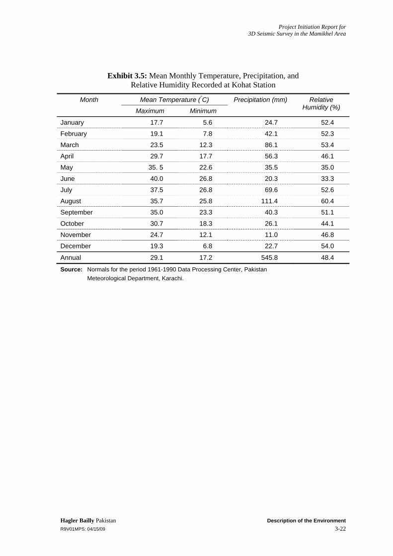
A Pakistan Meteorological Department (PMD) weather station is located at Kohat, which falls in the project area. Monthly temperature, humidity, and rainfall data recorded at this station is provided in Exhibit 3.5. The information is based on mean monthly climatic data for the 30-year period between 1961 and 1990.
3.4.2 Climate
Broadly speaking, the climate of the project area can be described as hot and sub-humid. Various meteorologists have developed classification schemes to describe the local climatic features of Pakistan.
Shamshad (1998) has classified the climate of Pakistan on the basis of characteristic seasons found in the country. Under his scheme, the project area is classified as ‘Subtropical triple season semiarid submontane areas.’ The characteristic feature of this climatic zone is a double rainy season. The region has two types of land: lowlands and submontane areas. The lowlands receive small amounts of rainfall between 254-635 mm, and have a steppe landscape. The submontane areas have two types of climatic varieties: single rainy season areas and double rainy season areas. The single rainy season areas are of the usual monsoon type, experiencing little precipitation during winter. The double rainy season areas experience considerable precipitation during winter as well as during the monsoon.
Temperature
The climate of the district is hot from May to September. June is the hottest month. The mean maximum and minimum temperatures recorded during June are about 40° C and 27°C, respectively. A pleasant change in the weather is noted from October till February.

Project Initiation Report for 3D Seismic Survey in the Mamikhel Area
Hagler Bailly Pakistan Description of the Environment R9V01MPS: 04/15/09 3-8
The winter is cold and severe. In winters a strong west wind known as the ‘Hangu Breeze’ often blows down the Miranzai valley towards the project area for weeks. The mean maximum and minimum temperatures, recorded during the month of January, are about 18° C and 6° C, respectively.
Precipitation
The rainfall is received throughout the year. The monsoon rains last from May to October. August is the rainiest month, with an average of about 111 mm. The winter rain occurs from November to April, with the most rain falling in March. The average annual rainfall is about 546 mm. Maximum humidity was recorded in the month of August during the summer season and in December during the winter season.
3.4.3 Ambient Air Quality
The only source of impact on the quality of the ambient air is vehicular traffic on the roads, which causes some dust emissions whose effect is quite localized. The main pollutants from vehicle exhaust are lead, particulate matter, carbon monoxide, sulfur dioxide, and nitrogen oxides. These emissions mainly affect the air quality in the immediate vicinity of the roads. Therefore, in general, it is unlikely that any significant air quality concerns exist for communities living nearby.
3.5 Biological Environment
3.6 Protected Areas The NWFP Wildlife Act, 1975 provides the basis for the preservation, protection, conservation, and management of wildlife and the declaration of different categories of protected areas (PA). The project area comprises four protected area, namely Sumari Bala community game reserve, Dar Malak/Alikach, Ghorzandi and Ter-Essakkumari game reserve (see Exhibit 3.6).
The present survey focused on these protected area, and collected baseline information on their ecological conditions and the state of the habitat. These are described in detail is below.
Teri Essak Khumari Game Reserve
This game reserve is about 90 % under barani agriculture surrounded by mountain. The vegetation on mountain slopes composed of grasses community with good vegetation cover (20-30 %). Where streambeds is composed of Saccharum spontanium, Cybopogan jawarancusa, associated with Acacia modesta and Halaxylon sp. Other common plant species found in this game reserve are Nanorhops rechiana, Cymbopogon jawarancusa, Cenchrus ciliaris Aristida sp., Fagonia sp., and Poganum harmala. The plant species found along /edge of agricultural field are Ziziphus nammularia, Euclyptus camaldananse, Tamarix aphylla, Morus alba, Monothica buxifolia, Acacia modesta, Prosopis glandulosa, and Prosopis juliflora.

Project Initiation Report for 3D Seismic Survey in the Mamikhel Area
Hagler Bailly Pakistan Description of the Environment R9V01MPS: 04/15/09 3-9
Hyena and wolf are the carnivore species, which are reported from the area. Other common mammals are, fox, jackal, and porcupine. black partridge, grey partridge, common babbler, little brown dove, skylark, see-see partridge, little green eater, and common kestrel.
Ghorzandi and Darmalak/Ali Kach Game Reserve
It is mainly composed of hilly area with a big stream running in the middle. Agricultre here is mainly restricted along the streambed. The vegetation on this mountain is semi-evergreen forest type dominant by Acacia modesta, Dadonea viscose, Berberis sp., and Monotheca buxifolia. The forest is protected by the local community. The vegetation is thick in southwest side than northeast. The dry streambed is dominant by Typha sp., and Saccharum spontanium. Other common plant species found in this game reserve are Nanorhops rechiana, Cymbopogon jawarancusa, Cenchrus ciliaris Fagonia sp., and Poganum harmala.
The floral diversity is splendid and harvesting is strictly controlled. Enough forage is available for livestock.
Leopard is infrequently visiting the area. Wolf is also reported from the area. Other common mammals are porcupine, wild boar, hare, fox, jackal, and civet. The common birds of this area are, black partridge, grey partridge, Indian roller, Indian tree-pie, rock bunting, black bulbul, chiff chuff, and desert warbler. Partridges are the main game birds.
Sumari Bala Community Game Reserve
The vegetation in hilly area is lush green forest type dominanted by Acacia modesta, Dadonea viscose, Berberis sp., and Monotheca buxifolia. The cover in hilly area is about 40-50 %. The dry streambed is dominant by Typha sp., and Saccharum spontanium. Other common plant species found in this game reserve are Nanorhops rechiana, Cymbopogon jawarancusa, Cenchrus ciliaris Aristida sp., Fagonia sp., Rhazia stricta and Waithania coagulanse.
Wolf is the only carnivore present in this area. Other common mammals are porcupine, wild boar, hare, and jackal. The common birds sighted in this game reserve are, black partridge, Grey partridge, white cheek bulbul,
3.7 Flora The project area is located in the dry subtropical temperate semi-evergreen scrub vegetation area of Pakistan (Roberts 1991). A total of 119 plant specimens were collected and were properly identified from the project area. The photographs of different habitats are shown in Exhibit 3.7. The vegetation survey locations are shown in Exhibit 3.8. A complete list of plants found in the study area is presented in Exhibit 3.9. The detailed description of vegetation of the project area is presented below.
Sumari Toi Valley
Mostly seasonal water streams are present, most of the time they remain dry. Northern and southern zones of valley are well divided on the basis of density of vegetation cover

Project Initiation Report for 3D Seismic Survey in the Mamikhel Area
Hagler Bailly Pakistan Description of the Environment R9V01MPS: 04/15/09 3-10
over there. Similarly, existence of vegetation species on both the zones also has distinct variation. Rare number of tree species has observed bare land in the valley, however trees of Acacia nilotica and Ziziphus mauritiana are there along the margins of agricultural lands located in the plain areas of the valley. General vegetation cover of the valley is dominated by Dodonaea viscosa at foot hills extending towards the above lying slopes. The main reason owing to which this species dominates over all other plants species found in this valley is its physiognomy, rapid propagation and is not utilized by grazing animals. However, Justacia adhatoda, Zizyphus nummularia with Chrysopogon aucherii and Cymbopogon jwarancusa species are present at foot hills. Dense forest of Monotheca buxifolia and Olea ferruginea species are found on the higher elevation of mountains.
Stony plain areas are dominated with grasses including Chrysopogon aucherii and Cymbopogon jwarancusa followed by Withania coagulans, Calotropis procera and Peganum harmala. Seasonal stream’s vegetation comprising species like Typha sp., Cyperus rotundus and Schoenoplectus littoralis.
Valley is under high grazing/ browsing pressure. Local people utilize plants and grasses species as fuel prepossess.
Valley Moramzai Toi Valley
Perennial Small water streams are present in the Ghorzandi. Agricultural practice takes place along the perennial stream. Acacia nilotica and Ziziphus mauritiana observed along the margins of the agricultural field. General vegetation is dominated by Dodonaea viscosa followed by Justaci adhatoda,, Monotheca buxifolia and grasses like Saccharum spontaneum and Cymbopogon jwarancusa. Whrereis in stony plain areas with loamy soil structure of valley, vegetation consists of Peganum harmala, and Solanum surattense. Rhazia stricta is from underneath flora with bushes of Acacia modesta, Prosopis glandulosa and grasses of Saccharum spontaneum.
Riparian area consists of Cyperus rotundus, Tyha sp. with Ipomoea carnea and dry stream beds have Saccharum benghalense and Saccharum spontanium.
The area is under over grazing/ browsing pressure. Trampling by animals makes the soil compact and seed germination is retarded. Many seedlings may degrade. The local people badly degrade the vegetation by cutting the fuel wood species for fuel purposes. Burning of grasses is frequently practice by natives to get better propagation of grasses during successive year, to have better graze land in future for their animals..
LilanAlgad Valley
Lilan algad is a large water stream flowing between Hangu and Karak districts, it is a perennial fresh water stream. Wild trees in valley are rare, however trees of Acacia nilotica, Phoenix dactylifera and Ziziphus mauritiana are there along the margins of agricultural lands located in the plain areas of the valley. While northern facing mountain (Umer khan kalai) have lush green vegetation cover dominated by Dodonaea viscose, Monotheca buxifolia, Olea ferruginea and Justaci adhatoda. In the foot a hill of valley’s mountains, vegetation is mostly comprises of grasses including Saccharum spontaneum and Cymbopogon jwarancusa, followed by Justicia adhatoda, Acacia
Project Initiation Report for 3D Seismic Survey in the Mamikhel Area
Hagler Bailly Pakistan Description of the Environment R9V01MPS: 04/15/09 3-11
modesta and Withania coagulans. The riparian area has Schoenoplectus littoralis, Cyperus rotundus and Tyha sp. Nannorhops ritcheana and Nerium oleander were present along the streambeds. Cuttings of Monotheca buxifolia is use as fuel, for making regional handicrafts. Animals like to browse this plant due to it sweat taste.
Teri Toi Valley
Small seasonal dry streams are present at various places. Mostly they remain dry. Most of the valley area is having low mountains in northern zone. In plain area of valley the vegetation cover dominated by Acacia modesta, followed by Prosopis glandulosa and Withania coagulans. Saccharum spontanium is the main fodder species of the area while Chrysopogon aucherii, Cymbop[ogon jwarancusa and Aristida mutabilis are also present at some places. Hilly areas of the northern zone of valley have Justaci adhatoda as dominant species at foot hills but at slopes and top Dodonaea viscose along with Monotheca buxifolia are present. Dry stream beds of the valley have Saccharum benghalense and Saccharum spontanium in general. Grazing and browsing pressure is visible in most of the valley, and cutting of tree to use them as fuel woo also observed. Especially large amount of Grasses are cut to use for rope making.
3.7.1 Rare and Endemic Species
No endemic or rare species exist within the project area. All species have a wide range of distribution in the project area and in other portions of Pakistan.
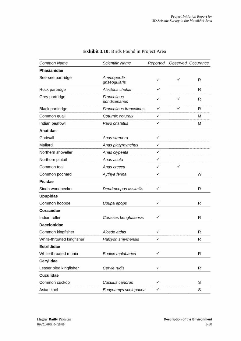
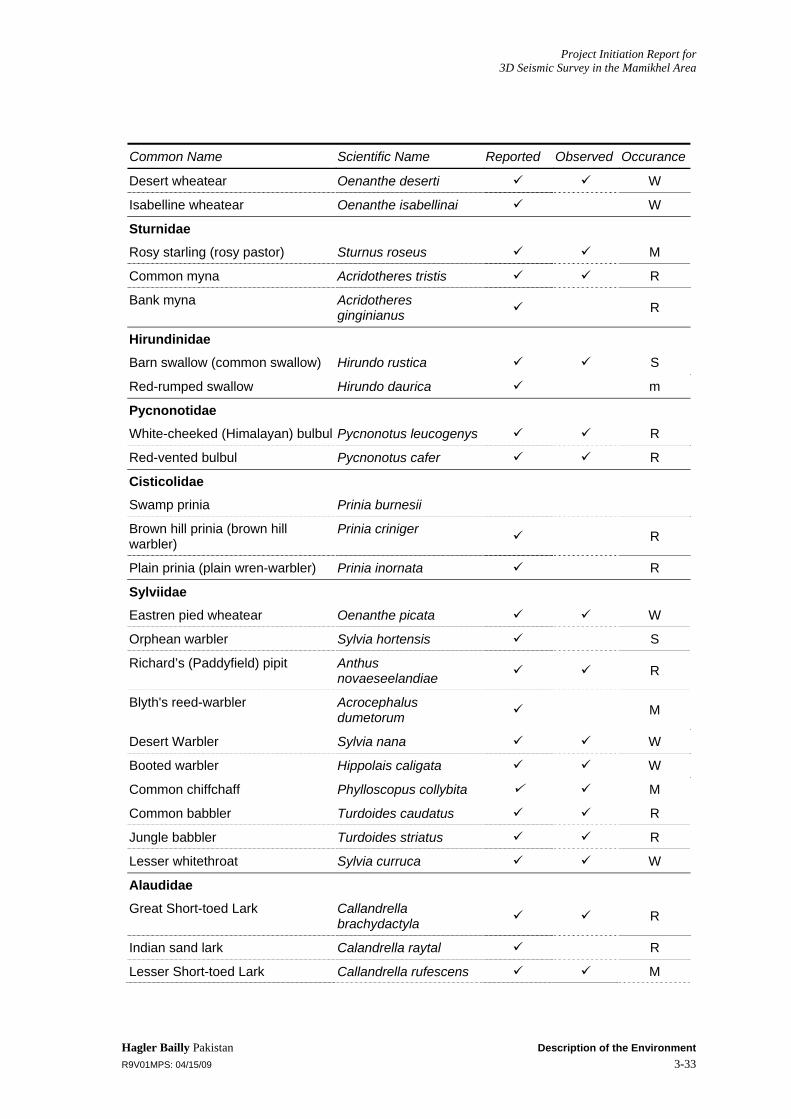
3.8 Wildlife Vertebrate fauna is grouped into five categories: ungulates, carnivorous mammals, small mammals, birds, and reptiles and amphibians. The status of these groups in the project area is discussed in this section. The vegetation survey locations are shown in Exhibit 3.8. Complete lists of the wildlife of the study area are given in Exhibit 3.10 to Exhibit 3.12.
Mammals
Wild boar (Sus scrofa) is another ungulate commonly found in the Sumari Bala, Moramzai toi and Lian Algad. The wildlife department and local people report that the population of this species in the Kohat division has recently grown.
The common leopard, (Panthera pardus), a highly threatened species in Pakistan, is also reported to be vagrant in the Sumari Bala Moramzdi toi and Lian Algad valley. The striped hyena (Hyaena hyaena) and gray wolf (Canis lupus pallipes) are two other threatened carnivores. Although their populations are small, they occupy the whole area because of their large home ranges. Jackals and foxes are the most common large mammals found in the project area.
Small mammals are well represented in Pakistan with 118 species that make up nearly 65% of the total mammalian fauna of the country. Porcupine, cap hare are small mammal that are found in the project area. Other common species of small mammals observed during the present survey include the five-striped palm squirrel, the Indian crested porcupine, the house rat, the house mouse, the Indian hare, and the Indian desert jird.

Project Initiation Report for 3D Seismic Survey in the Mamikhel Area
Hagler Bailly Pakistan Description of the Environment R9V01MPS: 04/15/09 3-12
Other small mammals recorded and reported are the Afghan hedgehog, the Indian hedgehog, the bush rat, the short-tailed mule rat, the marbled polecat, the stone marten, and the Indian pangolin.
Birds
The bird transects were placed in representative habitats all over the project area. Bird density and diversity was comparatively higher in riparian habitats, and natural springs were the highest concentration areas. Stony plains were poor with respect to the diversity and density of birds.
The resident birds found in the project area are the gray partridge, the black partridge, the see-see partridge, the red vented bulbul, the common babbler, the house crow, the common myna, the white-cheeked bulbul, the little brown dove, the Indian tree pie, the blue rock pigeon, the lesser white-throat, the common white-throat, the house bunting, the gray-necked bunting, the crested lark, and the white wagtail.
Migratory birds found in the project area are the little cormorant, the snake-bird, the rosy pelican, the little egret, the intermediate egret, the purple heron, the northern pintail, the common teal, the mallard, the widgeon, the ferruginous duck, and the bearded vulture.
The black winged kite, common kestrel, and little nightjar are also resident birds and are listed in Schedule II of Convention on International Trade in Endangered Species of Wild Fauna and Flora (CITES).
Reptiles and Amphibians
Monitor lizards (Varanus bengalensis and Varanus griseus), the largest lizards in the area, are included in the list provided by the CITES. The preferred habitat of the desert monitor (Varanus griseus) is sandy, while the Indian monitor (Varanus bengalensis) prefers water bodies. Another species, the spiny-tailed lizard (Uromastix hardwicki), has also been included in Appendix III of the CITES. This lizard has some economic importance for its valuable skin and its fat, which is used for medicinal purposes. As a result of this, the population of this lizard is decreasing day by day.
The Indian sandy boa (Eryx johni), whose population in the area is very small, is also included in Appendix II of CITES. The most prominent snake in the area is the saw-scaled viper (Echis carinatus). This is a highly poisonous snake and is distributed throughout Pakistan. The size reached by this species in the Nara Desert is larger than in other parts of Pakistan. Differences in size and color were observed between specimens caught in the project area and those from other areas of Pakistan. This species of snake is of great value and economic importance from a medical point of view. The Cobra (Naja naja) has also been reported from the project area.
3.9 Socioeconomic and Cultural Environment The project area includes the villages along three main streams (locally called Toi); Lilan algad, Ghurzandai algad Moramzai toi (which ultimately meets the Ghurzandai algad) and Star toi falling mainly in the area of districts Kohat and Karak (including areas of tehsils Banda Daud Shah, Lachi and Teri), along with Aspari toi. These streams serve as
Project Initiation Report for 3D Seismic Survey in the Mamikhel Area
Hagler Bailly Pakistan Description of the Environment R9V01MPS: 04/15/09 3-13
the main source of water for both the animals and humans. They are perennial sources of water for the project area. However, variations in the amount of water flowing through them depend upon the amount of rainfall the area receives. The people of the project area are satisfied with the overall quality of the water of these streams. The socioeconomic feature of the study area is presented in Exhibit 3.13.
3.9.1 Roads and Transportation
Most of the villages do not have black top roads instead they have kaccha roads, which are made and maintained by the local people. The few roads that are there are in poor condition and are further deteriorating by the day due to the lack of maintenance. Regular transportation is not available to the majority of population. Usually a single van takes the village people to the nearby town for daily business in the morning brings them back in the afternoon. Other than that people have to pay high cost of travel because of having to hire private transport that costs on the average about Rs. 800 to 1,000 per trip to Kohat or Karak. This nature of transport and road network is a major hurdle in the development of the area.
3.9.2 Housing
According to the field survey about 65 % of the houses are kaccha (made from clay and stones) and 33 % are pakka (made from bricks and cement) in the project area (see Exhibit 3.14). The field survey reveals the average household size is approximately 9 persons per household. According to the District Census Report in 70% houses in the Kohat district are kaccha while in the Karak district 84% of the houses built are kaccha and in the Hangu district 29% houses are kaccha. Most of the houses have toilets now, with trenches dug for waste disposal. Men usually go out into the open spaces to relieve themselves. There are no covered drainage systems in the project area, and the open drains serve as the breeding grounds for mosquitoes; that are responsible for the spread of malaria in the area.
3.9.3 Tribes and Language
The main kin groups are Bangash and Khattak (Seni and Barrak Khattak), with Pashto being the primary spoken language in the area. Sunnis are the predominant ethnic group.
3.9.4 Education System
Literacy rate in the project area is very low because of the lack of educational facilities in the area and access to them (see Exhibit 3.15). The ones that are there have minimal staff and facilities. According to the District Census Report the overall literacy rate is 44.06% (male 65% and female 23.48%), while in the Karak district it is 41.9% (male 68.2% and female 18.1%) and in the Hangu district the literacy rate is 30.5%(male 53.5% and female 9.8%) and according to the field survey the literacy rate in the project area in the Karak district is 28.29%(male 69.77% and female 7.28%) and in the Kohat district it is 18.09% (male 35% and female 6.6%). Poverty and lack of awareness also plays a major role in this regard. Enrollment to the schools is on the increase as people are getting more aware, but still a considerable number of school going children drop out

Project Initiation Report for 3D Seismic Survey in the Mamikhel Area
Hagler Bailly Pakistan Description of the Environment R9V01MPS: 04/15/09 3-14
because of poverty, lack of interest of students and their parents and no access to further education, even if someone is willing to go for education to nearby town or village the lack of transport and expensive nature of transport stops them from doing so. As the people are greatly influenced by religion so almost every boy and girl goes to madrassah or is taught Quran at home (see Exhibit 3.16).
3.9.5 Health Facilities
Majority of the population is deprived of proper health facilities as the hospitals are only in Lachi, Kohat and Teri (see Exhibit 3.17). As the 2 BHUs and 1 dispensary are not sufficient for local needs and do not have doctors or medicine so the people are treated by the dispenser or quacks. Major diseases are malaria, respiratory tract infections with joint pains while the children mostly suffer from cough and fever. Cases of infant and maternal mortality are rare but those that have occurred are due to lack of proper care, medical facilities, and malnutrition. The residents of the area reported an increased frequency of skin rashes and inflections during the past three years.
3.9.6 Water Reources
Main source of drinking water are the streams passing through most of the settlements. Three villages have proper water supply schemes with Government installed and operated tube wells, while quite a few household have dug wells whose depth varies from 12 to 20 meters and the amount of water depends upon the precipitation the area receives. Also there are three natural springs (at Umar khan kalay and Chashmai Akor khel) having fresh water while the rest of the underground water reservoirs have saline water. Women fetch water from the wells, streams and springs in pitchers.
Some of the important water resources are described as follows
Well at Chashmai Akorkhel with Electric Motor
GPS coordinates; 33 21’ 37.9” (N) 71 05’ 30.2” (E)
It was dug in 1980 by the local people to meet their domestic needs. Water depth varies between 11 to 13 mbgs. Although an electric motor is installed but water is extracted by buckets. Almost all the village uses the facility. It supplies water all year round and the water is clean and fit to use.
Water Supply Scheme at Chota Shagai
GPS coordinates; 33 07’ 42.0” (N) 71 19’ 39.2” (E)
Constructed in 2004/05 by the village people of Chota Shagai and Starr Shagai, it is a privately run and maintained water supply scheme. It is operational for 8 hours per day and the electric motor has a 2”diameter pipe. It supplies water to the above mentioned two villages. The water is saline but of better quality than most of the nearby settlements.

Project Initiation Report for 3D Seismic Survey in the Mamikhel Area
Hagler Bailly Pakistan Description of the Environment R9V01MPS: 04/15/09 3-15
Stream passing through Mami Khel
It is a centuries old water channel having potable quality water and is used by all the villagers having a perennial flow with some small game fish also found in the stream. The flow is dependent upon the amount of rainfall the area receives.
3.9.7 Agriculture
Agriculture is mainly rain fed and more than half of the total cultivable land is not used for agriculture due to non availability of water. Of the land that is actually used for agriculture the yield depends upon the amount and timing of rain, i.e., if the rains are timely and according to the requirements of the crops, the yield is good. Wheat and peanut are the major crops, where the wheat produced cannot even meet the needs of the people and in case of peanuts only the amount required for seeds is kept and the rest is sold. The growing number of wild boar is a matter of great concern to the local people as they destroy the wheat fields inflicting more damages to the already suffering poor people.
3.9.8 Livelihood
Almost all men and women engage in agriculture including those who have jobs (whenever time permits) with not more than 2 to 5 shops per village. As the literacy rate is low people in the white collar jobs are also very few and majority of those serve in the army and other law enforcing agencies. Those who had enough resources in major towns have moved out and given their land to tenants. In a recent trend, the young lot in the age bracket of 17 to 20 is sent abroad for jobs, mostly to Middle East. Another working group is the people who are working on daily wages. Still others are working in major towns like Peshawar, Lahore, Karachi, and Islamabad as drivers, waiters, watchmen and shopkeepers.
3.9.9 Livestock
Livestock mostly consists of goats followed in number by cows, donkeys, sheep, and camel (see Exhibit 3.18). As buffaloes have high ware requirements people prefer not to keep them. It is both used for domestic and commercial purposes. The livestock drinks water from the streams and ponds (locally called talabs) i.e., small depression in ground where rain water is redirected from the surrounding hills and stored. For grazing the herds of livestock are taken to the grazing lands and nearby hills where they feed on grass and shrubs. Such grazing grounds are generally two to four kms away from the village centre. In the seasons of scanty rainfall or draught, either fodder is bought from market or branches from tall trees are fed to the cattle. There are also reports of predation in the area, where on average 15 to 20 animals per year per village are lost to predators including leopard, wolf, hyenas, and jackals. No one has ever received any compensation for it. Poultry is only kept for domestic use, and is a compulsory item on the guests’ menu.

Project Initiation Report for 3D Seismic Survey in the Mamikhel Area
Hagler Bailly Pakistan Description of the Environment R9V01MPS: 04/15/09 3-16
3.9.10 Infrastructure
All the villages, except Umar Khan Kalay, have electric supply with 3, 4 villages having PTCL landlines, some villages having V-wireless phones while the rest are connected to the outside world only by mobile phones (see Exhibit 3.19). There 3 post offices with 4 Police stations in the project area.
3.9.11 Migrant Communities
As there are no great opportunities of business or jobs, therefore, there are no migratory communities moving in to the project area, with one exception of a nomadic settlement of 3 houses at a location between Umar khan kalay and Chashmai Akor khel, who have been in the area for the past few years
3.9.12 Dress Code
Women wear shalwar qamiz and use head gear (scarf, dupatta, or burqa) to cover themselves as pardah is strictly practiced, also the adult males are not allowed to go to the places from where women bring water and wash clothes (usually alongside the streams). Men also wear shalwar qamiz with a traditional cap in winters an additional woolen chadar is used, while the village elders (masharan) wear turban as a sign of prestige and respect in the social system.
3.9.13 Culture and Customs
The society is a male dominated society and the culture and customs are dictated by Islamic ideology and Pukhtun traditions. The family system is traditionally joint family system, pardah is strictly observed, guests are considered as a blessing of God and are welcomed and served in the best possible way; a meal for the guest will always include chicken.
3.9.14 Conflict Resolution
All major decisions of the house and in general of the village are taken by the elders (masharan) of the house and village respectively. Men have separate place to sit, called the Hujra, where all the decision making, social interactions and conflict resolution takes place, therefore, the hujra is the most important social institution of the Pukhtun society. Police and judiciary are the last option for dispute settlement in the project area, when the jirga cannot come up with a decision acceptable to both the affected parties
3.9.15 Status of NGO’s in the Project Area
At the moment there are no NGO’s or other civil society organizations working in the area because the people are strictly against NGO’s working in the project area.
3.2.16 Public Opinion
The people of the project area are of the opinion(see Exhibit 3.20) that more and more benefits must be given to them in terms of more jobs, better health and education facilities, access to clean drinking water, improved roads and transportation network etc.,

Project Initiation Report for 3D Seismic Survey in the Mamikhel Area
Hagler Bailly Pakistan Description of the Environment R9V01MPS: 04/15/09 3-17
the list of demands continues to grow with every subsequent visit of the survey teams. Also there are some misconceptions of the people about the activities of project proponents like the increasing number in cases of skin rash among the people of the project area. The major demand of the people of the project area is the provision of natural gas to the local people. As far as the payments of the previous developments are concerned all the compensations and other payments have been made to the affected people in the project area.
Project Initiation Report for 3D Seismic Survey in the Mamikhel Area
Hagler Bailly Pakistan Description of the Environment R9V01MPS: 04/15/09 3-18
Exhibit 3.1: Results of Soil Analysis
Sample ID
GPS Coordinates ph Organic Matter, %
Organic Carbon, % N E
1. 7.80 2.30 2.30 2. 7.80 0.93 0.53 3. 33 26’ 51.7” 71 14’ 16.7” 7.80 0.72 0.41 4. 33 26’ 57.7” 71 15’ 54.8” 7.70 0.75 043 5. 33 26’ 00.2” 71 07’ 27.5” 8.10 0.64 0.37 6. 33 24’ 50.1” 71 10’ 05.8” 7.90 0.81 0.46 7. 33 20’ 52.7” 71 10’ 29.0” 7.80 0.92 0.53 8. 33 22’ 09.4” 71 03’ 48.7” 7.80 1.19 0.68 9. 33 21’ 36.9” 71 05’ 44.3” 7.90 0.85 0.49
10. 33 21’ 11.8” 17 21’ 11.8” 7.90 0.80 0.46 11. 33 19’ 34.1” 71 02’ 12.8” 8.0 0.65 0.37 12. 33 17’ 32.0” 71 01’ 20.3” 8.0 0.39 0.22 13. 7.90 0.65 0.37 14. 7.70 0.64 0.37
Min Detection Level 0.0 0.1 0.05


Project Initiation Report for 3D Seismic Survey in the Mamikhel Area
Hagler Bailly Pakistan Description of the Environment R9V01MPS: 04/15/09 3-21
Exhibit 3.4: Water Quality Analysis of the Project Area
Sample ID
Village Source Chemical Analysis
pH TDS (mg/l)
TSS (mg/l)
Total Hardness
(mg/l)
Nitrate (mg/l)
1. Mami khel Water supply scheme
7.60 1118 21 496 0.27
2. Chashmai Akor khel
Spring 7.70 342 18 160 BDL
3. Chapari Banda Open well 7.70 1016 38 472 0.64
4. Essak Khumari Tank at Spring 7.60 436 43 204 0.32
5. Halala Hand pump 7.70 2542 13 816 2.78
6. Sanda Fateh.Khan
Water supply scheme
7.80 542 11 260 BDL
7. Chashmai Akor khel
Open well 7.50 554 23 248 BDL
8. Ghorzai Bala Hand pump 7.80 1072 12 464 0.28
9. Sheikhan Water supply scheme
7.50 656 15 320 0.87
10. Sumari Payan Tube well 7.30 822 38 400 1.96
11. Bergai Banda Hand pump 7.10 1058 41 500 2.27
12. Shagai Water supply scheme
7.60 2236 10 760 0.96
13. Umar Khan Kalai
Spring 7.20 442 19 200 0.40
14. Essak Khumari Hand pump 7.50 1038 29 448 4.96
Analytical Method
US EPA 150.1
US EPA 160.
US EPA 160.2
US EPA 130.2
US EPA 352.1
WHO Limit n.d n.d n.d 50
Min.Detection Level
00 10 4.0 1.0 0.1
PSQCA 6.5-8.5 100-500 10
n.d.: Not determined acc. To this regulation WHO: World Health Organization TSS: Total Suspended Solids TDS: Total Dissolved Solids PSQCA: Pakistan Standard and Quality Control Authority BDL: Below Detection Limit (minimum detection limit for COD is 4.0 mg/l) mg/l: Milligram per Liter
Project Initiation Report for 3D Seismic Survey in the Mamikhel Area
Hagler Bailly Pakistan Description of the Environment R9V01MPS: 04/15/09 3-22
Exhibit 3.5: Mean Monthly Temperature, Precipitation, and Relative Humidity Recorded at Kohat Station
Month Mean Temperature (°C) Precipitation (mm) Relative Humidity (%) Maximum Minimum
January 17.7 5.6 24.7 52.4
February 19.1 7.8 42.1 52.3
March 23.5 12.3 86.1 53.4
April 29.7 17.7 56.3 46.1
May 35. 5 22.6 35.5 35.0
June 40.0 26.8 20.3 33.3
July 37.5 26.8 69.6 52.6
August 35.7 25.8 111.4 60.4
September 35.0 23.3 40.3 51.1
October 30.7 18.3 26.1 44.1
November 24.7 12.1 11.0 46.8
December 19.3 6.8 22.7 54.0
Annual 29.1 17.2 545.8 48.4
Source: Normals for the period 1961-1990 Data Processing Center, Pakistan Meteorological Department, Karachi.


Project Initiation Report for 3D Seismic Survey in the Mamikhel Area
Hagler Bailly Pakistan Description of the Environment R9V01MPS: 04/15/09 3-24
Exhibit 3.7: Views of Different Habitats in the Study Area
Teri Toi Teri Toi
Sumari Toi Sumari Toi
Lilan Toi Lilan Toi
Moramzai Toi Moramzai Toi

!
!
!
!
!
!!
!
!
!
!
!
!
!! !
!
!
!
!
!
!
!
!
!
!
!
! !
!
!
!
!
!
!
!
!
!
!
!
!
!
!
!
!!
!
!
!
!
!
! !
!
!
!
!
!
!!
!
!
!
!
!
!
!
!!
!
!
!!
!!
!
!
!
!!
!!
!
!
! ! !
!
!
!!!
!!
!!!!!
!!
Aspari Toi
Ghor Zandi Algad
Lilan Algad
Moramzdi Toi
hisham Algad
Star Toi
Sumari Toi
Teri Toi
Umar Algad
Karak
Kohat
HanguKarak
Fayyaz Muhammad
Banda Darra
ChambagulSirki Paila
Shaikh Allah Din
Umar Khan Kalai
Chishma-i-Akor Khel
SanginiShakkar Khel
HotiSadiqabad
Sanda Fateh KKhan
Banda Tirawal
Sumari Payan
Banda Fateh KhanHindki Banda
Muhsin Khel
Haji Khan Gul Colony
Faqirabad
Kaka Khel ColonyLachi Algad
Lachi Galsha Khel
Manduri
Chichina Afghan Refugees Camp
Chichino
Sher Ali Banda(Afghan Refugees Camp)
Salimabad
Kamar Dand
Banda Zarhi Gul Lambi DheriBanda Sabbi
Buraka
Mansurgarh
Saidagul Banda
Azad Banda
Shahi Banda
Shaikh IsmailSumari Bala
Ghorzai BalaSpin Ali Banda
Ali Kech
Walai
Ghorzandai
Shaikhan
Mami KhelChotti ShagaiBeri Shagai
Teri
Chappri BandaBergai BandaHalala
Hayatabad
Isak Khumari
Anar China
Banda Chaprai
Chambagul Bara
Bara Bazar Khel
UmarChal
Sharki
WAPDA Colony
Mardan Kehel
Katgarh Banda
Togh Sarai71°20'0"E71°15'0"E71°10'0"E71°5'0"E71°0'0"E
33°30'0"N
33°25'0"N
33°30'0"N
¯
PIR for 3D Seismic Survey in the Mamikhel Area
Vegetation and WildlifeSurvey Locations
ScaleSourceDrawingDateClient
1 : 120,000SoP and Field SurveyW9E02MPSApril 2009MOL Pakistan Oil and Gas Co. B.V.
Legend
Cultivated Area
SettlementsRiver / Stream
Tal Block
District BoundaryMain Road
Contours
800m1000m1200m1400m
600m400m
Elevation Zones< 400m
Jeepable Track
Cities/Towns P
Survey Plan3D Seismic Area
0 2.5 5 7.5 10 km
Exhibit 3.8
!Vegetation & Wildlife Sampling Sites

Project Initiation Report for 3D Seismic Survey in the Mamikhel Area
Hagler Bailly Pakistan Description of the Environment R9V01MPS: 04/15/09 3-26
Exhibit 3.9: List of Vegetation Species Found within the Project Area
Botanical Name Local Name Life Form
Herb Shrub Grass Tree
Abutilon fruticosum - x
Abutilon hirtum - x
Acacia modesta Palusa x
Acacia nilotica Kikar x
Achyranthus aspera Puth kanda x
Albizia lebbek Siris x
Aloe vera Kanwar gandl x
Amaranthus graecizans - x
Amaranthus viridis Chulai x
Anagalis arvensis - x
Aristida mutabilis - x
Artemisia maritimis - x
Astragalus sp. - x
Bambusa arundinacea Bans x
Bergia ammanioides - x
Boerhaavia procumbens -
Bombax ceiba Simal x
Brachiaria ramosa - x
Brachiaria reptans - x
Buxus papillosa Shamshad x
Callistamon lanceolatus Bottle Brush x
Calotropis procera Spalmaka x
Canna indica - x
Capparis deciduas Kirra x
Cassia oxidentalis Jangli Chaksu x
Cenchrus ciliaris - x
Chenopodium album Bathu x
Chrysopogon aucherii - x
Cissus carnosa -
Clerodendron inermis - x
Cocculus pendulus Zahmoor

Project Initiation Report for 3D Seismic Survey in the Mamikhel Area
Hagler Bailly Pakistan Description of the Environment R9V01MPS: 04/15/09 3-27
Botanical Name Local Name Life Form
Herb Shrub Grass Tree
Commelina albescens Churra x
Convolvulus arvensis Pair wotha
Conyza canadensis Paleet x
Cordia myxa Lehsoori x
Croton sparciflorus - x
Cupressus sempervirens Sarroo x
Cymbopogon jwarancusa - x
Cynodon dactylon Ghass x
Cyperus rotundus Deela
Dactyloctenium aristatum - x
Dalbergia sissoo Shisham x
Datura innoxia Dhatura x
Dicanthium annulatum - x
Dicliptera bupleuroides - x
Dodonaea viscosa sanatha x
Eclipta alba Bhangrha x
Eleusine indica - x
Eucalyptus globulus Sufaida x
Eugenia jambolana Jaman x
Euphorbia granulata Hazar Dani x
Euphorbia helioscopia Chhatri dodak x
Euphorbia hirta Hazar dani x
Euphorbia royleana Euphorbia bush x
Fagonia indica Dhamasa x
Ficus benghalensis Bargad x
Ficus religiosa Peepal x
Ficus virgata Phagwara x
Ipomoea carnea - x
Jasminum sambac Chambeli x
Jasminum sp. Motia x
Justicia adhatoda Bhakaen x
Lathyrus aphaca Jungli matar x
Launaea procumbens - x

Project Initiation Report for 3D Seismic Survey in the Mamikhel Area
Hagler Bailly Pakistan Description of the Environment R9V01MPS: 04/15/09 3-28
Botanical Name Local Name Life Form
Herb Shrub Grass Tree
Leucaena leucantha - x
Malvastrum coromendelianum - x
Malva sylvestris - x
Mangifera indica Aam x
Maytenus royleanus Surghazai x
Medicago polymorpha Maina x
Melia azadirachta Dhrek x
Melilotus indica - x
Monotheca buxifolia Gurgura x
Morus alba Shahtoot x
Morus nigra Shahtoot x
Nannorhops ritcheana - x
Nerium oleander Kaner x
Ochthocloa compressa - x
Olea ferruginea Jungli zeeton x
Parthenium hysterophorus Chitti Booti x
Paspalidum geminatum - x
Peganum harmala Asponda x
Phoenix dactylifera Khajoor x
Polygonum plebijum - x
Prosopis glandulosa Devi x
Prosopis juliflora Devi x
Psidium guajava Amrood x
Punica granatum Anar x
Rhazia stricta Gandari x
Ricinus communis Harnoli x
Saccharum benghalense Kai x
Saccharum grifithii - x
Saccharum spontaneum - x
Salix babylonica Bhenis x
Salvia aegyptiaca - x
Salvia moorcraftiana - x
Schoenoplectus littoralis Kandiari

Project Initiation Report for 3D Seismic Survey in the Mamikhel Area
Hagler Bailly Pakistan Description of the Environment R9V01MPS: 04/15/09 3-29
Botanical Name Local Name Life Form
Herb Shrub Grass Tree
Setaria pumila Seel x
Solanum incanum Jangli Bengan x
Solanum nigrum Mako x
Solanum surattense Brum x
Sonchus asper Dodhal x
Sonchus oleraceous Dodhak x
Sorghum helepense Barru x
Tecomella undulata - x
Thuja orientalis Mor Pankh x
Tribulus terrestris Bhakhra x
Typha latifolia - x
Vicia faba Rewari x
Vitex negundo Nargandi x
Vitis vinifera Angoor
Withania somnifera Asgand Nagori x
Withania coagulans Shapangia x
Zaleya pentandra Itsit x
Zizyphus nummularia Kerkanra x
Zizyphus mauritiana Bera x
Project Initiation Report for 3D Seismic Survey in the Mamikhel Area
Hagler Bailly Pakistan Description of the Environment R9V01MPS: 04/15/09 3-30
Exhibit 3.10: Birds Found in Project Area
Common Name Scientific Name Reported Observed Occurance
Phasianidae
See-see partridge Ammoperdix griseogularis R
Rock partridge Alectoris chukar R
Grey partridge Francolinus pondicerianus R
Black partiridge Francolinus francolinus R
Common quail Coturnix coturnix M
Indian peafowl Pavo cristatus M
Anatidae
Gadwall Anas strepera
Mallard Anas platyrhynchus
Northern shoveller Anas clypeata
Northern pintail Anas acuta
Common teal Anas crecca
Common pochard Aythya ferina W
Picidae
Sindh woodpecker Dendrocopos assimilis R
Upupidae
Common hoopoe Upupa epops R
Coraciidae
Indian roller Coracias benghalensis R
Dacelonidae
Common kingfisher Alcedo atthis R
White-throated kingfisher Halcyon smyrnensis R
Estrildidae
White-throated munia Eodice malabarica R
Cerylidae
Lesser pied kingfisher Ceryle rudis R
Cuculidae
Common cuckoo Cuculus canorus S
Asian koel Eudynamys scolopacea S

Project Initiation Report for 3D Seismic Survey in the Mamikhel Area
Hagler Bailly Pakistan Description of the Environment R9V01MPS: 04/15/09 3-31
Common Name Scientific Name Reported Observed Occurance
Psittacidae
Rose-ringed parakeet Psittacula krameri R
Apodidae
House swift Apus affinis R
Strigidae
Spotted owlet Athene brama
Caprimulgidae
Little (Indian) nightjar Caprimulgus asiaticus R
Eurasian (European) nightjar Caprimulgus indicus S
Columbidae
Rock pigeon (blue rock pigeon) Columba livia R
Laughing dove (little brown dove) Streptopelia senegalensis W
Red collared dove (turtle dove) Streptopelia tranquebarica R
Eurasian (Indian) collared dove Streptopelia decaocto R
Gruidae
Common crane Grus grus M
Otididae
Houbara bustard Tetrax tetrax M
Rallidae
Common coot Fulica atra W
Scolopacidae
Common (Faintail) snipe Gallinago gallinago W
Common redshank Tringa totanus R
Common greenshank Tringa nebularia W
Charadriidae
Red-wattled lapwing Vanellus indicus R
Laridae
Little tern Sterna albifrons R
Accipitridae
Lessor spotted eagle Aquila pomarina R
Black-shouldered kite Elanus caeruleus R
Egyptian vulture Neophron percnopterus R
Short-toed snake eagle Circaetus gallicus W

Project Initiation Report for 3D Seismic Survey in the Mamikhel Area
Hagler Bailly Pakistan Description of the Environment R9V01MPS: 04/15/09 3-32
Common Name Scientific Name Reported Observed Occurance
Eurasian marsh harrier Circus aeruginosus M
Shikra Accipiter badius R
Eurasian sparrow hawk Accipiter nisus W
White-eyed buzzard Butastur teesa R
Long-legged buzzard Buteo rufinus W
Greater spotted Eagle Aquila clanga W
Tawny eagle Aquila rapax R
Bonelli's eagle Hieraaetus fasciatus W
Booted eagle Hieraaetus pennatus W
Falconidae
Common kestrel Falco tinnunculus W
Lagger falcon Falco jugger R
Peregrine falcon Falco peregrinus W
Podicepididae
Little cormorant Phalacrocorax niger
Ardeidae
Little egret Egretta garzetta
Grey heron Ardea cinerea
Intermediate egret Mesophoyx intermedia
Cattle egret Bubulcus ibis
Indian pond-heron Ardeola grayii
Little bittern Ixobrychus minutus
Laniidae
Long-tailed shrike (rufous-backed shrike)
Lanius schach S
Corvidae
Rufous treepie (Indian treepie) Dendrocitta vagabunda R
House crow Corvus splendens R
Black drongo Dicrurus macrocerus R
Muscicapidae
Blue rock thrush Monticola solitarius W
Paradise Flycatcher Terpsiphone paradisi S
Indian robin Saxicoloides fulicata R
Black redstart Phoenicurus ochruros M
Common stonechat Saxicola torquata R
Project Initiation Report for 3D Seismic Survey in the Mamikhel Area
Hagler Bailly Pakistan Description of the Environment R9V01MPS: 04/15/09 3-33
Common Name Scientific Name Reported Observed Occurance
Desert wheatear Oenanthe deserti W
Isabelline wheatear Oenanthe isabellinai W
Sturnidae
Rosy starling (rosy pastor) Sturnus roseus M
Common myna Acridotheres tristis R
Bank myna Acridotheres ginginianus R
Hirundinidae
Barn swallow (common swallow) Hirundo rustica S
Red-rumped swallow Hirundo daurica m
Pycnonotidae
White-cheeked (Himalayan) bulbul Pycnonotus leucogenys R
Red-vented bulbul Pycnonotus cafer R
Cisticolidae
Swamp prinia Prinia burnesii
Brown hill prinia (brown hill warbler)
Prinia criniger R
Plain prinia (plain wren-warbler) Prinia inornata R
Sylviidae
Eastren pied wheatear Oenanthe picata W
Orphean warbler Sylvia hortensis S
Richard’s (Paddyfield) pipit Anthus novaeseelandiae R
Blyth's reed-warbler Acrocephalus dumetorum M
Desert Warbler Sylvia nana W
Booted warbler Hippolais caligata W
Common chiffchaff Phylloscopus collybita M
Common babbler Turdoides caudatus R
Jungle babbler Turdoides striatus R
Lesser whitethroat Sylvia curruca W
Alaudidae
Great Short-toed Lark Callandrella brachydactyla R
Indian sand lark Calandrella raytal R
Lesser Short-toed Lark Callandrella rufescens M
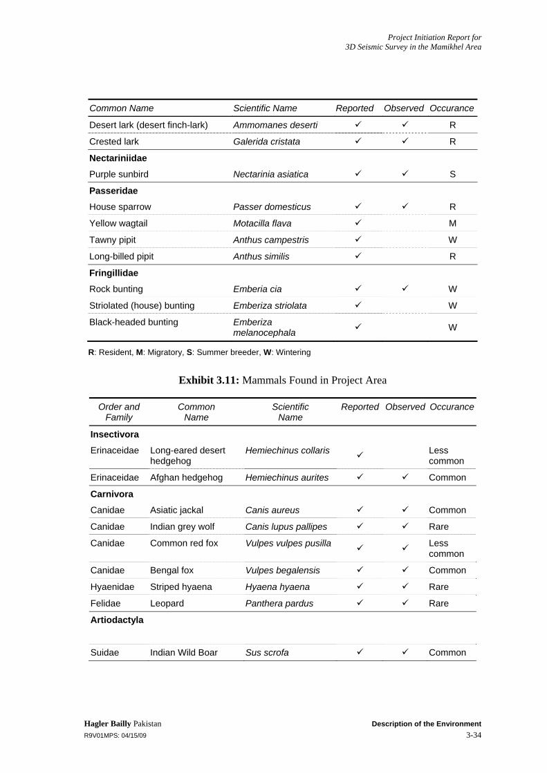
Project Initiation Report for 3D Seismic Survey in the Mamikhel Area
Hagler Bailly Pakistan Description of the Environment R9V01MPS: 04/15/09 3-34
Common Name Scientific Name Reported Observed Occurance
Desert lark (desert finch-lark) Ammomanes deserti R
Crested lark Galerida cristata R
Nectariniidae
Purple sunbird Nectarinia asiatica S
Passeridae
House sparrow Passer domesticus R
Yellow wagtail Motacilla flava M
Tawny pipit Anthus campestris W
Long-billed pipit Anthus similis R
Fringillidae
Rock bunting Emberia cia W
Striolated (house) bunting Emberiza striolata W
Black-headed bunting Emberiza melanocephala W
R: Resident, M: Migratory, S: Summer breeder, W: Wintering
Exhibit 3.11: Mammals Found in Project Area
Order and Family
Common Name
Scientific Name
Reported Observed Occurance
Insectivora
Erinaceidae Long-eared desert hedgehog
Hemiechinus collaris Less common
Erinaceidae Afghan hedgehog Hemiechinus aurites Common
Carnivora
Canidae Asiatic jackal Canis aureus Common
Canidae Indian grey wolf Canis lupus pallipes Rare
Canidae Common red fox Vulpes vulpes pusilla Less common
Canidae Bengal fox Vulpes begalensis Common
Hyaenidae Striped hyaena Hyaena hyaena Rare
Felidae Leopard Panthera pardus Rare
Artiodactyla
Suidae Indian Wild Boar Sus scrofa Common
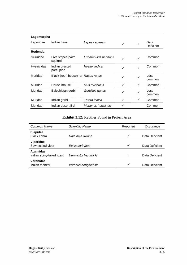
Project Initiation Report for 3D Seismic Survey in the Mamikhel Area
Hagler Bailly Pakistan Description of the Environment R9V01MPS: 04/15/09 3-35
Lagomorpha
Leporidae Indian hare Lepus capensis Data Deficient
Rodentia
Sciuridae Five striped palm squirrel
Funambulus pennanti Common
Hystricidae Indian crested porcupine
Hystrix indica Common
Muridae Black (roof, house) rat Rattus rattus Less common
Muridae House mouse Mus musculus Common
Muridae Balochistan gerbil Gerbillus nanus Less common
Muridae Indian gerbil Tatera indica Common
Muridae Indian desert jird Meriones hurrianae Common
Exhibit 3.12: Reptiles Found in Project Area
Common Name Scientific Name Reported Occurance
Elapidae Black cobra Naja naja oxiana Data Deficient
Viperidae Saw-scaled viper Echis carinatus Data Deficient
Agamidae Indian spiny-tailed lizard Uromastix hardwicki Data Deficient
Varanidae Indian monitor Varanus bengalensis Data Deficient
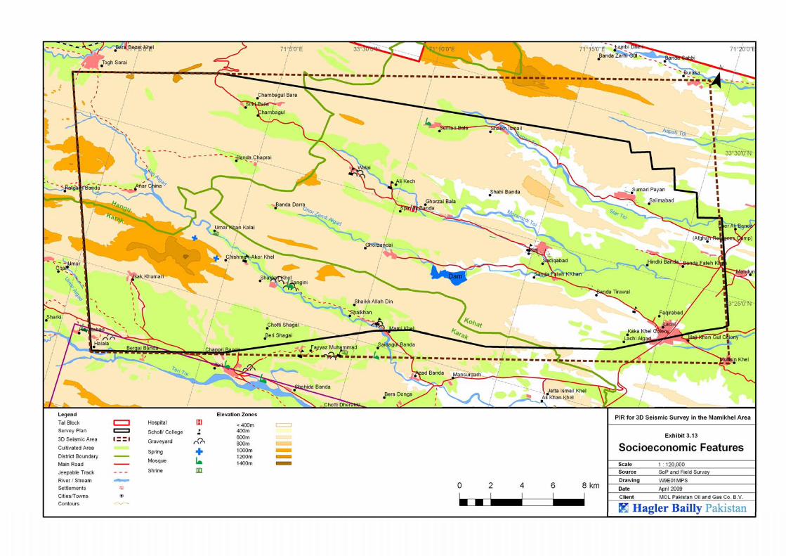
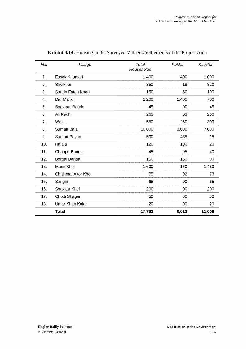
Project Initiation Report for 3D Seismic Survey in the Mamikhel Area
Hagler Bailly Pakistan Description of the Environment R9V01MPS: 04/15/09 3-37
Exhibit 3.14: Housing in the Surveyed Villages/Settlements of the Project Area
No. Village Total Households
Pukka Kaccha
1. Essak Khumari 1,400 400 1,000
2. Sheikhan 350 18 320
3. Sanda Fateh Khan 150 50 100
4. Dar Malik 2,200 1,400 700
5. Spelanai Banda 45 00 45
6. Ali Kech 263 03 260
7. Walai 550 250 300
8. Sumari Bala 10,000 3,000 7,000
9. Sumari Payan 500 485 15
10. Halala 120 100 20
11. Chappri.Banda 45 05 40
12. Bergai Banda 150 150 00
13. Mami Khel 1,600 150 1,450
14. Chishmai Akor Khel 75 02 73
15. Sangni 65 00 65
16. Shakkar Khel 200 00 200
17. Chotti Shagai 50 00 50
18. Umar Khan Kalai 20 00 20
Total 17,783 6,013 11,658

Project Initiation Report for 3D Seismic Survey in the Mamikhel Area
Hagler Bailly Pakistan Description of the Environment R9V01MPS: 04/15/09 3-38
Exhibit 3.15: Literacy and Enrollment in the Surveyed Villages/Settlements
No. Village/Settlement No. of Adult Literate Enrollment
Male Female Boys Girls
1. Essak Khumari 110 12 1400 380
2. Sheikhan 90 27 280 65
3. Sanda Fateh Khan 280 230 150 135
4. Dar Malik 335 280 605 00
5. Spelanai Banda 85 00 60 20
6. Ali Kech 45 23 190 60
7. Walai 30 00 90 30
8. Sumari Bala 400 00 350 00
9. Sumari Payan 785 90 500 70
10. Halala 03 00 90 40
11. Chappri.Banda 125 17 115 20
12. Bergai Banda 120 00 130 120
13. Mami Khel 560 50 480 00
14. Chishmai Akor Khel 33 01 40 14
15. Sangni 60 00 220 20
16. Shakkar Khel 90 00 220 18
17. Chotti Shagai 00 00 00 00
18. Umar Khan Kalai 16 00 00 00
Total 3,167 730 4,920 992

Project Initiation Report for 3D Seismic Survey in the Mamikhel Area
Hagler Bailly Pakistan Description of the Environment R9V01MPS: 04/15/09 3-39
Exhibit 3.16: Schools in the Surveyed Villages/Settlements
No. Village/Settlement Primary Boys School
Primary Girls School
Midium/High Boys School
Midium/High Girls School
1. Essak Khumari Yes Yes Yes Yes
2. Sheikhan Yes(public) Yes(public) No No
3. Sanda Fateh Khan Yes Yes No No
4. Dar Malik Yes No Yes No
5. Spelanai Banda Yes Yes No No
6. Ali Kech Yes Yes Yes(Middle) Yes(Middle)
7. Walai Yes Yes No No
8. Sumari Bala Yes No Yes(Middle) No
9. Sumari Payan Yes Yes No No
10. Halala Yes Yes No No
11. Chappri.Banda Yes Yes No No
12. Bergai Banda Yes Yes No No
13. Mami Khel Yes No Yes(Middle) No
14. Chishmai Akor Khel Yes Yes No No
15. Sangni Yes Yes Yes(Middle) No
16. Shakkar Khel Yes Yes Yes(Middle) No
17. Chotti Shagai No No No No
18. Umar Khan Kalai No No No No

Project Initiation Report for 3D Seismic Survey in the Mamikhel Area
Hagler Bailly Pakistan Description of the Environment R9V01MPS: 04/15/09 3-40
Exhibit 3.17: Health Facilities in the Surveyed Villages/Settlements
No. Village/Settlement Dispensary BHU Private Clinics Daiee Immunization
1. Essak Khumari No No Yes Yes Yes
2. Sheikhan No No No No Yes
3. Sanda Fateh Khan No No No No Yes
4. Dar Malik Yes No No No Yes
5. Spelanai Banda No Yes No Yes Yes
6. Ali Kech No Yes Yes(Hakeem) Yes Yes
7. Walai No No No No Yes
8. Sumari Bala No No No No Yes
9. Sumari Payan No Yes No No Yes
10. Halala No No Yes No Yes
11. Chappri.Banda No No No No Yes
12. Bergai Banda No No Yes No Yes
13. Mami Khel No No No No Yes
14. Chishmai Akor Khel No No No No Yes
15. Sangni No No No No Yes
16. Shakkar Khel No No No No Yes
17. Chotti Shagai No No No No Yes
18. Umar Khan Kalai No No No No Yes
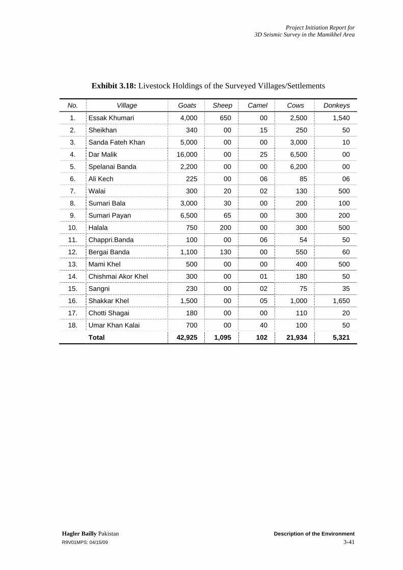
Project Initiation Report for 3D Seismic Survey in the Mamikhel Area
Hagler Bailly Pakistan Description of the Environment R9V01MPS: 04/15/09 3-41
Exhibit 3.18: Livestock Holdings of the Surveyed Villages/Settlements
No. Village Goats Sheep Camel Cows Donkeys
1. Essak Khumari 4,000 650 00 2,500 1,540
2. Sheikhan 340 00 15 250 50
3. Sanda Fateh Khan 5,000 00 00 3,000 10
4. Dar Malik 16,000 00 25 6,500 00
5. Spelanai Banda 2,200 00 00 6,200 00
6. Ali Kech 225 00 06 85 06
7. Walai 300 20 02 130 500
8. Sumari Bala 3,000 30 00 200 100
9. Sumari Payan 6,500 65 00 300 200
10. Halala 750 200 00 300 500
11. Chappri.Banda 100 00 06 54 50
12. Bergai Banda 1,100 130 00 550 60
13. Mami Khel 500 00 00 400 500
14. Chishmai Akor Khel 300 00 01 180 50
15. Sangni 230 00 02 75 35
16. Shakkar Khel 1,500 00 05 1,000 1,650
17. Chotti Shagai 180 00 00 110 20
18. Umar Khan Kalai 700 00 40 100 50
Total 42,925 1,095 102 21,934 5,321
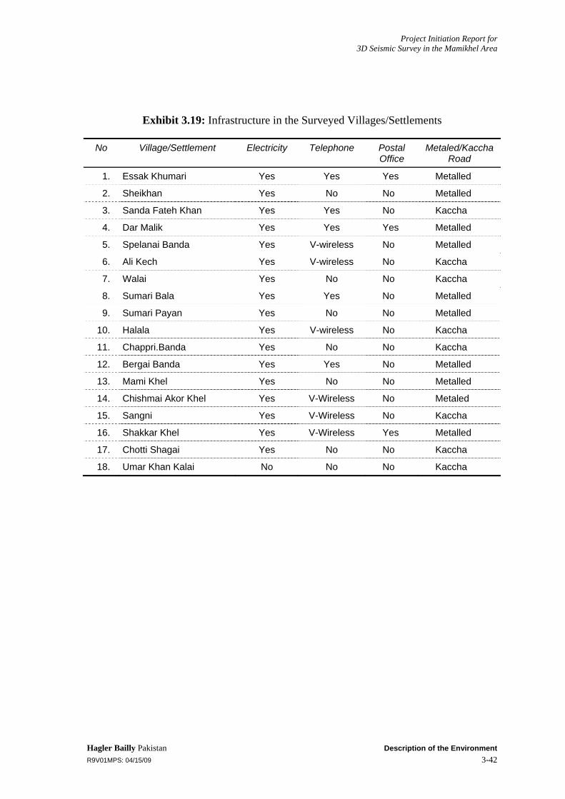
Project Initiation Report for 3D Seismic Survey in the Mamikhel Area
Hagler Bailly Pakistan Description of the Environment R9V01MPS: 04/15/09 3-42
Exhibit 3.19: Infrastructure in the Surveyed Villages/Settlements
No Village/Settlement Electricity Telephone Postal Office
Metaled/Kaccha Road
1. Essak Khumari Yes Yes Yes Metalled
2. Sheikhan Yes No No Metalled
3. Sanda Fateh Khan Yes Yes No Kaccha
4. Dar Malik Yes Yes Yes Metalled
5. Spelanai Banda Yes V-wireless No Metalled
6. Ali Kech Yes V-wireless No Kaccha
7. Walai Yes No No Kaccha
8. Sumari Bala Yes Yes No Metalled
9. Sumari Payan Yes No No Metalled
10. Halala Yes V-wireless No Kaccha
11. Chappri.Banda Yes No No Kaccha
12. Bergai Banda Yes Yes No Metalled
13. Mami Khel Yes No No Metalled
14. Chishmai Akor Khel Yes V-Wireless No Metaled
15. Sangni Yes V-Wireless No Kaccha
16. Shakkar Khel Yes V-Wireless Yes Metalled
17. Chotti Shagai Yes No No Kaccha
18. Umar Khan Kalai No No No Kaccha

Project Initiation Report for 3D Seismic Survey in the Mamikhel Area
Hagler Bailly Pakistan Description of the Environment R9V01MPS: 04/15/09 3-43
Exhibit 3.20: List of Respondents in the Study Area
S.No. Respondent’s Name Village
1. Raza Abbas Khan(Nazim u/c Teri) Essak Khumari
2. Zarnab Gul Sheikhan
3. Mumtaz Zada Sanda Fateh Khan
4. Sanaullah Khan Dar Malik
5. Ayub Khan(Ex Army Person) Spelanai Banda
6. Abdur Rashid(School Teacher) Ali Kech
7. Omar Ali Walai
8. Muhaamad Rafiq Sumari Bala
9. Sameen Gul(School Teacher) Sumari Payan
10. Ihsanudin Halala
11. Hasan Badshah Chappari Banda
12. Khan Saib Gul Bergai Banda
13. Ahmad Din Mamikhel
14. Saeen Mamikhel
15. Habib Khan(School Teacher) Chashmai Akor Khel
16. Raeed Gul Sangini
17. Abu Bakr Shakkar khel
18. Yasin Khan Shakkar khel
19. Akhtar Hussain Chota Shagai
20. Naeem Shah Umar Khan Kalai,
Project Initiation Report for 3D Seismic Survey in the Mamikhel Area
Hagler Bailly Pakistan Conclusion R9V01MPS: 04/15/09 4-1
4. Conclusion
The proposed project activities include construction of camps and access tracks for camps, seismic surveys, and preparation of existing tracks. On the basis of a review of the proposed project activities and environmental survey of the project area, it is concluded that the environmental mitigation proposed in the EIA are sufficient to address the environmental concerns associated with the proposed project. An Environmental Management Plan (EMP) has been developed to implement the mitigation measures identified in the EIA. The EMP, included as Part B of this document, defines the mechanism through which the proposed measures will be implemented; defines the responsibilities of the project sponsors and contractors; develops a system of checks and balances; proposes actions that are to be taken by each role player; and lays down the required monitoring, documentation, communication, and reporting procedures.
MOL Pakistan will hire a third party independent environmental monitoring consultant for the environmental monitoring of the proposed survey plan (Please see Part B of the report for details).

Part B: Environmental Management Plan

Project Initiation Report for 3D Seismic Survey in the Mamikhel Area
Hagler Bailly Pakistan Introduction to the EMP R9V01MPS: 04/15/09 5-1
5. Introduction to the EMP
The EMP, developed to effectively implement the mitigation measures identified in the EIA, is presented in this report. The EMP satisfies the requirements of the Pakistan Environmental Protection Agency Initial Environmental Examination and Environmental Impact Assessment Review Procedures, 2000.
5.1 Purpose and Objectives of the Environmental Management Plan The EMP provides a delivery mechanism to address the adverse environmental impact of a project during the seismic survey activities, to enhance project benefits, and to introduce standards of good practice to be adopted for all project works.
The primary objectives of the EMP are to:
Facilitate the implementation of the mitigation measures identified in the EIA
Define the responsibilities of the project proponents, contractors, and environmental monitors, and provide a means of effectively communicating environmental issues among them
Define a monitoring mechanism and identify monitoring parameters in order to:
Ensure the complete implementation of all mitigation measures
Ensure the effectiveness of the mitigation measures
Ensure that the operators and their contractors meet all environment-related legal obligations
Provide a mechanism for taking timely action in the face of unanticipated environmental situations
Identify training requirements at various levels
Ensure that MOL Pakistan’s corporate policy on environment is followed.
The environmental management plan is designed as a standalone document to make it convenient for field use.
5.2 Components of the EMP The EMP consists of the following:
Organizational structure; roles and responsibilities
Mitigation plan
Environmental monitoring
Communication and documentation
Change management

Project Initiation Report for 3D Seismic Survey in the Mamikhel Area
Hagler Bailly Pakistan Introduction to the EMP R9V01MPS: 04/15/09 5-2
Environmental and local-sensitivities training
Waste disposal plan
Restoration and rehabilitation
The components listed above are discussed in detail in Sections 6 to 13 of the current document.

Project Initiation Report for 3D Seismic Survey in the Mamikhel Area
Hagler Bailly Pakistan Organizational Structure and Responsibilities R9V01MPS: 04/15/09 6-1
6. Organizational Structure and Responsibilities
This section provides an organizational structure for environmental management during the proposed project activities and defines the roles and responsibilities of the various role players for the duration of the project.
6.1 Management Approach The organizational roles and responsibilities are summarized below:
MOL Pakistan: The overall responsibility for compliance with the environmental management plan rests with the project proponent (MOL Pakistan).
Seismic Contractor: The seismic contractor will carry out field activities for acquisition of seismic data. The seismic contractor has liabilities under the environmental laws of the country, and under the contract with MOL Pakistan.
Independent Monitoring Consultant (IMC): An independent team of consultants hired by MOL Pakistan will monitor the environmental performance of the seismic contractor and the environmental impacts of project activities, as well as advise MOL Pakistan on changes in unanticipated situations
A certain degree of redundancy is inevitable across all management levels, but this is in order to ensure that compliance with the environmental management plan is crosschecked. Other essential features of the EMP are:
MOL Pakistan will appoint a Field Representative/QC Officer to accompany the contractors throughout the seismic program.
MOL Pakistan will ensure that all contracts it executes with sub-contractors comply with positive environmental sensibilities and MOL’s HSE Policy.
To ensure commitment, the seismic contractors will be required to appoint a dedicated HSE officer.
All environmental personnel will be authorized to implement the policies and requirements of the environmental management plan.
MOL Pakistan will cooperate with regulatory agencies, such as the NWFP EPA and the Wildlife Department, and other stakeholders who may want to send their own teams to monitor the activities of survey teams during the proposed program.
6.2 Organizational Structure and Responsibilities The organizational structure for of the environmental management plan is shown in Exhibit 6.1, and its salient features described below.

Project Initiation Report for 3D Seismic Survey in the Mamikhel Area
Hagler Bailly Pakistan Organizational Structure and Responsibilities R9V01MPS: 04/15/09 6-2
Primary responsibilities:
The primary responsibilities of the project proponents (MOL Pakistan) and the contractors for the project activities will be assumed by their respective highest-ranking officers in the country.
MOL Pakistan’s Managing Director will be responsible, on the company’s behalf, for the environmental performance of the project. The Managing Director will be assisted by the HSE Manager.
On behalf of the seismic contractor, the main responsibility for all matters pertaining to the environment will be that of the General Manager of the contractor.
Field Management and Quality Control:
Conducting the seismic data acquisition operation in an environmentally sound manner will be the responsibility of the Party Chief of the Seismic Contractor.
The Field Representative/QC Officer of MOL Pakistan will be responsible for environmental soundness of all field operations.
On-the-Job Supervision and Monitoring:
The proposed project (seismic survey) contractor will also appoint a dedicated HSE Officer, who will be responsible for ensuring compliance with the EMP during the seismic operation. He will also be responsible for communicating with and training the seismic and camp crews in all aspects of the EMP.
MOL Pakistan will appoint a field Environment Coordinator who will be responsible for all environmental issues and for implementing the EMP
If any monitoring teams from government departments visit the field during the field operation, the MOL Pakistan HSE representative will be responsible for coordinating with them.
6.3 Appointment of IMC MOL Pakistan will appoint an environmental consultant to independently monitor
compliance with the EIA’s conditions and the impact of the project on the environment.
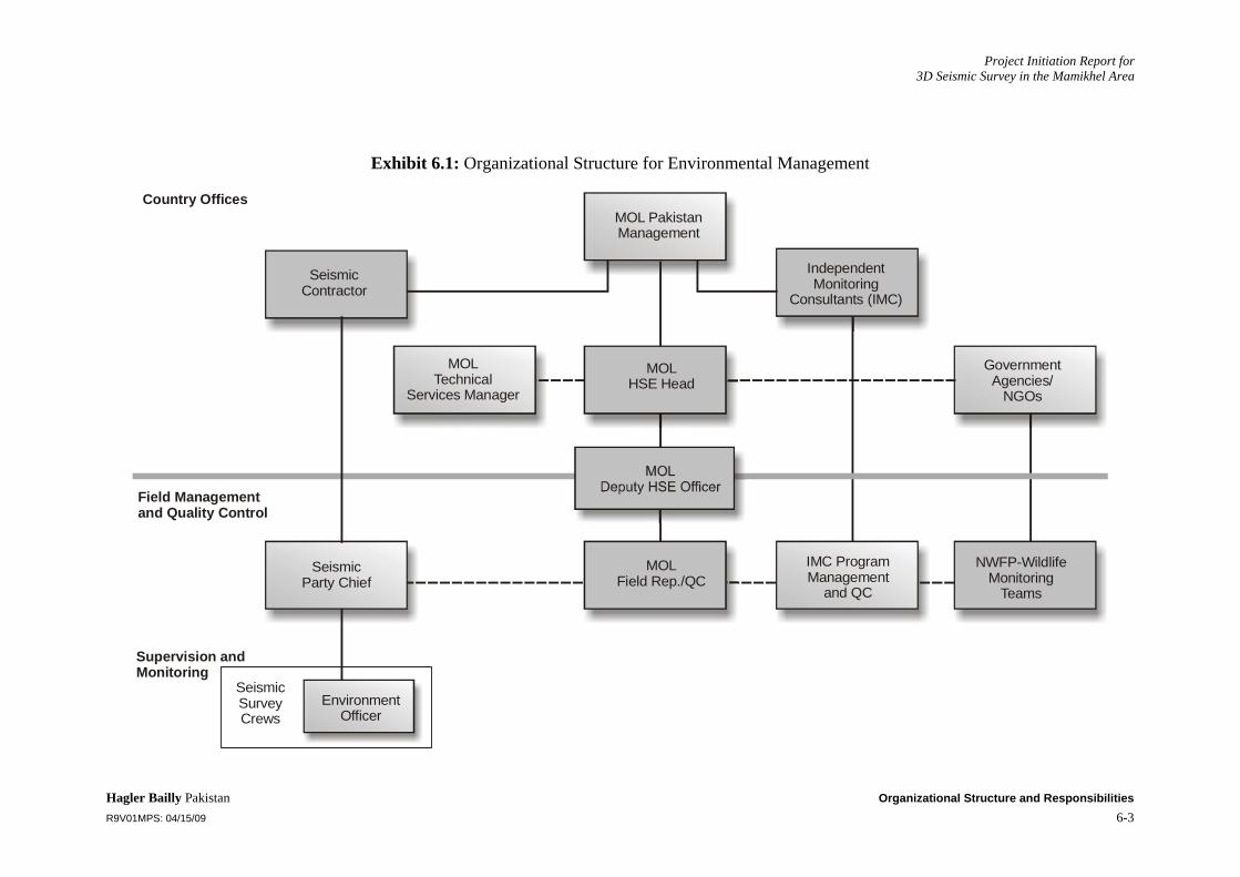
Project Initiation Report for 3D Seismic Survey in the Mamikhel Area
Hagler Bailly Pakistan Organizational Structure and Responsibilities R9V01MPS: 04/15/09 6-3
Exhibit 6.1: Organizational Structure for Environmental Management
MOL PakistanManagement
Seismic Contractor
MOLTechnical
Services Manager
Country Offices
Field Managementand Quality Control
Supervision andMonitoring
Seismic Party Chief
SeismicSurveyCrews
EnvironmentOfficer
NWFP-WildlifeMonitoring
Teams
IMC ProgramManagement
and QC
GovernmentAgencies/
NGOs
IndependentMonitoring
Consultants (IMC)
MOLField Rep./QC
MOLHSE Head

Project Initiation Report for 3D Seismic Survey in the Mamikhel Area
Hagler Bailly Pakistan Mitigation Plan R9V01MPS: 04/15/09 7-1
7. Mitigation Plan
The mitigation plan is a key component of the EMP. It ensures that the project is designed, constructed, maintained, and implemented in the manner described in the EIA. In Exhibit 7.1, the specific design requirements are listed. The responsibilities of various role players in the environmental management of the project are shown in Exhibit 7.2. The mitigation plan for the activities proposed for the seismic survey plan is presented in Exhibit 7.3. It lists all the project components and their associated mitigation measures identified in the EIA. For each component, the following information is presented in the plan:
A comprehensive listing of mitigation measures (actions)
The person(s) responsible for ensuring the full implementation of the action
The person(s) responsible for monitoring the action
The parameters to be monitored in order to ensure the effective implementation of the action
A time scale for the implementation of the action to ensure that the objectives of mitigation are met.
Exhibit 7.1: Specific Design Requirements
Access Track Width of prepared surface should normally be 3 m (where applicable).
Width of access track at bends, stream crossings, and vehicle passing points should not be more than 5 m
Track shoulder (the disturbed area on the sides) should not be more than 0.75 m on each side.
Hillsides should be cut to avoid erosion.
The slopes of the stream bank at the crossings should be compacted.
Campsite Effective drainage should be installed around each structure
Septic tanks and sumps should be appropriate sized taking into account the expected flow and the properties of the soil with provisions to prevent entry of rainwater into it.
Fuel tanks should be labeled with the contents and capacity of the tanks.
An impervious base should line fuels, oils, and chemicals storage areas and the area should be dyked.
Illumination on the campsite should be minimized using appropriate shades, the security lights should be directed within a corridor of 200 m from the fence.
The campsites should be fenced off.

Project Initiation Report for 3D Seismic Survey in the Mamikhel Area
Hagler Bailly Pakistan Mitigation Plan R9V01MPS: 04/15/09 7-2
Exhibit 7.2: Responsibilities for Environmental Management
Organization Designation Responsibilities Operating Documents
MOL Pakistan Managing Director
Fulfill MOL Pakistan’s obligations as laid out in its contract with the Government of Pakistan (GoP) Ensure that the proposed project is carried out according to satisfactory HSE and technical standards
Contract with GoP Relevant environmental laws EIA for the Project, and conditions of approvals (if any) from NWFP EPA MOL Pakistan’s HSE policy
HSE Manager
Ensure that the entire project is conducted in an environment-friendly manner. Ensure compliance with all relevant environmental laws. Assist the Managing Director in fulfilling MOL Pakistan’s environmental responsibilities and keep him updated on environmental matters relating to the operation Review environmental documentation received from the field, and ensure implementation of corrective measures, if any Coordinate with other stakeholders, including NWFP Wildlife Department and NWFP EPA.
Contract with GoP Relevant environmental laws EIA for the Project, and conditions of approvals (if any) from NWFP EPA MOL Pakistan HSE policy Environmental documentation received from the field
HSE Officer/Advisor
Ensure that mitigation measures included in the EIA and EMP are fully implemented Ensure compliance of the EMP, EIA and NWFP EPA’s conditions for approval (if any) Ensure compliance with MOL Pakistan’s HSE policy Report to MOL Pakistan’s HSEQ Manager
EIA for the Project, and conditions of approvals (if any) from NWFP EPA MOL Pakistan’s HSE policy
Contractors Country Manager Manage operations of field crew Contract with MOL Pakistan Site Manager Manage field activities and crews
Liaise with MOL Pakistan’s Site Representative and report to the Contractor’s country manager
Contract with MOL Pakistan EIA for the Project, and conditions of approvals (if any) from NWFP EPA MOL Pakistan’s and Contractor’s HSE policies
HSE Officer Manage and implement environmental mitigation measures, as well as MOL Pakistan’s and Contractor’s HSE policies Liaise with HSE Officer
EIA for the Project, and conditions of approvals (if any) from NWFP EPA MOL Pakistan’s and Contractor’s HSE policies
Government Departments (NWFP Wildlife Department, NWFP EPA)
Monitoring teams Conduct site visits to ensure compliance with EIA and EMP EIA for the Project, and conditions of approvals (if any) from NWFP EPA

Project Initiation Report for 3D Seismic Survey in the Mamikhel Area
Hagler Bailly Pakistan Mitigation Plan R9V01MPS: 04/15/09 7-3
Exhibit 7.3: Environmental Mitigation Plan
No. Project Component or Impact Action
Responsibility
1. Site selection 1.01 Ensure that campsites are at a safe distance from any groundwater wells, hand pump or any water resource
Seismic contractor
1.02 Ensure that the access road, and campsites, are selected at a safe distance from any settlements
Seismic contractor
1.03 Ensure that campsites are established in existing clearing, generally flat area. Seismic contractor
1.04 Ensure that environmental offsets are maintained Seismic contractor/MOL Pakistan
2. Land acquisition 2.01 Ensure determination of land price in consultation with affected community and local tribal leadership. The contract will be signed before land acquisition, compensation will be paid based on property right system prevailing in the area.
Seismic contractor/MOL Pakistan
2.02 Ensure execution of agreements with the affected people for land acquisition Seismic contractor/MOL Pakistan
2.03 Ensure payment of full compensation within 30 days of the execution of work Seismic contractor/MOL Pakistan
2.04 Ensure maintaining liaison with the community and leadership by establishing village committies
Seismic contractor/MOL Pakistan
2.05 Ensure that the site boundaries are clearly marked Seismic contractor/MOL Pakistan
2.06 Ensure that land-take is restricted to specific limits Seismic contractor/MOL Pakistan
3. Construction activities 3.01 Ensure that the construction is undertaken with the design parameters given in the EIA and shown in Exhibit 7.1.
Seismic contractor
3.02 Ensure that photographs of the:
Campsites before breaking the ground
Access road at selected location, particularly close to environmental sensitivities (such as thick vegetation, steep ground, settlement, and stream beds) prior to start of construction
Seismic contractor/MOL Pakistan
3.03 Ensure that the selected area for campsites are demarcated before starting any earthwork
Seismic contractor
3.04 Ensure that the work corridor on the access track is marked before the start of construction close to any sensitive receptor (such as thick vegetation, steep ground, settlement, and stream beds)
Seismic contractor

Project Initiation Report for 3D Seismic Survey in the Mamikhel Area
Hagler Bailly Pakistan Mitigation Plan R9V01MPS: 04/15/09 7-4
No. Project Component or Impact Action
Responsibility
3.05 Ensure that the construction work is limited to the work corridor or the demarcated site and no activity, including parking of vehicles and construction machinery, is undertaken outside the area
Seismic contractor
3.06 Ensure that surplus soil is properly disposed of in a manner that does not disturb the natural drainage.
Seismic contractor
3.07 Ensure that cleared vegetation is not disposed off in a manner that may affect the natural drainage
Seismic contractor
Construction activities 3.08 Ensure that sound construction management practices are implemented so that: Dust emissions are minimized Damage to natural surface is minimized Streams are not blocked The footprint of the project is minimized
Unnecessary removal or damage to vegetation is avoided
Seismic contractor/MOL Pakistan
3.09 Ensure that the communities in the project area are informed at least two weeks ahead of the commencement of the construction activities
Seismic contractor/MOL Pakistan
3.11 Ensure that no construction is undertaken during the night Seismic contractor
3.12 Ensure that no machinery is left unattended in the field, particularly within 1 km of a settlement
Seismic contractor/MOL Pakistan
4. Seismic Operation 4.1 Ensure that photographic records of pre project condition are kept. Seismic contractor
4.2 Ensure that during the seismic operation an IMC monitor surveys the seismic area to identify sensitive receptor to enable maintenance of safe distance
Seismic contractor/MOL Pakistan
4.3 Ensure that seismic crew activity will be restricted within corridor along seismic line Seismic contractor
4.2 Ensure that clearing of dense patches of vegetation in the entire project area is avoided
Seismic contractor
Seismic Operation 4.3 Felling of trees is avoided Seismic contractor/MOL Pakistan
4.4 Ensure that root stock of vegetation removed is left in place to allow regeneration
Seismic contractor
4.5 Ensure maintenance of minimum distances. Seismic contractor

Project Initiation Report for 3D Seismic Survey in the Mamikhel Area
Hagler Bailly Pakistan Mitigation Plan R9V01MPS: 04/15/09 7-5
No. Project Component or Impact Action
Responsibility
4.6 Ensure that communities are informed before commencing seismic operation close to the settlements
Seismic contractor/MOL Pakistan
4.7 Ensure that permission is sought from community if receiver cable is passed through a village. The crew size is minimized during working in or close to villages
Seismic contractor/MOL Pakistan
4.8 Ensure that clearing of seismic does not block the natural drainage Seismic contractor
4.9 Shot holes will be shifted to avoid trees and shrubs wherever technically possible.
Seismic contractor
4.10 Ensure that no machinery is left unattended Seismic contractor
4.11 No activity will be undertaken at night timings. Seismic contractor
4.12 Ensure that safe distances are maintained from water resources and human settlements.
Seismic contractor/MOL Pakistan
Seismic Operation 4.13 Ensure that safe distances are maintained from graveyards or sites of cultural importance.
Seismic contractor/MOL Pakistan
4.14 Ensure that safe distances are maintained from burrows, dens, rare plant species and water bodies
Seismic contractor/MOL Pakistan
4.15 Ensure that prior to the seismic activity, the route of the seismic area is checked and documented by a IMC to avoid any damage to thick vegetation
Seismic contractor
4.16 Ensure that the seismic line-clearing corridor is minimized to the extent possible
Seismic contractor
4.17 Ensure that offsets to sensitive receptors are maintained Seismic contractor/MOL Pakistan
4.18 Ensure that clearing for the vibroseis is kept to the minimum required Seismic contractor
4.19 Corridor of seismic area clearing will not exceed 3 m in width Seismic contractor
5. Waste management
5.1 Ensure that no contaminated effluents are released to the environment Seismic contractor
5.2 Ensure that water from washing areas and kitchen is released in sumps Seismic contractor

Project Initiation Report for 3D Seismic Survey in the Mamikhel Area
Hagler Bailly Pakistan Mitigation Plan R9V01MPS: 04/15/09 7-6
No. Project Component or Impact Action
Responsibility
5.3 Ensure that the sumps remain covered all the time and measures are taken to prevent entry rainwater into them
Seismic contractor
Waste management 5.4 Ensure that the food waste is not left uncovered at night. Seismic contractor/MOL Pakistan
5.5 Ensure that the camp waste is disposed of in such a manner that animals are not attracted to it
Seismic contractor
5.6 Ensure that the quantity of waste burnt at one time is managed so as to minimize smoke emissions
Seismic contractor
5.7 Ensure that Soil contaminated by a minor spill (covering an area up to 0.1 m2 and 75 mm deep) is collected and disposed at the burn pit
Seismic contractor
5.8 Ensure that soil contaminated by moderate spills or leaks (up to 200 liters) is contained using shovels, sand, and soil; and the contaminated soil is removed from the site and disposed off as appropriate
Seismic contractor
5.9 Ensure that soil contaminated by a major spill (more than 200 liters, requiring initiation of emergency response procedures) is also removed from the site and given whatever special treatment required, such as bioremediation.
Seismic contractor
6. Handling of fuels, oils and chemicals
6.1 Ensure that fuels, oils, and other hazardous substances are handled and stored according to standard safety practices.
Seismic contractor
6.2 Ensure that fuels, oils, and chemicals are only stored in areas lined by an impervious base and containing dykes.
Seismic contractor
6.3 Ensure that measures, such as used of concrete base or drip pans, are taken to avoid spills during fuel and oil transfer operations.
Seismic contractor
6.4 Ensure that periodic inspection of fuels, oil and chemical storage areas are undertaken to check for any leakage, damage to impervious layers or spills.
Seismic contractor
Handling of fuels, oils and chemicals
6.5 Ensure that appropriate arrangements, including shovels, plastic bags and absorbent materials, are kept available near fuel and oil storage areas
Seismic contractor
7. Water sourcing utilization
7.1 Ensure that the tube well(s) installed for the project’s water needs is (are) not within 500 m from any existing dug or tube well(if applicable)
does (do) not tap the shallow unconfined aquifer
Seismic contractor/MOL Pakistan
7.2 Ensure that water is extracted only from the deep confined aquifer Seismic contractor
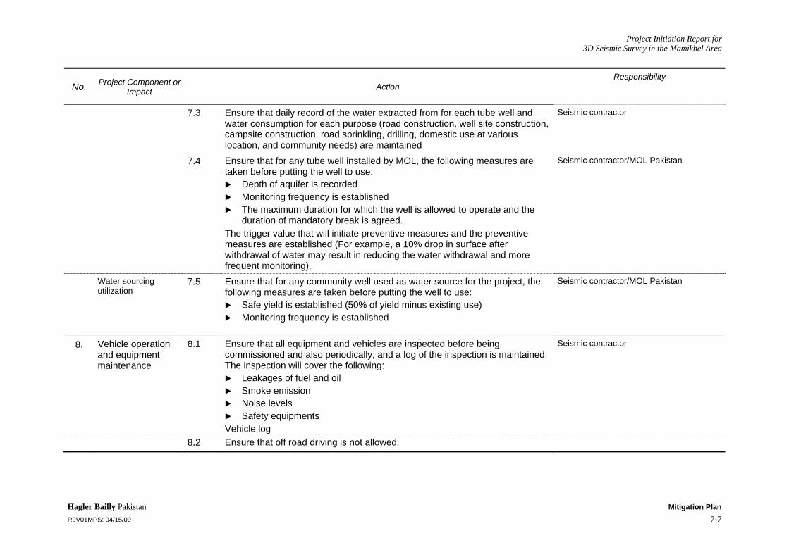
Project Initiation Report for 3D Seismic Survey in the Mamikhel Area
Hagler Bailly Pakistan Mitigation Plan R9V01MPS: 04/15/09 7-7
No. Project Component or Impact Action
Responsibility
7.3 Ensure that daily record of the water extracted from for each tube well and water consumption for each purpose (road construction, well site construction, campsite construction, road sprinkling, drilling, domestic use at various location, and community needs) are maintained
Seismic contractor
7.4 Ensure that for any tube well installed by MOL, the following measures are taken before putting the well to use:
Depth of aquifer is recorded Monitoring frequency is established The maximum duration for which the well is allowed to operate and the
duration of mandatory break is agreed. The trigger value that will initiate preventive measures and the preventive measures are established (For example, a 10% drop in surface after withdrawal of water may result in reducing the water withdrawal and more frequent monitoring).
Seismic contractor/MOL Pakistan
Water sourcing utilization
7.5 Ensure that for any community well used as water source for the project, the following measures are taken before putting the well to use:
Safe yield is established (50% of yield minus existing use) Monitoring frequency is established
Seismic contractor/MOL Pakistan
8. Vehicle operation and equipment maintenance
8.1 Ensure that all equipment and vehicles are inspected before being commissioned and also periodically; and a log of the inspection is maintained. The inspection will cover the following:
Leakages of fuel and oil Smoke emission Noise levels Safety equipments
Vehicle log
Seismic contractor
8.2 Ensure that off road driving is not allowed.
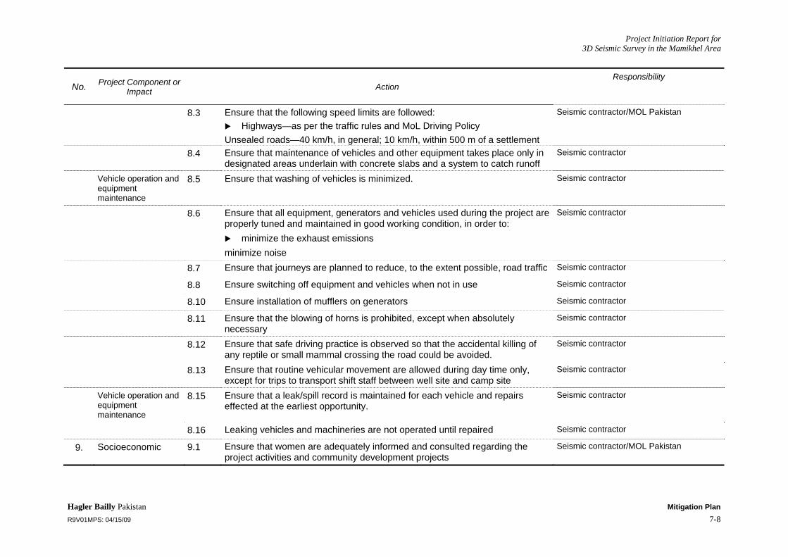
Project Initiation Report for 3D Seismic Survey in the Mamikhel Area
Hagler Bailly Pakistan Mitigation Plan R9V01MPS: 04/15/09 7-8
No. Project Component or Impact Action
Responsibility
8.3 Ensure that the following speed limits are followed: Highways—as per the traffic rules and MoL Driving Policy
Unsealed roads—40 km/h, in general; 10 km/h, within 500 m of a settlement
Seismic contractor/MOL Pakistan
8.4 Ensure that maintenance of vehicles and other equipment takes place only in designated areas underlain with concrete slabs and a system to catch runoff
Seismic contractor
Vehicle operation and equipment maintenance
8.5 Ensure that washing of vehicles is minimized. Seismic contractor
8.6 Ensure that all equipment, generators and vehicles used during the project are properly tuned and maintained in good working condition, in order to:
minimize the exhaust emissions minimize noise
Seismic contractor
8.7 Ensure that journeys are planned to reduce, to the extent possible, road traffic Seismic contractor
8.8 Ensure switching off equipment and vehicles when not in use Seismic contractor
8.10 Ensure installation of mufflers on generators Seismic contractor
8.11 Ensure that the blowing of horns is prohibited, except when absolutely necessary
Seismic contractor
8.12 Ensure that safe driving practice is observed so that the accidental killing of any reptile or small mammal crossing the road could be avoided.
Seismic contractor
8.13 Ensure that routine vehicular movement are allowed during day time only, except for trips to transport shift staff between well site and camp site
Seismic contractor
Vehicle operation and equipment maintenance
8.15 Ensure that a leak/spill record is maintained for each vehicle and repairs effected at the earliest opportunity.
Seismic contractor
8.16 Leaking vehicles and machineries are not operated until repaired Seismic contractor
9. Socioeconomic 9.1 Ensure that women are adequately informed and consulted regarding the project activities and community development projects
Seismic contractor/MOL Pakistan
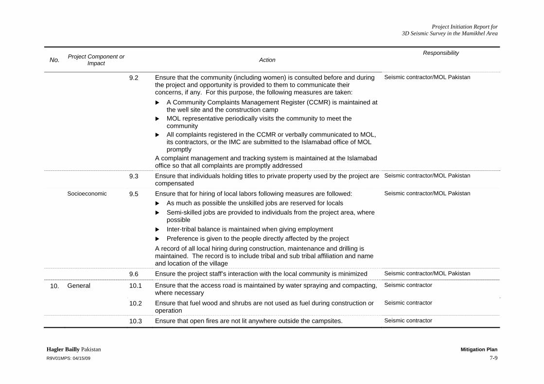
Project Initiation Report for 3D Seismic Survey in the Mamikhel Area
Hagler Bailly Pakistan Mitigation Plan R9V01MPS: 04/15/09 7-9
No. Project Component or Impact Action
Responsibility
9.2 Ensure that the community (including women) is consulted before and during the project and opportunity is provided to them to communicate their concerns, if any. For this purpose, the following measures are taken:
A Community Complaints Management Register (CCMR) is maintained at the well site and the construction camp
MOL representative periodically visits the community to meet the community
All complaints registered in the CCMR or verbally communicated to MOL, its contractors, or the IMC are submitted to the Islamabad office of MOL promptly
A complaint management and tracking system is maintained at the Islamabad office so that all complaints are promptly addressed
Seismic contractor/MOL Pakistan
9.3 Ensure that individuals holding titles to private property used by the project are compensated
Seismic contractor/MOL Pakistan
Socioeconomic 9.5 Ensure that for hiring of local labors following measures are followed: As much as possible the unskilled jobs are reserved for locals Semi-skilled jobs are provided to individuals from the project area, where
possible Inter-tribal balance is maintained when giving employment Preference is given to the people directly affected by the project
A record of all local hiring during construction, maintenance and drilling is maintained. The record is to include tribal and sub tribal affiliation and name and location of the village
Seismic contractor/MOL Pakistan
9.6 Ensure the project staff’s interaction with the local community is minimized Seismic contractor/MOL Pakistan
10. General 10.1 Ensure that the access road is maintained by water spraying and compacting, where necessary
Seismic contractor
10.2 Ensure that fuel wood and shrubs are not used as fuel during construction or operation
Seismic contractor
10.3 Ensure that open fires are not lit anywhere outside the campsites. Seismic contractor
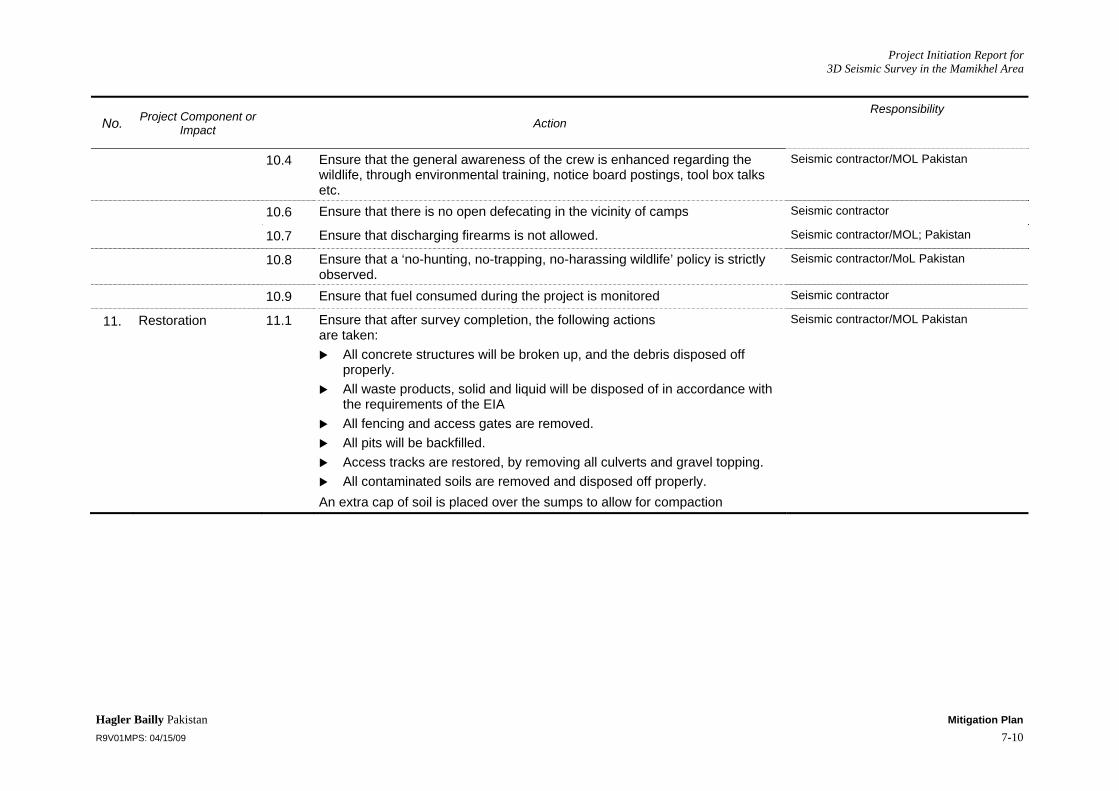
Project Initiation Report for 3D Seismic Survey in the Mamikhel Area
Hagler Bailly Pakistan Mitigation Plan R9V01MPS: 04/15/09 7-10
No. Project Component or Impact Action
Responsibility
10.4 Ensure that the general awareness of the crew is enhanced regarding the wildlife, through environmental training, notice board postings, tool box talks etc.
Seismic contractor/MOL Pakistan
10.6 Ensure that there is no open defecating in the vicinity of camps Seismic contractor
10.7 Ensure that discharging firearms is not allowed. Seismic contractor/MOL; Pakistan
10.8 Ensure that a ‘no-hunting, no-trapping, no-harassing wildlife’ policy is strictly observed.
Seismic contractor/MoL Pakistan
10.9 Ensure that fuel consumed during the project is monitored Seismic contractor
11. Restoration 11.1 Ensure that after survey completion, the following actions are taken:
All concrete structures will be broken up, and the debris disposed off properly.
All waste products, solid and liquid will be disposed of in accordance with the requirements of the EIA
All fencing and access gates are removed. All pits will be backfilled. Access tracks are restored, by removing all culverts and gravel topping. All contaminated soils are removed and disposed off properly.
An extra cap of soil is placed over the sumps to allow for compaction
Seismic contractor/MOL Pakistan

Project Initiation Report for 3D Seismic Survey in the Mamikhel Area
Hagler Bailly Pakistan Environmental Monitoring R9V01MPS: 04/15/09 8-1
8. Environmental Monitoring
Success of any EMP depends upon effective monitoring. Through this process, strict adherence to the environmental control measures and disciplines will be ensured. It will also provide a record of all incidents of environmental significance and related actions and mitigation measures. This process will also facilitate the evaluation of the effectiveness of the control measures and identification of additional mitigation measures needed to further reduce the environmental impacts.
8.1 Monitoring Approach The following monitoring will be conducted during the seismic survey:
Self-monitoring by the seismic contractor: This will be designed to ensure compliance with control measures.
Activity monitoring by the Independent Monitoring Consultant: Random checks on activities of the seismic crew to verify adherence to the control measures.
Post-survey site inspections: These inspections will be carried out to assess impacts of the project on the environment during and after completion of the survey.
Wildlife and vegetation monitoring: This type of monitoring will be designed to assess the effects of the project activities on key wildlife and vegetation species and water resources of the project area.
Various components of the monitoring and the monitoring sequence are discussed below.
8.2 Monitoring by Seismic Contractor All activities during the seismic survey will be closely monitored from an environmental perspective. The primary objective of this phase of the monitoring will be to ensure that the environmental control measures are strictly followed. For this purpose, the seismic contractor will be required to observe the following routine. Various checklists for environmental monitoring will be filled in (See Exhibits 8.1-8.9). The checklists are included as:
Checklist for Camp Siting Checklist for Camp Operation Checklist for Road Travel Checklist for Seismic Survey Lines Checklist for Recording Checklist for Vehicles Checklist for Fuels, Oils, and Chemicals Checklist for Restoration and Rehabilitation General Checklist.
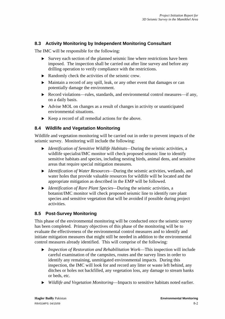
Project Initiation Report for 3D Seismic Survey in the Mamikhel Area
Hagler Bailly Pakistan Environmental Monitoring R9V01MPS: 04/15/09 8-2
8.3 Activity Monitoring by Independent Monitoring Consultant The IMC will be responsible for the following:
Survey each section of the planned seismic line where restrictions have been imposed. The inspection shall be carried out after line survey and before any drilling operation to verify compliance with the restrictions.
Randomly check the activities of the seismic crew. Maintain a record of any spill, leak, or any other event that damages or can
potentially damage the environment. Record violations—rules, standards, and environmental control measures—if any,
on a daily basis. Advise MOL on changes as a result of changes in activity or unanticipated
environmental situations. Keep a record of all remedial actions for the above.
8.4 Wildlife and Vegetation Monitoring Wildlife and vegetation monitoring will be carried out in order to prevent impacts of the seismic survey. Monitoring will include the following:
Identification of Sensitive Wildlife Habitats—During the seismic activities, a wildlife specialist/IMC monitor will check proposed seismic line to identify sensitive habitats and species, including nesting birds, animal dens, and sensitive areas that require special mitigation measures.
Identification of Water Resources—During the seismic activities, wetlands, and water holes that provide valuable resources for wildlife will be located and the appropriate mitigation as described in the EMP will be followed.
Identification of Rare Plant Species—During the seismic activities, a botanist/IMC monitor will check proposed seismic line to identify rare plant species and sensitive vegetation that will be avoided if possible during project activities.
8.5 Post-Survey Monitoring This phase of the environmental monitoring will be conducted once the seismic survey has been completed. Primary objectives of this phase of the monitoring will be to evaluate the effectiveness of the environmental control measures and to identify and initiate mitigation measures that might still be needed in addition to the environmental control measures already identified. This will comprise of the following:
Inspection of Restoration and Rehabilitation Work—This inspection will include careful examination of the campsites, routes and the survey lines in order to identify any remaining, unmitigated environmental impacts. During this inspection, the IMC will look for and record any litter or waste left behind, any ditches or holes not backfilled, any vegetation loss, any damage to stream banks or beds, etc.
Wildlife and Vegetation Monitoring—Impacts to sensitive habitats noted earlier.
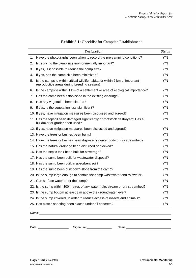
Project Initiation Report for 3D Seismic Survey in the Mamikhel Area
Hagler Bailly Pakistan Environmental Monitoring R9V01MPS: 04/15/09 8-3
Exhibit 8.1: Checklist for Campsite Establishment
Destcription Status
1. Have the photographs been taken to record the pre-camping conditions? Y/N
2. Is reducing the camp size environmentally important? Y/N
3. If yes, is it possible to reduce the camp size? Y/N
4. If yes, has the camp size been minimized? Y/N
5. Is the campsite within critical wildlife habitat or within 2 km of important reproductive areas during breeding season?
Y/N
6. Is the campsite within 1 km of a settlement or area of ecological importance? Y/N
7. Has the camp been established in the existing clearings? Y/N
8. Has any vegetation been cleared? Y/N
9. If yes, is the vegetation loss significant? Y/N
10. If yes, have mitigation measures been discussed and agreed? Y/N
11. Has the topsoil been damaged significantly or rootstock destroyed? Has a bulldozer or grader been used?
Y/N
12. If yes, have mitigation measures been discussed and agreed? Y/N
13. Have the trees or bushes been burnt? Y/N
14. Have the trees or bushes been disposed in water body or dry streambed? Y/N
15. Has the natural drainage been disturbed or blocked? Y/N
16. Has the septic tank been built for sewerage? Y/N
17. Has the sump been built for wastewater disposal? Y/N
18. Has the sump been built in absorbent soil? Y/N
19. Has the sump been built down-slope from the camp? Y/N
20. Is the sump large enough to contain the camp wastewater and rainwater? Y/N
21. Can surface water enter the sump? Y/N
22. Is the sump within 300 metres of any water hole, stream or dry streambed? Y/N
23. Is the sump bottom at least 3 m above the groundwater level? Y/N
24. Is the sump covered, in order to reduce access of insects and animals? Y/N
25. Has plastic sheeting been placed under all concrete? Y/N
Notes:
Date: Signature: Name:

Project Initiation Report for 3D Seismic Survey in the Mamikhel Area
Hagler Bailly Pakistan Environmental Monitoring R9V01MPS: 04/15/09 8-4
Exhibit 8.2: Checklist for Camp Operation
Description Status
1. Has any vegetation been cleared or damaged? Y/N
2. Have trees or bushes been burnt? Y/N
3. Have any trees or bushes been disposed in a water body or dry streambed? Y/N
4. Is water drawn from the local water sources? Y/N
5. If yes, has the yield and demand been determined to ensure there is enough to meet the requirements of the locals and the camp?
Y/N
6. If yes to point 4, is the water level in the well checked and recorded regularly?. (record the quantity used by the camp)
Y/N
7. If yes to point 4, has compensation been paid for the water use? Y/N
8. Has the natural drainage been disturbed? Y/N
9. Are the fuels and oils handled in a safe manner, ensuring no leakage or spillage? Y/N
10. Are there any fires being built in the open? Y/N
11. If yes, are fires supervised and controlled? Y/N
12. Are fire extinguishers available? Y/N
13. Is there any local wood being used for building fires or cooking the food? Y/N
14. Has any surface water entered the sump? Y/N
15. Is the sump kept covered, in order to reduce access of insects and animals Y/N
16. Are there enough waste bins around the camp? Y/N
17. Are the waste bins emptied daily? Y/N
18. Is food waste disposed in the open? Y/N
19. Are the containers placed in the vehicles to store trash being discharged at the campsite regularly?
Y/N
20. Is the combustible waste incinerated regularly? Y/N
21. Is the non-combustible waste sent to Kohat or nearest waste conctrator for disposal?
Y/N
22. Is the hazardous material incinerated, spilled or spread on the ground? Y/N
Notes:
Date: Signature: Name:

Project Initiation Report for 3D Seismic Survey in the Mamikhel Area
Hagler Bailly Pakistan Environmental Monitoring R9V01MPS: 04/15/09 8-5
Exhibit 8.3: Checklist for Road Travel
Description Status
1. Is the number of routes kept to a minimum? Y/N
2. Have the photographs been taken to record the pre-usage conditions? Y/N
3. Are the route classifications being followed? Y/N
4. Are the existing routes being used to access the survey lines? Y/N
5. Have new routes been developed? Y/N
6. If yes, has the IMC been notified and consulted with for the new route? Y/N
7. Are short cuts been used? Y/N
8 Are dry stream beds being used for travel where no existing track exists Y/N
9. Has vegetation been cleared or any grading/leveling been done along the routes? Y/N
10. Are vehicles used off the road/routes? Y/N
11. Are the routes that are close to animal water holes, their feeding, nesting or breeding areas used?
Y/N
12. Is the travel on the access roads minimized with the help of good upfront planning Y/N
13. Do vehicles travel in single file? Y/N
14. Are signs posted to mark the start and end of approved tracks, vehicle speed and sensitive areas?
Y/N
15. Is the vehicle speed limit of 40 kph followed when passing through or near towns or critical habitat?
Y/N
16. Are heavily traveled routes watered on a daily basis to minimize dust (where applicable) ?
Y/N
17. Are the drivers careful and watchful about wild and domestic animals? Y/N
18. Has any natural drainage been disturbed or altered? Y/N
19. Is any soil erosion observed? Y/N
20. If yes, have the mitigation measures been discussed and agreed? Y/N
21. Is stream crossing carried out at places that are approved by the IMC? Y/N
22. Is night travel avoided near the wildlife sensitive areas? Y/N
23. Is the use of horns avoided as far as possible? Y/N
24. Is the horn used during the night? Yes Y/N
25. Is a pressure horn used/fitted in any vehicles? Y/N
26. Are litter or cigarettes thrown outside the vehicles? Y/N
27. Do the vehicles carry adequate containers for litter/garbage and are they emptied at the campsite or other designated location regularly?
Y/N
28. Are proper repairs carried out in case of damage to the route caused by the survey related activities?
Y/N
Notes:
Date: Signature: Name:

Project Initiation Report for 3D Seismic Survey in the Mamikhel Area
Hagler Bailly Pakistan Environmental Monitoring R9V01MPS: 04/15/09 8-6
Exhibit 8.4: Checklist for Survey Lines
Description Status
1. Have photographs been taken for the sensitive areas to record pre-survey conditions?
Y/N
2. Are the restrictions imposed by the IMC followed? Y/N
3. Are the wildlife sensitive areas avoided? Y/N
4. Is the appropriate distance maintained from the animal water holes, as advised by the IMC?
Y/N
5. Is the line within 500 m of a settlement? Y/N
6. Has vegetation been cleared? Y/N
7. Was the IMC consulted before clearing the vegetation? Y/N
8. Were any trees felled? Y/N
9. Were any trees or bushes burnt or disposed in any water body or dry streambed? Y/N
10. Were any graders or bulldozers used to level the ground? Y/N
11. Has the natural drainage been disturbed? Y/N
12. If yes, are any mitigation measures needed? Y/N
13. If yes, have the mitigation measures been discussed and agreed? Y/N
14. Has soil erosion been observed as a result of the survey related activities? Y/N
15. If yes, are mitigation measures needed? Y/N
16. If yes, have the mitigation measures been discussed and agreed? Y/N
17. Is the width of the line and the associated route kept to a minimum (less than 4 m workspace)?
Y/N
18. Are periodic diversions built where needed, in order to prevent the route from becoming a new drainage path?
Y/N
19. Is the stream (whether running or dry) crossing carried out in a manner that does not damage its banks, in consultation with the IMC?
Y/N
20. If damage occurs, is it significant and need mitigation and monitoring? Y/N
21. If yes, have the mitigation measures been discussed and agreed? Y/N
22. Are any dry streambeds used for driving or walking along the line that have no existing track in them?
Y/N
23. Is anything other than cotton flagging used to mark survey line access locations? Y/N
24. Are whitewashed rocks used to mark survey lines? Y/N
Notes:
Date: Signature: Name:
Project Initiation Report for 3D Seismic Survey in the Mamikhel Area
Hagler Bailly Pakistan Environmental Monitoring R9V01MPS: 04/15/09 8-7
Exhibit 8.5: Checklist for Shooting and Recording
Description Status
1. Has the shooting schedule been prepared in consultation with the IMC? Y/N
2. Has the line been inspected by wildlife and vegetation specialists to identify nesting areas, den sites and rare plant species?
Y/N
3. Are the holes drilled deeper than required? Y/N
4. Is the hole diameter larger than required? Y/N
5. Are the charges set at the specified depth? Y/N
6. Is the charge quantity kept to a minimum, according to the requirement? Y/N
7. Are shot holes packed with filling material before shooting? Y/N
8. Is it ensured that all misfired shots are disabled by trained personnel knowledgeable of the appropriate procedure?
Y/N
9. Is vegetation clearing avoided for drilling the holes? Y/N
10. Are shot holes located in the vicinity of water holes, springs, dugouts or wells? Y/N
11. Are the shot hole locations cleaned after the recording? Y/N
12. Are all flagging, survey stakes and debris removed after the recording? Y/N
13. Is refuse and waste collected and sent to the campsite or other designated site for proper disposal?
Y/N
14. Are repairs carried out where operations have damaged natural drainage? Y/N
Notes:
Date: Signature: Name:

Project Initiation Report for 3D Seismic Survey in the Mamikhel Area
Hagler Bailly Pakistan Environmental Monitoring R9V01MPS: 04/15/09 8-8
Exhibit 8.6: Checklist for Vehicles
Description Status
1. Are the vehicles maintained and inspected regularly? Y/N
2. Are the oil, fuel, acid or water leaks from the vehicles immediately attended? Y/N
3. Are the vehicles with leaks operated? Y/N
4. Do the vehicles have fire extinguishers? Y/N
5. Has there been any spillage during vehicle fuelling or maintenance? Y/N
6. If yes, are the mitigation measures needed? Y/N
7. If yes, have the mitigation measures been discussed and agreed? Y/N
8. Are the vehicles washed or serviced in the field? Y/N
9. Are the vehicles washed on a concrete pad and the water collected? Y/N
10. Is vehicle-related waste, such as oils, filters, old tires or parts left lying around or disposed of inappropriately?
Y/N
11. Are the vehicles kept in good working condition? Y/N
12. Are the vehicles properly tuned? Y/N
13. Do the vehicles have excessive smoke emissions? Y/N
14. Is the fuel injection system of the diesel vehicles properly maintained? Y/N
15. Do the vehicles have properly functioning silencers (mufflers)? Y/N
16. Do the vehicles carry a container to store trash/refuse? Y/N
Notes:
Date: Signature: Name:

Project Initiation Report for 3D Seismic Survey in the Mamikhel Area
Hagler Bailly Pakistan Environmental Monitoring R9V01MPS: 04/15/09 8-9
Exhibit 8.7: Checklist for Fuels, Oils, and Chemicals
Description Status
1. Do the fuel storage facilities have adequate secondary containment up to 120% capacity in case of leakage or spillage?
Y/N
2. Is the fuel storage facility located at least 100 m and down-slope from any water body and not located on fissured or cavernous limestone?
Y/N
3. Is the fire fighting equipment available near the fuel storage? Y/N
4. Is the fuel storage downwind and downslope from the camp? Y/N
5. Is there any other combustible or flammable material in the fuel storage area? Y/N
6. Is regular inspection carried out to check leaks and spills? Y/N
7. Are the isolation valves installed, in case of multiple tanks connected together? Y/N
8. Are the fuel tanks properly marked with their contents? Y/N
9. Are the fuel transfer arrangements protected against spills? Y/N
10. Are the drip trays used? Y/N
11. Are tarpaulins placed under equipment and fuel containers that have the potential to spill or drip fuels, oils or chemicals?
Y/N
12. Are the fuel transfer operation supervised? Y/N
13. Are the equipment, materials and trained personnel available to clean up spills? Y/N
14. Are the spills and leaks thoroughly cleaned? Y/N
15. Are the spilled oil or fuel and used clean-up material disposed properly? Y/N
16. Are the spills and leaks reported and recorded? Y/N
17. Are the stained soils removed or covered following clean-up of spills in consultation with the IMC?
Y/N
18. Is the emergency response plan implemented for spills and leaks? Y/N
Notes:
Date: Signature: Name:

Project Initiation Report for 3D Seismic Survey in the Mamikhel Area
Hagler Bailly Pakistan Environmental Monitoring R9V01MPS: 04/15/09 8-10
Exhibit 8.8: General Checklist
Description Status
1. Are activities taking place in agricultural or grazing areas? Y/N
2. If yes, has the permit team made arrangements with the local people for access and compensation?
Y/N
3. Are permitting staff informing village leaders of location and timing of all major activities?
Y/N
4. When entering settlements, are seismic crews accompanied by local men and avoiding all contact with women?
Y/N
5. Are visitors from local areas restricted from entering the camp? Y/N
6. Are locally hired camp employees medically screened and trained in good hygiene practices?
Y/N
7. Is trash, wrappers, shopping bags, paper, cans, bottles or any other kind of litter left in the open?
Y/N
8. Is the IMC immediately notified of any wildlife sightings and are the sightings logged?
Y/N
9. Are ravines used for climbing or descending from the hills? Y/N
10. Are the wild animals or domestic animals harassed? Y/N
11. Is the “no hunting, fishing or trapping” policy strictly enforced? Y/N
12. Are there any pets in the field or the camp? Y/N
13. Are any archeological sites or places of cultural or religious significance disturbed? Y/N
14. Are any artifacts taken or removed by the survey crew? Y/N
15. In the event of incidental discoveries of archaeological sites, are the contingency measures followed?
Y/N
16. Are existing trails used for walking? Y/N
17. Is the “no shortcuts” policy followed? Y/N
Notes:
Date: Signature: Name:

Project Initiation Report for 3D Seismic Survey in the Mamikhel Area
Hagler Bailly Pakistan Environmental Monitoring R9V01MPS: 04/15/09 8-11
Exhibit 8.9: Restoration and Rehabilitation Checklist
Description Status
1. Have the camping sites been restored as close as possible to the original condition?
Y/N
2. Have the photographs taken to record the pre-project conditions been used for this purpose?
Y/N
3. Have the campsites been cleaned, leaving no refuse or wastes behind? Y/N
4. Have the routes been restored as close as possible to the original condition? Y/N
5. Have the photographs taken to record the pre-project conditions been used for this purpose?
Y/N
6. Have the survey lines been restored as close as possible to the original condition? Y/N
7. Have the photographs taken to record the pre-project conditions been used for this purpose?
Y/N
8. Have all flags, stakes, signs and refuse been removed? Y/N
9. Have all holes been backfilled? Y/N
10. Have the natural drainage of the campsite and the survey line been restored if damaged during the survey?
Y/N
11. Have the damaged stream banks been repaired and restored? Y/N
12. Have the re-vegetation measures been carried out where vegetation was disturbed or damaged?
Y/N
13. Have the erosion control measures been taken where needed? Y/N
14. Has it been ensured that the survey lines do not become new routes or barriers? Y/N
15. Have all the ditches and sumps been backfilled with an extra cap of soil on top to cater compaction
Y/N
16. Has the contaminated soil been removed and disposed of appropriately? Y/N
17. Have the sites been inspected to ensure the recommended restoration measures have been strictly
Y/N
Notes:
Date: Signature: Name:

Project Initiation Report for 3D Seismic Survey in the Mamikhel Area
Hagler Bailly Pakistan Communication and Documentation R9V01MPS: 04/15/09 9-1
9. Communication and Documentation
An effective mechanism for storing and communicating environmental information during the project is an essential requirement of an EMP. The key features of such a mechanism are:
Precise recording and maintenance of all information generated during the monitoring in a predetermined format
Communicating the information to a central location
Storing raw information in a central database
Processing the information to produce periodic reports
Providing information and answering queries on monitoring originating from various researchers and stakeholders
A description of the various components of the communication and documentation system is given below.
9.1 Data Recording and Maintenance All forms to be used for recording information during the environmental monitoring will follow a standard format, which will correspond to the database in which all the information gathered will be placed. All common fields will have identical formats in the database and on the forms. Check boxes will be used as much as possible for ease in filling out the forms and to facilitate data entry.
All forms will be numbered and a tracking system will be developed for each. Whenever a form is released for use in the field, its number will be recorded. The monitors will be required to account for each form after completion. In this manner, it will be ensured that all forms are returned to the office—be they filled, unused, or discarded.
9.2 Storage of Information A database for information collected during the project will be prepared. The database may include information on:
Training programs
Staff deployment
Environment Issue Tracking System (Non-compliance and corrective actions)
Natural resource consumption (fuel, water, gravel)
The data will be provided by relevant project staff as shown in Exhibit 9.1. IMC will collect and collate the data during construction activities.

Project Initiation Report for 3D Seismic Survey in the Mamikhel Area
Hagler Bailly Pakistan Communication and Documentation R9V01MPS: 04/15/09 9-2
9.3 Meetings The following environmental meetings will take place during the project:
Kick-off meetings
Daily meetings.
9.3.1 Kick-off Meeting
At the beginning of the seismic survey, a meeting will take place at the main contractor’s camp to discuss the environmental issues. Senior management of Mol Pakistan, IMC, and the Seismic Contractor and the field staff of these will organization attend the meeting.
The purpose of the meeting will be to present the EMP to the senior staff of the seismic survey team. The implementation of the plan will be discussed during the meeting.
9.3.2 Daily Meetings
A list of the environmental personnel who will meet daily is given below. Independent Monitoring Consultant
Activity monitoring teams
Wildlife and vegetation monitoring teams (if present) Seismic Contractor
HSE Officer
The purpose of the daily meetings will be to discuss the progress of the monitoring teams, to identify and discuss any areas of concern including any changes to the EMP as a result of changes in activity or unforeseen circumstances, and to finalize the daily environmental reports.
Any relevant environmental issues, progress of the monitoring teams, and areas of concern will be discussed during these meetings. The weekly environmental reports will also be discussed during these meetings.
9.4 Reports Follow reports will be produced (see Exhibit 9.2)
A daily environmental report (DER) will be produced jointly by the Seismic Contractor (HSE Officer) and the Independent Monitoring Consultant. Copies of the report will be preserved in the respective field offices.
EMP addendum will be prepared jointly by the Seismic Contractor (HSEOfficer) and the Independent Monitoring Consultant. This report will document changes to the EMP required as a result of changes in activity (e.g., relocation of seismic lines) or unforeseen circumstances. It will be updated whenever necessary and copies distributed to all personnel that are required to refer to the EMP on an ongoing basis.

Project Initiation Report for 3D Seismic Survey in the Mamikhel Area
Hagler Bailly Pakistan Communication and Documentation R9V01MPS: 04/15/09 9-3
A monthly, weekly, and fortnightly environmental monitoring report will be prepared by the Independent Monitoring Consultant and may consist of a summary of the daily environmental report. This report will be submitted to the regulatory authorities for operations monitoring.
The final project monitoring report will be produced by the Independent Monitoring Consultant. This report will provide the results and findings of the wildlife monitoring and the final inspection discussed above, and will include the action plan for any further mitigation measures, which might be needed. As a part of the final report, suggested improvements or modifications in the environmental control measures and the monitoring process will also be provided.
The sample of daily report is given in Exhibit 9.3.
9.5 Photographic Record of the Project Area A photographic record of the project area will entail:
Identifying key locations for taking photographs (the locations to be photographed include various sections of the access road, campsites, and well sites)
Using a digital camera to take photographs of the project area before the civil contractor undertakes any activity on the site, and recording the following information for each shot on a form:
Shot Number
Camera
Name of Photographer
Tracking Number (w.r.t issue)
Date
Time
GPS location
Center bearing of frame
Feature photographed
Other observations
Repeating the above after completion of all activities for selected locations.
9.6 Social Complaint Register The seismic contractor will maintain a social complaint register at the site to document all complaints received from local communities. The register will also record the measures taken to mitigate these concerns. The overall responsibility for compliance with the environmental management plan rests with the project proponent (MOL Pakistan).

Project Initiation Report for 3D Seismic Survey in the Mamikhel Area
Hagler Bailly Pakistan Communication and Documentation R9V01MPS: 04/15/09 9-4
Exhibit 9.1: Tentative Sources of Environmental Data
Data Required To be Provided By To be Recorded by
Staff deployed Administration Officer IMC
Local labor MOL’s Field Liaison Officer IMC
Water consumption Administration Office/Material In-charge
IMC
Fuel consumption Administration Office/Material In-charge
IMC
Camp waste Camp Boss IMC
Used oil Mechanic/ Material In-charge
IMC
Medical waste Camp doctor IMC
Monitoring Results IMC IMC
Photographs IMC IMC
Backup of all data IMC/MOL’s HSE Coordinator
IT Officer
Exhibit 9.2: Periodic Reports
Report Timing Prepared by Reviewed by
Daily By 9:00 am the following day
IMC Monitor during construction and seismic operation
Project Manager, IMC
Monthly Within 7 days of completion of reporting period
IMC Project Manager or senior manager
Effects Monitoring Whenever required IMC Project Manager
Change Management
Whenever required IMC MOL
Final Within 30 days of completion of project
IMC Project Manager or senior manager and MOL
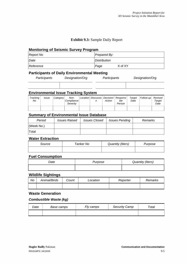
Project Initiation Report for 3D Seismic Survey in the Mamikhel Area
Hagler Bailly Pakistan Communication and Documentation R9V01MPS: 04/15/09 9-5
Exhibit 9.3: Sample Daily Report
Monitoring of Seismic Survey Program Report No Prepared By:
Date Distribution
Reference Page X of XY
Participants of Daily Environmental Meeting Participants Designation/Org Participants Designation/Org
Environmental Issue Tracking System Tracking
No Issue Category Non-
Compliance Severity
Location Discussion
Decision/Action
Responsible
Person
Target Date
Follow-up Revised Target Date
Summary of Environmental Issue Database Period Issues Raised Issues Closed Issues Pending Remarks
(Week No.)
Total
Water Extraction Source Tanker No Quantity (liters) Purpose
Fuel Consumption Date Purpose Quantity (liters)
Wildlife Sightings No Animal/Birds Count Location Reporter Remarks
Waste Generation Combustible Waste (kg)
Date Base camps Fly camps Security Camp Total

Project Initiation Report for 3D Seismic Survey in the Mamikhel Area
Hagler Bailly Pakistan Communication and Documentation R9V01MPS: 04/15/09 9-6
Recyclable Waste Generation Reported in DERs (kg)
Date Waste Oil (Liters)
Metal Drums (kgs)
Plastic chemical
containers (kgs)
Miscellaneous plastic (kgs)
Paper (kgs)
Wood (Kgs)
Other (Kgs)
Wildlife Sightings
No Date Animal/Birds Count Location Reporter Remarks

Project Initiation Report for 3D Seismic Survey in the Mamikhel Area
Hagler Bailly Pakistan Change Management R9V01MPS: 04/15/09 10-1
10. Change Management
An environmental assessment of the proposed project has been made on the basis of the project description available at the time the EIA was prepared. However, it is possible that changes in project design will be required when the project is implemented. This section describes the mechanism that will be put into place to manage changes that might affect the project’s environmental impact.
10.1 Changes to the Operation The changes in the project design have been categorized as first-order, second-order, and third-order. These are defined below.
10.1.1 First-Order Change
A first-order change is one that leads to a significant departure from the project described in the EIA and consequently requires a reassessment of the environmental impact associated with the change.
In such an instance, the IMC will be required to reassess the environmental change, the results of which will then be sent to NWFP EPA for approval. Examples of such changes include:
Increase in the Seismic Survey program by more than 25%
Increase in water requirement by more than 50%.
10.1.2 Second-Order Change
A second-order change is one that may entail project activities not significantly different from those described in the EIA, which may result in project effects whose overall magnitude would be similar to the assessment made in this report. In the event of such changes, the IMC will be required to reassess the impact of the activity on the environment, specify additional mitigation measures, if necessary, and report the changes to NWFP EPA (as part of the final monitoring report).
Examples of second-order changes include:
A change in the location of the seismic lines and campsite, or the alignment of access tracks such that minimum distances required in the EIA are still met
An increase in project personnel by more than 25%
Increase in the water needs by more than 10% but less than 50%
Changes in the documentation, communication, or stakeholder consultation program such that the overall objective of documenting compliance with the EMP and its communication to MOL, the IMC, and the project contractors or interested stakeholders at regular intervals is still met.

Project Initiation Report for 3D Seismic Survey in the Mamikhel Area
Hagler Bailly Pakistan Change Management R9V01MPS: 04/15/09 10-2
10.1.3 Third-Order Change
A third-order change is one that is of little consequence to the EIA findings. This type of change does not result in effects beyond those already assessed in the EIA; rather it may be made onsite to minimize the impact of an activity, such as relocating construction campsites to minimize clearing vegetation, etc. The only action required for such changes will be to record the change in the Change Record Register.
10.2 Changes to the EMP The possible categories of changes have been discussed above. Any changes in the project design or the results of the environmental monitoring, may necessitate changes in the EMP. Should this be necessary, the following actions will be taken:
A meeting will be held between MOL, the concerned contractor, and the IMC representatives. During the meeting the proposed addition to the EMP will be discussed and agreed upon by all parties.
Based on the discussion during the meeting, a change report will be produced collectively, which will include the additional EMP clause and the reasons for the addition.
A copy of the report will be sent to the head offices of MOL, the contractor, and the IMC.
All relevant project personnel will be informed of the addition. These additions will be reported in the IMC’s monthly environmental report.
The changes in the EMP may include either additional or reduced monitoring and reporting requirements.

Project Initiation Report for 3D Seismic Survey in the Mamikhel Area
Hagler Bailly Pakistan Environmental Training R9V01MPS: 04/15/09 11-1
11. Environmental Training
Environmental training will help to ensure that the requirements of the EIA and EMP are clearly understood and followed by all project personnel throughout the project period. The primary responsibility for providing training to all project personnel will be that of the IMC. An indicative environmental training program, which will be finalized before the commencement of the project, is provided in Exhibit 11.1. The IMC will train MOL staff, seismic contractors, and other staff engaged by MOL for the project. Training will cover all staff levels, ranging from the management and supervisory to the skilled and unskilled categories. The scope of the training will cover the requirements of the EIA and the EMP.
Exhibit 11.1: Training Program
Staff Trainers Contents
Drivers Independent Monitoring Consultant
Road safety Road restrictions Vehicle restrictions Waste disposal
Survey Crew Independent Monitoring Consultant
Wildlife sensitivities Identification of sensitive areas Proper marking of sensitive areas Communication of environmental problems to appropriate officer Waste disposal
Mechanics and Vehicle Repair Personnel
Independent Monitoring Consultant Seismic Contractor’s Senior Mechanic
Environmental controls for vehicles andequipment Waste disposal
Recording Unit Independent Monitoring Consultant
Wildlife sensitivities Identification of sensitive areas Waste disposal
Drilling Personnel Independent Monitoring Consultant
Wildlife sensitivities Identification of sensitive areas Waste disposal
Camp Staff Independent Monitoring Consultant Camp Boss
Waste disposal
Restoration and Cleanup Team
Independent Monitoring Consultant Restoration requirements

Project Initiation Report for 3D Seismic Survey in the Mamikhel Area
Hagler Bailly Pakistan Waste Disposal Plan R9V01MPS: 04/15/09 12-1
12. Waste Disposal Plan
This section provides the waste disposal plan that will be employed during the proposed project activities.
12.1 Effluents and Solid Waste Every effort will be made to minimize the waste generated while the project is in progress. The main types of waste that will be generated are:
Fuels, oils, and chemicals
Garage waste
Sewage
Camp waste
Medical waste
Demolition waste
Packing waste
Excess construction material.
The waste disposal system is summarized in Exhibit 12.1 and briefly discussed below.
12.2 Fuels, Oils, and Chemicals Used fuels, oils, and chemicals will be stored in containers in areas lined with impervious floors and surrounded by containing dykes at the rig site. Recyclable material will periodically be transported out of the project area and sold to contractors. Non-recyclable material will be transported to lined pits or burn pits for appropriate disposal.
Spilled fuels and oils will be collected and burned in the burn pit. Spilled chemicals will be handled and disposed of according to the material safety data sheet. The contaminated soil will be collected and buried, or burned, as appropriate.
12.3 Garage Waste Most garage waste, such as used filters and spare parts, can be recycled, and will be collected and transported out of the project area and sold to recycling contractors. Non-recyclable garage waste will be collected and transported to the burn pit for appropriate disposal.
12.4 Sewage Sewage from toilets will go into septic tanks, from which, after being treated, the wastewater will go into a soak pit, and the solid waste will be collected. The solid waste

Project Initiation Report for 3D Seismic Survey in the Mamikhel Area
Hagler Bailly Pakistan Waste Disposal Plan R9V01MPS: 04/15/09 12-2
from septic tanks will be emptied periodically, and the waste transported in tankers to municipal sewage treatment facilities in Kohat or Peshawar.
A drainage and sewerage system will be constructed for the camps. The sewerage system will consist of soak pits for the collection and treatment of wastewater from the camp kitchen, laundry, and showers. Water from the soak pits will be sprayed over the ground, allowing it to soak away or evaporate.
12.5 Camp Waste All combustible domestic waste will be burned at burn pit and the remainder will be buried in lined pits. Any non-combustible and non-biodegradable waste, such as glass, metal, or plastic, will be separated and transported out of the project area, where it will be sold to a contractor for recycling.
12.6 Medical Waste Medical waste will be stored in sealed containers and transported to the Kohat Medical center (or a similar facility), for incineration.
12.7 Demolition Waste Recyclable demolition waste will be given away for reuse. The remaining waste will be buried in lined pits. .
12.8 Packing Waste Recyclable packing waste will be given away to the approved recycling contractors. Non-recyclable packing waste will be burned at the burn pit.
12.9 Excess Construction Material Leftover construction material will be given away to material suppliers or other users. The remainder will be buried in lined pits.

Project Initiation Report for 3D Seismic Survey in the Mamikhel Area
Hagler Bailly Pakistan Waste Disposal Plan R9V01MPS: 04/15/09 12-3
Exhibit 12.1: Waste Disposal Summary
Type of Waste Description Operation Phase Disposal Method
Camp waste Animal, fruit or vegetable residue, domestic garbage
All Phase Recyclable waste to be given away for recycling; non-recyclable, combustible waste to be burned at burn pits or buried in lined pits
Packaging waste Paper, plastic, textiles, cardboard, rubber, wood, glass, tin cans, aluminum cans
All Phase Combustible wastes to be burned in the burn pit; recyclable wastes to be provided to recycling contractors
Medical waste Syringes, glass bottles, soiled bandages, expired drugs, dressings
All Phase To be incinerated at the Kohat Civil Hospital or an equivalent facility
Workshop waste Used oil, ferrous/non-ferrous materials, batteries, oil
All Phase Provided to a certified recycling contractor
Sewage and gray wastewater
Wastewater from kitchen and washing areas, sewage
All Phase Sewage to be disposed of using septic tanks and soak pits; solid residue to be disposed of in sewage treatment facilities in Kohat or Peshawar. Wastewater from kitchen and washing areas to be disposed of in soak pits
Completion waste Completion fluid Completion Prior to disposal, waste fluids to be tested for compliance with NEQS. If found to conform to the NEQS, the fluid will be used as a dust suppressant on the access track and at the well and campsites. If not, MOL will evaluate other options of disposal, such as evaporation inside lined pits.
Continues…

Project Initiation Report for 3D Seismic Survey in the Mamikhel Area
Hagler Bailly Pakistan Waste Disposal Plan R9V01MPS: 04/15/09 12-4
…Continued
Type of Waste Description Operation Phase Disposal Method
Oil spills/soil contaminated by oil leakages or spills
Contaminated soil All phases Soil contaminated by minor spills/leakages (defined as leaks from vehicles, machinery, equipment, or storage containers such that the area and depth of soil contaminated is less than 1 ft2 and 3 inches respectively) will be scraped and sent to the burn pit where it will be burned along with other combustible wastes. Moderate spills defined as spills of a volume less than or equal to 200 liters will be contained and controlled using shovels, sand, and native soil. These materials and equipment will be made available at campsites and the well site during operation. The contaminated soil will be excavated and stored in a bunded area lined with an impermeable base. Depending on the volume, the contaminated soil will be either disposed of by burning limited volumes of the soil in the burn pit, or by specialized treatment, such as bioremediations. Major spills of volumes exceeding 200 liters will require the initiation of MOL's Emergency Response Procedures. These spills will be handled and controlled according to the measures listed in MOL's Oil Spill Contingency Plan, and will require special treatment, such as bioremediation
Demolition waste Concrete, bricks, other building material
Completion Reusable material to be given away for re use. Remaining waste to be buried in lined pits.
Excess construction material
Sand, aggregate, cement, bricks, reinforcement steel bars, paints and other construction material
Completion of construction works
To be sold back or given away to the suppliers or other users

Project Initiation Report for 3D Seismic Survey in the Mamikhel Area
Hagler Bailly Pakistan Restoration and Rehabilitation R9V01MPS: 04/15/09 13-1
13. Restoration and Rehabilitation
Cleaning and restoration will be carried out during and immediately after each phase of the survey and will be the responsibility of each team in their respective area of operation. Additionally, there will be a clean-up crew known as the Restoration Team to ensure that the site is properly and adequately restored after the survey operation is completed. The following measures will be taken in this regard:
The campsites, routes, survey lines, etc., will be restored as close as possible to their original condition; the photographs taken to record the pre-project conditions will be used for this purpose.
All cloth flags, stakes, signs and refuse will be removed.
All concrete slabs from the water treatment facility will be broken and buried in its pit; a 1 m cap of soil will be placed over the pit. MOL will provide assistance to locals with the removal and transportation of concrete blocks from the explosive storage area to a storage site designated by the local Sardar (to be discussed).
The natural drainage of the campsite and the survey line will be restored if it has been damaged in any way during the survey.
Damaged stream banks will be repaired and restored.
Re-vegetation measures will be carried out using native vegetation where survey activities have damaged or disturbed vegetation.
Erosion control measures will be taken where needed.
It will be ensured that the survey lines do not become new routes or barriers.
Campsites will be cleaned so that no refuse or wastes are left behind; the waste will be properly disposed of.
All ditches and sumps will be backfilled; an extra cap of soil will be added at the top to cater for compaction.
Contaminated soil will be removed and properly disposed of.
For record purposes, photographs will be taken before and after the restoration measures at the campsites, routes and lines.
Following restoration, sites will be inspected to ensure the recommended measures have been strictly adhered to.