giant earthquakes and their tsunamis€¦ · 2 chapman conference on giant earthquakes and their...
TRANSCRIPT

American Geophysical Union Chapman Conference
Valparaíso, Viña del Mar, and Valdivia, Chile
16–24 May 2010
Giant earthquakes
and their tsunamis
Tsunami Sand spitSand spit

1
Chapman Conference on Giant Earthquakes and Their Tsunamis Valparaíso, Viña del Mar, and Valdivia, Chile 16–24 May 2010
Conveners
Brian Atwater, U.S. Geological Survey Sergio Barrientos, Universidad de Chile Marco Cisternas, Universidad Católica de Valparaíso Kelin Wang, Geological Survey of Canada
The conveners thank Nicolás Gorigoitia, Lynn Hayes, Mario Pino, Rob Wesson, and Cynthia Wilcox for helping to organize the conference. Sponsors The American Geophysical Union and the conference organizers acknowledge financial support from Universidad Católica de Valparaíso, Universidad de Chile, UNESCO/IOC, U.S. Geological Survey, and the municipalities of Viña del Mar and Valparaiso.

2
Chapman Conference on Giant Earthquakes and Their Tsunamis May 16 Sun Talks, posters, and discussion — Hotel Marina del Rey*, Viña del Mar 17 Mon Public presentations — P. Universidad Católica de Valparaíso, Valparaíso 18-20 Tue-Thu Talks, posters, and discussion — Hotel Marina del Rey*, Viña del Mar 20-24 Thu-Mon Field trips — Maullín and Cocotué; Valdivia * Linda Andreani Room SUNDAY, 16 MAY Session 16A Overviews 0900–0930 Welcome
0930–0945 George PLAFKER Overview of the mechanism of the giant 1960 Chile earthquake and near-field tsunami with comparisons to the 1964 Alaska and 2004 Sumatra events
0945-1000 Onno ONCKEN Chile’s seismogenic coupling zones – geophysical and neotectonic observations from the South American subduction zone
1000-1015 Christophe VIGNY Upper plate deformation is dominated by varying coupling on the Chilean subduction zone
1015-1030 Inés CIFUENTES Fifty years after the great 1960 Chilean earthquake: What have we learned and how do we use what we know to reduce human tragedies?
1030-1100 Discussion
1100-1130 Coffee break
1130-1145 Daniel MELNICK Structural control on megathrust rupture: Insights from the 1960 Chile earthquake segment
1145-1200 Rolando ARMIJO Structural partitioning of the Chilean subduction margin: Evidence for a West Andean Thrust
1200-1215 Kenji SATAKE Tsunami warning systems: Impacts of the 1960 and 2004 global tsunamis
1215-1230 Emile OKAL From Nias to Maule: Have we become wiser in the wake of Sumatra?
1230-1300 Discussion

3
SUNDAY, 16 MAY continued Session 16P 1960 earthquakes: Tectonics, source, recurrence 1430-1435 Pedro FEYJÓ On the earthquake that razed Valdivia
1435-1730 Posters: Summaries (1435-1530) and Presentations (1530-1730)
16P-1 Daniel CARRIZO Seismic asperities and barriers related to subducting bathymetric features along the Nazca-South American plate boundary
16P-2 Andrés TASSARA Strength of the megathrust below the Chilean forearc, nature of seismic asperities and model for giant earthquake growth
16P-3 Marcos MORENO Earthquake cycle deformation and its link to upper plate structure in the southern Andes
16P-4 Jan BEHRMANN Differences in composition and strength of subducted sediment define the rupture of the great 1960 Chile earthquake
16P-5 Andreas RIETBROCK Imaging the subduction thrust with passive seismic arrays: A comparison between northern and southern Chile
16P-6 Salvador FARRERAS May 22 1960 earthquake source parameters as derived from tsunami run-ups on Easter Island and alongshore Chile
16P-7 Yushiro FUJII Tsunami source of the 1960 Chilean earthquake inferred from tide gauge data
16P-8 Matthias DORRIES The 1960 Chilean earthquake and the free oscillations of the earth
16P-9 Daniel MELNICK Megathrust earthquakes over the past 1.7 ka at Guafo island, south Chile
16P-10 Lisa ELY Geological evidence of past tsunamis at the boundary between the 1960 and 1835 earthquake rupture areas, south-central Chile
16P-11 Eduard REINHARDT Recovery estimates for the Río Cruces after the May 1960 Chilean earthquake
16P-12 Jorge QUEZADA Holocene coastal uplift in the northern segment of 1960 Chilean earthquakes
16P-13 Jasper MOERNAUT Recurrence of 1960-like earthquake shaking in south-central Chile revealed by lacustrine sedimentary records
1730-1830 Discussion

4
MONDAY, 17 MAY Session 17A Public presentations 0900-0910 Alfonso MUGA Welcome from P. Universidad Católica de Valparaíso
0910-0920 Jorge SEQUEIRA Welcome on behalf of UNESCO-Chile
0920-0930 Inés CIFUENTES Welcome on behalf of the American Geophysical Union
0930-1000 Hiroo KANAMORI Revisiting the 1960 Chilean earthquake
1000-1030 Rodolfo SARAGONI The giant 1960 Chile earthquake: A large magnitude moderate earthquake
1030-1100 Hellmuth SIEVERS The seismic sea wave of 22 May 1960 along the Chilean coast: A personal account
1130-1200 Diana COMTE The 2010 Chile earthquake – variations in the rupture mode
1200-1230 Anne SOCQUET Modelling the source of the maule Mw 8.8 earthquake and early afterslip using GPS and insar data
1230-1300 Marcelo LAGOS Magnitude and impact of the 2010 Chilean tsunami
1300-1400 Conference luncheon Afternoon Outreach
Introduced by Inés Cifuentes, Mabel Keller, and Marco Cisternas

5
TUESDAY, 18 MAY Session 18A Chilean earthquake of 27 February 2010 0900-0915 Michael SPRANGER Loss assessment of the Feb 27, 2010 Chile
earthquake from a reinsurer’s perspective
0915-0930 Michael BEVIS The 27 February 2010 Maule earthquake: The emergency geodetic response and some of its early results
0930-1200 Posters: Summaries (0930-1010) and Presentations (1010-1200)
18A-1 Marc-Andre GUTSCHER What controls the frequency and size of megathrust earthquakes offshore Chile and Sumatra? Insights from crustal structure and thermal modeling
18A-2 Robert WESSON Long-term inter-seismic subsidence of Santa María Island, Chile (37°S) supported by resurvey of 1835 HMS Beagle soundings
18A-3 Ximena CONTARDO Potential seismogenic faults along the south central Chilean forearc, insight from seismic and bathymetric data
18A-4 Dave CHADWELL Offshore investigations of the 27 Feb. 2010 Maule, Chile earthquake rupture
18A-5 Richard ALLMENDINGER Interseismic strain, continental deformation, and great earthquakes of southern Chile
18A-6 Matthias ROSENAU Did the 27th February 2010 earthquake close the gap? Insights from pre-, co- and postseismic deformation pattern
18A-7 Anthony SLADEN A coseismic distributed-slip model for the 2010 Mw 8.8 Maule (Chile) earthquake
18A-8 Benjamin BROOKS Megathrust seismic events, post-seismic deformation and mountain building: Andean deformation related to the 27 Feb. 2010 Maule, Chile earthquake
18A-9 Christophe VIGNY The Maule Mw 8.8 earthquake monitored by continuous and survey mode GPS
18A-10 Frederick BLUME Rapid GNSS and data communication system deployments in Chile and Argentina following the M 8.8 Maule earthquake
18A-11 Robert SMALLEY High-rate GPS seismograms from the 27 Feb. 2010, M=8.8, Maule Chile earthquake
18A-12 M. Meghan MILLER High-rate low-latency CGPS for science and first responders: Proof-of-concept for a Maule earthquake scenario
1200-1300 Discussion

6
TUESDAY, 18 MAY continued Session 18P 2010 earthquake and its near-field tsunami 1430-1445 Stephen MILLER Modeling of the preparatory processes in the source
region and analysis of aftershock decay rates of the 2010 Mw 8.8 Chile earthquake
1445-1500 Marco CISTERNAS Similarities between the great Chilean earthquakes of 1835 and 2010
1500-1730 Posters: Ssummaries (1500-1540) and Presentations (1540-1730)
18P-1 Raul MADARIAGA The Maule Mw 8.8 earthquake: Modelling using 1 hz CGPS and seismic data
18P-2 Sutatcha HONGSRESAWAT Ultra-long period spectrum of the 2010 Maule, Chile earthquake from the Earth's spheroidal modes
18P-3 Mohammad RAEESI Asperity distribution of the 27 Feb. 2010 (Mw = 8.8) Chile earthquake
18P-4 Catherine PETROFF Rapid reconnaissance survey of the february 27, 2010 Chile tsunami - Constitución to Colcura, Quidico to Mehuín
18P-5 Patricio CATALÁN Observations by the international tsunamy survey team, regions VII-VI and V of Chile
18P-6 Rodrigo CIENFUEGOS Observations on morphological changes produced by the impact of the February 27, 2010 tsunami along the coastline of V-VI-VII region
18P-7 Hermann FRITZ Field survey of the 27 February 2010 tsunami in Chile, regions Maule and Biobío (VII and VIII)
18P-8 Jorge QUEZADA The third tsunami wave in Biobío region bays during the Chilean 27th February 2010 earthquake
18P-9 M. Teresa RAMÍREZ Geomorphological effects from the 27 February 2010 tsunami: A post-tsunami survey, central Chile
18P-10 Eduardo JARAMILLO Before and after comparisons of the Chilean coast affected by the earthquake and tsunami of February 27th
18P-11 Ricardo NORAMBUENA International Tsunami Survey Team – Chile
1730-1830 Discussion
7
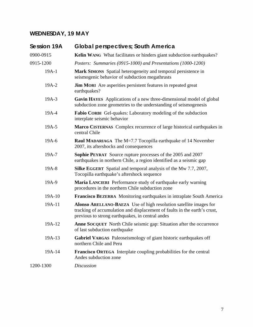
WEDNESDAY, 19 MAY Session 19A Global perspectives; South America 0900-0915 Kelin WANG What facilitates or hinders giant subduction earthquakes?
0915-1200 Posters: Summaries (0915-1000) and Presentations (1000-1200)
19A-1 Mark SIMONS Spatial heterogeneity and temporal persistence in seismogenic behavior of subduction megathrusts
19A-2 Jim MORI Are asperities persistent features in repeated great earthquakes?
19A-3 Gavin HAYES Applications of a new three-dimensional model of global subduction zone geometries to the understanding of seismogenesis
19A-4 Fabio CORBI Gel-quakes: Laboratory modeling of the subduction interplate seismic behavior
19A-5 Marco CISTERNAS Complex recurrence of large historical earthquakes in central Chile
19A-6 Raul MADARIAGA The M=7.7 Tocopilla earthquake of 14 November 2007, its aftershocks and consequences
19A-7 Sophie PEYRAT Source rupture processes of the 2005 and 2007 earthquakes in northern Chile, a region identified as a seismic gap
19A-8 Silke EGGERT Spatial and temporal analysis of the Mw 7.7, 2007, Tocopilla earthquake’s aftershock sequence
19A-9 Maria LANCIERI Performance study of earthquake early warning procedures in the northern Chile subduction zone
19A-10 Francisco BEZERRA Monitoring earthquakes in intraplate South America
19A-11 Alonso ARELLANO-BAEZA Use of high resolution satellite images for tracking of accumulation and displacement of faults in the earth’s crust, previous to strong earthquakes, in central andes
19A-12 Anne SOCQUET North Chile seismic gap: Situation after the occurrence of last subduction earthquake
19A-13 Gabriel VARGAS Paleoseismology of giant historic earthquakes off northern Chile and Peru
19A-14 Francisco ORTEGA Interplate coupling probabilities for the central Andes subduction zone
1200-1300 Discussion

8
WEDNESDAY, 19 MAY continued Session 19P North America and eastern Indian Ocean 1430-1445 Thomas HEATON Simulated deformations of Seattle high-rise buildings
from a hypothetical giant Cascadian earthquake
1445-1730 Posters: Summaries (1445-1530) and Presentations (1530-1730)
19P-1 Alberto LÓPEZ VENEGAS Understanding the nature of seismic swarms along curved subduction zones: The case of the northeastern Caribbean
19P-2 Marino PROTTI Monitoring a mature seismic gap under the Nicoya Peninsula with potential to generate a large earthquake in the near future
19P-3 Emile OKAL Sumatra at five years: What have we learned?
19P-4 Seshachalam SRINIVASALU 19th September 1985 tsunami deposits from Bahía de Potosi, Zihuatenejo, Guerrero, Mexico
19P-5 Seshachalam SRINIVASALU Geologic clues for ancient tsunamis in southeast coast of India
19P-6 Aron MELTZNER Persistent rupture segmentation along the Sunda megathrust off Sumatra
19P-7 Claudio VITA-FINZI Valdivia, Nias and the subduction model
19P-8 Chris GOLDFINGER Temporal clustering, energy-state proxy, and recurrence of Holocene paleoearthquakes in the region of the 2004 Sumatra-Andaman earthquake
19P-9 Chris GOLDFINGER Cascadia supercycles: Evidence of clustering and Holocene history of energy management from the long Cascadia paleoseismic record
19P-10 Robert WITTER Variable rupture scenarios for tsunami simulations inferred from a 10,000-year history of Cascadia megathrust earthquakes
19P-11 Alan NELSON Challenges in inferring great earthquake history from tidal marsh stratigraph, central Oregon coast
19P-12 Peter HAEUSSLER Megathrust splay faulting in southern Prince William Sound, Alaska, and modeling the near-field tectonic tsunami and run up at Seward, Alaska, from the 1964 M 9.2 earthquake
19P-13 Ian SHENNAN Variations of surface deformation and lateral extent of ruptures during late Holocene great earthquakes, south central Alaska
1730-1830 Discussion

9
THURSDAY, 20 MAY Session 20A Other subduction zones; tsunamis 0900-0915 Robert MUIR-WOOD Europe's two ”magnitude 9” earthquakes
0915-1200 Posters: Summaries (0915-1000) and Presentations (1000-1200)
20A-1 Kathryn WILSON The search for prehistoric subduction earthquakes along a variably-coupled and pervasively faulted plate boundary, the Hikurangi margin, New Zealand
20A-2 Majid SHAH-HOSSEINI Displaced coastal boulders: Evidence for catastrophic waves in Iranian Makran coast
20A-3 Gerassimos PAPADOPOULOS On the recurrence of mega earthquakes occurring in the Hellenic arc and trench system, Greece
20A-4 Brian ATWATER Geologic evidence for the 1755 Lisbon tsunami in the northeast Caribbean
20A-5 George PLAFKER Comparison of tsunami characteristics for giant tsunamigenic earthquakes in Chile (1877, 1960) and southern Peru (1868)
20A-6 David BURBIDGE Probabilistic tsunami hazard assessments for australia and countries of the southwest pacific and the indian oceans
20A-7 Hong THIO The effect of source uncertainty in probabilistic tsunami hazard analysis
20A-8 Marcelo LAGOS Numerical simulation of the 1960 tsunami in south-central Chile for risk assessment
20A-9 Velly ASVALIANTINA The use of tsunami inundation modelling for hazard mitigation purposes in Indonesia
20A-10 Chesley WILLIAMS The complexities of modeling tsunami risk to people and property
20A-11 James GOFF Pacific island palaeotsunamis: Precursors to the 1960 Valdivia tsunami?
1200-1300 Discussion

10
THURSDAY, 20 MAY continued Session 20P Tsunamis 1430-1445 Diego ARCAS Recent developments in tsunami forecasting from Sumatra
2004 to Chile 2010
1445-1730 Posters: Summaries (1445-1530) and Presentations (1530-1730)
20P-1 Peter HAEUSSLER Submarine landslides and tsunamis at Seward and Valdez triggered by the 1964 M 9.2 great Alaska earthquake
20P-2 Jascha POLET Near real-time analysis of source parameters and tsunamigenic potential of large global earthquakes
20P-2 Somsak WATHANAPRIDA Comparison of the 2004 Indian Ocean tsunami simulated by the most and commit models with observations of the tsunami waves which impacted the Khao Lak area of Thailand
20P-4 Cristobal CASTRO A high-order well-balanced finite volume schemes: new tools for the simulation of tsunami wave propagation
20P-5 Luis RIVERA The potential of the W phase algorithm for regional tsunami warning in Chile
20P-6 Barry HIRSHORN The Mw 8.8 Chile earthquake of February 27, 2010: source inversion from the W phase for tsunami warning
20P-7 Andrew NEWMAN Tsunami potential from the spectral energy content of the 2010 Chile earthquake
20P-8 Hernan MOREANO Differences in tsunami behavior at the Galápagos islands and the coastal region of Ecuador: Chile earthquake 27-02-2010
20P-9 PRIYOBUDI Tsunami mitigation in Indonesia: constraints and challenges
20P-10 Victor HUERFANO The Puerto Rico Tsunami Warning and Mitigation Program
1730-1830 Discussion

11
POST-CONFERENCE FIELD TRIPS 20–24 May 2010 — Maullín and Cocotué Coastal evidence of the 1960 earthquake and of several of its predecessors
24 May 2010 — Valdivia Coastal and urban traces of the 1960 earthquake

12
ABSTRACTS listed by name of presenter
ALLMENDINGER, Richard Interseismic strain, continental deformation, and great earthquakes of southern Chile Allmendinger, Richard W.1; Yáñez, Gonzalo2; Cembrano, José3
1. Dept. of Earth & Atmospheric Sciences, Cornell University, Ithaca, NY 2. Corporación Nacional del Cobre, Santiago, CHILE 3. Departamento de Ingeniería Estructural y Geotécnica, Universidad Católica de Chile, Santiago, CHILE
The great 2010 subduction megathrust earthquake of the Maule region of southern Chile occurred in a region of unusually high forearc strain and rotation rates as calculated from inversion of GPS velocity vectors measured during the interseismic period preceding the earthquake. The maximum instantaneous shear strain rate in the vicinity of the 2010 M8.8 and 1960 M 9.5 ruptures is about twice as large as interseismic rates in the forearc to the north. The region of overlap between the 1960 and 2010 events is characterized by high rates of interseismic clockwise vertical axis rotation, equivalent to nearly 4°/Ma. The trench off shore of both the 2010 and the 1960 events is filled with sediment as far north as the intersection of the Juan Fernández Ridge with the continental margin at 33°S; farther north, the trench is barren. The age of the subducted plate varies from <40 Ma at 33°S to essentially zero at the triple junction at 46°S. Finally, large magnitude shortening of the South American crust due to Late Cenozoic back arc thrust belts in Bolivia and northern Argentina terminates at 33°S. The 2010 rupture also correlates spatially with a marked angular deviation of the plate boundary and the forearc by ~15° clockwise, beginning at 33°S and continuing to 37°S. To the south of 37°S, the trench is more than 100 km farther west than the trench is north of 33°S. This deviation has been explained as a function of tectonic erosion of the margin but paleomagnetic data show an abrupt increase in clockwise vertical axis rotation of the forearc south of 33°S by as much as 32° in rocks 10 Ma and younger, indicating an important role for upper plate deformation. In the back-arc opposite the 2010 and 1960 ruptures, late Cenozoic crustal shortening is minor or absent, and elastic thickness of the plate relatively high. All of these observations suggest that, to the north of 33°S, that the total plate convergence is partitioned between subduction and deformation of the upper plate. South of 33°S, virtually all of the convergence is accommodated along the subduction thrust boundary. There are two possible explanations for the variation in partitioning of convergence: either the South American plate becomes more rigid, or the plate boundary becomes weaker, south of 33°S. The features described above suggest that both occur and thus explain the giant earthquakes of southern Chile.
ARCAS, Diego
Recent developments in tsunami forecasting from Sumatra 2004 to Chile 2010 Bernard, Eddie N1; Titov, Vasily1; Arcas, Diego2, 1
1. NOAA - Pacific Marine Environmental Laboratory, Seattle, WA 2. Joint Institute for the Study of the Atmosphere and Ocean - University of Washington, Seattle, WA
The need for real-time tsunami forecasts using numerical models and real-time data has driven tsunami research for years.
The February 27th, 2010 Maule tsunami provided a challenge and opportunity to test the modern state of the science in tsunami forecasting. The earthquake (Mw=8.8) was reported as the fifth largest on record and occurred in a heavily instrumented area where a variety of real-time measurements and forecast models were available to assess the generated tsunami potential in real-time. The existence of a network of seismic instruments to rapidly evaluate the earthquake magnitude and location, and the relatively recent development of an ocean wide DART® network of sea level measurement systems have made the acquisition of the necessary seismic and real-time seal level data a reality.<br><br> The experimental use of these data in numerical models to generate a Pacific-wide forecast for US territories is presented in this paper for the February 27, 2010 Maule region tsunami. A set of forecasted wave amplitude signals and inundation areas at different locations throughout the Pacific are compared with observed tide gauge measurements and reported inundation. Model comparison with tide gauges and coastal impacts provide an opportunity to assess the accuracy and efficiency of the forecast, and show that a reliable prediction capturing the correct magnitude, arrival time and impact on coastal areas can be generated on the fly, providing vital information to communities along the coastline. Successes, lessons learned and future challenges for tsunami forecast science are discussed.
ARELLANO-BAEZA, Alonso
Use of high resolution satellite images for tracking of accumulation and displacement of faults in the Earth’s crust, previous to strong earthquakes, in central Andes Arellano-Baeza, Alonso Alejandro1
1. Mining Department, Universidad de Santiago de Chile, Santiago, CHILE
Over the last decades strong efforts have been made to apply new spaceborn technologies to the study of strong earthquakes. As it is well known, strong earthquakes are preceded by strain energy accumulation deep in the Earth’s crust. It is reflected in the accumulation of displacement on faults and their orientation that takes place months and even years before an earthquake. Our studies have shown that this strain energy accumulation can be detected by applying a lineament extraction technique to the high-resolution multispectral satellite images. A lineament is a straight or a somewhat curved feature in a satellite image, which it is possible to detect by a special processing of images based on directional filtering and or Hough transform. We analysed the 7.9 Mw earthquake, which took place June 13, 2005 next to Arica, Chile (-69.328,-20.054). It was found that the number and orientation of lineaments changed significantly about one month before the earthquake approximately, and a few months later the system returns to its initial state. Analysis of other earthquakes in the Central Andes showed than they obey the same patron, nevertheless the variation in density of lineaments is less pronounced for lower magnitudes, disappearing for earthquakes with magnitudes less than 4.0 Mw. The regions with absence of seismic activity did not show any variation in number and direction of lineaments. The results obtained open a possibility to develop a methodology able to evaluate the seismic risk in the regions with similar geological conditions.

13
ARMIJO, Rolando Structural partitioning of the Chilean subduction margin: Evidence for a West Andean Thrust (WAT) Armijo, Rolando1
1. Tectonics, Institut de Physique du Globe de Paris, Paris, FRANCE The Andean orogeny is considered the paradigm for mountain belts associated with subduction plate boundaries. Yet, no mechanical model can explain satisfactorily the Andean mountain building process as a result of forces applied at its nearby Subduction Margin, along the western flank of the South America continent. In other words, the tectonic implications of the Chilean-type subduction proposed by Uyeda and Kanamori (1979) are not fully understood. Contrary to earlier views, the Andes mountain belt appears to have a doubly vergent structure defined by two distinct orogenic thrust boundaries at the East and West Andean Thrusts. While the well-known East Andean Thrust (in the back-arc region) coincides with the basal thrust of the Back-Thrust Margin over the eastern foreland (the South America continent), the generally disregarded and much less known West Andean Thrust (WAT, in the fore-arc region) is located at significant distance from the basal mega-thrust of the Subduction Margin. There is a wide western foreland (~200 km wide horizontally) separating the WAT from the subduction zone, which is designated Marginal (or Coastal) Block. Consequently a fundamental mechanical partitioning occurs across the fore-arc, between the subduction interface, a mega-thrust that is responsible of significant short-term strains and the occurrence of repeated large earthquakes, and the WAT, which appears fundamental in regard to processes associated with the Andean orogeny. Some observations, summarized here, are now available to describe this partitioning (Armijo et al., 2010, in press). A key tectonic section of the Andes is analyzed at latitude 33.5°S, where the belt is in an early stage of its evolution, aiming at resolving the primary architecture of the orogen. We focus on the active fault-propagation-fold system in the Andean cover behind the San Ramón Fault, which is critical for the seismic hazard in the city of Santiago and crucial to decipher the structure of the WAT. The San Ramón Fault is a thrust ramp at the front of a basal detachment with average slip rate of ~0.4 mm/yr. Young scarps at various scales imply plausible seismic events up to Mw 7.4. The WAT steps down eastwards from the San Ramón Fault, crossing 12 km of Andean cover to root beneath the Frontal Cordillera basement anticline, a range ~5 km high and >700 km long. We propose a first-order tectonic model of the Andes involving an embryonic intra-continental subduction of the Marginal Block consistent with geological and geophysical observations. The stage of primary westward vergence with dominance of the WAT at 33.5°S is evolving into a doubly-vergent configuration. A growth model for the WAT-Altiplano similar to the Himalaya-Tibet is deduced. We suggest the intra-continental subduction at the WAT is a mechanical substitute of a collision zone, rendering the Andean orogeny paradigm obsolete. Uyeda, S., and H. Kanamori (1979), Back-Arc opening and the
mode of subduction, Journal of Geophysical Research, 84, 1049-1061.
Armijo R., R. Rauld, R. Thiele, G. Vargas, J. Campos, R. Lacassin, and E. Kausel (2010), The West Andean Thrust (WAT), the San Ramón Fault and the seismic hazard for Santiago (Chile), Tectonics, doi:10.1029/2008TC002427, in press.
ASVALIANTINA, Velly The use of tsunami inundation modelling for hazard mitigation purposes in Indonesia Asvaliantina, Velly1, 2; Chaeroni, Roni1; Wardani, Khusnul1; Nugroho, Sapto1; Hidayat, Agus3
1. Coastal Dynamic Research Center, Agency for the Assessment and Application of Technology, Jakarta, INDONESIA 2. ICG/IOTWS Secretariat, UNESCO-IOC, Perth, Western Australia, AUSTRALIA3. A. Hidayat, LAPAN, Jakarta, INDONESIA
Indonesia is among countries that are very prone to tsunami. Some efforts have been done to mitigate the hazard. In the framework of Ina-TEWS development, the Indonesian government has funded some projects to develop tsunami hazard and tsunami evacuation maps for the high risk area. This paper presents the application of tsunami run-up numerical modelling for developing tsunami hazard maps, evacuation routes determination, and community preparedness activities. The TUNAMI-N3 (Tohoku University's Numerical Analysis Model for Investigation of Near-field tsunamis, #3 - with varying grids) is used in developing the tsunami inundation model for the at-risk coastal cities. Hypothetical source scenarios based on historical events and tectonic settings are applied. Some topography ground-checks were conducted to get the update physical features of the area and for the improvement of SRTM data being used. Up-to-date geospatial data are also used whenever possible. The model results were provided to related agencies and local governments for use in tsunami hazard maps as well as the design of evacuation routes.
ATWATER, Brian Geologic evidence for the 1755 Lisbon tsunami in the northeast Caribbean Atwater, Brian1
1. U.S. Geological Survey, Seattle, WA
Overwash from the North Atlantic Ocean flooded Anegada, British Virgin Islands, sometime between 1650 and 1800. The overwash breached sandy beach ridges 2.2-3.0 m high, moved the entrained sand as much as 1.5 km inland, concentrated shells it derived from the deposits of a marine pond inside the island, and scattered cobbles and boulders southward from limestone outcrops as much as 1 km from the sea. It postdates A.D. 1650 according to radiocarbon ages of leaves, and it probably predates human settlement that became well-documented by 1800.
Though the overwash might have resulted from either a storm or a tsunami, and it most likely represents the 1755 Lisbon tsunami. The Lisbon tsunami is the simplest explanation because it is known to have attained heights of several meters on many Caribbean shores. Alternatively, the overwash represents a tsunami from the Antilles subduction zone, either a thrust earthquake that probably failed to produce an orphan tsunami in Europe, or an outer-rise earthquake on normal faults evident along Puerto Rico Trench. If the overwash represents a hurricane, the storm surge exceeded modeled surges that are limited by a narrow continental shelf, and the storm waves overcame a fringing reef 1 km offshore and persisted across shallows that extend from the reef to the beach. A storm, moreover, probably cannot explain the inland fields of cobbles and boulders except by means of waterspouts.
These findings resulted from an attempt to assess the earthquake and tsunami potential of the Puerto Rico Trench. Contributors to the work include Uri S. ten Brink, Mark Buckley,

14
Robert S. Halley, Bruce E. Jaffe, Alberto M. López Venegas, Eduard G. Reinhardt, Maritia P. Tuttle, Steve Watt, and Yong Wei.
BARRIENTOS, Sergio 2010 Chile earthquake aftershock response: An international approach S. Barrientos1 , D. Comte1, J. Campos1 , M. Pardo1, S. Peyrat 1 , J. Ruiz1, S. Ruiz1, K. Bataille2, M. Miller2, J.P. Vilotte3, P. Bernard3, H. Lyon-Caen4, Ph. Gueguen5, S. Baize6, A. Fuenzalida4, A. Nercessian3, M. El Aissaoui3, A. Mariscal4, F. Bondoux7 , B. Heit8, D. Lange9, F. Schneider8, F. Tilmann9, A. Rietbrock10, S. Beck11, S. Roecker12, R. Russo13, A. Meltzer14, A. Reusch15, D. Simpson16, D. Legrand17
1. Universidad de Chile, Santiago, Chile 2. Universidad de Concepción, Chile 3. Institut de Physique du Globe de Paris (CNRS-UMR 7554); 4. Ecole Normale Supérieure de Paris (CNRS-UMR 8538) 5. LGIT (CNRS-IRD), Université J. Fourier, Grenoble 6. Institut de Radioprotection et de Sureté Nucléaire (IRSN) 7. IRD-Peru 8. Geoforschung Zentrum, Potsdam 9. Cambridge University 10. University of Liverpool 11. University of Arizona 12. Rensselaer Polytechnic Institute 13. University of Florida 14. Lehigh University 15. North Carolina A & T State University 16. Incorporated Research Institutions for Seismology 17. Universidad Nacional Autonoma de Mexico
The 2010 Chile earthquake ruptured the Concepcion-Pichilemu segment of the Nazca/South America plate boundary, south of the Central Chile region and triggered a tsunami along the coast. Within the first three weeks after the mega-earthquake there were over 260 aftershocks with magnitude 5.0 or greater and 18 with magnitude 6.0 or greater (NEIC, USGS). For the last 30 years, geodetic studies in this area were consistent with a fully coupled elastic loading of the subduction interface at depth; this led to identify the area as a mature seismic gap. Today, the 2010 earthquake raises some disturbing questions: Why and how the rupture terminated where it did at the northern end? How did the 2010 earthquake load the adjacent segment to the north and did the 1985 earthquake only partially ruptured the plate interface leaving loaded asperities since 1906? Since the number of M>7.0 aftershocks has been low, does the distribution of large-magnitude aftershocks differ from previous events of this size? What is the origin of the extensional-type aftershocks at shallow depths within the upper plate? The international seismological community (France, Germany, U.K., U.S.A.) in collaboration with the Chilean seismological community responded with a total of 140 portable seismic stations to deploy in order to record aftershocks. The collected seismic data will be merged and archived to produce an international data set open to the entire seismological community immediately after archiving. Each international group will submit their data as soon as possible in standard (mini seed) format with accompanying meta data to the IRIS DMC where the data will be merged into a combined data set and available to individuals and other data centers. This will be by far the best-recorded aftershock sequence of a large megathrust earthquake. This outstanding international collaboration will provide an open data set for this important earthquake as well as provide a model for future aftershock deployments around the world.
BEHRMANN, Jan Differences in composition and strength of subducted sediment define the rupture of the great 1960 Chile earthquake Behrmann, Jan H1; Roeser, Georg3; Kopf, Achim J2
1. Geodynamics, IFM-GEOMAR, Kiel, GERMANY 2. MARUM, University of Bremen, Bremen, GERMANY 3. TNE SST GEOP STJ, STATOIL, Stjordal, NORWAY
The great 1960 Chile subduction thrust earthquake was the largest, ever instrumentally recorded earthquake on Earth. The 1000 km long coseismic rupture originated at 37°S and propagated southward between the overriding South American and the downgoing Nazca plates. Subduction of large amounts of sediment apparently controls the mechanical behaviour of the seismogenic zone. I report a study of compositions and geotechnical properties of modern silts from this part the Southern Chile Trench, being the dominant lithology, and likely a good analogue to sediments subducted into the seismogenic zone in the past million years. There is a strong northward increase in feldspar and decrease in quartz, suggesting a deep brittle-ductile transition at 37°S, where the earthquake originated. Rotary shear experiments show dramatic southward drop in shear strength and friction coefficients. It can be inferred that the rupture nucleated in an asperity zone defined by mechanically strong, feldspar-rich sediment. Shearing then catastrophically propagated southward into an extensive, weak and narrow segment of the seismogenic zone, explaining the exceptionally large rupture and stress drop observed. The more general message is that documenting heterogeneous sedimentary input to other sediment-charged subduction zones, may help understand the nature and recurrence rate of coseismic faulting there.
BEVIS, Michael The 27 February 2010 Maule earthquake: The emergency geodetic response and some of its early results Bevis, Michael G1; Baez, Juan Carlos2; Parra, Hector4; Brooks, Benjamin A3; Simons, Mark6; Kendrick, Eric1; Caccamise, Dana1; Smalley, Robert J.5; Foster, James3; Genrich, Jeff 6; Blanco, Mauro7; Hu, Yan9; Wang, Kelin8; Domack, Eugene10; Rivas, Lautaro4
1. Div. Geodetic Sciences, School of Earth Sciences, Ohio State University, Columbus, OH 2. Depto Cs. Geodesicas y Geomatica, Universidad de Concepción, Los Angeles, CHILE 3. SOEST, University of Hawaii, Honolulu, HI 4. Depto Geodetico, Instituto Geográfico Militar , Santiago, CHILE 5. Center for Earthquake Research and Information, University of Memphis, Memphis, TN 6. Division of Geological and Planetary Sciences, California Institute of Technology, Pasadena, CA 7. Instituto CEDIAC, Universidad Nacional de Cuyo , Mendoza, ARGENTINA 8. Pacific Geoscience Center, Geological Survey of Canada, Sidney, British Columbia, CANADA 9. SEOS, University of Victoria, Victoria, British Columbia, CANADA 10. Geosciences, Hamilton College, Clinton, NY

15
We describe the emergency geophysical and geodetic response to the M 8.8 Maule earthquake. This involved revisiting the survey GPS stations associated with the Central and Southern Andes GPS Project (CAP), and establishing large numbers of new continuous GPS stations in Chile and Argentina. The network design for this effort, largely funded by the NSF RAPID program, was influenced by our knowledge of overlapping French and German networks. The CAP network and its sister network SAGA, built by GFZ (Germany), extend well to the south, and so provide a framework that allows the geophysical community to address post-seismic deformation associated with the 1960 Valdivia event as well as the inter-, co- and post-seismic phases of the Maule event. At the time of this writing (8 April) we have constructed ~ 30 new CGPS stations in the near field of the Maule EQ rupture zone, and additional stations are being built at the rate of about one per day. We will discuss the challenges associated with maintaining this network over many years, the role that UNAVCO has played in lending equipment to the project, the generous equipment donations made by several large GPS companies, our data policy and the availability of data and/or results from sister efforts. We will provide an overview of the early geodetic results, especially those from Chile, and consider them in the light of results previously obtained in the rupture zone of the great 1960 event further to the south.
BEZERRA, Francisco
Monitoring earthquakes in intraplate South America Bezerra, Francisco Hilario1; Ferreira, Joaquim Mendes1; do Nascimento, Aderson Farias1; Fuck, Reinhardt Adolfo2
1. Geology, Federal University of Rio Grande do Norte, Natal RN, BRAZIL 2. Institute of Geosciences, University of Brasilia, Brasilia, DF, BRAZIL
Intraplate South America presents a poor history of earthquake monitoring, but this has recently started to change. Much of the seismicity catalog in the continent relies on major global seismograph networks for earthquakes above 4.5 mb and on a few temporary networks for small and moderate events mb < 4.5. Northeastern Brazil is one of the most seismically active intraplate areas of South America. It has experienced earthquakes with magnitudes as high as 5.2 mb and Modified Mercalli intensities as high as VII. Earthquakes in the region occurs as swarms that can last up to ten years and can include hundreds of events per day in the most active periods. Earthquakes and their associated damages have been reported since the eighteenth century. It was only from the nineteenth century onward, however, that more precise descriptions of historical data shed light on seismicity. Historical data were obtained from books, newspapers, and interviews. All the data about seismicity were macroseismic before 1965, when the World Wide Standardized Seismograph Network (WWSSN) Natal station (NAT) started to operate. Seismic monitoring, however, did not improve and most of the epicenters and earthquake magnitudes before 1986 were estimated with the use of macroseismic data. The turning point of earthquake monitoring was the Samambaia fault seismicity. The deployment of portable networks made it possible to obtain precise hypocenter locations and focal mechanisms. The Samambaia earthquake swarm started on August 5 1986 and lasted until 1994, when more than 50,000 events were recorded; fourteen of which had mb > 4.0 and two of which had mb 5.1 and 5.0. In 1999 the RCBR station of the Incorporated Research Institutions for Seismology – Global Seismographic Network (IRIS/GSN) started to operate in the region. More portable stations have been deployed in the region since 1991. They have formed
temporary arrays of seismographic stations and have been used in aftershock studies. They have been sponsored by the Brazilian Research Council (CNPq, Projects Milênio and INCT-ET), Petrobras (Brazilian state oil company), and local governments. The current areas under investigation are the Transbrasiliano and Pernambuco continental shear zones, the Potiguar sedimentary basin, and crystalline areas in the State of Ceará. During monitoring periods, these arrays have changed location several times to improve hypocentral locations and coverage of the focal sphere. A permanent seismographic network RSISNE will be deployed in the near future. It will be a digital network of fifteen stations spaced 250 km apart and connected by a telecommunication system. The mission of this network is to determine rapidly the accurate location and size of all earthquakes with magnitudes above 2.5 and to disseminate this information immediately to concerned agencies. A local permanent network of five GPS stations is also deployed in the Potiguar basin area and has been in operation since 2004. The permanent seismograph and GPS networks have been formed in a partnership between Petrobras and the Federal University of Rio Grande do Norte. We hope this research infrastructure will improve knowledge of the lithosphere, intraplate seismicity, and seismicity of the Andes.
BLUME, Frederick Rapid GNSS and data communication system deployments in chile and Argentina following the M 8.8 Maule earthquake Blume, Frederick1; Meertens, Charles1; Brooks, Benjamin A2; Bevis, Mike4; Smalley, Robert J.3; Parra, Hector5; Baez Soto, Juan Carlos6; Simons, Mark7; Foster, James2; Miller, Meghan1; Borsa, Adrian1; Feaux, Karl1; Flores, Nicandro1
1. UNAVCO, Boulder, CO 2. B.A. Brooks, J. Foster, , University of Hawaii, Honolulu, HI 3. R.J. Smalley, University of Memphis, Memphis, TN 4. M. Bevis, The Ohio State University, Columbus, OH 5. H. Parra, Instituto Geográfico Militar, Santiago, CHILE 6. J. Baez Soto, Universidad de Concepcion, Concepcion, CHILE 7. M. Simons, California Institute of Technology, Pasadena, CA
Because the signal is so big, great earthquakes allow us to make quantum leaps in our understanding of Earth deformation process and material properties. The Maule earthquake, with its occurrence near a large subaerial landmass and the large numbers of instruments available to study it, will surely become one of the most important geophysical events in modern memory. Much of the important signal, however, decays and changes rapidly in the short-term following the event (weeks-months) and so a rapid response is necessary. Actually delivering the data from the CGPS response stations, however, represents an intellectual challenge in terms of properly matching the engineering realities with the scientific desiderata. We expect multiple major science advances (as well as unforeseen ones) to come from these data. Specifically: (1) Understanding earthquake and tsunami-genesis via use of the coseismic displacement field to create the most well-constrained spatially heterogeneous fault slip and tsunami-genesis models. (2) The role of stress loading on both the principal thrust plane and subsidiary planes. (3) The relationship between ongoing fault afterslip to the main event as well as to the spatio-temporal distribution of aftershocks (4) Study of large aftershocks jointly using conventional seismology and high-rate GPS coseismic displacement seismogram. (5) Rheological behavior of the fault interface. (6) The mechanical response of the bulk earth to large stress perturbations. Within 10 days of the earthquake 25 complete GPS systems were delivered by UNAVCO personnel to IGM and

16
OSU staff in Santiago. Consisting of of 10 Trimble NetRS and 15 Topcon GB-1000 receivers, the units were deployed througout the affected area during the following three weeks, using Tech2000 antenna masts. We will use a combination of three different data communications systems at the 25 CGPS stations: (1) the satellite-based Inmarsat Broad Global Area Service (BGAN), (2) Iridium systems, and (3), ground based cellular internet services provided by a number of telecom companies in Chile and Argentina. This communication plan will allow for daily downloads of 15 sec. data and burst transmission of 1 sec. data for up to 10 events. This effort will serve as the type example in the geodetic community for rapid CGPS data communications following a destructive earthquake. Over a period of 3 weeks, two UNAVCO engineers and one U. of Hawaii scientist will deploy the equipment in Chile and Argentina, respectively. The communications system hardware purchased during this response will become part of the UNAVCO pool after one year and will be available for future PI projects and event responses.
BROOKS, Benjamin
Megathrust seismic events, post-seismic deformation and mountain building: Andean deformation related to the 27 Feb. 2010 Maule, Chile earthquake Brooks, Benjamin A1; Bevis, Mike 2; Smalley, Robert J.3; Foster, James1; Blanco, Mauro4; Pollitz, Fred5; Folguera, Andres6; Ramos, Victor6; Cimbaro, Sergio9; Parra, Hector7; Baez Soto, Juan Carlos8; Simons, Mark10; Sladen, Anthony10; Alvarado, Patricia11; Anci, Sheila11 1. School of Ocean and Earth Science and Technology, University of Hawaii, Honolulu, HI 2. School of Earth Sciences, The Ohio State University, Columbus, OH 3. Center for Earthquake Research and Information, University of Memphis, Memphis, TN 4. Instituto CEDIAC, Universidad Nacional de Cuyo , Mendoza, ARGENTINA 5. Earthquake Hazards Program, US Geological Survey, Menlo Park, CA 6. Laboratorio de Tectónica Andina, Universidad Nacional de Buenos Aires, Buenos Aires, ARGENTINA 7. Depto. Geodesia, Instituto Geografico Militar Chile, Santiago, CHILE 8. Depto. Cs. Geodesicas y Geomatica, Universidad de Concepcion, Concepcion, CHILE 9. Depto. Geodesia, Instituto Geografico Nacional Argentina, Buenos Aires, ARGENTINA 10. Division of Geological and Planetary Sciences, California Institute of Technology, Pasadena, CA 11. Facultad de Ciencias Exactas, Universidad Nacional de San Juan, San Juan, ARGENTINA
In order to assess how great plate boundary earthquakes contribute to Andean orogenic process, we analyze co- and post-seismic surface deformation associated with the Feb. 27 2010 Maule, Chile great (Mw 8.8) earthquake using primarily continuously operating GPS (CGPS) data from the CAP and RAMSAC networks. Additionally, in the month following the Maule earthquake we deployed multiple continuously operating GPS stations (CGPS) in Chile and Argentina between 33°S and 41°S. In the Argentine backarc, the stations are ~200-400km east of the down-dip limit of cosesimic rupture, in places with co-seismic and predicted post-seismic displacements on the order of 10s of centimeters. We compare these CGPS observations with elastic
half-space and 1-d spherically-layered models to constrain both co-seismic (down-dip slip) and post-seismic (afterslip, mantle relaxation) processes. Further, we note an increase in backarc seismicity at the latitudes spanning the Maule rupture zone. Although the events do not yet have focal mechanisms determined, the observation of a backarc extensional strain field combined with static stress change modeling suggests that these seismic events are more likely normal or strike-slip rather than thrust faulting events. This analysis, in conjunction with our previous analyses of interseismic deformation in the backarc and Neogene backarc geological studies of abundant normal and strike-slip faulting, yields fundamental new insight into the role that the complete earthquake cycle (including stress transfer to the upper plate during great plate boundary earthquakes) plays in Andean mountain building.
BURBIDGE, David Probabilistic tsunami hazard assessments for Australia and countries of the Southwest Pacific and the Indian Oceans Burbidge, David Ross1
1. Geoscience Australia, Canberra, Australian Capital Territory, AUSTRALIA
The major tsunamis of the last few years have dramatically raised awareness of the possibility of potentially damaging tsunami reaching the shores of Australia and to the other countries in the region. Here we present three probabilistic hazard assessments for tsunami generated by megathrust earthquakes in the Indian, Pacific and southern Atlantic Oceans. One of the assessments was done for Australia, one covered the island nations in the Southwest Pacific and one was for all the countries surrounding the Indian Ocean Basin. The Australian study was partially funded by Emergency Management Australia (EMA), while the other studies were funded by the Australian Government’s overseas aid agency, AusAID. To conduct a probabilistic tsunami hazard assessment, we first need to estimate the likelihood that a tsunamigenic megathrust earthquake can occur at each subduction zone. This was done by estimating each subduction zone’s seismic moment release rate from its fraction of the global tectonic moment release rate. The latter was calculated from the rate of plate convergence across the zone and the zone’s geometry. We then created a logic tree covering the possible megathrust earthquakes in the region and used this to calculate each earthquake’s probability. To calculate the resulting tsunami for each of these megathrust earthquakes we created a library of “unit source” tsunami for a set of 100km x 50km unit sources along each subduction zone. For each unit source, the resulting sea floor deformation was calculated by modelling the slip along the unit source fault as a dislocation in a stratified, linear elastic half-space. This sea floor deformation was then fed into a finite difference tsunami propagation model to calculate the wave height off the coast for each unit source. This allowed us to quickly calculate the tsunami from any earthquake in the logic tree by summing the unit source tsunami from all the unit sources that fall within the rupture zone of the earthquake. The results of these calculations were then combined with our estimate of the probability of the earthquake to produce an offshore (~100m depth) tsunami hazard map for the country concerned. For Australia, the tsunami hazard from subduction zone earthquakes was quite high off the northwest coast of Australia but was more moderate off the east and southwest coasts of Australia. The tsunami hazard was much lower off the southern coasts of Australia. For nations in the southwest Pacific and Indian Ocean, the tsunami hazard was naturally very large for nations offshore major subduction zones

17
(eg Tonga). The hazard was generally much more moderate for nations located further away from the zones but there were some exceptions to that rule (eg French Polynesia). The hazard was very low for nations which are not in the direct path of tsunamis from any subduction zone (eg most of Mozambique). These assessments allow crucial questions from emergency managers in the region (such as “Just how often do large tsunamis reach our coasts?”) to be quantitatively addressed. In addition, they also provide a mechanism to prioritise communities for more detailed risk assessments in the future.
CARRIZO, Daniel Seismic asperities and barriers related to subducting bathymetric features along the Nazca-South American plate boundary Carrizo, Daniel 1; Contreras-Reyes, Eduardo 1
1. Geofisica, Universidad de Chile, Santiago, Metropolitana, CHILE
Seamount subduction will, as result of the necessity of accommodating its excess mass and buoyancy, lead to a local and anomalous increase in the normal stresses across the plate boundary. This process would result in either the formation of a seismic asperity region or barrier to earthquake rupture. Several models have established the increase of local coupling associated to the accommodation process of a subducting seamount. However, the magnitude of buoyancy forces associated to anomalous oceanic crustal thickness hosted beneath oceanic ridges are largely unconstrained. Buoyancy regions within the subducting oceanic plate may provide an extra increase of seismic coupling causing anomalous normal stresses as high as 30-40 MPa. Depending on the volume of the anomalous crustal thickness and obliqueness of the subducting feature, the associated buoyant force may act for several hundred of kilometers leading to a potential large rupture area or a large seismic rupture barrier. We studied the seafloor morphology of the oceanic Nazca plate and estimate the anomalous normal stress associated to buoyant regions seaward of the Chile-Peru Trench. The analysis shows that the segmentation of large earthquakes along the Chile-Peru Trench is related to the subduction of oceanic ridges and fracture zones. The subduction of Nazca ridge is coincident with the limits of earthquake rupture areas acting as a barrier. The oblique subduction of Perdida ridge is coincident with the active seismic gap of Central Andes behaving as a seismic asperity. The subducting Juan Fernandez ridge behaves as seismic barrier for large earthquakes (Mw > 8.0).
CASTRO, Cristobal A high-order well-balanced finite volume schemes: new tools for the simulation of tsunami wave propagation Castro, Cristobal E.1; Toro, Eleuterio F.2
1. KlimaCampus, University of Hamburg, Hamburg, GERMANY
2. Laboratory of Applied Mathematics, University of Trento, Trento, ITALY
In this work we present a new generation of numerical methods suitable for the simulation of tsunami wave propagation. The schemes are of the finite volume, oscillation-free type and are based on the ADER-FV approach described in [1,2,3]. The schemes are theoretically of arbitrary order of accuracy in space and time and here are implemented on unstructured meshes. As a
mathematical model we adopt the non-linear two-dimensional shallow water equations with variable bathymetry. The present high-order schemes are here further improved by introducing the so-called C-property [4], that is the schemes are well-balanced. This is an essential property of a method intended for the simulation of tsunami wave propagation. In this presentation we address two important issues that appear when one tries to solve tsunami propagation problems. First, when small gravity waves are propagated for hundred of wave-lengths, we show that the accuracy in space and time of the numerical method is fundamental to preserve the amplitude. In this presentation we study the propagation of small perturbations over long distances, relating the order of accuracy, the mesh dimensions and wave amplitude. Second, as we deal with high-order schemes we can naturally introduce and use (non-oscillatory) polynomial representation of the bathymetry. We assess the influence of the bathymetry representation in the final solution. Finally, we illustrate the potential of the presented numerical schemes through the simulation of a tsunami wave propagation problem with real bathymetry data and discuss possible further applications. [1] C. E. Castro et al. “ADER scheme on unstructured meshes for
shallow water: simulation of tsunami waves”, submitted [2] E. F. Toro et al. “Towards very high order godunov schemes”.
In E. F. Toro, editor, Godunov methods; Theory and applications, pages 907--940, Oxford, 2001. Kluwer Academic Plenum Publishers.
3] E. F. Toro and V. A. Titarev. “Solution of the generalized Riemann problem for advection-reaction equations”. Proc. Roy. Soc. London, pages 271--281, 2002.
[4] A. Bermúdez and M. E. Vázquez. “Upwind methods for hyperbolic conservation laws with source terms”. Computer and Fluids, 23(8):1049--1071, 1994.
CATALÁN, Patricio Observations by the International Tsunami Survey Team. Regions VII-VI and V of Chile Catalan, Patricio A1; Cienfuegos, Rodrigo2; Winckler, Patricio3; Contreras, Manuel4; Almar, Rafael2; Domínguez, Juan Carlos2; Fritz, Hermann M.5; Petroff, Catherine M6; Kalligeris, Nikos7; Weiss, Robert8; Ebeling, Carl9; Papdopoulos, Thanasis7; Barrientos, Sergio Eduardo11; Synolakis, Costas7, 10
1. Departamento de Obras Civiles, Universidad Santa Maria, Valparaiso, CHILE 2. Departamento de Ingeniería Hidráulica y Ambiental, Pontificia Universidad Católica de Chile, Santiago, CHILE 3. School of Ocean Engineering, Universidad de Valparaíso, Viña del Mar, CHILE 4. Facultad de Ingeniería, Universidad de Playa Ancha, Valparaíso, CHILE 5. Civil & Environmental Engineering, Georgia Institute of Technology, Savannah, GA 6. Civil & Environmental Engineering, University of Washington, Seattle, WA 7. Department of Environmental Engineering, Technical University of Crete, Chanea, GREECE 8. Department of Geology and Geophysics, Texas A&M University, College Station, TX 9. Geological Sciences, Northwestern University, Evanston, IL 10. Civil & Environmental Engineering, University of Southern California, Los Angeles, CA 11. Departamento de Geofísica, Universidad de Chile, Santiago, CHILE

18
On Saturday, February 27, 2010 at 06:34 UTC (03:43 local time) an 8.8 Mw magnitude earthquake occurred off the central coast of Chile, offshore Maule. The earthquake triggered a tsunami that affected more than 500 km of the Chilean coastline and also affected the Juan Fernández archipelago and Easter Island. Both events caused significant damage along a large stretch of the Chilean coast and islands, with the resulting death toll reaching nearly 500, with the majority of these due to the tsunami. An international tsunami survey plan was initiated within few days of the event, with scientists from the United States, Greece, Germany and Chile, and coordinated by UNESCO –ITIC. The main goal of this team was to collect relevant hydrodynamic data, including maximum tsunami heights, maximum run up heights, inundation distances and inundation areas, as well as collecting witness accounts of the events. Owing to the long spatial extent of the affected area, sub teams were formed to maximize efficiency and area coverage. The present work will present the results of this survey effort for the area north from the epicenter, specifically between Constitución and Quintero, where nearly 50 transects with run up heights and water depths were collected. Our results highlight a large variability in the maximum runup along the coast, where several hot spots are identified, in some cases suggesting amplification due to local effects. Typically, the maximum runup ranged between 4 to 6 m and showed a decaying trend north of Constitución. However, in the vicinity of Pichilemu (VI Region) the runup increased significantly and reached up to 10 m . Further north, the maximum runup decayed again. These overall trends are consistent with witnesses accounts that at least two large wave events were originated with opposing travelling directions originating at the southern and northern edges of the rupture zone. The variability was also expressed in terms of the arrival times of the observed waves.
CHADWELL, Dave Offshore Investigations of the 27 Feb. 2010 Maule, Chile earthquake rupture Chadwell, Dave1; Lonsdale, Peter1; Weinrebe, Wilhelm2; Diaz-Naveas, Juan3; Contardo, Ximena3; Contreras-Reyes, Eduardo4; Henig, Ashlee1; Kluesner, Jared 1; Moscoso, Eduardo2; Barroso, Eleonora3; Sasagawa, Glenn1; Sweeney, Aaron1; Tryon, Michael1; Viel-Gonzalez, Matias5 1. Scripps Institution of Oceanography, La Jolla, CA 2. Leibniz-Institute of Marine Sciences at the Univ. of Kiel (IFM-GEOMAR), Kiel, GERMANY 3. Pontificia Universidad Catolica de Valparaiso, Valparaiso, CHILE 4. Universidad de Chile, Santiago, CHILE 5. University of Gent, Gent, BELGIUM
On 27 February 2010, a magnitude 8.8 earthquake occurred offshore Maule, Chile. Initial estimates indicate a rupture extending approximately 500 km along the coast with slips on the deep fault of several meters. The R/V Melville was in the area working and its schedule permitted an 8–day leg to explore the submerged slope and trench above the rupture. From 17–25 March 2010, we conducted multibeam swath sonar survey and deployed four vertical geodetic sensors. We surveyed the seafloor from 37.5 S to 34.0 S from just seaward of the trench axis (~5200 m deep) to approximately 50 km landward (~ 1000 m deep) and up several canyons offshore river outlets (~100 m deep). The post–event Melville EM122 survey is being compared with pre–event SONNE and METEOR EM–120 multibeam surveys. With this differenced multibeam, and comparison of pre– and post–event reflectivity mosaics, we should be able to detect any large slumps, and perhaps surface breaks, that occurred since the previous survey. This will (i)
add a submarine component to onshore assessments of surficial geologic effects of this major thrust event; (ii) clarify the relative importance for tsunami generation of co–seismic uplift and multiple (?) ground–shaken slope failures; and (iii) help selection of optimal sites for future seabed instrument arrays for monitoring post–thrusting activity (e.g., seabed geodesy, microseismicity, fluid flow, etc). A second component of the effort deployed pressure sensor packages at three locations across a profile above the estimated maximum rupture area and at a fourth site over a minimum rupture. Our goal is to attempt to capture an additional coseismic event or possibly afterslip and/or viscoelastic relaxation. Each package consists of one or two autonomous recording pressure sensors that will sample the ambient water pressure nominally once per minute for up to a year. These style sensors drift randomly about 10 cm/yr. We will review the survey and report preliminary findings and discuss the sensor deployments. This work is supported by RAPID response grant OCE-10-25121 from the Marine Geology and Geophysics program at US National Science Foundation.
CIENFUEGOS, Rodrigo
Observations on morphological changes produced by the impact of the February 27, 2010 tsunami along the coastline of V-VI-VII Regions Cienfuegos, Rodrigo1; Catalan, Patricio A2; Winckler, Patricio3; Contreras, Manuel4; Almar, Rafael1; Domínguez, Juan Carlos1; Fritz, Hermann M.5; Petroff, Catherine M6; Kalligeris, Nikos7; Weiss, Robert8; Ebeling, Carl10; Papadopoulos, Thanasis7; Barrientos, Sergio Eduardo9; Synolakis, Costas11
1. Hydraulic and Environmental Engineering, Pontificia Universidad Catolica de Chile, Santiago, RM, CHILE 2. Departamento de Obras Civiles, Universidad Técnica Federico Santa María, Valparaiso, V, CHILE 3. School of Ocean Engineering, Universidad de Valparaíso, Valparaiso, V, CHILE 4. Departamento de Ingeniería Informática, Universidad de Playa Ancha , Valparaiso, V, CHILE 5. Civil & Environmental Engineering, Georgia Institute of Technology, Savannah, GA 6. Civil & Environmental Engineering, University of Washington, Seattle, WA 7. Department of Environmental Engineering, Technical University of Crete, Chanea, GREECE 8. Department of Geology and Geophysics, Texas A&M University, College Station, TX 9. Departamento de Geofísica, Universidad de Chile, Santiago, RM, CHILE 10. Geological Sciences, Northwestern University, Evanston, IL 11. Civil & Environmental Engineering, University of Southern California, Los Angeles, CA
On February 27, 2010 at 06:34 UTC (03:34 local time) a M8.8 earthquake hit central Chile causing widespread damage and fatalities. The epicenter was located offshore Maule but the rupture zone extended over nearly 600 km long and 130 km wide. This massive rupture triggered devastating tsunami waves that hit the Chilean coastline during several hours after the shock. An international tsunami survey plan was initiated few days after the event, with scientists from the United States, Greece, Germany, and Chile, coordinated by UNESCO –ITIC. The present work will focus on describing and characterizing several huge coastal morphology changes caused by the tsunami impact on the coastline

19
that were observed during the survey. Chilean river mouths in the central part of Chile are characterized by strong interactions between sporadic but large river flood events, resulting in an important sediment transport load discharge to the Pacific Ocean. Under normal conditions, these sediments are redistributed by longshore currents generated by energetic south-west dominant wave climates, which result very often in the formation of sand pits oriented to the north, or even lagoons and wetlands when river discharge is low. The resulting morphologic configuration is thus characterized by sand bars and dunes, which are in a quasi-equilibrium offering natural protection to coastal settlements. In this contribution we will describe morphological changes of several river mouths and wetlands located between Constitución and San Antonio, which were often enclosed by large sand bars before the tsunami attack. We will also highlight the protective role that sand dunes stabilized by vegetation played in Punta de Lobos, Pichilemu, and Puertecillo. This has a significant societal and environmental importance and should offer guidance for future reconstruction plans and coastal management.
CIFUENTES, Inés
Fifty years after the great 1960 Chilean Earthquake: What have we learned and how do we use what we know to reduce human tragedies? Cifuentes, I L,
American Geophysical Union
I chose to study the great 1960 Chilean earthquake for my PhD thesis at Columbia University because I wanted to know whether the precursor, proposed by Hiroo Kanamori and John Cipar, was real. Paul Silver and I showed that the Great 1960 Chilean earthquake did indeed have a low frequency precursor of comparable magnitude that began about 15 minutes before the initiation of the mainshock. The sequence of earthquakes began on May 21 with a magnitude 8.1 earthquake in the Peninsula de Arauco near Concepcion. The aftershocks of this event migrated to the SE and 33 hours later the magnitude 9.5 earthquake occurred.
Fifty years later we are able to rapidly determine the location, magnitude and type of faulting of an earthquake; we have a tsunami warning system and a local team of experts in Chile who work with international collaborators to collect earthquake data. The data becomes part of the global community of resources.
The missing piece is how to take what we know about earthquakes and provide it in plain English/Spanish (and other languages) to the public, government officials, civil defense, and the press so that fewer people die or are injured. This year we have witnessed human tragedies in Haiti, Chile, and Tibet as a result of our inability as scientists to communicate what we know to the public and to those who make decisions and are responsible for protecting their people.
Given the fact that we do not know how to predict earthquakes what can people do? They must learn what it means to live on a plate boundary. People die and are injured because buildings fall down. It is imperative that strict building codes be in place and that compliance, especially for schools and hospitals, be compulsory. People and their governments, both at the local and national level, can prepare and the scientific/technical community can work to educate and empower them. Teachers and students are critical to this mission and technology, including mobile phones, social media, Google maps, etc. will be invaluable.
CISTERNAS, Marco Similarities between the great Chilean earthquakes of 1835 and 2010 Cisternas, Marco1; Melnick, Daniel2; Ely, Lisa L3; Wesson, Robert4; Norambuena, Ricardo5
1. Universidad Catolica de Valparaiso, Valparaiso, CHILE 2. University of Postdam, Postdam, GERMANY 3. University of Central Washington, Ellensburg, WA 4. USGS, Golden, CO 5. UNESCO-Chile, Santiago, CHILE
The earthquake and tsunami of 20 February 1835 resemble their successors of 27 February 2010 in surveyed effects on coastal south-central Chile. We infer this similarity by reviewing accounts from Charles Darwin, Robert FitzRoy, father José Guzman, and the epoch’s official reports, among others, and by comparing these with our own findings from a two-week post-earthquake survey of the southern half of the 2010 rupture area. During our survey, begun eight days after the 2010 earthquake, we sought signatures of earthquake intensity, including damaged structures, landslides, cracks, liquefaction features, and testimonies of survivors. Through leveling and dGPS we measured the highest water marks left by the tsunami, including debris, seaweed, shells, beach sand, and the upper boundary of discolored and seaward-bent freshwater plants. Witnesses provided valuable information about the location of the watermark tracers, number of waves and arrival time. Following FitzRoy’s example, we also determined land-level changes using the post-earthquake elevation of sessile organisms attached to rocks relative to their normal growth elevations. All surveyed levels were reduced to the local mean tide using the software WXTide32. The similarities between the 1835 and 2010 events begin with the spatial distribution of damage from seismic shaking along the southern half of the 2010 rupture area. Both earthquakes caused their greatest damage in Concepción, Chillán, Cauquenes, and Talca. The similarities also extend to tsunamis. Although locally variable, the average height of the tsunami in 2010 was around 10 m in most places between Tirúa and Tumbes, as were the heights reported for 1835. Both tsunamis produced major damage where bays open to the north or northwest, including Tirúa, Tubul, Llico, Talcahuano, Dichato, and Constitución. The two tsunamis also had similar effects at Juan Fernandez Island. Probably the most striking similarity is the pattern of land-level change. In both earthquakes Santa María Island, Tubul, Tumbes, Talcahuano and Mocha Island were uplifted 3, 2, 1, ½, and ½ m respectively. These similarities suggest that the fault slip responsible for the 1835 earthquake resembled that of the southern half of the 2010 rupture. Do the similarities further imply a fault segment that breaks in a characteristic manner? To answer this open question requires improved understanding of the previous earthquakes of 1570, 1657, and 1751.
CISTERNAS, Marco Complex recurrence of large historical earthquakes in central Chile Cisternas, Marco1
1. Escuela de Ciencias del Mar, Pontificia Universidad Catolica de Valparaiso, Valparaiso, CHILE
Although large subduction earthquakes near Chile’s metropolitan region (32°- 35° S) seem to repeat at remarkably regular intervals, a closer scrutiny of both the already known historical sources and some recently found depicts a much more

20
complex story, including variety in source, size and interval. The earthquakes that have been assigned to the regular sequence occurred in 1575, 1647, 1730, 1822, 1906, and 1985, which gives an average interval close to 80 years. The last of these earthquakes was even forecast as filling a seismic gap on the thrust boundary between the subducting Nazca Plate and the overriding South America Plate. To forecast the next such earthquake for late in this century may require, however, at least five debatable assumptions: (1) All five of the above predecessors to the 1985 earthquake resembled it in having a thrust mechanism and in occurring on the plate boundary. This assumption may be safe for the earthquakes of 1730 and 1822 because they spawned documented tsunamis. However, tsunamis could also result from outer-rise earthquakes in the Nazca Plate, and a lack of categorical evidence for tsunamis from the 1647 and 1575 earthquakes may mean that these latter shocks originated in the South American Plate. (2) All six of the earthquakes were similar in size. In fact, they were probably quite different from one another, as judged from intensity or rupture length or both. The 1730 earthquake unquestionably dwarfed the rest, damaging coastal towns 800 km apart. On the contrary, the 1647 event had extraordinary and focused intensity on inland Santiago. (3) The six earthquakes listed above fit the time-predictable model. By this model, the time before an earthquake increases with the size of its immediate predecessor. However, in that case, the time between the earthquakes should vary more, commensurate with their differences in size. The interval after the 1730 earthquake, in particular, should have been longer than the 92 years before the 1822 event. (4) Intervening earthquakes can be excluded from the sequence. Should the forecast ignore the thrust earthquake of Ms =7.5 that occurred on the plate boundary in 1971? (5) No additional large earthquakes remain to be discovered in written records. One such earthquake has recently come to light, however. We found an original letter from the Chile’s lieutenant governor to the King of Spain, Felipe II, telling of a destructive earthquake in Santiago and environs on 7 August 1580. The account contains evidence that the 1580 earthquake was larger than that of 1575. All these doubts may complicate the task of forecasting future earthquakes in Chile’s most populated region. This work received contributions from Fernando Torrejón, who found the 1580 letter in Spain, and Brian F. Atwater who kindly helped with the writing.
COMTE, Diana The 2010 Chile earthquake – Variations in the rupture mode Comte, Diana1; Beck, Susan2
1. Department of Geophysics, University of Chile, Santiago, CHILE 2. Department of Geosciences, University of Arizona, Arizona, AZ
The magnitude 8.8, February 27, 2010 Chile, that occurred along the south central Nazca/South American plate boundary was an underthrusting event with an aftershock length of 600 km along strike. This segment of the south central coast of Chile has a long record of damaging underthrusting earthquakes dating back to 1570 that show variations in the rupture mode between earthquake cycles. In light of the recent 2010 Chile earthquake we review the historic earthquake record along this segment of the subduction zone. The 2010 earthquake appears to have failed at least 2 segments of the plate boundary that failed previously in multiple earthquakes with different rupture lengths. The southern region of the 2010 rupture last failed in 1835, 1751, 1657 and 1570. The central segment of the 2010 rupture last failed in 1928 (Ms=8.0), 1751, and in 1730. The 1751 earthquake ruptured both the 1928 and 1835 earthquake zones based on intensities and tsunami reports
and also probably ruptured the southern zone of the 1985 earthquake, and may be similar to the 2010 earthquake. The northern end of the 2010 rupture zone is uncertain but it appears that aftershocks occurred in part of the 1985 (Mw=8.0) zone that previously ruptured in a larger event in 1906 (Ms=8.4). Up until 1985 the repeat time for this segment was 83 -9 years, hence, we speculate that the 2010 earthquake may not have had significant slip in the 1985 zone but rather the high slip regions are more likely in the 1928 and 1835 zones. The 1928 Talca earthquake can be characterized by a simple source time function with one pulse of moment release with duration of 30 sec suggesting a simple rupture. The 1835 earthquake probably ruptured both the 1928 segment and an additional segment to the south. Along the southern segment of the 2010 rupture that last failed in 1835, the down dip region was the site of the large damaging intraplate Chillan normal fault event in 1939 (Mw=7.9). The 1939 earthquake was a complex normal fault event with duration of 60 sec and a depth of 80-100 km and likely occurred due to slab pull down-dip of a locked interplate zone. The 2010 earthquake initiated near the boundary between the 1928 earthquake and the up-dip region of the 1939 normal fault earthquake. There was a slip deficit in the southern segment compared to other segments along the plate boundary, hence, numerous studies had identified this segment as a seismic gap and the likely site of a future underthrusting earthquake. The 2010 Chile earthquake segment shows large variations in the rupture mode along the south central Chile subduction. What controls the size of the earthquake is still uncertain but important in understanding the potential hazard of the Chile subduction zone. A similar situation exists in northern Chile where there is a seismic gap. Recent rupture areas of the 2001 southern Peru earthquake, and the 1995 Antofagasta and 2007 Tocopilla earthquakes have ruptured part of the “gap” but not all if it. Hence, it is unclear which segments will rupture in the next large to great earthquake that is expected in northern Chile. Will we see a repeat of the 1877 earthquake and if so how large will it be?
CONTARDO, Ximena Potential seismogenic faults along the south central Chilean forearc: Insight from seismic and bathymetric data Contardo, Ximena1; Diaz-Naveas, Juan1
1. Escuela de Ciencias del Mar, PUCV. Valparaíso, Chile; *[email protected]
Along the subduction zones, big earthquakes of destructive magnitude and tsunamis are generated. This has been tragically demonstrated by the earthquake and tsunami of Sumatra (2004), Chile (2010 and 1960) and Alaska (1964). These events quite often hit densely populated coastal areas and originate great amount of damages and deceases.
Very relevant and current questions about convergent margins are focused on the subduction zone dynamics and their link with the forearc deformation. Processes such as frontal or basal accretion, the tectonic and sedimentary evolution of the marine forearc basins and the mechanisms controlling origin and faults reactivation, among others, are very important elements to understand the margin evolution.
Recent observations reveal an association between forearc basins and slip during subduction thrust earthquakes; they suggest a link between processes controlling upper plate structure and seismic coupling on the subduction-zone thrust fault. Furthermore, structural features, such as high-slip regions or gravity lows

21
associated with forearc basins, appear to strongly influence the rupture processes of large subduction zone earthquakes.
Preliminary results from high resolution bathymetry and seismic data reveal the structural pattern of a large strike slip fault, along the submarine forearc; it is nearly parallel to the margin, with a general tendency NNE-SSW. We investigate the geometry, the kinematics and dynamics features of that fault, to better understand its nature, activation mechanisms and seismogenic potential.
CORBI, Fabio
Gel-quakes: Laboratory modeling of the subduction interplate seismic behavior Corbi, Fabio1; Funiciello, Francesca1; Faccenna, Claudio1; Ranalli, Giorgio2; Moroni, Monica3
1. Dip. Scienze Geologiche, Università Roma Tre, Rome, ITALY 2. Earth Sciences Department, Carleton University, Ottawa, Ontario, CANADA 3. Department of Hydraulics, Transportations and Roads, Università di Roma 'Sapienza', Rome, ITALY
Megathrust earthquakes are the result of a stick-slip frictional instability occurring on subduction zones accounting for approximately 80% of the world's seismic energy release. The seismic behavior (size and number of events) varies greatly from zone to zone and this variability is still a major matter of debate. Hypothesis are based both on conceptual models (e.g. 'asperity model') and advanced numerical/ laboratory studies. The concept of asperity is fundamental and involves a multiscale problem ranging from seamounts to molecular interaction.
In this study we investigate the influence of strong asperities for the occurrence of subduction interplate earthquakes. For this purpose, a novel analogue modeling procedure has been adopted featuring scaled rheological and frictional behaviors of the subduction setting. We used a viscoelastic gelatin lithospheric wedge and a rate- and roughness-dependent frictional interface (i.e. sand paper) as analogue of a subduction zone forearc overlying a subduction fault. Geometrical, frictional and kinematical parameters of the system have been systematically tested in a parameter space analysis. Preliminary results demonstrate that roughness is a good predictor of the stick-slip behavior on the subduction fault potentially accounting for its seismic variability with depth.
DORRIES, Matthias The 1960 Chilean earthquake and the free oscillations of the Earth Dorries, Matthias1
1. University of Strasbourg, Strasbourg, FRANCE
The Chilean earthquake and the subsequent tsunami of May 22, 1960, were events of global scale, with destruction and deaths extending across the Pacific, well beyond the national border. Based on archival research and interviews with some of the main actors of the time, I will focus on the scientific research directly after the earthquake, when there was a frenzy of activity on a local as well as on a global level. In Chile, itself, Chilean geologists and geographers started to do field work, aided by a number of international researchers. An important figure was here the American seismologist Pierre Saint-Amand, who worked at NOTS (Naval Ordnance Test Station), and was on loan in Chile in 1960 as a Foreign Service Officer. Saint-Amand published the first detailed English report on the research on the earthquake, in August, 1961,
which included his analysis of eyewitness accounts, maps of seismic intensities using the Modified Mercalli Scale, pictures of the destruction, observation of curious phenomena (such as luminous phenomena associated with the earthquake), as well as a table which listed the timing and location of all the 1960 and 1961 earthquakes and was also the first to publish a broad series of articles on the tsunami and geology of Chile in the Bulletin of the Seismological Society of America. On a global scale, seismologists, analyzing seismograms, started to realize that the earthquake could perhaps provide an answer to what had so far been to a large extent only a theoretical calculation: the free oscillations of the Earth. During the 1950s Chaim Leib Pekeris did important theoretical work on this topic at the Weizmann Institute of Science at Rehovoth in Israel, while Hugo Benioff pursued the experimental side at Caltech. As the seismographs then in place were not sensitive to the low frequencies of the Earth's free oscillations, Benioff devised seismographs of a very long period, which were then sent to various stations, Isabella in California, Ñaña in Peru, and also Santiago in Chile, financed with the framework of the IGY of 1957. The new instruments were in place in research stations at the time of the Chilean earthquake. The tedious work of reading the strain meter records and doing the harmonic analysis with the help of computers provided the ultimate proof for the fundamental modes of oscillations. Frank Press, then the head of the Caltech seismological laboratory, presented these results at the Helsinki conference of the IUGG (International Union of Geodesy and Geophysics). As Louis B. Slichter of UCLA announced similar results, which were then immediately confirmed and interpreted by Chaim Pekeris, the theoretical specialist, also present, the Australian seismologist K.E. Bullen called this session 'one of the most dramatic sessions' he had ever witnessed, And before the end of the conference, two more similar results came in from the Lamont Laboratory and the Bell Laboratories. Ultimately all these papers appeared simultaneously in the February 1961 issue of the Journal of Geophysical Research. Profiting from a new world-wide cooperation in geophysics in the late 1950s, US seismologists thus were able to give to the Chilean earthquake a special status, as the one that allowed them to listen to the Earth ringing like a bell (as some seismologists put it).
EGGERT, Silke Spatial and temporal analysis of the Mw 7.7, 2007, Tocopilla aftershock sequence Eggert, Silke1; Sobiesiak, Monika2
1. Sekt. 2.1, GFZ Potsdam, Potsdam, GERMANY 2. Institute for Geosciences, Christian-Albrechts-Universitaet, Kiel, GERMANY
On 14 November 2007, 15:40:51 UTC a large Mw 7.7 earthquake occurred in the region of Tocopilla in Northern Chile. The epicenter is located at 22.30°S, 69.89°W, ~35 km south east of the city of Tocopilla and 160 km north of Antofagasta (earthquake location by GEOFON network). The earthquake took place in the southern part of the Northern Chile seismic gap which is supposed to be at the end of its seismic cycle. Currently, the gap is spanning the rupture area of the Mw=9 1877 Iquique event, a region which is now unbroken for almost 150 years. Therefore, the 2007 Tocopilla earthquake is the first large event that occurred inside the Northern Chile seismic gap since 1877. We present a study of the spatial and temporal distribution of the aftershock activity following the 2007 Tocopilla event using the frequency-magnitude distribution and other parameters. Studying this aftershock sequence will provide closer insight into the fault dimension of this subduction zone earthquake and the tectonic setting of the region. The distribution of aftershocks into depth shows that the majority of the hypocenters

22
are located along the subduction interface, reaching down to ~50 km depth. In the western part, the aftershock sequence splits into two branches, one heading towards the trench, the other bending into the crust in front of the Mejillones Peninsula. In the epicentral distribution, we observe a concentration of aftershocks around the northern part of the Mejillones Peninsula and along the coast up to the Río Loa. This leads to the conclusion that the shallow part in the north west did probably not break during the event. The spatial density of aftershocks shows two offshore patches north-east of the peninsula. Analyzing the spatio-temporal distribution of our aftershock data set, we can see that the fault rupture propagated towards the south west with a fault plane of about 150 km length. These observations are consistent with first results by other studies. Our preliminary results indicate that the Tocopilla event occured between 22° - 23.15° S with a longitude of 150 km. From our results, we can notice that the aftershock sequence of the Tocopilla earthquake terminated just north of the 1995 Antofagasta main shock nucleation zone. This would then be the symmetric hint and therefore a confirmation for the Mejillones Peninsula acting as a segment boundary. On a more regional scale, we can say that the Tocopilla earthquake ruptured only a very small part of the Northern Chile seismic gap.
ELY, Lisa Geological evidence of past tsunamis at the boundary between the 1960 and 1835 earthquake rupture areas, south-central Chile Ely, Lisa L1; Cisternas, Marco2; Lagos, Marcelo3; Orem, Caitlin1; Wesson, Robert4
1. Geological Sciences, Central Washington University, Ellensburg, WA 2. Escuela de Ciencias del Mar, Pontificia Universidad Católica de Valparaíso, Valparaiso, CHILE 3. Instituto de Geografía, Pontificia Universidad Católica de Chile, Santiago, CHILE 4. U.S. Geological Survey, Golden, CO
Geological evidence of at least three tsunami deposit candidates was found at the Tirua River estuary in south-central Chile (38.5°S Lat). The site lies at the boundary between the northern end of the 1960 earthquake rupture zone and the southernmost historical reports of the the last tsunami from the Concepción region to the north, which occurred in 1835. The site contains at least three laterally continuous sand layers exposed along the bank of the Tirua River from 1 to 1.7 km inland from the coast. The uppermost sand layer is most likely from the 1960 tsunami, based on buried historic artifacts and testimonies of local survivors, who described a sand sheet covering this surface following the 1960 tsunami. Preliminary radiocarbon ages of AD 1430-1620 and 1300-1400 on the lower two sand layers show temporal affinity to large historic and pre-historic earthquakes in southern Chile in AD 1575 and AD 1300-1400, which previous research indicates were similar in character and latitudinal extent to the 1960 earthquake. Alternatively, OSL ages suggest that the penultimate sand could correspond to the 1835 Concepción tsunami. Pending analyses on additional samples will aid in constraining the ages. The stratigraphic units dividing the three sand layers repeatedly exhibit a pattern of a basal brownish silty peat that grades upwards to grayish less organic silt and a sharp contact with the next overlying sand layer. We interpret this pattern as possible evidence of coseismic uplift out of the tidal zone, followed by interseismic subsidence. Forams indicative of brackish marsh environments occur throughout the section except for the zone between and including the upper two sands; diatoms were
found throughout but have not yet been identified. Thicker deposits of the upper two sand layers in a trench farther from the river bank and closer to the coast further support a seaward rather than fluvial source for the sand. By virtue of its marginal location at the northern end of the segment that ruptured in 1960, the site at Tirua could selectively preserve evidence of the giant earthquakes and tsunamis produced in the 1960 earthquake area, but also the large earthquakes and tsunamis from the Concepción segment to the north.
FARRERAS, Salvador May 22 1960 earthquake source parameters as derived from tsunami run-ups on Easter Island and alongshore Chile Farreras, Salvador F1; Ortiz, Modesto1
1. Phys Oceanography Dept , CICESE Research Center of Mexico, San Diego, CA
Tsunami arrival heights and times are numerically computed, for locations elsewhere, from groups of impulse Green’s functions of interplate earthquake rupture area segments, by solving the shallow water long wave equations. The algorithm is tested with data and information from the may 22 1960 Chilean tsunami. To determine the best fit for the rupture area extension, segmentation and fault slip of the dislocation, an inverse analysis of tsunami observations abroad is performed. Two alternatives are considered: a) a homogeneous one, where the earthquake originates in a single 800 km length rupture area with a single dislocation, and b) a heterogeneous one which considers four 200 km equal length rupture zones with several dislocations from north to south. Once adjusted, both alternatives agree very closely in their predicted maximum tsunami wave heights with those recorded at 5 sea level gauges in coastal locations of Chile, north and along the major axis of the rupture area, which is the path of minimum tsunami wave energy propagation. However, the homogeneous alternative predicts wave heights much larger than the heterogeneous one, 1000 km abroad and normal to the rupture axis, along the path of maximum wave energy propagation, where nearby sea level records are not available. Easter Island is located 3700 km west of the coast of Chile, almost along the path of maximum wave energy propagation from the 1960 tsunami. No sea level gauges were in operation in the island by that time. The tsunami impacted the southeast coast of the island, carrying 150 meters inland the 15 “moai” monumental statues of the Tongariki “ahu” ceremonial altar sited along shore Hotuiti Bay. Maximum horizontal extension of the tsunami inundation at the site was estimated from debris as 500 meters inland from the shore line. A maximum wave height at the site is derived from an evaluation of the tsunami wave forces necessary to start the motion and carry the massive structures horizontally inland, best fitting the facts and observations. The design tsunami force loads in the structures considered are: hydrostatic, buoyant and hydrodynamic drag. Surge inertial, wave breaking and impulsive forces are neglected. Results give in average, for the 15 ahu statues, a tsunami wave height of 12.1 ± 0.3 meters above mean sea level at the shoreline. Initial undisturbed sea water level at Hotuiti Bay was evaluated by harmonic analysis of the tidal components at the time of the tsunami arrival. Visual historical observations document a range of 12 to 14 meters estimated wave heights at the site and nearby, without reference to any datum. Once adjusted, the inverse analysis from this Easter Island evaluation and from the sea level measurements of the tsunami alongshore Chile, gives a much better fit of the heterogeneous hypothesis than the homogeneous one for the

23
rupture area segmentation and fault slip dislocations of the may 22 1960 Chilean earthquake.
FEYJÓ, Pedro On the earthquake that razed Valdivia Feyjó, P.1
1. Colonial office, Valdivia
Ilustre Señor. El viernes pasado que fueron 16 de éste, dos horas antes que anocheciese tembló la tierra en esta ciudad y hubo un terremoto que creo yo jamas tal se ha visto, fue de suerte que ninguna casa, iglesia ni monasterio quedó en pie que dentro de un cuarto de hora no se arrasase todo por el suelo, algunas gentes murieron, aunque según ello fué yo pensé que todos íbamos, porque no hubo hombre que se pudiera tener en pie, abriose la tierra en tanta manera que parecía que a todos nos quería tragar, el río grande de esta ciudad en lugar de correr hacia la mar corría hacia arriba con tanto ímpetu que no he visto yo correrle hacia abajo por ninguna parte tan recio, fué Nuestro Señor servido que la laguna donde manaba cayese un cerro sobre la boca del desaguadero y lo tapó de tal suerte que no corre agua por el [...]. Dos navíos que estaban en este puerto para el Perú casi despachados, aunque se halló en ellos mucha gente de marineros que los cargaban de madera, no pudieron remediarlos, que entrambos se perdieron […]. Los indios […] no han querido venir a servir al puerto por miedo de la mar, que dicen los ha de comer a todos y aquí se ha hecho por cierto que el repartimiento de doña Esperanza, que estaba junto a la mar, se le han ahogado mas de mil ánimas [...] y en esta ciudad nos velamos [...] no se suelte la laguna toda la agua de golpe y nos ahogue aquí a todos [...]. Lo mismo que digo de esta ciudad hay que decir de la Imperial, la Rica y Osorno, que todas quedaron sin ningún edificio.
[English translation] Illustrious Sir. This past Friday that was the 16th of this [month], two hours before nightfall the earth in this city trembled and there was an earthquake that I believe has never been seen before, such that no house, church, or monastery remained standing but within a quarter hour all was razed to the ground, some people died, though as it was I thought all of us would, because there was no man who could remain standing, the earth opened in such a way that it seemed about to swallow us, the large river of this city instead of running to the sea ran up[stream] with such impetus that I have never seen its running down [stream] anywhere, was Our Lord willed that the lake from which it used to spring a hill fell down on its outlet and closed it in a way that no water runs through […]. Two ships that were in this port bound for Peru and almost dispatched, though being loaded with wood by many sailors, couldn't be saved, both were lost [...]. The Indians […] have not wanted to come to serve at the harbor for fear of the sea, they say it will eat them all and here it is believed certain that in Doña Esperanza's allotment, which was by the sea, more than a thousand souls have drowned […] and in this city we keep vigil […] that the lake doesn't release suddenly all water and drown all of us here […]. What I say of this city must be said also of La Imperial, La [Villa]Rica and Osorno, that all of them were left without any building. “Carta de Pedro Feyjó al licenciado M. Calderón relatándole un
temblor que asoló a Valdivia y demás pormenores”. Dated December 28, 1575 at Valdivia. Included in: Colección de Documentos Inéditos para la Historia de Chile, Segunda Serie, vol. II 1573-1580, Fondo Histórico y Bibliográfico J.T. Medina, Santiago, 1957, pp. 212-214.
FRITZ, Hermann Field survey of the 27 February 2010 tsunami in Chile, Regions Maule and Biobío (VII and VIII) Fritz, Hermann M1; Kalligeris, Nikos2; Weiss, Robert3; Meneses, Gianina4; Petroff, Catherine M5; Ebeling, Carl6; Papadopoulos, Thanasis3; Catalan, Patricio A7; Cienfuegos, Rodrigo8; Winckler, Patricio9; Contreras, Manuel10; Almar, Rafael8; Domínguez, Juan Carlos8; Barrientos, Sergio Eduardo4; Synolakis, Costas11
1. School of Civil and Environmental Engineering, Georgia Institute of Technology, Savannah, GA 2. Department of Environmental Engineering, Technical University of Crete, Chanea, GREECE 3. Department of Geology and Geophysics, Texas A&M University, College Station, TX 4. Departamento de Geofísica, Universidad de Chile, Santiago, CHILE 5. Civil & Environmental Engineering, University of Washington, Seattle, WA 6. Geological Sciences, Northwestern University, Evanston, IL 7. Departamento de Obras Civiles, Universidad Técnica Federico Santa María, Valparaíso, CHILE 8. Departamento de Ingeniería Hidráulica y Ambiental, Pontificia Universidad Católica de Chile, Santiago, CHILE 9. School of Ocean Engineering, Universidad de Valparaíso, Valparaíso, CHILE 10. Departamento de Ingeniería Informática, Universidad de Playa Ancha, Valparaíso, CHILE 11. Civil & Environmental Engineering, University of Southern California, Los Angeles, CA
On 27 February, 2010 a magnitude Mw 8.8 earthquake occurred just off the coast of Chile’s Maule region some 100 km NNW of Concepcion, which caused substantial damage and loss of life on Chile’s mainland, the Juan Fernandez archipelago and Easter Island. The majority of the approximately 500 fatalities were located in coastal areas and attributed to the ensuing tsunami. PTWC responded and issued warnings soon after the earthquake but, because the tsunami arrived within 30 minutes at many locations, official evacuations were late. Fortunately, most coastal residents knew to go to high ground after an earthquake because of ancestral knowledge from past tsunamis such as the giant 1960 event, as well as tsunami education and evacuation exercises. More than half of the victims were tourists staying overnight in low lying camp grounds along the coast. A multi-disciplinary reconnaissance survey team was deployed within days of the event to document flow depths, runup heights, inundation distances, sediment deposition, damage patterns at various scales, and performance of the man-made infrastructure and impact on the natural environment. The 3 to 25 March 2010 ITST covered an 800 km stretch of coastline from Quintero to Valdivia in various subgroups. Herein the focus is on the Maule and Biobio coastlines including Santa Maria Island. The recorded Chile survey data includes more than 300 tsunami runup and flow depth measurements. The tsunami impact peaked with a localized maximum runup of 30 m on a steep slope within less than 2 km of the river mouth at Constitucion, while 10 m flow depth in the estuary are more representative for the tsunami. A significant variation in tsunami impact was observed along Chile’s mainland both at local and regional scales. Inundation and damage occurred several kilometres inland along rivers. Coastal uplift was measured along a 100 km stretch of coastline between Caleta Chome and Punta Morguilla. More than 2 m vertical uplift were observed on Santa Maria Island. Field observations, video recordings and satellite imagery are presented. The team interviewed numerous eyewitnesses and educated

24
residents about the tsunami hazard. Community-based education and awareness programs are essential to save lives in locales at risk from locally generated tsunamis.
FUJII, Yushiro Tsunami source of the 1960 Chilean earthquake inferred from tide gauge data Fujii, Yushiro1; Satake, Kenji2
1. International Institute of Seismology and Earthquake Engineering (IISEE), Building Research Institute (BRI), Tsukuba, Ibarakai, JAPAN 2. Earthquake Research Institute (ERI), University of Tokyo, Bunkyo-ku, Tokyo, JAPAN
We modeled the tsunami from the Chilean earthquake on May 22, 1960, Mw 9.5 (Kanamori, 1977, JGR), the greatest earthquake in the world history. Tsunami generated by this earthquake was recorded at many tide gauges located in and around the Pacific Ocean as reported by Berkman and Symons (1964, Coast and Geodetic Survey). Although the seismic moment of this event is still controversial, some source models were constructed by using the seismic or geodetic data. However, source model inferred from the tsunami data has not been reported. In this paper, we model the observed tsunami waveforms which we have digitized from the analog records at tide gauges, to estimate the tsunami source of this earthquake. We first assume a single fault model with a uniform slip of 17 m (Barrientos and Ward, 1990, GJI). The size of the fault is 850 km × 130 km with the strike of N7°E, dip of 20°, slip of 105°. The top depth of the fault is 4 km. Static deformation of seafloor is calculated for the rectangular fault model (Okada, 1985, BSSA) as an initial condition for the tsunami numerical computation. We adopted a constant rise time (or slip duration) of 3 min. In order to calculate tsunami propagation, the linear shallow-water, or long-wave, equations were numerically solved by using a finite-difference method (Satake, 1995, PAGEOPH). We used a 2 arc-minute grid resampled from GEBCO for the bathymetry data. The amplitudes of the synthetic waveforms generally agree with the observed ones, however, at some stations (e.g. Arica, Ominato) the observed phases of tsunamis are not well reproduced (Fig. 1). Barrientos and Ward (1990) also proposed the variable slip model which suggests that the slip on the fault is more complicated than the uniform slip model. In order to reveal the tsunami source, more detailed tsunami modeling with subfault model is required to estimate the slip distribution. In the presentation, we will discuss the source model by the tsunami waveforms inversion using the digitized tide gauge data.
GOFF, James Pacific Island palaeotsunamis: Precursors to the 1960 Valdivia tsunami? Goff, James R1; Chague-Goff, Catherine1; Dominey-Howes, Dale1
1. Australian Tsunami Research Centre, University of New South Wales, Sydney, AUSTRALIA
It is only in the last couple of decades that we have been able to make serious attempts to identify the evidence of past tsunamis. This has been particularly valuable in the search for precursors of the 2004 Indian Ocean Tsunami but similar work is also being carried out in many parts of the World. These efforts however, are somewhat ad hoc and are not particularly useful for national and regional tsunami hazard and risk assessments. This is unfortunate. As more data are collected around the World, a growing number of
palaeotsunamis are starting to become what we term “hybrids” - historic in one country and prehistoric in another. The 1700AD Cascadia event is probably the most well-known of these, although Chilean tsunamis such as the 1575AD and 1604AD are of increasing interest. For Pacific Island Countries (PICs) these hybrids, together with other palaeotsunami data can enhance meagre historical databases that extend back a mere 150 years or so. The collation and interpretation of palaeotsunami data is fraught with difficulties. There is a growing recognition that the study of contemporary tsunamis is a multi-disciplinary affair. The same applies to the identification and interpretation of palaeotsunamis although nearly all the relevant databases consist solely of geological data. While not surprising, this is quite limiting. We give an example of the New Zealand palaeotsunami database that includes geological, geomorphological, archaeological, anthropological, palaeoecological, and hybrid tsunami information. This is an interesting dataset, but it is, and always will be, incomplete. As a dataset though it has value not only for New Zealand but also for determining potential local, regional, and distant sourced events. To enhance this capability an attempt was made to develop an Australasian palaeotsunami database but it became apparent that the two datasets were not immediately compatible. There are two fundamental problems – inconsistencies in chronological interpretations and the criteria used to infer a palaeotsunami origin. These inconsistencies are not insurmountable and are currently being addressed. This work raises a key point though - before we can make effective use of national and regional palaeotsunami databases we must critically review existing data, only then can we make use of their full potential. Attempts to establish a PIC database in the wake of the 2009 South Pacific Tsunami highlighted a fascinating problem - we appear to know more about the Holocene palaeotsunami record for the Indian Ocean that has fewer events, than we do for PICs located in a region susceptible to tsunamis originating from numerous ‘Ring of Fire’ sources. To put this in context, there are 22 PICs scattered over one third of the globe, and at best we have reliable data for single events from a mere handful of sites. While we have found possible evidence for one or both of the 1575AD and 1604AD Chilean tsunamis in the South Pacific there is not much more. This is entirely unacceptable and we must work hard to address this issue to better understand tsunami hazard and risk for PICs.
GOLDFINGER, Chris Cascadia supercycles: Evidence of clustering and Holocene history of energy management from the long Cascadia paleoseismic record Goldfinger, Chris1; Witter, Robert Carleton2; Priest, George R2; Wang, Kelin3; Zhang, Yinglong J4; Patton, Jason1; Beeson, Jeff1
1. College of Oceanic and Atmospheric Sciences, Oregon State University, Corvallis, OR 2. Oregon Department of Geology, Newport, OR 3. Geological Survey of Canada, Sidney, British Columbia, CANADA 4. Oregon Health and Science University, Beaverton, OR
The Holocene Cascadia earthquake series affords uncommon opportunities to examine recurrence models, clustering and long term strain history of a subduction zone. In addition to the time series of turbidites developed for Cascadia, new Chirp seismic reflection data image many of the correlated Cascadia turbidites investigated with core samples. These data image individual turbidites with a spatial resolution of ~ 25 cm. The reflection records reveal that the Cascadia seismites are not exclusively

25
channelized, and directly image of proposed clusters and gaps on the basis of groupings of turbidites and the depth sections. Using the combined core and seismic data, we attempt to address the issue of energy management over multiple earthquake cycles through the temporal record of interseismic intervals and a proxy for magnitude of the earthquakes. Plate convergence between earthquakes is assumed to increase elastic strain energy in proportion to interevent time. We propose that coseismic energy may be modeled as proportional to the mass of turbidites triggered in seismic shaking. We infer that turbidite mass is a suitable proxy for energy release because of its consistency along strike at multiple sites. We scale turbidite mass (energy release) to balance plate convergence (energy gain) to generate a 10ka energy time series for Cascadia. The pattern reveals that the earthquake clusters apparent in the time series have variable behavior. Cluster 4 (~10000-8800 BP) maintains an even energy state before falling to a low after large event T16. Cluster 3 (~8200-5800 BP) climbs steadily in energy state until falling sharply to a similar low following large event T11. Cluster 2 (~4800-2500 BP) climbs then falls to a low after T6. Cluster 1 (~1600-300 BP) slowly declines from T5 to T1. What is apparent is that some events release less while others release more energy than available from plate convergence (slip deficit). Those that are larger may have borrowed stored energy from previous cycles. Cycle variations may explain mismatches between deformation models based on interevent times in the last 4600 years and coastal paleoseismic data. During that time, a long series of 8 earthquakes comprise a decline in energy state, yet some produced outsized tsunami relative to plate convergence alone. We suggest these events may be using energy from a previous peak at the time of T8, ~ 3400 years prior. The new reflection data image suggest that the oldest of our two clusters 3 and 4 comprise a larger cluster containing ~ 14-18 events, prior to which a long quiescent period occurred in the latest Pleistocene. Age control is insufficient to determine the length of earlier gap, however the presence of this gap firmly anchors the Cascadia clustering sequence. http://activetectonics.coas.oregonstate.edu/
GOLDFINGER, Chris Temporal clustering, energy-state proxy, and recurrence of Holocene paleoearthquakes in the region of the 2004 Sumatra-Andaman earthquake Patton, Jason1; Goldfinger, Chris1; Morey, Ann E.1; Djadjadihardja, Yusuf2; Hanifa, Udrekh2
1. COAS, Oregon State University, Corvallis, OR 2. Bandan Penghajian Dan Penerapan Teknologi, Jakarta, Jl.MH.Thamrin 8, INDONESIA
Earthquakes and tsunamis are some of the most deadly natural disasters, with the 26 December 2004 Sumatra-Andaman earthquake and tsunami responsible for the deaths of nearly a quarter of a million people. Knowledge about the earthquake cycle, through many cycles, is fundamental to understanding both the societal risk and the nature of the seismogenic process. Recurrence of great earthquakes is estimated based on turbidite stratigraphy (representing earthquake events) correlated between 49 deep sea sediment cores in the region of the 2004 rupture. We apply criteria developed in Cascadia, Japan, and in Sumatra thus far to discriminate such events from those triggered by other mechanisms by testing the turbidite stratigraphy for synchronous triggering of turbidity currents between sedimentologically isolated basin core sites and deeper trench sites using radiocarbon ages, multiple proxies, and ash stratigraphy. Nineteen turbidites are interpreted to have been triggered during strong ground shaking from
earthquakes over the past ~7 ka. The youngest turbidite is most likely the result of the 2004 earthquake. Calibrated probability density function peak ages for events 4 – 13 are 560±60, 710±80, 1100±110, 1420±80, 1480±60, 2210±80, 2580±60, 3580±90, 4400±80, 4760±60 yrs BP and events 15 – 19 are 5040±120, 5320±110, 5660±100, 6430±90, and 7000±70 yrs BP. The turbidite record is also compatible with the developing onshore record of paleoearthquakes in Aceh, Thailand, Sumatra, the forearc Islands, and the Andaman Islands. The recurrence interval (RI) estimate for earthquakes in the 2004 rupture region for the last 7 ka is 390±70 years. The recurrence pattern appears to include significant clustering through the Holocene, with three apparent clusters, and two gaps of 700-1000 years. We know that each earthquake cycle does not perfectly reflect plate convergence and seismic energy loss. Faults may gain or lose energy in longer cycles as implied for Chile and the Mentawai patch in Sumatra. We combine the timing of earthquakes with turbidite mass to develop a proxy for the relative energy state of the subduction zone and present preliminary results. Like the comparison of moment rates to plate convergence, we evaluate long term energy cycling using plate convergence rate as a measure of strain accumulation and deposition of turbidite mass as a proxy for energy dissipation. The plate coupling ratio is assumed a value of one, likely incorrect, but a necessary approximation. The energy state is also assumed to have zero net gain/loss as a boundary condition. We do not know the transfer function between mass and seismic moment, so this is currently a relative scale. This analysis suggests that the subduction zone has variable behavior. Some events appear to release less while others appear to release more energy than available from plate convergence (slip deficit). Those that release more may have borrowed stored energy from previous cycles.
GUTSCHER, Marc-Andre What controls the frequency and size of megathrust earthquakes offshore Chile and Sumatra? Insights from crustal structure and thermal modeling Gutscher, Marc-Andre1; Graindorge, David1; Dessa, Jean-Xavier2; Klingelhoefer, Frauke3
1. Domaines Oceaniques, UMR6538, Univ. Brest/CNRS, Plouzane, FRANCE 2. Geoazur, UPMC, Nice, FRANCE 3. Geosciences Marines, Ifremer Centre de Brest, Plouzane, FRANCE
It is well established that earthquake magnitude is directly related to the surface area of the rupture plane and to the mean co-seismic slip. The Chile and Sumatra margins are both subject to recurring mega-thrust earthquakes with segment lengths than can exceed 1000 km leading to M9 events. The 27 Feb. 2010 M8.8 event had a rupture length of up to 600km and filled the seismic gap that had experienced no great earthquake since 1835. Lateral variations in the crustal structure of both margins are examined in light of recent work (seismic studies) in order to identify the location of major segment boundaries, the physical characteristics of each segment, and the possible impact on seismogenesis are discussed. One important characteristic is the large sediment thickness observed along the Chile trench from 39°S to 33°S (the Valdivia and Concepcion-Valparaiso segments) with 2-3 km of sediments at the trench. The Banda-Aceh segment also exhibits the greatest sediment thicknesses (3-5 km) of the entire Sumatra margin. Finite-element modeling of forearc thermal structure was performed in order to determine the expected limits of the seismogenic zone (typically between 100-150°C and 350-450°C).

26
For the NW Sumatra margin thermal modeling predicts a very wide downdip width of the seismogenic zone, extending from the trench to 220 km arcward, in good agreement with observed aftershock hypocenters. This region corresponds to the area of greatest moment release during the 2004 M9.1 earthquake. The Chile margin, was modeled at 31°S in the flat-slab region and at 34°S in the northern portion of the Feb. 2010 rupture zone. Results indicate a seismogenic zone extending from 30km from the trench to 150km from the trench. This predicted width corresponds well to the distribution of aftershocks. Finally the mean recurrence interval for each margin is discussed (80-200 yrs for Chile and 150-200 yrs for most of Sumatra). We suggest the exceptionally long recurrence interval in NW Sumatra-Andaman (500-700 yrs) may be related to the slow (orthogonal) subduction velocity here v≤2cm/yr. Subduction velocity is relatively constant and significantly higher along the entire Chile margin (v=6-7cm/yr). Thus variations in recurrence times are likely to be structurally controlled (and may be influenced by segment length and sediment thicknesses).
HAEUSSLER, Peter
Megathrust splay faulting in southern Prince William Sound, Alaska, and modeling the near-field tectonic tsunami and run up at Seward, Alaska, from the 1964 M9.2 earthquake Haeussler, Peter J1; Suleimani, Elena2; Liberty, Lee4; Finn, Shawn4; Nicolsky, Dmitry2; Pratt, Thomas3
1. U.S. Geological Survey, Anchorage, AK 2. Geophysical Institute, University of Alaska, Fairbanks, AK 3. U.S. Geological Survey, Seattle, WA 4. Dept. of Geosciences, Boise State University, Boise, ID
The 1964 M9.2 earthquake ruptured an 800 km length of the Aleutian megathrust. Two megathrust splay faults ruptured in the southern Prince William Sound area, and a third splay rupture was proposed based on structural considerations. We collected ~400km of high-resolution multi-channel seismic data to try and characterize these faults and identify additional ones. Preliminary processing and analysis reveals numerous high-angle faults in the shallow (<150 m thick) strata beneath the southern part of the Sound. Beneath Montague Strait, we observe a zone of uplift and faulting broader than what occurred in the 1964 M9.2 earthquake, and we found additional active splays on one of the faults that ruptured in 1964. Also, growth faulting and the shallow depth to Tertiary rocks suggest reactivation of older structures and long-term regional uplift. These data indicate a suite of active megathrust splay faults, only two of which had documented slip in 1964. From a standpoint of identifying and modeling tsunami sources, this suite of structures might best be considered a single source, with two or more strands that are activated in any particular megathrust earthquake. Seward, Alaska, was struck by tsunamis generated from both submarine landslide and tectonic sources. The tectonic tsunami arrived about 30 minutes after the earthquake ended, and Plafker (1967) inferred that it was generated by a southwestward extension of the megathrust splay faults observed in Prince William Sound. We apply a recently developed and validated numerical model of tsunami propagation and runup to study the inundation of Resurrection Bay and the town of Seward by the 1964 Alaska tsunami. To simulate landslide tsunami runup in Seward, we use the viscous slide model of Jiang and LeBlond (1994) coupled with nonlinear shallow water equations. The data set includes a high resolution multibeam bathymetry and LIDAR topography grid of Resurrection Bay, and an initial thickness of
slide material based on pre- and post-earthquake bathymetry difference maps. For simulation of tectonic tsunami runup, we derive the 1964 coseismic deformation from detailed inversions of the slip distribution in the rupture area, and use them as an initial condition for propagation of the tectonic tsunami. The numerical model employs nonlinear shallow water equations formulated for depth-averaged water fluxes, and calculates a temporal position of the shoreline using a free-surface moving boundary algorithm. We find that the calculated tsunami runup in Seward caused first by local submarine landslide-generated waves, and later by the tectonic tsunami, is in good agreement with observations. This analysis of inundation from the two different tsunami source types improves our understanding of their relative contributions. The record of the 1964 earthquake, tsunami, and submarine landslides, and the high-resolution topography and bathymetry of Resurrection Bay make it an ideal location for testing numerical models of tsunami waves.
HAEUSSLER, Peter Submarine landslides and tsunamis at Seward and Valdez triggered by the 1964 M9.2 great Alaska earthquake Haeussler, Peter J1; Ryan, Holly2; Lee, Homa2; Labay, Keith1; Suleimani, Elena3; Alexander, Clark4; Kayen, Rob2
1. USGS, Anchorage, AK 2. USGS, Menlo Park, AK 3. Geophysical Institute, University of Alaska, Fairbanks, AK 4. Skidaway Institute of Oceanography, Savannah, GA
Submarine-landslide generated tsunamis caused the greatest loss of life (85 of 122 deaths) and property in the 1964 M9.2 Great Alaska earthquake. We utilize newly collected high-resolution bathymetry, high-resolution seismic profiling, and coring data to enhance our understanding of the submarine landslides in two Alaska fjords – Port Valdez and Resurrection Bay. In particular, we document the location and extent of the 1964 slides and deposits, image pre-1964 mass-failure deposits, and model the tsunamis to better understand their physics. Seward, at the north end of Resurrection Bay, was the only town hit by tsunamis generated from both submarine landslide and tectonic sources. We compared pre- and post-earthquake bathymetry data to assess the location and extent of submarine mass failures and sediment transport. Our comparison shows multiple slides and farther sediment transport than previously thought. We estimate the total volume of slide material to be about 211 million m3. Most of this sediment was transported to a deep, flat area about 6 to 13 km south of Seward. Sub-bottom profiling of this area shows an acoustically transparent unit, which we interpret as a sediment flow deposit from the submarine landslides. We use a viscous slide model to recreate the mass failures and tsunami waves of the 1964 earthquake to test the hypothesis that the local tsunamis were produced by a number of different slope failures. We find the numerical results are in excellent agreement with the observational data. The 1964 earthquake caused major damage to the port facilities and town of Valdez, most of it through the process of submarine-landslide generated tsunamis. Also, one of the highest tsunami wave runups ever documented (>60 m) occurred near Shoup Bay in western Port Valdez. Based on a comparison of pre- and post-earthquake bathymetry, we estimate the net volume of submarine landslide debris as about 400 million m3. Landslide features include (1) large blocks (up to 40-m high) near the location of the greatest tsunami-wave runup (~60 m) at the west end of Port Valdez, (2) two debris lobes associated with those blocks, (3) a series of gullies, channels, and talus, near the fjord-head delta at the east end of Port Valdez,

27
and (4) the front of a debris lobe that flowed from the east end of the fjord half-way down the fjord. Despite the large volume of sediment failures originating from the eastern part of the fjord, the much smaller, but more coherent block failures in the western part were the primary cause of the largest tsunamis. There were also mass failures in Port Valdez prior to the 1964 earthquake. We identified 5 additional sets of debris flow deposits, beneath the 1964 deposit. All the deposits have a similar distribution across the entire eastern end of the fjord. However, the 1964 deposit is the largest, probably because the penultimate event pre-dated the Little Ice Age, which generated a lot of sediment, and because of a particularly long recurrence interval between the last two megathrust earthquakes.
HAYES, Gavin Applications of a new three-dimensional model of global subduction zone geometries to the understanding of seismogenesis Hayes, Gavin P1; Wald, David J1
1. NEIC, USGS , Golden, CO
As part of an ongoing effort to rapidly characterize the source regions of large earthquakes worldwide, the U.S. Geological Survey National Earthquake Information Center (USGS, NEIC) is building a new three-dimensional model of global subduction zone geometries, called Slab1.0 (http://earthquake.usgs.gov/research/data/slab/). These geometries are defined using both seismological and geological constraints, including: global and regional seismicity locations and relocations; centroid moment tensor solutions; sea floor bathymetry, sediment thickness and plate boundary databases; and active source seismic data that images the shallow, aseismic subduction interface. By integrating all of these data and including information on their location uncertainty, we can accurately represent the geometry of the subduction interface in three dimensions extending from the sea floor, through the seismogenic zone and into the middle mantle. Having aggregated a substantial seismic catalog of well-determined subduction zone interface events, including their mechanisms and seismic moments, we examine what the resulting geometries reveal about subduction zone seismogenesis. For example, using these data, it is now straightforward to analyze seismicity distributions surrounding the subduction interface, moment release patterns through time and space, and how long- and short-wavelength features in the three-dimensional surfaces relate to subduction zone segmentation. Such analyses can also help identify potential locations and maximum dimensions of future megathrust earthquakes. We hope to show that by using this new and continually improving global database, we can gain a better understanding of the global subduction zone process. http://earthquake.usgs.gov/research/data/slab
HEATON, Thomas Simulated deformations of Seattle high-rise buildings from a hypothetical giant Cascadian earthquake Heaton, Thomas H1; Yang J.1
1. California Institute of Technology, Pasadena, CA
Little is known about the characteristics of ground motions that are expected from future giant (M > 9.0) earthquakes that are hypothesized to occur on the Cascadia subduction zone; there are currently no strong motion records from any historic giant
earthquake. However, we anticipate that long-period ground motions from such an event are both large and very long in duration. Furthermore, numerous high-rise buildings are situated in the Seattle basin, which seems to significantly amplify long-period ground motions compared to rock sites outside of the basin. To help understand the nature of the threat that such giant earthquakes may pose to Seattle buildings, we simulate rock ground motions using the empirical Green’s function technique. We use records from the 2003 M 8.1 Tokachi-Oki earthquake as empirical Green’s functions to simulate both strong-motion and teleseismic P-waves from an event that is similar to the 2004 M 9.2 Sumatran earthquake. Model parameters are chosen so that empirical Green’s function simulations match the average characteristics of P-waves recorded during the Sumatran earthquake. To simulate the effect of the Seattle basin, we develop a transfer function that is based on the analysis of teleseismic S-waves recorded on a profile extending across the basin (Pratt and others, 2003). The nonlinear response of 6-story and 20-story steel moment resisting frame buildings that meet either UBC-94 or the 1987 Japanese building code are computed for each of the simulated ground motions. In many instances, the ground motions are large enough to cause yielding in the building and in some instances the buildings experience simulated collapse due to P-delta instability. Even if the building does not experience simulated collapse, the long shaking duration means that the buildings may continue to yield for several minutes. Hysteretic yielding of buildings over such long durations is completely unprecedented; very little is known about the degradation of the buildings in these circumstances. Furthermore, we show that the simulations are sensitive to assumptions about the down-dip extent of the assumed rupture. If rupture from the hypothetical earthquake is confined to off-shore areas, then the Seattle shaking is much less than if rupture is assumed to extend to the boundary of the area of slow earthquakes (western margin of the Puget Sound). Given the many unresolved issues that are presented by such an earthquake, it seems inappropriate to use probabilistic seismic hazard analysis to design Seattle high-rises for a required safety level. This research is described in detail in the Ph.D. dissertation of Jing Yang (2009).
HIRSHORN, Barry The Mw 8.8 Chile Earthquake of February 27, 2010 : Source inversion from the W-phase for Tsunami warning Duputel, Zacharie1; Rivera, Luis A1; Kanamori, Hiroo1; Weinstein, Stuart1; Hirshorn, Barry F1; Hsu, Vindell1
1. NOAA/NWS/Pacific Tsunami Warning Center, Ewa Beach, HI
We have been testing the W-phase source inversion (Kanamori and Rivera, 2008) algorithm since early January, 2010 at the the Pacific Tsunami Warning Center (PTWC). Our initial hypocentral location and origin time message automatically triggers the W-phase software to begin its calculations at 25 minutes after the earthquake origin time. We use only vertical, broadband data streams from the IRIS and USGS global seismic networks for the inversion. For the Mw 8.8 Chile Earthquake of 2/27/2010, this initial message was sent 11 minutes after initiation of rupture at the hypocenter. As our Mw 8.66 value from the W-phase inversion compares well with the final Mw 8.8 value, and because this is the first time in the history of the US Tsunami Warning Program that a reliable CMT was available within 45 minutes of Origin time, this is a good preliminary performance for the W-phase at the PTWC. We used the WCMT solution to drive PTWC's real time model. Although the magnitude 8.66 was lower than then eventual M8.8 and the model solution was not the best that we obtained during the

28
event, the results did indicate early on that this EQ would generate a significant basin- crossing tsunami.Because the current impediment to a faster result is data collection and processing latencies, we will have to modify the algorithm to wait for more data to improve our results. After we are able to collect and process the real time data closer to the origin time, we will then look at decreasing the reporting time for the results down to 30 minutes after earthquake origin time. This incompressible delay is related to the propagation of W-phase to remote stations.
HONGSRESAWAT, Sutatcha Ultra-long period spectrum of the 2010 Maule, Chile earthquake from the earth's spheroidal modes Hongsresawat, Sutatcha1; Okal, Emile1; Stein, Seth1
1. Earth and Planetary Sciences, Northwestern University, Evanston, IL
We present a comprehensive study of the Earth's normal modes excited by the Maule, Chile earthquake of 27 February 2010, using uninterrupted time series extending over a minimum of three weeks, recorded at stations of the IRIS GSN, GEOSCOPE and GEOFON networks. For each one of 86 station-mode combinations, we use the formalism of Stein and Geller [1977] to compute the relative excitation of the (2l 1) singlets in the relevant geometry, and to build a synthetic seismogram exactly modeling the recorded time series (origin time and duration); a best fit of the observed and synthetic spectra yields an estimate of the moment of the source at the relevant period. The average results for the modes 0s2, 0s3, 0s4, 0s5, 1s2, 1s3( 3s1) and 1s4 deviate no more than 11 rom the Global-CMT moment of 1.84E29 dyn*cm, with no evident trend with frequency. In other words, we fail to document an ultra-low-frequency component (expressed as an increase of moment with period) in the source of the 2010 event. This result indicates that such components are not universal features of mega-quakes, even though they had been documented for the 1960 Chilean, 2004 Sumatra, and 1964 Alaska events (the only three events with larger moments in the past 50 years). In this respect, the 2010 earthquake is most comparable to the slightly smaller 2005 Nias event, which incidentally also featured a bi-lateral rupture. We will also present results on the radial and torsional modes, including 0s0 which at the time of writing, cannot be studied meaningfully, since this requires an even longer time series.
HUERFANO, Victor
The Puerto Rico Tsunami Warning and Mitigation Program (PRTWMP) Huerfano, Victor1
1. UPRM - Geology, Puerto Rico Seismic Network, Mayaguez, PR
Tsunami assessment, education, warning, and mitigation efforts are intended to reduce losses related to tsunamis. The Puerto Rico Seismic Network (PRSN) is participating in an effort with local and federal (FEMA, NOAA) agencies, to developing tsunami hazard risk reduction program under the National Tsunami Hazards Mitigation Program (NTHMP). This program supports the Puerto Rico Tsunami Ready program which is the base of the tsunami hazards assessment, education, warning and mitigation in Puerto Rico. This program is a model in the Caribbean. The circum-Caribbean region has a documented history of large damaging tsunamis that have affected coastal areas, including the events of the Virgin Islands in 1867 and Mona Passage in 1918. These
tsunamis have been triggered by tsunamigenic earthquakes. The seismic water waves originating in the prominent fault system around PR are considered to be a near-field hazard for Puerto Rico and the Virgin islands (PR/VI) because they can reach coastal areas within a few minutes after the earthquake. Sources for regional and tele tsunamis have also been identified. To help mitigate the risk of potential tsunamis on the coastal communities of Puerto Rico, with initial funding from the Federal Emergency Management Administration (FEMA) and the University of Puerto Rico (UPR), the Puerto Rico Tsunami Warning and Mitigation Program (PRTWMP) was established in 2000. Three of the main tasks are to evaluate the possibility of establishing a Tsunami Warning System (TWS), prepare tsunami flood maps and education. The need to establish a system of rapid notification for tsunami alerting in the Caribbean region has been recognized by the emergency management and scientific community. Presently, the Puerto Rico Seismic Network (PRSN) is working to establishing a Tsunami Warning System (TWS) for PR/VI. Also, there is a protocol for exchanging data and information on potentially tsunamigenic events in the PR/VI. Tsunami flood maps were prepared for all of Puerto Rico. These flood maps were generated in three phases. First, hypothetical tsunami scenarios were proposed. Secondly, each of these earthquakes source scenarios was simulated. The third step was to determine the worst case scenario for a tectonically generated tsunami throughout Puerto Rico. The run ups were drawn on GIS referenced topographic maps and aerial photographs. These products are being used by the local, state and federal emergency managers to educate the public and develop mitigation strategies and are the base of the tsunami evacuation maps. Currently nine municipalities were declared as tsunami ready communities by the national weather service and three more are working on that line. The main goal of the program is to declare all Puerto Rico coastal cities as tsunami ready communities. Based on these evacuation maps, tsunami warning signs are being installed throughout the potentially affected zones and are a very important component of the TWS. This paper describes the PRTWMP and the tsunami ready program of Puerto Rico, including the real time earthquake and tsunami monitoring as well as the specific protocols used to broadcast tsunami messages. The paper highlights tsunami hazards assessment, education, warning, and mitigation in Puerto Rico.
JARAMILLO, Eduardo Before & after comparisons of the Chilean coast affected by the earthquake and tsunami of February 27th Jaramillo, Eduardo1; Duarte, Cristian1; Manzano, Mario1; Campos, Cesar1; Sanchez, Roland1
1. Instituto de Ecología y Evolución, Universidad Austral de Chile, Valdivia, CHILE
We present a unique set of results which includes coastal ecological data collected shortly before and after the earthquake and tsunami (E&T) of February 27th. Sandy beach communities along the coast of the regions of Bío Bío and Maule were sampled during January- February 2010, into the framework of a research aimed to evaluate the effect of armoring on the physical and biological features of these intertidal habitats. This baseline study provided the unique opportunity to examine the effects of the E&T, showing that significant changes in beach characteristics and macroinfaunal communities occurred in response to seismic uplift of the shoreline and the subsequent tsunami. Since the increase in the width of the intertidal zone of unarmored and armored areas of sandy beaches of the southern area of the coastal zone affected by

29
the E&T (Lebu, Llico, Las Peñas), suggested an uplift of the continent, we examined the vertical distribution of sessile organisms on the nearby rocky shores. Large laminarial algae (Durvillaea antarctica, Lessonia nigrescens, Macrocystis pyrifera), which used to live near the lower intertidal and in the shallow subtidal are now located 1.5 – 2.0 m above the low tide level. This was also found for other algae (Mazaella laminaroides and coralline algae), molluscs (Perumytilus purpuratus, Pholas chiloensis, Chiton granosus) and tunicates (Pyura chilensis). Since most of that organisms were found dead, local diversity of rocky shore organisms has reduced after the E&T. Post E&T changes in sandy beaches included, among others: beach levels that before the E&T were covered by water all time (e.g. lower beach levels) are now exposed during low tide supporting organisms not found earlier (small decapods), and appearance of new intertidal habitat in front of previously reclaimed habitat by armored structures, support now upper shore organisms (talitrid amphipods), while before the E&T just lower shore species occurred there. Our results also show the unequal effect of the E&T along the studied zone, since close areas to that where the uplift was highest do not show much changes, either in sandy beaches or rocky shores. Supported by CONICYT (FONDECYT 1090650) and Dirección de Investigación y Desarrollo, Universidad Austral de Chile
KANAMORI, Hiroo Revisiting the 1960 Chilean earthquake Kanamori, Hiroo1
1. California Institute of Technology, Pasadena, CA
The 1960 Chilean earthquake is considered to be the largest earthquake in the last century with Mw=9.5. This is in contrast to Mw=9.2 for the 1964 Alaskan earthquake. However, the determination of Mw for the Chilean earthquake was made with only a relatively small number of records, and because of the uncertainties in the source geometry, instrument constant, source finiteness etc, Mw is inevitably subject to large uncertainties. Since the difference of 0.3 in Mw translates to a factor of 3 in moment, if Mw=9.5 is correct, it has important implications for tsunami excitation, the depth extent of faulting, and the strength of shaking on shore. Also, most studies using static deformation data suggest Mw=9.2, and the difference between the seismic and static estimates has been a matter of considerable debates. In view of these outstanding questions, we re-examined some of the existing seismic data using more recent knowledge on the dip angle, depth, and source finiteness. In general, this exercise confirmed the previous results, and Mw=9.5 appears to be a reasonable estimate. However, large uncertainties are still inevitable for individual determinations. An important new information came from Smith (1966) in which the normal-mode spectra obtained from the Isabella Benioff strainmeter of the 1960 Chilean earthquake and the 1964 Alaskan earthquake are directly compared. Smith (1966) concluded that the energy contained in the Chilean earthquake spectra recorded at Isabella is about 25 times larger than that of the Alaskan earthquake. However, since the fault geometries of these earthquakes were not well understood at the time, the spectral data could not be interpreted in terms of the source strength (e.g., seismic moment). With the help of Dr. Stewart Smith, we examined this data set by computing the extensional strain and spectrum at Isabella using the most up-to-date source geometries and the rupture finiteness. This is a relative comparison using the data obtained at the same location, with the same instrument and the same analysis method, and is more robust than the results obtained from individual records for each earthquake. The result suggests that the seismic moment of the Chilean earthquake is
about 3 to 5 times larger than that of the Alaskan earthquake, which is consistent with many of the previous results.
This result together with the seismicity during a period of 32 hours preceding the main shock, the unusual nature of the immediate foreshock 15 min before the main shock, and some macro-seismic descriptions of the onset of the main shock suggests that the 1960 Chilean earthquake appears to have involved a long and extensive nucleation process and is very different from the ordinary megathrust events we have experienced during the past 50 years.
LAGOS, Marcelo Numerical simulation of the 1960 tsunami in south-central Chile for risk assessment Lagos, Marcelo1; Cisternas, Marco2
1. Instituto de Geografia, Pontificia Universidad Católica de Chile, Santiago, RM, CHILE 2. Escuela de Ciencias del Mar, Pontificia Universidad Católica de Valparaíso, Valparaíso, Valparaíso, CHILE
The giant 1960 Chile earthquake (Mw 9.5) produced a large tsunami that mainly affected the coasts of Chile, Hawaii and Japan. In Chile, the earthquake and the tsunami that followed took more than two thousands lives and caused property damage estimated at US$550 million (1960 dollars). Today, fifty years after this catastrophic event, the coastal communities that were affected by this great tsunami, continue to urbanizing: social housing and schools are part of the new landscape, increasing levels of risk. The numerical simulations were focused on the Pacific coasts of the south-central Chile, examining the Rio Maullin estuary in detail, localized at 41.5°S midway along the 1960 rupture; in this place the 1960 earthquake lowered the area by 1.5 m, and the ensuing tsunami spread sand across lowland soils. The tsunami heights at the coast were greater than 9 m above sea level and in much of this flooded area, the tsunami reached a height of 4.5 m. To assess risk, the tsunami simulations were performed with several source models, selecting and validating the results that better fit with the observed tsunami heights and tsunami deposits localization. Then, in the computed inundation area selected, hydrodynamic parameters were calculated as well as physical and socioeconomic vulnerability aspects. The results of the risk assessment show that the local characteristics and their location, together with the concentration of poverty, establish spatial differentiated risk levels. This information builds the basis for future applied studies in land use planning that tend to minimize the risk associated to the tsunami threat.
LAGOS, Marcelo
Magnitude and impact from the 2010 Chilean tsunami Lagos, Marcelo1; Ramirez, M. Teresa2; Arcas, Diego3, 4; Garcia, Cristian5; Severino, Rodrigo5
1. Instituto de Geografia, Pontificia Universidad Catolica de Chile, Santiago, RM, CHILE 2. Centro de Investigaciones en Geografia Ambiental, Universidad Nacional Autonoma de Mexico, Morelia, MEXICO 3. NOAA Center for Tsunami Research, Seattle, WA 4. Joint Institute for the Study of the Atmosphere and Ocean, University of Washington, Seattle, WA 5. Mercator Instrumentos Cientificos, Santiago, CHILE

30
The earthquake (Mw 8.8) and tsunami that occurred on the 27th of February 2010 in Chile produced about 500 victims and more than 70 are still missing. The waves mostly impacted small coastal communities located within the rupture area. Human settlements along the coast were testimony to the fact that memories of the last tsunami (1835) had gradually disappeared and faded into oblivion. A week after the great disaster, our team worked in the affected area in response to a UNESCO-ITST (International Tsunami Survey Team). For two weeks traveled approximately 400 km along the coast, between Llolleo (33.6° S) and Bahia de Concepcion (36.7° S). Using surveying equipment such as total stations, geodesic GPS and laser rangefinders, we measured the height of the tsunami wave and traced topographic profiles of the inundation area. Using marks left by the main tsunami flow on houses and buildings and tree damage as indicators of water level, evidence of the effect of the tsunami on the coastline was duly recorded. The maximum tsunami heights were recorded in coastal cliffs (more than 19 meters); however, the greatest impact occurred on small bays and river mouths, and resulted in the complete destruction of modest dwellings. On the island located at the mouth of the Maule River, next to the city Constitucion, we recorded more than 11 meters inundation heights, broken upper branches of Eucalyptus trees were used as markers. In this city, a large wood pulp manufacturing plant of Celulosa Arauco located in front of the Pacific Ocean, seems to have played an important role in protecting the city of Constitucion from further damage by the tsunami. At the industrial plant’s bioreactor, we recorded tsunami waves up to 10.5 meters high. Considering the large tsunami size the damage could be much worst, since it occurred during one of the lowest annual tides. This information allows us to reconstruct and validate the behavior of the tsunami through modeling techniques. As well as to identify high-risk areas and provide valuable information for post-disaster planning decision-making.
LANCIERI, Maria Performance study of earthquake early warning procedures in the northern Chile subduction zone Lancieri, Maria1; Satriano, Claudio2; Fuenzalida, Amaya1; Ruiz, Sergio3, 1; Madariaga, Raul1
1. Ecole Normale Superieure, Paris, FRANCE 2. RISCC-LAB, AMRA, Naples, ITALY 3. Universidad de Chile, Santiago, CHILE
In this work we investigate the feasibility of a regional early warning approach in Northern Chile, through an offline performance study on recordings of the Mw 7.8 Tocopilla earthquake and its main aftershocks. For this event we dispose of a set of 7 near-source continuously recording stations of the IPOC project network (GFZ, IPGP, DGF). A regional EEW system is based on a dense sensor network covering a part of, or the entire seismogenic area. Source parameters (event location and magnitude) are estimated from the early portion of the recorded signals and are used to predict the ground motion at a target site. We use a real-time location algorithm (RTLoc) that exploits, the information from stations that have recorded the P-wave, as well as those not yet reached by the wave front. The real time magnitude estimation makes use of the RTMag, a probabilistic, evolutionary algorithm based on the empirical correlation between the initial portion of P and S-phase and the final event magnitude. It evaluates the conditional PDF of magnitude, at any time after the first event detection. We investigated the correlation between four “early” parameters and the final event magnitude on a new catalogue of 69 events with M > 4 (including the M 7.8 event) obtained from the
continuous records of the first two week following the main event. The first investigated parameter is the 3 Hz low pass filtered peak displacement (PD) read on short P and S phase windows. It is well correlated with the final magnitude, confirming the results presented in previous studies. Indeed when examining time windows of 2 sec of P-wave, we surprisingly do not observe any saturation effect for magnitudes greater than 6.5, but rather a slope change in the regression curve. A similar result is obtained from the integral of the square velocity (IV2) computed on 2 and 4 seconds of P and S phase signal as a function of magnitude. We further investigate correlation of characteristic and predominant period with magnitude. Those parameters are correlated with magnitude in the [4-6] range; but they do not clearly scale with the magnitude for the stronger events. A critical requirement for a regional EEW system in Northern Chile is to provide an accurate, real-time estimate of earthquake depth and to have an appropriate attenuation relationship available. Seismic risk in Chile is in fact related not only to subduction earthquakes, but also to inland intermediate depth earthquakes and shallow crustal events along the active western front of the Andes. In particular, crustal earthquakes have a larger high-frequency content, and are potentially more damaging.
LÓPEZ, Alberto Understanding the nature of seismic swarms along curved subduction zones: The case of the northeastern Caribbean Alberto López Venegas1, Jay Pulliam2, Uri S. ten Brink3, Hallie Mintz2, Victor A. Huérfano Moreno1
1. Geology Department and Puerto Rico Seismic Network, University of Puerto Rico, Mayagüez, P.O. Box 9017, Mayagüez, PR 00681. [email protected], [email protected], 2. Department of Geology, Baylor University, One Bear Place #97354, Waco TX 76798. [email protected], [email protected], 3. U.S. Geological Survey, 384 Woods Hole Rd., Woods Hole, MA 02543. [email protected]
The Northeastern corner of the Caribbean (Puerto Rico, Virgin Islands, and Northern Lesser Antilles) feature one of the few worldwide where the curvature of the arc is at a maximum. The fate of the subducting slab at depth along this curvature has been poorly studied and hence little is known about resulting seismicity, geodynamics and crustal deformation.
The Northeastern Caribbean has been experiencing peculiar seismic swarms over the past three decades. The earthquakes, located initially by the Puerto Rico Seismic Network (PRSN), occur in the area denominated as the Sombrero Seismic Zone, a region on the forearc of the Puerto Rico trench north of the Virgin Islands. Seismic events making up these swarms usually last several days to weeks, with varying magnitudes from Ms 2 to 4, albeit less frequent 5 and 6 events. The biggest limitation to understand the nature of such events is their location offshore, and the impossibility of having land exposure where to place seismic stations north of the Puerto Rico Trench. As a result, seismic swarms have been difficult to locate and hence, to identify their cause.
Several suggestions for their occurrence have included a tear in the subducting North America plate and stress relief associated with subducted ridges, reflecting either asperities in the subduction process or re-activation of faults. If the resulting activity is explained by any of the probable causes, it is possible a correlation exist with the unusually curved arcuate form of the subduction zone.

31
During a six-month deployment of 5 ocean bottom seismometers in 2007, two of these swarms were successfully recorded. Collected data were jointly processed with PRSN land data to obtain better estimates of epicenters and focal depths. With these results we are able to identify the source of the swarms, suggest possible mechanisms, and confirm whether a relation exist between the mechanism responsible for the seismic swarms and the curvature of the arc. Preliminary results indicate a tendency of relocated swarm earthquakes from a 1D velocity model of Fisher and McCann (1984) to fall on a steeply dipping plane. If this plane represents the subduction interface, then it is steeper than the interface interpreted from Engdahl et al. (1998) catalog. In addition, our re-locations are systematically deeper than the original PRSN locations.
MADARIAGA, Raul The M=7.7 Tocopilla earthquake of 14 November 2007: Its aftershocks and consequences Madariaga, Raul I1; Peyrat, Sophie1; Ruiz, Sergio1, 2; Lancieri, Maria1; Fuenzalida, Amaya1
1. Ecole Normale Supérieure, Paris, FRANCE 2. Departamento de Geofisica, Universidad de Chile, Santiago, CHILE
The Tocopilla earthquake of 14 November 2007 is the first large subduction event recorded with modern digital accelerograms in Chile. We inverted near field recordings of this event as well as its largest aftershocks using non-linear kinematic and dynamic inversions methods. The main event ruptures a rather narrow zone about 140 km in length by some 30 km wide. The day after a couple of large M>6 aftershocks extended the rupture ocean-wards near the Mejillones Peninsula. A full relocation of aftershocks shows that these thrust events were all located along the plate interface with just a few exceptions. The most important non-subduction event occurred 16 December 2007, a month after the main Tocopilla earthquake. The occurrence of a slab push event after a large subduction earthquake is well explained by Coulomb stress transfer models and crack dynamics. A dense seismic network, equipped with short period and accelerometers was deployed after the event of 14 November 2007 by the Task Force of GFZ Potsdam and the University of Chile in Santiago. This network was in place on December 16 providing an excellent data set that we used for a detailed study of the rupture processes. The main event of December 16 was located at 43 km depth, while the aftershocks distribution covered a circular zone of 5 to 8 km of radius centered on the main shock epicenter. The aftershocks are distributed on an almost vertical plane that agrees with one of the fault planes of the mechanism (86° dip) and all the aftershock have the same mechanism as the main event. We used nearest accelerometric records in order to do dynamic inversion, two of these accelerometers were situated right above the hypocenter. We performed a non-linear dynamic inversion based on MonteCarlo methods with an L2 norm. The data was initially filtered in the 0.05-1 Hz. The velocity model was derived from previous work by GFZ. Friction was modeled by the standard Ida slip weakening friction law. The best models that result from dynamic inversion reduced the variance by more than 70 %, these models ruptured a relatively small zone of the fault plane with a diameter of about 6 km. The rupture speed was quite slow and the energy release rate that gives the best results was of the order of 10 MJ/m2. The December 16 aftershock, located right under the transition zone from steady to stick slip, propagated very slowly. We have confronted the results of dynamic inversion with displacement
records filtered at several frequency bands up to 4 Hz. We also study the initiation of the event on seismograms, the event started by a clear cascade process involving several initial ruptures. The December 16 aftershock produced accelerations that are just as important or larger that the main subduction event, confirming previous studies of large intermediate depth Chilean earthquakes in the 7.5—8 magnitude range, like the 28 March 1965 la La Ligua and the Punitaqui event of 1997.
MADARIAGA, Raul
The Maule Mw 8.8 earthquake: Modelling using 1 Hz cGPS and seismic data Madariaga, Raul I1; Vigny, Christophe1; Ruiz, Sergio1, 2; Buforn, Elisa3; Pro, Carmen5; Lancieri, Maria1; Ruegg, Jean-Claude4; Fuenzalida, Amaya1; Peyrat, Sophie2; Campos, Jaime2; Socquet, Anne4
1. Laboratoire de Geologie, CNRS and Ecole Normale Superieure, Paris, FRANCE 2. Departamento de Geofisica, Universidad de Chile, Santiago, CHILE 3. Geologia y Meteorologia, Universidad Complutense, Madrid, SPAIN 4. Laboratoire de Tectonique, Institut de Physique du Globe, Paris, FRANCE 5. Departamento de Fisica, Universidad de Extremadura, Merida, SPAIN
The Maule earthquake of 27 February 2010 occurred in an area where a well defined gap was identified in the 90s. As expected, the 2010 earthquake ruptured the area of the Mw 8.5 1835 earthquake but it seems to have propagated beyond it into the rupture zones of the 22 May 1960 event to the South and the 1 December 1928 earthquake to the North. Since 1999 We installed campaign and continuous GPS receivers at different points in this and other well identified gaps in central Chile. We used this data to model rupture propagation during the earthquake. We supplement cGPS with records available from other networks in Chile and Argentina. We combine this data with far field P and S wave seismograms as well as a few available strong motion data in order to build a model of the rupture process of the earthquake. The 1 Hz cGPS data were validated by comparing them with collocated accelerometers at the El Roble station near Valparaiso. The horizontal 1Hz cGPS data and the accelerograms coincide for frequencies lower than 0.1 Hz. The rupture process consisted of two large rupture patches, with the strongest located in the Northern part of the rupture zone roughly from Pelluhue to Iloca where rupture propagated northwards. The other patch propagated southward and covered roughly the area from the Itata River to the Arauco Peninsula, although this patch is less well resolved because of poorer coverage. There is a strong directivity observed in the Northern sites, with 60 s duration for stations from Santiago to the North. Duration in Argentinian stations located near the centre of the fault and of a single accelerogram in Curico, central valley, is longer, of the order of 100 s similar to that observed in the far field. We used an array of 1 Hz cGPS stations that we deployed in the last 6 years in the Coquimbo region - some 700 km North of the hypocente – in order to follow the propagation of a large Shear wave pulse across the array that we stacked and back-projected into the source. This pulse is composed of almost pure SH waves generated by the Northern patch of the rupture. We are currently proceeding with the kinematic inversion of these data. Continuous 1 Hz GPS successfully supplement and replace strong motion accelerograms at frequencies lower than 0.1 Hz.

32
MELNICK, Daniel Structural control on megathrust rupture: Insights from the 1960 Chile earthquake segment Melnick, Daniel1
1. University of Potsdam, Potsdam, GERMANY
Only few subduction zones infrequently generate M>9 earthquakes, while the rest produce up to M~8.5. Two major processes may control the magnitude of such an earthquake: upper-plate contraction and finite propagation of the rupture. A major research goal has been to identify the physical processes that control nucleation, propagation, and slip distribution of megathrust ruptures. Features such as bathymetry, frictional properties of the plate interface, upper-plate structure, and coastline morphology have been proposed as controlling factors. These features may act as inhomogeneous or geometric barriers (sensu Aki), which can promote earthquake nucleation as well as restrain propagation. However, no single parameter seems to govern megathrust seismogenesis globally and thus inspection of individual events may provide valuable insight. The M9.5 1960 Chile earthquake ruptured ∼1000 km of the plate interface, involving maximum fault slip of 45 m. Nucleation occurred at 38.2S and propagated southward until 46S, where the Chile Ridge intersects the margin. This study reviews geology and tectonics of the 1960 segment and proposes a conceptual model for nucleation and rupture propagation of this giant event. The south Chile trench is filled with ∼2 km of sediments since ∼3 Ma, underthrusted and smeared over the entire coupling zone. The forearc basement consists of two distinct metamorphic units juxtaposed by the margin-oblique Lanalhue fault, a Permian shear zone along the southern Arauco Peninsula. Geomorphology, shallow seismicity, and GPS data suggest ongoing activity. Geodetic, structural, and geophysical data suggest this sector of the forearc behaves as a distinct microplate decoupled from the continent by an intra-arc strike-slip fault. The northern and southern limits of this microplate are the Lanalhue fault and Chile Ridge, respectively; its extent is coincident with the 1960 rupture. Deformed marine terraces as well as exhumation and sedimentation patterns suggest that margin-parallel translation of this microplate has been absorbed by uplift and deformation in the Arauco region since ∼4 Ma. The 1960 sequence nucleated adjacent to the Lanalhue fault in this zone of enhanced upper-plate contraction. I propose that monotonous basement geology, microplate behavior of the forearc, and subduction of trench sediments resulted in a smooth seismic strength along both the upper plate and plate interface, which allowed for unrestrained propagation of the 1960 rupture over 1000 km. The sharp rheological transition across the Lanahue fault and Chile Ridge acted as barriers restraining propagation. These sectors may thus represent long-lived segment boundaries. Impingement of the forearc microplate led to localized stress concentration and enhanced contraction in the Arauco region, which apparently controlled nucleation of the 1960 sequence. Forearc microplates are common in oblique subduction zones; the magnitude of 14 historical earthquakes in such margins scales linearly with along-strike microplate length times plate convergence rate. In addition, most of them nucleated near microplate edges as the 1960 event. Thus, forearc microplates may play a key role in restraining finite rupture area and consequently influence megathrust earthquake [email protected]
MELNICK, Daniel Megathrust earthquakes over the past 1.7 ka at Guafo Island, south Chile Melnick, Daniel1; Cisternas, Marco3; Moreno, Marcos Simon2; Wesson, Robert4; Lagos, Marcelo5; Plaza, Guido3
1. Institute of Geosciences, University of Potsdam, Potsdam, GERMANY 2. GFZ-Potsdam, Potsdam, GERMANY 3. Escuela de Ciencias del Mar, Universidad Católica de Valparaíso, Valparaíso, CHILE 4. USGS, Golden, CO 5. Instituto de Geografía, Universidad Católica, Santiago, CHILE
We investigate the seismic cycle at Guafo Island, located 70 km landward of the south Chile trench, and uplifted 3.6-4.0 m by the M9.5 1960 earthquake. Historical aerial images suggest rapid subsidence after 1960 at rates that apparently increase from 5-10 mm/a between 1975-1998 to 20-25 mm/a in 1998-2009. These estimates are consistent with a GPS rate of 12 mm/a between 1994-2009. Ongoing subsidence is leading to the erosion by wave action of a soil that formed on an uplifted bedrock platform in the years following the 1960 earthquake. In the search for records of previous earthquakes, we excavated 15, ~2-m-deep pits along four up to 200-m-long profiles in a forested coastal plain. Remains of buried soils were found in most pits, the lower of which in many cases rested on the bedrock abrasion platform. Ages of buried soils are constraint by fourteen AMS 14C dates from Juncus rhizomes in growth position, Amomyrtus leafs, and charcoal of AD 244-386, 430-551, 679-773, 1309-1409, and 1646-1802. We suggest that ages of soil development presumably followed coseismic uplift associated to large earthquakes, as observed after 1960. In some pits intertidal sand overlies the lower soils, which exhibit an erosive top suggesting relative sea-level rise, attributable to interseismic subsidence as observed at present. The AD ∼300 and ∼500 soils are of marsh character, erosive top, and overlaid variously by layers of gravel, shells, or bedrock fragments that may have been deposited by surf, storms, or tsunamis; in contrast, the AD ∼700 soil grades from marsh to forest character and contains only layers of gravel interbedded in the forest soil. The elevated position of the AD 700 soil, absence of overlying marine sand, and its marsh-to-forest transitional signature suggest that either coseismic uplift was higher during the associated seismic event, or subsequent post- and interseismic subsidence was not as strong as after the AD 300, 500, or 1960 earthquakes. Buried soils at Guafo might be tentatively correlated to the Maullin record (Cisternas et al. 2005), 250 km north. The AD 300, 500, 700, and 1400 soils at Guafo may be associated to Maullin soils G, F, E, and C, respectively. Soil E at Maullin is edaphically distinct and associated with a geomorphic break as its counterpart at Guafo. It seems thus that the AD 700 earthquake was different from others at both sites. We suggest that triggering of an upper-plate reverse fault by a megathrust event could explain these differences. Reverse faults are exposed at Guafo and can be interpreted in offshore ENAP seismic profiles. Fault triggering would result in higher coseismic uplift at Guafo, as at Montague island during the M9.2 1964 Alaska earthquake (Plafker, 1965). However, other processes cannot be discarded yet. Apparent acceleration of post-1960 subsidence may be related to an increase in megathrust locking resulting from fault healing processes. Our preliminary results suggest that long-term coastal uplift in southern Chile is modulated by coseismic and interseismic motions originating both within and beneath the seismogenic zone. [email protected]

33
MELTZNER, Aron Persistent rupture segmentation along the Sunda megathrust off Sumatra Meltzner, Aron J1,2; Sieh, Kerry2; Chiang, Hong-Wei3,4; Shen, Chuan-Chou3; Philibosian, Belle E1; Natawidjaja, Danny H5; Suwargadi, Bambang W5
1. Tectonics Observatory, California Institute of Technology, Pasadena, CA 2. Earth Observatory of Singapore, Nanyang Technological University, Singapore, SINGAPORE 3. Department of Geosciences, National Taiwan University, Taipei, TAIWAN 4. Department of Geology and Geophysics, University of Minnesota, Minneapolis, MN 5. Puslit Geoteknologi, LIPI, Bandung, INDONESIA
Two persistent barriers to earthquake rupture have been identified along the Sunda megathrust off the coast of Sumatra by using coral microatolls to infer uplift of outer arc islands, and hence slip on the plate interface, for modern and prehistoric earthquakes. Simeulue, a 100-km-long island off the west coast of northern Sumatra, straddles the boundary between the 2004 (<i>M</i><sub>W</sub> 9.1) and 2005 (<i>M</i><sub>W</sub> 8.6) Sunda megathrust ruptures. The 2004 and 2005 ruptures nucleated north and southeast of Simeulue, respectively, and each propagated bilaterally toward the island. Cumulative uplift was 1.5 m at the northwest and southeast tips of the island but diminished to 0.5 m or less at the island’s center. Central Simeulue was a barrier to rupture in both 2004 and 2005. Historical and paleoseismic records suggest that central Simeulue has behaved as a persistent barrier to rupture over at least the past 1100 years. Although the coral uplift record is incomplete for portions of the past 1100 years, northern Simeulue corals reveal that predecessors of the 2004 earthquake occurred in the 10th century AD, in AD 1394 ± 2, and in 1450 ± 3. Corals from southern Simeulue indicate that none of the major uplifts inferred on northern Simeulue in the past 1100 years extended to southern Simeulue. The two largest uplifts at a south-central Simeulue site—around AD 1430 and in 2005—apparently involved little or no uplift in northern Simeulue. The distribution of uplift and strong shaking during a historical earthquake in 1861 suggests the 1861 rupture area was also restricted to south of central Simeulue, as in 2005. Farther south near the Equator, the Batu Islands patch of the megathrust has been a barrier to rupture in great earthquakes from the north (1861, 2005) and south (1797). Both of these rupture barriers lie approximately atop fracture zones in the downgoing slab and coincide roughly with prominent breaks in the structural fabric of the overriding plate. Nevertheless, an understanding of the relationship between such physical features and rupture terminations has remained elusive.
MILLER, M Meghan High-rate low-latency CGPS for science and first responders: Proof-of-concept for a Maule earthquake scenario Miller, M Meghan1; Austin, Ken1; Bevis, Michael G2; Blume, Frederick1; Borsa, Adrian1; Brooks, Benjamin A3; Feaux, Karl1; Jackson, Mike1; Meertens, Charles1; Simons, Mark4; Smalley, Robert J.5; Williams, Todd1
1. UNAVCO, Boulder, CO 2. Ohio State University, Columbus, OH
3. University of Hawaii, Manoa, HI 4. California Institute of Technology, Pasadena, CA 5. University of Tennessee, Memphis, TN
High-rate low-latency continuous GPS (CGPS) networks can significantly enhance both scientific and hazard mitigation efforts associated with great tsunamigenic earthquakes. Notwithstanding the possibility of precursory deformation detection, such networks can rapidly constrain co-seismic event location and mechanism, as well as post-seismic afterslip. Combined with fault modeling algorithms, this post-seismic information could lead to understanding of where future large aftershocks are more likely to occur. We use the Maule earthquake and the rapid CGPS response as a case example to examine the efficacy of first response CGPS networks, and develop the argument that real-time monitoring of subduction zones will strengthen science, hazards, and emergency response efforts. Proof-of-concept is currently underway in Cascadia, building on the EarthScope Plate Boundary Observatory, as part of an NSF-sponsored onshore-offshore subduction zone monitoring demonstration that has direct relevance to the Maule event and its aftershocks. All 232 PBO CGPS stations in the Pacific Northwest are being upgraded to high-rate sampling and real-time telemetry to provide streaming data from this network to the public for scientific research and hazards monitoring. Blanketing the Pacific Northwest with real-time CGPS coverage will create a natural laboratory in an area of great scientific interest and high geophysical hazard in order to spur new volcano and earthquake research opportunities. Streaming high-rate data in real-time will enable researchers to routinely analyze for strong ground motion monitoring and earthquake hazards mitigation. This capability augments other real-time networks such as Japan’s, in support of proof-of-concept in the application of real-time and high-rate CGPS data to both disaster and scientific earthquake response. Potential contributions include CGPS-based estimates of near-field, extreme strong ground motion during large earthquakes, ability to stay on scale and measure accurately near-field dynamic velocities without clipping or aliasing, displacement observations for ingestion into predictive tsunami modeling, and added constraints for rapid determination of focal mechanism and moment. The geodetic signature of large post-seismic deformation transients may also be imaged with this capability, allowing spatial and temporal characterization of sequences of major aftershocks.
MILLER, Stephen Modeling of the prepartory processes in the source region and analysis of aftershock decay rates of the 2010 Mw 8.8 Chile earthquake Miller, Stephen Andrew1; Galvan, Boris1
1. Geodynamics, University of Bonn, Bonn, GERMANY
The February 27, 2010 Chile earthquake was predicted in the sense that geodetic (GPS) measurements showed clearly that this section was fully coupled and locked, with a slip deficit capable of generating an Mw 8.5 event (Reugg et. al., 2009). The best-fit model called for a freely slipping region below the locked depth of 35 km, coincident with the hypocentral depth. The purpose of this study is to investigate the physical processes and consequences of the freely slipping region, both in terms of ductile, stable sliding, and more importantly, the possible influence of fluids and other volatiles on the physcial breakdown of the locked section. These hypothetical processes are investigated using a pore-elastic-visco-plastic model, which includes a fluid-pressure dependent permeability that captures the effect of permeability changes

34
coincident with small-scale fracture and subsequent fluid flow into the hypocentral region. The model suggests that micro-seismicity prior to large subduction zone earthquakes should show an invasion process whereby high pressure fluids peroclate into the locked region at timescales that depend on the fluid-production rate of the downgoing dehydrating slab. An additional study focusses on the aftershock decay rate (p-value) of the Chile earthquake, which is observed to be about 1.3. Modeling results show that such fast decay rates correspond to post-seismic slip processes with limited fluid availability, in contrast to fluid-pressure driven aftershocks that result in p-values of about 0.8, such as L'Aquila and the Baja earthquakes. This implies that the Chile aftershocks along the suduction interface are being driven by relaxation processes without abundant fluids, with the fluids accumulated beneath the locked zone possibly injected into the overlying mantle wedge as was observed following the 1995 Antofagasta earthquake.
MOERNAUT, Jasper Recurrence of 1960-like earthquake shaking in south-central Chile revealed by lacustrine sedimentary records Moernaut, Jasper1; De Batist, Marc1; Heirman, Katrien1; Van Daele, Maarten1; Brümmer, Robert2; Urrutia, Roberto3; Wolff, Christian4; Roberts, Stephen5; Kilian, Rolf6; Pino, Mario2
1. Renard Centre of Marine Geology, Ghent University, Ghent, BELGIUM 2. Instituto de Geociencias, Universidad Austral de Chile, Valdivia, CHILE 3. EULA, Universidad de Concepcion, Concepcion, CHILE 4. GFZ Potsdam, Potsdam, GERMANY 5. British Antarctic Survey, Cambridge, UNITED KINGDOM 6. Trier University, Trier, GERMANY
Megathrust earthquakes at the South-Central Chilean subduction zone (e.g. 1960 earthquake; Mw: 9.5) cause landslides, tsunamis, soil liquefaction, coastal uplift/subsidence, volcanic eruptions, all of which pose major additional threats to society. A reliable seismic hazard assessment requires establishing if such mega-events occurred in the past and determining their recurrence pattern. The Lake District (39-42°S) in South-Central Chile, located in the northern half of the 1960 rupture zone, contains several large glacigenic lakes, the sedimentary deposits in which are highly susceptible to earthquake-triggered slope instability. To establish the recurrence interval of earthquakes during the Late Holocene, we mapped the spatial distribution of seismically-induced ‘event’ deposits and sedimentary structures in each lake using very-high resolution seismic data, and collected a series of short gravity cores and long piston cores. Multi-proxy sedimentary analyses (color, magnetic susceptibility, density, geochemistry, grain size), radiocarbon dating and varve-counting were used to identify ‘event’ deposits in each core and correlate paleoseismic horizons across basins. The sediment sequences investigated contain four main types of earthquake fingerprints: 1) multiple mass-wasting deposits on a single stratigraphic level, which are relicts of basin-wide subaqueous slope failure; 2) homogenites indicative of lake seiches and tsunamis; 3) fluid-escape structures (e.g. sediment volcanoes), which reflect sudden liquefaction in buried mass-wasting deposits and subsequent vertical fluidization flow; 4) in-situ deformed units in nearly-flat layers, which reflect strong horizontal ground accelerations. Comparison with historical earthquakes suggests that spatial extent, thickness and nature of event deposits might provide key quantitative information about local earthquake intensity. For example, deposits associated with the giant earthquakes of 1575 and 1960 are clearly defined in all
records, but event deposits associated with the smaller 1737 and 1837 earthquakes are more fragmentary. In three lake basins, we identified and correlated 12 paleoseismic ‘events’ with a sedimentary signature comparable to that of the giant 1960 earthquake, in sedimentary records spanning the last 3600 yr. This paleoseismic reconstruction points out that strong 1960-like earthquake shaking occurred approximately every 320 yrs along the northern part of the 1960 rupture zone. Sites characterized by a very-high earthquake recording capacity also recorded events of less strong shaking. More paleoseismic records in the southern half are needed to constrain if the revealed events ruptured the entire 1960 zone, or whether partial ruptures were more common.
MOREANO, Hernan Differences in tsunami behavior at the Galápagos Islands and the coastal region of Ecuador: Chile earthquake 27-02-2010
Moreano, Hernan R1; Arreaga, Patricia2
1. Center for Integrated Environmental Studies, Santa Elena State University, La Libertad, Santa Elena, ECUADOR 2. Marine Sciences, Instituto Oceanografico de la Armada, Guayaquil, Guayas, ECUADOR
The opportunity to have sea level data with five minutes intervals taken from two locations a thousand kilometers apart: the Galapagos Islands and La Libertad, where tidal gauges are installed at: Lat. 00 26` 06”S Long. 90 17` 06” W And Lat. 02 13` 04” S , Long. 80 54` 23” W respectively under the responsibility of the Instituto Oceanografico de la Armada (INOCAR), it has made possible to analyze the records and understand the behavior of the 27 February/10 tsunami on the insular and coastal regions of Ecuador. Both gauges started to “feel” the disturbance a few hours after the earthquake originated off the coast of Maule at 03H14 local time; this means 00H14 at Galapagos (Time Zone 6 S) and 01H14 at La Libertad (Time Zone 5 R) which shows a small alteration at about 07H00 and the record smoothly goes down to low tide and starts rising until 09H20 for a total period of 2 hours 20 minutes. The second, third and fourth waves have periods of 1 hour 40 minutes, 1 hour 20 minutes and 1 hour respectively, by late afternoon the effects were almost negligible and in general the tidal wave prevailed on the tsunami and the phenomenon was almost unnoted by beach tourist. The Galapagos record shows three noticeable peaks starting at 06H55 an hour later than in La Libertad and just half an hour before low tide, the first with a period of 35 minutes, with an amplitude of 0.47 m., the second at 07H35 with a period of 20 minutes and 0.38 m. amplitude which conceded with low water and as Paula Tagle describes (La Revista 21 de marzo/2010), Botany Bay just in front of Puerto Ayora at Santa Cruz island was empty and the boats were seated on the ground. A third wave of the same sort followed and then since 09H00 a series of shorter period waves and smaller amplitudes were present during the flood and ebb, by the evening conditions were stable.. The tsunami prevailed on the tidal wave for over an hour fortunately during the low tide and did not make any significative impact but in any case the National Secretary for Risk Management reacting to the advice given by INOCAR put the alert in action and people of Puerto Ayora was evacuated to the highlands. Understanding the behavior of tsunamis at La Libertad and Galapagos confirmed the statement made by Espinoza (1990) that the less dangerous are those generated by earthquakes far away from the Ecuadorian coast and the most dangerous those generated locally like that of January 31, 1906 (8.7) off the coast of Esmeraldas which is one of the five more powerful earthquakes

35
registered since records are kept; in any way, authorities will have to consider the lesson learned and good practices in this last event to improve plans designed to save lives and protect goods and property.
MORENO, Marcos Earthquake cycle deformation and its link to upper plate structure in the southern Andes Moreno, Marcos Simon1; Klotz, Jürgen2; Melnick, Daniel3; Echtler, Helmut2, 3; Bataille, Klaus4
1. Department of Geodynamics and Geomaterials , Helmholtz-Zentrum Potsdam, GERMANY 2. Department of Geodesy and Remote Sensing , Helmholtz-Zentrum Potsdam, GERMANY 3. Institut für Geowissenschaften, Universität Potsdam, Potsdam, GERMANY 4. Departamento de Ciencias de la Tierra, Universidad de Concepcion, Concepcion, CHILE
Spatial and temporal variations of surface deformation along subduction zones provide primary information for understanding the process of great earthquakes. This study presents observations of recent crustal deformation and numerical modeling to explore the interplay between earthquake cycle and upper plate fault deformation in the southern Andean forearc (36-46°S). It includes surface displacements derived from a dense array of GPS stations and 3D viscoelastic FEMs that simulate forearc deformation processes. GPS velocities show heterogeneous deformation that resembles rupture zones of two past mega-earthquakes occurred in 1835 (M~8.5) and 1960 (Mw=9.5). We model the contemporary deformation by combining the postseismic viscoelastic relaxation induced by the 1960 earthquake and the interseismic locking on the interface. The great 1960 event plays a principal role in the active surface deformation. It has induced a prolonged postseismic viscoelastic deformation, which currently produces seaward displacements up to 20 mm/yr in the area of peak cosesimic slip, and counterclockwise rotation across the northern earthquake boundary. Our results indicate that the kinematic coupling along the southern Andean interplate is not uniform. The interface that ruptured at 1835 appears to be fully locked and is therefore a potential source region for a megathrust event. Conversely, along the 1960 segment a significant amount of creep occurs, indicating that the entire fault is still recovering its frictional strength. The interface is strongly locked only in the central part of rupture, where highest coseismic slip was released. This region correlates with a strong gravity gradient, and thus may be a persistent asperity where interseismic stress and coseismic slip concentrate. A second-order deformation signal is associated with forearc sliver motion, which spatially coincides with the 1960 segment. This motion absorbs 25% of the margin-parallel component of oblique plate convergence and decreases northward to zero at the segment boundary. This gradient may be accommodated by margin-parallel shortening across reactivated fault zones inherited from the Permian-Triassic basement. The internal structure of the forearc most probably rules the spatial recurrence of megathrust earthquakes and the distribution of slip in the southern Andean plate interface. The seismic segmentation seems to be controlled by properties of the upper plate that mirror its tectonic evolution, such as lithology contrast, regional-scale faults and forearc sliver behavior.
MORI, Jim Are asperities persistent features in repeated great earthquakes ? Mori, Jim1; Park, Suncheon2
1. Disaster Prevention Research Institute, Kyoto University, Uji, Kyoto, JAPAN 2. Korea Meteorological Administration, Seoul, REPUBLIC OF KOREA
The heterogeneous slip distributions of great subduction zone earthquakes show areas of large and small slip on the fault. One unanswered question, is whether or not the regions of large slip (asperities) are fixed features on the fault plane that have similar large slip in repeated earthquakes. Along the New Britain Trench of Papua New Guinea, two great earthquakes (Mw8) ruptured a large portion of the plate boundary in 1971. In the following decades, several Mw7.5 to 7.9 earthquakes in 1995 and 2000 appeared to have re-ruptured the same portions of the subduction zone. The distribution of areas of large slip does not seem to have similar spatial patterns for the re-ruptured areas. This example suggests that the patterns of slip distribution can change with repeated earthquakes. Another example from the 1968 and 1994 Tokachi-oki earthquakes in Japan seems to show the opposite case with an asperity pattern that may be similar. We will look at other examples where subduction zone earthquakes have apparently re-ruptured the same area to investigate if asperities are fixed features on the subduction plate boundary.
MUIR-WOOD, Robert Europe's two 'magnitude 9' earthquakes Muir-Wood, Robert 1
1. Risk Management Solutions, London, UNITED KINGDOM
Based on a holistic assessment of all the surviving evidence of near and far field tsunamis, geological evidence of coseismic deformation as well as observations of long period ground motion - there have been two 'M9' earthquakes in Europe in the past two millenia: one in the eastern Mediterranean in 365AD and the second along the Atlantic margin of SW Portugal in 1755AD (also known as the 'Great Lisbon earthquake'). The total rupture length and displacement of the 1755 earthquake is highlighted by the focused 5.5m tsunami that affected the islands of the northern Lesser Antilles, as well as the unprecedented prolonged seiching seen in lakes, ponds and canals across North-West Europe. The 365AD event produced the greatest elevation of coseismic uplift (in southwestern Crete) known from any earthquake besides those of 1960 in Chile and 1964 in Alaska, but on a much larger scale than in either of these earthquakes. The earthquake appears to have led to the destruction of cities located up to 1000km apart and also created a regional tsunami that took tens of thousands of lives. Much debated (as to whether the deformation in Crete should be considered in isolation, or whether the synchronous destruction of cities reflects several separate earthquakes), I argue that the totality of evidence supports a single M9 earthquake rupturing a long section of the complex Eastern Mediterranean subduction zone. The 1755AD and 365AD earthquakes both highlight how M9 earthquakes have the potential to occur in apparently benign tectonic settings.
36
NELSON, Alan Challenges in Inferring great earthquake history from tidal marsh stratigraphy, central Oregon coast Nelson, Alan R1; Sawai, Yuki2; Hawkes, Andrea3; Witter, Robert Carleton4; Horton, Ben5; Bradley, Lee-Ann1; Kemp, Andrew5; Maharrey, Zebulon1
1. U.S. Geological Survey, Golden, CO 2. Geological Survey of Japan, Tsukuba, JAPAN 3. Woods Hole Oceanographic Institution, Woods Hole, MA 4. Oregon Dept of Geology, Newport, OR 5. Dept of Earth & Environmental Science, Univ Pennsylvania, Philadelphia, PA
Although more than a decade has passed since widespread agreement that the Cascadia subduction zone produces earthquakes ~M9, the number and size of great earthquakes recorded at many Cascadia estuaries remains uncertain. Until recently, earthquake history on the central Oregon coast was inferred from decades-old reconnaissance stratigraphy and dating by investigators with differing perspectives on models of tidal marsh sedimentation and sea-level change. Uncertainty in identifying evidence of earthquakes continues to center on stratigraphic and micropaleontologic criteria, particularly the site-dependent limits of resolution in recognizing signs of regional coseismic subsidence within stacks of interbedded peat and mud beneath tidal marshes.
Marsh stratigraphy at two estuaries, the Siuslaw River (lat. 43.97°) and Alsea Bay (lat. 44.43°), illustrates interpretive challenges in central Oregon regarding lateral continuity and sharpness of peat-mud contacts, suddenness of submergence, and age of events. Marshes of Cox Island at Siuslaw River overlie sequences of peat and mud similar to those described from many Oregon estuaries. Here, 38±18% of units in 28 cores consist of peaty beds (estimated organic component >50%). We traced the 3-4 most continuous of 12-15 peaty beds dating from the past 2 ka (0-4 m depth) for 250-500 m, but correlating intervening beds over >50-100 m was difficult. We attribute sharper, more extensive upper contacts on peaty beds—two capped by sand—to sudden coseismic subsidence of middle and high marshes, but origins for other upper contacts are problematic. Twice as many (42% vs. 23%) upper contacts on peaty beds are sharp (<3 mm) compared with lower bed contacts. But only half of lower contacts are gradual enough to suggest slow marsh emergence, whereas a third of upper contacts suggest gradual rather than sudden submergence. AMS 14C ages from peaty beds fall between as well as match times of inferred great earthquakes at other onshore and offshore sites. Stratigraphy beneath marshes on the eastern shore of Alsea Bay, 50 km north of Siuslaw River, is similar, but peaty beds make up less of the section and four widespread sheets of tsunami-deposited sand on former marshes increase the percentage of sharp upper contacts.
Transfer function analyses using assemblages of diatoms and foraminifera help assess the amount and rate of sea-level rise across sharp contacts inferred to record coseismic subsidence. Diatom and foraminiferal results at the Siuslaw show 0.1±0.42 m and 0.42±0.32 m of sudden subsidence, respectively, across the AD1700 contact, consistent with our 1987 inference of no relative sea-level changes >0.5 m in a 3.5-m-thick sequence of peaty sediment without sharp contacts 1.5 km south of Cox Island. At Alsea Bay, where sand sheets help delineate subsidence contacts, transfer function analyses of diatoms and foraminifera suggest modest subsidence (0.3±0.3 m) for four abrupt contacts dating from 2 ka.
NEWMAN, Andrew Tsunami potential from the spectral energy content of the 2010 Chile earthquake Newman, Andrew V.1; Convers, Jaime A.1
1. School of Earth and Atmospheric Sciences, Georgia Institute of Technology, 311 Ferst Drive, Atlanta, GA
The moment magnitude MW 8.8 Chile earthquake was only of only three subduction zone megathrust events larger than MW 8.5 in the past 45 years. Surprisingly only one of the other events, the 2004 MW 9.1-9.3 Sumatran-Andaman earthquake, generated a massive trans-oceanic tsunami. We suggest that the tsunami-potential of these massive events are tied to the near-trench component of coseismic rupture, and that such rupture may be rapidly detectable by utilizing contrasting spectral radiated energy. By evaluating the radiated P-wave energy from 52 stations at teleseismic distances (25° ≤ Δ ≤ 80°) for the duration of rupture (identified by energy fall-off at 115 s), we determined the 2010 Chile earthquake had a broadband energy release (period between 0.5 and 70 s) Ebb = 1.5e17 Nm, with a high-frequency energy release (period between 0.5 and 2 s) Ehf = 2.6e16. The resulting energy ratio Ehf/Ebb =1/6th, similar to the ratio of 1/5th found for most MW ≥ 7.5 shallow earthquakes [Newman and Convers, in revision], and comparable to the similarly sized 2005 MW 8.7 Sumatran earthquake which had Ehf/Ebb (1.5e17/1.1e18)=1/7th. However, the 2004 MW 9.1-.3 which resulted in the massive Indian Ocean tsunami had Ehf/Ebb (5.5e17/8.0e18) = 1/15th the energy, a value that was more than a factor of two deficient in high-frequency energy. The Ehf/Ebb ratio is comparable to the energy to moment ratio discriminant of Newman and Okal [1998] for slow-source tsunami earthquakes, and should scale for events that have a rupture duration longer than the maximum period of energy determination (70 s). Hence, downward deviations in the Ehf/Ebb ratio may itself be a valuable indicator of rupture extending into the shallow-interface near the trench, the local normally attributed to tsunami earthquake generation. A global evaluation of the spectral energy content of earlier MW ≥ 8.5 earthquakes including the 1960 Chile and 1964 Alaskan earthquakes will better illuminate this potentially valuable parameter, which is currently operational and readily available for real-time warning systems.
NORAMBUENA, Ricardo International Tsunami Survey Team – Chile (ITST-Chile) Kong, Laura1; Norambuena, Ricardo2; Cisternas, Marco3
1. ITIC, Honolulu, HI 2. UNESCO, Santiago CHILE 3. Universidad Católica de Valparaíso, CHILE
The ITST-Chile is a coordinated international effort by UNESCO to conduct a comprehensive survey of the tsunami impact to the Chilean coast. Tsunami disasters attract a large number of local, national, international professionals to investigate scientific, economic, social impacts. Some of these data are perishable making it essential to collect quickly. Important data may also be desirable from locations that are logistically difficult to assess without local assistance and access. At the same time, Emergency Agencies are focusing on public safety, critical support lifelines and infrastructure, resource mobilization to meet its citizens immediate post-event emergency response needs. To carry out both efforts, coordination and cooperation is critical. If data from science teams are made available, it will immediately

37
contribute to better-informed and ultimately, more practical and efficient response and recovery decision-making. Building from concepts employed in post-earthquake technical clearinghouses, the ITST-Chile utilized a simplified implementation of a science/technical clearinghouse to provide a framework for central coordination, information sharing and integration of the data collected from the 2010 Chile tsunami. During March and April, over 20 teams of scientists representing 10 countries conducted tsunami field surveys to collect information on run-up, flow depth, and inundation, building and structural damage, geology and tsunami sediments, impact to the natural environment, preparedness, and social and human impact from the tsunami. After completing their field campaign, each team provided a preliminary summary of their findings at ITST-Chile briefings hosted by UNESCO Santiago and also through upload to a secure data repository for data sharing, science discussion, and collaboration.
OKAL, Emile From Nias to Maule: Have we become wiser in the wake of Sumatra? Okal, Emile1
1. Northwestern University, Evanston, IL
Five years after the Sumatra earthquake, have we become wiser in our ability to mitigate tsunami hazard, issue and heed warnings? At least 11 substantial tsunamis have occurred since the 2004 event; they offer an alarmingly disparate spectrum in terms of the performance and efficiency of the warning algorithms, and of the behavior (and eventual death toll) of the populations at risk. We present a report card of these 11 events, ranging from a gold award for the 2007 Bengkulu earthquake, whose tsunami resulted in no human casualties, to a black star for the 2006 Java event, which combined a cacophony of contradictory statements from the warning centers, the simple dismissal by the authorities of the one warning issued with an adequate timing (by JMA), and the inherently treacherous character of a "tsunami earthquake" to result in more than 700 casualties. Among the most successful cases are the two Solomon Islands tsunamis (2007, 2010) where self-evacuation worked to significantly contain casualties, and the 2007 Peru event where a grass-roots warning system implemented in all but one coastal villages proved remarkably efficient. By contrast, the 2006 Kuril earthquake resulted in significant infrastructure damage in Crescent City, California, a community surprisingly unprepared given its history of damage in previous tsunamis. The 2009 Samoa event presents a mixed record, with a much more successful evacuation on Tutuila (American Samoa) than on Upolu ([Independent] Samoa). So does the 2010 Maule, Chile tsunami, which featured a generally successful level of self-evacuation on the mainland of Chile (by those people who could), and of centralized warning and evacuation in Polynesia, but a tragic failure to warn Juan Fernandez Island. In general, our results stress the value of education as the most valuable agent of mitigation of human hazard from local tsunamis.
OKAL, Emile
Sumatara at five years: What have we learned? Okal, Emile1
1. Northwestern University, Evanston, IL
It has now been five years since the 2004 Sumatra tsunami, which was probably the deadliest such event in the history of mankind. We review the great lessons of this earthquake and tsunami in the fields of seismology, tectonics, tsunami science, and hazard mitigation. First, the Sumatra earthquake occurred where it was not expected, and this led to our humble revision of the perceived correlation between simple tectonic parameters and maximum expectable earthquake. Next, the 2004 earthquake was followed by the 2005 and 2007 events farther South, as correctly (but partially in 2007) suggested by J. McCloskey in the context of Coulomb stress transfer. The 2004 disaster confirmed that tsunamis are global events involving the Earth as a complete system, which includes the solid Earth and the atmosphere, as well as the oceanic column, as evidenced by a broad class of observations ranging from ionospheric detection to high-frequency tsunami components and ground-based detection by seismometers. Finally, the 2004 tsunami pointed out the crucial role of education and communications over and beyond scientific algorithms in providing efficient tsunami warning and mitigation.
ONCKEN, Onno
Chile’s seismogenic coupling zones – Geophysical and neotectonic observations from the South American subduction zone Oncken, Onno1
1. GFZ Potsdam, Potsdam, GERMANY
Accumulation of deformation at convergent plate margins is recently identified to be highly discontinuous and transient in nature: silent slip events, non-volcanic tremors, afterslip, fault coupling and complex response patterns of the upper plate during a single event as well as across several seismic cycles have all been observed in various settings and combinations. Segments of convergent plate margins with high recurrence rates and at different stages of the rupture cycle like the Chilean margin offer an exceptional opportunity to study these features and their interaction resolving behaviour during the seismic cycle and over repeated cycles. A past (TIPTEQ) and an active international initiative (IPOC; Integrated Plate Boundary Observatory Chile) address these goals with research groups from IPG Paris, Seismological Survey of Chile, Free University Berlin, Potsdam University, Hamburg University, IFM-GEOMAR Kiel, GFZ Potsdam, and Caltech (USA) employing an integrated plate boundary observatory and associated projects. We focus on the south Central Chilean convergent margin and the North Chilean margin as natural laboratories. Here, major recent seismic events have occurred (south Central Chile: 1960, Mw = 9.5; 2010, Mw = 8.8; North Chile: 1995, Mw = 8; 2001, Mw = 8,7; 2007; Mw: 7,8) or are expected in the very near future (Iquique, last ruptured 1877, Mw = 8,8) allowing observation at critical time windows of the seismic cycle. Seismic imaging and seismological data have allowed us to relocate major rupture hypocentres and to locate the geometry and properties of the locked zone in both areas. The reflection seismic data exhibit well defined changes of reflectivity and Vp/Vs ratio along the plate interface that can be correlated with different parts of the coupling zone as well as with changes during the seismic cycle. Observations suggest an important role of the hydraulic system, and of lateral variation of locking on subsequent rupture and aftershock distribution as evidenced by the recent Maule earthquake. Neogene surface deformation in Chile has been complex exhibiting tectonically uplifting areas along the coast driven by interseismically active reverse faulting. In addition, we observe coseismically subsiding domains along other parts of the coast. Moreover, the coseismic and interseismic vertical

38
displacement identified is not coincident with long-term vertical motion that probably is superseded by slow basal underplating or tectonic erosion occurring at the downdip parts of the seismogenic zone causing discontinuous uplift. Analogue and numerical modelling lend additional support to the kinematic patterns linking slip at the seismogenic coupling zone and upper plate response. Finally, we note that the characteristic peninsulas along the South American margin constitute stable rupture boundaries and appear to have done so for a protracted time as evidenced by their long-term uplift history since at least the Late Pliocene that points to anomalous properties of the plate interface affecting the mode of strain accumulation and plate interface rupture.
ORTEGA, Francisco Interplate coupling probabilities for the central Andes subduction zone Ortega, Francisco1; Simons, Mark1; Genrich, Jeff1; Galetzka, John1; Comte, Diana2; Glass, Bianca3; Leiva, Carlos3; Gonzalez, Gabriel4; Norabuena, Edmundo5
1. California Institute of Technology, Pasadena, CA 2. Universidad de Chile, Santiago, CHILE 3. Universidad de Tarapaca, Arica, CHILE 4. Universidad Catolica del Norte, Antofagasta, CHILE 5. Instituto Geofisico del Peru, Lima, PERU
We aim to characterize the extent of apparent plate coupling on the subduction zone megathrust with the eventual goal of understanding spatial variations of fault zone rheology, inferring relationships between apparent coupling and the rupture zone of big earthquakes, as well as the implications for earthquake and tsunami hazard. Unlike previous studies, we approach the problem from a Bayesian perspective, allowing us to completely characterize the model parameter space by searching a posteriori estimates of the range of allowable models instead of seeking a single optimum model. Two important features of the Bayesian approach are the possibility to easily implement any kind of physically plausible a priori information and to perform the inversion without regularization, other than that imposed by the way in which we parameterize the forward model. Adopting a simple kinematic back-slip model and a 3D geometry of the inter-plate contact zone, we can estimate the probability of apparent coupling (Pc) along the plate interface that is consistent with a priori information (e.g., approximate rake of back-slip) and available geodetic measurements. More generally, the Bayesian approach adopted here is applicable to any region and eventually would allow one to evaluate the spatial relationship between various inferred distributions of fault behavior (e.g., seismic rupture, postseismic creep, and apparent interseismic coupling) in a quantifiable manner. We apply this methodology to evaluate the state of apparent inter-seismic coupling in the Chilean-Peruvian subduction margin (12S – 24S). As observational constraints, we use previously published horizontal velocities from campaign GPS [Kendrick et al., 2001] as well as 3 component velocities from a recently established continuous GPS network in the region. We compare results from both joint and independent use of these data sets. We obtain patch like features for Pc with higher values located between 15 km and 60 km depth. We identify a strong correlation between the features of high Pc and the regions associated with the rupture process of the 2001 (Mw 8.4) Arequipa and the 2007 (Mw 8.0) Pisco, earthquakes (all occurred after the time period of the campaign GPS measurements); as well as the region identified as the Arica bend seismic gap, which has not experienced a large earthquake since 1877.
PAPADOPOULOS, Gerassimos On the recurrence of mega earthquakes occurring in the Hellenic arc and trench system, Greece Daskalaki, Eleni1; Papadopoulos, Gerassimos A.1
1. Institute of Geodynamics, National Observatory of Athens, Athens, GREECE
The Hellenic Arc and Trench region (HAT) is a highly active seismotectonic system producing historical earthquakes up to magnitude M~8. Geological and archaeological observations and historical documentary sources indicate that the earthquakes of 21 July 365 and 8 August 1303 are the best known examples of mega, very possibly interplate HAT earthquakes. The 365 earthquake ruptured the western segment (WHAT) while the 1303 earthquake ruptured the eastern segment (EHAT) of the system. Both events produced large tsunamis which propagated and inundated not only near-field locations but also remote coastal zones of the East Mediterranean. The earthquakes and the associated tsunamis reportedly caused extensive destruction. Since no other similar events are known to have taken place in the past, one may conclude that such earthquakes are of very long return period. The future repeat of such mega earthquake-tsunami events constitutes a major threat not only for Greek settlements but also for remote communities in several places of the East Mediterranean Sea. Therefore, it is of broad scientific appeal and of societal urgency to assess the mean repeat time (mrt) of mega earthquakes along HAT. The seismic cycle of mega HAT earthquakes, however, is poorly understood due to the very small number of the known HAT mega earthquakes. To approach mrt of HAT mega earthquakes we were based on the statistics of the earthquake catalogue. The data contained in existing HAT earthquake catalogues of both the instrumental and historical periods are characterized by incompleteness and heterogeneity which varies in space and time. We selected a small number of catalogues as complete and homogeneous as possible, produced a new HAT earthquake catalogue and constructed magnitude-frequency (G-R) relations for several time segments of the catalogue (e.g. early historical, late historical, early instrumental, late instrumental, entire catalogue). Maximum earthquake magnitude and its mrt were calculated by applying several statistical techniques. The results were evaluated under the light that both the WHAT and EHAT did not ruptured by mega earthquakes after 1303 which may indicate that the plate interface is strongly coupled, and that mega earthquakes are under preparation along HAT.
PETROFF, Catherine
Rapid reconnaissance survey of the February 27, 2010 Chile tsunami - Constitución to Colcura, Quidico to Mehuín Petroff, Catherine M1,2; Ebeling, Carl3; Papadopoulos, Thanasis 4; Fritz, Hermann M.5; Kalligeris, Nikos4; Weiss, Robert6; Barrientos, Sergio Eduardo7; Meneses, Gianina7; Catalan, Patricio A8; Cienfuegos, Rodrigo9; Winckler, Patricio10; Contreras, Manuel11; Almar, Rafael9; Domínguez, Juan Carlos9; Synolakis, Costas12, 4
1. Civil and Environmental Engineering, University of Washington, Seattle, WA 2. LP4 Associates LLC, Mercer Island, WA 3. Earth and Planetary Sciences, Northwestern University, Evanston, IL

39
4. Laboratory of Natural Hazards, Technical University of Crete, Chania, GREECE 5. Civil and Environmental Engineering, Georgia Institute of Technology, Savannah, GA 6. Geology and Geophysics, Texas A&M University, College Station, TX 7. Departamento de Geofisica, Universidad de Chile, Santiago, CHILE 8. Departamento de Obras Civiles, Universidad Technica Federico Santa Maria, Valparaiso, CHILE 9. Departamento de Ingenieria Hidraulica y Ambiental, Pontificia Universidad Catolica de Chile, Santiago, CHILE 10. School of Ocean Engineering, Universidad de Valparaiso, Valparaiso, CHILE 11. Departamento de Ingenieria Informatica, Universidad de Playa Ancha, Valparaiso, CHILE 12. Civil and Environmental Engineering, University of Southern California, Los Angeles, CA
The magnitude 8.8 Maule, Chile earthquake of February 27, 2010 was followed by a near-field tsunami that devastated many coastal communities and affected more than 500 km of Chile's coastline. Significant structural damage and casualties were due to the multiple tsunami waves that swept onshore after this fifth largest seismic event ever recorded. A rapid reconnaissance tsunami survey of the Chilean coast, coordinated by the International Tsunami Information Center/ United Nations Educational, Scientific and Cultural Organization (ITIC/UNESCO) and sponsored by NSF, was carried out between March 8 and 25. Observations are presented from one of the three sub-teams comprising the survey. This sub-team surveyed a northern segment of the coast between Constitucíon and Chivilingo and a southern segment between the Bio Bio River and Mehuin for total of over 30 locations. The effects of the tsunami were highly variable, with some communities suffering little damage while only kilometers away significantly higher damage occurred. Using trace evidence as markers, we measured tsunami runup heights, flow depths and inundation limits, and collected beach profile data. We also conducted eyewitness interviews, made damage observations, and noted morphological changes resulting from the earthquake and tsunami. We highlight some of the main characteristics of the tsunami waves generated in the Maule event and discuss some of the consequences of Chile's response to its long history of high seismicity. We also compare areas impacted by the tsunami in Chile with other recent and historic areas prone to tsunamis, including the Cascadia subduction zone, located in the USA Pacific Northwest.
PEYRAT, Sophie Source rupture processes of the 2005 and 2007 earthquakes in northern Chile, region identified as a seismic gap Peyrat, Sophie1, 2; Favreau, Pascal2; Madariaga, Raul I3; Buforn, Elisa4; Campos, Jaime1; Vilotte, Jean-Pierre2
1. Univ. de Chile, Santiago, CHILE 2. Inst. de Physique du Globe, Paris, FRANCE 3. Ecole Normale Supérieure, Paris, FRANCE 4. Univ. Complutense, Madrid, SPAIN
The subduction zone of Northern Chile was considered as a typical seismic gap where large earthquakes may occur repeatedly with recurrence rates of a few hundred years. Closely connected with this assumption was the corollary that large earthquakes break the entire seismogenic zone from the trench to the transition zone.
The Tocopilla earthquake of 2007 is a clear counterexample to that simple classification of Chilean earthquake zones. The occurrence of this earthquake has then some strong implications for the definition of seismic gaps. Between Arica and Antofagasta, the last megathrust earthquake occurred in 1877 and produced a destructive tsunami. And the north and southern parts of this segment have been ruptured by the Arequipa (2001) and Antofagasta earthquakes (1995). Then this area was probably under a considerable tectonic loading. The Tarapaca earthquake (M 7.7) that occurred in 2005 in the middle of this region was an intraslab earthquake near the bottom of the seismogenic zone. It could also have played a role in stress transfer during seismic cycle. Moreover, in 2007, the Tocopilla earthquake (M 7.7) ruptured only the southern part of the seismic gap. To understand their roles in the seismic cycle and the subduction, we studied the source processes using seismic data of both these last large earthquakes, which are of different nature. We used a nonlinear inversion method to invert the kinematic slip distributions using strong-motion data. This low frequency inversion provides a relatively smooth image of the rupture history. The Tarapaca earthquake that occurred in June 2005 west to the seismic gap is an intraplate intermediate depth earthquake. This kind of earthquakes in subduction zones is quite common but very few have been studied in details. Consequently, the determination of source rupture for this event is important to understand the process of these earthquakes. This earthquake was a slab-pull event with down dip extensional source mechanism, and broke the subducting slab along a subhorizontal fault plane. The indeterminations of the kinematic models are partly resolved and discussed by constructing dynamic spontaneous rupture models. Replacing our result in the contexts of the subduction, we conclude that the rupture has probably broken the whole lithosphere by encountering few resistances and without being very sensitive to the presence of the double seismic zone. As for the November 2007 event, it is the largest thrust event that has taken place for almost 150 years inside the Northern Chile gap. The inversion results imply that rupture occurred only on the lowermost part of the seismogenic interface. The mainshock was a multiple event with 2 major subasperities distributed roughly North-South below the coastline. The kinematic inversion indicates that rupture stopped just North of the Mejillones peninsula that seems to act as a barrier. The Tocopilla earthquake did not break the entire plate interface relieving only partially the stress accumulated since the last major earthquake in the area. The remaining of the plate interface, oceanwards from the 2007 rupture zone may be still locked, or might have silently.
PLAFKER, George Overview of the mechanism of the giant 1960 Chile earthquake and near-field tsunami with comparisons to the 1964 Alaska and 2004 Sumatra events Plafker, George1; Savage, James1
1. U.S. Geological Survey, Menlo Park, CA
The Mw 9.5 Chile earthquake sequence (21-22 May 1960), the largest instrumentally recorded seismic event in history, was generated by a megathrust rupture of the southern end of the Peru-Chile Arc about 850 km long and 60—150 km wide down dip. Within Chile, the earthquake and tsunami took more than 2,000 lives and caused an estimated $550 million in property damage. The trans-Pacific tsunami killed an additional 230 people and caused an estimated $125 million damage in Japan, Hawaii and the Philippine Islands. Regional coseismic surface displacements that occurred between the Chile Trench and volcanic arc included

40
~170,000 km2 . They are characterized by a broad asymmetric down warp to as much as -2.3 m between the mainland coast and the volcanic arc and a contiguous zone of upwarp as much as 5.8 m that includes part of the Arauco Peninsula on the mainland coast and several offshore islands. Aftershock distribution suggests that the zone of uplift extends seaward to the Chile Trench. Dislocation models of the vertical surface displacements and seismic data indicate average and maximum megathrust slip was about 20.3 m and 54 m, respectively, and average landward dip is estimated at ~20°. Coseismic offshore vertical displacements generated a near-field tsunami with measured runups to 15 m in Chile and the largest and most destructive trans-Pacific tsunami of modern times. At Isla Guafo and Isla Mocha the direction and timing of waves with the highest runup (15 m), together with dislocation models of the vertical displacements, are suggestive of one or more local intraplate splay fault sources at or near the edge of the continental shelf superimposed on the overall broad upwarp due to megathrust slip at depth.
The giant Mw 9.2 Alaska (27/03/1964) and Mw 9.1+ Sumatra (26/12/2004) earthquakes are broadly similar to the Chile event in that (1) they ruptured major segments of the eastern Aleutian Arc (800 km long) and Sunda Arc (1200+ km long), (2) coseismic uplift offshore generated major near- and far-field tsunamis to 13 m high in Alaska and as much as 36 m in Sumatra, the deadliest tsunami in recorded history (169,000 casualties on nearby Sumatra and 63,000 throughout the Indian Ocean region). They differ significantly from Chile in that (1) they have much wider forearc and shelf regions 200+ km, (2) megathrust dips are much shallower (9 deg. or less), (3) calculated maximum slip of 20—30 m is about 50% of Chile, and (4) Major coseismic splay faults are involved in maximum uplift and tsunami generation in the Alaska forearc and are inferred within the forearc off northern Sumatra from intraplate seismicity and tsunami arrival times, heights, and periods.
Data for all three giant earthquakes are consistent with the interpretation that a fraction of the total fault slip can be partitioned between the gently dipping megathrust and intraplate splay faults that break relatively steeply to the surface. For tsunami generation, this means that the initial wave at the source can be higher and closer to shore than it would be for slip entirely on the megathrust, thereby significantly increasing hazards to inhabitants and property on nearby shores.
PLAFKER, George Comparison of tsunami characteristics for giant tsunamigenic earthquakes in Chile (1877, 1960) and southern Peru (1868) Barrientos, Sergio Eduardo3; Plafker, George 1; Ward, Steven 2
1. Earthquake Hazards Team, U.S. Geological Survey, Menlo Park, CA 2. Earth Sciences, University of California at Santa Cruz, Santa Cruz, CA 3. Department of Geophysics, University of Chile, Santiago, CHILE
Extremely large tsunamis that impacted the Chilean coasts were associated with giant megathrust earthquakes in southern Peru (13 August 1868), northern Chile (09 May 1877), and southern Chile (22 May 1960). Estimated magnitudes of the first two are about Mw 9 for ruptured contiguous segments of nearly 500 km; reported maximum runup was ~20 m for both events. The Mw 9.5 1960 event, the largest earthquake ever recorded, ruptured an 850-km-long segment between the Arauco and Taitao peninsulas located at triple junctions of the Nazca plate and Antarctica plates with the South American plate. The three events accommodated
convergence between the Nazca and South American plates of between 60 and 65 mm/yr. Regional coseismic seafloor and coastal elevation changes that accompanied these earthquakes generated significant near-field and far-field tsunamis. Within Chile, the 1960 earthquake and tsunami took more than 2,000 lives and caused an estimated $550 million in property damage. In this paper we present a new compilation of data on runup elevations, arrival times, and movement directions for the 1960 tsunami along the mainland coast of Chile and on offshore islands. In general, the progression of the tsunami appears to be from west to east across the continental shelf as determined from reported initial wave arrival times. Most observers reported 3 or 4 large waves. The earliest wave arrival times are reported as ~10 minutes after the earthquake on both Isla Mocha and Isla Guafo located 30-40 km offshore towards the outer part of the continental shelf; maximum reported runup is 15 m and 10+ m, respectively. Arrival time of the first wave was between 20 and 30 minutes at most localities on the outer coast for 375 km from north of Isla Chiloé to the latitude of Isla Guafo. Maximum runup was 7 to 12 m at most mainland localities and reportedly as high as 14 m at Maullin on the mainland just north of Isla Chiloé. Waves estimated to be 20 m high were reported by a lighthouse keeper at one locality on northernmost Chiloé Island. in the northern part of the earthquake source region, north of the latitude of Isla Mocha, runup decreases progressively to 4 m along the Arauco Peninsula and as little as 1 m at Lebu just south of Concepción. In the southern part of the earthquake source region, little is known about wave arrival times and runup heights along the sparsely inhabited outer coast of Chiloé and the remote islands of the Archipelago de los Chonos to the south. At several communities on the relatively sheltered east side of Chiloé, the islands of the archipelago, and the adjacent mainland coast tsunami runup was less than 3 m. Data for these very large megathrust events suggest that near-field maximum expected tsunami runup for future megathrust events in these same arc segments is likely to be about 15 m, and possibly as much as 20 m. This maximum tsunami runup range is reasonably compatible with theoretical estimations (Ward, 2010) for these exceptionally large earthquakes.
POLET, Jascha Near real-time analysis of source parameters and tsunamigenic potential of large global earthquakes Polet, Jascha1; Thio, Hong Kie2; Earle, Paul3
1. Geological Sciences, California State Polytechnic University, Pomona, Pomona, CA 2. URS Group, Pasadena, CA 3. US Geological Survey National Earthquake Information Center, Golden, CO
We will discuss several near real-time methods to determine the source characteristics of large and great global earthquakes and assess their tsunamigenic potential. In order of their sequence in the processing and analysis stream, these methodologies are:
1. A prototype system for Surface wave Location and Association in Quasi Real time (SLAQR) that employs very long period (> 60 s) vertical-component surface waves. This system has been implemented in test mode at the National Earthquake Information Center (NEIC) using data from the Global Seismographic Network (GSN). SLAQR continuously back-projects waveform envelopes on a global grid using surface wave dispersion relations and, due to the long period of the input data, is particularly well suited to determine accurate magnitudes for large and great earthquakes as well as slow tsunami earthquakes.

41
2. A system to determine centroid moment tensors (CMT’s) using three component surface waves with periods between 150-300 s. Two versions are currently operational at the NEIC: one fully automatic version in a research/ evaluation mode and another incorporated into the NEIC Hydra system, utilized by analysts. This system was recently improved by the use of bootstrapping to help analysts assess the reliability of the CMT solution.
3. The use of early aftershocks to determine first order rupture parameters. The algorithm automatically removes outliers by spatial binning, and subsequently determines the best fitting “strike” of the rupture and its length by projecting the aftershock epicenters onto a set of lines that cross the mainshock epicenter with incremental azimuths. This method determines the strike of the fault, the rupture length and directivity, and thus provides useful input to more detailed analyses of the earthquake’s rupture characteristics and Coulomb stress changes.
4. Prediction of tsunami wave heights and inundation distance based on CMT- (and possibly aftershock-) determined first order source parameters. We are investigating different approaches on how to best incorporate the results of the CMT bootstrapping analysis as input to a rapid tsunami modeling system, in order to determine a range of distant and local tsunami waveheights that is consistent with the seismic data.
PRIYOBUDI, M. Tsunami mitigation in Indonesia: Constraints and challenges Priyobudi, M.1
1. Badan Meteorologi Klimatologi dan Geofisika, Jalan Angkasa 1 No.2, Kemayoran, Jakarta Pusat, Indonesia, +66-21-6546316, [email protected]
Indonesia is seeking to mitigate tsunami hazards by combining an early-warning system with public awareness and community preparedness.
The Indonesian archipelago straddles boundaries between the Australian, Indian, Eurasia, and Pacific plates. The resulting earthquakes and volcanoes create enormous hazards from tsunamis that reach Indonesian shores quickly. Mitigation of these tsunami hazards can be approached structurally by means of a warning system (monitoring, observation, analysis and dissemination) and culturally through public education and community preparedness.
The Indonesia National Tsunami Early Warning System (InaTEWS) is centered in Badan Meteorologi Klimatologi dan Geofisika (BMKG). The system integrates seismic monitoring, sea level monitoring and tsunami model databases to evaluates the tsunami potential of detected earthquakes. Seismic wave inversion at InaTEWS now yields focal mechanism ten minutes after the earthquake. BMKG coordinates with other institutions, including the technology agency (BPPT) for ocean sea level monitoring and the mapping agency Bakosurtanal for near-real time GPS and tide gauges. This system disseminates advisories and warning in five different ways.
The warning effort is hampered by shortages of monitoring devices and difficulties in communicating warnings to remote areas. These challenges add to the importance of public awareness and community preparedness in Indonesian tsunami mitigation.
Public education on earthquakes and tsunamis, through various institutions in Indonesia, has sought to increase community preparedness. Several tsunami drill events have been carried out most years since 2005. Thus far no large tsunami has attacked an area that has been drilled or educated. In several cases people have run to high ground even without official warning from BMKG. Although it is seem to be an overestimate, people have become more aware of tsunamis.
PROTTI, Marino Monitoring a mature seismic gap under the Nicoya Peninsula with potential to generate a large earthquake in the near future Protti, Marino1; González, Víctor1; Schwartz, Susan2; Sampson, Daniel2; Dixon, Timothy3; Outbridge, Kimberly3; Kato, Teruyuki4; Kaneda, Yoshiyuki5
1. Observatorio Vulcanológico y Sismológico de Costa Rica, Universidad Nacional, Heredia, Heredia, COSTA RICA 2. Earth Sciences, University of California, Santa Cruz, CA 3. Earth Sciences, University of Miami, Miami, FL 4. ERI, Tokyo University, Tokyo, Tokyo, JAPAN 5. IFREE, JAMSTEC, Yokohama, Yokohama, JAPAN
Fast subduction of the Cocos plate under the Caribbean plate and Panama Block, along the Middle American Trench, in southern Central America, generates a constant flow of seismic and geodetic data essential for the understanding of large earthquake genesis. Strong differences in behavior of the seismogenic zone, such as background seismicity, occurrence or not of large earthquakes, earthquake recurrence time and degree of coupling, exist and produce a clear segmentation of the subduction zone. A very weak segment in central Costa Rica is bounded by two relatively strong segments capable of producing large earthquakes every 40 to 60 years. These two strong segments include peninsulas that sit right over the seismogenic zone allowing the recording of crustal deformation in the near field, therefore, these peninsulas constitute excellent sites for seismogenesis studies. One of them, the Nicoya peninsula is already a focus site of the Seismogenic Zone Experiment initiative, of the US-NSF funded MARGINS program. This segment has been recognized as a mature seismic gap with potential to generate a large earthquake in the near future (it ruptured with large earthquakes in 1853, 1900 and 1950). We will be presenting results, from almost two decades of seismic and geodetic monitoring in this subduction segment, that include capturing slow earthquakes within the seismogenic zone. Current studies suggest the potential of this seismic gap to produce an earthquake, in the near future, with magnitude close to 7.8 degrees. The other peninsula is Osa, where an aseismic ridge subducts underneath it and where large earthquakes have occurred in 1904, 1941 and 1983. Osa peninsula lies only 30 km from the trench and has the great advantage over most, if not all, seismogenic zones in convergent margins, of having the potential to be drilled from land.
QUEZADA, Jorge
Holocene coastal uplift in the northern segment of 1960 Chilean earthquakes Quezada, Jorge1; Fernandez, Alfonso2; Martinez, Carolina2; Jaque, Edilia2; Torrejon, Fernando3
1. Ciencias de la Tierra, Universidad de Concepcion, Concepcion, Biobio, CHILE 2. Geografía, Universidad de Concepción, Concepción, Biobio, CHILE 3. Centro EULA, Universidad de Concepción, Concepción, Biobio, CHILE
The northern segment of the 1960 earthquakes from 37,5 S to 39 S ruptured in May 21st during the Concepción M 7,5 earthquake. This area includes Arauco Peninsula, Santa María and Mocha islands. The amount of uplift was variable: 1,5 m in Mocha Island, less than 1 m in Santa Maria Island and around 1 m in the

42
coast of Arauco Peninsula. North and south Arauco Peninsula, the uplift diminishes. In that area exists evidence of Quaternary uplift as Pleistocene marine terraces and Holocene strandlines in the litoral plain and Santa María and Mocha islands. If that uplift is due to successive earthquakes like 1960, places located closest to the trench must have bigger uplift rates. Due to the islands and Arauco Peninsula, the study area has the advantage of shores at similar latitude and different trench-shore distance. So we compare two pairs of points north and south Arauco Peninsula, one includes Santa Maria Island and Escuadrón, both at 37 S, the other Mocha Island (38,3 S) and Pangue (37,8 S). The trench-shore distance and height of shoreline angle of Holocene plain are respectively: Mocha island: 89,2m, 34 m; Pangue: 113 km, 9,5m; Santa María Island: 102 km, 8,3m and Escuadrón: 135 km, 4,1m. To compute the uplift rates, is considered the Lajoie (1986) method: Uplift= (shorelineangle height-eustatic sea level)/transgression age. The transgression age correspond to the Middle Holocene one that occurred worldwide ca. 7 ka. Dating in shells in the higher part of Holocene plain in the study area are close to 7 ka. The Holocene sea level during the transgression is 1 m in the South America coast at 37 S (Milne et al, 2005). So the Holocene uplift rates are: Mocha island 4,7 m/ka, Pangue 1,2 m/ka, Santa María island 1 m/ka, Escuadrón: 0,4 m/ka. In both pairs considered, the Holocene islands uplift rates are bigger than the shore located in front of it at the continent. So we can conclude that the Holocene uplift rates in the study area, are due to successive subduction earthquakes. In Mocha island exist a flight of flat levels at different heights, separated by cliffs of ~1 m height and regular horizontal distance, the last and lower one was formed during the 1960 earthquake indicating also that the uplift are due to successive earthquakes. Due to the bigger coseismic uplift in the trench places diminishing arcward in subduction earthquakes, an arcward tilting is produced in most Pleistocene marine terraces around circumpacific (Ota, 1986). This feature are present in Arauco Peninsula, Mocha and Santa María island, so this confirm that the Quaternary uplift in the study area, are mostly due to subduction earthquakes. The bigger Holocene uplift rates in the islands, also evidences this arcward tilting. Lajoie, K. 1986. Coastal Tectonics. In Active Tectonics: Impact on
Society Wallace, R.; Milne, G.; Long, A.; Bassett, S. 2005. Modelling
Holocene relative sea-level observations from the Caribbean and South America. Vol N24(10-11), 1183-1202.
Ota, Y. 1986. Marine terraces as reference surfaces in late Quaternary tectonic studies: examples from the Pacific rim. R Soc N. Z Bull 24, 357-375.
QUEZADA, Jorge The third tsunami wave in Biobío Region bays during the Chilean 27th February 2010 earthquake Quezada, Jorge1; Jaque, Edilia1; Belmonte, Arturo1; Fernandez, Alfonso1; Martinez, Carolina1
1. Universidad de Concepcion, Concepcion, CHILE
The Mw 8,8 Chilean earthquake at 3:34 local time (UTC -3) generates a major tsunami in Chilean coast with sensible effects between Coquimbo (30 S) and Chiloe (43 S). Intriguing, in the epicentral area ~36ºS the run up was smaller than 2 m. The Biobio Region coast (36-38,5 S) has 4 shallow deep bays (<150 m), from north to south these bays are Coliumo (36,5 S), Concepcion (36,7 S), San Vicente and Arauco Gulf (37,2 S), all minus San Vicente (C shape small tsunami) with U-V shape in plan view and opened northward. This configuration was favourable to the amplification
of tsunami waves with potential destructive effects in the southern border when tsunamis came from north like this case (Quezada 2000). During the February 27th tsunami, 3-5 waves depending place provoked extensive damage. The third wave had the biggest run up and occurred approximately 4-5 hrs after the earthquake in the considered bays and penetrated from north to south. Different arrival time (local time) and run up of this wave in some places of the bays are the following. Coliumo Bay 7:30 hr: Pingueral at the middle east side 6m, Dichato at the SE border: 10m, the wave penetrating 1,8 km along Coliumo River. Concepción Bay 7:30-8:00 hr: Talcahuano at the SW border 10 m, Penco at SE border 5m. The wave extended 2 km from south border of Concepcion bay. Arauco Gulf 8-8:40 hr: the eastern border between Biobio river mouth to Coronel, run up < 1m; Playa Blanca, Colcura and Chivilingo southward in the eastern border 3,5m; Laraquete at the SE border 4 m. Tubul at south Arauco Gulf 7m, the wave penetrated inland along Tubul river 2,5 km; Llico at SW border Arauco Gulf 8m. Soutward these bays, the tsunami has lower run up but with local amplification effects as Tirua (38,5 S). The tsunami waves came from north, the shallow deep water and U plan view shape northward opened of the three Bays considered contributed to increase the run up and the stronger effects was located in the southern end of the bays and lesser effects along the middle eastern part when the tsunami waves moved laterally. Another amplification effect was produced at Constitucion 35,3 S with Maule river mouth NW opened, the tsunami generated by the southern segment of the earthquake is smaller and came from south but the tsunami generated by the northern segment that ruptured later came from NW and the run up is bigger than 6 m. The bigger and delayed time of the third wave could be a secondary fault movement like that occurred during 1964 Alaska and 2004 Indian Ocean earthquakes, water resonance or bigger vertical movement at the northern segment of the rupture. The average run up in other places is 3-5 m. Also the earthquake produced seiches at the upper course of Itata (36,5 S) and Biobio (36,8 S) rivers not linked with the tsunami. Quezada, J. 2000. Peligrosidad de tsunamis en la zona de
Concepción. X Congreso Geológico Chileno. Actas Vol. 1. p. 92-96.
RAEESI, Mohammad Asperity distribution of the 27 Feb. 2010 (Mw =8.8) Chile earthquake Raeesi, Mohammad1; Atakan, Kuvvet1
1. Dept. of Earth Science, Univ. of Bergen, Bergen, NORWAY
The great 27 Feb. 2010 Chile earthquake ruptured about 650 km of the forearc of Central Chile. The Rupture area is limited between the Juan Fernandez Ridge in the north and the Mocha Fracture Zone in the south. It is difficult to derive the slip distribution of such great earthquakes using inversion of teleseismic data in time domain. The published preliminary slip distributions of the event, which are derived mainly by inversion of teleseismic data in frequency domain, show substantial differences. We used the newly found method of 'trench parallel Bouguer anomaly', TPBA (Raeesi, 2009), to derive the asperity distribution of the earthquake. TPBA is found independent of seismic data, just based on gravity and bathymetry data. Positive TPBA patches in the forearc show the location of asperities. TPBA reveals the subducted features such as seamounts and ridges. The TPBA-derived asperities of the 2010 Chile event reveal why there was much smaller tsunami than the expected one; the asperities are located deep. It explains why the normal outer-rise aftershocks were limited to the northern and southern part of the rupture area. The TPBA-derived asperities reveal the re-rupture of the subducted

43
portion of the Mocha Fracture Zone which had ruptured in the 10 May 1975 (Mw=7.8) earthquake 35 years earlier. The normal outer-rise aftershock of 2010/02/27 08:01 (mb=6.8), which occurred 87 minutes after the mainshock, is closely related to the re-rupture of this subducted ridge. The aftershock distribution of the 2010 earthquake shows strong and logical correlation with the shallow parts of the TPBA-derived asperities. The longterm seismicity of the ruptured area is distinct from the neighboring forearc areas. The TPBA reveals extended and continuous asperities, which inevitably dictate the observed longterm seismicity. We also derived the slip distribution of the event using the time domain method of Kikuchi and Kanamori in frequency range of 0.01-2 Hz. Although major part of the released seismic energy remains in the lower frequency range which was filtered out, the higher frequencies enable determination of rupture process details. The results of our teleseismic slip inversion show reasonable correlation with the TPBA-derived asperities. Raeesi, M. (2009). Asperity detection along subduction zones, PhD. thesis, Bergen University, Norway.
RAMIREZ, M. Teresa
Geomorphological effects from the 27 February 2010 tsunami: A post-tsunami survey, central Chile Ramirez, M. Teresa1; Lagos, Marcelo2; Arcas, Diego3; Garcia, Cristian4; Severino, Rodrigo4
1. Centro de Investigaciones en Geografia Ambiental, Universidad Nacional Autonoma de Mexico, Morelia Michoacán, MEXICO 2. Instituto de Geografia, Pontificia Universidad Catolica de Chile, Santiago, CHILE 3. Center for Tsunami Research, National Oceanic and Atmospheric Administration, Seattle, WA 4. Mercator Instrumentos Científicos, Santiago, CHILE
A post-tsunami survey after the 27 February 2010 earthquake (Mw8.8) and tsunami allowed us to assess and collect data of coastal geomorphic effects in the central coast of Chile from a week after the tsunami. Our post-tsunami survey included one air reconnaissance flight, analysis of pre- and post-event low fly air-photographs and Google Earth satellite images, together with ground reconnaissance and mapping in the field, including topographic transects, during a period of 13 days. Eyewitness accounts enabled us to confirm our observations on effects produced by the tsunami along ~ 500km along the coastline of central Chile. Tsunami effects on the coast morphology included both erosional effects: large-scale features of scour, and scallop features, sand dune breaching, changes in stream channel, beach erosion, breaching of ridges, cobbles and granite boulder (~ 3m3) removal and transport; and the deposition of sand and debris in patches. Thickness of sediment deposits (~ 40cm) varied according to the morphology of the coast. Preliminary observations suggest that sediment volume removed by tsunami erosion was greater than sediment deposition. Post-tsunami survey results agree with previous studies indicating the significant role of coastal morphology in tsunami runup (e.g. Dichato Bay ~ 1.2km) and wave heights (La Boca de Rapel ~ 19m), cliffs versus open beaches, confined bays, estuaries, valleys, the presence of sand-dunes, man-made structures, and of forest. Sand dunes and forest played a significant role for tsunami protection. Other observations related to tsunami heights and runup were also developed during this period.
REINHARDT, Eduard Recovery estimates for the Río Cruces after the May 1960 Chilean earthquake Reinhardt, Eduard Gordon1; Risk, Michael 1; Nairn, Robert2
1. School oF Geography and Earth Science, McMaster University, Hamilton, Ontario, CANADA 2. Baird & Associates Coastal Engineers, Oakville, Ontario, CANADA
The May 22nd 1960 Chilean earthquake caused extensive coastal subsidence deepening coastal rivers creating extensive shallow banks (now wetlands) in many rivers including the Río Cruces. This study using sediment accumulation histories predicts the recovery time of the Río Cruces to pre-1960 conditions, an important factor for assessing the fidelity of seismic recorders in the geological record. Sediment cores (n=139) from the subtidal areas of the Río Cruces were lithologically logged and selectively analyzed using high-resolution particle-size distribution (PSD) plots, microfossil analysis (thecamoebians), 210Pb, 137Cs dating, δ13C analysis of sedimentary organic matter and trace metal documenting the post-1960 thickness of sediment. The analysis differentiated four main facies which include: 1) Floodplain Soil Horizon, 2) Tsunami or Flood Unit, 3) Post-earthquake Adjustment, and 4) River Sedimentation. The post-1960 river sediment is clearly demarcated in the cores by highly-peaked PSDs (4-5 phi), abundant thecamoebian tests and high diversities compared to the underlying facies. Species compositions are typical of lacustrine or slow moving river systems (Cucurbitella tricuspis, Difflugia oblonga, Centropyxis constricta, Centropyxis aculeata, Lagenodifflugia vas, Difflugia protaeiformis). Organic matter δ13C values showed regular patterns in the cores with the Floodplain Soil Horizon at ∼ 28 ‰, the Post-earthquake
Adjustment sediments at ∼ 25 ‰, and the modern River
Sedimentation having values ∼ 27 ‰. The lower values during the Post-earthquake Adjustment are due to the die-off of terrestrial plants (C3 and C4) after submergence. Based on this core data, the shallow banks along the Río Cruces will likely shoal in less than 100 yrs (<50 yrs from present). Between 1960 and 2008 the water depths of the shallow banks were reduced by more than half, to an average water depth of less than 1 m due to 60 to 80 cm (1.25 -1.68 cm/yr) of sedimentation over that period. Time estimates for recovery to a floodplain are estimated to be in the 100-200 yr range due to uncertainty in compaction rates of the organic rich sediment. These estimated recovery times in a microtidal setting (<1m) are longer than those measured in the macrotidal (∼9m) setting of Portage, Alaska (10-20 yrs) and more similar to the estimated rates of 100-150 yrs for the mesotidal (∼3m) Willapa Bay, Washington at the Cascadia subduction zone. Based on these estimates, the submerged mid-lower reaches of the Río Cruces are at the limit of being a good seismic recorder and it is possible that this setting would under represent large events if they had recurrence intervals less than several centuries.
RIETBROCK, Andreas
Imaging the subduction thrust with passive seismic arrays: A comparison between northern and southern Chile Rietbrock, Andreas1
1. University of Liverpool, Liverpool, UNITED KINGDOM

44
In the last decade numerous passive seismic arrays (e.g. PISCO, CINCA, CHARGE, TIPTEQ) have been installed along the Chilean subduction zone. This results in a vast amount of local seismicity data that has been collected together with numerous teleseismic recordings sampling the subduction zone from the marine forearc to and beyond the active volcanic arc. However, the resolution provided by many of these experiments is not sufficient to study in detail the relationship between seismicity and the seismic properties of the subduction thrust, thus severely hindering our understanding of the processes involved. While for Northern Chile, relative relocatons have revealed seismic streaks reaching from the subduction thrust several kilometres into the overlying South America crust (Nippress&Rietbrock; 2007); no such detailed studies have been conducted in the South. We will present here new receiver function results together with recently published seismic tomography results (Haberland, 2009) to reveal the relationship between forearc seismicity and the subduction megathrust. We used data from the temporary deployed TIPTEQ array that was installed in the nucleation area of the 1960 Valdivia earthquake between July 2003 and June 2004. The network consisted out of 120 short period land station and 10 OBS located between the shoreline and the trench. By comparing receiver function images and high-resolution earthquake locations, we observe a clear migration of seismicity from the plate interface down to the oceanic Moho at depth levels of the nucleation of the 1960 megathrust event. We also will present newly derived focal mechanisms for these events and compare our findings to observations from Northern Chile.
RIVERA, Luis The potential of the W phase algorithm for regional tsunami warning in Chile Rivera, Luis A1; Kanamori, Hiroo2; Duputel, Zacharie1
1. IPGS, IUdS/CNRS, Strasbourg, FRANCE 2. Seismolab, Caltech, Pasadena, CA
The global W-phase source inversion algorithm proved useful for far-field tsunami modeling and warning of the recent Maule, Mw=8.8, earthquake. It is desirable to apply the method for regional warning of near-field tsunamis which are far more serious than far-field tsunamis. To explore the potential of the W phase algorithm for regional tsunami warning in Chile, we performed W phase inversion using only the stations within Δ = 30°. In this case we can use only 5 stations and 9 channels, but we could obtain a good solution (fig 1, Mw=8.8). In this case, all the necessary data can be collected in 14 min. The Chilean case is similar to Japan, and we use here the Japanese broad band seismological network (F-net) along with the large Japanese earthquakes which occurred since 2003 to explore the applicability of the W-phase source inversion algorithm for regional tsunami warning purposes under geographical constraints comparable to the Chilean case. Modifications are necessary to adapt the algorithm for the regional application in the two aspects: the frequency pass-band and the data time-windowing. In order to have a sufficiently high signal to noise ratio for smaller events, it's necessary to shift the pass-band towards higher frequencies. This is related to the well known behavior of the background noise steadily growing with period longer than 200s. Concerning the data window, we adopt here a constant length window of 180s. The basis of the algorithm is a linear inversion for the moment tensor components which requires the source location to be known. We use the JMA preliminary epicenter as a first approximation to the centroid and then perform a spatial grid search around it to determine an optimal centroid location.
The experiment with the Japanese network suggests that even if the station geometry in Chile is inevitably linear, the method will probably provide an adequate rapid seismic information to be used for regional tsunami warning purposes. If a few stations can be incorporated from either global or other networks of nearby countries, the performance will be greatly improved.
ROSENAU, Matthias Did the 27th February 2010 earthquake close the gap? Insights from pre-, co- and postseismic deformation pattern Rosenau, Matthias1; Moreno, Marcos Simon1; Schurr, Bernd1; Klotz, Jürgen1; Oncken, Onno1
1. GFZ Potsdam, Potsdam, GERMANY
The great Mw 8.8 Maule earthquake of 27th February 2010 seemed to have fulfilled predictions of the seismic gap concept. But to which extent the strain accumulated since the last great earthquake in 1835 (M~8.5) has been released? Here we analyse the pre-seismic locking pattern, coseismic slip distributions and seismicity pattern to quantify the amounts of slip deficit before and after the Maule earthquake and highlight areas prone to large aftershocks. Pre-seismic locking of the Andean subduction megathrust has been inverted from GPS velocity field covering the years 1996 to 2008 using one of the most realistic finite element models of the Andean subduction zone. In comparison with the historical and instrumental seismicity distribution and coseismic slip distributions available so far (teleseismic inversions), we argue for a complete failure of the Constitucion gap in the epicentral area. However, significant slip deficits stand north and south of the rupture area posing short-term seismic hazard. The relation between pre-, co- and postseismic deformation suggests the following rupture scenario and postseismic situation: The earthquake nucleated in an area of high locking gradient, i.e. a downdip velocity discontinuity. From the epicentre, the rupture propagated bilaterally and bridged a barrier to the north characterized by pre-seismic megathrust creep. Two asperities enclosing the barrier coincide with areas of high pre-seismic locking. The rupture came to rest at the limits of the 1906 and 1960 great earthquakes towards the north and south, respectively, where pre-2010 locking was high. The failed asperities and bridged barrier are characterized consistently by high and low aftershock density, respectively. Updip and downdip of the rupture area, low aftershock densities might indicate that the event saturated the seismogenic width of the Andean megathrust. A complete failure scenario is supported by very low slip residuals remaining after substracting the 2010 coseismic slip distribution from GPS-inverted slip deficits accumulated in the gap area since 1835. Northward decreasing aftershock density consistent with static stress changes suggests postseismic relaxation of slip deficits and crustal strains. Southward, aftershock density is relatively high and extents well beyond the limits of significant (1 bar) static stress changes within the first hours after the mainshock. This suggests the presence of either very weak megathrust or crustal faults around the Arauco peninsula, possibly prone to dynamic triggering, and/or significant slow slip along the megathrust below Arauco. An aftershock cluster 9 days after the main shock north of the area of significant (1 bar) static stress changes suggests dynamic triggering of crustal strain release north of the Constitucion segment in the area of the 1906 earthquake. This area has been characterized by high seismicity and locking in the years prior to 2010. Because slip deficits accumulated since the 1906 earthquake (including an event in 1985) are suggested to be about 5 meters here, they may be heralds of the next large earthquake in South-Central Chile.

45
SARAGONI, Rodolfo The giant 1960 Chile earthquake: A large magnitude moderate earthquake Saragoni, G. Rodolfo1
1. Civil Engineering, University of Chile, Santiago, CHILE The giant interplate subduction thrust Valdivia, Chile earthquake of May 22, 1960 is the largest magnitude earthquake ever recorded by mankind. The earthquake affecting more than 80.000 square miles of Chilean territory is responsible for at least 5000 person either dead or missing due to the tsunami, hundred of wounded, over a million homeless and damage estimates in about half a billion dollars of 1960 ( Steinbrugge and Flores (1963)). The distribution of intensity for this earthquake 1960 was characterized by an exceptionally long and narrow area of Modified Mercalli intensity VIII extending through more than 6 degree of latitude, from north of Concepción southward as far as Chiloe Island (Duke and Leeds (1963)).A most recent study (Astroza and Lazo (2010)) has reevaluated the isoseismic curves of this earthquake considering MSK intensity scale, arriving to a similar conclusion than Duke and Leeds but reducing in half degree the exceptionally narrow area to an intensity of only VII-VIII. However in this area of relative low level of damage there are few places of large intensity such as: Río Negro VIII-IX, Valdivia X, Riñihue X, Puerto Montt VIII-XI. (Duke and Leeds (1963)).Most of these places are closest to the asperities estimated by Moreno et al. (2009) or are due to soil amplification effects. This moderate level of damage explains the scarce number of pictures of structural failures included in the report by Steinbrugge and Flores (1963). Most of the modern buildings, such as the Prates building in Valdivia, no report of significant damage (Steinbrugge and Flores (1963)).The most majority of dwellings that collapsed were of a very poor type of construction. This earthquake was not recorded by strong motion accelerographs, however a response spectra was estimated by Blume (1963) considering the natural period measurements and the response of several chimneys and towers of a steel plant. This plant had an excellent performance (Vignola and Arze (1960)). This paradox between exceptionally large magnitude of this earthquake and its moderate observed structural damage is maybe due that the Chilean subduction thrust earthquakes are composed by several dominant asperities from north to south, most of them located offshore, each one liberating less energy from far distances, at different times. This dominant effect of the asperities would explain the exceptionally narrow area of moderate damaging observed by Duke and Leeds (1963) and confirmed by Astroza and Lazo (2010). Steinbrugge,K.V. and R. Flores'The Chilean Earthquakes of May
1960: A Structural Engineering Point of View',BSSA,Vol. 53,N2,225-307.1963.
Duke,C.M. and D.J.Leeds,“Response of Soils, Foundations and Earth Structures to the Chilean Earthquakes of 1960”.BSSA,Vol.53.N2,pp.309-357.February 1963.
Astroza,M. and R.Lazo,“Study of Damage of May 21 and 22, 1960 Earthquakes” (In Spanish), 10 Chilean Congress on Seismology and Earthquake Engineering,Santiago,Chile,May 2010.
Moreno,M.S., J.Bolte, J.Klatz and D.Melnick.“Impact of Megathrust Geometry of Inversion of Coseismic Slip from Geodetic data: Application to the 1960 Chile earthquake”. Geophysical Research Letters,Vol.36,L16310,2009.
Blume, J.A.“A Structural Dyanmic Analysis of Steel Plant Subjected to the May 1960 Chilean Earthquakes”.B.S.S.A., Vol.53,439-480,February 1963.
SATAKE, Kenji Tsunami warning systems: Impacts of the 1960 and 2004 global tsunamis Satake, Kenji1
1. Earthquake Research Institute, University of Tokyo, Tokyo, JAPAN
The 1960 Chilean earthquake generated a tsunami which propagated across the Pacific Ocean and caused 60 casualties in Hawaii and 140 in Japan, in addition to 2000 local victims in Chile. This Pacific-wide tsunami motivated international collaboration on tsunami research and coordination of tsunami warning system. For the scientific research, tsunami commission was formed at the IUGG meeting. For the operational tsunami warning, International Coordination Group for Tsunami Warning System in the Pacific was formed under UNESCO/IOC. In 1960, little was known about great earthquakes and tsunami generation. Most of current seismological concepts have been developed in the last 50 years. Plate tectonics theory, introduced in the 1960s, explains the mechanism of tsunamigenic interplate earthquakes. Mathematical models of earthquake source, developed in the 1960s and 1970s, quantify the earthquake size by using seismic moment, relate it to fault parameters, and calculate seafloor deformation due to faulting. On the seismological observation, global seismic network was developed in the 1970s, was converted into digital recording in the 1980s, and became accessible in real-time in the 1990s. Using these data, it is now possible to estimate earthquake source parameters such as CMT (Centroid Moment Tensor) solutions soon after the seismic waves were recorded in the world. For the tsunami propagation, numerical computation method has been developed by the 1980s, and with developments of computer technology and availability of detailed bathymetry of the world ocean, it is now popular to carry out tsunami computer simulation. For the tsunami observation, DART buoys or bottom pressure gauges have been developed to detect tsunamis in deep oceans, where tsunami waveforms are much simpler without the effects of nonlinearity or reflection than coastal regions. Geological studies of past tsunami deposits started in the 1980s in the Pacific provided information on past earthquake and tsunami activities. Technical developments of tsunami warning and hazard mitigation system have been almost completed by 2004, at least for the trans-Pacific tsunamis. It was even possible to forecast tsunami waveforms on coastal tide gauges, by assimilation of observed data in deep oceans near the tsunami source. The Sumatra-Andaman earthquake (Mw 9.2) generated the Indian Ocean tsunami that caused total casualties more than 220,000. Unlike the Pacific situation in 1960, both scientific knowledge and technology for tsunami monitoring and warning systems existed in 2004. However, lack of operational tsunami warning system and tsunami knowledge in the coastal residents caused the worst tsunami disaster in history. In the last 5 years, many coastal and offshore tsunami observation system and regional tsunami warning systems have been developed in the Indian Ocean countries. Outreach activities of scientific research and education for general public have also started.
SHAH-HOSSEINI, Majid Displaced coastal boulders: Evidence for catastrophic waves in Iranian Makran coast Shah-hosseini, Majid1; Morhange, Christophe2; Lahijani, Hamid3; Marinner, Nick4; Naderi, Majid5; Sanjani, Said6
1. Geomorphology, CEREGE, Aix-en-Provence, FRANCE 2. Geomorphology, CEREGE, Aix-en-Provence, FRANCE

46
3. Marine Geology, INCO, Tehran, ISLAMIC REPUBLIC OF IRAN 4. Geomorphology, CEREGE, Aix-en-Provence, FRANCE 5. Marine Geology, INCO, Tehran, ISLAMIC REPUBLIC OF IRAN 6. Marine Geology, INCO, Tehran, ISLAMIC REPUBLIC OF IRAN
Makran subduction zone is an active seismic source stretched around 1000 km along the cost of Iran and Pakistan from strait of Hormoz to Indus river delta. Makran is known as a major seismic source in Indian Ocean whose tsunamis generated by its activity could affect coastal regions of Oman, Iran, Pakistan and India. The Makran tsunami of 1945 generated by an earthquake with magnitude of 8.1 calimed many lives and left huge damages in Makran coast in Pakistan, Iran and Oman. More events of ancient tsunamis are recorded in historical references; however, the archive of Makran tsunamis is incomplete. Palaeotsunami studies are a key factor to understand the size of past tsunamis and their effect on different coasts. Coastal displaced boulders, as geomorphological evidence of past catastrophic events, are found in several locations near Chabahar port in Iranian Makran coast. These boulders are either scattered or accumulate to form imbricated boulder ridges on the elevated coastal terraces along the coast in several kilometers. The boulders are composed of cemented beach sediments same as hosting terraces. Some boulders show marine bio-erosion featured by boring bivalve (Martezia Striata) suggesting detachment and transportation from subtidal zone, Dimensions, distance from coastline and elevation of more than 30 representative boulders are documented to estimate their volume, weight and displacement. The boulders weigh up to 20 tons and are found 4 to 6 meters higher than mean sea level. Using appropriate hydrological equations, the minimum tsunami or storm wave run-up responsible for detachment and transportation of the boulders is calculated. Comparing the calculated run-up to wave height derived from tsunami and maximum probable storm modeling in the region suggests the tsunamigenic origin of huge waves responsible for displacement of the boulders. Dating marine boring bivalves in boulders allows us to attribute the displacement of the boulders to the record of historical tsunamis in Makran.
SHENNAN, Ian Variations of surface deformation and lateral extent of ruptures during late Holocene great earthquakes, south central Alaska Shennan, Ian1; Barlow, Natasha1; Watcham, Emma1
1. Sea Level Research Unit, Department of Geography, Durham University, UNITED KINGDOM
Multidisciplinary studies in south central Alaska provide evidence of at least 7 great earthquakes during the past 4000 yr, including the Mw = 9.2 earthquake of March 27th 1964. We demonstrate variations in coseismic deformation by using stratigraphic and microfossil data to reconstruct relative sea-level changes in coastal sediment sequences through earthquake cycles. The key theme that arises over timescales of the last few millennia is one of temporal and spatial variability of surface deformation. Quantitative data show both temporal and spatial similarities and differences for different earthquake cycles. We find there is no fixed recurrence interval between great earthquakes, with the longest interval between the penultimate, ~900 BP, and the 1964 earthquakes.
Evidence for different great earthquakes suggests co-seismic rupture area of one, two or three plate boundary segments. The
1964 rupture involved two segments (Kodiak and Prince William Sound) of the Aleutian Megathrust. Using data from sites in upper Cook Inlet, recording coseismic subsidence in 1964, between Copper River Delta and Cape Suckling, coseismic uplift in 1964, and the Yakataga coast to Icy Bay, no uplift in 1964, we have evidence to suggest simultaneous rupturing ~900BP and ~1500BP of three segments. These are two segments of the megathrust that formed the 1964 rupture zone and the adjacent segment of the Yakutat microplate, extending to the Pamplona – Malaspina thrust front in the east. In this scenario the Yakataga seismic gap ruptures in conjunction with the Aleutian megathrust, with a combined area ~15% greater than 1964, giving an earthquake of greater magnitude and increased tsunamigenic potential.
SIEVERS, Hellmuth The seismic sea wave of 22 May 1960 along the Chilean coast: A personal account Sievers, Hellmuth A.1
1. Facultad de Ciencias del Mar y de Recursos Naturales, Universidad de Valparaíso, CHILE
The Chilean Navy solicited in 1957, through its Hydrographic Institute, to join the Seismic Sea Wave Warning (Tsunami) System with headquarters in Honolulu, Hawaii. The Chilean Navy was assisted in this effort by the Scripps Institution of Oceanography of the University of California. Chile joined the warning system during 1958. Monthly exercise messages were transmitted via All American Cable Co. taking between one to two hours to reach their destination. In January 1958 I took charge of the tsunami warning system in Chile. It was clear that the link with Honolulu turned out to be very timing, considering that in May 1960 a big earthquake hit the southern part of Chile followed by a very destructive tsunami. At the time of the earthquake, about 15:10 hours that Sunday 22 May, I was at my home in Viña del Mar, Chile, when our two story house started to oscillate heavily. I assumed it had to be a severe earthquake with its epicentre at a relative far distance. The first information through the radio stations was that all communication with southern Chile had been interrupted. Jumping through the dial from one radio station to another I hit on one where they referred to a radio ham’s communication who mentioned that big waves were hitting the coast. But, the newscast did not mention the location. Anyhow this piece of information was enough for me to send the first alarm message to Honolulu, Hawaii, calling All American Cable from my home. I did so because an immediate action had to be taken and there was no time to gather further information. Was it risky to do so? Maybe, but I am glad I did since this warning gave ample time to send alarm messages from Honolulu to many places around the Pacific Ocean. Commenting an article about tsunamis published in May 1999 in Scientific American, Don Mitchell a teenager in 1960, wrote that “there was ample warning” saving his life and that of “many other Hiloans”. Unfortunately, I was not allowed to travel to the disaster area to inspect personally the effects caused by the tsunami, but instead I was instructed to collect as much information as possible related to the tsunami effects. The Maritime Authorities of each affected port and coastal city were extremely helpful in sending reports of the damage caused by the tsunami, including diagrams with indications of the flooded areas and pictures whenever they were available. Tide gauge records and tidal abnormalities were also included. Important were the personal interviews with merchant marine officers, lighthouse personnel, newspaper reporters and survivors. The damage caused by the tsunami was considerably. Some localities like Melinca, Mehuin, Puerto Saavedra and Queule were completely washed away. Others like Ancud and Corral were terrible damaged in its lower grounds.

47
Three merchant marine ships were lost and a large number of smaller crafts and boats were destroyed or sunk. The loss of lives due to the earthquake was apparently not too high, but we will never know how many people died that day due to the tsunami.
SIMONS, Mark Spatial heterogeneity and temporal persistence in seismogenic behavior of subduction megathrusts Simons, Mark1; Hetland, Eric2; Kanda, Ravi1; Minson, Sarah1; Ortega, Francisco1; Sladen, Anthony1
1. Seismological Laboratory, Caltech, Pasadena, CA 2. Geological Sciences, University of Michigan, Ann Arbor, MI
Large scale inter-arc differences in the seismogenic behavior of subduction zones have previously been attributed to variations in the age and convergence rate of the subducting plate, and by implication to variations in normal tractions on the plate interface. Subsequent earthquakes (i.e., the 2004 Sumatra-Andaman) and alternate analyses are not consistent with this earlier conclusion. In contrast to the earlier focus on differences between subduction zones, several studies suggest a genreal, albeit not perfect, correlation between variations of gravity and topography within a given subduction zone and the principal locations of seismic moment release in large plate interface earthquakes. There is also a suggestion that the evolution of moment release during individual large earthquakes is frequently correlated with regional variations in the gravity field. With the advent of dense geodetic observations from GPS and InSAR, we are able to develop highly refined images of the distribution of coseismic and postseismic slip. Within the limits of resolution of these models, it appears that one cannot reject the hypothesis that regions of significant coseismic slip and regions experiencing post-seismic or aseismic creep are to a large extent mutually exclusive – at least over the short time period of our observations. We review results from several recent large earthquakes for which extensive regional geodetic data exists including 2001 Arequipa (Peru), 2003 Tokachi Oki (Japan), 2004 Sumatra-Andaman, 2005 Nias (Sumatra), 2007 Pisco (Peru). These observations suggest that spatial variations in seismic behavior within a given subduction zone are as great as differences between subduction zones, that frictional properties of the plate interface can vary over short distances, and finally that the distribution of asperities contributing to great earthquakes are persistent and not ephemeral. Finally, using N. Japan as an example, we begin to examine the extent to which inferred regions of coseismic slip, coupled with reasonable rheological models of the megathrust, are able to explain observed secular interseismic velocities.
SLADEN, Anthony
A coseismic distributed slip model for the 2010 MW8.8 Maule (Chile) earthquake Sladen, Anthony1; Simons, Mark1; Bevis, Michael G2; Brooks, Benjamin A4; Foster, James4; Smalley, Robert J.3; Lin, Yu-nung Nina1; Fielding, Eric J.5; Ortega, Francisco1; Owen, Susan5; Helmberger, Donald V.1; Wei, Shenji 1; Parra, Hector6; Baez Soto, Juan Carlos7
1. Division of Geological and Planetary Sciences, CALTECH, Pasadena, CA 2. School of Earth Sciences, The Ohio State University, Columbus, OH
3. Center for Earthquake Research and Information, University of Memphis, Memphis, TN 4. School of Ocean and Earth Science and Technology, University of Hawaii, Honolulu, HI 5. JPL-CALTECH, Pasadena, CA 6. Depto. Geodesia, Instituto Geografico Militar Chile, Santiago, CHILE 7. Depto. Cs. Geodesicas y Geomatica, Universidad de Concepcion, Concepcion, CHILE
We present a co-seismic slip model for the Mw 8.8 megathrust earthquake that occurred along the central coast of Chile on February 27, 2010. The aftershock distribution (NEIC data) indicates that the rupture propagated bilaterally from the epicenter located about 60 km south of the city of Constitucion. To constrain the distribution of coseismic slip, we combine teleseismic P and SH waveforms, with GPS and InSAR measurements. GPS data are collected from both campaign and continuous sites installed and maintained by a variety of groups from Chile, U.S., and and France. This combined GPS network provides good coverage of the rupture area as defined by aftershocks, from the city of Valparaiso in the north, to about 100 km south of the Arauco peninsula. Preliminary models use InSAR data from 5 ALOS/PALSAR radar images from both descending (wide-swath path 422) and ascending orbits (fine beam path 111,114, 117 and 119). The teleseismic, InSAR and GPS data, all indicate that the bilateral rupture was stronger to the north. A primary constraint on the along strike distribution of slip comes from the descending ALOS data, which requires the primary slip to be centered around 35°S with a maximum amplitude of at least 20 m. As an a posteriori test of the model, we present comparisons of the observed and predicted tsunami-generated open ocean sea surface heights. We also attempt to compare observations made by Darwin in 1835 with model predicted displacements to test the plausibility that the recent event is a repeat of the 1835 event.
SMALLEY, Robert High-rate GPS seismograms from the 27 Feb. 2010, M=8.8, Maule Chile earthquake Davis, James P1; Smalley, Robert J.1; Bevis, Michael G2; Brooks, Benjamin A3; Kendrick, Eric2; Barrientos, Sergio Eduardo1; Bataille, Klaus12; Simons, Mark13; Owens, Susan1; Cimbaro, Sergio4; Parra, Hector5; Foster, James3; Blanco, Mauro10; Barrientos, Sergio Eduardo11; Baez, Juan Carlos14
1. Center for Earthquake Research and Information The University of Memphis, Memphis, TN 2. School of Earth Sciences, The Ohio State University, Columbus, OH 3. School of Ocean and Earth Science and Technology, University of Hawii, Honolulu, HI 4. Depto. Geodesia, Instituto Geográfico Nacional Argentina, Buenos Aires, ARGENTINA 5. Depto. Geodesia, Instituto Geográfico Militar Chile, Santiago, CHILE 10. Instituto CEDIAC, Universidad Nacional de Cuyo , Mendoza, ARGENTINA 11. Departamento de Geofísica (DGF), Universidad de Chile, Santiago, CHILE 12. Universidad de Concepción, Concepción, CHILE 13. Division of Geological and Planetary Sciences, California Institute of Technology, Pasadena, CA 14. Depto. Cs. Geodésicas y Geomática, Universidad de Concepcion, Concepcion, CHILE

48
The Mw=8.8 Chile earthquake of February 27, 2010, provided an excellent opportunity for high-rate GPS seismology within and around the epicentral region of a Great Earthquake. We processed 1Hz data for 28 open HRGPS stations, mainly in South America, to estimate strong motion displacement time series. At least half of these stations suffered permanent displacements, ranging from 3.3 m in Conception, Chile, to ~3.5 cm in Buenos Aires, Argentina, as a result of elastic rebound associated with the locked subduction zone between the Nazca and South America plates. The HRGPS stations in Conception, located near the epicenter and within the rupture zone, and Santiago, near but outside the northern edge of the rupture zone, suffered data losses during the strongest part of the shaking. At distances of 150-300 km from the epicenter over 10 HRGPS stations in Argentina recorded complete strong motion time series with peak-to-peak displacement amplitudes of almost 60 cm and static displacements of 10-20 of cm. These recordings will be essential for dynamic modeling of the rupture as they compliment displacement time series produced by double integration of strong motion acceleration and the static offset provided by INSAR and standard GPS data. We used the program TRACK to produce absolute displacement seismograms by using a stack of all the differential data to estimate the reference or fixed site. GPS multipath is reduced through sidereal filtering of the absolute displacement time series. Several subnets of stations in Argentina, with station spacing of 10’s of km allow the use of seismic gradiometry to estimate dynamic strains, and determine variations in apparent velocity and azimuth as a function of time during the strong shaking. Using the HRGPS displacement seismograms to estimate dispersion, a phase-matched filter can be developed and applied to reduce GPS multipath. The earthquake clearly demonstrated the usefulness of continuous, high-rate GPS stations within an epicentral region, as well as need for improvements in the robustness of HRGPS data collection.
SOCQUET, Anne North Chile seismic gap: situation after the occurrence of last subduction earthquake Bejar Pizarro, Marta1, 2; Carrizo, Daniel1, 3; Socquet, Anne1; Armijo, Rolando1
1. Tectonique et mécanique de la lithosphère, Institut de Physique du Globe, Paris, FRANCE 2. Departamento de Geodinámica, Universidad Complutense, Madrid, SPAIN 3. Departamento de Geofísica, Universidad de Chile, Santiago, CHILE
The North Chile – South Peru subduction zone is a known seismic gap which had not experienced a significant subduction earthquake since the South Peru (Mw = 8.8, 16 August 1868) and the Iquique (Mw = 8.8, 10 May 1877) megathrust earthquakes (Dorbath et al. 1990; Comte & Pardo 1991). However, since the gap was identified, three large subduction earthquakes have occurred in the region. The Antofagasta earthquake (Mw = 8.1, 30 July 1995) broke a portion of the subduction located just south of the 1877 rupture, increasing stress to the north of the 1995 rupture. The Arequipa earthquake (Mw = 8.3, 23 June 2001) reduced the seismic gap by 300 km in its northern end, leaving still ~ 500 km to rupture. More recently, the Tocopilla earthquake (Mw = 7.7, 14 November 2007) occurred near the southern extremity of the seismic gap. We study the surface deformation produced by the 2007 earthquake to decipher its role in the seismic cycle. Modeling of Global Positioning System (GPS) and radar interferometry (InSAR) data allows us to show that this event ruptured the deeper part of the seismogenic interface (30-50 km) and did not reach the
surface. The rupture appears to have propagated southward and ended in the area of the Mejillones Peninsula, corroborating the role of barrier of this intersegment area and suggesting a zone of structural complexity in the subduction zone. Comparing our results with other earthquakes in the region suggests temporal and spatial interactions between great earthquakes nucleated in the shallow seismogenic interface and that may propagate down to the base of the locked interface zone (~50 km, e.g the 1995 Mw 8.1 Antofagasta earthquake) and moderate to large earthquakes that only rupture the lower seismogenic zone (~ 30-50 km depth, e.g. the 2007 Mw 7.7 Tocopilla earthquake). According to our models, the Tocopilla earthquake only partially ruptured the deeper part of the southernmost 150 km of the North Chile seismic gap, releasing a 2.5 % of the moment deficit accumulated in the complete seismic gap since 1877, suggesting that the seismic potential for a ~ Mw 8.7 earthquake rupturing partially or completely the 500-km-long North Chile seismic gap remains similar than before the 2007 Tocopilla earthquake. Comte, D. & Pardo, M., 1991. Reappraisal of great historical
earthquakes in the northern Chile and southern Peru seismic gaps, Natural Hazards, 4, 23– 44.
Dorbath, L., Cisternas, A. & Dorbath, C., 1990. Quantitative assessment of great earthquakes in Peru, Bull. seism. Soc. Am., 80, 551–576.
SOCQUET, Anne Modelling the source of the the Maule Mw 8.8 earthquake and early afterslip using GPS and InSAR data Socquet, Anne1; Marta, Bejar Pizzaro1; Vigny, Christophe2; Doin, Marie-Pierre2; Ducret, Gabriel2; Carrizo, Daniel3; Métois, Marianne2; Peltzer, Gilles4
1. IPGP , Paris, FRANCE 2. Laboratoire de Géologie, Ecole Normale Supérieure, Paris, FRANCE 3. Facultad de Ciencias Fisicas y Matematicas, Universidad de Chile, Paris, CHILE 4. Earth and Space Sciences Department, UCLA, Los Angeles, CA
The Mw8.8 Maule earthquake occurred in the Concepcion - Constitucion seismic gap that last ruptured in 1835. The deformation associated with this earthquake has been monitored by a continuous GPS network as well as with campaign style GPS measurements, performed in the frame of the Franco Chilean international laboratory “Montessus de Ballore” (see companion abstract by Vigny et al.). In addition, Alos, Envisat and ERS-2 data were used to construct SAR interferograms Amplitude image correlation offsets were also calculated. This complete data set provides a detailed mapping of the deformation generated by the Maule earthquake. Metric deformation extends from the south of the Arauco peninsula (~S38°) to Navidad (~S34°), up to ~100 km inland. It designs two main asperities of deformation extending from Arauco peninsula to Concepcion (S38° to S36.6°) and from Constitucion to Pichilemu (S35.5° to S34.3°). The Arauco peninsula is uplifted, as well as the coast line up to Constitucion. North of Constitucion the coast subsides, as well as inland areas. Centimetric deformation is also visible more than 500km away from the rupture area, within the South American continent. This deformation field was inverted to obtain the distribution of co-seismic slip on the subduction interface, using an elastic half space approximation. First results indicate that the earthquake activated the subduction plane from the south of the Arauco peninsula up to Navidad. This corresponds to the area ruptured by the 1835 earthquake and to the area locked during the interseismic period.

49
the average slip is ~10 meters. Two main slip asperities can explain the observations, collocated with the zones of maximum of deformation, with a local maximum of slip of 20m, which is way larger than deduced form the first source distributions deduced from teleseismic seismic data. Early postseimic deformation deduced from continuous GPS is also inverted to constrain the location of afterslip on the subduction plane. Its relation with the co-seismic asperities is analyzed.
SPRANGER, Michael
Loss assessment of the Feb 27, 2010 Chile earthquake from a reinsurers perspective Spranger, Michael1; Smolka, Anselm1
1. GeoRisksResearch, Munich Re, Munich, GERMANY
The Feb 27, 2010 earthquake is not only one of the largest instrumentally recorded earthquakes in history, it is also the most expensive earthquake for the insurance sector since the 1994 Northridge earthquake. It therefore provides a unique opportunity to collect high quality and high resolution loss data. Thorough analysis of these data is pivotal and will provide valuable insights for future earthquake risk modeling. Some first new insights in underlying assumptions in risk models like the easing effect of deductible in the underlying insurance policy on the overall insured loss, the dependency between physical damage to the building and the damage to its contents in high rise buildings, and the relation between physical damage and business interruption could already be gained during our reconnaissance trip shortly after the earthquake and will be presented. Many assumptions in financial risk models are still based on extrapolated experiences from Northridge (1994), Chile (1985), and some earthquakes in Costa Rica in the early 1990ies. This shows the importance of analyzing these sparse data. For the Chilean heavy industry, concentrated around Concepcion, this earthquake was almost a worst case event. Although physical damage was severe but not devastating, the resulting down time of many plants and refineries in a broad area is much longer than initially expected and modeled, resulting in high business interruption losses. Strong dependency of these losses from the fragile infrastructure became obvious during the field trip and will be discussed. Business interruption losses are a main driver of the overall insured loss in this earthquake. It is also interesting to note that losses from only a few highly exposed risks are dominating the insured market loss. Post loss amplification turned out to be a regional and not a countrywide effect, being restricted to severely affected areas only. For the first time, in this earthquake financial risk models had a notable influence on governmental loss estimates. Some of the presented insights might be extendable to other areas in the world where subduction zone earthquakes of similar size are a potential threat to densely populated areas in developed countries, like in the Pacific Northwest region.
SRINIVASALU, Seschalam 19th September 1985 tsunami deposits from Bahia de Potosi, Zihuatenejo, Guerrero, Mexico Jonathan, M.P.1; Roy, Priyadarshi Debajoythi2; Srinivasalu, Seschalam3; Ocampo Ríos, Brenda Grisset2; Centeno-García, Elena2
1. Centro Interdisciplinario de Investigaciones y Estudios sobre Medio Ambiente y Desarrollo (CIIEMAD) , Instituto Politécnico Nacional (IPN), Mexico Districto Federal, MEXICO 2. Instituto de Geología, Universidad Nacional Autónoma de México (UNAM), Ciudad Universitaria C.P., Coyoacan, MEXICO 3. Department of Geology, Anna University, Chennai , INDIA
Paleo tsunami deposits in Bahía de Potosi located in the September Southern region of Zihuatenejo was identified from the 19th 1985 Earthquake in the Cocos Plate from the Pacific zone. Earlier reports and field interviews surrounding the region suggest that the 1985 earthquake generated a wave height of two to four mts. The deposits were identified by cutting a sequence of trench parallel to the coast. The results generated from the preliminary study indicate that the tsunami deposits vary in thickness due to the local topographical conditions. The deposits indicate a thickness of 100 to 140 cm in the coastal regions and it is very well supported by the two contact layers in the top and bottom layers of the deposits. The tsunami deposit in the region clearly indicates the strong heavy mineral deposits in the region in the bottom layer of the contact zone. The presence of coarse sand grains in between the deposits also indicates the variation in deposits due to the tsunami wave velocity. In addition, the presence of micro fossils in the paleo tsunami deposits also supports the idea that the deposits are from deeper regions in the continental shelf region. The study is also the first hand report on the depositional sequence in this region of México.
SRINIVASALU, Seshachalam Geologic clues for ancient tsunamis in southeast coast of India Srinivasalu, Seshachalam1; Rajendran, Chittenipattu2; Rajendran, Kusala2; M Ponniah, JONATHAN3; Roy, Priyadarsi Debajyoti4; Uma Maheswari, Balasubramanian1; Judith D. Silva, Paniadimai1; Saravanan, Panchatcharam1
1. Department of Geology, Anna University Chennai, Chennai, Tamil Nadu, INDIA 2. Centre for Earth Sciences, Indian Institute of Science, Bangalore, Karnataka, INDIA 3. CIIEMAD, Instituto Politécnico Nacional, Mexico City, MEXICO 4. Departamento de Geoquimica, Universidad Nacional Autonoma de Mexico, Mexico City, MEXICO
Geologic discoveries have identified the tsunami history extending beyond thousands of years into the past especially on several middle- and high-latitude shores. In the tropics, however, it is still possible for catastrophes like the 2004 Indian Ocean tsunami to strike, tragically, with little or no long-term warning from either human or geologic history. The Indian Ocean tsunami of December 26, 2004, was unprecedented in historical records from this region. A Holocene geological record of tsunamis in India will substantially contribute to our understanding of the recurrence intervals and impacts of rare, basin-wide events. Hence The Deposits from the 2004 tsunami were characterised immediately after the event. Field observations and grain-size analyses indicate a contrast between tsunami deposits and underlying sedimentary units. Keeping the geomorphology and 2004 tsunami sediment characteristics as the key, excavations have been made for candidates on the east coast of India. Candidates have been found at 4 sites within 2 km from the coast line. Stratigraphic cross sections, particle size and foraminiferal analyses were made from excavated pits. At cuddalore a possible tsunami sand sheet has been identified at a depth of 15cm below a layer of fluvial clay. Another clay layer is present below this event layer. The top 5cm posses the

50
deposits of 2004 tsunami. The top layer (2004 tsunami layer) and the third layer (possible paleo-tsunami layer) have laminations with few thin (few mm) heavy mineral layers. Foraminifers such as Elphidium norvangi, Elphidium spp and Asterorotalia trispinosa are present in both these layers. These marine forms are significantly absent in other parts of the excavated trench. The possibilities of storm deposit or intertidal deposit have been ruled out since Asterorotalia trispinosa lives only around 35m water depth. It is not possible for sediments of this depth to get deposited by storm surge or by high tides. Similar deposits have been identified in other three sites near Karaikal and Pushpavanam. In all these places, the marine sand sheets were sandwiched between the fluvial clay indicating coastal flooding. Using Sedimentology and micropaleontology and field characteristics, the possibilities of storm surges and other coastal processes have been ruled out for the origin of these deposits and they have been identified as probable candidates of ancient tsunamis. Preliminary OSL ages of these marine sand layers show promising correspondence with paleotsunami deposits identified elsewhere. At Cuddalore (11.74°N) a possible tsunami sand sheet at a depth of 15cm and dated to 690 ± 40 BP is sandwiched between layers of estuarine clay, capped by a 5-cm sand from the 2004 tsunami. At Pushpavanam (10.27°N), two prominent sand layers with OSL ages of 700 ± 27 and 980 ± 40 and containing marine fossils were traced parallel to the shore for at least 2 km along a newly-excavated drainage canal that is ~1.5 km inland, consistent with a possible swale behind an inland beach ridge. [email protected]
TASSARA, Andrés Strength of the megathrust below the Chilean forearc from gravity modeling: implications for giant earthquake growth and the Mw8.8 Maule 2010 earthquake Tassara, Andrés1; Hackney, Ron2; Legrand, Denis3
1. Departamento de Ciencias de la Tierra, Universidad de Concepción, Concepción, CHILE 2. Geosciences Australia, Canberra, Victoria, AUSTRALIA 3. Instituto de Geofisica, Universidad Nacional Autónoma de Mexico, México D.F., MEXICO
Predicting where destructive subduction-zone earthquakes will occur requires identification of fundamental properties of megathrust faults from geophysical data. Published analyses shows that areas of large co-seismic slip ruptured by megathrust earthquakes correlate with low gravity and depressed bathymetry. This has been interpreted as an indication that the forearc along these areas is strongly coupled to the oceanic slab owing to high shear strength at the interplate fault. We compute two proxies for megathrust strength below the Chilean forearc using gravity data. A 3D density model resulting from seismically-constrained forward modelling of the Bouguer anomaly allows the computation of the so-called Vertical Stress Anomaly (VSA), i.e. the component of normal stress that is solely due to the weight of the forearc crustal column. We also inverted topography and gravity anomalies into flexural rigidity (D), a parameter controlled by mechanical coupling between both rigid plates and thus by megathrust shear strength. We performed quantitative comparisons of VSA and D with surface geology, seismicity distribution and slip models for the Mw9.5 Valdivia 1960, Mw8.0 Antofagasta 1995 and the Mw8.8 Maule 2010 earthquakes. This exercise suggests that areas of the megathrust slipping the most during co-seismic rupture can have either high or low shear strength. Strong megathrust patches are characterized by high values of VSA and D in spatial
correlation with mafic-dominated crust at the surface and high levels of seismicity commonly grouped around very-high VSA regions (compared with the surroundings) that are largely ruptured during great earthquakes. This is the case for the Antofagasta earthquake exemplifying most of the Central Andean forearc (18°-34°S), and some localized regions below the Southern Andean forearc (34°-46°S). Two of these regions correspond with the points from which the Valdivia and Maule earthquakes initiated. Both events ruptured their high-strength leading asperity during initial propagation but the final size of each was reached when the rupture front propagated through weak patches of the megathrust. These weak patches are characterized by low VSA and D in correlation with a felsic-dominated, low-density forearc column and low levels of background seismicity. For both earthquakes, maximum co-seismic slip occur where VSA (and less clearly D) are the lowest along the megathrust. These findings contradict current ideas about the nature of seismic asperities, suggest that the inherited geological (density) structure of the forearc exerts a significant control on the long-term spatial distribution of shear strength at the megathrust, and could help in assessing seismic and tsunami hazard at subduction zones worldwide.
THIO, Hong The effect of source uncertainty in probabilistic tsunami hazard analysis Thio, Hong Kie1; Polet, Jascha2
1. URS Group, Pasadena, CA 2. Geological Sciences, California State Polytechnic University, Pomona, CA
The maximum magnitude associated with subduction zone seismicity and the rates of occurrence of very large earthquakes are of critical importance for probabilistic tsunami hazard analysis. Although we have rough upper bounds for these parameters, i.e. the maximum dimensions of the subduction zone interface for the maximum magnitude and the plate convergence rates for recurrence interval, these are, to our knowledge, well above the actual values that we obtain from historical seismicity. For instance, in the source models used for seismic hazard in Alaska by the USGS only single segment ruptures are assumed contain multiple segments, let alone the entire subduction zone rupturing in a single event. Likewise, the recurrence intervals for the large earthquakes are such that less than 50% of the total convergence is accommodated in seismic events.
With these limitations, we have carried out several probabilistic tsunami hazard studies over the last few years for areas in and around the Pacific and Atlantic Oceans as well as the Mediterranean. In many cases the uncertainties in source parameters such as recurrence times and maximum magnitude have been included through the use of logic trees, which necessarily span a wide range of models to reflect a large degree of uncertainty. We will present the results of these studies, in particular the probabilistic inundation hazard maps for California and will pay particular attention to the uncertainty in source parameters and how they affect the probabilistic tsunami hazard both in the near-field as well as the far-field. We will also present some examples of the impact of recent advances and discoveries in paleo-tsunami studies on the hazard analysis.
VARGAS, Gabriel Paleoseismology of giant historic earthquakes off northern Chile and Peru

51
Vargas, Gabriel6,1; Leyton, Felipe6,8; Campos, Jaime6,2; Barrientos, Sergio Eduardo6,2; Pantoja, Silvio5,3; Lange, Carina5,3; Gutiérrez, Dimitri7; Sifeddine, Abdelfettah4; Ortlieb, Luc4
1. Geología, Universidad de Chile, Santiago, CHILE 2. Geofísica, Universidad de Chile, Santiago, CHILE 3. Oceanografía, Universidad de Concepción, Concepción, CHILE 4. LOCEAN, UMR 7159, IRD, Bondy-Paris, FRANCE 5. Center for Oceanographic Research in the Eastern South Pacific (COPAS), Universidad de Concepción, Concepción, CHILE 6. Núcleo Milenio en Sismotectónica y Peligro Sísmico, Universidad de Chile, Santiago, CHILE 7. IMARPE, Instituto del Mar del Perú, Callao, PERU 8. Ingeniería Civil, Universidad de Talca, Talca, CHILE
Laminated sedimentary record off northern Chile and Peru provide a new view about the occurrence of large earthquakes along the subduction zone off the Central Andes. From high resolution geochronology and sedimentology in laminated series accumulated on narrow shelf along the continental margin, we observed that anomalous structures, such as slumps and discontinuities, are associated with giant historic earthquakes in the area.
The comparison of the sedimentary record with the historical chronicles and seismological data suggests that high submarine ground acceleration, probably greater than 40-50%g, are needed to produce slumping, sediment disturbing or discontinuities, as well as deposits of density currents associated most probably to the tsunami waves. This is the case of the destructive earthquakes occurred on 1878 off northern Chile, on 1746 off Callao and on 1687 off Pisco, among others.
The analysis of long sediment cores together with high resolution seismic profile data allow us to infer the occurrence of several giant earthquakes in the last 1500 years in northern Chile, suggesting also a non linearity in the occurrence of those events. Ongoing analyses from long sediment cores off Callao tend to support this interpretation.
VIGNY, Christophe Upper plate deformation is dominated by varying coupling on the Chilean subduction zone Vigny, Christophe1; Métois, Marianne1; Socquet, Anne2
1. Laboratoire de Géologie, ENS-CNRS, Paris, FRANCE 2. IPG-P, Paris, FRANCE
It has been almost two decades now that GPS has been used to measure plate tectonics and quantify plate deformation. Since the initial work of (Larson et al., 1997), it is well known now (eg: Norabuena et al, 1998; Norabuena et al, 1999; Angermann et al., 1999; Altamimi et al., 2002; Kendrick et al, 2003; Vigny et al, 2008) that the present day convergence between Nazca and SouthAmerica plates is around 7 cm/yr in Chile, 15% slower than its Nuvel-1A estimate. Part of this convergence rate is taken up by permanent strain contributing to the building of the Andes, but most of it generates elastic deformation of the upper plate, recovered during the seismic cycle with an average of one M=8 event every ten years and at least one M>8.7 per century in what corresponds to the Chilean portion of the Nazca subduction.
Up to now, different models have been presented, testing different slab geometries, coupling depth, and rigid block motions, but all assuming a fully locked subduction (Klotz et al., 2001; Khazaradze et al., 2003; Kendrick et al., 2003; Brooks et al, 2003, Chlieh et al., 2003). However, recent measurements we carried out
in Chile (Concepion - 36°S, Coquimbo - 30°S, Antofagasta – 22°S) show that the deformation exhibits very different patterns in distinct areas and abrupt changes with latitude. We demonstrate that, to model these patterns with a full coupling on the trench is not possible everywhere, and we conclude that coupling must be varying on the subduction interface, both with depth and along strike, and can reach value as low as 40% regionally and even less locally. We also show that there is a trade-off between the estimation of the amount of coupling on the trench and the estimation of rigid block motions. On one hand, the estimation of the coupling can vary by up to 50% locally when varying an imposed sliver motion between 0 and 10 mm/yr. On the other hand, allowing the coupling to vary in the inversion allow to fit upper plate deformation up to Argentina without any need for an “Andean block” sliver motion.
To investigate these questions, we combined all available inter-seismic GPS measurements available on this part of the trench in one common reference frame. Between 20°S and 40°S the deformation is steady-state inter-seismic and can be modelled using elastic equations and back-slip assumption (Okada, 1985; Savage, 1983). We find that the amount of coupling and the coupling depth change with latitude, and that low coupling areas correlate well with historical earthquake rupture terminations and coastal anomalies (peninsulas). In particular, the peninsula of Talinay (~30°S) where the coupling almost completely vanishes seems to be a stable boundary, with historical events rupturing segments on either side. Near the Arauco peninsula (38°S), the transition with the viscous post-seismic rebound that still prevails 50 years after the 1960 Valdivia earthquake is very sharp. We conclude that these low coupling areas may be resilient structures (at least compared to the earthquake cycle time scale), possibly generated by heterogeneities of the oceanic plate.
Vigny, Christophe The Maule Mw8.8 earthquake monitored by continuous and survey mode GPS Vigny, Christophe1; Socquet, Anne2; Campos, Jaime3; Carrizo, Daniel5; Ruegg, Jean-Claude2; Métois, Marianne1; Morvan, Sylvain1; Aranda, Carlos4
1. Laboratoire de Géologie, ENS-CNRS, Paris, FRANCE 2. Institut de Physique du Globe de Paris (IPG-P), Paris, FRANCE 3. departamento de Geofisica (DGF), Universidad de Chile, Santiago, CHILE 4. Servicio Sismologico Nacional (SSN), Universidad de Chile, Santiago, CHILE 5. Advanced Mining Technology Center, Universidad de Chile, Santiago, CHILE
The Maule earthquake of 27 February 2010 occurred in the seismic gap left by the Mw8.5 1835 earthquake. Since the late 90’s, this gap was monitored by GPS. Over the last decade, and under the framework of the Chilean-French cooperation between U-Chile and CNRS, more than 20 cGPS stations were installed in the region between 37°S and 28°S. We combine our data with data available from other networks (CAP project, Bevis and co-authors in Chile and Argentina; RAMSAC Argentinian and RBMC Brasilian national networks, and IGS international network) to establish co-seismic displacements from continental scale to epicentral area. Benchmark networks were also installed and surveyed episodically in the region. In the rupture area, a network of 40 benchmarks distributed along 3 profiles was surveyed in 1996, 1999 and 2002, establishing the inter-seismic pattern of crustal deformation there, and re-surveyed immediately after the earthquake. We determine the co-seismic displacements at these sites by extrapolating the last

52
known position at the date of the re-survey using the inter-seismic rate, and by comparing the obtained positions to the present positions. Our data base describes horizontal and vertical displacements at almost 100 sites, a third of them in the epicentral area showing metric displacements, with peak horizontal displacements of 4.7-4.9 m at Constitucion and at the tip of the Arauco peninsula, where uplifts reach almost 2 m. It also includes post-seismic time series at the cGPS sites. We show that the rupture length is somehow smaller than the area covered by aftershocks and that no significant slip occurred north of 34.5°S (Pichilemu). We also show that the direction of slip is oblique to the trench, confirming the obliquity of the inter-seismic accumulation and the absence of slip partitioning in this area of Chile. Early post-seismic deformations are not proportional to co-seismic deformations: Constitucion and San Antonio exhibit similar patterns of immediate after-slip (~5cm in 10 days), when the rupture clearly did not reach the latitude of San Antonio. Those findings may have important consequences on the new seismic hazard in the metropolitan area, after the Maule 27-february event. Finally, we also show how high sampling rate GPS measurements (1s) allow to follow the rupture propagation and put constrains on its velocity. (*) The LIA is the International laboratory created by U-Chile and CNRS in 2006, devoted to studying the seismo-tectonics of the Chilean trench
VITA-FINZI, Claudio Valdivia, Nias and the subduction model Vita-Finzi, Claudio1
1. Mineralogy, Natural History Museum, London, UNITED KINGDOM
The 21-22 May 1960 Valdivia earthquakes are generally explained by displacement on a plate interface dipping east, and the associated postseismic vertical movements by afterslip on the megathrust, stress relaxation in the forearc mantle, or both. Yet the pattern of surface deformation that accompanied the main shocks is consistent with elastic buckling of the upper plate under end loading, which among other things accounts for the second zone of uplift east of the major coseismic downwarp and for the pattern of relaxation that is indicated by deformed shorelines and GPS measurements. Similarly, rapid Holocene uplift of Isla Mocha near the crest of the western antiform (>10 mm/yr during the last 3000 yr), which has been ascribed to aseismic slip on an imbricate fault, may instead denote coseismic slip on a buried reverse fault beneath the frontal fold in a serial sequence. Similar ambiguities arise with regard to the 2004 and 2005 Sumatra earthquakes and tsunami, as the neotectonic, geodetic and seismic data cited in support of the ruling subduction model can also be explained by distributed slip on reverse faults within the imbricate wedge of which Nias Is. is an emergent portion. The effects under review are complementary to those arising from movement on the megathrust but they could prove more significant for attempts to forecast coseismic coastal flooding and tsunami generation.
WANG, Kelin
What facilitates or hinders giant subduction earthquakes? Wang, Kelin1, 2
1. Pacific Geoscience Centre, Geological Survey of Canada, Sidney, British Columbia, CANADA 2. School of Earth and Ocean Sciences, University of Victoria, Victoria, British Columbia, CANADA
The very narrow range of stress drops in subduction earthquakes indicates that the size of these events is not controlled by the strength of the megathrust fault. A giant earthquake does not require a strongly couple fault but requires conditions that allow rupture to propagate over a long distance. A correlation between very large subduction earthquakes and large supply of trench sediments and an anti-correlation between these events and the ruggedness of the surface of the incoming plate both suggest that the seismogenic behaviour of subduction faults depends mainly on whether they are smoothly or roughly coupled. A fully locked fault is everywhere below failure, and it is where the failure stress is first reached such as in the weakest part of the fault that will initiate a rupture and trigger the rest of the fault to fail seismically. Barriers to rupture propagation may be persistently strong or only coseismically strong because of rate-strengthening. The presence of many barriers gives rise to rough coupling, that is, very heterogeneous stress and strength distribution. End-member examples of persistently strong barriers include subducting seamounts or other topographic features. They induce high stresses and cause yielding in a volume around the subduction fault. The net effect is constant modification of fault geometry, giving rise to a zone of distributed, cataclastic shear. The inability to localize shear strongly discourages seismic slip. A miniature version of this effect is observed in laboratory experiments as dilatancy of granular fault zone material leading to rate-strengthening. The collective effect of frequent but alternate seismic or aseismic yielding of many parts of the heterogeneous plate contact zone may appear as low-rate creeping (“partial locking”). Large supply of sediments off south-central Chile results in smooth coupling, and the megathrust produces infrequent giant earthquakes such as the M 9.5 event in 1960, although the fault is relatively weakly coupled as indicated by the lack of strong compression in the overriding plate. The more rugged incoming plate off northeast Japan results in rough coupling leading to smaller but more frequent earthquakes, although the plate interface is very strongly coupled as indicated by large compressive stresses in the overriding plate. In terms of smoothness of coupling affecting seismogenic behaviour, Cascadia, northern Sumatra, and Alaska are similar to SC Chile, and northern Chile, Kyushu, and Costa Rica are similar to NE Japan. Nankai is an intermediate situation. Regardless of sediment supply, margins featuring subduction of many closely spaced seamounts are not likely to be able to produce very large megathrust earthquakes.
WATHANAPRIDA, Somsak
Comparison of the 2004 Indian Ocean tsunami simulated by the MOST and ComMIT Models with observations of the tsunami waves which impacted the Khao Lak area of Thailand Wathanaprida, Somsak1, 2; Burton, Paul1; Vincent, Chris1
1. School of Environmental Sciences, University of East Anglia, Norwich, UNITED KINGDOM 2. Department of Mineral Resources, Bangkok, THAILAND
The MOST model (Method of Splitting Tsunami) and ComMIT (Community Model Interface for Tsunami) were used to model the 2004 Indian Ocean tsunami waves which inundated the coastline of Khao Lak area, Phang-nga Province, along the Andaman coast of Thailand. The models produce tsunami wave patterns of water levels, water speed and direction, and inundation distances along the coast; two specific sites along the Khao Lak coast, Nangthong Beach (Sunset Resort and Palm Beach Resort) and Bangniang Beach (Mukdara Beach Resort) were used to compare the models’ predictions with evidence provided from a

53
variety of sources, such as digital photographs and video clips taken on the day of the tsunami. An Mw value of 9.3 was found to provide the best match between the maximum water levels from survey data of Siripong et al. (2005) and Matsutomi et al. (2005) at 3 locations along coast of Kao Lak and the modelled maximum water levels. The modelled water recession prior to the arrival of the first wave occurred along the coastline at ~2 h 20 min after the earthquake (+2h 20min) resulting in a sea level drop of 3-5 m at 2 km offshore, followed by multiple wave crests reached the near-shore zone, with a crest height of 7.0-8.5 m as they approached the shoreline generally confirmed by observation evidence. The maximum wave heights of 7-9 m reached both beaches at +2h 27min, causing severe destruction. Approaching the shoreline, the wave approach direction was from the southwest with maximum water speeds of 8-12 ms-1 which compares well with the direction derived from movement of a police patrol boat moored offshore of Nangthong Beach and deposited 2.6 km away. The inundation area of the modelled tsunami corresponds well to the inundation of the 2004 event from aerial surveys, except the area behind Sunset beach where the waves were blocked by the headland and show a shorter inundation distance than actually occurred. The MOST and ComMIT models are now being used to develop reliable tsunami mitigation plans, evacuation maps, construction codes and to plan the locations of vertical evacuation shelters for the Khao Lak area.
WESSON, Robert
Long-term inter-seismic subsidence of Santa Maria Island, Chile, (37°S) supported by resurvey of 1835 HMS Beagle soundings Wesson, Robert1; Melnick, Daniel2; Cisternas, Marco3; Ely, Lisa4; Moreno, Marcos Simon5
1. U.S. Geological Survey, Denver, CO 2. Institute of Geosciences, University of Potsdam, Potsdam, GERMANY 3. Escuela de Ciencias del Mar, Pontificia Universidad Católica de Valparaíso, Valparaíso, CHILE 4. Department of Geological Sciences, Central Washington University, Ellensburg, WA 5. GFZ-Potsdam, Potsdam, GERMANY
Captain Robert FitzRoy and the HMS Beagle visited Santa María Island off the coast of south central Chile in late March and early April, 1835, less than six weeks after an earthquake (~M 8.5) affected the area on February 20. The earthquake, and the ensuing tsunami, destroyed Concepción, about 50 km to the northwest, and its nearby port of Talcahuano. FitzRoy reported uplift of the island of 2.4 to 3 m, based primarily on his observations of the elevation of newly dead, intratidal and subtidal shellfish attached to rocks. The island is located approximately 75 km landward of the Chile trench and about 12 km above the megathrust fault. Several lines of evidence suggest that the island has subsided significantly since 1835 and continues to subside today. First, the extensive wave-cut platform beneath the cliffs at the northern end of island that FitzRoy vividly describes as being exposed and covered with dead shellfish in 1835, is now at the lower level of the two-meter tidal range at the island. The nautical chart prepared by the officers of the Beagle suggests that the wave-cut platform was above high tide in 1835. Fifty years later, a Chilean nautical chart from 1886 depicts a smaller area of platform above high tide, but shows a beach on the platform at the base of the cliffs. An elderly resident of the nearby community of Puerto Norte reports that in the first half of the twentieth century a portion of the platform was largely above high tide, covered by supratidal rushes on which goats and geese used to graze. Today steep cliffs rise directly from the
platform. While lowering of the bedrock platform through erosion could be a factor, the required erosion would be very rapid and extensive. Long-time residents of the village on the southeastern (landward) side of the island also report that a row of houses close to sea level were lost to erosion in the last few decades. Subsidence of the island is also supported by GPS measurements for 2003-2009 which yield a subsidence rate of 9 +/- 1 mm/a as well as landward motion at a rate of 41 mm/a. To obtain additional evidence on the long-term relative sea-level changes at the island, we carried out a simple echo sounder survey in the bay off the southeastern coast of Santa María Island. The bay, Rada Santa Maria, was surveyed by the Beagle in 1835, soon after the co-seismic uplift, using a lead line and pole. The bay has a smooth and very gently dipping bottom, an average depth of about 8 m, and dimensions of about 3 x 5 km. Comparison of our measured depths with the ones sounded in 1835, suggests subsidence of 1-2 m. An analysis of the sensitivity of this result to possible sources of error will be presented. The inferred subsidence of the island can be explained by the locking of the plate interface and the accumulation of inter-seismic strain in accord with current ideas about the seismic cycle. Possible movement on splay faults above the megathrust may also play a role.
WILLIAMS, Chesley The complexities of modeling tsunami risk to people and property Grossi, Patricia1; Williams, Chesley R1
1. Risk Mgmt Solutions Inc, Newark, CA
Most earthquake-induced tsunami waves cause damage locally. Tsunami generated by giant earthquakes (M9.0+) can cause considerable damage and casualties both locally and across great distances of ocean basins as seen in the M9.1 Sumatra-Andaman Earthquake of 2004. This event showed the vulnerability of coastal communities. As coastal communities continue to expand, the risk posed by tsunami needs to be better quantified to allow for mitigation to save lives and to better prepare property at risk. The Sumatra-Andaman event highlighted a number of key observations about the vulnerability of people to tsunami. First and foremost, the knowledge of tsunami risk saved lives. As a result in Thailand the fatality rate among tourists was twice that of local residents. For the population within the first 500 to 1,000 meters of coastline, loss of life began at 2 to 3 meter tsunami wave with a 5 atality rate for 4 to 5 meter tsunami wave. The basic mitigation tools which are essential for people to survive a tsunami were absent. For most of the regions inundated by this event, there were no warnings issued, no evacuation routes planned and no postings indicating tsunami hazard zones. While education, evacuation planning and warnings can help minimize the level of casualties resulting from tsunami, mitigation of property damage due to tsunami is expensive and requires a details understanding of the potential risk. The types of structures typically at risk include local housing, industrial plants, port facilities, coastal tourist resorts and hotels as well as fishing boats, yachts and cargo ships. The mitigation options that protect property from the waves and therefore damage include breakwaters, seawalls, floodgates and coastal forests and can be very expensive. An alternative would be to plan and to build structures that withstand inundation to specific depths. The quantification of the risk would be crucial to define the specific design requirements. To model tsunami risk requires starting with a detailed seismic hazard model that defines the earthquake sources, the magnitude of the potential events and the recurrence for these events. The tsunami hazard is then linked to those events that could potential results in a displacement of the ocean floor that would be tsunamigenic. The characteristics of the potential

54
inundation need to be calculated and are limited by the scale of the displacement and the resolution of the bathymetric and the topographic data for the region of interest. The final step of the risk calculation is the inclusion of the exposure at risk and the vulnerability of the exposure to different levels of inundation. Ideally, this model would need to created with near global coverage to account for the potential impacts of tsunami resulting from giant earthquakes with their far reaching potential impacts.
WILSON, Kathryn
The search for prehistoric subduction earthquakes along a variably-coupled and pervasively faulted plate boundary, the Hikurangi margin, New Zealand Wilson, Kathryn1; Cochran, Ursula1; Berryman, Kelvin1; Litchfield, Nicola1; Hayward, Bruce2; Wallace, Laura1
1. GNS Science, Lower Hutt, NEW ZEALAND 2. Geomarine Research, Auckland, NEW ZEALAND
The Hikurangi subduction margin, New Zealand, has not experienced any significant (>Mw 7.2) subduction interface earthquakes since historical records began c.170 years ago. Finding a record of prehistoric subduction earthquakes along this margin is a high priority if we are to understand the seismogenic potential of the subduction interface. In this presentation we outline the advances made and obstacles encountered during the past decade of subduction earthquake geology research along the Hikurangi margin.
The most compelling evidence for past subduction earthquakes comes from the central Hikurangi margin where subsided coastal wetland sediments accompanied by paleotsunami deposits indicate at least two coseismic subsidence events during the Holocene at sites located c. 100 km apart. At the southern end of the Hikurangi margin Holocene coastal subsidence has been documented and at other localities probable paleotsunami deposits found, but we cannot yet resolve if the subsidence was coseismic or if the subsidence and tsunami deposits were associated with upper plate faults or the subduction interface. Outboard marine terraces along the southern Hikurangi margin record variable Holocene earthquake histories that relate to short-wavelength reverse faults in the upper plate. These faults may splay from the subduction interface but we do not recognise widespread uplift events that may represent synchronous interface and splay fault rupture events. Subduction earthquake research is in its infancy along the northern Hikurangi margin. The inboard Poverty Bay area displays evidence of Holocene subsidence but investigation of subduction earthquakes is complicated by high fluvial sedimentation rates and rapid coastal progradation while outboard promontories display high coastal uplift related to upper plate faults.
Along the southern sector of the Hikurangi margin geological evidence suggests 80% of the convergent component of relative Australia-Pacific plate motion is occurring on the Hikurangi subduction thrust while GPS evidence shows a large portion of the plate interface is presently interseismically coupled and accumulating elastic strain that will probably be released in a future earthquake. According to most datasets, the Hikurangi margin has probably experienced great subduction thrust earthquakes prior to historical times, yet to date we have found relatively little paleoseismological evidence for such events. The primary complicating factor is the pervasiveness of upper plate faults; upper plate deformation along these faults may be overprinting or masking the evidence for subduction earthquakes. Relatively rapid along strike changes in many of the properties of the Hikurangi margin such as the depth of interseismic plate coupling and slow
slip events, presence of seamounts and subducted sediment, varying rates of plate convergence, and the presence of fluids may also contribute to an unusual and complex seismogenic zone along the Hikurangi margin.
WITTER, Robert Variable rupture scenarios for tsunami simulations inferred from a 10,000-Year history of Cascadia megathrust earthquakes Witter, Robert Carleton1; Goldfinger, Chris2; Wang, Kelin3; Priest, George R1; Zhang, Yinglong J4
1. Oregon Dept of Geology & Mineral Industries, Newport, OR 2. COAS, Oregon State Univ, Corvallis, OR 3. Geological Survey of Canada, Sidney, British Columbia, CANADA 4. Oregon Health & Science Univ, Beaverton, OR
Differences in earthquake rupture scenarios for the Cascadia subduction zone contribute large uncertainties for simulations of tsunami inundation used to mitigate risk along the U.S. Pacific Northwest coast. Marine and coastal paleoseismic evidence now offer rare insight into rupture variability over multiple Cascadia earthquake cycles. To explore an array of geologically reasonable Cascadia tsunami scenarios, we 1) characterize earthquake sources consistent with paleoseismology and forearc structure, 2) use elastic models of vertical coseismic deformation as inputs to simulate tsunami inundation at Bandon, Oregon, and 3) compare simulation results with tsunami deposits in Bradley Lake, ~10 km south of Bandon. Maps will delineate inundation as percentile lines that reflect scenario rank and express the confidence level (percentage) that flooding from a Cascadia tsunami will not exceed the line. We define 19 scenarios that cover a range of earthquake magnitudes, rupture lengths, fault geometries and coseismic slips inferred from marine turbidite paleoseismology spanning 10,000 years. 41 turbidites from submarine channels along the entire length of the plate boundary define a mean Holocene recurrence interval of ~530 yr for ruptures ≥800-km-long and ~240 yr for southern Cascadia earthquakes that ruptured 3 shorter segments. Maximum slip in each scenario varies with latitude as the product of selected recurrence intervals and the convergence rate. Rupture models involve either: a) regional rupture with slip distribution symmetrically tapering to zero up and down dip; or b) regional rupture diverting slip onto an offshore splay fault, evident in seismic data, that dips 30 degrees and merges with the megathrust. Alternative scenarios terminate slip beneath the Pliocene accretionary outer wedge or allow slip to continue seaward beneath the Pleistocene wedge where seismic coupling may be near zero. Maximum coseismic slip varies from 7-34 m at the latitude of Bandon for earthquakes varying from Mw ~8.3->9. A logic tree ranks each scenario by weights reflecting the relative strength of supporting data. Tsunami simulations using the hydrodynamic model SELFE are compared to evidence for 13 tsunami deposits at Bradley Lake. Deposits of the 1700 tsunami require minimum slip of 13 m using the regional symmetric slip model. Augmenting uplift with a splay fault reduces slip by ~1 m. Earlier tsunamis, likely smaller than the 1700 wave, probably reached the lake when coastal erosion shifted the shoreline farther landward. Simulations with these conditions require minimum slip of ~9 m accrued over 280 yr—still longer than the shortest intervals between turbidites (~130-260 yr) that correlate with tsunami deposits in the lake. Disparities between the shortest turbidite recurrence intervals and tsunami evidence implying larger coseismic slip may indicate release of stored strain from previous earthquake cycles or underestimation of tsunami size by the simulations.

Sand spitSand spit
Most in Puerto Saavedra, a river-mouth town
200 km south of Concepción, survived the
1960 Chilean tsunami by fleeing to high
ground. On the , evacuees watch
one of the tsunami's first waves in the late
afternoon of May 22. The wave is breaking
across a sand spit that separates the river
from the sea. The following morning,
, survivors still on high ground ponder
the town's flooded ruins.
front cover
photo
above