earthquakes & tsunamis · earthquakes & tsunamis. manzanita, nehalem, ... with current...
TRANSCRIPT

Mission: “Provide Earth Science Information To Make Oregon Safe and Prosperous”
OREGON DEPARTMENT OF GEOLOGY & MINERAL INDUSTRIES
Lidar Earthquake/Tsunami Science Educate & Mitigate
EARTHQUAKES & TSUNAMIS Manzanita, Nehalem, and Rockaway Beach
April 29, 2012

Today’s Presentation
• “Giant” Earthquakes Explained
• Lessons from Japan 2011 Tsunami
• 10,000-year History of Oregon Earthquakes
• New DOGAMI Tsunami Inundation Maps
• New Evacuation Brochures!

Earthquake Basics
• Earthquakes occur along a fault or fault system
• Epicenter = the location on the earth’s surface directly above the origin of the earthquake
• Magnitude = a measure of how much energy is released in all directions
• Bigger faults make bigger earthquakes
• Bigger earthquakes last a longer time

Do you know Oregon’s four kinds of earthquake sources?
1
2
3 4
Cascadia Subduction Zone Example: the 1700 earthquake that caused shaking and a tsunami that inundated the OR coast and reached as far as Japan. Interplate Example: the 2001 Nisqually, WA earthquake that affected Washington and northwestern Oregon. Volcanic Example: the 1980 Mount St. Helens eruption-related earthquakes. Crustal Example: the 1993 Scotts Mills and Klamath Falls earthquakes. Crustal earthquakes also occur in SE Oregon where the crust is pulling apart.
1
2
3
4

Earthquake Frequency & Size
There are many earthquakes each year, only some are felt.
Number of Earthquakes
per Year (World)
Number of Earthquakes
per Year (USA)
Earthquake Magnitude
Energy Released
[Number of Atom Bombs] Examples
1,300,000 ? 2.0 0.00 130,000 ? 3.0 0.00
13,000 380 4.0 0.00 1,319 57 5.0 0.03
134 6 6.0 0.79 Klamath Falls ('93) 15 1 7.0 25 LA ('84) SF ('89) Kobe ('95) Haiti ('10)
1 - 8.0 791 China ('76) - - 9.0 25,003 Sumatra ('04), Japan ('11)
9.1 35,005 9.3 75,010 Alaska ('64) 9.5 137,518 Chile ('60)

Northridge, CA 1994
What Controls the Level of Shaking?
• Magnitude: More Energy Released
• Distance: Shaking declines with distance
• Local Soils: the soil type can amplify the shaking
Loma Prieta, CA 1989

Possible Shaking Intensity/Effects
III. Weak – Felt indoors, especially on upper floors of buildings. Vibrations similar to a passing truck.
IV. Light – Vibration felt like passing of heavy trucks. Stopped cars rock. Windows, dishes, doors rattle. Wooden walls and frames creak.
V. Moderate – Felt by nearly everyone; sleepers awakened. Small, unstable objects overturned. Doors swing. Pictures move. Pendulum clocks stop.
VI. Strong – Felt by all. People walk unsteadily. Some heavy furniture moved. Small objects fall off shelves. Pictures off walls.
VII. Very strong – Difficult to stand or walk. Noticed by drivers of cars. Slight to moderate damage in well-built structures; considerable damage in poorly built structures.
VIII. Severe – Steering of cars affected. Extensive damage to buildings with partial collapse. Fall of chimneys, factory stacks, columns, monuments, walls. Heavy furniture overturned. Wood-frame houses moved on foundations if not bolted.
IX. Violent – General panic. Damage to buildings ranges from collapse to serious damage.

M3.5 Earthquake Might be Felt
February 16, 2012 • San Francisco Area
- Magnitude 3.5 - 5 miles deep
- 9:13am local time - Reported as Felt by 1,912
people
Note the shaking intensity colors

M5+ Earthquake Usually Felt
February 13, 2012 • Northern California
- Magnitude 5.6 - 17 miles deep
- 1:07pm local time - Reported as Felt by 3,028
people
Note the shaking intensity colors

M7 Earthquake
• Ground Can Shake Moderately For 30 Seconds
• Poor Soils Can Amplify Effects • Damage Can be Moderate to Heavy
(even with current building codes)
Note the shaking intensity colors

Other Earthquake Effects:
• Liquefaction • Subsidence/Uplift • Landslides • Fires • Tsunamis
Wave height

Large Earthquake Frequency
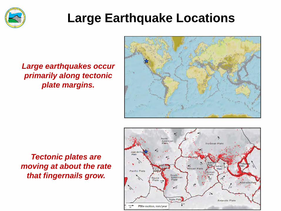
Large Earthquake Locations
Large earthquakes occur primarily along tectonic
plate margins.
Tectonic plates are moving at about the rate
that fingernails grow.
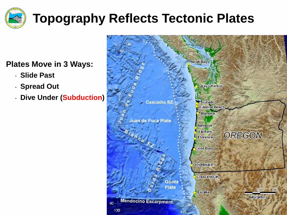
Topography Reflects Tectonic Plates
Plates Move in 3 Ways: - Slide Past - Spread Out - Dive Under (Subduction)
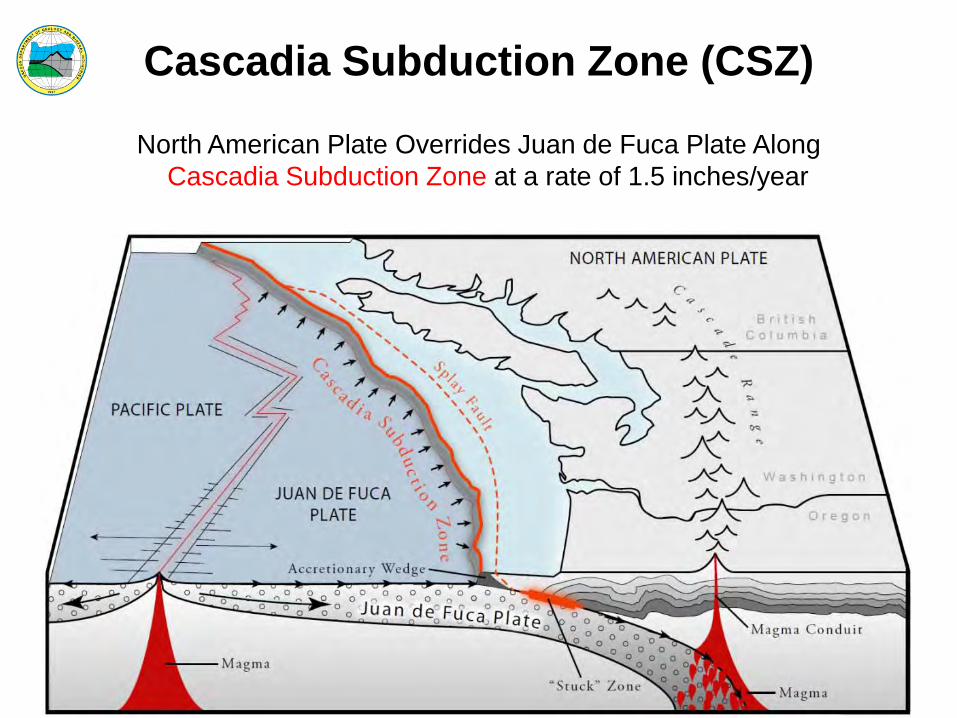
Cascadia Subduction Zone (CSZ)
North American Plate Overrides Juan de Fuca Plate Along Cascadia Subduction Zone at a rate of 1.5 inches/year

Subduction Zones – Japan vs. Oregon

ShakeMap Comparison ShakeMap for March 11, 2011 Tohoku
M9 Earthquake
ShakeMap for Simulated M9 Cascadia Earthquake

How long did the ground shake? 3 Minutes!!

March 11, 2011 Tsunami

Subduction Zone Tsunami Sources
Local Oregon Tsunamis
Distant Tsunamis

How are tsunami’s created?

Tsunamis are more than a “Wave”
• Waves break on shore • Tsunamis are a higher ocean surface that just keep coming

Tsunami Water Elevations
• First tsunami surges arrived in 15 minutes (Japan, 2011)
50 ft 100 ft

Lessons from March 11, 2011

Defenses Failed
Pine Forests
Sea Walls

Infrastructure Failed
• Tsunami wave height reached 39 feet
• Six spans of this bridge washed from 1,000 to 1,300 feet away
• Railroads no longer usable
Overturned and Underwater Central Pier

Vertical Evacuation Failed
Disaster Management HQ
In this City: 31 of 80 designated tsunami evacuation centers destroyed

Go to High Ground! Disaster Management HQ
30 officials went to the roof…11 survived

Wood Buildings Perform Well in EQ, But Poorly in Tsunami
At 6.5 to 8 feet deep: 72% destroyed
65% of “destroyed buildings” were simply washed away
Wood Houses Destroyed By Water Depth & Velocity

Reinforced Concrete Buildings Survive Better Than Wood
…but not always

Tsunami water carries an enormous amount of debris

Before Tsunami at Sendai

After Tsunami at Sendai

What should you expect in Oregon?
• M9.0 Great Earthquake - Western Oregon will experience strong
to violent shaking lasting for 2 or more minutes
- This experience will be unmistakable - Bridges will fail; Expect to walk to high
ground - 15 to 30 minutes later = start of
tsunami - Tsunami waves will continue for at
least 4 hours

• Prepare your evacuation plan and “go bag” now • When the ground shakes hard for a long time,
evacuate immediately to high ground on foot • Vertical evacuation is a “last resort” option • Tsunami waves will arrive for several hours
- First wave may not be the largest
• Wood buildings will not survive - Not all concrete or steel frame buildings will survive
• Help may not arrive for several to many days
Lessons from Japan
You will survive if you prepare and take action!

10,000-year History of Oregon Earthquakes
Locations of soil core samples taken off the Oregon coast

Offshore Landslides Record Earthquakes • Offshore landslides that have been generated from CSZ earthquakes produce turbidites.
• These turbidites can be measured from core samples like the one pictured here.
• The measuring of this mass, in addition to other sand deposits left in onshore estuaries, allow scientists to date and measure historical CSZ events.
• These historical CSZ events are then correlated between samples to create a comprehensive history of cascadia subduction zone events.

19 CSZ Events in Past 10,000 Years
earthquake

Science Team Modeled Many Tsunami Scenarios
= 5 Final Scenarios (S, M, L, XL, XXL)
Reference: Simulating tsunami inundation at Bandon, Coos County, Oregon, using hypothetical Cascadia and Alaska earthquake scenarios
Authors: Witter, R.C., Zhang, Y., Wang, K., Priest, G.R., Goldfinger, C., Stimely, L.L., English, J.T., and Ferro, P.A.
Oregon Department of Geology and Mineral Industries Special Paper 43

Historical Event Size & Frequency Relate to the 5 Scenarios
SB 379 (approximately)

DOGAMI Tsunami “T-Shirts”

Model Output to DOGAMI

Tillamook Bay - Tsunami Scenario XXL
Tsunami Modeling
Wave Elevation (meters MHHW)
Netarts Bay
Garibaldi
Bay City
Eureka
Brookings
Port Orford
Florence
Newport Lincoln City
Rockaway Beach
Willapa Bay
Grays Harbor
Juan de Fuca
Tillamook Pacific City
Columbia River Seaside

DOGAMI Turns Models to Maps • Turn Model Output Into Inundation Maps
- 5 Local CSZ “Tsunami T-Shirt Scenarios” - (S, M, L, XL, XXL)
- Occurs at High Tide - Land Subsidence Taken Into Account - Maps Include Other Relevant Information such
as Wave Time Series, Inundation Exposure, and Wave Elevation Profiles
- 2 Distant Alaska Scenarios - (Alaska 1964 (M9.2) & Alaska Max)
• Use XXL (worst local) and Alaska Max (worst distant) for Evacuation Brochures

Local CSZ Source Inundation Map

Local CSZ Source Inundation Profile

Local CSZ Source Wave Time Series

Local CSZ Source Inundation Exposure

Distant Source Inundation Map

Distant Source Inundation Profile
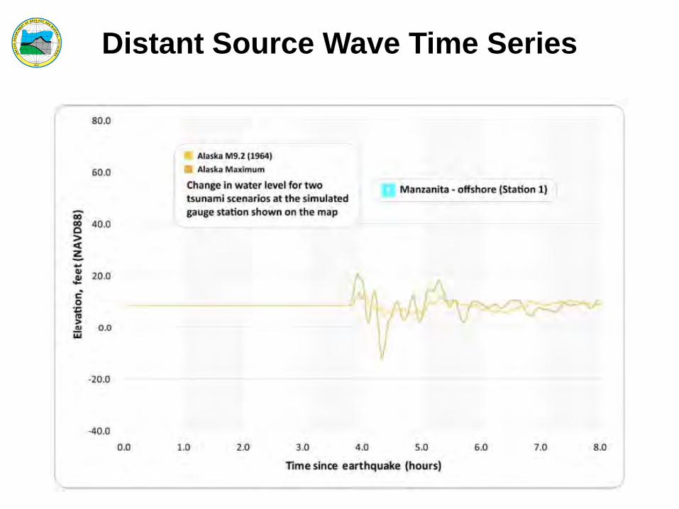
Distant Source Wave Time Series

Distant Source Inundation Exposure

NEW Evacuation Brochures
Evacuation brochure shows 2 scenarios:
• Worst-case Local Scenario (XXL)
• Worst-case Distant Scenario (Alaska Max)

Community Determines Evacuation Elements

Oregon Tsunami Clearinghouse www.OregonTsunami.com

Online Viewer - NANOOS www.OregonTsunami.org
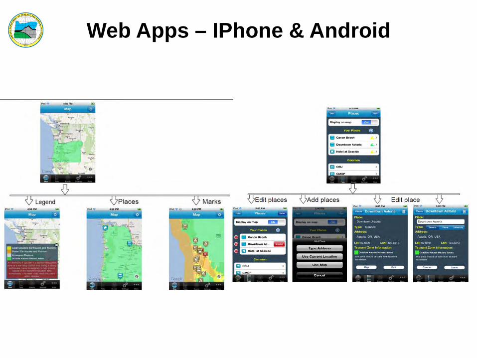
Web Apps – IPhone & Android

Earthquakes: What to do… Indoors: Drop, cover, and hold on. Drop to the floor, take cover under a sturdy
desk or table, and hold on to it firmly.
In Bed: Hold on and stay there, protecting your head with a pillow.
Outdoors: Move to a clear area if you can safely do so; avoid power lines, trees, signs, buildings, vehicles, and other hazards.
Driving: Pull over to the side of the road, stop, and set the parking brake. Avoid overpasses, bridges, power lines, signs and other hazards. Stay inside the vehicle until the shaking is over.
At the beach: Drop, cover and hold on until the shaking stops. Estimate how long the shaking lasts. If severe shaking lasts 20 seconds or more, immediately evacuate to high ground as a tsunami might have been generated by the earthquake.
In a high-rise building: Drop, cover, and hold on. Avoid windows and other hazards. Do not use elevators.

Tsunamis: What to do…
• Get Involved (Map Your Neighborhood, CERT) • Prepare Emergency “Go-kit” to Carry Along • Know Your Route from Evacuation Brochures
- (www.oregontsunami.org) • After shaking stops, Evacuate Immediately to
High Ground/Assembly Area • Stay until the “All Clear” is announced