assessment of india’s vulnerability from potentially destructive earthquakes and tsunamis
DESCRIPTION
ASSESSMENT OF INDIA’S VULNERABILITY FROM POTENTIALLY DESTRUCTIVE EARTHQUAKES AND TSUNAMIS – Land Use and Engineering Guidelines in Alleviating Future Disaster Impacts and LossesTRANSCRIPT

1
ASSESSMENT OF INDIA’S VULNERABILITY FROM POTENTIALLY DESTRUCTIVE EARTHQUAKES AND TSUNAMIS – Land Use and Engineering Guidelines in Alleviating
Future Disaster Impacts and Losses
George Pararas-Carayannis President, Tsunami Society
ABSTRACT
India has been experiencing population and phenomenal technological and economic growth. However, the combination of social and economic factors and the development of certain regions – particularly along the coastal zones – have increased India’s vulnerability to numerous natural disasters. Earthquakes, tsunamis, and weather related hazards have taken an unprecedented toll on human life and resources. The Great Earthquake and Tsunami of 26 December 2004 in the Indian Ocean and the 25 January 2001 Gujarat earthquake are recent examples of devastating catastrophic events and emphasize the need for proper disaster assessment, preparedness and adaptation of appropriate engineering guidelines that will mitigate future impact and destruction. To mitigate future impact of disasters such as earthquakes and tsunamis, a more critical and comprehensive approach must be taken in assessing the specific vulnerabilities of each particular region. Furthermore, new strategies need to be implemented to avoid a repeat of tragedies similar to the 2004 tsunami and that of the 2001 Guajarat earthquake. The present study presents only a brief overview of the regional vulnerabilities of India to potential earthquakes and tsunamis. Also, it provides some guidelines for effective disaster preparedness and mitigation through early warning systems, proper public education, appropriate land use, proper planning and sitting of critical structures, hazard microzonation, and such engineering considerations as building code changes and proper construction design criteria. 1. INTRODUCTION The Indian subcontinent is a seismically active region where major and great earthquakes occur frequently and have caused great destruction and loss of lives in the past. Most of the destructive earthquakes occur primarily along the northern and northwest regions of India. A few of these events stand out because of their destructive impact - events such as the earthquake that struck the Dharamshala-Kangra area in Himachal Pradesh of India on April 4th, 1905, known as the Kangra Earthquake (Ambraseys and Bilham, 2000, 2003; Middlemiss, 1910, Pararas-Carayannis, 2007). This was one of the most destructive and deadliest earthquakes in India's history. 19,727 people lost their lives in Dharamshala, Kangra and the neighboring towns and villages. A more recent example is the major earthquake, which occurred on 25 January 2001 in India's western state of Gujarat, near the Pakistan border. More than 30,000 people were killed by this quake and at least 30,000 more people were reported as injured in Bhuj, Bhachau, Ahmedabad and elsewhere (Pararas-Carayannis 2001). Besides these highly seismic areas of India where these earthquakes occurred, there are other areas of tectonic subduction and thrust faulting in the Andaman Sea, the Northern Arabian Sea, along a short segment of Sri-Lanka and elsewhere, where large earthquakes have occurred in recent times and in the distant past. Tsunamis generated by some of these earthquakes have been extremely destructive along the coastlines of India and elsewhere in the Indian Ocean. An early example of such an event

2
was a large magnitude earthquake in the Indus delta/Kutch region, or along the Makran subduction zone, in the Northern Arabian Sea which generated a tsunami that destroyed several ships of Alexander the Great's fleet in 325 B.C. on the journey back to Mesopotamia, after the Indian conquest (Pararas-Carayannis, 2006). The most recent destructive event in India was caused by the tsunami generated by the great earthquake of 26 December 2004 (Pararas-Carayannis 2005). This earthquake had an extensive rupture zone, which extended along Northern Sumatra and into the Andaman Sea. It was particularly destructive in the states of Andhra Pradesh and Tamil Nadu.
Seismicity of Northern India Because of extensive development, population growth and greater use of the coastal zones, India’s vulnerabilities to earthquake and tsunami hazards have dramatically increased. It is difficult to analyze in detail all the regions where future destructive events will occur. The present paper presents only an overview of India’s vulnerabilities to the more important of these hazards; with particular emphasis on tsunamigenic earthquakes in different regions and on tsunamis that can have, severe impact on the country’s newly developed coastal areas and resources. This overview includes brief summaries of the active seismotectonic mechanisms for different regions, as well as brief descriptions of past disasters. Finally, since the need for proper planning and sitting of critical structures for extreme natural hazards became evident when the destructive tsunami of December 26, 2004 struck a critical coastal facility - the Atomic Energy Township of Kalpakkam, on the east coast of India - a brief summary is provided on some of the strategies and engineering guidelines that must be implemented to mitigate future disaster disastrous impacts and losses.
2. SOURCE REGIONS OF EARTHQUAKES AND TSUNAMIS THAT IMPACT INDIA There are several regions where large earthquakes can occur and destructive tsunamis be generated that have impacted India in the past and will do so again in the future. In subsequent sections, the main source regions of large earthquakes are described as well as potential sources of

3
destructive tsunamis that will strike India’s coastlines. The main regions that are identified as more critical and reviewed here are: 1. The compressional seismic belt of Northern India; 2. The Kutch Grabben region; 3. The Karachi and deltaic Indus region and the Owens Fault Zone; 4. The Makran Subduction Zone in the Northern Arabian Sea; 5. The Andaman Sea Basin; 6. The northern segments of the Great Sunda Tectonic Arc. 2.1 THE COMPRESSIONAL SEISMIC BELT OF NORTHERN INDIA To understand the occurrence of large earthquakes in this region, the on-going seismotectonic processes must be reviewed. Earthquakes and active faults in northern India and adjacent regions in Pakistan are the direct result of the Indian subcontinent moving northward at a rate of about 40 mm/yr (1.6 inches/yr) and colliding with the Eurasian continent.
The Migration and Collision of the Indian Tectonic Plate

4
The collision with Asia began in the Middle Eocene era - about 50-55 million years ago - and has continued since. Compression along this tectonic boundary of continent-continent collision, results in a thrust or reverse type of faulting, with the net effect being buckling of the Indian sub-continent and an upward displacement of crustal material. This process of orogenesis has formed the Himalayan Mountain Range as well as the Pamir, Karakoram and Hindu Kush ranges and the Tibetan Plateau. Much of the compressional motion between the two colliding plates has been and will continue to be accommodated by slip on a suite of major thrust faults that are at the Earth's surface, in the foothills of the mountains and dip northward beneath the ranges. These include the Main Frontal thrust, the Main Central thrust, the Main boundary thrust, and the Main Mantle thrust. These thrust faults have a sinuous trace as they arc across the foothills in northern India and into Pakistan (Dasgupta et al., 2000). In detail, the modern active faults are actually a system of faults comprised of a number of individual fault traces – most of them thrust faults. Thus, Northern India is along zones of high seismic activity. The more intense seismic activity occurs by thrust faulting at the Himalayan foothills, which affect both Northern India and parts of Pakistan (Pararas-Carayannis, 2005). Major earthquakes occur frequently along this very active thrust fault system. In the last hundred years, eight earthquakes with magnitude of more than 6 have been recorded in the Uttar Pradesh region of India. As explained, these earthquakes resulted by the gradual shifting of the India tectonic plate beneath the Tibetan plate, in the geologically young Himalayan Mountain range and along the Himalayan arc. Recent earthquakes in the region include the magnitude 6.8 earthquake of 29 March 1999 that struck the Kumaon hills of Uttar Pradesh. Another destructive earthquake in 1991, measuring 6.1, and killed more than 1,000 people near the town of Uttarkashi - in the same region. In brief, the northern Part of India near the Himalayan region is associated with a much higher degree of seismicity than India’s peninsular region. Thus, it is very vulnerable to large earthquakes.
Epicenter of the 29 March 1999 Earthquake in the Uttar Pradesh Region
5
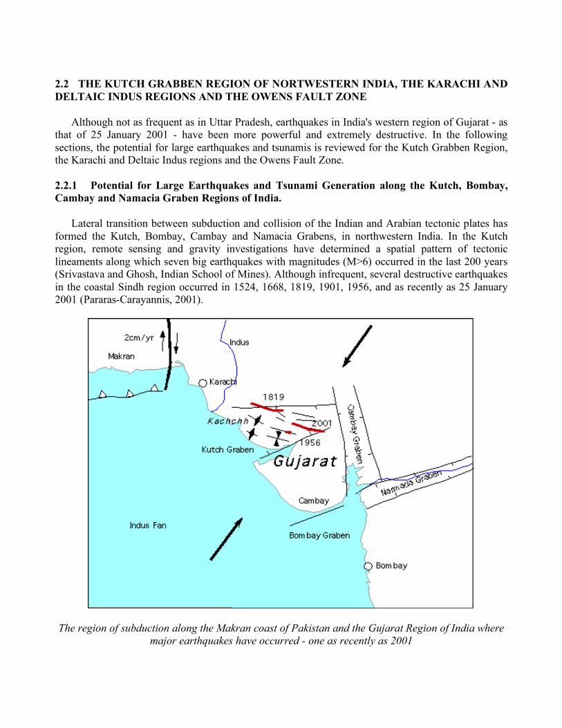
2.2 THE KUTCH GRABBEN REGION OF NORTWESTERN INDIA, THE KARACHI AND DELTAIC INDUS REGIONS AND THE OWENS FAULT ZONE Although not as frequent as in Uttar Pradesh, earthquakes in India's western region of Gujarat - as that of 25 January 2001 - have been more powerful and extremely destructive. In the following sections, the potential for large earthquakes and tsunamis is reviewed for the Kutch Grabben Region, the Karachi and Deltaic Indus regions and the Owens Fault Zone. 2.2.1 Potential for Large Earthquakes and Tsunami Generation along the Kutch, Bombay, Cambay and Namacia Graben Regions of India. Lateral transition between subduction and collision of the Indian and Arabian tectonic plates has formed the Kutch, Bombay, Cambay and Namacia Grabens, in northwestern India. In the Kutch region, remote sensing and gravity investigations have determined a spatial pattern of tectonic lineaments along which seven big earthquakes with magnitudes (M>6) occurred in the last 200 years (Srivastava and Ghosh, Indian School of Mines). Although infrequent, several destructive earthquakes in the coastal Sindh region occurred in 1524, 1668, 1819, 1901, 1956, and as recently as 25 January 2001 (Pararas-Carayannis, 2001).
The region of subduction along the Makran coast of Pakistan and the Gujarat Region of India where major earthquakes have occurred - one as recently as 2001

6
The larger earthquakes involved extensive vertical crustal uplift over land areas paralleling the orientation of the Kutch Graben. For example, the 1819 earthquake in Rann of the Kutch, bordering the Sindh region, was associated with thrust uplift of up to 30 feet along the Allah Bund fault and slippage depression of up to 10 feet along coastal fault plains. Although poorly documented as having generated a tsunami, the 1819 event was reported as having resulted in major sea inundation, destruction of coastal settlements, and permanent changes to the coastline and the drainage of major rivers, such as Indus. Probably the 1524 earthquake in the same region, also resulted in major inundation by the sea. The magnitude 7.7 Gujarat earthquake was extremely destructive and killed about 30,000 people in India and in neighboring Pakistan (Pararas-Carayannis, 2001).
Epicenter of the 25 January 2001 Earthquake in Gujarat
Finally, earthquakes associated with thrust and subsidence faulting in the coastal region of the Kutch Graben and, further south along the major fault, which runs along the west coast of Maharashtra, have the potential of generating local tsunamis. In addition, earthquake events on the Kutch Graben have the potential of triggering undersea landslides in the offshore region and local tsunamis. The tsunami hazard for this northwest region of India has been underestimated and needs to be properly evaluated. 2.3 THE KARACHI AND DELTAIC INDUS REGION – THE OWENS FAULT ZONE Four major faults exist in and around Karachi, other parts of deltaic Indus, and along the southern coast of Makran (Pararas-Carayannis, 2001, 2005). The first of these is the Allah Bund Fault. It traverses Shahbundar, Jah, Pakistan Steel Mills, and continues to the eastern parts of Karachi - ending

7
near Cape Monze. This fault has produced many large earthquakes in the past in the deltaic areas along the coast, causing considerable destruction. A major earthquake in the 13th century destroyed Bhanbhor. Another major earthquake in 1896 was responsible for extensive damage in Shahbundar. The second major fault near Karachi is an extension of the one that begins near Rann of the Kutch region of India. The third is the Pubb fault which ends into the Arabian Sea near the Makran coast. Finally, the fourth major fault near Karachi is located in the lower Dadu district, near Surajani. A major thrust fault which runs along the southern coast of the Makran coast and parts of deltaic Indus is believed to be of the same character as the West Coast fault along the coast of Maharashtra, where a tsunami may have been generated in 1524, near Dabhol (Pararas-Carayannis, 2001, 2006).
The Karachi and Deltaic Indus Region
2.3.1 Potential for Large Earthquakes and Tsunami Generation Along the Karachi and the Deltaic Indus Region There are no known records of whether any tsunamis were generated near the coastal regions of the above-mentioned faults. However, destructive local tsunamis can be generated near Karachi and the deltaic Indus area because of the proximity of thrust faults to coastal areas, the nature of crustal

8
movements of major earthquakes, and the unstable, heavily-sedimented, coastal slopes of this deltaic region. Future earthquakes along coastal thrust faults have the potential to generate destructive local tsunamis that could affect the coastal areas near Karachi as well as areas in the Kutch region of India and even the coasts of the Maharashtra region.
Historical Earthquakes along the Karachi and the Deltaic Indus Region 2.3.2 Potential for Large Earthquakes and Tsunami Generation along the Owens Fault Zone The Owen Fault Zone is a transform fault in the Arabian Sea that is associated with a tectonic boundary. It extends from the Gulf of Aden in a northeast direction towards the Makran coast where it enters the Balochistan region. Then it continues as a land fault known as the Chaman Fault along Pakistan's western frontier with Afghanistan. It begins near Kalat, in the northern Makran range, passes near Quetta and continues to Kabul, Afghanistan. Both the Owen Fault Zone and the Chaman Fault Zone can generate large destructive earthquakes (Pararas-Carayannis, 2006). The great Quetta earthquake of 1935 occurred along the Chaman Fault (Ramanathan and Mukherji, 1938). Other major thrust zones exist along the Kirthar, Sulaiman and Salt mountain ranges of Pakistan, but these do not affect India. Although highly seismic, neither the Chaman Fault nor the Owens faults have had earthquakes near coastal areas that have generated any known local tsunamis that have affected India. The potential for tsunami generation from a large earthquake along Pakistan’s coastal segment of the Chaman Fault Pakistan, needs to be properly evaluated. Although the Chaman is a transform fault, earthquakes nearer the coast could trigger underwater landslides and local tsunamis. However, and as

9
mentioned earlier, major earthquakes along thrust faults further east, near Karachi, have a much greater potential of generating destructive local tsunamis that could affect the northwest coasts of India. 2.4 THE MAKRAN SUBDUCTION ZONE IN THE NORTHERN ARABIAN SEA The Makran zone of subduction in the Northern Arabian Sea is a region where large earthquakes can occur and which can generate tsunamis that can greatly impact the western coasts of India. The Makran Subduction zone was formed by the northward movement and subduction of the Oman oceanic lithosphere beneath the Iranian micro-plate at a very shallow angle of subduction of about 20 degrees, has dragged tertiary marine sediments into an accretionary prism at the southern edge of the Asian continent (White and Louden, 1983; Platt et al., 1985; Byrne et al. 1992; Fruehn et al. 1997) - thus forming the Makran coastal region, a belt of highly folded and densely faulted mountain ridges which parallel the present shoreline. To the west of the accretionary prism, continental collision of about 10 mm/yr has formed the Zagros fold and thrust belt (Dorostian and Gheitanchi, 2003). To the east, the area comprises of a narrow belt, which truncates against the Chaman transform fault – an extensive system that extends – as already mentioned - on land in a north-northeast direction along Pakistan's frontier with Afghanistan.
The Makran Subduction Zone and Generating Area of the 28 November 1945 Tsunami Offshore, the active tectonic convergence of the India plate with the Arabian and Iranian microplates of the Eurasian tectonic block has created a tectonic plate margin - an active subduction zone along the boundary of the Arabian plate on the Makran coast. The tectonic plates there converge at an estimated rate of about 30 to 50 mm/y (Platt et al. 1988). Thus, an east-west trench has been formed south of Makran and, additionally, a volcanic arc has emerged. Specifically, the

10
underthrusting of the Eurasian plate by the Arabian plate has resulted in the formation of the Chagai volcanic arc, which extends into Iran. The Koh-e-Sultan volcano and other volcanic cones in the Chagai area are side products of this active subduction (Schoppel, 1977). The morphology of the region is further complicated by the extensive sedimentation, which takes place because of erosion of Himalayan mountain ranges and the numerous rivers flowing into the North Arabian Sea. A very thick sedimentary column enters the subduction zone (Closs et al., 1969, White and Louden, 1983), so the trench associated with the present accretionary front in the offshore region of Makran has been buried by sediments and does not have much of a morphological relief as other trenches around the world's oceans. 2.4.1 Potential for Large Earthquakes and Tsunamis Along the Makran Subduction Zone The seismicity of the Makran region is relatively low compared to the neighboring regions, which have been devastated regularly by large earthquakes (Jacob and Quittmeyer, 1979). Although infrequent, large earthquakes occur from time to time mainly on the eastern segment of the Makran subduction zone. The more recent great earthquake of 28 November 1945 is an example of the size of earthquakes this subduction zone can produce (Mokhtari and Farahbod, 2005; Pararas-Carayannis 2005, 2006). It generated a very destructive tsunami in the Northern Arabian Sea, which caused serious destruction along India’s western coastline. The tsunami was responsible for great loss of life and destruction along the coasts of Pakistan, Iran, India and Oman. The tsunami run-up heights varied from 1 to 13 m. Along the Makran coast of Pakistan, the tsunami reached a maximum run up height of 13 m (40 feet). Its waves destroyed fishing villages and caused great damage to port facilities. More than 4,000 people died from the combined effects of the earthquake and the tsunami, but most deaths were caused by the tsunami. The waves completely destroyed and killed all the people at Khudi, a fishing village about 30 miles west of Karachi. Karachi was struck by waves of about 6.5 feet in height (Pakistan Meterological Department, 2005). Tsunami waves as high as 11.0 to 11.5 m struck the Kutch region of Gujarat, on the west coast of India. There was extensive destruction and loss of life. Eyewitnesses reported that the tsunami came in like a fast rising tide. The tsunami reached as far south as Mumbai. Bombay Harbor, Versova (Andheri), Haji Ali (Mahalaxmi), Juhu (Ville Parle) and Danda (Khar). In Mumbai, the height of the tsunami was 2 meters. Fifteen (15) persons were washed away. According to reports, the first wave was observed at 8:15am (local time) on Salsette Island in Mumbai. There was no report on damage at Bombay Harbor. Five people died at Versova (Andheri, Mumbai), and six more at Haji Ali (Mahalaxmi, Mumbai), Several fishing boats were torn off their moorings at Danda and Juhu. In brief, the Makran Subduction Zone has the potential for very large earthquakes. Fortunately, they are infrequent and are usually preceded by smaller events that signal the occurrence of a larger earthquake. For example, for ten years prior to the 1945 event, there was a concentration of seismic activity in the vicinity of its epicenter. Recent seismic activity indicates a similar pattern and a large earthquake is possible in the region west of the 1945 event (Quittmeyer and Jacob, 1979). Although there are no historical records, it is believed that large earthquakes generated very destructive tsunamis in the distant geologic past. Although the historic record is incomplete, it is believed that tsunamis generated from this region were destructive on the coasts of India and on islands and other countries bordering the Indian Ocean. A thorough analysis of historical records may reveal the occurrence of past tsunamis. Finally, a factor that could contribute to the destructiveness of a tsunami generated from this
11
region would be the relatively large astronomical tide, which for the Makran coast is about 10-11 feet. A tsunami arriving during high tide would be significantly more destructive. In addition, the compacted sediments in this zone of subduction could contribute to a greater tsunami by causing a bookshelf type of failure – as that associated with the 1992 Nicaragua earthquake (Pararas-Carayannis, 1992).
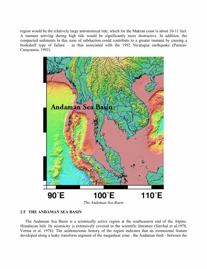
The Andaman Sea Basin
2.5 THE ANDAMAN SEA BASIN The Andaman Sea Basin is a seismically active region at the southeastern end of the Alpine-Himalayan belt. Its seismicity is extensively covered in the scientific literature (Sinvhal et al.1978, Verma et al. 1978). The seimotectonic history of the region indicates that an extensional feature developed along a leaky transform segment of the megashear zone - the Andaman fault - between the
12
Indo-Australian domain and the Sunda-Indochina block (Uyeda and Kanamori, 1979; Taylor and Karner, 1983). This old shear zone acted as a western strike slip guide for the extrusion of the Indochina block (50-20 My, Tapponnier et al., 1986) - and in response to the indentation of the Indian tectonic plate into Eurasian block. Collision of Indochina with the Sunda and Australian blocks stopped this crustal extrusion process. Subsequently, the Andaman fault system, recently prolonged through the Sumatra zone (the Sumatra fault), reactivated due to the lateral escape of the Sumatra forearc sliver plate and as a result of the oblique convergence and subduction with the Indo-Australian plate. 2.5.1 Potential for Large Earthquakes and Tsunamis in the Andaman Sea. The active seismicity of the Andaman Sea Basin, has caused many minor and intermediate earthquakes, a few major events and only one known earthquake with magnitude greater than 8. The historical record indicates that in April 1762, an earthquake at the Araken Coast off Myanmar generated the earliest known tsunami in the Bay of Bengal. On October 1847, an earthquake near the Great Nicobar Island generated another tsunami, but no details are available. On 31 December 1881 a magnitude 7.9 earthquake near Car Nicobar, generated yet another tsunami in the Bay of Bengal. Its height recorded at Chennai was one meter. During an eighty year period from 1900 to 1980, a total of 348 earthquakes were recorded in the area bounded by 7.0 N to 22.0 N and 88.0 E to 100 E. These earthquakes ranged in magnitude from 3.3 to 8.5 (Bapat, 1982), but only five of these had magnitudes equal to or greater than 7.1 and generated tsunamis (Murty and Bapat, 1999). For the shorter period from 1916 to 1975, only three of the earthquakes had magnitudes greater than 7.2 and generated significant tsunamis. (Verma et al., 1978). Until the great earthquake of 26 December 2004, only the earthquake of 26 June 1941 had been the strongest ever recorded in the Andaman and Nicobar Islands, in generating a destructive tsunami. Two other earthquakes on 23 August 1936 and 17 May 1955, with magnitudes 7.3 and 7.25, respectively, did not generate tsunamis of any significance. Based on these statistical information, it can be concluded that most of the earthquakes in the Andaman Sea Basin, even those with magnitudes greater than 7.1, do not usually generate significant tsunamis. The possible reason for the low number of tsunamis is that most of the earthquakes in the Andaman Sea are mainly associated with strike-slip type of faulting that involves lateral crustal movements. The exception was the 26 December 2004 earthquake, which, not only ruptured the Great Sunda Arc along the northern Sumatra region but also ruptured the same segment in the Andaman Sea as that in 1941. A possible explanation for the extreme tsunami generated in the Andaman segment in December 2004 is that this event had a different mechanism and involved both thrust and bookshelf faulting within the compacted sediments of the Andaman Sea segment of the Great Sunda Arc (Pararas-Carayannis, 2005). In view of the above historical record, it can be reasonably concluded that large earthquakes along the northern end of the Great Sunda subduction boundary in the Andaman Sea do not occur frequently. However, events with magnitudes greater than 7.1 have the potential of generating local destructive tsunamis. Finally, earthquakes with magnitude 8.0 or greater, associated with “dip-slip” types of vertical crustal displacements along thrust faults, have the potential of generating very destructive tsunamis.

13
2.6 NORTHERN SEGMENTS OF THE GREAT SUNDA TECTONIC ARC
As previously explained, the overall movement of the India tectonic plate in a north/northeast direction and its collision with the Eurasian tectonic plate has formed the Himalayan Mountains. The tectonic arc and the great trench formed by collisions on the eastern boundary have created a zone of subduction known as the great Sunda Arc or Sunda Trench. This zone extends for about 3,400 miles (5,500 kms) south from Myanmar, past Sumatra and Java and east toward Australia and the Lesser Sunda Islands, ending up near Timor. The Sunda Arc comprises of two distinct zones. In the eastern part, which is relatively old (more than 100 million years), oceanic lithosphere subducts offshore from Java. The younger (40 million years) northwest segments of the Arc mark the boundaries formed by the movement of the Indo-Australian plate as it collides with the Burma sub-plate, which is part of the Eurasian plate. A divergent boundary separates the Burma plate from the Sunda plate. The Burma sub-plate encompasses the northwest portion of the island of Sumatra as well as the Andaman and the Nicobar Islands. In the region off the west coast of northern Sumatra, the India plate is moving in a northeastward direction at about 5 to 5.5 cm per year relative to the Burma plate. Because of this migration and collision with both the Eurasian and the Australian tectonic plates, the India plate's eastern boundary has become a diffuse zone of seismicity and deformation, characterized by extensive thrust faulting and numerous large earthquakes that can generate destructive tsunamis.
Northern Segment of the Great Sunda Tectonic Arc. Epicenter of the 12 September 2007 Earthquake.
Sumatra on the northern segment of the Sunda arc is one of the most seismically active regions of the world. The northern segment of the Sunda Arc and its extension into the Andaman Sea is a region where large earthquakes have occurred in the past and can be expected again in the future. As the 26 December 2004 events demonstrated, this is a region where destructive tsunamis originate that can impact severely India and other countries bordering the Indian Ocean. Previous major and great earthquakes in this region occurred further north, in the Andaman Sea and further South along the
14
Sumatra, Java and Sunda segments of the great Sunda Arc. Earthquakes with magnitude greater than seven struck offshore islands in Western Sumatra in 1881, 1935, 2000, and 2002. Earthquakes with magnitude greater than 8 have struck the same region in 1797, 1833, 1861, 2004, 2005 and as recently as 12 September 2007 (Pararas-Carayannis, 2007). 2.6.1 The Effects of the 26 December 2004 Tsunami in India
The effects of the 26 December 2004 tsunami in India have been adequately documented in the literature (Pararas-Carayannis, 2005) but, because of its significance, a summary is provided. The estimated number of casualties in India was 16,000, but at least 6,000 more were reported as missing. The figures provided here are based on earlier reports and thus may not be entirely correct. Along India's southeastern coast, the tsunami swept away several villages, and thousands of fishermen at sea were missing. Hardest hit was the state of Tamil Nadu. The tsunami destroyed entire coastal villages. According to official reports, the overall death toll in the state was 7,793. The Nagapattinam district had 5,525 casualties. The latest reported death toll at Velankanni was 1,500. Kanyakumari district has had 808 deaths, Cuddalore district 599, the state capital Chennai 206 and Kancheepuram district 124. The death tolls in other districts were Pudukkottai (15), Ramanathapuram (6), Tirunelveli (4), Thoothukudi (3), Tiruvallur (28), Thanjavur (22), Tiruvarur (10) and Viluppuram (47). The nuclear power plant at Kalpakkam was shut down after seawater rushed into a pump station. No radiation leak or damage to the reactor was reported. There was significant loss of life and destruction in Andhra Pradesh. The most affected districts were Krishna, Prakasam, Nellore, Guntur, West Godavari and East Godavari. At Kerala, the tsunami killed many people (official toll 168) and caused extensive destruction particularly at Kollam (131 dead), Alappuzha (32) and Ernakulam (5) were affected. In the Union territory of Pondicherry, the affected districts were Pondicherry (107 dead), Karaikal (453 dead). The latest official toll was 560. An estimated 30,000 people were rendered homeless. The tsunami hit hard the Andaman and Nicobar Islands. The group comprises of a total of 572 islands of which 38 were significantly inhabited. The tsunami waves literally washed away some of these islands, and there were reports that the island of Trinket had split in two. The Great Nicobar and Car Nicobar were the worst hit among all the southern Nicobar Islands because of their proximity to the earthquake's epicenter and relative low topography. The maximum tsunami wave reached a height of 15m. According to reports one fifth of the population of the Nicobar Islands were dead, injured or missing. Chowra Island lost two thirds of its population of 1,500. The unofficial death toll (including those missing and presumed dead) is estimated to be about 7,000. On 30 December 2004, four days after the great earthquake, Barren 1 volcano on Barren Island - located 135 kilometers (80 miles) northeast of the capital Port Blair - erupted. 2.6.2 Potential for Large Earthquakes and Tsunamis along the Northern Segments of the Great Sunda Tectonic Arc. Slippage and plate subduction along the Great Sunda Tectonic Arc make this region seismic. Tsunamis can be generated from earthquakes originating anywhere along this long tectonic boundary. However, only earthquakes in the northern segments of the arc can generate tsunamis that can have significant impact on India’s shores. The primary reason for this is the geographical orientation of the seismic zone. Most of the energy of tsunamis generated along the coasts of Java or the Lesser Sunda

15
Islands would be focused away from India. However, earthquakes along the Andaman and the northern Sumatra segments of the arc can generate destructive tsunamis that can impact India severely. The potential for tsunami generation in the Andaman Sea basin has been discussed. The Andaman Sea basin is a forearc sliver plate. Most of the earthquakes along the eastern Andaman fault system involve lateral movements as this represents an elongated extension of the strike-slip type of the Sumatra faulting which extends along the entire length of the island. Earthquakes along this eastern region do not generate significant tsunamis. However, the western side of the sliver plate is an extension of the northern Sunda Arc boundary, which can break – as the 26 December 2004 and 1941 events demonstrated - and generate destructive tsunamis. Furthermore, the region where the 26 December 2004 occurred was a seismic gap region where great stress had accumulated over the years. When this earthquake occurred, the Indian plate subducted the Burma plate and moved in a northeast direction. This movement caused dynamic transfer and loading of stress to both the Australian and Burma plates, immediately to the south, on the other side of the triple junction point (Pararas- Carayannis, 2005, 2006, 2007).
Generating Areas of the 2004, 1861, 1833 and 2007 Tsunamis
Because of this load transfer, the Australian plate moved in relation to the Burma plate and probably rotated somewhat in a counterclockwise direction, causing the great earthquake of 28 March

16
2005. In fact, the 2005 earthquake had occurred in the same region as the 1861 earthquake. The block that moved was relatively small in comparison, thus the tsunami that was generated was not very destructive. However, following the great earthquakes of 2004 and 2005, it appears that there was additional significant transference of tectonic stress further south/southeast to the central region of Western Sumatra. The latest great earthquake (magnitude 8.2) of September 12, 2007 and the other two events and aftershocks (and later a fourth event) occurred even further south/southeast and within the segment that ruptured when a great (estimated magnitude Mw=8.7) earthquake occurred in 1833 (Pararas-Carayannis, 2007). Apparently, the September 12, 2007 earthquake had a smaller magnitude and length of rupture than the 1833 event, which generated a much greater tsunami. The shorter rupture (estimated roughly at about 200 km), and the smaller magnitude, was the probable reasons for the smaller 2007 tsunami. Fortunately, the energy release by two other earthquakes, which occurred subsequently in sequence, helped release gradually the tectonic stress along this segment. This may have contributed to the relatively smaller tsunami that was observed in Padang and elsewhere. This did not occur when the 1833 earthquake had struck the same region. All the energy of the 8.7 earthquake in 1833 was released at once and the rupture zone may have been as much as 300 km or even more. The effects of the 1833 tsunami in India are unknown. It remains to be seen if the earthquake of September 12, 2007 resulted not only from partial subduction but also from counterclockwise rotation of the Australian plate. Such rotation, with diminished vertical uplift, could account for the smaller 2007 tsunami. Field studies of uplift and lateral motions on the offshore islands would confirm if the mechanism of the 2007 event was different from the one that generated the1833 tsunami. Field studies on Sipora, North Pagai and South Pagai Islands of the outer-arc ridge of the great Sunda Arc, indicate that the great 1933 earthquake resulted in vertical uplift of up to 2.3 meters. Such extensive vertical uplift generated the greater tsunami. The uplift caused by the September 12, 2007 earthquake may have been much less than that of 1833. In brief, earthquakes and tsunamis similar to the 2007, 2005, 2004 and 1833 events can be expected every hundred years - or even more frequently - in this northern segment of the great Sunda subduction zone. This particular section of the megathrust along the western coast of the northern, central and southern Sumatra is one of the more likely sources of destructive tsunamis in the region in the future. A repeat of a single large earthquake with the same rupture and source dimensions as those of the 1833 or 2004 events, could generate devastating tsunamis that could affect Sumatra and other distant regions of the Indian Ocean. The northern segments of the great Sunda arc are source regions of tsunamis that can be very destructive in India and elsewhere in the Bay of Bengal and the Indian Ocean.
3. EARTHQUAKE AND DISASTER MITIGATION STRATEGIES Based on this documentation and cursory analysis it can be concluded that India is particularly vulnerable to large destructive earthquakes and tsunamis. The country’s northern and northwestern regions are particularly vulnerable to large destructive earthquakes. As the 2004 disaster clearly demonstrated, Tamil Nadu, Andhra Pradesh and other regions in the eastern coasts of the country are particularly vulnerable to tsunamis generated by large earthquakes in the Andaman Sea Basin and along the northern segments of the great Sunda tectonic arc. In addition, the western coasts of India are very vulnerable from tsunamis generated by large earthquakes along the Makran Subduction zone,
17
and in the Kutch Grabben, Karachi and deltaic Indus regions. The tsunami of 26 December 2004 demonstrated that India is particularly vulnerable to tsunami hazards and that mitigation strategies must be implemented to alleviate future impacts. The effects of this tsunami on the Atomic Township of Kalpakkam were particularly noteworthy as they demonstrated that potential future disasters could have significant collateral catastrophic consequences on critical structures. The Kalpakkam complex includes: a) a nuclear power generating plant; b) an atomic reprocessing plant (KARP) which reprocess spent fuel from the pressurized heavy water reactors - including those known as MAPS-1 and 2 to produce plutonium; c) a fast breeder test reactor; d) a Central Waste Management Facility (CWMF) (which includes concrete trenches where intermediate and high level radioactive wastes are stored); e) an Advanced Technology Vehicle (ATV) Testing Facility (Nuclear Submarine Project); f) a Tritium Extraction Plant; and g) A sea water desalination plant. According to reports, the tsunami waves that struck the Township of Kalpakkam killed 37 people, destroyed 670 residences and flooded the cooling system of the nuclear power generating facilities. It is not known what other impact the tsunami had. Nothing has been said about the extent of damage to these facilities and if any radioactive waste from the Waste Management Facility leaked out. Subsequently, it was reported that the nuclear plant was shut down two hours after its cooling system was flooded. In addition, that the sitting and design of the Kalpakkam facilities had been based on the worse historical monsoons and surges that could strike the region. However, what became evident from this disaster was the fact that the licensing of this facility and the engineering design criteria that had been used in sitting it at this location had not taken into consideration the potential impact of a destructive tsunami. The potential risk from a tsunami was overlooked, even though several tsunamis generated by earthquakes in the Andaman Sea and along Sumatra have struck India’s east coast in the past, including the 1941 Adaman Sea event. In brief, the facilities at the Kalpakkam site, as well as other critical facilities along India’s long coastlines, remain extremely vulnerable to future tsunami and other marine disasters. The following section presents a brief overview of how regulation of land use and adoption of engineering guidelines can help mitigate the effects of future disasters. 3.1 Land Use Guidelines in Alleviating Future Disaster Impacts and Losses Proper land use is probably the most effective method for mitigating the impact of future marine hazards, including tsunamis. This tool is largely underutilized. Often, in allocating the use of land, the economic considerations are given higher priority rather than the overall safety of the community. Often, the use of coastal lands is permitted for construction of critical facilities without proper or complete disaster risk analysis. To mitigate the impact of future marine disasters along coastal regions that are potentially vulnerable to tsunami or storm surge inundation, local governments should take steps to designate the danger zones that put parts of the population at risk by preventing certain kinds of development. For example, critical infrastructure and industrial facilities should never be allowed to be built in coastal areas likely to be flooded by tsunamis or typhoon surges, because that could compound the effects of a disaster by the leakage or spilling of flammable or hazardous materials. Construction and development should be prohibited in areas that put at risk the general population, but especially areas where the children, the elderly, or the handicapped are concentrated. Critical facilities such as schools, and nursing homes should not be built in coastal areas that are vulnerable. Similarly, police and fire departments and hospitals should be located in risk areas. It is important that such facilities

18
stay operational during the disaster and that they continue to function effectively during the post disaster period. Proper planning requires special information and evacuation procedures. For example, in coastal areas there should be posting of information and signs of evacuation procedures and routes to ensure the safety of the public. Early warning systems and educational programs on disaster preparedness could help mitigate future losses. For waterfront hotels in vulnerable areas, the staff of hotels should be familiar with procedures for evacuation and how to pass this information quickly to guests. Such basic planning, preparedness and public education would have saved many lives when the 2004 tsunami struck the waterfront resort areas in Thailand and elsewhere. 3.2 Engineering Considerations in Mitigating Future Disaster Impact and Losses Additionally, in constructing critical mega city infrastructure facilities in offshore and coastal areas that may be vulnerable to disasters, engineering guidelines must be adopted that can assure safety and reliability and help mitigate the impact of future events. Site selection for construction of important facilities requires careful disaster risk assessments. First, all the environmental hazards that may be unique to a site must be examined. For example, all available data must be collected on historical earthquakes, tsunamis, hurricanes, or surges. Then, each hazard and its impact must be examined separately. Proper hazard risk analysis must differentiate between expected yearly or seasonal occurrences and extreme events of longer cycles. In order to guarantee a critical structure’s design adequacy for earthquake hazards, the engineering analysis must first identify the geographical distribution of seismic sources, and then determine the recurrence frequencies of potentially destructive earthquakes. Additionally, the analysis must include examination of the substrata and other environmental conditions of the selected site. If the region is seismically active, all potential dynamic forces for a variety of lateral and vertical ground accelerations of different magnitude earthquakes must be taken into consideration. Furthermore, the geometry of the structure and the interaction of the building components with each other and with adjacent structures must be evaluated, as well as the potential for ground liquefaction. The engineering design criteria must not be restricted to the maximum effects of past disasters but need to include added margins of safety for extreme dynamic loads. Similarly, in designing and constructing critical structures in areas vulnerable to tsunamis, the engineering analysis must include the maximum effects of tsunami waves of different heights and periods – all of which can be established with proper analytical or computer models. In dealing with hurricanes and other storm systems, maximum winds currents and surges could be determined with the help of modeling methods. A major engineering consideration should be the reliability of a critical structure to continue operations during and after the disaster strikes. Uninterrupted functioning of urban infrastructure facilities and industries is necessary for quick recovery of a community after a disaster. The complete failure of New Orleans infrastructure facilities after the 2005 Hurricane Katrina is a tragic example. Poor planning and engineering contributed to the long-lasting post disaster impact that seriously affected the welfare of this community. Safety of a community before a disaster strikes requires expeditious evacuation. Continued safety in the post-disaster period requires clean water and sanitation and a continuous power supply. All these were absent in New Orleans long after the disaster had struck. In brief, good engineering practices can help mitigate the impact of marine disasters.

19
3.3 Tsunami Risk Analysis A detailed discussion of tsunami risk analysis is outside the scope of the present overview. However, it should be emphasized that assessing properly the tsunami risk of a region is of extensive interest to governmental and non governmental agencies so they can establish policies for proper land use, zoning and public safety. It is also of great interest to different industries for evaluation of potential vulnerabilities and for continuance of operations in the post-disaster period. Insurance companies need similar analysis for establishing recurrence frequencies and determining premiums. Engineering and construction firms need it for adequacy of design and structural strength of buildings. Finally, the public-in-general needs the information for awareness, preparedness and safety. Thus, a proper tsunami risk analysis must include collection and analysis of data for both local and distant sources, as well as information on the transformations that tsunamis undergo during travel to a distant shore. Similarly, the tsunami’s potential terminal effects, the resulting run-up, and the expected static and dynamic forces at impact must be evaluated properly. Analysis of the historic record of tsunami activity is the best way to begin the risk assessment process and arrive at a level of risk acceptability. Only then, fundamental questions of preparedness can be addressed, such as: a) what safety measures can be taken by authorities in protecting the coastal population and vital coastal resources, industries and structures? b) How can the risk of the tsunami hazard be minimized? c) Are public safety personnel properly trained to deal with the disaster? d) Are relief facilities adequate to respond in an emergency? 4. REFERENCES Ambraseys, N. and Bilham, R., "A short note on the Ms7.8 Kangra earthquake of 1905", Current Science, Vol. 79, No. 1, July 2000. Ambrasseys, N. and Bilham, R., 2003, "Earthquakes and Associated Deformation in North Baluchistan 1892-2001", Bulletin of the Seismological Society of America, Vol .93, No. 4, p. 1573 - 1605. Bapat, A. (1882). “Tsunamis and earthquakes in the Bay of Bengal”, Tsunami Newsletter, International Tsunami Information Center, Honolulu, Volume XV, No. 3, 36-37. Byrne Daniel E., Sykes Lynn R. Davis Dan M., 1992. “Great thrust earthquakes and aseismic slip along the plate boundary of the Makran subduction zone”. JOURNAL OF GEOPHYSICAL RESEARCH, VOL. 97, NO. B1, PAGES 449–478, 1992 Closs, H., Bungenstock, H., Hinz, K., 1969. “Ergebnisse seismischer Untersuchungen im nrdlichen Arabischen Meer: ein Beitrag zur internationalen Indischen Ozean Expedition.” METEOR Forschungsergebnisse, Reihe C, 2, 28 pp. Flueh, E. R., Kukowski, N., Reichert, C. (Editors). FS Sonne Cruise Report SO-123 - MAMUT, Maskat - Maskat 07.09. - 03.10.1997, GEOMAR Rep. 62, 292 pp.

20
Dasgupta, S., Pande, P., Ganguly, D., Iqbal, Z, Sanyal, K, Venkatraman, N.V., Dasgupta, S., Sural, B., Harendranath, L., Mazumdar, K., Sanyal, S., Roy, K., Das, L.K., Misra, P.S., Gupta, H., "Seismotectonic Atlas of India and its Environs", Geological Survey of India, 2000. Dorostian A., Gheitanchi M. R., 2003, “SEISMICITY OF MAKRAN” European Geophysical Society 2003. Tectonics of a Lateral Transition Between Subduction and Collision:The Zagros-Makran Transfer Deformation Zone (SE IRAN), Geophysical Research Abstracts, Vol. 5, 01210, 2003 Fruehn, J., White, R. S. and Minshull, T. A., 1997. “Internal deformation and compaction of the Makran accretionary wedge”, Terra Nova, 9: 101-104. Jacob, K. H. and Quittmeyer, R. L., 1979. “The Makran region of Pakistan and Iran: Trench-arc system with active plate subduction”. In: Farah, A. and de Jong, K. A. (Editors), Geodynamics of Pakistan: 305-317. Middlemiss, C.S., "The Kangra Earthquake of 4th April 1905", Memoirs of the Geological Survey of India, vol. 38, 1910 (1981 Reprint). Mokhtari, M. and Farahbod, A.M. 2005. “Tsunami Occurrence in the Makran Region”. Tsunami Seminar, Tehran, 26 February 2005 Murty. T. and A. Bapat, "Tsunamis on the coastlines of India", International Tsunami Symposium, May 1999 (Abstract). Pakistan Meterological Department 2005. “History of Tsunamis in Pakistan/Arabian Sea”, Report, January 2005. Pararas-Carayannis, G., 1978. “The Earthquake and Tsunamis of 19 August 1977 in the Lesser Sunda Islands of Indonesia”. ITIC Progres Reports for 1976-1977 prepared for the 1978 Sixth Session of ITSU in Manila, Philippines. http://drgeorgepc.com/Tsunami1977Indonesia.html Pararas-Carayannis, G., 1992. “The Earthquake and Tsunami of 2 September 1992 in Nicaragua” http://drgeorgepc.com/Tsunami1992Nicaragua.html Pararas-Carayannis, G., 2001. "The Earthquake of 25 January 2001 in India" http://drgeorgepc.com/Earthquake2001India.html Pararas-Carayannis, G., 2001. "The Earthquake and Tsunami of 28 November 1945 in Southern Pakistan” http://drgeorgepc.com/Tsunami1945Pakistan.html Pararas-Carayannis, G. 2001. “The Great Tsunami of August 26, 1883 from the Explosion of the Krakatau Volcano ("Krakatoa") in Indonesia” http://drgeorgepc.com/Tsunami1883Krakatoa.html Pararas-Carayannis, G., 2003. “Near and far-field effects of tsunamis generated by the paroxysmal eruptions, explosions, caldera collapses and massive slope failures of the Krakatau volcano in
21
Indonesia on August 26-27, 1883”. Presentation for the International Seminar/Workshop on Tsunami "In Memoriam 120 Years of Krakatau Eruption - Tsunami And Lesson Learned From Large Tsunami", August 26th - 29th 2003, Jakarta and Anyer, Indonesia; Journal of Tsunami Hazards, Volume 21, Number 4. 2003. http://drgeorgepc.com/Tsunami1883Krakatau.html Pararas-Carayannis, G., 2005. “The Great Earthquake and Tsunami of 26 December 2004 in Southeast Asia and the Indian Ocean”, http://drgeorgepc.com/Tsunami2004Indonesia.html Pararas-Carayannis, G., 2005. “The Earthquake and Tsunami of 26 June 1941 in the Andaman Sea”. http://drgeorgepc.com/Tsunami1941AndamanSea.html Pararas-Carayannis, G., 2005. “The Great Earthquake and Tsunami of 1833 off the coast of Central Sumatra in Indonesia” http://drgeorgepc.com/Tsunami1833Indonesia.html Pararas-Carayannis, G., 2005. “The Great Earthquake and Tsunami of 28 March 2005 in Sumatra, Indonesia”, http://drgeorgepc.com/Tsunami2005ndonesia.html
Pararas-Carayannis, G., 2005. "The Earthquake of 8 October 2005 in Northern Pakistan" http://drgeorgepc.com/Earthquake2005Pakistan.html Pararas-Carayannis, G., 2006, “Potential of tsunami generation along the Makran Subduction Zone in the Northern Arabian Sea – Case Study: The Earthquake and Tsunami of 28 November 1945”, 3rd Tsunami Symposium of the Tsunami Society May 23-25, 2006, East-West Center, Un. of Hawaii, Honolulu, Hawaii, Science of Tsunami Hazards Vol 24(5), 2006 http://drgeorgepc.com/TsunamiPotentialMakranSZ.html Pararas-Carayannis, G., 2006. “Alexander The Great – Impact of the 325 B.C. Tsunami in the North Arabian Sea Upon his Fleet” http://drgeorgepc.com/Tsunami325BCIndiaAlexander.html Pararas-Carayannis, G., 2007. “The Earthquake of 31 May 1935, near Quetta (Balochistan), Pakistan” http://drgeorgepc.com/Earthquake1935PakistanQuetta.html
Pararas-Carayannis, G., 2007. “The Earthquake of 4 April 1905 in Himachal Pradesh, India (the Kangra Earthquake)”. http://drgeorgepc.com/Earthquake1905IndiaKangra.html
Pararas-Carayannis, G. 2007, “The Earthquakes and Tsunami of September 12, 2007 in Indonesia”, http://drgeorgepc.com/Tsunami2007Indonesia.html
Platt, J. P., Leggett, J. K., Young, J., Raza, H. and Alam, S., 1985. “Large-scale sediment underplating in the Makran accretionary prism, Southwest Pakistan”, Geology, 13: 507-511. Quittmeyer, R.C., and Jacob, K.H., 1979, "Historical and Modern Seismicity of Pakistan, Afghanistan, N.W. India and S.E. Iran", Bulletin of the Seismological Society of America, 69/3, pp. 773-823, 1979

22
Ramanathan, K., and Mukherji, S., 1938, "A seismological study of the Baluchistan, Quetta, earthquake of May 31, 1935", Records of the Geological Survey of India, Vol. 73, p. 483 – 513. Times of India Newspaper archives (Mumbai), India, November 1945 Schoeppel, R.J., 1977, “Prospects of Geothermal power in Saindak area, Baluchistan province, Pakistan”. Final report for Oil and Gas Development Co. 15p. Sinvhal, H., Khattri, K.N., Rai, K. and V.K. Gaur. (1978), “Neotectonics and time-space seismicity of the Andaman Nicobar region”, Bulletin of the Seismological Society of America, Volume 68, No. 2, 399-409. Srivastava V. K. and Ranjana Ghosh, Report of the Dept. of Applied Geophysics, Indian School of Mines Tapponnier, P., Peltzkr, G. and R. Armijo, 1986, “On the mechanism of collison between India and Asia”. In: COWARD, M.P. & RIES, A.C. (eds) Collision Tectonics. Geological Society, London, Special Publications, 19, 115-157. Taylor B. and Karner G.D., 1983, “On the evolution of marginal basins”. Rev.Geophys., 21, 1727-1741 Uyeda S. and Kanamori H., 1979, “Back-arc opening and mode of subduction”. J.Geophys.Res., 84, 1049-1061 Verma, R.K., Mukhopadhyay, M. and N.C. Bhuin. (1978), “Seismicity, gravity and tectonics in the Andaman Sea”, in "Geodynamics of the Western Pacific", Proceedings of the International Conference on Geodynamics of the Western Pacific - Indonesian Region, March 1978, Tokyo, Advances 'in Earth and Planetary Science 6, Supplement Issue of Journal of Physics of the Earth, edited by S. Uyeda, R.W. Murphy and K. Kobayashi, Center for Academic Publications, Japan Scientific Societies Press, Tokyo, 233-248. White, R. S., Louden, K. E., 1983, “The Makran Continental Margin: Structure of a Thickly Sedimented Convergent Plate Boundary”, In: J. S. Watkinsand C. L. Drake (Editors), Studies in Continental Margin Geology. Mem. Am. Ass. Petrol. Geol. 34: 499-518.