geomorphological evolutionof badlandsbasedonthe dynamics
TRANSCRIPT
Geomorphological evolution of badlands based on thedynamics of palaeo-channels and their implications
V Ranga1,∗, S N Mohapatra1 and P Pani2
1Centre of Remote Sensing & GIS, School of Studies in Earth Science, Jiwaji University, Gwalior 474 011, India.2Centre for the Study of Regional Development, Jawaharlal Nehru University, New Delhi 110 067, India.
∗Corresponding author. e-mail: [email protected]
The badlands along the lower Chambal valley represent the worst case of water erosion in India. Thesebadlands are believed to have developed due to neo-tectonic activities and, probably, strengthening ofsouthwest monsoon in late Pleistocene–Holocene. Due to neo-tectonic activities, the Chambal River hasundergone many changes before reaching to its present planform. This study reports palaeo-channelson the Chambal River’s right flank along its lower reaches. Salient features of the palaeo-channels andtheir relation to present spatial pattern of badlands are studied. These palaeo-channels have significantlyinfluenced the development of badlands along the lower Chambal River and have given them distinct andconspicuous spatial patterns. In the light of the evidences, a modified schematic geomorphic evolution ofbadlands development is also proposed starting from a pre-incision scenario till the present day situation.A major modification in the proposed model is the multi-channel planform of the Chambal River beforeits incision.
1. Introduction
The formation of Himalaya Foreland Basin (HFB)leads to one of the most extensive alluvial plainsin the world, i.e., Indo-Gangetic plains (Giblinget al. 2005), where, Ganga Plains represent thefore-deep (DeCelles and Giles 1996) part of theHFB system (Goswami and Mishra 2014). Thesouthern margin of foreland basin is marked by aregional gentle fore-bulge (DeCelles 2011) in theform of Bundelkhand–Vindhyan Plateau (Singh1996), while the northern margin is marked by theShiwalik Hills. From north to south, the GangaPlain can be subdivided into three geomorphicunits: (1) Piedmont Zone (PZ), (2) Central Allu-vial Plain (CAP), and (3) Marginal Alluvial Plain(MAP) (Singh 1996; Agarwal et al. 2002; Goswamiand Mishra 2014), where, the MAP is enclosed bythe Yamuna River and the Indian craton. MarginalAlluvial Plains are incised with the most severe
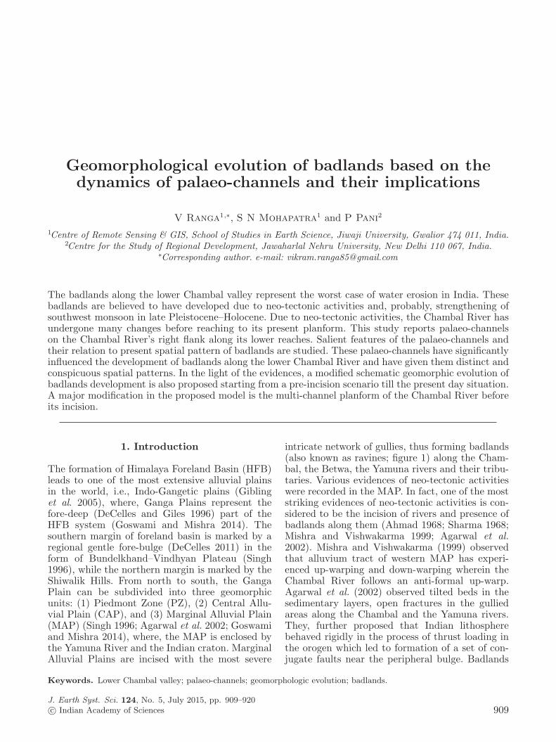
intricate network of gullies, thus forming badlands(also known as ravines; figure 1) along the Cham-bal, the Betwa, the Yamuna rivers and their tribu-taries. Various evidences of neo-tectonic activitieswere recorded in the MAP. In fact, one of the moststriking evidences of neo-tectonic activities is con-sidered to be the incision of rivers and presence ofbadlands along them (Ahmad 1968; Sharma 1968;Mishra and Vishwakarma 1999; Agarwal et al.2002). Mishra and Vishwakarma (1999) observedthat alluvium tract of western MAP has experi-enced up-warping and down-warping wherein theChambal River follows an anti-formal up-warp.Agarwal et al. (2002) observed tilted beds in thesedimentary layers, open fractures in the gulliedareas along the Chambal and the Yamuna rivers.They, further proposed that Indian lithospherebehaved rigidly in the process of thrust loading inthe orogen which led to formation of a set of con-jugate faults near the peripheral bulge. Badlands
Keywords. Lower Chambal valley; palaeo-channels; geomorphologic evolution; badlands.
J. Earth Syst. Sci. 124, No. 5, July 2015, pp. 909–920c© Indian Academy of Sciences 909
910 V Ranga et al.
Figure 1. A typical scenario of intricate network of ravines in the lower Chambal valley.
presents the most spectacular scenery in the other-wise flat topography of deposited sediments in thelower Chambal valley, covering an area of ca. 4800km2 (Sharma 1979). Along with the up-warpingof the area, intensification of SW monsoon in thelate Pleistocene–Holocene is also considered a pos-sible reason for badlands formation (Tandon et al.2006; Joshi 2014). However, the timing of badlandsformation is not well constrained in the area butGibling et al. (2005), after dating a gully fill in theKalpi region, found that the youngest gully fill sed-iments are ca. 35 ka (± 4 ka) old. Since these sedi-ments are actually gully fills, gullies and badlandsmust have formed prior to that period (Tandon et al.2006).Mishra and Vishwakarma (1999), while studying
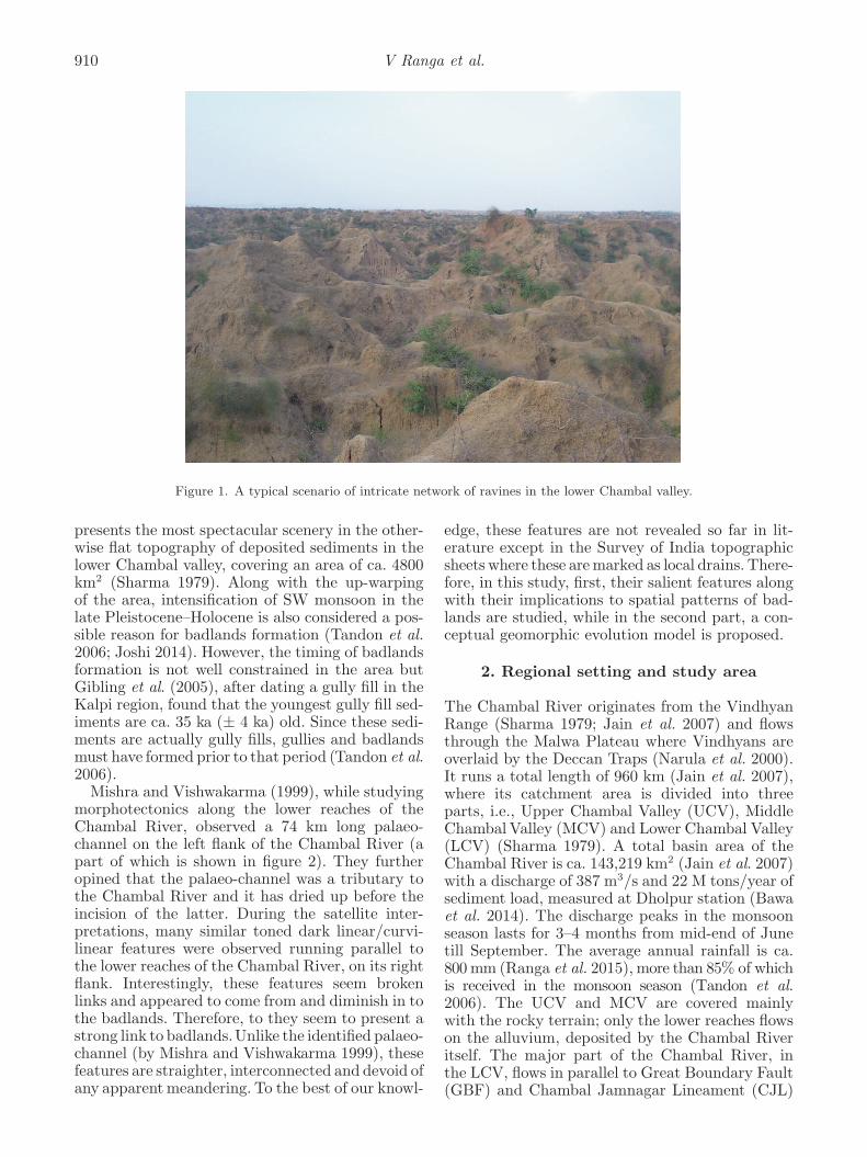
morphotectonics along the lower reaches of theChambal River, observed a 74 km long palaeo-channel on the left flank of the Chambal River (apart of which is shown in figure 2). They furtheropined that the palaeo-channel was a tributary tothe Chambal River and it has dried up before theincision of the latter. During the satellite inter-pretations, many similar toned dark linear/curvi-linear features were observed running parallel tothe lower reaches of the Chambal River, on its rightflank. Interestingly, these features seem brokenlinks and appeared to come from and diminish in tothe badlands. Therefore, to they seem to present astrong link to badlands.Unlike the identified palaeo-channel (by Mishra and Vishwakarma 1999), thesefeatures are straighter, interconnected and devoid ofany apparentmeandering. To the best of our knowl-
edge, these features are not revealed so far in lit-erature except in the Survey of India topographicsheets where these aremarked as local drains. There-fore, in this study, first, their salient features alongwith their implications to spatial patterns of bad-lands are studied, while in the second part, a con-ceptual geomorphic evolution model is proposed.
2. Regional setting and study area
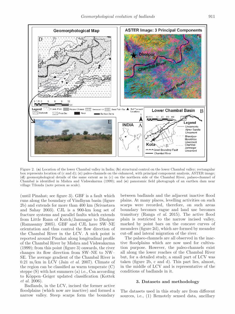
The Chambal River originates from the VindhyanRange (Sharma 1979; Jain et al. 2007) and flowsthrough the Malwa Plateau where Vindhyans areoverlaid by the Deccan Traps (Narula et al. 2000).It runs a total length of 960 km (Jain et al. 2007),where its catchment area is divided into threeparts, i.e., Upper Chambal Valley (UCV), MiddleChambal Valley (MCV) and Lower Chambal Valley(LCV) (Sharma 1979). A total basin area of theChambal River is ca. 143,219 km2 (Jain et al. 2007)with a discharge of 387 m3/s and 22 M tons/year ofsediment load, measured at Dholpur station (Bawaet al. 2014). The discharge peaks in the monsoonseason lasts for 3–4 months from mid-end of Junetill September. The average annual rainfall is ca.800mm (Ranga et al. 2015), more than 85% of whichis received in the monsoon season (Tandon et al.2006). The UCV and MCV are covered mainlywith the rocky terrain; only the lower reaches flowson the alluvium, deposited by the Chambal Riveritself. The major part of the Chambal River, inthe LCV, flows in parallel to Great Boundary Fault(GBF) and Chambal Jamnagar Lineament (CJL)
Geomorphological evolution of badlands 911
Figure 2. (a) Location of the lower Chambal valley in India; (b) structural control on the lower Chambal valley; rectangularbox represents location of (c and d); (c) paleo-channels on the enhanced, with principal component analysis, ASTER image;(d) geomorphological details of the same extent as in (c) on the northern side of the Chambal River, palaeo-channel ofChambal is identified in Mishra and Vishwakarma (1999); and (e) panoramic field photograph of an earthen dam nearvillage Tilonda (note person as scale).
(until Pinahat; see figure 3). GBF is a fault whichruns along the boundary of Vindhyan basin (figure2b) and extends for more than 400 km (Srivastavaand Sahay 2003). CJL is a 900-km long set offracture systems and parallel faults which extendsfrom Little Rann of Kutch/Jamnagar to Dholpur(Ramasamy 2005). GBF and CJL have SW–NEorientation and thus control the flow direction ofthe Chambal River in the LCV. A nick point isreported around Pinahat along longitudinal profileof the Chambal River by Mishra and Vishwakarma(1999); from this point (figure 3) onwards, the riverchanges its flow direction from SW–NE to NW–SE. The average gradient of the Chambal River is0.21 m/km in LCV (Jain et al. 2007). Climate ofthe region can be classified as warm temperate (C)steppe (S) with hot summers (a) i.e., Csa accordingto Koppen–Geiger updated classification (Kotteket al. 2006).Badlands, in the LCV, incised the former active
floodplains (which now are inactive) and formed anarrow valley. Steep scarps form the boundary
between badlands and the adjacent inactive floodplains. At many places, levelling activities on suchscarps were recorded, therefore, on such areasboundary becomes vague and land use becomestransitory (Ranga et al. 2015). The active floodplain is restricted to the narrow incised valley,marked by point bars on the concave curves ofmeanders (figure 2d), which are formed by meandercut-off and lateral migration of the river.The palaeo-channels are all observed in the inac-
tive floodplains which are now used for cultiva-tion purpose. However, the paleo-channels existall along the lower reaches of the Chambal Riverbut, for a detailed study, a small part of LCV wastaken (figure 2b, c and d). This part lies, almost,in the middle of LCV and is representative of theconditions of badlands in it.
3. Datasets and methodology
The datasets used in this study are from differentsources, i.e., (1) Remotely sensed data, ancillary
912 V Ranga et al.
Figure 3. Location of the lower Chambal valley on the Chambal basin with geological details of lower Chambal basin withits major tributaries (source: Geological Survey of India and Survey of India).
data, (2) soil analysis, and (3) field verifications.The first section includes mainly satellite imagesfrom different sensors and published maps anddata from various Govt. agencies. The latter sec-tions include field verification of former sectionincluding soil surveys, feature identifications, fieldobservations, etc.
3.1 Remotely sensed data and ancillary data
On-desk interpretation was carried out on a num-ber of satellite images from different sensorsincluding Landsat mosaics (spatial resolution =30 m) (http://earthexplorer.usgs.gov/) from The-matic Mapper sensor, images from LISS-III sensor(spatial resolution = 23.5 m) from Indian remotesensing satellites, Advanced Spaceborne ThermalEmission and Reflection Radiometer (ASTER)(spatial resolution = 15 m), GeoEye image (spatialresolution = 0.5 m), images from CORONA mis-sions (Galiatsatos 2004) (spatial resolution = 1.8 m(Sohn et al. 2004)) from the cold-war period (formore details on GeoEye & CORONA image, seeRanga et al. 2015) and Shuttle Radar TopographicMission (SRTM) digital elevation model (spatialresolution = 90 m).Additional information such as names of the
villages in the study area, location of earthen
dams, etc., was mapped from the Survey of India(SOI) topographic sheets (scale = 1:50,000). Geo-logical details were mapped from the geologicalmaps (scale = 1:2,000,000) of the states of MadhyaPradesh and Rajasthan (available at: http://www.portal.gsi.gov.in) published by Geological Surveyof India (GSI). The structural details were mappedfrom the GSI’s seismo-tectonic atlas (Narula et al.2000) (scale = 1:1,000,000). The ancillary datawas geo-referenced and projected to UTM projec-tion with WGS84 as datum. This projection sys-tem is common with the satellite images used inthis study. Geomorphological details were mappedfrom satellite images coupled with SOI topographicsheets and were later verified on field.Satellite images and other ancillary data were
used for visual purposes such as identification,marking, etc., there was no areal estimationmade with pixel based analysis. In most of theanalyses, information was extracted by digitiza-tion. Therefore re-sampling of the raster datato a common spatial resolution was unnecessary.Specifically, images from TM were used to makemosaic and extract palaeo-channels as line features.Higher resolution satellite images, i.e., GeoEye andCORONA images had limited coverage (a few hun-dred km2), therefore mosaics of TM images wereused to extract palaeo-courses of the whole LCV.
Geomorphological evolution of badlands 913
Catchment of the Chambal River was calculatedfrom SRTMDEM. GeoEye image was taken to fieldin a laptop and with the help of a Garmin e-trexvista GPS device, it was used for navigation andidentification of features. Images from CORONAmission was used to check the existence of thepalaeo-channels, thereby ruling out human inducedorigin of the palaeo-channels. Different satelliteimages were used to maximize visual discrimina-tion of palaeo-channels from their surroundings.For instance, an enhanced ASTER (with princi-pal component analysis) image gave best visualdiscrimination and was used for geomorphologicalmapping for the study area (figure 2c and d).
3.2 Field verifications and soil analysis
Field verifications were carried out in the monthsof June–July 2011. During field verification, phys-ical properties, such as colour, width and extent,of palaeo-channels were documented. Field vis-its, also validated the on-desk interpretations ofsatellite image and other ancillary data. Addi-tionally, four transects, across the palaeo-channelsat four different locations (figure 2d), were madeto study difference in soil texture. Soil sampleswere collected from top surface after removingploughing layer (∼20 cm) from palaeo-channels aswell as from the surrounding areas. A total ofnine samples from palaeo-channels and 10 sam-ples from the surrounding areas were taken. Forsoil texture determination, soil samples were mixedwith dispersing agent and distilled water; the mix-ture was shaken overnight for better dispersionof soil particles. Silt and clay were separated bypipette using Stoke’s law, while sand was sepa-rated by wet sieving. USDA soil triangle was usedfor calculating the soil texture and displaying ofresults.
4. Results and discussion
Following the chronology of the objectives, this sec-tion is subdivided into two parts: in the first part,salient features of the palaeo-channels and theirrelation to present pattern of badlands is studied.In the second subsection, a systematic conceptualgeomorphic evolution of badlands along the LCVhas been proposed.
4.1 Salient features of palaeo-channels andtheir relation with the present spatial
patterns of badlands
A total of 113 palaeo-channels could be mappedfrom satellite images; they were also, conspicuously,
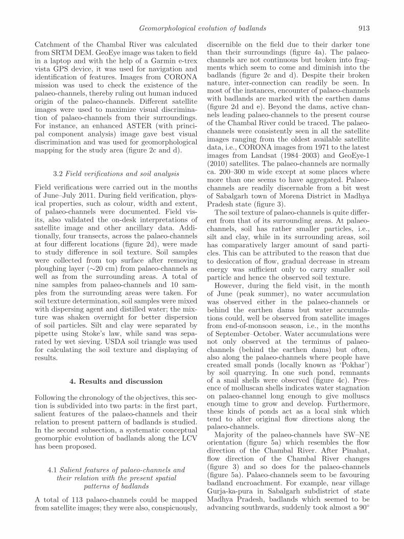
discernible on the field due to their darker tonethan their surroundings (figure 4a). The palaeo-channels are not continuous but broken into frag-ments which seem to come and diminish into thebadlands (figure 2c and d). Despite their brokennature, inter-connection can readily be seen. Inmost of the instances, encounter of palaeo-channelswith badlands are marked with the earthen dams(figure 2d and e). Beyond the dams, active chan-nels leading palaeo-channels to the present courseof the Chambal River could be traced. The palaeo-channels were consistently seen in all the satelliteimages ranging from the oldest available satellitedata, i.e., CORONA images from 1971 to the latestimages from Landsat (1984–2003) and GeoEye-1(2010) satellites. The palaeo-channels are normallyca. 200–300 m wide except at some places wheremore than one seems to have aggregated. Palaeo-channels are readily discernable from a bit westof Sabalgarh town of Morena District in MadhyaPradesh state (figure 3).The soil texture of palaeo-channels is quite differ-
ent from that of its surrounding areas. At palaeo-channels, soil has rather smaller particles, i.e.,silt and clay, while in its surrounding areas, soilhas comparatively larger amount of sand parti-cles. This can be attributed to the reason that dueto desiccation of flow, gradual decrease in streamenergy was sufficient only to carry smaller soilparticle and hence the observed soil texture.However, during the field visit, in the month
of June (peak summer), no water accumulationwas observed either in the palaeo-channels orbehind the earthen dams but water accumula-tions could, well be observed from satellite imagesfrom end-of-monsoon season, i.e., in the monthsof September–October. Water accumulations werenot only observed at the terminus of palaeo-channels (behind the earthen dams) but often,also along the palaeo-channels where people havecreated small ponds (locally known as ‘Pokhar’)by soil quarrying. In one such pond, remnantsof a snail shells were observed (figure 4c). Pres-ence of molluscan shells indicates water stagnationon palaeo-channel long enough to give molluscsenough time to grow and develop. Furthermore,these kinds of ponds act as a local sink whichtend to alter original flow directions along thepalaeo-channels.Majority of the palaeo-channels have SW–NE
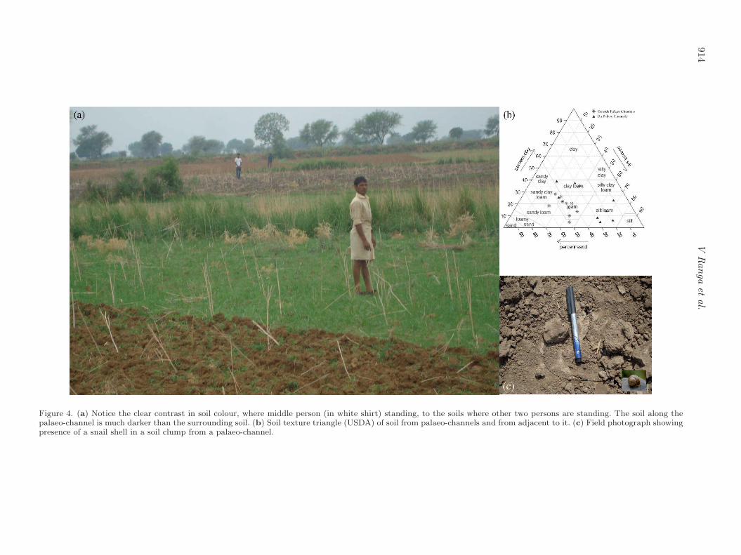
orientation (figure 5a) which resembles the flowdirection of the Chambal River. After Pinahat,flow direction of the Chambal River changes(figure 3) and so does for the palaeo-channels(figure 5a). Palaeo-channels seem to be favouringbadland encroachment. For example, near villageGurja-ka-pura in Sabalgarh subdistrict of stateMadhya Pradesh, badlands which seemed to beadvancing southwards, suddenly took almost a 90◦
914V
Ranga
etal.
Figure 4. (a) Notice the clear contrast in soil colour, where middle person (in white shirt) standing, to the soils where other two persons are standing. The soil along thepalaeo-channel is much darker than the surrounding soil. (b) Soil texture triangle (USDA) of soil from palaeo-channels and from adjacent to it. (c) Field photograph showingpresence of a snail shell in a soil clump from a palaeo-channel.
Geomorphological evolution of badlands 915
Figure 5. (a) Rose diagram of the palaeo-channel direction. (b) Badland encroachment turned almost 90◦ on encounterwith a palaeo-channel.
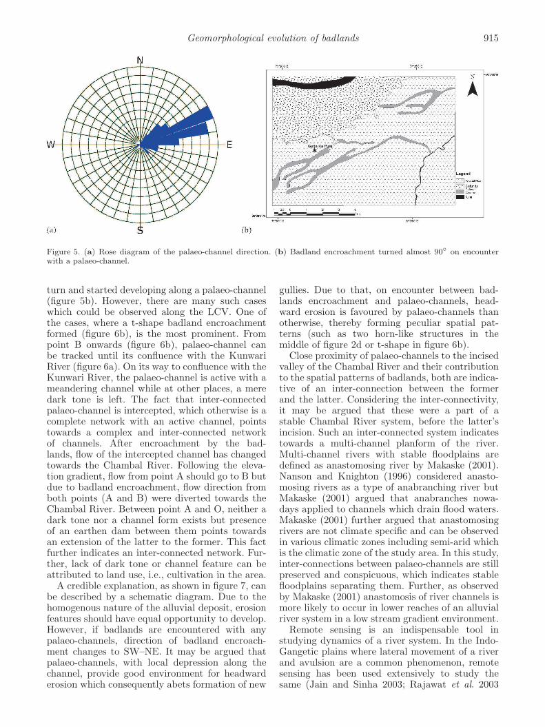
turn and started developing along a palaeo-channel(figure 5b). However, there are many such caseswhich could be observed along the LCV. One ofthe cases, where a t-shape badland encroachmentformed (figure 6b), is the most prominent. Frompoint B onwards (figure 6b), palaeo-channel canbe tracked until its confluence with the KunwariRiver (figure 6a). On its way to confluence with theKunwari River, the palaeo-channel is active with ameandering channel while at other places, a meredark tone is left. The fact that inter-connectedpalaeo-channel is intercepted, which otherwise is acomplete network with an active channel, pointstowards a complex and inter-connected networkof channels. After encroachment by the bad-lands, flow of the intercepted channel has changedtowards the Chambal River. Following the eleva-tion gradient, flow from point A should go to B butdue to badland encroachment, flow direction fromboth points (A and B) were diverted towards theChambal River. Between point A and O, neither adark tone nor a channel form exists but presenceof an earthen dam between them points towardsan extension of the latter to the former. This factfurther indicates an inter-connected network. Fur-ther, lack of dark tone or channel feature can beattributed to land use, i.e., cultivation in the area.A credible explanation, as shown in figure 7, can
be described by a schematic diagram. Due to thehomogenous nature of the alluvial deposit, erosionfeatures should have equal opportunity to develop.However, if badlands are encountered with anypalaeo-channels, direction of badland encroach-ment changes to SW–NE. It may be argued thatpalaeo-channels, with local depression along thechannel, provide good environment for headwarderosion which consequently abets formation of new
gullies. Due to that, on encounter between bad-lands encroachment and palaeo-channels, head-ward erosion is favoured by palaeo-channels thanotherwise, thereby forming peculiar spatial pat-terns (such as two horn-like structures in themiddle of figure 2d or t-shape in figure 6b).Close proximity of palaeo-channels to the incised
valley of the Chambal River and their contributionto the spatial patterns of badlands, both are indica-tive of an inter-connection between the formerand the latter. Considering the inter-connectivity,it may be argued that these were a part of astable Chambal River system, before the latter’sincision. Such an inter-connected system indicatestowards a multi-channel planform of the river.Multi-channel rivers with stable floodplains aredefined as anastomosing river by Makaske (2001).Nanson and Knighton (1996) considered anasto-mosing rivers as a type of anabranching river butMakaske (2001) argued that anabranches nowa-days applied to channels which drain flood waters.Makaske (2001) further argued that anastomosingrivers are not climate specific and can be observedin various climatic zones including semi-arid whichis the climatic zone of the study area. In this study,inter-connections between palaeo-channels are stillpreserved and conspicuous, which indicates stablefloodplains separating them. Further, as observedby Makaske (2001) anastomosis of river channels ismore likely to occur in lower reaches of an alluvialriver system in a low stream gradient environment.Remote sensing is an indispensable tool in
studying dynamics of a river system. In the Indo-Gangetic plains where lateral movement of a riverand avulsion are a common phenomenon, remotesensing has been used extensively to study thesame (Jain and Sinha 2003; Rajawat et al. 2003
916 V Ranga et al.
Figure 6. (a) A mosaic image from LISS-III sensor showing a portion of the LCV; solid line arrows indicate palaeo-channels while dashed lines show direction of flow of the Chambal River, and (b) a detailed geomorphic map ofthe area marked by rectangle in (a); dashed line arrow indicates flow direction of the Chambal River and elevationgradient.
Mitra et al. 2005; Rathore et al. 2010). This study isdifferent in the sense that much of the evidences aredestroyed due to badland encroachment. Destruc-tion of evidences, however, gave rise to peculiarspatial patterns to badland encroachment whichhelped in identifying them.Aging of sediments from
the palaeo-channels would have been valuable butobservations made in this study can form a hypoth-esis for a prospective study on the same. Datingof the sediments can also shed light on timing ofChambal’s incisionwhich then can be compared andcontrasted with other river incisions in the area.

Geomorphological evolution of badlands 917
Figure 7. A possible schematic explanation of processes shown in figures 5(b) and 6(b).
Figure 8. (a) Swallow holes and (b) two swallow holes adjacent to a gully. These features were observed in the badlandsalong the Kunwari River.
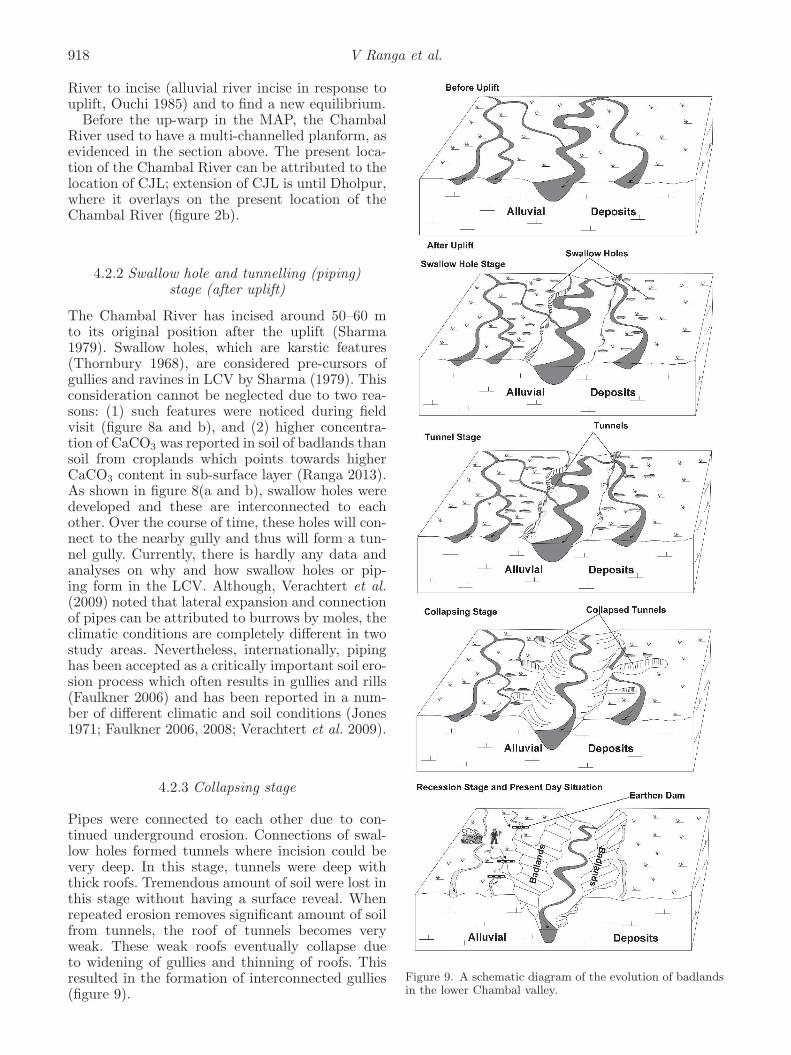
4.2 Conceptual geomorphic evolution model
A geomorphic model of evolution from the un-incised Chambal River to the present day situationwas originally given by Sharma (1968).This study, inthe light of above observations, adds a concept ofmulti-channel planform of an un-incised ChambalRiver. Whole model can be explained in five stagesas described below:
4.2.1 Before uplift
As noted by Agarwal et al. (2002), the last thrust-ing event in the Himalaya is believed to have causedthe peripheral bulge (Singh and Bajpai 1989).They have, further considered last major thrust-ing event to be ca. 500–700 ka, when upper Siwaliksediments were thrusted and uplifted (Singh 1996).Consequently, peripheral bulge forced the Chambal
918 V Ranga et al.
River to incise (alluvial river incise in response touplift, Ouchi 1985) and to find a new equilibrium.Before the up-warp in the MAP, the Chambal
River used to have a multi-channelled planform, asevidenced in the section above. The present loca-tion of the Chambal River can be attributed to thelocation of CJL; extension of CJL is until Dholpur,where it overlays on the present location of theChambal River (figure 2b).
4.2.2 Swallow hole and tunnelling (piping)stage (after uplift)
The Chambal River has incised around 50–60 mto its original position after the uplift (Sharma1979). Swallow holes, which are karstic features(Thornbury 1968), are considered pre-cursors ofgullies and ravines in LCV by Sharma (1979). Thisconsideration cannot be neglected due to two rea-sons: (1) such features were noticed during fieldvisit (figure 8a and b), and (2) higher concentra-tion of CaCO3 was reported in soil of badlands thansoil from croplands which points towards higherCaCO3 content in sub-surface layer (Ranga 2013).As shown in figure 8(a and b), swallow holes weredeveloped and these are interconnected to eachother. Over the course of time, these holes will con-nect to the nearby gully and thus will form a tun-nel gully. Currently, there is hardly any data andanalyses on why and how swallow holes or pip-ing form in the LCV. Although, Verachtert et al.(2009) noted that lateral expansion and connectionof pipes can be attributed to burrows by moles, theclimatic conditions are completely different in twostudy areas. Nevertheless, internationally, pipinghas been accepted as a critically important soil ero-sion process which often results in gullies and rills(Faulkner 2006) and has been reported in a num-ber of different climatic and soil conditions (Jones1971; Faulkner 2006, 2008; Verachtert et al. 2009).
4.2.3 Collapsing stage
Pipes were connected to each other due to con-tinued underground erosion. Connections of swal-low holes formed tunnels where incision could bevery deep. In this stage, tunnels were deep withthick roofs. Tremendous amount of soil were lost inthis stage without having a surface reveal. Whenrepeated erosion removes significant amount of soilfrom tunnels, the roof of tunnels becomes veryweak. These weak roofs eventually collapse dueto widening of gullies and thinning of roofs. Thisresulted in the formation of interconnected gullies(figure 9).
Figure 9. A schematic diagram of the evolution of badlandsin the lower Chambal valley.
Geomorphological evolution of badlands 919
4.2.4 Recession stage and present day situation
In this stage, the recession of already formed gul-lies continues by headward erosion. In the pro-cess of headward erosion, there can be number ofprocesses involved including widening, branchingof gullies, undercutting and plunge pools, etc. Asshown by Ranga et al. (2015), vegetation activityvaries over the year which may also influence ero-sion processes. During major part of the year, ero-sion activities are not so destructive but on theonset of monsoon huge soil losses could be seen.In the present situation, local people have madeearthen check dams at the places where palaeo-channels are meeting badlands. Consequently, bad-land extension by headward erosion ceased. At sev-eral places, local people made ponds along them tostore water, altering direction of flow. In such a sit-uation, there is further desiccation of flow in them.This low energy flow results in ephemeral stagna-tion of water which, possibly, gives paleo-channelstheir characteristic dark colour. Since, there is lowwater flowing through it, the outlines of streamsstarted diminishing with farm practices. It has alsobeen identified that these palaeo-channels after dis-appearing to badlands were continued by activechannels. It cannot be neglected that formation ofnew gully heads or ascension of gullies from rillscould have formed in parallel with formation of gul-lies from swallow holes. The idea of swallow holes,however, is still more attractive due to the presentform of continuous gullies at the LCV. As discon-tinuous gullies could also have formed; their con-nectivity to other gullies can be explained by pipingand tunnelling.
5. Conclusion
This study reports palaeo-channels observed on theright flank of the Chambal River along its lowerreaches. The palaeo-channels are conspicuously vis-ible on satellite images as well as on the field.The palaeo-channels are typically 200–300 m wideexcept where they seems either to have aggregatedor a pond formed due to soil quarrying by localpeople. Headward erosion seems to be favoured bythe palaeo-channels once they are encountered withgullies or ravines. Thus palaeo-channels played asignificant role in shaping up the spatial patternsof badlands.The palaeo-channels are interconnected to each
other, to the Chambal and the Kunwari rivers.The proximity of the palaeo-channels and theincised rivers, points towards a multi-channel plan-form of the Chambal River before its incision.In the light of the evidences, a modified modelof geomorphic evolution of badlands was pro-posed where multi-channel planform of the Cham-bal River is proposed against the single channel
planform. Future researches should be focussed onmore detailed analysis of the palaeo-channels suchas cross-sectional elevation profile, soil profile studyand most importantly constraining the age of thesediments.
Acknowledgements
The authors would like to thank Erasmus MundusExternal Program, window 13 for financing the firstauthor’s stay at KU Leuven. Authors are gratefulto Prof. Jean Poesen and Prof. Gert Verstraeten,KUL, Belgium for many useful insights and sugges-tions regarding analysis. They also like to acknow-ledge the help of GeoEye Foundation, who hadprovided the GeoEye image for this research.Authors are grateful to two anonymous reviewersfor their very useful comments.
References
Agarwal K K, Singh I B, Sharma M, Sharma S andRajagopalan G 2002 Extensional tectonic activity in thecratonward parts (peripheral bulge) of the Ganga Plainforeland basin, India; Int. J. Earth Sci. 91(5) 897–905,doi: 10.1007/s00531-002-0265-z.
Ahmad E 1968 Distribution and causes of gully erosionin India; In: 21st International Geographical Congress(Section IV), New Delhi.
Bawa N, Jain V, Shekhar S, Kumar N and JyaniV 2014 Controls on morphological variability androle of stream power distribution pattern, YamunaRiver, western India; Geomorphology 227 60–72, doi:10.1016/j.geomorph.2014.05.016.
DeCelles P G 2011 Foreland Basin Systems Revisited: Vari-ations in Response to Tectonic Settings; In: Tectonics ofSedimentary Basins (eds) Busby C and Azor A, JohnWiley & Sons Ltd., pp. 405–426. http://onlinelibrary.wiley.com/doi/10.1002/9781444347166.ch20/summary.
DeCelles P G and Giles K A 1996 Foreland basin systems;Basin Research 8(2) 105–123, doi: 10.1046/j.1365-2117.1996.01491.x.
Faulkner H 2006 Piping hazard on collapsible and dis-persive soils in Europe; In: Soil Erosion in Europe(eds) Boardman J and Poesen J, John Wiley & SonsLtd., pp. 537–562, http://onlinelibrary.wiley.com/doi/10.1002/0470859202.ch40/summary.
Faulkner H 2008 Connectivity as a crucial determinantof badland morphology and evolution; Geomorphology100(1–2) 91–103, doi: 10.1016/j.geomorph.2007.04.039.
Galiatsatos N 2004 Assessment of the CORONA series ofsatellite imagery for landscape archaeology: A case studyfrom the Orontes valley, Syria, http://etheses.dur.ac.uk/281/.
Gibling M R, Tandon S K, Sinha R and Jain M 2005Discontinuity-bounded alluvial sequences of the southernGangetic Plains, India: Aggradation and degradation inresponse to monsoonal strength; J. Sedim. Res. 75(3)369–385, doi: 10.2110/jsr.2005.029.
Goswami P K and Mishra J K 2014 Morphotectonic evo-lution of the Piedmont Zone of the west Ganga Plain,India; Zeitschrift fur Geomorphologie 58(1) 117–131, doi:10.1127/0372-8854/2013/0114.
Jain V and Sinha R 2003 Hyperalvulsive-anabranchingBaghmati river system, north Bihar plains, eastern India;Zietscrift fur geomorphologie 47(1) 101–116.
920 V Ranga et al.
Jain S K, Agarwal P K and Singh V P 2007 Hydrology andWater Resources of India; Springer.
Jones A 1971 Soil piping and stream channel initiation;Water Resour. Res. 7(3) 602–610, doi: 10.1029/WR007i003p00602.
Joshi V U 2014 The Chambal Badlands; In: Landscapes andLandforms of India (ed.) Kale V S (Dordrecht: Springer)1st edn, pp. 143–149.
Kottek M, Grieser J, Beck C, Rudolf B and Rubel F 2006World map of the Koppen–Geiger climate classificationupdated; Meteorologische Zeitschrift 15(3) 259–263, doi:10.1127/0941-2948/2006/0130.
Makaske B 2001 Anastomosing rivers: A review of theirclassification, origin and sedimentary products; Earth-Sci. Rev. 53(3–4) 149–196, doi: 10.1016/S0012-8252(00)00038-6.
Mishra M N and Vishwakarma L L 1999 Morphotectonicsof the Chambal and the Yamuna valleys in the WesternMarginal Gangetic Alluvial Plains; Geological Sur-vey of India, http://www.portal.gsi.gov.in/pls/gsipub/PKG PTL PORTAL LINKS.pGetCaseStudyRegion?inpRegionId=35.
Mitra D, Tangri A K and Singh I B 2005 Channel avulsionsof the Sarda river system, Ganga Plain; Int. J. RemoteSens. 26(5) 929–936, doi: 10.1080/0143116031000102458.
Nanson G C and Knighton A D 1996 Anabranching rivers:Their cuases, character and classification; Earth SurfaceProcesses and Landforms 21 217–239.
Narula P L, Acharyya S K and Banerjee J 2000 Seismotec-tonic atlas of India and its environs; Geological Survey ofIndia, Calcutta.
Ouchi S 1985 Response of alluvial rivers to slow active tec-tonic movement;Geol. Soc. Am. Bull. 96(4) 504–515, doi:10.1130/0016-7606(1985)96<504:ROARTS>2.0.CO;2.
Rajawat A S, Verma P K and Nayak S 2003 Reconstructionof palaeodrainage network in north-western India: Ret-rospect and prospects of remote sensing based studies;In: Proceedings Indian National Science Academy 69A217–230.
Ramasamy S M 2005 Remote Sensing in Geomorphology;New India Publishing.
Ranga V 2013 GIS based gully erosion mapping and mod-eling using multi-spectral spatial and non-spatial datain parts of Ambah and Morena Tehsils of Morena dis-trict, Madhya Pradesh Unpublished PhD thesis, JiwajiUniversity, Gwalior, India.
Ranga V, Van Rompaey A, Poesen J, Mohapatra S N andPani P 2015 Semi-automatic delineation of badlandsusing contrast in vegetation activity: A case study inthe lower Chambal valley, India; Geocarto Int., doi:10.1080/10106049.2015.1004130.
Rathore V S, Nathawat M S and Champatiray P K 2010Palaeochannel detection and aquifer performance assess-ment in Mendha River catchment, western India; J.Hydrol. 395 216–225, doi: 10.1016/j.jhydrol.2010.10.026.
Sharma H S 1968 Genesis of Ravines of the Lower Cham-bal Valley, India; In: 21st International GeographicalCongress (Section IV), New Delhi.
Sharma H S 1979 The physiography of the Lower Cham-bal Valley and its agricultural development: A study inapplied geomorphology ; Concept.
Singh I B 1996 Geological evolution of Gangetic plain – anoverview; Palaeontol. Soc. India 41 99–137.
Singh I B and Bajpai V N 1989 Significance of syndepo-sitional tectonics in the facies development of Gangeticalluvium near Kanpur, Uttar Pradesh; J. Geol. Soc. India36 61–66.
Sinha R and Tandon S K 2014 Indus–Ganga–BrahmaputraPlains: The alluvial landscape; In: Landscapes and Land-forms of India (ed.) Kale V S (Dordrecht: Springer), 1stedn, pp. 53–63.
Sohn H-G, Kim G-H and Yom J-H 2004 Mathematicalmodelling of historical reconnaissance CORONA KH-4BImagery; The Photogrammetric Record 19(105) 51–66,doi: 10.1046/j.0031-868X.2003.00257.x.
Srivastava D C and Sahay A 2003 Brittle tecton-ics and pore-fluid conditions in the evolution of theGreat Boundary Fault around Chittaurgarh, northwest-ern India; J. Struct. Geol. 25(10) 1713–1733, doi:10.1016/S0191-8141(03)00012-9.
Tandon S K, Gibling M, Sinha R, Singh V, Ghazanfari P andDasgupta A et al. 2006 Alluvial valleys of the GangeticPlains, India: Causes and timing of incision; In: IncisedValley (eds) Dalrymple R W, Leckie D A and Tillman RW, Tulsa 85 15–35.
Thornbury W D 1968 Principles of Geomorphology; Wiley& Sons.
Verachtert E, Van Den Eeckhaut M, Poesen J and DeckersS 2009 Characteristics and distribution of soil pipingerosion in loess-derived soils of Belgium; In: CongresoInternacional sobre Desertificacion.
MS received 5 November 2014; revised 1 February 2015; accepted 20 February 2015