environmental protection report3788/obj/20003031.pdf · weirs and fish passes north tawton weir;...
TRANSCRIPT

-SO'J+h \Aj£Dt ^-0 3
Environmental Protection Report
RIVER TAW-HABITAT REHABILITATION 1992
March 1993 Fisheries Section
NRANational Rncr\ Authority
C.V.M. DaviesEnvironmental Protection Manager s,)U,h West Re&ion

ENVIRONMENTAL IMPROVEMENT WORKS - RIVER 17W CATCHMENT - 1992
INTRODUCTION
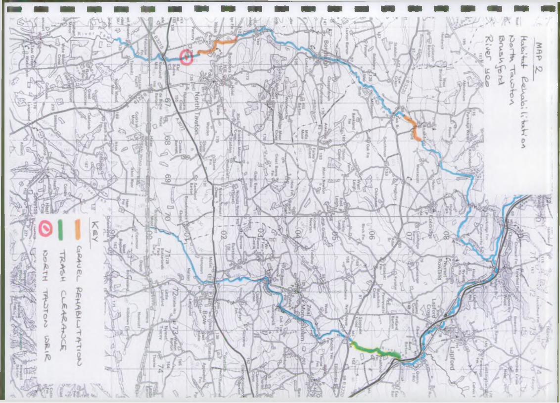
This report summarises the environmental improvement work carried out in the River Taw catchment during 1992. The work covered includes spawning gravel rehabilitation, trash dam clearance and improvements to fish passage at weirs. Map 1 shows a summary of the type and location of each kind of activity. Gravel rehabilitation was completed in four areas, trash dam clearance in four areas and improvements to fish passage were made at two sites in the catchment. The work was funded by the NRA and by the Taw Fisheries Association.
E N V IR O N M E N T A G E N C Y

GRAVEL REHABILITATIONRehabilitation of salmonid spawning beds was carried out in four areas in the Taw catchment during late September and early October this year. In areas throughout the catchment, spawning gravels have become compacted or infilled with excess silt, to the extent that salmon and trout find difficulty in burying their eggs effectively. Excess siltation also limits egg survival by reducing the flow of oxygenated water to the eggs while they are developing in the gravel. By turning over the gravel beds mechanically, the silt is freed from the spawning areas, leaving clean, mobile gravel. It is important that this work is done as close to spawning time as possible. If gravel is cleaned too early in the season then there is the risk that by spawning time it has become resilted. Work on the Taw was planned for completion during late August and early September. However, the high flows encountered during this period meant that the work had to be postponed to the end of September. In other rivers where this work has been carried out in the past, enhanced spawning has been recorded at rehabilitated sites and increased juvenile production has been note e.g. Axe, Dart, Torridge.
Four sections of river were dealt with as follows:
1. River Taw? North Tawton: NGR SS 652 024 to SS 657 014 (Hap 2)Twelve riffles were worked on in a section of river upstream and downstream of North Tawton Bridge. Most of the work was undertaken using a mechanical digger with a ripping hook device attached to the back actor (see Plate 1). This device was raked through the gravel at each riffle, loosening and releasing silt up to depths of two feet. After raking was complete, the gravel beds were then smoothed over using the front bucket on the machine. The work was carried out by a private contractor under the supervision of Warden Boyd.2. River Taw; Brushford: NGR SS 680 074 to SS 673 069 (Hap 2)Eleven riffles were reinstated in the Taw upstream and downstream of Brushford Bridge. This work was carried out using a mechanical digger as above, by private contractor under the supervision of Warden Boyd.3. Crooked Oak; Bishops Nymptan: NGR SS 743 232 to SS 758 231 (Map 3)Twenty six riffles were inproved in the Crooked Oak downstream of Yeo Bridge. The desilting work was carried out using a water pump. (Restricted access because of bankside tree cover and the small size of the stream precluded the use of a mechanical digger in this location). A portable (2" dia. delivery hose) water pump with a high pressure nozzle on the delivery hose was used to direct a powerful jet of water at the river bed (see Plate 2). This jet of water loosens the gravel and washes out excess silt at the same time. The process was assisted by hand-raking where necessary. This work on the Crooked Oak was completed by Wardens Bickley and Boyd.4. Sturcoanbe River; Witheridge: NGR SS 813 158 to SS 813 163 (Hap 4)In this section of the Sturcombe River, at its confluence with the Little Dart, riffles were worked over using a portable water pump. This section was completed as a trail to see if salmon and sea trout spawning could be encouraged in this area. The work was done by Wardens Boyd and Bickley.

TRASH DAM CLEARANCE
Trash dam clearance was carried out in four areas throughout the Taw catchment during July and September/October. In some areas, considerable amounts of woody debris had built up on natural obstructions in the river. Such natural obstructions are most commonly formed by bankside trees which have fallen into the river, but could also include tree branches growing close to the water level. Where trash build up takes place, the upstream migration of spawning salmonids can be restricted. Ponding is also liable to take place upstream of trash dams, leading to drowning out of spawning beds and fry habitat and an increase in silt deposition on the river bed. However, trash piles form important cover for otters and consultation with the NRA Conservation section always takes place before this clearance work is carried out, to ensure that otter habitat is not destroyed. (See Appendix 1 for an example of the Conservation Department input to this work).
Four sections of river were dealt with as follows:
1. Crooked Oak; Bishops Nympton: SS 743 232 to SS 758 231 (Map 3)Trash dam clearance was carried out in the Crooked Oak during July, in the same section of river where gravel improvements were later undertaken (See Plate 3). Some trash was removed here during October when the gravel work was underway. The work was done by Warden Bickley and colleagues.
2. Huntacott Water; Chumleigjh. (Map 3)Work was carried out during September in this important spawning tributary of the Little Dart. The work was carried out by private contractor and was funded by the Taw Fisheries Association.
3. Sturcombe River; Witheridge: SS 813 158 to SS 813 178 (Map 4)Trash dams were cleared from this Little Dart tributary during late September. The work was completed by private contractor.
4. River Yeo; Lapford: SS737 068 to SS 733 054 (Map 2)Following observations by the wardens that, during 1992, there had been an apparent improvement in quality in the River Yeo, it was decided to bring this work forward from 1993 to take full advantage of these improvements. Trash dam build up in this section of river had been extreme over the past few years and posed major problems for salmonid penetration into this tributary of the Taw. Clearance was successfully carried out in mid- October, by private contractor.

WEIRS AND FISH PASSES
North Tawton Weir; North Tawton: SS 668 010 (Nap 2)Fish passage at this weir has long been a problem during low flows (at higher flows, salmon and sea trout have always been able to negotiate the weir to reach the extensive spawning beds upstream to Dartmoor). Inpediment to fish passage in low flows has been caused by the step system at the bottom end of the weir, where fish could negotiate the first step out of the weir pool, but were unable to pass the second step (about two feet high) without adequate depth of water to leap from. The solution to this problem was identified as being two-fold. The first stage involved the raising of the weir pool water level using a blockstone check weir, followed by a second stage of cutting a channel through the offending step on the weir and channelling low flows into this channel by means of a deflector system on the face of the weir. Unfortunately, work on the weir was held up by high river flows in the late summer. However, the blockstone check weir (phase one of the work) was completed in mid-October and is already assisting fish over the weir (See Plate 4). It is expected that the second phase of the scheme will be completed before the end of this financial year. The work is being carried out by N. Webber and colleagues of the NRA Engineering Section.
Head Weir; River Hole: SS 666 185 (Map 3)Following extensive discussions between the NRA and the Taw Fisheries Association over the perceived problems with the new fish pass, the large gravel shoal at the foot of the weir pool on the right bank was removed in the early part of the year. This action had the desired effect of reducing the turbulence and backcurrent in the weir pool which was felt to be inhibiting fish from finding the entrance to the pass in higher flows. The weir and fish pass are still the subject of intensive observations by the NRA and the Fisheries Association.

Taw Catchment
H*V&IT*T iKPeoslEXEOT Ooe<<»

nl.mo ■ lamoK !1 ownhnusi
3£*V\a ^ U.4e<\l
H laa Vxxc_o'H' VyCJoJ'Wj"fl<2<Jt LA^i<~
DownN e w l^ ; ' J Ce»ny p « •
Sch: a' \ L^ S Q U I O r°MOLTOWl147 (ifuo t X e le ! r l • Barton
G o rto n MM +i
Funebra/
Thorn* Fm |
Parsonage
tattw ood'J G e o r g e / <- « / J y m p t ° n
HadlavMeet he Barton Frenchsjqne
Cast Trayne
S a t te r le ig h
IsvyealM a n a o s le ig h ,
_'tW e sta c o llCleave, Uppacotl
<Sletchcott«
OdamMilltofvn
1 tJV R o m an s le ig h
|Odam'Bartor
lummacottLangleyRowley.
test G arlandd r c r M t
Middt eJJar landAddington .Thornl
Wect Garlando XUoomba
CadburyBarton'
MottandWixon)o b b sMoor
ikeheadFm HOrridge
'fcamplai
Holland.FmH ansfq
Barton]
W in* wood Moprijbne Moor
lioss*
iticoml
Affeton'
>artnd(
CnawleiiWeek
W ii? "
'HollowC rot*
shtelglBartoi
OTott*
n p to n

2 6
a1
2 5
2 4
mi)*I
22
21
20
19
!8
1 7
16
N
4
3
i
■M'tt *hff"r y~T -* v >-r *>/w.. m.u».' ’ X l«w\ ^ N«-v* f * « r t^t *7n „ . ____, w j MstfsCc ■ '"iT,7> t -* ><» ’ ..lil .. W '5 0 " • .Last v
H w F m
s S .Bunk«Unrt
y 1b**«f Mooi * I
\ «Ttyjr
Ha.V>i -Va V ( ^ U o.'ck U
Iaa>0 « (2.1 0R_<“ ' I
........... ^
ofe°\cXo° *
vL-JT' \ u i / C«LLBudrticsw'f fy * _ k e y-* . v h \ J i X lO l
Pt;/
L > 7 A T " * S XI370 ° ,W«v«n , J V —f(r *WiHel^lum wi *206 Cumui. * JA 231 ^
T---
M o .
1 / 1242 /
N n j /
j f p ^
^ 5 ^ r f 8 T ^ {0asSjOeptlord } _ * \
^ (0,£/VO£i_ e£K^>l«_irHTtO«C> TRA^H C-l£ACA^OC£.
►Vlighei
I<ll*Y

IC, £*«/£<_ e-GHfr&li-ITW-TloO _ ftu£g. "TTkjJ I *°\2.
I
I
I
I
I
I
I
I
I
■


CAl—'S
C Z -< Z < z* o > v « -* Z . ^ c Z i *** v c ^ . v 5 , v ^ J C i ( 2 - . T3 vS HoP^ t Vi'iT » \ d \C c-vrV \ 3 o^

S0&2TH T7VU>Te»C> £- — A.^ C«ECK:
RIVElVCftTCHMENTLOCATION
OPERATION
DESIGNATIONS SITE HISTORY WORKING METHOD
SITE EVALUATION
ENHANCEMENTSA.
B .
APP&OOmX \
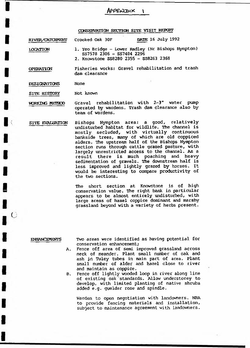
CONSERVATION SECTION SITE VISIT REPORT Crooked Oak 30F DftTE 16 July 19921. Yeo Bridge - Lower Radley (Nr Bishops Nympton)
SS7578 2306 - SS7404 22962. Knowstone SS8280 2355 - SS8263 2368Fisheries works: Gravel rehabilitation and trash dam clearanceNoneNot knownGravel rehabilitation with 2-3" water pump operated by wardens. Trash dam clearance also by team of wardens.Bishops Nympton area: a good, relatively undisturbed habitat for wildlife. The channel is mostly secluded, with virtually continuous bankside trees, many of which are old coppiced alders. The upstream half of the Bishops Nympton section runs through cattle grazed pasture, with largely unrestricted access to the channel. As a result there is much poaching and heavy sedimentation of gravels. The downstream half is less improved and lightly grazed by horses. It would be interesting to compare productivity of the two sections.The short section at Knowstone is of high conservation value. The right bank in particular appears to be almost entirely undisturbed, with large areas of hazel coppice dominant and marshy grassland beyond with a variety of herbs present.
Two areas were identified as having potential for conservation enhancement;Fence off area of semi improved grassland across neck of meander. Plant small number of oak and ash jn Tuley tubes in main part of area. Plant small number of alder and hazel close to river and maintain as coppice.Fence off lightly wooded loop in river along line of existing oak ‘standards. Allow understorey to develop, with limited planting of native shrubs added e.g. guelder rose and spindle.Warden to open negotiation with landowners. NRA to provide fencing materials and installation, subject to maintenance agreement with landowners.
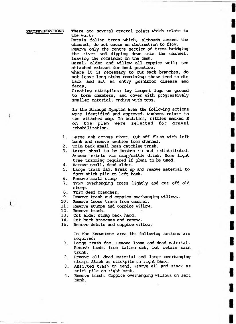
REOOMMEKDftnOWS There are several general points which relate tothe work;Retain fallen trees which, although across the channel, do not cause an obstruction to flow. Remove only the centre section of trees bridging the river and dipping down into the channel, leaving the remainder on the bank.Hazel, alder and willow all coppice well; see attached extract for best practice.Where it is necessary to cut back branches, do not leave long stubs remaining; these tend to die back and act as entry pointsfor disease and decay.Creating stickpiles; lay largest logs on ground to form chambers, and cover with progressively smaller material, ending with tops.In the Bishops Nympton area the following actions were identified and approved. Numbers relate to the attached map. In addition, riffles marked R on the plan were selected for gravel rehabilitation.
1. Large ash across river. Cut off flush with left bank and remove section from channel.
2. Trim back small bush catching trash.3. Large shoal to be broken up and redistributed.
Access exists via ramp/cattle drink. Some light tree trimming required if plant to be used.
4. Remove small, dead alder.5. Large trash dam. Break up and remove material to
form stick pile on left bank.6. Remove small stump7. Trim overhanging trees lightly and cut off old
stump.8. Trim dead branches.9. Remove trash and coppice overhanging willows.10. Remove loose trash from channel.11. Remove stumps and coppice willow.12. Remove trash.13. Cut alder stump back hard.14. Cut back branches and remove.15. Remove debris and coppice willow.
In the Knowstone area the following actions are required:
1. Large trash dam. Remove loose and dead material. Remote limbs from fallen oak, but retain main trunk.
2. Remove all dead material and large overhanging stump. Stack as stickpile on right bank.
3. Assorted trash on bend. Remove all and stack as stick pile on right bank.
4. Remove trash. Coppice overhanging willows on left bank.

233
232
231
j_i23000w
756 757 758 759
CROOKCb OflK — Mft. &S+WPS KSMPlbM ?AC,t 1
. ',0 , V , , , 7 H * c u f “ O n * irlrf >qu.r. on (hi, planV i h r*p-f !■ i ' i i r T IJ| i t 1 1*1 1 1 I-T ) iV y > V-t r -y i S T r | i *i i f y 1— ‘— 1 t t p r u t n u on* h « e u r* .
24 25 24 27 2fi 2* Acr«*
> ko no «« )u no tooo 1020 icho imo loeo noo M«r« r-L~ — H-1— I— L-rJ— i— V — 1—t-rt— S—‘‘t*— >1- ‘ !■*— S—*-V 00 1000 1100 3200 3100 )4 0 0 JJOO )4 0 0 F»«t
H>4« u d publiihtd br th« D irector Gtntrml of th« Ordnanct Survey. Southampton.
AREASA r« i m auur«<fi«nt If to plan «4 (« onlf.
Tht num ber and area, in hectares (h i) and acrti. it ihow n within each pared #f land.
8400................pared Aumbtr
EXAMPLE: I -609h i ........... i ’r> ;»4 - 4 7 ............................
W hen Identifyinj • parcel il ii im p on tn i to .......... . - ..... n» wKi<K it <ilh.

747 743
MAR1ANSLEIGH CP HZ. 'SiS o'PSSS 7422-7522
V'---_-l T=~== = CONVERSION SCALES
P.Z751 752
NORTH DEVON CO CONST
753
li V-t i*r rV r ^ y iV r I j r1 r r \ p *n >7 iV i tS r*t | -t*i p * n ^ iS t S [ n S ’j h i i tV i ^ H i 'r ; t
7 B 9 (0
‘1-W — S J -I1 S *- I— S-1— I— L-rJ— v-
T »*J rTITf ' 12H E C T A R E S - A C R E S
S 4 7 * »— 1— 1— 1— 1— 1— 1—■H i4 rVW ’iyVrf i-jVt h jVrfri f1! H rrr 1*ti*» r> i n rr'r i+i’fr—‘— *—*— ‘— 1— ‘— 1— 1— 1— ‘—*—1— *“IS 14 17 18 I*
METRES^EET30 100 130 240 2 M lbO 100 MO 140 140 180 400 420 +40 440 460 SCO S20 • S40 540 $80 400 420 440 440 480 700 720 740 740 780 000 820 840 840 880
•r *■ - H----- «>— .>-i. - i i----- t,—I—tJ----- kr-JL
tVt't rVi~jt'rrlrTfT)-T,r|i 20
■frrVrft i r ? r 1 1 » r v » jn rH r f r r ^ n i r v r i [ r i 1
31 22 23fnVrVII T * (
13 14
«X> 700 600 too <000 1100 1200—T—1100
■--r —i1400
~r— —1—r IS00 1400
-i1— tr t- v- ■ —f— Upj— |— — |— *-H— \— •—H— S—*—r1— *1—«—r1— »i—1 —r*— >i—1 -i1—S—W — *-r1700 1800 1900 2000 2100 2200 2300 2400 2500 2(00 2700 2800 2*>

• uUviAatiduv
“ooOCZi
