dushyant human settlement
DESCRIPTION
..TRANSCRIPT
DUSHYANT
SINGH
A1904013152
SECTION- C
SEMESTER - VHUMAN SETTLEMENT
AMITY SCHOOL OF ARCHITECTURE AND PLANNING
ASSIGNMENT – IV
PROGRAM – B.ARCH
BATCH – 2013-2018
Q2. Explain the theories given by Patrick Geddes?
Answer: Patrick Geddes on planning ideals :
Our whole life is governed by ideals, good and bad, whether we know it or not. North, south, east and west are only ideals of direction: you will never absolutely get there; yet you can never get anywhere, save indeed straight down into a hole, without them. Patrick Geddes.
Planning Philosophies
HE HAD THE CONCEPT OF SURVEY BEFORE THE PLAN
The concept of “Place, Work and Folk” Diagnostic Survey and Conservative Surgery
The Outlook Tower and Public Participation in planning Section Principles Classification of settlements and emphasis of regional planning of view in
planning.
Diagnostic Survey & Conservative Surgery
Diagnostic Survey: City Planning must constantly keep in view the whole city old and new alike in all its aspects and at all its levels and then the problem of city planning is to improve the situation by turning its difficulties into opportunities. Town Planning and City Design are not a new science but the recovery of the life and thought that is related to our civilization.
Conservative Surgery: It is more or less a renewal process than a removal from places. It brings out different and encouraging results with a far less financial outlay. It demands long and patient study. While preparing general design for the improvement of areas it may be done with or without reference to the old town but should be either regular and formal or individual and informal and the latter is to be encouraged especially for old towns. e.g. Madurai and Balrampur.
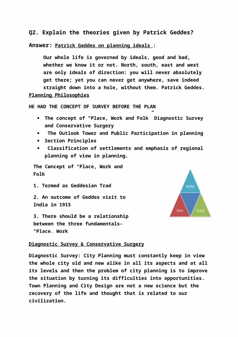
The Concept of “Place, Work and Folk”
1. Termed as Geddesian Trad
2. An outcome of Geddes visit to India in 1915
3. There should be a relationship between the three fundamentals- “Place, Work
and Folk” otherwise the whole process ceases to be planning
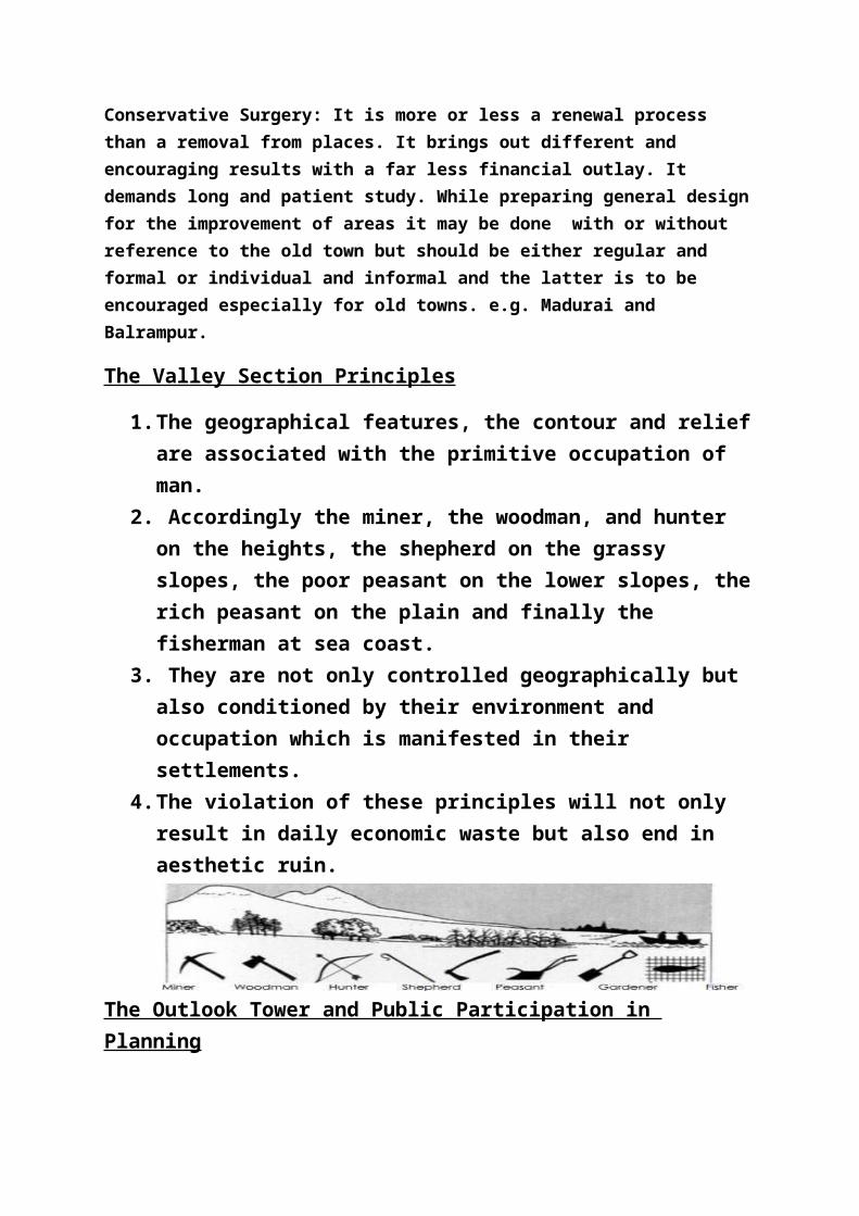
The Valley Section Principles
1. The geographical features, the contour and relief are associated with the primitive occupation of man.
2. Accordingly the miner, the woodman, and hunter on the heights, the shepherd on the grassy slopes, the poor peasant on the lower slopes, the rich peasant on the plain and finally the fisherman at sea coast.
3. They are not only controlled geographically but also conditioned by their environment and occupation which is manifested in their settlements.
4. The violation of these principles will not only result in daily economic waste but also end in aesthetic ruin.
The Outlook Tower and Public Participation in Planning
1. A tall old building high on the ridge of old Edinburgh overlooking the city and the surrounding regions.
2. The topmost storey allotted for visitors and artists and children to have a broader outlook of the city and acted as an open air –gallery.
3. The storeys below allotted for sciences starting from Geography, Astronomy, Geology, Meteorology, Botany, Zoology, Anthropology, History, Economics and so on.
4. The storeys further below having city maps, survey data pertaining to the place continued till the ground floor which consisted exhibition on the oriental civilization and general study of man.
CONURBATIONS THEORY
The term "conurbation" was coined in 1915 by Patrick Geddes in his book Cities In Evolution.
Internationally, the term "urban agglomeration" is often used to convey a similar meaning to "conurbation".
He drew attention to the ability of the (then) new technology of electric power and motorised transport to allow cities to spread and agglomerate together, and gave as examples "Midland ton" in England,

the Ruhr in Germany, Ramstad in the Netherlands, New York-Boston in the United States, the Greater Tokyo Area and Taiheiyō Belt in Japan and NCR of Delhi in India.
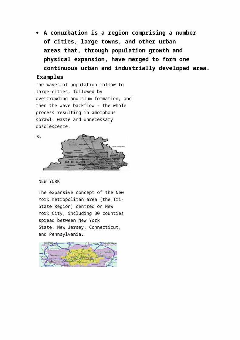
A conurbation is a region comprising a number of cities, large towns, and other urban areas that, through population growth and physical expansion, have merged to form one continuous urban and industrially developed area.
ExamplesThe waves of population inflow to large cities, followed by overcrowding and slum formation, and then the wave backflow – the whole process resulting in amorphous sprawl, waste and unnecessary obsolescence.
NEW YORK
The expansive concept of the New York metropolitan area (the Tri-State Region) centred on New York City, including 30 counties spread between New York State, New Jersey, Connecticut, and Pennsylvania.
CONSTELLATION THEORY
The map, prominent cities in Maharashtra are shown to be connected forming a ‘CONSTELLATION’ shape.
This CONSTELLATION THEORY was also coined by Sir Patrick Geddes , “4 or more cities, which are not economically, politically, socially equal come together in developing a whole region”
This theory is mostly used for administrative purpose in all countries worldwide.
Such theory is most prominently used because planning cities in a particular shape pattern is not possible in Today’s times.
Q1. Explain the following theories
A) Concentric City
B) Sectorial city
C) Multi – Nucleated City
Answer: Three key theories
E.W. Burgess–Concentric Zone Hoyt–Sector Model Harris and Ullman–Multiple Nuclei
A) Concentric Zone Theories Explained by E.W. Burgess (1925) Cities grow outwards from the centre in a series of rings. Correlation between the distance from the CBD and the wealth of the
inhabited area; wealthier families tended to live much further away from the Central Business District
Burgess's work is based on the bid rent curve.

Five Concentric Zones
Central Business Distric Transition and Industry
low incomes, oldest housing, Ghettos Low Income Residential Middle Income Residential
Suburban estates- good quality, gardens High Income Residential / Commuter
Assumptions
Older buildings in city centre Newer buildings at edge of city Land values highest in city centre Strong economic and ethnic segregation Low income groups lack transport and live close to city centre. Cities develop on a flat plain with equal access to transport
Criticism
It describes the peculiar American geography, where the inner city is poor while suburbs are wealthy
It assumes an isotropic plain - an even, unchanging landscape, doesn’t consider topography and physical feature
Commuter villages defy the theory, being in the commuter zone but located far from the city
Doesn’t consider Decentralization of shops, manufacturing industry, and entertainment
Urban regeneration and gentrification - more expensive property can be found in 'low class' housing areas
It does not address local urban politics and forces of globalization The model does not fit polycentric cities, for example NCR
B) Hoyt Sector Model
Sectors radiating out from the CBD
This map shows the footprint of every building in Chicago color-coded by the period in which the structure was built, a pattern of concentric zones is quite strikingly apparent.

Cities would tend to grow in wedge-shaped patterns, or sectors along transportation routes
Higher levels of access translate to higher land values- For eg. Low income residential along sub urban rail road, where as manufacturing activity along highway
In many respects, Hoyt's sector model is simply a concentric zone model modified to account for the impact of transportation systems on accessibility.
Criticism
Doesn’t consider mixed use development The growth of a sector can be limited by leapfrog land use It assumes an isotropic plain - an even, unchanging landscape, doesn’t consider
topography and physical feature Commuter villages defy the theory, being in the commuter zone but located far
from the city Doesn’t consider Decentralization of shops, manufacturing industry, and
entertainment Urban regeneration and gentrification - more expensive property can be found in
'low class' housing areas It does not address local urban politics and forces of globalization The model does not fit polycentric cities, for example NCR
Multiple Nuclei Model
Explained by Harris and Ullman (1945) an urban area grows, it develops around a
number of different business centres or nuclei Each nucleus acts as a growth point Growth occurs outwards from each nucleus,
until they all merge into one large urban area refinement of first two, but incorporates
outlying shopping malls, industrial areas and large residential suburbs
developed only with the use of automobiles, mostly since 1945
CBD no longer has a monopoly on retail and commercial activities since outlying malls and industrial parks compete with it.
