council meeting agenda 5 november 2014
DESCRIPTION
ÂTRANSCRIPT

Ordinary Meeting
Council Chambers Date: 5 November 2014
Time: 9:00am
AGENDA
THE ORDINARY MEETING OF THE MAREEBA SHIRE COUNCIL WILL BE HELD AT COUNCIL CHAMBERS, ON WEDNESDAY, 05 NOVEMBER 2014 AND THE ATTENDANCE OF EACH COUNCILLOR IS REQUESTED.
PETER FRANKS CHIEF EXECUTIVE OFFICER


Mareeba Shire Council - Agenda Wednesday 05 November 2014
Page 3
ORDER OF BUSINESS MEMBERS IN ATTENDANCE APOLOGIES/LEAVE OF ABSENCE/ABSENCE ON COUNCIL BUSINESS BEREAVEMENTS/CONDOLENCES DECLARATION OF ANY MATERIAL PERSONAL INTERESTS/CONFLICTS OF INTEREST CONFIRMATION OF MINUTES BUSINESS ARISING OUT OF MINUTES OF PREVIOUS MEETING
CORPORATE AND COMMUNITY SERVICES ............................................................................... 5
REGIONAL LAND USE PLANNING................................................................................................ 5 ITEM-1 Mareeba Shire Council Material Change of Use - Community Facility
(Community Precinct and Library) - Lot 4 on SP265032 - 18-22 Arara Street, Kuranda - DA/14/0047 .............................................................................................. 5
ITEM-2 C & P Lovey - Material Change of Use - Animal Husbandry Intensive (Boarding Kennel) - Lot 2 SP194667 - 93 Armstrong Road, Kuranda - DA/14/0042 ................ 27
ITEM-3 J Taylor - Reconfiguring a Lot - Subdivision (1 into 2 Lots) - Lot 2 on RP745173 - 4414 Black Mountain Road, Julatten - DA/14/0049 .............................................. 63
ITEM-4 K & G Turrisi - Reconfiguring a Lot - Subdivision (1 into 2 Lots) - Lot 118 on DA284 - 678 Springs Road, Mareeba - DA/14/0052 ............................................... 75
COMMUNITY WELLBEING .......................................................................................................... 89 ITEM-5 Mareeba Sporting Precinct Community Loan ......................................................... 89 ITEM-6 Chillagoe Hub CONFIDENTIAL ............................................................................. 93 FINANCE ...................................................................................................................................... 95 ITEM-7 Valueless Land to Acquire CONFIDENTIAL .......................................................... 95 ITEM-8 Properties Straddling Two (2) Shire Boundaries CONFIDENTIAL ......................... 97 GOVERNANCE AND COMPLIANCE ............................................................................................ 99 ITEM-9 Tenure over areas of Borzi Park and the Racecourse Reserve .............................. 99 INFRASTRUCTURE SERVICES ................................................................................................ 125
TECHNICAL SERVICES ............................................................................................................. 125 ITEM-10 Heritage Park, Dimbulah - Proposed Pedestrian Ramp ........................................ 125 ITEM-11 Level 3 Bridge Inspections.................................................................................... 131 ITEM-12 Kuranda Community Precinct ............................................................................... 135 ITEM-13 Mareeba Aerodrome - Missionary Aviation Fellowship (MAF) ............................... 145 ITEM-14 Update Report on Request Regards Mackay Sugar Extended B-Double Route
Access within Mareeba Shire ............................................................................... 151 WORKS ...................................................................................................................................... 155 ITEM-15 Extracting Construction Materials ......................................................................... 155 ITEM-16 Infrastructure Services - Works Sections Progress Report - September 2014 ...... 161 WATER & WASTE ...................................................................................................................... 175 ITEM-17 Infrastructure Services - Water and Wastewater - Customer Service Standards .. 175 ITEM-18 QMSC2014-11 Water Meter Replacement Program Concurrently with the
Introduction of an Automated Water Metering System .......................................... 187 ITEM-19 Water and Wastewater Group - Monthly Operations Report Infrastructure
Services Department ............................................................................................ 191 ITEM-20 Infrastructure Services - Waste Operations Progress Report - September 2014 .. 203
Mareeba Shire Council - Agenda Wednesday 05 November 2014
Page 4
ITEM-21 Mareeba Wastewater Treatment Plant - Process Design Phase .......................... 207 CHIEF EXECUTIVE OFFICER ................................................................................................... 211
ITEM-22 Office Closure for Staff Function ........................................................................... 211
Mareeba Shire Council - Agenda Wednesday 05 November 2014
Page 5
CORPORATE AND COMMUNITY SERVICES
REGIONAL LAND USE PLANNING
ITEM-1 MAREEBA SHIRE COUNCIL MATERIAL CHANGE OF USE - COMMUNITY FACILITY (COMMUNITY PRECINCT AND LIBRARY) - LOT 4 ON SP265032 - 18-22 ARARA STREET, KURANDA - DA/14/0047
DOCUMENT INFORMATION
MEETING: Ordinary MEETING DATE: 5 November 2014 REPORT OFFICER’S TITLE: Planning Officer DEPARTMENT: Corporate and Community Services
APPLICATION DETAILS APPLICATION PREMISES
APPLICANT Mareeba Shire Council ADDRESS 18-22 Arara Street, Kuranda
DATE LODGED 10 September 2014 RPD Lot 4 on SP265032 TYPE OF APPROVAL
Development Permit
PROPOSED DEVELOPMENT
Material Change of Use - Community Facility (Community Precinct and Library)
FILE NO DA/14/0047 AREA 7,872m2 LODGED BY Mareeba Shire Council OWNER Mareeba Shire
Council PLANNING SCHEME
Mareeba Shire Planning Scheme 2004 (amendment no. 01/11)
ZONE Residential Zone LEVEL OF ASSESSMENT
Impact Assessment
SUBMISSIONS No properly made submissions received ATTACHMENTS: 1. Proposal Plan/s - Clarke & Prince Pty Ltd dated August 2014 EXECUTIVE SUMMARY
Council is in receipt of a development application described in the above application details. The application is impact assessable and no properly made submissions were received in response to public notification of the application.

Mareeba Shire Council - Agenda Wednesday 05 November 2014
Page 6
Approval is sought to redevelop the former Kuranda Primary School site into the proposed 'Kuranda Community Precinct'. The Kuranda Community Precinct development will accommodate the relocated Kuranda Library as well as a number of indoor meeting/activity rooms and landscaped outdoor meeting/active play areas. The development will utilise a large portion of the former primary school infrastructure, with the remaining having previously been demolished and removed from site. The application and supporting material has been assessed against the relevant statutory planning instruments, including the FNQ Regional Plan, the State Planning Policy, and the Mareeba Shire Planning Scheme (including codes and policies) and does not conflict with any relevant planning instrument. The proposed development is considered to be a logical use of the already built up site and this officer has not identified any significant issues with the development. It is recommended the application be approved in full, subject to conditions.
OFFICER'S RECOMMENDATION
1. "That, in relation to the following development application:
APPLICATION PREMISES APPLICANT Mareeba Shire Council ADDRESS 18-22 Arara Street,
Kuranda DATE LODGED 10 September 2014 RPD Lot 4 on SP265032 TYPE OF APPROVAL
Development Permit
PROPOSED DEVELOPMENT
Material Change of Use - Community Facility (Community Precinct and Library)
and in accordance with the Sustainable Planning Act 2009, as amended, the applicant be notified that the application for a development permit for the development specified in (A) is:
Approved by Council in accordance with the approved plans/documents listed in (B), subject to assessment manager conditions in (C), assessment manager’s advice in (D), relevant period in (E), further permits in (F), and further approvals from Council listed in (G); (A) APPROVED DEVELOPMENT: Development Permit for Material Change of Use -
Community Facility (Community Precinct and Library)
And The assessment manager does not consider that the assessment manager’s decision conflicts with a relevant instrument.
(B) APPROVED PLANS:
Plan/Document Number
Plan/Document Title Prepared by Dated
1103-SD.00 Cover Sheet Clarke and Prince Pty Ltd Aug 2014 1103-SD.01 Proposed Site Plan Clarke and Prince Pty Ltd Aug 2014

Mareeba Shire Council - Agenda Wednesday 05 November 2014
Page 7
1103-SD.02 Ground Floor Plan Clarke and Prince Pty Ltd Aug 2014
1103-SD.03 Elevations (Sheet 1) Clarke and Prince Pty Ltd Aug 2014
1103-SD.05 Elevations (Sheet 2) Clarke and Prince Pty Ltd Aug 2014
(C) ASSESSMENT MANAGER’S CONDITIONS (COUNCIL)
(a) Development assessable against the Planning Scheme 1. Development must be carried out substantially in accordance with the
approved plans and the facts and circumstances of the use as submitted with the application, subject to any alterations:
- found necessary by Council’s delegated officer at the time of
examination of the engineering plans or during construction of the development because of particular engineering requirements; and
- to ensure compliance with the following conditions of approval. 2. Timing of Effect
2.1 The conditions of the development permit must be complied with to the satisfaction of Council’s delegated officer prior to the commencement of the use except where specified otherwise in these conditions of approval.
2.2 Prior to the commencement of use, the applicant must notify Council
that all the conditions of the development permit have been complied with, except where specified otherwise in these conditions of approval.
3. General
3.1 The development approval would not have been issued if not for the conditions requiring the construction of infrastructure within the conditions of approval.
3.2 The applicant/developer is responsible for the cost of necessary
alterations to existing public utility mains, services or installations required by works in relation to the proposed development or any works required by condition(s) of this approval.
3.3 All works must be designed, constructed and carried out in
accordance with FNQROC Development Manual requirements (as amended) and to the satisfaction of Council’s delegated officer.
3.4 Noise Nuisance
Refrigeration equipment, pumps, compressors and mechanical ventilation systems must be located, designed, installed and maintained to achieve a maximum noise level of 3dB(A) above background levels as measured from noise sensitive locations and a maximum noise level of 8dB(A) above background levels as measured from commercial locations.

Mareeba Shire Council - Agenda Wednesday 05 November 2014
Page 8
The applicant is required to install and maintain suitable screening to all air conditioning, lift motor rooms, plant and service facilities located at the top of or on the external face of the building. The screening structures must be constructed from materials that are consistent with materials used elsewhere on the facade of the building. There are to be no individual external unscreened air conditioning units attached to the exterior building facade.
3.5 Waste Management
On site refuse storage area must be provided and be screened from view from adjoining properties and road reserve by a 1 metre wide landscaped screening buffer or 1.8m high solid fence or building. Where bulk bins are used and are to be serviced on site, certification by a Registered Professional Engineer of Queensland (RPEQ) must be provided to Council prior to the issue of a building permit which demonstrates that internal access is of adequate design and construction to allow waste collection/delivery vehicles to enter and exit the site in a forward gear.
4. Infrastructure Services and Standards
4.1 Access
A commercial access crossover servicing the proposed internal car park must be upgraded/constructed (from the edge of the road pavement to the property boundary of the subject lot) in accordance with the FNQROC Development Manual standards, to the satisfaction of Council's delegated officer. The applicant must ensure that any redundant vehicle crossovers are removed and reinstated with kerb and channel.
4.2 Stormwater Drainage/Water Quality
The applicant must ensure a non-worsening effect on surrounding land as a consequence of the development and must take all reasonable and practicable measures to ensure discharge occurs in compliance with the Queensland Urban Drainage Manual (QUDM) and the FNQROC Development Manual.
4.3 Car Parking/Internal Driveways
The applicant/developer must ensure the development is provided with 8 on-site car parking spaces including 1 disabled parking space, which are available solely for the parking of vehicles associated with the use of the premises. All car parking spaces and internal driveways must be concrete, bitumen or asphalt sealed, line marked, and appropriately drained prior to the commencement of the use and to the satisfaction of Council's delegated officer. Any line marking must remain clearly visible for the life of the development.

Mareeba Shire Council - Agenda Wednesday 05 November 2014
Page 9
Bicycle parking facilities for a minimum of 4 bicycles is to be provided on site, in close proximity to the car parking facilities. All car parking spaces, bicycle parking facilities and internal driveways must be constructed in compliance with the following standards, to the satisfaction of Council's delegated officer: - Australian Standard AS2890:1 Off Street Parking – Car Parking
Facilities; - Australian Standard AS2890.3 Bicycle Parking Facilities - Australian Standard AS1428:2001 – Design for Access and Mobility.
4.4 Landscaping and Fencing
(a) Prior to the commencement of the use a detailed landscape plan must be prepared for the site and submitted to Council's delegated officer for consideration and approval.
The landscape plan should address the whole development, including any existing landscaping to be retained, and demonstrate compliance with the Landscaping Code. Species used should be generally in accordance with Schedule A of Planning Scheme Policy No. 9 - Landscaping.
The landscaping of the site must be carried out in accordance with the endorsed landscape plan and prior to the commencement of the use, and mulched, irrigated and maintained to the satisfaction of Council's delegated officer.
(b) Within 30 business days of any residential use being
established on Lot 3 on SP265032 or any future lot created from Lot 3 on SP265032 that adjoins Lot 4 on SP265032, a solid 1.8 metre high timber or colorbond fence of neutral colour is to be erected along the full length of the sites north-west boundary, to the satisfaction of Council's delegated officer.
4.5 Lighting
Where outdoor lighting is required the developer shall locate, design and install lighting to operate from dusk to dawn within all areas where the public will be given access, which prevents the potential for light spillage to cause nuisance to neighbours and must be provided in accordance with Australian Standard 1158.1 – Lighting for Roads and Public Spaces. Illumination resulting from direct, reflected or other incidental light emanating from the subject land must not exceed 8 lux when measured at any point 1.5m outside the property boundary of the subject site. The lighting fixtures installed on site must meet appropriate lux levels as documented within Australian Standard 4282 – Control of the Obtrusive Effects of Outdoor Lighting.

Mareeba Shire Council - Agenda Wednesday 05 November 2014
Page 10
4.6 Water Supply
Where the existing reticulated water supply does not currently service the site or is not at an adequate capacity, the developer is required to extend or upgrade the reticulated water supply infrastructure to connect the site to Council’s existing infrastructure at a point that has sufficient capacity to service the development in accordance with FNQROC Development Manual standards (as amended). If a new or upgraded water service connection is required to service the development, it must be provided in accordance with FNQROC Development Manual standards (as amended) to the satisfaction of Council’s delegated officer.
4.7 Sewerage Connection
The developer must connect the proposed development to Council’s reticulated sewerage system in accordance with FNQROC Development Manual standards (as amended) to the satisfaction of Council’s delegated officer. Where sewerage connections are not available to the site, or where existing connections are not satisfactory for the proposed development, the developer is required to extend or upgrade the reticulated sewerage infrastructure to connect the site to Council’s existing infrastructure at a point that has sufficient capacity to service the development in accordance with FNQROC Development Manual standards (as amended).
(D) ASSESSMENT MANAGER’S ADVICE
(a) The change in the use of the building may also require a change in the
classification of the building under the Building Act. The applicant is advised to contact a Building Certifier to establish if a change in the classification of the building is required.
(b) Advertising signage for the proposed development may require a Development
Permit for Operational Works. The applicant is to confirm with the Manager Shire Planning prior to installing any advertising signage on the premises.
(c) Compliance with applicable codes/policies
The development must be carried out to ensure compliance with the provisions of Council’s Local Laws, Planning Scheme Policies, Planning Scheme and Planning Scheme Codes to the extent they have not been varied by a condition of this approval.
(d) Compliance with Acts and Regulations
The erection and use of the building must comply with the Building Act and all other relevant Acts, Regulations and Laws, and these approval conditions.

Mareeba Shire Council - Agenda Wednesday 05 November 2014
Page 11
(e) Environmental Protection and Biodiversity Conservation Act 1999
The applicant is advised that referral may be required under the Environmental Protection and Biodiversity Conservation Act 1999 if the proposed activities are likely to have a significant impact on a matter of national environmental significance. Further information on these matters can be obtained from www.deh.gov.au
(f) Cultural Heritage
In carrying out the activity the applicant must take all reasonable and practicable measures to ensure that no harm is done to Aboriginal cultural heritage (the “cultural heritage duty of care”). The applicant will comply with the cultural heritage duty of care if the applicant acts in accordance with gazetted cultural heritage duty of care guidelines. An assessment of the proposed activity against the duty of care guidelines will determine whether or to what extent Aboriginal cultural heritage may be harmed by the activity. Further information on cultural heritage, together with a copy of the duty of care guidelines and cultural heritage search forms, may be obtained from www.derm.qld.gov.au
(E) RELEVANT PERIOD
When approval lapses if development not started (s.341)
• Material Change of Use – four (4) years (starting the day the approval takes effect);
(F) OTHER NECESSARY DEVELOPMENT PERMITS AND/OR COMPLIANCE PERMITS
• Development Permit for Building Work (G) OTHER APPROVALS REQUIRED FROM COUNCIL
• Compliance Permit for Plumbing and Drainage Work • Access approval arising from condition number 4.1 (Please contact Council’s
Urban & Regional Planning Group to obtain application form and applicable fee). "
THE SITE
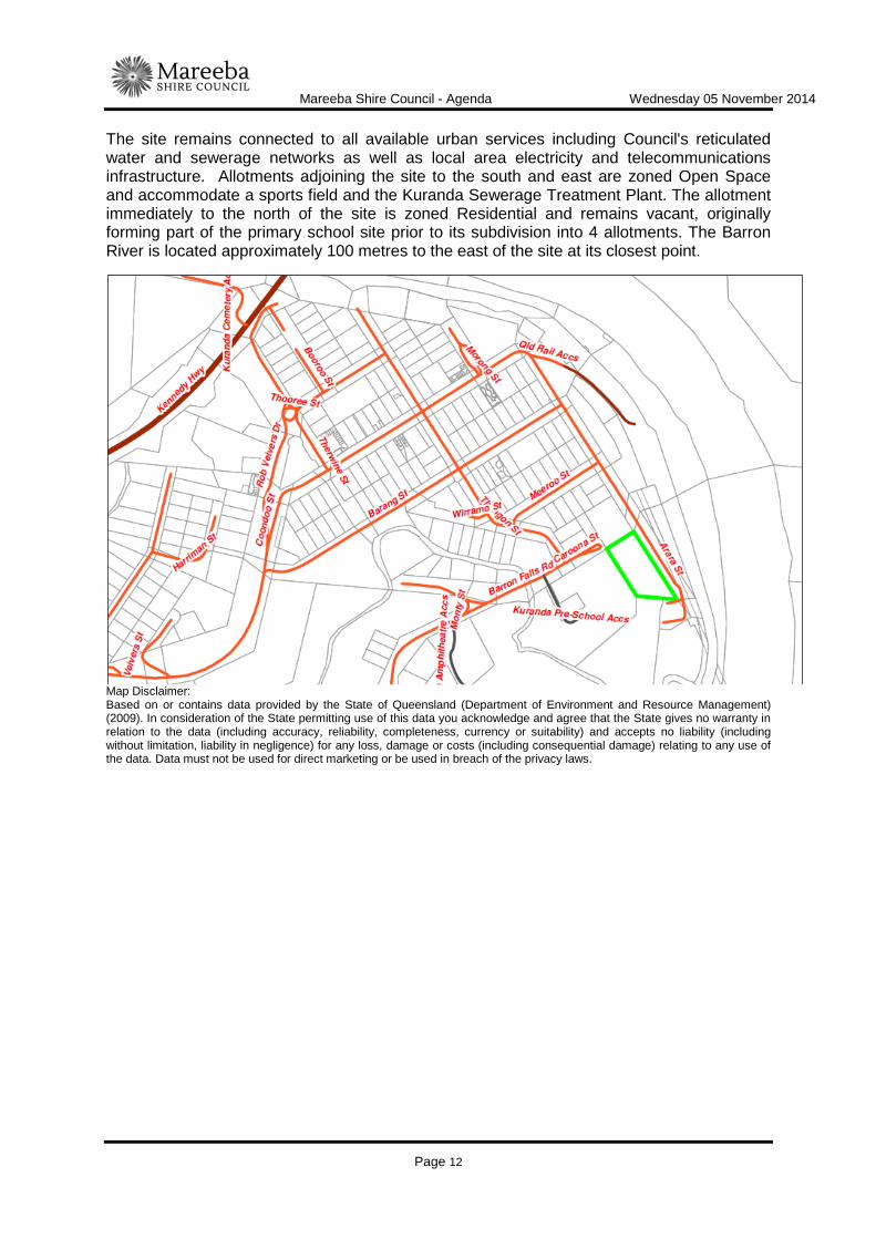
The subject site forms a large part of the former Kuranda Primary School site (previously subdivided), situated at Lot 18-22 Arara Street, Kuranda, and is described as Lot 4 on SP265032, Parish of Cairns, County of Nares. Lot 4 is generally regular in shape with a total area of 7,872m2 and is zoned Residential under the Planning Scheme. The site is access from and contains approximately 150 metres of frontage to Arara Street. Arara Street is constructed to two lane bitumen sealed standard for the entire frontage of the site which also includes 27 on-street parallel parking spaces associated with the former primary school. Having previously accommodated a school, the site is improved by a number of structures including a classroom block (Block C), an ablutions block, tuckshop, storage shed and a number of other open sided undercover sheds. A number of concrete slabs remain on site from previously demolished school buildings. The site also contains scattered mature planted vegetation throughout.
Mareeba Shire Council - Agenda Wednesday 05 November 2014
Page 12
The site remains connected to all available urban services including Council's reticulated water and sewerage networks as well as local area electricity and telecommunications infrastructure. Allotments adjoining the site to the south and east are zoned Open Space and accommodate a sports field and the Kuranda Sewerage Treatment Plant. The allotment immediately to the north of the site is zoned Residential and remains vacant, originally forming part of the primary school site prior to its subdivision into 4 allotments. The Barron River is located approximately 100 metres to the east of the site at its closest point.
Map Disclaimer: Based on or contains data provided by the State of Queensland (Department of Environment and Resource Management) (2009). In consideration of the State permitting use of this data you acknowledge and agree that the State gives no warranty in relation to the data (including accuracy, reliability, completeness, currency or suitability) and accepts no liability (including without limitation, liability in negligence) for any loss, damage or costs (including consequential damage) relating to any use of the data. Data must not be used for direct marketing or be used in breach of the privacy laws.

Mareeba Shire Council - Agenda Wednesday 05 November 2014
Page 13
Map Disclaimer: Based on or contains data provided by the State of Queensland (Department of Environment and Resource Management) (2009). In consideration of the State permitting use of this data you acknowledge and agree that the State gives no warranty in relation to the data (including accuracy, reliability, completeness, currency or suitability) and accepts no liability (including without limitation, liability in negligence) for any loss, damage or costs (including consequential damage) relating to any use of the data. Data must not be used for direct marketing or be used in breach of the privacy laws.

Mareeba Shire Council - Agenda Wednesday 05 November 2014
Page 14
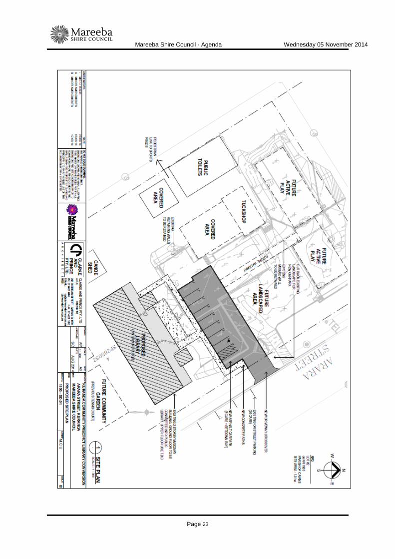
BACKGROUND AND CONTEXT The subject land forms part of the former Kuranda Primary School site (Lot 82 on NR7983). The school was decommissioned in December 2006 and has been under Council ownership as a freehold allotment since 2008. On 22 September 2010, the former Tablelands Regional Council approved an application to subdivide Lot 82 into four allotments (REC/10/0037). This subdivision was finalised in June 2014 and Lot 4 on SP265032 was created (the site subject for this application). The majority of infrastructure associated with the former primary school remained in newly created Lot 4. This application for Material Change of Use - Community Facility has now been lodged to establish use rights over the site for the proposed Kuranda Community Precinct. DESCRIPTION OF PROPOSED DEVELOPMENT The development application seeks a Development Permit for Material Change of Use - Community Facility (Community Precinct and Library) in accordance with the plans shown in Attachment 1. The proposed development will include the renovation of the former primary school's "block C" to make it suitable for the relocation of the Kuranda Library on the ground floor of the building. The first floor will also be renovated to include a number of meeting/activity rooms for general use by the public including clubs and organisations. An on-site car park to accommodate up to 8 vehicles (including 1 disabled vehicle) will be constructed to accommodate the proposed development, namely the library. A further 27 on-street car parks located immediately adjacent the site along Arara Street which were previously used to service the former school will provide additional on-street parking to service the precinct. As indicated on the site plan, there are other areas identified as future active play areas which will require only minimal development works (i.e. landscaping and paving for walkways). Other structures associated with the former primary school, including a number of undercover areas and a large ablution block, will also be incorporated into the precinct development. The site is already connected to Council's reticulated water and sewerage networks as well as local area electricity and telecommunications infrastructure. REGIONAL PLAN DESIGNATION
The subject site is included within the Urban Footprint land use category in the Far North Queensland Regional Plan 2009-2031. Kuranda is identified as a Village Activity Centre in the Regional Plan. The Regional Plan Map 3- ‘Areas of Ecological Significance’ also identifies the site as being wholly located within a Strategic Rehabilitation Area.

Mareeba Shire Council - Agenda Wednesday 05 November 2014
Page 15
PLANNING SCHEME DESIGNATIONS
Planning Scheme Definitions The proposed use is defined as:-
"Community facility means the use of premises by a public authority, an organisation, commercial operation or group of persons for the physical, social, cultural, religious or intellectual development or welfare of the local community, but does not include a building or place elsewhere specifically defined in this plan."
RELEVENT PLANNING INSTRUMENTS Assessment of the proposed development against the relevant planning instruments is summarised as follows:- (a) Far North Queensland Regional Plan 2009-2031 Assessment against the Regional Plan is required because the plan is not reflected in the planning scheme. The application is assessed as being capable of substantially complying with the relevant provisions of the Regional Plan, provided reasonable and relevant conditions are applied. The following Desired Regional Outcome Land Use Policies are relevant to the assessment of the application:
DRO 1.1 Biodiversity Conservation Land Use Policy Complies Comments
1.1.5 Urban development on a lot that is within
a strategic rehabilitation area results in improved ecological connectivity or habitat extent within that lot.
Complies - The proposal is for the redevelopment of the former Kuranda Primary School site into the Kuranda Community Precinct. Existing mature vegetation will remain on site as will the majority of infrastructure associated with the former school. The community precinct development will involve minimal works on site only and revegetation is not considered necessary in this instance.
DRO 3.3 Healthy and Safe Communities
Land Use Policy Complies Comments
3.3.A Community health and safety in urban and rural environments is improved by providing appropriate social infrastructure, places for community activity, and involving local communities in planning processes.
Complies - The proposed Community Precinct will provide social infrastructure (library, meeting rooms) as well as places for community activity (meeting rooms, outdoor active play areas).
3.3.B Best practice urban design is utilised to create built environments that enhance community health and safety.
Complies
Strategic Framework designation: Major Urban Growth Node (Kuranda)
Zone: Residential Zone
Overlays Significant Vegetation Overlay

Mareeba Shire Council - Agenda Wednesday 05 November 2014
Page 16
DRO 3.5 Sense of Community, Place & Identity Land Use Policy Complies Comments
3.5.1 Adequate provision is made for public
spaces and places for community activities when planning and designing greenfield developments and infill areas
Complies - The proposed development will provide public space and places for community activities.
DRO 4.1 Compact Urban Form
Land Use Policy Complies Comments
4.1.1 Urban development is contained within the urban footprint
Complies - The subject site is situated within the Urban Footprint.
4.1.2 Urban development is sequenced to ensure logical and orderly land use and infrastructure delivery.
Complies - The proposed Community Precinct will utilise the majority of infrastructure associated with the former primary school and is considered a logical and orderly use of the land.
4.1.3 Development within the key regional growth areas achieves the strategic planning intent of the subregional narratives
Complies
DRO 4.2 Regional Activity Centres
Land Use Policy Complies Comments
4.2.1 Regional activity centres are identified and operate as a network in accordance with the regional hierarchy (see table 6 and map 9).
Complies
4.2.2 Development of regional activity centres results in consolidation in the central core and surrounding frame, is of appropriate type and scale, and is accommodated by efficient use of land and buildings.
Complies
DRO 7.1 Protection of Waterways, Wetlands and Water Quality
Land Use Policy Complies Comments
7.1.1 Development is planned, designed, constructed and managed in accordance with best practice environmental management to protect environmental values and meet water quality objectives of the Environmental Protection Policy (Water) 1997 (EPP Water) for regional surface water, groundwater and wetlands.
The development can be conditioned to comply.
(b) State Planning Policy
On 2 December 2013 (amended July 2014), the Department of State Development, Infrastructure and Planning introduced a single State Planning Policy (SPP) to replace the various SPP's previously in place. As such, this State Planning Policy is not reflected in the Planning Scheme and is therefore applicable to the assessment of the application. This officer has conducted an assessment of the proposed development against the provisions contained within the SPP and it is not considered to be in conflict with any relevant aspect of the SPP.

Mareeba Shire Council - Agenda Wednesday 05 November 2014
Page 17
Queensland State Planning Policy - December 2013
State Interest Complies Assessment Requirements & Comments
Water quality
Receiving waters - a development application for any of the following:
(1) a material change of use for urban purposes that involves a land area greater than 2500 square metres that:
(a) will result in an impervious area greater than 25 per cent of the net developable area, or
(b) will result in six or more dwellings, or
(2) reconfiguring a lot for urban purposes that involves a land area greater than 2500 square metres and will result in six or more lots, or
(3) operational works for urban purposes that involve disturbing more than 2500 square metres of land.
Receiving waters
Development:
(1) avoids or otherwise minimises adverse impacts on the environmental values of receiving waters, arising from:
(a) altered stormwater quality or flow, and
(b) wastewater (other than contaminated stormwater and sewage), and
(c) the creation or expansion of non-tidal artificial waterways, and
(2) complies with the SPP code: Water quality (Appendix 2).
Comment
The development can be conditioned to comply with this aspect of the SPP.
(c) Mareeba Shire Planning Scheme 2004 (amendment no. 01/11) Relevant Desired Environmental Outcomes Complies Comments
(g) The standard and location of the built environment, particularly in Mareeba and Kuranda, minimise the use of non-renewable resources, having regard to associated wastewater and effluent disposal infrastructure.
The proposed development will be serviced by existing water, sewerage, electrical and telecommunications infrastructure. Arara Street is constructed to a bitumen sealed standard. Considering the previous use of the site as a primary school, the proposed development is not likely to have any significant impact on non-renewable resources.
(h) All members of the community have appropriate access to relevant services and facilities that meet their needs and create a sense of community satisfaction.
Complies - The proposed development will provide community infrastructure and promote community and social interaction. The development is provided for the benefit of Kuranda residents.
(j) Threats to public safety and health associated with the natural and built environments, including flooding in the catchments of the Barron River and Mitchell River are minimised.
Complies - The subject site is not projected to be impacted by the flooding of the Barron River in a Q100 flood event.
(p) The Kuranda Village’s role and identity not only as an international tourist destination but as a residential centre and a functional service location for the wider district is protected and enhanced whilst ensuring the community’s harmony and a sense of place is maximised through ensuring that the mix between tourists and residents meets the needs of both groups.
Complies - The proposed development will provide community infrastructure and promote community and social interaction. The development is provided for the benefit of Kuranda residents.
(r) The identification and protection of the amenity of noise sensitive development and liveability of residential areas.
The proposed development can be conditioned to comply. The subject site contains residential land uses to the north only, all other surrounding land uses do not include

Mareeba Shire Council - Agenda Wednesday 05 November 2014
Page 18
residential components (sports oval, sewerage treatment plant)
(s) The provision of pedestrian and bicycle facilities in urban areas.
Complies - The subject site is accessible via a broad pedestrian network. And is accessed via an adequately constructed road.
Relevant Development Codes
The following Development Codes are considered to be applicable to the assessment of the application:
Part 4, Division 6 Residential Zone Code Part 5, Division 6 Significant Vegetation Overlay Code Part 6, Division 5 Car Parking Code Part 6, Division 15 Landscaping Code
The application included a planning report and assessment against the planning scheme. An officer assessment has found that the application satisfies the relevant acceptable solutions (or probable solutions/performance criteria where no acceptable solution applies) of the relevant codes set out below, provided reasonable and relevant conditions are attached to any approval. Relevant Codes Comments
Residential Zone Code The application can be conditioned to comply with the relevant acceptable/probable solutions contained within the code.
Significant Vegetation Overlay Code The application proposed the redevelopment of part of the
former Kuranda Primary School site as a community facility (Kuranda Community Precinct). The subject site is situated within a Category A vegetation area and contains only planted vegetation associated with the former school. No significant clearing of any of this vegetation is proposed, in fact, extensive landscaping of the site is proposed to increase the site's visual appeal.
Assessment against the provisions contained within this code are not considered relevant in this instance.
Car Parking Code The application can be conditioned to comply with the relevant
acceptable/probable solutions contained within the code apart from the following:
Acceptable Solution AS9.1 - Car Parking Numbers
Refer to planning discussion section of report. Landscaping Code The application can be conditioned to comply with the relevant
acceptable/probable solutions contained within the code. (e) Planning Scheme Policies/Infrastructure Charges Plan The following planning scheme policies are relevant to the application:

Mareeba Shire Council - Agenda Wednesday 05 November 2014
Page 19
No. 4 - Development Manual All development works are required to be designed and constructed in accordance with the FNQROC Development Manual. (f) Adopted Infrastructure Charges Notice Water Supply The subject site is already connected to Council's reticulated water supply network and is considered to have a substantial headworks credit for water supply associated with the previous use of the site as a primary school. In this officer's opinion, the proposed development is substantially less intense, in terms of water demand, than that of the former primary school and is therefore not likely to place an additional demand on Council's reticulated water supply network outside this existing credit. As such, a headworks charge for water supply is not considered necessary in this instance. Sewerage Supply The subject site is already connected to Council's reticulated sewerage network and is considered to have a substantial headworks credit for sewerage associated with the previous use of the site as a primary school. The proposed community facility (community precinct and library) will incorporate the former primary school's ablution block as well as additional toilet facilities (x2) in the proposed library. In this officer's opinion, the proposed development is substantially less intense, in terms of sewerage discharge, than that of the former primary school and is therefore not likely to place any additional demand on Council's sewerage infrastructure outside this existing credit. As such, a headworks charge for sewerage supply is not considered necessary in this instance. Roadworks

Mareeba Shire Council - Agenda Wednesday 05 November 2014
Page 20
An augmentation of the road network contribution (Planning Scheme Policy No. 6) is generally applied to new development that will result in an increase in vehicle traffic along a Council controlled road. This contribution is generally paid in lieu of external road upgrades/construction. Arara Street was one of two primary access streets servicing the former school and is constructed to bitumen sealed standard for its entire length. Traffic associated with the former primary school included heavy vehicle traffic (buses), staff vehicles and vehicles associated with the daily drop-off and pick-up of students. In this officer's opinion, the proposed community facility (community precinct and library) is substantially less intense, in terms of traffic generation, than the former primary school and is not likely to result in an increase in vehicle movements along Arara Street when compared to vehicle movements generated by the former school. As such, an augmentation of the road network contribution is not considered necessary in this instance. REFERRALS Concurrence This application did not trigger referral to any Concurrence Agencies. Advice This application did not trigger referral to any Advice Agencies. Internal Consultation Development Engineering, Infrastructure Services PUBLIC NOTIFICATION The development proposal was placed on public notification from 25 September 2014 to 17 October 2014. The applicant submitted the notice of 22 October 2014 advising that the public notification requirements were carried out in accordance with the requirements of the Act. No submissions were received.

Mareeba Shire Council - Agenda Wednesday 05 November 2014
Page 21
PLANNING DISCUSSION Non-compliance with the relevant acceptable/probable solutions contained within the Car Parking Code are discussed as follows: Car Parking Numbers S9 Sufficient car parking spaces are provided to accommodate the demand likely to be
generated by the use.
AS9.1 The number of car parking spaces provided for the use is in accordance with the Car Parking Schedule.
Comment The proposed development, which will include the relocated Kuranda library as well as a number of indoor meeting/activity rooms and outdoor active play areas, will be provided with a total of 35 car parking spaces comprising of 8 on-site car parking spaces as well as 27 on-street car parking spaces which were used exclusively by the former primary school. It is considered reasonable to assume the existing on-street parking should now pertain to the community precinct, given the nature of the development and its location immediately adjacent the subject site. In this officer's opinion, the total number of car parking spaces provided should be adequate to accommodate the demand likely to be generated by the use. It is considered the development complies with S9.
ATTACHMENT 1. Approved Plans ECM VS3606515 Date Prepared: 27 October 2014

Mareeba Shire Council - Agenda Wednesday 05 November 2014
Page 22
ATTACHMENT 1 APPROVED PLANS (DWS VS 3606515)
Mareeba Shire Council - Agenda Wednesday 05 November 2014
Page 23

Mareeba Shire Council - Agenda Wednesday 05 November 2014
Page 24

Mareeba Shire Council - Agenda Wednesday 05 November 2014
Page 25

Mareeba Shire Council - Agenda Wednesday 05 November 2014
Page 26

Mareeba Shire Council - Agenda Wednesday 05 November 2014
Page 27
ITEM-2 C & P LOVEY - MATERIAL CHANGE OF USE - ANIMAL HUSBANDRY INTENSIVE (BOARDING KENNEL) - LOT 2 SP194667 - 93 ARMSTRONG ROAD, KURANDA - DA/14/0042
DOCUMENT INFORMATION
MEETING: Ordinary MEETING DATE: 5 November 2014 REPORT OFFICER’S TITLE: Senior Planner DEPARTMENT: Corporate and Community Services
APPLICATION DETAILS
APPLICATION PREMISES APPLICANT C & P Lovey ADDRESS 93 Armstrong Road,
Kuranda DATE LODGED 21 August 2014 RPD Lot 2 on SP194667 TYPE OF APPROVAL
Development Permit
PROPOSED DEVELOPMENT
Material Change of Use - Animal Husbandry-Intensive (Boarding Kennel)
FILE NO DA/14/0042 AREA 41.79 hectares LODGED BY C & P Lovey OWNER Barron Roofing Pty
Ltd PLANNING SCHEME
Mareeba Shire Planning Scheme 2004 (amendment no. 01/11)
ZONE Rural zone LEVEL OF ASSESSMENT
Code Assessment
SUBMISSIONS n/a ATTACHMENTS: 1. Proposal Plan/s
2. Cardno Noise Impact Assessment - K9 River Retreat - September 2014
EXECUTIVE SUMMARY
Council is in receipt of a development application described in the above application details. The application is code assessable and was not required to undergo public notification.

Mareeba Shire Council - Agenda Wednesday 05 November 2014
Page 28
It has been assessed against the relevant statutory planning instruments, including the Regional Plan and the Planning Scheme and does not conflict with any relevant planning instrument. Draft conditions were provided to the Applicant and have been agreed. It is recommended that the application be approved in full with conditions.
OFFICER'S RECOMMENDATION
"1. That in relation to the following development application:
APPLICATION PREMISES APPLICANT C & P Lovey ADDRESS 93 Armstrong Road,
Kuranda DATE LODGED 21 August 2014 RPD Lot 2 on SP194667 TYPE OF APPROVAL
Development Permit
PROPOSED DEVELOPMENT
Material Change of Use - Animal Husbandry-Intensive (Boarding Kennel)
and in accordance with the Sustainable Planning Act 2009, the applicant be notified that the application for a development permit for the development specified in (A) is:
Approved by Council in accordance with the approved plans/documents listed in (B), subject to assessment manager conditions in (C), assessment manager’s advice in (D), relevant period in (E), further permits in (F), and further approvals from Council listed in (G); And The assessment manager does not consider that the assessment manager’s decision conflicts with a relevant instrument (A) APPROVED DEVELOPMENT: Development Permit for Material Change of Use -
Animal Husbandry-Intensive (Boarding Kennel) (B) APPROVED PLANS:
Plan/Document Number
Plan/Document Title Prepared by Dated
A-1 Rev A Existing Building (K9 River Retreat - Floor Plan and Details
RMS 12/08/14
SP-1 Rev A Site Plan & K9 River Retreat Area Plan
RMS 12/08/14
A-2 Rev A Existing Building (K9 River Retreat)
RMS 12/08/14
A11364 Noise Impact Assessment - K9 River Retreat
Cardno Sept 2014

Mareeba Shire Council - Agenda Wednesday 05 November 2014
Page 29
(C) ASSESSMENT MANAGER’S CONDITIONS (COUNCIL) (a) Development assessable against the Planning Scheme 1. Development must be carried out substantially in accordance with the approved
plans and the facts and circumstances of the use as submitted with the application, subject to any alterations:
- found necessary by Council’s delegated officer at the time of examination of the engineering plans or during construction of the development because of particular engineering requirements; and
- to ensure compliance with the following conditions of approval.
2. Timing of Effect 2.1 The conditions of the development permit must be complied with to the
satisfaction of Council’s delegated officer prior to the commencement of the use except where specified otherwise in these conditions of approval.
2.2 Prior to the commencement of use, the applicant must notify Council that all the conditions of the development permit have been complied with, except where specified otherwise in these conditions of approval.
3. General 3.1 The development approval would not have been issued if not for the
conditions requiring the construction of infrastructure or the payment of infrastructure charges within the conditions of approval.
3.2 The applicant/developer is responsible for the cost of necessary alterations to existing public utility mains, services or installations required by works in relation to the proposed development or any works required by condition(s) of this approval.
3.3 All payments or bonds required to be made to the Council pursuant to any condition of this approval must be made prior to commencement of the use and at the rate applicable at the time of payment.
3.4 All works must be designed, constructed and carried out in accordance with FNQROC Development Manual requirements (as amended) and to the satisfaction of Council’s delegated officer.
3.5 Noise Management The Animal Husbandry-Intensive (Boarding Kennel) use must at all time be operated to ensure compliance with the Environmental Protection (Noise) Policy 2008. Specifically: (i) Dogs are housed indoors during the night period between 18:00 and
0:700; and
Mareeba Shire Council - Agenda Wednesday 05 November 2014
Page 30
(ii) Windows of dog rooms shall remain closed during the night period between 18:00 and 07:00; and
(iii) Feeding of dogs is not to commence prior to 07:00 or to occur after 18:00; and
(iv) The Operator of the facility must at, all times, actively manage noise from animals housed at the facility such that the occurrence of excessive noise is prevented; and
(v) Exercising of dogs is not to occur outside the hours of 07:00 to 18:00; and
(vi) Public access to the premises for Animal Husbandry-Intensive (Boarding Kennel) purposes is excluded outside of the hours of 07:00 to 18:00, including for the purposes of delivering and collecting animals and for deliveries of supplies
3.6 Solid Waste Management
All dog faeces is to be collected as soon as practicable and composted on site in a Rapid Compost Tumbler, or equivalent unit, to the satisfaction of Council's delegated officer. Other solid waste is to be collected and disposed on off site at an approved waste management facility. Untreated on site burial is not acceptable.
3.7 Cleaning of Dog Kennels All rooms in which dogs are housed must be cleaned daily and kept in a sanitary condition at all times, to the satisfaction of Council's delegated officer.
3.8. Storage and preparation of food All food is to be stored and prepared in a properly constructed building capable of being easily cleansed, maintained and kept free of vermin. All animal food must be stored in vermin proof containers.
3.9. Confinement of animals Animals shall at all times be kept within the confines of the kennels and exercise yards except during their receipt or release, or when on leash and under the direct supervision of the applicants.
3.10 Signage (i) No more than one (1) sign shall be erected on the Armstrong Road
frontage to advertise the approved use.
(ii) The sign must be kept clean, in good order and safe repair for the life of the approval.

Mareeba Shire Council - Agenda Wednesday 05 November 2014
Page 31
(iii) The sign must be removed when no longer required.
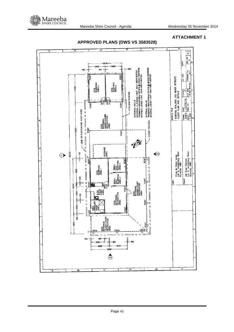
3.11 Maximum number of dogs to be accommodated in boarding kennel No more than twenty-two dogs are to be boarded on the subject land as part of the Animal Husbandry-Intensive (Boarding Kennel) use at any one time.
4. Infrastructure Services and Standards 4.1 Access
The property access to Armstrong Road must be upgraded (from the edge of the road pavement to the property boundary) in accordance with the FNQROC Development Manual, to the satisfaction of Council's delegated officer.
4.2 Car Parking/Internal Driveways The developer must ensure that the development is provided with at least one (1) on-site car parking space which is available solely for the parking of vehicles associated with the Animal Husbandry-Intensive (Boarding Kennel) use of the premises. All earthworks, access tracks, driveways, carparking areas and the like are to be gravelled so that the risk and consequences of erosion and dust are minimised. All earthworks are to be planted or otherwise protected from scour as soon as possible after works are carried out and to the satisfaction of Council's delegated officer.
4.3 Water Supply The approved development must be provided with a potable water supply that can satisfy the standards for drinking water set by the Australian Drinking Water Guidelines 2004 (National Health and Medical Research Council and the National Resource Management Ministerial Council).
4.4 On-Site Wastewater Management All wastewater associated with the Animal Husbandry-Intensive (Boarding Kennel) use is to be disposed of through an approved on-site effluent disposal system constructed generally in accordance with the latest version On-Site Domestic Wastewater Management Standard (ASNZ1547) to the satisfaction of Council's delegated officer.
5. Additional Payment Condition (section 650 of the Sustainable Planning Act 2009) 5.1.1 In accordance with Planning Scheme Policy No. 6 - Augmentation of the
Road Network Contribution, the following additional payment is required towards the upgrading of Armstrong Road between Lot 2 on SP194667 and Oakforest Road:

Mareeba Shire Council - Agenda Wednesday 05 November 2014
Page 32
Infrastructure Charge Rate Current
Amount of Charge
Augmentation of the Road Network Contributions (Myola)
$20 per m2 GFA
97.11m2
$1,942.20
TOTAL CURRENT AMOUNT OF CHARGE $1,942.20 5.1.2 The additional payment here applies for material change of use. As such
the additional payment becomes payable when the change happens.
5.1.3 Until paid in full, the amount of the additional payment will be increased on 1 July each year in accordance with any increase to the maximum adopted infrastructure charge rate for High Impact Rural in the State Planning Regulatory Provision (adopted charges).
5.1.4 Instead of making the additional payment required under 5.1.1, the applicant may construct 100 metres of Oak Forest Road commencing at the northern side of the Barron River causeway and extending north for 100 metres to a bitumen seal width of 6.5 metres, in accordance with Rural Road (Class 100 - 999 Table D1.4) of the Mareeba Shire Planning Policy No. 4 - Development Manual, to the satisfaction of Council's delegated officer. Prior to works commencing, plans for the works described above must be approved as part of an Operational Works application. Should the applicant choose to construct these works, the works must be completed by the day the material change of use happens.
(D) ASSESSMENT MANAGER’S ADVICE (a) The change in the use of the building may also require a change in the
classification of the building under the Building Act. The applicant is advised to contact a Building Certifier to establish if a change in the classification of the building is required.
(b) Compliance with applicable codes/policies The development must be carried out to ensure compliance with the provisions of Council’s Local Laws, Planning Scheme Policies, Planning Scheme and Planning Scheme Codes to the extent they have not been varied by a condition of this approval.
(c) Compliance with Acts and Regulations The erection and use of the building must comply with the Building Act and all other relevant Acts, Regulations and Laws, and these approval conditions.
(d) Environmental Protection and Biodiversity Conservation Act 1999 The applicant is advised that referral may be required under the Environmental Protection and Biodiversity Conservation Act 1999 if the proposed activities are

Mareeba Shire Council - Agenda Wednesday 05 November 2014
Page 33
likely to have a significant impact on a matter of national environmental significance. Further information on these matters can be obtained from www.environment.gov.au.
(e) Cultural Heritage In carrying out the activity the applicant must take all reasonable and practicable measures to ensure that no harm is done to Aboriginal cultural heritage (the “cultural heritage duty of care”). The applicant will comply with the cultural heritage duty of care if the applicant acts in accordance with gazetted cultural heritage duty of care guidelines. An assessment of the proposed activity against the duty of care guidelines will determine whether or to what extent Aboriginal cultural heritage may be harmed by the activity. Further information on cultural heritage, together with a copy of the duty of care guidelines and cultural heritage search forms, may be obtained from www.datsima.qld.gov.au.
(E) RELEVANT PERIOD When approval lapses if development not started (s.341)
• Material Change of Use – four (4) years (starting the day the approval takes effect);
(F) OTHER NECESSARY DEVELOPMENT PERMITS AND/OR COMPLIANCE PERMITS
• Development Permit for Building Work
(G) OTHER APPROVALS REQUIRED FROM COUNCIL
• Compliance Permit for Plumbing and Drainage Work • Access approval arising from condition number 4.1 (Please contact Council’s
Urban & Regional Planning Group to obtain application form and applicable fee)."
THE SITE
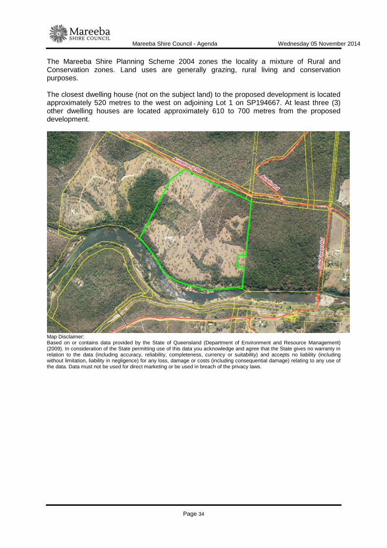
The subject site is described as Lot 2 on SP194667, Parish of Mona Mona, County of Nares, having an area of 41.71 hectares. A dwelling and ancillary shed exist on the western side of the subject land. Approximately 80% of the subject site is cleared grassed pasture whilst the remaining 20% is largely covered by Category A or B vegetation that is a least concern region ecosystem. Two (2) small pockets of Category A or B vegetation of concern region ecosystems are located adjacent to the southern and western boundaries, well clear of the area proposed for the current development. The land has a frontage of approximately 490 metres onto Armstrong Road and is bordered by the Barron River on its southern boundary. Access to the subject site is gained from Armstrong Road which is constructed to formed gravel standard for the full frontage of the subject land. Armstrong Road is accessed across the Barron River low level causeway at the very end of Oak Forest Road.
Mareeba Shire Council - Agenda Wednesday 05 November 2014
Page 34
The Mareeba Shire Planning Scheme 2004 zones the locality a mixture of Rural and Conservation zones. Land uses are generally grazing, rural living and conservation purposes. The closest dwelling house (not on the subject land) to the proposed development is located approximately 520 metres to the west on adjoining Lot 1 on SP194667. At least three (3) other dwelling houses are located approximately 610 to 700 metres from the proposed development.
Map Disclaimer: Based on or contains data provided by the State of Queensland (Department of Environment and Resource Management) (2009). In consideration of the State permitting use of this data you acknowledge and agree that the State gives no warranty in relation to the data (including accuracy, reliability, completeness, currency or suitability) and accepts no liability (including without limitation, liability in negligence) for any loss, damage or costs (including consequential damage) relating to any use of the data. Data must not be used for direct marketing or be used in breach of the privacy laws.

Mareeba Shire Council - Agenda Wednesday 05 November 2014
Page 35
Map Disclaimer: Based on or contains data provided by the State of Queensland (Department of Environment and Resource Management) (2009). In consideration of the State permitting use of this data you acknowledge and agree that the State gives no warranty in relation to the data (including accuracy, reliability, completeness, currency or suitability) and accepts no liability (including without limitation, liability in negligence) for any loss, damage or costs (including consequential damage) relating to any use of the data. Data must not be used for direct marketing or be used in breach of the privacy laws. BACKGROUND AND CONTEXT The development proposed by this development application commenced on the subject land, without an effective development approval, in early to mid 2014. Council officers contacted the applicants informing them of the need to obtain a development permit and advising that the development should cease until such time. This current development application has been made in response. PREVIOUS APPLICATIONS & APPROVALS Council, at its Ordinary Meeting held on 17 February 2010, resolved to issue a development permit for an application made by C Lovey for Material Change of Use - Tourist Facility (6 cabins) on land described as Lot 2 on SP194667, Parish of Mona Mona, situated at Armstrong Road, Kuranda. To date, no works have commenced on site in relation to this development. The revelant period for this development approval remains current until 23 February 2016. DESCRIPTION OF PROPOSED DEVELOPMENT The development application seeks a Development Permit for Material Change of Use - Animal Husbandry-Intensive (Boarding Kennel) in accordance with the plans shown in Attachment 1.
Mareeba Shire Council - Agenda Wednesday 05 November 2014
Page 36
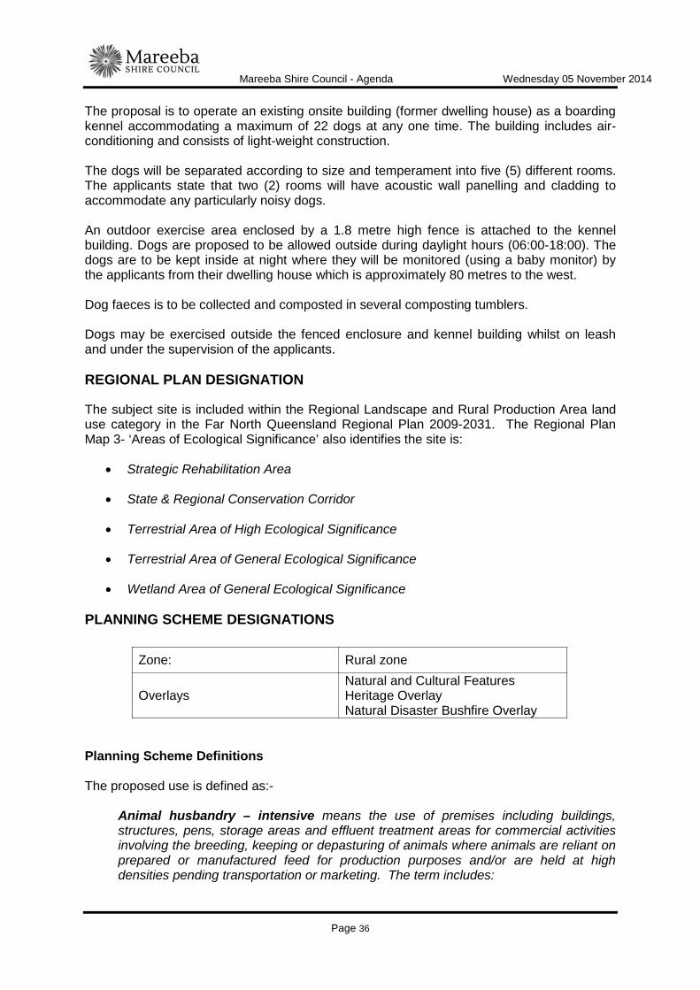
The proposal is to operate an existing onsite building (former dwelling house) as a boarding kennel accommodating a maximum of 22 dogs at any one time. The building includes air-conditioning and consists of light-weight construction. The dogs will be separated according to size and temperament into five (5) different rooms. The applicants state that two (2) rooms will have acoustic wall panelling and cladding to accommodate any particularly noisy dogs. An outdoor exercise area enclosed by a 1.8 metre high fence is attached to the kennel building. Dogs are proposed to be allowed outside during daylight hours (06:00-18:00). The dogs are to be kept inside at night where they will be monitored (using a baby monitor) by the applicants from their dwelling house which is approximately 80 metres to the west. Dog faeces is to be collected and composted in several composting tumblers. Dogs may be exercised outside the fenced enclosure and kennel building whilst on leash and under the supervision of the applicants. REGIONAL PLAN DESIGNATION
The subject site is included within the Regional Landscape and Rural Production Area land use category in the Far North Queensland Regional Plan 2009-2031. The Regional Plan Map 3- ‘Areas of Ecological Significance’ also identifies the site is:
• Strategic Rehabilitation Area
• State & Regional Conservation Corridor
• Terrestrial Area of High Ecological Significance
• Terrestrial Area of General Ecological Significance
• Wetland Area of General Ecological Significance PLANNING SCHEME DESIGNATIONS
Planning Scheme Definitions The proposed use is defined as:-
Animal husbandry – intensive means the use of premises including buildings, structures, pens, storage areas and effluent treatment areas for commercial activities involving the breeding, keeping or depasturing of animals where animals are reliant on prepared or manufactured feed for production purposes and/or are held at high densities pending transportation or marketing. The term includes:
Zone: Rural zone
Overlays Natural and Cultural Features Heritage Overlay Natural Disaster Bushfire Overlay
Mareeba Shire Council - Agenda Wednesday 05 November 2014
Page 37
"Cattery" - the keeping, boarding or breeding of 4 or more cats (excluding kittens under the age of 3 months;
“Crocodile farms” – the keeping of more than two crocodiles;
“Cattle feedlots or lot feeding”;
"Goat Farm" - the keeping or breeding of 2 or more goats per hectare; "Kennel" - the keeping, boarding or breeding of 4 or more dogs (excluding pups under the age of 3 months);
"Piggery" - the keeping of 1 or more pigs;
“Poultry farm” - the keeping and breeding of poultry for sale, exchange, egg production or slaughtering;
“Stable” - the keeping or stabling of more than two horses per hectare. RELEVENT PLANNING INSTRUMENTS Assessment of the proposed development against the relevant planning instruments is summarised as follows:- (a) Far North Queensland Regional Plan 2009-2031 Assessment against the Regional Plan is required because the plan is not reflected in the planning scheme. The application is assessed as being capable of substantially complying with the relevant provisions of the Regional Plan, provided reasonable and relevant conditions are applied. The following Desired Regional Outcome Land Use Policies are relevant to the assessment of the application:
DRO 1.1 Biodiversity Conservation
Land Use Policy Complies Comments
1.1.1 Urban development within the regional landscape and rural production area is located outside of areas of high ecological significance (see map 3).
An animal boarding facility is not considered to be an urban activity for the implementation of the regional plan.
DRO 1.3 Air and Acoustic Environment Protection
Land Use Policy Complies Comments
1.3.1 Urban design, industrial and residential subdivision layout, building design and operational practices are adopted that act to minimise air and noise emissions and the impacts of emissions on sensitive land uses
The development can be conditioned to ensure compliance with this policy.
1.3.2 Development that generates emissions must be adequately separated or planned, designed, constructed and operated to ensure the impacts of air and noise emissions on sensitive land uses meet the objectives of the Environmental protection (air) policy
The proposed development would be separated from the closest dwelling house (not on the subject land) by approximately 520 metres. Cardno consultants were engaged by the applicants to review the proposed development and to provide a professional opinion on the likelihood of noise nuisance being caused.
Mareeba Shire Council - Agenda Wednesday 05 November 2014
Page 38
and the environmental protection (noise) policy.
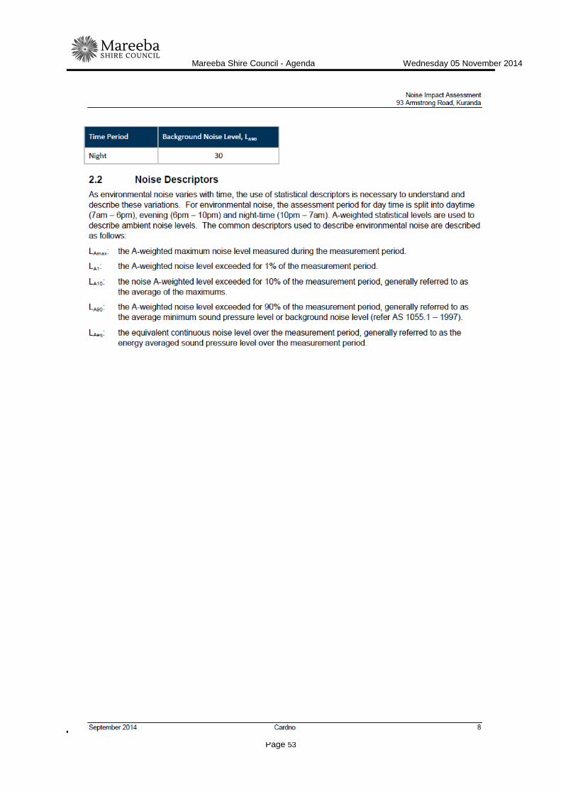
In the opinion of Cardno, the proposed development is located in a location with sufficient separation distance to neighbouring residents and would be in compliance with Environmental Protection (Noise) Policy 2008 provided: • Dogs are housed indoors during the night period
between 18:00 and 0:700; and
• Windows of dog rooms shall remain closed during the night period between 18:00 and 07:00.
These recommendations will be conditioned as part of any development approval.
DRO 2.4 Primary Production & Fisheries
Land Use Policy Complies Comments
2.4.1 Good quality agricultural land is protected from urban development outside the urban footprint.
n/a The subject land is not identified as good quality agricultural land, nor is the proposed development 'urban development'.
DRO 7.1 Protection of Waterways, Wetlands and Water Quality
Land Use Policy Complies Comments
7.1.1 Development is planned, designed, constructed and managed in accordance with best practice environmental management to protect environmental values and meet water quality objectives of the Environmental Protection Policy (Water) 1997 (EPP Water) for regional surface water, groundwater and wetlands.
The development can be conditioned to ensure compliance with this policy.
(b) State Planning Policy On 2 December 2013 (amended July 2014), the Department of State Development, Infrastructure and Planning introduced a single State Planning Policy (SPP) to replace the various SPP's previously in place. As such, this State Planning Policy is not reflected in the Planning Scheme and is therefore applicable to the assessment of the application. This officer has conducted an assessment of the proposed development against the provisions contained within the SPP and it is not considered to be in conflict with any relevant aspect of the SPP.
Queensland State Planning Policy - July 2014
State Interest Complies Assessment Requirements & Comments
Biodiversity
A development application where the land relates to a matter of state environmental significance, if the application is for:
(a) operational work, or
(b) a material change of use other than for a
N/A//x Development:
(1) identifies any potential significant adverse environmental impacts on matters of state environmental significance, and
(2) manages the significant adverse environmental impacts on matters of state environment

Mareeba Shire Council - Agenda Wednesday 05 November 2014
Page 39
dwelling house, or
(c) reconfiguring a lot that results in more than six lots or lots less than five hectares.
significance by, in order of priority:
(a) avoiding significant adverse environmental impacts, and
(b) mitigating significant adverse environmental impacts where these cannot be avoided, and
(c) where applicable, offsetting any residual adverse impacts.
Comment
The proposed development would involve the re-use of existing buildings. The development does not require additional clearing or infrastructure and not likely to detrimentally impact on a matter of state environmental significance.
Natural hazards
A development application for a material change of use, reconfiguring a lot or operational works on land within:
(1) a flood hazard area, or
(2) a bushfire hazard area, or
(3) a landslide hazard area, or
(4) a coastal hazard area.
N/A//x For all natural hazards:
Development:
(1) avoids natural hazard areas or mitigates the risks of the natural hazard, and
(2) supports, and does not unduly burden, disaster management response or recovery capacity and capabilities, and
(3) directly, indirectly and cumulatively avoids an increase in the severity of the natural hazard and the potential for damage on the site or to other properties, and
(4) avoids risks to public safety and the environment from the location of hazardous materials and the release of these materials as a result of a natural hazard, and
(5) maintains or enhances natural processes and the protective function of landforms and vegetation that can mitigate risks associated with the natural hazard, and
Comment
The proposed boarding kennel building is not located within an identified natural hazard area for flood or landslide. The subject land is identified as containing areas of bushfire hazard, however the proposed boarding kennel building is located outside the identified bushfire hazard area.
(c) Mareeba Shire Planning Scheme 2004 (amendment no. 01/11) Relevant Development Codes
The following Development Codes are considered to be applicable to the assessment of the application:
Part 5, Division 8 Natural Disaster - Bushfire Overlay Code Part 6, Division 20 Animal Husbandry – Intensive Code
Mareeba Shire Council - Agenda Wednesday 05 November 2014
Page 40
The application did not include a planning report and assessment against the planning scheme. An officer assessment has found that the application satisfies the relevant acceptable solutions (or probable solutions/performance criteria where no acceptable solution applies) of the relevant codes set out below, provided reasonable and relevant conditions are attached to any approval. Relevant Codes Comments
Natural Disaster Bushfire Overlay Code The application complies with applicable acceptable/probable
solutions/performance criteria. Animal Husbandry - Intensive Code The application complies with applicable acceptable/probable
solutions/performance criteria. (d) Planning Scheme Policies The following planning scheme policies are relevant to the application: No. 1 - Water Supply (Outside Reticulated Water Supply Area) The applicants advise that on site water tank storage comprising 54,000 litres is available for the proposed development. The subject land also has riparian frontage to the Barron River. No. 4 - Development Manual All development works are required to be designed and constructed in accordance with FNQROC Development Manual standards. (e) Additional Trunk Infrastructure Condition - Road Infrastructure (Section 650 of
SPA) The subject land is located outside the identified Priority Infrastructure Area (PIA). Section 650 of SPA allows Council to condition additional trunk infrastructure outside the PIA where necessary. Armstrong Road is presently formed to a gravel standard and it is reasonable to require the applicant to make a contribution towards the upgrading of this road to bitumen standard. State Planning Regulatory Provision (adopted charges) establishes the maximum infrastructure charge Council may levy for particular land uses. The SPRP (adopted charges) does not establish a specific maximum charge for Animal Keeping, instead the maximum adopted charge is "the charge for the charge category that the local government determines should apply for the use at the time of assessment". The most appropriate charge category is High Impact Rural. The SPRP (adopted charges) sets a maximum infrastructure charge of $20 per m2 of gross floor area (GFA) for high impact rural. The development has a GFA of 97.11 m2. This equates to a charge of $1,942.00. The following additional payment condition is suggested:
5.1.1 In accordance with Planning Scheme Policy No. 6 - Augmentation of the Road Network Contribution, the following additional payment is required towards the

Mareeba Shire Council - Agenda Wednesday 05 November 2014
Page 41
upgrading of Armstrong Road between Lot 2 on SP194667 and Oakforest Road:
Infrastructure Charge Rate Current
Amount of Charge
Augmentation of the Road Network Contributions (Myola)
$20 per m2 GFA
97.11m2
$1,942.20
TOTAL CURRENT AMOUNT OF CHARGE $1,942.20
5.1.2 The additional payment here applies for material change of use. As such the additional payment becomes payable when the change happens.
5.1.3 Until paid in full, the amount of the additional payment will be increased on 1 July each year in accordance with any increase to the maximum adopted infrastructure charge rate for High Impact Rural in the State Planning Regulatory Provision (adopted charges).
5.1.4 Instead of making the additional payment required under 5.1.1, the applicant may construct 100 metres of Oak Forest Road commencing at the northern side of the Barron River causeway and extending north for 100 metres to a bitumen seal width of 6.5 metres, in accordance with Rural Road (Class 100 - 999 Table D1.4) of the Mareeba Shire Planning Policy No. 4 - Development Manual, to the satisfaction of Council's delegated officer. Prior to works commencing, plans for the works described above must be approved as part of an Operational Works application. Should the applicant choose to construct these works, the works must be completed by the day the material change of use happens.
REFERRALS Concurrence This application did not trigger referral to any Concurrence Agencies. Advice This application did not trigger referral to any Advice Agencies. Internal Consultation Development Engineering and Environmental Health. PLANNING DISCUSSION Although the development application is code assessable and not subject to public notification, the following comments were received in relation to the proposed development:
Mareeba Shire Council - Agenda Wednesday 05 November 2014
Page 42
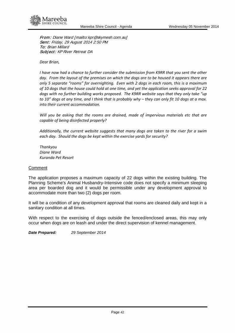
From: Diane Ward [mailto:[email protected]] Sent: Friday, 29 August 2014 2:50 PM To: Brian Millard Subject: KP River Retreat DA Dear Brian, I have now had a chance to further consider the submission from K9RR that you sent the other day. From the layout of the premises on which the dogs are to be housed it appears there are only 5 separate “rooms” for overnighting. Even with 2 dogs in each room, this is a maximum of 10 dogs that the house could hold at one time, and yet the application seeks approval for 22 dogs with no further building works proposed. The K9RR website says that they only take “up to 10” dogs at any time, and I think that is probably why – they can only fit 10 dogs at a max. into their current accommodation. Will you be asking that the rooms are drained, made of impervious materials etc that are capable of being disinfected properly? Additionally, the current website suggests that many dogs are taken to the river for a swim each day. Should the dogs be kept within the exercise yards for security? Thankyou Diane Ward Kuranda Pet Resort
Comment The application proposes a maximum capacity of 22 dogs within the existing building. The Planning Scheme's Animal Husbandry-Intensive code does not specify a minimum sleeping area per boarded dog and it would be permissible under any development approval to accommodate more than two (2) dogs per room. It will be a condition of any development approval that rooms are cleaned daily and kept in a sanitary condition at all times. With respect to the exercising of dogs outside the fenced/enclosed areas, this may only occur when dogs are on leash and under the direct supervision of kennel management. Date Prepared: 29 September 2014
Mareeba Shire Council - Agenda Wednesday 05 November 2014
Page 43
ATTACHMENT 1 APPROVED PLANS (DWS VS 3583528)

Mareeba Shire Council - Agenda Wednesday 05 November 2014
Page 44

Mareeba Shire Council - Agenda Wednesday 05 November 2014
Page 45

Mareeba Shire Council - Agenda Wednesday 05 November 2014
Page 46
ATTACHMENT 2

Mareeba Shire Council - Agenda Wednesday 05 November 2014
Page 47

Mareeba Shire Council - Agenda Wednesday 05 November 2014
Page 48

Mareeba Shire Council - Agenda Wednesday 05 November 2014
Page 49

Mareeba Shire Council - Agenda Wednesday 05 November 2014
Page 50

Mareeba Shire Council - Agenda Wednesday 05 November 2014
Page 51

Mareeba Shire Council - Agenda Wednesday 05 November 2014
Page 52
Mareeba Shire Council - Agenda Wednesday 05 November 2014
Page 53
Mareeba Shire Council - Agenda Wednesday 05 November 2014
Page 54

Mareeba Shire Council - Agenda Wednesday 05 November 2014
Page 55

Mareeba Shire Council - Agenda Wednesday 05 November 2014
Page 56

Mareeba Shire Council - Agenda Wednesday 05 November 2014
Page 57

Mareeba Shire Council - Agenda Wednesday 05 November 2014
Page 58

Mareeba Shire Council - Agenda Wednesday 05 November 2014
Page 59
Mareeba Shire Council - Agenda Wednesday 05 November 2014
Page 60

Mareeba Shire Council - Agenda Wednesday 05 November 2014
Page 61

Mareeba Shire Council - Agenda Wednesday 05 November 2014
Page 62

Mareeba Shire Council - Agenda Wednesday 05 November 2014
Page 63
ITEM-3 J TAYLOR - RECONFIGURING A LOT - SUBDIVISION (1 INTO 2 LOTS) - LOT 2 ON RP745173 - 4414 BLACK MOUNTAIN ROAD, JULATTEN - DA/14/0049
DOCUMENT INFORMATION
MEETING: Ordinary MEETING DATE: 5 November 2014 REPORT OFFICER’S TITLE: Planning Officer DEPARTMENT: Corporate and Community Services
APPLICATION DETAILS APPLICATION PREMISES
APPLICANT J Taylor ADDRESS 4414 Black Mountain Road, Julatten
DATE LODGED 24 September 2014 RPD Lot 2 on RP745173 TYPE OF APPROVAL
Development Permit
PROPOSED DEVELOPMENT
Reconfiguring a Lot - Subdivision (1 into 2 Lots)
FILE NO DA/14/0049 AREA 46.093 Ha LODGED BY J Taylor OWNER J Taylor PLANNING SCHEME
Mareeba Shire Planning Scheme 2004 (amendment no. 01/11)
ZONE Rural LEVEL OF ASSESSMENT
Code Assessment
SUBMISSIONS N/A - Code Assessment ATTACHMENTS: 1. Proposal Plan/s
EXECUTIVE SUMMARY
Council is in receipt of a development application described in the above application details. The application is code assessable and was therefore not required to undergo public notification. The applicant proposes to excise approximately 2.5 hectares of land from the eastern side of the subject property, generally covering the area of an existing fruit orchard. The subject site is not mapped as containing Good Quality Agricultural Land (GQAL). The application has been assessed against the relevant statutory planning instruments, including the FNQ Regional Plan, the State Planning Policy and the Mareeba Shire Planning
Mareeba Shire Council - Agenda Wednesday 05 November 2014
Page 64
Scheme (including codes and policies) and is in conflict with the rural subdivision provisions contained within the Planning Scheme. Proposed Lot 2, having a total area of approximately 2.5 hectares, is significantly smaller than the Planning Scheme's desired minimum lot size of 30 hectares for land not identified as GQAL. The proposed subdivision conflicts with an overall intent of the Rural Zone as it would result in further fragmentation of rural land and the ad-hoc creation of yet another rural living allotment. This officer assessment has not identified sufficient planning grounds to justify an approval despite these conflicts. The application has significant conflicts with the Mareeba Shire Planning Scheme and it is therefore recommended that the application be refused.
OFFICER'S RECOMMENDATION
"That, in relation to the following development application:
APPLICATION PREMISES APPLICANT J Taylor ADDRESS 4414 Black Mountain
Road, Julatten DATE LODGED 24 September 2014 RPD Lot 2 on RP745173 TYPE OF APPROVAL
Development Permit
PROPOSED DEVELOPMENT
Reconfiguring a Lot - Subdivision (1 into 2 Lots)
and in accordance with the Sustainable Planning Act 2009, as amended, the applicant be notified that the application for a development permit for the development specified in (A) is:
Refused by Council for reasons set out in (B).
(A) REFUSED DEVELOPMENT: Development Permit for Reconfiguring a Lot - Subdivision (1 into 2 Lots)

Mareeba Shire Council - Agenda Wednesday 05 November 2014
Page 65
(B) ASSESSMENT MANAGER’S REASONS FOR REFUSAL: That Council considers:- 1. The proposed development is in conflict with Part 4, Division 14, 4.77 Overall
Outcomes for Rural Zone Code: (b) where agricultural production and the raising of animals are protected from
incompatible land uses;
2. The proposed development is in conflict with Part 4, Division 14, 4.80 Rural Zone Code: Reconfiguring a Lot S1 The viability of the farming industry throughout the Shire and including
Good Quality Agricultural Land, and future opportunities for farming pursuits are not compromised. PS1.2 Allotments to have a minimum area of 30 hectares and road
frontage of 150 metres if outside the area identified on Agricultural Land Quality Maps S2, S3, S4 and S5.
3. The proposed development is in conflict with land use policies 2.4.1, 2.6.1, 4.6.1,
4.6.2, 5.4.2 and 5.4.3 of the Far North Queensland Regional Plan 2009-2031.
4. That there are not sufficient grounds to justify approval, despite the identified conflicts."
THE SITE
The subject site is situated at 4414 Black Mountain Road, Julatten and is described as Lot 2 on RP745173, Parish of Mowbray, County of Solander. The site is irregular in shape with a total area of 46.093 hectares, and is zoned Rural under the Mareeba Shire Planning Scheme. The site is not mapped as good quality agricultural land (GQAL). The subject site contains approximately 730 metres of frontage to Black Mountain Road (to the south) and another 70 odd metres of frontage to an undeveloped section of road reserve (to the east). Black Mountain Road is constructed to a formed gravel standard for its entire frontage to the subject site with access gained via a single gravel crossover. The site has an undulating topography and contains a mixture of large cleared grazing paddocks, scattered thickets of mature vegetation and large areas of thick mature vegetation at both the northern end and south-west corner of the site. The site drains to the north into Euluma Creek and Mowbray River which border the rear of the site. A mature fruit orchard of approximately 2.5 hectares in size is situated adjacent the eastern boundary of the site. A single dwelling and ancillary outbuilding is situated towards the centre of the site. All surrounding allotments are zoned Rural and used for both rural lifestyle purposes and agricultural purposes including livestock grazing, fruit tree orchards and timber tree plantations.
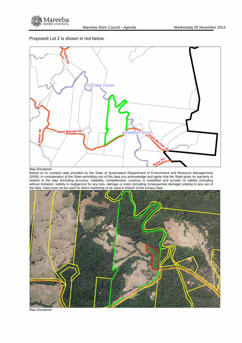
Mareeba Shire Council - Agenda Wednesday 05 November 2014
Page 66
Proposed Lot 2 is shown in red below.
Map Disclaimer: Based on or contains data provided by the State of Queensland (Department of Environment and Resource Management) (2009). In consideration of the State permitting use of this data you acknowledge and agree that the State gives no warranty in relation to the data (including accuracy, reliability, completeness, currency or suitability) and accepts no liability (including without limitation, liability in negligence) for any loss, damage or costs (including consequential damage) relating to any use of the data. Data must not be used for direct marketing or be used in breach of the privacy laws.
Map Disclaimer:

Mareeba Shire Council - Agenda Wednesday 05 November 2014
Page 67
Based on or contains data provided by the State of Queensland (Department of Environment and Resource Management) (2009). In consideration of the State permitting use of this data you acknowledge and agree that the State gives no warranty in relation to the data (including accuracy, reliability, completeness, currency or suitability) and accepts no liability (including without limitation, liability in negligence) for any loss, damage or costs (including consequential damage) relating to any use of the data. Data must not be used for direct marketing or be used in breach of the privacy laws. BACKGROUND AND CONTEXT Nil PREVIOUS APPLICATIONS & APPROVALS Nil DESCRIPTION OF PROPOSED DEVELOPMENT The development application seeks a Development Permit for Reconfiguring a Lot - Subdivision (1 into 2 Lots) in accordance with the plans shown in Attachment 1. The proposed subdivision would result in the creation of the following allotments:
• Proposed Lot 1 - area of approx. 43.5 Ha, frontage of approx. 740 metres to Black Mountain Road
• Proposed Lot 2 - area of approx. 2. 5 Ha, frontage of approx. 65 metres to undeveloped road reserve (practical access still possible off Black Mountain Road)
Proposed Lot 1 will contain the site's existing dwelling and ancillary outbuildings. Both proposed allotments will be accessed off Black Mountain Road and can be connected to electricity and telecommunications infrastructure. REGIONAL PLAN DESIGNATION
The subject site is included within the Regional Landscape and Rural Production Area land use category in the Far North Queensland Regional Plan 2009-2031. The Regional Plan Map 3- ‘Areas of Ecological Significance’ also identifies the site as containing:
• Strategic Rehabilitation Area
• State & Regional Conservation Corridors
• Terrestrial Area of High Ecological Significance
• Wetland Area of General Ecological Significance
PLANNING SCHEME DESIGNATIONS
Strategic Framework designation: Rural
Zone: Rural (Not GQAL)
Overlays Significant Vegetation Overlay Natural Disaster - Bushfire Overlay

Mareeba Shire Council - Agenda Wednesday 05 November 2014
Page 68
RELEVENT PLANNING INSTRUMENTS Assessment of the proposed development against the relevant planning instruments is summarised as follows:- (a) Far North Queensland Regional Plan 2009-2031 Assessment against the Regional Plan is required because the plan is not reflected in the planning scheme. The application is assessed as being capable of substantially complying with the relevant provisions of the Regional Plan, provided reasonable and relevant conditions are applied. The following Desired Regional Outcome Land Use Policies are relevant to the assessment of the application:
DRO 2.4 Primary Production & Fisheries Land Use Policy Complies Comments
2.4.1 Good quality agricultural land is
protected from urban development outside the urban footprint.
× The subject site and immediate surrounding allotments are not mapped as Good Quality Agricultural Land (GQAL). Despite the marginal quality of the subject land for conventional agricultural uses (cropping, grazing), the creation of yet another 'rural lifestyle' allotment may constrain the future rural development options of the surrounding area. The future development of rural uses such as animal husbandry-intensive which are dependent on achieving separation distances from sensitive receptors (dwelling houses) will be made more difficult by the creation of the proposed lot and the subsequent additional dwelling house.
DRO 2.6 Rural Subdivision
Land Use Policy Complies Comments
2.6.1 Further fragmentation of agricultural land in the regional landscape and rural production area is avoided to maintain economically viable farm lot sizes.
× At present the subject site has a total area of 46.093 Ha and contains multiple rural uses including livestock grazing and fruit orchard. The proposed development means to excise approximately 2.5 hectares of the subject site currently under orchard, which in this officers opinion, could only serve to reduce the sites overall viability whilst creating a smaller rural lifestyle allotment with limited to no economic viability. The proposed development is further fragmenting agricultural land is therefore in conflict with Land Use Policy 2.6.1.
DRO 4.6 Rural Residential Development
Land Use Policy Complies Comments
4.6.1 New rural residential development is located in rural living areas.
× Despite the rural zoning, proposed Lot 2 is effectively a rural residential allotment. The subject land is not located within the rural living area.
4.6.2 Future demand for rural residential housing is provided from within the existing stock of land zoned for this purpose.
× The subject land is zoned Rural, not rural residential.

Mareeba Shire Council - Agenda Wednesday 05 November 2014
Page 69
DRO 5.4 Primary Industries Land Use Policy Complies Comments
5.4.2 Threats to primary production from
incompatible development are identified and managed through land use planning and where appropriate, by developer established buffers.
× The proposed development will result in the creation of an additional 'rural lifestyle' allotment and subsequent increase in dwelling densities within the rural zone. The addition of yet another dwelling within the rural zone will only hinder future rural development such as animal husbandry-intensive uses which are dependent on achieving separation distances from sensitive receptors (dwellings).
5.4.3 Potential conflict between primary industries and urban activities is managed through land use planning and, where appropriate, developer-established buffers.
× The proposed development will result in the creation of an additional 'rural lifestyle' allotment and subsequent increase in dwelling densities within the rural zone. The addition of yet another dwelling within the rural zone will only hinder future rural development such as animal husbandry-intensive uses which are dependent on achieving separation distances from sensitive receptors (dwellings).
DRO 7.1 Protection of Waterways, Wetlands and Water Quality
Land Use Policy Complies Comments
7.1.1 Development is planned, designed, constructed and managed in accordance with best practice environmental management to protect environmental values and meet water quality objectives of the Environmental Protection Policy (Water) 1997 (EPP Water) for regional surface water, groundwater and wetlands.
If approved, the development would be conditioned to comply.
(b) State Planning Policy
On 2 December 2013 (amended July 2014), the Department of State Development, Infrastructure and Planning introduced a single State Planning Policy (SPP) to replace the various SPP's previously in place. As such, this State Planning Policy is not reflected in the Planning Scheme and is therefore applicable to the assessment of the application. This officer has conducted an assessment of the proposed development against the provisions contained within the SPP and it is not considered to be in conflict with any relevant aspect of the SPP.
Queensland State Planning Policy - December 2013
State Interest Complies Assessment Requirements & Comments
Natural hazards
A development application for a material change of use, reconfiguring a lot or operational works on land within:
(1) a flood hazard area, or
(2) a bushfire hazard area, or
(3) a landslide hazard area, or
For all natural hazards:
Development:
(1) avoids natural hazard areas or mitigates the risks of the natural hazard, and
(2) supports, and does not unduly burden, disaster management response or recovery capacity and capabilities, and

Mareeba Shire Council - Agenda Wednesday 05 November 2014
Page 70
(3) directly, indirectly and cumulatively avoids an increase in the severity of the natural hazard and the potential for damage on the site or to other properties, and
(4) avoids risks to public safety and the environment from the location of hazardous materials and the release of these materials as a result of a natural hazard, and
(5) maintains or enhances natural processes and the protective function of landforms and vegetation that can mitigate risks associated with the natural hazard, and
Comment
The proposed reconfiguration can be conditioned to comply with this aspect of the SPP.
(c) Mareeba Shire Planning Scheme 2004 (amendment no. 01/11) Relevant Development Codes
The following Development Codes are considered to be applicable to the assessment of the application:
Part 4, Division 14 Rural Zone Code Part 5, Division 6 Significant Vegetation Overlay Code Part 5, Division 8 Natural Disaster - Bushfire Overlay Code Part 6, Division 12 Reconfiguring a Lot Code
The application included a planning report and assessment against the planning scheme. An officer assessment has found that the application satisfies the relevant acceptable solutions (or probable solutions/performance criteria where no acceptable solution applies) of the relevant codes set out below, provided reasonable and relevant conditions are attached to any approval. Relevant Codes Comments
Rural Zone Code The application can be conditioned to comply with the applicable acceptable/probable solutions contained within the code apart from the following:
Reconfiguring a Lot - Probable Solution PS1.2
Refer to planning discussion section of report. Significant Vegetation Overlay Code Although this code is triggered in the assessment of the
application, the subject site does not contain any areas mapped as Category A or B Vegetation on Map V2. Therefore assessment against this code is not considered relevant in this instance.
Natural Disaster - Bushfire Overlay Code The application can be conditioned to comply with the relevant
acceptable/probable solutions contained within the code. Reconfiguring a Lot Code The application can be conditioned to comply with the relevant
acceptable/probable solutions contained within the code.

Mareeba Shire Council - Agenda Wednesday 05 November 2014
Page 71
(e) Planning Scheme Policies/Infrastructure Charges Plan The following planning scheme policies are relevant to the application: No. 4 - Development Manual Should Council choose to approve the proposed development against this officer's recommendation, a condition should be attached to any approval requiring all development works be designed and constructed in accordance with the FNQROC Development Manual. (f) Additional Infrastructure Payment Condition Should Council choose to approve the proposed development against this officer's recommendation, it is recommended that a condition be attached to the approval requiring the applicant upgrade a section of Black Mountain Road to the standards set out in the FNQROC Development Manual. In lieu of this road construction, the applicant may choose to pay an Augmentation of the Road Network Contribution in accordance with Planning Scheme Policy 6. REFERRALS Concurrence This application did not trigger referral to any Concurrence Agencies. Advice This application did not trigger referral to any Advice Agencies. Internal Consultation Development Engineering - Access PLANNING DISCUSSION Noncompliance with the relevant acceptable solutions or probable solutions/performance criteria of the following Codes are summarised as follows: Rural Zone Code The overall outcomes sought for the Rural Zone code are to achieve an area:
(b) where agricultural production and the raising of animals are protected from
incompatible land uses; Comment The rural zone is intended for agricultural and primary production purposes. Fragmenting rural allotments below the Planning Scheme's minimum lot size will generally lead to a higher dwelling density within the rural zone, increasing the probability that one or more of the additional dwelling houses will result in a land use conflict with bona fide rural uses.
Mareeba Shire Council - Agenda Wednesday 05 November 2014
Page 72
In particular, the increased dwelling density associated with the creation of smaller rural allotments, makes it more difficult to establish new intensive rural activities or to expand existing intensive rural activities. This is due to the separation distances that must be maintained between the rural use and any nearby dwelling houses. The recent expansion of the poultry industry has highlighted the potential for land use conflict between intensive rural activities and nearby dwelling houses. The proposed development conflicts.
Conflicts with the specific outcomes and probable solutions for the Rural Zone:
Reconfiguring a Lot S1 The viability of the farming industry throughout the Shire and including Good
Quality Agricultural Land, and future opportunities for farming pursuits are not compromised. PS1.2 Allotments to have a minimum area of 30 hectares and road frontage of
150 metres if outside the area identified on Agricultural Land Quality Maps S2, S3, S4 and S5.
Comment
The applicant proposes to excise approximately 2.5 hectares of land off the eastern side of the subject site, which generally covers the area over an existing mature fruit orchard (proposed Lot 2). The balance lot (proposed Lot 1) will be left with a land stock of approximately 43.6 hectares. Proposed Lot 2 is significantly smaller than the desired minimum resultant lot size of 30 hectares for land within the Rural zone (where not GQAL). The applicant has stated that the subdivision is required to create an allotment for his son to acquire. An overriding intention of the Planning Scheme is to minimise further fragmentation of agricultural land within the Rural zone and to maintain economically viable farm lots sizes. Although the site is not mapped as containing GQAL, it is currently well in excess of 30 hectares and contains multiple rural uses including livestock grazing and a fruit tree orchard. The proposed development would result in the fragmentation and dissipation of rural land and the ad-hoc creation of yet another rural living allotment. Although the subdivision may benefit the applicant, there is not considered to be any overriding benefit to the community as a result of the subdivision. In fact, the development creates further opportunity for land use conflicts to occur and may further hinder the development of rural uses such as animal husbandry-intensive which are dependent on separation distances only achievable within the Rural zone. The proposed development conflicts with PS1.2 and Specific Outcome S1.

Mareeba Shire Council - Agenda Wednesday 05 November 2014
Page 73
Conclusion An intention of the Planning Scheme for the Rural zone is to discourage the creation of further small rural lots, and the proposal is in conflict with this intention. The application is recommended for refusal. ATTACHMENT 1. Proposal Plan/s (ECM VS 3597851) Date Prepared: 28 October 2014

Mareeba Shire Council - Agenda Wednesday 05 November 2014
Page 74
ATTACHMENT 1 PROPOSAL PLAN/S (DWS VS 3597851)

Mareeba Shire Council - Agenda Wednesday 05 November 2014
Page 75
ITEM-4 K & G TURRISI - RECONFIGURING A LOT - SUBDIVISION (1 INTO 2 LOTS) - LOT 118 ON DA284 - 678 SPRINGS ROAD, MAREEBA - DA/14/0052
DOCUMENT INFORMATION
MEETING: Ordinary MEETING DATE: 5 November 2014 REPORT OFFICER’S TITLE: Planning Officer DEPARTMENT: Corporate and Community Services
APPLICATION DETAILS APPLICATION PREMISES
APPLICANT K & G Turrisi ADDRESS 678 Springs Road, Mareeba
DATE LODGED 13 October 2014 RPD Lot 118 on DA284 TYPE OF APPROVAL
Development Permit
PROPOSED DEVELOPMENT
Reconfiguring a Lot - Subdivision (1 into 2 Lots)
FILE NO DA/14/0052 AREA 51.446 Ha LODGED BY Twine Surveys Pty Ltd OWNER K & G Turrisi PLANNING SCHEME
Mareeba Shire Planning Scheme 2004 (amendment no. 01/11)
ZONE Rural Zone (GQAL) LEVEL OF ASSESSMENT
Code Assessment
SUBMISSIONS N/A - Code Assessment ATTACHMENTS: 1. Proposal Plan/s - Twine Surveys Pty Ltd dated 11 September
2014 EXECUTIVE SUMMARY
Council is in receipt of a development application described in the above application details. The application is code assessable and was therefore not required to undergo public notification. The applicants propose to subdivide a 1 Ha portion of land from the south east corner of the site. The applicants have stated that the separate title is required for the construction of an additional family dwelling to ensure the continued management of the farm now, and into the future. The subject site is mapped as containing Good Quality Agricultural Land (GQAL).

Mareeba Shire Council - Agenda Wednesday 05 November 2014
Page 76
The application and supporting material has been assessed against the relevant statutory planning instruments, including the FNQ Regional Plan, the State Planning Policy, and the Mareeba Shire Planning Scheme (including codes and policies) and is in conflict with the rural subdivision provisions contained within the Planning Scheme. Proposed Lot 119, with a total area of just 1 Ha, is significantly smaller than the Planning Scheme's desired minimum resultant lot size of 60 Ha for land mapped as GQAL. The proposal would result in the fragmentation and ultimate loss of GQAL as well as an increase in dwelling densities within an actively farmed area. This officer has not identified sufficient planning grounds to justify an approval, despite these conflicts. Considering its conflicts with the Mareeba Shire Planning Scheme, it is recommended the application be refused.
OFFICER'S RECOMMENDATION
1. It is recommended that, in relation to the following development application:
APPLICATION PREMISES APPLICANT K & G Turrisi ADDRESS 678 Springs Road,
Mareeba DATE LODGED 13 October 2014 RPD Lot 118 on DA284 TYPE OF APPROVAL
Development Permit
PROPOSED DEVELOPMENT
Reconfiguring a Lot - Subdivision (1 into 2 Lots)
and in accordance with the Sustainable Planning Act 2009, as amended, the applicant be notified that the application for a development permit for the development specified in (A) is:
Refused by Council for reasons set out in (B).
(A) REFUSED DEVELOPMENT: Development Permit for Reconfiguring a Lot - Subdivision (1 into 2 Lots)
(B) ASSESSMENT MANAGER’S REASONS FOR REFUSAL:
That Council considers:-
1. The proposed development is in conflict with Part 4, Division 14, 4.77 Overall Outcomes for Rural Zone code:
The overall outcomes sought for the Rural Zone Code are to achieve an area:
(b) where agricultural production and the raising of animals are protected from incompatible land uses;
(c) where Good Quality Agricultural Land is protected from fragmentation and alienation, not developed for purposes other than agricultural and support

Mareeba Shire Council - Agenda Wednesday 05 November 2014
Page 77
uses, and is protected from incompatible land uses in accordance with SPP 1/92.
2. The proposed development is in conflict with Part 4, Division 14, 4.80 for Rural Zone Code:
Reconfiguring a Lot
S1 The viability of the farming industry throughout the Shire and including Good Quality Agricultural Land, and future opportunities for farming pursuits are not compromised.
PS1.1 Allotments to have a minimum area of 60 hectares and road frontage of 300 metres within the area identified on Agricultural Land Quality Maps S2, S3, S4, S5; or
3. The proposed development is in conflict with land use policies 2.4.1, 2.6.1, 4.6.1, 4.6.2, 5.4.2 and 5.4.3 of the Far North Queensland Regional Plan 2009-2031.
4. That there are not sufficient grounds to justify approval, despite the identified conflicts."
THE SITE
The subject site is situated at 678 Springs Road, Mareeba, and is described as Lot 118 on DA284, Parish of Southedge, County of Dagmar. The site is irregular in shape with a total area of 51.446 Ha, and is zoned Rural under the Mareeba Shire Planning Scheme. Approximately 65% or 33 ha of the site is mapped as Good Quality Agricultural Land (GQAL) and is farmed. The remainder of the site is vegetated and unused with two large rocky outcrops situated towards the centre of the site. The site slopes and drains downhill from these outcrops towards Springs Road and Fassio Road. The site is accessed from and contains approximately 1.04 km of frontage to Springs Road which is constructed to bitumen sealed standard for this entire frontage. The allotment is improved by a single dwelling and multiple farm sheds clustered in the south west corner of the lot. The site is bordered by MDIA channel infrastructure for its entire western boundary. A Sunwater easement (Emt A on RP726785) traverses the eastern side of the site. All surrounding allotments are zoned rural and used as predominately support agricultural uses with small number used for rural lifestyle purposes. Proposed Lot 119 is shown in red below.

Mareeba Shire Council - Agenda Wednesday 05 November 2014
Page 78
Map Disclaimer: Based on or contains data provided by the State of Queensland (Department of Environment and Resource Management) (2009). In consideration of the State permitting use of this data you acknowledge and agree that the State gives no warranty in relation to the data (including accuracy, reliability, completeness, currency or suitability) and accepts no liability (including without limitation, liability in negligence) for any loss, damage or costs (including consequential damage) relating to any use of the data. Data must not be used for direct marketing or be used in breach of the privacy laws.
Map Disclaimer: Based on or contains data provided by the State of Queensland (Department of Environment and Resource Management) (2009). In consideration of the State permitting use of this data you acknowledge and agree that the State gives no warranty in relation to the data (including accuracy, reliability, completeness, currency or suitability) and accepts no liability (including without limitation, liability in negligence) for any loss, damage or costs (including consequential damage) relating to any use of the data. Data must not be used for direct marketing or be used in breach of the privacy laws.
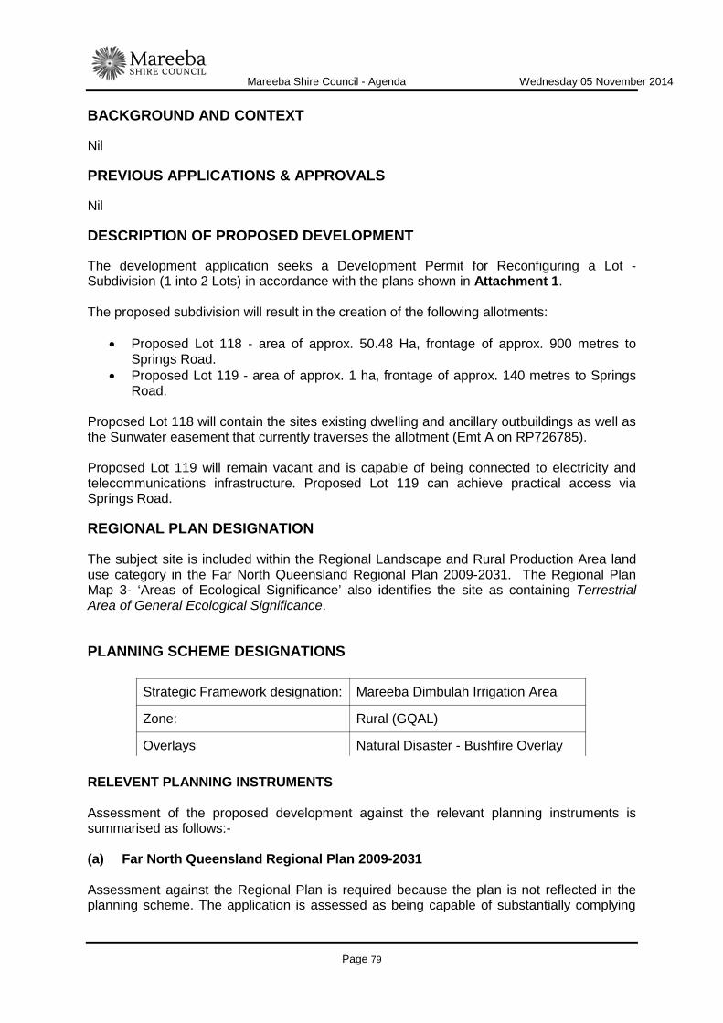
Mareeba Shire Council - Agenda Wednesday 05 November 2014
Page 79
BACKGROUND AND CONTEXT Nil PREVIOUS APPLICATIONS & APPROVALS Nil DESCRIPTION OF PROPOSED DEVELOPMENT The development application seeks a Development Permit for Reconfiguring a Lot - Subdivision (1 into 2 Lots) in accordance with the plans shown in Attachment 1. The proposed subdivision will result in the creation of the following allotments:
• Proposed Lot 118 - area of approx. 50.48 Ha, frontage of approx. 900 metres to Springs Road.
• Proposed Lot 119 - area of approx. 1 ha, frontage of approx. 140 metres to Springs Road.
Proposed Lot 118 will contain the sites existing dwelling and ancillary outbuildings as well as the Sunwater easement that currently traverses the allotment (Emt A on RP726785). Proposed Lot 119 will remain vacant and is capable of being connected to electricity and telecommunications infrastructure. Proposed Lot 119 can achieve practical access via Springs Road. REGIONAL PLAN DESIGNATION
The subject site is included within the Regional Landscape and Rural Production Area land use category in the Far North Queensland Regional Plan 2009-2031. The Regional Plan Map 3- ‘Areas of Ecological Significance’ also identifies the site as containing Terrestrial Area of General Ecological Significance.
PLANNING SCHEME DESIGNATIONS
RELEVENT PLANNING INSTRUMENTS Assessment of the proposed development against the relevant planning instruments is summarised as follows:- (a) Far North Queensland Regional Plan 2009-2031 Assessment against the Regional Plan is required because the plan is not reflected in the planning scheme. The application is assessed as being capable of substantially complying
Strategic Framework designation: Mareeba Dimbulah Irrigation Area
Zone: Rural (GQAL)
Overlays Natural Disaster - Bushfire Overlay

Mareeba Shire Council - Agenda Wednesday 05 November 2014
Page 80
with the relevant provisions of the Regional Plan, provided reasonable and relevant conditions are applied. The following Desired Regional Outcome Land Use Policies are relevant to the assessment of the application:
DRO 2.4 Primary Production & Fisheries Land Use Policy Complies Comments
2.4.1 Good quality agricultural land is
protected from urban development outside the urban footprint.
× The proposed development will result in the fragmentation of GQAL and subsequent increase in dwelling densities within the rural zone. Increasing dwelling densities within rural areas, particularly around the Paddy's Green farming area will increase the probability of land use conflict occurring with bona fide rural uses. In particular, the increased dwelling density associated with the creation of additional rural lifestyle allotments makes it more difficult to establish new intensive rural activities or to expand existing intensive rural activities. This is due to the separation distance that must be maintained between the rural use and any nearby dwelling houses.
DRO 2.6 Rural Subdivision
Land Use Policy Complies Comments
2.6.1 Further fragmentation of agricultural land in the regional landscape and rural production area is avoided to maintain economically viable farm lot sizes.
× The proposed development will result in the creation of an additional 'rural lifestyle' allotment and subsequent increase in dwelling densities within the rural zone which may compromise future farming pursuits on proposed Lot 118.
DRO 4.6 Rural Residential Development
Land Use Policy Complies Comments
4.6.1 New rural residential development is located in rural living areas.
× Despite the rural zoning, proposed Lot 119 is effectively a rural residential allotment. The subject land is not located within the rural living area.
4.6.2 Future demand for rural residential housing is provided from within the existing stock of land zoned for this purpose.
× The subject land is zoned Rural, not rural residential.
DRO 5.4 Primary Industries
Land Use Policy Complies Comments
5.4.2 Threats to primary production from incompatible development are identified and managed through land use planning and where appropriate, by developer established buffers.
× The proposed development will result in the creation of an additional 'rural lifestyle' allotment and subsequent increase in dwelling densities within the rural zone. The addition of yet another dwelling within the rural zone will only hinder future rural development such as animal husbandry-intensive uses which are dependent on achieving separation distances from sensitive receptors (dwellings).
5.4.3 Potential conflict between primary industries and urban activities is managed through land use planning and, where appropriate, developer-established buffers.
× The proposed development will result in the creation of an additional 'rural lifestyle' allotment and subsequent increase in dwelling densities within the rural zone. The addition of yet another dwelling within the rural
Mareeba Shire Council - Agenda Wednesday 05 November 2014
Page 81
zone will only hinder future rural development such as animal husbandry-intensive uses which are dependent on achieving separation distances from sensitive receptors (dwellings).
DRO 7.1 Protection of Waterways, Wetlands and Water Quality
Land Use Policy Complies Comments
7.1.1 Development is planned, designed, constructed and managed in accordance with best practice environmental management to protect environmental values and meet water quality objectives of the Environmental Protection Policy (Water) 1997 (EPP Water) for regional surface water, groundwater and wetlands.
If approved, the development would be conditioned to comply.

Mareeba Shire Council - Agenda Wednesday 05 November 2014
Page 82
(b) State Planning Policy
On 2 December 2013 (amended July 2014), the Department of State Development, Infrastructure and Planning introduced a single State Planning Policy (SPP) to replace the various SPP's previously in place. As such, this State Planning Policy is not reflected in the Planning Scheme and is therefore applicable to the assessment of the application. This officer has conducted an assessment of the proposed development against the provisions contained within the SPP and it is not considered to be in conflict with any relevant aspect of the SPP.
Queensland State Planning Policy - December 2013
State Interest Complies Assessment Requirements & Comments
Natural hazards
A development application for a material change of use, reconfiguring a lot or operational works on land within:
(1) a flood hazard area, or
(2) a bushfire hazard area, or
(3) a landslide hazard area, or
For all natural hazards:
Development:
(1) avoids natural hazard areas or mitigates the risks of the natural hazard, and
(2) supports, and does not unduly burden, disaster management response or recovery capacity and capabilities, and
(3) directly, indirectly and cumulatively avoids an increase in the severity of the natural hazard and the potential for damage on the site or to other properties, and
(4) avoids risks to public safety and the environment from the location of hazardous materials and the release of these materials as a result of a natural hazard, and
(5) maintains or enhances natural processes and the protective function of landforms and vegetation that can mitigate risks associated with the natural hazard, and
Comment
The proposed reconfiguration can be conditioned to comply with this aspect of the SPP.
(c) Mareeba Shire Planning Scheme 2004 (amendment no. 01/11) Relevant Development Codes
The following Development Codes are considered to be applicable to the assessment of the application:
Part 4, Division 14 Rural Zone Code Part 5, Division 8 Natural Disaster - Bushfire Overlay Code Part 6, Division 12 Reconfiguring a Lot Code
The application included a planning report and assessment against the planning scheme. An officer assessment has found that the application satisfies the relevant acceptable solutions (or probable solutions/performance criteria where no acceptable solution applies)

Mareeba Shire Council - Agenda Wednesday 05 November 2014
Page 83
of the relevant codes set out below, provided reasonable and relevant conditions are attached to any approval. Relevant Codes Comments
Rural Zone Code The application can be conditioned to comply with the relevant acceptable/probable solutions contained within the code apart from the following:
Reconfiguring a Lot - Probable Solution PS1.2
Refer to planning discussion section of report. Natural Disaster - Bushfire Overlay Code The application can be conditioned to comply with the relevant
acceptable/probable solutions contained within the code. Reconfiguring a Lot Code The application can be conditioned to comply with the relevant
acceptable/probable solutions contained within the code. (e) Planning Scheme Policies/Infrastructure Charges Plan The following planning scheme policies are relevant to the application: No. 4 - Development Manual Should Council choose to approve the proposed development against this officer's recommendation, a condition should be attached to any approval requiring all development works be designed and constructed in accordance with the FNQROC Development Manual. (f) Additional Infrastructure Payment Condition Should Council choose to approve the proposed development against this officer's recommendation, it is recommended that a condition be attached to the approval requiring the applicant upgrade a section of Springs Road to the standards set out in the FNQROC Development Manual. In lieu of this road construction, the applicant may choose to pay an Augmentation of the Road Network Contribution in accordance with Planning Scheme Policy 6. REFERRALS Concurrence This application did not trigger referral to any Concurrence Agencies. Advice This application did not trigger referral to any Advice Agencies. Internal Consultation Development Engineering - Access

Mareeba Shire Council - Agenda Wednesday 05 November 2014
Page 84
PLANNING DISCUSSION Noncompliance with the overall outcomes and relevant acceptable solutions/probable solutions of the Rural Zone Code are summarised as follows: Conflicts with the overall outcomes for the Rural Zone:
(b) where agricultural production and the raising of animals are protected from incompatible land uses;
Comment The rural zone is intended for agricultural and primary production purposes. The proposed reconfiguration will result in the creation of a 1 Ha rural lifestyle allotment and ultimately, an increase in dwelling densities within the rural zone. Increasing dwelling densities within rural areas, particularly around the Paddy's Green farming area will increase the probability of land use conflict occurring with existing and future bona fide rural uses. In particular, the increased dwelling density associated with the creation of additional rural lifestyle allotments makes it more difficult to establish new intensive rural activities or to expand existing intensive rural activities. This is due to the separation distance that must be maintained between the rural use and any nearby dwelling houses. Although the applicants have stated that the proposed subdivision is required to construct an additional family dwelling, this Council has no control over the future sale of proposed Lot 119 as a standalone rural lifestyle allotment, situated immediately adjacent farmed GQAL. The proposed development conflicts. (c) where good quality agricultural land is protected from fragmentation and
alienation, not developed for purposes other than agricultural and support uses, and is protected from incompatible land uses in accordance with SPP1/92;
Comment Approximately 65% or 33 Ha of the subject land is currently farmed and mapped as GQAL. The proposed development will result in the subdivision and ultimate loss of 1 Ha of the sites GQAL and subsequent creation of a rural lifestyle allotment. In addition to the fragmentation and alienation of the sites GQAL, the proposed subdivision will ultimately result in the siting of an additional dwelling immediately adjacent farmed GQAL, increasing the probability of land use conflicts occurring, and potentially compromising future farming pursuits on proposed Lot 118, not to mention other surrounding farms. Although the applicants have stated that the proposed subdivision is required to construct an additional family dwelling, this Council has no control over the future sale of proposed Lot 119 on the open market as a standalone rural lifestyle allotment. The proposed development will result in the fragmentation and alienation of GQAL and will

Mareeba Shire Council - Agenda Wednesday 05 November 2014
Page 85
ultimately result in the siting of a sensitive land use (dwelling) immediately adjacent farmed GQAL. A key principle of the lapsed SPP1/92 Development and Conservation of Agricultural Land was:
Cases will arise where local authorities have to consider development proposals on good quality agricultural land. In such instances, a 'key' principle should be whether an overriding need in terms of benefit to the community can be demonstrated for the development at that particular location.
Whilst there may be a benefit to the applicants, there is not considered to be an overriding need in terms of benefit to the community. Although SPP1/92 lapsed in December 2012, its principles are still reflected in the Regional Plan and Planning Scheme and remain relevant to development assessment. The proposed development conflicts.
Conflicts with the specific outcomes and probable solutions for the Rural Zone:
4.80 Reconfiguring a Lot S1 The viability of the farming industry throughout the Shire and including Good
Quality Agricultural Land, and future opportunities for farming pursuits are not compromised. PS1.1 Allotments to have a minimum area of 60 hectares and road frontage of
300 metres within the area identified on Agricultural Land Quality Maps S2, S3, S4, S5; or
PS1.2 Allotments to have a minimum area of 30 hectares and road frontage of
150 metres if outside the area identified on Agricultural Land Quality Maps S2, S3, S4 and S5.
Comment Approximately 65% or 33 Ha of the subject land is currently farmed and mapped as GQAL. The proposed development will result in the subdivision and ultimate loss of 1 Ha of the sites GQAL and the creation of, essentially, a rural lifestyle allotment. The fact that the subject site is already smaller than the desired 60 Ha minimum lot size for land mapped as GQAL is not sufficient grounds to allow further fragmentation of the allotment. In addition to the fragmentation and alienation of the sites GQAL, the proposed subdivision will ultimately result in the siting of an additional dwelling immediately adjacent farmed GQAL, increasing the probability of land use conflicts occurring, and potentially compromising future farming pursuits on proposed Lot 118, not to mention other surrounding farms.

Mareeba Shire Council - Agenda Wednesday 05 November 2014
Page 86
Although the applicants have stated that the proposed subdivision is required to construct an additional family dwelling, this Council has no control over the future sale of proposed Lot 119 on the open market as a standalone rural lifestyle allotment. The proposed development conflicts with probable solution PS1.1 and specific outcome S1.
Conclusion An intention of the Planning Scheme for the Rural zone is to discourage the fragmentation of rural land and the creation of small rural lots, particularly in areas known to contain good quality agricultural land. Although the subdivision may directly benefit the applicant, this officer has not identified sufficient planning grounds to justify an approval, despite the evident conflicts. The application is recommended for refusal. ATTACHMENTS 1. Proposal Plan/s (ECM VS 3602217) Date Prepared: 28 October 2014
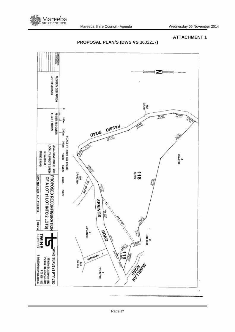
Mareeba Shire Council - Agenda Wednesday 05 November 2014
Page 87
ATTACHMENT 1 PROPOSAL PLAN/S (DWS VS 3602217)

Mareeba Shire Council - Agenda Wednesday 05 November 2014
Page 88
Mareeba Shire Council - Agenda Wednesday 05 November 2014
Page 89
COMMUNITY WELLBEING
ITEM-5 MAREEBA SPORTING PRECINCT COMMUNITY LOAN DOCUMENT INFORMATION
MEETING: Ordinary MEETING DATE: 5 November 2014 REPORT OFFICER’S TITLE: Manager Community Wellbeing DEPARTMENT: Corporate and Community Services EXECUTIVE SUMMARY
This report is presented to Council to review the amount and term of the interest free loan approved for the Mareeba Netball Association Inc, on behalf of the Community Bank Recreational Precinct Reference Group. At the ordinary Council Meeting 15 October 2014 Council resolved to grant an interest free loan for $40,000 over five (5) years and this report recommends this resolution be altered to a loan of $30,000 over eight (80 years.
OFFICER'S RECOMMENDATION
"That Council agrees to loan the Mareeba Netball Association Inc, on behalf of the Community Bank Recreational Precinct Reference Group, an amount of $30,000 by means of an interest free loan over a period of eight (8) years, in the event of their funding application being successful."
BACKGROUND
Council was presented with a report to the meeting of 15 October 2014 outlining the funding application relating to the proposed Community Bank Recreational Precinct and subsequent funding assistance required for this project. At this meeting, the following resolution was passed by Council:
"That Council endorse the application for Get Playing Plus funding which will be lodged by Mareeba Netball Association Inc, on behalf of the Community Bank Recreational Precinct Reference Group, for funds to construct Stage One of the Community Bank Recreational Precinct. Further, that Council agrees to loan the Netball Association an amount of $40,000 by means of an interest free loan over a period of five (5) years, in the event of their funding application being successful"
Since this meeting, representatives from the Mareeba Netball Association Inc. have approached officers advising that the required loan funds have reduced from $40,000 to

Mareeba Shire Council - Agenda Wednesday 05 November 2014
Page 90
$30,000 and that they would not be in a position to repay this amount over the five (5) year period offered. A request is now provided to Council to consider extending the term of the loan to an eight (8) year period to ensure we are not imposing undue financial stress on the club. Community loans recently provided by Council have provided a range of amounts and terms - from $11,000 over 3 years to $15,000 over 10 years. The reason for these variations is purely based on the ability of the individual community groups/clubs to repay.
LINK TO CORPORATE PLAN
COM 3 - Encourage the building of strong partnerships with community, private sector and government so as to build community capacity and develop strategies to encourage and support leadership and self-responsibility in the community.
CONSULTATION
Internal Manager Finance Director Corporate and Community Services External Maria Pin, Mareeba Netball Club Meredith Ford, Mareeba Netball Club Connie Martens, Mareeba Netball Club
LEGAL AND RISK IMPLICATIONS (STATUTORY BASIS, LEGAL AND RISKS)
Nil
POLICY IMPLICATIONS
Nil
FINANCIAL & RESOURCE IMPLICATIONS
Capital Nil Operating Nil
IMPLEMENTATION/COMMUNICATION
Loan agreement to be established between Council and the Mareeba Netball Association Inc following announcement of the success of the funding application recently submitted.

Mareeba Shire Council - Agenda Wednesday 05 November 2014
Page 91
ATTACHMENTS
Nil Date Prepared: 29 October 2014

Mareeba Shire Council - Agenda Wednesday 05 November 2014
Page 92

Mareeba Shire Council - Agenda Wednesday 05 November 2014
Page 93
ITEM-6 CHILLAGOE HUB
REASON FOR CONFIDENTIALITY
This report is CONFIDENTIAL in accordance with Section 275(1)(e) of the Local Government Regulation 2012, which permits the meeting to be closed to the public for business relating to the following:
(e) contracts proposed to be made by Council.

Mareeba Shire Council - Agenda Wednesday 05 November 2014
Page 94

Mareeba Shire Council - Agenda Wednesday 05 November 2014
Page 95
FINANCE
ITEM-7 VALUELESS LAND TO ACQUIRE
REASON FOR CONFIDENTIALITY
This report is CONFIDENTIAL in accordance with Section 275(1) (h) of the Local Government Regulation 2012, which permits the meeting to be closed to the public for business relating to the following:
(h) Other business for which a public discussion would be likely to prejudice the interests of Council or someone else, or enable a person to gain a financial advantage.

Mareeba Shire Council - Agenda Wednesday 05 November 2014
Page 96
Mareeba Shire Council - Agenda Wednesday 05 November 2014
Page 97
ITEM-8 PROPERTIES STRADDLING TWO (2) SHIRE BOUNDARIES
REASON FOR CONFIDENTIALITY
This report is CONFIDENTIAL in accordance with Section 275(1) (h) of the Local Government Regulation 2012, which permits the meeting to be closed to the public for business relating to the following:
(h) Other business for which a public discussion would be likely to prejudice the interests of Council or someone else, or enable a person to gain a financial advantage.

Mareeba Shire Council - Agenda Wednesday 05 November 2014
Page 98

Mareeba Shire Council - Agenda Wednesday 05 November 2014
Page 99
GOVERNANCE AND COMPLIANCE
ITEM-9 TENURE OVER AREAS OF BORZI PARK AND THE RACECOURSE RESERVE
DOCUMENT INFORMATION
MEETING: Ordinary MEETING DATE: 5 November 2014 REPORT OFFICER’S TITLE: Manager Development & Governance DEPARTMENT: Corporate & Community Services EXECUTIVE SUMMARY
Council has been approached by several Clubs being the Mareeba Cricket Club, the Mareeba United Football Club and the Mareeba Mountain Goats Inc. requiring security of tenure over areas of Borzi Park and areas of the Race Course Reserve. The Department of Natural Resources and Mines (DNRM) is currently finalising (Gazettal) a previous request by Council to include Sport and Recreation in the purpose of the Race Course Reserve. There is also a consequential effect on the lease held by the Mareeba Turf Club Inc. and so that Council can achieve an appreciation of the interests over this wider area, it has been determined to consider the requests in a single report.
OFFICER'S RECOMMENDATION
"That Council: 1. Grant a Trustee Lease to the Mareeba Cricket Club Inc. over an area of Borzi Park (to
be surveyed) adjoining the lease area of the Hispanic Club and the Mareeba United Football Club Inc. as shown on the included map for a period of 20 years and as per the conditions of the Community Leasing Policy adopted by Tablelands Regional Council on 5 September 2013 (Attachment 1);
2. Enter into a Management Agreement with the Mareeba Cricket Club Inc. over the
playing fields area of Borzi Park during the recognised cricket season each year as per example agreement (Attachment 2);
3. Grant a Trustee Lease to the Mareeba United Football Club Inc. over the area shown
as Lease C on SP254844 in Lot 156 on NR2175 for a period of twenty years (Survey plan SP254844 Attachment 3) as per the adopted Community Leasing Policy;
4. Enter into a Management Agreement with the Mareeba United Football Club Inc. over
the playing fields area of Borzi Park during the recognised football season each year as per the example Agreement (Attachment 2);
5. Grant a Trustee Lease to the Mareeba Turf Club Inc. over a revised lease area known
as Lease A on SP254844 in Lot 156 on NR2175 (refer Attachment 3) for a period to

Mareeba Shire Council - Agenda Wednesday 05 November 2014
Page 100
the present expiry date of 30 June 2027 as per the adopted Community Leasing Policy and existing clauses relating to the payment of an annual Council Maintenance Contribution;
6. Grant a Trustee Lease to the Mareeba Mountain Goats Inc. over the area shown as
Lease B on SP254844 in Lot 156 on NR2175 (refer Attachment 3) for a period of twenty years in accordance with the adopted Community Leasing Policy; and
7. Grant a Trustee Lease to the Mareeba Mountain Goats Inc. over the whole area of
Reserve no. R1146 - Lot 858 on NR7156 (refer to map included) being a reserve for Local Government, sub purpose Rubbish, for a period of twenty years and in accordance with the conditions of the adopted Community Leasing Policy."
BACKGROUND
All of the above recommendations have been considered in Land Management Plans that have received or are receiving approval from DNRM at the time of this report. The Land Management Plans are too large to include as an attachment to this report but copies can be provided for Council if required. The Community and Recreation Lease Policy is a policy that transferred across from TRC under the de-amalgamation arrangements and was reviewed by Council at a workshop held on Wednesday 1 October 2014. Mareeba & District Cricket Club Inc. The Cricket Club has used areas of Borzi Park for many years now without having any formal tenure over any areas including the playing ovals. They want to secure funding for infrastructure grants to construct practise nets and eventually a Club House extension sometime in the future. They have also expressed concerns how the fields are mowed and maintained during the cricket season and are willing to look after the playing fields during this period under a Management Agreement with Council. Their concerns are that Council mows and maintains the fields moreover for general use by the public which includes junior training by the Soccer Club whereas Cricket requires shorter cropped outer fields to maintain consistency with scoring abilities of other fields in the competition. Under the Management Agreement they will maintain the area of the playing fields during the recognised Cricket Season. The field is used for both cricket and soccer and the competition seasons are complementary with one finishing as the other starts up. A management agreement between Council and each user group/club to outline the respective roles and responsibilities regarding the maintenance of the field is an appropriate mechanism which has been successfully used by other councils, including Cairns Regional Council. The lease area (outlined in red) proposed for use by the Mareeba & District Cricket Club Inc and the field's area can be seen on the map on the following page:

Mareeba Shire Council - Agenda Wednesday 05 November 2014
Page 101
Mareeba United Football Club Inc. The Mareeba Bulls is an expanding Club with numbers increasing in its junior ranks to the extent that the club is finding it difficult to locate places where the juniors can train. The Club wants to accommodate this interest and approached both the Mareeba Turf Club Inc. and Council about securing more land so that extra fields could be constructed. The surveyed area, Lease C on SP254844 which is part of the car park of the Turf Club was recognised by the Turf Club as being seldom required for car park purposes and in any case, sufficient space is available for this purpose to the west of the Turf Club gate. The Football Club also had concerns about the mowing of the nearby Borzi Park fields which they use during the recognised football season. They want the grass mowed somewhat higher than the Cricket Club and are willing to maintain the fields during the football season under a Management Agreement with Council also. Mareeba Turf Club Inc. The Turf Club currently has a lease over the entire area of Lot 156 on NR2175. The Club was Trustee of the area from 1908 up until an agreement was made with Council in 2004-2007 that Council would take over the Trusteeship and lease it back to the Turf Club. At this time, application was made to DNRM that the purpose of the reserve be amended to "Racecourse, Sport and Recreation". More recently, the Mareeba Mountain Goats Inc. have made approaches to Council and the Turf Club about using the western area of the reserve for the purpose of construction of mountain bike tracks. This area was also seldom used by the Turf Club and after negotiation; they agreed to release the area to Council for re-leasing. With this and the area to be leased to the Football Club, a new lease is required to be granted to the Turf Club as DNRM require new leases to be drawn up when an area of the lease is altered and do not allow amendments in these cases.
Mareeba Shire Council - Agenda Wednesday 05 November 2014
Page 102
Mareeba Mountain Goats Inc. The Mountain Goats are another club experiencing rapid growth and have put forward conceptual plans to the Sport and Recreation Minister of having a mountain bike track with one section reaching from Cairns to Mareeba. The racecourse reserve and the Local Government reserve are considered ideal for mountain biking as they are extensively undulated with natural regrowth scattered throughout. They also want to construct bike tracks for competition and a "skills park" for beginners in the area as per the following example:
The following map shows an overall view:
Mareeba Shire Council - Agenda Wednesday 05 November 2014
Page 103
The Mareeba Mountain Goats Inc. have been applying for grants and support for their concept but to date have been unsuccessful. They have been advised by the grant bodies that secure tenure is required and the lack of has affected their previous applications. They re-applied for the "Get in the Game - Get Playing Plus" round of grants which closed on the 20 October 2014. The bike tracks and other ancillary infrastructure are the only facilities envisaged to be developed on the lease areas as it is the intention of the Club to form an agreement with the Turf Club for the use of their facilities on event days.
LINK TO CORPORATE PLAN
COM 2: Conduct an analysis of current community facilities and develop a Shire wide community facilities plan to provide equity of access. Key Performance Indicators: •A report on the current status of all facilities is completed •A Shire wide community facilities plan is compiled
CONSULTATION
Internal Mayor Tom Gilmore Cr Brown Director Corporate & Community Services Manager Community Wellbeing External Michelle Bombardieri - Mareeba & District Cricket Club Inc. Alex Srhoj - Mareeba United Football Club Wes King - Mareeba Turf Club Inc. Rudi De Faveri - Mareeba Mountain Goats Inc.
LEGAL AND RISK IMPLICATIONS (STATUTORY BASIS, LEGAL AND RISKS)
Nil
POLICY IMPLICATIONS
Proposed leases are in accordance with Council's Recreation & Community Leasing Policy
FINANCIAL & RESOURCE IMPLICATIONS
Capital Nil Operating $800.00 income will be received annually through the new leases being granted Is the expenditure noted above included in the 2014/2015 budget? Nil

Mareeba Shire Council - Agenda Wednesday 05 November 2014
Page 104
If not you must recommend how the budget can be amended to accommodate the expenditure Nil
IMPLEMENTATION/COMMUNICATION
Notify all the parties and draft leases and Management agreements, request survey of Cricket Club lease in Borzi Park.
ATTACHMENTS
1. Attachment 1, Management Agreement Council Sports Facility - ECM #2999006 2. Attachment 2, Survey Plan 254844 - ECM #2999012 Date Prepared: 18/9/2014
Mareeba Shire Council - Agenda Wednesday 05 November 2014
Page 105
Attachment 1 - Management Agreement Council Sports Facility
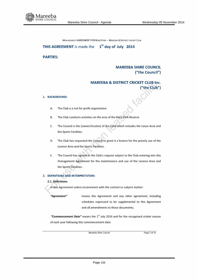
Mareeba Shire Council - Agenda Wednesday 05 November 2014
Page 106
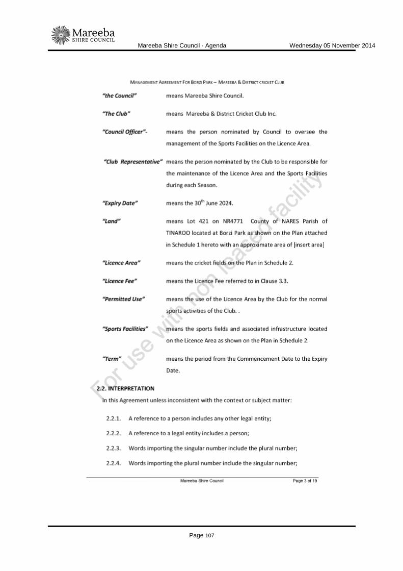
Mareeba Shire Council - Agenda Wednesday 05 November 2014
Page 107

Mareeba Shire Council - Agenda Wednesday 05 November 2014
Page 108

Mareeba Shire Council - Agenda Wednesday 05 November 2014
Page 109

Mareeba Shire Council - Agenda Wednesday 05 November 2014
Page 110

Mareeba Shire Council - Agenda Wednesday 05 November 2014
Page 111

Mareeba Shire Council - Agenda Wednesday 05 November 2014
Page 112
Mareeba Shire Council - Agenda Wednesday 05 November 2014
Page 113

Mareeba Shire Council - Agenda Wednesday 05 November 2014
Page 114

Mareeba Shire Council - Agenda Wednesday 05 November 2014
Page 115

Mareeba Shire Council - Agenda Wednesday 05 November 2014
Page 116

Mareeba Shire Council - Agenda Wednesday 05 November 2014
Page 117
Mareeba Shire Council - Agenda Wednesday 05 November 2014
Page 118

Mareeba Shire Council - Agenda Wednesday 05 November 2014
Page 119

Mareeba Shire Council - Agenda Wednesday 05 November 2014
Page 120

Mareeba Shire Council - Agenda Wednesday 05 November 2014
Page 121
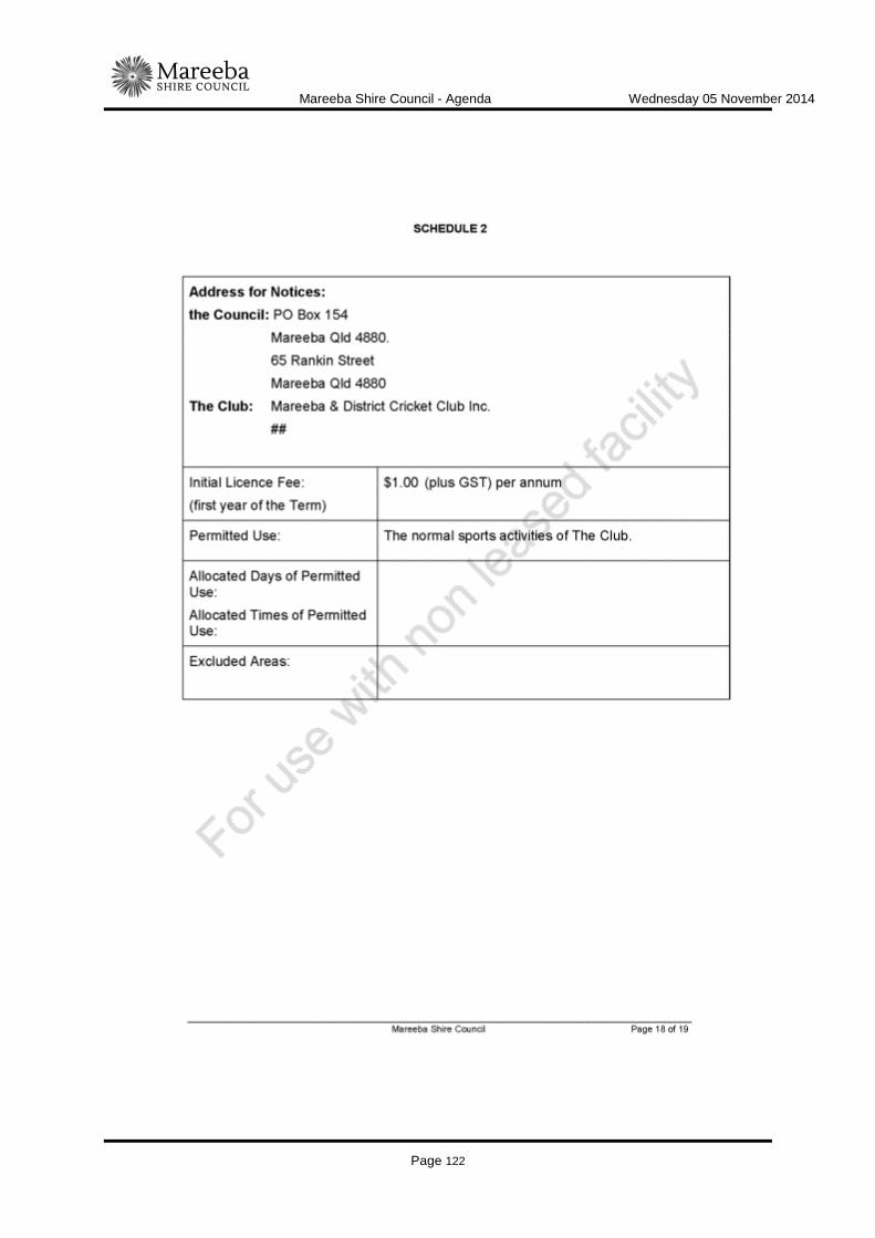
Mareeba Shire Council - Agenda Wednesday 05 November 2014
Page 122

Mareeba Shire Council - Agenda Wednesday 05 November 2014
Page 123
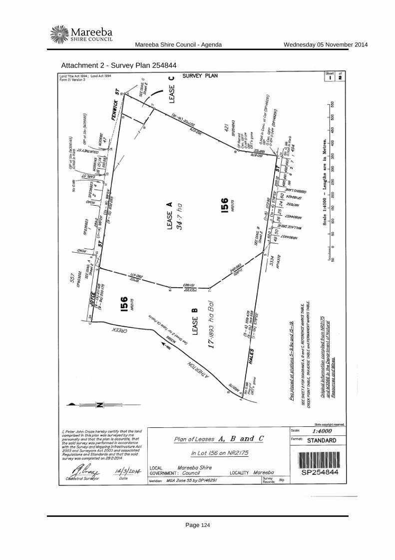
Mareeba Shire Council - Agenda Wednesday 05 November 2014
Page 124
Attachment 2 - Survey Plan 254844

Mareeba Shire Council - Agenda Wednesday 05 November 2014
Page 125
INFRASTRUCTURE SERVICES
TECHNICAL SERVICES
ITEM-10 HERITAGE PARK, DIMBULAH - PROPOSED PEDESTRIAN RAMP
DOCUMENT INFORMATION
MEETING: Ordinary MEETING DATE: 5 November 2014 REPORT OFFICER’S TITLE: Coordinator Technical Services DEPARTMENT: Infrastructure Services, Technical Services EXECUTIVE SUMMARY
A request has been received to investigate the cost of constructing a pedestrian/wheelchair ramp at the Heritage Park in Dimbulah to allow access to the adjoining roadway. A site investigation was undertaken and found that the proposed site for the ramp was not situated in an ideal and safe place as it led pedestrians directly to a major road intersection. The purpose of this report is to inform Council that an alternate safer solution is to construct a 2.0m wide concrete footpath from the existing footpath in the Heritage Park to the existing footpath in front of the Post Office Building. A preliminary design has been carried out and the works are estimated to cost $15,000, however this project is not currently included on Council's Project Prioritisation Tool (PPT) list of projects.
OFFICER'S RECOMMENDATION
"That Council:
1. approve the construction of a two (2) metre wide concrete footpath from the Heritage Park to the Post Office in Dimbulah and authorise the release of funds from Developer Contributions - Mareeba District Parks at an estimated cost of $15,000;
2. transfer the necessary funds from Developer Contributions for Mareeba District
Parks to the Capital Works budget to allow the works to be constructed this financial year."
BACKGROUND
A request has been received to investigate the cost of constructing a pedestrian/wheelchair ramp at the Heritage Park in Dimbulah. A site investigation was undertaken by Council

Mareeba Shire Council - Agenda Wednesday 05 November 2014
Page 126
Officers and it was found that the proposed site for the ramp was not situated in an ideal and safe place, as it led pedestrians directly to a major road intersection (refer attached photo). Officers then proceeded to investigate the possibility of constructing a two (2) metre wide footpath from the existing footpath in the Heritage Park to the existing footpath in front of the Post Office building. The length of this is estimated to be 47m. Attached is a plan showing this proposed footpath connection. This design provides safe pedestrian/wheelchair movements and directs them to a designated pedestrian crossing. The design shown will require minor earthworks with little to no disruptions to existing services. Below is a breakdown of estimated costs.
Service location, site establishment and site disestablishment $2,250 Earthworks $2,700 Install bedding material, formwork and pour concrete $10,050 Preliminary total cost of works $15,000
This project is one (1) of only two (2) footpaths in Dimbulah currently listed on the PPT, the other is the extension of the existing concrete footpath on the eastern side of Glynn Street to Short Street at an estimated cost of $40,000. While both projects are ranked equal on the PPT, the connection between the park and the Post Office is considered a higher priority at this time, due to its use as a wheelchair access to essential services and safe crossing point of the main highway.
LINK TO CORPORATE PLAN
ECON 3 - Undertake the management of Council's assets in accordance with the long term asset management plans developed for all infrastructure asset classes to ensure the Shire's infrastructure networks are maintained and renewed to maximise their long term benefit to industry and the community. COM 2 Conduct an analysis of current community facilities and develop a Shire wide community facilities plan to provide equity of access
CONSULTATION
Internal Mayor and Councillors Director Infrastructure Services Manager Technical Services Manager Works External Nil
LEGAL AND RISK IMPLICATIONS (STATUTORY BASIS, LEGAL AND RISKS)
Nil

Mareeba Shire Council - Agenda Wednesday 05 November 2014
Page 127
POLICY IMPLICATIONS
Nil
FINANCIAL & RESOURCE IMPLICATIONS
Capital The works are estimated to cost $15,000 Operating Nil Is the expenditure noted above included in the 2014/2015 budget? Nil If not you must recommend how the budget can be amended to accommodate the expenditure Developer Contributions - Mareeba District Parks
IMPLEMENTATION/COMMUNICATION
Nil
ATTACHMENTS
1. Site plan of proposed footpath; 2. Photo of ramp access to roadway. Date Prepared: 27 October 2014

Mareeba Shire Council - Agenda Wednesday 05 November 2014
Page 128

Mareeba Shire Council - Agenda Wednesday 05 November 2014
Page 129

Mareeba Shire Council - Agenda Wednesday 05 November 2014
Page 130
Mareeba Shire Council - Agenda Wednesday 05 November 2014
Page 131
ITEM-11 LEVEL 3 BRIDGE INSPECTIONS DOCUMENT INFORMATION
MEETING: Ordinary MEETING DATE: 5 November 2014 REPORT OFFICER’S TITLE: Coordinator Technical Services DEPARTMENT: Infrastructure Services, Technical Services Group EXECUTIVE SUMMARY
As a component of the 2014/15 Capital Works Programme eight (8) bridges were listed for Level 3 Bridge Inspections with a budget of $120,000. Six (6) consulting firms were invited to submit quotes and of these four (4) were received. The quotations were lower than expected and while variations can be expected dependent on the findings of the initial investigation, it is believed Council will have the ability to include additional bridges to the eight (8) initially identified for Level 3 Bridge Inspections.
OFFICER'S RECOMMENDATION
"That Council commission Pitt & Sherry to undertake the Level 3 Bridge Inspections on the initial eight (8) bridges at a cost of $36,960 and approve the inclusion of possibly a further fourteen (14) bridges subject to negotiation with the successful firm."
BACKGROUND
Mareeba Shire Council invited six (6) suitably qualified consultants to provide fee breakdowns for consultancy services to undertake level 3 bridge inspections on the following bridges:
• Speewah Road - Groves Creek • Chewko Road - Atherton Creek • Anzac Avenue - Barron River • Springmount Road - Walsh River • Springmount Road - Oakey Creek • Mt Lewis Road - Bushy Creek • Kanervo Road - Davies Creek • Hales Siding Road - Chinaman Creek
The level 3 inspection requires a structural engineer to carry out an extensive inspection, which may involve physical testing and/ or structural analysis, to assess;
• The current structural condition, • Behaviour and capacity, • Rate of deterioration and • Residual life expectancy of the asset.

Mareeba Shire Council - Agenda Wednesday 05 November 2014
Page 132
The engineers report will also recommend any asset management strategies that may be employed to prolong the life of the structures. The consultants that submitted quotations were:
• AECOM Australia Pty Ltd • Pitt & Sherry • GHD Pty Ltd • PDR Engineers
Below is the summary of quotations;
AECOM Australia Pty Ltd $80,212.00 incl GST Pitt & Sherry $36,960.00 incl GST GHD Pty Ltd $38,152.40 incl GST PDR Engineers $31,955.00 incl GST
Using a Tender Evaluation Summary form, the four (4) consultants were evaluated based on various criteria previously identified. This will be circulated to Councillors. Based on the quotations received and the evaluation process, it was found that Pitt & Sherry had demonstrated a better understanding of Council's brief and provided enough evidence with regards to relevant experience in carrying out level 3 bridge inspections and dealing with the needs of Councils. The key consultancy personnel are both Bridge Engineers with extensive experience carrying out level 3 bridge inspections across rural Victoria, New South Wales and Queensland. The Pitt & Sherry submission is competitive and provides Council with assurance that Council requirements will be met. It should be noted that initial advice received from consultants, before quotations were called, was that each bridge would be approximately $15,000 to inspect. The cost range for the quotations received varies from $3,000 to $15,000. The costs submitted are base costs and additional fees may be incurred on a bridge-by-bridge basis for any currently unquantifiable works identified as being required during the inspection process. Should the $120,000 allocated budget for the level 3 bridge inspections on the eight (8) mentioned bridges not be reached, Council then has the option to include extra bridges that have been identified as also requiring a level 3 bridge inspection. Below is a list of these bridges:
• Mount Lewis Road - Nissan Creek • Leadingham Creek Road - Leadingham Creek • Barron Street - Clohesy River • Bolton Road - Clohesy River • Davies Creek Road - Watercourse • Chapmans Road - Bushy Creek • Kovacic Road - Shanty Creek • Hodzic Road - Oakey Creek • Hillview Road - Boggy Creek • Jeffrey Road - Watercourse • Hoey Road - Bullock Creek

Mareeba Shire Council - Agenda Wednesday 05 November 2014
Page 133
• Catherine Road - SunWater Channel Crossing • Narcotic Creek Road - Nicotine Creek • McLeod Road - SunWater Channel Crossing
Additional unit costs will be negotiated with the successful tenderer, for the selected additional bridges, in order for costs to fall within the set budget.
LINK TO CORPORATE PLAN
ECON 3 - Undertake the management of Council's assets in accordance with the long term asset management plans developed for all infrastructure asset classes to ensure the Shire's infrastructure networks are maintained and renewed to maximise their long term benefit to industry and the community.
CONSULTATION
Internal Director Infrastructure Services Manager Technical Services Coordinator Technical Services Foreperson Bridge Construction and Maintenance External Nil
LEGAL AND RISK IMPLICATIONS (STATUTORY BASIS, LEGAL AND RISKS)
Nil
POLICY IMPLICATIONS
Nil
FINANCIAL & RESOURCE IMPLICATIONS
Capital The works are budgeted to cost $120,000 Operating Nil Is the expenditure noted above included in the 2014/2015 budget? Yes
IMPLEMENTATION/COMMUNICATION
Nil

Mareeba Shire Council - Agenda Wednesday 05 November 2014
Page 134
ATTACHMENTS
Nil Date Prepared: 28 October 2014

Mareeba Shire Council - Agenda Wednesday 05 November 2014
Page 135
ITEM-12 KURANDA COMMUNITY PRECINCT DOCUMENT INFORMATION
MEETING: Ordinary MEETING DATE: 5 November 2014 REPORT OFFICER’S TITLE: Manager Technical Services DEPARTMENT: Infrastructure Services, Technical Services Group EXECUTIVE SUMMARY
Clarke & Prince (Architects) completed initial concept designs for the relocation of the Kuranda library and internal car park at the Kuranda Community Precinct (KCP). The Quantity Surveyors estimate indicated an approximate cost of $445,000 for the building works and car park. Due to budget constraints the concept plans were reviewed by the committee where significant scope reductions resulted in a saving of $142,000, reducing the overall cost for the fit out of the library in Block C and the construction of the car park to $303,000 ex GST. Clarke & Prince have provided a fee proposal of $28,606.00 ex GST for the next phase of the project which includes the services as listed below.
• Contract Documentation • Tender Documentation and evaluation • Construction
Therefore the total cost of building fit out, car park construction and consultants' fees is estimated to be $331,606.00 ex GST. Mareeba Shire Council budget for the relocation of the Kuranda Library, including fit out and the construction of the car park is $360,000.00
OFFICER'S RECOMMENDATION
"That Council:
1. endorse the engagement of Clarke & Prince and sub-consultants as endorsed by the KCP Committee for $28,606.00 ex GST
2. endorse the concept plan by Clarke & Prince as endorsed by the KCP Committee
3. delegate responsibility to the Mayor and CEO to approve the detailed design for the library layout and car park on behalf of council subject to endorsement by the KCP Committee."
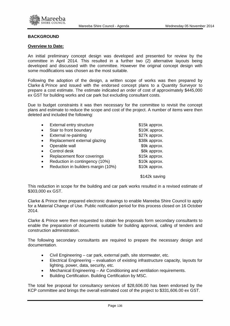
Mareeba Shire Council - Agenda Wednesday 05 November 2014
Page 136
BACKGROUND
Overview to Date: An initial preliminary concept design was developed and presented for review by the committee in April 2014. This resulted in a further two (2) alternative layouts being developed and discussed with the committee. However the original concept design with some modifications was chosen as the most suitable. Following the adoption of the design, a written scope of works was then prepared by Clarke & Prince and issued with the endorsed concept plans to a Quantity Surveyor to prepare a cost estimate. The estimate indicated an order of cost of approximately $445,000 ex GST for building works and car park but excluding consultant costs. Due to budget constraints it was then necessary for the committee to revisit the concept plans and estimate to reduce the scope and cost of the project. A number of items were then deleted and included the following:
• External entry structure $15k approx. • Stair to front boundary $10K approx. • External re-painting $27k approx. • Replacement external glazing $38k approx. • Operable wall $9k approx. • Control desk $8k approx. • Replacement floor coverings $15k approx. • Reduction in contingency (10%) $10k approx. • Reduction in builders margin (10%) $10k approx.
$142k saving
This reduction in scope for the building and car park works resulted in a revised estimate of $303,000 ex GST. Clarke & Prince then prepared electronic drawings to enable Mareeba Shire Council to apply for a Material Change of Use. Public notification period for this process closed on 16 October 2014. Clarke & Prince were then requested to obtain fee proposals form secondary consultants to enable the preparation of documents suitable for building approval, calling of tenders and construction administration. The following secondary consultants are required to prepare the necessary design and documentation.
• Civil Engineering – car park, external path, site stormwater, etc. • Electrical Engineering – evaluation of existing infrastructure capacity, layouts for
lighting, power, data, security, etc. • Mechanical Engineering – Air Conditioning and ventilation requirements. • Building Certification. Building Certification by MSC.
The total fee proposal for consultancy services of $28,606.00 has been endorsed by the KCP committee and brings the overall estimated cost of the project to $331,606.00 ex GST.

Mareeba Shire Council - Agenda Wednesday 05 November 2014
Page 137
Programme for delivery of project:
• Report to Council on 5 November 2014 requesting endorsement of concept plan and engagement of Clarke & Prince and sub-consultants.
• Should Council endorse the Clarke & Prince fee proposal and concept plans, then working drawings and specifications for the car park are programmed for delivery on week of 24 November 2014 and building documentation on 8 December 2014.
• Endorsement of detail design documentation by the committee on 9 December 2014.
• Earliest possible construction start for car park by MSC day labour is 15 December 2014. This date allows time for detailed estimating and inclusion in the capital works programme and is also weather dependant.
• Advertise tender for building works on the week of 5 January 2015 and close on 28 January 2015. Extended tender period to allow for Christmas shutdown by various building suppliers. This work will not be affected by the weather conditions.
LINK TO CORPORATE PLAN
COM 3: Encourage the building of strong partnerships with community, private sector and government so as to build community capacity and develop strategies to encourage and support leadership and self-responsibility in the community.
CONSULTATION
Internal Manager Community Wellbeing Senior Lands and Facilities Officer External Clarke & Prince Architects Kuranda Community Precinct Committee
LEGAL AND RISK IMPLICATIONS (STATUTORY BASIS, LEGAL AND RISKS)
Nil
POLICY IMPLICATIONS
Nil
FINANCIAL & RESOURCE IMPLICATIONS
Capital Yes - $360,000.00 Operating Nil

Mareeba Shire Council - Agenda Wednesday 05 November 2014
Page 138
Is the expenditure noted above included in the 2014/2015 budget? Yes If not you must recommend how the budget can be amended to accommodate the expenditure Nil
IMPLEMENTATION/COMMUNICATION
Detail designs and documentation to be endorsed by the KCP committee prior to advertising tenders or commencement of construction of the car park.
ATTACHMENTS
1. Drawing No 1103 - SD.00; 2. Drawing No 1103 - SD.01; 3. Drawing No 1103 - SD.02; 4. Drawing No 1103 - SD.03; 5. Drawing No 1103 - SD.05. Date Prepared: 28 October 2014
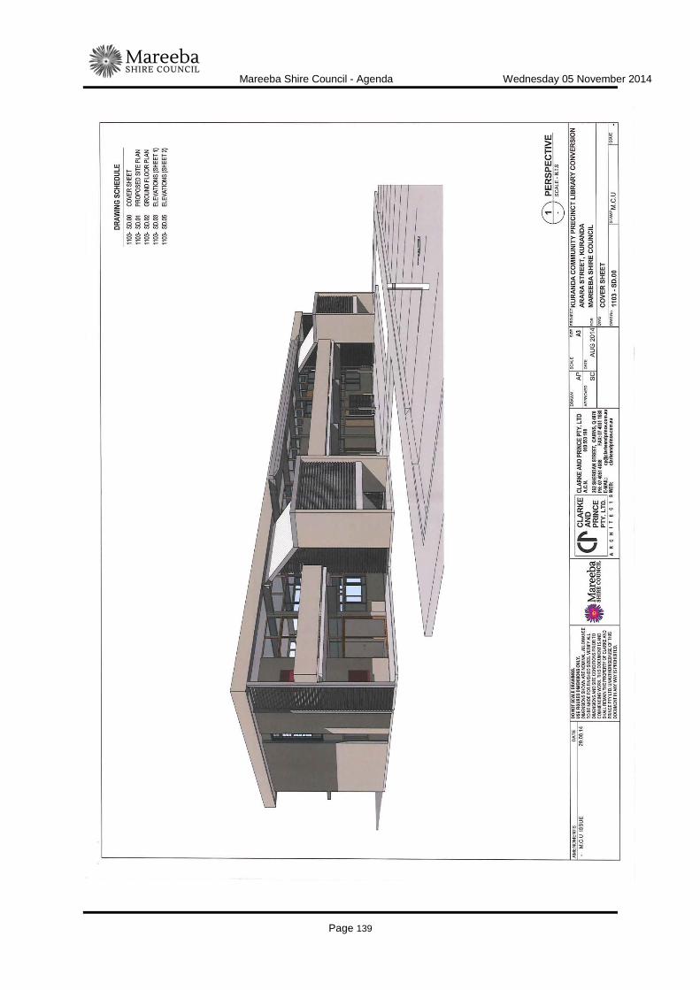
Mareeba Shire Council - Agenda Wednesday 05 November 2014
Page 139

Mareeba Shire Council - Agenda Wednesday 05 November 2014
Page 140
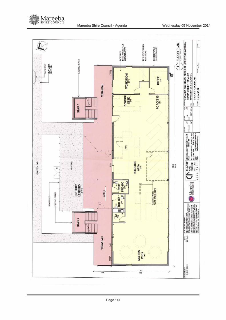
Mareeba Shire Council - Agenda Wednesday 05 November 2014
Page 141
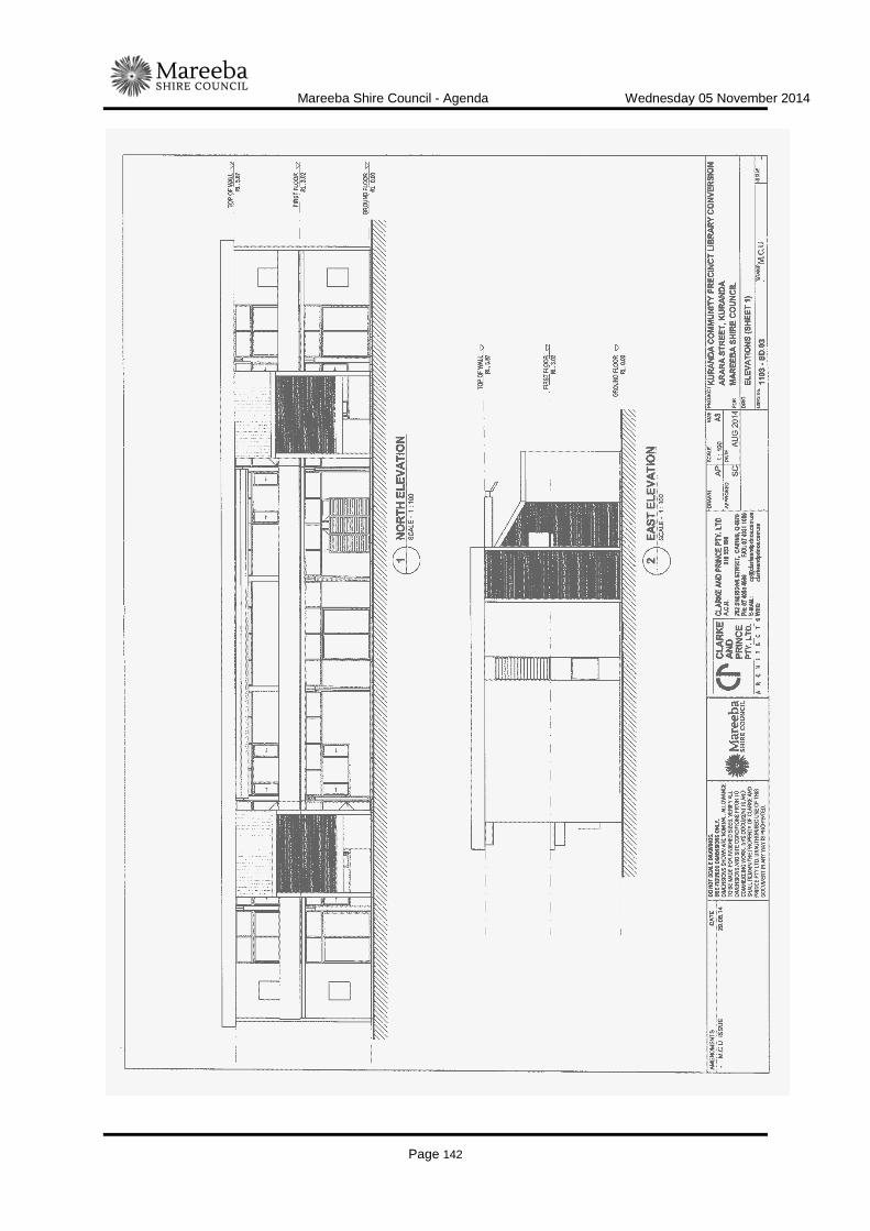
Mareeba Shire Council - Agenda Wednesday 05 November 2014
Page 142

Mareeba Shire Council - Agenda Wednesday 05 November 2014
Page 143

Mareeba Shire Council - Agenda Wednesday 05 November 2014
Page 144

Mareeba Shire Council - Agenda Wednesday 05 November 2014
Page 145
ITEM-13 MAREEBA AERODROME - MISSIONARY AVIATION FELLOWSHIP (MAF)
DOCUMENT INFORMATION
MEETING: Ordinary MEETING DATE: 5 November 2014 REPORT OFFICER’S TITLE: Manager Technical Services DEPARTMENT: Infrastructure Services, Technical Services Group EXECUTIVE SUMMARY
Missionary Aviation Fellowship (MAF) has been operating out of the Mareeba Aerodrome for a number of years. The operations have gradually expanded to include a flight training school which is currently under construction. On-site parking will be provided as part of the development, however on completion of the work a "missing link" of unsealed roadway will remain between the new car park and the existing bitumen access road. MAF has approached Council to seal this section of road so that this portion of the roadway does not remain unsealed. The on-street works are estimated to cost $31,000.00, are unfunded and are not currently on the list of projects in the Project Prioritisation Tool (PPT).
OFFICER'S RECOMMENDATION
"That: 1. should Missionary Aviation Fellowship (MAF) proceed with the sealing of the internal
car park that Council undertake the on-street works at an estimated cost of $31,000.00 ex GST and fund these works utilising Developer Contributions - Mareeba South Roads.
2. if works proceed in 1. above, Council transfer the required funds from Developer
Contributions - Mareeba South Roads to the 2014/2015 Capital Budget."
BACKGROUND
Missionary Aviation Fellowship (MAF) are currently constructing a flight training centre at the Mareeba aerodrome. As part of these works a sealed car park will be constructed on the site which will extend only to the lease boundary. This will result in an unsealed section of roadway between the edge of the existing bitumen and the new car park. MAF has approached Council to fund the sealing of this section of roadway so as to effectively complete the project and not be left with a "missing link" between the sealed access road and the new car park.

Mareeba Shire Council - Agenda Wednesday 05 November 2014
Page 146
The on-street works will include approximately 240m² of new bitumen sealed pavement and a concrete "V" drain located in the existing shallow earth table drain. The estimated cost to undertake the on-street works using Council day labour is $31,000, while the cost to construct the internal car park is approximately $33,000. Council is being asked to meet the cost of the on-street works while MAF will fund the car park as part of its development conditions. These on-street works are not currently listed in Council's Project Prioritisation Tool (PPT) project list and therefore no funding has been set aside for this project. There are approximately 35 road widening and bitumen seal projects listed on the PPT in the Mareeba area at a total cost of approximately $3.0M. There is approximately $1.3M in Developers Contributions for the Mareeba area including $345,000.00 in Developers Contributions- Mareeba South Roads from where funds for this project could be drawn. While this project is not currently listed on the PPT, it is considered highly desirable to undertake this work at this time to avoid damage and ongoing maintenance issues to Council's access road, particularly during the wet season. Increased movements from vehicles entering the carpark will result in damage to the edge of bitumen and gravel shoulders and will require regular maintenance if the sealing is not undertaken. MAF has the internal car park programmed for completion by the end of November and has requested a quotation from Council to undertake these works.
LINK TO CORPORATE PLAN
ECON 3 - Undertake the management of Council's assets in accordance with the long term asset management plans developed for all infrastructure asset classes to ensure the Shire's infrastructure networks are maintained and renewed to maximise their long term benefit to industry and the community. ECON 2 - In partnership with local business, industry groups and economic and regional development organisations, continue to develop strategies to assist, strengthen, develop and promote existing and new businesses and industries.
CONSULTATION
Internal Manager Works Director Infrastructure Services Mayor External MAF Executive Officer
LEGAL AND RISK IMPLICATIONS (STATUTORY BASIS, LEGAL AND RISKS)
Nil
POLICY IMPLICATIONS
Nil

Mareeba Shire Council - Agenda Wednesday 05 November 2014
Page 147
FINANCIAL & RESOURCE IMPLICATIONS
Capital $31,000.000 Operating Nil Is the expenditure noted above included in the 2014/2015 budget? Not currently included in 2014/15 budget If not you must recommend how the budget can be amended to accommodate the expenditure Funding can be provided utilising Developer contributions
IMPLEMENTATION/COMMUNICATION
Nil
ATTACHMENTS
1. Photos of the site; 2. Approved plan of car park located adjacent to the access road. Date Prepared: 28 October 2014
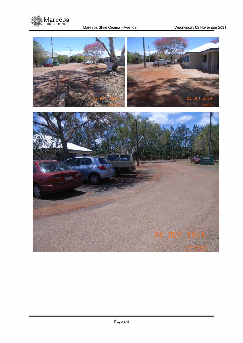
Mareeba Shire Council - Agenda Wednesday 05 November 2014
Page 148

Mareeba Shire Council - Agenda Wednesday 05 November 2014
Page 149

Mareeba Shire Council - Agenda Wednesday 05 November 2014
Page 150

Mareeba Shire Council - Agenda Wednesday 05 November 2014
Page 151
ITEM-14 UPDATE REPORT ON REQUEST REGARDS MACKAY SUGAR EXTENDED B-DOUBLE ROUTE ACCESS WITHIN MAREEBA SHIRE
DOCUMENT INFORMATION
MEETING: Ordinary MEETING DATE: 5 November 2014 REPORT OFFICER’S TITLE: Technical Officer, Projects Investigations DEPARTMENT: Infrastructure Services, Technical Services Group EXECUTIVE SUMMARY
To inform Council of any developments or issues associated with extended Mackay Sugar B-Double operations on additional local road routes approved at the 4 June 2014 Council workshop.
OFFICER'S RECOMMENDATION
"That Council receive and note the progress report in relation to extended trial access to B-Double routes to support Mackay Sugar harvesting and transport operations."
BACKGROUND
In accordance with the recommendations of the Council workshop a number of roads were rejected for B-Double access and specific operating conditions applied to all additional local roads approved for B-Double cane hauling access under the provisions of the Heavy Vehicle National Law (HVNL). Council Officers have continued to periodically monitor Mackay Sugar cane hauling operations and conduct occasional targeted oversight to ensure QUBE compliance with operating conditions applying to roads approved for three (3) month trial access, NHVR Permit 4538. Mackay Sugar has been providing Council with projected fortnightly harvesting schedules to assist Council monitoring of B-double operations. Council has been informed of incidents involving Mackay Sugar/ QUBE B-Doubles on the state controlled Mulligan Highway and Mossman-Mt Molloy Road. A roll over was reported on the Rex Range while a QUBE vehicle reportedly clipped another oncoming heavy vehicle on a narrow bridge in the Mitchell flats area south of Mt Molloy. In its initial assessment Council refused B-double cane hauling access to Fichera and Lockwood Roads primarily on the basis of a combination of poor horizontal and vertical geometry on the approaches to the Tinaroo Creek bridge on Fichera Road. Mackay Sugar has continued to request Council to reconsider its decision. Mackay Sugar and Cane Grower representatives have met with Council personnel to discuss the Fichera - Lockwood Road access decision.

Mareeba Shire Council - Agenda Wednesday 05 November 2014
Page 152
In order to facilitate B-Double access Cane Grower representatives have proposed the implementation of traffic control to regulate single lane traffic flow through the area of concern either side of the Tinaroo Creek bridge. Council officers on inspection have given in-principle approval for Cane Growers/ Mackay Sugar to come back to Council with a traffic management plan for assessment prior to final approval of the proposal. Council officers advised Mackay Sugar that the traffic control should not unreasonably inconvenience local traffic. Mackay Sugar has also surveyed local residents to ascertain their support for B-Double operations. Council received a number of completed survey forms from residents having no objection to B-Double operations on the basis that B-Doubles would represent a 33% percent reduction in heavy vehicle movements on Fichera and Lockwood Roads. Council has received a number of complaints from Lockwood Road residents in relation to excessive dust being generated by cane hauling operations. While Council officers have been liaising with Mackay Sugar requesting dust suppression watering on Lockwood Road, Mackay Sugar has not proceeded with dust suppression watering because there is no obligation to water the road as semi-trailers have 'as of right' access and as such Council has no recourse to enforce the request. Should B-Doubles proceed, Mackay Sugar will then have watering responsibility. Council officers have advised Mackay Sugar of their concerns about general road safety being compromised as a result of dusty conditions on Lockwood Road.
LINK TO CORPORATE PLAN
ECON 3 - Undertake the management of Council's assets in accordance with the long term asset management plans developed for all infrastructure asset classes to ensure the Shire's infrastructure networks are maintained and renewed to maximise their long term benefit to industry and the community.
CONSULTATION
Internal Technical Services Group External Tableland Canegrowers Mackay Sugar QUBE Logistics
LEGAL AND RISK IMPLICATIONS (STATUTORY BASIS, LEGAL AND RISKS)
Nil
POLICY IMPLICATIONS
Nil
Mareeba Shire Council - Agenda Wednesday 05 November 2014
Page 153
FINANCIAL & RESOURCE IMPLICATIONS
Nil
IMPLEMENTATION/COMMUNICATION
Nil
ATTACHMENTS
Nil Date Prepared: 24 October 2014

Mareeba Shire Council - Agenda Wednesday 05 November 2014
Page 154

Mareeba Shire Council - Agenda Wednesday 05 November 2014
Page 155
WORKS
ITEM-15 EXTRACTING CONSTRUCTION MATERIALS DOCUMENT INFORMATION
MEETING: Ordinary MEETING DATE: 5 November 2014 REPORT OFFICER’S TITLE: Environmental Compliance Officer DEPARTMENT: Infrastructure Services, Works Group EXECUTIVE SUMMARY
On a recent Western Roads tour with senior management of Infrastructure Services, Councillors queried whether naturally abundant materials such as sand, gravels, rock and waters in river beds could be used as a source of materials for the construction and maintenance of the Council road network. The use of locally sourced natural materials for construction and maintenance purposes does provide operational advantages. However, Council must be aware of the statutory regulation that administers the taking of these resources and the potential complaints that may be generated by lawful commercial extraction operators. Generally, the Queensland Government does provide for local governments taking of these resources for the purposes of infrastructure construction and maintenance through exemptions and licensing thresholds. However, further investigation and actions are required to be taken to formalise and minimise the risk associated with the utilisation of these resources. This report outlines the preliminary investigation into the utilisation of naturally occurring resources in river beds for the purposes of road infrastructure construction and maintenance.
OFFICER'S RECOMMENDATION
"That Council note the preliminary findings of the investigation into the process, benefits and dis-benefits of utilising materials from river beds for road maintenance and construction activities and that Technical Services Infrastructure Services will assess the merit of utilising such materials on a project by project basis."
BACKGROUND
Council resolved at its Ordinary Meeting on 01 October 2014 as follows: "That a report be presented to Council, as soon as possible, outlining the process and benefits/ dis-benefits of extracting construction materials from river beds for road construction projects, in particular bridge and culvert works."
Mareeba Shire Council - Agenda Wednesday 05 November 2014
Page 156
This request was made as a result of the recent Western Roads tour by senior managers of Infrastructure Services and Councillors. The operational benefits of extracting construction materials such as sand, gravel, rock and water from river beds for road construction purposes are as follows:
• Financial advantage by reduced upfront purchasing cost of quarry materials; and • Reduced transportation from commercial quarries or dredgers; and • Reduced wait times for material especially in circumstances where extra materials
are required; and • Minimised damage to gravel roads from the carting operations; and • Minimised environmental impact of carting such as reduced carbon footprint, and
dust. Operational disadvantages of utilising river bed materials consist of:
• Rehabilitation costs (if any); and • Increased establishment of additional plant and equipment necessary to extract,
screen, and crush. Other advantages / disadvantages:
• Reduced support for quarrying, and dredging businesses within the shire that have previously supplied materials and have sought Development Approval under the Town Plan and other relevant state licensing triggers.
The activities of extraction, dredging, screening, the taking of water, vegetation disturbance etc are predominantly regulated by the Queensland Government. These activities are regulated through the issuance of authorities with conditions or codes of practices. The licenses are made by application to the appropriate State Department and are usually accompanied by associated assessment and annual fees. The Commonwealth Government also regulates on matters of national significance such as Native Title and environmentally significant areas such as RAMSAR Wetlands, Wet Tropics, and the Great Barrier Reef. Generally, the individual State authorities recognise the contribution of construction and maintenance of transport infrastructure and have reduced bureaucratic red tape by providing code of practices, exemptions and elevated licensing thresholds. This allows the authorities to target activities that present most risk of harm or the excessive taking of resources belonging to the State (ie. Base flows in rivers). A preliminary assessment of pertinent legislation to the subject activities has been undertaken and the details, exemptions, license triggers etc are presented in Attachment 1. Of particular note is the exemption given to local governments under the town planning scheme. By definition of the assessable land use "extractive activity", MSC is exempt from seeking a Development Approval for a material change of use under the Town Planning Scheme. This is as opposed to a commercial operator who must seek a Development Approval for a Material Change of Use and seek necessary licenses such as an Environmental Authority and a Quarry licence.

Mareeba Shire Council - Agenda Wednesday 05 November 2014
Page 157
It is the intention of Infrastructure Services to further investigate the potential to utilise natural resources within river beds, where evidently abundant, for the purposes of road and bridge construction and maintenance activities. To do, this Infrastructure Services is proposing to:
• Identify, locate and map sand, gravel, rock pits (borrow pits) that are currently or maybe potentially used by Council.
• Identification of land tenure in river bed immediately adjacent to bridges and culverts ie road reserve.
• Identify licensing triggers and exemptions relevant to the taking of resources within river beds.
• Develop a checklist for pre project planning purposes to identify materials available and the appropriateness of its use. Where natural resources have been identified for a project, the scope of the proposed extraction must be assessed against exemption conditions and license triggers.
• Identify and adopt a rehabilitation and restoration policy for the use of natural resources in a river bed. It is envisaged that Council may use the Department of Transport and Main Roads existing borrow pit guidelines.
The above will be undertaken prior to the detailed consideration of the forward works program to be reported to Council in the new year.
LINK TO CORPORATE PLAN
ECON 3 - Undertake the management of Council’s assets in accordance with the long term asset management plans developed for all infrastructure asset classes to ensure the Shire's infrastructure networks are maintained and renewed to maximise their long term benefit to industry and the community. GOV 5 - Conduct a work management systems and procedures review to develop an efficient organisation supported by cost effective and safe work practices and systems.
CONSULTATION
Internal Manager Works, Infrastructure Services Manager Technical Services, Infrastructure Services Senior GIS Officer, Infrastructure Services Environmental Compliance Officer, Infrastructure Services. Senior Planner, Corporate Services External DEHP were contacted to clarify terminology but would not interpret legislation without a written request. The author used previous advice from DNRM in preparing this report.
LEGAL AND RISK IMPLICATIONS (STATUTORY BASIS, LEGAL AND RISKS)
Legal implications are inherent in this subject and pertain to the risk of causing an offence under particular legislation. Council will assume manageable environmental, safety and operational risk in extracting materials from river beds.

Mareeba Shire Council - Agenda Wednesday 05 November 2014
Page 158
POLICY IMPLICATIONS
Welcome to Country and Acknowledgement of Traditional Ownership. Environmental Policy Survey and Design Quality Assurance Project Management
FINANCIAL & RESOURCE IMPLICATIONS
Capital Nil Operating Nil Is the expenditure noted above included in the 2014/2015 budget? NA If not you must recommend how the budget can be amended to accommodate the expenditure NA
IMPLEMENTATION/COMMUNICATION
The outcome of further investigation into the lawfulness of extracting natural resources from river beds will have Operational Implications for Infrastructure Services.
ATTACHMENTS
1. Preliminary Findings - Licence Triggers and Exemptions
Date Prepared: 27 October 2014

Mareeba Shire Council - Agenda Wednesday 05 November 2014
Page 159

Mareeba Shire Council - Agenda Wednesday 05 November 2014
Page 160
Mareeba Shire Council - Agenda Wednesday 05 November 2014
Page 161
ITEM-16 INFRASTRUCTURE SERVICES - WORKS SECTIONS PROGRESS REPORT - SEPTEMBER 2014
DOCUMENT INFORMATION
MEETING: Ordinary Meeting MEETING DATE: 5 November 2014 REPORT OFFICER’S TITLE: Manager Works DEPARTMENT: Infrastructure Services, Works Group EXECUTIVE SUMMARY
This report sets out works undertaken by the Transport Infrastructure, Parks and Gardens and Bridge Sections of Infrastructure Services during the month of September 2014. The report was held over from the Ordinary Meeting of 15 October to ensure accurate financial data. This September Progress Report is being tabled in November as officers needed more time to develop financial statements that are more reflective of the actual operational costs.
OFFICER'S RECOMMENDATION
"That Council receive and note the Infrastructure Services Transport Infrastructure, Parks and Gardens and Bridge Sections, Progress Report for the month of September 2014."
BACKGROUND
Works Group Maintenance Activities Maintenance activities accruing more than $1,000 in expenditure were carried out in September at the following locations:
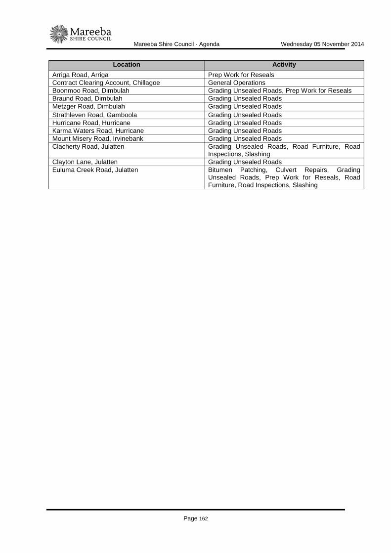
Mareeba Shire Council - Agenda Wednesday 05 November 2014
Page 162
Location Activity Arriga Road, Arriga Prep Work for Reseals Contract Clearing Account, Chillagoe General Operations Boonmoo Road, Dimbulah Grading Unsealed Roads, Prep Work for Reseals Braund Road, Dimbulah Grading Unsealed Roads Metzger Road, Dimbulah Grading Unsealed Roads Strathleven Road, Gamboola Grading Unsealed Roads Hurricane Road, Hurricane Grading Unsealed Roads Karma Waters Road, Hurricane Grading Unsealed Roads Mount Misery Road, Irvinebank Grading Unsealed Roads Clacherty Road, Julatten Grading Unsealed Roads, Road Furniture, Road
Inspections, Slashing Clayton Lane, Julatten Grading Unsealed Roads Euluma Creek Road, Julatten Bitumen Patching, Culvert Repairs, Grading
Unsealed Roads, Prep Work for Reseals, Road Furniture, Road Inspections, Slashing

Mareeba Shire Council - Agenda Wednesday 05 November 2014
Page 163
The table below shows the current budget position of road maintenance for Mareeba Shire Council.
The maintenance spend for September 2014 fell by $125,000 compared to August and $175,000 compared with July. Maintenance costs will continue to decrease as Transport Infrastructure staff become engaged on capital works for the Department of Transport and Main Roads projects.
Location Activity Hillview Road, Julatten Grading Unsealed Roads McLeans Bridge Road, Julatten Culvert Repairs, Grading Unsealed Roads, Prep
Work for Reseals, Road Inspections, Slashing Morrish Road, Julatten Grading Unsealed Roads Mount Lewis Road, Julatten Bitumen Patching, Grading Unsealed Roads, Road
Furniture, Slashing Nine Mile Road, Julatten Grading Unsealed Roads, Slashing Pashen Road, Julatten Grading Unsealed Roads Pinnacle Road, Julatten Bitumen Patching, Culvert Repairs, Slashing,
Grading Unsealed Roads, Road Furniture, Road Inspections
Rasmussen Road, Julatten Grading Unsealed Roads, Road Inspections, Slashing
Black Mountain Road, Julatten Grading Unsealed Roads, Road Inspections Boggy Creek Road, Julatten Grading Unsealed Roads Bump Track, Julatten Grading Unsealed Roads Koah Road, Koah Prep Work for Reseals Barang Street, Kuranda General Repairs & Maintenance - Road Furniture Black Mountain Road (Bitumen Section), Kuranda Grading Unsealed Roads, Road Furniture, Road
Inspections, Slashing Myola Road, Kuranda Bitumen Patching, Slashing Oak Forest Road, Kuranda Bitumen Patching, Road Furniture, Road
Inspections Rob Veivers Drive, Kuranda Bitumen Patching, Concrete Footpath Maintenance,
Road Furniture, Slashing Bulimba Road, Lyndside Grading Unsealed Roads Davies Creek Road, Mareeba Grading Unsealed Roads Ray Road, Mareeba Bitumen Patching, Road Furniture East Mary Road, Mt Carbine Bitumen Patching, Slashing Pump Road, Mt Carbine Slashing Fraser Road, Mt Molloy Road Furniture, Slashing Wetherby Road, Mt Molloy General Repairs & Maintenance, Grading Unsealed
Roads, Road Inspections, Slashing Mount Mulgrave Road, Mt Mulgrave Grading Unsealed Roads Armstrong Road, Mona Mona Grading Unsealed Roads, Road Inspections Nychum Road, Nychum Grading Unsealed Roads Ok Mine Road, Nychum Grading Unsealed Roads Brooks Road, Paddys Green Prep Work for Reseals, Road Furniture Speewah Road, Speewah Road Furniture, Grading Unsealed Roads, Prep
Work for Reseals
Location YTD Actual
YTD Budget
Annual Budget
Mareeba Shire Council $1,248,335 $720,748 $2,882,990
Mareeba Shire Council - Agenda Wednesday 05 November 2014
Page 164
Below is a table showing the roads where Unsealed Road Maintenance Grading has taken place this financial year. Some road lengths are incorrect and this data is being reviewed by Councils Technical Services Group.
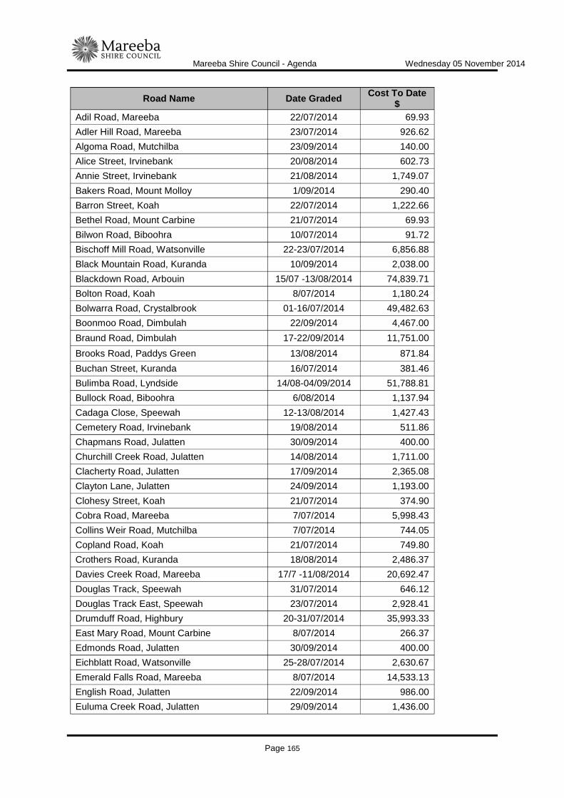
Mareeba Shire Council - Agenda Wednesday 05 November 2014
Page 165
Road Name Date Graded Cost To Date $
Adil Road, Mareeba 22/07/2014 69.93 Adler Hill Road, Mareeba 23/07/2014 926.62 Algoma Road, Mutchilba 23/09/2014 140.00 Alice Street, Irvinebank 20/08/2014 602.73 Annie Street, Irvinebank 21/08/2014 1,749.07 Bakers Road, Mount Molloy 1/09/2014 290.40 Barron Street, Koah 22/07/2014 1,222.66 Bethel Road, Mount Carbine 21/07/2014 69.93 Bilwon Road, Biboohra 10/07/2014 91.72 Bischoff Mill Road, Watsonville 22-23/07/2014 6,856.88 Black Mountain Road, Kuranda 10/09/2014 2,038.00 Blackdown Road, Arbouin 15/07 -13/08/2014 74,839.71 Bolton Road, Koah 8/07/2014 1,180.24 Bolwarra Road, Crystalbrook 01-16/07/2014 49,482.63 Boonmoo Road, Dimbulah 22/09/2014 4,467.00 Braund Road, Dimbulah 17-22/09/2014 11,751.00 Brooks Road, Paddys Green 13/08/2014 871.84 Buchan Street, Kuranda 16/07/2014 381.46 Bulimba Road, Lyndside 14/08-04/09/2014 51,788.81 Bullock Road, Biboohra 6/08/2014 1,137.94 Cadaga Close, Speewah 12-13/08/2014 1,427.43 Cemetery Road, Irvinebank 19/08/2014 511.86 Chapmans Road, Julatten 30/09/2014 400.00 Churchill Creek Road, Julatten 14/08/2014 1,711.00 Clacherty Road, Julatten 17/09/2014 2,365.08 Clayton Lane, Julatten 24/09/2014 1,193.00 Clohesy Street, Koah 21/07/2014 374.90 Cobra Road, Mareeba 7/07/2014 5,998.43 Collins Weir Road, Mutchilba 7/07/2014 744.05 Copland Road, Koah 21/07/2014 749.80 Crothers Road, Kuranda 18/08/2014 2,486.37 Davies Creek Road, Mareeba 17/7 -11/08/2014 20,692.47 Douglas Track, Speewah 31/07/2014 646.12 Douglas Track East, Speewah 23/07/2014 2,928.41 Drumduff Road, Highbury 20-31/07/2014 35,993.33 East Mary Road, Mount Carbine 8/07/2014 266.37 Edmonds Road, Julatten 30/09/2014 400.00 Eichblatt Road, Watsonville 25-28/07/2014 2,630.67 Emerald Falls Road, Mareeba 8/07/2014 14,533.13 English Road, Julatten 22/09/2014 986.00 Euluma Creek Road, Julatten 29/09/2014 1,436.00

Mareeba Shire Council - Agenda Wednesday 05 November 2014
Page 166
Road Name Date Graded Cost To Date $
Fantin Road, Koah 10-14/07/2014 9,639.36 Fraser Road, Mount Molloy 30/09/2014 2,211.00 Gibbs Lane, Irvinebank 21/08/2014 780.17 Gilmore Road, Mareeba 14/07/2014 30,317.46 Godfrey Road, Mareeba 21/07/2014 1,546.55 Gordon Street, Irvinebank 26/08/2014 888.96 Hales Siding Road, Irvinebank 5-19/08/2014 25,481.48 Harper Road, Speewah 30/07/2014 1,233.51 Henry Hannam Drive, Mareeba 8/07/2014 1,617.82 High Street, Irvinebank 20/08/2014 1,420.98 Hillview Road, Julatten 15/09/2014 1,518.89 Hoey Road, Speewah 30/07/2014 2,174.16 Hurricane Road, Hurricane 27/08-12/09/2014 63,212.00 Ibis Dam Road, Irvinebank 19/08/2014 29.83 Ivicevic Road, Paddys Green 14/08/2014 3,330.38 James Street, Watsonville 29/07/2014 1,329.72 James Street, Mareeba 1/07/2014 249.37 Jeffrey Road, Kuranda 22/08/2014 528.79 Jessie Street, Irvinebank 21/08/2014 721.62 Kanervo Road, Koah 7-8/07/2014 8,208.78 Karma Waters Road, Hurricane 13-29/09/2014 50,490.00 Kay Road, Mareeba 23/07/2014 1,363.53 Koah Road, Koah 22/07/2014 2,943.70 Kovacic Road, Mareeba 16/07/2014 1,178.20 Leonardi Road, Mareeba 10/07/2014 619.93 Lockyer Lane, Watsonville 25-28/07/2014 3,993.79 Macdonald Street, Irvinebank 20/08/2014 1,656.35 Martin Road, Chewko 16/07/2014 15.04 McCorry Road, Kuranda 9/07/2014 15.79 McDougall Road, Julatten 30/09/2014 959.00 McGrath Road, Mareeba 10/07/2014 91.72 McLeans Bridge Road, Julatten 2/09/2014 791.55 McLeod Road, Mutchilba 27/08/2014 46.62 Metzger Road, Dimbulah 16/09/2014 3,858.90 Mitchellvale Road, Mount Molloy 30/09/2014 39.00 Moffat Street, Irvinebank 21/08/2014 1,223.81 Monaro Close, Kuranda 22/08/2014 7,341.50 Morrish Road, Julatten 15-18/09/2014 6,553.44 Morton Street, Kuranda 22/07/2014 275.00 Mount Lewis Road, Julatten 24-30/09/2014 20,794.00 Mount Misery Road, Irvinebank 22-28/08/2014 17,262.47 Mount Mulgrave Road, Mount Mulgrave 08-17/09/2014 19,752.47 Mount Perseverance Road, Julatten 30/09/2014 526.00 Myola Road, Kuranda 20-21/08/2014 4,335.98

Mareeba Shire Council - Agenda Wednesday 05 November 2014
Page 167
Road Name Date Graded Cost To Date $
Nine Mile Road, Julatten 23-24/09/2014 5,342.00 Norris Road, Mount Molloy 30/09/2014 5,950.00 Nychum Road, Nychum 14-26/08/2014 34,153.17 OK Mine Road, Nychum 27/08/2014 4,620.95 Oak Forest Road, Kuranda 19/08/2014 5,239.21 O'Callaghan Street, Irvinebank 21/08/2014 602.73 Ootann Road, Almaden 08/10 - 16,555.00 Pashen Road, Julatten 19/09/2014 1,561.63 Pinnacle Road, Julatten 17-22/09/2014 2,950.00 Quinn Road, Mount Molloy 30/09/2014 250.00 Rains Road, Paddys Green 12-13/08/2014 6,856.03 Rasmussen Road, Julatten 2-03/09/2014 4,739.00 Rollinson Drive, Mareeba 23/07/2014 93.24 Rubina Terrace, Irvinebank 22/08/2014 1,401.00 Sabin Road East, Mareeba 17/07/2014 894.93 Sandridge Road, Watsonville 29-30/07/2014 3,669.90 Scrub Street, Kuranda 22/08/2014 4,620.00 Shaban Drive, Mareeba 22/07/2014 152.86 Shiffron Road, Watsonville 22/07/2014 1,007.25 Speewah Road, Speewah 24-31/07/2014 6,692.56 Spena Road, Mareeba 4/08/2014 3,395.36 Springfield Road, Springfield 02-04/07/2014 15,691.70 Spurrier Road, Mareeba 17/07/2014 550.00 Srhoj Road, Mareeba 21/07/2014 1,514.86 Stannery Hills Dam Road, Irvinebank 31/07/2014 163.18 Stannary Hills Road, Irvinebank 8/08/2014 4,884.07 Stoney Creek Road, Speewah 13/08/2014 2,929.32 Strathleven Road, Gamboola 08-13/09/2014 13,346.12 Streil Road, Koah 16/07/2014 3,360.49 Tait Street, Mutchilba 16/07/2014 250.00 Tapiola Road, Koah 17/07/2014 27.13 Tinaroo Creek Road, Mareeba 8/07/2014 5,448.48 Torwood Road, Bolwarra 07-30/07/2014 58,396.81 Toy Creek Road, Watsonville 25/07/2014 676.60 Vallely Road, Biboohra 10/07/2014 91.72 Vulcan Ore Road, Irvinebank 20/08/2014 1,106.73 Vulcan Wood Road, Irvinebank 19/08/2014 1,005.11 Walsh River Road, Watsonville 23-24/07/2014 5,799.96 Wetherby Road, Mount Molloy 18/08 -1/09/2014 32,928.00 Wessel Road, Mount Molloy 30/09/2014 950.00 West Bischoff Mill Road, Watsonville 21/07/2014 3,599.04 Wright Road, Mareeba 14-15/07/2014 1,955.23 Wright Road, Koah 15/07/2014 350.00 Black Mountain Road, Julatten 03-05/09/2014 7,956.64
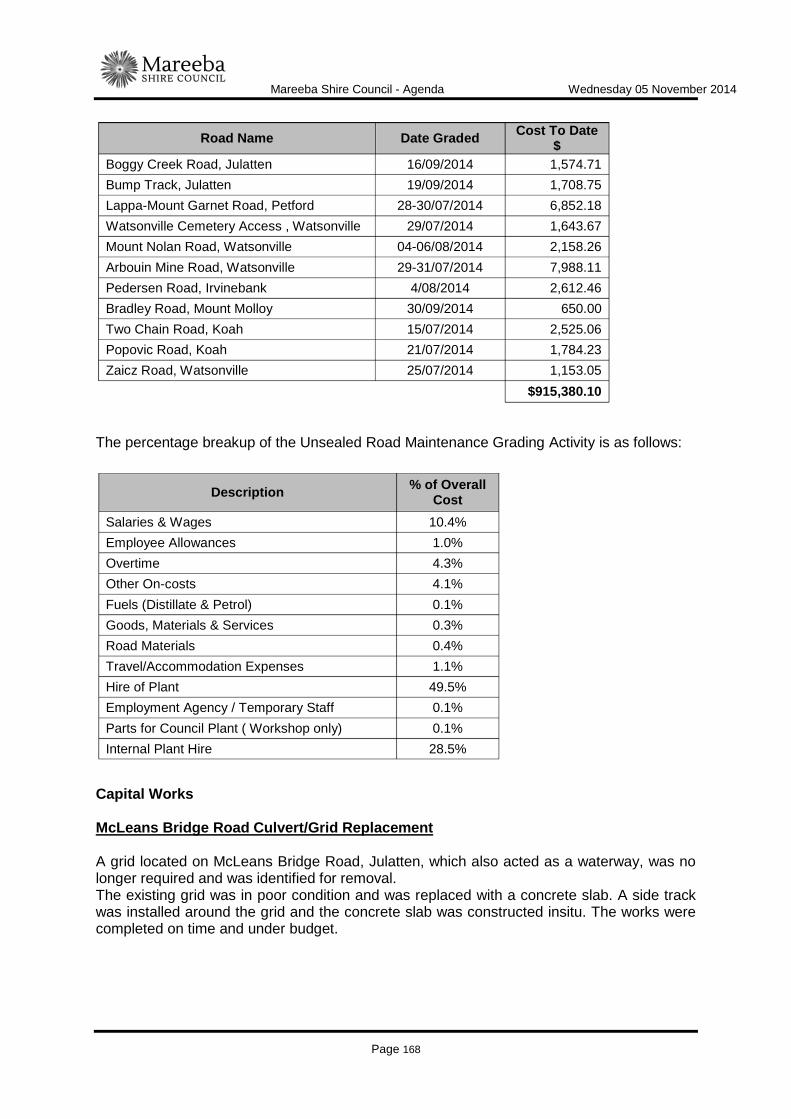
Mareeba Shire Council - Agenda Wednesday 05 November 2014
Page 168
The percentage breakup of the Unsealed Road Maintenance Grading Activity is as follows:
Capital Works McLeans Bridge Road Culvert/Grid Replacement A grid located on McLeans Bridge Road, Julatten, which also acted as a waterway, was no longer required and was identified for removal. The existing grid was in poor condition and was replaced with a concrete slab. A side track was installed around the grid and the concrete slab was constructed insitu. The works were completed on time and under budget.
Road Name Date Graded Cost To Date $
Boggy Creek Road, Julatten 16/09/2014 1,574.71 Bump Track, Julatten 19/09/2014 1,708.75 Lappa-Mount Garnet Road, Petford 28-30/07/2014 6,852.18 Watsonville Cemetery Access , Watsonville 29/07/2014 1,643.67 Mount Nolan Road, Watsonville 04-06/08/2014 2,158.26 Arbouin Mine Road, Watsonville 29-31/07/2014 7,988.11 Pedersen Road, Irvinebank 4/08/2014 2,612.46 Bradley Road, Mount Molloy 30/09/2014 650.00 Two Chain Road, Koah 15/07/2014 2,525.06 Popovic Road, Koah 21/07/2014 1,784.23 Zaicz Road, Watsonville 25/07/2014 1,153.05
$915,380.10
Description % of Overall Cost
Salaries & Wages 10.4% Employee Allowances 1.0% Overtime 4.3% Other On-costs 4.1% Fuels (Distillate & Petrol) 0.1% Goods, Materials & Services 0.3% Road Materials 0.4% Travel/Accommodation Expenses 1.1% Hire of Plant 49.5% Employment Agency / Temporary Staff 0.1% Parts for Council Plant ( Workshop only) 0.1% Internal Plant Hire 28.5%
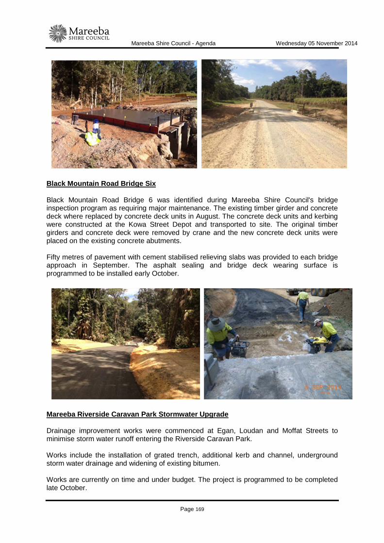
Mareeba Shire Council - Agenda Wednesday 05 November 2014
Page 169
Black Mountain Road Bridge Six Black Mountain Road Bridge 6 was identified during Mareeba Shire Council's bridge inspection program as requiring major maintenance. The existing timber girder and concrete deck where replaced by concrete deck units in August. The concrete deck units and kerbing were constructed at the Kowa Street Depot and transported to site. The original timber girders and concrete deck were removed by crane and the new concrete deck units were placed on the existing concrete abutments. Fifty metres of pavement with cement stabilised relieving slabs was provided to each bridge approach in September. The asphalt sealing and bridge deck wearing surface is programmed to be installed early October.
Mareeba Riverside Caravan Park Stormwater Upgrade Drainage improvement works were commenced at Egan, Loudan and Moffat Streets to minimise storm water runoff entering the Riverside Caravan Park. Works include the installation of grated trench, additional kerb and channel, underground storm water drainage and widening of existing bitumen. Works are currently on time and under budget. The project is programmed to be completed late October.

Mareeba Shire Council - Agenda Wednesday 05 November 2014
Page 170
Mulligan Highway Rectification Works Mt Carbine (DTMR) Failure of the base layer at constructions works carried out at Mt Carbine earlier this year resulted in Mareeba Shire Council undertaking rectification activities on behalf of DTMR. The method of rectification included overlaying the existing sealed pavement with 120mm of Type 2.1 Road Base, adding 1.5% of GB Cement and stabilising to a depth of 250mm. The works were sealed on 26 September. The project was carried out on a cost plus corporate overheads basis.
DTMR Routine Maintenance Performance Contract (RMPC) Routine maintenance activities were undertaken during September at the following locations;

Mareeba Shire Council - Agenda Wednesday 05 November 2014
Page 171
The total claim to DTMR for the works listed above for the month of September was $258,796.09.
Location Activity
Mulligan Highway (Molloy Boundary) Pothole patching Mossman- Mt Molloy Pothole patching BDR Medium Formation Grade Herberton Petford Formation works Mulligan Highway (Molloy Boundary) Minor Culvert Pipes/pit works Herberton Petford Minor Culvert Pipes/pit works Mareeba Dimbulah Slashing Mossman- Mt Molloy Herbicide spraying Mossman- Mt Molloy Vegetation control works Mulligan Highway (Marreba Molloy) Roadside Litter Collection Mulligan Highway (Molloy Boundary) Roadside Litter Collection Mossman -Mt Molloy Roadside Litter Collection Mareeba Dimbulah Roadside Litter Collection Mossman -Mt Molloy Other Roadside Work Mulligan Highway (Molloy- Boundary) Rest Area Servicing Kennedy Highway (Cairns- Mareeba) Rest Area Servicing Mulligan Highway (Mareeba- Molloy) Emergency Callout Mossman- Mt Molloy Emergency Callout Mareeba- Dimbulah Emergency Callout Molloy -Boundary Repair Signs Kennedy Highway Cairns- Mareeba Repair Signs Mareeba- Dimbulah Repair Signs Mulligan Highway (Mareeba -Molloy) Other Sign Work Mulligan Highway (Mareeba- Molloy) Repair or Replace Guide Markers

Mareeba Shire Council - Agenda Wednesday 05 November 2014
Page 172
Parks and Gardens Section Maintenance Activities Parks and Gardens maintenance activities accruing more than $1,000 in expenditure were carried out in September at the following locations:
The table below shows the current budget position of Parks and Gardens maintenance for Mareeba Shire Council.
Bridge Section Capital Works Black Mountain Road Flaggy Creek Bridge was identified during our bridge inspection program as requiring major maintenance. The existing timber girder and concrete deck are to be replaced by concrete deck units. The concrete deck units and kerbing have been constructed at the Kowa Street Depot and will be transported to site once sufficient curing of the concrete has taken place for the units to be lifted and loaded on to a truck.
Location Activity Parks and Gardens, Chillagoe General Operations, General Repairs and Maintenance Mutchilba Park, Mutchilba General Operations, General Repairs and Maintenance Basalt Gully and Bi-Centennial Lakes, Mareeba General Repairs and Maintenance, Mowing Mary Andrews Gardens, Mareeba General Repairs and Maintenance, Mowing Arnold Park, Mareeba General Repairs and Maintenance, Mowing Centenary Park, Mareeba General Repairs and Maintenance, Mowing Byrnes Street Medians, Mareeba General Repairs and Maintenance, Mowing Council Office & Library, Mareeba General Repairs and Maintenance, Mowing Ralph Leinster Park, Mareeba General Repairs and Maintenance, Mowing, Slashing Molloy Road Approaches, Mareeba General Repairs and Maintenance, Clean Inlet/Outlets Culvert,
Slashing Anzac Park, Mareeba General Repairs and Maintenance, After Hours Callout Rotary Park, Mareeba General Repairs and Maintenance, Mowing Kuranda Parks, Library, CBD and Streets General Repairs and Maintenance, Mowing Anzac Memorial Park, Kuranda General Repairs and Maintenance Town Hall Park, Dimbulah General Operations, General Repairs and Maintenance, Mowing
Borzi Park, Mareeba General Repairs and Maintenance, Mowing Davies Park, Mareeba General Repairs and Maintenance, Mowing Mareeba Streets General Repairs and Maintenance, Mowing, Slashing Furniture & Playground Equipment General Repairs and Maintenance, Investigation/Inspections
Clean up rubbish Mona Mona External Works Sunbird Park, Mareeba General Repairs and Maintenance, Mowing Corrective Services Labour (Supervision) General Repairs and Maintenance
Location YTD Actual
YTD Budget
Annual Budget
Mareeba Shire Council $372,735 $351,965 $1,375,459

Mareeba Shire Council - Agenda Wednesday 05 November 2014
Page 173
The table below shows the current budget position of bridge maintenance for Mareeba Shire Council.
LINK TO CORPORATE PLAN
ECON 3 - Undertake the management of Council's assets in accordance with the long term asset management plans developed for all infrastructure asset classes to ensure the Shire's infrastructure networks are maintained and renewed to maximise their long term benefit to industry and the community.
CONSULTATION
Internal Infrastructure Services staff External Nil
LEGAL AND RISK IMPLICATIONS (STATUTORY BASIS, LEGAL AND RISKS)
Nil
POLICY IMPLICATIONS
Nil
Location YTD Actual
YTD Budget
Annual Budget
Mareeba Shire Council $134,533 $218,531 $874,123

Mareeba Shire Council - Agenda Wednesday 05 November 2014
Page 174
FINANCIAL & RESOURCE IMPLICATIONS
Capital Included in 2014/2015 budget Operating Included in 2014/2015 budget Is the expenditure noted above included in the 2014/2015 budget? Yes
IMPLEMENTATION/COMMUNICATION
Nil
ATTACHMENTS
Advice is provided to residents and businesses affected by any activities. Date Prepared: 27 October 2014

Mareeba Shire Council - Agenda Wednesday 05 November 2014
Page 175
WATER & WASTE
ITEM-17 INFRASTRUCTURE SERVICES - WATER AND WASTEWATER - CUSTOMER SERVICE STANDARDS
DOCUMENT INFORMATION
MEETING: Ordinary Meeting MEETING DATE: 5 November 2014 REPORT OFFICER’S TITLE: Technical Officer DEPARTMENT: Infrastructure Services, Water and Waste Group EXECUTIVE SUMMARY
Under the Water Supply (Safety and Reliability) Act 2008, Council is required to prepare and publish for public comment a Water and Wastewater Customer Service Standard. Once the Customer Service Standard has been prepared, s117 of the Act requires Council to comply with the Customer Service Standard when supplying services to customers who do not have an individual service contract. The Customer Service Standard must be finalised by December 31 2014.
OFFICER'S RECOMMENDATION
"That Council note that the Draft Water and Wastewater Customer Service Standard will be published to the website and open to public comment for a period of two weeks commencing Monday 10 November 2015 and closing Monday 23 November 2014."
BACKGROUND
On 13 May 2014, specific changes to the Water Supply (Safety and Reliability) Act 2008 were enacted. As a water service provider, Mareeba Shire Council is required to prepare a new Customer Service Standard that states target levels of service for specific customer service key performance indicators. The new Customer Service Standard is required to include the following key performance indicators including targets. Council officers have reviewed historical performance data and propose to set targets to meet the new legislative requirements as per Table 1 - Key Performance Indicators and Targets.

Mareeba Shire Council - Agenda Wednesday 05 November 2014
Page 176
Table 1 - Key Performance Indicators and Targets
Performance Indicator Performance Measure Target
Total water main breaks Per 100km of water main 25
Total sewerage main breaks and chokes
Per 100km sewerage main 15
Incidence of unplanned interruptions – water
Per 1000 properties 5
Average response time for water incidents (bursts & leaks)
Minutes 60
Average response time for sewerage incidents (including main breaks and chokes)
Minutes 60
Water quality complaints Per 1000 properties 10
Total water and sewerage complaints
Per 1000 properties 100
The Water Supply (Safety and Reliability) Act 2008, s115 requires the proposed Customer Service Standard to be published for a period set by Council. It is proposed to provide the Customer Service Standard on the Council website for a period of 2 weeks for members of the public to read and provide submissions. During that period any person may make submissions about the proposed standard to Council. The final Customer Service Standard must be prepared taking into consideration all submissions received and is to be finalised by 31 December 2014. Once the Customer Service Standard has been prepared, s117 of the Act requires Council to comply with the Customer Service Standard when supplying services to customers who do not have an individual service contract.
LINK TO CORPORATE PLAN
ECON 3 Undertake the management of Council’s assets in accordance with the long term asset management plans developed for all infrastructure asset classes to ensure the Shire's infrastructure networks are maintained and renewed to maximise their long term benefit to industry and the community.
CONSULTATION
Internal Director Infrastructure Services Manager Water and Waste Water and Waste Engineer Environmental Compliance Officer External To be completed as per this Report's recommendation.

Mareeba Shire Council - Agenda Wednesday 05 November 2014
Page 177
LEGAL AND RISK IMPLICATIONS (STATUTORY BASIS, LEGAL AND RISKS)
Water Supply (Safety and Reliability) Act 2008, ss113-117.
POLICY IMPLICATIONS
Nil
FINANCIAL & RESOURCE IMPLICATIONS
Capital Nil Operating Nil Is the expenditure noted above included in the 2014/2015 budget? Nil If not you must recommend how the budget can be amended to accommodate the expenditure Nil
IMPLEMENTATION/COMMUNICATION
This document will be made available online and to the operational field staff.
ATTACHMENTS
1. Draft Water and Wastewater Customer Service Standard November 2014. Date Prepared: 27 October 2014

Mareeba Shire Council - Agenda Wednesday 05 November 2014
Page 178

Mareeba Shire Council - Agenda Wednesday 05 November 2014
Page 179
Mareeba Shire Council - Agenda Wednesday 05 November 2014
Page 180

Mareeba Shire Council - Agenda Wednesday 05 November 2014
Page 181

Mareeba Shire Council - Agenda Wednesday 05 November 2014
Page 182

Mareeba Shire Council - Agenda Wednesday 05 November 2014
Page 183

Mareeba Shire Council - Agenda Wednesday 05 November 2014
Page 184
Mareeba Shire Council - Agenda Wednesday 05 November 2014
Page 185
Mareeba Shire Council - Agenda Wednesday 05 November 2014
Page 186

Mareeba Shire Council - Agenda Wednesday 05 November 2014
Page 187
ITEM-18 QMSC2014-11 WATER METER REPLACEMENT PROGRAM CONCURRENTLY WITH THE INTRODUCTION OF AN AUTOMATED WATER METERING SYSTEM
DOCUMENT INFORMATION
MEETING: Ordinary MEETING DATE: 5 November 2014 REPORT OFFICER’S TITLE: Manager Water and Waster DEPARTMENT: Infrastructure Services, Water and Waste Group EXECUTIVE SUMMARY
The last round of water meter readings highlighted that 400 water meters in the Mareeba Shire area were not reading or giving false readings due to their age, wear and tear. The expected maximum life of a water meter is ten (10) years with the change out program generally starting when the water meters reach an age of 7 years old, or 3.6 ML (megalitres) of water has passed through the meters. Due to higher than average water usage in the Mareeba Shire area most water meters have exceeded the 3.6 ML usage rate and in most circumstances on average 4.0 ML has passed through the meters. An audit of the age of the water meters has showed, Council has 3,552 water meters that are over the fair wear and age category. It is widely noted throughout the water industry (confirmed by Elster Water Metering State Manager on Monday 25 August 2014) that aged water meters lose 50% of their operating accuracy by the time they reach their 7 to 10 year life span. In Mareeba Shire Council's case the life expectancy would be less as the higher the flow through the water meters the more likely they are to be worn given the consistently high usage of water through the meters. The net result is MSC have water meters that are not reading correctly with high revenue losses to Council and highlights the need to begin replacing the aged water meters on a staged program and ensure the water meters are listed on the asset management register and programmed for replacement/renewal at the end of their useful life. It would also be highly cost effective to install the Automated Water Meter Reading equipment in conjunction with a water meter replacement program to reduce costs and create efficiencies.
OFFICER'S RECOMMENDATION
"That Council approve the replacement of the aged and inefficient water meters in conjunction with the introduction of the Taggle Automated Water Meter Reading System and approve funds from the Water Reserves ($1.4M) of $643,092.48 (exclusive of GST) as per the proposal received from Taggle for the replacement of aged water meters and the introduction of the Taggle AMR System on the three year staged program."

Mareeba Shire Council - Agenda Wednesday 05 November 2014
Page 188
BACKGROUND
During the 2014-2015 Capital Budget Workshops held in May 2014, it was discussed and agreed on, the introduction of Automated Water Meter Reading devices would occur over three consecutive financial years with stage one to take place in the Kuranda area. At the last round of water meter readings in July highlighted that 400 water meters in the Mareeba Shire area were not reading due to their age, wear and tear. It is now recommended that stage one of the introduction of Automated Water Meter Reading devices begin in the Mareeba area due to the high proportion of aged and worn meters in this area. This prompted an audit of the remaining water meters throughout the MSC region and it has been highlighted that 3552 water meters are aged and in need of replacement to ensure Council are not continually loosing valuable revenue. This strategic and forward planning and linking to the asset register will ensure Council maintain its revenue streams in line with operating costs. Efficient use and management of capital is key to the delivery of a cost effective water business Automated Meter Reading has many benefits, including the ability to detect any unusual water use patterns indicating a potential leak at a property. AMR is a progressive technology being used more and more throughout Australia to read both water and electricity meters. It can provide many cost-effective benefits to both the service provider and the customer. Cost effective real time water meter reading will play a critical role in our demand management program. Automatic Meter Reading (AMR) for water utilities will provide huge opportunities for optimising existing infrastructure and providing reliable data on which to base future investment decisions. It is proposed to replace the aged water meters and fit the Taggle AMR System simultaneously, thus saving costs and increasing efficiency. Proposed options for Council to give consideration to are attached in the Taggle proposal, however it is recommended Mareeba be chosen first and not Kuranda as initially indicated at the capital budget workshop due to the high proportion of aged water meters in the Mareeba Township.
Mareeba 20 mm
25 mm
32 mm
40 mm
50 mm
80 mm
100 mm
150 mm Total
Replace meters & fit AMR 2,224 120 2 41 44 4 20 1 2,456
Fit AMR to existing meters 1,289 58 6 18 24 2 3 0 1,400

Mareeba Shire Council - Agenda Wednesday 05 November 2014
Page 189
Costs excluding GST are:
LINK TO CORPORATE PLAN
ECON 3 - Undertake the management of Council's assets in accordance with the long term asset management plans developed for all infrastructure asset classes to ensure the Shire's infrastructure networks are maintained and renewed to maximise their long term benefit to the industry and community.
CONSULTATION
Internal Director Infrastructure Services Department Engineer Water and Waste Manager Systems and Customer Service Supervisor Water Reticulation External Mackay Regional Council Cairns Regional Council Elster Taggle
LEGAL AND RISK IMPLICATIONS (STATUTORY BASIS, LEGAL AND RISKS)
Nil
POLICY IMPLICATIONS
Nil
Mareeba Shire Council - Agenda Wednesday 05 November 2014
Page 190
FINANCIAL & RESOURCE IMPLICATIONS
Capital New water meters and automated meter reading system $643,092.48 (exclusive of GST) Operating Nil Is the expenditure noted above included in the 2014/2015 budget? Nil If not you must recommend how the budget can be amended to accommodate the expenditure Nil
IMPLEMENTATION/COMMUNICATION
Consultation with Council staff and the wider community.
ATTACHMENTS
NIL
Date Prepared: 20 October 2014

Mareeba Shire Council - Agenda Wednesday 05 November 2014
Page 191
ITEM-19 WATER AND WASTEWATER GROUP - MONTHLY OPERATIONS REPORT INFRASTRUCTURE SERVICES DEPARTMENT
DOCUMENT INFORMATION
MEETING: Ordinary MEETING DATE: 5 November 2014 REPORT OFFICER’S TITLE: Manager Water and Waste DEPARTMENT: Infrastructure Services, Water and Waste Group EXECUTIVE SUMMARY
The purpose of this report is to summarise Council’s Water and Wastewater activities undertaken by the Infrastructure Services Department during the month of September 2014. This September Operations Report is being tabled in November as officers needed more time to develop financial statements that are more reflective of the actual operational costs.
OFFICER'S RECOMMENDATION
"That Council receive and note the September 2014 Monthly Water and Wastewater Report."
BACKGROUND
1. Capital Works Projects • Arsenic Removal Plant at Chillagoe - Packaged Plant will arrive 15 October 2014,
installation works are underway however Ergon needs to upgrade the power supply to the site and this has the potential to delay commissioning
• Work has commenced on Stage 1 of the Historian Project (Water Wastewater & Waste SCADA and Telemetry Recording and Reporting)
• Tender awarded to BJS Plumbing & Civil for the Barang Street Sewerage Rising Main Upgrade in Kuranda - expected construction completion date is mid-March 2015
• Tender awarded to Pumping Irrigation and Machinery Services (PIMS) for the Mareeba Industrial Park Water Booster Station - expected construction completion date is mid-January 2015
• Tender for a new water reservoir on Myola Road, Kuranda awarded to fgf Developments and is due for completion in June 2015
2. Environmental Monitoring - Treatment
• Mareeba STP non-compliant. Biological Oxygen Demand and exceeded the Ammonia maximum limit.
• Kuranda STP remains compliant with licence conditions.

Mareeba Shire Council - Agenda Wednesday 05 November 2014
Page 192
3. Budget - Water
Graphical - Revenue
Graphical – Expense

Mareeba Shire Council - Agenda Wednesday 05 November 2014
Page 193
4. Budget - Wastewater
Graphical - Revenue
Graphical – Expense

Mareeba Shire Council - Agenda Wednesday 05 November 2014
Page 194
5. Chlorine Residual Readings

Mareeba Shire Council - Agenda Wednesday 05 November 2014
Page 195
6. Mareeba Water Supply Scheme – Operations Data

Mareeba Shire Council - Agenda Wednesday 05 November 2014
Page 196
7. Kuranda Water Supply Scheme - Operations Data

Mareeba Shire Council - Agenda Wednesday 05 November 2014
Page 197
8. Mount Molloy Water Supply Scheme - Operations Data

Mareeba Shire Council - Agenda Wednesday 05 November 2014
Page 198
9. Dimbulah Water Supply Scheme - Operations Data

Mareeba Shire Council - Agenda Wednesday 05 November 2014
Page 199
10. Chillagoe Water Supply Scheme - Operations Data

Mareeba Shire Council - Agenda Wednesday 05 November 2014
Page 200
11. Mareeba Wastewater Treatment Plant - Operations Data

Mareeba Shire Council - Agenda Wednesday 05 November 2014
Page 201
12. Kuranda Wastewater Treatment Plant - Operations Data
Date Prepared: 27 October 2014

Mareeba Shire Council - Agenda Wednesday 05 November 2014
Page 202

Mareeba Shire Council - Agenda Wednesday 05 November 2014
Page 203
ITEM-20 INFRASTRUCTURE SERVICES - WASTE OPERATIONS PROGRESS REPORT - SEPTEMBER 2014
DOCUMENT INFORMATION
MEETING: Ordinary MEETING DATE: 5 November 2014 REPORT AUTHOR/ OFFICER’S TITLE: Manager Water and Waste Group DEPARTMENT: Infrastructure Services, Water and Waste Group EXECUTIVE SUMMARY
The purpose of this report is to summarise Council’s waste activities undertaken by the Infrastructure Services Department during the month of September 2014. This September Operations Report is being tabled in November as officers needed more time to develop financial statements that are more reflective of the actual operational costs.
OFFICER'S RECOMMENDATION
"That Council receive and note the Infrastructure Services, Waste Operations Progress Report, September 2014." BACKGROUND
The following is a summary of the waste activities undertaken during the month of September 2014. 1. Waste Operations
Recycled materials transported from outlying waste transfer stations to Mareeba waste transfer station this month. New wash-down hose installed at Mareeba waste transfer station for contractors and general public use in place of fire hose in accordance with site audit recommendations. Gas vents on old Mareeba landfill installed and operational. Road construction from old landfill to new landfill completed. A 30 cubic meter bin of recycled material was transported by JJ Richards from the Mareeba waste transfer station to Cairns material recycling facility for processing. This periodically re-occurs as the recyclable material builds up. All transfer stations and Mareeba landfill are currently operational.

Mareeba Shire Council - Agenda Wednesday 05 November 2014
Page 204
2. Customer Service Waste Statistics
The following graph displays customer requests logged in the Customer Request Management (CRM) system during the month of September 2014.
3. Waste Collected at Each of the Transfer Stations Waste material collected at each of the waste transfer stations is either deposited directly to the Mareeba landfill, recycled or transported to the SITA facility in Cairns for processing. The following pie charts are separated into waste received as whole units and waste received as accrued tonnage.
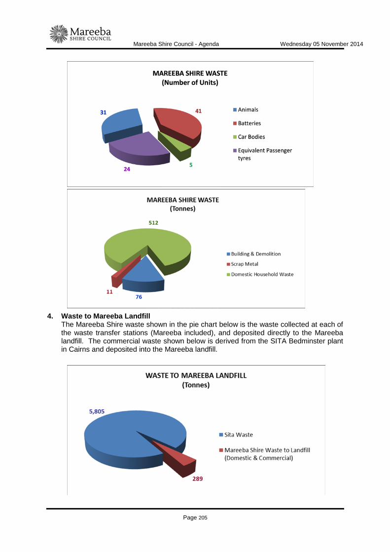
Mareeba Shire Council - Agenda Wednesday 05 November 2014
Page 205
4. Waste to Mareeba Landfill
The Mareeba Shire waste shown in the pie chart below is the waste collected at each of the waste transfer stations (Mareeba included), and deposited directly to the Mareeba landfill. The commercial waste shown below is derived from the SITA Bedminster plant in Cairns and deposited into the Mareeba landfill.

Mareeba Shire Council - Agenda Wednesday 05 November 2014
Page 206
5. Revenue
The income is derived from: • Commercial disposal (predominantly SITA) • Interest earned • Interest on Constrained Works • Recycling (steel, batteries) • Rates
The expenditure is derived from:
• Waste administration • Landfill management • Transfer station management
6. Financial Operational Budget Information per budget Section Overall
Graphical – Revenue
Graphical – Expenditure
Date Prepared: 3 October 2014
Mareeba Shire Council - Agenda Wednesday 05 November 2014
Page 207
ITEM-21 MAREEBA WASTEWATER TREATMENT PLANT - PROCESS DESIGN PHASE
DOCUMENT INFORMATION
MEETING: Ordinary MEETING DATE: 5 November 2014 REPORT OFFICER’S TITLE: Director Infrastructure Services DEPARTMENT: Infrastructure Services, Water and Waste Group EXECUTIVE SUMMARY
Council has adopted a program for the refurbishment of the Mareeba Wastewater Treatment Plant. Included in that program is the initial step of undertaking the Process Design for the refurbished plant in order to subsequently invite tenders for the detailed design and construction of the plant. Submissions have recently been sought from suitably qualified consultants to undertake the Process Design. This report briefly summarises the submissions and recommends the commissioning of the consultant to undertake the Process Design.
OFFICER'S RECOMMENDATION
"That Council commission Hunter Water Australia to undertake the Process Design phase of the Mareeba Wastewater Treatment Plant."
BACKGROUND
Council has resolved to commence a program of refurbishment at the Mareeba Wastewater Treatment Plant to allow the effluent to meet and eventually exceed the licence requirements of the plant. This program is subject to details as provided to the Department of Environment and Heritage Protection to have the proposed refurbished plant available for compliance testing by January 2017. The project is proposed to be delivered along the following lines:
- Process Design Phase - Design and Construction Phase based on the adopted Process Design
The Process Design phase will provide Council with a design that meets and exceeds the existing plant licence and allows the plant to be re-configured to higher treatment standards

Mareeba Shire Council - Agenda Wednesday 05 November 2014
Page 208
in the future, if required. This Phase will also provide Council with the specification basis to enable a design and construct contract to be invited during 2015. The Process Design phase will provide Council with the sizing and details of the proposed refurbished plant, in order for a civil designer to undertake the detailed civil design during the design and construct phase. Council has received funding to date of $100,000 from the State Government to commence the planning and design for the plant refurbishment. It is proposed that this initial allocation will be utilised initially to fund the Process Design phase. Submissions have recently been sought from experienced design firms to undertake the Process Design phase in conjunction with Council officers. The firms invited to provide Council with a submission were:
- Tenix - Hunter Water Australia - Yabbie Pond Pty Ltd - Jacobs Group (formerly Sinclair Knight Merz)
Comments on the submissions are as follows: Tenix Tenix was previously the recommended tenderer when Tablelands Regional Council considered and deferred the upgrading of the Mareeba Wastewater Treatment Plant to the new development approval from the Department of Environment. This proposal was then for a full design and construct contract which has now lapsed due to time and the decision of Mareeba Shire Council to refurbish the existing plant to meet the current licence standards. Tenix has a reasonable track record in the industry for providing operable treatment plants under a design and construct basis. Tenix recently built the Malanda Wastewater Treatment Plant and has developed treatment plants in Atherton and for the Whitsunday Shire Council. The company is primarily a construction and operation company with a competent but small design team. The proposal from Tenix in this instance is adequate and covers all required issues. It is considered however to be directed towards the future construction of the plant and does not adequately address the overall scope as set out in the design brief. These considerations will be required to be heavily emphasised in order to achieve maximum outcome for Council for the available funding. Hunter Water Australia Hunter Water Australia has extensive experience throughout Australia and South East Asia in treatment plant design. The company was the leading design consultant when Tablelands Regional Council was planning to construct the upgraded plant with the assistance of the original State Government subsidy. The process adopted during the design considerations for that plant was extremely collaborative and inclusive and allowed a final solution that canvassed all available options and technologies. Hunter Water Australia propose to follow a similar method of option assessment for the refurbished plant including a multi criteria analysis, risk assessment, operability and condition assessment of the existing infrastructure to determine what components may be
Mareeba Shire Council - Agenda Wednesday 05 November 2014
Page 209
incorporated into the final refurbished plant. The Hunter Water Australia submission meets the adopted brief for the Process Design thoroughly. Yabbie Pond Pty Ltd This company is a small specialist company that has had experience in assisting treatment plant upgrading in the Mackay area. The company also provided assistance in the recent modification work to the Kuranda Wastewater Treatment Plant. The company proposes the following steps:
- Inception Site Assessment and Information Collation - Treatment Process Upgrade Options assessment - Develop Recommended Process Design - Develop Preferred Sludge Drying / Dewatering Options - Preparation of Functional Design Specification - Documentation and Estimation
While the company has the potential to deliver, the submission is considered to be basic and not broad enough to capture future trends in treatment and therefore opportunities in improving effluent quality over time. Jacobs Group The submission from the Jacobs Group (formerly Sinclair Knight Merz), clearly identified a requirement to review previous work undertaken with respect to the Mareeba Wastewater Treatment Plant. The submission focussed particularly on the work prepared prior to the Tablelands Regional Council inviting tenders for the design and construction of a new plant in 2011, however did not propose any new or alternative review of possible treatment options in a refurbished plant. The submission, while it did identify the need to review the previous detailed work undertaken pre 2011, did not propose a satisfactory methodology that provided reviewing officers the confidence that Council was being afforded the best opportunity to achieve the desired outcomes of a compliant plant capable of being readily augmented in the future to meet contemporary standards at the time. Pricing Submitted prices for the submissions were as follows: Tenix $78,395 Hunter Water Australia $84,964 Yabbie Pond Pty Ltd $38,850 Jacobs $64,716 The above pricing reflects the consideration and input proposed by each firm and demonstrates the thoroughness and proposed consideration to be given to the required tasks. From the above, Hunter Water Australia is considered the most suitable consultant to undertake the Process Design phase.

Mareeba Shire Council - Agenda Wednesday 05 November 2014
Page 210
LINK TO CORPORATE PLAN
ECON 3 - Undertake the management of Council's assets in accordance with the long term asset management plans developed for all infrastructure asset classes to ensure the Shire's infrastructure networks are maintained and renewed to maximise their long term benefit to industry and the community.
CONSULTATION
Internal Water and Wastewater staff. External Nil
LEGAL AND RISK IMPLICATIONS (STATUTORY BASIS, LEGAL AND RISKS)
Council has agreed to a Transition Environmental Plan with the Department of Environment and Heritage Protection.
POLICY IMPLICATIONS
Nil
FINANCIAL & RESOURCE IMPLICATIONS
Capital Nil Operating Nil Is the expenditure noted above included in the 2014/2015 budget? No. If not you must recommend how the budget can be amended to accommodate the expenditure Funding to be allocated from the $100,000 grant from the State Government for this purpose.
IMPLEMENTATION/COMMUNICATION
Nil
ATTACHMENTS
Nil Date Prepared: 28 October 2014
Mareeba Shire Council - Agenda Wednesday 05 November 2014
Page 211
CHIEF EXECUTIVE OFFICER
ITEM-22 OFFICE CLOSURE FOR STAFF FUNCTION DOCUMENT INFORMATION
MEETING: Ordinary MEETING DATE: 5 November 2014 REPORT OFFICER’S TITLE: Chief Executive Officer DEPARTMENT: Office of the CEO EXECUTIVE SUMMARY
This report is presented to Council to obtain authorisation to close service centres for an end of year staff meeting.
OFFICER'S RECOMMENDATION
"That Council approves the early closure of service centres from 2pm on Friday 19 December 2014 for an end of year staff function."
BACKGROUND
As the end of the first year of Mareeba Shire Council operations comes to a close, staff ought to be acknowledged for their tremendous efforts in creating the foundations for this new organisation. There is no doubt that it has been a difficult and burdensome time for staff and as a token of appreciation, management would like to take this opportunity to thank staff for their dedication and hard work throughout this period. The management team have worked very closely with staff to create a positive culture and are recommending that service centres close at 2pm on Friday 19 December to allow all staff to attend an end of year staff function at the Mareeba Amenities Hall. The reason for a 2pm closure is that the majority of outdoor staff finish work at 3pm and by commencing at 2pm we can ensure the staff attend this important meeting at which the Mayor and CEO can address the staff. Councils after hours service will operate during the afternoon and staff will be available to deal with critical and emergency issues. It should be noted that from recent observations there are an average of 10 interactions (phone and counter) after 2pm on a Friday.
LINK TO CORPORATE PLAN
Nil

Mareeba Shire Council - Agenda Wednesday 05 November 2014
Page 212
CONSULTATION
Internal Senior Management Team External NIL
LEGAL AND RISK IMPLICATIONS (STATUTORY BASIS, LEGAL AND RISKS)
NIL
POLICY IMPLICATIONS
NIL
FINANCIAL & RESOURCE IMPLICATIONS
Capital NIL Operating NIL Is the expenditure noted above included in the 2014/2015 budget? NIL If not you must recommend how the budget can be amended to accommodate the expenditure NIL
IMPLEMENTATION/COMMUNICATION
All staff will be advised of this decision in due course.
ATTACHMENTS
Nil Date Prepared: 30/10/2014