assessment report for drilling and structural …€¦ · structural geological studies conducted...
TRANSCRIPT

ASSESSMENT REPORT FOR DRILLING AND STRUCTURAL GEOLOGICAL STUDIES
CONDUCTED DURING 2013
SPRINGPOLE GOLD PROJECT, RED LAKE DISTRICT, ONTARIO
NTS Sheet 52N08 UTM WGS84 Zn15N
By
James K. Muntzert, B.A, M.Sc. P.Geo. Sr. Consulting Geologist
Muntzert Enterprises, Inc.
13 October 2014

i
ASSESSMENT REPORT FOR DRILLING AND STRUCTURAL GEOLOGICAL STUDIES CONDUCTED DURING 2013
Executive Summary: During 2013, four separate but related work programs were conducted on the mining claims that comprise the Springpole Gold Project. The Springpole Gold Project is owned by Gold Canyon Resources Inc., Vancouver, BC. The work was conducted under the authority of Exploration Permit #PR-13-101, issued by MNDM on 17 May 2013. These work programs included: • Three campaigns of drilling were conducted between 29 January and 19 October by
Rodren Drilling Ltd., West St. Paul, MB • Structural geological and geotechnical studies were conducted by SRK Consultants
(Canada) simultaneously with the winter drilling campaign and additional field mapping and core logging were conducted in September.
The drilling campaigns are summarized in the table below:
Campaign Start Finish Holes Meters Winter 29-Jan 12-Mar 7 2,401.5
Summer 18-Jun 27-Jul 17 2,993.0 Fall 27-Sep 19-Oct 18 720.8
All logging and assaying of the core from these 42 holes were conducted in 2013. Winter Drilling Campaign:
The seven diamond drill holes completed in this phase of the program were designed to explore for additional resources that might exist immediately outside a proposed open pit boundary. All seven holes were drilled from the ice; all seven holes were inclined to intersect the proposed open pit wall at approximately right angles and all were drilled using Reflex orientation tools. The locations of these holes are shown on Figure 4. SRK Consultants were contracted to collect geotechnical data and structural orientations at the drill rigs as the core was recovered. After these data were collected, the core was removed from the drill rigs and taken to the “core shack” where the lithology was logged, samples marked and core photographs taken using the standard procedures established for Springpole deposits. After the logging/photographing were complete, the core was sawn in half. One half was taken for a sample and submitted to SGS Laboratories in Red Lake, ON for gold and

ii
silver analyses. The other half of the core was returned to the core box and is stored on site for future reference.
Summer Drilling Campaign:
In October 2012, Gold Canyon released a resource estimate. The resource estimate categorized the resources in Indicated and Inferred categories. The summer drilling program was designed to provide assay data that will ultimately be used to upgrade as much of the inferred resources to indicated resources as possible. The majority of the inferred resources were located in areas with sparse drilling or along the edges of the previous drilling. This drilling campaign was essentially an “in-fill” program to collect data in those areas where the data were insufficient to satisfy the rigorous tests necessary for resource categorization. Seventeen diamond drill holes were drilled from barges on Springpole Lake. The locations of these holes are shown on Figure 5. A total of 2,993 meters were drilled. The core recovered from these holes was logged and photographed prior to it being sawn. Half of the core was collected and submitted for assays at SGS laboratories in Red Lake, Ontario. The other half of the core was returned to the core box and is stored on site.
Fall Drilling Campaign:
The majority of drill holes located in the central portion of the Portage Zone had very poor core recovery in the very upper part (between the lake bottom and “bedrock”) of the drill hole. The thickness of this poorly sampled zone varied from a few meters to over 75 meters. Material that was occasionally recovered from this upper part indicated that the zone contained very soft, clay rich lake bottom sediments, till and very altered alkaline intrusive rocks. In those holes without significant recovery in the upper zone, the first samples recovered were alkaline intrusive rocks that were often highly mineralized, albeit very soft and intensely clay altered. Because of the uncertainty of the thickness and composition of the “unrecovered” zone, a new drilling technique was designed by Rodren Drilling Ltd. to try to get better recovery. The new technique employed a combination of standard soil sampling tools and techniques for the very soft material and the use of Vibracore equipment to penetrate and sample the more competent sediments/rocks. Eighteen sites were drilled using the new techniques. The locations of these holes are shown on Figure 6. Good recovery of soft sediments and till was accomplished; in three holes, bedrock was recovered. These holes established that the Portage zone is covered with up to 71 meters of soft clay sediments and till. The material recovered in these drill holes is summarized in the table below:
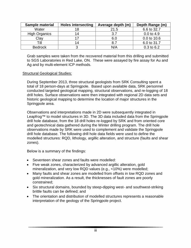
iii
Sample material Holes intersecting Average depth (m) Depth Range (m) Water 18 21.5 6.6 to 32.7
High Organics 14 3.7 0.0 to 4.9 Clay 17 6.0 0.0 to 10.6 Till 14 8.7 6.0 to 31.7
Bedrock 3 N/A 0.3 to 6.2
Grab samples were taken from the recovered material from this drilling and submitted to SGS Laboratories in Red Lake, ON. These were assayed by fire assay for Au and Ag and by multi-element ICP methods.
Structural Geological Studies:
During September 2013, three structural geologists from SRK Consulting spent a total of 18 person-days at Springpole. Based upon available data, SRK personnel conducted targeted geological mapping, structural observations, and re-logging of 18 drill holes. Surface observations were then integrated with regional 2D data sets and historic geological mapping to determine the location of major structures in the Springpole area. Observations and interpretations made in 2D were subsequently integrated in Leapfrog™ to model structures in 3D. The 3D data included data from the Springpole drill hole database, from the 18 drill holes re-logged by SRK and from oriented core and geotechnical data gathered during the Winter drilling program. The drill hole observations made by SRK were used to complement and validate the Springpole drill hole database. The following drill hole data fields were used to define the modelled structures: RQD, lithology, argillic alteration, and structure (faults and shear zones). Below is a summary of the findings: • Seventeen shear zones and faults were modelled: • Five weak zones, characterized by advanced argillic alteration, gold
mineralization, and very low RQD values (e.g., <10%) were modelled; • Many faults and shear zones are modelled from offsets in low RQD zones and
gold mineralization. As a result, the thicknesses of fault zones are poorly constrained;
• Six structural domains, bounded by steep-dipping west- and southwest-striking brittle faults can be defined; and
• The orientation and distribution of modelled structures represents a reasonable interpretation of the geology of the Springpole project.
iv
Recommendations:
Based on the results of the winter and summer drilling campaigns, it is recommended that the 2012 resource estimate should be updated to include these new data. SRK recommended that additional structural studies be conducted including: • Continued structural and lithological modelling; • Relogging of selected drill holes using photographs of uncut core; • Drilling at least two holes using oriented core equipment at specified locations to
intersect several defined faults and structure to further refine the actual orientation of the structures.
• Ongoing assessment and refinement of the structural model to improve the orientation and distribution of modelled faults, and to identify any additional fault orientations.
Further, Gold Canyon recommends the following based on SRK’s structural geological modeling: • Field mapping and sampling in the area along the southwest side of Springpole
Lake, with emphasis on locating possible outcrops of alkaline rocks. • Review of the geophysical surveys in the area southwest of Springpole Lake. If
there are encouraging results, specific recommendations for additional Induced Polarization surveys to cover this area would be in order.

a
Table of Contents Executive Summary: ...................................................................................................... i
Winter Drilling Campaign: ............................................................................................. i Summer Drilling Campaign: ..........................................................................................ii Fall Drilling Campaign: ..................................................................................................ii Structural Geological Studies: ..................................................................................... iii Recommendations: ......................................................................................................iv
1. Introduction: ........................................................................................................... 1
2. Location and Property: .......................................................................................... 1
2.1. Mining Claims: ..................................................................................................... 2
3. History: ................................................................................................................... 3
4. Geology: ................................................................................................................. 3
4.1 Regional Geology: .................................................................................................... 3
4.2 Geology of the Springpole Property: ..................................................................... 4
4.2.1. Structure: ....................................................................................................... 7
4.2.2. Alteration: ...................................................................................................... 7
4.2.3. Mineralization: ............................................................................................... 8
4.2.4. Deposit Types: .............................................................................................. 9
5. 2013 Work Programs: .......................................................................................... 10
5.1 Drilling: ................................................................................................................ 11
5.1.1. Drill Hole Collar Survey: .............................................................................. 12
5.1.2. Down-hole Survey: ...................................................................................... 12
5.1.3. Winter Drilling Program: .............................................................................. 12
5.1.4. Summer Drilling Program: ........................................................................... 17
5.1.5. Fall Drilling Program: ................................................................................... 26
5.2 Geotechnical and Structural Geological Program: .......................................... 32
5.2.1. Geotechnical Program:................................................................................ 32
5.2.2. Structural Geological Program: ................................................................... 34
6. Sampling and Assaying: ..................................................................................... 37
7. Use of Diamond Drilling and Assay Results: .................................................... 39
8. Conclusions and Recommendations: ................................................................ 40
9. Professional Certification: .................................................................................. 42
Bibliography: ............................................................................................................... 43
b
Appendix A .................................................................................................................. 46
Drill logs and graphic representation for each hole ....................................................... 46
Appendix B .................................................................................................................. 47
Drill Plans, showing hole traces .................................................................................... 47
Appendix C .................................................................................................................. 48
Drill sections .................................................................................................................. 48
Appendix D .................................................................................................................. 49
SGS (Canada) Inc. Assay Certificates. ......................................................................... 49
Appendix E .................................................................................................................. 50
Technical Memorandum; Structural Model of Springpole Project, by C. Nagy .............. 50
Table of Figures Figure 1: Springpole Gold Project Location Map ............................................................. 1 Figure 2: Land tenure Map of Springpole Gold Project ................................................... 2 Figure 3: Springpole Project regional Geology (modified from Arseneau, 2012) ............. 5 Figure 4: Drill holes in Winter Drilling Campaign. ......................................................... 13 Figure 5: Drill holes in the Summer Drilling Campaign ................................................. 18 Figure 6: Drill holes (Vibracore) in Fall Drilling Campaign. ............................................ 29 Figure 7: Modeled Structures and other structural information overlain on topography and bathymetry………………………………………………………………………………...35
Table of Tables Table 1: Mineral Resource Statement, Springpole Gold Project (October 17, 2012). ..... 3 Table 2: List of Claims on which Drilling occurred. ....................................................... 11 Table 3: Vibracore Drilling Results. .............................................................................. 32 Table 4: Summary of 2013 Drill results from SG13-200 to SG13-206 .......................... 37 Table 5: Summary of 2013 Drill Results from SP13-207 to SP13-223. ........................ 38 Table 6: Mineral Resources (March 2012) ................................................................... 39 Table 7: Mineral Resources (October 2012) ................................................................ 40 Table 8: Process tonnes and ounces contained. .......................................................... 40

1
1. Introduction: The Springpole Gold Project is wholly owned by Gold Canyon Resources Inc. (Gold Canyon), Suite 810, 609 Granville Street, Vancouver, BC, Canada V7Y 1G5 and is a gold exploration venture with well-defined mineral resources. The following report presents the results of the drilling programs conducted during 2013 that completed 42 drill holes on the Springpole Gold Project and structural geological studies. The work was conducted under the authority of Exploration Permit #PR-13-101, issued by MNDM on 17 May 2013. 2. Location and Property: The Springpole Gold Project is wholly owned by Gold Canyon. It is located approximately 110 kilometers northeast of Red Lake, Ontario (Figure 1).
Figure 1: Springpole Gold Project Location Map A temporary tent camp from which all field activities are managed is situated on a small land bridge between Springpole Lake and Birch Lake at Latitude N51°23’44.3” and Longitude W92°17’37.4”; UTM projection WGS84 Zone 15N Northing 5,694,065m and

2
Easting 549,150m, on National Topographic Sheets (NTS) 052N08. The average elevation is 395 meters above sea level. The Springpole Gold Project is accessible either by float-plane or helicopter. All fuel, food and material supplies are flown in from Red Lake. Heavier and bulky supplies are freighted in on a seasonal winter road. The closest road access is the landing at the old South Bay Mine on Confederation Lake, which is approximately 50 kms by air.
2.1. Mining Claims: The Springpole Gold Project comprises 30 freehold patented claims, 6 leasehold patented claims and 300 unpatented claims (Figure 2).
Figure 2: Land tenure Map of Springpole Gold Project

3
The 2013 drilling programs were conducted on only a portion of these claims. A total of 42 holes were drilled. Of this total, 35 drill holes were collared on three patented claims and seven were collared on three unpatented claims. Because part of the holes were inclined, some holes actually penetrated onto adjacent claims. (Figure 4). 3. History: The history of the Springpole Gold Project prior to 2006 is well documented in the following technical reports presented by Zabev, 2004, and Armstrong et al, 2006; as well as in the summary report of exploration Fall 2009 through Winter 2010 by Roberts, 2010; and, in the 43-101 reports presented by Arseneau, 2012 and 2012a. Gold exploration on the Springpole Property initially began in the 1920's and carried through to the 1940’s, and started again in 1985 and has carried through to the present. Between 1985 and 2013, Gold Canyon, its predecessor companies Akiko-Lori Resources Ltd., and Akiko Gold Company and numerous partners completed more than 164,000 meters of diamond drilling to define three main gold resources: Camp-Main Zone; East Extension Zone and Portage Zone. This work culminated in a resource estimate by Arseneau (2012a), which for these three zones are as follows: Table 1: Mineral Resource Statement, Springpole Gold Project (October 17, 2012).
Category Quantity
Grade Au
Grade Ag
Contained Metal Au
Contained Metal Ag
Million tonnes g/t g/t Million Oz Million Oz Indicated 128.2 1.07 5.7 4.41 23.8 Inferred 25.7 .083 3.2 0.69 2.7
Modified from Arseneau (2012a): Table i, Page v. 4. Geology: As with the history of the project, the geology of the region has been repeatedly reported by various authors over the years. Only pertinent excerpts of the geology are included in this report. (Camier, 2012).
4.1 Regional Geology:
The excerpt below is quoted from Devaney, 2001 (with references removed) from the text found in the “Springpole Project Summary Report on Exploration Activities Fall 2009 through Winter 2010” assessment report by Roberts, 2010; and, from the 43-101 report by Arseneau, 2012 entitled “Independent Technical Report for the Springpole Gold Project, NW Ontario, Canada”. Figure 3 provides a schematic of the regional geology of the area.

4
“The Birch-Uchi Greenstone Belt (Figure 3) is the portion of the Uchi Sub-province with an arcuate, concave to the southeast, map-view form (i.e., a major oroclinal bend between the Red Lake and Meen-Dempster portions of the sub-province). Studies of the southern part of the Birch-Uchi greenstone belt as a rootless greenstone belt only a few kilometers thick, have revealed a long (ca. 3.0 to 2.7 Ga), multistage history of crustal development. Based on mapping, lithogeochemistry, and radiometric dating, the supracrustal rocks of the greenstone belt were subdivided into three stratigraphic group-scale units (listed in decreasing age): the Balmer, Woman and Confederation assemblages. This three-part subdivision was applied to most of the Uchi Subprovince. The Confederation assemblage is thought to be a continental margin (Andean-type) arc succession, versus the less certain tectono-stratigraphic context of the other assemblages. Workers performing recent and ongoing studies of the southern Birch-Uchi greenstone belt and the Red Lake greenstone belt (i.e., the Western Uchi Subprovince NATMAP Project) have proposed some modifications and additions to the Balmer-Woman-Confederation stratigraphic scheme. As discussed herein, some relatively small conglomeratic units likely form a synorogenic, discontinuously distributed, post-Confederation assemblage in the Birch-Uchi greenstone belt. Radiometrically dated plutons within the Birch-Uchi greenstone belt are of post-Confederation assemblage, ca. 2725-2700 Ma age. The northern margin of the Birch-Uchi greenstone belt forms a pattern of sub-regional scale cusps of supracrustal strata alternating with batholiths. Basaltic units are prominent around the periphery of the greenstone belt and may be part of the Woman assemblage but the accuracy of this stratigraphic assignment is unknown. Based on a ca. 2740 Ma age of Shabumeni Lake [intermediate to felsic fragmental] volcanic rocks at a site near the northern greenstone belt margin, suggested that Confederation assemblage age rocks make up the bulk of the greenstone belt.” (Devaney, 2001).
4.2 Geology of the Springpole Property:
The Springpole property is underlain by a complexly folded, sheared and faulted sequence of mafic to intermediate volcanic rocks interspersed with sedimentary units. The sequences of sedimentary rocks identified on the property consist of sediments associated with the basement volcanic rocks as interflow units, intermediate volcanic lapilli tuff with minor cherty units, as well as well-bedded siltstone, iron formation, and greywacke and post-volcanic Timiskaming polymictic conglomerates. These rocks form the basement host into which a polyphase alkaline intrusive suite of rocks has intruded. However, these Timiskaming conglomerates are also reported to contain some clasts of trachytic feldspar porphyry and suggest contemporaneous emplacement with the alkaline intrusives.

5
Figure 3: Springpole Project regional Geology (modified from Arseneau, 2012)

6
The alkaline sequence of rocks intruding in to the mafic to intermediate suite and sedimentary rocks is composed of several phases of feldspar porphyry that has been identified through petrographic work as being a system of multiple phases of trachyte that are believed to be part of the roof zone of a larger syenite intrusive stock. Fragments displaying phaneritic textures were reportedly observed from deeper drill cores in the southeast portion of the Portage Zone on the Property and have been previously presented by Roberts (2010) and Arseneau (2012). Purportedly, observations suggest early intrusive phases consist of medium- to coarse-grained and megacrystic feldspar phenocrysts, up to 5 centimeters long, composed of albite and orthoclase feldspar supported in an aphanitic groundmass. Successive phases show progressively finer grained porphyritic textures, while the final intrusive phases are aphanitic. But, all phases of the porphyry are conspicuous by their trachyoidal texture and alkaline mineralogy. Furthermore, feldspar porphyry diatreme dikes and dikelets transecting the mafic to intermediate basement lithologies are found throughout the property. These dikes and dikelets are generally fine-grained and conspicuous by their potassium-feldspar phenocrysts and locally abundant exotic fragmental inclusions. Fluorite-calcite bodies occurring as lenses, veins and irregular breccia pods are reportedly found intermittently along an E-W shear extending from Round Pond to the west. These fluorite-calcite bodies are allegedly high in rare earths Several petrographic studies were carried out on the Springpole rocks. The first petrographic studies appear to have been carried out by Barnett (1996) for Santa Fe and identified the porphyry as a trachyte. In 2009 and 2010 further petrographic studies were conducted by Sanders & McIntosh (2009; 2010), of historic drill core and drill core from boreholes SP10-001 through SP11-006 (Arseneau, 2012). These studies confirmed that trachyte intrusive rocks are the dominant lithology within the project area, and are host to the mineralization (Roberts, 2010; Arseneau, 2012). Interpretation of the intrusive complex is complicated by a mixture of overprinted regional and local metamorphic events that are related to burial and tectonism. Pervasive alteration and metamorphism have reduced the original porphyry intrusive to a series of complex alteration assemblages dominated by sericite, biotite, pyrite, calcite/dolomite and quartz (Arseneau, 2012). This alteration assemblage within the porphyritic rocks was a product of intense acid-leaching from the action of H2SO4, HCL and HF in an epithermal environment (Barron, 1997). However, primary igneous textures are locally well-preserved and provide indications to the possible genesis of the initial stage of gold mineralization, which appears to have been derived from the trachytic intrusive (Barron, 1997). Within the country rocks to the north and east of the main area of interest are trachyte and lamprophyre dikes/sills that appear to be sourced from the trachyte or syenite porphyry intrusives (Arseneau, 2012). Overlying all of these rocks are thin deposits of Quaternary glacial sediments. In the uplands, these sediments are generally less than 10 meters thick and generally comprise sand deposits with a basal layer of bouldery till. In 2011 and 2012, DST

7
engineers drilled numerous holes using power and hand augers to define aggregate sources for future infrastructure construction. These holes roughly defined a few local areas that had up to eight or nine meters of glacial sediment, mostly sand. In most of the holes, the glacial sediments were about two to three meters thick. No eskers have been identified in the local area that could be used as aggregate sources.
4.2.1. Structure:
The country rocks that pre-date the alkali intrusive suite are composed of a complex sequence of altered and metamorphosed mafic to intermediate volcanic rocks and associated volcaniclastics, derived siliciclastic sedimentary rocks, chemical sediments (including banded iron formation), and coarse pebble conglomerates (Roberts, 2010; Arseneau, 2012). Devaney (2001) suggests these sediments are likely Confederation Assemblage metasedimentary rocks dating around 2,740 Ma; and, represent the proximal portions of a mixed volcanic-sedimentary basin. Barron (1996), states that pebble conglomerate outcroppings located between Springpole Lake and Birch Lake, contain clasts of trachyte porphyry suggesting the “Timiskaming-type” conglomerates postdate the intrusion. However, Devaney (2001) suggests these arcuate form conglomerates represent late orogenic, deformed, dextral strike-slip, pull-apart basins of “Timiskaming-type” late Archean, post Confederation assemblage age rocks (Roberts, 2010; Arseneau, 2012). Tectonic deformation has added complexity to the apparent geometry of, and the potential of the Springpole gold deposit. Gravity and magnetic surveys carried out across the Springpole Gold Project demonstrate that several phases of deformation are apparent. Banded iron formations describe north-northwest facing tight to isoclinal antiforms and synforms, and are illustrated on the property geologic map produced during the Summer 2005 Mapping Program (Armstrong et al, 2006), and are obvious as strong magnetic anomalies on the aeromagnetic surveys conducted by Fugro (Arseneau, 2012). In 2011, SRK Consulting was contracted to carry out a preliminary structural study of the controls on ore deposit geometry. The study found that the deposit has been subjected to several deformational events (Arseneau, 2012). Arseneau (2012) suggests further studies are required to definitively establish the relationship of the timing of deformational events with respect to economic mineralization. 4.2.2. Alteration:
All rocks on the property exhibit pervasive alteration. This consists of multiple overprinted phases. Both country rocks and alkali intrusive rocks exhibit pervasive green-schist facies metamorphism and alteration, probably the result of burial.

8
This is evident as chlorite, calcite and pyrite in the intermediate volcanic rocks, pyritization of the banded iron formation, and sericite-pyrite alteration within the alkali intrusive associated rocks (Roberts, 2010; Arseneau, 2012). Exploration work carried out in the fall of 2009 and winter–spring of 2010 indicates evidence of early alteration phases. This occurs as potassic and phyllic/sericitic alteration: K-Feldspar, biotite and muscovite (sericite) respectively, and is nearly pervasive in the alkali intrusive rocks and surrounding country rocks. Regional metamorphism has subsequently altered the primary hydrothermal mineral assemblages but textures have been preserved with the exception of areas of high strain (e.g., northwest trending shear zones) (Roberts, 2010; Arseneau, 2012). Advanced argillic alteration appears throughout the trachyte intrusive and occurs in some of the late stage lamprophyre dikes although on a small scale. It is difficult to assess at what stage acid-sulphate alteration occurs but it appears to define an envelope around the Portage Zone potassic-alteration/mineralization suggesting an origin comparable to the zoned alteration associated with epithermal-style porphyry intrusive hosted gold deposits (Roberts, 2010; Arseneau, 2012; Barron, 1997).
4.2.3. Mineralization:
The main intrusive complex appears to contain many of the characteristics of an alkaline porphyry style mineralization event associated with diatreme breccias. Direct comparison with drill core from two sites shows a number of consistent textures and styles of mineralization. Recent observations from drilling combined with an airborne magnetic survey indicate the potentially economic gold mineralization is coincident with an unexplained geophysical anomaly. This style of mineralization is characterized by the Portage Zone and portions of the East Zone, where mineralization is hosted by diatreme breccia in aphanitic trachyte. It is supposed that ductile shearing and brittle faulting have played a significant role in redistributing structurally controlled blocks of the mineralized rock. Yet to be established is the areal extent of the porphyry-style alteration zoning within the Portage Zone, which should consist of an outer zone of phyllic (sericite) dominant alteration with narrow zones of advanced argillic alteration characterized by illite and kaolinite, surrounding a core zone of intense potassic alteration characterized by biotite and K-feldspar (Arseneau, 2012). Multi-element analysis conducted during the 1992 program on the Portage Zone, combined with gold assays, gave the first indication of the style of mineralization at Springpole.

9
Diamond drilling in the winter of 2010 revealed a more complex alteration with broader, intense zones of potassic alteration replacing the original rock mass with biotite and pyrite. The expected alteration zone envelopes or shells are very difficult to define due to a complex sheared geometry and the poorly defined contact zones of the deposit. In the core area of the deposit where fine grained disseminated gold mineralization occurs with biotite as the primary potassic alteration mineral. Gold displays a good correlation with potassium/rubidium (Arseneau, 2012). The intrusion of the trachyte complex into the volcanic pile, as well as the chemical and siliciclastic sedimentary rocks in a near surface environment, produced mesothermal to epithermal style lode vein mineralization. Mesothermal fluids would have existed within the emplaced intrusive, associated with the diatreme breccias, and in the immediately adjacent wall rock/country rocks. In the porphyry intrusive, and at the contact between intrusive and wall rock in the East Zone, and localized within the Main Zone, mesothermal style quartz-biotite-calcite-sulfide veins with occasional tourmaline are observed with occasional coarse, visible gold (Arseneau, 2012). Further from the intrusive complex and wall rock contact zones where meteoric fluids have a greater influence, epithermal style vein textures and mineralization dominate. These consist of banded to sucrose-textured quartz-calcite veins with low-temperature mineral assemblages that include sericite, minor biotite, possible orthoclase/adularia, calcite, dolomite and ankerite. Here gold-silver and tellurium alloys dominate including electrum and gold-silver tellurides (Arseneau, 2012). Furthermore, as evidenced from the high degree of structural deformation (ductile and brittle) in the form of isoclinal folding, ductile shear zones that exhibit protomylonite and blastomylonite textures, coupled with brittle fault textures, indicates the Springpole area has been subjected to intense alteration and metamorphic processes. These processes may have formed the means for remobilizing the gold into epithermal quartz veins, which was the principal stimulus for exploring Springpole in the late 1980’s and early 1990’s when shear zone hosted gold deposits were the targets of choice in the Red Lake area (Arseneau, 2012).
4.2.4. Deposit Types:
The following discussion on the deposit types is excerpted from the 43-101 of Arseneau (2012). It was expanded upon by Arseneau (2012) from an earlier technical report submitted by Roberts (2010), and the 43-101 report by Armstrong et al. (2006), and has been included and modified in this report. Initial exploration investigations on the property was under the assumption the area was mineralized by typical Archean mesothermal lode gold. However, this assumption was modified based upon the abundance and size of epizonal trachyte

10
porphyry intrusive masses and the widespread brecciation and alteration centered on the Portage Zone. Barron (1996), after careful study, considered this area to be the apex of a buried syenite stock. A high emplacement level for the Portage Zone and surrounding porphyry was further supported by the lack of contact metamorphic effects in the enclosing country rocks. Trachyte clasts within the basal conglomerates overlying the intrusive complex indicate that it was subjected to paleo-surface weathering and erosion. The rarity of the trachyte clasts and their restriction to the base of the conglomeratic unit would seem to indicate erosion occurred over a short time interval. Furthermore, the lack of voluminous trachyte flows suggested there was no markedly positive volcanic edifice. Therefore, Barron (1996) concluded that collectively these features suggested the Portage Zone and surrounding Main and East Zones existed as a small island of maar craters of low relief in a rapidly deepening shallow basin. This interpretation has its closest modern analogue in the Ladolam Gold Deposit, Lihir Island, Papua New Guinea. Mineralization at Lihir is believed to be less than 500,000 years old and is telescoped upon an earlier porphyry environment (Carman, 2003); deposition of gold is still an active process at Ladolam as the hydrothermal system remains active. If the Ladolam Gold Deposit is accepted as a reasonable genetic analogue to the Springpole Deposit, then the following genetic model can be applied. However, detailed geological mapping by Santa Fe geologists led them to suggest that mineralization at Springpole was more comparable to, and had many similarities to the deposits of the Cripple Creek District, Colorado, including the Cresson Mine (Arseneau, 2012).
5. 2013 Work Programs: During 2013 three separate drilling campaigns were conducted by Rodren Drilling Ltd., 160 Poneida Rd., West St. Paul, MB R4A 5A9, under contract to Gold Canyon Resources Inc. In September, as part of the recommendations made by Arseneau in 2012, three geologists from SRK Consultants (Canada) conducted structural geological studies. This work included combinations of targeted geological mapping, structural observations, relogging core from 18 drill holes drilled between 2010 and 2013, using orientation data gathered from the 2013 winter drilling program and geological modeling. All of this work was conducted under the authority of Exploration Permit #PR-13-101, issued by MNDM on 17 May 2013. These programs are discussed in detail in the following sections.

11
5.1 Drilling:
Between 29 January and 19 October 2013, Rodren Drilling Ltd., 160 Poneida Road, West St. Paul, MB R4A 5A9, under contract to Gold Canyon Resources, drilled 24 diamond drill holes totaling 5,394.5 meters and 18 holes to sample the very upper portion between lake bottom and bedrock, totaling 720.8 meters, on the mining claims which comprise the Springpole Gold Project. The work was conducted under the authority of Exploration Permit #PR-13-101, issued by MNDM on 17 May 2013. The drilling program was conducted in three distinct phases over the year as summarized below:
Campaign Start Finish Holes Meters Winter 29-Jan 12-Mar 7 2,401.5
Summer 18-Jun 27-Jul 17 2,993.0 Fall 27-Sep 19-Oct 18 720.8
Two skid mounted diamond drills (Discovery EF-75) were used to drill seven inclined holes from the lake ice during the Winter campaign. During the Summer campaign, two Discovery EF-75 drills were moved to barges and drilled 17 vertical holes. The Fall campaign was conducted using one skid mounted BBS-37 drill rig, mounted on a barge to drill 18 holes to sample between lake bottom and bedrock. The 42 drill holes drilled during 2013 are located on five patented claims and three unpatented claims (Figures 5, 6 and 7). Seven holes were inclined; five holes cross the claim boundary and end on an adjacent claim as can be seen in Figure 5. Table 2 lists the meters drilled on each claim.
Table 2: List of Claims on which Drilling occurred.
Claim ID # collars
Meters drilled on claim
903535 1 122.2 903536 1 128.4 903537 5 1060.2
KRL11230 2 313.5 KRL11231 0 72.6 KRL12867 0 290.0 KRL12868 16 1879.4 KRL13043 17 2249.0
Total 42 6,115.3

12
5.1.1. Drill Hole Collar Survey: Drill hole collars are initially located using a hand held GPS (Garmin MAP62s). After the drill rig was moved to the site, had been properly aligned and drilling had commenced, the collar was resurveyed using a Trimble R-8 GNSS system that has sub-centimeter accuracy in both the horizontal and vertical directions when used in static mode and sub-decimeter accuracy in the kinematic mode. 5.1.2. Down-hole Survey: Down-hole survey method utilized for the 2013 program was the Reflex Down-hole Gyro survey system. The gyro provides directional data (azimuth and dip) at any interval from inside the drill rods. This system is used to provide azimuth and inclination data in rocks with strong magnetic fields, because the gyros operate independently of the earth’s magnetic field. The system also records ambient temperature as well as collecting basic gravity measurements. The gyro system was successfully applied to the majority of the 2011 drill program (Arseneau, 2012). All data recorded from the down-hole surveys were incorporated into 3-D planning and modeling (Arseneau, 2012). The SV13 series of holes (Vibracore) were not surveyed using down-hole methods. 5.1.3. Winter Drilling Program:
Between 29 January 2013 and 12 March 2013, Rodren Drilling conducted diamond drilling from seven sites located on the ice of Springpole Lake (Figure 5). These drill holes had a two-fold purpose: • These holes were drilled into areas having limited assay information, and were
used to explore for additional mineralized resources beyond a proposed open-pit shell.
• The sites were located to determine the orientation of any faults to aid the structural geological studies and to gather geotechnical data in the seven locations around a proposed open-pit shell.
The seven drill holes in the Winter Drilling Campaign were drilled into areas in which there were few assays and extended into areas outside the proposed open-pit shell (SRK, 2013). Three of the drill holes (SG13-201, SG13-205 and SG13-206) encountered multiple zones of mineralization (see Table 4). Below are descriptions of the gross lithologies intersected by these drill holes: (Note: all coordinates are UTM84-15N)

13
Figure 4: Drill holes in Winter Drilling Campaign.

14
• SG13-200: Coordinates: 549648.92E, 5693248.19N: Azimuth: 200°: Inclination: -70°. Depth: 351 meters. This hole intersected andesite between 45 meters and 145.3 meters which varied from fine to coarse grained. Cubic pyrite was present intermittently throughout this section. Weak argillic alteration was present throughout. From 145.3 meters to 168 meters aphanitic trachyte having crackle breccia texture was intersected. The trachyte is moderately altered by sericite and biotite. From 168 meters to the bottom of the hole at 351 meters, the rock type is volcanic breccia. There are occasional milled (rounded) fragments up to 6-cm visible. From 231.0 meters to 303.0 meters, the volcanic breccia is decomposed to sand and rubble. No core was recovered from four zones with in this interval. Below 303 meters, the core is more competent. At 333.3 meters to 335.5 meters and 346.9 meters to 348.7 meters are alkaline porphyry dikes that are potassium feldspar and sericite altered. There were no significant assays in this drill hole.
• SG13-201: Coordinates: 549801.34E, 5693264.61N. Azimuth: 135°. Inclination: -70°. Depth: 339 meters. This hole intersected coarse grained andesite from 27 meters to 138 meters. This rock is moderately altered with biotite and chlorite. From 138 meters to 148.1 meters is volcanic breccia with crackle breccia texture. The contact between andesite and volcanic breccia is gradational and it becomes light tan in color from a distinct decrease in chlorite alteration. From 148.1 meters to 162.0 meters is a coarse grained andesite. The upper contact is sheared. It is moderately altered with biotite and chlorite. Very fine grained pyrite is prevalent throughout. From 162.0 meters to 260.0 meters is volcanic breccia with a weak crackle breccia texture. From 260.0 meters to 267.0 meters, the core is crumbly, incompetent and has a high sulfide content. Between 263 meters and 267 meters, only sand was recovered, probably indicating that this is a fault zone. From 267.0 meters to 314.4 meters is volcanic breccia that is similar to the interval above, but it is lighter in color and has a strong structural fabric oriented between 60° and 80° to the core axis. Between 314.4 meters and 316.5 meters, is megacrystic feldspar porphyry having orthoclase phenocrysts greater than 2 cm in length, while the groundmass is composed of milled phenocrysts 1-3 mm across. From 316.5 meters to 339.0 meters is volcanic breccia that has a dark gray matrix containing occasional clasts of unknown rock types. The volcanic breccia is pervasively biotite and sericite altered. Two intervals of mineralized rock were intersected: From 148.0 meters to 196.0 meters (48 meter interval) the rock had an average grade of 0.66 g/t Au and 4.76 g/t Ag; from 254.0 meters to 282.0 meters (28 meter interval) the rock had an average grade of 0.72 g/t Au and 8.56 g/t Ag. (See Table 4).
• SG13-202: Coordinates: 549500.28E, 5693423.05N: Azimuth: 270°: Inclination: -70°: Depth: 351 meters. From 37.2 meters to 99.0 meters this hole intersected medium grained andesite with weak to moderate sericite alteration. There is less than 5% pyrite throughout. Carbonate veining is common. From 99.0 meters to 105.5 meters

15
is a medium to coarse grained porphyry that is weakly sericite altered. From 105.4 meters to 111.0 meters is a shear zone with gradual transition from porphyry to andesite. Foliation is at approximately 42° to the core axis. From 111.0 meters to 351.0 meters is andesite that varies from fine to medium grained until 322.0 meters where it becomes aphanitic. At 179 meters the rock is strongly magnetic. This hole did not intersect any significant mineralized zones.
• SG13-203: Coordinates: 549299.82E, 5693676.28N: Azimuth; 225°: Inclination -65°: Depth: 349.5 meters. From 37.2 meters to 81.0 meters, this drill hole intersected medium grained andesite that is green because of pervasive chlorite and sericite alteration. This zone is very competent. From 81.0 meters to 108.3 meters the rock is metasediments, some of which appears to be conglomerates, but toward the bottom of this section, it appears to be brecciated. This section is pervasively biotite altered. From 108.3 meters to 108.7 meters is fine grained andesite. From 108.7 meters to 114.0 meters is a lamprophyre dike that has sharp contacts. The upper part is strongly magnetic, but lower it is not magnetic. From 114.0 meters to 131.9 meters is fine grained andesite. From 131.9 meters to 144.0 meters is metasediments with thin interbeds of andesite. The zone is pervasively altered by sericite. From 144.0 meters to 202.4 meters is megacrystic feldspar porphyry. There are several sizes of feldspar phenocrysts ranging from 3 mm to 3 cm. From 202.4 meters to 249.0 meters is metasediments that range from thinly to massively bedded. There are thin andesite and trachyte interbeds. The entire section is moderately potassically altered. From 249.0 meters to 349.5 meters is medium grained andesite. This section is pervasively altered by chlorite and sericite and contains fine grained disseminated pyrite. No significant mineralized zones were intersected in this hole.
• SG13-204: Coordinates: 549520.85E, 5693730.33N; Azimuth: 019°; Inclination: -65°. Depth: 351 meters. From 25.5 meters to 79.5 meters this hole intersected porphyry, the upper portion of which is megacrystic feldspar porphyry with phenocrysts ranging up to several centimeters in length. The grain size decreases lower in the section with more brecciation. The core is hard because of strong potassic alteration. From 79.5 meters to 85.5 meters is aphanitic trachyte that is brecciated. This core is also very hard because of silica and/or potassic alteration. From 85.5 meters to 132.0 meters is fine to medium grained andesite. It is moderately sheared/foliated. The section is pervasively altered with biotite and sericite. From 132.0 meters to 171.0 meters is volcanic breccia with a chaotic texture. The clasts range from 2 to 50 cm. The dominate clasts are megacrystic feldspar porphyry. From 171.0 meters to 262.7 meters is andesite that is primarily fine grained, but has crackle breccia textures. It is altered with biotite and sericite, and pyrite is common. Some areas have calcite veinlets that fill the crackle breccia joints. From 262.7 meters to 319.3 meters is volcanic breccia that has a chaotic breccia texture. Clasts range from 2 mm to 2 cm in size. Between 319.3 meters and 321.1 meters is a lamprophyre dike that has

16
sharp contacts. It has been carbonate altered. From 321.1 meters to 334.3 meters is an aphanitic trachyte that has spherical amygdules that are filled by light minerals that have been further altered by potassic flooding. From 334.3 meters to 351 meters is volcanic breccia with fragments ranging up to 10 cm in diameter. There were no mineralized zones having significant assays in this hole.
• SG12-205: Coordinates: 549782.40E, 5693446.62N; Azimuth: 030°; Inclination: -70°; Depth: 349.5 meters. This hole intersected alkaline rocks for its entire length. From 13.9 meters to 349.5 meters are alternating intercepts of volcanic breccia and megacrystic feldspar porphyry. The volcanic breccia is generally matrix dominated with clasts of the underlying or overlying megacrystic feldspar porphyry, some of which are partially assimilated. The matrix of the volcanic breccia is generally a fine grained to aphanitic medium to dark gray trachyte. The layers of breccia and porphyry are generally approximately 20 meters thick, but occasionally the megacrystic feldspar porphyry is up to 50 meters to 60 meters thick. There are occasional aphanitic trachyte intercepts 10 meters to 15 meters thick. These intercepts appear to be very similar in composition to the matrix in the volcanic breccia. Carbonate and sericite alteration occurs as fracture filling in the breccias, and carbonate has replaced the center of many of the feldspar phenocrysts. Three lamprophyre dikes were intersected: one between 75.0 meters and 75.1 meters; one at 218.4 meters to 218.7 meters and the lower at 237.5 meters to 238.6 meters. The upper one contains up to 10% pyrite and is very vuggy. The middle dike contains feldspar phenocrysts that have been partially replaced by carbonates. Recovery of the lower dike was low because it is mostly a rubble zone. It is more altered with sericite and biotite. The phenocrysts have been replaced by carbonates. Four mineralized zones were intersected in this drill hole that had significant assays: 28.0 meters to 37.0 meters (9.0 meters) had average grades of 0.92 g/t Au and 3.33 g/t Ag; 99.0 meters to 103.0 meters (4.0 meters) average 2.29 g/t Au and 110.30 g/t Ag; From 226.0 meters to 327.0 meters (101.0 meters) averaged 0.93 g/t Au and 12.36 g/t Ag; and from 339.0 meters to 349.5 meters (10.5 meters) had average grades of 0.64 g/t Au and 4.80 g/t Ag. Note that this hole bottomed in mineralized rock. (see Table 4).
• SG13-206: Coordinates: 549139.84E, 5693889.13N; Azimuth: 040°; Inclination: -50°; Depth: 310.5 meters. This drill hole intersected andesite from 46.2 meters to 117.0 meters. The andesite ranges from aphanitic to fine grained. It has been strongly altered by sericite and clay. It has been sheared and contains carbonate veinlets throughout. Pyrite and other sulfide mineralization is locally common. The lower part is pervasively biotite altered. From 117.0 meters to 169.5 meters is aphanitic trachyte. The rock has been sheared and contains abundant anastomosing carbonate veinlets. From 169.5 meters to 183.5 meters is fine grained andesite. The upper contact is sheared. The rock is chlorite altered, with chlorite blebs to 1 cm diameter present, especially along foliation planes. Magnetite crystals up to 1 mm are locally present. From 183.5 meters to 283.0

17
meters is trachyte breccia. The upper portion is a heterolithic breccia. Selective alteration by sericite has occurred in some clasts. From 283.0 meters to 310.5 meters is aphanitic trachyte. It is generally unaltered, but anastomosing quartz veinlets have carbonate replacement in the center of the veins. Pyrite is finely disseminated throughout the section. This drill hole intersected four zones of mineralization that have significant assay values: From 68.0 to 91.5 meters (23.5 meters) the average grade is 1.27 g/t Au and 4.56 g/t Ag. From 108.0 meters to 175.0 meters (67.0 meters) having an average grade of 1.94 g/t Au and 2.94 g/t Ag. From 241.0 meters to 255.0 meters (14.0 meters) the rock had an average grade of 1.28 g/t Au and 2.44 g/t Ag. From 277.0 meters to 289.0 meters (12.0 meters) the average grade was 1.33 g/t Au and 1.87 g/t Ag. (see Table 4).
5.1.3.1. Discussion, Comments and Conclusions:
The Winter drilling program comprised seven inclined drill holes. The azimuths of these holes were more or less perpendicular to the proposed pit walls. These seven holes were used for dual purposes: to explore for additional resources outside the proposed pit wall, and to obtain orientation data on faults that were suspected in the area. The orientation of the faults provided pertinent information for the proposed structural geological studies that SRK Consultants conducted in September. The results of the structural geological studies have given important information about dislocations/disruptions of the Portage deposit and provide basis for further exploration proposals to locate offset portions of the mineralized bodies, both within and outside the proposed pit walls. The proposals and recommendations are discussed in a later section.
5.1.4. Summer Drilling Program: In October 2012, Gold Canyon released a resource estimate (Arseneau, 2012a). The resource estimate categorized the resources as Indicated and Inferred. Arseneau recommended that the Inferred category resources should be upgraded to Indicated category. The majority of the inferred resources are located in areas with sparse drilling or along the edges of the drilling. The summer drilling campaign was essentially an “in-fill” program to collect data in those areas where the data were insufficient to satisfy the rigorous tests necessary for resource categorization. Between 18 June and 27 July, 17 diamond drill holes were drilled from barges on Springpole Lake. All of the drill holes were drilled vertically. The locations of these holes are shown on Figure 5. A total of 2,993 meters were drilled. The core recovered from these holes was logged and photographed prior to it being sawn.

18
Figure 5: Drill holes in the Summer Drilling Campaign
19
Half of the core was collected and submitted for assays at SGS laboratories in Red Lake, Ontario. The other half of the core was returned to the core box and is stored on site. Table 5 shows composited assays from these holes that were reported in news releases. Below are descriptions of the lithology in each of these drill holes: • SP13-207: Coordinates: 549343.71E, 5693707.49N; Depth: 224 meters.
From 69.7 meters to 70.5 meters is overburden, composed of pieces of a variety of rocks that comprise the glacial till of the area. From 70.5 meters to 89.6 meters is dark gray trachyte that is strongly argillically altered with moderate biotite alteration and up to 5% pyrite. The core is decomposed. From 89.6 meters to 119.0 meters is greenish gray, medium to coarse grained feldspar porphyry with feldspar phenocrysts up to 20 mm in length. The rock is moderately argillically and sericite altered and contains abundant iron oxide minerals. From 119.0 meters to 122.0 meters is a thin medium gray trachyte breccia. It is sericite and argillically altered. It is distinct because it has no iron oxide minerals. From 122.0 meters to 137.6 meters is medium to coarse grained feldspar porphyry that is very similar to that described above. It is strongly iron oxide stained. The core is strongly fractured and contains many sandy/friable zones. From 137.6 meters to 163.0 meters is a fine grained trachyte that is also decomposed. There are very few large feldspar phenocrysts visible. The core is strongly argillized and contains moderate amounts of sericite and biotite. There is evidence the core originally contained up to 10% pyrite that has been completely oxidized. From 163.0 meters to 224.0 meters is medium to coarse grained feldspar porphyry. The feldspars are generally 5 mm to 10 mm in length. It is weakly to moderately altered by clays, sericite and biotite. Iron oxides are not as prevalent as above. Between 179.0 meters and 180.2 meters is a fine grained lamprophyre dike that contains 5 to 10% euhedral pyrite up to 2mm in dimensions. Between 197.0 meters and 202.5 meters the core is friable and decomposed. At 198.3 meters euhedral galena crystals occur on a fracture. Between 202.5 meters and 210.0 meters the core is competent, but still soft. From 210.0 meters to the end of the hole at 224.0 meters the core is totally decomposed to sand. There were some very high grade assays in this drill holes. 98.0 meters to 137.5 meters (39.5 meters) the rock had an average grade of 6.51 g/t Au and 18.0 g/t Ag. This interval had a high grade zone from 119.0 meters to 125.0 meters with average assays of 36.31 g/t Au and 47.20 g/t Ag. From 182.0 meters to 224.0 meters (42.0 meters) the average grade was 3.11 g/t Au and 24.9 g/t Ag. This hole ended in highly mineralized rock. (See Table 5 for more assays).
• SP13-208: Coordinates: 549110.34E, 5693909.67N; Depth: 152 meters. From 25.3 meters to 110.3 meters is interbedded andesite flows and andesite tuff. The andesite is grey green, fine to medium grained with moderate chlorite, sericite and biotite alteration. There is carbonate alteration sporadically through the intercept. The andesite tuffs are medium black in color. Although

20
they are also altered, the alteration is weaker than in the flows; there is no magnetite, and not as much carbonate alteration. From 110.3 meters to 152.0 meters the hole intersected metasediments. These are moderately altered by sericite, biotite and carbonates. This rock is schistose and has carbonate veining, but the entire section is nonmagnetic. Two mineralized zones were intersected in the metasediments that had significant assays: From 116.0 meters to 136.0 meters (20 meters) the rock averaged 1.55 g/t Au and 6.19 g/t Ag. From 144.0 meters to 152.0 meters (8.0 meters) the average grade was 0.78 g/t Au and 8.08 g/t Ag. This hole ended in mineralization. (See Table 5 for more assays).
• SP13-209: Coordinates: 549172.78E, 5693822.32N; Depth: 200 meters. From 48.7 meters to 88.8 meters the hole intersected metasediments that vary from aphanitic to conglomeratic. In the upper section, the rocks are weakly altered and non-magnetic, but the sericite and biotite alteration increases to moderate down the hole. The magnetism also increases down hole. From 80.4 meters to 81.9 meters is a lamprophyre dike that contains up to 10% pyrite. Between 81.9 meters and 88.8 meters there is an increase in quartz veining and this interval is more brecciated. At 88.8 meters galena occurs in a quartz vein. From 88.8 meters to 121.0 meters the hole intersected volcanic breccia that has interbedded tuffaceous units. The breccia is weakly sericite and biotite altered, weakly magnetic in most areas and contains very little carbonate alteration. The foliation of most of this unit is about 45° to the core axis. From 121.0 meters to 150.8 meters is dark aphanitic trachyte that contains variable amounts of sericite alteration and is weakly argillically altered throughout. It is generally magnetic. There are several intervals that contain up to 10% fine grained pyrite. From 150.8 meters to 159.5 meters is medium grained tuffaceous polymictic volcanic breccia with rhyolite clasts. It is moderately sericite altered. This unit is foliated at 40° to the core axis. From 159.5 meters to 191.5 meters is aphanitic trachyte that is very similar to the trachyte described above, except that it is very weakly altered and contains less pyrite. From 191.5 meters to 200.0 meters the hole intersected fine grained metasediments that are strongly schistose, but weakly altered. The unit contains 1% to 5% pyrite. Four relatively thin zones of mineralization having good assays were intersected: The best of which was from 92.0 meters to 109.0 meters (17 meters) had an average grade of 1.47 g/t Au and 0.52 g/t Ag. The other assays are shown on Table 5.
• SP13-210: Coordinates: 549364.12E, 5693659.30N; Depth: 200 meters. From 52.0 meters to 66.1 meters is overburden that is predominately glacial till containing granite and diorite rubble. From 66.1 meters to 73.5 meters is andesite tuff that is moderately to strongly altered by sericite, chlorite and clays. There are intervals of pyrite mineralization up to 5%. The core is strongly magnetic. From 73.5 meters to 119.0 meters is fine grained trachyte. The upper and lower contacts are gradational. The trachyte is moderately altered with clay minerals and sericite and weak biotite. There is a gradual change at 119.0 meters from trachyte to a volcanic breccia. It is strongly

21
altered by clay, sericite and biotite. The core is mostly incompetent and partially decomposed, with several zones that have completely decomposed to sand. The sandy areas contain 5 to 7% fine grained pyrite. At 143.0 meters there is a gradual transition back to fine grained trachyte. The trachyte intercept continues to the end of the hole at 200.0 meters. Overall, this intercept is moderately to strongly altered with clay minerals, sericite and biotite. There are intervals of strongly magnetic rock. Pyrite contents range from 1 to 5% over all, with a few thin intervals were it increases to 10%. Between 171.1 meters to 171.7 meters is a lamprophyre dike. From 171.7 meters to 200.0 meters the core is decomposed and often occurs only as sand. There were two mineralized zones in this hole: from 103.0 meters to 109.0 meters (6.0 meters) has an average grade of 1.21 g/t Au and 1.20 g/t Ag. Between 157.0 meters and 200.0 meters (43.0 meters) the grade averages 1.17 g/t Au and 3.46 g/t Ag. This holes ends in mineralized rock. (See Table 5).
• SP13-211: Coordinates: 549263.57E, 5693773.67N; Depth: 158 meters. From 67.7 meters to 71.0 meters is overburden. From 71.0 meters to 150.0 meters the hole intersected fine grained to medium grained trachyte that has interbedded layers of brecciated trachyte. The rock is moderately sericite and biotite altered throughout. Pyrite is also variable throughout the interval. From 140.0 meters to 143.0 meters is a strongly decomposed lamprophyre dike. It contains carbonate veinlets. From 150.0 meters to 158.0 meters is feldspar porphyry with feldspar phenocrysts ranging from 2 to 10 mm in length. There is moderate stockwork veining. Sericite and biotite alteration are moderate. From 73.0 meters to 158.0 meters (85.0 meters) is a continuously mineralized zone that has average grades of 2.13 g/t Au and 4.21 g/t Ag. This holes ends in mineralized rock. See additional assay data in Table 5.
• SP13-212: Coordinates: 549403.17E, 5693627.05N; Depth: 176 meters. From 52.5 meters to 86.0 meters the lithology is a fine-grained andesite. The core is mostly broken along fracture and foliation planes with sulfides finely disseminated throughout in trace amounts. The groundmass is pervasively sericite-altered, with biotite and argillic alteration concentrated along joints/fracture/foliation breaks. Core is generally dark grey through this interval. From 86.0 meters to 176.0 meters the core is a dark grey to black, aphanitic trachyte. This lithologic unit is consistent with minor textural changes. There is indicated crackle-breccia texture from 155-164m, with an associated increase in disseminated pyrite. Towards the bottom of the interval there is a lamprophyre dike at 174.0 meters to 174.6 meters. The dike is pervasively biotite-altered with sharp upper and lower contacts at 55° to core axis. Across interval there is a noted increase in weak dark green clay/chlorite on joint and fracture surfaces. This hole intersected three mineralized zones, the best of which was from 102.0 meters to 122.0 meters (20.0 meters) that had an average grade of 3.61 g/t Au and 6.05 g/t Ag. Assays for the other intervals are shown in Table 5.
• SP13-213: Coordinates: 549410.21E, 5693789.25N; Depth: 125 meters. From 47.0 meters to 109.0 meters, the core is a severely decomposed/

22
argillized/weathered volcanic breccia with mostly competent but fractured feldspars (1cm). Clasts are sub-rounded, tear drop shapes, composed of aphanitic lithic material- dull green to grey color. Clasts (1-3cm) broken and offset. Groundmass is carbonate-leached and non-magnetic with minor pyrite and sulfides, with moderate biotite stringers. Groundmass and feldspars are moderately sericite-altered. Groundmass is very crumbly texture, chalky, and clay-rich. From 72.0 meters to 74.0 meters there is strong jarosite/goethite oxidation staining on exterior of core (maroon/purple), with a weak foliation 45 degrees to core axis. Lithic-rich clasts form boudinage in a clast-dominated groundmass. Pockets of leached carbonates are infilled with biotite and disseminated pyrite and sulfides. Core is very clay-rich. At 87.0 meters there is a compositional change in the breccia. Groundmass becomes mafic (biotite) dominated, but is still very clay-rich. There is a noticeable increase in pyrite and associated black sulfides. From 87.0 meters to 100.0 meters there are several medium-grained porphyry intrusions that are moderately lithified. Feldspars in the intrusions exhibit strong alteration halos—Iron-oxides and 1-3mm cubic pyrite are present. Volcanic breccia becomes dominantly coarse-grained with indefinite clasts at 96.0 meters with platy pyrite present along joint surfaces (5mm-1cm). There are visible rounded magnetite crystals (1-2mm), along foliation fabric. From 100-104m the texture consists of intrusive dikes and sericite-rich porphyry clasts with plucked feldspar grains. Gradational alteration zoning exists around rounded to sub-rounded quartz grains and clasts present. From 109.0 meters to 119.0 meters the core is porphyry with a chaotic texture. From 116.0 to 119.0 meters, there are skinny, anastomosing (5mm) veinlets, that are severely offset and disjointed. Biotite occurs along seams with associated sulfides. Cleavage surfaces of feldspars are reflective, especially in less-altered sericite-altered groundmass. The core is strong and appears moderately lithified. From 119.0 meters to 125.0 meters the core consists of decomposed volcanic breccia consisting of a white, clay-rich groundmass with finely disseminated sulfides and pyrite with a weakly preserved texture that is mica-dominated that exhibits moderate-strong sericite alteration. This hole intersected one mineralized zone from 51.0 meters to 86.0 meters (35.0 meters) that has an average grade of 0.87 g/t Au and 1.11 g/t Ag. (See Table 5).
• SP13-214: Coordinates: 549465.14E, 5693541.67N; Depth: 200 meters. From 39.5 meters to 178.5 meters this hole intersected andesite. This andesite is fine to medium grained in the upper portion of the intercept, gradually increasing in grain size toward the bottom. It is generally moderately to strongly sericite and biotite altered with varying amounts of pyrite and magnetite. There are zones of quartz-carbonate veining up to 5 cm thick. These contain coarse grained biotite. From 178.5 meters to 186.2 meters is a feldspar porphyry with feldspar phenocrysts ranging from 5 to 10 mm. The upper contact is a shear zone that is gouge filled and is 5 cm thick. The lower contact is sharp, above which is weak stockwork veining and leaching. From 186.2 meters to 200 meters is a dark grey andesite that has moderate biotite and weak sericite
23
alteration. This hole intersected two thin mineralized zones; from 81.0 meters to 87.0 meters (6.0 meters) with average grades of 0.68 g/t Au and 3.22 g/t Ag; from 121.0 meters to 123.0 meters (2.0 meters) with average grades of 1.90 g/t Au and 19.40 g/t Ag. (See Table 5).
• SG13-215: Coordinates: 549285.58E, 5693722.64N; Depth: 179 meters. From 49.6 meters to 64 meters is overburden. The recovery is poor, with sand and granite and diorite pieces, typical of the glacial till covering this deposit. From 64.0 meters to 90.9 meters is fine grained to medium grained andesite that has been moderately sericite and clay altered. Biotite alteration is generally weak to moderate. Pyritization varies from less than 1% up to 5%. Between 80.0 meters and 90.9 meters the andesite becomes brecciated, but the matrix is andesitic. From 90.9 meters to 136.5 meters is trachyte. To 115.0 meters the trachyte is fine to medium grained. The phenocrysts are 1 to 5 mm and are equant. Biotite alteration increases with depth and becomes pervasive. The core is moderately sericite and clay altered too. At 115 meters to 136.5, the trachyte becomes aphanitic, but other characteristics do not change. Between 136.5 meters to 148.1 meters is megacrystic feldspar porphyry that is moderately sericite altered with weak but pervasive potassic alteration. From 148.1 meters to 149.2 meters is an aphanitic lamprophyre dike. From 149.2 meters to 159.6 meters is an extremely altered, fine grained trachyte. The upper contact is marked by bleaching and brecciation (matrix/trachyte dominated) with rounded clasts 1-2cm. The overall breccia is 0.2m thick. Overall trachyte is mottled grey-green-pink-white. Some moderate foliation is apparent. Sulfides are still finely disseminated ~1% with higher concentration in bleached zones and concentrations of magnetism confined to less altered zones of trachyte. From 159.6 meters to 179.0 meters, the unit transitions back into the megacrystic feldspar porphyry as described above (from 136.5-148.1m). The unit takes on a crackle breccia texture. This drill hole intersected one thin zone of mineralization; from 153.0 meters to 155.0 meters (2.0 meters) having an average grade of 2.54 g/t Au and 5.7 g/t Ag. (See Table 5).
• SG13-216: Coordinates: 549538.21E, 5693638.98N; Depth: 155 meters. From 26.0 meters to 34.0 meters there was no core recovered. Between 34.0 meters to 67.0 meters the core consists of a moderately to strongly decomposed, clay-rich, sericite-altered porphyry. Pervasive sericite alteration occurs throughout groundmass. Feldspar grains 5mm-2cm, are highly fractured and argillized with weak pyrite and sulfides. Feldspars are severely fractured along cleavage planes, and there is moderately developed carbonate stockwork veining with marginal sulfides and pyrite. From 67.0 meters to 116.0 meters is trachyte that ranges from aphanitic to medium grained. It has been moderately biotite and clay altered. Pyrite and sulfides are finely disseminated throughout groundmass, but where pyrite concentrations are higher, they occur along irregular leached veinlets and infill voids. Alternating intervals of broken/rubble clay-rich zones are common with moderate to strong pyrite and sulfides finely disseminated. The core becomes increasingly decomposed.

24
From 116.0 meters to 120.5 meters is megacrystic porphyry that is leached and vuggy. Strong sericite alteration of feldspar grains and leaching into groundmass with pyrite and sulfides along grain margins. At 117m minor galena crystals are found within voids. Lime-green clays infill the micro-fractures in feldspars and in the groundmass. From 120.5 meters to 140.0 meters the core is trachyte with chaotic texture, similar to that described above. Minor bladed biotite (less than 1mm) infilling is present in larger void space. From 145-155m the core is sandy, broken/rubbly. Two mineralized zones have significant assays: From 56.0 meters to 110.0 meters (54.0 meters) the core had an average grade of 1.05 g/t Au and 4.48 g/t Ag. From 122.0 meters to 150.0 meters (28.0 meters) the average grade was 0.87 g/t Au and 3.04 g/t Ag. (See Table 5).
• SG13-217: Coordinates: 549662.73E. 5693315.54N; Depth: 248 meters. From 31.0 meters to 32.5 meters is overburden composed of sand and diorite cobbles. From 32.5 meters to 161.0 meters is andesite that is generally fine to medium grained. It has been weakly to moderately altered by clays and chlorite. Core is weak to moderately foliated. Fine grained pyrite is present in the upper portion, but below 95 meters, it is rarely present. Between 138.0 and 161.0 meters the core has a breccia texture that has carbonate veins along the fractures. From 161.0 meters to 210.5 meters is a fine grained trachyte. Feldspar phenocrysts 1 to 5 mm are partially replaced by sericite. The trachyte is moderately altered by sericite and clays. There is weak biotite alteration. Pyrite mineralization varies from 1 to 5 percent. At 210.5 meters to 216.0 meters is a volcanic breccia. The upper contact is marked by a bull quartz vein with dolomite along the selvage. The breccia has a chaotic texture that is clast supported by rounded clasts of predominately feldspar porphyry. From 216.0 meters to 248.0 meters is fine grained trachyte, that is dark gray and has been slightly to weakly altered with sericite, clays and biotite. The sulfides have been oxidized to iron oxides. Two zones of weak mineralization were intersected: From 140.0 to 160.0 meters (20 meters) the core averaged 0.53 g/t Au and 2.06 g/t Ag. From 190.0 meters to 242.0 meters (52.0 meters) the average grade was 0.97 g/t Au and 4.19 g/t Ag. (See Table 5).
• SG13-218: Coordinates: 549571.15E, 5693358.03N; Depth: 122 meters. Overburden was encountered from 36.0 meters to 36.5 meters. From 36.5 meters to 59.5 meters the rock is feldspar porphyry dominant breccia that is severely decomposed and strongly argillically altered. White clays are pervasive through the groundmass, with minor sulfides and pyrite. Feldspar grains are fractured and broken with little alteration. Mica stringers are pervasive and cross-cutting through the groundmass. The core is increasingly micaceous. The texture is crumbly and clay dominated. Porphyry clast concentration decreases, with groundmass exhibiting a more defined shear fabric (50 degrees to core axis). From 59.0 meters to 63.5 meters is a moderately biotite-altered lamprophyre dike with decomposed upper and lower contacts. The dike is slightly magnetic and has equigranular mafic minerals with several 10-15mm zones of sericite-rich clays. Volcanic breccia with a
25
chaotic texture was intersected from 65.0 meters to 122.0 meters. The breccia is a mixture of lithic clasts and aphanitic sedimentary clasts (tan/green), angular to sub-rounded within a white quartz/carbonate clay-rich matrix with strong sericite alteration in groundmass of clasts. Finely disseminated pyrite and sulfides associated. Shear fabric developing (60 degrees to core axis). Mica veinlets and stringers crosscut clasts and groundmass. From 108.0 to 109.0 meters is a shear zone with increased pyrite and sulfides that easily crumbles. One mineralized interval was intersected between 78.0 meters and 100.0 meters (22.0 meters) with average grades of 0.93 g/t Au and 1.61 g/t Ag. (See Table 5).
• SG13-219: Coordinates: 549571.15E, 5693358.03N: Depth: 176 meters. From 26.0 meters to 66.1 meters is medium grained to coarse grained andesite that is pervasively chlorite and sericite altered with slight to weak biotite alteration generally along fractures. From 66.1 meters to 81.0 meters is metasediments that are thin bedded and pervasively altered by chlorite and biotite. From 81.0 meters to 100.4 meters the core is medium grained andesite with phenocrysts 3 to 6 mm. The biotite alteration has increased in this unit. From 100.4 meters to 111.9 meters is megacrystic feldspar porphyry with phenocrysts ranging from 5-20mm. The core is very hard (K-feldspar/silica alteration) overprint with pervasive sericite in groundmass. Sulfides are less abundant-trace amounts. No magnetism, rare veins. Contact is sharp. From 111.9 meters to 176.0 meters is medium grained, dark gray andesite that is very similar to that described above, Some sporadic zones of possible brecciation from 132.0 meters to 176.0 meters. Two narrow intervals of mineralization with good gold and high silver assays were intersected in this drill hole: From 50.0 meters to 56.0 meters (6.0 meters) the average grade is 1.02 g/t Au and 15.42 g/t Ag. From 114.0 meters to 120.0 meters (6.0 meters) the average grade is 2.08 g/t Au and 13.67 g/t Ag. (See Table 5).
• SG13-220: Coordinates: 549210E, 5693788N; Depth: 201 meters. From 57.4 meters to 58.3 meters is overburden consisting of granitic and andesite boulders and sand. Between 58.3 meters and 92.7 meters the core consists of coarse grained chaotic volcanic breccia that has moderate sericite and talc and weak biotite alteration. Clasts range from 2.5 cm to 20 cm, are set in a fine grained groundmass. Moderately competent with intermittent sections containing no cohesion. There is approximately 5 to 10% fine grained disseminated and striated pyrite. From 92.7 meters to 107.7 meters is fine grained tuffaceous trachyte. It is schistose with moderate to strong biotite and sericite and weak chlorite alteration. From 107.7 meters to 111.1 meters is a fine grained lamprophyre dike. From 111.1 meters to 201.0 meters is aphanitic trachyte that has been strongly sericite and biotite altered. From 58.3 meters to 107.7 meters (49.4 meters) this core has an average grade of 0.91 g/t Au and 1.38 g/t Ag. (See Table 5).
• SG13-221: Coordinates: 549730.10E, 5693319.03N; Depth: 176 meters. From 17.68 meters to 28.5 meters is till overburden composed of rounded

26
granite and diorite cobbles. From 28.5 meters to 155.5 meters is andesite that is strongly chlorite and sericite altered. There is a trace of very fine grained pyrite. From 155.5 meters to 176.0 meters is fine grained to medium grained trachyte. There are whispy irregular white carbonate veinlets where the matrix is more aphanitic. This core is moderately biotite altered. From 157.0 meters to 173.0 meters (16.0 meters) the core has an average grade of 0.47 g/t Au and 2.51 g/t Ag. (See Table 5).
• SG13-222: Coordinates: 549425.90E, 5693570.46N; Depth: 176 meters. From 43.5 meters to 43.8 meters is granitic and andesitic cobble till. From 43.8 meters to 176.0 meters is a medium gray-white aphanitic to fine grained trachyte with weak biotite, chlorite and sericite alteration. The core is competent with zones of clay correlated with strong jointing, and consistently exhibiting moderate to strong magnetism. There is approximately 1 to 5% fine grained disseminated and cubic pyrite. This hole had no significant assays.
• SG14-223: Coordinates: 549675.74E, 5693600.75N; Depth: 125 meters. From 3.1 meters to 9.1 meters is overburden containing granite and andesite cobbles. From 9.1 meters to 74.5 meters is megacrystic feldspar porphyry with moderate pervasive sericite alteration and moderate biotite alteration. Feldspars are white, subhedral to euhedral and up to approximately 25-30mm in length. There is 1 to 5% very fine-grained anhedral pyrite disseminated throughout. Feldspars are randomly oriented and abundantly dispersed throughout. From 74.5 meters to 125.0 meters the core is dark gray chaotic volcanic breccia that is green where sericite alteration is more prominent. The breccia is composed primarily of megacrystic porphyry clasts that are matrix supported. It is nonmagnetic. It has been strongly carbonate altered in both the matrix and with carbonate veinlets. There is approximately 1 to 5% disseminated pyrite. There were no significant assays in this hole.
5.1.4.1. Discussion, Comments and Conclusions: The 2013 summer drilling program was designed to provide assay data which will ultimately be used to upgrade as much of the inferred resources to indicated resources as possible. Based on the results obtained from this drilling, the resource estimate will have to be upgraded to determine if more drilling is required.
5.1.5. Fall Drilling Program:
A review of the logs of drill holes in the Portage zone that were collared on Springpole Lake revealed that the recovery in the upper parts of many hole was generally very poor. There are many instances where recovery was nil to less than 20% in the zone from lake bottom to the top of bedrock. The core that was recovered from the upper part indicated that the zone contained very soft, clay rich lake bottom sediments, till and very altered alkaline intrusive rocks. The thickness of this zone varied from a few

27
meters to over 75 meters. In those holes without significant recovery in the upper zone, the first samples recovered were alkaline intrusive rocks that were often highly mineralized, albeit very clay altered. This drill program was designed to test a theory that there was potential to add to the mineral resource at Springpole from the weathered material that is in situ at bedrock/lake bottom interface. Based on the knowledge that Springpole ore is very soft and friable in nature and that the ore commonly occurs immediately under the lake bottom, there is a strong possibility that the “unrecovered” zone contained mineralized rock that had washed away during the normal diamond drilling procedures.
Because of the uncertainty about the thickness and composition of the “unrecovered” zone, a new drilling technique was designed by Rodren Drilling Ltd. to try to get better recovery. The new technique employed a combination of standard soil sampling tools and sampling techniques for the very soft material and the use of Vibracore equipment to penetrate and sample the more competent sediments/rocks. The ability to obtain a sample of actual bedrock using this technique was sometimes frustrated by the presence of larger rocks in the overlying till or more competent bedrock at the sampling site, neither of which could be penetrated by the sampling tool.
5.1.5.1 New Drilling Procedures:
The new drilling procedures were as follows:
• A BBS-37 drill rig, mounted on a barge, was moved to the pre-determined
drill collar site. Anchors were set and the barge’s location precisely located to the correct coordinates. Once the barge had been secured over the coordinate, a hand-held Garmin MAP62s GPS was used to survey the final coordinates.
• All drill holes were drilled vertically. • HW casing was carefully lowered until the casing touched lake bottom. The
depth of the casing (lake bottom) was recorded. The HW casing was allowed to settle or be pushed into the sediment until the next joint was flush with the deck to allow work using the smaller diameter pipes to proceed.
• NQ drill rod without a bit or corebarrel was carefully lowered to the lake bottom depth.
• A NQ-sized split tube or Shelby tube (standard soil sampling tools that recovers up to two feet of sample) was attached to a standard wireline core barrel retriever. The retriever is designed so that a weight can slide up and down a rod and if necessary, can be used to “hammer” the sampling tool into the soft sediment.
• This retriever/sample tube assembly was allowed descend rapidly to the bottom of the hole. The weight of the assembly was often sufficient to drive the sampling tube into the soft sediment and get a full two-foot sample. If not, the wireline was manually pulled back and quickly released, allowing the weight to drive the tube further into the sediments.
• The sample tube was then retrieved by hoisting the wireline.

28
• If the split tube was used, it was immediately opened, measurement of the amount of sample recovered and a description of the sample were recorded. The entire sample was placed in a plastic sample bag. The pertinent data were recorded on the sample bag.
• The water swivel was attached to the NQ rods and high volume water was used to wash away the sediment and allow the drill rod to lower until the next five-foot joint of pipe could be added.
• The retriever/sample tube steps were repeated until the more competent sediments were encountered that could not be sampled.
• At the “point of refusal” where the split tube would not penetrate the sediments any further, the Vibracore equipment was attached to the NQ drill rods. The Vibracore was used to advance the NQ to the point of refusal.
• At the point of refusal the depth of the hole was recorded. • The Vibracore equipment was removed, and the NQ drill rods pulled out of
the hole. • Any recovered samples were dumped into plastic sample sacks with the
pertinent data recorded both for the records and on the sample bag. • All samples were taken to the core shack, where better descriptions of the
recovered samples are made. Grab samples of the material were collected and submitted for fire assay and multi-element IPC analyses. All assay results are shown in Appendix D.
5.1.5.2 Results:
Between 27 September and 19 October, eighteen sites were drilled using the new techniques (Figure 6). Individual drill hole results and intercepts are described below:
• SV13-224: Coordinates: 549377 E, 5693753 N; Depth of Hole: 45.7
meters. Water depth is 28.9 m. From 28.9m to 33 meters is clays with high organic content. From 33.0 meters to 38.1 meters is soft gray clay. From 38.1 meters 45.4 meters is a mixture of grayish white clay and fine grained white to grey sands. Bouldery till was encountered at 45.4 meters. At 45.7 meters, a rock blocked advance of the drill string.
• SV13-225: Coordinates: 549342E, 5693712N; Depth of Hole: 71.3 meters. Water depth is 24.7 meters. From 24.7 meters to 29.0 meters is dark brown material with high organic content. From 29.0 meters to 39.3 meters is light gray clay. From 39.3 meters to 70.1 meters is intermixed clay and fine grained sand. At 70.1 meters till was encountered. Bedrock was intercepted at 71.0 meters.
• SV13-226: Coordinates: 549405E, 5693781N; Depth of Hole: 46.6 meters. Water depth is 22.3 meters. From 22.3 meters to 24.7 meters is dark brown material with high organic content. From 24.7 meters to 29.6 meters is medium gray clay. From 29.6 meters to 46.6 is bouldery till.
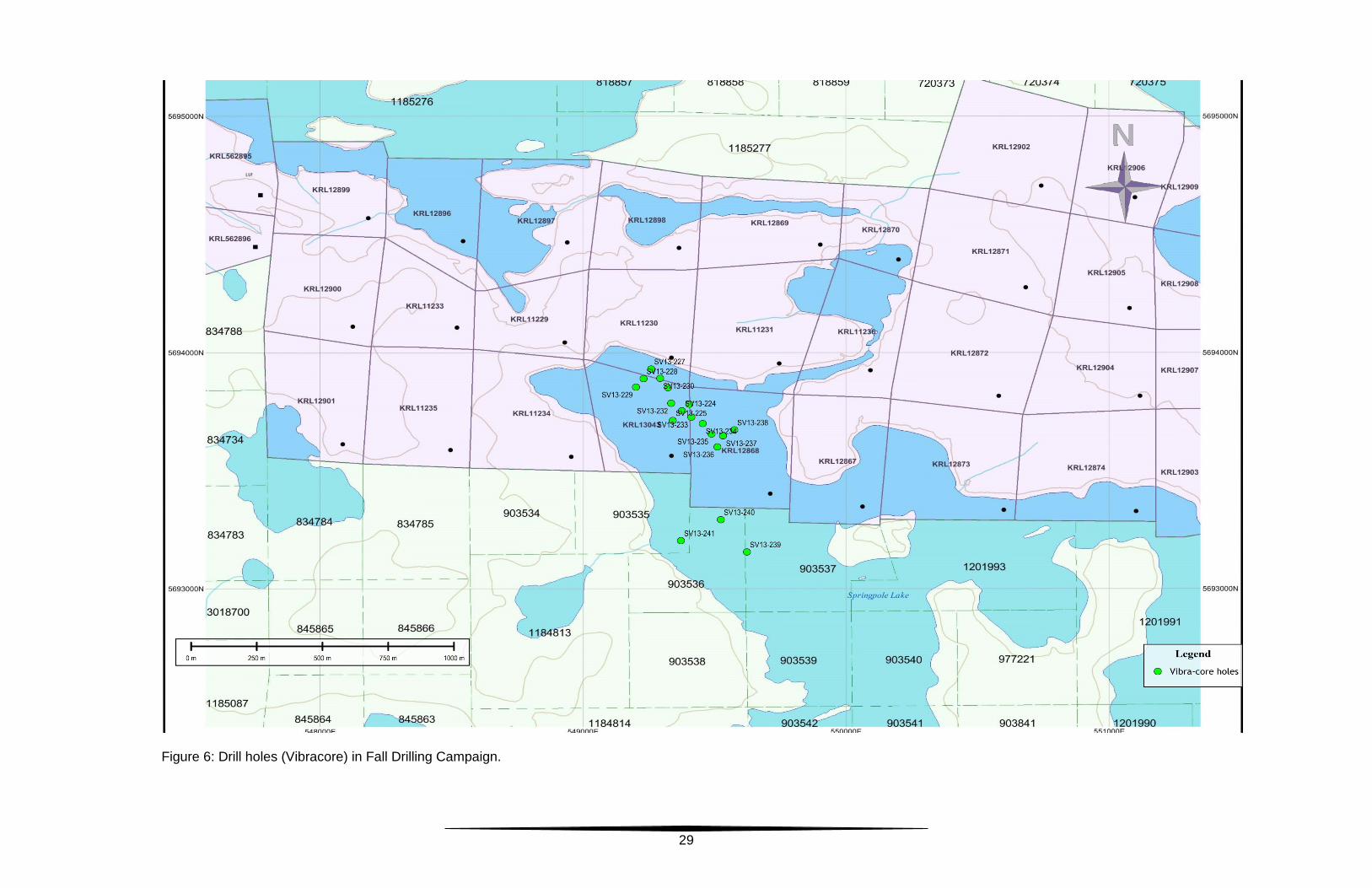
29
Figure 6: Drill holes (Vibracore) in Fall Drilling Campaign.

30
The interval of till from 39.6 meters to 46.6 meters (7.0 meters) has an average grade of 0.76 g/t Au and 0.86 g/t Ag.
• SV13-227: Coordinates: 549260E, 5693930N; Depth of Hole: 33.5 meters. Water depth is 14.6 meters. From 14.6 meters to 15.2 meters is high organic material. From 15.2 to 33.5 meters is bouldery till.
• SV13-228: Coordinates: 549231E, 5693889N; Depth of Hole: 40.1 meters. Water depth is 23.5 meters. From 23.5 meters to 28.0 meters is high organic material. From 28.0 meters to 38.5 meters is light grey clay with occasional thin interbeds of fine grained white sand. From 38.5 meters to 40.1 meters is bouldery till.
• SV13-229: Coordinates: 549202E, 5693853N; Depth of Hole: 43.3 meters. Water depth is 24.7 meters. From 24.7 meters to 29.6 meters is highly organic material…an entire leaf was preserved near 28.0 meters. From 29.6 meters to 40.2 meters is light gray clay with increasing amounts of very fine grained sand. From 40.2 meters to 43.3 meters is bouldery till.
• SV13-230: Coordinates: 549294E, 5693890N; Depth of Hole: 41.2 meters. Water depth is 18.0 meters. From 18.0 meters to 23.5 meters is light to medium gray clay. There was no high organic material. From 23.5 to 35.0 meters is bouldery till. Very weathered, alkaline intrusive bedrock was intersected at 35.0 meters to the bottom of the hole at 41.2 meters. The bedrock interval from 39.2 meters to 41.1 meters contained anomalously high Ag (8.3 g/t Ag). Between 30.99 meters and 41.1 meters gold assays range from 0.25 g/t Au to 0.49 g/t Au.
• SV13-231: Coordinates: 549324E, 5693851N; Depth of Hole: 34.4 meters. Water depth is 22.3 meters. From 22.3 meters to 24.7 meters is highly organic material with recognizable leaf fragments. From 24.7 meters to 33.5 meters light gray clay with minor 2 cm thick fine grained sandy layers. From 33.5 meters to 34.4 meters is bouldery till.
• SV13-232: Coordinates: 549336E, 5693785N; Depth of Hole: 56.4 meters. Water depth is 24.1 meters. From 24.1 meters to 28.6 meters is highly organic material. From 28.6 meters to 37.2 meters is grey clay with occasional very fine grained sand layers. From 37.2 meters to 56.4 meters, no core was recovered.
• SV13-233: Coordinates: 549413E, 5693726N; Depth of Hole: 43.3 meters. Water depth is 23.5 meters. From 23.5 meters to 27.4 meters is dark brown highly organic material. From 27.4 meters to 34.4 meters is gray clay. From 34.4 meters to 43.3 meters is medium grained silty/sandy till.
• SV13-234: Coordinates: 549456E, 5693699N; Depth of Hole: 48.8 meters. Water depth is 21.6 meters. From 21.6 meters to 25.1 meters is dark brown highly organic material. From 25.1 meters to 29.0 meters is light to medium gray clay. From 29.0 meters to 48.8 meters, no core was recovered.
• SV13-235: Coordinates: 549490E, 5693655N; Depth of Hole: 31.5 meters. Water depth is 17.6 meters. From 17.6 meters to 20.0 meters is dark brown highly organic material. From 20.0 meters to 24.4 meters is light
31
gray clay. From 24.4 meters to 31.5 meters is sandy till, which ranges from poorly sorted to well sorted.
• SV13-236: Coordinates: 549512E, 5693600N; Depth of Hole: 38.1 meters. Water depth is 17.7 meters. From 17.7 meters to 22.1 meters is dark brown highly organic material. From 22.1 meters to 25.1 meters is light gray clay. From 25.1 meters to 38.1 meters no core was recovered.
• SV13-237: Coordinates: 549533E, 5693647N; Depth of Hole: 24.5 meters. Water depth is 13.4 meters. From 13.4 meters to 16.0 meters is very fine grained light gray clay. From 16.0 meters to 24 meters is sandy till with occasional well-rounded pebbles. Near the bottom of this interval, the till is coated in iron oxides. Moderately decayed, strongly sericite altered alkaline intrusive was intersected from 24.0 meters to 24.5 meters. A grab sample of the bedrock assayed 0.56 g/t Au.
• SV13-238: Coordinates: 549576E, 5693672N; Depth of Hole: 15.0 meters. Water depth is 6.6 meters. From 6.6 meters to 10.0 meters is light gray clay and very fine grained sand. No core was recovered from 10.0 meters to 15.0 meters.
• SV13-239: Coordinates: 549624E, 5693155N; Depth of Hole: 43.3 meters. Water depth is 32.7 meters. From 32.7 meters to 36.4 meters is dark brown highly organic material. From 36.4 meters to 43.1 meters is light gray clay. From 43.1 to 43.3 meters is gritty light gray clay that has andesite fragments that contain cubic pyrite.
• SV13-240: Coordinates: 549525E, 5693292N; Depth of Hole: 31.3 meters. Water depth is 25.9 meters. From 25.9 meters to 28.8 meters is dark brown highly organic material. From 28.8 meters to 31.3 meters is gray clay. Drilling difficulties were encountered at 31.3 meters that prevented penetrations below 31.3 meters.
• SV13-241: Coordinates: 549373E, 5693203N; Depth of Hole: 32.6 meters. Water depth is 24.7 meters. From 24.7 meters to 28.7 meters is dark brown highly organic material. From 28.7 meters to 32.5 meters is light gray clay. From 32.5 meters to 32.6 meters is fine to coarse grained sand.
5.1.5.3. Discussion, Comments and Conclusions:
Eighteen holes were drilled using this new technique. Good recovery of soft sediments and till was accomplished; in three holes, bedrock was recovered. The recovery using the Vibracore was good, except that the entire sample was lost from three holes because it slid out of the drill rods as they were being pulled from the hole. These holes established that the Portage zone is covered with up to 71 meters of soft clay lake bottom sediments and till. Table 3 below summarizes the results.

32
Table 3: Vibracore Drilling Results.
Sample material Holes intersecting Average depth (m) Depth Range (m) Water 18 21.5 6.6 to 32.7
High Organics 14 3.7 0.0 to 4.9 Clay 17 6.0 0.0 to 10.6 Till 14 8.7 6.0 to 31.7
Bedrock 3 N/A 0.3 to 6.2
Grab samples were taken from the recovered material from this drilling and submitted to SGS Laboratories in Red Lake, ON. These were assayed by fire assay for Au and Ag and by multi-element ICP methods. See assay results in Appendix D. The primary reason that this drilling program was developed and undertaken was to explore the “zone of poor recovery” for mineralized alkaline bedrock that had high Au and Ag grades. Unfortunately, this program firmly established that the zone between lake bottom and the top of bedrock is essentially barren of any Au and Ag mineralization.
5.2 Geotechnical and Structural Geological Program:
SRK Consultants (Canada) were hired to supervise the geotechnical and structural geological program. This program was conducted at two separate times of the year, but data collected from each part were melded into one final report by Nagy (SRK, 2013) that is attached hereto as Appendix E.
5.2.1. Geotechnical Program:
During the Winter drilling program, two SRK geotechnical engineers were on site to train, assist and supervise the drilling crews and Gold Canyon geologists: • to assure proper recordation of the data; and • to conduct QA/QC of the general work completed. The seven drill holes in the winter campaign were drilled using HQ3 equipment (triple tube) and Reflex ACT 2 orientation tools. A brief description of the drilling procedures follows: • The drill rigs were positioned at the collar location and properly oriented for
azimuth and inclination. • PQ casing was “slung” (supported by cables from the surface to maintain the
proper inclination angle for the drill hole) to the lake bottom. • HW casing was then lowered and drilled until bedrock was encountered.

33
• HQ3 drilling commenced from the first bedrock, using five-feet long core barrels equipped with metal split tubes. Where the bedrock was competent, the Reflex orientation tools were also engaged.
• At the end of each five foot run, the core inner tube was retrieved. • The split tubes were carefully extruded using water pressure. When the split
tubes first emerged, they were wrapped with electrical tape (or similar tape) to prevent the tubes from opening and disturbing the core.
• The split tubes were taken to a “mobile core shack” located adjacent to the drill rig for logging at the rig site.
• The geologists/geotech engineers placed the split tube on an angle iron trough to support the tubes. The securing tape was cut; the top metal split tube was carefully removed so the core was not disturbed.
• A photograph of the core was immediately taken to record it in its “undisturbed” condition.
• The geologists/geotech engineers then measured the core recovered in the split tube; recorded each joint, fracture and fault as to its location, orientation and angle with regard to the core axis. If the core was competent and the orientation tool was in use, the alpha and beta angles were recorded. The roughness, fracture filling (coating) and other pertinent engineering features of each fracture were recorded. The RQD (rock quality data) and recovery were calculated.
• After the data had been recorded, the core was then carefully “slid” out of the bottom split into a core box. When full, the core box was taped shut, and carefully transported back to the main core shack.
• At no time during this procedure was the core allowed to freeze, and extra care was taken to prevent rough handling and rough transportation methods.
• After the engineers had finished their examination work of the core, Gold Canyon geologists logged the lithology, marked the core for sampling and attached sample tags.
• The core was then photographed according to the routine procedures. • The core was sawn in half, half of the core placed in sample bags with the
appropriate sample tag, the bags marked with the sample numbers. The remaining half of the core was placed in the core box and stored in the core library at Springpole Lake.
• The samples were grouped into batches and submitted for Au and Ag assaying at SGS Laboratories facilities in Red Lake, ON.
One of the objectives of this geotechnical program was to obtain data regarding the actual orientation (strike and dip) of faults, shear zones, joints, foliation, etc. in the rocks that were intersected in the seven drill holes. Nagy used these data to direct much of his structural geological modeling. These data defined several fault offsets of the Portage Deposit that can now be used to guide additional exploration in areas where previous geological understanding was limited and poorly understood.

34
5.2.2. Structural Geological Program: The structural geological program started during September 2013, when three structural geologists from SRK Consulting spent a total of 18 person-days at Springpole. Based upon available data, SRK personnel conducted targeted geological mapping, structural observations, and re-logging of 18 drill holes. Surface observations were then integrated with regional 2D data sets and historic geological mapping to determine the location of major structures in the Springpole area. Observations and interpretations made in 2D were subsequently integrated in Leapfrog™ to model structures in 3D. The 3D data included data from the Springpole drill hole database, from the 18 drill holes re-logged by SRK and from oriented core data gathered during the Winter drilling program. The drill hole observations made by SRK were used to complement and validate the Springpole drill hole database. The following drill hole data fields were used to define the modelled structures: RQD, lithology, argillic alteration, and structure (faults and shear zones). Observations from a previous structural interpretation (SRK 2011) were also considered throughout the 3D modelling process. The conclusions from Nagy’s internal memo (SRK, 2013) (attached as Appendix E) are considered a good summary of the structural geology of the Springpole Gold Project, and are quoted here; (see Figure 7). “The key conclusions from the structural modelling of the Springpole Project are: A total of 17 shear zones and faults were modelled, including: • Five medium confidence and one very low confidence, northwest-striking,
steep-dipping early shear zones that bound the northeast and southwest extent of the weak zones;
• Two medium, one low and two very low confidence, west-striking, steep-dipping brittle faults that bound the north and south extents of the weak zones. These faults are younger than the northwest-striking shear zones, and older than the southwest-striking faults;
• Two medium confidence, young southwest-striking, steep-dipping brittle faults that offset the northwest- and west-striking faults, and the weak zones; and
• Four very low confidence, southeast-, south-, and northeast- striking faults that bound and/or offset the indicated resource but are not observed in any other data set.
A total of five weak zones, characterized by advanced argillic alteration, gold mineralization, and very low RQD values (e.g., <10%) were modelled, including: • Three high confidence, northwest-striking, steep-dipping zones, bounded to the
northeast and southwest by northwest-striking shear zones, and to the north

35
and south by west-striking brittle faults. These zones are offset by southwest-striking brittle faults; and
• Two medium confidence, northwest-striking, shallow-dipping zones in the south of the deposit that are bound to the north by a west-striking fault.
Many faults and shear zones (e.g. SW2, W2, W3, W4, W5, EL1, EL2, EL3, and EL4) (see Figure 4) are modelled from offsets in low RQD zones and gold mineralization. As a result, the thicknesses of fault zones are poorly constrained; A total of six structural domains bounded by steep-dipping west- and southwest-striking brittle faults can be defined;
Figure 7: Modeled Structures and other structural information overlain on topography and bathymetry.

36
The orientation and distribution of modelled structures represents a reasonable interpretation of the geology of the Springpole project.” Nagy’s recommendations for further structural work are quoted below:
“SRK recommends the following actions be undertaken to improve the Springpole structural model: • Geological modelling of major lithologies to test and refine the modelled
structural framework; • Photo relogging/photo verification of uncut core at potential fault intersections
to better constrain the character and thickness of damage zones, and the spatial distribution of faults;
• Oriented geotechnical drilling to test the spatial distribution, and characteristics of modelled faults. Drilling locations should be outside of the weak zone and oriented towards the southeast to test southwest- and west-striking faults. Additional drilling outside of the weak zones and oriented towards the southwest should be considered to test northwest-striking shear zones. SRK proposes the following two drill holes: o Drill hole SRK-01: 549286E 5693570N, dip of 40 degrees, dip azimuth of
135 degrees, depth of 500 metres; and o Drill hole SRK-02: 549440E 5693977N, dip of 40 degrees, dip azimuth of
130 degrees, depth of 525 metres. • Ongoing assessment and refinement of the structural model to improve the
orientation and distribution of modelled faults, and to identify any additional fault orientations.”
5.2.2.1. Discussion, Comments and Conclusions: Gold Canyon geologists recognized that the Portage Deposit has undergone considerable structural disruption. Nagy’s report demonstrates the major faults and shear zones, but Nagy did not address in any depth, the direction of movements of the various structural domains of the Portage deposit. Additional work is needed to determine the gross relative movements to aid exploration. During the 2012 drilling program, Gold Canyon geologists recognized that rocks in the southeast portion of the Portage Deposit appear to be greenstones rather than alkaline intrusives and the mineralization is lower grade. Nagy’s SW2 shear zone could explain this major change in lithology and mineralization. A rather obvious feature of Nagy’s work, although he does not address this, is the apparent right lateral movement along shear zone SW2, based solely on the W1 to W5 fault alignments. There is no direct evidence of this movement, but given the change in lithology and the displacement of the east-west faults it is a possibility.
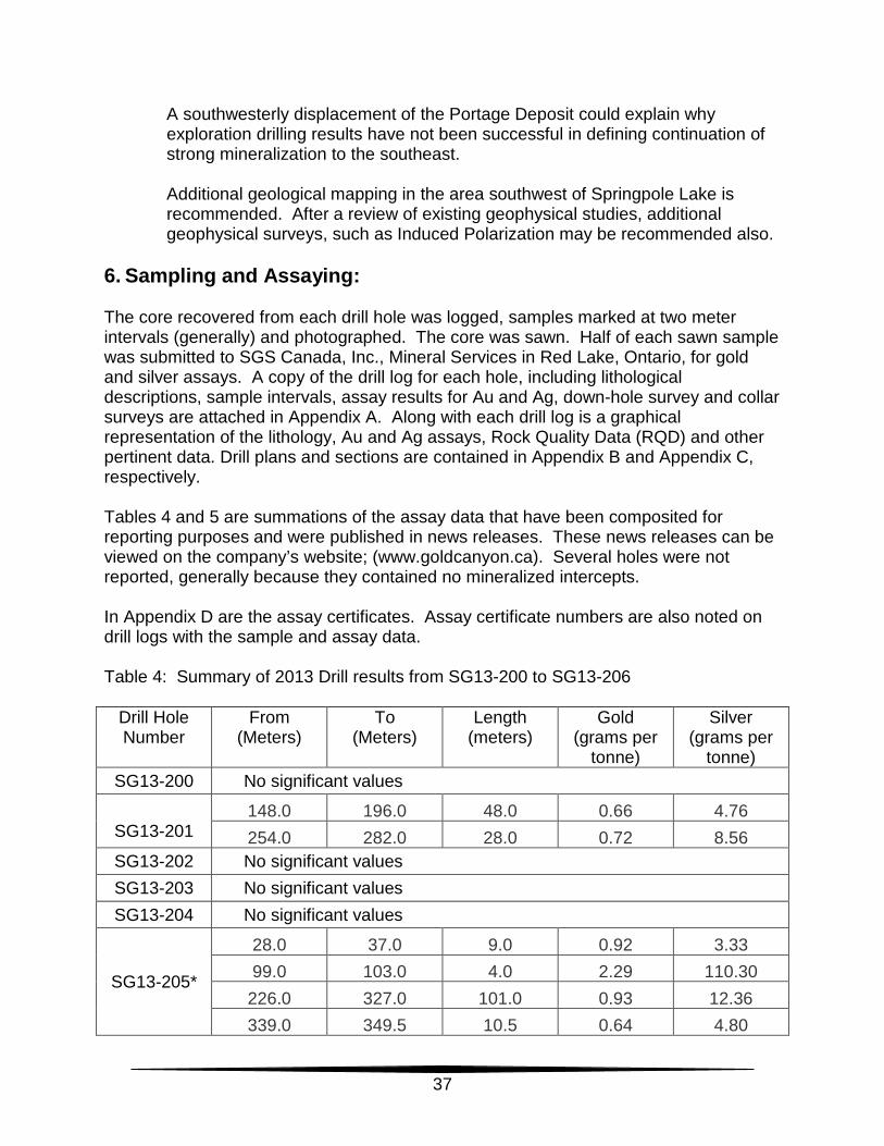
37
A southwesterly displacement of the Portage Deposit could explain why exploration drilling results have not been successful in defining continuation of strong mineralization to the southeast. Additional geological mapping in the area southwest of Springpole Lake is recommended. After a review of existing geophysical studies, additional geophysical surveys, such as Induced Polarization may be recommended also.
6. Sampling and Assaying: The core recovered from each drill hole was logged, samples marked at two meter intervals (generally) and photographed. The core was sawn. Half of each sawn sample was submitted to SGS Canada, Inc., Mineral Services in Red Lake, Ontario, for gold and silver assays. A copy of the drill log for each hole, including lithological descriptions, sample intervals, assay results for Au and Ag, down-hole survey and collar surveys are attached in Appendix A. Along with each drill log is a graphical representation of the lithology, Au and Ag assays, Rock Quality Data (RQD) and other pertinent data. Drill plans and sections are contained in Appendix B and Appendix C, respectively. Tables 4 and 5 are summations of the assay data that have been composited for reporting purposes and were published in news releases. These news releases can be viewed on the company’s website; (www.goldcanyon.ca). Several holes were not reported, generally because they contained no mineralized intercepts. In Appendix D are the assay certificates. Assay certificate numbers are also noted on drill logs with the sample and assay data. Table 4: Summary of 2013 Drill results from SG13-200 to SG13-206
Drill Hole Number
From (Meters)
To (Meters)
Length (meters)
Gold (grams per
tonne)
Silver (grams per
tonne) SG13-200 No significant values
SG13-201
148.0 196.0 48.0 0.66 4.76 254.0 282.0 28.0 0.72 8.56
SG13-202 No significant values SG13-203 No significant values SG13-204 No significant values
SG13-205*
28.0 37.0 9.0 0.92 3.33 99.0 103.0 4.0 2.29 110.30
226.0 327.0 101.0 0.93 12.36 339.0 349.5 10.5 0.64 4.80

38
SG13-206
including
68.0 91.5 23.5 1.27 4.56 108.0 175.0 67.0 1.94 2.94 145.0 153.0 8.0 4.44 6.35 241.0 255.0 14.0 1.28 2.44 277.0 289.0 12.0 1.33 1.87
* Drill hole ended in mineralization. Table 5: Summary of 2013 Drill Results from SP13-207 to SP13-223.
Drill Hole Number
From (Meters)
To (Meters)
Length (meters)
Gold (grams per
tonne)
Silver (grams per
tonne)
SP13-207*
including including
including including
70.5 89.6 19.1 0.61 4.63 98.0 137.5 39.5 6.51 18.00
116.0 127.0 11.0 22.04 35.09 119.0 125.0 6.0 36.31 47.20 147.0 157.0 10.0 0.75 0.57 182.0 224.0 42.0 3.11 24.91 186.0 196.0 10.0 4.28 29.20 215.0 224.0 9.0 5.54 49.56
SP13-208*
including
116.0 136.0 20.0 1.55 6.19 134.0 136.0 2.0 6.22 0.40 144.0 152.0 8.0 0.78 8.08
SP13-209
92.0 109.0 17.0 1.47 0.52 121.0 161.0 40.0 0.60 0.96 171.0 175.0 4.0 1.04 1.80 191.5 199.0 7.5 0.81 0.36
SP13-210* 103.0 109.0 6.0 1.21 1.20 157.0 200.0 43.0 1.17 3.46
SP13-211*
including including
73.0 158.0 85.0 2.13 4.21 91.0 93.0 2.0 10.91 9.60
143.0 150.0 7.0 4.15 9.17
SP13-212
including
72.0 86.0 14.0 0.79 0.95 102.0 122.0 20.0 3.61 6.05 102.0 104.0 2.0 12.78 14.20 120.0 122.0 2.0 16.66 20.20

39
including 160.0 172.0 12.0 0.87 1.11 SP13-213 51.0 86.0 35.0 0.77 8.68
SP13-214 81.0 87.0 6.0 0.68 3.22 121.0 123.0 2.0 1.90 19.40
SP13-215 153.0 155.0 2.0 2.54 5.70
SP13-216 56.0 110.0 54.0 1.05 4.48 122.0 150.0 28.0 0.87 3.04
SP13-217 140.0 160.0 20.0 0.53 2.06 190.0 242.0 52.0 0.97 4.19
SP13-218 78.0 100.0 22.0 0.93 1.61
SP13-219 50.0 56.0 6.0 1.02 15.42 114.0 120.0 6.0 2.08 13.67
SP13-220 58.3 107.7 49.4 0.91 1.38 SP13-221 157.0 173.0 16.0 0.47 2.51 SP13-222 No significant values SP13-223 No significant values
* Drill hole ended in mineralization. 7. Use of Diamond Drilling and Assay Results: In March 2012, Arseneau published a NI-43-101 compliant resource estimate using all of the drilling and assay data from 1986 to the end of 2011 (through drill hole SP11-107), (“Independent Technical Report for the Springpole Gold Project, NW Ontario, Canada: March 21, 2012). The results of this estimate were as follows: Table 6: Mineral Resources (March 2012)
Classification
Tonnage (million metric
tonnes)
Gold grade (g/t)
Silver grade (g/t)
Gold Contained
(million troy
ounces)
Silver Contained (million troy
ounces)
Indicated 30.0 1.26 5.0 1.22 4.82 Inferred 60.0 1.27 6.0 2.45 11.58
Notes: (1) 1 troy ounce = 31.103 grams. (2) Cut-off grade of 0.4 grams Au per tonne gold.
Following the completion of the 2012 drilling program, Arseneau updated the March 2012 estimate in October 2012 (Arseneau, 2012a), which is summarized below:

40
Table 7: Mineral Resources (October 2012)
Category Quantity Grade Au
Grade Ag
Contained Metal Au
Contained Metal Ag
Million tonnes g/t g/t Million Oz Million Oz Indicated 128.2 1.07 5.7 4.41 23.8 Inferred 25.7 .083 3.2 0.69 2.7
As can be seen by comparing these tables, a large increase in tonnes and contained ounces of Au and Ag was the result of the 2012 drilling program. Using the updated NI-43-101 resource estimate, SRK Consulting (Canada) Inc, led by Arseneau, completed a NI-43-101 compliant Preliminary Economic Assessment in March 2013, “Preliminary Economic Assessment for the Springpole Gold Project, Ontario, Canada” (Arseneau, 2013). In this study, economic factors such as metallurgical recoveries, mining and processing costs, capital costs were considered. As a result of these modifications, the following resources are considered to be economic using the factors established in the report. Table 8: Process tonnes and ounces contained.
Description Unit Value Process Feed Material Tonnes 72,400,000
Diluted Au Grade (mill head grade) g/t 1.19 Contained Au Ounces 2,777,000
Diluted Ag Grade (mill head grade) g/t 6.01 Contained Silver Ounces 13,991,000
Modified from Table iii, page viii. 8. Conclusions and Recommendations: In the Preliminary Economic Study, the authors recommended the following:
“SRK believes the project should be taken to the next level of engineering study and economic assessment, typically a pre-feasibility study. It is estimated that a pre-feasibility, along with all of the accompanying engineering and field work would cost approximately $5M (excluding additional resource development drilling programs). Some of the activities involved to advance the project include: • Additional metallurgical test work; • Initiate project permitting; • Consummate agreements with First Nations groups; and • Convert remaining inferred resources to indicated resources.”


43
Bibliography:
Armstrong, T., Puritch E., and Yassa, A., 2006, Technical Report and Resource Estimate on the Springpole Lake Gold Property, Red Lake Mining Division, Northwestern Ontario for Gold Canyon Resources Inc., P&E Mining Consultants.
Arseneau, G., 2012, Independent Technical Report for the Springpole Gold Project,
NW Ontario, Canada; 43-101 report commissioned by Gold Canyon Resources Inc., Vancouver, BC: 175 p. SRK Consultants.
Arseneau, G., 2012 a, Mineral Resource Update for the Springpole Gold Project, NW
Ontario, Canada, 198 p. SRK Consultants. Barnett, R., 1996, Petrographic Electron Microprobe Investigation of Selected Samples
from the Springpole Gold Project for Santa Fe Canadian Mining Limited. Unpublished company technical report.
Barron, K. M., 1996, The petrological and metallogenic significance of the alkaline
igneous centre at the Springpole gold prospect, northwestern Ontario: PhD. Thesis for Department of Earth Sciences, University of Western Ontario, London, Ontario.
Camier, W. J., 2012 (1), Assessment Report for 2010 Summer Drilling Program on Gold
Canyon Resources Inc., Springpole Gold Project Red Lake District NTS Sheet 52N08, UTM WGS84 Zn 15N, NW Ontario. Assessment report submitted to OGS for assessment credit July, 2012. Gold Canyon Resources Inc., Vancouver BC.
Camier, W. J., 2012 (2), Assessment Report for Diamond Drill Holes SP11-040 through
SP11-054, Springpole Gold Project Winter Drilling Program (2011) Gold Canyon Resources Inc., Red Lake District, NW Ontario, NTS Sheet 52N08, UTM WGS84 Zn 15N. Assessment report submitted to OGS for assessment credit October, 2012. Gold Canyon Resources Inc., Vancouver BC.
Camier, W. J., 2012 (3), Assessment Report for Diamond Drill Holes SP11-100 through
SP11-109, Springpole Gold Project 2011 Drill Program, Gold Canyon Resources Inc., Red Lake District, NW Ontario, NTS Sheet 52N08, UTM WGS84 Zn 15N. Assessment report submitted to OGS for assessment credit October, 2012. Gold Canyon Resources Inc., Vancouver BC.
Carman, G. D., 2003, Geology, mineralisation and hydrothermal evolution of the
Ladolam gold deposit, Lihir Island, Papua New Guinea: Society of Economic Geologists, Special Publication No. 10, p. 247-284.
44
Devaney, J. R., 2001, Stratigraphy of epiclastic and volcaniclastic facies units, northern Birch-Uchi greenstone belt, Uchi Subprovince; Ontario Geological Survey, Open File Report 6030, 49 p.
Devaney, J. R., 2001, Sedimentology and volcanology of selected tectonized
stratigraphic units, southern Birch-Uchi greenstone belt, Uchi subprovince: Ontario Geological Survey, Open File Report 6031, 47 p.
Roberts, A. R., 2010, Springpole Project Summary Report on Exploration Activities Fall
2009 through Winter 2010; Assessment Report, Gold Canyon Resources Inc., Vancouver, BC.
Sanders, R., and McIntosh, A., 2010 (1), Petrographic Analysis of Selected Core
Samples, Springpole Property, Ontario. Internal Report, Gold Canyon Resources Inc.
Sanders, R., and McIntosh, A., 2010 (2), Petrographic Analysis of Selected Core
Samples, Springpole 2010 Winter Core Program. Internal Report, Gold Canyon Resources Inc.
SRK Consulting (Canada) Inc., 2011. Springpole Project Structural Investigation, by J.
F. Ravenelle; Internal report prepared for Gold Canyon Resources Inc. December, 2011.
SRK Consulting (Canada) Inc. 2013. Preliminary Economic Assessment for the
Springpole Gold Project, Ontario, Canada. SRK Consulting (Canada) Inc., 2013, Technical Memorandum; Structural Model of
Springpole Project, by C. Nagy; Internal report prepared for Gold Canyon Resources, Inc.; December 2013. (This document is attached as Appendix E)
Zabev B., 2004: Technical Report on the Springpole Lake Property, Red Lake Mining
Division, NW Ontario for Gold Canyon Resources Inc

Appendix A
Drill logs and graphic representation for each hole

Appendix B
Drill Plans, showing hole traces
Appendix C
Drill sections
Appendix D
SGS (Canada) Inc. Assay Certificates.

Appendix E
Technical Memorandum; Structural Model of Springpole Project, by C. Nagy