the geological circuit of the four structural domains: the ... · the geological circuit of the...
TRANSCRIPT

Fie
ld T
rip
Gu
ide B
oo
k -
B1
5
Florence - ItalyAugust 20-28, 2004 Pre-Congress B15
32nd INTERNATIONAL GEOLOGICAL CONGRESS
THE GEOLOGICAL CIRCUIT OF THE FOUR STRUCTURAL DOMAINS:THE RIF, THE MESETA, THE ATLASES, AND THE ANTI-ATLAS
Leaders: B. Tadili, L. Ait Brahim
Associate Leaders: A. Chalouan, H. El Hadi, B. Fedan, A. Tahiri
Volume n° 1 - from PR01 to B15
B15_copertina_R_OK C 28-05-2004, 19:26:48

The scientific content of this guide is under the total responsibility of the Authors
Published by: APAT – Italian Agency for the Environmental Protection and Technical Services - Via Vitaliano Brancati, 48 - 00144 Roma - Italy
Series Editors:Luca Guerrieri, Irene Rischia and Leonello Serva (APAT, Roma)
English Desk-copy Editors:Paul Mazza (Università di Firenze), Jessica Ann Thonn (Università di Firenze), Nathalie Marléne Adams (Università di Firenze), Miriam Friedman (Università di Firenze), Kate Eadie (Freelance indipendent professional)
Field Trip Committee: Leonello Serva (APAT, Roma), Alessandro Michetti (Università dell’Insubria, Como), Giulio Pavia (Università di Torino), Raffaele Pignone (Servizio Geologico Regione Emilia-Romagna, Bologna) and Riccardo Polino (CNR, Torino)
Acknowledgments:The 32nd IGC Organizing Committee is grateful to Roberto Pompili and Elisa Brustia (APAT, Roma) for their collaboration in editing.
Graphic project:Full snc - Firenze
Layout and press:Lito Terrazzi srl - Firenze
B15_copertina_R_OK D 27-05-2004, 7:38:23
Florence - ItalyAugust 20-28, 2004
Pre-Congress
B15
32nd INTERNATIONAL GEOLOGICAL CONGRESS
THE GEOLOGICAL CIRCUIT OF THE FOUR STRUCTURAL DOMAINS:
THE RIF, THE MESETA, THE ATLASES, AND THE ANTI-ATLAS
AUTHORS:B. Tadili (Département de Physique du Globe, Institut Scientifique)L. Ait Brahim (Département de Géologie, Faculté des Sciences, Rabat),A. Chalouan (Département de Géologie, Faculté des Sciences, Rabat),H. El Hadi (Département de Géologie Faculté des Sciences, Casablanca),B. Fedan (Département de Géologie, Institut Scientifique, Rabat),A. Tahiri (Département de Géologie, Institut Scientifique, Rabat)
Volume n° 1 - from PR01 to B15
B15_R_OK A 27-05-2004, 7:44:20

Front Cover:Overlapping of the calcareous ridge on the Tangier Unit (RIF)
B15_R_OK B 27-05-2004, 7:44:22

THE GEOLOGICAL CIRCUIT OF THE FOUR STRUCTURAL DOMAINS:THE RIF, THE MESETA, THE ATLASES, AND THE ANTI-ATLAS B
15
3 - B15
Vo
lum
e n
° 1
- f
rom
PR
01
to
B1
5
Leaders: B. Tadili, L. Ait BrahimAssociate Leaders: A. Chalouan, H. El Hadi, B. Fedan, A. Tahiri
Introduction This geological circuit has a pluri-disciplinary aspect (Stratigraphy, Palaeontology, Petrography and Tectonics-Geodynamics) for the fact that it crosses great structural domains that have recorded the Pan- African, Precambrian and Alpine (Atlasic and Rifain) orogeny. They are represented by deposits dating back more than 2 billion years. The structural domains are as follows: the Anti-Atlas and African Craton with the ophiolitic complex and the Pan-African orogeny around 685 MA associated to the closing of an ocean and continental collision (folds, overlapping, magmatic rocks, etc.;, the mesetian domain with Shoul block that have recorded the Caledonian compression in Morocco, and the Hercynian orogeny also recorded in the rest of Western Europe (folds, overlapping, magmatic rocks, etc.); the Atlasic Domain with intra-continental chains of High and Middle Atlas with rocks dating from Triassic to current; Mesozoic deformations syn- and post-rifting, and rising of the
Neogenous relief (folds, faults, slopes, etc.) with mount Toubkal which rises to 4167m; and fi nally the Rifain Domain, a part of the Mediterranean alpine chain made up of Palaeozoic tectonical and metamorphic nappes (gneiss, kinzigites, etc.) and of ultra-basic rocks (peridotites, etc).The circuit also contains pleasant landscapes (cedar forests, lakes, gorges, dunes, etc.), historical monuments (the Roman City of Volubilis, 3rd century BC, the Mausoleum of Moulay Ismail, contemporary to Louis XIV, Tour Hassan and the Mausoleum of Mohammed V, the Mosque of Koutoubia built in 1147) as well as high–category Hotels.
Field itineraryDAY 1
Tanger - Tétouan - Chaouène
Transportation 4 x 4 carsOvernight location ChaouèneAccommodations Hotel Asmaa ****
Geological circuit
B15_R_OK 3 27-05-2004, 7:51:20

Vo
lum
e n
° 1
- f
rom
PR
01
to
B1
5
B15 -
Leaders: B. Tadili, L. Ait Brahim
B1
5
Stop 1:Across the valley of TétouanPanoramic view of the Internal Rif and its contact with the fl ysch nappes and the External Rif. The ‘Dorsale calcaire’ complex, with its imposing relief, consists of stacked carbonate slabs, made of Upper Triassic-Liassic platform to passive margin deposits with a thin cover of Jurassic-Upper Cretaceous pelagic and Tertiary detrital sediments. The Paleozoic Ghomaride
nappes are represented by low hills occupying the space located between the Dorsale calcaire and the Alboran sea. The Sebtide metamorphic units appear in the Koudiat Taifor-Cabo Negro hill (gneisses and micaschists). The Martil plain, fi lled by Pliocene marl-sand deposits, was a subsiding basin opened by Pliocene normal faults.
Stop 2:Azla NorthHere, We start a “cup cross the continental Curst and the upper Mantle”. The fi rst stops (Azla to Zaouia) are located in the middle and upper crust (Palozoic Ghomaride nappes), the next, between Zaouia and Bou Ahmed, are located in the lower crust (schists, micaschists and gneiss of Sebtide). The Beni Bousera stops will show the ultramafi c rocks of upper mantle emplaced as tectonic sliver during the Paleogene subduction/ collision process, at the expense of the infracontinental lithospheric mantle uplifted to upper crustal levels during the tethyan rifting (the Moho discontinuity is missing). The Azla north stop shows the Pliocene post-nappe formations of the internal Rif. The subhorizontal (undeformed) yellow sandy marls of the low Pliocene are discordant on Ghomaride nappes. This
Structural Domains
Overlapping of the calcareous ridge on the Tangier Unit (RIF)
B15_R_OK 4 27-05-2004, 7:51:25

THE GEOLOGICAL CIRCUIT OF THE FOUR STRUCTURAL DOMAINS:THE RIF, THE MESETA, THE ATLASES, AND THE ANTI-ATLAS B
15
5 - B15
Vo
lum
e n
° 1
- f
rom
PR
01
to
B1
5
stop also allows us to see coastal degradation due to the combined effect of regional sinking and sea advance.
Stop 3:Azla South -Kaâ Mazari-An outcrop of Trias red detrital sediments affected by syn-sedimentary normal faults and by reverse faults associated to overlaps of carboniferous turbidites slivers.
Stop 4:Panoramic view of Ras AakaïliA panoramic view of the tectonic units of the internal Rif (The three Ghomarides nappes, Sebtides units, Dorsale calcaire, Martil Plain, Jbel Zem zem…). The stop is located on the Devonian limestone of Aakaili nappe (Figure 1).
Figure 1 - Ras Aakaili- Panoramic view (Chalouan, 1994)
Stop 5:Low-angle normal fault of Cape ZaouiaThis stop shows an interesting extensional fault between the Palaeozoic Aakail nappe and the Filali micaschist (Figure 2). This contact, which was interpreted as a thrust, has a 30° NW dip and is underlined by a tectonic breccia impregnated with malachite and azurite mineralization. Then, the Aakaili directly superimposes the micaschists and this fault causes suppression of the three Federico units. The foliation seen in the Ordovician-Silurian
schist has an Eo-Variscan age, that in the micaschist is alpine.
Stop 6:The micaschists of TarerhaThe micaschists belong to the lowest Sebtides (Filali units). They are a monotonous series however, with some basic rock intercalations and quartz pegmatitic veins with pink andalusite. The micaschists contain minerals deriving from different parageneses, such as garnet, biotite, muscovite, sillimanite, andalusite, kyanite, staurolite, plagioclase, potash feldspar and quartz. The foliation (S2) is associated to isoclinal folds which constitute their axial plain. This foliation carries a NNW-SSE trending stretching lineation. The latter is underlined by preferential oriented micas and andalusite or by pressure shadow around garnet minerals. The main foliation and the
stretching lineation developed contemporaneously with retromorphic minerals and are associated to dominant top-to-N kinematic indicators. These structures are overprinted by crenulation folds trending parallel to the local antiform axis (here, Beni Bousera antiform), i.e. roughly parallel
to the stretching lineation. These structurally recorded tectonic-metamorphic phases are labelled II and III. Phase I corresponds to the subduction event responsible for the HP-LT conditions observed in the Beni Mezala (highest Sebtides) and various Alpujarride units. Phase IV refers to the extensional tectonics which initiated under HT-LP conditions (emplacement of anatectic dykes) and then operated decreasing T in brittle conditions (i.e. Zaouia low-angle normal fault; previous stop). In regard to P/T alpine metamorphic conditions of these rocks, T calculations give conditions ranging from 530°C at the top to 780°C at the bottom, at a maximum pressure of c. 7 kbar before the late stage of andalusite growth. Isotopic calculations on biotites from both the Filali schists and kinzigites reveal a cluster of K/Ar ages around 22 ± 2 Ma. This age cluster can be viewed as refl ecting a rapid cooling of the deep Sebtides-Alpujarrides units following an Alpine HT-LP climax of metamorphism, close to 750-800°C, 10 kbar.
Stop 7:The Kinzigites of Bou AhmedThe Kinzigites, called also “the metamorphic unit
Figure 2 - Low angle normal fault of Zaouia (Chalouan, 1994)
B15_R_OK 5 27-05-2004, 7:44:49

Vo
lum
e n
° 1
- f
rom
PR
01
to
B1
5
B15 -
Leaders: B. Tadili, L. Ait Brahim
B1
5
or granulite of the Beni Bousera”, overcome the peridotite rocks. They have an average thickness of 100m and they consist of an irregularly alternating of light quartz-feldspathic beds and dark aluminous ones. These gneissic rocks, foliated and compact, describe isoclinal folds whose hinges are stretched and broken so that the rock takes on an augen gneiss aspect. The Kinzigite slivers with garnet-sillimanite ± kyanite-graphite-quartz bearing assemblages and accessorily rutile, zircon and tourmaline, yielded peak P-T conditions in the range of 800-850°C, 9-13 kbar, and locally 760-820°C, > 16 kbar (Bouybaouene et al., 1998). These high pressure relics evoke those of the Variscan inner zones of the European-South Alpine area. Recent petrologic and geochronologic data support this idea, in spite of the strong Alpine overprint which makes it diffi cult to distinguish Variscan versus Alpine assemblages in the pre-Permian rocks (Filali and Beni Bousera units).
Stop 8:The Peridotites of Beni BouseraThe Beni Bousera ultramafi c massif crops out for about 70 km2. It is overwhelmed by the kinzigite unit. On the top, foliation and stretching lineation are similar and parallel to those of the kinzigites. On the
east side, the ultramafi c massif is in contact with the Filali and Ghomarides metasediments through the NNW-SSE trending Beni Bousera high angle normal fault. The stretching lineation developed in this massif shows dominant top-to-NNW kinematic indicators. The peridotite rocks are intruded by post-tectonic leucogranite dykes.Peridotite emplacement: Based on petrologic and (mostly) geochronological arguments, the Beni Bousera-Ronda ultramafi c massifs have been and still are interpreted as hot asthenospheric diapirs emplaced during the Neogene and responsible for the Alpujarride-Sebtide metamorphism (Loomis, 1975; Platt and Vissers, 1989; Blichert-Toft et al., 1999; Montel et al., 2000). As admitted by Vissers et al. (1995) and Chalouan et al. (2001), this is not adequate to account for the occurrence of Alpine HP-LT assemblages in varied Sebtide-Alpujarride rocks, and for their dating at >25-27 Ma (Monié et al., 1991; Montigny et al., 2003). In our view, the Beni Bousera-Ronda lherzolites emplaced as tectonic slivers during the Paleogene subduction/collision process, at the expense of the infra-continental lithospheric mantle uplifted at upper crustal levels during the Tethyan rifting (Reuber et al., 1982; Michard et al., 1991). Indeed, the Ojen eclogites and Ronda pyroxenites
Béni Bouchraa Peridotites Alboran Domain (RIF)
B15_R_OK 6 27-05-2004, 7:51:02

THE GEOLOGICAL CIRCUIT OF THE FOUR STRUCTURAL DOMAINS:THE RIF, THE MESETA, THE ATLASES, AND THE ANTI-ATLAS B
15
7 - B15
Vo
lum
e n
° 1
- f
rom
PR
01
to
B1
5
yielded U-Pb SHRIMP zircon ages between 183 ± 3 and 131 ± 3 Ma which seemingly record the Tethyan extensional event (Sanchez-Rodriguez & Gebauer, 2000). A Sm/Nd age of 235.1 ± 1.7 Ma from Alpujarride garnets may also record the Triassic break-up of Pangea (Argles et al., 1999). To summarize, it seems possible to recognize in the Alpine evolution of the Sebtide units four tectonic-metamorphic stages, with higher P/T gradients in the northern (Beni Mezala) antiform than in the southern (Beni Bousera). During the earlier stage (I), recorded by the blueschist- and eclogite-facies relic assemblages in the Permian-Triassic rocks of the Beni Mezala area, at least part of the Sebtide units were subducted down to a depth of 50-60 km (BM1 unit). The next stage (II) corresponds to the isothermal exhumation of the varied units through distributed thinning and ductile, low-angle normal faults carrying lower-grade units onto higher-grade ones (Federico stack). The next stage (III) still occurs in HT-LP conditions, and corresponds to a late metamorphic shortening event (multiscale crenu-lation folds, with synkinematic andalusite in the Filali schists and overlying Permian metapelites). The last, extensional stage (IV) begins in HT-LP conditions (with post-tectonic leucogranite dykes in the Beni Bousera antiform), and ends in sub-surface conditions (Chalouan et al., 2001; Michard et al., 2002). The latter stage corresponds to the exhumation of the Sebtide antiforms by excision of their Ghomaride overburden through ductile, then brittle normal faults (e.g. Zaouia fault), and can be correlated with the Alboran Sea rifting event [Chalouan et al., 1997, 2001]. This evolution strictly compares with that of the Alpujarride units in western Betics, as described by Balanyá et al. [1993, 1997], Martínez-Martínez & Azañón [1997], and Azañón & Crespo-Blanc [2000].
Stop 9:Cross valley of Oued laouThis stop allows us to see the tectonic contact between the Dorsale calcaire and the metamorphic units of Federico (highest Sebtides). The Tizgarine nappe, characterized by Permian-Triassic red schist and metaquartzite, is thrust over the Upper Triassic non-metamorphic dolomite of the Dorsale calcaire (Figure xx).
Stop 10:The Tirinesse intramontane basinThis stop shows the neotectonic effect on the recent evolution of the Rif belt. The stop is located on the NW edge of the NE-SW elongated rectangular basin
of Tirinesse (Figure 4).This basin is surrounded by the Triassic-Liassic carbonate rocks, on its NW and SE borders, and by a Palaeozoic series of Ghomaride nappes (Koudiat Tiziane and Talembote) on its NE and SW borders. The contact between these old bordered formations and the Pliocene yellow sandy-marls and conglome-rate deposits of the centre of the basin is due to two couples of normal faults oriented NE-SW and WNW-ESE. The age of this extensional event is Late Miocene, because the normal faults cut the Pontian surface and they are fi lled, when they are gaping, by the Pliocene deposits like the Tirinesse basin itself. This extensional event is very important for the geological history of the Rif
Figure 3 - Oued Laou. Panoramic view showing the highest Sebtides nappes overlapping the Dorsale calcaire
Figure 4 - Tirinesse intramontane basin (in Saji, 1993)
B15_R_OK 7 27-05-2004, 7:45:15

Vo
lum
e n
° 1
- f
rom
PR
01
to
B1
5
B15 -
Leaders: B. Tadili, L. Ait Brahim
B1
5
belt. It contributes to the collapse of coastal basins of the internal Rif which are immediately fi lled by Pliocene marine deposits. It also contributes to the collapse and opening of the Gibraltar straight and the fi nal shaping of the Rif mountain coastal line (see also Aarabene and Arkoub stops).
DAY2Chaouène - Ouezzane - Souk Larbâa - Rabat
Transportation 4 x 4 carsOvernight location RabatAccommodations Hotel Safi r ****
Stop 1:TalembotePanoramic view of the Internal Domain, fl yschs nappes and External Domain.
From the Chefchaouene-Tetouan main road there is a panoramic view of the Internal Rif and External Rif contact (Figure 5). The imposing chains on the third map represent the Internal Rif thrust over both the fl ysch nappes (Tisirene and Beni ider nappes, hills on the second map) and External Rif (Tangiers unit, the fi rst map of the view).
Figure 5 - Panoramic view of Talembote cross valley (Chalouan, 1995)
In the Internal Rif part, we recognize some stacked Liassic-Triassic carbonate slivers of the Dorsale calcaire (internal and external) thrust by the Palozoic Talembote klippe. The latest is mainly composed by a thick reef Devonian limestone. The Talembote Palaeozoic klippe is now collapsed by normal faults into the Dorsale calcaire carbonates.The Tangiers unit (Intrarif) contains clays and siliceous shales (phtanites) of the Cenomanian-Turonian and marls with intercalation of Upper Cretaceous-Eocene limestone balls. The Beni Ider nappe contains marly sands and calcareous series of Cenomanian-Eocene and a thick (1 km) Oligocene-Lower Burdigalian micaceous sand fl ysch (gréso-micacé) (Figure 6).
Figure 6 - Cross-section of Talembote (Chalouan, 1995)
Stop 2:Oued Tazarine BridgeThis stop shows the NNE-WSW trending contact between the Tangiers and Loukkos units. This thrust contact is underlined by exotic blocs of Triassic red clays, gypsum, ophites and black dolomite (Benyaich, 1991).
Stop 3:Aïn El BeidaThis stop shows the tectonic NW-SE trending contact between the Loukkos unit (the most external unit of the Intrarif) and the Mesorif. The lowest marly hills of Loukkos unit thrust the Jurassic turbiditic sandy formation of the Mesorif (“Ferrysch” of “Forêt d’Izzarène”) (Figure 7).
Figure 7 - Cross-section of the External Rif west of Zoumi (Ben Yaich, 1991) a-“Ferrysch” (Callovian-
Oxfordian); b- calciturbidites and conglomerates with calcareous blocs (Tithonic); c- marls and marl-calcareous
with pyritceous Ammonites (Neocomien); d- pelites and sandstones (Albo-Aptien); a- marl-calcareous
(Cenomanien); f- marls (Senonien); g- marl-calcareous with silex rognons (Paleocene-Lower Eocene); h-
Sandstone of Zoumi (BurdigalianSerravallian).
Stop 4:“Ferrysch” of Izzarene ForestThis stop is located on the edge of the road along the Zandoula river. The “Ferrysch” is an Upper Jurassic (Callovian-Oxfordian) formation formed by an alternation of fi ne sandstone benches and fi ne pelitic beds. The fl ysch of the Ferrysch ends with the Tithonic calcareous bar, which crops out on top of some crests in this region.
B15_R_OK 8 27-05-2004, 7:45:19
THE GEOLOGICAL CIRCUIT OF THE FOUR STRUCTURAL DOMAINS:THE RIF, THE MESETA, THE ATLASES, AND THE ANTI-ATLAS B
15
9 - B15
Vo
lum
e n
° 1
- f
rom
PR
01
to
B1
5
Stop 5:Contact Mesorif-PrerifThis tectonic contact is a NW-SE trending vertical fault. It runs between the Upper Cretaceous marls of the Internal Prerif and the Jurassic-Lower Cretaceous rocks of the Mesorif. This contact contains Triassic blocs (red clay and sandstone, gypsum, ophites). The verticality of this contact is most likely caused by the intervention of recent faults.
Stop 6:Ouezzane nappeAt the western exit of Ouezzane city (to Souk Larbaa) there is a klippe of the Ouezzane occupying Jbel Akika mountain. It shows a sandy sub-vertical formation of the Ouezzane nappe thrust over marls of the internal Prerif.
Stop 7:AkrechNeogene’s stratotype The Neogene stratigraphy of Bou Regreg Valley has been studied by many authors (Feinberg & Lorenz, 1973; Bossio et al., 1976; Wernli, 1977 & 1988; Cita & Ryan, 1978). Recently, the record of the area has been supplemented by coring and the integration of biostratigraphic, geomagnetic, isotopic and astronomic events (Hodell et al., 1989 & 1994; Benson et al., 1991 & 1995; Benson & Rakic-El Bied, 1991 & 1996); Rakic-El Bied & Benson, 1996).
The Neocene Discordance over the Meseta Palaeozoic socleThe careers open on the right bank of the Akreuch river offer a panorama of the transgression of the sea of higher Tortonian on Meseta with a projection of more than 80 km towards the D’ Oulmès area. The Palaeozoic yellow sands with their small and rounded basal conglomerates lie in discordance on the Palaeozoic folded and faulted base of Meseta coastal drawing in the topography, a horizontal level which is shifted by a normal fault in E-W direction, with a southern outlook.
Messinian stratotype limitThe Oued Akrech section is located 7 km SSE of Rabat in a road-cut along a steep bluff next to the Oued Akrech at coordinates 33°56’13”N, 6°48’45”W.The Neogene succession at Oued Akrech starts with an Upper Tortonian shallow marine glauconitic sandstone, locally referred to as “Molasse de Base”. This 5m thick yellowish coloured sandstone overlies
-steeply inclined - Devonian limestones with an angular unconformity and is followed by an indurated phosphatic layer. This layer, which represents a period of a strongly reduced sediment accumulation rate, is succeeded by glauconitic sandy marls and a 2m thick deep marine sandy marl with numerous biogenic components. The latter contains the solitary coral Flabellum and is locally termed the Coraline Zone.The Messinian consists of deep marine marls known as the Blue Marl after their distinct fresh colour. The weathered colour of these marls as exposed at Oued Akrech, however, is a yellow-beige with reddish colour bands (colour cycles). At the level of the phosphatic layer, the marine depositional environment changed rapidly from sublittoral to upper bathyal (paleodepth 500 to 700 m), as indicated by the benthic microfauna.The GSSP of the base of the Messinian Stage is now formally defi ned at the base of reddish layer no. 15 in section Oued Akrech . This point coincides closely with the FRO of the planktonic foraminiferal Globorotalia miotumida group and the Amaurolithus delicatus FO, and falls within the interval of reversed polarity that corresponds to C3Br.lr. The base of the reddish layer has been assigned an astronomical age of 7,251 Ma.
Deformation affecting the Neogene deposits of the Bou Regreg valleyThe left bank of the Bou Regreg river, for more than one kilometer shows the deformations that affected the Neocene deposits. The 5m thick yellow sands with their basic conglomerate of higher Tortonian, rest in angular unconformity on the various Palaeozoic facies (Ordovicien, Siluro-lochkovien, Praguien, Emsien, carboniferous).They are surmounted by the Tortono-Messinian and Lower Pliocene marls. The whole is affected by E-W oriented decametric cartographic normal faults with a Northern view which are organized in half graben by breaking down the northern border of the coastal meseta under Mamora and the Rharb basin. This deformation is sealed by the Maghrebian fl agstone dated by Wernli (1988) as middle Pliocene (intra zone with G crassaformis).
Miocene-Pliocene stratotype limit: area of Ain el BeidaThe Ain el Beida section is located in a brick quarry along the Bou Regreg river a few kilometers south of Rabat and contains the middle part of the Blue Marl. The fi rst studies of Ain el Beida mainly dealt with the
B15_R_OK 9 27-05-2004, 7:45:22

Vo
lum
e n
° 1
- f
rom
PR
01
to
B1
5
B15 -
Leaders: B. Tadili, L. Ait Brahim
B1
5
planktonic foraminiferal biostratigraphy of the Neogene in Morocco.
The Ain el Beida drill allowed a detailed study of a complete and continuous record of the Blue Marl and resulted in a high-resolution integrated biostratigraphic, m a g n e t o s t r a t i g r a p h i c and isotope stratigraphic framework for the Upper Tortonian to Lower Pliocene of Atlantic Morocco. The paleomagnetic signal proved to be very good in the fresh cores and the resulting magnetostratigraphy allowed a straightforward calibration to the geomagnetic polarity time scale. Oxygen isotope records displayed cyclic variations with an estimated period of 41 kyr which are interpreted as refl ecting changes in global ice volume caused by obliquity-driven changes in high-latitude solar insolation. They clearly reveal peak glacial conditions reached during the Late Messinian (isotope stage TG 20-22). Finally, the section was proposed as the Global Standard Stratotype-Section and Point for the base of the Pliocene, to be located at the base of the Gilbert paleomagnetic Chron. Recently, however, the Miocene/Pliocene has been formally defi ned at the base of the Trubi Marl Formation as exposed in the section of Eraclea Minoa on the southern coast of Sicily (Italy).
Stop 8:AkrechOrdovician pillow lavas, different Ordovician and Devonian facies, and Caledonian deformation.
Geological map of Morocco1/100.000 Rommani ,map
Cross Section in the SE of Rabat;; (EL HASSANI, 1990)
Ordovician succession in the right bank of Bou Regreg River (EL HASSANI, 1990)
B15_R_OK 10 27-05-2004, 7:50:34

THE GEOLOGICAL CIRCUIT OF THE FOUR STRUCTURAL DOMAINS:THE RIF, THE MESETA, THE ATLASES, AND THE ANTI-ATLAS B
15
11 - B15
Vo
lum
e n
° 1
- f
rom
PR
01
to
B1
5
Ordovician : A section of the right bank of the Bou Regreg river.
This section is limited by a major fault separated by a Sehoul bloc and Bou Regreg axis. The succession is greenish-grey sandstone and pelites with fl oated micas, bioturbated and with intersected laminations. These rocks present more yellowish quartzitic beds with abundant fl oated micas - a sandstone bank with beige, 2-m thick, sub-vertical, surmounted by a gréso-pelitic sequence of approximately 3 m and showing intersected laminations which indicate that the polarity of the layers is towards the South; - a form of pillow lavas (4-5 m), presenting vacuoles of degasifi cation. The passage between the sedimentary rocks and the volcanic rocks is progressive, it is made by graywackes with intercalations of volcanic levels and sandy levels, which confi rms the syn-sedimentary character of these castings;- greenish grey sand stone and pelites with fl oated micas. The thickness is centimetric;- association of basic rocks where gabbros deteriorated in onion skins, basaltic spilites and pillow lavas are recognized; the latter are wrapped in
a volcanogenic breach;- gabbro sill, with a thickness of approximately 10 m. Here the gabbro is characterized by its deterioration shaped into balls which at their periphery have an onion-skin structure. The texture and products of deterioration make it possible to say that it acts like a grained rock and its basic nature certainly corresponds to a gabbro.- micaceous greenish-grey sandstone and pelites at the base, passing to the top with fi nely sandy, dark greenish-grey, very fi nely micaceous pelites. The trilobit fossils (dét. J.DESTOMBES in EL HASSAN, 1990) and Graptolite specimens (dét. S. WILLEFERT), brachiopods, ostracods and conularides dated to the upper part of the Lower Arenig. The Acritarches Chitinozoaires association (RAHMANI, 1978) in the lower part dated Arenig, and Llanvirn in the upper part. These terms show centimetric folds and they are crossed by several systems of fractures that prevent us from considering the real thickness of
this alternation. The Silurian (Lower Gorstian) is transgressive on a microconglomeratic level.Silurian : On the Ordovician greenish grey sand stone and pelites the Silurian succession is (EL HASSANI, 1990 ) :- A light gray microconglomeratic level approxi-mately 1.5 m thick with pelitic, sandy and volcanic microgalets in a ferruginous and carbonated matrix
Silurian succession on the right bank of the Bou Regreg River(EL HASSANI, 1990)
Devonian succession in Beld Dfa (EL HASSANI, 1990)
B15_R_OK 11 27-05-2004, 7:45:54

Vo
lum
e n
° 1
- f
rom
PR
01
to
B1
5
B15 -
Leaders: B. Tadili, L. Ait Brahim
B1
5
- micritic limestone and 20m thick pelites recently dated from Gorstien with graptolithes (EL HASSANI, 1990) -pelites (20m thich) with graptolithes ( Gorstian);- limestone and pelites (30 m); in the upper part limestones contain a Gorstien-Ludfordien boundary, the upper-most levels contain an upper Pridoli graptolithes Pristiograptus transgrediens and already Lochkovian fauna.Lower Devonian: It is in the region of Rabat, along the right bank of the Bou Regreg river, that the Lower Devonian strata rest in conformity on the Upper Silurian beds. The Devonian stratigraphy was refi ned by ALBERTI (1966-1977), who defi ned the Lochkovian-Praguian boundary and gave a detailed description of Devonian formations. Studies undertaken by EL HASSANI (1990), based on several sections, allow us to compare the facies and thickness in the Rabat-Tifl et area. The typical section at Bled Dfa (Bou Regreg right bank) offers a continuous succession from the Lochkovian to the Upper Emsian. It consists of platy limestones alternating with black shales conformable to those of the Upper Silurian. These limestones are bituminous and include terrigenous debris (quartz). Bioclasts are represented by lamellibranchiata, ostracoda and mainly graptolites. The Lochkovian is 60 m thick. The Praguian is constituted of grey-blue nodular limestone with tentaculites, brachiopods and echinoderms. These limestones are 40 m thick and in the upper part contain centimetric shaly joints. The Lower Emsian is represented at the base by cherty limestones, then thick layers of dolomites and recrystallized massive limestones with lamellibranchiata and crinoids. The transition to the Upper Emsian is marked by an alternation of limestones and black shales (EL HASSANI, 1990). The Upper Emsian corresponds to black shales, so-called “schistes carton”, locally with some layers of nodular limestones. These shales contain trilobites (Phacops sp.).The Givetian is not known in the Rabat area, but in Tifl et (East of Rabat) it is characterized by reef limestones. The Givetian is also found in the form of blocks in the Satour Upper Famennian conglomerates and in the northern border of the Sidi Bettache basin.- Variations are also noted in the Lower Emsian, which is laterally peri-reefal limestone in Rabat, sub-reefal limestones and brecciated in Tifl et, whereas in El Mograne the Emsian is partly terrigenous with
sandy limestone.
The section on the right bank of the Bou Regreg river Upper Silurian: constituted of alternating limestone and graptolitic shales- The succession shows a micro-conglomeratic level (1.50m).- alternation of micritic limestones and yellow shales (20m). The shales contain Graptolite fauna dated in the Lower Gorstian (Ludlow).- Grey shales (20m), alternation of shales and limestone. The Graptolite fauna indicates the boundary between the Gorstian and the Ludfordian (S. Willefert, in litteris).Lochkovian: It is in stratigraphic continuity with the Upper Silurian and shows the following succession: - dark laminated limestone with crinoids, in tablets, 20 to 40 cm-thick, alternating with layers of black shale.- black shale with graptolites (Monograptus microdon) that show nodular or lenticular limestones in the upper part; - alternation of dark limestones, 10 to 20 cm thick, with laminations, and thicker black pelitic layers in tablets; - alternation of layers, 10 to 30 cm thick, of dark laminated limestone in tablets and pelitic layers. The fi rst indications of syndepositional tectonics are perceptible from the base of the Lochkovian, in the form of normal faults with centimetric throw. The transition from bedded Lochkovian limestone to nodular Praguian limestones is gradational on a small (decimetric) scale, but cartographically this boundary is not quite clear and refl ects an important paleogeographical and sedimentary change.The Praguian: it is characterized by the following succession:- thin grey limestone (microsparite), organized in centimetric fl at nodules, surrounded by greenish or blackish shale;- centimetric layers and nodules of limestone, showing slumps;- a lenticular layer of gray limestone, with millimetric shale joints;- alternation of well-bedded nodular limestone, with centimetric green or black shale layers.The Praguian - Emsian boundary is clear enough, and is marked by the disappearance of nodular limestone and the appearance of limestone with chert. These limestones are overlain by black shales (Daleje shales). The nature of the contact, as
B15_R_OK 12 27-05-2004, 7:46:02

THE GEOLOGICAL CIRCUIT OF THE FOUR STRUCTURAL DOMAINS:THE RIF, THE MESETA, THE ATLASES, AND THE ANTI-ATLAS B
15
13 - B15
Vo
lum
e n
° 1
- f
rom
PR
01
to
B1
5
currently observed, is sometimes stratigraphic, either channeling or tectonic. The Emsian sequence is constituted of:- well-bedded limestone (about 1 m thick). The total thickness, when the sequence is preserved, is 30 m; - constructed massive limestone (thickness 100 m); - centimetric to metric limy layers, with green-gray shale joints. The higher part of these layers contains some goniatites (Anarcestes lateseptatus, Beyrich det: Walliser) that indicate a Late Emsien age (Walliser, in litteris);- gray-black shale, which constitutes the axial part of what is called “the quarry syncline”. This facies contains goniatites (Anarcestes lateseptatus) and trilobites (Phacops sp). However, in a certain number of outcrops, the chalky-shale boundary corresponds
to a sedimentary discontinuity, materialized by ferruginous red surfaces.
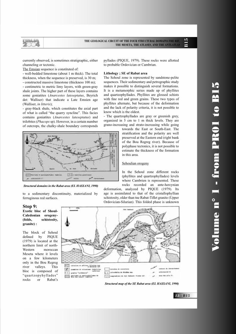
Stop 9:Exotic bloc of Shoul-Caledonian orogeny- (folds, schistosity, granite) :
The block of Sehoul defi ned by PIQUE (1979) is located at the northern limit of north-Western moroccan Meseta where it levels on a few kilometers only in the Bou Regreg river valleys. This bloc is composed of “quartzopyhyllades” rocks or Rabat’s
pyllades (PIQUE, 1979). These rocks were allotted to probable Ordovician or Cambrian.
Lithology ; SE of Rabat areaThe Sehoul zone is represented by sandstone-pelite sequences. Their sedimentary and petrographic study makes it possible to distinguish several formations. It is a metamorphic series made up of phyllites and quartzophyllades. Phyllites are glossed schists with fi ne red and green grains. These two types of phyllites alternate, but because of the deformation and the lack of polarity criteria, it is not possible to know which is the oldest. - The quartzophyllades are gray or greenish grey, organized in 5 cm to 1 m thick levels. They are grano-increasing and strato-increasing while going
towards the East or South-East. The stratifi cation and the polarity are well preserved at the Eastern end (right bank of the Bou Regreg river). Because of polyphase tectonics, it is not possible to estimate the thickness of the formation in this area.
Sehoulian orogeny
In the Sehoul zone different rocks (phyllites and quartzophyllades) levels where Cambrien is represented. These rocks recorded an ante-hercynian
deformation, analyzed by PIQUE (1979). Its age is assimilated to that of the cristallophyllian schistosity, older than tne Rabat-Tifl et granite (Upper Ordovician-Silurian). This folded phase is unknown
Structural domains in the Rabat area (EL HASSANI, 1990)
Structural map of the SE Rabat area (EL HASSANI, 1990)
B15_R_OK 13 27-05-2004, 7:46:03

Vo
lum
e n
° 1
- f
rom
PR
01
to
B1
5
B15 -
Leaders: B. Tadili, L. Ait Brahim
B1
5
elsewhere in Morocco. Authors qualify the rocks affected by this deformation a “suspect ground» or «exotic block». This area is characterized in addition by the presence from a «Caledonian» granite.
Folding and associated cleavage The Sehoul zone has a regional variation in the intensity of fl exible deformation and schistosity. The fi rst is visible in the megascopic structures as well as in the microscopic structures. The schistosity records an evolution since the schistosity of dissolution evolved/moved into the schistosity of fl ow.The fi rst episode of deformation is characterized by isoclinal intrafoliarfolds with curved axes, sometimes presenting stretched sides and thickened hinges. They are synchronous of an axial plane schistosity fl ow. The hinges of these folds are seldom visible. Phyllites are closely affected by S1 schistosity, which completely transposed the original sedimentary litage. The intersection between these two surfaces creates a particular lineation. These phyllites also show an S2 hercynian crenulation. Thus synschistose metamorphism is marked here by an association of quartz, chlorite, and sericite. It indicates the epizone (zone with chlorite and sericite). The post S1 shearings according to subparallel plans with schistosity S1, cause the microscopic amygdalisation of the rock along subparallel plans with S1. These surfaces locally shift the small quartz veins and seem to be accompanied by dissolution under pressure. This amygdalisation indicates the prolongation of tectonic vergency in tardi-schistous conditions.Metamorphism age : The K/Ar results obtained (EL HASSANI & al, 1991) suggest a fi rst episode of metamorphism of Ordovician age (450 My), partially erased by a second episode close to 320 My.RABAT-TIFLET granites : The granitoids of Rabat are all located inside the block of Sehoul. CHARLOT et al., (1973) undertake geochronologic studies on the granites of Rabat-Tifl et. They think that these various granites correspond to the same magmatic arrival. The age found by these authors of 414 My (is recalculated: 430 + 2 My, with a constant of 1.42), which corresponds to the Ordovician-Silurien limit. The granitic intrusion of Rabat developed a contact metamorphism with cordierite, andalusite, biotite and chlorite. The fi rst two minerals show an internal schistosity in continuity with external schistosity in extreme cases of the phenoblasts; these minerals are thus synchronous development of sehoulian schistosity S1. This shows that the granite of Rabat is partly
syntectonic, and therefore that the sehoulian phase would have the same age as that of the granite, i.e. fi nal, contemporary Ordovician of the taconic phase. The pseudomorphosis of these chlorite and biotite minerals is post-kinematics, since they recut S1 schistosity, and prior to the fi rst shearings.
Stop 10:RabatMausoleum of Mohammed V and Hassan Tower built in 1962, Oudayas, Chellah, Medina
DAY3Rabat - Oulmes - Meknes
Transportation 4 x 4 carsOvernight location MeknesAccommodations Hotel Zaki ****
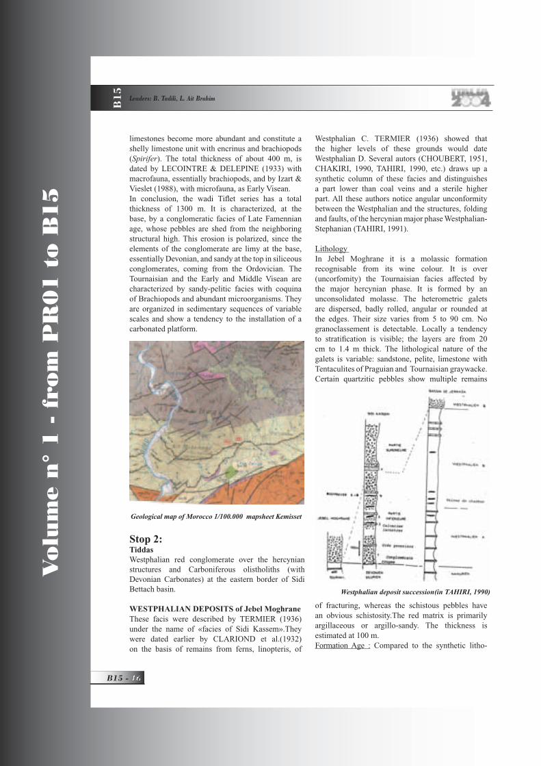
Stop 1:Tifl etFameno-Tournaisian conglomerate of the north and Devono-Carboniferous Basin of Sidi Bettach.Oued Tifl et Upper Devonian–Lower Carboniferous section :In the North-western Meseta, the Late Devonian period is characterized by the interruption of the reefal carbonated sedimentation that prevailed during the Givetian, and the inception of the Upper Devonian – Carboniferous Sidi Bettache basin, which was bounded to the north by the Rabat-Tifl et debris fl ow and conglomeratic sequences.
The wadi Tifl et section This outcrop is situated 2 km east of the city of Tifl et, on the side of the road (Rabat-Meknès) and on the banks of wadi Tifl et.
Mohammed V Mausoleum and the Hassan Tower (Rabat)
B15_R_OK 14 27-05-2004, 7:50:20
THE GEOLOGICAL CIRCUIT OF THE FOUR STRUCTURAL DOMAINS:THE RIF, THE MESETA, THE ATLASES, AND THE ANTI-ATLAS B
15
13 - B15
Vo
lum
e n
° 1
- f
rom
PR
01
to
B1
5
currently observed, is sometimes stratigraphic, either channeling or tectonic. The Emsian sequence is constituted of:- well-bedded limestone (about 1 m thick). The total thickness, when the sequence is preserved, is 30 m; - constructed massive limestone (thickness 100 m); - centimetric to metric limy layers, with green-gray shale joints. The higher part of these layers contains some goniatites (Anarcestes lateseptatus, Beyrich det: Walliser) that indicate a Late Emsien age (Walliser, in litteris);- gray-black shale, which constitutes the axial part of what is called “the quarry syncline”. This facies contains goniatites (Anarcestes lateseptatus) and trilobites (Phacops sp). However, in a certain number of outcrops, the chalky-shale boundary corresponds
to a sedimentary discontinuity, materialized by ferruginous red surfaces.
Stop 9:Exotic bloc of Shoul-Caledonian orogeny- (folds, schistosity, granite) :
The block of Sehoul defi ned by PIQUE (1979) is located at the northern limit of north-Western moroccan Meseta where it levels on a few kilometers only in the Bou Regreg river valleys. This bloc is composed of “quartzopyhyllades” rocks or Rabat’s
pyllades (PIQUE, 1979). These rocks were allotted to probable Ordovician or Cambrian.
Lithology ; SE of Rabat areaThe Sehoul zone is represented by sandstone-pelite sequences. Their sedimentary and petrographic study makes it possible to distinguish several formations. It is a metamorphic series made up of phyllites and quartzophyllades. Phyllites are glossed schists with fi ne red and green grains. These two types of phyllites alternate, but because of the deformation and the lack of polarity criteria, it is not possible to know which is the oldest. - The quartzophyllades are gray or greenish grey, organized in 5 cm to 1 m thick levels. They are grano-increasing and strato-increasing while going
towards the East or South-East. The stratifi cation and the polarity are well preserved at the Eastern end (right bank of the Bou Regreg river). Because of polyphase tectonics, it is not possible to estimate the thickness of the formation in this area.
Sehoulian orogeny
In the Sehoul zone different rocks (phyllites and quartzophyllades) levels where Cambrien is represented. These rocks recorded an ante-hercynian
deformation, analyzed by PIQUE (1979). Its age is assimilated to that of the cristallophyllian schistosity, older than tne Rabat-Tifl et granite (Upper Ordovician-Silurian). This folded phase is unknown
Structural domains in the Rabat area (EL HASSANI, 1990)
Structural map of the SE Rabat area (EL HASSANI, 1990)
B15_R_OK 13 27-05-2004, 7:46:03
Vo
lum
e n
° 1
- f
rom
PR
01
to
B1
5
B15 -
Leaders: B. Tadili, L. Ait Brahim
B1
5
limestones become more abundant and constitute a shelly limestone unit with encrinus and brachiopods (Spirifer). The total thickness of about 400 m, is dated by LECOINTRE & DELEPINE (1933) with macrofauna, essentially brachiopods, and by Izart & Vieslet (1988), with microfauna, as Early Visean. In conclusion, the wadi Tifl et series has a total thickness of 1300 m. It is characterized, at the base, by a conglomeratic facies of Late Famennian age, whose pebbles are shed from the neighboring structural high. This erosion is polarized, since the elements of the conglomerate are limy at the base, essentially Devonian, and sandy at the top in siliceous conglomerates, coming from the Ordovician. The Tournaisian and the Early and Middle Visean are characterized by sandy-pelitic facies with coquina of Brachiopods and abundant microorganisms. They are organized in sedimentary sequences of variable scales and show a tendency to the installation of a carbonated platform.
Stop 2:TiddasWestphalian red conglomerate over the hercynian structures and Carboniferous olistholiths (with Devonian Carbonates) at the eastern border of Sidi Bettach basin.
WESTPHALIAN DEPOSITS of Jebel Moghrane These facis were described by TERMIER (1936) under the name of «facies of Sidi Kassem».They were dated earlier by CLARIOND et al.(1932) on the basis of remains from ferns, linopteris, of
Westphalian C. TERMIER (1936) showed that the higher levels of these grounds would date Westphalian D. Several autors (CHOUBERT, 1951, CHAKIRI, 1990, TAHIRI, 1990, etc.) draws up a synthetic column of these facies and distinguishes a part lower than coal veins and a sterile higher part. All these authors notice angular unconformity between the Westphalian and the structures, folding and faults, of the hercynian major phase Westphalian-Stephanian (TAHIRI, 1991).
Lithology In Jebel Moghrane it is a molassic formation recognisable from its wine colour. It is over (uncorfomity) the Tournaisian facies affected by the major hercynian phase. It is formed by an unconsolidated molasse. The heterometric galets are dispersed, badly rolled, angular or rounded at the edges. Their size varies from 5 to 90 cm. No granoclassement is detectable. Locally a tendency to stratifi cation is visible; the layers are from 20 cm to 1.4 m thick. The lithological nature of the galets is variable: sandstone, pelite, limestone with Tentaculites of Praguian and Tournaisian graywacke. Certain quartzitic pebbles show multiple remains
of fracturing, whereas the schistous pebbles have an obvious schistosity.The red matrix is primarily argillaceous or argillo-sandy. The thickness is estimated at 100 m.Formation Age : Compared to the synthetic litho-
Geological map of Morocco 1/100.000 mapsheet Kemisset
Westphalian deposit succession(in TAHIRI, 1990)
B15_R_OK 16 27-05-2004, 7:49:48

THE GEOLOGICAL CIRCUIT OF THE FOUR STRUCTURAL DOMAINS:THE RIF, THE MESETA, THE ATLASES, AND THE ANTI-ATLAS B
15
17 - B15
Vo
lum
e n
° 1
- f
rom
PR
01
to
B1
5
logical column drawn up by CHOUBERT (1951), the formation dates Westphalian D.
Stop 3:Jebel MalouchanePanoramic view of the Central Moroccan Massif and Zayan fi eld.
Stop 4:On the roadHercynian gradient of syn-cleavage and syn-granitic deformation.
The distribution of the deformation and metamorphism around the granite of Oulmès was studied by several authors (PIQUÉ, 1976; DAHMANI, 1985; AIT OMAR, 1986; DIOT, 1989; etc.). Here a short synthesis of this work which is based on the observations made in a WNW-ESE section in the West of the granite (1) Far from the granite, P1 are rather open, with vertical or strongly diverse with the NW axial plans. S1 is beginner . The metamorphism is anchizonal. (2) Further east, the folds are metric and clearly different from the SE. S1 becomes tighter with reorientations in S1 of the detrital elements. (3) P1 are closed, microplissement is accentuated. S1 is fl ow, the detrital quartz grains are fl attened and are stretched in S1; the newly formed white micas are abundant and are concentrated in preferential plans of crystallization. The metamorphism is epizonal. (4) The schistous fl ow becomes more important and leads to the transposition of S0 in S1. The transposition is done preferentially in the sides of the folds. The folds became more closed and isoclinal, then they become similar with thinning of the sides and thickening to the hinge level . (5) S1 is underlined by alternations of quartzitic and
phyllitic microlithons with biotite. The sides of the folds are stretched and roved. (6) In the immediate vicinity of the granite, the rock consists of recrystallized or newly formed mineral alignment parallel to S1 made of andalusite and biotite porphyroblasts. It is the foliation stage; metamorphism is mesozonal. The microplis are fl attened and rolled and the hinges are insulated.
Thus, around the granite, the evolution of folding and schistosity translates a growing gradient of the deformation. The metamorphism also grows in this direction. Observations allowed the authors (PIQUÉ, 1976; AITOMAR, 1986; DIOT, 1989) to conclude with the syntectonic character of the granite. Models of installation of the granite were proposed by AIT OMAR (1986) and DIOT (1989); all these authors admit an intrusion of the granite in a sinistral shearing crustal zone directed NE-SW. The granite of Oulmès appears consequently like the product of crustal fusion in this zone in response to the regional shortening. The geochemical studies on the granite plead in favour of such genetic relations between granite and the shearing zone.
Stop 5 :OulmèsHercynian granite and thermal water source of Tarmilat and Permian volcanic rocks and detritical Permian facies.
The Oulmès granitic massif is 9.5 km long and no more than 5 km wide and consists of a two-micas
Geologiacl map of Morocc 1/50.000 Sheet of Oulmès( BAUDIN and al,2001).
Cross section (western part) in the northern part of the Khouribga-Oulmès anticlinorium ( BAUDIN and
al,2001)
Cross section (eastern part) in the northern part of the Khouribga-Oulmès anticlinorium (BAUDIN and al,2001).
B15_R_OK 17 27-05-2004, 7:49:53

Vo
lum
e n
° 1
- f
rom
PR
01
to
B1
5
B15 -
Leaders: B. Tadili, L. Ait Brahim
B1
5
granite crosscut by stocks and dykes of leucogranite. Tin, tungsten and beryllium occurences and partialy mined orebodies are associated with this granite massif. The aureole of contact metamorphism is made of biotite, andalusit hornfels and stained schist and encloses a tourmalinized zone.
The granite of Oulmès is regarded as syntectonic with the main hercynian phase (PIQUE, 1976; AIT OMAR, 1986; DIOT, 1989). Many radiochronologic data on the granite (K/Ar method, CHOUBERT and Al, 1965; Rb/Sr, TISSERANT, 1977 and MRINI, 1985) emphasize ages ranging between 300 and 260 MA. Syn-cleaved folding were dated to 290 MA near Oulmès and to 289 MA in Fourhal bassin in the East (HUON, 1985). These ages correspond to the limit Westphalian-Stephanian on the scale of ODIN and al.(1982).The Oulmès granite shows an alumino-potassic affi nity and a crustal origin (MAHMOOD, 1980; BOUTALEB, 1988). Intense hydrothermal deterioration produces many other granitic facies.
Stop 6:Ouljet SoltaneLate Hercynian slip-strike faults and overlapping
Stop 7:erreyThermal source of Jerrey
Stop 8:VolubilisVisit to the Roman City of Volubilis 3rd century BC, the old Roman ruins are classifi ed as an international inheritance by the UNESCO.
Stop 9:MeknesBab Mansour, Mausoleum of Moulay Ismail
(Contemporary Louis XIV), MedinaTHE MOROCCAN ATLASESLate Triassic-Early Liassic: the Atlantic and Atlasic rifting
The Mesozoic sedimentary rocks known in Morocco unconformably cover the folded and eroded Palaeozoic rocks. The oldest Triassic sedimentary sequences are Carnian in age (locally Upper Ladinian in northeast Morocco: OUJIDI et al., 1997). They are found: i) in faulted basins distributed in the present Atlantic margin. They correspond to the syn-sedimentary deposits of the Atlantic rift (LE ROY, 1997; LE ROY et al., 1997) and they are not considered here; ii) in halfgrabens located from Middle to Central High Atlas (Figure 2). Their active border faults, mainly NE-SW trending, are reactivated Hercynian thrusts and reverse faults (LAVILLE et al., 1995). The left-lateral oblique faults like the Tizi n’Test fault correspond to Hercynian N 70° strike-slip faults (BEAUCHAMP, 1988). The synsedimentary activity of the halfgrabens is indicated by the facies distribution and the lateral thickness changes of the sedimentary sequences. The subsidence decreased during the Norian and the halfgraben border faults were sealed up by the Lower Liassic carbonates. Contemporaneously with this crustal extension, tholetitic magmas were emplaced (BERTRAND et al., 1982) and a thermal fl ow occurred, indicated by the alteration of the uppermost Triassic-lowermost Liassic basalts and by the development of a very low grade paragenesis (BENCHEKROUN et al., 1987), probably hydrothermal, dated at about 200 Ma (HUON et al., 1993; CLAUER et al., 1995; RAIS, work in progress). All of these structural, metamorphic and magmatic arguments suggest that an intracontinental rift, the Atlasic rift, developed from the Middle Atlas to Central High Atlas, in a NE-SW direction parallel to the Atlantic rift. Contrary to the Atlantic rift, which led to the oceanic accretion, the Atlasic rift aborted during the earliest Liassic.The postrift Lower and Mid-Liassic carbonate shelf extended over a large part of northern Morocco, far from the limits of the former Atlasic rift. During the Carixian for instance, various sedimentary facies characterised this shelf :- chert limestones which sometimes graded
laterally to reefal buildings. These limestones are restricted to the axis of the future Atlasic troughs;
- oolitic limestones;
Late Liassic-Bathonian: the Atlas troughs
Vestige of a Roman city – Volubilis (Meknes)
B15_R_OK 18 27-05-2004, 7:50:04
THE GEOLOGICAL CIRCUIT OF THE FOUR STRUCTURAL DOMAINS:THE RIF, THE MESETA, THE ATLASES, AND THE ANTI-ATLAS B
15
19 - B15
Vo
lum
e n
° 1
- f
rom
PR
01
to
B1
5
At the limit between the Domerian and the Toarcian, a transtensive fracturation of the form carbonate shelf occurred, individualising the Middle Atlas and High Atlas troughs made of coalesce lozange-shaped depocentres which were limited by synsedimentary normal and transcurrent fault N 50°E in the Middle Atlas and N 70°E in the High Atlas. The fracturation of the mid-Liass shelf was contemporaneous with the beginning of the oceanic accretion in the Central Atlantic. At time, the eastward drift of Africa was triggered, inducing new intracontinental stresses in the northern part of the Africa plate. As a result, the crustal weakness zones were reactivated in this new stress and, as for the Late Triassic rifting episode, in many cases one can effectively demonstrate that: border faults of these basins correspond to Hercynian structures. This is obvious for the southern limit of the High Atlas basin, which corresponds to the former Atlas Palaeozoic transform fault, and for southeastern limit of the Middle Atlas trough, parallel to the former Marrakech-Oujda shear zone. In the two subsident troughs a thick pile of marine sedimentary sequences was deposited from Late Liassic to the end of Dogger, in contrast with thin or even absent contemporary deposits outside troughs. The main sedimentary facies which characterise this period are: - yellow cephalopods marls which often contain
turbiditic horizons, deposited in the Atlasic trou axis;
- encrinitic limestones indicative of inner shelf conditions at the margins of the Atlasic troughs;
- red clays (Mibladen series), which were deposited in the Moulouya and Oranese Meseta areas lagoonal environment with tidal fl ats and frequent emersions.The maximum depth of the basins was attained
between the Early Aaleno-Bajocian and the Late Bajocian, with the deposition of deep basin facies: Lower Aaleno-Bajocian Posidonomya Boulemane marls with turbiditic intercalations. The deposition of the Upper Bajocian, so-called “Calcaire corniche”, a reefal and oolitic limestone indicative of open shelf environments, marked the progressive fi lling of the troughs. However, deep basin conditions persisted as far as into the Late Bajocian in the northeastern part of the Middle Atlas trough where they are represented by the “Marnes de Sakka supérieures”.
In the Middle Atlas domain deposition of the the Upper Bajocian “Calcaire corniche” marked the beginning of the northeastward retreat of the sea. In the main part of the Atlas trough, the “Calcaire
corniche” was covered by red beds, mostly aerial, deposited in a para-deltaic and deltaic system. The numerous dinosaur tracks which were found in these strata indicate that they correspond to the Upper Jurassic and part of the Lower Cretaceous. The orientation of the palaeo-currents and the nature of the clasts suggest that they originated from the Saharian domain like the contemporary Algerian Ksour sandstones (DELFAUD & ZELLOUF, 1993). However, other source lands were represented by several physiographically high areas which furnished relatively immature clasts. Meanwhile, marine conditions persisted in northeastern Morocco, where deep deltaic sediments were deposited (CATTANEO, 1991) and in the western part of the High Atlas, connected to the young Atlantic (e.g., AMRHAR, 1995). From a structural point of view, the rhomboidal shape of the depocentres and the arcuate shape of the plutonic alkaline bodies (ZAYANE, 1992 ) emplaced in the central High Atlas during the Late Jurassic argue for a strong transcurrent, sinistral component in the Atlasic troughs along N 70°E faults (LAVILLE, 1988), perhaps associated with a normal N-S extension (WARMS, 1988). In the eastern High Atlas, El KOCHRI & CHOROWICZ (1996) suggested that the N 70°E trending faults were normal faults, connected by NW-SE transfer faults. On the other hand, it is important to note that the Palaeozoic basement is practically never represented in the Atlasic anticlines, where Triassic siltstones and/or plutonic massifs crop out. This suggests that the deformation of Central Atlas was coeval with a general décollement of the Mesozoic cover at the level of the Upper Triassic sequences. The main shortening in the Atlas axis was expressed by open folds locally accompanied by the development of an incipient cleavage. It occurred during the Late Jurassic-Early Cretaceous, since the eroded hinges of some folds (in particular those which contain plutonic rocks) were unconformably covered by transgressive strata of late Lower Cretaceous age. This tectogenesis was not followed by any uplift of the mountain range.
The Early-Late Cretaceous and Palaeocene- EoceneThis period was dominated by the general eustatic transgression which, in Morocco, proceeded northeastward from the Atlantic and southwestward from the Tethys. On the basis of sedimentological evidence (presence of marine sedimentary rocks in the western part of the Atlasic domain and littoral conditions in the east), the marine Albo-Aptian
B15_R_OK 19 27-05-2004, 7:46:48

Vo
lum
e n
° 1
- f
rom
PR
01
to
B1
5
B15 -
Leaders: B. Tadili, L. Ait Brahim
B1
5
deposits of BeniMellal (Ouaouizart and Ait Attab basins) in the High Atlas and Boulemane (Tighboula-Oudiksou and Ain Nokra basins) in the Middle Atlas are classically considered as Atlantic-related, although faunal similarities would suggest Tethysian affi nities (CHARRIÈRE & VILA, 1991).Evaporitic sediments with colored marls and gypsum were deposited during the Early and Middle Cenomanian. They grade westward into the marls and limestones of the inner carbonate shelf. During the Late Cenomanian-Early Turonian, the transgression attained its maximum and the shelf facies became homogeneous within the whole Atlasic domain. To the west, they covered the western Meseta although small areas remained emerged. To the north, the Idrissides land (CIIOUBERT & FAURE-MURET, 1962) constituted the northern border of the seaway.The Senonian palaeogeography remained practically similar to that of the Turonian, the facies changes resulting from the general regression. In the Atlasic domain, the fracturation of the Turonian shelf produced small basins where confi ned facies (bituminous marls) were deposited between uplifting and emerging areas characterised by phosphorite sediments (CHARROUD et al., 1993). These Atlasic bituminous marls (BENALIOULHAJ, 1991) were coeval with the Western Meseta phosphoritic deposits indicative of the Atlantic shallow shelf. The Eocene marls, dolomites and gypsum are the last marine deposits in the Atlas domain, sometimes covered by sandstones attributed to the Oligocene.Noteworthy is the emplacement of Eocene alkaline magmas in two massifs, Taourirt (AGARD, 1950) and Tamazert (BOUABDELI, 1987) of the Atlas domain .
The NeogeneIn northern Morocco, the Africa-Europe convergence during the Neogene was at the origin of the Rif orogeny, with the development of south- and southwest-vergent nappes, HP metamorphism, etc. The Upper Miocene “post-nappes” basins of the Rif (e.g., AÏT BRAHIM & CHOTIN, 1989) register the successive stress fi elds acting from the Tortonian to Present. Meanwhile, the Atlas domain reacted to the same regional N-S shortening. South of the High Atlas, the Souss and Ouarzazate basins fi lled up with detrital sandstones and conglomeratic sequences. At the base of the Ouarzazate sequences, the Hadida Formation (GORLER et al., 1988) represents the Oligocene (and Lower Miocene?). The clasts have a southern (Anti-Atlas) origin. The overlying
sequence, the Kandoula Formation, represents the Lower - (?)Middle Miocene. It exhibits proximal alluvial fans originated from the north, registering henceforth the uplift of the High Atlas. Laterally, these clastic sequences correspond to the Toundoute pellicular and gravity-driven nappe (LAVILLE et al., 1977), itself issued from the High Atlas domain. The upper part of the Kandoula Formation represents the Middle Miocene-Lower Pleistocene and it is composed of fl uviatile and torrential sequences of northern (High Atlas) origin. Final emplacement of the clastic sequences was contemporaneous with the development of fl at-lying and south-vergent shear zones (OUTTANI et al., 1995). The High Atlas northern border is represented by north-vergent, E-W trending reverse faults, with a right-lateral component (MOREL et al., 1993).Like the High Atlas, the Middle Atlas is limited by reverse faults, here NE-SW, often showing a leftlateral component (DUÉE et al., 1977; LAVILLE & FEDAN, 1989). Some of them, e.g., the Ait Oufella fault at the southeastern limit of the Middle Atlas, are fl at-lying thrusts related to a décollement at the base of the Mesozoic cover (MOREL et al., 1993).The Neogene and Quaternary volcanism is distributed along the Transmoroccan lineament (AÏT BRAHIM, 1986) which runs from Oujda to Agadir. Its alkaline nature is attributed to a mantellic origin and its emplacement along the NE-SW axis has been related to the left-lateral motion along this lineament (PIQUÉ et al., 1998a).
Discussion and conclusions on Moroccan AtlasesThe Moroccan Atlas displays several particular points which distinguish it from the other segments of the Maghrebian Atlas chain. Their enumeration sheds light on its particular geodynamic evolution.
The Atlasic rift of Morocco and the development of the Atlasic troughsWARMS (1988) among others described the Jurassic “Atlasic rift” of Morocco as the result of N 70°E to E-W trending normal faults which merge into a crustal detachment zone weakly dipping to the North. A similar model was developed later for the Algerian Atlas (VIALLY et al., 1994). Others argued, on the contrary, for an oblique opening of the Moroccan Atlasic basins. In the Middle Atlas and the central High Atlas, LAVILLE & PETIT (1984) and LAVILLE et al. (1995) showed that, since the end of Triassic times, the NE-SW Hercynian directions (e.g., the Marrakech-Oujda shear zone) were reactivated as
B15_R_OK 20 27-05-2004, 7:46:50

THE GEOLOGICAL CIRCUIT OF THE FOUR STRUCTURAL DOMAINS:THE RIF, THE MESETA, THE ATLASES, AND THE ANTI-ATLAS B
15
21 - B15
Vo
lum
e n
° 1
- f
rom
PR
01
to
B1
5
normal faults which delimitated halfgrábens while the N 70°E to E-W faults (e.g., those which constituted the Atlas Palaeozoic Transform Zone) acted as sinistral transcurrent faults. Later, during Jurassic times, the distribution of the depocentres and the plutonic massifs suggest their en-dchelon pattern along the sinistral transcurrent N 70°E trending faults.The important lateral component of the motion along the N 70°E to E-W faults during the Jurassic, already proposed by MATTAUER et al. (1977), implies that the “Atlasic rift” of WARMS (1988), SOUHEL et al. (1993) and CANÉROT et al. (1996) corresponds rather to a transtensive zone referred to above as the “Atlasic troughs”. Between the northern limit of the Africa plate, parallel to the present Rif mountain, and the south-Atlasic line, the Atlas domain was a sinistral mega-shear zone where the development of the Middle and High Atlas troughs resulted from sinistral motions along the N 70°E to E-W faults, while the NE-SW faults acted preferentially as normal faults. At that time, the Atlasic domain was connected to the Atlantic, to the southwest, and the Tethys, to the northeast. The fi lling of the Atlasic troughs occurred during the end of the Jurassic, when the sinistral transcurrent, probably transtensive, movement decreased progressively.
The Central Atlas main deformationAlong the axis of the High Atlas, the main tectogenesis, i.e. the development of the penetrative structures, occurred during the Late Jurassic-Early Cretaceous, certainly before the deposition of the marine Cretaceous sequences (LAVILLE & FEDAN, 1989). Since the Cretaceous transgression covered at least parts of the Atlas domain, it is clear that the orogenesis (i.e. the uplift of the Atlas mountain range) did not immediately follow its tectogenesis (LAVILLE et al., 1991). The explanation for the absence of post-tectonic uplift is that the tectogenesis did not create a crustal thickening and a subsequent isostatic rebound, which is compatible with a transpressive regime for the Late Jurassic-Early Cretaceous tectonism.
Now, it is important to note that the Mesozoic shortening of the Moroccan Atlas did not affect the other segments of the Maghrebian Atlas which were deformed later, during the Eocene in Algeria (e.g., VIALLY et al., 1994) and the Neogene in Tunisia (e.g., PHILIP et al., 1986). Reasons for this diachronous deformation are not clear yet. The oblique convergence between Africa and Europe could have been realised earlier in Morocco, in
front of the Iberian microplate, then in easternmore segments of the Atlas (PIQUÉ et al., 1998b).
Alkaline magmatism in the Atlas domain Alkaline magmatic activity occurred during three periods in the Moroccan Atlas:- during the Late Jurassic, alkaline magmas emplaced in the central High Atlas. The geometry of the small plutons suggests that they emplaced in connection with the sinistral transcurrent motion along N 70°E trending faults;- during the Eocene in the Taourirt and Tamazert massifs;- during the Neogene and the Quaternary. The three main volcanic provinces, i.e. Oujda Mountains, Middle Atlas and Siroua are aligned along the NE-SW Transmoroccan lineament.
The Jurassic alkaline rocks are not represented in the western or eastern High Atlas, but only in the Central High Atlas axis, along the former Atlasic rift. It is thus probable that their emplacement has been favoured, within the Atlas transcurrent domain, by the earlier crustal thinning previously realised during the Late Triassic-Early Liassic rifting.The Eocene and Neogene-Quaternary alkaline rocks are distributed along NE-SW trending zones. It is suggested that their emplacement is related to a N-S regional shortening, attributed to the Africa-Europe convergence.
The Atlas upliftIn the course of the continuing Africa-Europe collision, the uplift of the High Atlas and to a lesser degree the Middle Atlas was due to the reactivation of the crustal faults in a roughly N-S compressive stress fi eld (GOMEZ et al., 1996). The High Atlas N 70°E faults then acted as reverse faults, north- and south-vergent thrusts developed along the borders of the chain, and a sinistral component was present on the Middle Atlas NE-SW faults.
In conclusion, the main tectonic event (i.e. the development of regional folds, themselves derived from sedimentary ridges and depocenters) in the Central Atlas was achieved prior to the deposition of the Cretaceous transgressive beds. It resulted from the adaptation of the Mesozoic cover to a transpressive reactivation of Hercynian faults and a general décollement of this cover from its Hercynian basement.By contrast, along the Atlas borders, the main
B15_R_OK 21 27-05-2004, 7:46:52

Vo
lum
e n
° 1
- f
rom
PR
01
to
B1
5
B15 -
Leaders: B. Tadili, L. Ait Brahim
B1
5
deformation occurred later, during Neogene times. It was characterised by reverse faults and fl at-lying thrusts divergent with regard to the Atlas axis. The kilometric-scale thrusts (LAVILLE et al., 1977; MOREL et al., 1993; LOWELL, 1995; OUTTANI et al., 1995; etc.) are of particular interest since they are the manifestation of décollement tectonics, perhaps initiated during the Mesozoic and strongly reactivated during the Neogene. Whether or not they are limited to the Atlas borders or played a signifi cative role in the deformation and the uplift of the whole chain has not yet been determined.
DAY 4Meknes - El Hajeb - Azrou - Timhdite - Itzer - Midelt
Transportation 4 x 4 carsOvernight location MideltAccommodations Hotel Ayachi ****
Stop 1:rise towards El HajebPanorama and presentation of the day. The Middle Atlas is composed by the juxtaposition of 2 structural domains: the tabular Middle Atlas and the folded Middle Atlas. These two domains are separated by a major lineament which underlines the zone of passage of the Northern Middle Atlas Fault
Stop 2:AzrouCedar Forest (Amazing panorama).
Stop 3:Jbel HabriQuaternary alkaline volcanism of the Middle Atlas. On the road to Timhdite, there are three craters Habri, Hibri and Tabrit.
Stop 4:TimhditeTertiary Dale and the northern Middle Atlasic fault separating the tabular Middle Atlas from the folded Middle Atlas.
Stop 5:BerkitMaestrichtian Bituminous Shists.
Stop 6:Aït OufellaSouthern Middle Atlasic Fault (Triassic and Jurassic Grounds).
Stop 7:MibladeneVanadinite, Lead, Barite and Cerusite Mineralizations.
Stop 8:MideltSite of dinosaur bones.
DAY 5Midelt - Rich - Errachidia - Erfoud - Merzouga
Transportation 4 x 4 carsOvernight location Erfoud / MerzougaAccommodations Hotel El Ati **** / Bivouac
Stop 1:Rise towards Tizi n’TalghentPanorama and presentation of the day. The crossing through the high Atlas cuts through two different structural domains: the fi rst extends from Tizi Talghemt to Foum Zabel; the second, southernmost, is limited by the southern Atlasic fault.
Stop 2:Tizi n’TalghemtNorthern limit of the High Atlas, Anticline ridge of Talghemt followed by a large syncline. In this area, we fi nd the Middle Liassic, Upper Liassic and Lower Dogger facies.The Upper Toarcian marls (Td-E10) are clearly shown along the road. These facies presents a set of fossils such as: Osperlioceras beauliziense, Polyplectus discoides, Hammatroceras praefallax, Hammatoceras sp, Phylloceras and especially Lytoceras.These marls are capped by a black limestone bar (Td-E 1 1) which locally shows a chaotic aspect and is presented in the form of scraps aligned along a fault. Its thickness is reduced; but, it can be important locally. The fauna collected in this bar indicates the Laeviuscula zone of Lower Bajocien. We have there, therefore, a signifi cant gap which includes the top of Upper Toarcian and all the Aalenian.The series continues with 50 m of marls (Td-E 12 to Td-E 22) without fossils, marly limestone (Td-E 23 to Td-E27); and at the top we fi nd sand stone gaps.
Stop 3:Foum N’zalaThe area shows a passage between massive limestone (formation of Idikel) and limestone lities (formation of Aberdouz). One of the levels underlines the beginning of the fossiliferous episode with the fi rst event of the ammonites observed above massive limestone rich in slumps and sedimentary blocks.
B15_R_OK 22 27-05-2004, 7:46:53

THE GEOLOGICAL CIRCUIT OF THE FOUR STRUCTURAL DOMAINS:THE RIF, THE MESETA, THE ATLASES, AND THE ANTI-ATLAS B
15
23 - B15
Vo
lum
e n
° 1
- f
rom
PR
01
to
B1
5
The Sunedeur Sinemurian and Carixian
The series is very dilated. It can be subdivided in three units.- The fi rst unit, having a Sinemurian age,
corresponds to generally massive limestones (formation of Idikel), with a fauna represented primarily by lamellibranches and gasteropodes. This unit is organized in three great sets, each approximately 30 m thick.
- The second unit corresponds to massive black limestones, which record phenomena of slips and resedimentations.
- The third unit is made of limestones clearly lities, lighter coloured, where the marly interlits become frequent. The base of this unit corresponds to the fi rst sitted ones with ammonites.
The DomerianThe Upper Domerian is represented by alternations of limestone and marls. The latter are thicker and more frequent. Fauna is defi nitely more abundant in comparison to the lower levels unclaimed. This one is represented, primarily, by Atieticeratinae. From level 83, the limestones are replaced by marly-limestones, often ferruginous and very rich in ammonite fauna.
Stop 4:Foum TillichtThe Sinemurian is represented here by a dark massive limestone, locally containing fl int nodules which recorded phenomena of land slides and re-
sedimentation.The Sinemurian facies is represented by dark massive limestones, locally charged with fl int nodules. The latter have locally recorded phenomena of slips and resedimentation. The fi rst fossiliferous bases found in this cut correspond to a thin ferruginized level, rich in fauna of Arnioceras gr. Rejectum which makes it possible to date these levels from the passage between Lower Sinemurian - Upper Sinemurian.
Stop 5:Area of RichThe deposits of the Upper Liassic and the Lower Dogger, show a similar facies to the marls and marly-limestones of the Agoudim formation. They are organized in 3 sections, with distinct faunistic contents and a well established age, at least for the lower part.The lower section is characterized by a prevalence of marls containing an abundant hemipelagic fauna. Its higher limit is marked by a calcareous bar (KG 95), approximately 5 m thick..The median section is distinguished from the preceding one by more and thicker limestone deposits as well as by its primarily benthic fauna with brachiopods, gastropods, polyparies and Foraminifera.The upper section forms a massive limestone cliff called corniche.
Stop 6:Hammet Moulay Ali ChérifThe Sinemurian series are generally similar to the Sinemurian deposits of N’zala. However, It is characterized by the absence of slumps and re-sedimentary
levels which are replaced by carbonated structures.The fi rst Pleisbachian levels (level 120) correspond to sandy turbidites where the various terms of the sequence of Bouma are represented, but are often truncated at the top. These are overcome by turbiditic levels where the channels and the blocks of resedimentation
become rather abundant (level 140) attesting the passage from distal deposits of turbidites at the base to deposits of turbidites proximales. The series continues
B15_R_OK 23 27-05-2004, 7:46:55

Vo
lum
e n
° 1
- f
rom
PR
01
to
B1
5
B15 -
Leaders: B. Tadili, L. Ait Brahim
B1
5
upwards alternating limestones and marls with some fi nal decimeters of turbidite. The marly phase is more abundant and limestones fi ner and richer in fauna than ammonites. Higher up, the series becomes sandy again, the chenalisante structures as well as the phenomena of slips and resedimentation reappear, underlining the passage to a progradant mode.
Stop 7:Foum Bou ZabelTizi n’Tfi rest ridge
Stop 8:Hassan Addakhil DamSouthern High Atlas Fault.
Stop 9:Jebel Bou Tcharafi neLower to Middle and Upper Devonian sections with famous “Dalle d’Erfoud”: Limestones with
Goniatites and Orthoceras.The Tafi lalt belongs to the north-eastern part of the Anti-Atlas region. The Devonian facies of this area contrasts with that of the Dra Valley area in the western Anti-Atlas. The Tafi lalt Devonian belongs to the hemipelagic and pelagic facies, whereas in the Dra Valley there is an important siliciclastic infl ux and, especially during the Lower Devonian, the neritic facies prevails (BULTYNCK &WALLISER 2000. The Lower Devonian succession, about 160 m thick, mainly consists of shales and limestones. The only exception is the Hamar Laghdad mounds complex near Erfoud.During the Eifelian-Givetian limestones with goniatites, only a few tens of meters thick, prevail. The Frasnian is an hemipelagic-pelagic limestone succession. Black limestones representing the Kellerwasser Event are developed at the top of the Frasnian.The Famennian is subdivided into several units, the latter ranging into the Carboniferous. The lower part is characterized by cephalopod limestones, in the northern Tafi lalt with the typical reddish-brown several dm thick “Dalle d’Erfoud” with goniatites and orthoconic cephalopods, which is used for the production of polished plates.
Atlasic Folds - Hamada d’Aoufous(Southern Atlasic Fault)
Achgig section (SE of Erfoud) serving as a reference Devonian section (BULTYNCK &WALLISER 2000)
Location of Bou Tachrafi ne sections on the topographic map of Morocco 1/100.000 mapsheet Erfoud
The central Hamar Laghdad area seen from the south. Numbers correspond to the map of the mud mounds
(BRACHERT and al., 1992)
B15_R_OK 24 27-05-2004, 7:48:57

THE GEOLOGICAL CIRCUIT OF THE FOUR STRUCTURAL DOMAINS:THE RIF, THE MESETA, THE ATLASES, AND THE ANTI-ATLAS B
15
25 - B15
Vo
lum
e n
° 1
- f
rom
PR
01
to
B1
5
Stop 10:Jebel Hamar LaghdadThe limestone mounds complex of the Lower Devonian. The best Devonian reef constructions in Africa. The origin and development of Lower Devonian mud mounds of the Hamar Laghdad area in the eastern Anti Atlas, Morocco, are controlled by extrinsic and intrinsic factors. Extrinsic factors
include the existence of a paleohigh (Lochkovian volcaniclastics), unidirectional currents and repeated storm events as weIl as sea level fl uctuations. Intrinsic, biologically induced factors are the preferred growth factors of organisms on the top and the fl anks of the mounds because of more favourable ecological conditions, and a rapid synsedimentary lithifi cation of the steep mound fl anks by interskeletal cementation of auloporid tabulate carats.
The mounds developed in an epicontinental basin below the wave base but within the range of storms. The formation of the mounds started within the uppermost part of the bedded crinoid facies of the Kess-Kess Formation with the hydrological accumulation of a bioclastic pile. This elevation became settled by crinoids and high-diverse tabulate
Geological map of the Hamar Laghdad (BRACHERT et al., 1992)
Section of the western Hamar Laghdad area with conodont biostratigraphy (BRACHERT and al., 1992)
¨Position (A) and profi les
(B,C) of Jebel Mech
Irdane. (WAL-
LISER, 2000)
Deformed Devonian in the Erfoud Area(Anti-Atlas)
B15_R_OK 25 27-05-2004, 7:49:02

Vo
lum
e n
° 1
- f
rom
PR
01
to
B1
5
B15 -
Leaders: B. Tadili, L. Ait Brahim
B1
5
carats producing bioclastic sediment.
Stop 11:Jbel Mech IrdaneThe International Global Stratotype Section and Point for the Eifelian-Givetian Stage boundary was recommended by SDS (Sub-commission Devonian Stratigraphy) and approved by IUGS in 1994.The Jebel Mech Irdane embodies the Global Stratotype Section and Point (GSSP) for the Eifelian-Givetian Stage boundary. This was recommended by SDS during its fi eld-meeting 1991, and ratifi ed by IUGS 1994 (see Walliser & al., 1995). The J. Mech Irdane is a synclinal structure in the SE-Moroccan Tafi lalt, 12 km SW of Rissani.
DAY 6Merzouga - Rissani - Tinghir - Dades - El Kelâa M’gouna - Ouarzazate
Transportation 4 x 4 cars
Overnight location OuarzazateAccommodationsHotel Farah El Janouh ****
Stop 1:Erg of MerzougaSand dunes, sun rise.
Stop 2:The road to TineghirDesert Erg.
Stop 3:TineghirTodra and Dades gorges. Neogene Atlasic deformation (folds, faults)
Stop 4:El Kelâa M’gounaTown of the Desert Rose.
Stop 5:TiouineUpper Precambrian Volcano-sedimentary complex.
Stop 6:TazenaghtUpper Precambrian granite, gneiss and ortho-mylonite (1800 MA).
Stop 7:Bou AzzerPrecambrian ophiolitic complex (680 MA) with serpentin and ultrabasic complex. Panafrican deformation (slip-strike faults, mylonitisation)
Merzouga sand dunes
Neogenous Atlasic deformations (Dades Throats) A t Ben Haddou Kasbah (Ouarzazate)
B15_R_OK 26 27-05-2004, 7:49:09

THE GEOLOGICAL CIRCUIT OF THE FOUR STRUCTURAL DOMAINS:THE RIF, THE MESETA, THE ATLASES, AND THE ANTI-ATLAS B
15
27 - B15
Vo
lum
e n
° 1
- f
rom
PR
01
to
B1
5
Stop 8:Ouarzazate StudiosVisit to the Ouarzazate Studios.
DAY 7Ouarzazate - Aït Ben Haddou - Irherm - Taddert - Marrakech
Transportation 4 x 4 carsOvernight location MarrakechAccommodations Hotel Atlas Asni ****
Stop 1:Aït BenhaddouVisit to the Aït Benhaddou Kasbah (Where the fi lms: ‘Gladiator’, ‘Jewel of The Nile’ and many others were made.
Stop 2:Tizi n’TichkaPanoramic view of the High Atlas of Marrakech. Cenozoic syn-rift and post-rift deformation represented by grabens and Triassic rock blocks (Overlapping of the Palaeozoic basement over Mesozoic, Cenozoic and Quaternary grounds).
Stop 3:MarrakechVisit of Jemâa El Fna Place, Panoramic view of Marrakech
DAY 8Return to Florence
References citedAGARD, J., 1950.- Sur l’âge et le mode de gisement des aïounites et mestigmérites du Maroc oriental. Notes et Mémoires du Service géologique du Maroc, Rabat, 76: 189-196.AIT BRAHIM L. (1991) - Tectoniques cassantes et états de cobtraintes recentes du Maroc Nord . Résultats de la cinématique des plaques Afrique-Europe et du Bloc d’Alboran - Thèse de Doctorat d’Etat, Iniv. Mohammed V, Rabat, 233p.AÏT BRAHIM L. ET CHOTIN P. (1983)- Mise en évidence d’un épisode compressif dans les calcaires plio-quaternaires du bassin du Saïss, Rif, Maroc. C.R. Acad. Sci. Paris, 296, p. 1333-1336AIT BRAHIM L. et CHOTIN P. (1984 ) - Mise en évidence d’un changement de direction de compression dans l’avant pays rifain au cours du Tertiaire et du Quaternaire-Bull. Soc. Géol. France, Paris, (7), t.XXVI, N°4, pp.681-694.AIT BRAHIM L., CHOTIN P., HINAJ S., ABDELOUAFI A., EL ADRAOUI A., NAKHCHA C., DHONT D.., SOSSEY ALAOUI F., BOUAZA A., TABYAOUI H., CHAOUNI A., (2002) - Paleostress evolution in the Moroccan African margin from Triassic to Present. Tectonophysics, Volume 357, Issues 1-4, 1 November 2002, Pages 187-205.AIT OMAR, S. (1986).- Modalité de mise en place d’un pluton granitique et ses relations avec la déformation régionale: l’exemple du granite hercynien d’Oulmès (Maroc central). Thèse de 3ème cycle Univ. Rennes. 224 p.ALBERTI, G.K.B. (1977).- Rabat-Tifl et area in Morocco. The Silurian-Devonian boundary. I.U.G.S., series A, Stuttgart, pp: 159-167.AMRHAR, M., 1995.- Tectonique et inversions géodynamiques postrift dans le HautAtlas occidental. Structures, instabilités tectoniques et magmatismes liés à l’ouverture de l’Atlantique central et la collision Afrique-Europe. Thèse, Université de Marrakech, Marrakech, Maroc: 1-253.ARGLES, T.W., PRINCE, C.I., FOSTER, G.L. AND VANCE, D. (1999), New garnets for olds ? Cautionary tales from young mountain belts, Earth Planet. Sci. Lett. 172, 301-309.
Jemâa El Fna (Marrakech)
B15_R_OK 27 27-05-2004, 7:49:13

Vo
lum
e n
° 1
- f
rom
PR
01
to
B1
5
B15 -
Leaders: B. Tadili, L. Ait Brahim
B1
5
AUBOUIN, J., 1980.- De la tectonique des plaques à la genèse des chames de montagne. Mémoire hors série de la Société géologique de France, 10: 163-180.Azañón, J.M. and Crespo-Blanc, A. (2000), Exhumation during a continental collision inferred from the tectonometamorphic evolution of the Alpujarride Complex in the central Betics (Alboran Domain, SE Spain), Tectonics 19, 549-565.BALANYÁ, J.C., GARCÍA-DUEÑAS, V., AZAÑÓN, J.M. AND SÁNCHEZ-GÓMEZ, M. (1997), Alternating contractional and extensional events in the Alpujarride nappes of the Alboran Domain (Betics, Gibraltar Arc), Tectonics 16, 226-238.BAUDIN T.,CHEVREMONT P., RAZIN Ph., THIEBLEMONT D., RACHDI H., ROGER J., BENHAOURCH R and WINCKEL A. (2001) Carte géologique du Maroc au 1/50000, feuille d’Oulmès, Mémoire explicatif. Notes et Mém. Serv. Géol. Maroc n°410bis.BEAUCHAMP, J., 1988.- Triassic sedimentation and rifting in the High Atlas (Morocco). In: W. MANSPEIZER (ed.), TriassicJurassic Rifting: Continental Breakup and the Origin of the Atlantic Ocean and Passive Margins. Elsevier, Amsterdam; Oxford; New-York: 477-497 (Developments in geotectonics; 22).BENALIOULHAJ, N., 1991.- Les Formations à phosphates et à schistes bitumineux du bassin des Oulad Abdoun et du bassin de Timahdit (Maroc): pétrographie, minéralogie, géochimie et environnement de dépôt. Thèse, Université Louis Pasteur, Strasbourg, France: 1-238.BENCHEKROUN, S., PIQUÉ, A., LUCAS, J., BESNUS, Y. & RoBILLARD, D., 1987.- Les Argiles triasiques au Maroc et leur évolution diagénétique et métamorphique. Sciences géologiques, Bulletin, 40: 285-293.BENYAICH, A. (1991), Evolution tectono-sédimentaire du Rif externe centro-occidental (régions de M’sila et Ouezzane, Maroc). La marge africaine du Jurassique au Crétacé inférieur : Les bassins néogènes d’avant-fosse, Thèse Doctorat Etat, Univ. Pau, 308 p.BERTRAND, H., DoSTAL, J. & DUPUY, C., 1982.- Geochemistry of early Mesozoic tholeiites from Morocco. Earth and Planetary Sciences Letters, 58: 225-239.BLICHERT-TOFT, J., ALBARÈDE, F. AND KORNPROBST, J. (1999), Lu-Hf isotope systematics of garnet pyroxenites from Beni Bousera, Morocco : Implications for basalt origin, Science 283 1303-1306.
BOUABDELI, A., 1987.- Étude pétrologique et géochimique des lamprophyres et roches associées de la région de Tamazert (HautAtlas de Midelt, Maroc). Thèse, Université de Montpellier, Montpellier, France: 1-162.BOUTALEB M. (1988) Reconstitution tectono-métamorphique magmatique et hydrothermale du district stanno-wolfmifère de Walmès (Maroc central). Implications métallogéniques. Thèse es Sciences Institut National Polytechnique de Lorraine, 270p, 75 fi g, 5pl.BOUYBAOUENE, M. L., GOFFÉ, B. AND MICHARD, A. (1998), High-pressure granulites on top of the Beni Bousera peridotites, Rif belt, Morocco: a record of an ancient thickened crust in the Alboran domain, Bull. Soc. géol. Fr. 1 69, 153-162.BRACHERT T., BUGGISH W., FLUGEL E., HUSSNER HM., JOACHIMSKI M., TOURNEUR F., WALLISER OH (1992) – Ontrols of mud mound formation : the Early Devonain Kess-Kess carbonates of the Hamar Laghdad, Anti Atlas Morocco. Geologische Rundschau 81/1,pp.15-44.BROUTIN, J., FÉRRANDINI, J. & SABER, H., 1989.- Implications stratigraphiques et paléogéographiques de la découverte d’une fl ore permienne euraméricaine dans le Haut Atlas occidental (Maroc). Comptes Rendus de l’Académie des Sciences, Paris, 308 (11): 1509-1515.BULTYNCK P. & WALLISER O.H. (2000) Emsian to Middle Frasnian sections in the Northern Tafi lat. Moroccan meeting of the Subcommission on Devonian stratigraphy (SDS)-IGCP421. Notes et Mém. Serv. Géol. Maroc, n°399, pp,11-20, 12FigureCANÉROT, J., SGUHEIL, A., EL HARIRI, K., BouCHOUATA, A. & GHARIB, A., 1996.- Geodynamic evolution of the central High Atlas (Morocco). In: 30’h International Geological Congress, Beijing. Geological Publishing, House Beijing, Pekin: 1190.CATTANEO, G., 1991.- Évolution sédimentaire et paléogéographie du Jurassique supérieur et du Crétacé basal de l’avant-pays rifain oriental (Maroc). Bulletin de la Société géologique de France, 162: 69-78.CHAKIRI, S. (1991).- Le Paléozoïque de la région de Tsili-Tiddas (Maroc central occidental), Stratigraphie, Sédimentologie et évolution structurale hercynienne. Thèse 3ème cycle, Univ. Rabat, 227pCHALOUAN, A., MICHARD, A., FEINBERG, H., MONTIGNY, R AND SADDIQI, O. (2001), The Rif mountain building (Morocco): a new tectonic scenario, Bull. Soc. géol. Fr. 172, 5, 603-616.CHALOUAN, A., SAJI, R., MICHARD, A. AND BALLY, A.W. (1997), Neogene tectonic evolution
B15_R_OK 28 27-05-2004, 7:47:29
THE GEOLOGICAL CIRCUIT OF THE FOUR STRUCTURAL DOMAINS:THE RIF, THE MESETA, THE ATLASES, AND THE ANTI-ATLAS B
15
29 - B15
Vo
lum
e n
° 1
- f
rom
PR
01
to
B1
5
of the southwestern Alboran aasin as inferred from seismic data off Morocco, AAPG Bull. 81, 1161-1184.CHARLOT R., RHALIB M. et TISSERANT D. (1973).- Etude géochronologique préliminaire des granites de la région de Rabat-Tifl et (Maroc occidental). Notes & Mém. Serv. géol. Maroc, 249, pp:55-58CHARRIÈRE, A. & VILA, J.M., 1991.- Découverte d’Aptien marin à foraminifères dans le Moyen Atlas (Maroc): un golfe mésogéen à travers la «Terre des Idrissides»?. Comptes Rendus de l’Académie des Sciences, Paris, 313 (II): 1579-1586.CHARROUD, M., AÏT SLIMANE, A. & FÉDAN, B., 1993.- Répercussions de la tectonique locale et des transgressions-regressions atlantiques sur l’évolution crétacée et paléogène de la bordure sud-ouest du Moyen Atlas (Maroc). In: 14’fi International Meeting of Sedimentology, Marrakech, Avril 1993, Abstract. Université de Marrakech, Marrakech: 97-98.CHOTIN P., AIT BRAHIM L.ET TABYAOUI H.(2000)- The southen tethysian margin in northeastern Morocco ; sedimentary characteriteristics and tectonic control.Peri-tethys Memoir 5 :new data on Peri-tethys sedimentary basins, Mém.Mus.natn. Hist.nat., 182 : pp. 107-128 .Paris ISBN :2-85653-524-0CHOUBERT G. (1951).- Essai de chronologie hercynienne. Notes Serv. géol. Maroc, t.4, n°.84, p.9-78.CHOUBERT, G. & FAURE-MURET, A. (1961).- Introduction stratigraphique. In DANZE-CORSIN P.: Note sur une fl ore du Carbonifère inférieur de l’oued Korifl a (région sud de Rabat). Notes et Mém. Serv. géol. Maroc,152, pp:81-85.CHOUBERT, G. & FAURE-MURET, A., 1962.- Évolution du domaine atlasique marocain depuis les temps paléozoïques. In: Livre à la Mémoire de Paul Fallot. Mémoires de la Société géologique de France, Paris, 1: 447-527.CLARIOND L. (1932).- Sur l’extension des mouvements antéviséens au Maroc. C. R. Acad. Sci. Paris, 195, pp. 717-718.CLAUER, N., RAIS, N., SCHALTEGGER, U. & PIQUÉ, A., 1995.- K-Ar systematics of clay-to-mica minerals in a multi-stage lowgrade metamorphic evolution. Chemical Geology (isotope geoscience section),124: 305-316.COGNEY, G. (1957).- Recherches géologiques au confl uent des oueds Bou Regreg, Grou et Akrech (Maroc occidental). Trav. Instit. Sci. Chérif.; sér. Géol. et Géogr. Phys., 6, 56p.DAHMANI, A. (1985).- Le métamorphisme dans l’auréole du granite d’Oulmès (Maroc central): étude pétrographique et relations avec les déformations
hercyniennes. Thèse 3ème cycle, Rabat.DELFAUD, J. & ZELLOUF, K., 1993.- Existence, durant le Jurassique et le Crétacé inférieur, d’un Paléo-Niger coulant du sud vers le nord au Sahara occidental. In: 4p’»` Colloque de Géologie africaine, Pau. Comité des Travaux historiques et scientifi ques, Paris: 93-104.DERCOURT, J., RICOU, L.E. & VRIELYNCK, B., 1993.-Atlas Tethys Paleoenvironmental Maps. Gauthier-Villars, Paris: 1-307, 14 maps, 1 pl.DIOT, H. (1989).- Mise en place des granitoïdes hercyniens de la Meseta marocaine. Etude structurale des massifs de Sebt Brikiine (Rehamna), de Zaer et d’Oulmès (Massif central) et d’Aouli Bou-Mia (Haute Moulouya). Implications géodynamiques. Thèse ès-sciences Univ. Paul Sabatier Toulouse, 174p.DUÉE, G., HERVOUET, Y., LAVILLE, E., LUCA, P. DE & RoBILLARD, A., 1977.- L’Accident nord-Moyen Atlasique dans la région de Boulemane (Maroc): une zone de coulissement synsédimentaire. Annales de la Société géologique du Nord, 98: 145-162.EL HASSANI, A, HUON, S, HOEPFFNER, Ch, WHITECHURCH, H, & PIQUE A (1991).- Une déformation d’âge ordovicien moyen dans la zone des Sehoul (Meseta marocaine septentrionale). Regard sur les segments «Calédoniens» au NW de l’Afrique. C. R. Acad. Sci. Paris , t.312, pp:1027-1032.EL HASSANI, A. (1990).- La bordure nord de la chaîne hercynienne du Maroc. Chaîne «calédonienne» des Sehoul et plate-forme nord-mésétienne. Thèse ès-Sciences, Univ. L. Pasteur, Strasbourg, 208 p.EL HASSANI, A., DESTOMBES, J. & WILLEFERT, S. (1988).- Le problème de l‘Arenig-Llanvirn (Ordovicien), la discordance calédonienne et la préparation de l‘orogenèse hercynienne dans la région de Rabat-Tifl et (Maroc occidental). Bull. Inst. Sci.,12, pp:27-45.EL KoCHRI, A. & CHOROWICZ, J., 1996.- Oblique extension in the Jurassic trough of the Central and Eastern High Atlas (Morocco). Journal of Canadian Earth-Sciences, 33: 84-92.EL WARTITI, M. (1990). - Le Permien du Maroc mésétien : étude géologique et implications paléogéographiques. Thèse doc. ès-Sciences, Univ. Mohammed V, Rabat, 501 pp.FEDAN B (1980). – Etude structurale du versant sud du Moyen-Atlas central d’Enjil des Ikhatarn à Imouzzer Marmoucha (Moyen-Atlas, Maroc). Thèse 3° cycle, Fac. Sci., Rabat, 148 p.FEDAN B. (1984). – Le Lias-Dogger d’Issouka (Moyen Atlas). Biostratigraphie et sédimentologie. Bull. Inst. Scient. , Rabat, n° 8.
B15_R_OK 29 27-05-2004, 7:47:32

Vo
lum
e n
° 1
- f
rom
PR
01
to
B1
5
B15 -
Leaders: B. Tadili, L. Ait Brahim
B1
5
FEDAN B. (1985). – Naissance et évolution d’une plate-forme carbonatée : l’exemple du Moyen Atlas (Maroc) au cours du Lias ; Comparaison avec les régions voisines. Bull. Inst. Scient. Rabat, n° 8, pp. 43-65.FEDAN B. (1986). – Présence du Crétacé dans le Moyen-Atlas, à l’Est du méridien de Boulemane. Bull. Inst. Scient., Rabat, n° 10, p. 54.FEDAN B., BELFAUD J et DUEE G. (1986). – L’évolution du Moyen Atlas pendant le Lias- Dogger : prérifting, rifting, comblement et sénescence. 11ème R.A.S.T., Clermont- Ferrand, p.65.FEDAN B. et THOMAS G. (1985-86). – Découverte de dépôts néogènes déformés par l’accidents nord-moyen-atlasique (Maroc). Implications sur son activité mio-plio- quatrenaire au nord de Boulemane. Géol. Méditerranéenne, t.XII-XIII, n°3-4, pp.153-156.FEDAN B. (1988). – Evolution géodynamique d’un bassin intraplaque sur décrochements : (Moyen-Atlas, Maroc) durant le Méso-Cénozoïque. Thèse Doct. d’Etat. Univ. Mohammed V, Rabat, 338 p.FEDAN B., LAVILLE E. et EL MEZGUELDI A. (1989). – Le bassin Jurassique du Moyen-Atlas (Maroc) : exemple de bassin sur relais de décrochements. Bull. Soc. Géol. France, série 8, t. V, n° 6, pp. 1123-1136.Geological map of Morocco 1/100.000 Mapsheet of Khémisset. Notes et Mém. Serv. géol Maroc. n°398. 2002Geological map of Morocco 1/100.000 Mapsheet of Rommani. Notes et Mém. Serv. géol Maroc n°353 (1989).Geological map of Morocco 1/50.000 Mapsheet of Oulmès. Notes et Mém.Serv. géol Maroc. n°410. 2001.GOMÉZ, F., BARAZANGI, M. & BENSAÏD, M., 1996.- Active tectonism in the Middle Atlas mountains of Morocco: synchronous shortening and extension. Journal of the Geological Society, London, 153: 389-402.GORLER, K., HELMDACH, F.F., GAEMERS, P., HEISSIG, K., HINSCH, W., MÉIDLER, K., SCHWARZHAUS, W. & ZUCHT, M., 1988.The Uplift of the central High Atlas as deduced from Neogene continental sediments of the Ouarzazate province, Morocco. In: V.H. JACOBSHAGEN (ed.), The Atlas system of Morocco studies on its geodynamic evolution. Lectures and Notes in Earth-Sciences, 15: 361-404.HINAJE S., AIT BRAHIM L. (2002)- Les basins lacustres du Moyen Atlas (Maroc): un exemple
d’activité tectonique polyphasée associée à des structures d’effondrement. Comun .Inst. Geol. e Mineiro, t.89, pp.283-294HOLLARD, H. (1967).- Le Dévonien du Maroc et du Sahara nord-occidental. Intern. Symp.. Devonian. syst., Calgary, 1967, I, pupl. Alberta Soc. Pétrol. Geol., pp.203-244.HOLLARD, H. (1974): Recherches sur la stratigraphie des formations du Devonien Moyen, de l’Emsien Supérieur au Frasnien, dans le sud du Tafi lalt et dans le Ma’der (Anti-Atlas Oriental). – Notes Serv. Géol. Maroc., 36 (264):7-68; RabatHUON, S., CORNÉE, J.J., PIQUÉ, A., RAIS, N., CLAUER, N., LIEWIG, N. & ZAYANE, R., 1993.- Mise en évidence au Maroc d’événements thermiques d’âge triasico-liasique liés à l’ouverture de l’Atlantique. Bulletin de la Société géologique de France, 164: 165-176.LAVILLE, E. & FEDAN, B., 1989.- Le Système atlasique marocain au Jurassique: évolution structurale et cadre géodynamique. Sciences géologiques, Strasbourg, Mémoires, 84: 3-28.LAVILLE, E. & PETIT, J.P., 1984.- Role of synsedimentary strike-slip faults in the formation of Moroccan Triassic basins. Geology, 12: 424-427.LAVILLE, E. & PIQUÉ, A., 1991.- La Distension crustale atlantique et atlasique au Maroc au début du Mésozoïque: le rejeu des structures hercyniennes. Bulletin de la Société géologique de France, 162 (6): 1161-1171.LAVILLE, E., 1988.- A Multiple releasing and restraining stepover model for the Jurassic strike-slip basin of the Central High Atlas (Morocco). In: W. MANSPEIZER (ed.), Triassic-Jurassic Rifting: Continental Breakup and the Origin of the Atlantic Ocean and Passive Margins. Elsevier, Amsterdam; Oxford; New-York: 499-523 (Developments in geotectonics; 22).LAVILLE, E., CHARROUD, A., FEDAN, B., CHARROUD, M. & PIQUÉ, A., 1995.- Inversion négative et rifting atlasique: l’exemple du bassin triasique de Kerrouchène (Maroc). Bulletin de la Société géologique de France, 166: 364-374.LAVILLE, E., FEDAN, B. & PIQUÉ, A., 1991.- Déformation synschisteuse jurassique, orogenèse cénozoïque: deux étapes de la structuration du Haut Atlas (Maroc). Comptes Rendus de lAcadémie des Sciences, Paris, 312 (II): 1205-1211.LAVILLE, E., LESAGE, J.L. & SEGURET, M., 1977.- Géométrie, cinématique (dynamique) de la tectonique atlasique sur le versant sud du Haut Atlas marocain. Aperçu sur les tectoniques hercyniennes et tardi-hercyniennes. Bulletin de la Société géologique de France, 19 (7): 527-539.
B15_R_OK 30 27-05-2004, 7:47:33

THE GEOLOGICAL CIRCUIT OF THE FOUR STRUCTURAL DOMAINS:THE RIF, THE MESETA, THE ATLASES, AND THE ANTI-ATLAS B
15
31 - B15
Vo
lum
e n
° 1
- f
rom
PR
01
to
B1
5
LE ROY, P., PIQUÉ, A., LE GALL B., AÏT BRAHIM, L., MORABET, M. AL. & DEMNATI, A., 1997.- Les Bassins côtiers triaSlcoliasiques du Maroc occidental et la diachronie du rifting intra-continental de l’Atlantique central. Bulletin de la Société géologique de France, 168: 637-648.LECOINTRE, G. & DELEPINE, G. (1933). - Etudes géologiques dans la région paléozoïque comprise entre Rabat et Tifl et (Sehoul et Aït Belkassem). Notes et Mém. Serv. Mines et Carte géol. Maroc, 28, 80 p.LOOMIS, T.P. (1975), Tertiary mantle diapirism, orogeny and plate tectonics east of strait of Gibraltar, Am. J. Sci. 275, 1-30.LOWELL, J., 1995.- Mechanics of basin inversion from worlwide examples. In : J. BUCHANAN & P. BUCHANAN (eds), Basin inversion. Special Publication- Geological Society of London, 88: 39-57.MAHMOOD, A. (1985). - Emplacement of the zoned Zaer pluton, Morocco. Geol. Soc. Am. Bull., 96, pp: 931-939.Martínez-Martínez, J.M. and Azañón, J.M. (1997), Mode of extensional tectonics in the southeastern Betics (SE Spain) : Implications for the tectonic evolution of the peri-Alboran orogenic system, Tectonics 16, 205-225.MATTAUER, M., TAPPONNIER, P. & PROUST, F., 1977.- Sur les mécanismes de formation des chaînes intracontinentales: l’exemple des chaînes atlasiques du Maroc. Bulletin de la Société géologique de France, 7, 19 (3): 521-526.MICHARD, A., CHALOUAN, A., FEINBERG, H., GOFFÉ, B. AND MONTIGNY, R. (2002), How does the Alpine belt end at Gibraltar? A collage astride a plate boundary in the West Mediterranean area (Morocco, Spain), Bull. Soc. géol. Fr. 173, , n° 1, 3 - 15.MICHARD, A., GOFFÉ, B., CHALOUAN, A. AND SADDIQI, O. (1991), Les corrélations entre les Chaînes bético-rifaines et les Alpes et leurs conséquences, Bull. Soc. Géol. Fr. 162, 1151-1160.MONIÉ, P., GALINDO ZALDIVAR, J., GONZALEZ LODEIRO, F., GOFFÉ, B. AND JABOLOY, A., (1991), 39Ar/40Ar geochronology of Alpine tectonism in the Betic Cordilleras (southern Spain), J. Geol. Soc. London 148, 288-297.MONTEL, J.-M., KORNPROBST, J. AND VIELZEUF, D. (2000), Preservation of old U-Th-Pb ages in shielded monazites : example from the Beni-Bousera Hercynian kinzigites (Morocco), J. metam. Geol. 18, 335-342.MONTIGNY, R., MICHARD, A., CHALOUAN, A., SADDIQI, O., BOUYBAOUENE, M., GOFFÉ, B. AND FEINBERG, H. (2002), K-Ar and 40Ar-
39Ar study of metamorphic rocks from the Internal Rif (Morocco); geochronological constraints on the peridotite emplacement and exhumation tectonics in the Gibraltar Arc, revisited, Bull. Soc. géol. Fr. 173, in pressMOREL, J.L., ZOUINE, E.M. & POISSON, A., 1993.- Relations entre la subsidence des bassins moulouyens et la création des reliefs atlasiques (Maroc): un exemple d’inversion tectonique depuis le Néogène. Bulletin de la Société géologique de France, 164: 79-91.MRINI, Z. (1985).- Age et origine des granitoïdes hercyniens du Maroc: apport de la géochrologie et de la géochimie isotopique (Sr, Nd, Pb). Thèse Univ. Clermont-Ferrand, 156p.OUJIDI, M., COUREL, L., BENAOUISS, N., EL MOUSTAÏNE, M., EL YOUSSI, M., ET TGUHAMI, M., JALIL, N., OUAHRACHE, D., SABAOUI, A. & ToURANI, A., 1997.- La Marge péri-téthysienne marocaine pendant le Trias. In: Les Marges téthysiennes dAfrique du Nord: séance spécialisée 16-17 décembre 1997. Société géologique de France, Paris: 34.OUTTANI, F., ADDOUM, B., MERCIER, E., FRIZON DE LAMOTTE, D. & ANDRIEUX, J., 1995.- Geometry and kinematics of the South Atlas Front (Algeria-Tunisia). An analysis emphasising the structural role of the fault-propagation folds. Tectonophysics, 249: 233-248.PHILIP, H., ANDRIEUX, J., DLALA, M., CHIHI, L. & BEN AYED, N., 1986.- Évolution tectonique mio-plio-quaternaire du fossé de Kasserine (Tunisie centrale): implications sur l’évolution géodynamique récente de la Tunisie. Bulletin de la Société géologique de France, 8 (4): 559-568.PIQUE A., CHARROUD M., LAVILLE E., AIT BRAHIM L., AMRHAR M.(2000) -The Tethys southen margin in Morocco and cainozoic evolution of the atlas domain. Peri-tethys Memoir 5 :new data on Peri-tethys sedimentary basins, Mém. Mus.natn .Hist.nat., 182 : pp. 93-106.Paris :2-85653-524-0.PIQUÉ, A. & LAVILLE, E., 1996.- The Central Atlantic rifting: reactivation of Palaeozoic structures?. Journal of Geodynamics, 21:235-255.PIQUÉ, A. & MICHARD, A., 1989.- Moroccan Hercynides: a synopsis. The Palaeozoic sedimentary and tectonic evolution at the northern margin of West Africa. American Journal of Science, 289: 286-330.PIQUE, A. (1979).- Evolution structurale d’un ségment de la chaine hercynienne: la Meseta marocaine nord-occidentale. Thèse d’Etat, Strasbourg et Sci. Géol. Mém. 56, 243pPIQUÉ, A., AÏT BRAHIM, L. AZZOUZI, M’H., MAURY, R., BELLON, H., SEMROUD, B. &
B15_R_OK 31 27-05-2004, 7:47:35

Vo
lum
e n
° 1
- f
rom
PR
01
to
B1
5
B15 -
Leaders: B. Tadili, L. Ait Brahim
B1
5
LAVILLE, E., 1998a.- Le Poinçon maghrébin: contraintes structurales et géochimiques. Comptes Rendus de lAcadémie des Sciences, Paris, 326: 575-581.PIQUÉ, A., AÏTBRAHIM, L., AÏT OUALI, R., AMRHAR, M., CHARROUD, M., GOURMELEN, C., LAVILLE, E., REKHISS, F. & TRICART, P., 1998b.- Évolution structurale des domaines atlasiques du Maghreb au Méso- et Cénozoïque; le rôle des structures héritées dans la déformation du domaine atlasique de l’Afrique du Nord. Bulletin de la Société géologique de France,169: 797-810.PIQUÉ, A., JEANNETTE, D. & MICHARD, A., 1980.- The Western Meseta Shear Zone, a major and permanent feature of the Hercynian belt of Morocco. Journal of Structural Geology, 2: 55-61.PLATT, J.P. AND VISSERS, R.L.M. (1989), Extensional collapse of thickened continental lithosphere: a working hypothesis for the Alboran Sea and Gibraltar Arc, Geology 17, 540-543.RAHMANI, K. (1978).- Etude palynologique du Paléozoïque de la région de Rabat (Maroc). Notes & Mém. Serv. géol. Maroc, 324, 132 p.REUBER, I., MICHARD, A., CHALOUAN, A., JUTEAU, T. AND JERMOUMI, B. (1982), Structure end emplacement of the alpine-type peridotite from Beni Bousera, Rif, Morocco : a polyphase tectonic interpretation, Tectonophysics 82, 231-251.SAIDI A., TAHIRI A.,AIT BRAHIM L. et SAIDI M.(2002)- Etats de contraintes et mécanismes d’ouverture et de fermeture des bassins permiens du Maroc hercynien. L’exemple des bassins des Jebilet et des Réhamna. C.R.Géosciences, n° 334, pp.221-226.SAJI, R. (1993), - Evolution tectonique post-nappes dans le Rif septentrional (Maroc).Ses effets sur l’ouverture de la mer d’Alboran. Diplôme d’Etudes Superieures de 3è cycle. Université Mohammed V, Rabat.SANCHEZ-RODRIGUEZ, L. AND GEBAUER, D. (2000), Mesozoic formation of pyroxenites and gabbros in the Ronda area (southern Spain), followed by early Miocene subduction metamorphism and emplacement into the middle crust : U-Pb sensitive high-resolution ion microprobe dating of zircon, Tectonophysics 316, 19-44.
SOUHEL, A., CANÉROT, J., BOUCHOUATA, A., CHAFIKI, D., EL HARIRI, K. & GHARIB~ A., 1993.- Le Rift atlasique sur la transversale de Beni-Mellal (Haut Atlas central). VI. Essai de synthèse géodynamique. In: 14»International Meeting of Sedimentology, Marrakech, Avril 1993, Abstract. Université de Marrakech, Marrakech: 305-306.TABYAOUI H., AIT BRAHIM L., TAHIRI A. et CHOTIN P., (2000)- Evolution tectono-sédimentaire du NE du Maroc au cours du Trias superieur :apport des données microtectoniques.revue géologie Medit. Tome XXVI, n3-4,pp34-50TAHIRI, A. (1991).- Le Maroc central septentrional : stratigraphie, sédimentologie et tectonique du Paléozoïque; un exemple de passage des zones internes aux zones externes de la chaîne hercynienne du Maroc. Thèse ès-Sciences, Univ. de Bretagne occidentale, Brest, 311 p.TERMIER, H. (1936).- Etude géologique sur le Maroc central et le Moyen Atlas septentrional. Notes & Mém. Serv. Géol. Maroc, 33, 1566p.TISSERANT, D. (1977).- Les isotopes du strontium et l’histoire hercynienne du Maroc. Eude de quelques massifs atlasiques et mésétiens. Thèse 3ème cycle, Strasbourg, 103 p.VIALLY, R., LETOUZEY, J., BENARD, F., HADDADI, N., DESFORGES, G., ASKRI, H. & BOUDJEMA, A., 1994.- Basin inversion along the North African margin: the Saharan Atlas (Algeria). In: F. ROURE (ed.), Peri-Tethyan Platforms: Proceeding of the IFP Peri-Tethys Research Conference held in Arles, France, March 23, 1993. Technip, Paris: 79-118.VISSERS, R.L.M., PLATT, J.P. AND VAN DER WAL, D. (1995), Late orogenic extension of the Betic Cordillera and the Alboran Domain : a lithospheric view, Tectonics 14, 786-803.WALLISER, O. H. (1991): Section Jebel Mech Irdane. - In: Walliser, O. H. (ed.): Morocco Field Meeting of the Subcommission on Devonian Stratigraphy; Guide Book: 25-48.WALLISER, O. H. (1991): The Jebel Mech Irdane section. Notes et Mém. Serv. Géol. Maroc, n°399, pp,57-62, 4Figure
B15_R_OK 32 27-05-2004, 7:47:36

Back Cover: fi eld trip itinerary
B15_copertina_R_OK E 27-05-2004, 7:39:09

Edited by APAT
FIELD TRIP MAP
32nd
IN
TE
RN
AT
ION
AL
GE
OLO
GIC
AL
CO
NG
RE
SS
B15_copertina_R_OK B 27-05-2004, 7:39:40