year of tropical convection - arm.gov
TRANSCRIPT
In this issue:
What is Tropical Convection?
A Few of the Phenomena the Scientists are Studying
– Madden-Julian Oscillation
– Tropical Cyclones
– El Niño and La Niña
Definitions:
– Atmospheric Convection
– Equator
– Intertropical Convergence Zone (ITCZ)
– Monsoon
– Ocean-Atmosphere System
– Precipitation
– Solar Energy
– Tropical Cyclone
– Tropical Disturbance
Related Activity: Why is it Hotter at the Equator?
EDUCATION NEWS Year of Tropical Convection With contributions from Hilary Wingert, 4th grade teacher at White Bluffs Elementary, Richland, WA
Scientists from organizations around the world—including the U.S. Department of Energy, the National Aeronautics and Space Administration (NASA), and the National Oceanic and Atmospheric Administration (NOAA)—are observing, modeling, and forecasting tropical convection as part of the Year of Tropical Convection (YOTC). Their goal is to create more reliable systems to diagnose, model, and forecast tropical disturbances. Some of the phenomena in the tropical atmosphere that are being studied include:
The Madden-Julian Oscillation
Tropical cyclones
El Niño and La Niña-Southern Oscillation
The Intertropical Convergence Zone
Monsoons
What is Tropical Convection?
Convection describes the movement of molecules in liquids and gases. This type of movement transfers heat from one place to another. Atmospheric convection creates a pattern of warm air rising, often with clouds forming, and cool air sinking. It is one of the prime methods of transporting solar energy from the equator to the polar regions, and it causes the daily rainstorms common in regions located around the equator.
July 2011
A Few of the Phenomena the Scientists are Studying
Madden-Julian Oscillation
The Madden-Julian Oscillation (MJO) is a tropical disturbance that moves eastward around the tropics in a cycle lasting 30–60 days. It influences precipitation patterns, the circulation of the atmosphere, and surface temperatures in the tropic and sub-tropic regions near the equator. Typically, the MJO is the most active in the Northern Hemisphere in late fall, winter, and early spring.
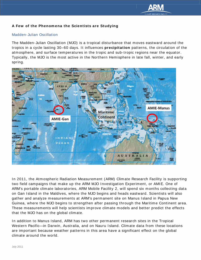
In 2011, the Atmospheric Radiation Measurement (ARM) Climate Research Facility is supporting two field campaigns that make up the ARM MJO Investigation Experiment, or AMIE. One of ARM’s portable climate laboratories, ARM Mobile Facility 2, will spend six months collecting data on Gan Island in the Maldives, where the MJO begins and heads eastward. Scientists will also gather and analyze measurements at ARM’s permanent site on Manus Island in Papua New Guinea, where the MJO begins to strengthen after passing through the Maritime Continent area. These measurements will help scientists improve climate models and better predict the effects that the MJO has on the global climate.
In addition to Manus Island, ARM has two other permanent research sites in the Tropical Western Pacific—in Darwin, Australia, and on Nauru Island. Climate data from these locations are important because weather patterns in this area have a significant effect on the global climate around the world.

July 2011
Tropical Cyclones
A tropical cyclone is identified as a storm system with a large low-pressure center. It is accompanied by numerous thunderstorms. More precisely, the term “tropical cyclone” means:
Tropical: Originating between the Tropic of Cancer and the Tropic of Capricorn.
Cyclone: A storm with a counter-clockwise rotation in the Northern Hemisphere and clockwise rotation in the Southern Hemisphere.
Depending on the strength and location of a tropical cyclone, you might hear it referred to as a hurricane, typhoon, tropical storm, cyclonic storm, and many other terms.
El Niño and La Niña
We often hear about El Niño and La Niña, but what are they? These phenomena are fluctuations of the ocean-atmosphere system in the tropical Pacific. This system has a significant impact on global weather patterns. El Niño is distinguished by its unusually warm ocean temperatures in the central Pacific near the equator. Conversely, La Niña is characterized by unusually cold ocean temperatures in the eastern Pacific near the equator.
The picture below shows ocean temperature anomalies in November 2007, when La Niña was observed. Red represents temperatures that are warmer than normal, and blue represents temperatures that are colder than normal. You can see the cold ocean temperature in the Pacific Ocean, off the west coast of North and South America.
July 2011
Definitions
Atmospheric Convection: The moving of air in the atmosphere. Characterized by warm air rising and cool air sinking.
Equator: The imaginary great circle around the Earth’s surface, equidistant from the poles and perpendicular to the Earth’s axis of rotation. It divides the Earth into the Northern Hemisphere and the Southern Hemisphere.
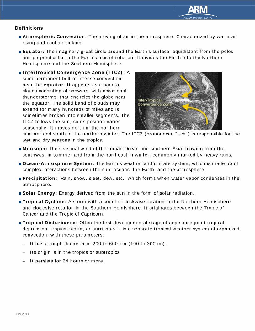
Intertropical Convergence Zone (ITCZ): A semi-permanent belt of intense convection near the equator. It appears as a band of clouds consisting of showers, with occasional thunderstorms, that encircles the globe near the equator. The solid band of clouds may extend for many hundreds of miles and is sometimes broken into smaller segments. The ITCZ follows the sun, so its position varies seasonally. It moves north in the northern summer and south in the northern winter. The ITCZ (pronounced “itch”) is responsible for the wet and dry seasons in the tropics.
Monsoon: The seasonal wind of the Indian Ocean and southern Asia, blowing from the southwest in summer and from the northeast in winter, commonly marked by heavy rains.
Ocean-Atmosphere System: The Earth’s weather and climate system, which is made up of complex interactions between the sun, oceans, the Earth, and the atmosphere.
Precipitation: Rain, snow, sleet, dew, etc., which forms when water vapor condenses in the atmosphere.
Solar Energy: Energy derived from the sun in the form of solar radiation.
Tropical Cyclone: A storm with a counter-clockwise rotation in the Northern Hemisphere and clockwise rotation in the Southern Hemisphere. It originates between the Tropic of Cancer and the Tropic of Capricorn.
Tropical Disturbance: Often the first developmental stage of any subsequent tropical depression, tropical storm, or hurricane. It is a separate tropical weather system of organized convection, with these parameters:
– It has a rough diameter of 200 to 600 km (100 to 300 mi).
– Its origin is in the tropics or subtropics.
– It persists for 24 hours or more.

July 2011
Related Activity: Why is it Hotter at the Equator?
Grade Level: 6th-8th
Approximate Time: One hour for experiment; additional time for student response sheet
Objective: The student will investigate the different heating effects of sunlight as evidenced by observation, documentation, and explanation of how the angle of direct sunlight affects heat differential.
Background Information: Temperatures at the equator are, on average, the hottest on the planet. It is a common misunderstanding that it is hotter at the equator because the equator is closer to the sun. Its location at the center of the Earth is what makes its average temperature warmer than any other place on Earth, because the equator always receives direct sunlight, whether it is summer or winter. Because of the Earth’s spherical shape, sunlight hits the equator directly year-round, unlike the North and South Poles.
For the full lesson plan, visit:
http://education.arm.gov/teacherslounge/lessons/Hotter-at-Equator-Gr-6-8.pdf
Images YOTC logo from the YOTC website, http://www.ucar.edu/yotc/; La Niña and ITCZ graphics from NOAA; AMIE image courtesy of Chuck Long, Pacific Northwest National Laboratory.
ABOUT ARM
The ARM Climate Research Facility is a U.S. Department of Energy scientific user facility for the study of global climate change by the national and international research community. http://www.arm.gov/.