vermont ecosystem restoration program (erp)...
TRANSCRIPT

1
Vermont Ecosystem Restoration Program (ERP)
Annual Report 2014
Prepared by:
Vermont Agency of Natural Resources
Submitted to the Vermont General Assembly
in accordance with 10 V.S.A. §1386(d)
February 1, 2015

2
Acknowledgements
This report was prepared by the staff of the Vermont Department of Environmental Conservation’s Ecosystem Restoration Program, with contributions from staff of the Watershed Management Division, Vermont Agency of Agriculture, Food and Markets, Vermont Agency of Transportation Better Back Roads Program, Vermont Department of Forests, Parks and Recreation, and Vermont League of Cities and Towns.
Cover photo: Photos show an ERP-funded green stormwater infrastructure retrofit project which consisted of two
treatment cells designed to capture runoff before entering into the Laplatte River, in the Town of Hinesburg. Photo
credit: Lewis Creek Association.
The Vermont Department of Environmental Conservation is an equal opportunity agency and offers all persons the benefits of participating in each of its programs and competing in all areas of employment regardless of race, color,
religion, sex, national origin, age, disability, sexual preference, or other non-merit factors. This document is available upon request in large print, braille or audio cassette.
VT Relay Service for the Hearing Impaired 1-800-253-0191 TDD>Voice - 1-800-253-0195 Voice>TDD
i
3
Contents
Executive Summary ................................................................................................................... 1
Ecosystem Restoration Program (ERP) Year in Review ............................................................ 4
Introduction ............................................................................................................................ 4
Lake Champlain Phosphorus TMDL Update ........................................................................... 4
Green Infrastructure Initiative ................................................................................................. 5
Stormwater Master Planning .................................................................................................. 6
Illicit Discharge Detection Elimination (IDDE) and Stormwater Infrastructure Mapping ........... 6
Vermont Better Back Roads Program and Road Related Initiatives ........................................ 7
St. Albans Watershed Initiative ............................................................................................... 9
Local Municipal Actions .......................................................................................................... 9
Portable Skidder Bridge Initiative ...........................................................................................10
Appendix A: List of ERP Grants Awarded in SFY14 ..................................................................12
Appendix B: Number of ERP Projects and Dollars Awarded with SFY14 Funds by River Basin
and County ...............................................................................................................................16
Appendix C: Success Stories ....................................................................................................20
Project #1: Green Stormwater Infrastructure Project at Peoples Academy High School,
Morristown, Lamoille County .................................................................................................20
Project #2: Floodplain Restoration at the Woodstock Community Riverfront Park, Windsor
County ...................................................................................................................................21
Project #3: Jeffersonville Floodplain Easement, Lamoille County ..........................................21
Project #4: Northrop & Talcott Road Erosion Mitigation Projects, Fairfield, Franklin County ..22
Project #5: Waysees Road Erosion Control on Lake Seymour, Town of Morgan, Orleans
County ...................................................................................................................................22
Project #6: Kendrick Pond Dam Removal, Town of Pittsford, Rutland County .......................23
Project #7: Erosion Control on Lake Dunmore Community Access Path, Town of Salisbury,
Addison County .....................................................................................................................23
Project #8: Stabilization of Pond Brook Gully, Town of Monkton, Addison County .................23
ii
1
Executive Summary
The Ecosystem Restoration Program (ERP) provides state grant funds for projects that control
nonpoint sources of water pollution. Nonpoint pollution sources are diffuse water pollution
sources caused by precipitation or snowmelt running off of developed areas, roads, agricultural
lands, and logging areas. Nonpoint source pollution, often referred to as polluted runoff and
erosion, delivers excessive amounts of sediment, nutrients, and other pollutants to surface
waters, and is the leading cause of water quality degradation in Vermont.
The ERP grant funds target high priority actions to reduce sediment and nutrient pollution. A
total of 45 grants and contracts worth nearly $2 million of State Fiscal Year (SFY) 2014 funds
were awarded to municipalities, watershed organizations, natural resources conservation
districts, the regional planning commissions, the University of Vermont, and non-governmental
organizations to improve water quality.
The following tables, accompanying figures, and appendices summarize the SFY14 grant
awards:
Table 1: Summarizes the number of projects and dollars awarded by watershed;
Table 2: Summarizes the number of projects and dollars awarded by county;
Figure 1: Summarizes the projects awarded by project type;
Appendix A: Summarizes information in Table 1 & 2 as pie charts;
Appendix B: Outlines the projects funded with SFY14 capital funds;
Appendix C: Offers a short compendium of selected success stories. In addition to the management of a water quality grant program, ERP staff and program
partners work on a variety of water quality initiatives. Those initiatives include the U.S.
Environmental Protection Agency’s (EPA) Vermont Lake Champlain Phosphorus Total
Maximum Daily Load (TMDL) process, the Vermont Better Back Roads Program, the St. Albans
Watershed Initiative, and stormwater management technical assistance that includes
management of the State’s Green Infrastructure Initiative, Stormwater Master Planning,
Stormwater Infrastructure Mapping, and Illicit Discharge Detection and Elimination (IDDE)
mapping and assessment. The report describes this past year’s accomplishments under these
initiatives.
2
Table 1. SFY14 ERP-Funded Projects by Watershed
Watershed name Number of Projects Total SFY14 Amount
Batten Kill-Walloomsac-Hoosic 4 $46,685
Poultney-Mettawee 3 $93,475
Otter, Little Otter, Lewis Creek 2 $44,000
Southern Lake Champlain 0 $0
Northern Lake Champlain 5 $180,600
Missisquoi 3 $176,825
Lamoille 4 $172,600
Winooski 5 $208,347
White 2 $112,665
Ottauquechee-Black 5 $189,791
West-Williams-Saxtons 1 $94,000
Deerfield 0 $0
Lower Connecticut 0 $0
Stevens-Wells-Waits-Ompompanoosuc 1 $9,267
Passumpsic 2 $69,800
Upper Connecticut 1 $8,000
Lake Memphremagog 2 $103,424
Multiple Basins (Most projects applied statewide) 5 $488,943
TOTAL for SFY14 45 $1,998,422
Table 2. SFY14 ERP-Funded Projects by County
County Number of Projects
Total SFY14 Amount
Addison 0 $0
Bennington 4 $46,685
Caledonia 3 $100,500
Chittenden 1 $67,600
Essex 1 $8,000
Franklin 5 $211,675
Grand Isle 0 $0
Lamoille 3 $141,900
Orange 1 $9,267
Orleans 2 $103,424
Rutland 6 $149,905
Washington 2 $91,574
Windham 2 $109,000
Windsor 4 $177,361
Multiple Counties 11 $781,531
TOTAL for SFY14 45 $1,998,422
3
Figure 1. SFY14 ERP-Funded Projects in Dollars and by Project Type
0
100,000
200,000
300,000
400,000
500,000
600,000
700,000
800,000
900,000
Stormwater,PhosphorusReduction
River, Floodplain,Lake Shoreland
Restoration
Road InfrastructureStability
Agricultural RunoffMitigation
4
Ecosystem Restoration Program (ERP) Year in Review
Introduction
The Vermont Department of Environmental Conservation (VTDEC) Ecosystem Restoration Program (ERP), first established in 2005, provides capital funds, in the form of competitive grants and contracts, to implement priority water quality restoration and protection projects. The fundamental goal of the program is to accelerate the reduction of sediment and nutrient pollution, including phosphorus, from uncontrolled runoff and erosion into the state’s surface waters. The objectives of the ERP grant program are to:
Reduce unmanaged stormwater runoff from developed areas;
Reduce polluted runoff from farms and timberlands;
Upgrade road networks with best road-related stormwater management practices; and,
Restore and protect floodplains, river corridors, wetlands, shoreland, and riparian areas. (The term, “riparian” means the land immediately adjacent to rivers, streams, lakes, ponds, and wetlands.)
The ERP program directs funds toward implementation of priority projects identified in the VTDEC tactical basin planning process. The tactical basin planning process involves assessing the water quality of surface waters (rivers, streams, lakes, ponds, and wetlands) throughout a basin, identifying problem areas, and prioritizing actions. Partner organizations are encouraged to participate in identifying the highest priority projects for state funded support. Partners include municipalities, watershed organizations, conservation districts, regional planning commissions, other local and regional citizen groups, and other state agencies. The VTDEC’s watershed coordinators and technical staff in the rivers, lakes, and wetlands programs provide technical assistance to partners in the development of ERP grant applications. The ERP program targets funds to mitigate priority problem sites specified in tactical basin plans, or other state-sanctioned water quality plans, such as river corridor plans, stormwater master plans, stormwater infrastructure maps, road erosion inventories, and other relevant assessments. The program awards approximately 50-60 grants each year, totaling roughly $2-$2.5 million of state capital construction funds.
Lake Champlain Phosphorus TMDL Update
The Department of Environmental Conservation (VTDEC) released two major reports in 2014. The Lake Champlain Phosphorus Total Maximum Daily Load (TMDL) Phase I Implementation Plan (Phase I Plan) was released on May 29, 2014. The Vermont Clean Water Initiative Report, commonly known as the Act 97 Report, was released on November, 17, 2014. These reports were prepared in collaboration with the Vermont Agencies of Agriculture, Food and Markets (VAAFM), Transportation (VTrans), and Commerce and Community Development (ACCD). For copies of these documents and factsheets that summarize the Phase 1 Plan, refer to the following websites:
The Lake Champlain Phosphorus TMDL Phase I Implementation Plan: http://www.watershedmanagement.vt.gov/erp/champlain/docs/LCTMDLphase1plan.pdf
The Vermont Clean Water Initiative Report: http://www.watershedmanagement.vt.gov/erp/champlain/docs/VTcleanwaterinitiative.pdf
5
Lake Champlain TMDL Fact Sheets, by Sector: Lake Champlain TMDL Factsheet-Agriculture Lands Management PDF 564 KB
Lake Champlain TMDL Factsheet-Forest Lands Management PDF 600 KB Lake Champlain TMDL Factsheet-River and Floodplain Protection PDF 644 KB Lake Champlain TMDL Factsheet-Road Related Stormwater Management PDF 582 KB Lake Champlain TMDL Factsheet-Stormwater Management PDF 667 KB Lake Champlain TMDL Factsheet-Wetlands Management PDF 552 KB
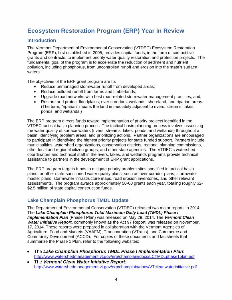
Green Infrastructure Initiative
The ERP Green Infrastructure (GI) Coordinator continues to manage Vermont’s Green Infrastructure Initiative, a statewide effort to increase adoption of Low Impact Development (LID) principles and implementation of Green Stormwater Infrastructure (GSI) practices throughout Vermont. The term LID describes a suite of innovative land use planning and site design techniques that help minimize the creation of stormwater runoff across the landscape. The term GSI refers to a set of best management practices that primarily rely on natural processes to manage and treat stormwater runoff. This Initiative uses a combination of education, outreach, training, technical assistance, and coordination to accomplish its goals. With the Green Infrastructure Strategic Plan as a guiding document, a number of critical tasks were completed including increased training opportunities for design professionals, improved coordination, and raised awareness of LID and GSI practices. The first annual progress report of implementation to date was released in July 2014.
Implementing Executive Order 06-12
On behalf of the Vermont Agency of Natural Resources (VTANR), the Ecosystem Restoration Program continued to play a pivotal role in the implementation of Executive Order 06-12. The ERP staff assisted in the coordination of the Green Infrastructure Council and moved forward with a number of projects, initiatives and programmatic changes within VTANR. A full report can be found here. Major accomplishments include changes to the tactical basin planning and stormwater master planning processes, training for agency staff, discussion of contractor certification programs, beginning the process of updating the Vermont Stormwater Management Manual to include a wider array of green stormwater infrastructure (GSI) practices, incorporating GSI into the design of two major rehabilitation projects in Vermont State Parks, and providing funding for GSI design and implementation to outside partners.
Providing Training Opportunities for Professionals
Design professionals were afforded a number of opportunities to learn more about GSI practices. The initiative hosted four different workshops focused on the technical aspects of GSI. These workshops were attended by roughly 200 individuals.
Raising Public Awareness of LID Principles and GSI Practices
The concepts of LID and GSI continue to be new for Vermonters, so the initiative places a large focus on education and outreach. In SFY14 the initiative delivered at least 16 different presentations and webinars to high schools and colleges, municipalities, civic groups, non-profit organizations and professional trade groups. These presentations reached roughly 540 individuals throughout the state and beyond. Furthermore, a set of nine LID fact sheets were prepared and distributed. In addition, the work of the initiative was featured in a variety of media articles throughout the state, including the Watershed Management Division blog.
6
Coordinating LID and GSI Efforts Statewide via the Green Infrastructure (GI) Roundtable
In 2010, VTANR established the GI Roundtable – a group of interested parties representing both the public and private sector. The group was instrumental in the development of the 2011 – 2013 GSI Strategic Plan and advocated for Executive Order 06-12. In SFY14, the roundtable put their efforts behind a new 5-year strategic plan that outlines seven key objectives. Action items associated with those seven objectives are in development. The GI Roundtable meetings occur on a quarterly basis. A Google Group was created to support conversations and discussion outside physical meetings. The group has grown to 168 participants.
Providing Technical Assistance to Municipalities and Watershed Groups
The ERP program provided technical assistance to municipalities and other partners on a wide range of projects throughout the state. Such assistance is tremendously important for LID and GSI projects, which require a greater understanding of site-specific elements. Assistance included but was not limited to site visits, desktop reviews, input on project designs, technical specifications, and identification of potential funding sources.
Stormwater Master Planning
In 2014 the Ecosystem Restoration Program presented 6 webinars on the Vermont Stormwater Master Planning Guidelines. These guidelines are meant to assist municipalities manage stormwater better by providing guidance, examples, potential funding sources, and a summary table of stormwater related zoning, mapping and water quality issues. The guidelines are intended to evolve continually and will be updated annually with new information. The webinars provide basic training for the most common stormwater master templates and provide case studies to exemplify their implementation. The Vermont Stormwater Master Planning Guidelines Webinar Series has been taped and
can be found under ERP’s Municipal Stormwater Management webpage:
http://www.watershedmanagement.vt.gov/erp/htm/erp-stormwater.htm
Illicit Discharge Detection Elimination (IDDE) and Stormwater Infrastructure Mapping
The Ecosystem Restoration Section recently completed draft stormwater geographic information system (GIS) drainage maps for 27 municipalities across the state. Statewide drainage maps of all urbanized areas are anticipated to be completed by 2017. The maps provide an overall picture of storm drainage system connectedness on public and private properties to raise awareness about stormwater runoff impacts to Vermont’s waterways and the need for regular drainage system maintenance in addition to pollution prevention. When water drains directly to rivers and streams in pipes without passing through vegetation or over soil, pollutants in that water contribute to water quality impairments. Flooding risks also increase. Also, understanding the connectedness of the drainage system is a valuable tool for hazardous spill prevention for local fire and police departments. Illicit discharges are improperly connected sewer or wastewater lines to stormwater lines. Information on the extent of the connected drain system and how it is associated with the municipal sewer system is also essential for the detection and elimination of illicit discharges. Knowledge of which areas of the sewer service area have combined stormwater and sewer systems can better assist municipalities in planning and implementing combined sewer
7
separation projects. Knowledge of the layout and extent of the stormwater system can inform options for cleaning up existing polluted stormwater discharges. This mapping initiative provides information, guidance and funding assistance for potential stormwater retrofit and clean up opportunities. Knowledge of where storm drains are located can also assist municipalities and residents with emergency preparedness for large rainfall events or spring snowmelt runoff events. Localized flooding and property damage can be prevented by keeping storm drains clean. Mapping drainage system also helps municipalities implement stormwater ordinances or create a municipal stormwater management program. The 27 mapped urbanized areas completed in SFY14 include: Bakersfield, Bethel, Bristol, Chelsea, East Montpelier, East St. Johnsbury, Fairfield, Glover, Granville, Hancock, Hartford, Middlesex, Montpelier, Moretown, North Hyde Park, Orwell, Pawlet, Pittsfield, Randolph, Rochester, Royalton, Sharon, Shoreham, Tunbridge, West Fairlee, Wolcott, and Worcester. For more information: http://www.watershedmanagement.vt.gov/erp/htm/SW_IDDE_program.htm
Vermont Better Back Roads Program and Road Related Initiatives
In 2014, VTDEC continued a strong partnership with VTrans to implement the Vermont Better Back Roads Program (VBBR) program. The VBBR is a grant program that supports water quality improvement practices, such as sediment and erosion controls, along town roads. There are two types of VBBR grants. Category A funds support the development of road erosion inventories and capital budget plans to implement road erosion control practices. Category B funds support implementation of road best management practices.
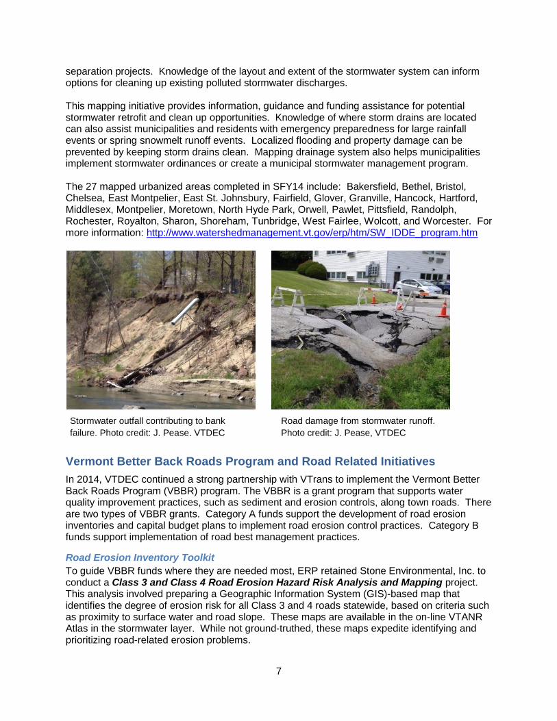
Road Erosion Inventory Toolkit
To guide VBBR funds where they are needed most, ERP retained Stone Environmental, Inc. to conduct a Class 3 and Class 4 Road Erosion Hazard Risk Analysis and Mapping project. This analysis involved preparing a Geographic Information System (GIS)-based map that identifies the degree of erosion risk for all Class 3 and 4 roads statewide, based on criteria such as proximity to surface water and road slope. These maps are available in the on-line VTANR Atlas in the stormwater layer. While not ground-truthed, these maps expedite identifying and prioritizing road-related erosion problems.
Road damage from stormwater runoff.
Photo credit: J. Pease, VTDEC
Stormwater outfall contributing to bank
failure. Photo credit: J. Pease, VTDEC
8
The ERP program also retained Watershed Consulting Associates, Inc. to develop a Road Erosion Inventory Methodology and Capital Budget Planning Guide. This work is on-going. The methodology and guide will provide a standard methodology to inventory, ground-truth, and prioritize erosion risk for road segments. A mobile application (mobile “app”) is planned as one of the deliverables. This methodology will help to strategically target funds to address the highest priority erosion and sediment sources along our road networks statewide.
Better Back Road Grants Awarded in Two Rounds
The VTrans Better Back Roads (VBBR) program contributed $440,000 and VTDEC contributed $227,000 for a combined total of $667,000 to support the first VBBR grant round in SFY14. The VTDEC funding was linked directly to road improvement priorities described in river basin tactical plans. A new approach for this grant round included workshops to learn about better back road practices, water quality concerns and how to complete VBBR applications. This approach resulted in an unprecedented 84 projects funded, with the number of new town applicants and inventory projects tripled (17 and 21 projects, respectively). The ERP program contributed an additional $30,000 to the VBBR’s next grant round. The ERP funds were used to target water quality problems on private roads that contribute sediment and nutrient pollution to surface waters. (The ERP has traditionally supported erosion and sediment control projects along private roads, since VTrans is prohibited from supporting projects on private roads). The combined $470,000 of round two funding supported 69 projects including 10 new towns and four projects along private roads. For more information, see: http://vtransengineering.vermont.gov/sections/environmental/betterbackroads
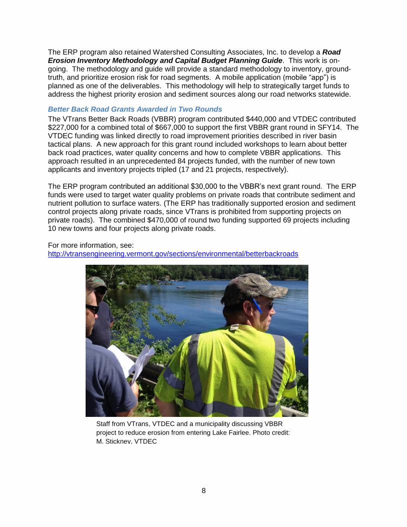
Staff from VTrans, VTDEC and a municipality discussing VBBR
project to reduce erosion from entering Lake Fairlee. Photo credit:
M. Stickney, VTDEC

9
St. Albans Watershed Initiative
The St. Albans Bay Watershed Initiative was created to focus attention on water quality problems that continually plague St. Albans Bay. The Initiative focuses on reducing nutrient and sediment-laden polluted runoff that drains directly into the bay. Sources include polluted runoff from agricultural land, developed lands, and roads, as well as unstable river channels. The initiative is being implemented in close partnership with the Northwest Regional Planning Commission, the City of St. Albans, the University of Vermont Extension System, and the VTrans Vermont Better Back Roads Program. The Northwest Regional Planning Commission received support from ERP to help identify water quality improvement projects within the watershed. The work consisted of three parts: (1) Evaluate previously completed water quality improvement reports to potential projects; (2) Use GIS overlay mapping techniques to identify potential critical source areas (CSA) in the watershed likely to contribute phosphorus runoff; and (3) identify capital funds-eligible nonpoint source pollution reduction projects concerning: (a) public and privately owned road-related projects, and (b) stormwater retrofit opportunities in areas of the watershed that are not within the boundary of the municipal stormwater permit (i.e., Municipal Separate Storm Sewer System (MS4) permit). As a first step in addressing stormwater runoff problems, the City of St. Albans received support to develop a flow restoration plan for the upper portion of Stevens Brook. The plan, completed in February 2014, identifies a number of public and privately owned sites that could better control stormwater runoff volumes and improve conditions in the upper reaches of the brook. The University of Vermont (UVM) Extension System also received ERP funds to work with agricultural landowners in the Jewett Brook and lower Stevens Brook watersheds. The purpose of the work is to implement conservation practices at critical source areas. The UVM Extension program is also serving as a ‘case manager’ to assist landowners with enrollment in U.S. Department of Agriculture (USDA) Natural Resource Conservation Service (NRCS) cost-share soil and water conservation programs. The ERP program provided an additional $60,000 in funds to VTrans to implement six priority VBBR projects in three towns within the watershed --Swanton, Fairfield and St. Albans.
Local Municipal Actions
The ERP program continues to support a part-time Water Resources Coordinator at the Vermont League of Cities and Towns (VLCT). The coordinator provides municipalities with technical and educational assistance to protect water quality. Work focuses on stormwater management, road-related stormwater management, green stormwater infrastructure, river corridor protection, lake shoreland protection, and flood hazard protection. Accomplishments in 2014 include the following:
Technical assistance to 22 towns on water resource protection;
Educational assistance on the VTrans Town Road and Bridge Standards that pertain to road best management practices. Activities included presentations at regional Transportation Advisory Committees and Road Foreman meetings, the Town Officers Education Conference (TOEC) series, the VLCT Selectboard Institutes, the annual Hazard Preparedness Conference, VLCT Town Fair, and individual technical assistance to municipal officials representing more than 70 towns.
10
Published 6 articles in the VLCT News on subjects including changes in the National Flood Insurance Program (NFIP), floodplain zoning, the Shoreland Protection Act, the new Flood Ready Vermont website, the Emergency Relief and Assistance Fund (ERAF) and green stormwater infrastructure.
Portable Skidder Bridge Initiative
Portable skidder bridges are designed and intended for use as temporary structures for crossing streams during logging. Portable skidder bridges are becoming widely viewed as a Best Management Practice for controlling nonpoint source pollution associated with logging operations. When properly installed, used, and removed, they create less stream bank and stream bed disturbance as compared to other alternatives such as culverts or poled fords. They are also economical since they are reusable, easy to install and can be transported from job to job. Portable skidder bridges will reduce the potential for sedimentation, channeling, and degradation of aquatic habitat to occur while
allowing loggers to harvest timber in compliance with Acceptable Management Practices (AMPs) for Maintaining Water Quality on Logging Jobs in Vermont. The following is a summary of program activities that promote the use of portable skidder bridges. The Portable Skidder Bridge Free Loan and Education Program ended in 2014. The program was designed and intended to be an incubator program for technology transfer as loggers realize the economic and environmental benefits of using portable skidder bridges and incorporate them into their logging operations. From 2011 through 2013, it was supported by a grant through the Lake Champlain Basin Program and was administered by the Northern Vermont Resource Conservation and Development (RC&D) Council. Seventeen free loans agreements were made with loggers operating in the Lake Champlain Basin during the grant project period from 2011 through 2013. Those bridges provided temporary access to 915 acres of forestland that was harvested. The volume of timber transported across those bridges was 3,125 cords. The Portable Skidder Bridge Cost Share and Education Program also ended in 2014. This program was funded by a grant from the U.S. Forest Service State & Private Forestry Program, also administered by the Northern Vermont RC&D Council. The program provided up to a 50% match with a grant award of up to $1,500 per bridge for qualifying loggers to build or purchase a bridge with approved specifications. From 2011 through 2014, the program awarded grants to seventeen loggers. Thirty-eight bridges were built to program specification. The Portable Skidder Bridge Rental Program, administered by the Natural Resources Conservation Districts, continues to rent bridges to loggers for $100/month. Eleven Conservation Districts participate in this program. The bridges are located at participating sawmills and log yards for loggers to conveniently pick up and return. Loggers who rent bridges are provided an educational packet that illustrates guidelines to follow for installation, use and
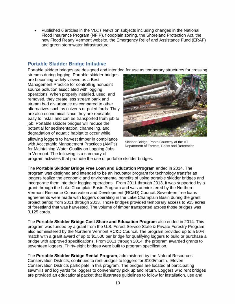
Skidder Bridge, Photo Courtesy of the VT Department of Forests, Parks and Recreation
11
removal of the bridges while following Acceptable Management Practices for Maintaining Water Quality on Logging Jobs in Vermont. Demand for rental bridges has continued to grow since this program was established in 2005.

12
Appendix A: List of ERP Grants Awarded in SFY141
County Partner Summary Title Funding Topic Cat
Addison Six SFY13 projects are being implemented, totaling $259,650 in grant funds.
Bennington Bennington County Conservation District
Tropical Storm Irene-Related Berm Removal on White Creek
$11,498 R 2
Bennington County Conservation District
Rupert Bed and Bank Stabilization $15,836 R 2
Batten Kill Watershed Alliance
Mill Brook Mass Failure Stabilization, Floodplain Restoration
$14,625 R 2
Bennington County Regional Commission
Rupert Stormwater Master Plan $10,962 S 1
Caledonia and Orleans
Town of Hardwick, Caledonia County Natural Resources Conservation District
Stormwater Treatment, South Main Street, Hardwick
$1,515 (project
total with prior year
funds is $30,700)
S 2
Caledonia County Natural Resources Conservation District
St. Johnsbury Stormwater Treatment and Illicit Discharge Detection & Elimination (IDDE) Study, Passumpsic and Sleepers Rivers
$57,800 S 1
Caledonia County Natural Resources Conservation District
St. Johnsbury Western Avenue Stormwater Retrofit Study
$12,000 S 1
Memphremagog Watershed Association
Lake Memphremagog Basin Illicit Discharge Detection & Elimination (IDDE) Study of the stormwater system in Brighton, City of Newport, Derby, Barton
$49,160 S 1
Orleans County Natural Resources Conservation District
Phosphorus Reduction by Restoring Riparian Areas in the Lake Memphremagog Basin
$54,264 R 2
Lewis Creek Association Stormwater Treatment Project Implementation on the Laplatte River, Hinesburg
$67,600 S 1
Essex Essex County Natural Resources Conservation District
Agricultural BMP Nutrient and Pathogen Reduction in the Upper Connecticut River
$8,000 A 2
Franklin and Grand Isle
Northwest Regional Planning Commission
Franklin County Regional Hydroseeder Program
$38,675 Rd, A 2
Friends of Northern Lake Champlain
Stewarding Farmland in the Missisquoi and St. Albans Bay Basins
$68,000 A 2
1 Key for Topic and “Cat” (Category) symbols are at the end of the table.

13
County Partner Summary Title Funding Topic Cat
(Franklin – Grand Isle continued)
Friends of Northern Lake Champlain
Missisquoi Basin Stormwater Master Planning and Priority Retrofit Project
$75,000 S 1
Franklin Watershed Committee (FWC)
Multi-barrier Cluster Approach to Stewarding Farmland, Lake Carmi
$15,000 (paired with
MRBA)
A 2
Missisquoi River Basin Association (MRBA)
Multi-barrier Cluster Approach to Stewarding Farmland, Lake Carmi
$15,000 (paired with
FWC)
A 2
VT Agency of Transportation
Road erosion reduction projects in St. Albans watershed, St. Albans Initiative
$50,000 (project
total with prior year
funds is $60,000)
Rd 2
Lamoille Lamoille County Planning Commission
Brewster River Geomorphic Assessment and Corridor Plan, Cambridge
$24,240 R 1
Vermont River Conservancy, Lamoille County Natural Resources Conservation District
Wild Branch River Corridor Easement Implementation
$76,660 R 3
Lamoille County Natural Resources Conservation District
Lamoille Stormwater Project, Johnson State College and Peoples Academy High School
$41,000 S 2
Orange White River Natural Resources Conservation District
River Corridor Protection and Riparian Area Restoration Project Implementation, Wells River
$9,267 R 2
Orleans See Projects Under Caledonia and Orleans Counties
Rutland Rutland Natural Resources Conservation District
Stormwater Reduction in the Tenney Brook and East Creek
$34,000 S 1
Poultney-Mettowee Natural Resources Conservation District
Poultney High School Stormwater Management, Poultney River
$41,710 S 2
Poultney-Mettowee Natural Resources Conservation District
Woodlawn Farm Agricultural Runoff Reduction/Barnyard Improvement, tributary to the Mettowee River, Pawlett
$42,765 A 2
Town of Killington US Route 4, Killington Road Park and Ride Stormwater Project
$242 (project
total with prior year
funds is $12,430)
S 2
14
County Partner Summary Title Funding Topic Cat
(Rutland continued)
Village of Poultney York Street Stormwater Management Feasibility Analysis to Control Stormwater Runoff into Poultney River
$9,000 S 1
Washington Friends of the Mad River Addressing Priority Road Erosion Sites in Fayston
$30,614 Rd 2
Central VT Regional Planning Commission
Waterbury/Winooski River Corridor Plan and Fluvial Erosion Hazard Mapping
$60,960 R 1
Windham Windham County Natural Resource Conservation District
River Corridor Plan, Williams River, Chester, Andover
$94,000 R 1
Windham County Natural Resource Conservation District
Trees for Streams, Windham County $15,000 R 2
Windsor Vermont River Conservancy
Pingree Flats Easement Project - Money Brook Tributary to Black River, Plymouth
$52,713 R 3
Two Rivers-Ottauquechee Regional Commission
Ottauquechee Abandoned US4 Abutment Removal
$48,000 R 2
Connecticut River Watershed Council
Restoration of Ottauquechee River, Barnard Brook Riparian Areas, Billings Farm, Woodstock
$14,148 R, A 2
Village of Woodstock Ottauquechee River Riparian Area Restoration, Woodstock Community River Park
$47,500 (project
total with prior year
funds is $62,500)
R 2
Regional- Lake Champlain Basin
Friends of the Winooski River
Basin Illicit Discharge Detection & Elimination (IDDE) Study of the Stormwater Systems in the Municipalities of Barre City, Barre Town, Berlin, Williamstown, and Stowe
$3,859 (project
total with prior year
funds is $59,400)
S 1
Friends of the Winooski River
Targeted Riparian Restoration in the Winooski Watershed
$33,960 R 2
Winooski Natural Resources Conservation District
Trees for Streams in the District $28,960 R 2
University of Vermont-Extension
Implementing Precision Agriculture Technology for Liquid Manure Nutrient Management
$63,150 A 2

15
County Partner Summary Title Funding Topic Cat
Regional-CT River
White River Partnership Upper and Middle White River Corridor Plan
$77,325 R 1
White River Natural Resources Conservation District
Agricultural Water Quality Best Management Practices (BMP) for Small Farms, First and Third Branch, White River
$35,340 A 1
Statewide Federation of Vermont Lakes and Ponds
Lakescaping: Shoreland Area Restoration Using LakeWise Best Practices
$25,779 L 2
Vermont Association of Conservation Districts
Trees for Streams, in Collaboration with 14 Natural Resources Conservation Districts
$137,461 (project
total with prior year
funds is $149,761)
R 2
Vermont Youth Conservation Corps
Water Quality Implementation Teams Project
$75,403 R 2
Vermont Youth Conservation Corps
Additional Water Quality Implementation Projects - Buffers
$11,000 R 2
VT Agency of Transportation
Vermont Better Back Roads Program - Municipal Road Runoff Mitigation Projects
$227,000 Rd 2
VT Agency of Transportation
Vermont Better Back Roads Program – Mitigation Projects on Private Roads/Lands
$30,000 Rd 2
Topic Key A: Agricultural Runoff Rd: Road Construction/Maintenance L: Lake shoreline restoration/protection S: Stormwater Runoff R: River corridor/floodplain restoration/protection W: Wetland restoration Category 1: Project Development/Scoping 2: Project Implementation 3: Resource Protection
16
Appendix B: Number of ERP Projects and Dollars Awarded
with SFY14 Funds by River Basin and County
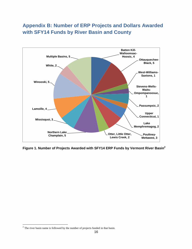
Figure 1. Number of Projects Awarded with SFY14 ERP Funds by Vermont River Basin2
2 The river basin name is followed by the number of projects funded in that basin.
Batten Kill-Walloomsac-
Hoosic, 4 Ottauquechee-
Black, 5
West-Williams-Saxtons, 1
Stevens-Wells-Waits-
Ompompanoosuc, 1
Passumpsic, 2
Upper Connecticut, 1
Lake Memphremagog, 2
Poultney-Mettawee, 3
Otter, Little Otter, Lewis Creek, 2
Northern Lake Champlain, 5
Missisquoi, 3
Lamoille, 4
Winooski, 5
White, 2
Multiple Basins, 5
17
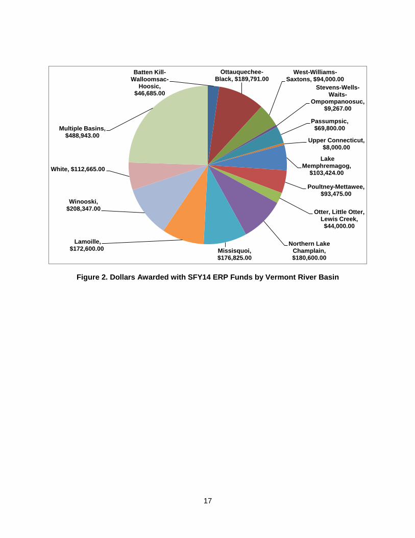
Figure 2. Dollars Awarded with SFY14 ERP Funds by Vermont River Basin
Batten Kill-Walloomsac-
Hoosic, $46,685.00
Ottauquechee-Black, $189,791.00
West-Williams-Saxtons, $94,000.00
Stevens-Wells-Waits-
Ompompanoosuc, $9,267.00
Passumpsic, $69,800.00
Upper Connecticut, $8,000.00
Lake Memphremagog,
$103,424.00
Poultney-Mettawee, $93,475.00
Otter, Little Otter, Lewis Creek, $44,000.00
Northern Lake Champlain, $180,600.00
Missisquoi, $176,825.00
Lamoille, $172,600.00
Winooski, $208,347.00
White, $112,665.00
Multiple Basins, $488,943.00
18
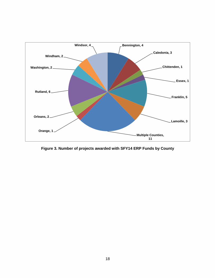
Figure 3. Number of projects awarded with SFY14 ERP Funds by County
Bennington, 4
Caledonia, 3
Chittenden, 1
Essex, 1
Franklin, 5
Lamoille, 3
Multiple Counties, 11
Orange, 1
Orleans, 2
Rutland, 6
Washington, 2
Windham, 2
Windsor, 4
19
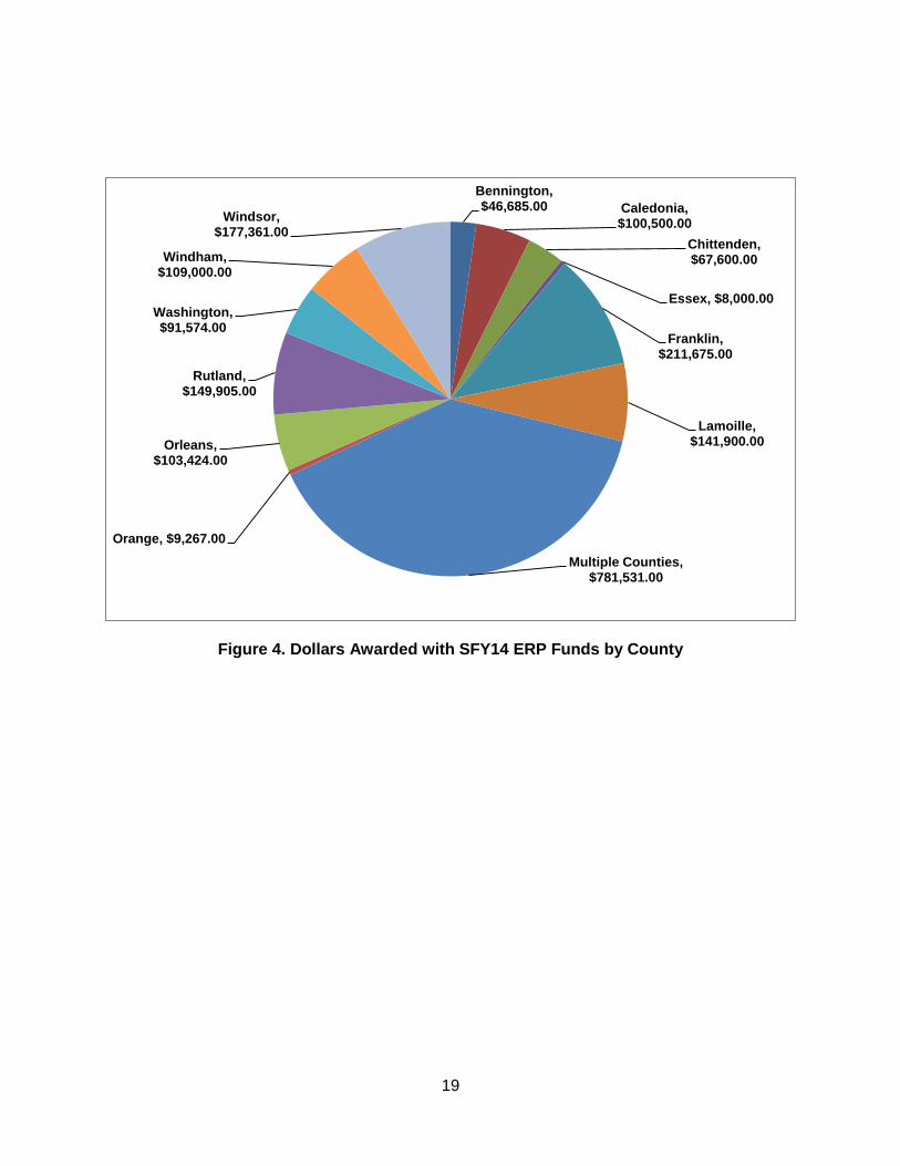
Figure 4. Dollars Awarded with SFY14 ERP Funds by County
Bennington, $46,685.00 Caledonia,
$100,500.00
Chittenden, $67,600.00
Essex, $8,000.00
Franklin, $211,675.00
Lamoille, $141,900.00
Multiple Counties, $781,531.00
Orange, $9,267.00
Orleans, $103,424.00
Rutland, $149,905.00
Washington, $91,574.00
Windham, $109,000.00
Windsor, $177,361.00
20
Appendix C: Success Stories
The following selected projects represent types of implementation projects supported with SFY14 Ecosystem Restoration Program grants. These projects are representative of green stormwater infrastructure practices to control stormwater runoff from developed lands, road-related erosion and sediment controls, and river corridor and floodplain protection to improve flood resilience and enhance water quality locally.
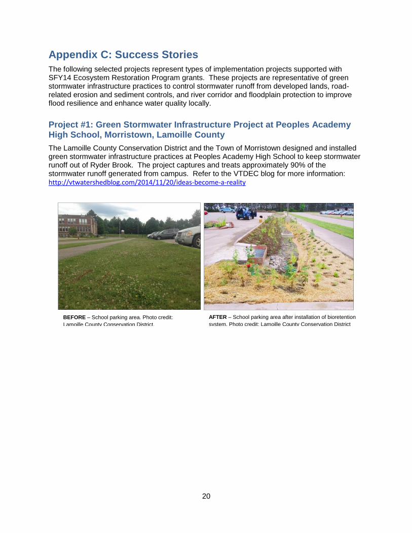
Project #1: Green Stormwater Infrastructure Project at Peoples Academy High School, Morristown, Lamoille County
The Lamoille County Conservation District and the Town of Morristown designed and installed green stormwater infrastructure practices at Peoples Academy High School to keep stormwater runoff out of Ryder Brook. The project captures and treats approximately 90% of the stormwater runoff generated from campus. Refer to the VTDEC blog for more information: http://vtwatershedblog.com/2014/11/20/ideas-become-a-reality
BEFORE – School parking area. Photo credit:
Lamoille County Conservation District.
AFTER – School parking area after installation of bioretention
system. Photo credit: Lamoille County Conservation District

21
Project #2: Floodplain Restoration at the Woodstock Community Riverfront Park, Windsor County
The Village of Woodstock restored the floodplain at land formerly used as the town snow dump, to create the new Woodstock Community Riverfront Park. The project installed green stormwater infrastructure called rain gardens and a vegetated buffer to filter stormwater runoff before it reaches the Ottauquechee River. The park supports public access to the Ottauquechee River for boating or swimming. Refer to the VTDEC blog for more information: http://vtwatershedblog.com/2014/12/17/woodstock-community-riverfront-park-completed/
Project #3: Jeffersonville Floodplain Easement, Lamoille County
The Village of Jeffersonville permanently protected 3 acres of the floodplain which will serve the dual purpose of mitigating damages and property loss from future flooding and improving water quality for the Brewster and Lamoille rivers. Work with a second landowner continues to protect another 2 acres of floodplain.
AFTER –Restored floodplain, Ottauquechee River.
Photo credit: M. Caduto, VTDEC
BEFORE – Eroding and degraded floodplain,
Ottauquechee River. Photo credit: M. Caduto, VTDEC
Brewster River
Lamoille River
Floodplain
Easement Areas
Jeffersonville in the aftermath of the April 2011 flood. Outlined in yellow shows the conserved 3 acres of floodplain. Outlined in red
shows the additional 2 acres of floodplain to be conserved. Route 15 bisects the photo and the Lamoille River covers the bottom
of the photo. The Brewster River borders the village at the top of the photo. Photo credit: S. Pomeroy, VTDEC
22
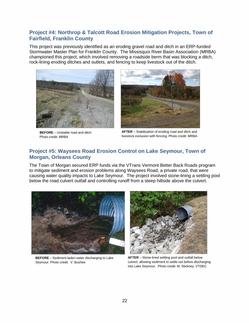
Project #4: Northrop & Talcott Road Erosion Mitigation Projects, Town of Fairfield, Franklin County
This project was previously identified as an eroding gravel road and ditch in an ERP-funded Stormwater Master Plan for Franklin County. The Missisquoi River Basin Association (MRBA) championed this project, which involved removing a roadside berm that was blocking a ditch, rock-lining eroding ditches and outlets, and fencing to keep livestock out of the ditch.
Project #5: Waysees Road Erosion Control on Lake Seymour, Town of Morgan, Orleans County
The Town of Morgan secured ERP funds via the VTrans Vermont Better Back Roads program to mitigate sediment and erosion problems along Waysees Road, a private road, that were causing water quality impacts to Lake Seymour. The project involved stone-lining a settling pool below the road culvert outfall and controlling runoff from a steep hillside above the culvert.
BEFORE – Unstable road and ditch.
Photo credit: MRBA
BEFORE – Unstable road and ditch. Photo credit:
MRBA
AFTER – Stabilization of eroding road and ditch and
livestock exclusion with fencing. Photo credit: MRBA
BEFORE – Sediment-laden water discharging to Lake
Seymour. Photo credit: V. Bushee
AFTER – Stone-lined settling pool and outfall below
culvert, allowing sediment to settle out before discharging
into Lake Seymour. Photo credit: M. Stickney, VTDEC

23
Project #6: Kendrick Pond Dam Removal, Town of Pittsford, Rutland
County
The removal of an old (circa 1870) ice pond dam restored 10 square miles of stream habitat in Rutland County. More information may be found at the VTDEC blog: http://vtwatershedblog.com/2014/12/10/kendrick-dam-removal-project-completed/
Project #7: Erosion Control on Lake Dunmore Community Access Path, Town of Salisbury, Addison County
The Federation of Vermont Lakes and Ponds teamed up with the Town of Salisbury, Vermont Youth Conservation Corps and VTDEC LakeWise Program to stabilize an eroding public access path to Lake Dunmore.
Project #8: Stabilization of Pond Brook Gully, Town of Monkton, Addison County
Monitoring data show that the Pond Brook Watershed is the largest contributor of nutrient
pollution loading into Lewis Creek. Lewis Creek Association (LCA) identified six actively eroding
gullies in need of stabilization. The LCA worked with the landowner and the USDA-NRCS. to
stabilize two severely eroding gullies at a farm in Monkton. Stabilization of the remaining four
gullies was completed in December, 2014. BEFORE – Eroding and degraded floodplain,
Ottauquechee River. Photo credit: M. Caduto, VTDEC
BEFORE – Mill pond behind dam filled with
accumulated sediment. Photo credit: E. Swift, VTDEC
AFTER – Free-flowing Sugar Hollow Brook. Photo
credit: E. Swift, VTDEC
BEFORE – Erosion at community access path at
Lake Dunmore. Photo credit: A. Picotte, VTDEC
BEFORE – Stabilization of access path.
Photo credit: A. Picotte, VTDEC