urbanizing at the lake’s edge: watershed planning and · 5 for instance, josé rizal, preeminent...
TRANSCRIPT

GOMEZ | Journal in Urban and Regional Planning (2014)
34
Urbanizing at the Lake’s Edge: Watershed Planning and
Governance Lessons from the Laguna de Bay Region,
Philippines
José Edgardo Abaya Gomez, Jr.*
INTRODUCTION, SCOPE AND METHODOLOGY As the largest freshwater body in the archipelago, Laguna de Bay1 <pronounced “Ba-ee”> has served generations of lakeshore dwellers, and looms large in Philippine history as a bounteous provider, as well as a venue for fluvial celebrations, commuting, and tourism. Urbanization of Metro Manila, which forms the lake’s northwest quadrant, has over time increased pollution levels alarmingly. Meanwhile, Laguna de Bay’s farther shores have continued to serve as sites for agriculture, which feed growing populations in the 29 lakeside settlements of the Southern Tagalog region2. Indeed, upscale suburbs have crept southwards along the lake’s western rim, transforming in the last decade what were once rice and sugarcane plantations into grayfields, as exemplified by the City of Santa Rosa, where industries and gated subdivisions abound. Policy makers are thus looking at collaborative planning and stiffer regulation to stem the tide of haphazard land conversion and inappropriate use, especially in the wake of typhoon Ketsana, which devastated Metro Manila and towns lining Laguna de Bay between 26-27 September 2009, by dumping a month’s rain (200+ mm.) in 24 hours and causing around 700 fatalities.
1 Also written as Laguna de Bai, and referring to a settlement, “Ba-i” along the southern edge of the lake. 2 These towns are: Bay, Biñan, Cabuyao, Calamba, Calauan, Kalayaan, Los Baños, Lumban, Mabitac, Paete, Pakil, Pangil, Pila, San Pedro, Santa Cruz, Santa Rosa, Siniloan, Victoria, Angono, Baras, Binangonan, Cardona, Jala-Jala, Morong, Pililla, Tanay, Taytay, Muntinlupa, and Taguig.
ABSTRACT
Planning and implementation at the watershed level is often “easier said than done”, especially in developing countries where there may yet be a lack of shared perspective, reliable data and comprehensive state control over vast basins of territory. In the Philippines, pressures of urbanization and climate change have refocused attention on public administration of freshwater resources and the agencies that regulate water use. This study highlights the Laguna Lake Development Authority and its attempts to delegate management in the Santa Rosa sub-basin of the watershed. It analyzes how differences of mandate at regional and local levels make control of a common resource problematic. The research reviews multiple-agency dynamics that go into planning a common resource vis-à-vis experiences from those who govern and use the lake, then makes practical recommendations for improvement. Keywords: watershed governance, Laguna de Bay, clustering, tragedy of the commons
* Assistant Professor at the School of Urban and Regional Planning in University of the Philippines in
Diliman.

URBANIZING AT THE LAKE’S EDGE: WATERSHED PLANNING AND GOVERNANCE LESSONS FROM THE LAGUNA DE BAY REGION, PHILIPPINES
GOMEZ| Journal in Urban and Regional Planning (2014)
35
Though the Laguna Lake Development Authority (LLDA) was established over three decades ago to oversee and regulate the use of water resources and development around the lake, it has had a mixed record of accomplishment. It may be considered the nerve center of peer agencies that are concerned with Laguna de Bay. While there is already a shared conception of the watershed, and a tenuous solidarity that revolves around protecting the lake, joint actions to prohibit undesirable activities or inhibit further building encounter resistance or delay, arising out of misunderstanding or simple impracticability of say, forbidding fishermen, who must feed growing families, from increasing their daily catches. Based on a review of institutions, this research describes the lake as a commons, and problematizes its aspects that should factor into stepwise watershed planning. The empirical focus is mainly on the Santa Rosa sub-watershed as part of the lake, but findings and the discussion are likely applicable to Southeast Asian insular watershed scenarios. Key informant interviews were contrasted against official records, so that a dimension of lived experiences enriches the discussion. The subsequent analysis is then integrated into a critique of administrative regimes.

URBANIZING AT THE LAKE’S EDGE: WATERSHED PLANNING AND GOVERNANCE LESSONS FROM THE LAGUNA DE BAY REGION, PHILIPPINES
GOMEZ | Journal in Urban and Regional Planning (2014)
36
REVIEW OF RELATED LITERATURE Watershed Basics and The Concept of the Commons
A watershed or catchment is an area that drains to a common point; typically, its resources are characterized by high exclusion costs and subtractibility3 (Kerr, 2007). A watershed can vary in size from thousands of hectares to a few tracts of forest, pastures, agricultural land, surface water, and ground water all linked by hydrology, often with smaller catchments nested within a super-basin. Because watersheds are often also inhabited, they eventually become the subject of political and administrative concern, as growing populations find that they must fight for, or share linked resources, yet shoulder the costs of their neighbors’ pollution. This reality identifies the watershed conceptually with the idea of the commons, as explained by Hardin (1968)—natural space that is originally shared by all and owned by none, but which often must come under regulation, to avoid the havoc that follows overpopulation and the mad scramble for scarce resources. Alternatively, common governance arrangements may be propounded, where non-government entities join in managing the resource, subject to compensation mechanisms. Sustainable Urbanization in Regions and Watershed Planning
Southeast Asia boasts of its modest share of watersheds, which make up tropical lacustrine landscapes that have supported the flourishing of civilizations and iconic local cultures. The Philippines’ Laguna de Bay, 869 square kilometers, (Siringan and Jaraula, 2003)4, though smaller than Cambodia’s Tonle Sap of 2,700 km.2, or Indonesia’s Danau Toba of 1,133 km.2, and perhaps not as quaint as Myanmar’s Inle Lake of 116 km.2 nevertheless happens to be both a source of livelihood and household water, while its fertile shores have been home to many a national figure5. Because Laguna de Bay is surrounded by vegetated rising ground upon which sits a network of hamlets, middling cities, and the burgeoning capital region, Metro Manila, it suggests itself to regional planners as a coherent space for rationalization. Such regional planning straddles the national-local gap, and attempts to respond to functional problems, increasingly of a physical and environmental nature, that result from the demands of rapid population growth, rising standards of living, and personal mobility (Glasson, 1992). From this perspective, the watershed is an appropriate unit for planning hydrological concerns, but is not a customary unit of human social organization, in the way that a village or a city might be. Such regional planning also speaks to the notable paucity of subnational plans observed in Asia, as well as insufficient detail in any comprehensive regional plans already extant (King et al, 2003). Traditional planning approaches nowadays espouse sustainability, which requires that human activities do not deplete what can be termed “natural capital” or “environmental capital”. Natural capital refers to any stock of natural assets that yields a flow of valuable goods and services into the future. For example, a forest, a fish stock or an aquifer can provide a harvest or flow that is potentially sustainable year after year. The forest or fish stock is “natural capital” and the sustainable harvest is “natural income” (Roseland, 2000). Sustainable development paradigms do not run counter to urbanization, but rather lean towards more compact urban form that
3 A high exclusion cost or non-exclusive resource is difficult to exclude others from using. For a subtractable or rival resource, one user’s welfare is diminished by other users (also from Kerr, 2007). 4 The same authors indicate that from measurements from 1939 to 1990 show a decrease in lake area from 922 to about 869 km2 or some 89,000 hectares , and a mean water depth shallower from 2.52 to 2.24 meters. 5 For instance, José Rizal, preeminent Philippine hero, was born and raised in Calamba, a rural town to the south of the lake. The late national artist Botong Francisco, who hailed from Angono along the northern shores, was known to sit pensively on the roof of a moored boat, while he sketched or painted his masterpieces.

URBANIZING AT THE LAKE’S EDGE: WATERSHED PLANNING AND GOVERNANCE LESSONS FROM THE LAGUNA DE BAY REGION, PHILIPPINES
GOMEZ| Journal in Urban and Regional Planning (2014)
37
retains quality of life and social interactions, while reducing energy consumption and greenhouse gas emissions through ecological design—urban form ideas with roots dating back to the end of the 19th century (Jabareen, 2006). A more radical transformation however, is advocated by those for whom the largely-anthropocentric sustainable development paradigm is but a palliative planning measure for regional and urban development. For wicked and amorphous problems, the persistent planner may opt for Naess’ (1973) rejection of the Man-In-Environment image in favor of the ecocentric relational total-field image. This turn towards seeing humans as just another aspect of nature—albeit a potentially transformational one. This is echoed by Jenkins (2011) who reminds us that while pragmatic strategy helps facilitate cultural reform, it often requires elements of cosmological strategy—or a shift in worldview that make complex eco-social threats such as climate change or watershed deterioration intelligible. Such ecocentrism is concerned with creating a society that will maintain its environment, doing away with the rat race that teaches masses to climb out of poverty, only to live unsustainable lifestyles (Atkinson, 1992). Without simply wishing away prior cultural differences that may have a confounding effect, the result of such advocacy is a shift towards the concept of a bioregion. A bioregion, as evidenced by a simple etymology, refers to a geographic region defined by biological or ecological parameters, whether created through initial conservation efforts, or restored from a defective state. Within this bioregion some effort is ideally made to promote development that has low environmental impact and a high degree of fit with nature—though it must be admitted that not everyone has the option of choosing such a “lifeplace” to inhabit on a long term basis (Lyndgaard, 2008). To treat Laguna de Bay and its subwatersheds as a bioregion is a distinction supported by this research. Lake Ecology and Anthropogenic Effects
Under pristine conditions, natural lakes support an endemic spectrum of biodiversity. In order to inform watershed planning, an important starting point for science is the understanding of how this biodiversity supports the production of ecosystem services, and how different social groups value those services. This rationalizes choices between strict conservation and sustainable growth, as the cost of foregoing food and fiber production may be larger than the additional conservation benefits (Pascual & Perrings, 2007). Moreover, in urban and urbanizing areas, there is always the potential for pollution to enter standing and flowing waters. The result, called degraded water, refers to water that has suffered chemical, physical, or microbiological degeneration in quality. This could be due to thermoelectric usage, irrigation (e.g. where pesticides are used), concentrated animal feeding operations, stormwater run-off, domestic graywater discharge, or food/chemical processing effluents. This further results in harmful fluctuations in dissolved oxygen levels and fecal coliform. The degraded water must be treated (sometimes to better-than-original quality) before reuse (‘O Connor et al, 2008). In relation to this, the presence of plant communities appears to have a significant impact on leaching of nitrate, ammonium, and phosphate, which can be absorbed by certain species (Vauramo & Setälä, 2010). Forest management also helps in maximizing products and services at both the stand and landscape levels. This will require precision administration not unlike precision technologies used in intensive agriculture, except that the public has the expectation that forest lands will be managed for water use and quality, biodiversity, and wildlife habitat in addition to food and fiber production (Burger, 2009).
URBANIZING AT THE LAKE’S EDGE: WATERSHED PLANNING AND GOVERNANCE LESSONS FROM THE LAGUNA DE BAY REGION, PHILIPPINES
GOMEZ | Journal in Urban and Regional Planning (2014)
38
Regulating Stakeholders, Water Rights, and Markets
For watershed projects, the vital issue is a group’s ability to establish a new governance system to effectively manage the commons (Agrawal, 2001). This is so that members act to sustain the shared resource—or at least submit willingly to regulation, even if benefits arrive only gradually across the long term. Notwithstanding, such regulation of water sources and their adjacent lands has impacts on the livelihoods and lifestyles of water-users inhabiting the region in question, as well as more remote citizens. This makes watershed planning contentious and complex. Often, it is difficult to answer the question `Who speaks for the watershed?’ as there is rarely agreement among watershed residents as to the resource problems or what kind of policies should be used to deal with the resource concerns (Kraft & Penberthy, 2000). Lumping groups as "property owners" obscures differences between large, full-time farmers and small holders. But people are neither "undifferentiated nor unpredictable". Land use (and water use) cannot be effectively regulated without taking into account social and political relationships (Adams, 2005). When some semblance of clarity between stakeholder relationships has been defined, it becomes easier to assign water rights. A “water right” is defined as “right to take and use water subject to the terms and conditions of the grant” (Burchi and D’Andrea 2003). There are basically two categories: “basic water right” that people have as a consequence of primary legislation—i.e. as a basic right that assures survival, which is permanent and not subject to any administrative process. The second is a “water-use right” conferred through an administrative process of water allocation, such as licensing (ADB, 2009). It is the exercise of the latter right that figures prominently in the economics of water use and trading, as water provides a variety of goods (e.g. drinking-water, irrigation water) and services (e.g. hydroelectricity generation, recreation and amenity) that are utilized by agriculture, industry and households, even if the quantity of supply cannot be readily specified, being as it is affected by flow characteristics, evaporation, and ground percolation, among other factors (FAO, 2004). Moreover, water may be considered a 'bulky' resource. This means that its economic value per unit weight or volume tends to be relatively low. Therefore, its conveyance entails a high cost per unit of volume and is often not economically viable over long distances unless a high marginal value can be obtained. The costs of abstraction, storage and any conveyance tend to be high relative to the low economic value that is placed on the use of an additional unit of water. This can create values for water that are location-specific (Young, 1996), especially because water, like other natural resources, is unevenly distributed throughout a given territory. Recent years have seen the introduction and refinement of a new, macro-level market for development rights, which trades off use of a resource versus long-term protection elsewhere. Wetland and stream markets are traded based on size (area and length). Such market mechanisms help to redistribute and regulate growth (BenDor & Doyle, 2010), though are imperfect and favor established urban systems. Water Resource Governance and Some East Asian Experiences
Samples of attempts to regulate water resources can be seen in Thailand, where a certain paternalism of government agencies over farmers prevails, regarding the issue of irrigated lands that are rapidly being urbanized, while government suffers from line function fragmentation, or overlaps and conflicts between government ministries and agencies in their water-related functions (Sajor & Ongsakul, 2007). The fragmentation is apparent in Indonesia as well, as there are at least two agencies—one provincial, the other watershed-oriented, vying for control over the Ciliwung watershed, whose development has been limited by presidential decree (Hendrayanto, 2007). In the case of Taiwan for instance, stakeholders in a study by Chou (2011), commented that the jurisdiction of a watercourse site is separated into many

URBANIZING AT THE LAKE’S EDGE: WATERSHED PLANNING AND GOVERNANCE LESSONS FROM THE LAGUNA DE BAY REGION, PHILIPPINES
GOMEZ| Journal in Urban and Regional Planning (2014)
39
organizations, with different administrative standards in planning, design, construction, or management. Despite similar disjunctions in the Philippines, government has at least been able to prioritize action for critical watersheds that support downstream communities. For instance, Laguna de Bay has recently been tapped as a secondary source of water for Metro Manila to augment the supply from Angat dam to the north. This is because household demand for water, which ranges from a bare 20 liters per capita per day (lpcd) to 400 lpcd, has been rising with population uptrends of at least 2% per annum (NSCB, 2012). The country’s planning standard for domestic water consumption of about 250 lpcd may therefore need to be reexamined in the light of increasing supply constraints. Even relative to the available estimates, this figure is certainly higher due to the fact that it includes non-revenue water or system losses (Inocencio, et al, 1999). THE GOVERNANCE SETTING: GEOGRAPHY AND BIOPHYSICAL HIGHLIGHTS OF LAGUNA DE BAY The lake is part of the expansive region called the Pasig-Marikina-Laguna de Bay Basin that has a total drainage area of over 4,600 km2 (NWQSR-LLDA, 2005), of which some 3,820 km2 pertains specifically to the Laguna de Bay watershed, with twenty-four (24)6 sub-basins surrounding just under 900 km2 characteristically-shaped triple-lobed “W” of Laguna de Bay (Cariño, 2003). Like other Philippine lakes, Laguna de Bay was formed out of volcanic and tectonic activity as well as sedimentation processes that severed it as a marine appendage of Manila Bay some 6,000 ago, when sea levels fell during the mid-Holocene. Its formation has been somewhat more complex in so far as its central and eastern lobes resulted from calderagenic eruptions, while its southern boundary was delineated by formation of the downslopes of the Talisay caldera and the Makiling, Atimbía, and Nagcarlan edifices as well as lahar deposits from Banahaw Volcano. The lake’s westernmost boundary and its separation from Manila Bay were made possible by the emergence of the Diliman Plateau along the West Valley Fault (Punongbayan, 2003). The watershed is largely underlain by two geological substrates, Quaternary Alluvium and Laguna Formation, and is characterized by the remains of andesitic and basaltic lavas and course pyroclastic rocks (Haman, 1996). Climatologically, the area experiences a good amount of rainfall, ranging from 1,800 mm. to 2,250 mm. per year over the plain areas, and up to 2,500 mm. per year in the escarpment and other upland areas (Haman, 1996, Rojas, 2009). Hydrologically, the Laguna de Bay watershed holds a volume of at least 2.25 million cubic meters of water (Santos-Borja, 2005). The Santa Rosa sub-watershed, which this research emphasizes, is estimated to account for water discharges of 738.58 m3/second to 818.93 m3/second as peak flow contribution range, given its foreseen urbanization within the next decade (Rojas, 2009). The effects of such urbanization will interact with slope, size of drainage basin, vegetation cover, and soil type to affect discharge characteristics. In terms of living natural resources, the lake supports a wide variety of tropical flora and fauna, with several commercially-valuable introduced species. Records from local planners listed at least eight species of fish recorded consisting of three indigenous and six introduced. Plants from phytoplankton to complex vascular species abound, just as to birds, amphibians, small reptiles, and mammals like deer (Cervidae) and wild boars (Suidae) in the forest (Santa Rosa, Socioeconomic Profile, 2005).
6 Sub-basins (counting from Metro Manila, clockwise): Muntinlupa, Taguig, Marikina, Manggahan, Angono, Morong, Baras, Tanay, Pililla, Jala-jala, Santa Maria, Siniooan, Pangil, Caliraya, Pagsanjan, Santa Cruz, Pila, Calauan, Los Baños, San Juan, San Cristobal, Santa Rosa-Cabuyao, Biñan, San Pedro.

URBANIZING AT THE LAKE’S EDGE: WATERSHED PLANNING AND GOVERNANCE LESSONS FROM THE LAGUNA DE BAY REGION, PHILIPPINES
GOMEZ | Journal in Urban and Regional Planning (2014)
40
WHO NEEDS GOVERNANCE: A SOCIOECONOMIC SNAPSHOT AND ONGOING NARRATIVE OF THE LAKE Laguna de Bay forms the heart of the Southern Tagalog region, an agricultural area inhabited since precolonial times (i.e. prior to 1565 contact with Spanish conquistadors). Much the same basic livelihoods of farming, hunting-gathering, and fishing prevail today, especially along the rural eastern edge of the lake, but augmented by aquaculture, since the LLDA successfully introduced milkfish (Chanos chanos) culture in the early 1970s (FAO, 1999, Delmendo, 1987), and fishermen began to raise tilapia (Oreochromis species) in cages, as well as other commercially-viable fish decades later. Too, the lake was recorded to have provided some 47,000 metric tons of catch at least up to the year 2000 (LLDA Website), though such quantities are generally perceived to be optimistically stated, since the initial 1963 recordings of at least 82,882 metric tons (Delmendo, 1987), with more typical figures like 20,723 tons of wild fish harvest, and 23,597 tons of shrimps in 1973, which declined to 13,346 metric tons of fish and 992 metric tons of shrimp a decade later. Fishermen involved in such aquatic monoculture have been observed to use cages commonly measuring 10x20 meters or smaller, and together cover areas ranging from 150 to 11,200 m.2 (Santiago, et al., 2003). In the last three decades, companies have located in urbanizing towns along the western side of the lake—with Muntinlupa and Taguig in Metro Manila arguably foregone examples of lake-insensitive growth, having inevitably piled their demands upon the ecosystem in terms of freshwater withdrawals from the watershed’s production zone. This resulted in water shortages, subsidence, and effluent backwashes. The most prominent locator is the local subsidiary of the Coca-Cola corporation, which has been investing heavily in water quality studies and projects to save the lake and rationalize its development. Other corporate locators include real estate developers who have put up subdivisions, as well as industrial manufacturing firms that have clustered in the many technoparks of Laguna province. One unfavorable result of rapid urbanization of the northern shores—and in the last decade, the western shores of Laguna de Bay is the increase in pollution. General sampling figures by the LLDA and the Environmental Management Bureau (EMB) of the Department of Environment & Natural Resources (DENR) show that water quality hovers between “fair” and “poor”, which means that upon sampling, it often fails to comply with national water standards for inland waters [Table 2B, DENR A.O.35 of 1990]7 for dissolved oxygen, biological oxygen demand (BOD – less than 120 mg/l), total suspended solids (TSS – less than 150 mg/l) and total dissolved solids (TDS – less than 1,500 mg/l). Not surprisingly, the poorer readings tend to come from the urbanized shores bordering Metro Manila, for the period 2001-2005. Contaminants can be traced mostly to point sources--about 77 percent of BOD load in the Laguna de Bay came from households, 11 percent from industry, and 12 percent from land runoff (NWQSR-LLDA, 2005). In some cases, the author has observed muck being spewed from outlet pipes that originate deep within the recesses of shanty towns. It should be mentioned that Laguna de Bay is the source of electricity and potable water. In the former case, according to the LLDA website, natural discharges from elevated basins on the east allow the Kalayaan plant to generate at least 300 megawatts of power. In the latter case, the Maynilad Water Services Inc., which supplies potable water to western Metropolitan Manila, opened its treatment plant in Putatan, Muntinlupa city, in 2011, with intake from the lake. This last move has met with mixed public reactions, as there are apprehensions about the purity of
7 From http://emb.gov.ph/laws/water%20quality%20management/dao90-35.html, downloaded 17 April 2012.
URBANIZING AT THE LAKE’S EDGE: WATERSHED PLANNING AND GOVERNANCE LESSONS FROM THE LAGUNA DE BAY REGION, PHILIPPINES
GOMEZ| Journal in Urban and Regional Planning (2014)
41
the water being pumped to households, despite treatment. The fact that the rival Manila Water Company plans to put up a similar pumping station in the next decade, points to the increasing risk of drawing from an already stressed source, to service the unabating demands of the capital. FINDINGS Urbanization as it Happens: The City of Santa Rosa and its Sub-Watershed
To clarify the research site, the City of Santa Rosa as well as parts of the municipalities of Biñan, Cabuyao, and Silang together make up Santa Rosa watershed. It was in the basin formed by these localities that the construction of the Laguna Technopark began in 1989, a private industrial estate regulated by government that provided 224 hectares of pioneer development for international factories, which later expanded to 387 hectares. Other founding locators included Coca-Cola, Toyota, and Panasonic, who had set up plants by 1990. By 1994, the erstwhile municipality of Santa Rosa was generating enough income to attain cityhood under Philippine law, and a year later, the iconic world-class amusement park, Enchanted Kingdom (a modest 17-hectare approximation of Disneyland), firmly catapulted the city into national headlines. Upgrading of the Southern Luzon Expressway in 2006 improved accessibility to the various sites, enhancing the strategic location of lands making up the Santa Rosa sub-watershed, which sit along the crossroads going southwest to the highland resort town of Tagaytay, in Cavite province, or farther south to the the urban-rural mosaic of the hilly Southern Tagalog region. Taken together, all these elements have compelled Santa Rosa City and its flanking towns of Biñan and Cabuyao, as well as its upland neighbor, Silang, to occasional public scrutiny, even as the former continue to welcome investors. While political leaders pay lip service to environmental obligations, as demonstrated by stakeholder summits and as of this writing, two workshops that led to the drafting in September 2011 of a Memorandum of Agreement to work together by sub-watershed cluster under the auspices of LLDA, interviews of local planning staff make it appear that there is neither a critical mass of champions, nor yet the rare vertical alignments of congressman, governor, mayor, and technical staff—or even barangay8 captains, who realize the urgency of their water woes. As the city planner put it in an interview, little was done by the local government in the 1990s to anticipate the real estate boom that followed industrial locators, such that former sugarlands that used to sell at PhP50 per square meter (about USD$1.10 per 10.76 square feet) back then now sell for PhP10,000 per square meter (about USD$250.00 per 10.76 square feet), making it difficult even for the relatively wealthy Santa Rosa city government to purchase lands for land-banking and open space retention. It remains crucial to eventually reacquire lots from private owners, or at least regulate the lands in the upstream of the city’s political jurisdiction. It is here that the recharge zone begins for the Matang-tubig spring, the main source of freshwater whose aquifers lie in Cabuyao, but which feeds the Santa Rosa and Tiway-Tiway rivers of the sub-watershed that discharges into Laguna de Bay. From a political perspective therefore, the battle for proper environmental governance is thus being waged in Santa Rosa, as it is not too far gone down the road of urbanization to enact water-sensitive and innovative zoning ordinances, or other measures to restore its water balance. Too, there is no more auspicious time than the present to vigorously define the sub-watershed and its stewards, as substantial external funding
8 Barangay <ba-rang-gai> - the smallest spatio-political unit in the Philippines, equivalent to a village, with a formal political structure, composed of an elected political chief and councilors.
URBANIZING AT THE LAKE’S EDGE: WATERSHED PLANNING AND GOVERNANCE LESSONS FROM THE LAGUNA DE BAY REGION, PHILIPPINES
GOMEZ | Journal in Urban and Regional Planning (2014)
42
from private donors has been pouring in since 2008, that may be spent to determine the natural limits, potentials, and likely future of Santa Rosa sub-watershed and adjacent lands. SITUATING SANTA ROSA WATERSHED IN THE POLICY AND INSTITUTIONALFRAMEWORK FOR THE LAKE The laws protecting Laguna de Bay predate industrialization of the area by nearly three decades. These statutes include the mandate that created LLDA, as well as the Philippine Water and Sanitation Codes (Presidential Decrees 1076 & 856 respectively, circa 1970s). This makes the Philippines one of the developing countries that adopted, early in its history, what was implicitly a watershed approach to territorial management. These laws, along with new ones9, should have been enforced more strictly before the economies of Santa Rosa, Biñan, Cabuyao and Silang boomed in the last decade, so that their urbanization could have been framed by both physical safeguards (e.g. reengineering of irrigation into sewerage, building retaining walls, distancing of wells10) and administrative processes (e.g. instituting river clean-ups and waste segregation). The institutions that wield legal fiat over Laguna de Bay’s preservation, restoration, and development can be divided into three categories of involvement: comprehensive, partial, and peripheral. First, the lead agency in the government that has an unequivocal mandate to manage the watershed is the LLDA. Its raison d’être is in Republic Act 4850, which provided for the creation of LLDA as a quasi-government corporation in 1966, vesting it with regulatory, developmental, and quasi-judicial functions. Subsequent amendments strengthened the LLDA’s powers to act on ecological disturbances, and still later, in 1993, it came under full government control by attachment to the DENR. In pursuing its mandate, it is LLDA that has continued to exert pressure on local chief executives to comply with national water standards or face legal action. Such a history of endowment begs the question why it should be less than effective at improving the water quality over which it plays steward. Equally comprehensive in its ability to affect the general welfare, but limited in its territorial reach is the Local Government Unit (LGU), which acquired powers to oversee and decide on environmental concerns under the Republic Act 7160, known as the 1991 Local Government Code of the Philippines, and famously known as one of Southeast Asia’s early experiments with decentralization. Of these LGUs, there are five types; which are, from largest to smallest: (1) provinces—of which 5 border the lake (Rizal, Quezon, Laguna, Batangas, and Cavite) and 1, Metro Manila, is sui generis, the National Capital Region; (2) highly-urbanized cities (HUCs), represented by Taguig and Muntinlupa, which form the edge of Metro Manila bordering the lake; (3) cities like Santa Rosa and San Pablo, (4) municipalities, and (5) barangays, the smallest spatio-political units of the state. LGUs are the frontliners, sometimes literally choked by their own waterways, unless they take local action, as in the case of the Biñan river some years ago, that was so clogged with garbage that “I have a picture of a dog walking across its surface…”,
9 Since the 1990s, the Philippine Congress has passed several environmental protection laws, the more prominent of which probably include The National Integrated and Protected Areas Act of 1992 (Republic Act 7586), The Clean Air Act of 1999 (R.A. 8749), the Solid Waste Management Act of 2000 (R.A. 9003), and the Disaster Risk Reduction and Management Act of 2010 (R.A.10121). 10 Presidential Decreee 1067, the Philippine Water Code, specified as far back as 1976 in its implementing rules and regulation, the minimum spacing between artesian wells dug by households, depending on liters per second (lps) extraction rate, with the closest distance being 200 meters apart for 2-10 lps, and up to a kilometer apart for 40 or higher lps. This would have an effect on the subsurface cone of depression formed by such multiple extractive structures, with differing severity depending on whether these were spread across a wide urban or rural area.

URBANIZING AT THE LAKE’S EDGE: WATERSHED PLANNING AND GOVERNANCE LESSONS FROM THE LAGUNA DE BAY REGION, PHILIPPINES
GOMEZ| Journal in Urban and Regional Planning (2014)
43
narrated the city environmental officer who, together with LLDA and an “Environmental Army” of volunteers, succeeded in a massive clean-up effort. It is among these LGUs that Santa Rosa City, Biñan, Cabuyao and Silang are counted, and as the towns that make up a sub-basin, are expected by regulators to comply proportionately with national water standards to the degree that matches their relatively wealthier (and more pollutive) status. MORE ON INSTITUTIONS: ADMINISTRATIVE-LEGAL LEAKS, BARRIERS AND OVERLAPS The LLDA has substantial powers under Republic Act 4850 of 1966; to wit: “To plan, program finance and/or undertake infrastructure projects such as river, flood and tidal control works, waste water and sewerage works, water supply, roads, portworks, irrigation, housing and related works, when so required within the context of its development plans and programs including the readjustment, relocation, or settlement by population within the region as may be deemed necessary and beneficial by the Authority…”. In addition, it issues permits for wastewater discharge, land development clearance, shoreline lease and development, barge operation, and fishpens. To its credit, the LLDA has put in place an Integrated Water Resources Management approach, which consists of the following components, as per Cariño (2003), and Santos-Borja (2005): (1) an Environmental User Fee (EUF) System, which has imposed fees on polluters, and can reach up to 600% of baseline costs, depending on both pollutant concentration and volume in effluents; this brought down pollution load to around 20% in the mid-2000s from a high of about 40% in the preceding decade; (2) a Zoning and Management Plan which rationalized and reduced hectarage for fisheries, down from an excessive 35,000 hectares in the 1980s--which caused fishstocks to plummet, to a moderated 10,000 hectares for fishpens and 5,000 for cages; (3) a Shoreland Development and Management Plan, presently being undertaken in coordination with urban planning of the LGUs which line the 14,000 hectare littoral, and (4) a River Rehabilitation Program, which, though naïvely started with sporadic and slipshod volunteer clean-ups, now proceeds more deliberately, as informed by research on watershed hydrogeology.
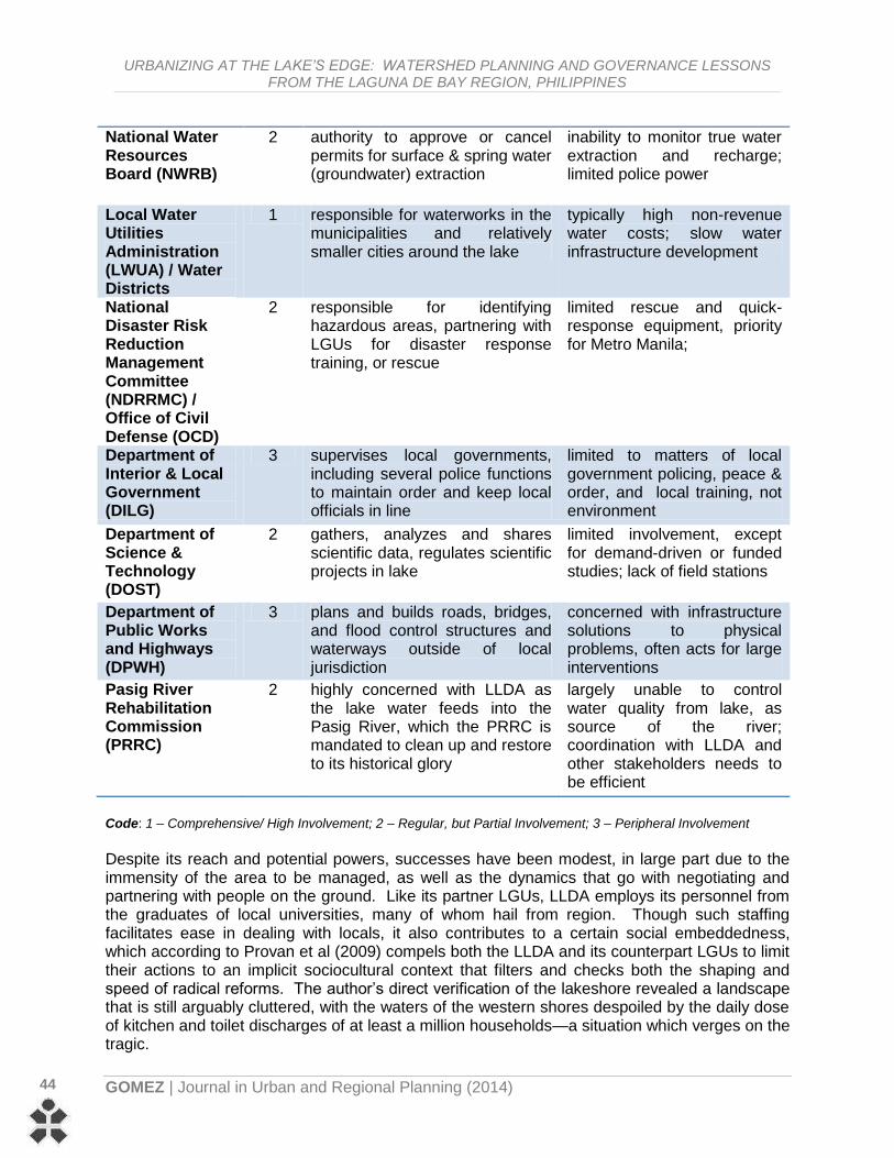
Table 1: Philippine Government Agencies with Direct or Regular Activities (Related to Policy and Implementation) in Laguna de Bay
Institution / Government
Agency
Code Powers and Duties Related to the Lake
Common Problems Related to Lakeshore Development
[DENR] Laguna Lake Development Authority (LLDA)
1 overall authority for lake protection and development
conflicts with competing private interests, LGUs
Local Government Unit (LGU)
1 authority to act on the ground, in interest of local community
small budgets for reform, limited perspectives
Department of Agriculture (DA)
2 responsible for crops and fertilizer programs; farm technology
balancing act between fishery productivity & effect of feed spoilage & fertilizer run-off
URBANIZING AT THE LAKE’S EDGE: WATERSHED PLANNING AND GOVERNANCE LESSONS FROM THE LAGUNA DE BAY REGION, PHILIPPINES
GOMEZ | Journal in Urban and Regional Planning (2014)
44
National Water Resources Board (NWRB)
2 authority to approve or cancel permits for surface & spring water (groundwater) extraction
inability to monitor true water extraction and recharge; limited police power
Local Water Utilities Administration (LWUA) / Water Districts
1 responsible for waterworks in the municipalities and relatively smaller cities around the lake
typically high non-revenue water costs; slow water infrastructure development
National Disaster Risk Reduction Management Committee (NDRRMC) / Office of Civil Defense (OCD)
2 responsible for identifying hazardous areas, partnering with LGUs for disaster response training, or rescue
limited rescue and quick-response equipment, priority for Metro Manila;
Department of Interior & Local Government (DILG)
3 supervises local governments, including several police functions to maintain order and keep local officials in line
limited to matters of local government policing, peace & order, and local training, not environment
Department of Science & Technology (DOST)
2 gathers, analyzes and shares scientific data, regulates scientific projects in lake
limited involvement, except for demand-driven or funded studies; lack of field stations
Department of Public Works and Highways (DPWH)
3 plans and builds roads, bridges, and flood control structures and waterways outside of local jurisdiction
concerned with infrastructure solutions to physical problems, often acts for large interventions
Pasig River Rehabilitation Commission (PRRC)
2 highly concerned with LLDA as the lake water feeds into the Pasig River, which the PRRC is mandated to clean up and restore to its historical glory
largely unable to control water quality from lake, as source of the river; coordination with LLDA and other stakeholders needs to be efficient
Code: 1 – Comprehensive/ High Involvement; 2 – Regular, but Partial Involvement; 3 – Peripheral Involvement
Despite its reach and potential powers, successes have been modest, in large part due to the immensity of the area to be managed, as well as the dynamics that go with negotiating and partnering with people on the ground. Like its partner LGUs, LLDA employs its personnel from the graduates of local universities, many of whom hail from region. Though such staffing facilitates ease in dealing with locals, it also contributes to a certain social embeddedness, which according to Provan et al (2009) compels both the LLDA and its counterpart LGUs to limit their actions to an implicit sociocultural context that filters and checks both the shaping and speed of radical reforms. The author’s direct verification of the lakeshore revealed a landscape that is still arguably cluttered, with the waters of the western shores despoiled by the daily dose of kitchen and toilet discharges of at least a million households—a situation which verges on the tragic.

URBANIZING AT THE LAKE’S EDGE: WATERSHED PLANNING AND GOVERNANCE LESSONS FROM THE LAGUNA DE BAY REGION, PHILIPPINES
GOMEZ| Journal in Urban and Regional Planning (2014)
45
At this stage, it becomes necessary to mention the role of the National Water Resources Board (NWRB), the lead national agency created as a council in 1974, that formulates water policy and standards, and more importantly for the lake, approves permits for extraction of groundwater, including industrial and domestic wells across the entire watershed territory. One of its most recent important outputs has been to spearhead the dissemination of the Integrated Water Resources Management (IWRM) Plan Framework crafted in 2006 as a national policy guide on water conservation and rational use. Like the LLDA, the NWRB mandate is spatially expansive, and thus difficult to implement with a limited annual budget. In truth, NWRB is known for its widespread approval of water use concessions and groundwater extraction permits, which the 1976 Water Code effectively grants in perpetuity, subject to the notoriously hazy condition of “beneficial use” (Article 28, Presidential Decree 1067). As commented by one of its officials, neither does it have personnel nor equipment to monitor extraction of water from all wells approved throughout the archipelago. Such poor policing, when combined with LLDA’s own spotty inspections, results in a porous blanket of feedback regarding where water is coming from, where it is going, and how much of it is being used in and around the lake region. Though both agencies have overlapping concerns over water, they have not been able to match the pace of urbanization and population demands for lacustrine resources. To the former’s credit, it must be added, the work of front-end regulation and information dissemination has been sustained, though it cannot yet catch undisclosed over-extraction and wastewater dumping. Analysis & Discussion Looking ahead, an astute planner would see that much the same scenario may replay itself in other sub-basins around the lake’s rim. As each town rushes to urbanize in pursuit of its own economic gain, the whole will deteriorate--a classic tragedy of the commons. While LLDA has the right to clamp down on blatant littering, it does not seem to have the wherewithal to impose more draconian regulation; neither would it be popular for it to be looking too often over the shoulders of town mayors, who enjoy the votes of their less-farsighted constituents. Though LLDA makes news once in a while for closing down businesses whose wastewater contaminates the lake, such busts raise other practical questions like, why were effective sewers and pollution control mechanisms not laid down en masse in the first place? Such piecemeal enforcement is fertile ground for extortion and collusion between enforcing agents and small-time shopkeepers who merely see such actions as irritants, divorced from the vision of having a clean lake for everyone’s welfare. From a watershed planning and governance perspective, what is called for here, in lieu of iron-fisted regulation, is exactly what LLDA is trying to catalyze: an effective managerial-cum-sociopolitical clustering of settlements by sub-basin. This makes inherent sense, based on experiences in other countries, as neighboring LGUs can only be effective within their own limited world, so to speak, which in this case is encompassed within the few hectares of valley or floodplain defined by a rivulet, stream, waterfall, or marsh. Beyond such confines, poorer local governments have no capacity to police their territory. There have been debates though, as mentioned by one international NGO representative working with Santa Rosa City, regarding which type of clustering might be best. This informant argued that functional clustering around a historical-traditional hub might be a better alternative. That is, instead of by basin, LGUs could team up as, say, industrial cluster (Biñan, Santa Rosa, Cabuyao), woodcarving and handicraft cluster (Paete, Pakil, Pangil), industrial cluster, and arts and heritage cluster (Angono, Binangonan, Cardona), etc., thus building on long-standing identities and competencies. LLDA, however, remains adamant about trying out the new scheme first, then making modifications
URBANIZING AT THE LAKE’S EDGE: WATERSHED PLANNING AND GOVERNANCE LESSONS FROM THE LAGUNA DE BAY REGION, PHILIPPINES
GOMEZ | Journal in Urban and Regional Planning (2014)
46
later. Both options look promising, as long as they remain within the administrative reach and “comfort zones” of local leaders. Comparing LLDA’s attempts to encourage coalitions to protect the lake, one must recall from other studies that the administration of a watershed requires collaborative institutions with high levels of commitments to shared policies, sufficient resource allocations, and levels of inter-organizational cooperation (Ryan and Bidwell, 2007). Such collaborative natural resource management is believed to enhance social learning: it builds social capital, reduces stakeholder conflict, increases government accountability, and ensures that local knowledge informs planning. Groups need information that will assist them to (1) identify and refine investment priorities from among a range of issues, (2) develop and improve communication with private landholders, (3) choose from among the mix of policy options available to accomplish watershed targets, and (4) evaluate the achievement of intermediate watershed management objectives over time (Curtis et al, 2005). Collaborative governance, however, as LLDA is learning, tends to be difficult to orchestrate, first because of fragmentary overall administrative structures which were established long before the watershed was ever problematized. A STEPWISE FRAMEWORK for GOVERNING the WATERSHED Extracting lessons inductively from the tension between different reforms pushed from both top and bottom—that is, by LLDA and the local towns, one may sense that there are common stages of governance, but each is somehow circumscribed by its operational reality. While administering and planning for a watershed region may be approached from different angles, there is a core logic that governs the estimation and handling of the whole. Under this rationality, the main undertakings can be described as follows: Situational Step: Defining Boundaries and Sub-Boundaries
As with any complex problem, the decision-makers must delimit the nature and physical limits of the bioregion-as-potential watershed, as can best be done rationally. While this is conceptually possible with modern satellite technology and aerial photography, the planner-administrator in the developing world may have to settle for less than the entirety11. There are any number of reasons for this: lack of means to technically define the whole, presence of uncharted wilderness, armed resistance or border disputes with neighboring states, to name a few. In either case, the minimum to be defined is a specific basin, with a known water resource, and often crossing at least one political jurisdiction such that a supra-body is needed to mediate between the users of the commons who do not hail from the same town. Moreover, in cases where delineation of an immense area is possible, sub-basin definition is necessary to break the natural expanse into manageable sites. Organizational Step: Identifying & Shaping Stakeholders
In drawing in others, one can expect coordination but rarely total unity. Administrators and planners need to become comfortable with the shifting amalgam of mayors, councilors, real estate developers, environmentalists, agriculturists’ organizations, homeowners’ associations, etc. who will typically bargain for more benefit, but with less accountability. Although only a
11 This entirety is composed of the towns of Rizal and Laguna Provinces; the towns of Silang, General Mariano Alvarez, Carmona, and Tagaytay City in Cavite; Lucban in Quezon, and the cities of Marikina, Pasig, Taguig, Muntinlupa, Pasay, Caloocan, Quezon, as well as the municipality of Pateros in Metro Manila, though LLDA distinguishes between administrative and hydrological jurisdictions, whose peripheries differ slightly.

URBANIZING AT THE LAKE’S EDGE: WATERSHED PLANNING AND GOVERNANCE LESSONS FROM THE LAGUNA DE BAY REGION, PHILIPPINES
GOMEZ| Journal in Urban and Regional Planning (2014)
47
partial and temporary consensus may be reached on any given aspect of the watershed, what is important is to bring to light all interests, so that meaningful dialogue can be sustained. Again the idea of effective size resurfaces, with the literature reminding us that local focus and small teams enjoy greater success. But how small should “small” be? The author asserts that the group should be small enough to share norms and a clear vision of their sub-watershed. Yet it should also be large enough for legal recognition, and have enough resources to access adjudication and technical consultants easily. This size, clearly, will vary from country to country, depending on other enabling socioeconomic and political factors. Too, in keeping with trends in expanding human consciousness, it would be ideal to recognize not only the marginalized, voiceless human groups (e.g. children and future generations) but also the non-human stakeholders in the watershed (e.g. animal and plant populations—and not just the endangered ones). Realistically, this latter consideration may be asking too much of the small-town clerk who would not be able to tell the difference between a finch and a bulbul even if he were implored to save their habitats. In the long-run however, as fortunes and education improve, it is expected that more informed decisions will be made by such stakeholders for total (i.e. not just people-centered) care of the bioregion, hence the importance of introducing such cosmologies to local administration. Normative-Correctional Step: Laying Down the Law for Watersheds and Water Use Controls
It is at this stage that the hard decisions must be made: to close down, to phase out, to refit and reengineer, and to relocate—industries, livelihoods, customs, formal and informal settlers, plant and animal populations, etc. This is when plans are implemented, and where mutual coercion must be agreed upon by the majority of people, in order to save their shared natural resources. That is, stakeholders (including government) agree to surrender, limit, or modify past rights and privileges, in order that the watershed may be sustainably utilized. Such normative or correctional actions come at any stage of development; they may be geared towards conservation of a still-pristine wilderness, designed to balance and rationalize ecological elements vis-à-vis pressures to expand an already built-up site, or engineered to rehabilitate derelict brownfields to a respectable simulacrum of remembered, or imagined verdure. Questions of legal control over the watershed may arise not out of local resistance, but rather because of friction from multiple competing jurisdictions of government agencies as well as local governments. The hapless (or cunning) citizens or corporations who pursue self-interest will thus typically go forum shopping, seeking the politician or agency bureaucrat who can deliver their needs, in exchange for a legitimate fee, a vote, a bribe, or a favor. Bureaucratic capture is also possible, though will not necessarily last through the next election, as powerful private interests push to have their properties and profit-making activities approved, located in prime spots, or exempted from certain fees, taxes or penalties. The challenge then becomes a classic planning or public administration conundrum of how to unify energies and loyalties within the bureaucracy, so that the citizen shall transact following only the orthodox way. Solutions to achieve this would include visioning exercises, downsizing, merging, or rearranging hierarchies in offices until, to use Grindle’s (2002) term, “good enough governance” is attained, for purposes of rationalizing land, air and water use in the catchment for public welfare. Valuational-Transactional Step: Market-Based Government Intervention
Finally, although it may appear as a fragile overlay to the rigid framework set by law and policy, as well as to the underlying bedrock of physical “givens”, the economic web that connects human settlements plays a vital role in ensuring watershed sustainability. Here we run up

URBANIZING AT THE LAKE’S EDGE: WATERSHED PLANNING AND GOVERNANCE LESSONS FROM THE LAGUNA DE BAY REGION, PHILIPPINES
GOMEZ | Journal in Urban and Regional Planning (2014)
48
against Smith’s Invisible Hand, maneuvering the average citizen in pursuit of his own economic interest, for survival first, and self-actualization later. In order to modify the behaviors of thousands of citizens in each city so that their acts no longer significantly harm the commons, it becomes necessary to make the watershed “legible” in the metrics of the market. This potentially offsets or checks people’s greed, and is done most practically by valuation of the elements of the watershed. These elements must then enter into the system of user fees or polluter sanctions that is set up by legitimate authority and imposed on the inhabitants of the commons. Though purists may decry that certain intangible qualities cannot be reduced to monetary terms, there do not seem to be practical alternatives to countering the capitalist market’s insatiable hunger for water, land, tourism, and food resources. Payments arising out of “wiring in” to the market can then be used for mapping, policing, and redistribution of benefits, which is government’s traditional role in any case, plus newer experiments in carbon-credit systems and preferential trade agreements with environmentally-compliant producers. One may therefore concede this is better than playing a losing game with poachers and squatters, who gain more economically from exploiting the commons in the absence of a clear system of resources values, punishments and rewards for use of watershed products. OTHER PRACTICAL CONSIDERATIONS AND CONCLUSIONS There are a couple of other governance considerations that enter into the picture. One is the detail of implementation on the ground. This is where all manner of delay and misunderstanding crop up, as described by Pressman and Wildavsky (1973) and by implementation literature in general. Sooner or later, the provincial governor or the LLDA head may ask himself whether all the various elements will cohere in the end to form a sustainable paradise: the tree plantings by schoolchildren, the volunteer clean-ups of choked streams, the incremental laying of sewers along the lake’s edge, the banning of plastics, the dismantling of illegal fish traps, the padlocking of pollutive establishments, etc. All these have been tried in the urban areas around Laguna de Bay, with varying intensity, frequency, and therefore varying levels of success. The other consideration is the reality encountered by administrators who must plan for multiple watersheds. In an ideal world, or at least in relatively small states, like Singapore or Brunei Darussalam, every watershed would be clearly delineated and afforded adequate protection, with a reasonable amount of extraction and settlement permitted. More often than not however, national and regional level executives can wield regulatory and redeeming power over a chosen few areas only. How these are prioritized is, in the final analysis, a matter of political philosophy—whether government chooses to throw its efforts into restoring ecologically a highly populated sub-basin, or instead protect a largely uninhabited but biologically-irreplaceable landscape may depend on whether it is being utilitarian-anthropocentric or deontological-ecocentric… and so on. In closing, it should be noted that the prospects are not altogether bleak for Laguna de Bay, although local and regional officials need to work together harder to plan cities and enforce behavior controls of individuals, businesses, and large industry. The case of Santa Rosa hints at what could take place in watersheds of similarly-disposed countries like Vietnam and Cambodia, when the door is opened to investors and environmental enforcement systems are not quite prepared for the surge in land and water use transformations. The idea of environment-friendly design nowadays also pervades the urban milieu, by incorporating techniques that contribute to water conservation, and that somehow contribute to place-making
URBANIZING AT THE LAKE’S EDGE: WATERSHED PLANNING AND GOVERNANCE LESSONS FROM THE LAGUNA DE BAY REGION, PHILIPPINES
GOMEZ| Journal in Urban and Regional Planning (2014)
49
and local identity as well (Vernon and Tiwari, 2009). When combines with science-based planning, watershed administration, and regulatory governance remain, in such cases, as durable tools to regulate the commons. ***
BIBLIOGRAPHY
Adams J, 2005, “Class: An Essential Aspect of Watershed Planning” Journal of Agricultural and Environmental Ethics, 18, 533-556
Agrawal A, 2001, “Common Property Institutions and Sustainable Governance of Resources” World Development, 29(10), 1649-1672
ADB, 2009, “Water Rights and Water Allocation: Issues and Challenges for Asia”, Asian Development Bank, Manila Atkinson A, 1992, “The Urban Bioregion as `Sustainable Development’ Paradigm”, Third World Planning Review, 14(4), 327-354. BenDor T.K. and Doyle M.K., 2010, “Planning for Ecosystem Service Markets” Journal of the American Planning Association, 76(1), 59-72
Burchi, S. and D’Andrea A., 2003, “Preparing National Regulations for Water Resources Management Principles and Practice”, FAO Legislative Study No. 80. Rome Burger J.A., 2009, “Management Effects on Growth, Production and Sustainability of Managed Forest Ecosystems: Past Trends and Future Directions” Forest Ecology and Management, 258, 2335-2346
Cariño, J.K., 2003, “Integrated Water Resources Management: The Experience of the Laguna Lake Development Authority (LLDA), Philippines” in proceedings of the First National Congress on Philippine Lakes, SEAMEO-SEARCA, Los Baños, Laguna, Philippines, 25-28 November Chou R, 2011, “From Policy to Implementation: The Case of Developing Watercourses Towards Multifunctionality in Flood-Afflicted Taiwan” International Development Planning Review, 33, (2), 213-239
Curtis A., Byron I., and McKay J., 2005, “Integrating Socio-Economic and Biophysical Data to Underpin Collaborative Watershed Management”, Journal of the American Water Resource Association, 41(3), 549-563
Delmendo, M., 1987, “Milkfish Culture in Pens: An Assessment of its Contribution to Overall Fishery Production of Laguna de Bay” in report of the ASEAN/UNDP/FAO Regional Small-Scale Fisheries Development Project, Manila FAO, 2004, “Economic Valuation of Water Resources in Agriculture”, Food and Agriculture Organization Water Reports 27, Rome FAO, 1999 “Rural Aquaculture in the Philippines”, Food and Agriculture Organization Report 1999/20, Rome Glasson J, 1992, An Introduction to Regional Planning (UCL Press, London)
Grindle, M.S., 2002 “Good Enough Governance: Poverty Reduction and Reform in Developing Countries” Governance: An International Journal of Policy, Administration, and Institutions 17(4): 525–548
Haman B.Z., 1996, “Assessment of Water Resources Potential: Ayala Land Inc.,” Canlubang J-V Project. Hardin G, 1968, “The Tragedy of the Commons” Science, 162, 1243-1248
Hendrayanto, 2007, “Transboundary Watershed Management: A Case Study of Upstream-Downstream Relationships in Ciliwung Watershed” in proceedings of the International Workshop on Integrated Watershed Management for Sustainable Water Use in a Humid Tropical Regions, Tsukuba, Japan. Inocencio, A.B., Padilla, J.E., and Javier, E.P., 1999 “How Much Water Do Households Require?” PIDS Policy Notes, 99(11), 1-8.
Jabareen Y.R., 2006 “Sustainable Urban Forms: Their Typologies, Models, and Concepts” Journal of Planning Education and Research, 26(38), 38-52 Jenkins W, 2011 “Environmental Pragmatism, Adaptive Management, and Cultural Reform” Ethics and the Environment, 16(1), 51-74.
Kerr J, 2007 “Watershed Management: Lessons from Common Property Theory” International Journal of the Commons, 1(1), 89-109.
King, P., Annandale, D., and Bailey, J., 2003, “Integrated Economic and Environmental Planning in Asia: A Review of Progress and Proposals for Policy Reform” Progress in Planning, 59, 233-315.
Kraft, S. and Penberthy, J., 2000, “Conservation Policy for the Future: What Lessons Have We Learned From Watershed Planning and Research?” Journal of Soil and Water Conservation, 55(3), 327-333.
LLDA Website - http://www.llda.gov.ph/ accessed since January 2012. Lyndgaard K, 2008, “Developing a Bioregional Pedagogy for Transregional Students: Practices and Experiences from the Composition Classroom” Green Theory and Praxis: The Journal of Ecopedagogy, 4(1), 86-99. Naess, A, 1973, “The Shallow and the Deep, Long Range Ecology Movement: A Summary“ Inquiry, 16(1), 95-100.
National Statistics Coordination Board [NSCB] (2012), statistics downloaded 19 April 2012 from http://www.nscb.gov.ph/secstat/d_popn.asp NWQSR-LLDA (2005) downloaded 25 April 20212 from http://emb.gov.ph/wqms/2001-2005%20NWQSR/NWQSR%20-%20Body.pdf ‘O Connor, G.A., Elliot, H.A., Bastian, R.K., 2008, “Degraded Water Reuse: An Overview” Journal of Environmental Quality, 37, S-157-S-168

URBANIZING AT THE LAKE’S EDGE: WATERSHED PLANNING AND GOVERNANCE LESSONS FROM THE LAGUNA DE BAY REGION, PHILIPPINES
GOMEZ | Journal in Urban and Regional Planning (2014)
50
Pascual, U. and Perrings, C., 2007, “Developing Incentives and Economic Mechanisms for In Situ Biodiversity Conservation in Agricultural Landscapes” Agriculture, Ecosystems, and Environment, 121, 256-268.
Presidential Decree 1067 of 1976, Water Code of the Philippines Pressman, J.L. and Wildavsky, A.B. 1973 (reprinted 1984), Implementation: How Great Expectations in Washington are Dashed in Oakland, (University of California Press, U.S.A) Provan, K.G., Huang,K., and Milward, H.B., 2009 “The Evolution of Structural Embeddedness and Organizational Social Outcomes in a Centrally Governed Health and Human Services Network” Journal of Public Administration Research and Theory, 19, 873-893
Punongbayan, R.S., 2003, “Origin of Philippine Lakes” in proceedings of the First National Congress on Philippine Lakes, SEAMEO-SEARCA, Los Baños, Laguna, Philippines, 25-28 November Rojas, D.Jr., 2009, “Santa Rosa Watershed Hydrology and Hydrogeology Report”, WWF-Philippines. Roseland M, 2000, “Sustainable Community Development: Integrating Environmental, Economic, and Social Objectives” Progress in Planning, 54, 73-132. Ryan, C.M. and Bidwell, R.D., 2007, “Assessing New Governance Strategies for Watershed Planning” International Journal of Organization Theory and Behavior, 10(4), 547-575
Sajor, E. and Ongsakul, R., 2007, “Mixed Land Use and Equity in Water Governance in Peri-Urban Bangkok” International Journal of Urban & Regional Research, 31(4), 782-801
Santa Rosa, City of, 2005, “Socioeconomic Profile”, City Planning Office, Santa Rosa, Laguna Santiago C., Focken, U., Gonzal, A., and Laron, M., 2003, “Aquaculture Practices in Laguna de Bay, Philippines” in proceedings of the First National Congress on Philippine Lakes, SEAMEO-SEARCA, Los Baños, Laguna, Philippines, 25-28 November Santos-Borja, L.C., 2005, “Aquaculture Development and Management in Laguna de Bay”, paper presented at the First Living Lakes African Regional Conference, Kisumu, Kenya, http://www.globalnature.org/bausteine.net/file/showfile.aspx?downdaid=6209&domid=1011&fd=2 Siringan, F. and Jaraula, C.M., 2003, “Changes in Lake Morphology as Source of Basic Information for Lake Management” in proceedings of the First National Congress on Philippine Lakes, SEAMEO-SEARCA, Los Baños, Laguna, Philippines, 25-28 November Vauramo, S. & Setälä, H., 2010, “Urban Belowground Food-web Responses to Plant Community Manipulation – Impacts on Nutrient Dynamics” Landscape and Urban Planning, 97, 1-10 Vernon, B. and Tiwari, R., 2009 “Place-Making Through Water-Sensitive Urban Design” Sustainability, 1 789-814
Young, R.A., 1996, “Measuring Economic Benefits for Water Investments and Policies”, World Bank Technical Paper No. 338 Interviews [throughout late 2011] with: Jose Cariño III (LLDA), Vicente Paragas (NWRB), Edgardo Tongson (WWF)