university of toronto faculty of applied science and...
TRANSCRIPT

University of Toronto Faculty of Applied Science and Engineering
APS112 & APS113 Final Design Specification (FDS)
Project # 26 Date March 28, 2016
Project Title Rethinking the DundasBloor Intersection
Client Name Jim Chisholm
Client Contact [email protected]
Tutorial Section 25
Teaching Assistant Christopher Ngigi
Project Manager Hans Kunov
Communication Instructor Nina Munteanu
Prepared By Jordan Lee Jordan Stewart Chang Chen Shuran Wang Jingkai Jia Xinyuan Zhang Zheng Huang
This Final Design Specification (the "Report") has been prepared by firstyear engineering students at the University of Toronto (the "Students") and does not present a Professional Engineering design. A Professional Engineer has not reviewed the Report for technical accuracy or adequacy. The recommendations of the Report, and any other oral or written communications from the Students, may not be implemented in any way unless reviewed and approved by a licensed Professional Engineer where such review and approval is required by professional or legal standards; it being understood that it is the responsibility of the recipient of the Report to assess whether such a requirement exists. The Report may not be reproduced, in whole or in part, without this Disclaimer.

Engineering Strategies and Practice 1
Executive Summary The West Bend Community Association, led by Jim Chisholm, seeks to improve the layout of the Dundas St. West Bloor St. West intersection to make it safer and more efficient. The following report consists of the project requirements and detailed specifications of the final design. There are many problems with the current layout of the design area which extends up north to the Dundas West TTC Station. Some major problems include the high volume of pedestrians who jaywalk across the street north of the intersection as well as the traffic buildup when cars need to turn off onto side streets. Taking into consideration stakeholder concerns and the variable service environment, the team developed a set of functions, objectives, and constraints. The design’s main functions are to control the movement of traffic and pedestrians and prevent traffic buildup. The most important objectives are safety and increasing pedestrian crossings. These Project Requirements were instrumental in developing viable solutions. The Island and Infrastructure Improvements to Intersection (I4) was selected to be the Final Design. This design was retooled from the CDS to include aspects of other designs in order to better fulfill the requirements. The I4 is the optimal design, balancing safety, convenience, and accessibility. The key aspects of this design include an island in between the TTC station and Crossways for safer pedestrian crossing, the addition of bike lanes on Bloor and Dundas, and the addition of various lane and turn restrictions near the intersection. The design will follow the appropriate regulations and standards of construction, including the Ontario Provincial Standards for Roads and Public Work and the Occupational Health and Safety Act. The top three objectives: safety, increased pedestrian crossings, and control pedestrian flow will be tested using the ISO and ASTM tests specified. Because of the design’s independent nature, implementation shall take place in 3 overlapping phases, each focusing on a specific section (Bloor, Dundas, or intersection) of the design. Environmental and social factors were documented and the human factors of the design were taken into consideration. The project economics were researched and the projected total cost of the design is approximately $191,127; additional costs estimated to be $1,881 per year. The design project is now complete. The team shall present the final design to the client and other interested parties on April 28th.

Engineering Strategies and Practice 2
1.0 Project Requirements Jim Chisholm of the West Bend Community Association has tasked a group of 7 University of Toronto Engineering students to improve an intersection in central Toronto, so that it is safer and more convenient for all users. This section defines the requirements for the project. 1.1 Problem Statement The DundasBloor intersection and the road extending up to the TTC Station currently poses problems for motorists, pedestrians, and cyclists. Substantial volumes of vehicles, streetcars and commuters combine to create dangerous levels of congestion in the area. The intersection is located in a densely populated residential neighborhood, surrounded by a shopping complex, school, TTC and GO station, all of which contribute to the high population density [1] [2]. Due to the ineffective and inconvenient placement of crosswalks, pedestrians habitually cross Dundas between the Crossways and the TTC at areas other than the designated crosswalks [4]. The narrow west sidewalk on Dundas is impeded by utility poles and boxes; there is sparse landscape treatment to buffer pedestrians from street traffic [3]. The lack of precisely marked bicycle lanes, increases cyclist safety risks as well. Traffic often builds up on the north and south sides of Dundas, due to lack of space to pass when cars need to turn left (Appendix A). The current intersection increases overall travel time of commuters and is a safety threat to all of its users. The client need is to transport mass in the form of vehicles, pedestrians, and cyclists through the intersection and surrounding area in a safer, quicker, and more intuitive manner than the current design. The proposal must take into consideration the effects of the nearby infrastructure to properly remodel the intersection. The design should account for future growth of population in the area, as well as human nature to commit error. Ultimately, the design should increase the safety of all involved parties, while improving overall efficiency and average commute time.

Engineering Strategies and Practice 3
1.2 Identification of Stakeholders Analyzing the intersection’s current problems, the team identified several stakeholders that have interests in the project. Their interests are an important factor to consider in order to maximize benefits for all parties. Table1. Stakeholders’ Interests and Impact on Project
Stakeholder Interests Impact on Project
Toronto Transit Commission (TTC)
Safety of public transit users Increase profit Traffic flow [5]
Control people flow Traffic relief
Metrolinx and GO Transit Convenience of users Safety of transit users
Accessibility
Toronto Municipal Government
Safety of road [6] Reduce cost
Minimize cost Follow safety guidelines [7]
Bishop Marrocco Secondary Access to school Wider sidewalks
Taxi Drivers Increase profit Improve traffic condition
Have designated area for taxis
Local Businesses Increase profit
Increase pedestrian flow
Toronto Environmental Alliance (TEA)
Encourage public transit [8] Increase transit flow and accessibility
Canadian Association of Road Safety Professionals (CARSP)
Safety of users [9] Safety
Cycle Toronto
Promote commuting and healthy living [10]
Add bicycle lanes, green space

Engineering Strategies and Practice 4
1.3 Functions The fundamental function of the design is to control the mass flow in the intersection. The following list of functions was derived from the client statement and information obtained from the first client meeting [4]. 1.31 Functional Basis
Control Mass 1.32 Primary Functions
Control movement of traffic and pedestrians Prevent traffic buildup Accommodate to fastgrowing population in the neighbourhood
1.33 Secondary Functions
Instruct pedestrians and drivers when to cross or make turns Make intersection more accessible Utilize unused space around the intersection Prevent pedestrians from jaywalking Prevent drivers from making illegal turns
1.34 Unintended Functions
Used as a model of solution later in a similar situation 1.4 Objectives Objectives serve as criteria to determine the eligibility and success of designs. Through pairwise comparison, the team listed the objectives from greatest to least importance (Appendix B). The client has specified that cost not be a significant factor in this design. Table2. Objectives and Metrics
Objective Objective Goals/Metrics
Safe Should not cause serious conflicts defined in Swedish Traffic Conflict Technique [11]
Increase Crossing Opportunities
Should not allow more than 20 pedestrians/hour to cross an unsignalized street [12]
Control Pedestrian Flow Keep pedestrian flow under 3000 ped/h Keep unidirectional pedestrian flow at 0.5 persons/m² [12] [13]

Engineering Strategies and Practice 5
Improve Street Connectivity Sidewalk should have horizontal clearance of 2.1m [14] [15]; add designated bike lanes; reduce conflict between traffic modes
Safe Construction Material used should follow ISO standard catalogue ICS 91 [16] Noise levels should not exceed 85 dB for extended periods [17]
Fast Implementation Should be implemented without critical delays in schedule [18]
1.5 Constraints Constraints were developed based on the restrictions provided by the client, stakeholder considerations, and legal codes and standards on civil facility. They must be satisfied for a design to be considered.
Shall not alter position of TTC, GO Train, underground tubes and wires system Shall not alter or destroy buildings in the design area Safety of laborers shall follow Occupational Health and Safety Act [19] Shall follow relevant codes in Ontario Provincial Standards for Roads & Public Works [20]
(Appendix C) Shall follow codes related to “utility” and “constitutes highway” in City of Toronto Act [21] Shall follow Construction Specification for Concrete Sidewalk [22]
1.6 Service Environment The BloorDundas intersection and the area north of it has a variable service environment. The design will have to function in a wide range of conditions. 1.61 Physical Environment
Climate Average annual temperature ranges between 2.5° to 12.5°C. Lowest temperature: 10.5°C (January) Highest temperature: 26.8°C (July) [23]
Precipitation Snowfall (Average):
133 cm/year; 38 cm/month maximum[24] 40.9 snowfall days/year [25]
Rainfall (Average): 709 mm/year [24] 145.5 wet days/year [23]
Air Quality Average air quality health index: 2 [26]

Engineering Strategies and Practice 6
Sunset and Sunrise time [27]: Table3. Sunset and Sunrise Time
Season Sunrise Sunset
Winter 7:40 17:21
Summer 6:00 20:40
1.62 Living Environment
Residents Citizens aged 65+ comprise 14% of total residents in East York [30]
Pedestrians Approximately 24,530 Dundas West Station users per day [3] Nearby Bishop Marrocco Secondary School [28] Average pedestrian walking speed: 1m/s [31] 17 pedestrians injured from 20002009 near BloorDundas intersection [30]
Animals Squirrels and raccoons [29]
Plants Concrete flower planters [3]
1.63 Virtual Environment
GPS, cellular service systems located above ground WiFi networks located underground through TTC Electricity lines located underground through City of Toronto and TTC
1.7 Client Ethics and Values
The client, Jim Chisholm, represents the West Bend Community Association, a local group whose focus is to ensure the safety and happiness of its residents [32]. The WBCA is informed of City initiatives that would affect its area and they actively interact with all levels of government to ensure the community’s voice is heard [32]. The client is primarily concerned with the safety of users. He has emphasized the importance of an elegant design that improves the flow of the intersection and is convenient for its users, notably pedestrians [4].

Engineering Strategies and Practice 7
2.0 Detailed Design The Island and Infrastructure Improvements to Intersection, otherwise known as I4, is the recommended design solution. Currently, the DundasBloor intersection faces problems with traffic flow, pedestrian safety, and overall efficiency. This design greatly improves the current situation by implementing small, meaningful changes throughout the design area. Collectively, these simple improvements make the intersection safer, more accessible and more effective. Figure1. Traffic Flow Design

Engineering Strategies and Practice 8
Figure2. Dundas Road South of Intersection
Table4. I4 Changes and Reasoning
Major Additions Impact
Concrete island built along the middle of Dundas, in between Dundas West Station and the Crossways (Appendix E) White lines painted along crossing path for visibility (nonsignalized; pedestrians cross when safe) (Figure 4)
∎ Reduce the risk posed when jaywalkers cross toward the TTC station. ∎ Maintains convenience of crossing
Addition of green painted bike lanes along Dundas (North/South) and Bloor (West/East) [36] [37]
∎ Clearly defines lanes for motorists and cyclists ∎ Improved accessibility and safety for cyclists ∎ Increased distance between motorists and pedestrians
Lane Changes Impact
Center lane on south side of intersection heading north on Dundas is the designated straightthrough lane
∎ Slows traffic movement

Engineering Strategies and Practice 9
Lane Changes Impact
Reduce to one lane going north on Dundas by Crossways
∎ Slows traffic for safer pedestrian crossings
Streetcar lane on south side of intersection is a designated left hand turn lane for motorists; only streetcars may proceed forward
∎ Reduces traffic congestion on north side of intersection ∎ Satisfies Bloor by the Park [68]
No right hand turns on red lights from Bloor (east) onto Dundas (north)
∎ Reduces vehicular congestion north of intersection, allowing for safer pedestrian crossing
Furthest right hand lane on Dundas (south of intersection) is designated right; motorists cannot drive straight through
∎ Reduces vehicular congestion north of intersection, allowing for safer pedestrian crossing
Infrastructure Changes
Stoplights use highefficiency LEDs, allowing a “system of uninterruptable power supply”, or UPS, to be installed
∎ Consume 90% less energy than comparable incandescent bulbs [33] ∎ UPS ensures that signals function during a power failure for up to 16 additional hours [33]
Traffic signal optimization involves coordination with nearby intersections to reduce stops and delays for all traffic in the intersection [33]. The cost of implementation is slightly upwards of $15,000 [34]
∎ According to a City of Toronto study, for every $1.00 invested by the City on such a stoplight system, the potential savings are $74.00 to the public [34] ∎ Projected to reduce total travel time by 4.3% and fuel consumption by 5.1% [38]
Crosswalks within intersection use accessible pedestrian signals (APS)
∎ Assisting visually impaired pedestrians through auditory signals [35]
Concrete flower planters in the vicinity of the intersection are removed.
∎ Improves aesthetic of intersection [3] ∎ Creates more space for pedestrian travel [39]
The final design achieved a cumulative score of 82.50% in meeting the predetermined objectives and is the most effective and viable solution (Appendix G).

Engineering Strategies and Practice 10
2.01 Satisfaction of Functions and Objectives The following functions and objectives were met in the following way: Primary Functions
Control movement of traffic and pedestrians Concrete island funnels pedestrian flow Various turning restrictions limit motorists Bike lanes control cyclist movement
Prevent traffic buildup Introduces traffic signal optimization Allows both vehicles and streetcars to share the lefthand lane going north on Dundas
Accommodate to fastgrowing population in the neighbourhood Implementation of clearlydefined bicycle lanes Addition of traffic island and painted crosswalk beside the Crossways
Secondary Functions
Instruct pedestrians and drivers when to cross or make turns Implementation of correct traffic signals and signages
Make intersection more accessible Implementation of Accessible Pedestrian Signal crosswalk system in intersection
Utilize unused space around the intersection Design does not meet this function
Prevent pedestrians from jaywalking Design does not meet this function
Prevent drivers from making illegal turns Clearly defines legal turns for vehicles
Unintended Functions
Used as a model of solution later in a similar situation Design itself is a model of solution
Table5. I4 Performance versus Objectives
Objectives Description % Met
Legend ∎ Advantage ० Disadvantage
O1 Safe ∎ Safely redesigns traffic flow within the intersection ∎ Reduces possibility of headon collision during lefthand turns
100%

Engineering Strategies and Practice 11
Objectives Description % Met
O2 Increase Crossing Opportunities
∎ By implementing a traffic island, street crossing will be safer for pedestrians still looking to jaywalk ० Gives pedestrians more incentive to jaywalk
70%
O3 Control Pedestrian Flow ∎ APS system assists pedestrians on when to cross ∎ Removing flower planters for added pedestrian space
80%
O4 Safe Construction ∎ Follows the ISO standard for safe materials ० Disruptive noise levels; multitude of construction efforts
60%
O5 Improve Street Connectivity
∎ Effectively separates modes of traffic and implements safe bicycle lanes
100%
O6 Fast Implementation ∎ Many steps are independent and can be constructed simultaneously ० Island will take longer time to implement
60%
Figure3. 3D Model of I4

Engineering Strategies and Practice 12
The I4 design satisfies the functions, meets the constraints and performs most favourably against the objectives. Qualitatively, it is a simple, effective design to implement. It is relatively inexpensive, with a short implementation time. Reducing a lane north and installing an island midway across from the TTC Station increases pedestrian safety while maintaining convenience. The bicycle lanes along Bloor and Dundas make it safer for cyclists. The various intersection improvements reduce the probability of collisions. I4 is therefore the optimal solution for pedestrians, cyclists, and motorists, balancing safety, convenience, and accessibility. Figure4. Example of Pedestrian Crossover [66]
2.1 Regulations, Standards, and Intellectual Property Intellectual Property The patents for this design are owned by Canadian government; it shall be granted along with the authoritative approval for road construction. Regulations and Standards Table6. Regulations and Standards (Appendix H for figures)
Concrete Island & Pedestrian Crossover
Ontario Traffic Manual Book 15 Pedestrian Crossing Facilities Crossing mark on ground shall have width no less than 2.5 meters [40] Pedestrian X signs shall be implemented at the crossover (Figure H1) Island shall be wide enough to fit a person with a stroller or a bicycle [40] The island shall have sufficient lighting [40]
Ontario Provincial Standards for Roads and Public Work Shall follow section 13, Cement and Concrete [41]

Engineering Strategies and Practice 13
Signal Design Canadian Capacity Guide for Signalized Intersection Green interval timing shall be recalculated by the guide or by the software
that uses this methodology [42] Ontario Traffic Manual Book 12 Traffic Signals
Signal shall follow the table of clearance standard (Figure H2) [43] Green left turn signal shall be followed by 1.53 seconds of a yellow left
turn signal or green clearance which allows trapped vehicle to make the turn [43]
The process shall be followed up with 2 seconds of all red signals on the intersection (Figure H3) [43]
Roads Ontario Provincial Standards for Roads and Public Work Shall strictly follow Section 7, Road Safety [41] Shall follow Section 13, Cement and Concrete [41]
Bicycle Lane Ontario Traffic Manual Book 11 Pavement and Marking The width of the bike lane shall not be less than 1.5 meters [44] Modes of traffic shall be separated by 10 cm retroreflective solid white
stripe. [44]
Workers Occupational Health and Safety Act Shall follow this act [45]
2.2 Testing Testing for Safety
1. General road safety tested based on ISO 39001:2012 road traffic safety test [46]. 2. Assessment of quakeproof of the design tested based on ISO 4866:2010 [47]. 3. Construction safety tested based on ISO 131052:2014 on machinery for concrete surface floating
and finishing [48] 4. Road roughness tested based on ASTM E136495 to ensure sufficient roadvehicle safety [49]. 5. Safe usage of paint tested based on STP 1226: Lead in Paint, Soil and Dust to evaluate the
potential hazard in paint [50]. Testing for Accessibility
1. Intelligent transportation system (ITS)generated traffic monitoring data collected at this intersection tested based on ASTM E2665 – 08 for using data with efficiency [51].
2. Accessibility for the disabled tested by Accessibilities for Ontarians with Disabilities Action sidewalks, ramps,crosswalks [52].

Engineering Strategies and Practice 14
Testing for Controlled Pedestrian Flow 1. Pedestrian flow tested based on the ASTM E266508 to later calculation [52]. 2. Compare the pedestrian flow with that in other busy intersections, and gain a numerical rating of
them based on the quantities. 2.3 Implementation Requirements Implementing the conceptual design will require the approval and funding of the municipal government. This section shall detail the steps to complete the design. Cost will be covered in the economics section. Figure5. Overview of Design Implementation
The I4, due to its independent components, will be implemented in a multi stage process. Each path can take place simultaneously with the others in order to expedite the process. The following flow chart goes into depth on what changes will be made at each stage.

Engineering Strategies and Practice 15
Path 1: 1. Install Intersection Improvements
a. High efficiency LEDs [33] b. Accessible Pedestrian Signal system [33] c. Traffic signal optimization [33]
2. Implement various turning restrictions
a. South side of Dundas i. Right hand turn only ii. Streetcar lane restricted to left turns only for motorists iii. Only one lane going north through intersection
b. East side of Bloor i. No right hand turns on red lights
Path 2:
1. Construct Island a. Lay foundation b. Install accessibility ramps [54]
2. Install bike lanes on Dundas a. Shift lanes b. Reduce Dundas to one lane going north
3. Repaint lane lines on Dundas Path 3:
1. Install bike lanes on Bloor [53] a. Indicate with green line
2.4 Life Cycle and Environmental Impact This section analyzes the positive and negative impacts on the lifecycle and environment. This section outlines the input and output in terms of energy and mass throughout the different stages of the design. Goal Definition and Scoping The LCA (life cycle assessment) focuses on the production, transportation, and disposal of resources needed for the project, specifically the concrete and traffic lights. The concrete is necessary for the traffic island, whereas the traffic lights are necessary for the intersection. Minor details, such as repainting and signage, have been determined as beyond the scope at this stage. Inventory Analysis The life cycle diagram demonstrates the stages through which the design will pass in its lifetime. It shows the input of material and energy involved in the process, and the corresponding outputs.

Engineering Strategies and Practice 16
Figure6. Life Cycle Diagram
Impact Analysis and Improvement Assessment Potential environmental impact is analyzed and appropriate action to help mitigate the negative impacts is presented below. Table7. Environmental Impact and Possible Mitigation
Stage/Process Environmental Impact Mitigation
Materials Gathering (Concrete Production)
Greenhouse gases such as CO2 would be released into the air
Weak base water would pollute the soil
Air pollution and would be harmful to workers’ health [58]
Conservation in producing concrete [55]
Reusing in paving mixtures using recycling techniques [56]
Wastewater treatment [57] ० Pretreat water before discharge ० Recycle processed water

Engineering Strategies and Practice 17
Stage/Process Environmental Impact Mitigation
Transporting Materials
Large vehicles will make noise Greenhouse gases will be
released into the air
Restricted time for material transportation
Use noise control equipment for vehicles [59]
Construction (Sidewalks and Traffic Island)
Noise may bother nearby residents
Waste weak water is harmful to the soil
Dust from concrete mixture would pollute the air
Road closures would cause traffic delays
Restrict time for construction Reduce and reuse water Recycle construction and demolition
materials [60] Require workers to wear proper
equipment Assure traffic is directed safely
Construction (Stoplights )
May cause traffic delays during construction
Install stoplights at nonpeak traffic times
Operation (Stoplights)
Electricity needed Use of LED lights could save up to 90% in energy costs [60]
2.5 Human Factors This section analyzes relevant human factors and user interaction with the design. The factors are classified from physical level to political level. Physical
Island Configuration Satisfies average human thickness of 28.2 cm [62]
Ramp Universal design assists wheelchair users
Optimized traffic system Time interval is enough for an ordinary pedestrian to pass Time interval is enough for drivers to respond
Left turn and right turn lanes Time interval is sufficient for vehicles to make left turn

Engineering Strategies and Practice 18
Psychological Allocated bicycle lane
Cyclists feel safer, more confident Accessible pedestrian signal
Reduce pedestrians’ impatience of waiting LED signal light & left turn light
Easier for drivers and pedestrians to notice Save cognitive resource of drivers and pedestrians [63]
Optimized traffic signal system Reduce driver’s impatience of traffic congestion
Installation of island Provide sense of safety to jaywalkers
Clear difference between different lanes Save cognitive resource of drivers and pedestrians
Social
Island Reduce conflicts between jaywalkers and motorists
Optimized traffic signal system Reduce conflicts among motorists
Reduced lane (traffic flow) Smooth interaction between pedestrians and motorists
Signal light & left turn light Reduce conflict between left turn motorists and pedestrians
Bicycle lane Reduce conflict between cyclists and drivers
Implement of left turning lane & right turning lane Reduce conflict between different turning cars
Political
Adding bicycle lane Positive environmental reputation
Following ISO standard Government trust and respect
Implementation of LED Reduce energy costs
Following Road Rules of Canada [64] Easier for local users to operate and interact with the design

Engineering Strategies and Practice 19
2.6 Social Impact The design was created considering all stakeholder interests, aiming to achieve positive social impact. The implementation of the final design will cause impacts on all users and stakeholders, may or may not satisfying their interests. This section lists the stakeholders/users and the design’s impacts grouped by their interests.
1. Safety of users [6] Toronto Municipal Government / CARSP / Bloor by the Park BIA [68] a. Follows construction standards [65] b. Safely designed for all users
2. Convenience and accessibility Pedestrians / Public transit users a. Improved stoplight system b. Improves access to TTC station c. Island installed with ramp for pedestrians with disabilities [66]
3. Traffic Car drivers, TTC streetcar drivers a. Dundas reduced to one lane leading to potential traffic congestion south of intersection
4. Parking space of taxi Taxi drivers a. Designated parking space beside Crossways
5. Improved traffic condition for cyclists Cyclists / Cycle Toronto a. Bicycle lanes added
6. Pollution elimination Toronto Environmental Alliance / Local residences a. Potential exhaust emission due to slowing down of traffic
Additional Impacts
Implementation of bicycle lanes and other road surface markings increases profit for paint production companies [67]
Hiring of construction workers increases job opportunities During construction, temporary inconvenience to all users of the road

Engineering Strategies and Practice 20
2.7 Economics The following section outlines the basic lifecycle economic costs of the proposed design. These include capital, operating, disposal, and external costs. Refer to Appendix D for a detailed outline on specific costs associated with the design. Table8. Economic Life Cycle
Life Cycle Internal Costs External Costs/Benefits
Fixed Costs Variable Costs
Capital Cost
Installation of stoplights [68]
Installation of APS system [68]
Installation of traffic island
Implementation of bicycle lanes [69]
Alteration of sidewalks
Materials Equipment
Buildup of traffic during implementation period
Excess noise from construction
Air pollution from installation
Temporary increase in job opportunities
Following completion, vehicular and pedestrian traffic flow improves
Operating Cost
Contracting with construction and installation companies
Stoplight electricity
Equipment and material maintenance
Intersection and road upkeep
Increase in natural hazards Traffic congestion Air pollution
Disposal Cost
Waste management contracting
Labour Materials Equipment
Inconvenience to nearby community and users during construction

Engineering Strategies and Practice 21
Figure7. Proposed relationship between project cost and duration [70]
3.0 Updated Project Management Plan
The team had three meetings with the client on January 22nd, February 16th and March 21th. During the third client meeting, the conceptual design specification was presented and after discussion where various improvements were made, a final design emerged. The revised recommended design is detailed in this document. The final project will be formally presented to the client on April 28.
4.0 Conclusion
This document marks the conclusion of the design project. The design team has produced three documents for the client: the project requirements, the conceptual design specification, and this final design specification. The team has identified the client needs, generated solutions, recommended the I4, and provided detailed design specifications. The team will be giving a formal presentation of the design to the clients and other interested parties on April 28.
Engineering Strategies and Practice 22
5.0 References [1] City of Toronto, 2016. [Online]. Available: http://www1.toronto.ca/wps/portal/contentonly?vgnextoid=73c9be4436161410VgnVCM10000071d60f89RCRD [Accessed: 22 Jan 2016] [2] Toronto Transit Commission, "TTC Dundas West Station", 2016. [Online]. Available: https://www.ttc.ca/Subway/Stations/Dundas_West/station.jsp [Accessed: 25 Jan 2016]. [3] Brook Mcllroy Planning + Urban Design/Pace Architects. “BloorDundas ‘Avenue’ Study,” September 2009 [Online] Available: https://www1.toronto.ca/city_of_toronto/city_planning/community_planning/files/pdf/bloordundas_final_rep_full.pdf [Accessed: 22 Jan 2016] [4] J. Chisholm, private communication, Jan. 22, 2016.
[5] Wikipedia, (2016). Bloor GO Station. [online] Available: https://en.wikipedia.org/wiki/Bloor_GO_Station [Accessed: 21 Jan 2016] [6] Morrell, P. (2015). Pedestrian struck, killed near Bloor and Dundas. CBC. [online] Available: http://www.cbc.ca/news/canada/toronto/pedestrianstruckkillednearblooranddundas1.2703523 [Accessed: 22 Jan 2016] [7] City of Toronto, (2016). Design Guidelines Urban Design City Planning | City of Toronto. [online] Available: http://www1.toronto.ca/wps/portal/contentonly?vgnextoid=4b2752cc66061410VgnVCM10000071d60f89RCRD [Accessed: 23 Jan 2016] [8] Toronto Environmental Alliance, (2016). Public Transit. [online] Available: http://www.torontoenvironment.org/public_transit [Accessed: 24 Jan 2016] [9] Carsp.ca, (2016). CARSP | Canadian Association of Road Safety Professionals. [online] Available: http://www.carsp.ca/ [Accessed: 25 Jan 2016] [10] Toronto Cycling. “Purpose” [Online]. Available: http://www.torontocycling.org/purpose.html [Accessed: 22 Jan 2016] [11] The Department of Technology and Society at Lund University, The Swedish Traffic Conflict Technique[Online]. Available: http://www.tft.lth.se/fileadmin/tft/dok/Brochure_ConflictTecnique.pdf[Accessed: 20Feb2016]
Engineering Strategies and Practice 23
[12] BC Government,Pedestrian Crossing Control Manual for British Columbia(online) https://www.th.gov.bc.ca/publications/eng_publications/Ped_X_Manual/1358ch3.pdf [13] BC Engineering Branch, Signal Design [Online]. Available: http://www.th.gov.bc.ca/publications/eng_publications/electrical/electrical_and_traffic_eng/2004Electrical_Signing_Design_Manual/Section%20400/Section%20400.pdf [Accessed: 28Jan2016] [14] City of Toronto, Toronto Green Standard [Online]. Available: http://www1.toronto.ca/city_of_toronto/city_planning/developing_toronto/files/pdf/mr_hr_tech.pdf [Accessed: 23Jan2016] [15] APTA, APTA Sustainability and Urban Design Program [Online]. Available: http://www.apta.com/resources/standards/Documents/APTASUDSUDRP00512.pdf [Accessed: 28Jan2016] [16] ISO standard, ISO standard catalogue ICS 91[Online]. Available:http://www.iso.org/iso/iso_catalogue/catalogue_ics/catalogue_ics_browse.htm?ICS1=91[Accessed: 28Jan2016] [17] WebMD, 2014. Harmful Noise Levels. [online] Available: http://www.webmd.com/brain/tc/harmfulnoiselevelstopicoverview [18] Wikipedia, 2016. Construction Delay. [online] Available: https://en.wikipedia.org/wiki/Construction_delay [19] Government of Ontario, Occupational Health and Safety Act, R.S.O. 1990, c. O.1. [Online]. Available: https://www.ontario.ca/laws/statute/90o01?search=Occupational+Health+and+Safety+Act [Accessed: 21Jan2016] [20] Ontario ministry of transportation, Ontario Provincial Standards for Roads & Public Works.[Online].Available: https://www.raqsb.mto.gov.on.ca/techpubs/ops.nsf/OPSHomepage[Accessed: 24Jan2016] [21] Government of Ontario, City of Toronto Act, 2006, S.O. 2006, c. 11, Sched. A .[Online]. Available: https://www.ontario.ca/laws/statute/06c11?search=street+pattern[Accessed: 23Jan2016] [22] Ontario Provincial Standard Specification, Construction Specification for Concrete Sidewalk. [Online].Available: http://www.raqsa.mto.gov.on.ca/techpubs/opsa.nsf/af4b115ca8a0b0598525706100661bf4/85257082004ae1c8852570c9006ae62d/$FILE/OPSS%20351%20Nov05.pdf [Accessed: 26Jan2016]
Engineering Strategies and Practice 24
[23] Government of Canada,”Statistics Canada”. [Online]. Available: http://www.statcan.gc.ca/tablestableaux/sumsom/l01/cst01/phys08aeng.htm [Accessed: 27Jan2016] [24] The Weather Network,[Online].Available: http://www.theweathernetwork.com/ca/forecasts/statistics/ontario/toronto [Accessed: 27Jan2016] [25] Current Result,Weather and Science Fact,Toronto Snowfall Totals & Accumulation Averages.[Online].Available: https://www.currentresults.com/Weather/Canada/Ontario/Places/torontosnowfalltotalssnowaccumulationaverages.php [Accessed: 1Feb2016] [26] Ontario Ministry of the Environment and Climate Change, Toronto West: AQHI [Online] Available: http://www.airqualityontario.com/aqhi/search.php?stationid=35125&show_day=1&start_day=25&start_month=1&start_year=2015&submit_search=Get+AQHI+Readings [Accessed: 27Jan2016] [27] Time and Date, [Online].Available: http://www.timeanddate.com/sun/canada/toronto?month=7&year=2016 [Accessed: 27Jan2016] [28] Wikipedia, Bishop Marrocco/Thomas Merton Catholic Secondary School. [Online]. Available: https://en.wikipedia.org/wiki/Bishop_Marrocco/Thomas_Merton_Catholic_Secondary_School [Accessed: 27Jan2016] [29] Critter Control,Squirrels in Attics [Online] Available:http://toronto.crittercontrol.com/services/squirrels/squirrelsinattics.html [Accessed: 26Jan2016] [30] City of Toronto, City of Toronto Community Council Profiles.[Online].Available: http://www1.toronto.ca/City%20Of%20Toronto/City%20Planning/Wards/Files/pdf/C/CCA_STE%20Census%20Profile%202011.pdf [Accessed: 25Jan2016] [31] Toronto,Traffic Signal Tabular Readme. [Online].Available: http://www1.toronto.ca/wps/portal/contentonly?vgnextoid=965b868b5535b210VgnVCM1000003dd60f89RCRD&vgnextchannel=7807e03bb8d1e310VgnVCM10000071d60f89RCRD [Accessed: 27Jan2016] [32] West Bend Community Association, About [Online]. Available: http://www.thewestbend.ca/#!about/cjg9 [Accessed: 23Jan2016] [33] City of Toronto, "LEDs and UPS Traffic Signals Traffic Management | City of Toronto", 2016. [Online]. Available: http://www1.toronto.ca/wps/portal/contentonly?vgnextoid=2abc81a6e9432410VgnVCM10000071d60f89RCRD&vgnextchannel=9452722c231ec410VgnVCM10000071d60f89RCRD [Accessed: 22 Feb 2016]
Engineering Strategies and Practice 25
[34] R. Mendleson, "More Toronto traffic lights may soon be in sync | Toronto Star", thestar.com, 2016. [Online]. Available: http://www.thestar.com/news/gta/2013/02/22/more_toronto_traffic_lights_may_soon_be_in_sync.html [Accessed: 20 Feb 2016] [35] City of Toronto, "Accessible Pedestrian Signals (APS) Traffic Signals Traffic Management | City of Toronto", 2016. [Online]. Available: http://www1.toronto.ca/wps/portal/contentonly?vgnextoid=4d18f5cf807e1410VgnVCM10000071d60f89RCRD&vgnextchannel=9452722c231ec410VgnVCM10000071d60f89RCRD [Accessed: 23 Feb 2016] [36] City of Toronto, "Pavement Markings and Signs Bikeway Network Cycling | City of Toronto", 2016. [Online]. Available: http://www1.toronto.ca/wps/portal/contentonly?vgnextoid=a983970aa08c1410VgnVCM10000071d60f89RCRD [Accessed: 22 Feb 2016] [37] City of Toronto, “Bike Lane Bylaw Handbill”, 2016. [Online]. Available: http://www1.toronto.ca/city_of_toronto/transportation_services/cycling/files/pdf/bike_lane_bylaw_handbill.pdf [Accessed: 23 Feb 2016] [38] City of Toronto, "Signal Optimization (Coordination) Traffic Signals Traffic Management | City of Toronto", 2016. [Online]. Available: http://www1.toronto.ca/wps/portal/contentonly?vgnextoid=0c9d9325bd1ec410VgnVCM10000071d60f89RCRD&vgnextchannel=9452722c231ec410VgnVCM10000071d60f89RCRD [Accessed: 24 Feb 2016] [39] Thetorontoblog.com, "Bloor Street Transformation Project construction update | www.TheTorontoBlog.com", 2016. [Online]. Available: http://thetorontoblog.com/2011/05/02/willbloorstreettransformationprojectfinallyfinishbeforeitsjune16redcarpetopeningparty/ [Accessed: 22 Feb 2016] [40] Government of Ontario, Ontario Traffic Manual Book 15 Pedestrian Crossing Facilities (online) Available:http://www.directtraffic.ca/wpcontent/uploads/2014/02/Book151.pdf[Accessed: 22Mar2016] [41] Ontario Ministry of Transportation, Ontario Provincial Standards for Roads and Public Work (online) Available:https://www.raqsb.mto.gov.on.ca/techpubs/ops.nsf/OPSHomepage[Accessed: 22Mar2016] [42] Transportation Association of Canada, Canadian Capacity Guide for Signalized Intersection (online) Available:http://tacatc.ca/sites/tacatc.ca/files/site/doc/resources/reportcapacityguide.pdf[Accessed:

Engineering Strategies and Practice 26
22Mar2016] [43] Government of Ontario, Ontario Traffic Manual Book 12 Traffic Signals (online) Available:http://www.directtraffic.ca/wpcontent/uploads/2014/02/Book121.pdf [44] Government of Ontario, Ontario Traffic Manual Book 11 Pavement and Marking (online) Available:http://www.directtraffic.ca/wpcontent/uploads/2014/02/Book111.pdf[Accessed: 22Mar2016] [45] Government of Ontario, Occupational Health and Safety Act (online) Available:https://www.ontario.ca/laws/statute/90o01/v19?search=Occupational+Health+and+Safety+Act [Accessed: 22Mar2016] [46]ISO Standard, “Road traffic safety (RTS) management systems” 2012. [Online]. Available: https://www.iso.org/obp/ui/#iso:std:iso:39001:ed1:v1:en [Accessed: 27 Mar 2016]. [47] ISO Standard, "ISO 4866:2010 Mechanical vibration and shock Vibration of fixed structures Guidelines for the measurement of vibrations and evaluation of their effects on structures", Iso.org, 2010. [Online]. Available: http://www.iso.org/iso/home/store/catalogue_tc/catalogue_detail.htm?csnumber=38967. [Accessed: 27 Mar 2016]. [48] ISO Standard, "ISO 131052:2014 Building construction machinery and equipment Machinery for concrete surface floating and finishing Part 2: Safety requirements and verification", Iso.org, 2014. [Online]. Available: http://www.iso.org/iso/home/store/catalogue_tc/catalogue_detail.htm?csnumber=62285. [Accessed: 27 Mar 2016]. [49]ASTM International, "ASTM E1364 95(2012) Standard Test Method for Measuring Road Roughness by Static Level Method", 2012. [Online]. Available: http://www.astm.org/Standards/E1364.htm[Accessed: 27 Mar 2016]. [50] A. Iske and M. Beard, "Lead in Paint, Soil and Dust: Health Risks, Exposure Studies, Control Measures, Measurement Methods, and Quality Assurance", 1995. [51] A. 08 and A. International, "ASTM E2665 08 Standard Specification for Archiving ITSGenerated Traffic Monitoring Data", Astm.org, 2016. [Online]. Available: http://www.astm.org/Standards/E2665.htm. [Accessed: 27 Mar 2016].

Engineering Strategies and Practice 27
[52] City of Toronto, Accessibilitiy for Ontarians with Disabilities Act 2013. [Online]. Available: http://www1.toronto.ca/wps/portal/contentonly?vgnextoid=7ed9e29090512410VgnVCM10000071d60f89RCRD&vgnextchannel=d90d4074781e1410VgnVCM10000071d60f89RCRD. [Accessed: 28 Mar 2016]. [53] City of Toronto, “Bloor Street Bike Lane Design Feasibility Study and Pilot Project”, 2016. [Online]. Available: http://www1.toronto.ca/City%20Of%20Toronto/Transportation%20Services/Cycling/Files/pdf/bloorbikelanes_March2016_panels.pdf [Accessed: 14Mar2016]. [54] Www1.toronto.ca, “Accessibility Design Guidelines”, 2016. [Online]. Available: https://www1.toronto.ca/static_files/equity_diversity_and_human_rights_office/pdf/accessibility_design_guidelines.pdf. [Accessed: 27 Feb 2016]. [55] P.Kumar Mehta. Reducing the Environmental Impact of Concrete, Oct 2001 [Online] Available: http://maquinamole.net/EcoSmartConcrete.com/docs/trmehta01.pdf [Accessed: 24 Feb 2016] [56] National Guide to Sustainable Municipal Infrastructure. Ottawa: 2005 Federation of Canadian Municipalities and National Research Council, Oct 2005.[Online] Available: https://www.fcm.ca/Documents/reports/Infraguide/Reuse_and_Recycling_of_Road_Construction_and_Maintenance_Materials_EN.pdf [57] Adam D. Neuwald. Treating and Recycling Concrete Process Water , May 29, 2010. [Online] Available: http://precast.org/2010/05/treatingandrecyclingconcreteprocesswater/ [58] University of California, Berkeley. Concrete and Environment.[Online]. Available: http://www.ce.berkeley.edu/~paulmont/CE60New/Concrete%20and%20the%20Environment.pdf [59] NSW EPA, Managing noise from vehicles,[Online]. Available: http://www.epa.nsw.gov.au/noise/vehiclenoise.htm [Accessed: 25 Feb 2016] [60] Curtin University and the Queensland University of Technology. Reducing the Environmental Impact of Road Construction.[Online] Available: http://www.sbenrc.com.au/wpcontent/uploads/2013/11/SBEnrcProject1.3BriefingReportReducingenergyintensityofroadconstruction.pdf [61] First in Architecture, “Average Male and Female Dimensions / Heights”, 2016. [Online]. Available: http://www.firstinarchitecture.co.uk/averagemaleandfemaledimensions [Accessed: 20Feb2016]
Engineering Strategies and Practice 28
[62] NASA, “Volume I, Section 3 3 ANTHROPOMETRY AND BIOMECHANICS”, 2016. [Online]. Available: http://msis.jsc.nasa.gov/sections/section03.htm [Accessed: 11Feb2016] [63] Kathryn W. “Minimize Cognitive Load to Maximize Usability”, 2013. [Online]. Available: https://www.nngroup.com/articles/minimizecognitiveload/ [Accessed: 24Jan2016] [64] Transportation Association of Canada, “Canada Model Rules of the Road”, 2016. [Online]. Available: http://tacatc.ca/sites/tacatc.ca/files/site/model_rules.pdf [Accessed: 24Jan2016] [65] "Construction Specifications for Road Works Construction Standards Engineering & Construction Services | City of Toronto", Www1.toronto.ca, 2016. [Online]. Available: http://www1.toronto.ca/wps/portal/contentonly?vgnextoid=03d73d3085131410VgnVCM10000071d60f89RCRD&vgnextchannel=9deeabbf06721410VgnVCM10000071d60f89RCRD. [66] "Ontario Traffic Manual Pedestrian Crossing Facilities ", 2010 [Online] Available: http://www.directtraffic.ca/wpcontent/uploads/2014/02/Book151.pdf [Accessed: 25 Feb 2016] [67] "Road surface marking", Wikipedia, 2016. [Online]. Available: https://en.m.wikipedia.org/wiki/Road_surface_marking#Paint. [68] "Bloor by the Park", Bloorbythepark.com, 2016. [Online]. Available: http://www.bloorbythepark.com. [68] Richmond.ca, "City of Richmond BC How Traffic Signals Work", 2016. [Online]. Available: http://www.richmond.ca/services/ttp/signals/how.htm. [69] Pedestrian & Bicycle Information Center, “Bicycle Lanes”, 2016. [Online]. Available: http://www.pedbikeinfo.org/planning/facilities_bike_bikelanes.cfm. [70] U.S Department of Transportation: Federal Highway Administration, "Work Zone Road User Costs Concepts and Applications", 2016. [Online]. Available: http://ops.fhwa.dot.gov/wz/resources/publications/fhwahop12005/sec4.htm [71] Google Maps. 2016. BloorDundas Intersection. [Online]. Available: https://www.google.ca/maps/search/bloor+dundas+/@43.6564075,79.4532459,18.41z?hl=en [Accessed: 24Jan2016] [72] Brook Mcllroy Planning + Urban Design/Pace Architects. “BloorDundas ‘Avenue’ Study,” September 2009 [Online] Available: https://www1.toronto.ca/city_of_toronto/city_planning/community_planning/files/pdf/bloordundas_final_rep_full.pdf [Accessed: 22 Jan 2016]

Engineering Strategies and Practice 29
[73] Wikipedia, Bishop Marrocco/Thomas Merton Catholic Secondary School. [Online]. Available: https://en.wikipedia.org/wiki/Bishop_Marrocco/Thomas_Merton_Catholic_Secondary_School [Accessed: 27Jan2016] [74] The Department of Technology and Society at Lund University, The Swedish Traffic Conflict Technique[Online]. Available: http://www.tft.lth.se/fileadmin/tft/dok/Brochure_ConflictTecnique.pdf[Accessed: 20Feb2016] [75] BC Government,Pedestrian Crossing Control Manual for British Columbia(online) https://www.th.gov.bc.ca/publications/eng_publications/Ped_X_Manual/1358ch3.pdf [76] Ontario Ministry of Transportation, Construction Specification for Traffic Signal Equipment and Electrical Traffic Control Devices.[Online]. Available: http://www.raqsb.mto.gov.on.ca/techpubs/ops.nsf/0/844d6ef37f1569398525706e006759da/$FILE/OPSS%20620%20Nov2014.pdf [Accessed: 27Jan2016] [77] Ontario Ministry of Transportation, Construction Specification for the Installation of Interlocking Concrete Pavers.[Online].Available: http://www.raqsb.mto.gov.on.ca/techpubs/ops.nsf/0/1e30cd1e8ef6b6eb85257d89006196ef/$FILE/OPSS.PROV%20355%20Nov2014.pdf [Accessed: 28Jan2016] [78] Ontario Ministry of Transportation, Construction Specification for Asphalt Sidewalk, Driveway, and Boulevard and for Sidewalk Resurfacing .[Online].Available: http://www.raqsb.mto.gov.on.ca/techpubs/ops.nsf/0/03853bcd35fcc5398525706e006759c4/$FILE/OPSS%20311%20Nov09.pdf [Accessed: 25Jan2016] [79] "Toronto Building Fee Schedule Forms, Fees & Guides Toronto Building | City of Toronto", Www1.toronto.ca, 2016. [Online]. Available: http://www1.toronto.ca/wps/portal/contentonly?vgnextoid=6d3ea41deefc0410VgnVCM10000071d60f89RCRD&vgnextchannel=6c661ba53b450410VgnVCM10000071d60f89RCRD#FAQ4. [80] "Construction Worker Salary (Canada)", Payscale.com, 2016. [Online]. Available: http://www.payscale.com/research/CA/Job=Construction_Worker/Hourly_Rate. [81] "Soil, Aggregates, Salt, Concrete, Cement, Waste Removal | Toronto, Mississauga, York, Greater Toronto Area | G & L Group", Torontoredimix.com, 2016. [Online]. Available: http://www.torontoredimix.com/concretecalculator. [82] "Price List | Ocean Concrete", Oceanconcrete.com, 2016. [Online]. Available: http://oceanconcrete.com/pricelist.

Engineering Strategies and Practice 30
[83] W. Dickinson, "Bike Lane Markings Ennis Flint", Ennisflint.com, 2016. [Online]. Available: http://www.ennisflint.com/Products/PreformedThermoplastic/PreMark/BikeLaneMarkings. [84] R. Mendleson, "More Toronto traffic lights may soon be in sync | Toronto Star", thestar.com, 2016. [Online]. Available: http://www.thestar.com/news/gta/2013/02/22/more_toronto_traffic_lights_may_soon_be_in_sync.html. [85] "Mini Excavator Rentals and Rates | www.bobcatrental.ca", Bobcatrental.ca, 2016. [Online]. Available: http://www.bobcatrental.ca/miniexcavatorrentalsandrates. [86] "LED Traffic Signals: A Brighter Choice | NHSaves", Nhsaves.com, 2016. [Online]. Available: http://www.nhsaves.com/municipalities/ledtrafficsignalsabrighterchoice/. [87] "Construction Cost Guide", 2016. [Online]. Available: http://www.th.gov.bc.ca/publications/const_maint/Cost_Guide_June2007.pdf. [88] "How traffic signal is made making, used, parts, components, structure, machine, Raw Materials", Madehow.com, 2016. [Online]. Available: http://www.madehow.com/Volume2/TrafficSignal.html [89] "Mississauga Scrap Metal Pricing Premier Recycling Mississauga Ltd.", Premier Recycling, 2016. [Online]. Available: http://www.premierrecycling.ca/contact/premierrecyclingmississaugaltd/pricing/ [90] "Aluminum Light Pole", 2016. [Online]. Available: http://www.dot.state.fl.us/rddesign/DS/06/IDx/17515.pdf [91] Www1.toronto.ca, “Accessibility Design Guidelines”, 2016. [Online]. Available: https://www1.toronto.ca/static_files/equity_diversity_and_human_rights_office/pdf/accessibility_design_guidelines.pdf. [Accessed: 27 Feb 2016]. [92] M. Trentacoste, 2007.Pedestrian and Bicyclist Intersection Safety Indices[Online]. Available: https://www.fhwa.dot.gov/publications/research/safety/pedbike/06130/06130.pdf [Accessed: 18 Mar 2016]. [93] Government of PEI, Speed Limits, Following Distances and Driving Skills[Online]. Available: http://www.gov.pe.ca/photos/original/tpw_dh_chap4.pdf [Accessed: 18 Mar 2016]. [94] City of Toronto, 2016. Vehicle Travel Lane Width Guidelines[Online]. Available: https://www1.toronto.ca/City%20Of%20Toronto/Engineering%20and%20Construction%20Services/Standards%20and%20Specifications/Files/pdf/Road%20Design%20Guidelines/Vehicle_Travel_Lane_Width_

Engineering Strategies and Practice 31
Guidelines_Jan2015.pdf[Accessed: 28 Mar 2016]. [95] D. Harwood and D. Torbic, 2008. Pedestrian Safety Prediction Methodology [Online]. Available: http://onlinepubs.trb.org/onlinepubs/nchrp/nchrp_w129p3.pdf[Accessed: 18 Mar 2016]. [96] "Driver Training", Slideshare.net, 2009. [Online]. Available: http://www.slideshare.net/shivappa/drivertraining [Accessed: 28 Mar 2016]. [97] "Conventional Bike Lanes National Association of City Transportation Officials", National Association of City Transportation Officials. [Online]. Available: http://nacto.org/publication/urbanbikewaydesignguide/bikelanes/conventionalbikelanes/[Accessed: 28 Mar 2016]. [98] K. Reashor, 2004. Crosswalk and Crossing Guard Criteria and Approvals[Online]. Available: http://www.halifax.ca/council/agendasc/documents/041116if3.PDF [Accessed: 18 Mar 2016]. [99] BC Government, Pedestrian Crossing Control Manual. [online] Available: https://www.th.gov.bc.ca/publications/eng_publications/Ped_X_Manual/1358ch3.pdf[Accessed: 18Mar2016] [100] T. Star, "GO and TTC make a connection at Dundas West | Toronto Star", thestar.com, 2016. [Online]. Available: http://www.thestar.com/news/city_hall/2011/03/22/go_and_ttc_make_a_connection_at_dundas_west.html[Accessed: 27 Mar2016].

Engineering Strategies and Practice 32
Appendix A Physical Structures in Design Area FigureA1. Overhead Layout of Design Area [71]
Intersection Structures
Dundas West Station located 60 metres north of intersection [72] GO Transit Bloor Station 200 metres east of intersection [72] Two streetcar lines and two bus routes terminate at Dundas West Station Crosssection of Bloor St has four lanes within 27 metres rightofway [72] Street pavement approximately 16.5 metres wide on Bloor St [72]
Buildings (Appendix A) Bishop Marrocco Secondary School, located southeast of intersection, with approximately 1000
students in grades 9 to 12 [73] Several restaurants and residential buildings along Dundas [72] Crossways apartment complex located northeast of intersection

Engineering Strategies and Practice 33
Appendix B Objectives Objectives are generated from the problem statement and the client meeting. TableB1. Pairwise Comparison
Safe I.C.O P.F S.C M.S F.I Total
Safe / 1 1 1 1 1 5
Increase Crossing Opportunities
0 / 1 1 1 1 4
Pedestrian Flow 0 0 / 1 1 1 3
Use Safe Materials 0 0 0 / 0 1 1
Improve Street Connectivity
0 0 0 1 / 1 2
Fast Implementation
0 0 0 0 0 / 0
Figure B1. Swiss Traffic Conflict Technique: Evaluation of the Conflicts [74]

Engineering Strategies and Practice 34
Figure B2. Warrant Method: Evaluate the Crossing Opportunities [75]
Appendix C Constraints The following is a list of the relative codes in “Ontario Provincial Standards for Roads & Public Works”. The design shall follow these standards. OPSS 620 [76]: Specifications for traffic signal equipment and electrical traffic control devices OPSS.PROV 330 [77]: Specifications for concrete pavers OPSS 311 [78]: Specifications for asphalt sidewalk, driveway, and boulevard Appendix D Total Design Cost Projection TableD1. Economic LifeCycle Cost Projections Note: These figures are based on an assumed 1month total construction time and 8hour work days. Dollar figures are rounded to the nearest whole number.
Cost Type Expenses Cost of Specific Items Total Cost
Capital Cost
Labor
Construction Permit [79]:
hour$194.24 ∙ week
40 work hours ∙ month4 weeks
= $31,078 Inspection and Examination [79]:
hour$82.08 ∙ week
40 work hours ∙ month4 weeks
= $13,133
$44,211

Engineering Strategies and Practice 35
Capital Cost Labor
Labor Wages [80]:
hour$20.00 ∙ week
40 work hours ∙ month4 weeks ∙ job
30 persons = $96,000
$96,000
Capital Cost Material Traffic Island Concrete [81] [82]: $256.00m concrete3 ∙ traf f ic island
2.0 m concrete 3
= $512 Bicycle Lane Paint [83]:
m$6.43 ∙ lane
100 m ∙ 4 lanesintersection
= $2,573 Stoplight System [84]: $15,000
intersection = $15,000
$18,085
Capital Cost Equipment Excavation Machinery [85]:
week$1,400 ∙ 1 week
road excavation = $1,400
$1,400
Total Capital Cost $159,696
Operating Cost Electricity Stoplight System Electricity [86]:
+$70.00LED bulb ∙
26 bulbsintersection bulb
$2.33/year ∙ 26 bulbs
= $1,881 per year
$1,881 per year
Operating Cost General Service
[Based on usage] Not applicable
Operating Cost Annual Maintenance
[Based on usage] Not applicable
Total Operating Cost
$1,881 per year + service expenses

Engineering Strategies and Practice 36
Disposal Cost
Road Resurfacing
Asphalt Renewal [87]:
intersection27m x 16.5m ∙ $70.00
m asphalt2 = $31,185
$31,185
Disposal Cost Material Disposal
Disposal of Stoplight Aluminum [88] [89] [90]:
$0.55lb aluminum ∙ 112 lbs
stoplight ∙4 stoplightsintersection
= $246
$246
Total Disposal Cost $31,431
Approximate Total Project Cost
$191,127 + $1,881 per year + various extra expenses
Appendix E Island and Infrastructural Improvements to Intersection The following appendix contains diagrams of the final design. Figure E1. Crosssection of Dundas Street West south of Bloor Street West

Engineering Strategies and Practice 37
Figure E2. Bloor Bike Lane Implementation with Pros and Cons [72]
The following figures demonstrate the appropriate standards to constructing a ramp. Figure E3. Ramp Transition onto Sidewalk [91]

Engineering Strategies and Practice 38
Figure E4. Traffic Island Ramp Specifications [91]
Figure E5. Detailed Ramp Specifications [91]

Engineering Strategies and Practice 39
Appendix F Metrics for Testing
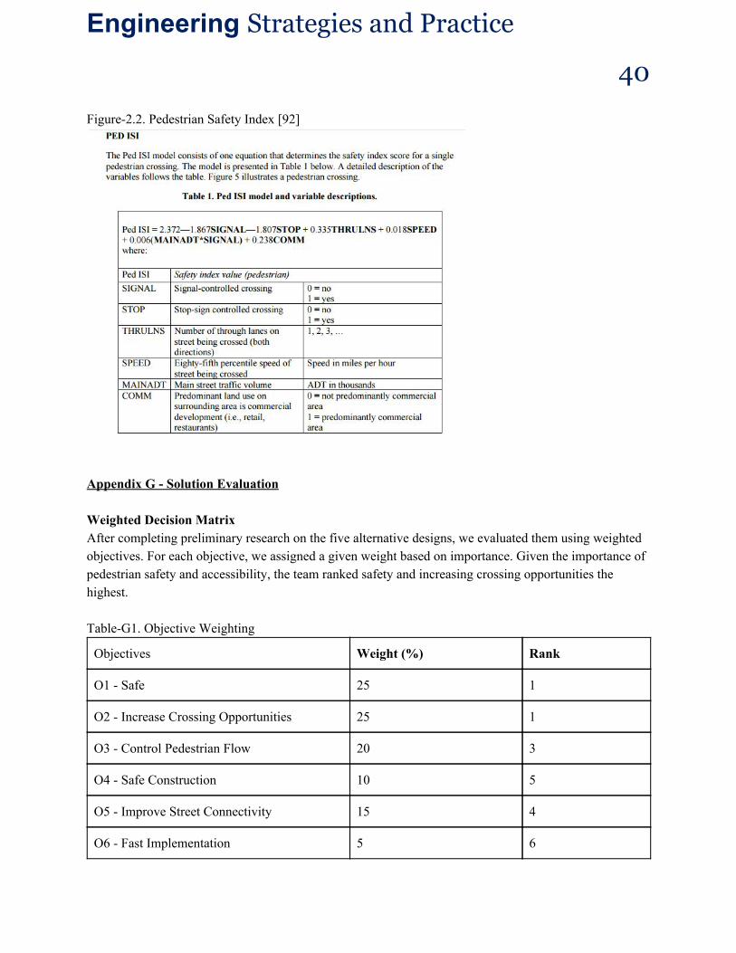
Objectives Test Metrics
Safe
Calculate the pedestrian safety index and bike safety index using the Pedestrian/Bike ISI Models(Figure 2.2) [92]. Measure the following distances of the cars on Dundas St. West and compare the data to the “3 second rule[93]” Measure the volume of cars in different road intersection in the design. Calculate the predicted collision per year based on the Models for Signalized Intersection in Toronto[95]. Measure the width of the driver’s lane to ensure satisfaction on minimum lane width. Measure bicycle lane width to ensure safety of cyclists.
The index with pedestrians and cyclists feel the most comfortable is “1”[92]. The ideal safe following distance depends on the driving speed[96]. While driving at 60km/h, the following distance should be 4 car lengths. A shared curb lane should be no narrower than 4.0m, preferably 4.3m [94]. The width of a bike lane adjacent to s curb face should be 1.83m(6 feet). If lane adjacent to a street edge, 1.22m(4 feet) is preferred, with a minimum width of 0.91m(3 feet) [97].
Increase Crossing
Opportunity (Accessible)
Measure pedestrian crossing opportunities on Dundas St. West in front of TTC station per hour during rush hours and nonrush hours. Document and convert types of pedestrian into equivalent adult units [98]. Use Warrant Model to determine the crossing opportunity [99].
A pedestriantovehicle ratio greater than 2:10 or a pedestrian volume of 3500 ped/8h shows high pedestrian crossing activity [94].
Control pedestrian
flow
Measure the pedestrian volume on both the sides walks of Dundas St. West per hour. Calculate number of pedestrians/m2.
Normal pedestrian movement density of 1.55ped/m2 and congestion density of 3.32 ped/m2 [100].
Engineering Strategies and Practice 40
Figure2.2. Pedestrian Safety Index [92]
Appendix G Solution Evaluation Weighted Decision Matrix After completing preliminary research on the five alternative designs, we evaluated them using weighted objectives. For each objective, we assigned a given weight based on importance. Given the importance of pedestrian safety and accessibility, the team ranked safety and increasing crossing opportunities the highest. TableG1. Objective Weighting
Objectives Weight (%) Rank
O1 Safe 25 1
O2 Increase Crossing Opportunities 25 1
O3 Control Pedestrian Flow 20 3
O4 Safe Construction 10 5
O5 Improve Street Connectivity 15 4
O6 Fast Implementation 5 6

Engineering Strategies and Practice 41
The team debated heavily while evaluating the alternative designs. The actual percentages given were qualitative though they were backed up with evidence from the designs. Each category had metrics/objective goals (see 1.4) and we judged these objective goals to give the percentages. TableG2. Weighted Decision Matrix
2.1: Tunnel 2.2: Road Redesign
2.3: Crosswalk
2.4: Barrier
2.5: Intersection
O1 Safe 100 x 0.25 70 x 0.25 80 x 0.25 100 x 0.25 100 x 0.25
O2 Increase Crossing Opportunities
100 x 0.25 0 x 0.25 85 x 0.25 0 x 0.25 70 x 0.25
O3 Control Pedestrian Flow
100 x 0.20 100 x 0.20 90 x 0.20 70 x 0.20 80 x 0.20
O4 Safe Construction
50 x 0.10 80 x 0.10 100 x 0.10 100 x 0.10 60 x 0.10
O5 Improve Street Connectivity
33 x 0.15 80 x 0.15 40 x 0.15 33 x 0.15 100 x 0.15
O6 Fast Implementation
0 x 0.05 60 x 0.05 80 x 0.05 100 x 0.05 60 x 0.05
Score 79.95 60.50 79.25 58.95 82.50
The design that best performed against the objectives was Island and Infrastructural Improvements to Intersection. This was chosen to be our final design. Appendix H Regulations and Standards FigureH1. Required Signage for Pedestrian Crossover

Engineering Strategies and Practice 42
FigureH2. Standard Car Clearance Calculation
FigureH3. Left Turn Car Clearance Chart