typology and current structure of the …
TRANSCRIPT

ROMANIAN REVIEW OF REGIONAL STUDIES, Volume VII, Number 2, 2011
TYPOLOGY AND CURRENT STRUCTURE OF THE GEOSYSTEMS IN
THE SOUTHERN PART OF THE TRASCĂU MOUNTAINS
GABRIELA ADINA LAZ ĂR1, ALEXANDRU MUREŞAN2
ABSTRACT - The geoecological complexity of the Trascău Mountains is revealed not only by means of its natural components but also by means of its existing interactions and inter-dependences with the anthropic elements identified within the region. The current paper represents an overview and a small scale analysis of the existing types of geosystems identified in the southern part of the Trascău Mountains, mainly along the Ampoi River valley, as well as of the type of the existing interactions between the anthropic elements with the natural environment materialized by means of land utilization carried out in order to sustain the existence and development of agricultural activities, as a basis for the development of the local communities. Throughout the time, the human communities have modified the natural environment in such a manner that they have altered the nature’s ability to restore its initial equilibrium, many of the current types of landforms (especially those located alongside the water courses) being modified as result of the man’s interference. The development of the human communities resulted in an increase of the demand for more resources which materialized in an increase in the cultivated surfaces, development of more settlements, and modification of the land utilization with a more pronounced development of crops to the detriment of the natural vegetation. In regards to the existing human settlements, the spreading of the households along the Ampoi River valley and along its tributaries can be observed, the villages thus possessing a congregate shape.
Keywords: geosystems, biostasy, parastazy, land use map
INTRODUCTION Geoecology, as defined by Troll C. (1971), represents the “science of the entire complex of
inter-relations between the living communities and their natural environment”, being therefore a discipline which studies the natural basis of the human’s vital space. It is an entirely geographical discipline and its fundamental object of study is represented by landscape from a geographical point of view.
Erhart was the one who, using the concept of rhexistasy which referred to the state of the natural systems in regards to the human intervention, defined the terms “geosystems in biostazy” and “geosystems in rhexistasy”, defining them as natural systems non-affected or partially affected by the human intervention with a possibility of come-back to the initial state in a given period of time. Having as a starting point Erhart’s theory, P. Tudoran (1973) defined a third category of geosystems, namely the “geosystems in parastazy” which is used to explain the degree of intervened changes within the structure and quality of natural components due to human intervention.
The current study represents a geoecological analysis, meaning that all the natural biotic and abiotic elements were taken into analysis as well as the existing interactions between the geomorphologic, climatic, hydrologic elements with the living organisms, comprising the human element as well.
At a first glimpse, the geographical space represented by the southern part of the Trascău Mountains corresponds to a mosaic of “landscapes”, which represent the outer terrestrial layer
1 PhD Candidate, Babeş-Bolyai University, Faculty of Geography, 400006, Cluj-Napoca, Romania. E-mail: [email protected] 2 PhD Candidate, Babeş-Bolyai University, Faculty of Geography, 400006, Cluj-Napoca, Romania. E-mail: [email protected]
GABRIELA ADINA LAZ ĂR and ALEXANDRU MUREŞAN
62
composed by a variety of biotic, abiotic and anthropic elements. Nowadays, as result of the continuous expansion of the human communities, it is getting harder to distinguish between what is natural and what has been modified by the human intervention. And this is why the human communities have to be considered as important elements of the landscape and must be analyzed as such.
In order to be able to elaborate an accurate geoecological analysis of the southern part of the Trascău Mountains, we will refer in our study to the three major components of landscape (according to P. Tudoran, 1983), namely the ecological potential of the analyzed area - represented by abiotic elements (lithography, relief, climate and hydrography), the biological exploitation (which comprises the vegetal and animal associations) and the anthropic utilization of the land (quantified in terms of development of households and settlements, road and communication infrastructure and by means of land use for different agricultural purposes).
The detailed analysis of all these components is rendered below, the geosystemic typology and complexity of the southern part of the Trascău Mountains being revealed by the identified geo-facets, rendered on the map on the type of land use within the analyzed region (for which we have used the Corine Land Cover database, 2006).
THE ECOLOGICAL AND BIOLOGICAL COMPLEXITY OF THE ANALYZED AREA The southern part of the Trascău Mountains is represented by the mountainous and hilly areas
located above the Zlatna Depression, along the valley of the Ampoi River (as well as along its left side tributaries). The analyzed region is a well individualized unit as result of its location (in a depression area), with a variety of relief forms and human settlements which are spread mainly along water courses and in the lower parts of the hilly area. The northern part of the analyzed unit is dominated by the presence of Corabia and Dâmbău peaks, with altitudes ranging from nearly 1200 meters to around 1300 meters, a decrease in altitude being observed while descending towards the depression area, reaching about 400 or less in the proximity of the Ampoi River valley.
As regards the climate of the region, there is a moderate character of the climate as result of the sheltering position of this depression basin surrounded by hills, with an average annual temperature of 6.5ºC, which offers proper conditions for the presence and development not only of the broadleaf forestry vegetation (towards the upper parts), but also of the vegetation characteristic for hayfields and grasslands. At the same time, the hilly vegetation of this area is represented by small patches of orchards and vineyards, unequally distributed on the slopes, as well as by grasslands and hayfields.
The hydrographic network is represented by the Ampoi River and by its left side tributaries, the water meadows of these small rivers offering proper conditions for the development of crops and human settlements.
The edaphical component of this region contributes indirectly to the sustaining and development of the human settlements by means of its characteristics, offering adequate conditions for the development of the forestry, grassland or hayfields vegetation, as well as for the cultivation of different crops (such as maize, wheat, sunflower), vegetables, orchards or vineyards.
The geosystem of the broadleaf forests Due to the reduced extension of the analyzed area in relation to the entire surface of the
Trascău Mountains, one type of geosystem was identified, namely the geosystem of the broadleaf forests, which represents a natural system comprising a multitude of geo-facets systematized as regards the human intervention. As a consequence, the geo-facets in biostazy, the geo-facets with a regressive evolution and the geo-facets in parastazy were identified, their spatial distribution being rendered on the land use map of the analyzed area.
The geosystem of the broadleaf forests is spread at different altitudes ranging from nearly 1200 m to 800 m in the northern part of the analyzed area to 550-600 m towards the depression area. This geosystem is developed on different relief forms, from the concave forms of the surrounding hills to relatively flat surfaces, sub-horizontal surfaces or on the slopes with different exposures.

TYPOLOGY AND CURRENT STRUCTURE OF THE GEOSYSTEMS IN THE SOUTHERN PART OF THE TRASCĂU MOUNTAINS
63
The climate of this geosystem is much milder in comparison with the neighbouring mountain area as result of the relative low altitudes, daily and annual differences being therefore recorded; the annual average temperature ranges from around 6.5 ºC to 9.4 ºC, the maximum average temperature is around 15.4ºC, while the minimum one is of about 4.6 ºC; the annual average rainfall is comprised between 500 and 650 mm. In addition, as result of its position, the phenomenon of thermal inversion is encountered within this depression area, a phenomenon with significant influence and contribution to the spreading of crops and orchards, as well as the grassland vegetation.
As mentioned above, and depending on the type of vegetation and soil cover present within the southern part of the Trascău Mountains, different geo-facets were identified.
The geo-facets in biostazy The geo-facets in biostazy correspond to the areas occupied by the forestry vegetation, as well
as by those occupied by grasslands and hayfields. These types of geo-facets correspond to the surfaces where the natural vegetation is developed and are recognized for their state of equilibrium between components; the low human intervention (manifested especially by means of cutting the grass) may temporarily produce a regressive but not irreversible evolution, so that a return to the initial state is possible quite rapidly. Also, we have to mention that within the forestry systems a low human intervention is also present (in terms of tree cutting), but without any implication in the natural state of the forestry vegetation.
a. The geo-facets of broadleaf forests with beech trees (Fagus sylvatica) have suffered a low human intervention within their natural equilibrium, the vertical structure of this natural forestry vegetation being very well individualized on all three substrata; the edifying species are represented by beech trees, often found in combination with other species such as durmast (Quercus petraea), hornbeam tree (Carpinus betulus), maple (Acer platanoides), linden tree (Tilia cordata) or ash tree (Fraxinus ornus). The herbaceous substratum is represented by species such as Hieracium rotundatum or Festuca drymeia. The herbaceous substrata posses an non-uniform spreading within these types of geo-facets, other species such as: Luzula luzuloides, Deschampsia flexuosa, Vaccinium myrtillus, Calamagrostis arundinacea and Veronica officinalis being also present. Mosses are also well represented by the Diacranum scoparium and Leucobrium glaucum species.
b. The geo-facets of the broadleaf forests with durmast trees are located on the sunnier slopes (with southern exposure) of the hilly area. Due to their thermophilic environmental requirements, these forests cover areas located at lower altitudes ranging from 300 meters to 600 meters, on the sunnier slopes with southern exposure reaching altitudes of 700 (thus penetrating the areas occupied by forests with beech trees). The edifying species of these geo-facets is the durmast (Qurecus petraea), along with other co-dominant or sub-dominant species such as Quercus cerris, Quercus pubescens, Cerasium avium, Fraxinus ornus. Within the herbaceous substrata, the following species are the most representative: Poa nemoralis, Genista tinctoria, Campanula persicifolia, Galium odoratum, Anemone nemorosa, Dentaria bulbifera and Gleochoma hirsuta (Ivan Doina, 1992).
The presence and development of the forests with sub-mezophile and thermophile species of trees located at lower altitudes is a consequence of the presence of the Carpathian mountain chain, which is manifested by an increased quantity of precipitation in comparison with the forest-steppe areas.
The soil cover of these geo-facets is unequally distributed on the surfaces, the dominant class of soils being represented by the brown soils which, under certain conditions of climate (annual average temperature ranging from 6°C to 10°C ) and rainfall (annual average rainfall of 500 - 1000 mm), offer suitable conditions for the development of the forestry vegetation; by means of bio-accumulative processes, vegetation capitalizes the existing organic matter found in soil for its nutritional necessities.

GABRIELA ADINA LAZ ĂR and ALEXANDRU MUREŞAN
64
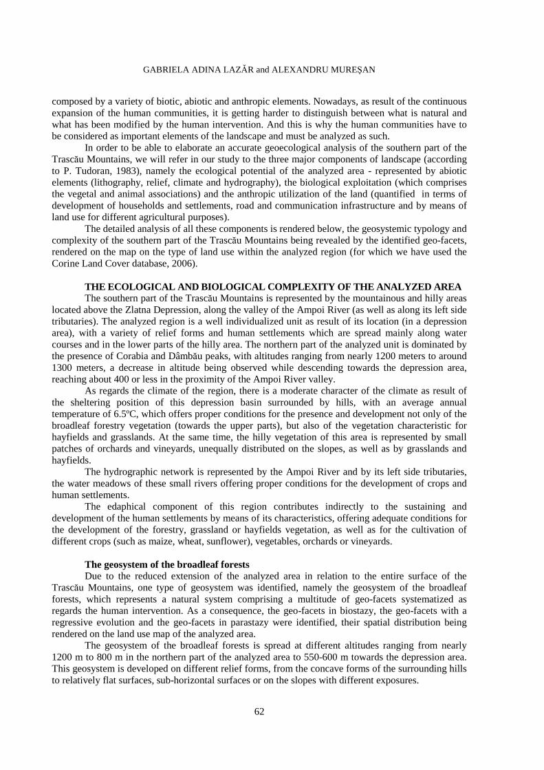
Figure 1 presents the characteristics and the type of land use in the Zlatna Depression area, the lower parts (located in the nearness and along the main roadway) are occupied by arable surfaces, with different crops, slopes are used as hayfields or grasslands, while the upper parts of the region are occupied by the forestry vegetation with broadleaf species.
Figure 1. An overview of the Zlatna Depression area
c. The geo-facets of grasslands and hayfields are developed on the slopes of the hilly area at
altitudes ranging from 300 m to 600-750 m and comprise a multitude of grass associations with xerophile mezo-xerophile or mezophile environmental requirements. In this regard, we have to mention that there is a certain correspondence between the fundamental types of grasslands and the areas with natural vegetation, assorted especially after the type of forestry vegetation (Gh. Anghel, N. Dioniţă, 1980; Gh. Anghel, 1981; I. Ţurca et. al., 1984, cited by C. Bărbulescu and Gh. Motca, 1987). The development of the grassland vegetation within the analyzed area has multiple natural causes represented firstly by relief, which in terms of slopes, exposure and declivity influences the development of species; at the same time, the climatic elements (in terms of precipitation and humidity) and the sheltering position of the region (by means of its contribution to the decrease of wind intensity) offer the necessary conditions for the existence of a great ecological diversity of the present plant species.
Grasslands are dominated by the presence of the steppe fescue (Festuca valesiaca), often found in association, dominance or co-dominance with other plant species with similar ecological requirements. From a qualitative point of view, the most favourable grasslands are those where the dominant species is the brown-top (Agrostis capillaris) along with the abundance of other gramineous species, the floristic composition of the grassland being therefore responsible for its nutritional values.
In the lower parts of the hilly area, grasslands occupy more shaded places, while at higher altitudes grasslands and hayfields occupy the slopes with southern, eastern and western exposures.
In order the highlight the importance of grassland and hayfields, for the region under analysis (the primary activities developed within this depression area being represented by the agricultural ones) we have used the data on the type of land use provided by the Alba County Regional Department of Statistics, an analysis of the entire surface revealing the fact that the surfaces with the largest extent are represented by hayfields (49%), followed by grasslands (34%) and by arable surfaces (17%).

TYPOLOGY AND CURRENT STRUCTURE OF THE GEOSYSTEMS IN THE SOUTHERN PART OF THE TRASCĂU MOUNTAINS
65
Figure 2. The type of land use in the southern part of the Trascău Mountains Source: Corine Land Cover (2006), with modifications
The geo-facets with regressive evolution The geo-facets with regressive evolution are represented by the agricultural surfaces where
different species are cultivated, as well as by the surfaces occupied by orchards and vineyards. Within this type of geo-facets, the natural elements are found in a semi-natural equilibrium due to the constant human intervention (M. Buza, 1979).
These geo-facets are developed in inter-dependence with the natural elements, the relief being, in this case as well, responsible for the spreading and development of the agricultural surfaces. If slopes are covered with either grasslands or orchards and vineyards, the lower parts (the more flattened surfaces) are used for the cultivation of crops. As mentioned above, the areas occupied by hayfields are the most extended, followed by grasslands and arable surfaces; the areas occupied by orchards and vineyard have a reduced territorial development, approximately 7 ha, which represent less than 0.1 % of the entire analyzed surface. The land used for agricultural purposes (for the cultivation of crops and vegetables) occupies 17% of the entire analyzed surface and is represented by the surfaces cultivated mainly with maize, wheat, sunflower and rye.
The geo-facets in parastazy The geo-facets in parastazy are represented by those surfaces where human settlements are
settled, therefore a constant anthropic intervention being present. Within these geo-facets the existing natural and anthropic elements are non-assorted with reality, and a return to the initial state of equilibrium between the natural components will never occur even if the human intervention is to cease.
The geo-facets of human settlements are represented by the villages spread along the valley of the Ampoi River, as well as along its left side tributaries (the Vâltori, the Feneş, the Ampoiţa rivers). The morphology of the relief dictates the shape of these settlements, so that, within this depression basin, villages possess a congregate shape with the concentration of villages in the nearness of the commune centre.

GABRIELA ADINA LAZ ĂR and ALEXANDRU MUREŞAN
66
From an administrative point of view, these villages belong to Zlatna and Meteş administrative territorial units. The parastazic geo-facets of these human settlements are represented by the following villages: Vâltori, Feneş, Presaca Ampoiului, Isca, Meteş, Ampoiţa, Remetea, Lunca Ampoiţei, Lunca Meteşului, as well as by the existing road infrastructure (the national road 74 which connects the town of Alba-Iulia with the town of Zlatna and crosses the depression area from east to west, as well as by the county or communal roads which connect the existing villages with the centre of communes).
CONCLUSIONS As a result of the constant human intervention within the natural state of its components,
environment can suffer irreversible changes, the human communities being the ones entirely responsible for the protection of the natural elements, if a sustainable development of any region is to be considered. Within the southern part of the Trascău Mountains, a gradual development of the anthropic-induced vegetation and of the natural one can be observed, the lower parts of the analyzed area, namely the water meadows and the flattened surfaces, being occupied by human settlements (the built-in areas being surrounded by agricultural lands cultivated with vegetable and different crops), while slopes are used for the development of grassland vegetation, which can provide, all year long (by means of pastures in the warmer season and by means of hay provision for winter), nourishment for the ovine and bovine herds of the inhabitants living in these settlements. At the same time, the higher parts of the analyzed area are occupied by the forestry vegetation representing areas less modified by the human intervention.
From a geoecological point of view and in terms of the human impact on the environment, we can assert the fact that the natural vegetation is harmoniously combined with the existence of human settlements and the maintenance of the current floristic species composition of the forestry and grassland vegetation, in correlation with the existence of agricultural surfaces, is able to assure the existence of the human communities of the region without any other future significant changes.
AKNOWLEDGEMENT
The authors wish to thank for the financial support provided from programs co-financed by The SECTORAL OPERATIONAL PROGRAMME HUMAN RESOURCES DEVELOPMENT, Contract POSDRU 6/1.5/S/3 - "Doctoral studies: through science towards society".
REFERENCES BĂRBULESCU, C., MOTCA, GH. (1987), Pajiştile de deal din România [The hilly grasslands of
Romania], Edit. Ceres, Bucureşti. BUZA, M. (1979), Structura geosistemelor din Munţii Cindrelului [The structure of the geosystems in
the Cindrel Mountains], in: Studii şi Cercetări Geol., Geofiz., Geogr., seria Geografie, T.XXVI, pp.79-87.
IVAN, DOINA - coord. (1992), Vegetaţia României [Vegetation of Romania], Editura Tehnica Agricolă, Bucureşti.
TUDORAN, P. (1983), Ţara Zarandului, studiu geoecologic [The Land of Zarand, a Geoecological Study], Editura Academiei RSR, Bucureşti
TROLL, C. (1971), Landscape Ecology (Geoecology) and Biogeocenology – A Terminal Approach, in: Journal of Physical and Regional Geosciences, Geoforum 8/71, Pergamon, Vieweg.
*** (2006), Corine Land Cover, European Environment Agency, Copenhagen.