town of blackstone, massachusetts - cmrpc · central massachusetts regional planning commission 2...
TRANSCRIPT

Central Massachusetts Regional Planning Commission 2 Washington Square, Union Station, 2nd Floor, Worcester, MA 01604-4016
TOWN OF BLACKSTONE, MASSACHUSETTS
Location: Southern Massachusetts, bordered by Mendon on the north; Bellingham on the east; North Smithfield and Woonsocket, Rhode Island, on the south; and Millville on the west. Blackstone is 22 miles southeast of Worcester and 37 miles southwest of Boston.
Total Area: 11.23 sq. miles Land Area: 10.90 sq. miles Population: 9,026 Density: 804 per sq. mile
This snapshot contains details about the following items:
Population Economy Land use Housing Public Safety Education Transportation Traffic Safety
Data Sources: The Massachusetts Department of Transportation / Geographic Information Systems / Education / State Police / Division of Unemployment Assistance / Housing and Community Development, The US Census Bureau, Massachusetts Association of Realtors, Massachusetts Institute for Social and Economic Research (MISER), The Warren Group and massbenchmarks.org.
BLACKSTONE
BOSTON
WORCESTER
Community Snapshot BlackstoneThis snapshot contains data on:
Population-Economy-Housing-Education-Transportation-Public Safety
Central Massachusetts Regional Planning Commission www.cmrpc.org
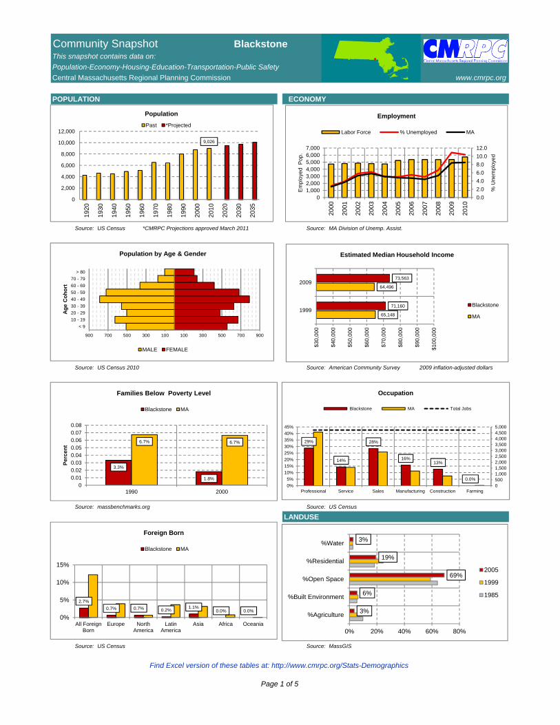
POPULATION ECONOMY
Source: US Census *CMRPC Projections approved March 2011 Source: MA Division of Unemp. Assist.
Source: US Census 2010 Source: American Community Survey 2009 inflation-adjusted dollars
Source: massbenchmarks.org Source: US Census
LANDUSE
Source: US Census Source: MassGIS
9,026
0
2,000
4,000
6,000
8,000
10,000
12,000
1920
1930
1940
1950
1960
1970
1980
1990
2000
2010
2020
2030
2035
Population
Past *Projected
0.0
2.0
4.0
6.0
8.0
10.0
12.0
01,0002,0003,0004,0005,0006,0007,000
2000
2001
2002
2003
2004
2005
2006
2007
2008
2009
2010
% U
ne
mp
loye
d
Em
plo
yed
Po
p.
Employment
Labor Force % Unemployed MA
65,148
64,496
71,160
73,563
$30
,00
0
$40
,00
0
$50
,00
0
$60
,00
0
$70
,00
0
$80
,00
0
$90
,00
0
$10
0,0
00
1999
2009
Estimated Median Household Income
Blackstone
MA
3.3%
1.8%
6.7% 6.7%
00.010.020.030.040.050.060.070.08
1990 2000
Pe
rce
nt
Families Below Poverty Level
Blackstone MA
2.7%
0.7% 0.7% 0.2%1.1%
0.0% 0.0%
0%
5%
10%
15%
All ForeignBorn
Europe NorthAmerica
LatinAmerica
Asia Africa Oceania
Foreign Born
Blackstone MA
29%
14%
28%
16%13%
0.0%
05001,0001,5002,0002,5003,0003,5004,0004,5005,000
0%
5%
10%
15%
20%
25%
30%
35%
40%
45%
Professional Service Sales Manufacturing Construction Farming
Occupation
Blackstone MA Total Jobs
< 9
10 - 19
20 - 29
30 - 39
40 - 49
50 - 59
60 - 69
70 - 79
> 80
900 700 500 300 100 100 300 500 700 900
Ag
e C
oh
ort
Population by Age & Gender
MALE FEMALE
3%
6%
69%
19%
3%
0% 20% 40% 60% 80%
%Agriculture
%Built Environment
%Open Space
%Residential
%Water
2005
1999
1985
Find Excel version of these tables at: http://www.cmrpc.org/Stats-Demographics
Page 1 of 5
Community Snapshot BlackstoneThis snapshot contains data on:
Population-Economy-Housing-Education-Transportation-Public Safety
Central Massachusetts Regional Planning Commission www.cmrpc.org
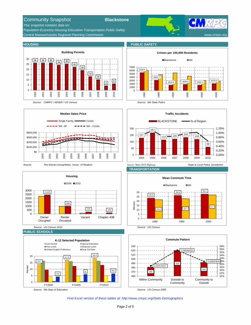
HOUSING PUBLIC SAFETY
Source: CMRPC / MISER / US Census Source: MA State Police
Source: The Warren Group/Mass. Assoc. of Realtors Source: Mass DOT Highway State & Local Police Jurisdiction
TRANSPORTATION
Source: US Census 2010 Source: US Census
PUBLIC SCHOOLS
Source: MA Dept of Education Source: US Census 2000
26 26 2624 25
22
19
13
10
46
0
5
10
15
20
25
30
200
0
200
1
200
2
200
3
200
4
200
5
200
6
200
7
200
8
200
9
201
0
Building Permits
$0
$100,000
$200,000
$300,000
$400,000
200
0
200
1
200
2
200
3
200
4
200
5
200
6
200
7
200
8
200
9
201
0Median Sales Price
Single Family Condo
MA -SF MA - Condo
5348.4
3093.2
1620.3 1830.8 1630.32070.9
01000200030004000500060007000
198
0
198
5
199
0
199
5
200
0
200
5
Crimes per 100,000 Residents
Blackstone MA
127
167
113 120132
118
59
0.00%
0.20%
0.40%
0.60%
0.80%
1.00%
1.20%
0
50
100
150
200
2004 2005 2006 2007 2008 2009 2010
Traffic Accidents
BLACKSTONE % of Region
13.7
17.018.4
4.26 6.6
0
5
10
15
20
FY2008 FY2009 FY2010
Per
cen
t
K-12 Selected PopulationLow-Income Special Education
Free Lunch Reduced Lunch
Limited English Proficiency Drop Out Rate
23.526.6
28.1
21.6 22.727
0
5
10
15
20
25
30
1980 1990 2000
Min
ute
s
Mean Commute Time
Blackstone MA
481
520
492
0.322170127
0.348292029
0.329537843
31%31%32%32%33%33%34%34%35%35%36%
460
470
480
490
500
510
520
530
Within Community Outside toCommunity
Community toOutside
Commute Pattern
2,419
984
225 123
0500
10001500200025003000
OwnerOccupied
RenterOccupied
Vacant Chapter 40B
Housing
2000 2010
Find Excel version of these tables at: http://www.cmrpc.org/Stats-Demographics
Page 2 of 5
Community Snapshot BlackstoneThis snapshot contains data on:
Population-Economy-Housing-Education-Transportation-Public Safety
Central Massachusetts Regional Planning Commission www.cmrpc.org
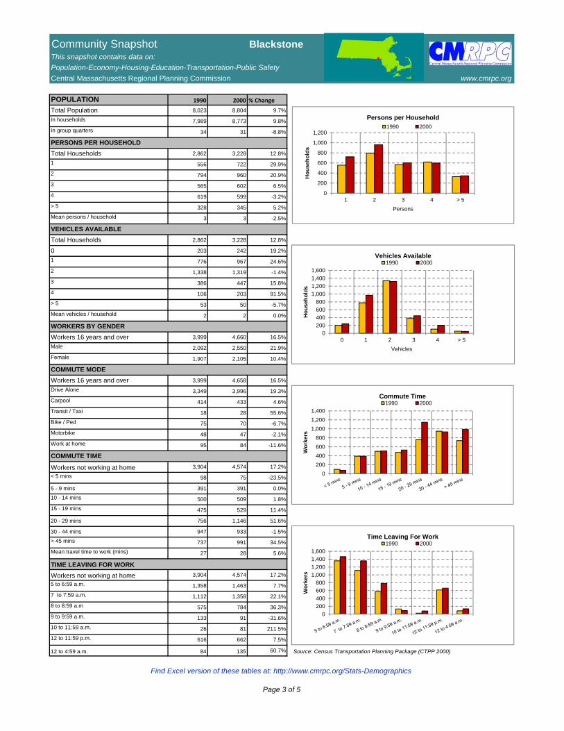
POPULATION 1990 2000 % Change
Total Population 8,023 8,804 9.7%
In households 7,989 8,773 9.8%
In group quarters 34 31 -8.8%
PERSONS PER HOUSEHOLD
Total Households 2,862 3,228 12.8%
1 556 722 29.9%
2 794 960 20.9%
3 565 602 6.5%
4 619 599 -3.2%
> 5 328 345 5.2%
Mean persons / household 3 3 -2.5%
VEHICLES AVAILABLE
Total Households 2,862 3,228 12.8%
0 203 242 19.2%
1 776 967 24.6%
2 1,338 1,319 -1.4%
3 386 447 15.8%
4 106 203 91.5%
> 5 53 50 -5.7%
Mean vehicles / household 2 2 0.0%
WORKERS BY GENDER
Workers 16 years and over 3,999 4,660 16.5%
Male 2,092 2,550 21.9%
Female 1,907 2,105 10.4%
COMMUTE MODE
Workers 16 years and over 3,999 4,658 16.5%
Drive Alone 3,349 3,996 19.3%
Carpool 414 433 4.6%
Transit / Taxi 18 28 55.6%
Bike / Ped 75 70 -6.7%
Motorbike 48 47 -2.1%
Work at home 95 84 -11.6%
COMMUTE TIME
Workers not working at home 3,904 4,574 17.2%
< 5 mins 98 75 -23.5%
5 - 9 mins 391 391 0.0%
10 - 14 mins 500 509 1.8%
15 - 19 mins 475 529 11.4%
20 - 29 mins 756 1,146 51.6%
30 - 44 mins 947 933 -1.5%
> 45 mins 737 991 34.5%
Mean travel time to work (mins) 27 28 5.6%
TIME LEAVING FOR WORK
Workers not working at home 3,904 4,574 17.2%
5 to 6:59 a.m. 1,358 1,463 7.7%
7 to 7:59 a.m. 1,112 1,358 22.1%
8 to 8:59 a.m 575 784 36.3%
9 to 9:59 a.m. 133 91 -31.6%
10 to 11:59 a.m. 26 81 211.5%
12 to 11:59 p.m. 616 662 7.5%
12 to 4:59 a.m. 84 135 60.7% Source: Census Transportation Planning Package (CTPP 2000)
0
200
400
600
800
1,000
1,200
1 2 3 4 > 5
Ho
use
ho
lds
Persons
Persons per Household1990 2000
0
200
400
600
800
1,000
1,200
1,400
1,600
0 1 2 3 4 > 5
Ho
use
ho
lds
Vehicles
Vehicles Available1990 2000
0
200
400
600
800
1,000
1,200
1,400
Wo
rke
rs
Commute Time1990 2000
0
200
400
600
800
1,000
1,200
1,400
1,600
Wo
rke
rs
Time Leaving For Work1990 2000
Find Excel version of these tables at: http://www.cmrpc.org/Stats-Demographics
Page 3 of 5
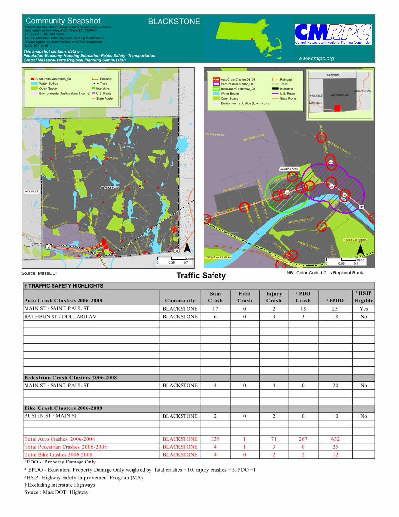
BLACKSTONE
Southern NE Trunkline Trail
¬«12¬«24
¬«104
¬«96
£¤122
ROOSEVELT PARK
TUPPERWARE PARK
MAIN STREET
REILLY AVENUE
CANAL STREET
BLACKSTONE STREET
SAINT PAUL STREET
FARNUM STREET
ASCENSION STREET
PROSPECT STREETAUSTIN STREET
RIVERS EDGE ROAD
BRIDGE STREET
KIMBERLY LANENANCY COURTFIRST AVENUE
MARKET STREETPLEASANT STREET
KANE COURT
ALICE AVENUE
MILL
STRE
ET
MENDON
MILLVILLEBLACKSTONE
£¤122£¤126
MENDON STREET
ELM STREET
FARM
STRE
ET
MAIN STREET
BLAC
KSTO
NE ST
REET
MILK STREET
FEDE
RAL
STRE
ET
BELL
INGH
AM R
OAD
LINCOLN STREET
SUMMER STREET
RATH
BUN
STRE
ET
UNIO
N ST
REET
ORCHARD STREET
REIL LY AVENUE
CHESTNUT STREET
CAROL LANE
PARK
STRE
ET
RAYNER STREET
KING
STRE
ET
CANAL STREET
EDGE
WATE
R DR
IVE
COUNTY STREET
PICKERING ROAD
HANDY ROADSH
ORE
DRIV
E
ASCENSION STREET
SAINT PAUL STREET
MILL
ER AV
ENUE
SPRUCE STREET
FAIR
WAY LA
NE
CRESTWOOD DRIVE
ROBE
RTA
ROAD
DAWN STREET
RENNIE DRIVE
CLYDE STREET
MILK STREET
Traffic Safety 0 0.10.05
Miles
BLACKSTONEMILLVILLE
MENDON
BELLINGHAM
UXBRIDGE
Community Snapshot BLACKSTONE
www.cmrpc.orgThis snapshot contains data on:Population-Economy-Housing-Education-Public Safety -TransportationCentral Massachusetts Regional Planning Commission
Information depicted on these mapsis for planning purposes.Data obtained from MassDOT, MassGIS, CMRPCProduced by the GIS Center :Central Massachusetts Regional Planning Commission.2 Washington Sq,Union Station, 2nd Floor, Worcester, MA 01604-4016
NB : Color Coded # is Regional Rank
¯0 0.70.35
Miles¯
Source: MassDOT
AutoCrashClusters06_08PedCrashCluster02_08BikeCrashClusters02_08Water BodiesOpen SpaceEnvironmental Justice (Low Income)
RailroadTrailsInterstateU.S. RouteState Route
AutoCrashClusters06_08Water BodiesOpen SpaceEnvironmental Justice (Low Income)
RailroadTrails
InterstateU.S. RouteState Route
† TRAFFIC SAFETY HIGHLIGHTSSum Fatal Injury ¹ PDO ³ HSIP
Auto Crash Clusters 2006-2008 Community Crash Crash Crash Crash ² EPDO EligibleMAIN ST / SAINT PAUL ST BLACKSTONE 17 0 2 15 25 YesRATHBUN ST / DOLLARD AV BLACKSTONE 6 0 3 3 18 No
Pedestrian Crash Clusters 2006-2008MAIN ST / SAINT PAUL ST BLACKSTONE 4 0 4 0 20 No
Bike Crash Clusters 2006-2008AUSTIN ST / MAIN ST BLACKSTONE 2 0 2 0 10 No
Total Auto Crashes 2006-2008 BLACKSTONE 339 1 71 267 632Total Pedestrian Crashes 2006-2008 BLACKSTONE 4 1 3 0 25Total Bike Crashes 2006-2008 BLACKSTONE 4 0 2 2 12¹ PDO - Property Damage Only² EPDO - Equivalent Property Damage Only weighted by fatal crashes = 10, injury crashes = 5, PDO =1³ HSIP- Highway Safety Improvement Program (MA)† Excluding Interstate HighwaysSource : Mass DOT Highway

MENDON
MILLVILLE
MENDON STREET
ELM STREET
FARM
STRE
ET
MAIN STREET
BLACKSTONE STREET
MILK STREET
FEDE
RAL
STRE
ET
BELL
INGH
AM R
OAD
LINCOLN STREET
SUMMER STREET
RATH
BUN
STRE
ET
UNIO
N ST
REET
ORCHARD STREET
REIL LY AVENUE
CHESTNUT STREET
CAROL LANE
PARK
STRE
ET
RAYNER STREET
KING
STRE
ET
CANAL STREET
EDGE
WATE
R DR
IVE
COUNTY STREET
PICKERING ROAD
HANDY ROAD
SHOR
E DR
IVE
ASCENSION STREET
SAINT PAUL STREET
MILL
ER AV
ENUE
SPRUCE STREETMI
LLER
STRE
ET
FAIR
WAY LA
NE
CRESTWOOD DRIVE
ROBE
RTA
ROAD
DAWN STREET
RENNIE DRIVE
CLYDE STREET
MILK STREET
BLACKSTONE
£¤122
Harris Pond
Lake Hiawatha
MENDON
MILLVILLE
Blacksto ne Tra ils - Alt3
Blackstone Trails - Alt3
Blackst one Trails - A lt3
Titanic Rail Trail
Blackstone River Bikeway
Titanic Rail Trail
BLACKSTONE
£¤122
£¤126
QUISSET WMAOPEN LAND
MENDON
MILLVILLE
BLACKSTONE
MENDON STREET
ELM STREET
FARM
STRE
ET
MAIN STREET
BLACKSTONE STREET
MILK STREET
FEDE
RAL
STRE
ET
BELL
INGH
AM R
OAD
LINCOLN STREET
SUMMER STREET
RATH
BUN
STRE
ET
UNIO
N ST
REET
ORCHARD STREET
REILLY AVENUE
CHESTNUT STREET
CAROL LANE
PARK
STRE
ET
RAYNER STREET
KING
STRE
ET
CANAL STREET
EDGE
WATE
R DR
IVE
COUNTY STREET
PICKERING ROAD
HANDY ROAD
SHOR
E DR
IVE
ASCENSION STREET
SAINT PAUL STREET
MILL
ER AV
ENUE
SPRUCE STREET
MILL
ER ST
REET
FAIR
WAY LA
NE
CRESTWOOD DRIVE
ROBE
RTA
ROAD
DAWN STREET
WARNER STREET
MILK STREET
£¤122
MENDON
MILLVILLE
£¤122
£¤126
CMAQ
BLACKSTONE
MENDON STREET
ELM STREET
FARM
STRE
ET
MAIN STREET
BLACKSTONE STREET
MILK STREET
FEDE
RAL
STRE
ET
BELL
INGH
AM R
OAD
LINCOLN STREET
SUMMER STREET
RATH
BUN
STRE
ET
UNIO
N ST
REET
ORCHARD STREET
REIL LY AVENUE
CHESTNUT STREET
CAROL LANE
PARK
STRE
ET
RAYNER STREET
KING
STRE
ET
CANAL STREET
EDGE
WATE
R DR
IVE
COUNTY STREET
PICKERING ROAD
HANDY ROAD
SHOR
E DR
IVE
ASCENSION STREET
SAINT PAUL STREET
MILL
ER AV
ENUE
SPRUCE STREET
MILL
ER ST
REET
FAIR
WAY LA
NE
CRESTWOOD DRIVE
ROBE
RTA
ROAD
RENNIE DRIVE
CLYDE STREET
MILK STREET
0 0.60.3Miles
Traffic VolumePavement Condition
Trails
Major RoadsInterstate
U.S. Route
State Route
Pavement Conditions
Excellent
Good
Fair
Poor
Very Poor
Major RoadsInterstateU.S. RouteState Route
Traffic Volume≤1>1 - 2,5002,500 - 7,4997,500 - 14,99915,000 - 30,000> 30,000
Existing TrailProposed Trail
Potential TrailLongDistanceTrails >25 MiProposed Bikeway
Water BodiesOpen Space
Railroad
InterstateU.S. Route
State Route
Funding for Roadway ProjectsAllocatedProposedRequestedProposed Bikeway
Project Symbol
) Bridges
F Intersections* Other
Environmental Justice (Low Income)
Major RoadsInterstateU.S. RouteState Route
0 0.70.35 Miles
0 0.70.35Miles0 0.70.35
Miles
Community Snapshot BLACKSTONE
www.cmrpc.orgThis snapshot contains data on:Population-Economy-Housing-Education-Public Safety -TransportationCentral Massachusetts Regional Planning Commission
Information depicted on these maps is for planning purposes.Data obtained from MassDOT, MassGIS, CMRPCProduced by the GIS Center :Central Massachusetts Regional Planning Commission.2 Washington Sq,Union Station, 2nd Floor, Worcester, MA 01604-4016
¯ ¯
¯¯Source: CMRPC Source: CMRPC
Source: CMRPC Source: CMRPC
Roadway Improvement Projects -TIP* *TIP-Transportation Improvment Program