the influence of hedgerow systems on the hydrology of
TRANSCRIPT
HAL Id: hal-00885959https://hal.archives-ouvertes.fr/hal-00885959
Submitted on 1 Jan 1999
HAL is a multi-disciplinary open accessarchive for the deposit and dissemination of sci-entific research documents, whether they are pub-lished or not. The documents may come fromteaching and research institutions in France orabroad, or from public or private research centers.
L’archive ouverte pluridisciplinaire HAL, estdestinée au dépôt et à la diffusion de documentsscientifiques de niveau recherche, publiés ou non,émanant des établissements d’enseignement et derecherche français ou étrangers, des laboratoirespublics ou privés.
The influence of hedgerow systems on the hydrology ofagricultural catchments in a temperate climate
Philippe Mérot
To cite this version:Philippe Mérot. The influence of hedgerow systems on the hydrology of agricultural catchments in atemperate climate. Agronomie, EDP Sciences, 1999, 19 (8), pp.655-669. �hal-00885959�
Review article
The influence of hedgerow systems on the hydrologyof agricultural catchments in a temperate climate
Philippe Merot’
Unité Sol et Agronomie de Rennes-Quimper, Inra, 65 route de Saint-Brieux, 35042 Rennes cedex, France
(Received 9 September 1998; accepted 31 August 1999)
Abstract - The bocage landscape is an ancient system of organising rural areas by using a hedge network enclosingfields and meadows. It is one form of hedgerow systems used as a windbreak, water and erosion barrier, or ecologicalcorridor in numerous regions around the world. Its hydrological impact in temperate countries is poorly known,although paradoxically often cited as important. This paper is a literature review of researches concerning the hydrolog-ic effects of hedgerow systems mainly conducted in the region of Brittany, in France, for the last 20 years. The actual orpotential evapotranspiration seems little modified by hedges at the catchment scale for a bocage with a hedge density ofapproximately 100 m.ha-1. However, local effects are observed on the actual evapotranspiration around the hedges insummer. No effect on the annual rainfall has been measured, but the spatial heterogeneity of the rainfall distributionincreases close to the hedge. The bocage has a buffering effect on quick flow during storm runoff of high frequency,modifying the Hortonian overland flow and the contributing flow on saturated areas. The bank and the hedge surround-ing the bottom land are the key factor for hydrological effects. Water erosion is limited in bocage landscape, with noexportation outside the catchment. © 1999 Inra/Éditions scientifiques et médicales Elsevier SAS
landscape / hydrology / hedge / storm runoff / erosion
Résumé - Le rôle du bocage sur l’hydrologie de bassins versants ruraux en climat tempéré. Le bocage est unmode d’organisation de l’espace rural représenté par un réseau de haies enclosant les parcelles. Il fait partie de ces sys-tèmes linéaires boisés utilisés dans de nombreuses régions pour protéger cultures et sols du vent, du ruissellement et del’érosion. Son rôle hydrologique en pays tempéré est relativement méconnu, bien que paradoxalement cité commeimportant. Il se manifeste à différents niveaux du cycle de l’eau: L’évapotranspiration réelle ou potentielle semble peumodifiée à l’échelle du bassin versant par le bocage, du moins aux densités actuelles, de l’ordre de 100 m.ha-1. Onobserve cependant des effets estivaux locaux sur l’ETR, au voisinage de la haie, Aucun effet sur la pluviosité annuellen’a été mesuré, mais les haies entraînent de fortes hétérogénéités locales des précipitations à leur proximité. Le bocagejoue un rôle tampon sur les écoulements rapides des eaux en période de crue, du moins pour les événements de forte
Communicated by Christian Roth (Australia)
* pmerot @roazhon.inra.fr
fréquence. Cela joue tant sur le ruissellement hortonien que sur ruissellement de zones contributives. Différents modéli-sations spatiales ont permis de généraliser ces résultats. C’est essentiellement le talus de ceinture de fond de vallée quijoue un rôle prépondérant. L’érosion hydrique est limitée en zone de bocage à un transport au sein des parcelles, sansexportation externe au bassin versant. © 1999 Inra/Éditions scientifiques et médicales Elsevier SAS
paysage / bocage / hydrologie / crue / érosion
1. Introduction
In many areas around the world, hedgerow sys-tems have been constructed to mark the boundaries
of the estates, to contain or shelter the cattle, etc.This paper deals with one particular type ofhedgerow network, called the bocage, that is typi-cal in western Europe. The bocage shows a greatdiversity both in the nature of the hedges: lowhedges, shrub hedges or tree hedges, planted onbanks reinforced with stones or on banks of solidearth or directly on the soil [59], and in the struc-ture of the hedge network in terms of density, ori-entation and connectivity [11]. In France, institu-tional or individual land consolidation has led to
the thinning out, degradation and even the disap-pearance of bocage in many areas: more than 200000 km of hedges have disappeared over the last50 years in Brittany (28 000 km2). However, fol-lowing a series of studies [11, 34, 46, 50], there hasbeen renewed interest in bocage, firstly by ecolo-gists and more recently by land use specialists con-fronted with the new functions of agriculture [4,49]. The role that bocage could play as a purifyingsystem for non point source pollution [45], or forlimiting the diffusion of atmospheric pollutants[38] is also currently discussed. This is leading topolicies for reconstituting a new bocage network.
The regulatory role of bocage on the water cycleis often presented as an unquestionable advantageof this type of landscape. But paradoxically, fewstudies have been conducted on the hydrologic roleof hedges in temperate climates. On the other hand,there has been a large number of studies on the rolethey can play as a windbreak in more arid climates[10, 20, 63, 64], in limiting erosion during heavyrainfall [2, 18, 57] or in alley cropping in semi-aridclimates [28, 35].
In Brittany, the climate is humid and temperate:The mean annual rainfall ranges from 650 to
1 200 mm, and the mean annual temperature is of10.1 to 12.2 °C. Daily rainfall over 40 mm occursonly 3 to 6 days per year in average [37], but 180to 210 days are rainy. The potential and actualevapotranspiration varies from 650 to 760 mm, and450 to 650 mm per year, respectively. The aim ofthis paper is to present a literature review on the
hydrology in the bocage landscape under a temper-ate climate, mainly based on researches conductedin France for the last 20 years.
2. The role of bocage among the otherelements of the physical environment
A relevant assessment of the role of the bocagerequires first to consider the relative importance ofthe other factors controlling the hydrology in tem-perate regions. In Brittany, the hydrology of catch-ments is primarily controlled by the climate (ie, theW-E and N-S rainfall gradient) and the bedrock(i.e., granite, sandstone and schist) [23]. First, thebedrock type affects low flows as it was empha-sised by Schreiber and Demuth [55]: in summertime, the low flow of rivers can be ten time less onschist than on granite; for example, the specificmean monthly dry discharge for a five year recur-rence reaches 0.20 and 2.35. 10-3.m3.s-1.m-2 for
respectively a river on schist (Coët Organ) and ariver on granite (Evel) (figure 1), close to eachother and receiving similar rainfall (981 versus1050 mm per year) (data from [23]). The secondmajor effect of bedrock is that the overlying soilsare ten time less permeable on schists than ongranite, due to a difference of texture (loamy vs.sandy loam). This influences the quick flow of the
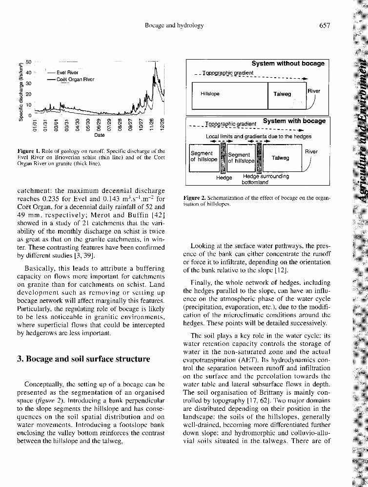
catchment: the maximum decennial dischargereaches 0.235 for Evel and 0.143 m3.s-1.m-2 forCoët Organ, for a decennial daily rainfall of 52 and49 mm, respectively; Merot and Buffin [42]showed in a study of 21 catchments that the vari-ability of the monthly discharge on schist is twiceas great as that on the granite catchments, in win-ter. These contrasting features have been confirmedby different studies [3, 39].
Basically, this leads to attribute a bufferingcapacity on flows more important for catchmentson granite than for catchments on schist. Landdevelopment such as removing or setting upbocage network will affect marginally this features.Particularly, the regulating role of bocage is likelyto be less noticeable in granitic environments,where superficial flows that could be interceptedby hedgerows are less important.
3. Bocage and soil surface structure
Conceptually, the setting up of a bocage can bepresented as the segmentation of an organisedspace (figure 2). Introducing a bank perpendicularto the slope segments the hillslope and has conse-quences on the soil spatial distribution and onwater movements. Introducing a footslope bankenclosing the valley bottom reinforces the contrastbetween the hillslope and the talweg,
Looking at the surface water pathways, the pres-ence of the bank can either concentrate the runoffor force it to infiltrate, depending on the orientationof the bank relative to the slope [ 12].
Finally, the whole network of hedges, includingthe hedges parallel to the slope, can have an influ-ence on the atmospheric phase of the water cycle(precipitation, evaporation, etc.), due to the modifi-cation of the microclimatic conditions around the
hedges. These points will be detailed successively.
The soil plays a key role in the water cycle: its
water retention capacity controls the storage ofwater in the non-saturated zone and the actual
evapotranspiration (AET). Its hydrodynamics con-trol the separation between runoff and infiltrationon the surface and the percolation towards thewater table and lateral subsurface flows in depth.The soil organisation of Brittany is mainly con-trolled by topography [17, 62]. Two major domainsare distributed depending on their position in thelandscape: the soils of the hillslopes, generallywell-drained, becoming more differentiated furtherdown slope; and hydromorphic and colluvio-allu-vial soils situated in the talwegs. There are of
course noteworthy exceptions (plateau hydromor-phy, hydromorphy of geological origin).When the hedge is between hillslope and foots-
lope, there is a reinforcement of the boundarybetween hydromorphic soils and the hillslope soils.
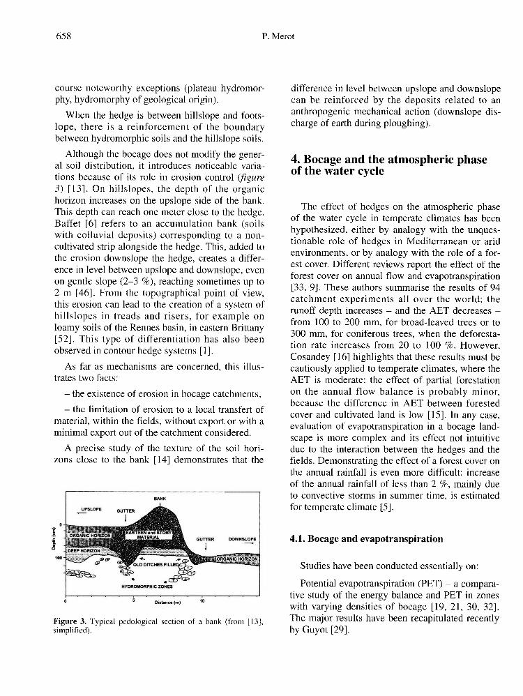
Although the bocage does not modify the gener-al soil distribution, it introduces noticeable varia-tions because of its role in erosion control (figure3) [13]. On hillslopes, the depth of the organichorizon increases on the upslope side of the bank.This depth can reach one meter close to the hedge.Baffet [6] refers to an accumulation bank (soilswith colluvial deposits) corresponding to a non-cultivated strip alongside the hedge. This, added tothe erosion downslope the hedge, creates a differ-ence in level between upslope and downslope, evenon gentle slope (2-3 %), reaching sometimes up to2 m [46]. From the topographical point of view,this erosion can lead to the creation of a system of
hillslopes in treads and risers, for example onloamy soils of the Rennes basin, in eastern Brittany[52]. This type of differentiation has also beenobserved in contour hedge systems [1].
As far as mechanisms are concerned, this illus-trates two facts:
- the existence of erosion in bocage catchments,- the limitation of erosion to a local transfert of
material, within the fields, without export or with aminimal export out of the catchment considered.
A precise study of the texture of the soil hori-zons close to the bank [14] demonstrates that the
difference in level between upslope and downslopecan be reinforced by the deposits related to ananthropogenic mechanical action (downslope dis-charge of earth during ploughing).
4. Bocage and the atmospheric phaseof the water cycle
The effect of hedges on the atmospheric phaseof the water cycle in temperate climates has beenhypothesized, either by analogy with the unques-tionable role of hedges in Mediterranean or aridenvironments, or by analogy with the role of a for-est cover. Different reviews report the effect of theforest cover on annual flow and evapotranspiration[33, 9]. These authors summarise the results of 94catchment experiments all over the world: therunoff depth increases - and the AET decreases -from 100 to 200 mm, for broad-leaved trees or to300 mm, for coniferous trees, when the deforesta-tion rate increases from 20 to 100 %. However,Cosandey [16] highlights that these results must becautiously applied to temperate climates, where theAET is moderate: the effect of partial forestationon the annual flow balance is probably minor,because the difference in AET between forestedcover and cultivated land is low [15]. In any case,evaluation of evapotranspiration in a bocage land-scape is more complex and its effect not intuitivedue to the interaction between the hedges and thefields. Demonstrating the effect of a forest cover onthe annual rainfall is even more difficult: increaseof the annual rainfall of less than 2 %, mainly dueto convective storms in summer time, is estimatedfor temperate climate [5].
4.1. Bocage and evapotranspiration
Studies have been conducted essentially on:
Potential evapotranspiration (PET) - a compara-tive study of the energy balance and PET in zoneswith varying densities of bocage [19, 21, 30, 32].The major results have been recapitulated recentlyby Guyot [29].
Actual evapotranspiration (AET) - a compara-tive study of the hydrological balance of two catch-ments, one with bocage and the other without [40].
These two studies showed that neither PET norAET are seriously affected by the presence orabsence of bocage, in the humid temperate contextof Brittany. The fact that the PET is independent ofthe presence of bocage is important as far ashydrology is concerned, since the PET is often thebasis for calculating the AET. Nevertheless, sincePET is not affected in Brittany by hedgerow sys-tems to a considerable degree, the effect ofhedgerow on PET factors (wind, radiation balance,temperature, air humidity) will not be developpedhere; detailed considerations can be founded in
Guyot [29]. In summary, PET depends on the evap-orative capacity of the air (contribution of advec-tive energy) and the net radiation. The main effectof bocage is the reduction in the evaporative capac-ity of the air, the modification of the radiative bal-ance acts as a corrective term only [31]. However,because of the relatively high atmospheric humidi-ty, the contribution of advective energy to PET issmall (20 %). The theoretical reduction of the PET,based on Penman formula would be less than 6 %
([29] p. 252), in a bocage field compared to anopen field.
4.2. Independence of the AET with regard to thepresence or absence of bocage
The annual AET at the catchment scale can beassessed by the hydrological balance. This hasbeen done by Merot [40] when comparing catch-ments with and without bocage. The author cameto the conclusion that AET was equal for the twolandscapes during two mean climatic years.Although this conclusion is coherent with theresults obtained for PET, it must be qualified bythe following remarks: firstly, the hydrological bal-ance method applied by Merot [40] did not take thewater content of the soil into account, and secondlythe degree of forestation of the catchment withoutbocage (15 % of the catchment is forested, whilethe other one is no forested) biased the comparison
of the AET of the two catchments, which couldlead to underestimating the existing differences.
The local scale studies of a bank give furtherinformation. The study by Carnet [13] of the soilwater content and the soil water potential profilesbelow and around the banks shows a significantdrying in summer. For example, in the deep soils,the matrix potential reaches 1.5 MPa at 1.80 mdepth compared to 0.1 MPa at the same depth 30 maway from the hedge. This indicates that there islocally (close to and under the bank) an increase inthe AET in summer. The reason for this is twofold.
First, trees have deeper root systems than crops;second, the AET of cultivated plots decreaseswhen the crops reach maturity whereas trees con-tinue to take up water much later in the season.Mette and Sattelmacher [48] and Mette [47] con-ducted a study on the organisation, hydrology andgeochemistry of a wooded bank in Schleswig-Holstein (Germany). They have drawn up a map ofthe root density of the crops on both sides of abank showing the competition between trees andcrops, depending on the distance from the hedge.They also monitored the soil water potentialthroughout the year, showing a greater drying at50 cm in depth - with a difference up to 40 kPa insummer - under the hedge and close to it, compar-atively to a 10 m distant site. They came to thesame conclusions as Carnet [13]. Moreover, theyobserved a large di-symmetry of drying dependingon the orientation, the hillslope exposed to thenorth remaining wetter because of the lower cli-matic demand. Agus et al. [1] have also showndrying close to a hedge. This drying is dissymmet-rical depending on the root system of the hedge,which is more developed upslope. In Poland,Ryszkowski [53] has measured an increase of170 mm of annual AET of hedges comparatively tosurrounding plots. He explains this increasing bydifferences in albedo, root system and also in
atmospheric exchanges related to the roughness ofthe hedges.
Does this local drying affects AET at the catch-ment scale? This effect depends on the relative vol-ume of soil concerned by the large drying due tothe hedge compared to the volume of soil of theenclosed fields. A simple calculation based on a
bocage model with regular square fields gives arough estimate. Considering that the hedge affectsa 4 m2 area on both sides, the relative extension ofthe affected domain, which increases linearly withthe density of the bocage, reaches 8 % for a densityof 100 m of hedge/ha or 16 % for 200 m.ha-1.Farington and Salama [25] report an experimentwhere the evaporative effect caused by tree rows isused to decrease, by evapotranspiration, the levelof a water table which was detrimental to growingcrops. However, in this case, the hedges corre-sponded to 25 to 30 % of the surface area of thehillslopes.We can therefore consider that in summer AET
near the hedges is higher than in surrounding fieldsand fields in open catchments. This leads to two
consequences for a bocage area at a higher level ofintegration (hillslope and catchment). First, there isa heterogeneity in the distribution of moisture ofthe soils on the hillslope marked by a decrease inthe water content in the vicinity of the hedge insummer, and second, AET increases at the level ofthe catchment. However, given the accuracy ofAET measurements at the scale of the catchmentwhich is at best only 5 to 10 %, differences couldonly be measured with a density of bocage higherthan 60 to 120 m.ha-1.
Therefore, although the experimental studiesshowed that there is no significant difference eitherin AET or in PET in catchments with or without
bocage, more theoretical approaches suggest thatin an area with bocage there should be a decreasein the PET and an increase in the AET, of a fewpercent in each case.
4.3. Bocage and precipitation
The idea that the bocage may influence the over-all volume of precipitation is sometimes put for-ward, although few scientific data can justify thisassertion [54]. This needs to be qualified in twocases: first, an effect on occult precipitation(increased fog, dew, etc.) may be consideredbecause of microclimatic modifications caused bythe bocage, in particular the decrease in windspeed close to the ground; and second, storms
seem to be more frequent on areas with bocage(Hubert-Moy, personal communication, 1995).The effect of a hedge on the spatial distribution
of snow and rain has been reported several times inliterature [22, 51, 56]. The effect on rain dependson where the winds come from with respect to the
bocage and the local topography. There is anincrease in the heterogeneity of precipitation on theground due to an increase upwind and a decreasedownwind. The variation can reach 5 mm for a 10to 25 mm precipitation depth [40]. In hilly areas,the effect can be more complex. Narrow bottomland enclosed by a bocage bank may receive lessrainfall because of the synergy between the oro-
graphic effect and the protective effect of thehedge. This effect should be taken into account,because of the important role of this area in theflow generation.
5. Bocage and the rewetting of soils
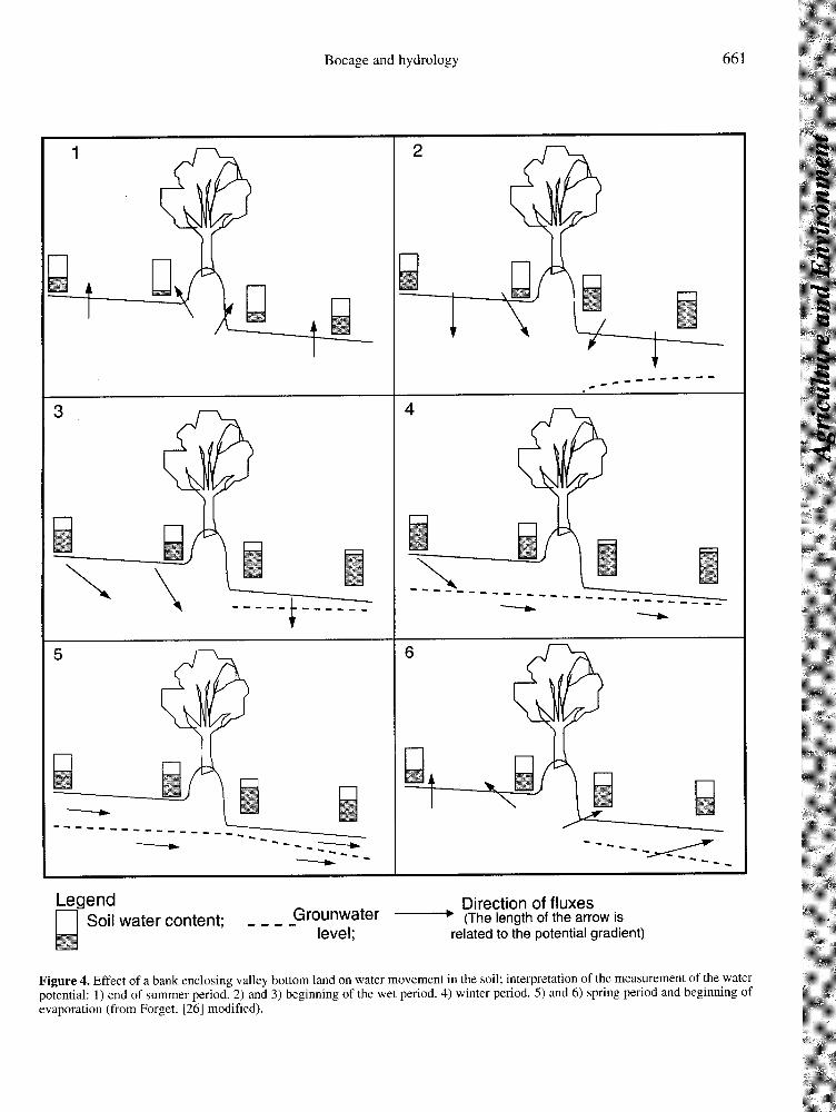
A recent study conducted on the local scalemakes it possible to illustrate infiltration dynamicsclose to the hedge [26]. A series of tensiometersplaced perpendicularly to a bank with trees enclos-ing bottom land (at 1, 3 and 5 m far from thehedge, and at every 10 cm from -20 cm to -155 cmdepth) and monitored from the beginning of thedry period make it possible to describe thesequence of infiltration over time. The scheme pre-sented in figure 4 is the interpretation of these data.The initial situation at the end of summer is a dryzone, shaped like a bulb, centred on the bank and agroundwater level which is lower upslope of thebank than downslope. Rewetting occurs gradually,keeping a dry dome, which becomes skewedbecause of a more rapid rewetting downslope. Theinfluence of the hedge remains visible until thecomplete rewetting of the soil, and reappears at theend of the rainy period. This study confirms andclarifies the results of Carnet [13].
6. Bocage and quick flowduring storm runoff
Storm runoff is generated by different internalprocesses within the catchment: surface runoff

(Hortonian flow), groundwater ridge formation,contribution of the saturated zone of bottom land
(contributive zone runoff, [36]). It is now clearlyestablished that the hydrology of the catchment inBrittany is determined by the interaction of 4 com-partments: groundwater, saturated zone, whichseems to correspond to the hydromorphic soils ofbottom land, runoff and hillslope subsurface flow[24, 43]. The hydrology is therefore very muchcontrolled by soil distribution, which is in turn con-trolled by the topography.
The influence of bocage on quick flow will beconsidered here at three levels:
- at the catchment outlet, where the storm runoff
hydrograph represents a synthesis of the differentprocesses involved in the catchment,- in the saturated zone at the talweg bottom
(contributive zone runoff),- on the hillslopes (Hortonian flow).
6.1. Quick flow at the outlet of a catchment
6.1.1. Comparison of two catchments
The studies conducted by Merot [40] are basedon the comparison of the hydrology of two small(32 ha) catchments, one with and the other withoutbocage. The bocage network consists of hedges ona bank, with a hedge density of 106 m.ha-1 includ-
ing 64 m.ha-1 perpendicular to the slope and, inparticular, a continuous bank enclosing the valleybottom. Precipitation and water level flow werecontinuously recorded on each catchment. Theconclusions from this study are the following:
Comparison of storm runoff on a typical eventshows that the direct runoff volume and the peakflow [60] was 1.5 to 2 times lower in the bocagecatchment than in the non bocage catchment. Thestatistical analysis of a series of approximately 30storm runoffs shows that the runoff coefficient, Cr(Cr = storm flow volume/volume of associated pre-cipitation), is stable around 5 %, whatever the win-ter storm runoff on the bocage catchment, whereasit varies from a few percent up to 15 % on the opencatchment (figure 5). In summer, the number ofstorm runoffs is too small to conclude, but it seems
that the role of bocage on summer storm runoffs isnot significant or that it can be reversed (Cann, oralcommunication) for small storm runoffs.
A deeper analysis can be undertaken (figure 6)by looking for explanatory factors which usuallyinvolve a factor expressing the state of saturation ofthe catchment (antecedent rainfall, soil moisture,initial flow of the river, etc.), factors linked to therainfall event (rainfall intensity, rainfall amount,etc.) and factors linked to the state of the surface(vegetation, soil roughness, etc.). A step by stepidentification of the main factors gives differentresults for the bocage catchment and the opencatchment. For the bocage catchment, the volumeof runoff water depends only on the rainfallamount (figure 6B). For the open catchment (figure6A), the volume of runoff water depends on a com-plex factor (on the x axis) which integrates rainfalldepth, Pu (mm) and intensity, Iu (mm.h-1).
Moreover, for this open catchment, two sets canbe distinguished, depending on the wetness of thecatchment prevailing before the rainfall-runoffevent: isolated storms, with the initial soil moistureat field capacity, and successive storms, occurringless than 48 hours after another storm and with aninitial soil moisture above field capacity.
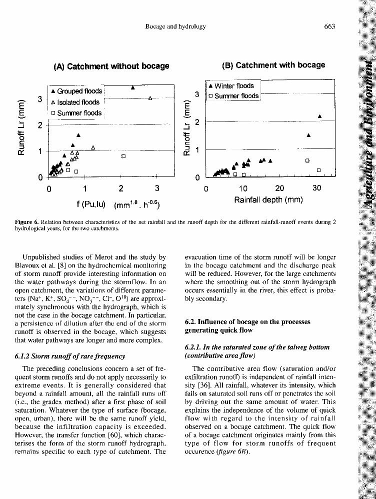
Unpublished studies of Merot and the study byBlavoux et al. [8] on the hydrochemical monitoringof storm runoff provide interesting information onthe water pathways during the stormflow. In anopen catchment, the variations of different parame-ters (Na+, K+, SO4--, NO3--, Cl-, O18) are approxi-mately synchronous with the hydrograph, which isnot the case in the bocage catchment. In particular,a persistence of dilution after the end of the stormrunoff is observed in the bocage, which suggeststhat water pathways are longer and more complex.
6.1.2 Storm runoff of rare frequencyThe preceding conclusions concern a set of fre-
quent storm runoffs and do not apply necessarily toextreme events. It is generally considered thatbeyond a rainfall amount, all the rainfall runs off(i.e., the gradex method) after a first phase of soilsaturation. Whatever the type of surface (bocage,open, urban), there will be the same runoff yield,because the infiltration capacity is exceeded.However, the transfer function [60], which charac-terises the form of the storm runoff hydrograph,remains specific to each type of catchment. The
evacuation time of the storm runoff will be longerin the bocage catchment and the discharge peakwill be reduced. However, for the large catchmentswhere the smoothing out of the storm hydrographoccurs essentially in the river, this effect is proba-bly secondary.
6.2. Influence of bocage on the processesgenerating quick flow
6.2.1. In the saturated zone of the talweg bottom(coutributive area flow)
The contributive area flow (saturation and/orexfiltration runoff) is independent of rainfall inten-sity [36]. All rainfall, whatever its intensity, whichfalls on saturated soil runs off or penetrates the soil
by driving out the same amount of water. Thisexplains the independence of the volume of quickflow with regard to the intensity of rainfallobserved on a bocage catchment. The quick flowof a bocage catchment originates mainly from thistype of flow for storm runoffs of frequentoccurence (figure 6B).
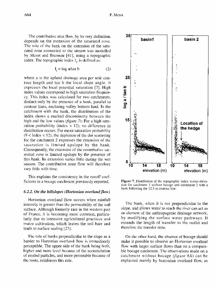
The contributive area flow, by its very definition,depends on the extension of the saturated zone.The role of the bank on the extension of the satu-rated zone connected to the stream was modelled
by Merot and Bruneau [41], using a topographicindex. The topographic index It, is defined as:
It = log a/tan b (2)
where a is the upland drainage area per unit con-tour length and tan b the local slope angle. Itexpresses the local potential saturation [7]. Highindex values correspond to high saturation frequen-cy. This index was calculated for two catchments,distinct only by the presence of a bank, parallel tocontour lines, enclosing valley bottom land. In thecatchment with the bank, the distribution of theindex shows a marked discontinuity between thehigh and the low values (figure 7): For a high satu-ration probability (index > 12), no difference indistribution occurs. For mean saturation probability(9 < index < 12), the depletion of the dot scatteringfor the catchment 2 expresses the extension of thesaturation is limited upslope by the bank.Consequently, the extension of the contributive sat-urated zone is limited upslope by the presence ofthis bank. Its extension varies little during the wetseason. The contributive zone flow will therefore
vary little with time.
This explains the consistency in the runoff coef-ficients in a bocage catchment previously reported.
6.2.2. On the hillslopes (Hortonian overland flow)
Hortonian overland flow occurs when rainfall
intensity is greater than the permeability of the soilsurface. Although formerly rare in the western partof France, it is becoming more common, particu-larly due to intensive agricultural practices andmaize cultivation, which leaves the soil bare andleads to surface sealing [27].
The role of banks perpendicular to the slope as abarrier to Hortonian overland flow is immediatelyperceptible. The upper side of the bank being both,higher and more level because of the accumulationof eroded particles, and more permeable because ofthe roots, reinforces this role.
The bank, when it is not perpendicular to theslope, and allows water to reach the river can act asan element of the anthropogenic drainage network,by modifying the surface water pathways. Itextends the length of transfer to the outlet andtherefore the transfer time.
On the other hand, the absence of bocage shouldmake it possible to observe an Hortonian overlandflow with larger surface flows than on a compara-ble bocage catchment. The observations made on acatchment without bocage (figure 6A) can beexplained mainly by hortonian overland flow, as
the flow depends on rainfall intensity and on thewetness of the catchment.
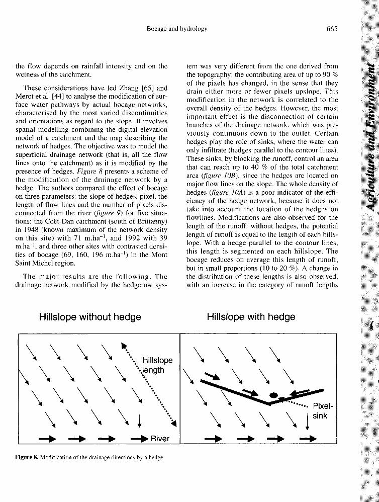
These considerations have led Zhang [65] andMerot et al. [44] to analyse the modification of sur-face water pathways by actual bocage networks,characterised by the most varied discontinuitiesand orientations as regard to the slope. It involvesspatial modelling combining the digital elevationmodel of a catchment and the map describing thenetwork of hedges. The objective was to model thesuperficial drainage network (that is, all the flowlines onto the catchment) as it is modified by thepresence of hedges. Figure 8 presents a scheme ofthe modification of the drainage network by ahedge. The authors compared the effect of bocageon three parameters: the slope of hedges, pixel, thelength of flow lines and the number of pixels dis-connected from the river (figure 9) for five situa-tions: the Coët-Dan catchment (south of Brittanny)in 1948 (known maximum of the network densityon this site) with 71 m.ha-1, and 1992 with 39m.ha-1, and three other sites with contrasted densi-ties of bocage (69, 160, 196 m.ha-1) in the MontSaint Michel region.
The major results are the following. Thedrainage network modified by the hedgerow sys-
tem was very different from the one derived fromthe topography: the contributing area of up to 90 %of the pixels has changed, in the sense that theydrain either more or fewer pixels upslope. Thismodification in the network is correlated to theoverall density of the hedges. However, the mostimportant effect is the disconnection of certainbranches of the drainage network, which was pre-viously continuous down to the outlet. Certainhedges play the role of sinks, where the water canonly infiltrate (hedges parallel to the contour lines).These sinks, by blocking the runoff, control an areathat can reach up to 40 % of the total catchmentarea (figure 10B), since the hedges are located onmajor flow lines on the slope. The whole density ofhedges (figure 10A) is a poor indicator of the effi-ciency of the hedge network, because it does nottake into account the location of the hedges onflowlines. Modifications are also observed for the
length of the runoff: without hedges, the potentiallength of runoff is equal to the length of each hills-lope. With a hedge parallel to the contour lines,this length is segmented on each hillslope. Thebocage reduces on average this length of runoff,but in small proportions (10 to 20 %). A change inthe distribution of these lengths is also observed,with an increase in the category of runoff lengths
lower than 250 m and a decrease in the runoff
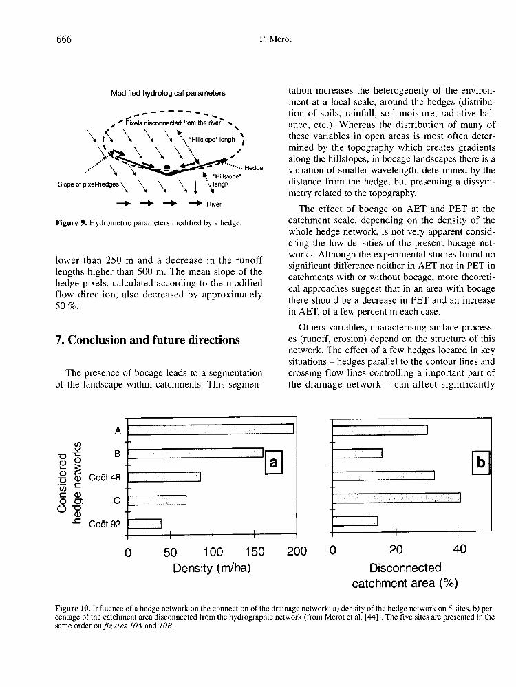
lengths higher than 500 m. The mean slope of thehedge-pixels, calculated according to the modifiedflow direction, also decreased by approximately50%.
7. Conclusion and future directions
The presence of bocage leads to a segmentationof the landscape within catchments. This segmen-
tation increases the heterogeneity of the environ-ment at a local scale, around the hedges (distribu-tion of soils, rainfall, soil moisture, radiative bal-ance, etc.). Whereas the distribution of many ofthese variables in open areas is most often deter-mined by the topography which creates gradientsalong the hillslopes, in bocage landscapes there is avariation of smaller wavelength, determined by thedistance from the hedge, but presenting a dissym-metry related to the topography.The effect of bocage on AET and PET at the
catchment scale, depending on the density of thewhole hedge network, is not very apparent consid-ering the low densities of the present bocage net-works. Although the experimental studies found nosignificant difference neither in AET nor in PET incatchments with or without bocage, more theoreti-cal approaches suggest that in an area with bocagethere should be a decrease in PET and an increasein AET, of a few percent in each case.
Others variables, characterising surface process-es (runoff, erosion) depend on the structure of thisnetwork. The effect of a few hedges located in keysituations - hedges parallel to the contour lines andcrossing flow lines controlling a important part ofthe drainage network - can affect significantly
runoff and erosion, even when the overall densityof the bocage is low. In a case study, the directrunoff volume and the peak flow was 1.5 to 2 timeslower in the bocage catchment than in the other.This role could be important, because the occur-rence of Hortonian runoff increases on intensivelycultivated fields. The hedges enclosing valley bot-tom land play a determining role, because they canalso limit the extension of saturated areas connect-ed to the hydrologic network. They can limit thesurface runoff on contributing zone, which is themajor process for surface flow in this region, forflood of high frequency.
While the main features of the effect of bocageon hydrology are established, further work is need-ed in the following directions:
• the relative role of bocage depending on thecontext, particularly the geological context, or howhydrological impact of bocage depends on the rela-tive volume of superficial flow and deep flow.
• the role of bocage depending on the nature ofthe hedge: this entails knowing to what extent theresults obtained in bocage landscapes with hedgeson banks are applicable to systems with hedgeswithout banks.
• upscaling: the influence of the bocage can bemeasured on the local scale and on small catch-
ments, but it has not yet been integrated at largerscales.
On the methodological point of view, the contri-bution of new techniques in hydrology, such as dis-tributed hydrological modelling and geographicinformation systems, should make it possible toquantify the effect of bocage, but the resultspresently available are partial and often qualitative.New approaches, such as landscape ecology,should also bring a new vision of the relationshipsbetween landscape structures and flows [58].
Finally, the effect of bocage on water quality,either on its own or in synergy with other land-
scape structures (riparian forests, wet bottom landareas) is a new and important concern.
It has been demonstrated that bocage landscapesin the Western France [34], unlike other woodedlinear systems encouraged elsewhere in the world,
have lost their relevance for agricultural productionin the present intensive agricultural context of thisregion. On the other hand, it still plays an impor-tant role in regulating water resources and conserv-ing water and soil resources. These collective func-tions, as well as its ecological role, must lead us toreconsider this type of landscape.
References
[1] Agus F., Cassel D.K., Garrity D.P., Soil-waterand soil physical properties under contour hedgerowsystems on sloping oxisols, Soil Tillage Res. 40 (1997)185-199.
[2] Alegre J.C., Rao M.R., Soil and water conserva-tion by contour hedging in the humid tropics of Peru,Agric. Ecosyst. Environ. 57 (1995) 17-25.
[3] André S., Watremez P., Typologie des bassinsversants du Finistère et transfert de nitrate, Compte-rendu intermédiaire, contrat Ifremer, 1997.
[4] Anomyme, Les haies de Bretagne. Enquête statis-tique; application à un diagnostic de leurs rôles, DRAFBretagne, Institut pour le Développement ForestierRennes, 1997.
[5] Aussenac G., Forêts et eaux: relations entreécosystèmes forestiers et ressources en eau, in: La ges-tion durable des forêts: contribution de la recherche,Inra Mensuel 12 (1996) 18-25.
[6] Baffet M., Influence de la haie sur l’évolution descaractères physico-chimiques et hydrodynamiques dessols, thèse, univ. Limoges, 1984.
[7] Beven K., Kirkby M.J., A physically based, vari-able contributing area model of basin hydrology,Hydrol. Sci. Bull. 24 (1979) 43-69.
[8] Blavoux B., Dray M., Merot P., Comparaison desécoulements sur deux bassins versants élémentaires,bocager et ouvert, à l’aide du traçage isotopique naturelpar 18O, In: Les bocages, histoire, écologie, économie,Inra, CNRS, Ensa et université de Rennes (1976)153-158.
[9] Bosch J.M., Hewlett J.D., A review of catchmentexperiments to determine the effect of vegetationchanges on water yield and evapotranspiration, J.Hydrol. 55 (1982) 2-23.
[10] Brenner A.J., Jarvis P.J., Van Der Beldt R.J.,Windbreak-crop interactions in the Sahel. 1)Dependence of shelter on field conditions, Agric. For.Meteorol. 75 (1995) 215-234.
[11] Burel F., Hedgerows and their role in agricultur-al landscapes. Critical review in Plant Sciences 15(1996) 169-190.
[12] Burel F., Baudry J., Lefeuvre J., Landscapestructure and the control of water runoff, in: BunceR.G., Ryszkowski L., Paoletti M.G., (Eds.), LandscapeEcology and Agroecosystems, Lewis; London, (1993)41-47.
[13] Carnet C., Étude des sols et de leur régimehydrique en région granitique de Bretagne : uneapproche du rôle du bocage, thèse Univ. Rennes, UERsciences biologiques, mention agronomie, 1978.
[14] Carnet C., L’effet anti-érosif du bocage enrégion granitique de Bretagne, in: Vogt & Vogt, col-loque sur l’érosion agricole en milieu non méditer-ranéen, Univ, Strasbourg (1979) 153-156.
[15] Cosandey C., Influence de la forêt sur le cyclede l’eau, Hydrol. Cont. 7 (1992) 13-22.
[16] Cosandey C., La forêt réduit-elle l’écoulementannuel ? Ann. Géo. 581-582 (1995) 7-25.
[17] Curmi P., Durand P., Gascuel-Odoux C.,Hallaire V., Merot P., Robin P., Trolard F., Walter C.,Bourrié G., Le programme Cormoran-Inra: De l’impor-tance des facteurs du milieu physique et de son amé-nagement dans le contrôle géochimique de la teneur ennitrate des eaux superficielles, J. Eur. Hydrol. 26 (1995)37-56.
[18] Dalton P.A., Smith R.J., Truong P.N.V., Vetivergrass hedges for erosion control on a cropped floodplain: hedge hydraulics Agric. Water Manage. 31(1996) 91-104.
[19] Damagnez J., Rapport de synthèse, caractérisa-tion physique des bocages, in: Les bocages, histoire,écologie, économie, Inra, CNRS, Ensa et univ. Rennes(1976) 105-108.
[20] De Jong E. & Kowalchuk T.E., The effect ofshelterbelts on erosion and soil properties, Soil Sci. 159(1995) 337-345.
[21] De Parcevaux S., Guyot G., Bioclimatologie etaménagement du bocage, Bull. Tech. Inf. (FRA),353/355 (1980) 631-656.
[22] Dikey G.L., Crop water use and water conserva-tion benefits from windbreaks: in G.R. Brandle., D. LHintz., J. W Sturrock, (Eds.), Windbreak Technology,Elsevier (1988) 363-380.
[23] D.I.R.E.N., Atlas hydrologique de la Bretagne,Préfecture de Région, Agence de Bassin Loire Bretagne,Saunier-eau et environnement, 1994.
[24] Durand P., Juan Torres J.L., Solute transfer inagricultural catchments: the interest and limits of mix-ing models, J. Hydrol. 181 (1996) 1-22.
[25] Farington F., Salama R.B., Controlling drylandsalinity by planting trees in the best hydrogeological set-ting, Land Degrad. Dev. 7 (1996) 183-204
[26] Forget V., Fonctionnement hydrique etbiogéochimique du talus de ceinture de bas-fonds: rôledans l’épuration du milieu en nitrates, DEA Science dusol, Rennes, 1997.
[27] Gascuel-Odoux C., Cros-Cayot S., Durand P.,Spatial variations of sheet flow and sediment transporton agricultural field, Earth Surface Processes andLandforms 21 (1996) 843-851
[28] Govindarajan M., Rao M.R., Mathuva M.N.,Ramachandran Nair P.K., Soil-water and root dynamicsunder hedgerow intercropping in semiarid Kenya.Agron. J. 88 (1996) 513-520.
[29] Guyot G. Climatologie de l’environnement. Dela plante aux écosystèmes, Chap. V topoclimats etmicroclimats, Masson, Paris, 1997.
[30] Guyot G., Bouchet J., Chiapalle J., Malet P.,Seguin B., Verbrugge M., Climat et aménagement enpays de bocage, Rapport de fin de contrat. InraBioclimatologie Montfavet, Ministère de l’agriculture etdu développement rural, 1976.
[31] Guyot G., Seguin B., Influence du bocage sur leclimat d’une petite région, in: Les bocages, histoire,écologie, économie, Inra, CNRS, Ensa et univ. Rennes(1976) 121-130.
[32] Guyot G., Seguin B., Influence du bocage sur leclimat d’une petite region: résultats des mesures effec-tuées en Bretagne, Agric. Meteorol. 19 (1978) 411-430.
[33] Humbert J., Najjar G., Influence de la forêt surle cycle de l’eau en domaine tempéré. Une analyse de lalittérature francophone, Centre d’étude et de rechercheen écogéographie, ULP, Strasbourg, 1992.
[34] Inra, Ensa, Univ. Rennes, Les bocages histoire,écologie, économie, Table Ronde CNRS, 1976.
[35] Kiepe P., Effect of Cassia siamea hedgerow bar-riers on soil physical properties. Geoderma 66 (1995)113-120.
[36] Kirkby M.J., Hillslope hydrology, John Wileyand sons, Chichester, 1978.
[37] Larivière G. & Verdou J.P., Contribution àl’étude du climat de la Bretagne, Monographie de lamétéorologie nationale, n°73, 1969.
[38] Longley M., Çilgi T., Jepson C.J., SothertonN.W., Measurements of pesticide spray drift depositioninto field boundaries and hedgerows: 1. summer appli-cation, Environ. Toxicol. Chem. 16 (1997) 165-172.
[39] Mazenc B., Sanchez M., Thierry D., Analyse del’influence de la physiographie d’un bassin versant sur
les parmètres d’un modèle hydrologique global et surles débits caractéristiques, J. Hydrol. 69 (1984) 97-118.
[40] Merot P., Le bocage en Bretagne granitique: uneapproche de la circulation des eaux, thèse Inra-Ensa-Univ. Rennes 1, 1978.
[41] Merot P., Bruneau P., Sensitivity of bocagelandscapes to surfaces run-off: application of the Kirkbyindex, Hydrol. Process. 7 (1993) 167-173.
[42] Merot P., Buffin D., Essai de caractérisation dela variabilité hydrologique en Bretagne in: P. Merot etA. Jigorel, (éds.), Hydrologie des pays celtiques, InraEditions (Colloq. Inra n°79), 1996, pp. 127-135.
[43] Merot P., Durand P., Morisson C., Four-compo-nent hydrograph separation using isotopic and chemicaldeterminations in an agricultural catchment in westernFrance, Phys. Chem. Earth 20 (1995) 415-425.
[44] Merot P., Gascuel-Odoux C., Walter C., ZhangX., Molenat J., Bocage landscape and surface waterpathways, Rev. Sci. Eau, 12/1 (1999) 23-44.
[45] Merot P., Reyne S., Rôle hydrologique etgéochimique des Structures Linéaires Boisées: bilanbibliographique et perspectives d’étude, Et. Rech. Syst.Agraires Dév. 29 (1995) 83-100.
[46] Merot P., Ruellan A., Pédologie, hydrologie desbocages: caractéristiques et incidence de l’arasementdes talus boisés, Bull. Tech. Inf. 353/355 (1980)657-689.
[47] Mette R., Yield formation and nutrient uptakeby corn and oats in the hedgerow - field crop interface,consequences for nutrient and water balances with spe-cial regard to root ecology of both arable crops andhedgerow vegetation, Verlag Ukrich E Grauer,Wendlingen, 1993.
[48] Mette R., Sattelmacher B., Root and nitrogendynamics in the hedgerow - field interface.
Consequences for land use management, Proceedings ofthe 7th Int. Symp of CIEC; Agroforestry and land usechange in industrialised nations, Berlin, HumboltUniversity (1994) 275-284.
[49] Michel P., Pedron M., Schmutz T., Les multi-ples rôles des haies bretonnes, Institut pour ledéveloppement forestier, Agreste, les Cahiers 16 (1997)1-8.
[50] Mineau P., Mc Laughlin A., Conservation ofbiodiversity within Canadian Agricultural landscape:integrating habitat for wildlife, J. Agric. Environ. Ethics9 (1996) 93-113.
[51] Peev B., The ecological role of the shelterbeltsin the republic of Bulgaria in: Brandle G.R., Hintz
D.L., Sturrock J.W., (Eds.), Windbreak technology,Elsevier (1988) 110-113.
[52] Pihan J. Bocage et érosion hydrique des sols enBretagne. Les bocages, histoire, écologie, économie,Inra, CNRS, Ensa et université de Rennes, 1976, pp.185-192.
[53] Ryszkowski L. Ecological guidelines for man-agement of rural areas in Poland. In: Grodzonski,Cowling, Breymeyer, eds., Ecological risk: perspectivesfrom Poland and the United States, Nat. Ac. Press,Washington DC, 1990, pp. 249-263.
[54] Ryszkowski L. & Kedziora A., Impact of agri-cultural landscape structure on energy flow and watercycling, Landscape Ecol., 1 (1987) 85-94.
[55] Schreiber P. & Demuth S., Regionalization oflow flows in Southwest Germany, Hydrol. Sci. J., 42(1995) 845-858.
[56] Sholten H., Snow distribution on crop fields, in:G.R. Brandle., D. L Hintz., J. W Sturrock, (Eds.),Windbreak Technology, Elsevier, 1988, pp. 349-350.
[57] Smadja J., Sur une dégradation annoncée desmilieux népalais: initiatives villageoise pour remplacerles ressources forestières, Natures Sciences Sociétés, 3(1995) 190-204.
[58] Thenail C., Exploitations agricoles et
territoire(s): contribution à la restructuration de lamosaïque paysagère, Univ. Rennes 1, 1996.
[59] Touffet J. & Rozé F., La végétation dans lespaysages bocagers de Bretagne.
"
Bocage et aménage-ment rural: quel avenir?
" Bull. Tech. Inf., 353/355(1980) 691-723
[60] Van Te Chow, Maidment D.R., Mays L.W.Applied hydrology, Mc Graw-Hill, 1988.
[61] Verbrugghe M., Contribution à l’analyse desmicroclimats au niveau de l’arbre, des couvertsforestiers et des parcelles agricoles entourées de brise-vent, thèse, Univ Aix-Marseille II, 1989.
[62] Widiatmaka W., Analyse structurale et fonction-nement hydrique d’un système pédologique limoneuxacide sur granite et sur schiste de Massif Armoricain,France. thèse, Ensa Rennes, 1994.
[63] Windbreak & Agroforestry, proceeding of aninternational symposium, Ridgetown college, Ontario,Canada, 1991.
[64] Zhang H., Brandle J.R., Meyer G.E., Hodges L.,The relationship between open windspeed and wind-speed reduction in shelter, Agroforestry systems 32(1995) 297-311.
[65] Zhang X., Hedgerow effect on drainage net-work. Inra, Science du sol, Rennes, Doc. Int., 1995.