hedgerow survey handbook - hedgelink · hedgerow survey handbook a standard procedure for local...
TRANSCRIPT

Hedgerow Survey HandbookA standard procedure for local surveys in the UKPrepared on behalf of the Steering Group for the UK Biodiversity Action Plan
for Hedgerows
2nd edition
Defra deals with theessentials of life – food, air,land, water and people.
www.defra.gov.uk
Department for Environment, Food and Rural AffairsNobel House17 Smith SquareLondon SW1P 3JRTelephone: 020 7238 6000Website: www.defra.gov.uk
© Crown copyright 2007
Copyright in the typographical arrangement and design rests with the Crown.
This publication (excluding the logo) may be reproduced free of charge in anyformat or medium provided that it is reproduced accurately and not used in amisleading context. The material must be acknowledged as Crown copyrightwith the title and source of the publication specified.
This document should be cited as: Defra (2007) Hedgerow Survey Handbook.A standard procedure for local surveys in the UK. Defra, London.
Published by the Department for Environment, Food and Rural Affairs.
Printed in the UK, March 2007, on material that contains a minimum of 100%recycled fibre for uncoated paper and 75% recycled fibre for coated paper.
PB11951
Cover pictures:
Main picture – Roadside hedgerow with trees (Jon Stokes)Top left – Hawthorn Berries (David Townshend)Middle left – Flowering Blackthorn (David Townshend)Bottom left – Blackthorn Sloes (David Townshend)Middle right – Primrose flowers (Rob Wolton)Bottom right – Hedge laying (Rob Wolton)

Hedgerow Survey Handbook
A standard procedure for localsurveys in the UK
2nd Edition
Prepared on behalf of the Steering Group forthe UK Biodiversity Action Plan for Hedgerows


3
Foreword 5
Preface 6
Chapter 1 Why Survey? 8
Chapter 2 Survey Organisation 19
Chapter 3 Pre-survey Preparations 29
Chapter 4 Field Survey – what to record and why 41
Chapter 5 Summary guide to completion of the Field Survey Forms 80
Chapter 6 Data Management, Storage, Analysis, and Reporting 86
Acknowledgements 88
References and Further Reading 90
Appendices
Appendix 1 Glossary of terms 98
Appendix 2 Guidance on health and safety 104
Appendix 3 Sources of possible funding for hedgerow surveys 107
Appendix 4 Legal protection of hedgerows 109
Appendix 5 UK Biodiversity Action Plan priority species 111associated with hedgerows
Appendix 6 Field Survey Form 113
Appendix 7 Survey Summary Form 126
Appendix 8 List of recently introduced species 130
Appendix 9 Hedgerow BAP Targets and Favourable Condition Attributes 132
Appendix 10 Veteran tree rule of thumb trunk diameters 135
Appendix 11 Status of woody species in hedgerows 137
Contents


5
It is a good time for hedgerows across the UK.Thankfully, their removal is now largely a thing of thepast, as society’s recognition of their tremendous valuefor biodiversity, landscape and history grows. And farmore money is available to help farmers look aftertheir hedgerows through European and Government-funded schemes than when Michael Meacher, thenMinister of State for the Environment, wrote theforeword for the first edition of this Handbook fiveyears ago. In England over 165,000 km of hedgerowshave already been entered into EnvironmentalStewardship.
Hedgerows have their part to play too in helping us to respond and adapt toclimate change, providing conduits through which wildlife may move, andprotecting soil, livestock and property against extreme weather events. Theyeven help to lock up carbon and provide a sustainable source of fuel. Even on asmall scale, this can help towards our goal of One Planet Living.
Yet we still don’t know enough about the quality and make up of our hedgerows.At a national level we have a broad picture through the national CountrysideSurvey programme which Defra supports, but action requires local knowledge andthis is lacking over the majority of the UK. I am pleased that the first edition ofthis Handbook promoted a good number of surveys, but we need more!
So I encourage all of you reading this new improved version of the Handbookto get surveys underway in your area, working with the local community andvolunteers wherever possible. The rewards are likely to be considerable, not justin terms of knowledge leading to conservation action, but also in terms ofraising awareness and interest in our fabulous hedgerow heritage.
The Steering Group for the UK Biodiversity Action Plan for Hedgerows has donewell indeed to revise this much needed Handbook, and I am delighted to beable to commend it to you.
Barry GardinerMinister For Biodiversity, Landscape and Rural Affairs
Foreword
6
This Handbook sets out a standard way of recording hedgerows. Its focus is onthe wildlife, or biodiversity, of hedgerows. We recognise that hedgerows arealso important for farming, for the contribution they make to the beauty of ourcountryside, and historically and culturally. Surveys covering these aspects will,we hope, build on the methods given in this Handbook.
The first edition of this Handbook, published in 2002, proved popular and waswidely used. This second edition takes account of the feedback we havereceived, and many helpful suggestions for improvement. It also takes accountof recent advances in our understanding of what a hedgerow looks like when itis in a good or ‘favourable condition’ for wildlife.
Information on whether or not hedgerows are in ‘favourable condition’ isimportant when it comes to making decisions on how they should be managed.It is also critical for policy decisions and setting nature conservation direction.Those responsible for delivering Biodiversity Action Plans (BAPs) for hedgerows,whether at local or UK level, particularly need this information. This is why theSteering Group for the UK BAP for Hedgerows has commissioned the secondedition of this Handbook.
In 2006, we believe that only some 22% of the UK’s hedgerows are in afavourable state. The survey method in this Handbook will give accurate,consistent information about the state of our hedgerows at a local level, what themain influences on their condition are, and what we need to do to restore them.
We have clearly distinguished between those aspects of hedgerows which it isessential to record as far as BAPs are concerned, and those which are optional.Among the optional elements is a brand new one on veteran trees.
We have improved the database that accompanies the Handbook. Our hope isthat this database will be used and the information provided to local recordcentres and the like, so that survey findings are widely available and can beused to help build up the picture at regional, country and UK level.
We hope that the Handbook will raise awareness and interest among landmanagers and local communities about the considerable importance ofhedgerows for wildlife, and help to identify the most pressing challenges andthe best ways to address them.
Preface

7
One of our basic premises has been that surveyors should be able to go to anyhedgerow and use the survey method without any historical records or priorinformation. The only exception to this is that the owner, or manager, must beknown and their permission sought and gained.
Hedgerows are complex! They show great variety across the country and as awildlife habitat they are the interface between woodland and open field. So, ithas been a huge challenge to develop a survey method that will work justabout anywhere in the country, with any type of hedgerow. We have tried tokeep it simple and precise, but have found lengthy explanations and guidanceat times unavoidable.
Even defining a hedgerow has required a lot of careful thought and carefuldrafting. Suggestions for further simplification and clarification of theHandbook are always welcome.
Preface

8
Why Survey?Introduction
Hedgerows are of great importance acrossthe UK, in our towns and cities as well as inthe countryside. However, in most places wehave remarkably little information on howmany we have, or about their composition orstructure, let alone their condition. As aresult, it is often difficult to make informeddecisions about what needs to be done toconserve these ‘green veins’ for the future.This Handbook is designed to help fill thisgap in our knowledge through providing apractical way of carrying out surveys to astandard format.
The focus of the Handbook is on collecting information pertinent to the wildlifethat inhabits hedgerows and the biodiversity which they support. In particular, ithas been written to help with the development and implementation of BAPs,both the UK hedgerow plan and local plans. Revised UK BAP targets forhedgerows can be found at http://www.ukbap.org.uk/ and in Appendix 9.
Chapter 1
Hedgerows and hedgerow trees provide avaluable habitat for bats (all bat speciesand their roosts are protected)
Box 1: What is a hedgerow?The survey method described in this Handbook covers a broad definition and wasdeveloped by the Local Surveys Sub-Group of the Steering Group for the UK BAPfor Hedgerows.
A hedgerow is defined as any boundary line of trees or shrubs over 20m long andless than 5m wide at the base, provided that at one time the trees or shrubs weremore or less continuous. It includes an earth bank or wall only where such afeature occurs in association with a line of trees or shrubs. This includes ‘classic’shrubby hedgerows, lines of trees, shrubby hedgerows with trees and very gappyhedgerows (where each shrubby section may be less than 20m long, but the gapsare less than 20m).

Survey Objectives
Local hedgerow surveys can be carried out for a variety of reasons, including:
• Documenting the distribution, character and special attributes ofhedgerows in the area.
• Establishing the state of the hedgerows, in terms of the length andcondition, to help develop policies and strategies to ensure they survivewell into the future, and to enable grants to be targeted most effectively.
• Identifying those hedgerows that are of particular importance forwildlife, landscape, cultural or historical reasons, and so particularlyworthy of protection or conservation.
• Providing a baseline to allow future changes to be detected andevaluated and to document the success or otherwise of anyconservation programmes.
The use of this Handbook will enable all these objectives to be met, only needingto be expanded should there be a strong focus on historical or cultural aspects.
Local surveys carried out using this Handbook will complement the Countryside Survey programme which is designed to identify trends in changes in the countryside at a country-wide level (see www.cs2000.org.uk forfurther information on the Countryside Survey programmes in Britain andNorthern Ireland).
The survey method described in the Handbook has not been developedspecifically to help with the Hedgerow Regulations (1997) in England andWales, although some of the information collected will be relevant to theirimplementation.
Why Survey?
9
10
Defining a hedgerow
The broad definition of a hedgerow used in the Handbook is described in Box 1and in summary it is:
Any boundary line of trees or shrubs over 20m long and less than 5mwide between major woody stems at the base.
Chapter 1
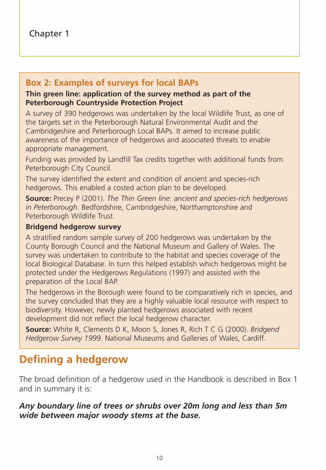
Box 2: Examples of surveys for local BAPsThin green line: application of the survey method as part of thePeterborough Countryside Protection ProjectA survey of 390 hedgerows was undertaken by the local Wildlife Trust, as one ofthe targets set in the Peterborough Natural Environmental Audit and theCambridgeshire and Peterborough Local BAPs. It aimed to increase publicawareness of the importance of hedgerows and associated threats to enableappropriate management.
Funding was provided by Landfill Tax credits together with additional funds fromPeterborough City Council.
The survey identified the extent and condition of ancient and species-richhedgerows. This enabled a costed action plan to be developed.
Source: Precey P (2001). The Thin Green line: ancient and species-rich hedgerowsin Peterborough. Bedfordshire, Cambridgeshire, Northamptonshire andPeterborough Wildlife Trust.
Bridgend hedgerow surveyA stratified random sample survey of 200 hedgerows was undertaken by theCounty Borough Council and the National Museum and Gallery of Wales. Thesurvey was undertaken to contribute to the habitat and species coverage of thelocal Biological Database. In turn this helped establish which hedgerows might beprotected under the Hedgerows Regulations (1997) and assisted with thepreparation of the Local BAP.
The hedgerows in the Borough were found to be comparatively rich in species, andthe survey concluded that they are a highly valuable local resource with respect tobiodiversity. However, newly planted hedgerows associated with recentdevelopment did not reflect the local hedgerow character.
Source: White R, Clements D K, Moon S, Jones R, Rich T C G (2000). BridgendHedgerow Survey 1999. National Museums and Galleries of Wales, Cardiff.

11
However, hedgerows in the countryside are usually in the form of a network ofmany hedgerows linked to each other. Critical questions for the surveyor are:where does an individual hedgerow start and stop; and what is the ‘unit’ ofsurvey? To ensure that definable lengths of hedgerow can be surveyed, the endpoints of a ‘unit’ must be clearly identified. For the purposes of this Handbook,an end point, or node, is:
1. any point of connection between two, or more, hedgerows or to otherfeatures e.g. fences, walls, ditches, roads
2. the point at which a hedgerow stops and there is a gap of more than20m to the next hedgerow (e.g. where the hedgerow ends in the middleof a field).
3. the point at which the hedgerow links to a woodland or other semi-natural habitat such as a pond.
Having defined the hedgerow using the above criteria, there may be significantvariation along this length that may require refining lengths into ‘survey units’.These additional points where changes occur are as follows:
4. the point at which the hedgerow changes character from one hedgerowtype to another for 20m or more
5. where there is a distinct change in hedgerow height for lengths of 20m or more
6. the ends of lengths (20m or more) of recent planting, coppicing or laying.
If the hedgerow is of a very variable species composition, such that differentparts have markedly different species compositions1, it should be recorded asone survey unit if the whole hedgerow is of similar size and shape along itslength, except for recording woody species per 30m, when more than onesurvey section should be chosen to represent the differing species compositionsalong the hedgerow.
Why Survey?
1 Where there may be a change from species-poor to species-rich as the result of a multi-species replanting of gaps in asingle-species hedgerow.

12
Each section between two end points or nodes is considered a separatehedgerow (see Figure 1). Sometimes a section between end points may goround a sharp corner that may historically have been a ‘T’ junction or even across-intersection (this can often be checked with reference to historic maps,see Table 4). This is regarded as the same hedgerow as far as this Handbook isconcerned (see Figure 1).
Figure 1 – Determining the extent of each hedgerow.
a) Identifyingthe extentof ahedgerow
Look carefully for the pointif you only have access to one side SIDE A
NODE
NODE
SIDE B
b) Definingseparatehedgerowswhere there aregaps
SIDE B
SIDE A
PONDHEDGEROW 1
ROAD
HEDGEROW 2
Small gaps under 20mincluded in hedgerow No hedgerow if gap greater than 20m
The fence and gap <20mand therefore part of the hedgerow
Chapter 1

13
Why Survey?
Box 3: Examples of other types of local hedgerow surveysHedgerow surveys in South YorkshireThis overview of hedgerow surveys in the region found that, although a numberhad been completed, they were unevenly distributed and also the quality of datacollected was very variable.
South Yorkshire Forest investigated the status and condition of hedgerows and dry-stone walls. The survey enabled them to make recommendations for therestoration of the boundary landscape features, as well as a basis for the selectionof species for future hedgerow planting.
Other surveys in the region included those forming Habitat Action Plan Inventories,responses to planning applications/environmental impact assessment, definingimportant hedgerows to assist local authorities, assessing the age of hedgerows inan ancient landscape, and as part of a Government employment training scheme.
Source: J Flannigan (pers. comm.). Survey of hedgerow surveys in South Yorkshire.Council for the Protection of Rural England.
Brigg Town Council hedgerow project – educational roleBrigg Town Council, three local schools and the North Lincolnshire Council for theProtection of Rural England undertook a local hedgerow survey. The schools thenincorporated the study of these hedgerows into their curriculum and produced anewsletter, Hedgerow Herald. Interviewed on local radio about their work, onepupil commented:
“Hedgerows are older and more interesting than they look. They are not just abush growing in a straight line. We found eggshells, broken snail shells and lots ofwood mice nests. Insects seem really boring when you don’t know anything aboutthem, but when you look deeper into what they do it is really interesting.”
Source: Hedgerow Herald, July 2001.
East Anglesey Hedgerow SurveyThis survey looked at ancient / species-rich hedgerows, and it confirmed thatspecies-rich hedgerows occur in the areas of Anglesey that were thought to berichest, and are generally in good condition. An interesting finding was that thedistribution of species-rich hedgerows showed no positive association with existingwoodland, ancient or otherwise. The results of the survey will be used to targetconservation effort in the area, and to identify potential seed sources and suitablespecies mixes for hedgerow restoration and creation.
Source: Geoff Radford, North Wales Environmental Services on behalf of Isle ofAnglesey County Council.

14
Defining a species-rich hedgerow
Where the structural species making up the 30m section of hedgerow includeat least five (or at least four in northern and eastern England, upland Wales andScotland) woody species that are either native somewhere in the UK, or whichare archaeophytes2 (see Appendix 11), the hedgerow is defined as species-rich.Climbers and bramble do not count towards the total except for roses.Hedgerows that contain fewer woody species but have a rich basal herbaceousflora may also be defined as species-rich, but the criteria to define these have tobe set on a local basis as there is no national definition.
Hedgerow Condition Assessment
The main enhancement to the standard survey method in this edition has beento enable the collection of data that can be used to assess whether hedgerowsare in ‘favourable condition’, as defined by the Steering Group for the UK BAPfor Hedgerows. In addition, the length of hedgerows in an area can beestablished and other important features described, such as hedgerow trees.Using this survey method, the results can be directly related to BAP targets bothfor local and UK plans. This condition assessment is aimed at hedgerowscomprising mainly native species, regardless of whether they are rural or urban.
Hedgerow condition assessment depends on recording hedgerow ‘attributes’.These are measurable characteristics, like height and width, that have beengiven thresholds by the Steering Group to indicate whether a particularhedgerow is in ‘favourable condition’. These attributes are all listed atAppendix 9. The basic attributes deemed to be indicative of ‘favourablecondition’ include the height and width of the woody component, along withthe degree of intactness of the hedgerow canopy, and also the height aboveground at which the canopy starts. Other features of the hedgerow that areimportant measures of condition include the width of any perennial herbaceousvegetation and undisturbed ground adjacent to the hedgerow. Speciescomposition is also important, specifically the presence of recently introduced ornon-native species. These attributes will form the benchmark against which anydecline or improvement in hedgerow condition can be monitored, for instance
Chapter 1
2 Being recorded as naturalised in the wild before 1500 AD.

15
Why Survey?
in relation to Local BAP targets. The results can also inform strategic decisionsthat need to be taken to prevent the decline of hedgerows and to guide andencourage their restoration and management.
The survey method recognises that a range of hedgerow types is of value forwildlife; not just the ‘classic’ shrubby hedgerows, but also ‘lines of trees’ andcombinations of shrubby hedgerows and trees. These types need to beassessed in slightly different ways to suit their individual character.
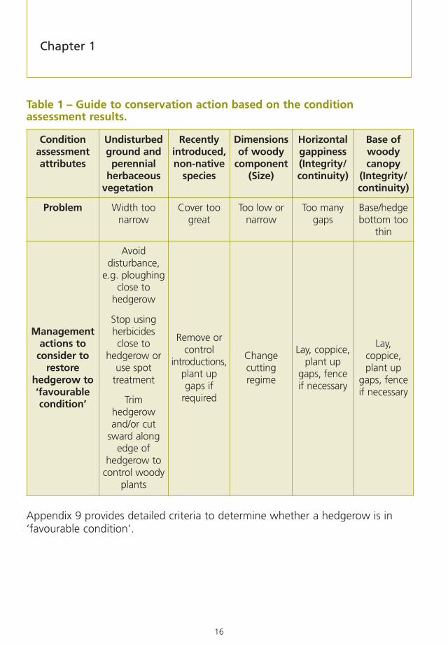
It is often helpful to provide some context for the condition assessmentresults when the conclusions of the study are drawn up. Table 1 links thecondition assessment to practical conservation action.
16
Table 1 – Guide to conservation action based on the conditionassessment results.
Appendix 9 provides detailed criteria to determine whether a hedgerow is in‘favourable condition’.
Conditionassessmentattributes
Undisturbedground andperennial
herbaceousvegetation
Recentlyintroduced,non-native
species
Dimensionsof woody
component(Size)
Horizontalgappiness(Integrity/continuity)
Base ofwoodycanopy
(Integrity/continuity)
Problem Width toonarrow
Cover toogreat
Too low ornarrow
Too manygaps
Base/hedgebottom too
thin
Managementactions to
consider torestore
hedgerow to‘favourablecondition’
Avoiddisturbance,
e.g. ploughingclose to
hedgerow
Stop usingherbicidesclose to
hedgerow oruse spot
treatment
Trimhedgerowand/or cut
sward alongedge of
hedgerow tocontrol woody
plants
Remove orcontrol
introductions,plant upgaps if
required
Changecuttingregime
Lay, coppice,plant up
gaps, fenceif necessary
Lay,coppice,plant up
gaps, fenceif necessary
Chapter 1

17
Table 2 – Carrying out a local hedgerows survey: the key steps anddecisions to take.
Step/Decision
1 Define survey objectives.
2 Define survey area.
3 Define timescales.
4 Consult with key stakeholders such as local authorities, BAP groups, parishcouncils, farmer and landowner organisations, wildlife trusts and the LocalRecords Centres, and refine 1 – 3 above.
5 Decide whether to survey every hedgerow in the survey area (a census) or asample of hedgerows (a sample survey). If sampling, determine necessary samplesize to ensure statistical validity and decide on sampling strategy. Considerstratifying the sample, so that results can be compared with areas that may bedifferent in hedgerow or landscape characteristics.
6 Decide whether to collect any of the optional information in addition to thatconsidered essential in this Handbook, and any historical, cultural or other datarequired to meet survey objectives.
7 Decide whether or not to limit collection of some data to a single 30m sectionper hedgerow. Hedgerow length, the number of connections to otherhedgerows and basic hedgerow type must be assessed over the whole length ofeach hedgerow, and woody species diversity must be assessed from 30msections. All other essential information can be collected either from the wholehedgerow or from just a 30m stretch, depending on survey objectives andavailable resources. For large surveys using a 30m section is likely to be the mostappropriate approach.
8 Decide whether to increase the level of accuracy to which measurements, suchas hedgerow height, and width should be carried out, above the recommendedminima in the Handbook.
9 Consider carrying out a pilot survey to refine sample size, to assist with resourceassessment, and to tailor species lists, etc, to survey area. Re-visit 3 above.
10 Raise required funding and recruit necessary staff, co-ordinators and volunteers.
11 Obtain necessary equipment (e.g. maps, aerial photographs, measuring tapesand poles, GPS, computers, software).
Why Survey?

18
Table 2 – Carrying out a local hedgerows survey: the key steps anddecisions to take. Continued
Step/Decision
12 Train surveyors in field survey methods, data entry and health and safety requirements.
13 Obtain necessary access permissions, and carry out any desirable pre-publicity.
14 Start field work.
15 Enter information on each hedgerow surveyed into the Microsoft Accessdatabase that accompanies this handbook (may be done when field work ends).
16 Carry out periodic quality control.
17 End field work.
18 Analyse data and produce key results.
19 Complete Survey Summary Form (Appendix 7) and submit to local and UK BAP groups and Defra.
20 Ensure data and analyses are deposited with Local Records Centre, etc. (seeChapter 6).
21 Produce reports (preferably with non-technical summary) and publicise results.
22 Consider implementation of any recommendations and proposals that havecome out of the work. Also consider timescales for repeat survey.
Chapter 1

19
Survey OrganisationIntroduction
For any hedgerow survey it is important to set aside sufficient time for planning.This will help to ensure that the survey runs smoothly and produces valid findings.
The brown hairstreak butterfly favours blackthorn hedgerows.
Song thrush with chicks. A BAP Hedgerow surveys may be undertaken with reference to priority species particular species, such as the brown hairstreak butterfly or
the dormouse.
The objectives (as set out in Chapter 1) and scale of the survey will help decidewhether the project can be led by one person, or if a steering group is needed.It is important to establish who has overall responsibility for the survey, and toidentify and agree the roles of other team members.
Chapter 2

20
Once the objectives are clearly set out, these will help to determine whatinformation needs to be collected, the size of the sample, the ideal time tocarry out the survey allowing for seasonal limitations, and the human andfinancial resource implications (determining the sample size is covered inChapter 3).
Time should be allowed to apply for funding, if required, and to recruit and trainsurveyors, whether employed or volunteers. Autumn can be a good time to startplanning for a survey taking place over the following summer. A longer periodmay be necessary if grant aid is required. As part of the planning it is advisableto contact local organisations such as the local authority/council, the countyWildlife Trust, the Campaign to Protect Rural England (CPRE) and the BritishTrust for Conservation Volunteers (BTCV). Such organisations may be undertakinghedgerow surveys already and/or may be prepared to provide some assistance.
Funding opportunities
Funding for local surveys may be available from Defra and a number of othersources. Contact points are given in Appendix 3. Applying for grant aid mayrequire imagination or lateral thinking in terms of categories of funds to seek.Potentially, hedgerow surveys cover a wide range of interests includingbiodiversity, landscape history, landscape character, environmental awarenessand community engagement.
When applying for funding, a careful check should be made of the entrycriteria. Guidance is usually provided on completing applications, but as ageneral rule it is best to provide as much detail about the survey as possible,including clear objectives, likely outcomes and benefits, the survey method, thetype of surveyors (voluntary or professional, skilled botanists, etc), and abreakdown of the estimated costs. Some grant schemes will fund only aproportion of the costs, with the remainder having to be obtained from othermeans, including ‘in kind’ contributions.
Hedgerow groups and publicity
In areas where hedgerows are considered to be a particular feature of thelandscape character, some counties have established local groups focusing on arange of activities relating to hedgerows, including surveying (Box 4). Suchgroups are valuable for co-ordinating activities at a local level and may providepublicity.
Chapter 2

21
Most farming organisations have a newsletter in which the survey could beannounced. This, together with local newspapers, should help give credibility tothe survey and will prove useful when it comes to asking for access consent.
At the completion of the survey, the publication of newsletter articles is a goodway of reporting survey findings to a wide audience, as well as saying ‘thankyou’ to any volunteers and land managers.
Survey team
Having decided on thesampling strategy (seeChapter 3), the number ofsurveyors required tocomplete the survey in thespecified time/season can becalculated. Where severalsurveyors are required, asurvey coordinator should beappointed to act as a focalpoint and cover aspects suchas training, quality control,access, daily itineraries, dataentry and subsequentanalysis andreporting/publicity.
The survey may beundertaken by professionalor volunteer surveyors, or amix of both. This will haveresource implications.Professionals are recommended where a strict programme is required. Surveyorswill require a good grounding in natural history and should at least be able toidentify common native trees and shrubs as well as the recently-introducedspecies (listed at Appendix 8). Skills in surveying and map reading are useful.A valid driving licence is an advantage but not essential for all field surveyors.Transport can be a significant cost factor depending on the size of the areacovered by the survey.
Survey Organisation
Box 4: Local Hedgerow GroupsThe Devon Hedge Group was established topromote a wider appreciation and understandingof the importance of the county’s hedgerows,their specific management requirements andtheir value for farming, wildlife, landscape,archaeology and cultural purposes. The Groupwas formed in 1996 and includes among itsmembers farmers and their representatives(e.g. National Farmers’ Union and Country Land& Business Association), nature conservationorganisations, archaeologists and localauthorities.
The Suffolk Hedge Group, made up of farmersand representatives of conservation groups,recognises the importance of hedgerows forwildlife and as landscape features. Their vision isfor more hedgerow planting and improvedmanagement. Work by the Group includes anaudit to estimate the length of hedgerows inSuffolk (Parker R, 2000).

22
Surveying in pairs is recommended for health and safety reasons and should beconsidered within the resource assessment. Depending on the number ofsurveyors involved, it is good practice to mix surveying teams occasionally toensure consistency between them and prevent bad habits developing. This canassist in quality control.
Greater botanical knowledge is required to complete the survey of ground flora(an optional part of the assessment), and, if this is to be included, surveyorsshould be competent botanists. If there is a shortage of such skills, a systemcould be developed whereby a more experienced botanist pairs up with a lessexperienced person. In all cases, it is essential that surveyors are honest in theiridentification of species. Unless they are believed to be rare or speciallyprotected, unknown specimens can be collected (but not uprooted) foridentification by a specialist. In thisrespect, the local Wildlife Trust orbranch of the Botanical Society of theBritish Isles (BSBI) may be able tosuggest someone who could help. Analternative approach is for a specialistteam to survey subsequently.
For extensive surveys of severalmonths’ duration, the production of ashort, internal progress newsletterprovides a valuable means of contactbetween surveyors, including any‘reminders’ relating to surveyprocedure.
Timing of the field survey
The field survey period extends approximately from April to October, dependingon the part of the country. June and July are ideal months, particularly wheresurveys include assessments of the ground flora. Over this period, a number ofhedgerow shrubs may be flowering, and the spring flowering species will still bereasonably apparent, although the rank vegetation in a hedge-bottom willobscure evidence of plants like wood anemone, bluebell and dog’s mercurylater in the season.
Chapter 2
Training is recommended to ensure accuracy andconsistency in approach between surveyors

23
Local hedgerow managementpractices are also important. By latesummer, hedgerows may have beencut, making identification moredifficult. If repeated surveys areintended, it will be important tosurvey at similar times of year toensure that comparable results willbe obtained in terms of width andheight measurements.
Duration of survey
To calculate the amount of effort,and hence resources required, anestimate of how long the survey willtake is needed. This will varyconsiderably between surveys, withthe following factors being important:
• experience of surveyors
• difficulty in contactingfarmers/landowners andobtaining access permission
• average distance, and ease of travel, between hedgerows
• average length of each hedgerow
• range of assessments to be made on each hedgerow
• ecological ‘quality’ of each hedgerow (e.g. species-rich hedgerows willtake slightly longer to record)
• weather during the survey (e.g. surveys take longer in wet or very coldweather).
Time must also be allowed for data entry into the associated database, andpossibly a Geographical Information System (GIS), and for data handling/analysis –it is easy to underestimate the time needed for this.
Survey Organisation
Roadside hedgerow in Warwickshire. Particular caremust be taken if surveying roadside hedgerows.Always wear a fluorescent jacket.

24
Health and safety and insurance
All individuals have a responsibility for their own health and safety. Possiblehazards are presented by survey locations alongside roads, railways andwatercourses.
Surveyors should be made aware of health and safety issues, and should have aclear understanding of the procedure in case of accident or injury. This shouldbe a fundamental element of any training.
Before a survey is carried out, a risk assessment should be completed to identifypotential hazards and their associated risks, and to ensure that appropriateprocedures are in place to control risks as far as reasonably practicable.Appendix 2 provides further advice on this aspect.
Equipment
The list at Table 3 will help to identify the materials and equipment that may beneeded for the survey.
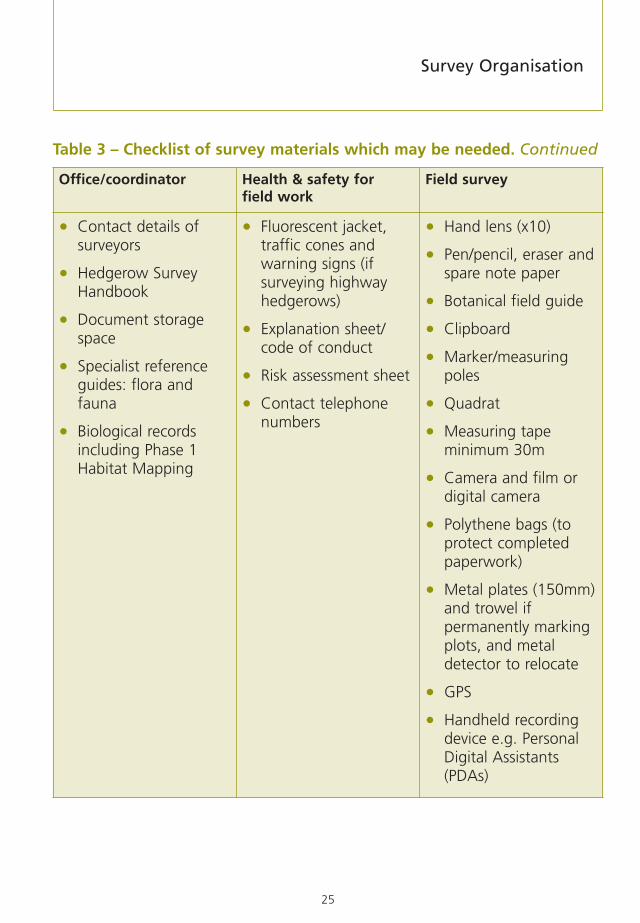
Table 3 – Checklist of survey materials which may be needed.
Office/coordinator Health & safety for field work
Field survey
• Aerial photographs
• Ordnance surveymaps 1:25,000 and1:10,000
• GIS computerpackage
• Database andspreadsheet packages
• Risk assessment formsand information
• First aid kit includingtweezers (for thorns)
• Sturdy, waterprooffootwear
• Appropriate clothing
• Mobile phone
• Drinking water
• Sun screen
• Insect repellent
• Rucksack
• Maps (locational &survey)
• Survey forms
• Personal identification
• Letter of introduction
• Compass, preferablywith scale rule
• Binoculars
Chapter 2
25
Table 3 – Checklist of survey materials which may be needed. Continued
Office/coordinator Health & safety for field work
Field survey
• Contact details ofsurveyors
• Hedgerow SurveyHandbook
• Document storagespace
• Specialist referenceguides: flora andfauna
• Biological recordsincluding Phase 1Habitat Mapping
• Fluorescent jacket,traffic cones andwarning signs (ifsurveying highwayhedgerows)
• Explanation sheet/code of conduct
• Risk assessment sheet
• Contact telephonenumbers
• Hand lens (x10)
• Pen/pencil, eraser andspare note paper
• Botanical field guide
• Clipboard
• Marker/measuringpoles
• Quadrat
• Measuring tapeminimum 30m
• Camera and film ordigital camera
• Polythene bags (toprotect completedpaperwork)
• Metal plates (150mm)and trowel ifpermanently markingplots, and metaldetector to relocate
• GPS
• Handheld recordingdevice e.g. PersonalDigital Assistants(PDAs)
Survey Organisation

26
A ‘universal’ marking/measuring kit can be assembled easily and cheaply usingplumbers’ push-fit overflow piping. This is normally available in grey or white.White is preferred for visibility reasons. The 21.5mm diameter piping can be cutto length easily and joined using push-fit in-line connectors and corners. Forcompactness, the pipe lengths could be 50cm, or 1m if compactness was notan issue. From a basic kit of pipe lengths and connectors, a range ofmeasurements can be made and a ground flora quadrat constructed. The‘universal’ kit is useful for:
1. Estimating the height and width of the hedgerow by placing severalconnected lengths next to the hedgerow, or pushing them through tomeasure width.
2. Estimating the height of the hedgerow canopy.
3. Measuring the diameter of an isolated hedgerow tree where lack of accessto both sides precludes the use of a tape.
4. Laying against the hedgerow to mark out the start and end of the 30msurvey section.
5. Forming a rigid 2 x 1m quadrat for ground flora recording.
A total of 6m of pipe will be needed, either 12x50cm lengths (plus eight in-lineconnectors) or 6 x 1m lengths (plus two in-line connectors), plus 4 corners. Thepipes will need to be marked with critical measurements.
1. For height and width measurements the accuracy required is to thenearest 25cm. These can be indicated using bands of black or red tape.Length combinations using straight connectors can be used to recordmeasurements from 50cm to 6m if required.
2. The height of the base of the hedgerow canopy can be estimated in asimilar way.
Chapter 2

27
3. Tree diameters can be measured by forming an ‘L’ shape with one of thelengths marked off in 1cm increments using an indelible marker pen3.When this ‘right-angle’ is placed against the tree at breast height (1.3m)the point at which the pipe touches the circumference of the tree is theradius. Multiplying by 2 gives the diameter4.
4. Sections can be joined to an appropriate length to lay against thehedgerow as a means of marking the start and end of the 30m sections(these may need to be re-used if quadrats are to be sampled).
5. A rigid quadrat can be formed using two 2m sections (each 2m sectioncan be made up from two 1m lengths or four 0.5m lengths), two 1msections and four corner joints. This will allow quadrats to be pushedunder the hedgerow canopy relatively safely and easily. The bands of tapeor connector positions can be useful guides in assessing percentage coverfor abundant species e.g. nettles or cleavers (each 50cm x 50cm = 12.5%of the total area). For low frequency species a good guide is a standard A4clipboard. This is approximately 3% of the area of the 2 x 1m quadrat.
Training
Training is essential to cover health and safety, and to ensure accuracy andconsistency in approach between surveyors. It may be possible to completetraining in one day, depending on the amount of detail required and theexperience of the surveyors. Training should cover such items as the definitionof terms, map reading and surveying. Special attention should be given to fieldidentification of frequently occurring and indicator vascular plants. All surveyorsshould be familiar with this Handbook, in particular Chapters 4 and 5 and theGlossary of Terms at Appendix 1.
Pre-survey Preparations
3 Because the connectors are a push-fit, joining two pieces of 50cm pipe may produce a total length of 102cm. Cuttingto shorter lengths, say 49cm or 48.5cm, may be necessary to achieve the correct ‘assembled’ lengths.
4 Note that, if the tree is covered in ivy the ‘tree’ diameter measurement will need to be adjusted to take account ofthis.

28
Quality control
Quality control is important to ensure that the data collected are reliable andthere is sufficient confidence in the survey’s results and conclusions.
At the end of each day in the field, or before moving to a new location,surveyors should allocate time to checking survey forms for completeness andlegibility. The Survey Summary Form (Appendix 7) should record any difficultiesthat have arisen while undertaking the survey.
Field supervision of surveyors, by an experienced surveyor, is advisable to ensureconsistency between survey teams. In addition, quality control needs to beundertaken in the office and in the field to ensure data are being collected andprocessed to the required standard, and to measure observer error. A 10%randomly selected spot check is generally considered adequate as a repeatprocedure. Where errors are discovered, further investigation may be required.
A Microsoft Access database has been designed to accept survey data (seeChapter 6). This has protected fields to reduce the likelihood of errors in dataentry. A randomly selected quality check should be made of 10% of surveyforms against the database. Spot checks should also be made of any datatransferred from field maps onto ‘neat’ copies (although this practice should bediscouraged, except where absolutely necessary) or GIS.
Chapter 2

29
Pre-survey PreparationsCollation of background data
Depending on the survey objectives, background data will be required to assistwith the design of a sampling strategy and, possibly, to supplement field surveyrecords (Table 4). In most cases, this will only involve obtaining the necessaryOrdnance Survey (OS) maps. A copyright licence is needed to copy OS mapping– details can be found on the OS website (http://www.ordnancesurvey.co.uk). Inaddition, other background information, such as aerial photographs, biologicalrecords and historical records will usually be useful and, for some surveys, willbe vital.
A good source of information on environmental designations and schemes isthe MAGIC (Multi-Agency Geographic Information for the Countryside)website: http://www.magic.gov.uk. This site provides free access to interactivemaps which show the location and boundaries of Areas of Outstanding NaturalBeauty, Sites of Special Scientific Interest, Special Protection Areas, ScheduledMonuments, and several other designated areas. Landscape Character/NaturalAreas in England, Heritage Zones in Scotland and Landscape Character Areas inNorthern Ireland provide a general framework for sampling.
Mapping
Various scales of mapping arehelpful. The OS Landranger(scale 1:50,000) and Explorer(1:25,000) series are requiredto plan survey work. The1:25,000 OS maps are themost useful when selectingsample grid squares,particularly for surveys coveringmore than a single parish. They are in colour and show field boundaries,contours, watercourses, CRoW5 access land and public rights of way.
5 Countryside & Rights of Way Act (2000) (see http://www.opsi.gov.uk/Acts/acts2000/20000037.htm).
Chapter 3
Box 5: The application of GISRotherham District Council has developed GISwith information on Heritage Sites, includingthe location of species-rich hedgerows.Barnsley Metropolitan Borough Council hasincluded examples of species-rich and ancienthedgerows in their Habitat Action Planinventory.

30
For the field survey, 1:10,000 OS maps are required to plot and reference thehedgerows. The Landplan series at 1:10,000 scale is produced in colour or blackand white, showing land features only. It is available through OS Superplanagents, who can also supply digital versions for use with GIS. GIS are a form ofautomated mapping, enabling the production of geographical and thematicmaps. Whilst not essential, GIS have advantages in sample selection,presentation of findings and future record collation (Box 5). The local authority,Local Biological Records Centre or Wildlife Trust may be prepared to let theirsystem be used.
Table 4 – Typical sources of supporting background information.
Data Possible sources Comments
Site designations MAGIC website www.magic.gov.uk
Biological records County Wildlife TrustBiological Records CentreGovernment WildlifeAgencyLocal AuthorityInternetNational BiodiversityNetwork
May know of previoushedgerow surveysMay locate protectedspecies associated withhedgerows
Phase I Habitatmapping
County Wildlife TrustGovernment WildlifeAgency
Check date of survey andwhether it records fieldboundaries
Aerial photographs Local AuthorityGovernment WildlifeAgencyInternet
Check date and scale ofphotography
Survey maps Ordnance SurveyLocal Authority
Local bookshop for1:25,000; OS SuperplanAgents for 1:10,000
Chapter 3

31
Table 4 – Typical sources of supporting background information.Continued
Data Possible sources Comments
GIS Local AuthorityCounty/regional/localWildlife Trust
May be prepared to letyou use their system
Historical records County Records OfficeHistoric EnvironmentRecordHistoric LandscapeCharacter Map
The English HistoricLandscape Charactermaps are produced on acounty basis
Early editions ofOrdnance Surveymaps
Ordnance SurveyBritish Museum MapLibraryCounty Records
Available on-line at:http://www.promap.co.ukor http://old-maps.co.uk
Other related surveys Local BAP GroupLocal AuthorityLocal Wildlife TrustLocal history groupArchaeological groupCPREHistoric EnvironmentRecordCharacter Area profiledescriptions (England)Butterfly ConservationMammal SocietyOther specialist groups
Surveys for certain speciesmay be related tohedgerows
Pre-survey Preparations

32
Aerial photographs
Before starting the field survey, aerial photographs (1:10,000 scale, approx) canbe used to plot the extent of the hedgerow network.
The use of recent aerial photography avoids wasting valuable survey timevisiting areas without hedgerows. However, care is needed to distinguishbetween very low hedgerows and ditches. These can be difficult todifferentiate, depending on the quality and timing of the aerial photography, ascan walls and low, compact hedgerows. Aerial photography is, at the very least,a valuable tool for identifying boundaries worth further inspection.
Before the field survey is undertaken aerial photographs can be used to plot the extent of the hedgerownetwork
Aerial photographs may be held by the local planning authority, possibly as partof their GIS. Colour sets are also available for consultation covering Scotlandfrom Area Offices of Scottish Natural Heritage, and Wales from the CountrysideCouncil for Wales. Other sources may be found from the Internet, such aswww.local.live.com.
Chapter 3

33
Biological records
Local Biological Records Centres may hold records on protected species as wellas habitats. Habitat mapping may also be available, identifying intact, derelictand species-rich hedgerows, hedgerows with trees, and the habitats either sideof hedgerows. However, as with aerial photography, much depends on the dateof the survey, as conditions may have changed.
Historical records
If the survey’s objectives require the collection of data on hedgerow history andthe identification of ancient hedgerows and hedgerow networks, importantbackground data can be collated from archival information such as estate maps,tithe maps and awards, enclosure maps, charters and manorial records andearly editions of the OS. Much of this information should be available fromthe local County Records Office.
Additionally, Historic Landscape Character maps are produced on a county basisin England, through a programme by English Heritage. For local areas theseshould assist in relating the field layout to particular periods, for example pre-Medieval, thereby providing a context for individual hedgerows. In Wales,Cadw, has produced a Register of Landscapes of Outstanding Historical Interestincluding those where hedgerows feature. In Scotland, reference should bemade to the Historic Landuse Assessment developed by Historic Scotland andThe Royal Commission on the Ancient and Historical Monuments of Scotland(RCAHMS).
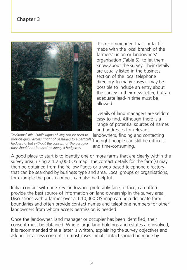
Gaining site access
Public rights of way can be used to provide quick access to a particularhedgerow, but without the consent of the occupier they should not be used tosurvey a hedgerow. Permission to undertake surveys must be obtained in allcircumstances. Experience shows that it is best to seek permission in advance offield work starting as it can take time to find out who owns or managesparticular pieces of land.
Pre-survey Preparations
34
It is recommended that contact ismade with the local branch of thefarmers’ union or landowners’organisation (Table 5), to let themknow about the survey. Their detailsare usually listed in the businesssection of the local telephonedirectory. In many cases it may bepossible to include an entry aboutthe survey in their newsletter, but anadequate lead-in time must beallowed.
Details of land managers are seldomeasy to find. Although there is arange of potential sources of namesand addresses for relevant
landowners, finding and contactingthe right people can still be difficultand time-consuming.
A good place to start is to identify one or more farms that are clearly within thesurvey area, using a 1:25,000 OS map. The contact details for the farm(s) maythen be obtained from the Yellow Pages or a web-based telephone directorythat can be searched by business type and area. Local groups or organisations,for example the parish council, can also be helpful.
Initial contact with one key landowner, preferably face-to-face, can oftenprovide the best source of information on land ownership in the survey area.Discussions with a farmer over a 1:10,000 OS map can help delineate farmboundaries and often provide contact names and telephone numbers for otherlandowners from whom access permission is needed.
Once the landowner, land manager or occupier has been identified, theirconsent must be obtained. Where large land holdings and estates are involved,it is recommended that a letter is written, explaining the survey objectives andasking for access consent. In most cases initial contact should be made by
Chapter 3
Traditional stile. Public rights of way can be used toprovide quick access (‘right of passage’) to a particularhedgerow, but without the consent of the occupierthey should not be used to survey a hedgerow.

35
telephone, although in some circumstances it may be easier to gain consentimmediately prior to the start of the field survey by visiting the farmhouse. Onceidentified, it is helpful to record (with agreement) their name, address andtelephone number on the Survey Summary Form (Appendix 7) for future reference.
To help gain permission to undertake a survey, it is often very useful to engagethe landowner/land manager in the project. Many are interested in the historyor wildlife of their farm and this can be used as a means of introducing thesurvey to them. It may also help to offer feedback on the results of the surveyon their land. In addition, the survey may provide them with information theycould use in their application for an agri-environment scheme, such asEnvironmental Stewardship.
Table 5 – Farming organisations.
Organisation Website National tel. no.
Country Land and BusinessAssociation (CLA)
www.cla.org.uk 020 7235 0511
National Farmers’ Union (NFU) www.nfu.org.uk 024 7685 8500
NFU Scotland www.nfus.org.uk 0131 4724000
NFU Cymru – Wales www.nfu-cymru.org.uk 01982 554200
Farmers’ Union of Wales www.fuw.org.uk 01970 820820
Ulster Farmers’ Union www.ufuni.org 028 90 370222
Pre-survey Preparations

36
The varied pattern of hedgerows in the Black Mountains, South Wales. Note the absence of hedgerows onthe higher ground.
A letter of authority should be carried by field surveyors at all times. In addition,a brief note describing the survey objectives should be offered to thelandowner/land manager. In some cases, the land manager may want toaccompany the surveyors and, wherever possible, this should be granted.
If ownership of the selected hedgerows cannot be determined or consent isrefused, a standard procedure for selecting additional sample areas/hedgerowsshould be employed, for example taking the next nearest hedgerow to thesample selection point (see Chapter 4, including Figure 2).
Chapter 3

37
Developing a sampling strategy
The resources available, together with the objectives of any particular survey,will affect the decision on how many hedgerows should be surveyed. There aretwo basic strategies: a census and a sample.
A census survey includes all hedgerows within the survey area. Usually,limitations of finances and time mean that this approach can be used on onlyrelatively small areas, for example a parish/township or an estate.
Box 6: Monitoring changeA study of hedgebanks in DorsetThe Geographical Handbook of the Dorset Flora was the result of an extensivebotanical survey carried out by Professor Ronald Good, between the years 1931and 1939, and represents the largest dataset collated for a single habitat type. Ingreat detail, it records the condition of the county’s hedgebanks during the 1930s,a time when the methods of hedgerow management and the agriculturallandscape within which they stood were considerably different from today.
In 1999 the Dorset Environmental Records Centre secured a grant from theHeritage Lottery Fund for the computerisation of Good’s records. This, togetherwith a re-survey of the sites examined by Professor Good, has enabled anassessment of changes in Dorset’s hedgebanks to be made. The bank flora wasfound to be less diverse, with a loss of rare species; the diversity of woody specieshad increased but there was a deterioration in hedgerow structure. These findingshelp to identify methods of favourable hedgerow management.
Source: Button, N (2003) Dorset’s changing hedgebanks – a resurvey of ProfessorGood’s hedgebanks in Dorset. Contract report for Defra.
Pre-survey Preparations

38
Where a census is not possible, a sample of hedgerows will need to be selectedfor survey. The number of hedgerows that can be included in the sample willdepend on the scale of the survey, available resources and the questions thatthe survey seeks to answer. In general, the greater the variability of hedgerowsin the area, the larger the number of sample points that are required toproduce sound results. There are various ways of selecting the hedgerows to besurveyed, but the method to be used should be objective, and agreed inadvance. This is to ensure, as far as possible, that the sample provides a fairrepresentation of the hedgerows in the area, and reduces any personal bias inselecting the hedgerows to be surveyed.
Kilometre grid squares are used widely as a sampling unit. Obtaining anobjective sample within the grid square can be done in a variety of ways. Theapproach recommended here is to select nine hedgerows within a 1km square.This is covered in more detail in Chapter 5 and figure 2.
If there is a high density of hedgerows, and resources allow, a finer grid using16, 25 or 36 cells can be applied. A quarter of a kilometre square may be moreappropriate in parts of the country with a dense hedgerow network, forexample North Wales or South West England.
For large scale surveys at a district or county level, it may be appropriate torandomly select a number of 1km squares and survey one hedgerow that isclosest to the centre. If this route is chosen, it may be important to ensure thatthere is sufficient representation of all landscape types. A purely randomselection of squares may not achieve this, so it may be necessary to specify acertain number of squares for each landscape category. Landscape charactermaps can assist with this and are available from Natural England, ScottishNatural Heritage and Countryside Council for Wales. Within each category it isstill important to have a proportional random selection of survey squares.
If there is uncertainty over the most appropriate sampling strategy, it is essentialto consult someone with experience in sampling and statistics at the outset.
Guidance is provided on how to select individual hedgerows in each sampleunit in Chapter 4 and illustrated at Figure 2.
Chapter 3

39
Trialling the survey method
Part A of the Field Survey Formpresents the minimum informationthat should be collected (seeAppendix 6). Where possible,a pilot survey should beundertaken, and should coveraspects such as the samplingstrategy and procedure. The pilotcan help determine whether thesample size is adequate.
Even if all the hedgerows in anarea are being surveyed, a pilotsurvey is still recommended. Itshould check the localappropriateness of species listsand the need for any additionalcategories relating to ‘other’features. For example, in thelimited space available on the FieldSurvey Form it is better to includespecies and features that are likelyto occur frequently (to save timewriting them out in full). The pilot can also provide a basis for subsequenttraining sessions and assist in calculating the resources required for thefull survey.
Data collection
The survey forms are designed to allow easy data entry in the field andsubsequently into the database that accompanies this Handbook.
For most small-scale, local hedgerow surveys, pen and paper will be the simplestand most efficient system for recording. However, for extensive surveys, and toreduce subsequent data entry, field survey forms can be adapted for applicationon a hand-held computer or data logger. A number of different types are
Pre-survey Preparations
Box 7: Sample selection inCumbriaThe main objective of the CumbriaHedgerow Survey was to provide baselineinformation on the hedgerows in thecounty. To survey all hedgerows wouldhave been impractical, so a sample wasselected. Few hedgerows occur above analtitude of 300m, and it was found thatthese areas could be excluded by rejectingthe areas mapped as the four upland landclasses in the Cumbria Land Classification.To cover some 10% of the non-uplandarea, a sample of 1km squares wasselected from a 3 x 3 km grid. The squareswere selected at random from the grid,whilst ensuring adequate representation ofthe remaining Cumbria Land Classes, andthe Countryside Character areas that occurin Cumbria.
Source: Colin Barr (pers. comm.)Cumbria Hedgerow Survey (2003).

40
available on the market. Decisions asto which type to use might be basedon durability for outdoor application,length of battery life, data securityand portability versus size of keyboardand screen. Some machines arecapable of displaying mapping andcan be used in conjunction withGlobal Positioning Systems (GPS)and GIS. Such equipment shouldbe tested before embarking on thefull survey, and surveyors will needto be trained in their use.
Measurement of accuracy
The survey method requires a number of different measurements to be madeon the hedgerows such as height and length. The level of precision isstandardised for each type of measurement and surveyors should aim to be atleast as precise as the recommended standards. Where desired, a greater levelof precision can be adopted but this usually requires more time in the field.These measurements are used to determine whether hedgerows fall within theagreed limits and thresholds for condition assessment. Specific requirements canbe found in Chapter 5.
Chapter 3
A recently laid hedgerow with male fern and greaterstitchwort

41
Field Survey – what to recordand whyIntroduction
This chapter, and those that follow, detail the procedure for carrying out localhedgerow surveys. Chapter 4 describes how to locate the survey hedgerowsand survey them. It also explains how to determine whether or not hedgerowsare in ‘favourable condition’. Chapter 5 provides a summary guide tocompletion of the field survey forms and the intention is that it will be ‘essentialreading’ for field surveyors. The final chapter (Chapter 6) deals with thesubsequent data management and reporting.
Reporting forms for the field survey elements are at Appendix 6 and a surveysummary report form is at Appendix 7.
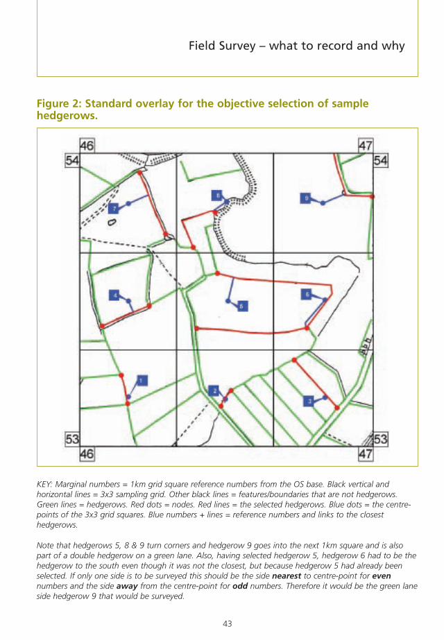
Locating hedgerows in sample surveys
The development of a sampling strategy is described in Chapter 3. Therecommended approach is to select nine hedgerows within a 1km square, butthe selection method described below can be adopted for other samplingdensities. To select nine hedgerows, an acetate overlay of a 1km square with agrid of 9 cells (each 333m x 333m) should be prepared and the centre point ineach cell marked. These centre points form the starting points for hedgerowselection. From these selection points the nearest hedgerow, in any directionshould be located (see Figure 2). This requires using maps on which all probablehedgerows have been marked, either from interpretation of aerial photographsor visual ground reconnaissance. If the survey is based on 1km squares, theremay be occasions where the selected hedgerow crosses into an adjoiningsquare. The recommendation is that the hedgerow should be surveyed if it fallsmainly inside the target square (>50% of its length).
Chapter 4
42
The sample hedgerows within the square should be numbered with theirselection point number. These should be arranged from the south-west cornerto the north-east corner in keeping with OS grid referencing (eastings beforenorthings). If, for various reasons, certain hedgerows cannot subsequently besurveyed, the simplest approach is to ignore those numbers rather thanre-number and cause possible confusion to surveyors on the ground. If this islikely to reduce the sample size then the approach would be to select the next-nearest candidate hedgerow to the selection point and give that hedgerow theappropriate number. An example would be where a hedgerow identified as 7turned out to be too gappy to fall within the definition of a hedgerow, but thenext-nearest hedgerow was more intact and could be surveyed. This hedgerowwould then be surveyed as number 7 and the planning maps amendedaccordingly.
The unique reference number is very important and should be recorded on thesurvey map, along with cross-references to the hedgerow survey sides (A + B).The reference number will be used in the database and will enable individualhedgerows to be identified and the same side re-surveyed in the future.
All potential hedgerows that could besurveyed should be plotted on thebase map as part of the surveypreparation, but some adjustment inthe field may be needed where thereare breaks in the hedgerow of over20m, and ‘missing’ hedgerows (asmay have been misinterpreted fromaerial photographs etc.). These maycreate additional hedgerows and/orsurvey units. If these are to be addedto the survey they will need to benumbered to maintain a uniquereference. The recommendation is toadd a suffix to the hedgerow number.For example, if hedgerow 7 turned outto be two hedgerows, these would be numbered 7a and 7b6 on the maps andrecording forms. GPS can provide a check that the right hedgerow has beenreached, but this is not essential if the surveyors are good map readers.
Chapter 4
6 Using lower-case letters will avoid confusion with the upper-case letters used to identify the sides of each hedgerow.
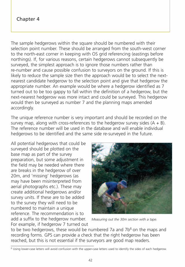
Measuring out the 30m section with a tape.
43
Figure 2: Standard overlay for the objective selection of samplehedgerows.
KEY: Marginal numbers = 1km grid square reference numbers from the OS base. Black vertical andhorizontal lines = 3x3 sampling grid. Other black lines = features/boundaries that are not hedgerows.Green lines = hedgerows. Red dots = nodes. Red lines = the selected hedgerows. Blue dots = the centre-points of the 3x3 grid squares. Blue numbers + lines = reference numbers and links to the closesthedgerows.
Note that hedgerows 5, 8 & 9 turn corners and hedgerow 9 goes into the next 1km square and is alsopart of a double hedgerow on a green lane. Also, having selected hedgerow 5, hedgerow 6 had to be thehedgerow to the south even though it was not the closest, but because hedgerow 5 had already beenselected. If only one side is to be surveyed this should be the side nearest to centre-point for evennumbers and the side away from the centre-point for odd numbers. Therefore it would be the green laneside hedgerow 9 that would be surveyed.
Field Survey – what to record and why

44
Selecting the 30m survey section
The 30m section chosen for recording woody species and other features alsoneeds to be selected objectively. A systematic way suggested in this Handbookis to measure 30m from one of the hedgerow end points and take the next30m length as the survey section (Figure 2). The end point from which to startshould ideally also be selected objectively, although this is not always essential.The recommendation is to work from the selection point used to identify whichhedgerow to survey and to choose the closest end point for even numberedpoints and the furthest end point for odd numbered points. If the samplehedgerow is less than 60m in length then the survey section will include the‘far’ end of the hedgerow and the length at the beginning will have to bereduced to accommodate the 30m survey section. For the woody species (seesection 17 in the Field Survey Form) the 30m section should have as few gapsas possible, otherwise a different section may have to be selected. However, forsections 6-17 of the Field Survey Form, the 30m survey section must berepresentative and selected objectively.
Figure 3 – Standard field procedure for locating 30m survey section.
The easiest way to locate the 30m survey section is to measure with a tape 30mfrom the start of the hedgerow and then place markers at 30m and 60m todefine either end of the survey section. A quick alternative method suitable foruse by a surveyor working alone is to use a 2m length of pipe and lay it outfifteen times consecutively.
Positioningthe 30msurveysection
SIDE A
NODE
NODE
SIDE B
30m survey section30m
Chapter 4

45
For repeat surveys of 30m sections, permanent buried metal marker plates e.g.150mm x 150mm galvanised ‘mending plates’, available from builders’merchants, may be installed at each end. It is important to ensure that theplates are not located where they may be disturbed by cultivation. Guidancenotes should be made and ground-based photographs taken to help futuresurveyors locate these plates (e.g. ‘plate located 1m from hedgerow centreline’or ‘on ditch-bank top, field-side’, etc). It is important to obtain landmanager/landowner consent for this operation. Usually, it will not be necessaryto permanently mark 30m sections to meet a survey’s objectives. Marking isnormally only required where it is important to monitor change to individualhedges over time, as opposed to population of hedges.
Selecting the survey side and quadrat locations
Once the survey section has been located, the survey side should be selected. If both sides of the hedgerow are available for survey it is recommended thatboth are done. However, depending on survey objectives and resourceavailability, it is acceptable to survey one side only. This may be more practical in surveys covering large numbers of hedgerows where it is the state of thepopulation that is important rather than that of individual hedgerows. If onlyone side is to be surveyed the primary survey side (Side A) will need to beselected (the aspect of the ‘A’ side (north, south etc) needs to be recorded atthe top of the field recording form). This needs to be done objectively. Therecommendation is to make side ‘A’ the side closest to the selection point foreven numbered points and the far side of the hedgerow for odd numberedpoints (this will ensure that some ‘internal’ sides of double hedgerows alonggreen lanes or roads will be surveyed). The ‘A’ side should be where anyquadrats are placed for recording the ground flora in the optional part of thesurvey method (see Figure 18).
If the quadrat locations are to be permanently marked (and this will seldom benecessary), it is important to ensure that the plates are not located where theymay be disturbed by cultivation. Assuming there will be no disturbance, therecommendation is to install two marker plates7 on the two corners furthestfrom the hedgerow centre. This will make access for relocation easier and willpotentially avoid too many tree and shrub roots. Again, consent from the landmanager/landowner must be obtained for this operation.
Field Survey – what to record and why
7 This will locate the hedgerow to within 100m if six figures are used and 10m for eight figures.
46
Completing the Field Survey Form – Essential andoptional assessments of the survey method
The Field Survey Form (see Appendix 6) is divided into two parts:
Part A includes all of the essential assessments that should be completed infull for every surveyed hedgerow to enable BAP condition assessments to bemade. The key uses of the results for the essential parts of the method aredescribed in boxes after the relevant sub-sections.
Parts B covers various optional assessments that collect supplementary dataon the ground flora, and more detail about associated features like banks,verges and veteran trees. Optional assessments will vary according to each localsurvey’s objectives.
Most sections of the form can be completed by simply entering numbers, orcircling or ticking the appropriate answer. Definitions of terms used on the formare included in the Glossary (Appendix 1).
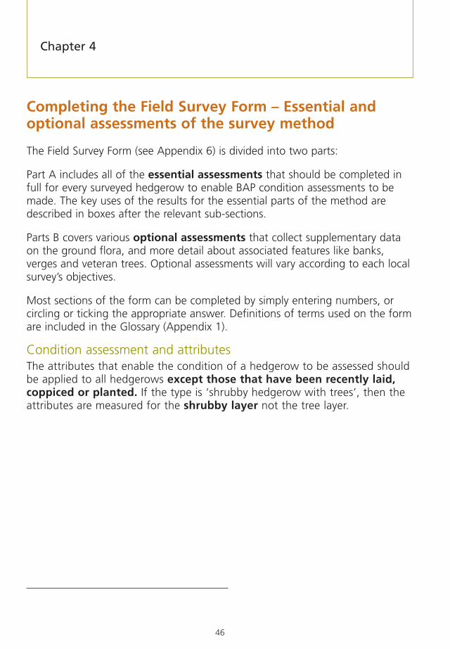
Condition assessment and attributesThe attributes that enable the condition of a hedgerow to be assessed shouldbe applied to all hedgerows except those that have been recently laid,coppiced or planted. If the type is ‘shrubby hedgerow with trees’, then theattributes are measured for the shrubby layer not the tree layer.
Chapter 4

47
Part A – Essential Assessments
Elements that should be recorded for the whole hedgerow (Sections 1-6)
Referencing the hedgerowOnce the hedgerow has been located and any survey section(s) marked out, thefollowing should be recorded:
• The title of the survey using a short, punchy name as surveyors willhave to write this a number of times, or even adopt a standardabbreviation.
• The six, or eight8 figure grid reference of the mid-point of the wholehedgerow, survey unit or survey section. Depending on the scale ofmapping used, acetate grids can be bought, or made, to overlay ontomaps to provide precise identification of hedgerows. Alternatively, ifGPS are available, the full two-letter and 10-figure grid reference canbe recorded or downloaded onto a computer for subsequentincorporation into a GIS package.
• The date(s) of the survey. Ideally all survey elements should be doneon the same day.
• The hedgerow reference number. This will normally be thesequential number as described earlier, with possibly a suffix if a plottedhedgerow turns out to be more than one hedgerow or comprises morethan one hedgerow type (survey unit), for example 7a and 7b.
• The name(s) or initials of the surveyor(s). If initials are used, ensurethat they are unique.
• The side or sides surveyed (N, E, S, W or both sides). Theorientation of sides A & B should be indicated by circling theappropriate compass point letters. If the hedgerow runs due NE-SW thetwo sides could be recorded as either N+S or W+E. Surveyors shouldnot be concerned about this as either indication is unambiguous whenlooking at the map. Ambiguity may arise where the hedgerow changesdirection significantly along its length. It may start running
Field Survey – what to record and why
8 Using lower-case letters will avoid confusion with the upper-case letters used to identify the sides of each hedgerow.

48
approximately W-E and then change to approximately N-S as shown inthe example Hedgerow 8 at Figure 2. In this example, the end closestto the selection point (as it is an even number) is where themeasurement would begin for locating the second 30m length as thesurvey section. It is here that the determination of the survey sideshould be made. If this hedgerow is surveyed along thesouthern/eastern sides, then the survey side recorded onto the formwould be ‘S’. If this principle is adopted, even if the whole hedgerowwas surveyed there would be no ambiguity about which side wassurveyed if both were not done. In extreme cases, the side surveyed mayhave to change along the length because of an obstruction. Detailsshould be entered into the section on ‘difficulties’ (section 2d) abouthow much was done from which side and where the change occurred(also marking on the map).
1 – Name of landowner/contact detailsEnsure that the landowner is willing to have this information held on thedatabase relating to the survey and, if the data are to be made publiclyavailable, that permission has been granted (Section 1a and 1b).
2 – Survey times and weather/other conditionsInformation on survey times is needed to assist with future time planning andto record time inputs for the Survey Summary Form.
The general weather conditions may affect the accuracy of the results. Surveysshould not be done in bad weather unless there are time constraints or othercompelling reasons, for example the surveyor had driven a long way, or theweather deteriorated during the survey.
Any difficulties that may be encountered, including stock loose in the field,difficulty walking along the headland because of cleavers or oilseed rape,should also be recorded as this may be useful for any resurvey or for anyspecialist team doing additional work like ground flora quadrats.
Chapter 4

49
3 – Hedgerow typeIdentifying the different types of hedgerow is fundamental to the surveyprocess. As described above, a hedgerow may be variable along its length andmay need to be subdivided into a number of survey units based on changes inhedgerow type. A simplified key to determining whether or not a feature isclassed as a hedgerow, and if so, what type, is at Figure 4.
Figure 4 – A key for determining if a feature is a hedgerow and thehedgerow type.
Key to Hedgerow Types
Woody component < 5mwide at base
Woody component> 5m at base
Woody component> 20m long
Woody component< 20m long*
The feature is not joinedat one end
to anotherhedgerow
The feature is joined atone end to another
hedgerow
Tall trees absent or> 20m apart overmost of its length
Tall trees < 20mapart over most
of its length
Shrub layerpresent
NOT AHEDGEROW
SHRUBBY HEDGEROWWITH TREES
LINE OFTREES
NOT AHEDGEROW
SHRUBBYHEDGEROW
Shrub layerabsent
*Note: Any gap over 20m long marks the end of one hedgerow and the beginning of another. All other gaps, including gateways, are part of the hedgerow and should be included in the assessment (except for the woody species count of a 30m survey section that must be done where there is 30m of continuous canopy), even if thehedgerow comprises more gaps than woody plants.
Field Survey – what to record and why

50
Detailed definitions of the three different kinds of hedgerows are describedbelow. There is inevitably some overlap and so judgement is needed to selectthe most appropriate type. A change in type within a 30m section is unlikelygiven the small size of this relative to the scale of the woody plants in thehedgerow, particularly trees, but the predominant type should be assessed ifsuch a rare situation arises (see Hedgerow management shapes).
Shrubby hedgerow: The ‘classic’ shrubby hedgerow is a line of woodyhedgerow plants that have some or all of their leafy canopies less than 2m inheight from the ground, so that the woody linear feature as a whole appears asa ‘shrubby’ hedgerow, even though some of the woody species in it are capableof growing into trees. The shrubby component must be less than 5m wide. Thishedgerow type may have hedgerow trees along its length, but their canopiesshould be more than 20m apart.
Line of trees: This is a line of trees where the base of the canopy is greater than2m from the ground and the gap between tree canopies is less than 20m, sothat the woody linear feature as a whole appears as a ‘line of lollipops’ (seeFigure 5). The width of the feature at its base has to be less than 5m to qualifyas a hedgerow. There may be a distinct shrub layer beneath the line of trees butthis shrub layer must have less than 20m of continuous canopy cover (seeFigure 5).
Figure 5 – A line of trees.
Shrubby hedgerow with trees: This is a shrubby hedgerow of more than20m of woody hedgerow plants where the distance between the ground andthe base of the leafy layer is less than 2m, so that the woody linear feature as awhole appears as a ‘shrubby layer plus lollipops’ (see Figure 6). The shrubbycomponent must be less than 5m wide at its base.
Chapter 4

51
Figure 6 – Shrubby hedgerow with trees.
Very gappy shrubby hedgerows are included to ensure that hedgerows tendingtowards this level of gappiness are considered and can be condition assessed.Both shrubby hedgerows and shrubby hedgerows with trees can range from acomplete continuous canopy cover to being gappy remnants of shrubs. Theillustrations below (Figure 7) can be used to assist in determining whether tosurvey the feature.
The broad definition of a hedgerow used in this Handbook specifies that wherethere is a gap of more than 20m between woody plants the two sections eitherside of the gap are considered as separate hedgerows. However, somehedgerows are very gappy so that most of the feature is actually gaps, but nogap is greater than 20m. These hedgerows should be surveyed and conditionassessed. When the gaps exceed 20m, and no woody section is greater than20m long, then the feature can be described as the remains of a hedgerow,and should not normally be surveyed unless the objectives of the local surveyrequire it.
Figure 7 – Gappy hedgerows.
a) Gaps between woody components less than 20m therefore condition assessment applies even wherethe woody sections are less than 20m in length.
Field Survey – what to record and why

52
b) Gaps between woody components 20m or more and no woody section is 20m or more in length,therefore the feature is no longer a hedgerow and condition assessment not required.
4 – LengthThis measurement should be made regardless of whether the whole hedgerowor just a 30m section within the hedgerow is surveyed. It can either be donewith reference to a map or measured on the ground. Measurement on site islikely to be necessary where there are gaps greater than 20m in length creatingseveral separate hedgerows.
5 – ConnectionsThe survey hedgerow may be connected to other hedgerows and form part of avaluable hedgerow network, used, for example, as a flyway by foraging bats.This section of the form records the total number of other hedgerows that havea direct connection to the hedgerow being surveyed.
It should be noted that, for the purposes of the survey, the hedgerow is onlythat section between the two end points. Continuation beyond those endpoints, as well as any connecting hedgerows, will therefore count as‘connections’. Gaps in the woody component of up to 20m still count as beingpart of the hedgerow.
Key result for connections with other hedgerowsSum of all connections divided by total number of hedgerows surveyed =average number of connections per hedgerow.
Chapter 4

53
6 – Extent of surveySome of the essential assessments can only be applied to whole hedgerowlengths (sections 3-5 of the Field Survey Form at Appendix 6) while others canbe applied to either whole hedgerows or to 30m survey sections. The aims ofthe survey should guide the choice of whether to assess the condition of thewhole length of the hedgerow or 30m sections. For instance, where thecondition assessments contribute to working out the amount of hedgerowrestoration needed on a particular piece of land, then the whole length of eachhedgerow on the land must be assessed. In contrast, for reporting on hedgerowcondition across a county, recording from 30m samples is likely to be the onlyfeasible method.
Elements that may be recorded for either the whole hedgerow or for a30m survey section (Sections 7-16)
7 – Adjacent land useData should be gathered on the adjacent land uses either side of the hedgerow.The way that land adjacent to the hedgerow is managed can have a significanteffect on the hedgerow itself. Intensive farming can result in enrichment ofhedgerow bases and loss of herbaceous species. However, as a result of cross-compliance measures and agri-environment options many farmers are nowleaving wide, uncropped margins alongside hedgerows to protect them. Aroundarable fields, they are mostly sown with perennial grasses, sometimes withadded wildflowers or with pollen/nectar producing species. The presence ofsuch margins is important to note in this section of the form, and their widthshould be recorded in section 9.
A range of land use options is provided on the survey form (arable, grass,woodland, road/route and water). These are then sub-divided. Some specialistknowledge is required to correctly identify improved, semi-improved orunimproved grassland (refer to the Glossary for these and other definitions).Presence of livestock includes obvious signs such as cow pats or sheep dung.
Details of types of road/route can be taken from OS Explorer maps, includingclass of road or public right of way. Major roads include all motorways, dualcarriageways and other ‘A’ roads. Minor roads include ‘B’, ‘C’ and unclassifiedsurfaced roads. Tracks include unsurfaced roads (e.g. on farms) and bridleways.
Field Survey – what to record and why

54
8 – Associated features8a Bank: This section of the survey form asks for an estimate to be made ofthe height of any bank present. Hedge-banks or adjacent ditches also add tothe ecological value of the hedgerow; for instance, banks can have a very richflora, including plants like primroses, bluebells and ferns.
8b Average herbaceous vegetation height: The average height of herbaceousvegetation on banks and margins gives clues about the intensity of any grazing ormowing management, for example indicating the contrast between a tall, lightly-managed, sward of 50cm or more in height and a short grazed turf of only a fewcentimetres. The height of the main mass of herbage should be estimated ormeasured, not the topsof scattered floweringspikes of grasses andtaller herbs whichproject above the mainsward.
8c Fence: The presenceof fences adjacent tohedgerows providesinformation about thelevel of protection from grazing animals.
8d-g Ditch – Any ditch next to, or within, the hedgerow should be recorded.
Key results for associated features Percentage of total number of hedgerows associated with banks, fences or ditches.
Key result for adjacent land usePercentage of total number (sides) of hedgerows or 30m samples immediatelyadjacent to each main land use: arable, grass, woodland, road/route, water, other.
Chapter 4
Figure 8a – External ditch Figure 8b – Internal ditch

55
9 – Undisturbed ground and perennial herbaceous vegetation coverTwo other important criteria for hedgerows in ‘favourable condition’ are thewidth of undisturbed ground and of perennial herbaceous vegetation adjacentto the hedgerow. These attributes pick up management close to the hedgerowthat is likely to damage woody species, for example cultivation harming theirroots. They also highlight the lack of perennial herbaceous habitat, such as dueto ploughing or blanket, non-selective, herbicide use. Herbaceous vegetation isan important part of the hedgerow habitat as many animals rely on it forshelter, foraging and nesting (see Figure 9).
9a Average width of undisturbed ground: The threshold for ‘favourablecondition’ is a width of at least 2m from the centre line of the hedge.Hedgerows adjacent to undisturbed vegetation such as permanent grassland orwoodland (as recorded in 7b or 7c) automatically achieve the threshold forfavourable condition.
9b Average width of perennial herbaceous vegetation: The continuousperennial herbaceous vegetation between the centre-line of the hedgerow andadjacent areas of disturbed ground should be recorded. In most cases this islikely to be less than the width of undisturbed ground, because of the presenceof bare ground beneath most hedgerows (particularly the most densehedgerows), but it may be further reduced by intensive grazing or herbicideapplications. Hedgerows bordering grassland, even improved grassland (asrecorded in 7b), automatically satisfy the ‘favourable condition’ for this attribute.The threshold to achieve ‘favourable condition’ is a width of at least 1m.
Field Survey – what to record and why

56
Figure 9 – Measuring the width of undisturbed ground and perennialherbaceous vegetation.
All hedgerows are in favourable condition.
Key results for undisturbed ground and perennial herbaceousvegetation cover1) Percentage of hedgerows with a width of undisturbed ground greater than 2m.
2) Percentage of hedgerows with a width of perennial herbaceous vegetation ofgreater than 1m.
a)
b)
c)
Chapter 4

57
10 – Nutrient enrichment ground flora indicator speciesA high percentage cover of nettles (Urtica spp.), cleavers (Galium aparine) ordocks (Rumex spp.) in the hedge-bottom is a broad indication that there is likelyto be a species-poor ground flora, probably resulting from nutrient enrichment,for example, from agricultural fertilisers being spread beyond the edge of thecrop into the hedgerow base.
The percentage cover is estimated either along the whole hedgerow length or inthe 30m detailed survey section. No suitable thresholds have been developed forthe enrichment species but cover of 20% or more of these species, singly or together,is likely to show that there has been significant enrichment of the hedgerow baseand therefore this should be used to indicate ‘favourable condition’.
More detailed recording of the ground flora as described in Part B of the FieldSurvey Form can give a better idea of enrichment as species diversity can becalculated and percentage cover of all species compared. Species that areparticularly vulnerable to enrichment can be identified by using references suchas Hill (2004).
11 – Recently introduced, non-native species Relatively recently introduced, non-native species – often originally imported toBritain as garden plants – can be very detrimental to the structure, diversity andecological value of a hedgerow. These recently introduced species or ‘neophytes’are defined in the ‘New Atlas of the British and Irish Flora’ Preston (2002).
Figure 10 – Measuring the percentage cover of recently introducedspecies in the hedgerow woody component.
Favourable conditionas the recentlyintroduced speciescover represents <10%(view facinghedgerow).
Key result for nutrient enrichment of hedgerowsPercentage of hedgerows/30m samples recorded with more than 20% cover ofnettles, cleavers and docks, either singly or together.
Field Survey – what to record and why

58
For non-native woody species, the cover should be estimated as a percentage ofthe total area of the vertical face of the hedgerow on the side being assessed asshown at Figure 10. Where the whole length of hedgerow is being assessed,these need to be recorded along the whole length, as well as in the 30msection used for recording woody species richness (see below). The threshold for‘favourable condition’ in both the shrub layer and ground flora is no more than10% cover of recently introduced non-native species.
12 – Hedgerow shapeThis part of the form asks the surveyor to identify the general shape of classicshrubby hedgerows and shrubby hedgerows with trees (see ‘Hedgerow types’).Lines of trees are not sub-divided into shapes. The shape of the hedgerow cangive a good indication of how it has been managed over the last few years. Theseven main hedgerow shapes illustrated on the form are:
A. Trimmed & dense: Hedgerows that have obviously been trimmed inthe fairly recent past (probably within the previous two to three years).If several months have passed since the last trimming, there may besome quite long shoots protruding from the hedgerow, but it willretain its basic shape. Hedgerows have a generally ‘neat’ appearance,with a rectangular, ‘A’ or ‘topped-A’ shape. This category also includeshedgerows that have most recently been trimmed only on one side, oron the top. Hedgerows are dense along most of their length, withbranches and foliage in the lower parts of the hedgerow.
B. Intensively managed: Hedgerows that have been closely andfrequently flailed and/or browsed by high densities of livestock,especially sheep. These hedgerows are usually low and narrow, andcharacteristically lack branches and foliage in the lower parts of thehedgerow.
C. Untrimmed: Hedgerows that have not been recently trimmed(probably not within the previous two to three years) and now have avery ‘straggly’ appearance, with numerous long and woody branches
Key results for condition assessmentPercentage of whole hedgerows/30m samples with no more than 10% cover ofrecently introduced, non-native species.
Chapter 4

59
protruding from the main body of the hedgerow. They are usually stillquite dense, with some foliage in the lower part of the hedgerow,although the increasing volume may be progressively shading outsome of the lower branches. Essentially this is an unmanaged andslightly overgrown version of A. Such hedgerows may subsequently betrimmed (A) coppiced (F) or laid (G) but, if not, they will progressivelytake the shape of type D or E hedgerows.
D. Tall & leggy: A hedgerow that has not been trimmed for many years(probably at least eight years). The hedgerow lacks any significantfoliage in the lower parts. Neglected hawthorn hedgerows often takethis form, forming lines of twisted and gnarled stems, beneath moredense canopies.
E. Untrimmed, with outgrowths: Overgrown, usually very wide,hedgerows that no longer retain any clear evidence of their originalshape. Hedgerows with a large proportion of blackthorn, or otherreadily suckering shrub species, may quickly develop into this type ofhedgerow if left unmanaged.
F. Recently coppiced: A hedgerow that has recently been coppiced,probably within the last five years, appears as woody trunks (or‘stools’) cut down to be more or less level with the ground, and fromwhich multiple, thin, woody stems are re-growing.
G. Recently laid: A hedgerow that has obviously been recently laid,probably within the last 2-3 years (the illustration shows what this typewould look like facing the hedgerow). It should still retain clear evidenceof laying (e.g. stems cut at the base; horizontal and intertwined stems,supporting stakes in the hedgerow) and will not have attained the‘trimmed and dense’ appearance of type A hedgerows.
The hedgerow should be placed in the most appropriate category (even if itdoes not quite resemble the hedgerow illustrated in section 12 of the FieldSurvey Form).
Key result for hedgerow management shapePercentage of total number of hedgerows surveyed in each shape category.
Field Survey – what to record and why

60
13 – DimensionsThe average height and width of the hedgerow need to be estimated and thecross-sectional area calculated. All measurements of height and width shouldbe ‘at the time of the survey’ and take no account of any previous trimmingheights or widths that might be evident. A 2m tall measure (clearly marked at25cm intervals) allows precise height and width measurements to be made(see ‘Equipment’).
The conservation problems these dimension attributes illustrate are: too severeor frequent cutting; loss of shelter for fauna; and, in particular, unsuitablenesting habitat for most birds. With this in mind, the Steering Group for the UKBAP for Hedgerows has adopted a minimum cross-sectional area of 3m2 as thethreshold for hedgerows in ‘favourable condition’. In addition to having a cross-sectional area of 3m2, the hedgerow should be at least 1m high and at least1.5m wide to be in favourable condition. When calculating the cross-sectionalarea it can be assumed that the hedgerow is rectangular (box-shaped) in profile.
13a Average hedgerow height: The average height of the woody growthshould be estimated, excluding any bank beneath the hedgerow, gaps and anyhedgerow trees (Figure 11a). Where a hedgerow is part way up a bank, theheight is measured from the base of the main woody stems of the hedgerowplants on the bank (Figure 11b). Where the bank is asymmetric so that theheight of the hedgerow is less on one side, the height is measured on theshorter side (see Figure 11c). If there is a clear shrub layer beneath a canopy ofhedgerow trees (shrubby hedgerow with trees), the average height of this shrublayer should be recorded. The average height of a line of trees is recorded asthe height of the top of the canopy. The higher a hedgerow is, the harder it isto make a precise measure of height. Surveyors should make their best estimatefor high hedgerows; often this will in reality be to the nearest 1 or 2m.Standing a surveyor of known height up against the hedgerow (or alternativelyusing a 2m measure), and standing back to see them against the full height ofthe hedgerow can help in making these height estimates.
Chapter 4

61
Figure 11 – Measuring the average height of the woody component.
13b Average hedgerow width: The average width of the woody growthshould be estimated at the widest point of the hedgerow canopy (see Figure12), again excluding gaps or isolated hedgerow trees. If the hedgerow widthappears to be fairly uniform along its length, this can be done most easily at agateway or gap. Alternatively (particularly for relatively thin hedgerows), thehedgerow could be measured by two surveyors on opposite sides pushing ameasuring pole through the hedgerow (see ‘Equipment’). Generally, banksshould be excluded from width measurements. However, where there is a bankbetween woody vegetation, and it is hard to determine the width of woodygrowth in two sections either side of the bank, the width is measured at thewidest point, including the internal bank. Some hedgerows have outgrowths atthe base, perhaps of blackthorn suckers, which spread into the adjacent field
a) Average height =2m (view facinghedgerow).
b) Average heighton a hedgerowbank = 2m (cross-section view).
c) Average heighton a half bank= 2.5m (cross-section view).
Field Survey – what to record and why

62
margins. Outgrowths should only be counted as part of the hedgerow widthwhen they are over 0.5m in height. It should be noted that the ‘favourablecondition’ threshold for average width is at least 1.5m.
Figure 12 – Measuring the average width of the woody component
Key results for height and widthPercentage of hedgerows with:
1. Cross-sectional area at least 3m2
2. Height of at least 1m
3. Width of at least 1.5m.
a) Average width =1.5m betweenshoot tips (cross-section view).
b) Basal widthexcludes outgrowthsless than 0.5m talland detachedsuckers/seedlings(cross-section view).
Chapter 4

63
14 – IntegrityThis section relates to the structure and ‘gappiness’ of a hedgerow, both alongthe hedgerow and vertically (height of the canopy base). The conservationthreats identified by these attributes include neglect through lack of cutting,laying and replanting, and intensive grazing. Over-intensive cuttingmanagement can also cause problems, reducing the life-span of woody speciesor their capacity to regenerate. Gaps at the base of the hedgerow mean thatshelter for invertebrates, small mammals, amphibians and reptiles is lost, whilegaps along the hedgerow reduce habitat continuity.
14a Continuity of canopy along hedgerow (% gaps): The total length ofany gaps present as a percentage of the total hedgerow length, or 30m surveysection (as appropriate) should be estimated. For example, suppose a 253mhedgerow has six gaps of widths, 2m, 4m, 7m, 1m, 1m and 3m, then the totallength of gaps is 18m = 7%. The threshold for ‘favourable condition’ is lessthan 10% gaps, so this particular hedgerow would be in favourable condition.However, as there is one gap of greater than 5m it would fail on the nextattribute, ‘14b Any gaps >5m wide’.
Even breaks in canopy of less than 1m are regarded as gaps and surveyorsshould try to estimate these breaks to the nearest 50cm. However, the gap hasto be a complete break in the canopy; overlapping canopies are not consideredas gaps (see Figure 13).
14b Any gaps >5m wide?: In the example above (14a), the hedgerow has onegap greater than 5m. The threshold for ‘favourable condition’ is achieved whenno individual gap present is greater than 5m wide and so, in this example, thehedgerow is not in ‘favourable condition’ for this attribute. Access points arenot included as gaps for the purposes of condition assessment for this attribute,because 5m is about the standard gate width in some areas and, thus, theirinclusion would lead to automatic failure of some hedgerows that are otherwisein favourable condition. However, these gaps do contribute to the overallgappiness of a hedgerow and are included in the percentage total (see 14a).
Field Survey – what to record and why
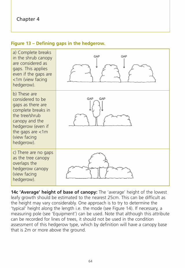
64
Figure 13 – Defining gaps in the hedgerow.
14c ‘Average’ height of base of canopy: The ‘average’ height of the lowestleafy growth should be estimated to the nearest 25cm. This can be difficult asthe height may vary considerably. One approach is to try to determine the‘typical’ height along the length i.e. the mode (see Figure 14). If necessary, ameasuring pole (see ‘Equipment’) can be used. Note that although this attributecan be recorded for lines of trees, it should not be used in the conditionassessment of this hedgerow type, which by definition will have a canopy basethat is 2m or more above the ground.
a) Complete breaksin the shrub canopyare considered asgaps. This applieseven if the gaps are<1m (view facinghedgerow).
b) These areconsidered to begaps as there arecomplete breaks inthe tree/shrubcanopy and thehedgerow (even ifthe gaps are <1m(view facinghedgerow).
c) There are no gapsas the tree canopyoverlaps thehedgerow canopy(view facinghedgerow).
Chapter 4

65
Although the ‘favourable condition’ threshold height is 0.5m, it should benoted that some hedgerow types, like those dominated by hazel or where thehedgerow is affected by shading from other vegetation such as woodland, maynaturally lack leafy growth around the base. For hedgerows where this isbelieved to be the primary, or only, reason for the average height of the base ofthe canopy being 0.5m or more, a note should be made on the form: suchhedgerows are in ‘favourable condition’ for this attribute.
Figure 14 – Measuring base canopy of the woody component
15 – Isolated hedgerow treesHedgerow trees can add greatly to the landscape and wildlife value of ahedgerow, and ancient, or veteran, trees are a specially valuable habitat. Thelong term future of the hedgerow tree population depends critically onreplacement young trees being recruited into hedgerows. Part A of the surveyform is used to record the species and trunk size diameter of isolated hedgerowtrees (see definition of these in Appendix 1). Isolated hedgerow trees are thosewith canopies that do not touch those of other trees. They can be recognisedby: having a clear stem; being twice the average height of the hedgerow; orbeing obvious as individuals that have clearly been favoured as single trees,even if young, by the management regime operating on the hedgerow (for
Key results for integrityPercentage of hedgerows with:
1. Gaps less than 10% of the hedgerow length
2. No gap greater than 5m
3. Base of leafy growth less than 0.5m from the ground for a shrubby hedgerow
‘Favourablecondition’ as baseof canopy <50cmfrom the ground(view facinghedgerow).
Field Survey – what to record and why
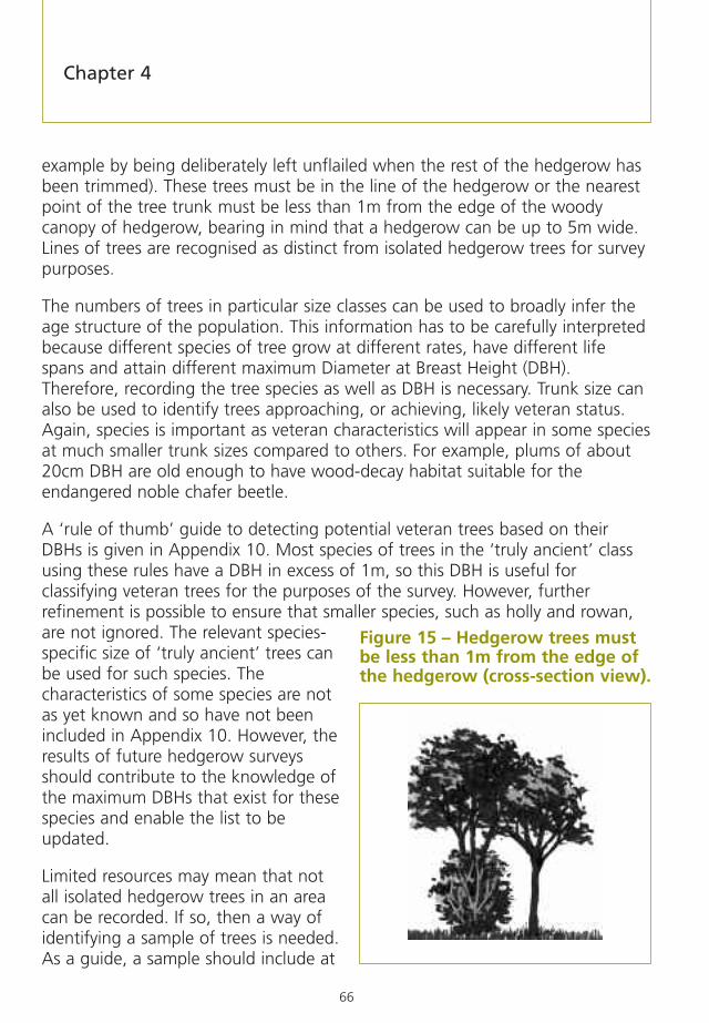
66
example by being deliberately left unflailed when the rest of the hedgerow hasbeen trimmed). These trees must be in the line of the hedgerow or the nearestpoint of the tree trunk must be less than 1m from the edge of the woodycanopy of hedgerow, bearing in mind that a hedgerow can be up to 5m wide.Lines of trees are recognised as distinct from isolated hedgerow trees for surveypurposes.
The numbers of trees in particular size classes can be used to broadly infer theage structure of the population. This information has to be carefully interpretedbecause different species of tree grow at different rates, have different lifespans and attain different maximum Diameter at Breast Height (DBH).Therefore, recording the tree species as well as DBH is necessary. Trunk size canalso be used to identify trees approaching, or achieving, likely veteran status.Again, species is important as veteran characteristics will appear in some speciesat much smaller trunk sizes compared to others. For example, plums of about20cm DBH are old enough to have wood-decay habitat suitable for theendangered noble chafer beetle.
A ‘rule of thumb’ guide to detecting potential veteran trees based on theirDBHs is given in Appendix 10. Most species of trees in the ‘truly ancient’ classusing these rules have a DBH in excess of 1m, so this DBH is useful forclassifying veteran trees for the purposes of the survey. However, furtherrefinement is possible to ensure that smaller species, such as holly and rowan,are not ignored. The relevant species-specific size of ‘truly ancient’ trees canbe used for such species. Thecharacteristics of some species are notas yet known and so have not beenincluded in Appendix 10. However, theresults of future hedgerow surveysshould contribute to the knowledge ofthe maximum DBHs that exist for thesespecies and enable the list to beupdated.
Limited resources may mean that notall isolated hedgerow trees in an areacan be recorded. If so, then a way ofidentifying a sample of trees is needed.As a guide, a sample should include at
Figure 15 – Hedgerow trees mustbe less than 1m from the edge ofthe hedgerow (cross-section view).
Chapter 4

67
least 100 trees, so that there are likely to be more than a couple ofrepresentatives of young and veteran trees. A pilot survey will help to select anadequate sample size.
One way of selecting a sample is to use the selection points already used foridentifying sample hedgerows and from a hedgerow to be sampled for othercharacteristics, select the nearest hedgerow tree to the selection point. Thereshould then be no bias in these points in relation to factors such as distancealong a hedgerow.
If the total number of isolated hedgerow trees in a survey area is to beestimated then, for at least some randomly chosen sample hedgerows, thenumber of trees in the hedgerow must be counted, even if the species and sizeinformation is not collected. The sample of trees will give the proportions ofyoung and veteran trees even if an overall total number for the whole surveyarea is not available. However, it will not be possible to calculate how manyyoung trees need to be recruited, for example by tree tagging to protect themfrom flailing.
Key results for isolated hedgerow trees1. Percentage of young trees with a DBH of 1-5cm within the total number of trees
in the sample.
2. Percentage of veteran trees with a DBH of 1m or more within total number oftrees in the sample.
3. Average number of isolated hedgerow trees per 100m of hedgerow (extrapolatefrom 30m counts if necessary).
4. Total number of isolated hedgerow trees in the survey area.
5. Replacement rate per year = total number of trees over 5cm DBH divided by100. It is assumed that a 100 year period is needed to replace the number oftrees larger than 5cm (‘older trees’). This is a generalisation but there is littleinformation on specific mortality rates of trees over their potential life spans.
Field Survey – what to record and why

68
16 – General notes on the whole hedgerow or 30m survey sectionThis section of the Field Survey Form has space for adding notes relating tospecial wildlife or nature conservation feature, such as evidence of fauna (16a)associated with the hedgerow, particularly that of a legally protected species.This might include, for example, hazel shells eaten by a dormouse, or a badgersett. Notes can be made of other features associated with the hedgerow suchas a stile or a stone gate post.
A record should be made of other features (16b) such as hedgerows that haveobviously been planted recently or where there are particular managementissues, such as excessive cover of bramble, bracken or traveller’s joy.
Photographs (16c) may beuseful in the subsequentinterpretation of featuresassociated with thehedgerow or to provide arecord of the condition ofthe hedgerow at the timeof the survey.A requirement to includephotographic recordsshould be agreed beforethe start of the field survey.Occasional photographsmay be needed to illustratea report or a presentation.Ground based photographsare also useful in relocatingsurvey sections.
Digital cameras are becoming cheaper and have advantages in that the imagescan be stored electronically along with the rest of the data. Any photographicrecord of the hedgerow should have a unique reference number linked to thereference number of the hedgerow. In addition, the reference number, positionand direction of the photograph should be shown on the field map. If feasible,the photograph itself should include some obvious reference point in the viewso it will be possible to take a repeat photograph from a similar position at afuture date. For repeat surveys, a note of the type of camera lens and the
Chapter 4
Photographs may assist in the subsequent interpretation offeatures, but must be cross-referenced to the hedgerow numberand located on the map.

69
distance of the photographer from the hedgerow are also useful. With a digitalcamera some information is normally recorded with the image (e.g. date andtime, shutter speed, aperture and whether the shot used a wide angle ortelephoto setting, etc).
Elements that should be recorded for the 30m survey section only(Section 17)
17 – Woody species per 30mThe final section of Part A of the Field Survey Form identifies the woody specieswithin a 30m survey section. Woody species counts should only be performedon a 30m section or sections, even where the whole hedgerow is beingrecorded for other characteristics. This assessment can only be done on 30msections of continuous woody species cover. It cannot be done if thehedgerow is less than 30m long, nor can it be done if the 30m sample sectioncontains any gaps, including gates. If the selected 30m survey section fallswithin a gappy part of hedgerow and can be moved to a part with continuouscanopy, this should be done. This may not be possible on very gappyhedgerows. Note that this means the 30m section chosen for recording woodyspecies may be different to that used for recording features in sections 7-16 ofthe Field Survey Form.
The average number of woody species per 30m length can assist in dating thehedgerow (in broad terms), as well as determining whether a hedgerow isdefined as species-rich. Species that count towards species-richness arestructural species, not climbers (other than roses) or bramble. They are alsolimited to woody species either native in the UK, or which are ‘archaeophytes’(have been recorded as naturalised in the wild before 1500 AD). Sycamore (Acerpseudoplatanus) should also be included as its status as native/archaeophyte orrecent introduction is unclear. The woody species that are classified as native orarchaeophyte according to the New Atlas of the British Flora (Preston 2002) arelisted in Appendix 8. However, all species in the woody canopy of the hedgerowshould be recorded because it is necessary to know the cover of recentlyintroduced species (‘neophytes’) for the relevant condition assessment attribute(see ‘Recently introduced, non-native species’). Also, the percentage cover ofclimbers and bramble provides useful information, for example on the scale ofproblems such as the swamping of hedgerows by traveller’s-joy (Clematisvitalba). In practice, it is easier to include them in the cover estimates ratherthan trying to exclude them.
Field Survey – what to record and why

70
Where possible, identification should be made at a species level. A number offield guides are available to suit individual skill levels and preferences, but therecommended names of species should follow the ‘New Flora of the BritishIsles’ (Stace 1997). If surveyors cannot be sure of the species, the genus (e.g.rose Rosa sp.) should be recorded instead. If there are clearly two or moredifferent but unidentified species of the same genus, this should be made clearon the recording form (e.g. rose sp. 1 and rose sp. 2). This will ensure that thedata recorded gives an accurate picture of species richness (number of woodyspecies per 30m) for that hedgerow section.
The species list on the form is not exclusive and may need to be adapted toinclude other frequently occurring species in an area. The list should bereviewed at the time of the pilot survey and/or based on local knowledge.Space is provided on the form to add other, less frequently occurring, species.
A decision should be made whether each woody species in the survey sectionoccurs in the shrub layer or as isolated hedgerow trees, or both. Sometimes thiscan be difficult to determine. Some tree species may have been managed bytrimming them as an integral part of the hedgerow structure and should berecorded as shrubs. At the other extreme, shrub species might have developedinto a tree form. As a useful guide, hedgerow trees have a clear trunk/stem (i.e. few or no woody outgrowths from the base or lower part of the stem)and/or are twice the average height of the hedgerow. In many cases, it will beevident that a section of hedgerow has been trimmed to favour the growth ofa young tree.
Within the 30m length, once a clear separation between the shrub layer andtrees has been established, all shrub layer species should be identified and thepercentage cover of each estimated by visual assessment. Having identified eachspecies present it is sometimes easier to then stand back from the hedgerow toassess their relative cover. This is where measuring poles marking out the surveysection are useful as they provide clearly defined end-points for estimating thecover values.
Chapter 4

71
Part B: Optional Assessments (Sections 18-21)
This part of the survey methodology is intended for selective use in localhedgerow surveys that require more than just the essential assessmentsdescribed above. Where the objectives of a survey require more detail aboutassociated features, hedgerow management, hedgerow trees or the groundflora, then surveyors should select the appropriate section from those shownbelow.
18 – Associated featuresData should be gathered on features typically associated with hedgerows thatcould influence their structure, species composition and management. The mostcommon features are: banks; ditches/streams;verges/headlands; dry-stone walls; and fences. If otherfeatures are present, an additional space is available forrecording these. In certain parts of the country it maybe necessary to include additional categories to coverspecific local features. This should be determined fromthe pilot survey together with local knowledge, but theadditional features must be clearly defined.
A range of options is provided on the form forcommonly occurring features:
Key results for woody species1. Percentage of hedgerows that are species-rich
2. Average number of qualifying species per 30m section
3. Percentage of hedgerows with at least 80% cover of native woody species(including archaeophytes and sycamore) in the survey area
4. Percentage of hedgerows with at least 80% cover of native woody species (notinclude archaeophytes and sycamore) in the survey area�.
An earth half-bank in Devon
Field Survey – what to record and why

72
18a – BanksHedgerows may be assessed with either one-sided (half-bank) or two-sidedbanks. Hedgerows on top of two-sided banks are typical in the westerncounties, where they are called hedgebanks, and tend to be locally distinctive.Half-banks are more widely distributed, particularly along country lanes.
Information on whether the bank is earth or stone faced should also be recorded.Stone-faced banks are traditional in Cornwall and other western counties.
18b – DitchesThe width and type of any associated ditch should be recorded. Where aninternal ditch is present, it is not always possible to measure accurately thewidth at the base because of access difficulties.
18c – Walls and fencesThe presence of a dry-stone wall along all or part (more than 20%) of thehedgerow length, and its general condition should be recorded.
If a fence is present, the height and type should be recorded. Most agriculturalfences will be approximately 1.2m high. ‘Netting’ includes all wire mesh and‘chicken wire’ fences, with holes of varying sizes, such as those used for sheepor rabbit fencing. For the ‘other fence’ category the type of fence should bedescribed.
The ‘other feature’ category includes features such as traditional farm gateswith stone gateposts, or stiles within or alongside the hedgerow.
19 – Hedgerow/margin management
19a Hedgerow managementAny evidence of hedgerow management should be recorded here, and thisshould indicate whether this management was very recent (within the past twoyears), recent (2-10 years) or older (more than 10 years).
When recording whether or not management has been undertaken, someknowledge of hedgerow management techniques is necessary, and this shouldbe covered in training sessions. Obvious signs of management may includemore than one category stated in the Field Survey Form. For example, there maybe signs of older hedgerow laying, with more recent evidence of trimming andgapping up (i.e. hedgerow planting to fill gaps). All categories that apply shouldbe recorded.
Chapter 4

73
Overgrown, leggy hedgerow, with evidence of previous laying
Recently coppiced hedgerow bank In North Wales Clipped and dense hedgerow in Worcestershire
Field Survey – what to record and why

74
Identification of management activities undertaken in the more distant past will require a close look at the structure of the hedgerow. For example,multi-stemmed vertical growth suggests previous coppicing (Figure 16a), whilsthorizontal/acute-angled stems or ‘elbows’ suggest previous laying (Figure 16b).
19b Hedge-bottom managementEvidence of recent hedge-bottom management should be recorded in thissection. This includes details of any mowing, herbicide application andcultivation. Any lack of management should also be recorded.
19c Margin/headland managementThe margin/headland is the area between the edge of the hedgerow and theland use recorded in Part A, for example cultivated land or a road. Margins areusually grass, and are either dense and tussocky or mown/cut. Margins withinagri-environment schemes, like Environmental Stewardship, should also berecorded.
Hedgerow that has previously been subjected toannual flailing and heavy grazing by sheep – but nowshowing early signs of recovery
Newly laid hedgerow. Similarly angled stems areclearly evident in all recently laid hedgerows
Chapter 4

75
Figure 16 – Evidence of old former management.
20 – Ground flora species per 30mThe ground flora is an important component of hedgerows and can contributesignificantly to species diversity. Recording species presence and cover isdesirable but requires good identification skills. The ground flora can berecorded under lines of trees as well as for shrubby hedgerows.
The species are grouped according to type i.e. grasses, forbs and ferns. Anyclimbers/creepers present are associated with ground cover species rather thanin the vertical component of the hedgerow. Species such as ivy may formcomponents of both ground and shrub layers.
a) Previously coppiced hedgerow b) Previously laid hedgerow
Field Survey – what to record and why

76
As with the woody component, the species list on the form is not exclusive. Thelist may need to be adapted to include frequently occurring species in thelocality. Space has been left to record other species present (likely to be lessfrequently occurring species).
The ground flora should be sampled using two quadrats measuring 2m x 1m(with 2m axis running down the line of the hedgerow and the 1m axisextending out from the hedgerow bottom as shown at Figure 17).
The quadrats should be positioned at points 10m (Q1) and 20m (Q2) along the30m hedgerow survey length (see Figure 17).
The plastic pipe work described under ‘Equipment’ provides an effective rigidquadrat.
All species present In the ground flora should berecorded. Plants shown in the photographs includebluebell, dog’s mercury, cleavers, violet, hart’s-tongue, ivy and bramble.
Chapter 4

77
Figure 17 – Standard field procedure for locating 30m ground florasurvey quadrats.
The survey should record the ground flora influenced by the hedgerow ratherthan by the adjoining land use. One quadrat (Q1) should be placed under thecanopy and as close to the woody stems as possible (as shown in Figure 18).The second quadrat (Q2) can be used to record variation in the ground flora.This can be richer in species at the edge of the woody canopy or on thehedgerow bank if present. The position of each quadrat should be recorded asbeing under the canopy, on a bank, on an adjacent verge or on the field edgeas appropriate.
A value for bare ground should also be recorded and this may be related todense shading. Each species present should be assigned a percentage cover,estimated to the nearest 5% (or to nearest 1% if less than 5%). If using plasticpiping, bands of tape or connector positions can be useful guides in assessingpercentage cover for abundant species (e.g. nettles or cleavers) as each 50cm x50cm is equivalent to 12.5% of the total area. For low frequency species agood guide is using a standard A4 clipboard. This is approximately 3% of thearea of the 2m x 1m quadrat.
21 – Veteran tree featuresA veteran tree is of value because ofits age, size and condition. A treemay be considered a ‘veteran’ if ithas any of the features listed under’Condition’ in Section 21 of the FieldSurvey Form. Fay’s ‘Evaluation of thespecialist survey method for veterantree recording’ (Fay 2003) definesveteran trees in more detail.
Locating the groundflora quadratpositions within the30m survey section
Field Survey – what to record and why
Figure 18 – Quadrat (2m x 1m)positioned in a hedge-bottom

78
In addition to size (see Section 15), work on wood-decay invertebrates hasshown that the numbers of species can be influenced by the relative abundanceof veteran tree features among a tree population. The incidence of thesefeatures can be recorded on any tree of 100cm DBH and over, or on any of thesmaller species of less than 100cm DBH that is in the truly ancient class for thatspecies (see Appendix 10).
Other types of tree that may be encountered in hedgerows are ancientcoppiced stools. These can have ground-level diameters greater than 1m. Thecurrent pole growth will probably appear young and vigorous and care shouldbe taken not to overlook the old stool from which these poles emerge. Any oldcoppices should be recorded as veterans by measuring the stool base andmaking notes on the form. Often these coppice stools will be far from circular.If so, record the maximum diameter in any one direction.
Survey Summary Form
This form (see Appendix 7) summarises the key information that will be mostuseful for informing policy and the development of conservation action at bothnational and local levels.
It is very important to estimate the total length of hedgerows surveyed and thetotal length in the survey area. These results will enable future surveys to detectlosses or gains and show how successful hedgerow conservation action hasbeen since the first survey. The length of each different type of hedgerow is alsohelpful to know (see section 3 – Hedgerow type). The total length is easy tocalculate where a census approach is used. However, if there are too many 1kmsquares in a survey area to map them all, lengths of hedgerows in particularsample areas should be mapped and the results extrapolated to the wider area.A sample of squares can be drawn at random from those 1km squares whereindividual hedgerows have been selected for survey. Then the extent of thehedgerows in each 1km square in the sample is mapped, if possible sub-dividing the mapped hedgerows into the hedgerow types (shrubby hedgerows,lines of trees, shrubby hedgerows with trees). The amount of mapping that canbe done will be dependent upon resources; the more squares that can bemapped, the more confidence can be placed in the estimates for the wholearea that are based on this mapped sample of squares. Print-offs of aerialphotographs that show hedgerows clearly can be very useful in cutting downthe amount of mapping required in the field, especially when thesephotographs are taken out into the field by the surveyors.
Chapter 4

79
The relationship between the total length of hedgerows surveyed in detail tothe estimate of the total length in the survey area will show how representativethe results from the sample hedgerows are likely to be. In terms of precision inmapping, surveyors should aim to be precise about a mapped length ofhedgerow to within 20m in each 1km square, while the length of individualhedgerows surveyed in detail should be estimated to within 5m.
Key results for hedgerow length in survey area1. Number of hedgerows individually surveyed
2. Total length of surveyed hedgerow = sum of lengths of individual hedgerowssurveyed
3. Total length of hedgerows in the survey area
4. Total length of different types of hedgerow
Field Survey – what to record and why

80
Summary guide to completionof the Field Survey FormsPart A – Essential Assessments
Elements that should be recorded for the whole hedgerow (Sections 1-6)
Referencing the hedgerowOnce the hedgerow has been located and the survey section marked out,record:
• The title of the survey
• The date in DD/MM/YYYY format
• The grid reference of the mid-point of the whole hedgerow or surveysection using either letter codes for the 100km square, i.e. SE, or thegrid numbers9
• The hedgerow reference number and suffix if necessary
• The name of the surveyor(s)
• The side surveyed (N, E, W, S or both sides).
1 – Name of landowner/contact detailsEnter the details for the owner/occupier who has given permission to survey thehedgerow.
2 – Survey times and weather/other conditions that may affect thesurveyEnter the start (2a) and finish (2b) times for each survey.
Record the general weather conditions: fine, breezy, cool, etc. (2c).
Record any difficulties encountered in surveying the hedgerows (2d).
9 These are the small prefix numbers found in the corners of any paper OS map: 1:10,000, Explorer 1:25,000 orLandranger 1:50,000.
Chapter 5

81
3 – Hedgerow typeDefinitions of the different types of hedgerows and hedgerow trees aredescribed in Chapter 4. Record the appropriate category.
4 – LengthMeasure and record the length to the nearest 5m.
5 – ConnectionsRecord the total number of other hedgerows that have a direct connection toeach end of the hedgerow being surveyed.
6 – Extent of surveyRecord whether the whole hedgerow (6a) or a 30m section (6b) is beingsurveyed.
Elements that should be recorded for the whole hedgerow or on 30msurvey section (Sections 7-16)
The remainder of Part A of the form can relate to either the whole hedgerow,or just to the 30m survey section, depending on the nature of the survey.
7 – Adjacent land useComplete this section for both sides of the hedgerow, even if most assessmentsare done from one side. If the far side of the hedgerow cannot be visited and isnot visible, record as ‘not known’.
8 – Associated features8a Bank: Estimate height on each side (A & B), if applicable, to the nearest25cm.
8b Average herbaceous vegetation height: Estimate height of main mass ofherbage to the nearest 5cm.
8c Fence: Record presence.
8d-g Ditch: Record whether internal or external, and whether wet or dry at thetime of survey.
Summary guide to completion of the Field Survey Forms

82
9 – Undisturbed ground and perennial herbaceous vegetation coverNote that for hedgerows within 2m of walls, buildings, tarmac roads or otherexisting ‘built’ features this attribute does not apply.
9a Average width of undisturbed ground: Estimate (to the nearest 50cm upto 2m wide then to nearest 1m) from the centre-line of the hedgerow to theedge of any ploughed or otherwise cultivated or disturbed land.
9b Average width of perennial herbaceous vegetation: Estimate theaverage width of the continuous perennial herbaceous vegetation (to thenearest 50m up to 2m wide then to nearest 1m), between the centre-line ofthe hedgerow and adjacent areas of disturbed bare ground (ignore very smallpatches), or annual crops.
Hedgerows bordering grassland and woodland automatically qualify as being in‘favourable condition’.
10 – Nutrient enrichment ground flora indicator speciesEstimate percentage cover of nettles (Urtica spp.), cleavers (Galium aparine) anddocks (Rumex spp.) to the nearest 5%, in a 2m wide band, parallel with thecentre-line of the hedgerow, on each side of the hedgerow.
11 – Recently introduced, non-native species Estimate and record percentage cover of recently introduced species to thenearest 5%. If there is less than 5% cover just record the name(s).
Shrub layer: Estimate the cover of introduced woody species as a percentageof the total area of the vertical face of the hedgerow on the side beingassessed.
Hedge-bottom: Estimate the percentage cover of introduced ground floraspecies within a 2m band parallel with the centre-line of the hedgerow.
12 – Hedgerow shapeChoose the shape illustrated on the recording form that most closely resemblesthe hedgerow being surveyed.
If the hedgerow clearly does not fit any of these categories, note and sketch theshape on the form. Disregard any associated features e.g. hedge-banks orditches.
Chapter 5

83
13 – Dimensions13a Average height: Estimate the average height of the woody growth to thenearest 25cm (unless measuring the heights of lines of trees which should beestimated to the nearest 1-2m).
13b Average width: The average width of the woody growth should bemeasured or estimated to the nearest 25cm.
14 – Integrity14a Continuity of canopy along hedgerow (% gaps): Estimate the totallength of any gaps (excluding gateways) as a percentage of the total length ofthe hedgerow.
14b Any gaps >5m wide? Simply record ‘Y’ or ‘N’.
14c Average height of base of canopy: Estimate the average height of thelowest leafy growth to the nearest 25cm.
15 – Isolated hedgerow treesRecord the species and trunk size diameter of isolated hedgerow trees10.Diameters should be recorded to the nearest 5cm, or to the nearest 1cm if DBHis less than 5cm. If the tree forks below 1.3m, measure immediately below thefork. Also, if there are bulges, burrs or other irregular features, measure at thenearest point below these features where the trunk is more regular. Measureany coppices round the stool base and any pollards below the ring ofpollarding.
16 – NotesRecord evidence of fauna (16a) or other features (including recent planting)(16b) in relation to the whole hedgerow or a 30m survey section. Record anyphotograph numbers of the hedgerow (which should be indicated on the field map).
Summary guide to completion of the Field Survey Forms
10 Trunk size is measured by recording the diameter of the trunk at 1.3m from the ground (Diameter at Breast Height orDBH).
84
Elements that should be recorded for the 30m survey section only(Section 17)
17 – Woody species per 30mRecord all woody species, and whether each occurs in the shrub layer or asisolated hedgerow trees, or both.
For all shrub layer species estimate the percentage cover by visual assessmentignoring any gaps.
If the species is present only as a hedgerow tree, put a tick in the ‘Tree no.’column (species that would not occur as trees have a shaded box in thiscolumn). Do not attempt to estimate percentage cover for these species.Species which occur in both shrub and tree layers should be entered in bothcolumns, but only the specimens in the shrub layer estimated for percentagecover. In general, record cover to the nearest 5%. However, for species withlittle cover, try to record a cover less than 5%.
Part B: Optional Assessments (Sections 18-21)
18 – Associated features18a – BanksRecord whether any bank is one-sided (half-bank) or two-sided, and whether itis earth or stone faced.
Note if the bank is fenced, and whether there is evidence of grazing (bylivestock) or mowing/cutting.
18b – Ditches/streamsRecord the width of the base to the nearest 25cm. If there are accessdifficulties, note such problems on the form.
18c – Walls and fencesRecord the presence of any dry-stone wall along all or part (more than 20%) ofthe hedgerow length and note its general condition.
If a fence is present, record the height and type. Most agricultural fences will beapproximately 1.2m high. For the ‘other fence’ category describe the type.
Chapter 5

85
In the ‘other’ category, record features such as a traditional farm gates withstone gateposts, or stiles within or alongside the hedgerow.
19 – Hedgerow/margin managementRecord any evidence of hedgerow management here, and state whether thismanagement was very recent (within the past two years), recent (2-10 years) orolder (more than 10 years). If there is evidence of more than one form ofmanagement, record all that apply.
For margin/headland management, record the width of the margin on each sideof the hedge and whether it is grazed, cut or unmanaged.
20 – Ground flora species per 30mRecord the presence and percentage cover (to the nearest 5%) of all groundflora species sampled using two quadrats measuring 2m x 1m. Only recordclimbers/creepers which cover the ground.
Mosses and liverworts present should be grouped and recorded as bryophytesunless surveyors have specialist expertise.
A value for bare ground should also be recorded.
21 – Veteran tree featuresRecord presence/absence of the features listed below, and the percentage ofthe canopy which is alive to nearest 5%. Recording should be done from bothsides of the tree if practicable. Include old coppiced tree stools, if present, andmeasure the basal diameter.
• Dead wood attached to the tree, any piece more than 1m long and8cm in diameter
• Loose, split, missing and dead bark, any patches more than 30 x 30cm
• Bark sap runs
• Tears, splits, scars, lightning strikes >30cm length
• Hollow trunks or hollows in major limbs
• Major rot sites, any more than 15cm across
Summary guide to completion of the Field Survey Forms

86
Data Management, Storage,Analysis, and ReportingData entry
It is strongly advised that all records and associated information arecomputerised. This will enable the data to be fully analysed and will facilitatedistribution to other interested parties. A standard Microsoft Access databasehas been developed for this purpose. The database is available from the website(www.naturalengland.org.uk) along with details on how to enter data. GIS canbe used to digitise the map-based information gathered in the field. Thedatabase can be linked to a GIS or used independently.
For repeat surveys a database on contact details of land managers should beestablished within the constraints of the Data Protection Act (see section 1a atAppendix 6).
Data storage
In addition to the data stored on the Microsoft Access database, other datamight include mapped information and photographs. These may exist in apaper or electronic format and this will determine the type of data storage andmanagement. Storing data in a variety of ways and locations is desirable. Clearreference to the author of all documents is essential. A description of the surveymethod must accompany the survey data so that any subsequent users will beable to interpret the results correctly. Data can be sent to Local Record Centres(LRCs); their contact details can be found on the National Federation ofBiological Recording (NFBR) website (www.nfbr.org.uk). Completed SurveySummary Forms, and a report if it has been produced, can also be sent to Defra(contact details can be found in the acknowledgements section) on behalf ofthe Steering Group for the UK BAP for Hedgerows.
Chapter 6

87
Data analysis, reporting and survey outcomes
Completion of the Survey Summary Form at Appendix 7 is necessary as aminimum level of analysis. This can then be used as the basis of a short reportproviding details of the survey method, including such aspects as the surveyperiod, the sampling strategy, quality control, the main findings and anyproblems encountered. Consideration will need to be given to the audience andcirculation of the report. If the survey received Defra funding there is arequirement to submit a final report and a completed Survey Summary Form.
Data Management, Storage, Analysis, and Reporting

88
The publication of the original edition of the Hedgerow Survey Handbook waswritten under contract by Catherine Bickmore Associates and was funded byDefra, Countryside Agency, Countryside Council for Wales and English Natureon behalf of the Steering Group for the UK Biodiversity Action Plan forHedgerows. The revision of this Handbook was prepared by ADAS, also undercontract, and funded by Defra.
The Steering Group are particularly grateful to the following members for theirguidance and assistance: Ann Davies & Will Pryer (Defra), Rob Wolton, HeatherRobertson and Emily Ledder (Natural England); Clare Burrows (CountrysideCouncil for Wales); Colin Barr (Barr Ecology) and Rick Stuart (Centre for Ecologyand Hydrology).
As well as those named above, a number of other Steering Group membersmade important contributions to the development of the hedgerow conditionassessment methodology, for BAP hedgerows, which forms a key part of thisrevised Handbook. These include Jon Stokes (Tree Council); Lucy Bjorck (RSPB);Carol Millsopp & Terence Henry (Department of Agriculture and RuralDevelopment in Northern Ireland); Jane Goodwin & Andrew Stott (Defra); JoyEde, David Smallshire, Chris Reid, Simon Dunsford & Martin Longley (NaturalEngland); Peter Chamberlain (Devon County Council) and Wendy Rees (DevonAONB hedge survey).
We also thank a number of practitioners and other organisations whoparticipated in a Defra organised local hedgerow survey workshop (February2006) and those who subsequently provided further feedback on theirexperience of using the 1st Edition of the Handbook. These include thefollowing individuals: Catherine Bickmore (Catherine Bickmore Associates); RobWiddicombe (Herefordshire CC); Geoff Radford (Anglesey Hedgerow Survey);Steph Fuller (Welsh Assembly Government); Eleanor Hewins (Just Ecology);Anna Cohen (Hertfordshire CC); Jon Marshall (Marshall Agro-Ecology); SusanStangroom (North Somerset Council); Peter Challis (Sussex Hedgerow InventoryProject); John Wharam (CPRE Warwickshire); Trevor Taylor (independentconsultant); Beverley Rhodes (Derby City Council); Viv Green (Shropshire WildlifeTrust); Rose Wolfe (Solway Coast AONB); Alison Bennett (Land UseConsultants); Helen Pontier; Peter Ogden and John Stratton (Defra).
Photographs included in this publication were provided by the CountrysideCouncil for Wales, Natural England, Colin Barr, Rob Wolton, David Townshend,Will Pryer and Chris Britt. Line drawings are by Anne Wright.
Acknowledgements

89
This document and the survey forms can be viewed and downloaded from:http://www.defra.gov.uk/farm/environment/landscape/hedgerows.htm
Copies of this document are also available from the at the following address:
Natural EnglandEnquiriesNorthminsterPeterborough, PE1 1UATel: 0845 600 3078Fax: 01733 455 103Email: [email protected]
Reports and/or completed Survey Summary Forms should be sent to:
ELM Divisional Support Team3rd FloorNobel House17 Smith SquareLondonSW1P 3JREmail: [email protected]
Acknowledgements

90
Background reading
British Trust for Conservation Volunteers (2001). Health and Safety Overview forPractical Conservation Projects. BTCV, Wallingford.
CADW (1998). Part 2:1 Register of landscapes of outstanding historical interestin Wales. CADW; Welsh Historic Monuments, Cardiff.
Countryside Commission/English Nature (1998). The Character of England:Landscape, wildlife and natural features. (CD version).
Council of Europe (2000). General Guidelines for the Development of the pan-European Ecological Network. Nature and Environment, No.107.
Dowdeswell, W. H. (1987). Hedgerows and Verges. Allen & Unwin, London.
Dyson Bruce, L, Dixon, P. Hingley, R. & Stevenson, J. (1999). Historic LanduseAssessment: Development and potential of a technique for assessing historiclanduse patterns – Report of the pilot project (1996-1998). Historic Scotland,Edinburgh.
English Nature (1998). Natural Areas: Nature conservation in context. (CDversion, also see web site).
Fairclough, G.J. (1999). Historic Landscape Characterisation – ‘The state of theart.’ English Heritage, London.
Fairclough, G.J., Lambrick, G. & McNab, A. (1999). Yesterday’s World,Tomorrow’s landscape. The English Heritage Historic Landscape Project, 1992-1994. English Heritage, London.
HSE (2002). Fives steps to risk assessment. PO Box 1999, Sudbury CO10 6FS.
Marren P. (1999). Britain’s Rare Flowers. T & A D Poyser, London.
Rackham, O. (1986). History of the Countryside. Dent, London.
Roberts, B.K & Wrathmell, S. (2000). An Atlas of Rural Settlement in England.English Heritage, Northampton.
References and further reading

91
RSPB (1994). Hedges and Farmland. An RSPB curriculum guide. Royal Societyfor the Protection of Birds, Sandy.
Simonson, W. & Thomas, R. (1999). Biodiversity: Making the links. EnglishNature, Peterborough.
Swanwick, C. (2002). Landscape character assessment: guidance for Englandand Scotland. Countryside Agency, Wetherby and/or Scottish Natural Heritage,Edinburgh.
Field Handbooks
Barr, C.J. (2000). Countryside Survey 2000: Field Handbook. Centre for Ecologyand Hydrology, Lancaster.
Fay, N. & de Berker, N. (2003). Evaluation of the specialist survey method forveteran tree recording. Peterborough: English Nature Research Reports No 529.
Hill, M. O., Preston, C. D. & Rob, D. B. (2004) Plantatt – Attributes of Britishand Irish plants: status, size, life history, geography and habitats. Centre forEcology and Hydrology, Huntingdon.
Hubbard, C.E. (1984). Grasses (3rd ed.). Penguin Books, London.
Jermy, C. & Camus, J. (1991). The Illustrated Guide to Ferns and Allied Plants ofthe British Isles. Natural History Museum Publications, London.
Joint Nature Conservation Committee (1990). Handbook for Phase 1 HabitatSurvey – a technique for environmental audit. England Field Unit, JNCC.
Mitchell, A. F., (1974) A field guide to the trees of Britain and Northern Europe.Collins, London.
Paton, J.A. (1999). Liverwort Flora of the British Isles. Harley Books.
Preston C. D., Pearman D. A. & Dines, T. D. (2002) New atlas of the British andIrish flora. Oxford University Press, Oxford.
Read, H. (2000) Veteran trees: A Guide to good management. English Nature.Peterborough
References and further reading

92
Rich, T.C.G. & Jermy, A.C. (1998). Plant Crib 1998. Botanical Society of theBritish Isles, London.
Rose, F. (1981). The Wild Flower Key (Revised by C. O’Reilly, 2006). Warne,London.
Rose, F. (1989). Colour Identification Guide to the Grasses, Sedges, Rushes andFerns of the British Isles and North Western Europe. Viking.
Smith, A.J.E. (1978). Moss flora of Britain and Ireland. Cambridge UniversityPress, Cambridge.
Stace, C. (1997). New Flora of the British Isles (2nd edition). CambridgeUniversity Press, Cambridge.
Watson, E.V. (1981). British Mosses and Liverworts. Cambridge University Press,Cambridge.
Hedgerows and field margins: management and research
Andrews, J. & Rebane, M. (1994). Farming and Wildlife: A practicalmanagement Handbook. Royal Society for the Protection of Birds, Sandy.
Anon, (undated). The Good Hedge Guide: Your pocket guide to hedgerowmanagement. Bayer, Bury St Edmunds.
Barr, C.J., Britt, C.P., Sparks, T.H. & Churchward, J.M. (Eds) (2005). HedgerowManagement and Wildlife. A review of research on the effects of hedgerowmanagement and adjacent land on biodiversity. Department for Environment,Food and Rural Affairs, London.
Barr, C.J. & Petit, S (Eds) (2001). Hedgerows of the World: their ecologicalfunctions in different landscapes. International Association for LandscapeEcology, UK.
Bickmore, C.J. & West, R.C. (1999). Welsh hedgerows: development of a surveyand stratification process. Aspects of Applied Biology 54, 263-268.
References and further reading

93
Bickmore. C.J. & Wenman, J.P. (2001). Developing a national hedgerow surveyfor England and Wales. In: Barr, C. & Petit, S. (eds.), Hedgerows of the World:their ecological functions in different landscapes. International Association forLandscape Ecology, UK.
Boatman, N.D. (Ed) (1994). Field Margins: integrating agriculture andconservation. BCPC Monograph No. 58. British Crop Protection Council,Farnham.
Brooks, A. & Agate E. (1975). Hedging – A practical conservation Handbook.British Trust for Conservation Volunteers, Wallingford.
Catherine Bickmore Associates (1999). Survey, Classification and ConservationReview of Welsh Hedgerows (Phase 1). Countryside Council for Wales, Bangor.
Catherine Bickmore Associates (2001). Hedgerow Survey Method: Developmentand resource assessment. Countryside Council for Wales, Bangor.
Countryside Agency (2000). Locally Distinctive Hedges. Research Note CRN 3.Countryside Agency.
Council for the Protection of Rural England (1997). CPRE Hedgerow ActionPack. Council for the Protection of Rural England, London.
Dowdeswell, W.H. (1987). Hedgerows and Verges. Allen & Unwin, London.
Hepburn, L.V. (2000). Establishment of a register of species-rich hedgerows inScotland 1998-1999. Scottish National Heritage, Edinburgh.
Maclean, M. (1992). New Hedges for the Countryside. Farming Press Books,Ipswich.
McCollin, D (Ed) (2000). Hedgerows: perspectives on biodiversity andenvironmental management. Selected papers from the ‘Hedgerow conservation:policy, protection and evaluation meeting’. J. Env. Management 60, Number 1. Special Issue.
References and further reading

94
Menneer, R. (1994). Wildlife Revival in Cornish Hedges: History, traditions andpractical guidance. Dyllansow Truran, Redruth.
Moorhouse, A. (1990). Managing Farm Hedges. In: Farming and ConservationManagement – Putting new ideas into practice. Fourth report of TERF: InterRegional Group, Norwich.
Parker R. (2000). Estimating the length of hedgerows in Suffolk. English NatureResearch reports No 366, English Nature, Peterborough.
Pollard E., Hooper M.D. and Moore N.W. (1974). Hedges. Collins, London.
Porter V. (1990). Small Woods and Hedgerows. Pelham Books, Harmondsworth, UK.
Sanderson, H. & Prendergast, H.D.V. (2002). Commercial uses of wild andtraditionally managed plants in England and Scotland. Report for CountrysideAgency, English Nature and Scottish Natural Heritage. Royal Botanic Gardens,Kew.
Sotherton, N. & Page, R. (undated). A Farmer’s Guide to Hedgerow and FieldMargin Management. Game Conservancy Trust, Fordingbridge.
The Wildlife Trust (2001). The Thin Green Line: Ancient and species-richhedgerows in Peterborough. Bedfordshire, Cambridgeshire, Northamptonshireand Peterborough. Wildlife Trust, Peterborough.
Watt, T.A. & Buckley, G.P. (1994). Hedgerow Management and NatureConservation. Wye College Press, London.
Wesley, M. (1997). Devon’s Hedges – Conservation and Management. DevonBooks, Tiverton.
References and further reading

95
Legal and policy background
Anon, (1979). Ancient Monuments and Archaeological Areas Act 1979. HMSO,London.
Anon, (1983). Wildlife and Countryside Act 1981. HMSO, London.
Anon, (1990). Town and Country Planning Act 1990. HMSO, London.
Anon, (1994). Conservation (Natural Habitats etc) Regulations 1994 (SI1997/1166). HMSO, London.
Anon, (1995). Environment Act 1995. HMSO, London.
Anon, (2000). Countryside and Rights of Way Act 2000. HMSO, London.
Anon (2000). Local Government Act 2000. HMSO, London.
Defra (2001). The Hedgerows Regulations 1997: a guide to the law and goodpractice. HMSO, London.
Department of the Environment (1994). Planning Policy Guidance: NatureConservation PPG9. HMSO, London.
European Council (1992). Council Directive 92/43/EEC. Official Journal of theEuropean Communities, 1206, 7-49. Also known as the Habitats Directive onthe Conservation of Natural Habitats of Wild Fauna and Flora.
The Hedgerow Regulations 1997 (SI 1997/1160).�
UK Steering Group (1995). Biodiversity: the UK Steering Group Report. Volume1: Meeting the Rio Challenge. HMSO, London.
UK Steering Group (1995). Biodiversity: the UK Steering Group Report. Volume2: Action Plans. HMSO. London.
References and further reading

96
Statistics
Cochran, W.G. (1963). Sampling Techniques. Wiley, New York and London.
Jeffers, I.N.R. (undated). Sampling. Statistical Checklist 2. Institute of TerrestrialEcology, Huntingdon.
Sampford, M.R. (1962). Introduction to Sampling Theory. Oliver & Boyd,Edinburgh.
Yates, F. (1960). Sampling Methods for Censuses and Surveys (3rd ed.). CharlesGriffin, London.
Websites
ADAS: www.adas.co.uk
Campaign to Protect Rural England: www.cpre.org.uk
Centre for Ecology and Hydrology: www.ceh.ac.uk
Country Land and Business Association: www.cla.org.uk
Countryside Council for Wales: www.ccw.gov.uk
Countryside Survey: www.cs2000.org.uk
Department of Agriculture and Rural Development Nl: www.dardni.gov.uk
Department for Environment, Food and Rural Affairs: www.defra.gov.uk
English Heritage: www.english-heritage.org.uk
Farmers’ Union Wales: www.fuw.org.uk/
Historic Mapping: www.old-maps.co.uk
Legislation: www.legislation.hmso.gov.uk/acts
Local Live (aerial maps): http://local.live.com/
References and further reading

97
MAGIC: www.magic.gov.uk
National Federation of Biological Recording: www.nfbr.org.uk
NFU: www.nfuonline.com/
NFU Scotland: www.nfus.org.uk/
Natural England: www.naturalengland.org.uk
Old Maps: http://old-maps.co.uk
Ordnance Survey: www.ordnancesurvey.co.uk
Promap: www.promap.co.uk/promap/index.jsp
Royal Society for the Protection of Birds (RSPB): www.rspb.org.uk
Scottish Natural Heritage: www.snh.gov.uk
The Stationery Office: www.tso.co.uk
Ulster Farmers’ Union: www.ufuni.org/portal.aspx
References and further reading

98
Running head
Glossary of termsArable: Land cultivated for the production of crops including cereals (wheat,barley, oats, etc.), oilseed rape and root crops (turnips, sugar beet, potatoes,etc.).
Archaeophytes: Species recorded as naturalised in the wild before 1500 AD.
Bank – half: A hedgerow with a bank on one side only. Tends to be alongsidea road or track, as a form of terrace or cut embankment.
Bank – stone-faced: Stone-faced banks are traditional in some parts of thecountry, such as Cornwall and other western counties, whereby an earth filledbank is faced with stone to support the woody component of the hedgerow.In Ireland and parts of Wales the bank may be referred to as a ‘ditch’.
Bank – lynchett: A form of bank with a near vertical face on one side.
Cloddiau/clawdd: Welsh term for a stone-faced earth bank usually supportinga hedgerow, similar to a Devon bank.
Coppicing: The practice of periodically cutting down woody vegetation almostto the ground and allowing it to regenerate. It is recognised by multiple stemsgrowing from the base of the hedgerow.
Ditch: Linear excavation for the purpose of drainage; It may be internal(through the middle) or external (alongside) to the hedgerow (Figure 7 andFigure 8).
End point, node: An end point is any point of connection between twohedges or other features (road, track, fence, ditch etc.) or the point at whicha hedgerow stops and there is a gap of more than 20m to the next hedgerow(e.g. where the hedgerow ends in the middle of an agricultural field, or linksto a woodland or another semi-natural habitat). For the purposes of the surveyeach section between two end points is considered as a separate hedgerow.
Fence – netting: A fence with vertical posts and some form of mesh ornetting. Includes sheep fencing, rabbit fencing, chain link or chicken wire.
Appendix 1

99
Fence – wire/wire strand: A fence with vertical posts and strand(s) of anytype of wire running horizontally.
Fence – post and rail: A fence with vertical posts and horizontal railings,usually made of wood.
Flailed: Hedgerow cut/trimmed using a tractor-mounted flail. Branches in flailedhedges may be shattered or smashed at the ends.
Gap: Any section of a hedgerow that is not occupied by woody vegetation andis under 20m in length (a gap over 20m is not included as part of thehedgerow). Even breaks in canopy of less than 1m are regarded as gaps. Gapsalso include spaces filled by walls, fences, brambles or other non-structuralhedgerow species, including climbers (such as traveller’s joy), and dead sectionsof hedgerows. Access points are not included as gaps for the purposes ofcondition assessment. A gateway or entrance should be identified separately.
Grassland – Improved: Bright green, lush sward dominated by grasses andwith a low diversity of forbs, i.e. non-grasses (less than 5 species per 2 x 2m).(Lolium perenne, Phleum pratense and/or Trifolium repens and other agriculturalgrasses more than 50% cover).
Grassland – Semi-improved: Grasses abundant but forbs usually 10-30%cover (generally 5 to 10 forb species per 2 x 2m). Lolium perenne cover isgenerally less than 20-30%. Lolium may be replaced by other competitivegrasses such as Dactylis glomerata, Festuca rubra, Agrostis stolonifera, Holcuslanatus and Bromus hordeaceus. (Note: Unimproved acid grassland can beanomalous. It typically has forb species such as Potentilla erecta, Galium saxatileand Rumex acetosella as well as abundant fine leaved grasses including Festucaspp and Agrostis capillaries). Forb cover may be less than 10% and the swardrelatively species-poor, i.e. less than 5 forb species per 2 x 2m, but Lolium coveris generally less than 10%. Bryophyte and/or lichen cover can be high).
Grassland – Unimproved: Often species-rich (but see note above about acidgrassland), with more than 10 forb species per 2 x 2m and forb cover usuallygreater than 20%. Lolium perenne generally less than 10% cover. Grasslandtypes may be acidic, calcareous or neutral in character and include wetgrassland, thus composition can vary widely. Note that ungrazed or lightlygrazed grassland, including rush pastures, can have high grass or rush cover
Glossary of terms

100
and low forb species numbers/cover but the grass or rush cover is made up oflow nutrient species such as Brachypodium pinnatum, Molinia caerulea orjointed rushes such as Juncus subnodulosus.
Ground flora: Plants in the hedge-bottom that may also include some woodyspecies.
Heathland: Vegetation dominated by ericaceous sub-shrubs (e.g. heather,bilberry, Erica species or dwarf gorse species).
Hedgerow: A hedgerow is defined as any boundary line of trees or shrubs over20m long and less than 5m wide between major woody stems at the base,provided that at one time the trees or shrubs were more or less continuous. Itincludes an earth bank or wall only where such a feature occurs in associationwith a line of trees or shrubs. This definition includes ‘classic’ shrubbyhedgerows, lines of trees, shrubby hedgerows with trees and the gappy‘remains’ of hedgerows (where the shrubby component may be less than 20mlong, but the gaps are less than 20m).
Hedgebank: An earth bank or mound relating to the hedgerow, distinct fromthe surrounding landform. Hedgerows on top of two-sided banks are typical inthe western counties where they are called hedgebanks.
Hedgerow – established: Hedgerow over 5 years old, thereby distinguishing itfrom a ‘new hedgerow’.
Hedgerow – laid (Cut and laid): A hedgerow that has had its stems partiallycut through, near the base, and then bent and positioned to form a barrier.Also known as ‘cut and pleach’, ‘steep and lay’ or ‘stop and lay’. Recognised bythe horizontal or diagonal angle (elbows) of the larger stems in the hedgerow(see Figure 16).
Hedgerow – leggy: Hedgerow that is ‘thin’ at and near the base (lower than0.5m), with few or no horizontal branches and leafy shoots.
Hedgerow – new: Hedgerow which is still establishing (may be indicated bythe presence of plant shelters/guards for plant protection and immature plants)and likely to have been planted within the previous 5 years.
Appendix 1

101
Hedgerow – shrubby: The ‘classic’ shrubby hedgerow is a line of woodyhedgerow plants that have some or all of their leafy canopies less than 2m inheight from the ground, so that the woody linear feature as a whole appears asa ‘shrubby’ hedgerow, even though some of the woody species in it are capableof growing into trees. The shrubby component must be less than 5m wide at thebase. This hedgerow type may have hedgerow trees along its length, but theircanopies will be more than 20m apart.
Hedgerow – species-rich: This is where the structural species making up the30m section of hedgerow include at least five (or at least four in northern andeastern England, upland Wales and Scotland) woody species that are eithernative somewhere in the UK, or which are archaeophytes, that is, they havebeen recorded as naturalised in the wild before 1500 AD. Climbers (exceptroses) and bramble do not count towards the total. Hedgerows that containfewer woody species but have a rich basal herbaceous flora may also bedefined as species-rich, but at present the criteria to define this have to be seton a local basis as there is no national definition.
Hedgerow – shrubby with trees: A shrubby hedgerow of more than 20m ofcontinuous vegetation, which also has a distinct line of trees extending above it,their canopies being closer than 20m, so that the woody linear feature as awhole appears as a ‘shrubby layer plus lollipops’ (see Figure 6).
Hedgerow – stock-proof: One through which livestock cannot easily pass soforming an effective barrier to movement without the need for a fence.
Isolated hedgerow tree: A tree, the canopy of which does not touch those ofother trees. They can be recognised by having a clear stem or being twice theaverage height of the hedgerow. Alternatively they are obvious as individualsthat have clearly been favoured as single trees, even if young, by themanagement regime operating on the hedgerow, for example by beingdeliberately left unflailed when the rest of the hedgerow has been trimmed.These trees must be in the line of the hedgerow or the nearest point of the treetrunk must be less than 1m from the edge of the woody canopy of hedgerow,bearing in mind that a hedgerow can be up to 5m wide at the base. Lines oftrees are recognised as separate from isolated hedgerow trees for surveypurposes.
Lake: Any inland water-body larger than 2ha (i.e. larger than a pond).
Glossary of terms
102
Line of trees: This is a line of trees where the base of the canopy is greaterthan 2m from the ground and the gap between tree canopies is less than 20m,so that the woody linear feature as a whole appears as a ‘line of lollipops’ (seeFigure 5). The width of the feature at the base of the tree trunks has to be lessthan 5m to qualify as a hedgerow for this Handbook method. There may be adistinct shrub layer beneath the line of trees but this shrub layer has less than20m of continuous canopy cover (see Figure 5). See also ‘Shrubby hedgerowwith trees’.
Livestock: Cattle, sheep, goats, pigs, horses or other farmed mammals
Margin: The grassy verge or uncropped strip adjacent to a hedgerow. Aroundarable fields, the margin may extend 12m or more from the hedgerow. Themargins of grassland fields are often undistinguishable from the main field butare sometimes managed differently, perhaps fenced off or tussocky becausethey are cut infrequently.
Mode: The mode is the ‘most popular’ measure among a set of measures, i.e.the one that occurs most often in the data set, rather than an arithmetic mean(sum of measures divided by the number of measures). The mode reflects theecological character of a hedgerow better than an arithmetic mean.
Pollard: A tree where canopy branches have been cut back to the main stem,generally at a height of 2-3m, and new ones have been allowed to sprout.
Pond: A body of standing water, 25m2 to 2ha in area, which usually holds waterfor at least 4 months of the year.
Recently introduced species or ‘neophytes’ are species that have beenintroduced to the UK after 1500AD.
River: Any natural watercourse (linear and flowing) with an average widthgreater than 2.5m.
Stream: Any natural watercourse (linear and flowing) with an average width of2.5m or less.
Tree – ancient or veteran: Generally any tree with a diameter of more than1m at breast height. Smaller species may, however, have smaller diameters
Appendix 1

103
(see Appendix 10). Other trees may also be classified as ancient or veteranregardless of size through the possession of large coppice stools, dead wood,dead bark, sap runs, tears, splits, scars or lightning strikes, hollow trunks orlimbs and major rot sites.
Tree – hedgerow: Generally any tree that stands within, or 1m or less from,a hedgerow (see also ‘isolated hedgerow tree’). It can either be a young tree(sapling) with a clear stem, which is obviously being allowed to grow clear ofthe hedgerow (e.g. by deliberately trimming the hedgerow to avoid the tree) oran older tree that is at least twice the average height of the hedgerow. (Seealso ‘Line of trees’).
Trimmed: Hedgerow cut, usually with a flail, to give a neat, croppedappearance.
Wall: A vertical structure to include dry stone, mortared or any other form ofwall.
Weed control: Common signs of herbicide applications in hedge-bottoms arestrips of dead or dying vegetation (usually yellowed or brown) alongside arablefields or patches of dead/dying nettles, docks or thistles on the margins ofagricultural grassland. Weed control in new hedgerows may also include useof black polythene or mulches, or application of residual herbicides to maintainweed-free soil along the hedgerow.
Woodland – Broadleaved: An area of trees occupying more than 0.25ha witha canopy cover of more than 25% and less than 10% coniferous species in thecanopy.
Woodland – Coniferous: An area of trees occupying more than 0.25ha with acanopy cover of more than 25% and less than 10% broadleaved species in thecanopy.
Woodland – Mixed: An area of trees more than 0.25ha with a canopy coverof more than 25% and with at least 10% of both broadleaved and coniferousspecies in the canopy.
Glossary of terms

104
Guidance on health and safetyPotential hazards and procedures to consider whensurveying hedgerows
A risk assessment should be undertaken before the field survey is commenced.The following are some of the aspects which should be considered.
General pointsAppropriate clothing should be carried and worn when required.
Plenty of drinking water should be available to prevent dehydration, even oncooler, wet days.
Note any allergies or medical requirements that may be relevant, includinghay fever.
An up-to-date tetanus vaccination is advised.
A first aid kit should always be available.
Working in pairs/lone workingIt is advisable to work in pairs whilst surveying.
Location: Be conscious of the varied dangers associated with different naturalhabitats e.g. marsh, waterside.
Isolation: Be aware of the location of the nearest house/public telephone; carrya mobile phone and/or phone card.
Communication: Always advise someone of your exact site location and route,accompanied by expected return time. Telephone if you are going to be late,and have an agreed contingency plan if you should not return.
Appendix 2

105
Roads and railwaysFor hedgerows alongside a public highway the following should be considered:
Fluorescent clothing should be worn for visibility.
Keep off open roads wherever possible, stay on verges.
Place warning signs 100m either side of a survey area where there is no verge.A ‘look-out’ may be required.
Surveys along railways require the consent of the track operator and theirHealth and Safety procedures will apply. Specialist safety training will probablybe necessary in advance of any surveys on railways.
Fauna and floraMost wildlife and livestock are not a threat to humans or will avoid humans,but the following should be considered:
Some frequently occurring hedgerow shrubs such as blackthorn have sharpthorns and protective gloves and a hat should be considered.
Bracken spores are carcinogenic. Where possible avoid dense stands and/orwear a mask.
Some plants (e.g. giant hogweed) release irritants and toxins. Some caterpillarshave hairs which can cause intense irritation – beware of larval webs of thebrown-tail moth.
Avoid startling animals and livestock as far as possible. Be particularly wary ofbulls and bullocks, especially if you have a dog with you.
Ticks may transmit Lyme disease (attacks nervous systems with neural andpsychiatric consequences). To reduce the potential of ticks attaching, cover bareskin. If a tick does attach, seek medical advice.
Fences and gatesBe aware of electric fencing – the land occupier should be able to let you knowwhere it is located.
When climbing over gates that cannot be opened, it is good practice to go overthe hinged end.
Guidance on health and safety

106
Water bodiesHedgerows can be associated with deep ditches and other water bodies.
Where water is present in some form, use common sense, such as avoidingsteep banks, and do not enter unless you have tested the bottom and/or cansee it. Also be aware of the potential to get trapped in muddy/silty conditions.
Leptospirosis (Weil’s disease): In the UK this disease is most commonlyassociated with rats, through bacteria in their urine, which can survive up to4 weeks in water. However, water voles, cows and other animals can alsocarry the bacteria. Therefore humans can become contaminated via infectedurine, water or mud. The bacteria enter humans via cuts or through mucousmembranes (e.g. eyes and inner nose). Simple precautions include: cleansingand covering cuts with waterproof plasters; avoid rubbing eyes, nose andmouth; wash hands thoroughly after the survey; and clean equipment andclothing after use. If the disease is contracted the symptoms are similar to fluand could be accompanied by jaundice and/or conjunctivitis. If these symptomsoccur 3-19 days after the survey where possible transmission could haveoccurred, contact a doctor and ask for an ELISA blood test.
InsuranceSome land occupiers, particularly large firms, may insist that you have insuranceor indemnification before you are allowed to carry out any field surveys on theirland. Insurance should be the responsibility of the coordinator to organise.
Appendix 2

107
Running head
Sources of possible funding forhedgerow surveysThere are a number of possible sources of funding for hedgerow surveys. Someof these possible sources are listed below:
Countryside Council for Wales Plas PenrhosFfordd PenrhosBangorGwyneddLL57 2LQwww.ccw.gov.uk
Department for Environment, Nobel HouseFood and Rural Affairs 17 Smith Square
LondonSW1P 3JRwww.defra.gov.uk
Environment and Heritage Service, Commonwealth HouseNorthern Ireland 35 Castle Street
BelfastBT1 1GUwww.doeni.gov.uk
Environment Wales Enterprise House127 Bute StreetCardiffCF10 5LEwww.environment-wales.org
Esmee Fairbairn Charitable Trust 7 Cowley StreetLondonSW1P 3NBwww.esmeefairbairn.org.uk
Appendix 3

108
Heritage Lottery Fund Head Office7 Holbein PlaceLondonSW1W 8NRwww.hlf.org.uk
National Museum and Gallery of Wales CardiffCF10 3NPwww.museumwales.ac.uk
Natural England 1 East Parade SheffieldS1 2EThttp://www.naturalengland.org.uk
Scottish Natural Heritage 12 Hope TerraceEdinburghEH9 2ASwww.snh.org.uk
Wales Council for Voluntary Action Baltic HouseMount Stuart SquareCardiffCF10 5FHwww.wcva.org.uk
You should also contact your local county council, who may also be able toprovide advice and/or funding.
Appendix 3

109
Legal protection of hedgerowsBy way of background and to assist in conducting hedgerow surveys, thissection outlines the statutory framework governing the protection ofhedgerows. Differences between England, Wales, Scotland and Northern Irelandshould be noted.
The Environment Act 1995 provides the framework for the protection of‘important’ hedgerows in England and Wales. These are defined in theHedgerows Regulations 1997 and are outlined below, together with otherinstruments relevant to the protection of hedgerows.
Hedgerows Regulations 1997
The Hedgerows Regulations (made under Section 97 of the Environment Act1995) were introduced in England and Wales in 1997 to protect thischaracteristic element of the countryside. The Regulations prohibit the removalof most countryside hedgerows without first submitting a hedgerow removalnotice to the local planning authority. Local planning authorities are able toorder the retention of ‘important’ hedgerows (but not others). The Regulationsset out criteria to be used by the local planning authority in determining whichhedgerows are important. The Government is currently reviewing theRegulations.
For more detailed information on the Regulations please see Defra’s guidance‘The Hedgerows Regulations 1997: A Guide to the Law and Good Practice’which can be requested by emailing: [email protected].
Tree Preservation Orders
Trees within a hedgerow can be subject to a Tree Preservation Order (TPO)(Town and Country Planning Act 1990). Consent is required from the localplanning authority before such protected trees are cut down, topped or lopped.
Appendix 4

110
Other policy mechanisms
As a ‘cross compliance’ condition of payment of subsidy under the SinglePayment Scheme, farmers must comply with the requirements of theHedgerows Regulations and must not trim or cut their hedgerows between 1March and 31 July.
Some hedgerows may also be protected because they are part of a legallydesignated (protected) site of nature conservation importance such as a Site ofSpecial Scientific Interest (SSSI) (Wildlife and Countryside Act, 1981), or SpecialArea of Conservation (SAC) (Habitats Directive, 1992). Hedgerows may also beprotected as part of a Scheduled Ancient Monument (Ancient Monuments andArchaeological Areas Act, 1979).
In addition, a hedgerow may be indirectly protected where it forms a habitat fora legally protected species under the Wildlife and Countryside Act 1981, or theConservation (Natural Habitats etc.) Regulations 1994. Where hedgerow surveysare being undertaken it is very important not to disturb such species.
The value of hedgerows is also recognised in Government guidance including:in England, Planning Policy Statement 7; in Wales, Technical Advice Note(Wales) 5; in Scotland, National planning policy guidelines 14: Natural heritage,and; in Northern Ireland, Policy and planning statement 2: Nature conservation.
Appendix 4

111
UK Biodiversity Action Plan priorityspecies associated with hedgerows
Common name Scientific name
MammalsBarbastelle bat Barbastella barbastellaBechstein’s bat Myotis bechsteiniiGreater mouse-eared bat Myotis myotisGreater horseshoe bat Rhinolophus ferrum-equinumLesser horseshoe bat Rhinolophus hipposiderosPipistrelle bat Pipistrellus pipistrellusBrown hare Lepus europaeusDormouse Muscardinus avellanariusRed squirrel Sciurus vulgaris
Reptiles and amphibiansGreat crested newt Triturus cristatusSand lizard Lacerta agilis
BirdsBullfinch Pyrrhula pyrrhulaCirl bunting Emberiza cirlusGrey partridge Perdix perdixLinnet Carduelis cannabinaReed bunting Emberiza schoeniclusRed-backed shrike Lanius collurioSong thrush Turdus philomelosSpotted flycatcher Muscicapa striataTree sparrow Passer montanusTurtle dove Streptopelia turtur
InsectsMaple wood-boring beetle Gastrallus immarginatusNoble chafer beetle Gnorimus nobilisStag beetle Lucanus cervusDotted bee-fly Bombylius discolor (adults)Pearl-bordered fritillary butterfly Boloria euphrosyneBarberry carpet moth Pareulype berberataButtoned snout moth Hypena rostralisHeart moth Dicycla sp.Square-spotted clay moth Xestia rhomboideaWhite-spotted pinion moth Cosmia diffinis
Appendix 5

112
Source: Simonson, W. and Thomas, R. (1999). Biodiversity: making the links. English Nature,Peterborough.
N.B. The list of UK BAP priority species is currently (2006) under review.
Common name Scientific name
FungiSandy stilt puffball Battarraea phalloides
Plants and lichensPurple ramping fumitory Fumaria purpureaWestern ramping fumitory Fumaria occidentalisLichen Bacidia incomptaLichen Teloschistes chrysopthalmusOrange-fruited elm-lichen Caloplaca luteoalbaRound-leaved feather-moss Rhynchostegium rotundifolium
Appendix 5

113
Running head
Field Survey Form
2 – SURVEY TIMES AND WEATHER/OTHER CONDITIONS THAT MAY AFFECT THE SURVEY
2a – Start time: 2b – Finish time: 2c – Weather:
2d – Were there any difficulties in surveying the hedgerows? If so describe YES NO
Difficulty(ies):
1 – NAME OF LANDOWNER/CONTACT DETAILS
Name: Address: Tel:
1a – Permission granted to enter details onto database YES/NO
1b – Permission granted to publish ownership information (if relevant) YES/NO
WHOLE HEDGEROW
Date Hedgerow No
Surveyor(s): Side Surveyed – Both Y/N
Side A N E S W
Side B N E S W
Local Hedgerow Field Survey Form
PART A – ESSENTIAL ASSESSMENTS (To be completed for all local hedgerow surveys)
TITLE OF SURVEY:
Grid Ref 100km Easting Northing
Letters ornumbers 10km 1km 100m 10m 1m 10km 1km 100m 10m 1m
Appendix 6

114
7 – ADJACENT LAND USE
SideA
SideB
SideA
SideB
7a – Arable Arable crop 7e – Road/Route Major Road
Uncroppedmargin
Minor Road
7b – Grass Improved Track(unsurfaced)
Semi-improved Footpath
Unimproved Rail
7c – Woodland Young Canal
Semi-mature 7f – Water River
Mature Stream
7d – Other Lake/pond
WHOLE HEDGEROW OR 30m SURVEY SECTION (Section 7-16)
6 – EXTENT OF SURVEY 6a – Whole hedgerow 6b – 30m Section(s)
5 – CONNECTIONS – total number of other hedgerowsconnected to each end of the hedgerow
End 1 End 2 Total
4 – LENGTH (m) – between nodes or intersections with other hedgerows, tonearest 5m
3 – HEDGEROW TYPE
3a – Shrubby hedgerow 3b – Line of trees3c – Shrubby with lineof trees
Appendix 6
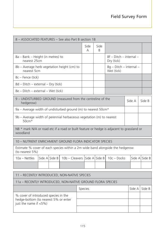
115
11 – RECENTLY INTRODUCED, NON-NATIVE SPECIES
11a – RECENTLY INTRODUCED, NON-NATIVE GROUND FLORA SPECIES
Species Side A Side B
% cover of introduced species in thehedge-bottom (to nearest 5% or enterjust the name if <5%)
10 – NUTRIENT ENRICHMENT GROUND FLORA INDICATOR SPECIES
Estimate % cover of each species within a 2m wide band alongside the hedgerow (to nearest 5%)
10a – Nettles Side A Side B 10b – Cleavers Side A Side B 10c – Docks Side A Side B
9 – UNDISTURBED GROUND (measured from the centreline of thehedgerow)
Side A Side B
9a – Average width of undisturbed ground (m) to nearest 50cm*
9b – Average width of perennial herbaceous vegetation (m) to nearest50cm*
NB * mark N/A or road etc if a road or built feature or hedge is adjacent to grassland orwoodland
8 – ASSOCIATED FEATURES – See also Part B section 18
SideA
SideB
8a – Bank – Height (in metres) to nearest 25cm
8f – Ditch – internal –Dry (tick)
8b – Average herb vegetation height (cm) tonearest 5cm
8g – Ditch – internal –Wet (tick)
8c – Fence (tick)
8d – Ditch – external – Dry (tick)
8e – Ditch – external – Wet (tick)
Field Survey Form

116
14 – INTEGRITY – Continuity and height of canopy along hedgerow
14a – % GAPS – percentage gaps, to nearest 5%
14b – Any gaps >5m? (Y/N) 14c – Average height of base ofcanopy (m) to nearest 25cm
13 – DIMENSIONS
13a – Average Height (m)Excluding bank, to nearest 25cm
13b – Average Width (m)At the widest point of canopy;excluding bank, to nearest 25cm
12 - HEDGEROW SHAPE – See also Part B section 19a
What shape is the hedgerow? – Circle diagram of cross-section that most closely resembles hedgerow.
a) Trimmed & dense b) Intensively managed c) Untrimmed d) Tall & leggy
e) Untrimmed, withoutgrowth
f) Recently coppiced(facing view)
g) Recently laid(facing view)
h) Other – Sketch
11b – RECENTLY INTRODUCED, NON-NATIVE WOODY SPECIES
Species Side A Side B
% cover of introduced species in theshrub layer (to nearest 5% or enter justthe name if <5%)
Appendix 6

117
15 – ISOLATED HEDGEROW TREES – See also Part B section 21
Use one row per specimen or one row and a number if there are many individuals of the samespecies in the same size class. Estimate DBH to nearest 5cm or nearest 1cm if DBH less than 5cm.
Species DBH(cm)
Species DBH(cm)
Field Survey Form

118
17 – WOODY SPECIES IN 30m SURVEY SECTION ONLY – Add any others, including non-natives
SpeciesShrubs
%cover
TreesNo. Species
Shrubs%
cover
TreesNo.
Alder, common (Alnus glutinosa) Plum, wild (Prunus domestica)
Apple, crab (Malus sylvestris) Poplar, black (Populus nigra betulifolia)
Ash (Fraxinus excelsior) Privet, wild (Ligustrum vulgare)
Aspen (Populus tremula) Rose, dog- (Rosa canina)
Beech (Fagus sylvatica) Rose, field- (Rosa arvensis)
Birch, downy (Betula pubescens) Rose (Rosa sp.)
Birch, silver (Betula pendula) Rowan (Sorbus aucuparia)
Blackthorn (Prunus spinosa) Spindle (Wuonymus europaeus)
Broom (Cytisus scoparius) Sycamore (Acer pseudoplatanus)
Buckthorn (Rhamnus cathartica) Wayfaring-tree (Viburnum lantana)
Cherry, wild (Prunus avium) Willow, grey (Salix cinerea)
Dogwood (Cornus sanguinea) Willow, goat (Salix caprea)
Elder (Sambucus nigra)
Elm, English (Ulmus procera)
Elm, wych (Ulmus glabra)
30m SURVEY SECTION ONLY
16 – NOTES – Whole hedgerow or 30m survey section
16A – Fauna (evidence of)
16b – Features (including evidence of recent planting)
16c – Photograph numbers (and locate on map)
Appendix 6

119
17 – WOODY SPECIES IN 30m SURVEY SECTION ONLY – Add any others, including non-natives(continued)
SpeciesShrubs
%cover
TreesNo. Species
Shrubs%
cover
TreesNo.
Elm, (Ulmus sp.)
Gorse (Ulex europaeus)
Gorse, western (Ulex gallii)
Guelder rose (Viburnum opulus)
Hawthorn (Crataegus sp.)
Hazel (Corylus avellana)
Holly (Ilex aquifolium)
Hornbeam (Carpinus betulus)
Lime, large-leaved (Tilia platyphyllos)
Lime, small-leaved (Tilia cordata)
Maple, field (Acer campestre) Bramble (Rubus fruticosus agg.)
Oak, pedunculate (Quercus robur) Honeysuckle (Lonicera periclymenum)
Oak, sessile (Quercus petraea) Ivy (Hedera helix)
Pear, (Pyrus communis sensu lato) Traveller’s-joy (Clematis vitalba)
Pine, Scots (Pinus sylvestris) % Gaps/access openings
Field Survey Form

120
PART B – OPTIONAL ASSESSMENTS
18 – ASSOCIATED FEATURES
18a – Banks
Typical cross section of hedgerow-banks where present (please circle one)
a) Half-bank b) Full hedge-bank c) Other (sketch)
Bank type and management
Bank type Bank Management
Stone Earth None Fenced off Grazed Mown/cut
Side A
Side B*
18b – Ditches/Streams
Side A Side B*
Ditch/stream – Width at base (m) to the nearest 25cm
Appendix 6

121
19b – Hedge-bottom ManagementMowing/cutting
Herbicides Cultivation Grazing None
Signs of Recent Management <2 years
Signs of Management 2-10 years
19 – HEDGEROW/MARGIN MANAGEMENT
19a – Hedgerow ManagementFlailed/
trimmedCoppiced Laid
Planting/Gapping
Pollardingtrees
None
Signs of Recent Management <2 years
Signs of Management 2-10 years
Signs of older Management >10 years
18c – Walls and Fences
Fence Side A Side B* Dry-stone Wall – Condition Side A Side B*
Height (m), to nearest 25cm Good
Type Side A Side B* Poor
Post & rail Remnant
Post & netting Other feature – State Side A Side B*
Post & wire
Other fence – state Side A Side B*
* Where visible
Field Survey Form

122
20 – GROUND FLORA SPECIES PER 30MSpecies % cover Species % cover
Q1 Q2 Q1 Q2
Agrostis sp. Bent Plantago lanceolata –Ribwort plantain
Alopecurus pratensis – Meadowfoxtail Plantago major – Greater plantain
Anthoxanthum odoratum –Sweet vernal-grass
Potentilla reptans – Creepingcinquefoil
Arrhenatherum elatius –False oat-grass Primula vulgaris – Primrose
Cynosurus cristatus –Crested dog’s-tail Pteridium aquilinum – Bracken
Dactylis glomerata – Cocksfoot Ranunculus repens –Creeping buttercup
Elytrigia repens – Couch Rubus fruticosus – Bramble
Festuca rubra – Red fescue Rumex sp. – Docks
Holcus lanatus – Yorkshire fog Senecio jacobaea – Ragwort
Holcus mollis –Creeping soft-grass Silene dioica – Red Campion
Lolium perenne –Perennial rye-grass
Stellaria holostea –Greater stitchwort
Phleum pratense – Timothy Trifolium pratense – Red clover
Poa annua –Annual meadow-grass Trifolium repens – White clover
Poa trivialis –Rough meadow-grass Urtica dioica – Common nettle
Veronica chamaedrys – Ivy-leavedspeedwell
Viola sp. – Violet
19c – Margin/Headland Management
Average width (m) Side A Side B*
Margin Management
Grazed Side A Side B* Cut Side A Side B* Unmanaged Side A Side B*
* Where visible
Appendix 6

123
20 – GROUND FLORA SPECIES PER 30M (continued)Species % cover Species % cover
Q1 Q2 Q1 Q2
Achillea millefolium – Yarrow
Alliaria petiolata – Garlic mustard
Anemone nemorosa – Woodanemone
Anthriscus sylvestris – Cow parsley
Arum maculatum – Lords-and-ladies
Centaurea nigra – Commonknapweed
Cirsium arvense – Creeping thistle
Cirsium vulgare – Spear thistle
Galium aparine – Cleavers
Galium mollugo – Hedge bedstraw
Geranium dissectum –Cut-leaved cranesbillGeranium molle –Dove’s-Foot cranesbill Bryophytes – mosses & liverworts
Geranium robertianum – Herb-Robert Bare ground
Glechoma hederacea – Ground ivy Location of quadrats
Hedera helix – Ivy Under canopy
Heracleum sphondylium – Hogweed Bank
Hyacinthoides non-scripta – Bluebell Verge
Mercurialis perennis – Dog’s mercury Field edge
Field Survey Form
Record all ground flora species within each of the two 2 x 1m quadrats and estimate percentage cover tothe nearest 5%.

124
Condition
Percentage of live canopy (To nearest 5%) %
Tick
Dead wood attached to the tree, any piece more than 1m long and 8cm in diameter
Loose, split, missing and dead bark, any piece more than 30cm x 30cm
Bark sap runs
Tears, splits, scars, lightning strikes more than 30cm long
Hollow trunks or hollow major limbs
Major rot sites, any more than 15cm across
Form Maiden Pollard Coppice Other:
21 – VETERAN TREE FEATURES
To be recorded on any tree of 1 metre DBH and over, or any tree smaller if in the truly ancientclass for that species.
SpeciesHedgerowreference
Surveyor Date
Grid Ref 100km Easting Northing
Letters ornumbers 10km 1km 100m 10m 1m 10km 1km 100m 10m 1m
Diameter at Breast Height (1.3m) in metres (To nearest 5cm).
m
Appendix 6

125
Notes – e.g. photograph numbers, threats, landscape/social importance, bracket fungi, mosses, lichens, nest holes etc.
Field Survey Form

126
Survey Summary FormSteering Group for the UK Biodiversity Action Plan forHedgerows
1. Survey title 2. Year(s) of survey
3. Surveyed area
(Place)
4. Report reference(s)
5. Lead body
Contact name Address
Telephone number (including national dialling code)
6. Key partners
7. Survey cost (only include actual expenditure) Total Defra grant ££
ha
Appendix 7
Postcode

127
8. Overview of objectives and results (100 words max)
9. Survey method
Hedgerow Survey Handbook 2nd Edition (without modification) . . . . . . . . . . . . . . . . . . . . . .
Other (specify) . . . . . . . . . . . . . . . . . . . . . . . . . . . . . . . . . . . . . . . . . . . . . . . . . . . . . . . . . . . . . . .
10. Survey type
Full census . . . . . . . . . . . . . . . . . . . . Random sample . . . . . . . . . . . . . . . .
Non-random Sample . . . . . . . . . . . . .
11. Survey level (Refers to different parts of the Field Survey Form – tick all which have been used)
Core Assessments (Part A) . . . . . . . . Associated features/Hedgerows/Marginmanagement (Part B) . . . . . . . . . . . .
Ground flora (Part B) . . . . . . . . . . . . . Veteran tree features (Part B) . . . . . . .
12. Hedgerow length & Numbers Length (km) Number
Total of surveyed Hedgerows
Total in survey area (if different)
Survey Summary Form

128
13. Main hedgerow types (give rough proportions for each type)
*Managed hedges are those which have been trimmed, cut, laid, coppiced or planted in thelast 10 years
14. Main land use of surveyed area:
Grassland . . . . . . . . . . . . . . . . . . . . . Arable . . . . . . . . . . . . . . . . . . . . . .
Other (specify) . . . . . . . . . . . . . . . . . .
15. Proportion of species-rich Hedgerows(% of hedgerows with 5 or more native woody spp/30m or 4 more in N&E England or Scotland)
16. a. Proportion of Hedgerows made up of >80% native woody species(include archaeophytes and sycamore)
16. b. Proportion of Hedgerows made up of >80% native woody species(not including archaeophytes and sycamore)
17. Isolated hedgerow trees % in size classes (cm DBH)(only include large species, e.g. oak, ash, beech and sycamore)
18. Total number of isolated hedgerow trees in survey area
19. Data storage
Standard Microsoft Access Database GIS . . . . . . . . . . . . . . . . . . . . . . . . .
Other (specify) . . . . . . . . . . . . . . . . .
%>100cm%60-100
%20-60%5-20%<5cm
%
%
%
%Linesof trees%Unmanaged
%*Managed%Hedgebanks%RecentPost 1845
%AncientPre 1845%Mixed
species%Hawthorndominated
Appendix 7

129
20. Data held by:
Local Records Centre/ Biodiversity ActionBiological Records Centre . . . . . . . . . Reporting System . . . . . . . . . . . . . . .
Other (please specify) . . .
21. Volunteers
Number of individuals . . . . . . . Number of volunteer days . . . .
22. Changes noted from previous surveys(e.g. extent, condition, woody species diversity, new planting, management, connections) (optional)
Signature Date
Name in BLOCK LETTERS
Contact telephone number
Survey Summary Form

130
Running head
List of recently introduced speciesa) WOODY SPECIES
Broom, Montpellier Genista monspessulana
Butterfly-bush Buddleja spp.
Cherry laurel Prunus laurocerasus
Cornelian cherry Cornus mas
Dogwood, red-osier Cornus sericea
Dogwood, white Cornus alba
Fuchsia Fuchsia magellanica
Gorse, Spanish Genista hispanica
Norway maple Acer platanoides
Oak, evergreen (holm) Quercus ilex
Privet, garden Ligustrum ovalifolium
Rhododendron Rhododendron ponticum
Rose, Japanese Rosa rugosa
Shallon Gaultheria shallon
Snowberry Symphoricarpos albus
Stag’s-horn sumach Rhus typhina
Tamarisk Tamarix gallica
Appendix 8

131
* Except Scot’s pine (Pinus sylvestris) in Northern Scotland
NOTESThis list is not exclusive – there will be other recently introduced species that occur in hedgerows.The following species should not be considered as ‘recent introductions’ for the purposes of this survey: sycamore (Acerpseudoplatanus), horse chestnut (Aesculus hippocastanum), sweet chestnut (Castanea sativa) and wild plum (Prunus domestica,including the plum sub-species bullace/damson, P. domestica ssp. insititia).
c) GROUND FLORA (climbers)
Ground-elder Aegopodium podagraria
Hogweed, giant Heracleum mantegazzianum
Indian balsam Impatiens glandulifera
Knotweed, giant Fallopia sachalinensis
Knotweed, hybrid Fallopia x bohemica
Knotweed, Japanese Fallopia japonica
Montbretias Crocosmia spp
Russian vine Fallopia baldschuanica
Winter heliotrope Petasites fragrans
b) CONIFERS (Pinopsida)
Cedars Cedrus spp.
Cypresses Chamaecyparis spp.
Douglas fir Pseudotsuga menziesii
Firs Abies spp.
Hemlock-spruces Tsuga spp.
Larches Larix spp.
Lawson’s cypress Chamaecyparis lawsoniana
Leyland cypress x Cuprocyparis leylandii
Pines* Pinus spp.*
Spruces Picea spp
Western red cedar Thuja plicata
List of recently introduced species

132
Hedgerow BAP Targets and‘Favourable Condition’ AttributesThe UK Biodiversity Action Plan (BAP) for hedgerows incorporates a number of targets shown inthe table below.
Target 4 relates to the proportion of hedgerows to be in a ‘favourable condition’.
Target Number Description
T1 Maintain the net extent of hedgerows across the UK.
T2 Maintain the overall number of individual, isolated hedgerow trees(estimated by CS 2000 to be 1.8 million in Great Britain in 1998) andthe net number of isolated veteran trees (to be estimated for the first
time by CS 2007).
T3 Ensure that between 2005 and 2010 hedgerows remain, on average, atleast as rich in native woody species.
T4 Achieve ‘favourable condition’ of 243,000 km (35%) of hedgerows by2010 and 348,000 km (50%) by 2015. (Target does not include
Northern Ireland.)
T5 Reverse the unfavourable condition of over-managed hedgerows acrossthe UK by reducing the proportion of land managers who trim most of
their hedges annually to 60% by 2010 (applicable to England only).
T6 Halt further decline in the condition of herbaceous hedgerow flora inGreat Britain by 2010 (and improve their condition by 2015). (Target
does not include Northern Ireland.)
T7 Improve the condition of the hedgerow tree population by increasingnumbers of young trees (1-4 years) in Great Britain to 40,000 by 2010
and 80,000 by 2015. (Target does not include Northern Ireland.)
T8 Achieve a net increase in the length of hedgerows of an average of 800km per year in Great Britain to 2010 and 2015 (Target does include
Northern Ireland.)
Appendix 9

133
The Steering Group for the UK Biodiversity Action Plan for Hedgerows has agreed the followingattributes as defining favourable condition. The Essential Assessments in the Field Survey Formwill allow the relevant information on all these attributes to be collected.
Attribute (section ofrecording form)
Threshold(sub-section ofrecording form)
Method
To be in ‘favourable condition’ a hedgerow must meet all the thresholds listed below.
9 – Undisturbedground & perennialherbaceous vegetationcover
9a – Undisturbedground(At least 2m)
Estimate average width of undisturbed(uncultivated) ground from the centre-lineof the hedgerow. Automatically favourableif borders grassland.
9b – Herbaceousvegetation(At least 1m)
Estimate average width of perennial herbaceousvegetation between the centre-line of thehedgerow and adjacent disturbed ground.
10 – Nutrientenrichment
No suitablethresholds havebeen developed, butshould be less than20% combinedcover of nettles,cleavers and docks
Estimate percentage cover of nettles,cleavers and docks within a 2m wide bandalongside the hedgerow.
11 – Recentlyintroduced, non-native species
11a – Non-nativeherbaceous species.(Maximum 10%)
Estimate cover of all non-native herbaceousspecies as percentage of area of 2m bandextending from centre-line of hedgerow.
11b – Non-nativewoody species.(Maximum 10%)
Estimate cover of all non-native woodyspecies as percentage of area of vertical face of hedgerow.
13 – Size 13a – Height: (At least 1m)
Measure ‘average’ height excluding bank.
13b – Width: (At least 1.5m)
Measure ‘average’ width at widest point ofhedgerow canopy, shoot tip to shoot tip.
Cross-sectional area:Minimum 3m2
Take the ‘average’ height and width for thehedgerow, and multiply to give thecross-sectional area.
Hedgerow BAP Targets and Favourable Condition Attributes

134
Appendix 9
Attribute (section ofrecording form)
Threshold(sub-section ofrecording form)
Method
To be in ‘favourable condition’ a hedgerow must meet all the thresholds listed below.
14 – Integrity/continuity
14a – <10% gaps Estimate total length of gaps present as apercentage of total hedgerow length or30m section (as appropriate).
14b – No gaps >5m wide
Record if any gaps > 5m wide excludingaccess points.
14c – Base ofcanopy less than0.5m above groundfor shrubbyhedgerows
Estimate ‘average’ height from the base ofthe hedgerow to the lowest leafy growth.

135
Veteran tree rule of thumbtrunk diameters
These ‘rules of thumb’ collate the maximum trunk sizes recorded by Mitchell (1974) for each species and adaptingcategories of ‘potentially interesting’, ‘valuable’ and ‘truly ancient’ described by Read (2000) to relate to thesemaximum trunk sizes.
Species Diameter at Breast Height (1.3m) in metres
Max diameter Potentiallyinteresting
Valuable Truly ancient
Acer campestre 0.96 0.31 0.45 0.60
Acer platanoides 1.27 0.41 0.60 0.80
Acer pseudoplatanus 2.23 0.71 1.05 1.39
Aesculus hippocastanum 2.04 0.65 0.96 1.27
Alnus glutinosa 1.18 0.38 0.55 0.74
Alnus incarna 0.64 0.20 0.30 0.40
Arbutus unedo 0.38 0.12 0.18 0.24
Betula pendula 0.96 0.31 0.45 0.60
Betula pubescens 0.96 0.31 0.45 0.60
Buxus sempervirens 0.25 0.08 0.12 0.16
Carpinus betulus 1.27 0.41 0.60 0.80
Castanea sativa 3.18 1.02 1.50 1.99
Crataegus monogyna 0.96 0.31 0.45 0.60
Fagus sylvatica 1.97 0.63 0.93 1.23
Fraxinus excelsior 1.91 0.61 0.90 1.19
Ilex aquifolium 0.57 0.18 0.27 0.36
Juglans regia 1.91 0.61 0.90 1.19
Malus sylvestris 0.96 0.31 0.45 0.60
Mespilus germanica 0.48 0.15 0.22 0.30
Pinus sylvestris 1.59 0.51 0.75 0.99
Populus x canadensis var serotina 1.91 0.61 0.90 1.19
Populus alba 0.64 0.20 0.30 0.40
Populus nigra 1.59 0.51 0.75 0.99
Populus x canescens 1.59 0.51 0.75 0.99
Prunus avium 1.43 0.46 0.67 0.90
Pyrus pyraster 0.64 0.20 0.30 0.40
Quercus cerris 2.55 0.82 1.20 1.59
Quercus ilex 1.37 0.44 0.64 0.86
Quercus petraea 2.83 0.91 1.33 1.77
Quercus robur 3.18 1.02 1.50 1.99
Robinia pseudoaccacia 1.59 0.51 0.75 0.99
Salix caprea 1.27 0.41 0.60 0.80
Salix fragilis 1.11 0.36 0.52 0.70
Sorbus aria agg 0.60 0.19 0.28 0.38
Sorbus aucuparia 0.80 0.25 0.37 0.50
Appendix 10

136
Species Diameter at Breast Height (1.3m) in metresMax diameter Potentially
interestingValuable Truly ancient
Sorbus intermedia agg 0.64 0.20 0.30 0.40
Sorbus latifolia agg 0.86 0.28 0.40 0.54
Sorbus torminalis 0.89 0.29 0.42 0.56
Sorbus x thuringiaca 0.48 0.15 0.22 0.30
Sorbus x thuringiaca 0.48 0.15 0.22 0.30
Taxus baccata 3.18 1.02 1.50 1.99
Tilia cordata 1.91 0.61 0.90 1.19
Tilia platyphyllos 1.85 0.59 0.87 1.15
Tilia x europea 2.23 0.71 1.05 1.39
Ulmus glabra 2.23 0.71 1.05 1.39
Ulmus minor 1.94 0.62 0.91 1.21
Ulmus procera 2.23 0.71 1.05 1.39
Ulmus x hollandica 1.59 0.51 0.75 0.99
Ulmus x vegeta 1.75 0.56 0.82 1.09
Appendix 10

137
Status of woody speciesin hedgerows
Systematic name Common name
Native11
Acer campestre Field maple
Alnus glutinosa Alder
Berberis vulgaris Barberry
Betula pendula Silver birch
Betula pubescens Hairy birch
Buxus sempervirens Box
Carpinus betulus Hornbeam
Cornus sanguinea Dogwood
Corylus avellana Hazel
Crataegus laevigata Midland hawthorn
Crataegus monogyna Hawthorn
Cytisus scoparius Broom
Daphne laureola Spurge laurel
Daphne mezereum Mezereon
Euonymus europaeus Spindle
Fagus sylvatica Beech
Frangula alnus Alder buckthorn
Fraxinus excelsior Ash
Hippophae rhamnoides Sea buckthorn
Ilex aquifolium Holly
Juniperus communis Juniper
Ligustrum vulgare Privet
Malus sylvestris Crab apple
Pinus sylvestris12 Scot’s pine
Populus nigra ssp betulifolia Black poplar
Populus tremula Aspen
Prunus avium Gean
Prunus padus Bird-cherry
Prunus spinosa Blackthorn
11 Species that are native in part or all UK (see Defra/NE website for country lists).12 Scot’s Pine is only regarded as native in northern Scotland, elsewhere it is classed as an archaeophyte.
Appendix 11

138
Systematic name Common name
Native (continued)
Pyrus cordata Plymouth pear
Quercus petraea Sessile oak
Quercus robur Pedunculate oak
Rhamnus cathartica Purging buckthorn
Ribes alpinum Mountain currant
Ribes rubrum Red currant
Ribes spicatum Erect-spiked red-currant
Rosa agrestis Small-leaved sweet briar
Rosa arvensis Field rose
Rosa caesia Hairy dog rose
Rosa canina agg. Dog rose
Rosa micrantha Small-flowered sweet briar
Rosa mollis agg. Soft downy rose
Rosa obtusifolia Round-leaved dog rose
Rosa rubiginosa Sweet briar
Rosa sherardii Sherard’s downy rose
Rosa stylosa Short-styled field rose
Rosa tomentosa Harsh downy rose
Rubus idaeus Raspberry
Ruscus aculeatus Butcher’s broom]
Salix aurita Eared sallow
Salix caprea Goat willow
Salix cinerea Grey willow
Salix myrsinifolia Dark-leaved willow
Salix pentandra Bay willow
Salix phylicifolia Tea-leaved willow
Salix purpurea Purple osier
Sambucus nigra Elder
Sorbus aria agg Whitebeam
Sorbus aucuparia Rowan
Sorbus domestica Service-tree
Sorbus intermedia agg Swedish whitebeam
Sorbus latifolia agg Broadleaved whitebeam
Sorbus torminalis Wild service tree
Sorbus x thuringiaca (Whitebeam & Rowan hybrid)
Appendix 11

139
Systematic name Common name
Native (continued)
Taxus baccata Yew
Tilia cordata Small leaved lime
Tilia platyphyllos Large-leaved lime
Tilia x europea Common lime
Ulex europaeus Gorse
Ulex gallii Western gorse
Ulex minor Dwarf gorse
Ulmus x vegeta Huntingdon elm
Ulmus glabra Wych elm
Ulmus minor Smooth-leaved elm
Ulmus plotii Plot’s elm
Ulmus procera English elm
Ulmus x hollandica Dutch elm
Viburnum lantana Wayfaring tree
Viburnum opulus Guelder rose
Archaeophyte
Castanea sativa Sweet chestnut
Malus domestica Apple
Mespilus germanica Medlar
Prunus cerasus Sour cherry
Prunus domestica Plum, bullace etc
Pyrus pyraster Pear
Salix alba White willow
Salix fragilis Crack willow
Salix triandra Almond willow
Salix viminalis Common osier
Status of woody species in hedgerows

140
Systematic name Common name
Neophyte/native? – uncertain status
Acer pseudoplatanus Sycamore
Ribes nigrum Black currant
Neophyte
Acer platanoides Norway maple
Aesculus hippocastanum Horse-chestnut
Alnus incarna Grey alder
Arbutus unedo Strawberry tree
Chamaecyparis lawsonii Lawson’s cypress
Cornus mas Cornellian cherry
Cotoneaster microphyllos agg. Small leaved cotoneaster
Euonymus japonicus Evergreen spindle
Fuschia magellanica Fuschia
Juglans regia Walnut
Laburnum anagyroides Laburnum
Larix decidua/ kaempferi/ hybrid Larch
Ligustrum ovalifolium Garden privet
Lycium barbarum Duke of Argyll’s tea plant
Mahonia aquifolium Oregon grape
Pinus sitchensis Sitka spruce
Pittosporum crassifolium/P. tenuifolium Pittosporum
Populus alba White poplar
Populus x canadensis var serotina Black Italian poplar
Populus x canescens Grey poplar
Prunus cerasifera Cherry plum
Pseudotsuga menziesii Douglas fir
Quercus cerris Turkey oak
Quercus ilex Holm oak
Rhododendron ponticum Rhododendron
Ribes uva-crispa Gooseberry
Robinia pseudoaccacia Locust
Sambucus racemosa Red-berried elder
Symphoricarpos alba Snowberry
Syringa vulgaris Lilac
Tamarix gallica Tamarisk
Appendix 11

Published by the Department for Environment, Food and Rural Affairs. © Crown Copyright 2007.
Printed on material that contains a minimum of 100% recycled fibrefor uncoated paper and 75% recycled fibre for coated paper.
www.defra.gov.uk
PB11951