county sligo hedgerow survey report compressed · 3.2 the objectives of the county sligo hedgerow...
TRANSCRIPT
COUNTY SLIGO HEDGEROW SURVEY REPORT
N. Foulkes
12th December 2008
Sligo County Council
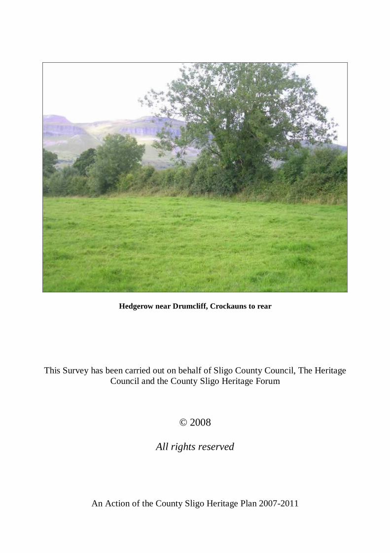
Hedgerow near Drumcliff, Crockauns to rear
This Survey has been carried out on behalf of Sligo County Council, The Heritage Council and the County Sligo Heritage Forum
© 2008
All rights reserved
An Action of the County Sligo Heritage Plan 2007-2011
i
PAGE NO. CONTENTS i LIST OF TABLES iii LIST OF FIGURES iii ACKNOWLEDGEMENTS iv EXECUTIVE SUMMARY 1 1.0 INTRODUCTION 2 2.0 BACKGROUND 3 2.1 The history of hedgerows in County Sligo 3 2.2 The value of hedgerows for County Sligo 5 3.0 SURVEY RATIONALE AND OBJECTIVES 6 3.1 The need for a hedgerow survey in County Sligo 6 3.2 The objectives of the County Sligo Hedgerow Survey 7 3.3 Legislation and policy 7 4.0 METHODOLOGY AND FIELD SURVEY 9 4.1 Defining hedges 9 4.2 Selecting the sample 9 4.3 Maps and aerial photographs 11 4.4 Period of fieldwork 11 4.5 Access and permission 12 4.6 Structural recordings of hedges 12 4.7 Floristic recordings of hedges 13 4.8 Recording the extent of hedgerows in sample squares 13 4.9 Target notes 14 4.10 Photography 14 4.11 Data recording 14 5.0 RESULTS OF THE COUNTY SLIGO HEDGEROW SURVEY 15 5.1 Extent of hedgerows in County Sligo 15 5.2 Species composition of hedgerows in County Sligo 17
5.3 General ecological, historical, and agricultural context of hedgerows in County Sligo. 28
5.4 Construction of hedges in County Sligo. 33 5.5 Structure and condition of hedges in County Sligo. 37 5.6 Management of hedges in County Sligo. 45 5.7 Quality of hedgerows in County Sligo 49 5.8 Hedgerow management and development control 51 5.9 Other observations 53 6.0 ANALYSIS AND DISCUSSION 55
ii
7.0 RECOMMENDATIONS 72 7.1 Context 72 7.2 Recommendations 75 8.0 CONCLUSIONS 82 9.0 REFERENCES AND BIBLIOGRAPHY 83 10.0 APPENDICES 90 10.1 Example of aerial photograph 90 10.2 Example of vector map showing sample hedges 91 10.3 Example of Ordnance Survey map 92 10.4 Structural recording categories 93 10.5 Domin scale 94 10.6 DAFOR scale 94
10.7 Hedgerow related actions of the County Sligo Heritage Plan 2007-2011 94
10.8 Methodology review 95 10.9 Draft hedgerow conservation policies for County Sligo 98 10.10 List of species encountered during the survey 100
LIST OF TABLES
Table 4.7.1 List of woody non-shrub species recorded. Table 5.1.1 Measurement of hedgerow extent in sample squares in County Sligo. Table 5.2.1 Frequency of woody shrub species occurrence and mean abundance in
sampled County Sligo hedges. Table 5.2.2 Frequency of woody non-shrub species occurrence in sampled hedges. Table 5.2.3 Average number of shrub species per hedge (within the two 30m sample
strips) Table 5.2.4 Comparison of average species diversity figures for townland boundary and
roadside hedges. Table 5.2.5 Frequency of tree species occurrence in sampled County Sligo hedges. Table 5.3.1 Frequency of occurrence of sampled County Sligo hedges in CORINE land
cover classes. Table 5.7.1 Comparison of the ‘favourable condition’ status of hedges County by County. Table 5.8.1 Summary of hedgerow-related planning conditions. Table 6.1 Comparison of average hedgerow density. Table 6.2 Comparison of shrub species diversity statistics. Table 6.3 Proportion of species rich hedges in County Hedgerow Surveys. Table 7.1 List of hedgerow stakeholder groups. LIST OF FIGURES
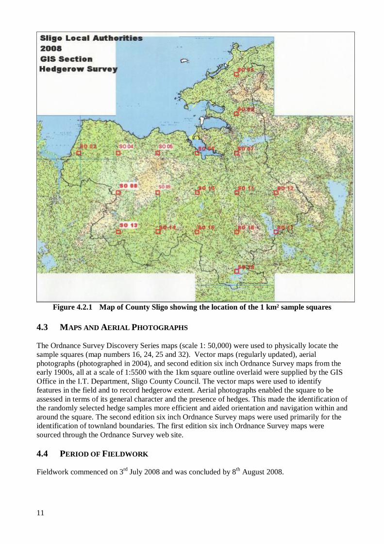
Figure 4.2.1 Map of County Sligo showing the location of the 1 km² sample squares Figure 5.1.1 Distribution of sampled hedges in County Sligo. Figure 5.2.1 Frequency of occurrence of main woody shrub species in sampled hedges in
County Sligo. Figure 5.2.2 Level of abundance of woody non-shrub species in sample strips in County
Sligo.
iii
Figure 5.2.3 Distribution of main hedgerow species in sample squares. Figure 5.2.4 Distribution of species rich hedges in the sample squares. Figure 5.2.5 Percentage breakdown of domination of ivy at canopy level in sample 30m
strips. Figure 5.3.1 Farm / property use of land adjacent to sampled hedgerows. Figure 5.3.2 Habitat category of land adjacent to sampled hedgerows. Figure 5.3.3 Links of sampled hedgerows with habitats in County Sligo. Figure 5.3.4 Historical context of sampled hedgerows. Figure 5.4.1 Boundary construction of sampled hedgerows. Figure 5.4.2 Proportion of sampled hedges in bank/wall/shelf size categories. Figure 5.4.3 Proportion of sampled hedges with adjacent drains and their associated drain
size categories. Figure 5.5.1 Proportion of sampled hedges in hedge height categories. Figure 5.5.2 Proportion of sampled hedges in hedge width categories. Figure 5.5.3 Proportion of sampled hedges in ‘percentage gaps’ categories. Figure 5.5.4 Proportion of sampled hedges in basal density categories. Figure 5.5.5 Proportion of sampled hedges in profile categories. Figure 5.5.6 Proportion of sampled hedges in abundance level of hedgerow trees
categories. Figure 5.5.7 Proportion of sampled hedges having degraded banks or walls. Figure 5.6.1 Types of hedgerow management recorded in hedges sampled. Figure 5.6.2 Proportion of managed sampled hedges in management method categories. Figure 5.6.3 Additional fencing of sampled hedgerows. Figure 5.7.1 Favourable condition status of sampled hedges in County Sligo. ACKNOWLEDGEMENTS Many people have contributed their time and support to this project. Thanks are primarily due to: County Sligo Heritage Forum for commissioning the project through the County Sligo Heritage Plan 2007-2011 and to Sligo County Council and The Heritage Council for funding this survey. Siobhán Ryan, Heritage Officer and Barbara Dobson in the Heritage Office, Sligo County Council. Members of the County Sligo Heritage Forum, in particular the members of the Natural Heritage Working Group who oversaw the delivering of the project: Ben Wilkinson; Brian McGarraghy; Caroline Sheil; Declan Feeney; Don Cotton; Jean Dunleavy; Martin Enright; Michael Archer; Michael Casey; Noel Raftery; Therisia Roddy; Tim Roderick; Will Woodrow and Gerard Scott. Cian Lundy for his assistance in providing Planning Application details. Theresa Gilligan and Billy Sommerville of the IFA, and the County Sligo Executive of the IFA. Caroline Conmy, GIS Office, Sligo County Council for back-up support in providing maps and aerial photographs: Anthony Byrne, Planning Section, for inputting ‘extent’ data into the Councils GIS database. Andy Booth and Robert Birtwistle who provided support with the fieldwork. My gratitude is also extended to all the landowners who allowed access to their land during this survey. If I had accepted all of the invitations to take tea I would still be out there.
1
EXECUTIVE SUMMARY
Sligo is a maritime county in the province of Connaught. It is bounded on the east by County Leitrim, on the north by the Atlantic Ocean, on the west and south by County Mayo and on the south-east by County Roscommon. It comprises an area of 1800 km² (695 miles²). County Sligo’s hedgerow network is an asset to the county, being valuable in terms of agriculture, landscape, wild flora and fauna, water quality, carbon sequestration and employment.
In the summer of 2008, field recording of hedgerows was carried out using a standard methodology in 18 sample 1 km squares distributed evenly around the county, covering approximately 1% of its total area. The focus of the survey was to record information on the extent, species composition, structure, condition and management of hedgerows in County Sligo. At the request of the Natural Heritage Working Group compliance with recent hedgerow related planning consents was also investigated. Results from the County Sligo survey were compared with those from similar hedgerow surveys conducted in County Mayo in 2007, County Cavan, East Galway, Longford, Kildare and Leitrim in 2006, County Laois and County Offaly in 2005, and Counties Roscommon and Westmeath during 2004. Based on the results from the sample, the total length of hedgerow in County Sligo was estimated at 10449km, and the average figure for hedgerow density as 5.33 kilometres per square kilometre (km/km²). Examination of Ordnance Survey maps indicates that the majority of hedgerows in the county originated between 1837 and 1912. A total of 24 shrub and tree species, including 13 native species, were recorded in the sampled hedges. Whitethorn is the most frequently occurring shrub species found in 88% of hedges; Ash is the most common tree species, occurring in 47% of hedges in tree form. There was an average of 2.71 tree/shrub species per 30m sample strip. 73% of hedgerows sampled comprised solely of native species. Approximately 13% of hedges recorded were classed as ‘species rich’, with the majority of these found in the eastern half of the county. Hedges with drains were found, on average, to contain greater species diversity than those with no drains. Roadside hedges made up 17% of the sample, with Townland boundaries accounting for 8%. The majority of hedges were of a standard construction involving a single line of shrubs with a bank; whitethorn was the dominant species in 60% of hedges indicating a planted origin for much of the resource. Levels of management were found to be relatively low with 55% of hedges having no evidence of management within the last five years or more, although almost a quarter of hedges had been managed within the last year. 17% were considered to be redundant in terms of their agricultural function as field boundaries. In relative terms, the hedges recorded during the County Sligo survey compare favourably with those from other counties in respect of their structural characteristics. 22% of hedges met a series of ‘favourable condition’ criteria linked to structure and species composition. The level of gappiness
2
and the basal structure were the two categories responsible for the majority of the hedges failing to meet the ‘favourable condition’ criteria. Evidence of old hedge laying was noted in 19% of the hedges sampled, this is well above the rates found in other western counties. The pattern of distribution suggests that the technique was widespread. However, no examples of recent hedge laying were recorded in sample hedges. The level of compliance with hedgerow-related planning conditions was low in the survey area. Hedgerows do not generally qualify for designation and protection. It is therefore important that appropriate conservation measures are adopted in order to safeguard the resource. Based on the hedgerow survey results, a series of recommendations were made, applicable at a National and County level. The recommendations promote current best practice with regard to hedgerow conservation. Draft Hedgerow Conservation Policies for County Sligo As a result of the survey, Draft Hedgerow Conservation Policies were drawn up for County Sligo (Appendix 10.8). These draft policies will form the basis of a Hedgerow Conservation policy for County Sligo to be implemented by the partner organisations, subject to adequate resources being in place. It is recommended that the draft Hedgerow Conservation policies should be further developed and adopted as a County Hedgerow Policy by the relevant project partners and stakeholders in the short-medium term. 1.0 INTRODUCTION Hedgerows are a valuable multi-functional resource in our countryside, benefiting agriculture, wildlife, the environment, tourism and the general community. However there is only limited and localised data on the current extent, nature, variation and condition of Irish hedgerows. For the purposes of this survey hedgerows are defined as “Linear strips of woody plants with a shrubby growth form that cover more than 25% of the length of a field or property boundary. They often have associated banks, walls, ditches (drains), or trees”. This sample study examines the extent, species composition, structure, condition and management of hedgerows in County Sligo. This information can then be used to further the objectives of the County Sligo Heritage Plan 2007-2011 which identifies a number of actions, directly or indirectly, interrelated to hedgerow conservation and management (see Appendix 10.7). The Sligo County Development Plan 2005-2011 has an objective to protect, enhance and conserve hedgerows in the county.
3
2.0 BACKGROUND 2.1 THE HISTORY OF HEDGEROWS IN COUNTY SLIGO The history of field boundaries, including hedgerows is closely linked with land use and ownership patterns. Under the Gaelic system of joint land ownership there was little need for permanent enclosure or fencing. Instead, tillage plots were protected with fencing for one season before being moved. There is, however, some evidence to suggest that some ring forts were set (planted) with blackthorn and whitethorn. Permanent banks with or without hedges on them may also have existed.
The Norman conquest meant the eclipse of many Gaelic lords and chieftains. It was the Normans who introduced the concept of private land ownership as they spread throughout Ireland during the 13th century. They introduced the Feudal System, whereby tenants had to rent fixed plots of land from the landlord. The division of land and enclosure of commons was encouraged, and in some cases enforced by landlords.
By later medieval times (mid 14th to end of 15th centuries), townlands had become the fundamental unit of land tenure. Most would have been demarcated by natural boundaries such as rivers and streams, but some were bounded by constructed banks, walls or ditches. The banked boundaries in particular often had hedges too. The land within was largely unenclosed, though this was dependent on the landowner and their preferences. Townland boundary hedges thus tend to have larger banks and ditches than other hedges, and are often among the oldest hedges in the landscape. For these reasons they may also contain a more diverse flora than other, non townland boundary hedges. Sligo was established as a Shire in 1576 during the reign of Elizabeth 1 (1558-1603). This origin of the estate system in the seventeenth century resulted in major agrarian landscape change and the associated establishment of fields, particularly in the more prosperous agricultural regions of Ireland (Aalen et el. 1997). In 1721 the Irish Parliament passed an Act “to oblige proprietors and tenants of neighbouring lands to make fences between their several lands and holdings ... at equal expense in making between such several lands and holdings good and sufficient ditches of six foot wide and five foot deep at least, where the same is practicable, well and sufficiently quicked in good husbandlike manner with white thorn, crab and other quicksets, where the same will grow, and, in ground where such quicksets will not grow, with furze”. The term ‘quick’ or ‘quickset’ refers to young hedging plants, usually whitethorn (hawthorn). The main period of land enclosure in Ireland was during the period 1740-1830. Agricultural improvement through land rotation programmes necessitated protection of crops by restricting the movement of livestock to particular fields. It was during this period that the familiar patchwork landscape of hedged fields largely came into being. In his Topographical Dictionary (1837), Samuel Lewis makes reference to the field boundaries in County Sligo “The fences in some parts are broad ditches faced with stone or sods, and sometimes planted with quicksets; in others they are dry stone walls”. He also noted that the planting of forest trees in hedgerows “is becoming every year more customary”. Current townland boundaries were regularised by the first Ordnance Survey carried out in Sligo in 1837; although there is evidence to suggest that some current townland boundaries may exist as a
4
result of relatively recent revisions and realignments and that some older boundaries that may have once formed part of townland boundaries in the past are no longer so (Murray 2001). The population increases of the 18th and 19th centuries necessitated the intensive reclamation of much previously un-cultivated land, due in no small part to the success of the potato and the desire of landlords to extract maximum rents from their lands. Initially settlement would have spread along new roads. However, as pressure on land increased, communal mountain pasture lands above the 150m contour were exploited and small farms developed on mountain slopes. In areas where stone was plentiful walls would have been the most practical form of boundary. Earthen banks faced with stone would also be common in County Sligo.
The county was badly affected by the Great Famine. The 'official' statistics for the county show that the population dropped from 180,886 in 1841 down to 128,515 in 1851. In the aftermath of the famine, strong farmers increased their holdings at the expense of weaker neighbours. The “Land League” was initiated in County Mayo during 1879 by Michael Davitt, James Daly, and others, which brought about great social change and led to long term reorganisation of the rural landscape. It is to this period that the majority of the current field systems, rural settlement patterns and hedgerows in County Sligo date. The Congested Districts Board (CDB) initiated infrastructure development, agricultural improvement and promoted changes in the countryside including encouraging the dispersion of farms and reorganising land-holdings. Clustered farm settlements and rundale holdings were replaced by owner occupied strip holdings. The second edition Ordnance Survey maps (1909-12) show enclosure patterns much more consistent with those of the current day indicating that a substantial part of the hedgerow network in the county would have been established between the famine and the end of the nineteenth century.
The Grand Juries, forerunners to the County Councils, were responsible for many road building programmes in the late eighteenth and early nineteenth centuries. A measure of funding was often provided for the provision of roadside hedges. Other hedgerows in the county may owe their origin to other transport routes. The building of Railways (1847-1860s), would also have involved the planting of many miles of hedgerow. Intensification of farming and the development of larger machinery resulted in hedgerow removal on many farms particularly during the 1960s and ‘70s. The absence of any comparable survey data means that it is not possible to quantify the extent of the loss, but a comparison of the current status with field boundary patterns from the second edition Ordnance Survey maps from the early part of the twentieth century would suggest that hedgerow loss is a fraction of what occurred in Britain during a similar period. Large scale mechanisation has been less of a feature of agricultural development in western counties and hedgerow removal rates are likely to be much lower in County Sligo in comparison with midland and eastern counties. In the early 1990s increased emphasis on environmental conservation in connection with agriculture (largely driven by the EU) resulted in the Department of Agriculture and Food introducing the Rural Environmental Protection Scheme (REPS). The objectives of the REPS are:
To establish farming practices and production methods that reflect the increasing concern for conservation, landscape protection and wider environmental problems.
To protect wildlife habitats and endangered species of flora and fauna. To produce quality food in an extensive and environmentally friendly manner.
Hedgerow conservation is an intrinsic component of the scheme. The design and operation of the
5
REPS will be a primary mechanism for hedgerow conservation in Ireland for the foreseeable future. 2.2 THE VALUE OF HEDGEROWS FOR COUNTY SLIGO Hedgerows perform a number of important and diverse functions and are of intrinsic value in their own right. The key values and services provided by hedgerows are now described below.
Landscape The patchwork of fields and hedgerows, along with stonewalls, endow the lowland countryside with a distinctive and attractive appearance. The flowering and fruiting of hedgerow shrubs give a colour and fragrance to the summer countryside that is unique. In particular, regional and local variations in hedgerows give character to a townland or area and lead to a sense of place. They frame the passage through much of the countryside by lining the roads and in certain areas give the impression of a wooded landscape. Agriculture Although the hedgerow network is largely a result of 18th and 19th century farming methods, hedges still have many benefits for the modern farmer. Apart from their basic function as cheap (Meyen, 1997) and environmentally friendly stock-proof boundaries, they provide vital shelter and protection of stock and crops across the county. By trapping airborne viruses they can prevent the spread of disease between farms and they can prevent animals from neighbouring farms coming in direct nose to nose contact. Good hedgerows reduce wind speeds and thus protect against soil erosion. Flora and Fauna Hedgerows are home to a range of wild flowers and flowering and fruiting trees and shrubs, all of which form an essential part of the food chain. They support invertebrates like butterflies, moths, ladybirds, beetles, bumblebees and hoverflies. In turn, two thirds of our bird species nest in hedgerows, finding essential food and shelter within. Birds of prey like kestrels, merlins, owls, and sparrow-hawks use hedgerows for hunting along. Bats depend on hedgerows for shelter, roosting, and most importantly for their insect food. Hedges can also support other mammals like bats, wood-mice, hedgehogs, and badgers.
Hedges as habitat corridors The network of hedges across the country provides links between surviving fragments of other wildlife habitats, thereby allowing the movement and dispersal of species through agricultural landscapes. This network is strategic to the conservation of much of our native flora and fauna, more especially in parts of the county where tillage and reseeded pasture are common. The quality of any particular hedge, in terms of its height, width, density, and general structure and condition (especially the amount and size of gaps), determines the extent to which it will act as a corridor for species movement and dispersal. However, even a relatively poor hedge may be important in an otherwise intensive agricultural landscape. Water Quality Hedges play a role in helping to maintain and improve water quality. The root systems of hedgerow shrubs and trees regulate the movement of water through the landscape, absorbing and recycling nutrients, thus reducing the risk of pollution, whilst also reducing the potential for flooding. Hedges also stop sediment from moving down-slope, preventing excessive siltation in waterways. ‘Siltation’ is the clogging up of river beds with fine grained particles like soil. It contributes to the deterioration of aquatic habitats, preventing salmon and trout from spawning.
6
Carbon Sequestration Estimating an average hedgerow width of two metres, hedgerows cover an approximate area of 764 square km of the country and potentially play a role in meeting Ireland's obligations under the Kyoto Protocol (see section 3.3). However this is not factored in to the carbon budget at present.
Employment A number of people derive at least part of their income directly or indirectly from the management of hedges. No estimate has been made of the economic impact of the management of the hedgerow resource in Ireland.
A Material Resource In respect of native and naturalised species, a significant proportion of the country’s broadleaf tree resource is contained within hedgerows. These provide the raw materials for a variety of crafts, and are also a source of carbon-neutral fuel. 3.0 SURVEY RATIONALE AND OBJECTIVES 3.1 THE NEED FOR A HEDGEROW SURVEY IN COUNTY SLIGO As will be seen from section 4.3, hedgerow conservation in Ireland is embraced through legislation, policy and incentive. Any attempts to promote hedgerow conservation need to be based on an accurate and meaningful assessment of the current resource. Until now there has been no systematic record made of the current extent, species composition, structure, condition and management of the hedgerows of County Sligo. The Hedgerow Survey provides useful information in a variety of ways; It gives a snapshot of the quantity and character of the hedgerows in the county. This
information serves as a benchmark for future surveys. Repeat surveys (using the same samples) will provide a useful tool in monitoring
environmental change. It is possible to identify current and potential future threats facing the resource by assessing
the results in light of current best practice in hedgerow conservation. The survey identifies plant life local to the county. Comparisons can be drawn between hedgerows under different management regimes. Detailed information collated as part of the County Sligo Hedgerow Survey can complement
data collated from other habitat related studies, e.g. The Badger and Habitats Survey of Ireland (Smal 1994); The Countryside Bird Survey (Birdwatch Ireland, ongoing study).
The County Sligo Hedgerow Survey can be placed in its national context when viewed alongside other surveys based on the same methodology.
Provides valuable baseline data which will be essential in planning and implementing a future Biodiversity Action Plan for County Sligo.
The survey results and conclusions will also provide a useful tool for decision makers, advisory bodies and educational institutions including;
Local Authority Planners National Roads Authority Road Engineers

7
Landscape Planners Environmental Consultants, particularly in drawing up Environmental Impact Statements Department of Agriculture and Food Teagasc Farmers, land owners and estate managers Foresters Schools, Colleges, and Universities State Bodies – National Parks and Wildlife Service, CIE, Waterways Ireland, etc. Local Communities, Tidy Town and Development groups
3.2 THE OBJECTIVES OF THE COUNTY SLIGO HEDGEROW SURVEY
To carry out a detailed field survey of hedgerows in County Sligo, quantifying their extent, composition, structure, condition and management.
To use the information gathered to make recommendations on conservation policies and
priorities, and to inform any future studies that should be carried out.
To develop a county hedgerow policy for Sligo in consultation with interested parties.
To hold a seminar to disseminate the findings of the project to a wider audience.
To collate and make this information available for future research, through a detailed survey report and set of raw data (including maps and appendices).
3.3 LEGISLATION AND POLICY Various legislative Acts, Directives, and Guidelines (International, European, and National) reflect the importance of the hedgerow resource and its management. These are listed below with a summary given for those having the most direct relevance. International
The Kyoto Protocol (1997) This calls for the “Protection and enhancement of sinks and reservoirs of greenhouse gases.” In the process of photosynthesis, hedgerow trees and shrubs take in Carbon Dioxide and release oxygen. Carbon Dioxide is a major greenhouse gas.
European Union
(EU) Habitats Directive (1992) Article 10 of the Directive states that, “Member States shall endeavour in their land-use planning and development policies, to encourage the management of features of the landscape which are of major importance for wild flora and fauna." Special Areas of Conservation (SAC’s) are designated under the Habitats Directive. Restrictions would apply to hedgerows that fall within SAC’s.
(EU) Birds Directive (1979) Article 3 of the Directive states that “Member States shall take the requisite measures to preserve, maintain, or re-establish a sufficient diversity or area of habitats for all the species
8
of birds referred to in Article 1” - i.e. -all species of naturally occurring birds in the wild state. Special Protection Areas (SPA’s) are designated under the Birds Directive. Restrictions would apply to hedgerows that fall within SPA’s.
(EC) Council Regulations 2078/1992 (Agri-Environmental Schemes) The Rural Environmental Protection Scheme (REPS) operates under this European Regulation. Specifications set down the conditions by which participant farmers in the Scheme must manage their hedgerows. 1257/1999 (Good Farming Practice) Water Framework Directive (2000) Nitrates Directive (1991) In order to reduce or prevent pollution of watercourses one of the objectives of the Nitrates Directive is to limit the losses of nitrates linked to agricultural activities. To this end the Nitrates Directive promotes the "Buffer" effect of non-fertilised grass strips and hedges along watercourses and ditches.
National
The Wildlife Act, (1976), as amended by the Wildlife (Amendment) Act, 2000 The purpose of Section 40 of the original Act, as amended by Section 46 of the Amendment, is to protect breeding birds during the nesting season by establishing a prohibition on the cutting of hedges during the period from 1st March to 31st August (inclusive) each year.
The Roads Act, (1993) Owners or occupiers of land are obliged to take all reasonable steps to ensure that any roadside hedge is; “not a hazard or potential hazard to persons using a public road and that it does not obstruct or interfere with the safe use of a public road or the maintenance of a public road”. Also, under this Act, a road authority must prepare an Environmental Impact Statement (EIS) for motorways and dual carriageways over 8kms in rural areas.
Planning and Development Act, (2000) Architectural Conservation Areas (ACA’s) are designated under the Planning and Development Act. Development plans for ACA’s may contain objectives and policies for any hedgerows within the ACA. Local Authorities can also make Tree Preservation Orders (TPO’s), but currently there are no TPO’s designated in respect of hedgerows (Hickie, 2004).
National Biodiversity Plan (2002) Produced in response to the Convention on Biological Diversity (CBD, Rio de Janeiro, 1992), the plan has a number of actions that are relevant to hedgerow conservation. These include; Action 32: "Review options on Regulation of Hedgerow Removal and Produce guidelines on
Hedgerows and Biodiversity." This should be taken in the context of paragraph 2.27 of the plan which states: "Field boundaries, mainly hedgerows, are a particularly prominent feature of the Irish countryside and provide important habitats for a variety of species. Hedgerows have suffered significant losses. Current legal controls for their protection are limited. For the future, the overall goal should be to have no net loss of the hedgerow resource." Action 10 states, under “Integrating Biodiversity into Sectors”, “Each Local Authority to prepare a Local Biodiversity Plan in consultation with relevant stakeholders.” Further actions will also have an impact of hedgerow conservation. Examples include:
Action 34: “The Department of Arts, Heritage, Gaeltacht and the Islands will develop Guides
9
to Best Practice with Local Authorities and other relevant bodies to safeguard biodiversity. These will, inter alia, normally require such bodies to use native species and seed stock in their tree planting programmes and to employ other environmentally beneficial management practices (e.g. cease using herbicides).”
National Heritage Plan (2002) The National Heritage Plan recognises hedgerows as prominent and important features in terms of their ecological, archaeological and landscape values. Action 32 (Heritage in the Countryside) ensures the “protection and enhancement of hedgerows as a natural and archaeological heritage resource through the use of regulatory, educational and financial measures, as appropriate.”
Electricity Supply Act, (1927) Article 98 of the above Acts permits any “authorised operator” to “lop or cut any tree, shrub or hedge which obstructs or interferes” with electric wires.
Communications Regulations Act, (2002) Article 58 of the above Acts permit any “authorised operator” to “lop or cut any tree, shrub or hedge which obstructs or interferes” with the physical infrastructure of the network.
The Forestry Act, (1946) Section 37 deals with the issue of the “Notice of intention to uproot or cut down trees”.
Sustainable Rural Housing Guidelines (2005) The guidelines on Roadside Boundaries state that “The removal of existing roadside boundaries, except to the extent that this is needed for a new entrance, should be avoided where at all possible except where required for traffic safety purposes.”
4.0 METHODOLOGY AND FIELD SURVEY The County Sligo Hedgerow Survey was carried out to the methodology described in “A Methodology for the recording of hedgerow extent, species composition, structure, and condition in Ireland” (Foulkes and Murray, 2006). 4.1 DEFINING HEDGES For the purpose of this survey hedges are defined as “Linear strips of woody plants with a shrubby growth form that cover more than 25% of the length of a field or property boundary. They often have associated banks, walls, ditches (drains), or trees” Sampled hedgerows were a minimum of 60m in length. The terms ‘hedge’ and ‘hedgerow’ are used inter-changeably throughout this report. In accordance with the methodology, garden hedges and those bordering curtilage (BL3 as fully defined by Fossitt, 2000) have not been recorded unless they also border agricultural land. 4.2 SELECTING THE SAMPLE The south-western (or “bottom left hand”) 1 km square of each of the Ordnance Survey ten kilometre National Grid squares of the country was chosen for the Hedgerow Survey, in accordance with the sampling procedure used for the Badger and Habitats Survey of Ireland (Smal, 1995) and subsequently the Countryside Bird Survey (Birdwatch Ireland, ongoing study). This sampling
10
method gives the potential for some joint assessment of these data sets in the future. Samples areas are 1 km square. A total of 18 samples (17 full squares and one part square on the border with County Roscommon) were selected in this way. The sample area is approximately 1% of the total area of County Sligo. Figure 4.2.1 shows the position of the sample squares in the County. Within each sample square a maximum of 10 hedges were selected for detailed study using randomly generated points on a transparent overlay. The points on the overlay were selected at random using a random number generator and an appropriately scaled, numbered grid marked by subdividing the square; the randomly chosen numbers were then matched with points on this grid. The overlay was then placed on top of the relevant aerial photograph of each square, and the hedge nearest to each point on the overlay was chosen for detailed investigation. If there was no hedge within a fixed radius (equating to approximately 175m) of the randomly selected point, the number of sampled hedges was reduced by one. This was to ensure that the sample would not be skewed by a higher sampling density in certain areas. Where the ‘hedge’ chosen on the aerial photograph was discovered on the ground to be something other than a hedge (e.g. a tree line, a colonised drain, a vegetated bank, or a wall covered in vegetation), the next hedge nearest to the relevant point on the overlay sheet was recorded instead, provided that it fell within the specified radius of the random point. Each hedge chosen for detailed investigation by the random selection process was clearly marked and labelled with a number on a copy of the relevant vector map (see Appendix 10.3), with beginning and end points also marked. A length of hedge was generally taken as one side of a field or enclosure. End points were identified as the junction between adjacent sides of a field, or where three or more hedge lengths meet. In a few instances end points were marked where the construction, management, or character of a hedge changed suddenly and conspicuously along its length, or where a clear and obvious difference in the origin of the hedge was apparent, but where no junction was evident. This was normally a result of boundary removal, where the two portions of a linear hedge once bounded separate fields. Appendix 10.2 shows an example of a vector map showing the sample hedges marked.
11
Figure 4.2.1 Map of County Sligo showing the location of the 1 km² sample squares
4.3 MAPS AND AERIAL PHOTOGRAPHS The Ordnance Survey Discovery Series maps (scale 1: 50,000) were used to physically locate the sample squares (map numbers 16, 24, 25 and 32). Vector maps (regularly updated), aerial photographs (photographed in 2004), and second edition six inch Ordnance Survey maps from the early 1900s, all at a scale of 1:5500 with the 1km square outline overlaid were supplied by the GIS Office in the I.T. Department, Sligo County Council. The vector maps were used to identify features in the field and to record hedgerow extent. Aerial photographs enabled the square to be assessed in terms of its general character and the presence of hedges. This made the identification of the randomly selected hedge samples more efficient and aided orientation and navigation within and around the square. The second edition six inch Ordnance Survey maps were used primarily for the identification of townland boundaries. The first edition six inch Ordnance Survey maps were sourced through the Ordnance Survey web site. 4.4 PERIOD OF FIELDWORK Fieldwork commenced on 3rd July 2008 and was concluded by 8th August 2008.
12
4.5 ACCESS AND PERMISSION A protocol was agreed with the IFA that there would be no access to private lands without the prior consent of the landowner. The IFA agreed to facilitate the fieldwork by providing contact details for landowners where identification of land ownership was a problem. The Heritage Office, Sligo County Council provided a covering letter explaining the purpose of the survey and requesting the co-operation of landowners. A sign indicating that the survey work was taking place (with contact telephone number) was placed in the windscreen of the fieldworkers’ car so that people in the survey area would be alerted to the work and not be suspicious of an unattended vehicle. Although on occasions tracking down landowners was time consuming, in most cases there was no problem gaining the necessary permission. Permission was denied to the fieldworkers in three instances. In total this resulted in five hedges not being surveyed. Full public liability insurance cover was in effect for the field work. 4.6 STRUCTURAL RECORDINGS OF HEDGES For each hedge selected (a maximum of 10 hedges per sample square, as described above), two end points were marked on the map. End points were generally identified as field corners or by junctions with other hedges or boundary features (i.e. one side of a field) or gaps greater than 20m. A GPS reading was taken at the most northerly end point of each sample hedge using a Garmin GPS 60 hand held unit. Each selected hedge was subjected to a detailed investigation along its whole length. Recordings were made in 25 categories, grouped under the following headings: context, construction, structure/condition, and management. Each category field had a corresponding code that was entered into the appropriate box on the data recording grid (see Appendix 10.4). Context Each hedge was placed in its ‘context’: noting the type of farm on which it was located, and the wider physical environment, in terms of adjacent land use and links with other habitats. The data recorded was consistent with The Heritage Councils habitat classification ‘A Guide to Habitats in Ireland’ (Fossitt, 2000). Any potential indicators of hedgerow antiquity were also noted. Construction The basic ‘construction’ of the hedge related to the linearity of the woody shrubs (single or double line) and the presence or absence of features such as drains, banks, walls or shelves (a ‘shelf’ is where there is a difference between the land height on either side of the hedge).
Structure/Condition The ‘structure’ related to the physical dimensions of the hedge (height, width, cross section, percentage of gaps, etc.), including any degradation to the basic construction. Condition was gauged by an assessment of the vigour of the hedgerow shrubs, degree of fruiting and a record of the quantity and age profile of hedgerow trees. Management ‘Management’ covered the type and method of hedgerow management, past and present. The nature of any fencing was also recorded.
13
4.7 FLORISTIC RECORDINGS OF HEDGES For each hedge examined, two 30m strips were paced out and marked from two randomly chosen points along the sample’s length. Based on hedgerow survey work in Britain (Bickmore, 2002), a 30m strip is generally accepted as an adequately representative sample size for recording woody species in a hedge. By recording woody species along a standardised length, statistical comparison of hedges of different lengths is made possible. Irish hedges tend to show high degrees of variation in species composition from one end of a hedge to the other. For this reason, two 30m strips were recorded for each sample hedge in this survey with the data averaged to give a single figure per hedge. The increased sampling intensity for each hedge gives a more accurate picture of the overall species composition of each hedge. Each woody shrub species present within the length of each strip was allocated an appropriate Domin Scale value. Where possible, identification was made at a species level. Identification and nomenclature followed ‘An Irish Flora” (Webb 1977). The Domin Scale was used to record the percentage cover of each woody shrub species detected (see Appendix 10.5). The presence of other species within the hedge but which did not fall within either sample strip was recorded separately. The presence of Ivy (Hedera helix) at canopy level was recorded according to the Domin scale. The extent of cover (or absence) of the following species was also noted in accordance with the DAFOR scale (see Appendix 10.6). Table 4.7.1 List of woody non-shrub species recorded
Tree species present along the whole length of the hedge were noted and the dominant tree species, where applicable, was noted. 4.8 RECORDING THE EXTENT OF HEDGEROWS IN SAMPLE SQUARES For the purposes of this survey the extent of hedgerows within a sample square were recorded by visual inspection of all linear features apparent on the relevant aerial photograph or vector map. The presence of hedgerows was marked with a solid red line on a black and white photocopy of the vector map. Remnant hedgerows were recorded with a broken red line. Remnant hedges are those where the shrubs have reverted to their (often aged) tree form with extensive gaps. Any other linear feature that was apparent on the aerial photograph/vector map was investigated and non-hedgerows were noted with a solid green line to prevent duplication of investigation. These included vegetated banks, vegetated drains, walls with or without shrubs, fence lines, mini woodland strips. Where
Scientific Name Common Name
Rubus fruticosa agg. Brambles Rosa spp Wild Rose Lonicera periclymenum Honeysuckle Clematis vitalba Clematis Calystegia sepium, Convolvulus arvensis Bindweed Ribes nigrum Blackcurrant Ribes uva-crispa Gooseberry Vaccinium myrtillus Bilberry Rubus idaeus Raspberry Calluna vulgaris Heather
14
clear and extensive gaps occurred within hedges a green line was used to mark the gap section. This was practiced to minimize the over estimation of hedgerow length due to the inclusion of significant gaps. 4.9 TARGET NOTES Where appropriate, notes were made of irregularities, special features, or notable characteristics within the sample square or with regard to specific hedges. 4.10 PHOTOGRAPHY A Nikon Coolpix 3700 digital camera was used to photograph all sample hedges plus other notable hedges, specific characteristics, wildlife, etc. All digital images were recorded at a minimum of 3.2 mega pixels 4.11 DATA RECORDING All of the data recorded during the field survey was transferred into a Microsoft Excel spreadsheet for subsequent analysis. Target notes were recorded on a separate worksheet within the Excel file and, where applicable, cross-referenced to the data in the spreadsheet. Digital photographs were downloaded, referenced, and stored in electronic folders relating to each sample square.
15
5.0 RESULTS OF THE COUNTY SLIGO HEDGEROW SURVEY The results from the sample survey are presented in sections 5.1 to 5.9. Further analysis of the data and comments on its significance are discussed in section 6.0. All the data were subjected to standard statistical analyses (frequencies of species occurrence, mean species richness, frequency of structural characteristics, etc.) and graphed using a Microsoft Excel spreadsheet. 5.1 THE EXTENT OF HEDGEROWS IN COUNTY SLIGO Table 5.1.1 shows the extent of hedgerows and remnant hedgerows in the individual sample squares of County Sligo. The total area surveyed was 16.33km² which is approximately 0.9% of the total area of the county. Table 5.1.1 Measurement of Hedgerow Extent in Sample Squares in County Sligo
OS Grid Reference
Square Reference
Nearest Town/Village
Area km²
Hedgerow Length (m)
Remnant Length (km)
Density (excluding remnant) (km/km²)
No. of sample hedges recorded
G70 50 SO01 Cliffony 1.00 3,084.9 0.0 3.1 3 G70 40 SO02 Drumcliff 1.00 13,979.0 0.0 14.0 10 G30 30 SO03 Inishcrone 1.00 3,958.0 0.0 4.0 7 G40 30 SO04 Dromore West 1.00 266.0 0.0 0.3 2 G50 30 SO05 Red Hill 1.00 5,102.0 0.0 5.1 9 G60 30 SO06 Beltra 1.00 2,046.0 0.0 2.0 3 G70 30 SO07 Ballysadare 1.00 155.0 0.0 0.2 0 G40 20 SO08 Ox Mountains 1.00 0.0 0.0 0.0 0 G50 20 SO09 Cloonacool 1.00 0.0 0.0 0.0 0 G60 20 SO10 Ballynacarrow 1.00 10,766.0 607.0 10.8 10 G70 20 SO11 Drumfin 1.00 9,018.2 107.0 9.0 8 G80 20 SO12 Drummacool 1.00 2,318.0 0.0 2.3 6 G40 10 SO13 Aclare 1.00 9,548.0 735.0 9.5 7 G50 10 SO14 Tobercurry 1.00 9,740.0 104.0 9.7 9 G60 10 SO15 Bunnanaddan 1.00 9,770.0 0.0 9.8 10 G70 10 SO16 Kesh 1.00 12,370.0 310.0 12.4 10 G80 10 SO17 Lough Arrow 0.08 106.0 0.0 1.3 0 G70 00 SO18 Lough Gara 0.25 630.0 0.0 2.5 2
Hedgerow Length It can be estimated that County Sligo has a hedgerow length of 10,449 km assuming that the squares surveyed are a representative sample of the county as a whole. The length of hedgerow in the sample squares ranged from 0 km (SO08, SO09) up to 13,979 km (SO02). Remnant Hedgerow The estimated length of remnant hedgerows is just 210 km. This equates to approximately 2% of the total of hedgerow and remnant hedgerow length. Only five of the sample squares contained remnant hedgerows (SO10, SO11, SO13, SO14 and SO16).
16
Hedgerow Density The average figure for hedgerow density (km of hedgerow / km²) in County Sligo is 5.33. The highest density recorded in any of the individual sample squares was 14 km/km² (SO02). The distribution of the sampled hedgerows is illustrated graphically in Figure 5.1.1.
01
02
04 05 06 0703
08 09 10 11 12
1713 14 15
18
16
Figure 5.1.1 Distribution of sampled hedges in County Sligo
Potential Error in hedgerow extent values Recording non hedgerows as hedgerows Close inspection of every hedge within each 1km square for the purpose of recording hedgerow extent was outside the scope of the survey within the working timeframe. Even on close inspection it was difficult, in many cases, to determine whether a particular linear feature was or was not a hedgerow based on the survey definition. When it came to recording extent this distinction was often determined from a distance. It is possible that some features that were recorded for extent purposes as hedgerows may have been considered not to be hedgerows on closer examination. This potential error would be almost non-existent in most landscapes but in areas on the fringes of bog-land the difference between a hedgerow and a colonized drain, or similar feature is more blurred. Of particular relevance to this survey were distinguishing between earth-banks colonised with a few shrubs (but with high levels of brambles) and hedgerows, and also assessing whether linear features were greater than 4m in width, in which case they would be classed as linear scrub and not hedgerow. Recording of remnant hedgerows as hedgerows Similar comments to the above apply, but in reverse. Some hedgerows that were recorded for extent purposes may on close inspection have been classified as remnant hedges. Any potential errors from the two above points would tend to cancel each other out. Although the
17
potential error cannot be accurately quantified without further study for the purposes of this survey it has been deemed to be insignificant. Non detection of new hedges Young hedges that would not be included on early Ordnance Survey Maps and that would have been too small to register as distinct linear features on aerial photographs or vector maps could only be recorded if detected during the field survey. The incidence of this was very low and it is not considered that new hedges would significantly contribute to the overall hedgerow extent.
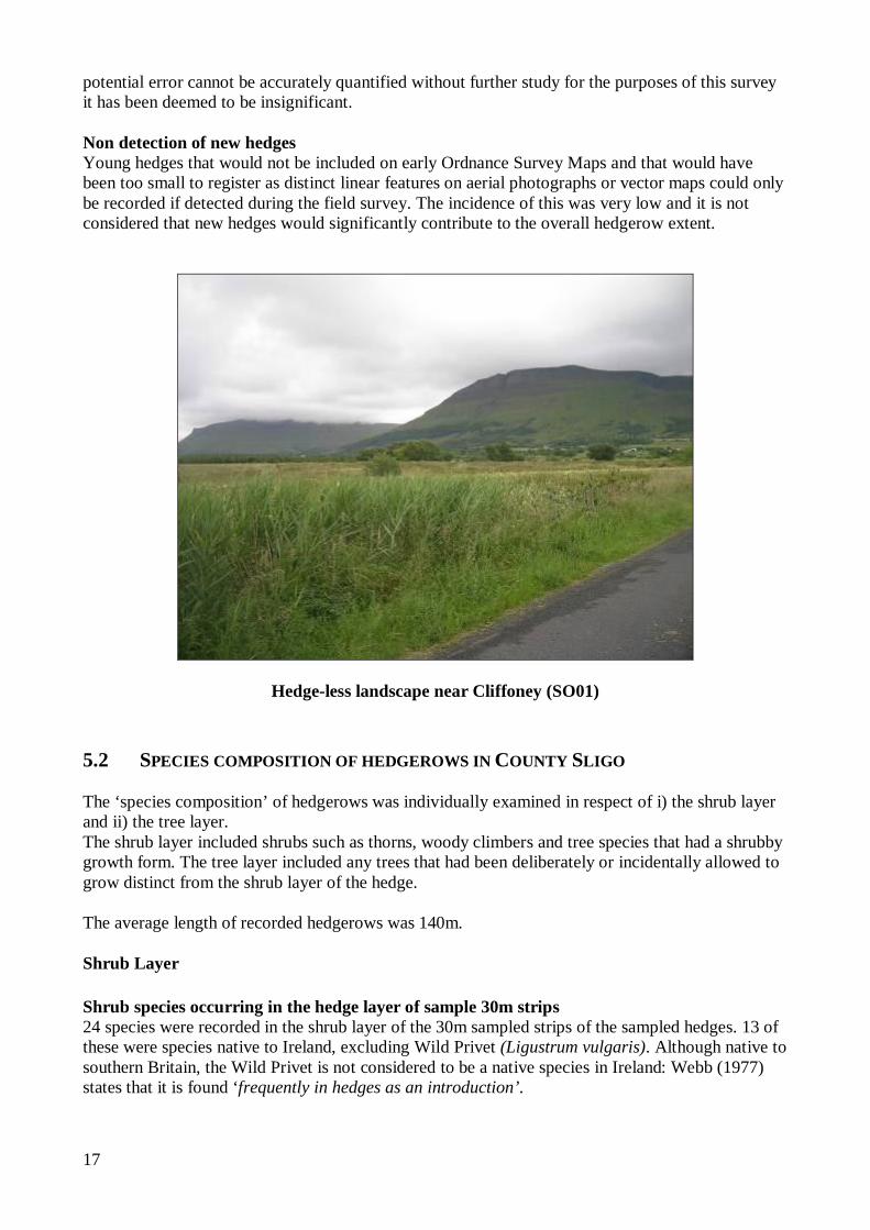
Hedge-less landscape near Cliffoney (SO01) 5.2 SPECIES COMPOSITION OF HEDGEROWS IN COUNTY SLIGO The ‘species composition’ of hedgerows was individually examined in respect of i) the shrub layer and ii) the tree layer. The shrub layer included shrubs such as thorns, woody climbers and tree species that had a shrubby growth form. The tree layer included any trees that had been deliberately or incidentally allowed to grow distinct from the shrub layer of the hedge. The average length of recorded hedgerows was 140m. Shrub Layer Shrub species occurring in the hedge layer of sample 30m strips 24 species were recorded in the shrub layer of the 30m sampled strips of the sampled hedges. 13 of these were species native to Ireland, excluding Wild Privet (Ligustrum vulgaris). Although native to southern Britain, the Wild Privet is not considered to be a native species in Ireland: Webb (1977) states that it is found ‘frequently in hedges as an introduction’.
18
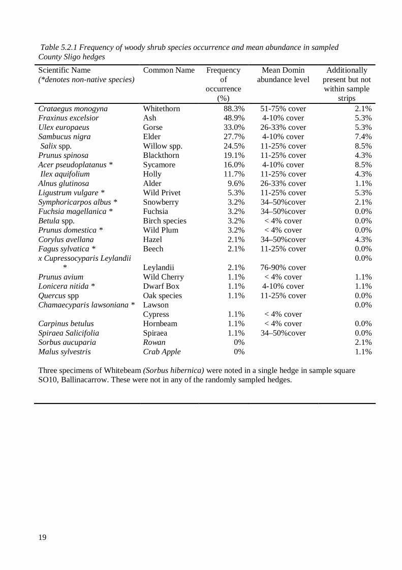
In common with all previous studies, Hawthorn / Whitethorn (Crataegus monogyna) is the most commonly occurring hedgerow shrub found in 88% of sampled hedges. It also has, of the most commonly occurring species, the highest percentage cover in hedges, on average making up between 51% -75% of all of the hedges in which it occurred. Ash (Fraxinus excelsior) is the second most frequently occurring species, found in 49% of sampled hedges, but its level of cover in those hedges averaged only 4-10%. Gorse (Ulex europaeus) was recorded in a third of hedges. Elder (Sambucus nigra) which was found in 28% of the samples was also found at relatively low levels of cover (4-10%, on average). Willow species (Salix spp.) were found in a quarter of the samples with Blackthorn (Prunus spinosa) in almost a fifth. Alder (Alnus glutinosa) was found in almost 10% of the samples and at relatively high levels of cover. Sycamore (Acer pseudoplatanus) was found at low levels of cover in 16% of hedges but was also found in a further 8.5% of hedges, but not within the sample strips. Rowan (Sorbus aucuparia) and Crab Apple (Malus sylvestris) were noted in sample hedgerows but not within any of the sample 30m strips.
The frequency and abundance of each shrub species is presented in Table 5.2.1, including details of where species were additionally found in sample hedges but not within the 30m sample strips; the frequency of occurrence of the main shrub species are represented graphically in Figure 5.2.1. The ‘frequency of occurrence’ is the frequency with which each species is found in one or other of the two sampled 30m strips of each hedge. The “mean Domin abundance level” is a representation of the degree of cover of each species within the 30m sample strips. To arrive at the figure the average is taken of the relevant mid-point Domin percentage figure from each hedge in which the species occurs.
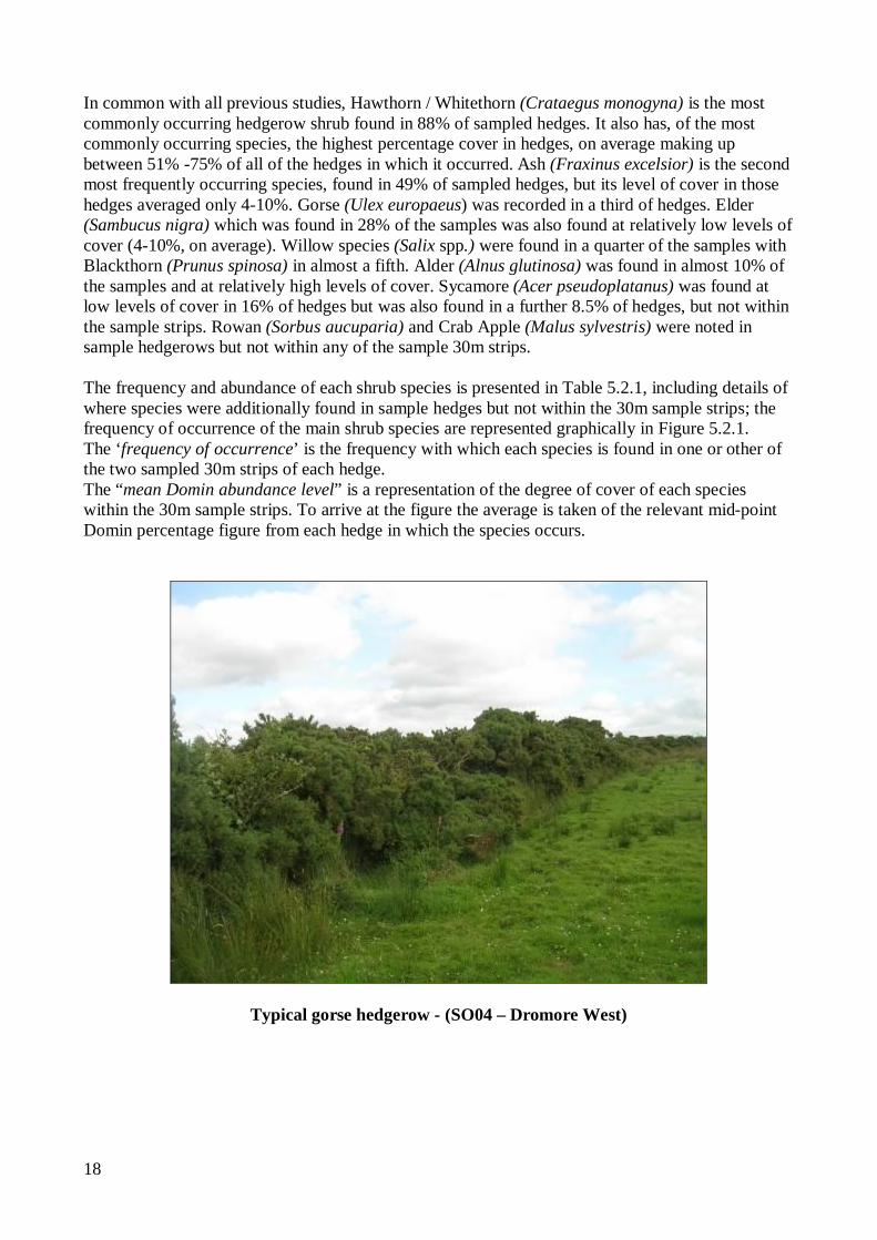
Typical gorse hedgerow - (SO04 – Dromore West)
19
Table 5.2.1 Frequency of woody shrub species occurrence and mean abundance in sampled County Sligo hedges
Scientific Name (*denotes non-native species)
Common Name Frequency of
occurrence (%)
Mean Domin abundance level
Additionally present but not within sample
strips Crataegus monogyna Whitethorn 88.3% 51-75% cover 2.1% Fraxinus excelsior Ash 48.9% 4-10% cover 5.3% Ulex europaeus Gorse 33.0% 26-33% cover 5.3% Sambucus nigra Elder 27.7% 4-10% cover 7.4% Salix spp. Willow spp. 24.5% 11-25% cover 8.5% Prunus spinosa Blackthorn 19.1% 11-25% cover 4.3% Acer pseudoplatanus * Sycamore 16.0% 4-10% cover 8.5% Ilex aquifolium Holly 11.7% 11-25% cover 4.3% Alnus glutinosa Alder 9.6% 26-33% cover 1.1% Ligustrum vulgare * Wild Privet 5.3% 11-25% cover 5.3% Symphoricarpos albus * Snowberry 3.2% 34–50%cover 2.1% Fuchsia magellanica * Fuchsia 3.2% 34–50%cover 0.0% Betula spp. Birch species 3.2% < 4% cover 0.0% Prunus domestica * Wild Plum 3.2% < 4% cover 0.0% Corylus avellana Hazel 2.1% 34–50%cover 4.3% Fagus sylvatica * Beech 2.1% 11-25% cover 0.0% x Cupressocyparis Leylandii
* Leylandii 2.1% 76-90% cover 0.0%
Prunus avium Wild Cherry 1.1% < 4% cover 1.1% Lonicera nitida * Dwarf Box 1.1% 4-10% cover 1.1% Quercus spp Oak species 1.1% 11-25% cover 0.0% Chamaecyparis lawsoniana * Lawson
Cypress 1.1% < 4% cover 0.0%
Carpinus betulus Hornbeam 1.1% < 4% cover 0.0% Spiraea Salicifolia Spiraea 1.1% 34–50%cover 0.0% Sorbus aucuparia Rowan 0% 2.1% Malus sylvestris Crab Apple 0% 1.1% Three specimens of Whitebeam (Sorbus hibernica) were noted in a single hedge in sample square SO10, Ballinacarrow. These were not in any of the randomly sampled hedges.
20
0% 10% 20% 30% 40% 50% 60% 70% 80% 90% 100%
Whitethorn
Ash
Gorse
Elder
Willow species
Blackthorn
Sycamore
Holly
Alder
Wild Privet
Snowberry
Fuchsia
Birch species
Wild Plum
Hazel
Beech
Leylandii
% occurrence in hedges surveyed Figure 5.2.1 Frequency of occurrence of main shrub species in sampled hedges in County
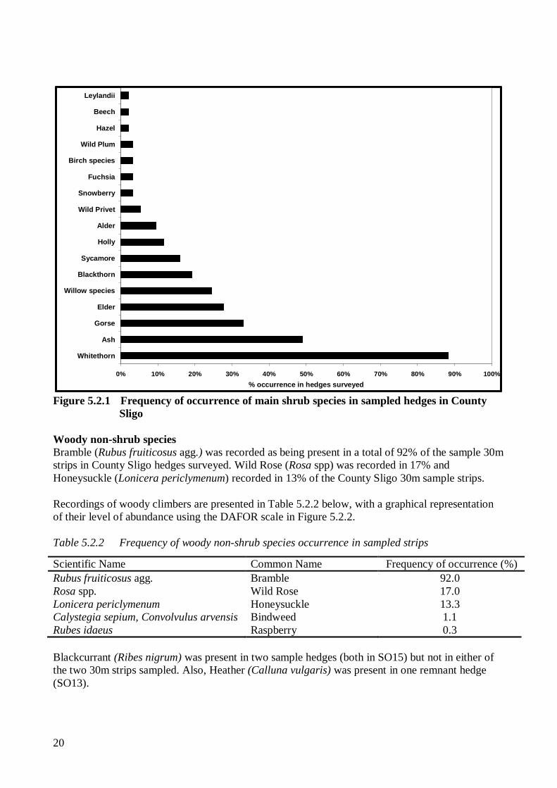
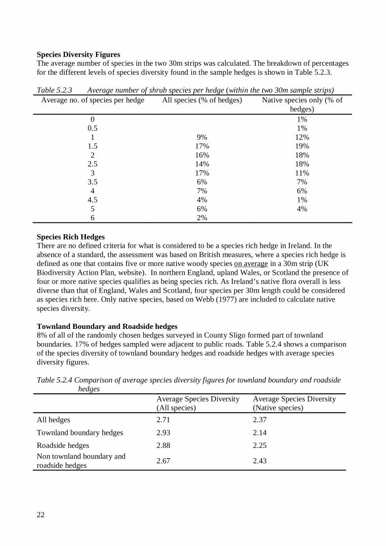
Sligo Woody non-shrub species Bramble (Rubus fruiticosus agg.) was recorded as being present in a total of 92% of the sample 30m strips in County Sligo hedges surveyed. Wild Rose (Rosa spp) was recorded in 17% and Honeysuckle (Lonicera periclymenum) recorded in 13% of the County Sligo 30m sample strips. Recordings of woody climbers are presented in Table 5.2.2 below, with a graphical representation of their level of abundance using the DAFOR scale in Figure 5.2.2. Table 5.2.2 Frequency of woody non-shrub species occurrence in sampled strips
Blackcurrant (Ribes nigrum) was present in two sample hedges (both in SO15) but not in either of the two 30m strips sampled. Also, Heather (Calluna vulgaris) was present in one remnant hedge (SO13).
Scientific Name Common Name Frequency of occurrence (%) Rubus fruiticosus agg. Bramble 92.0 Rosa spp. Wild Rose 17.0 Lonicera periclymenum Honeysuckle 13.3 Calystegia sepium, Convolvulus arvensis Bindweed 1.1 Rubes idaeus Raspberry 0.3
21
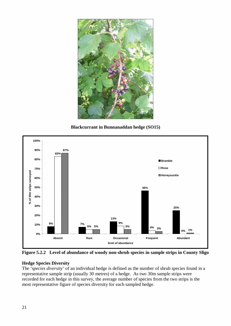
Blackcurrant in Bunnanaddan hedge (SO15)
8% 7%
13%
46%
25%
83%
5%9%
4%0%
5% 5%3% 1%
87%
0%
10%
20%
30%
40%
50%
60%
70%
80%
90%
100%
Absent Rare Occasional Frequent Abundant
level of abundance
% o
f 30m
str
ips
surv
eyed
Bramble
Rose
Honeysuckle
Figure 5.2.2 Level of abundance of woody non-shrub species in sample strips in County Sligo Hedge Species Diversity The ‘species diversity’ of an individual hedge is defined as the number of shrub species found in a representative sample strip (usually 30 metres) of a hedge. As two 30m sample strips were recorded for each hedge in this survey, the average number of species from the two strips is the most representative figure of species diversity for each sampled hedge.
22
Species Diversity Figures The average number of species in the two 30m strips was calculated. The breakdown of percentages for the different levels of species diversity found in the sample hedges is shown in Table 5.2.3. Table 5.2.3 Average number of shrub species per hedge (within the two 30m sample strips)
Average no. of species per hedge
All species (% of hedges) Native species only (% of hedges)
0 1% 0.5 1% 1 9% 12%
1.5 17% 19% 2 16% 18%
2.5 14% 18% 3 17% 11%
3.5 6% 7% 4 7% 6%
4.5 4% 1% 5 6% 4% 6 2%
Species Rich Hedges There are no defined criteria for what is considered to be a species rich hedge in Ireland. In the absence of a standard, the assessment was based on British measures, where a species rich hedge is defined as one that contains five or more native woody species on average in a 30m strip (UK Biodiversity Action Plan, website). In northern England, upland Wales, or Scotland the presence of four or more native species qualifies as being species rich. As Ireland’s native flora overall is less diverse than that of England, Wales and Scotland, four species per 30m length could be considered as species rich here. Only native species, based on Webb (1977) are included to calculate native species diversity. Townland Boundary and Roadside hedges 8% of all of the randomly chosen hedges surveyed in County Sligo formed part of townland boundaries. 17% of hedges sampled were adjacent to public roads. Table 5.2.4 shows a comparison of the species diversity of townland boundary hedges and roadside hedges with average species diversity figures. Table 5.2.4 Comparison of average species diversity figures for townland boundary and roadside
hedges
Average Species Diversity (All species)
Average Species Diversity (Native species)
All hedges 2.71 2.37
Townland boundary hedges 2.93 2.14 Roadside hedges 2.88 2.25 Non townland boundary and roadside hedges 2.67 2.43
23
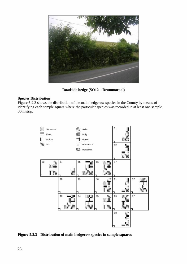
Roadside hedge (SO12 – Drummacool) Species Distribution Figure 5.2.3 shows the distribution of the main hedgerow species in the County by means of identifying each sample square where the particular species was recorded in at least one sample 30m strip.
01
02
04 05 06 0703
08 09 10 11 12
1713 14 15
18
16
Sycamore
Elder
Willow
Blackthorn
Hawthorn
Ash
Alder
Holly
Gorse
Figure 5.2.3 Distribution of main hedgerow species in sample squares
24
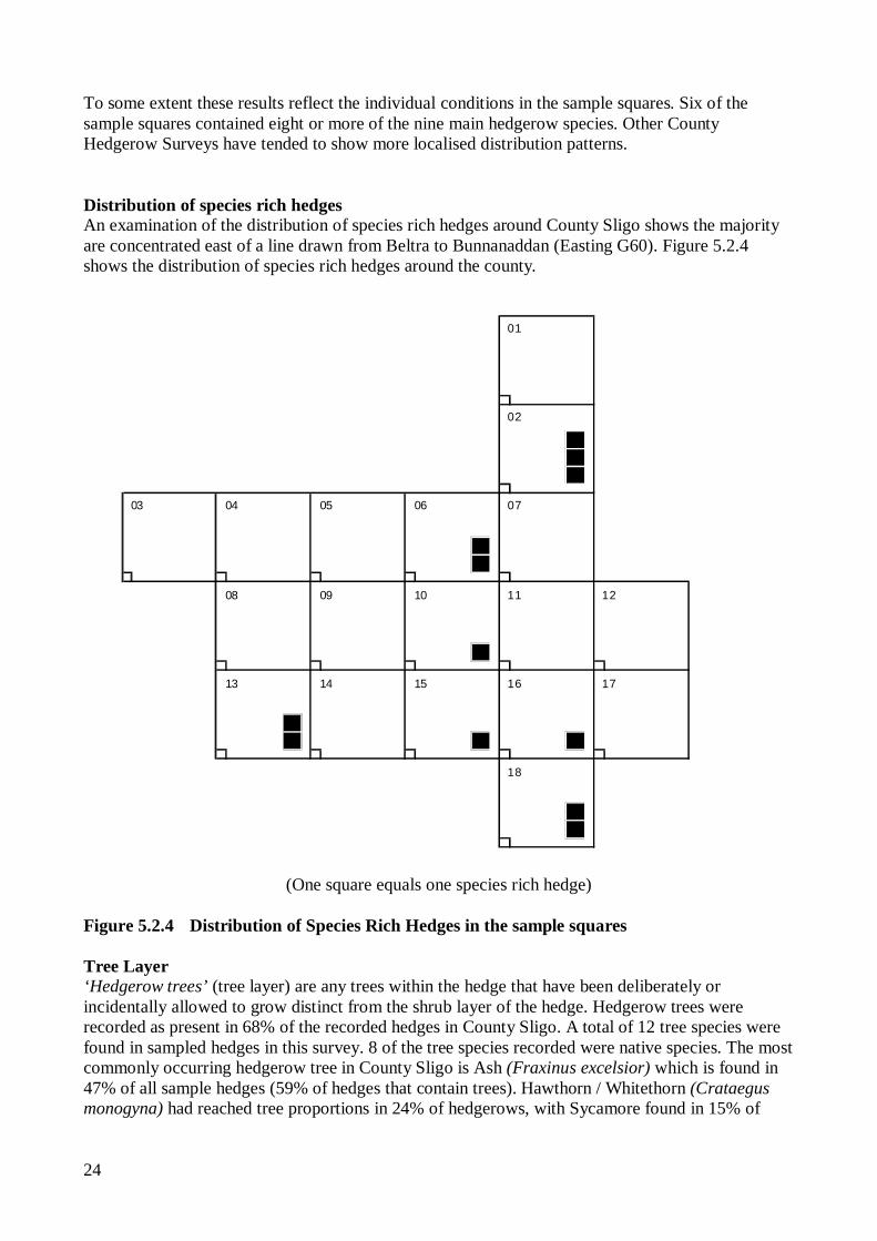
To some extent these results reflect the individual conditions in the sample squares. Six of the sample squares contained eight or more of the nine main hedgerow species. Other County Hedgerow Surveys have tended to show more localised distribution patterns. Distribution of species rich hedges An examination of the distribution of species rich hedges around County Sligo shows the majority are concentrated east of a line drawn from Beltra to Bunnanaddan (Easting G60). Figure 5.2.4 shows the distribution of species rich hedges around the county.
18
16 1713 14 15
03
08 09 10 11 12
04 05 06 07
01
02
(One square equals one species rich hedge)
Figure 5.2.4 Distribution of Species Rich Hedges in the sample squares Tree Layer ‘Hedgerow trees’ (tree layer) are any trees within the hedge that have been deliberately or incidentally allowed to grow distinct from the shrub layer of the hedge. Hedgerow trees were recorded as present in 68% of the recorded hedges in County Sligo. A total of 12 tree species were found in sampled hedges in this survey. 8 of the tree species recorded were native species. The most commonly occurring hedgerow tree in County Sligo is Ash (Fraxinus excelsior) which is found in 47% of all sample hedges (59% of hedges that contain trees). Hawthorn / Whitethorn (Crataegus monogyna) had reached tree proportions in 24% of hedgerows, with Sycamore found in 15% of
25
hedges. No other species was found in more than 10% of hedges sampled. Table 5.2.7 lists the tree species recorded and their frequency of occurrence. Table 5.2.7 Frequency of tree species occurrence in sampled County Sligo hedges Scientific Name (*denotes non-native species)
Common Name Frequency of occurrence (%)
Fraxinus excelsior Ash 47% Crataegus monogyna Whitethorn 24% Acer pseudoplatanus * Sycamore 15% Alnus glutinosa Alder 9% Salix spp. Willow spp. 6% Ilex aquifolium Holly 4% Betula spp. Birch spp. 2% Sorbus aucuparia Rowan 1% Fagus sylvatica * Beech 1% Sambucus nigra Elder 1% Chamaecyparis lawsoniana * Lawson Cypress 1% Carpinus betulus * Hornbeam 1%
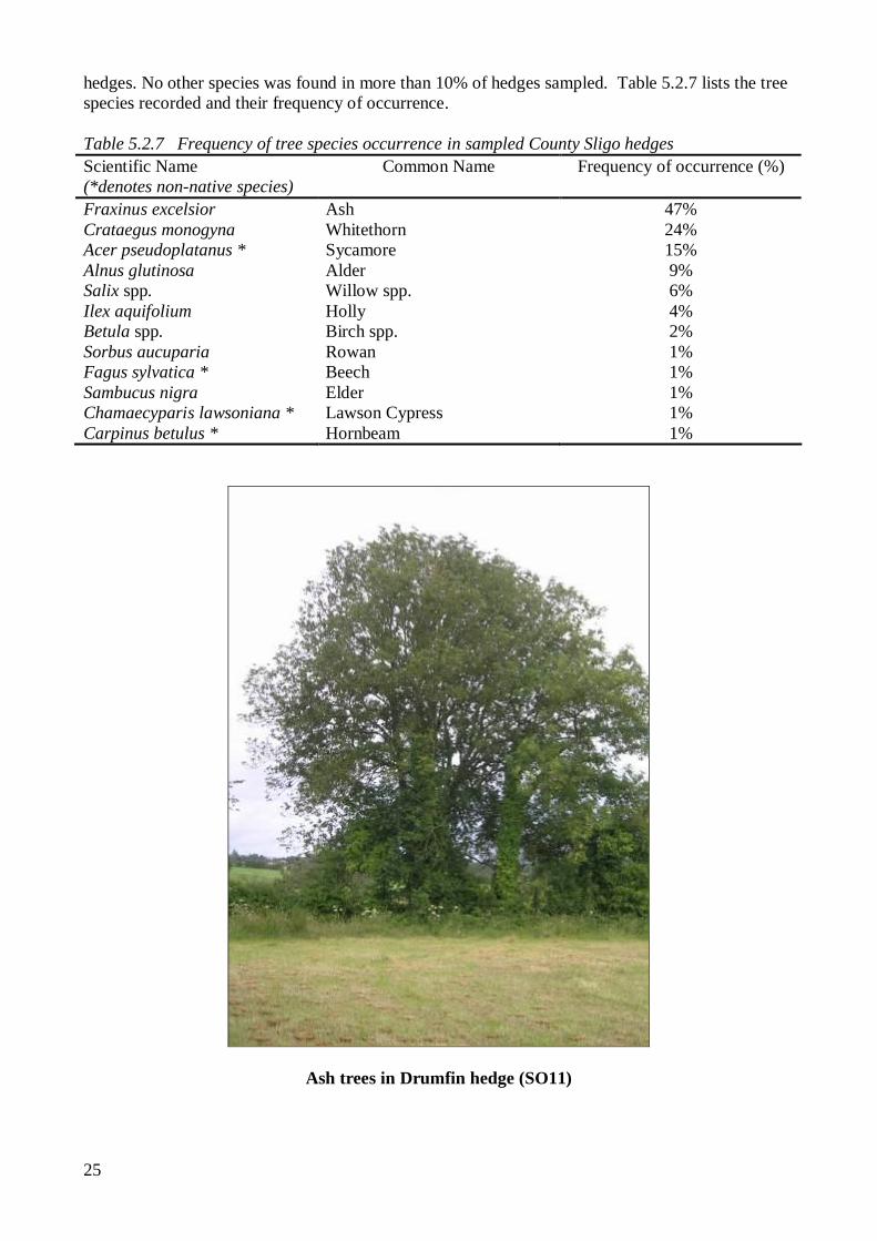
Ash trees in Drumfin hedge (SO11)
26
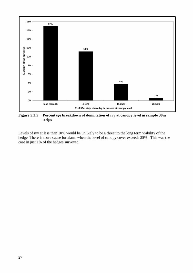
Tree Species Diversity 40% of the hedges where trees were recorded had just one tree species. A further 16% contained two tree species, 9% had three species, and 3% had four species. Ivy The specifications for the REP Scheme permit the control of ivy (Hedera helix) where it poses a threat to the stability or long term viability of hedgerows. This is set in the context of the importance of ivy for wildlife and the statement that ‘Wherever possible ivy should be retained and allowed to develop’ (Specifications for REPS Planners, 2007). Figure 5.2.5 shows the Domin level of ivy at canopy level in the 30m strips of the sampled hedges.
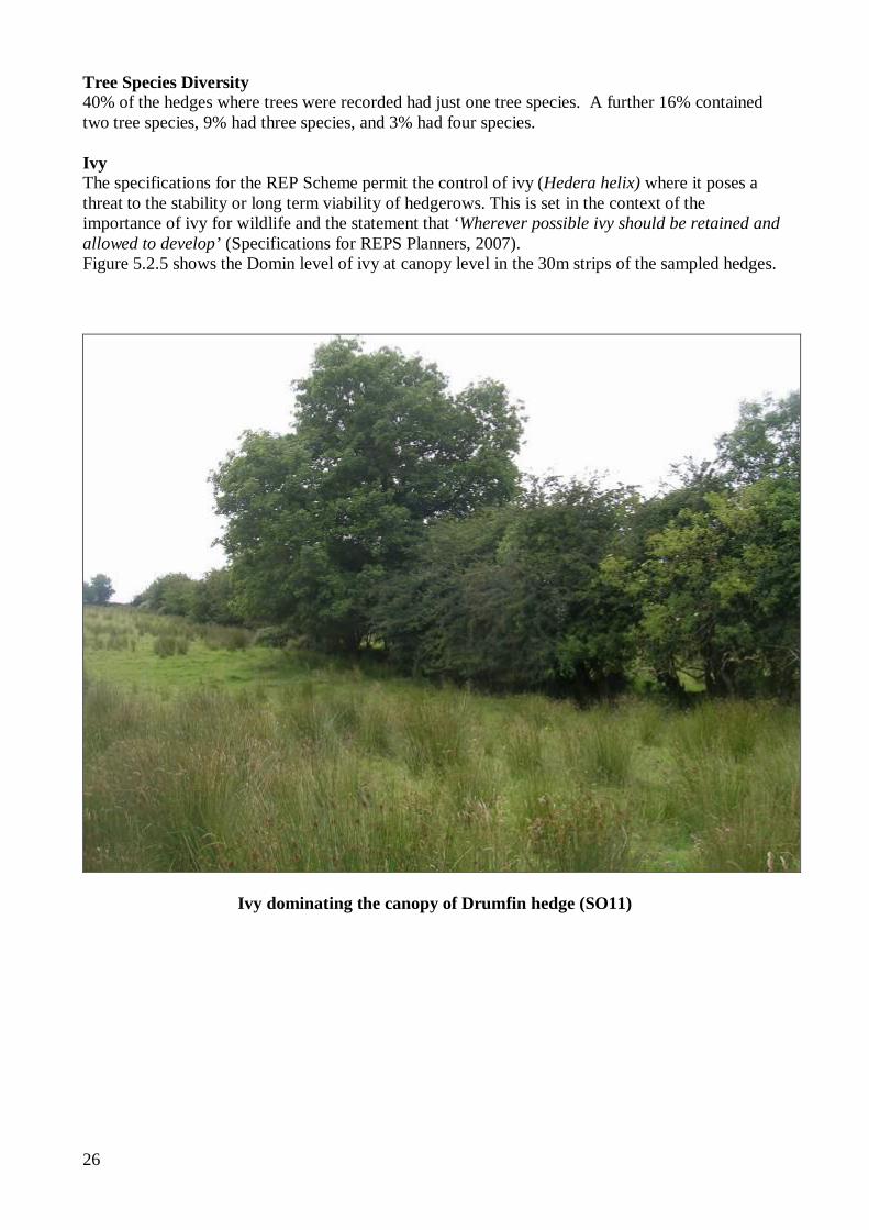
Ivy dominating the canopy of Drumfin hedge (SO11)
27
11%
4%
1%
17%
0%
2%
4%
6%
8%
10%
12%
14%
16%
18%
less than 4% 4-10% 11-25% 26-50%
% of 30m strip where Ivy is present at canopy level
% o
f 30m
str
ips
surv
eyed
Figure 5.2.5 Percentage breakdown of domination of ivy at canopy level in sample 30m
strips Levels of ivy at less than 10% would be unlikely to be a threat to the long term viability of the hedge. There is more cause for alarm when the level of canopy cover exceeds 25%. This was the case in just 1% of the hedges surveyed.
28
5.3 GENERAL ECOLOGICAL, HISTORICAL, AND AGRICULTURAL CONTEXT OF HEDGEROWS IN COUNTY SLIGO.
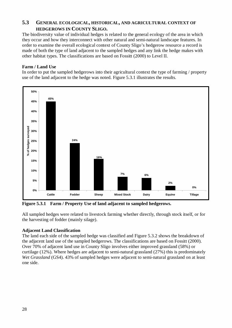
The biodiversity value of individual hedges is related to the general ecology of the area in which they occur and how they interconnect with other natural and semi-natural landscape features. In order to examine the overall ecological context of County Sligo’s hedgerow resource a record is made of both the type of land adjacent to the sampled hedges and any link the hedge makes with other habitat types. The classifications are based on Fossitt (2000) to Level II. Farm / Land Use In order to put the sampled hedgerows into their agricultural context the type of farming / property use of the land adjacent to the hedge was noted. Figure 5.3.1 illustrates the results.
45%
24%
7% 6%
2%0%
16%
0%
5%
10%
15%
20%
25%
30%
35%
40%
45%
50%
Cattle Fodder Sheep Mixed Stock Dairy Equine Tillage
% o
f hed
ges
surv
eyed
Figure 5.3.1 Farm / Property Use of land adjacent to sampled hedgerows. All sampled hedges were related to livestock farming whether directly, through stock itself, or for the harvesting of fodder (mainly silage). Adjacent Land Classification The land each side of the sampled hedge was classified and Figure 5.3.2 shows the breakdown of the adjacent land use of the sampled hedgerows. The classifications are based on Fossitt (2000). Over 70% of adjacent land use in County Sligo involves either improved grassland (58%) or curtilage (12%). Where hedges are adjacent to semi-natural grassland (27%) this is predominately Wet Grassland (GS4). 43% of sampled hedges were adjacent to semi-natural grassland on at least one side.
29
58%
27%
12%
1% 0.5%2%
0%
10%
20%
30%
40%
50%
60%
70%
Improved Grassland Semi-naturalGrassland
Curtilage/Road Disturbed Land Semi-naturalWoodland
(Watercourse)
% o
f hed
ges
surv
eyed
Figure 5.3.2 Habitat category of land adjacent to sampled hedgerows.
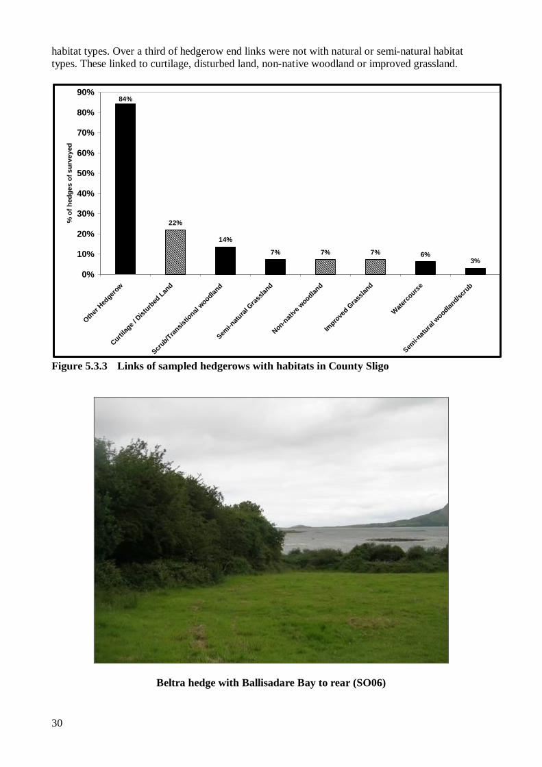
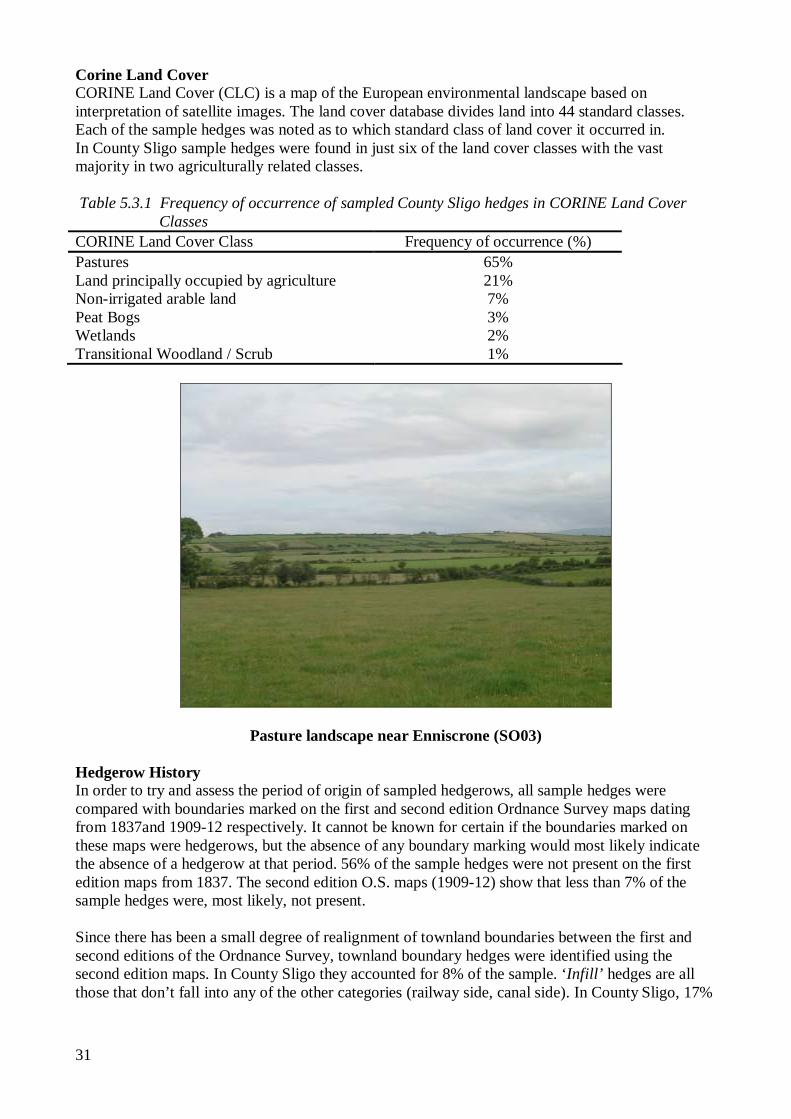
Cliffoney hedge adjacent to Wet Grassland (GS4) (SO01) Links with Other Habitats The corridor role of hedgerows in facilitating the movement and distribution of wild flora and fauna through the landscape is believed to be enhanced significantly if hedgerows link into other (natural or semi-natural) habitat features. Figure 5.3.3 shows the breakdown of how the sampled hedges connected with other hedgerows and other habitat types. 84% of hedgerows sampled had at least one link with another hedgerow and 30% of the samples linked with other natural or semi-natural
30
habitat types. Over a third of hedgerow end links were not with natural or semi-natural habitat types. These linked to curtilage, disturbed land, non-native woodland or improved grassland.
22%
14%
7% 7% 7% 6%3%
84%
0%
10%
20%
30%
40%
50%
60%
70%
80%
90%
Other Hed
gerow
Curtilag
e / D
isturb
ed Lan
d
Scrub/Tran
sistio
nal woodlan
d
Semi-n
atural
Gras
sland
Non-native
woodlan
d
Impro
ved G
rassla
nd
Waterco
urse
Semi-n
atural w
oodland/sc
rub
% o
f hed
ges
of s
urve
yed
Figure 5.3.3 Links of sampled hedgerows with habitats in County Sligo
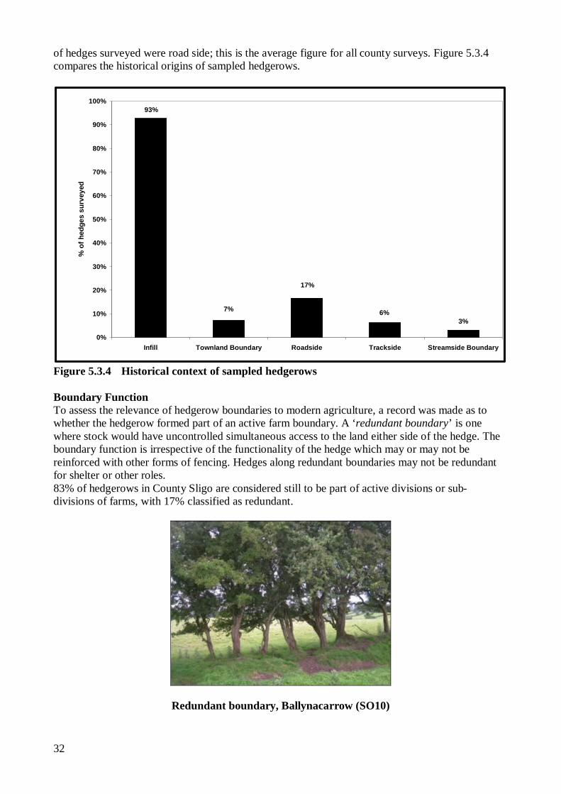
Beltra hedge with Ballisadare Bay to rear (SO06)
31
Corine Land Cover CORINE Land Cover (CLC) is a map of the European environmental landscape based on interpretation of satellite images. The land cover database divides land into 44 standard classes. Each of the sample hedges was noted as to which standard class of land cover it occurred in. In County Sligo sample hedges were found in just six of the land cover classes with the vast majority in two agriculturally related classes. Table 5.3.1 Frequency of occurrence of sampled County Sligo hedges in CORINE Land Cover
Classes CORINE Land Cover Class Frequency of occurrence (%) Pastures 65% Land principally occupied by agriculture 21% Non-irrigated arable land 7% Peat Bogs 3% Wetlands 2% Transitional Woodland / Scrub 1%
Pasture landscape near Enniscrone (SO03)
Hedgerow History In order to try and assess the period of origin of sampled hedgerows, all sample hedges were compared with boundaries marked on the first and second edition Ordnance Survey maps dating from 1837and 1909-12 respectively. It cannot be known for certain if the boundaries marked on these maps were hedgerows, but the absence of any boundary marking would most likely indicate the absence of a hedgerow at that period. 56% of the sample hedges were not present on the first edition maps from 1837. The second edition O.S. maps (1909-12) show that less than 7% of the sample hedges were, most likely, not present. Since there has been a small degree of realignment of townland boundaries between the first and second editions of the Ordnance Survey, townland boundary hedges were identified using the second edition maps. In County Sligo they accounted for 8% of the sample. ‘Infill’ hedges are all those that don’t fall into any of the other categories (railway side, canal side). In County Sligo, 17%
32
of hedges surveyed were road side; this is the average figure for all county surveys. Figure 5.3.4 compares the historical origins of sampled hedgerows.
17%
6%3%
7%
93%
0%
10%
20%
30%
40%
50%
60%
70%
80%
90%
100%
Infill Townland Boundary Roadside Trackside Streamside Boundary
% o
f hed
ges
surv
eyed
Figure 5.3.4 Historical context of sampled hedgerows Boundary Function To assess the relevance of hedgerow boundaries to modern agriculture, a record was made as to whether the hedgerow formed part of an active farm boundary. A ‘redundant boundary’ is one where stock would have uncontrolled simultaneous access to the land either side of the hedge. The boundary function is irrespective of the functionality of the hedge which may or may not be reinforced with other forms of fencing. Hedges along redundant boundaries may not be redundant for shelter or other roles. 83% of hedgerows in County Sligo are considered still to be part of active divisions or sub-divisions of farms, with 17% classified as redundant.
Redundant boundary, Ballynacarrow (SO10)
33
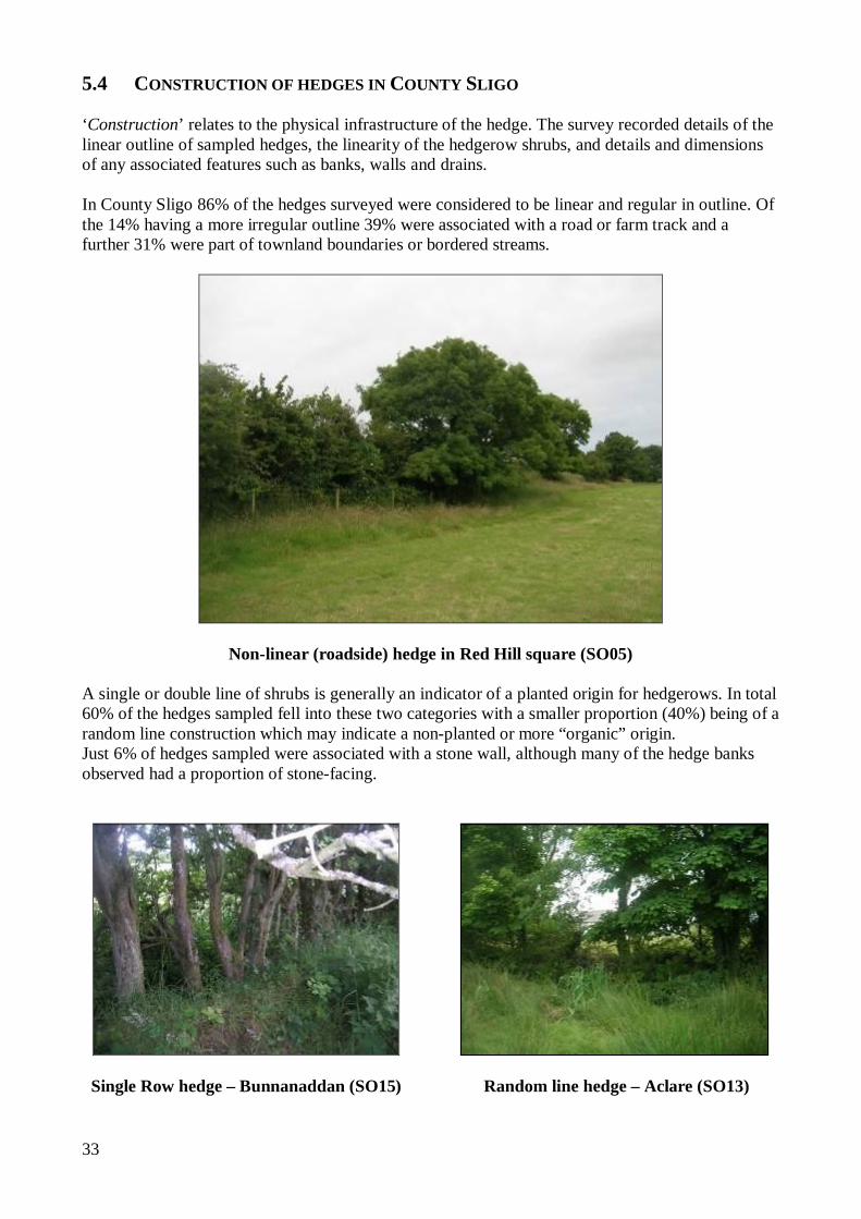
5.4 CONSTRUCTION OF HEDGES IN COUNTY SLIGO ‘Construction’ relates to the physical infrastructure of the hedge. The survey recorded details of the linear outline of sampled hedges, the linearity of the hedgerow shrubs, and details and dimensions of any associated features such as banks, walls and drains. In County Sligo 86% of the hedges surveyed were considered to be linear and regular in outline. Of the 14% having a more irregular outline 39% were associated with a road or farm track and a further 31% were part of townland boundaries or bordered streams.
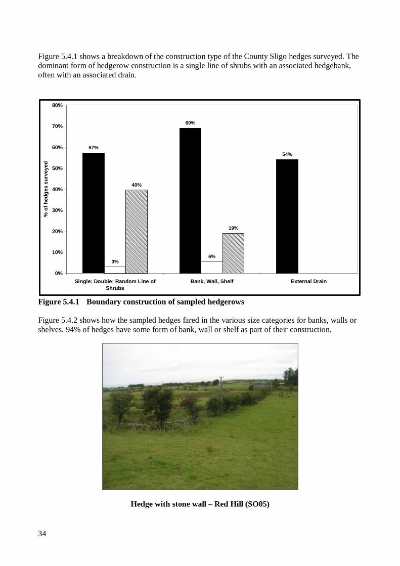
Non-linear (roadside) hedge in Red Hill square (SO05) A single or double line of shrubs is generally an indicator of a planted origin for hedgerows. In total 60% of the hedges sampled fell into these two categories with a smaller proportion (40%) being of a random line construction which may indicate a non-planted or more “organic” origin. Just 6% of hedges sampled were associated with a stone wall, although many of the hedge banks observed had a proportion of stone-facing.
Single Row hedge – Bunnanaddan (SO15) Random line hedge – Aclare (SO13)
34
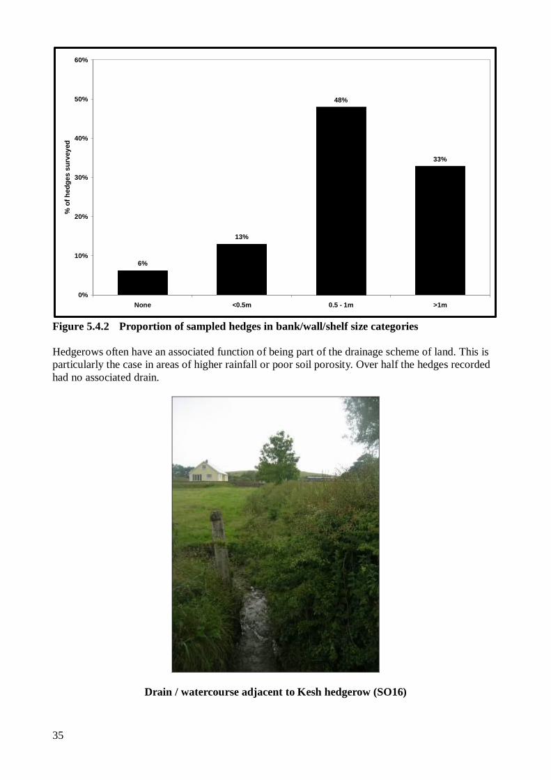
Figure 5.4.1 shows a breakdown of the construction type of the County Sligo hedges surveyed. The dominant form of hedgerow construction is a single line of shrubs with an associated hedgebank, often with an associated drain.
57%
69%
54%
3%6%
40%
19%
0%
10%
20%
30%
40%
50%
60%
70%
80%
Single: Double: Random Line ofShrubs
Bank, Wall, Shelf External Drain
% o
f hed
ges
surv
eyed
Figure 5.4.1 Boundary construction of sampled hedgerows Figure 5.4.2 shows how the sampled hedges fared in the various size categories for banks, walls or shelves. 94% of hedges have some form of bank, wall or shelf as part of their construction.
Hedge with stone wall – Red Hill (SO05)
35
6%
13%
48%
33%
0%
10%
20%
30%
40%
50%
60%
None <0.5m 0.5 - 1m >1m
% o
f hed
ges
surv
eyed
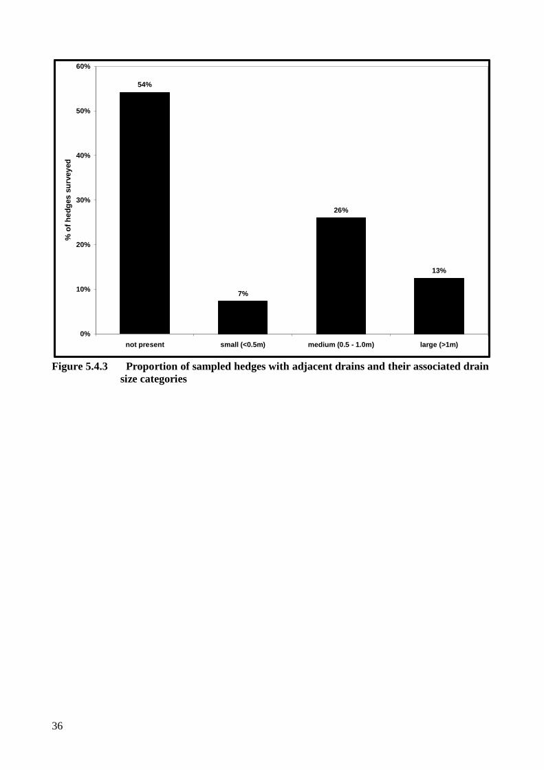
Figure 5.4.2 Proportion of sampled hedges in bank/wall/shelf size categories Hedgerows often have an associated function of being part of the drainage scheme of land. This is particularly the case in areas of higher rainfall or poor soil porosity. Over half the hedges recorded had no associated drain.
Drain / watercourse adjacent to Kesh hedgerow (SO16)
36
54%
7%
26%
13%
0%
10%
20%
30%
40%
50%
60%
not present small (<0.5m) medium (0.5 - 1.0m) large (>1m)
% o
f hed
ges
surv
eyed
Figure 5.4.3 Proportion of sampled hedges with adjacent drains and their associated drain
size categories
37
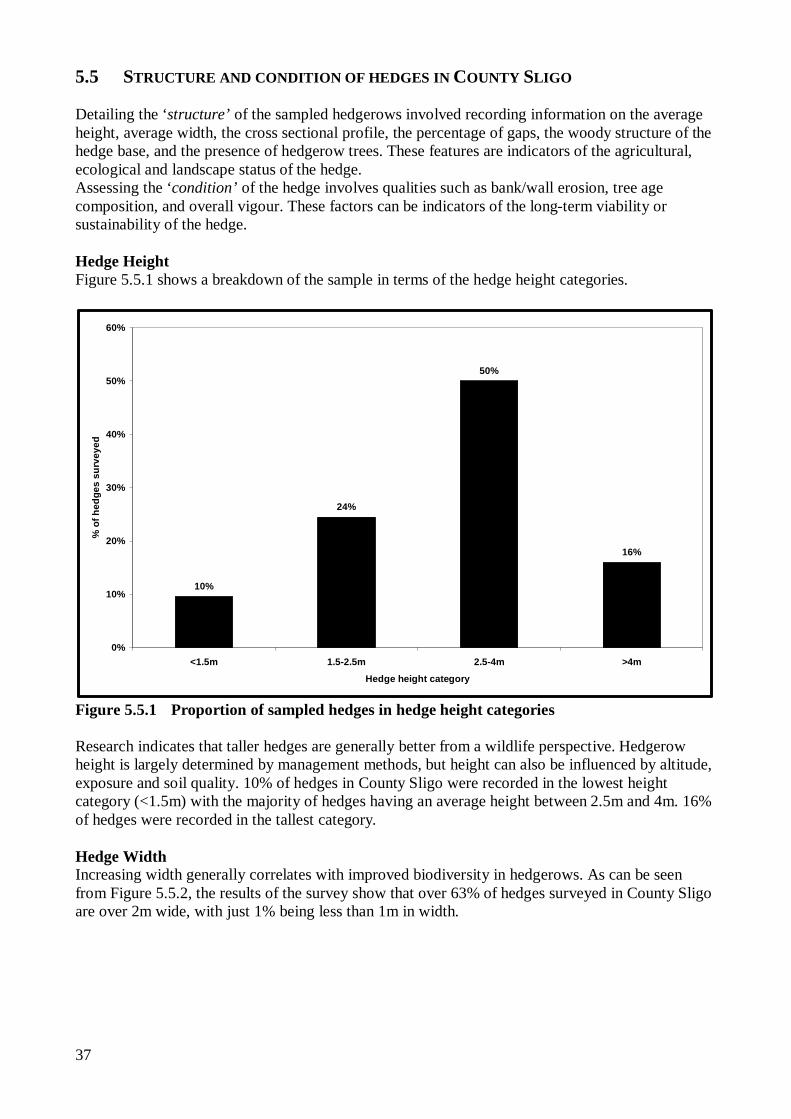
5.5 STRUCTURE AND CONDITION OF HEDGES IN COUNTY SLIGO Detailing the ‘structure’ of the sampled hedgerows involved recording information on the average height, average width, the cross sectional profile, the percentage of gaps, the woody structure of the hedge base, and the presence of hedgerow trees. These features are indicators of the agricultural, ecological and landscape status of the hedge. Assessing the ‘condition’ of the hedge involves qualities such as bank/wall erosion, tree age composition, and overall vigour. These factors can be indicators of the long-term viability or sustainability of the hedge. Hedge Height Figure 5.5.1 shows a breakdown of the sample in terms of the hedge height categories.
10%
24%
50%
16%
0%
10%
20%
30%
40%
50%
60%
<1.5m 1.5-2.5m 2.5-4m >4m
Hedge height category
% o
f hed
ges
surv
eyed
Figure 5.5.1 Proportion of sampled hedges in hedge height categories Research indicates that taller hedges are generally better from a wildlife perspective. Hedgerow height is largely determined by management methods, but height can also be influenced by altitude, exposure and soil quality. 10% of hedges in County Sligo were recorded in the lowest height category (<1.5m) with the majority of hedges having an average height between 2.5m and 4m. 16% of hedges were recorded in the tallest category.
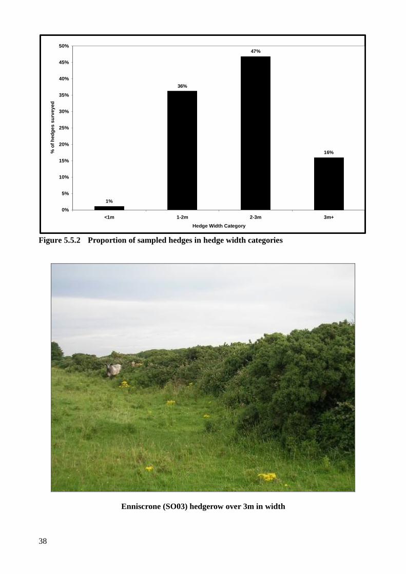
Hedge Width Increasing width generally correlates with improved biodiversity in hedgerows. As can be seen from Figure 5.5.2, the results of the survey show that over 63% of hedges surveyed in County Sligo are over 2m wide, with just 1% being less than 1m in width.
38
1%
36%
47%
16%
0%
5%
10%
15%
20%
25%
30%
35%
40%
45%
50%
<1m 1-2m 2-3m 3m+
Hedge Width Category
% o
f hed
ges
surv
eyed
Figure 5.5.2 Proportion of sampled hedges in hedge width categories
Enniscrone (SO03) hedgerow over 3m in width
39
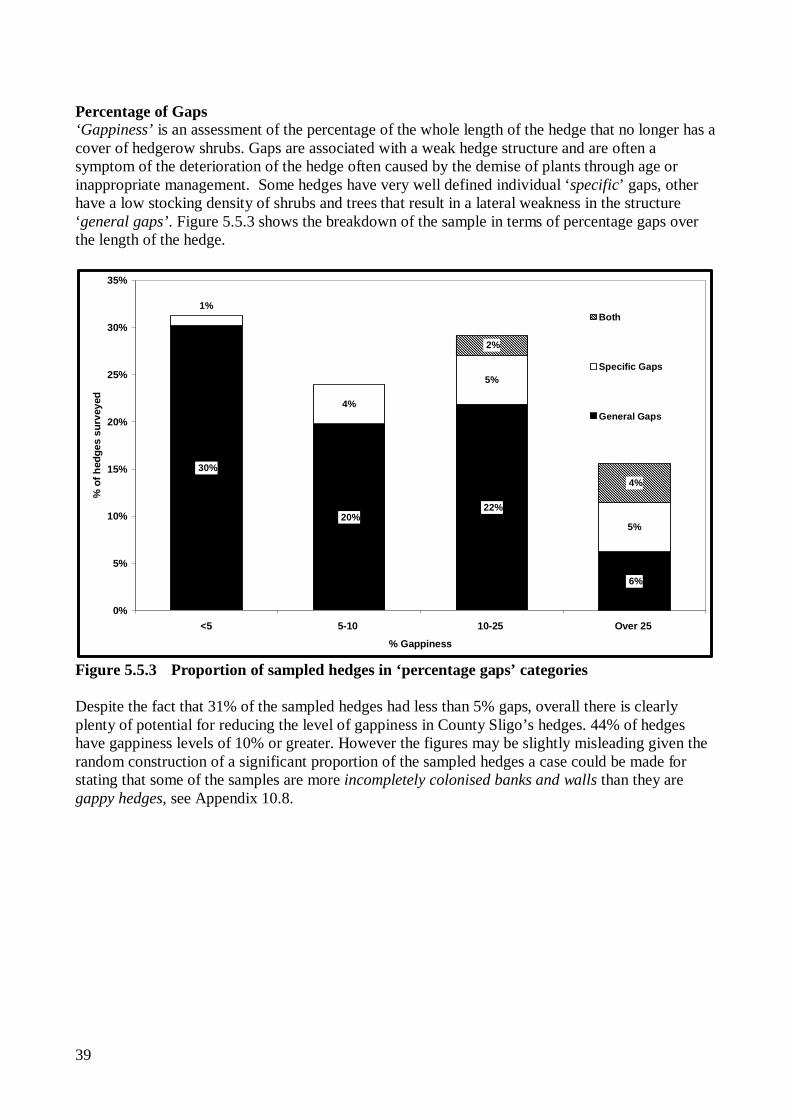
Percentage of Gaps ‘Gappiness’ is an assessment of the percentage of the whole length of the hedge that no longer has a cover of hedgerow shrubs. Gaps are associated with a weak hedge structure and are often a symptom of the deterioration of the hedge often caused by the demise of plants through age or inappropriate management. Some hedges have very well defined individual ‘specific’ gaps, other have a low stocking density of shrubs and trees that result in a lateral weakness in the structure ‘general gaps’. Figure 5.5.3 shows the breakdown of the sample in terms of percentage gaps over the length of the hedge.
4%
5%
5%
6%
22% 20%
30%
1%
4%
2%
0%
5%
10%
15%
20%
25%
30%
35%
<5 5-10 10-25 Over 25
% Gappiness
% o
f hed
ges
surv
eyed
Both
Specific Gaps
General Gaps
Figure 5.5.3 Proportion of sampled hedges in ‘percentage gaps’ categories Despite the fact that 31% of the sampled hedges had less than 5% gaps, overall there is clearly plenty of potential for reducing the level of gappiness in County Sligo’s hedges. 44% of hedges have gappiness levels of 10% or greater. However the figures may be slightly misleading given the random construction of a significant proportion of the sampled hedges a case could be made for stating that some of the samples are more incompletely colonised banks and walls than they are gappy hedges, see Appendix 10.8.
40
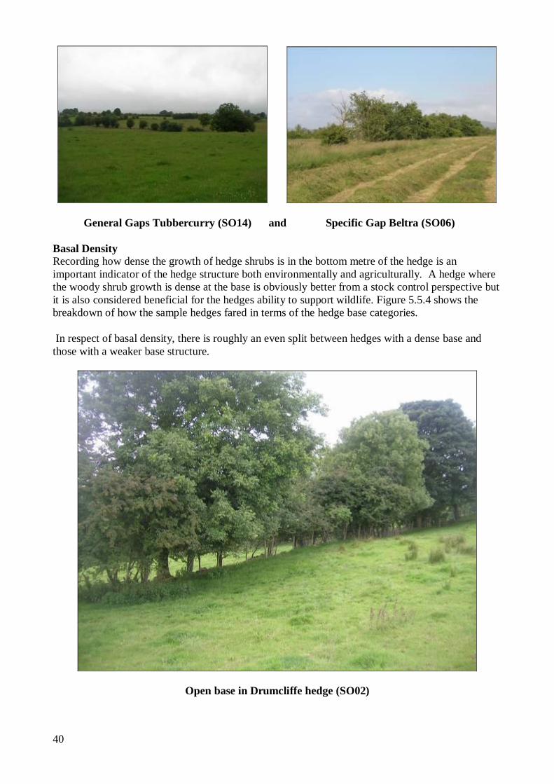
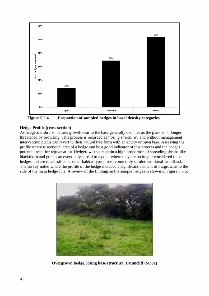
General Gaps Tubbercurry (SO14) and Specific Gap Beltra (SO06) Basal Density Recording how dense the growth of hedge shrubs is in the bottom metre of the hedge is an important indicator of the hedge structure both environmentally and agriculturally. A hedge where the woody shrub growth is dense at the base is obviously better from a stock control perspective but it is also considered beneficial for the hedges ability to support wildlife. Figure 5.5.4 shows the breakdown of how the sample hedges fared in terms of the hedge base categories. In respect of basal density, there is roughly an even split between hedges with a dense base and those with a weaker base structure.
Open base in Drumcliffe hedge (SO02)
41
14%
34%
52%
0%
10%
20%
30%
40%
50%
60%
open scrawny dense
% o
f hed
ges
surv
eyed
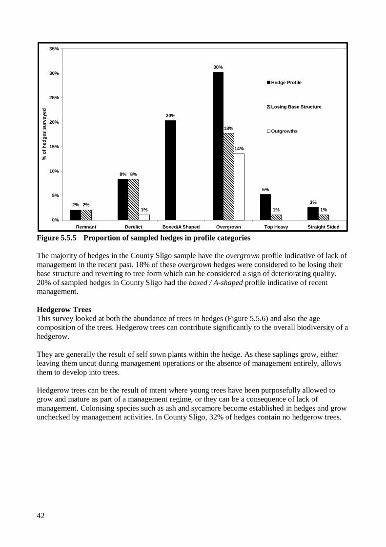
Figure 5.5.4 Proportion of sampled hedges in basal density categories Hedge Profile (cross section) As hedgerow shrubs mature, growth near to the base generally declines as the plant is no longer threatened by browsing. This process is recorded as ‘losing structure’, and without management intervention plants can revert to their natural tree form with an empty or open base. Assessing the profile or cross sectional area of a hedge can be a good indicator of this process and the hedges potential need for rejuvenation. Hedgerows that contain a high proportion of spreading shrubs like blackthorn and gorse can eventually spread to a point where they are no longer considered to be hedges and are re-classified as other habitat types, most commonly scrub/transitional woodland. The survey noted where the profile of the hedge included a significant element of outgrowths to the side of the main hedge line. A review of the findings in the sample hedges is shown in Figure 5.5.5.
Overgrown hedge, losing base structure, Drumcliff (SO02)
42
8%
20%
30%
5%
3%2%
8%
18%
1% 1%1%
14%
2%
0%
5%
10%
15%
20%
25%
30%
35%
Remnant Derelict Boxed/A Shaped Overgrown Top Heavy Straight Sided
% o
f hed
ges
surv
eyed
Hedge Profile
Losing Base Structure
Outgrowths
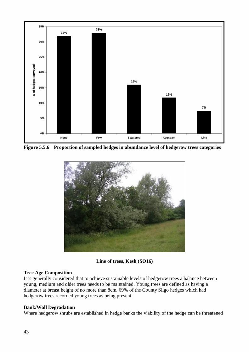
Figure 5.5.5 Proportion of sampled hedges in profile categories The majority of hedges in the County Sligo sample have the overgrown profile indicative of lack of management in the recent past. 18% of these overgrown hedges were considered to be losing their base structure and reverting to tree form which can be considered a sign of deteriorating quality. 20% of sampled hedges in County Sligo had the boxed / A-shaped profile indicative of recent management. Hedgerow Trees This survey looked at both the abundance of trees in hedges (Figure 5.5.6) and also the age composition of the trees. Hedgerow trees can contribute significantly to the overall biodiversity of a hedgerow. They are generally the result of self sown plants within the hedge. As these saplings grow, either leaving them uncut during management operations or the absence of management entirely, allows them to develop into trees. Hedgerow trees can be the result of intent where young trees have been purposefully allowed to grow and mature as part of a management regime, or they can be a consequence of lack of management. Colonising species such as ash and sycamore become established in hedges and grow unchecked by management activities. In County Sligo, 32% of hedges contain no hedgerow trees.
43
32%33%
16%
12%
7%
0%
5%
10%
15%
20%
25%
30%
35%
None Few Scattered Abundant Line
% o
f hed
ges
surv
eyed
Figure 5.5.6 Proportion of sampled hedges in abundance level of hedgerow trees categories
Line of trees, Kesh (SO16)
Tree Age Composition It is generally considered that to achieve sustainable levels of hedgerow trees a balance between young, medium and older trees needs to be maintained. Young trees are defined as having a diameter at breast height of no more than 8cm. 69% of the County Sligo hedges which had hedgerow trees recorded young trees as being present. Bank/Wall Degradation Where hedgerow shrubs are established in hedge banks the viability of the hedge can be threatened
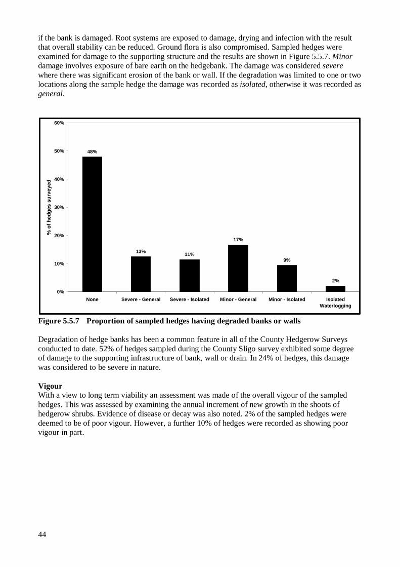
44
if the bank is damaged. Root systems are exposed to damage, drying and infection with the result that overall stability can be reduced. Ground flora is also compromised. Sampled hedges were examined for damage to the supporting structure and the results are shown in Figure 5.5.7. Minor damage involves exposure of bare earth on the hedgebank. The damage was considered severe where there was significant erosion of the bank or wall. If the degradation was limited to one or two locations along the sample hedge the damage was recorded as isolated, otherwise it was recorded as general.
48%
13% 11%
17%
9%
2%
0%
10%
20%
30%
40%
50%
60%
None Severe - General Severe - Isolated Minor - General Minor - Isolated IsolatedWaterlogging
% o
f hed
ges
surv
eyed
Figure 5.5.7 Proportion of sampled hedges having degraded banks or walls Degradation of hedge banks has been a common feature in all of the County Hedgerow Surveys conducted to date. 52% of hedges sampled during the County Sligo survey exhibited some degree of damage to the supporting infrastructure of bank, wall or drain. In 24% of hedges, this damage was considered to be severe in nature. Vigour With a view to long term viability an assessment was made of the overall vigour of the sampled hedges. This was assessed by examining the annual increment of new growth in the shoots of hedgerow shrubs. Evidence of disease or decay was also noted. 2% of the sampled hedges were deemed to be of poor vigour. However, a further 10% of hedges were recorded as showing poor vigour in part.
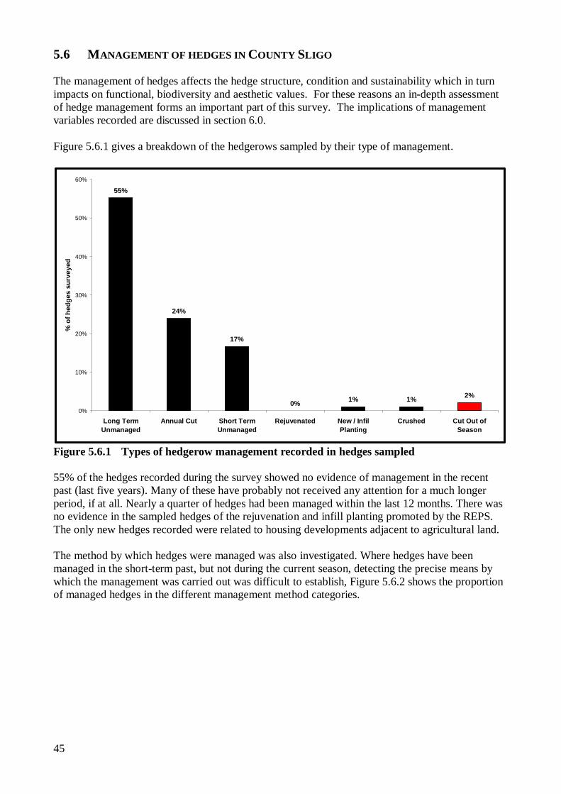
45
5.6 MANAGEMENT OF HEDGES IN COUNTY SLIGO The management of hedges affects the hedge structure, condition and sustainability which in turn impacts on functional, biodiversity and aesthetic values. For these reasons an in-depth assessment of hedge management forms an important part of this survey. The implications of management variables recorded are discussed in section 6.0. Figure 5.6.1 gives a breakdown of the hedgerows sampled by their type of management.
55%
24%
17%
0% 1% 1% 2%
0%
10%
20%
30%
40%
50%
60%
Long TermUnmanaged
Annual Cut Short TermUnmanaged
Rejuvenated New / InfilPlanting
Crushed Cut Out ofSeason
% o
f hed
ges
surv
eyed
Figure 5.6.1 Types of hedgerow management recorded in hedges sampled 55% of the hedges recorded during the survey showed no evidence of management in the recent past (last five years). Many of these have probably not received any attention for a much longer period, if at all. Nearly a quarter of hedges had been managed within the last 12 months. There was no evidence in the sampled hedges of the rejuvenation and infill planting promoted by the REPS. The only new hedges recorded were related to housing developments adjacent to agricultural land. The method by which hedges were managed was also investigated. Where hedges have been managed in the short-term past, but not during the current season, detecting the precise means by which the management was carried out was difficult to establish, Figure 5.6.2 shows the proportion of managed hedges in the different management method categories.
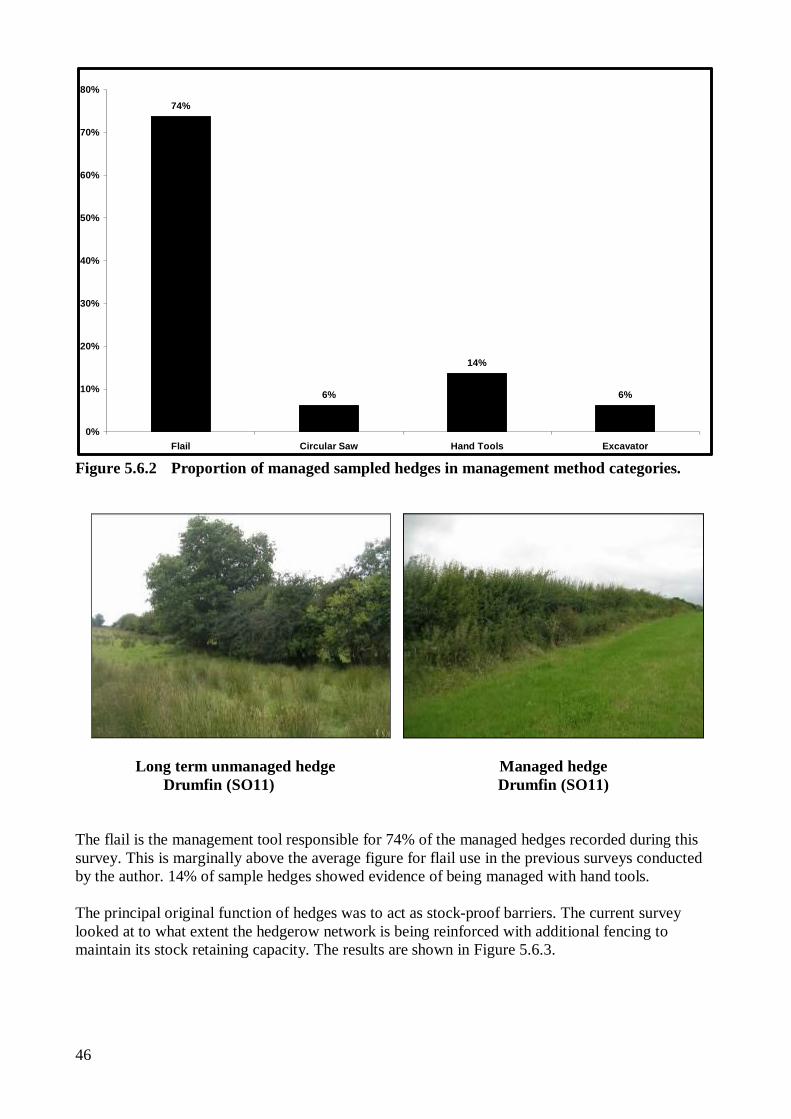
46
74%
6%
14%
6%
0%
10%
20%
30%
40%
50%
60%
70%
80%
Flail Circular Saw Hand Tools Excavator Figure 5.6.2 Proportion of managed sampled hedges in management method categories.
Long term unmanaged hedge Managed hedge Drumfin (SO11) Drumfin (SO11) The flail is the management tool responsible for 74% of the managed hedges recorded during this survey. This is marginally above the average figure for flail use in the previous surveys conducted by the author. 14% of sample hedges showed evidence of being managed with hand tools. The principal original function of hedges was to act as stock-proof barriers. The current survey looked at to what extent the hedgerow network is being reinforced with additional fencing to maintain its stock retaining capacity. The results are shown in Figure 5.6.3.
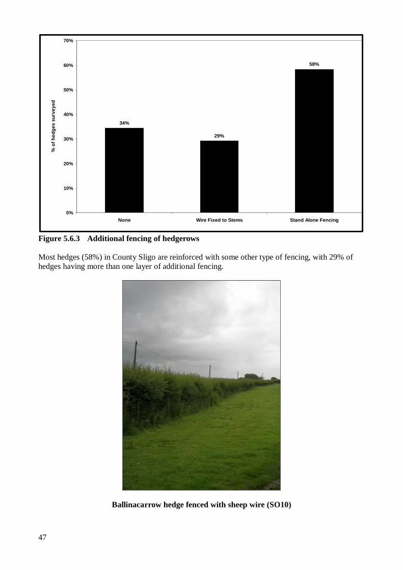
47
34%
29%
58%
0%
10%
20%
30%
40%
50%
60%
70%
None Wire Fixed to Stems Stand Alone Fencing
% o
f hed
ges
surv
eyed
Figure 5.6.3 Additional fencing of hedgerows Most hedges (58%) in County Sligo are reinforced with some other type of fencing, with 29% of hedges having more than one layer of additional fencing.
Ballinacarrow hedge fenced with sheep wire (SO10)
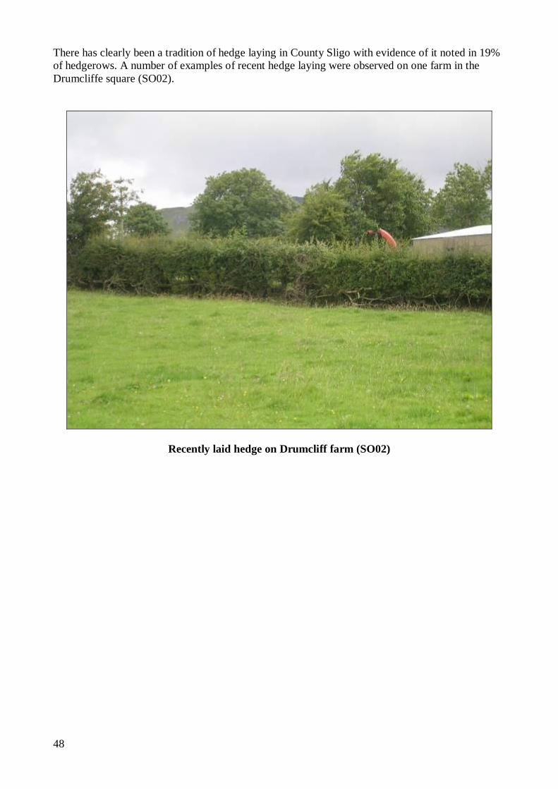
48
There has clearly been a tradition of hedge laying in County Sligo with evidence of it noted in 19% of hedgerows. A number of examples of recent hedge laying were observed on one farm in the Drumcliffe square (SO02).
Recently laid hedge on Drumcliff farm (SO02)

49
5.7 QUALITY OF HEDGES IN COUNTY SLIGO Condition of Species Rich Hedges The Steering Group for the UK Biodiversity Action Plan (UK Biodiversity Action Plan Website) have produced a list of nine criteria as to what constitutes ‘favourable condition’ for species rich hedges. Of these only five were sufficiently consistent with data recorded in the County Sligo Hedgerow Survey to allow comparison. These were
1. Average height at least 2m
2. Average width at least 1.50m
3. Less than 10% gaps, with no individual gap wider than 5m
4. Base of woody component closer than 50cm to the ground
5. Less than 10% introduced non native species.
The four criteria which could not be compared due to lack of comparability between recording criteria for this survey and hedgerow data recording in the UK are; 6. Less than 10% bare or trampled ground below the woody canopy
7. At least 2 m (from centre of hedge) unploughed margin
8. Low cover of nettles, docks and cleavers in the margin
9. Absence of dead vegetation in the base as a result of spraying.
There are no defined criteria for what is considered to be a species rich hedge or what is considered to be favourable condition for Irish hedgerows. In the absence of such criteria this assessment is guided by the British measures. All sample hedges were assessed against criteria 1-5 above. 22% of hedges sampled in County Sligo passed all five of the standards for favourable condition which compares favourably with results from other counties. Of the sampled hedges in County Sligo, 12.8% were classed as species rich and of these 25% passed the five criteria for favourable condition which is 3.1% of the total hedges sampled. All of the available comparative figures from the other County surveys are shown in Table 5.7.1. Table 5.7.1 Comparison of the ‘favourable condition’ status of hedges County by County County % of hedges in
favourable condition
% of Species Rich Hedges
% of species rich hedges in
favourable condition
% of total sample that are species rich
hedges in favourable condition
Leitrim 25.0 46.9 40.0 18.8 Kildare 23.0 18.8 41.0 7.7 Mayo 22.3 12.9 42.3 5.4 Sligo 21.9 12.8 25.0 3.1 Laois 20.0 44.7 32.4 14.5 Longford 6.4 15.4 16.7 2.6 Offaly 4.8 31.5 24.4 7.7 Cavan n/a 40.7 39 15.7 East Galway n/a 14.7 13 n/a
50
Roscommon n/a 4.8 55.6 2.6 Westmeath n/a 4.6 14.3 0.7 Figure 5.7.1 shows a breakdown of how the Sligo hedges sampled compared against each of the favourable condition criteria.
22%
9%
1%
49% 49%
13%
25%
17%
33%
50%
8%
0%
10%
20%
30%
40%
50%
60%
Favourable Too low Too narrow Too gappy Base not dense Excessive non-natives
Are hedges in favourable condition?
% o
f hed
ges
surv
eyed
All Hedges
Species Rich
Figure 5.7.1 Favourable condition status of sampled hedges in County Sligo 22% of sampled hedges met all five favourable condition criteria. The two main categories responsible for sampled hedges failing to meet the criteria were ‘too gappy’ (49%) and ‘base not dense’ (49%). 9% of hedges were classified as ‘too low’ Seven different non-native species were present to levels considered excessive in terms of favourable condition status. These were, in descending order of prevalence, Sycamore, Snowberry, Fuschia, Leylandii, Beech, Spiraea, and Wild Privet. Wild Privet is considered native to certain parts of Ireland, but, according to Webb (1977), not County Sligo. This resulted in 13% of sampled hedges failing to meet the favourable condition criteria.
51
5.8 HEDGEROW MANAGEMENT AND DEVELOPMENT CONTROL At the request of the Natural Heritage Working Group of the County Sligo Heritage Forum a field assessment of any hedgerow-related planning conditions associated with properties falling within the sample squares was undertaken. Details of planning applications and associated conditions within the survey areas going back to 2000 were provided by Sligo County Council. Where planning permission was granted, any hedgerow-related planning conditions were noted, and during the fieldwork, observation was made as to the extent of compliance with any conditions relating to hedgerows. 39 separate hedgerow planning conditions related to 28 planning applications were noted from the information provided by Sligo County Council. Of the 28 Developments 3 had not commenced work, and 3 had been superseded by more recent planning applications. This left 30 planning conditions related to 22 planning applications which could be summarised as follows (one condition fell within two categories). Table 5.8.1 Summary of Hedgerow-Related Planning Conditions
New roadside boundaries In two cases groundwork for the development had only just commenced and it was too early to assess compliance. In a further case the original hedge had been removed, the development was in the latter stages of completion but no new roadside boundary had been constructed. In two cases the original roadside boundary was still intact except for a new access point. In the three cases where a new roadside boundary had been constructed, one had a cut stone wall, the other two had concrete block walls, one rendered, the other not. Retention of Existing Trees and Hedges Without an inventory of the original trees and hedges on site it was not possible to determine whether trees and hedges had been retained. Landscaping scheme to be submitted Based on the information supplied by Sligo County Council two successful planning applications that were required to submit detailed landscaping plans as a condition of planning approval had yet to do so. Landscaping carried out according to details submitted Of the three developments that had submitted a landscaping plan two were under construction and it was too early to assess the level of compliance with the details of the landscaping plan. In the third case the details of the plan had not been implemented.
Planning Condition Number New roadside boundary to be constructed of local random rubble, or clay bank planted with indigenous hedging
8
All existing trees and hedgerows to be retained 12 Landscaping scheme to be submitted; 2 Landscaping to be carried out according to details submitted 3 Site specific condition 5 All planting completed within first planting season 1
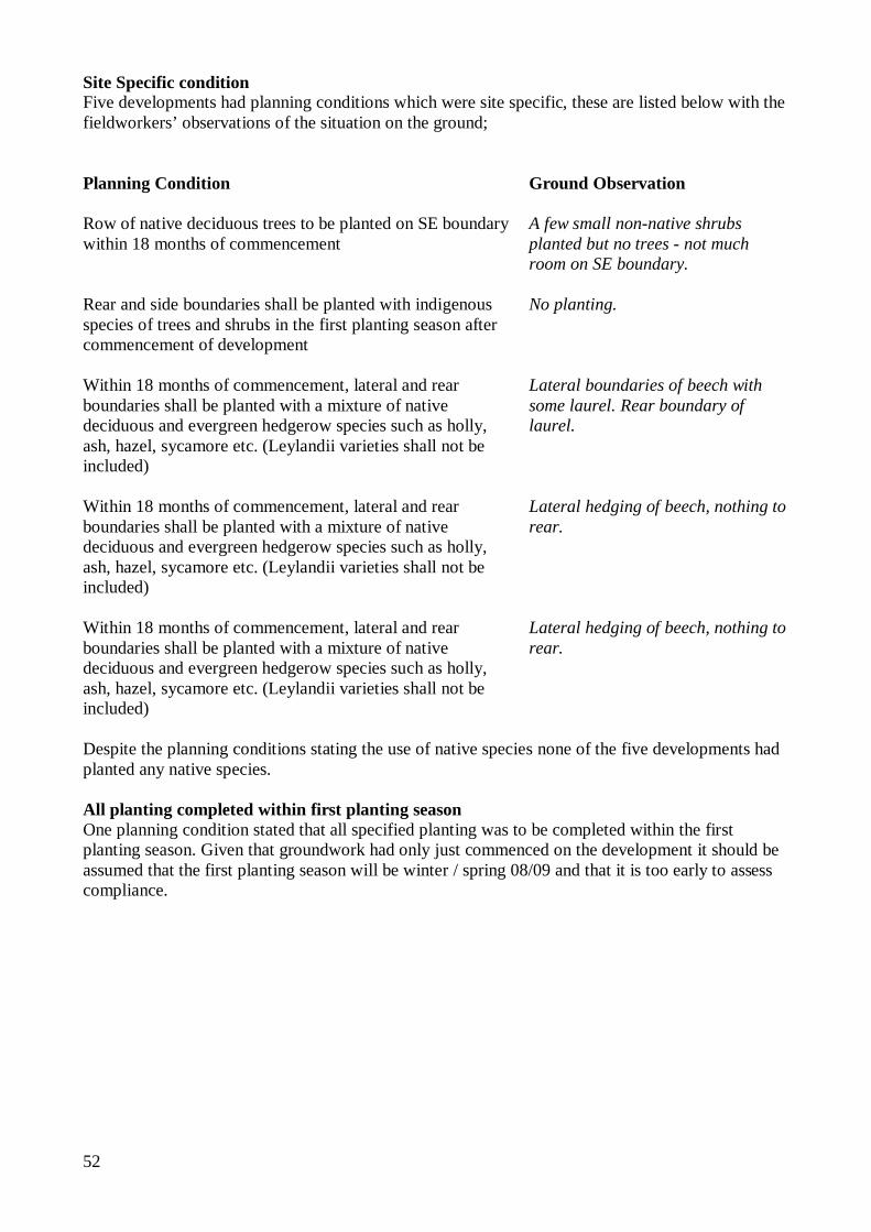
52
Site Specific condition Five developments had planning conditions which were site specific, these are listed below with the fieldworkers’ observations of the situation on the ground; Planning Condition Ground Observation
Row of native deciduous trees to be planted on SE boundary within 18 months of commencement
A few small non-native shrubs planted but no trees - not much room on SE boundary.
Rear and side boundaries shall be planted with indigenous species of trees and shrubs in the first planting season after commencement of development
No planting.
Within 18 months of commencement, lateral and rear boundaries shall be planted with a mixture of native deciduous and evergreen hedgerow species such as holly, ash, hazel, sycamore etc. (Leylandii varieties shall not be included)
Lateral boundaries of beech with some laurel. Rear boundary of laurel.
Within 18 months of commencement, lateral and rear boundaries shall be planted with a mixture of native deciduous and evergreen hedgerow species such as holly, ash, hazel, sycamore etc. (Leylandii varieties shall not be included)
Lateral hedging of beech, nothing to rear.
Within 18 months of commencement, lateral and rear boundaries shall be planted with a mixture of native deciduous and evergreen hedgerow species such as holly, ash, hazel, sycamore etc. (Leylandii varieties shall not be included)
Lateral hedging of beech, nothing to rear.
Despite the planning conditions stating the use of native species none of the five developments had planted any native species. All planting completed within first planting season One planning condition stated that all specified planting was to be completed within the first planting season. Given that groundwork had only just commenced on the development it should be assumed that the first planting season will be winter / spring 08/09 and that it is too early to assess compliance.
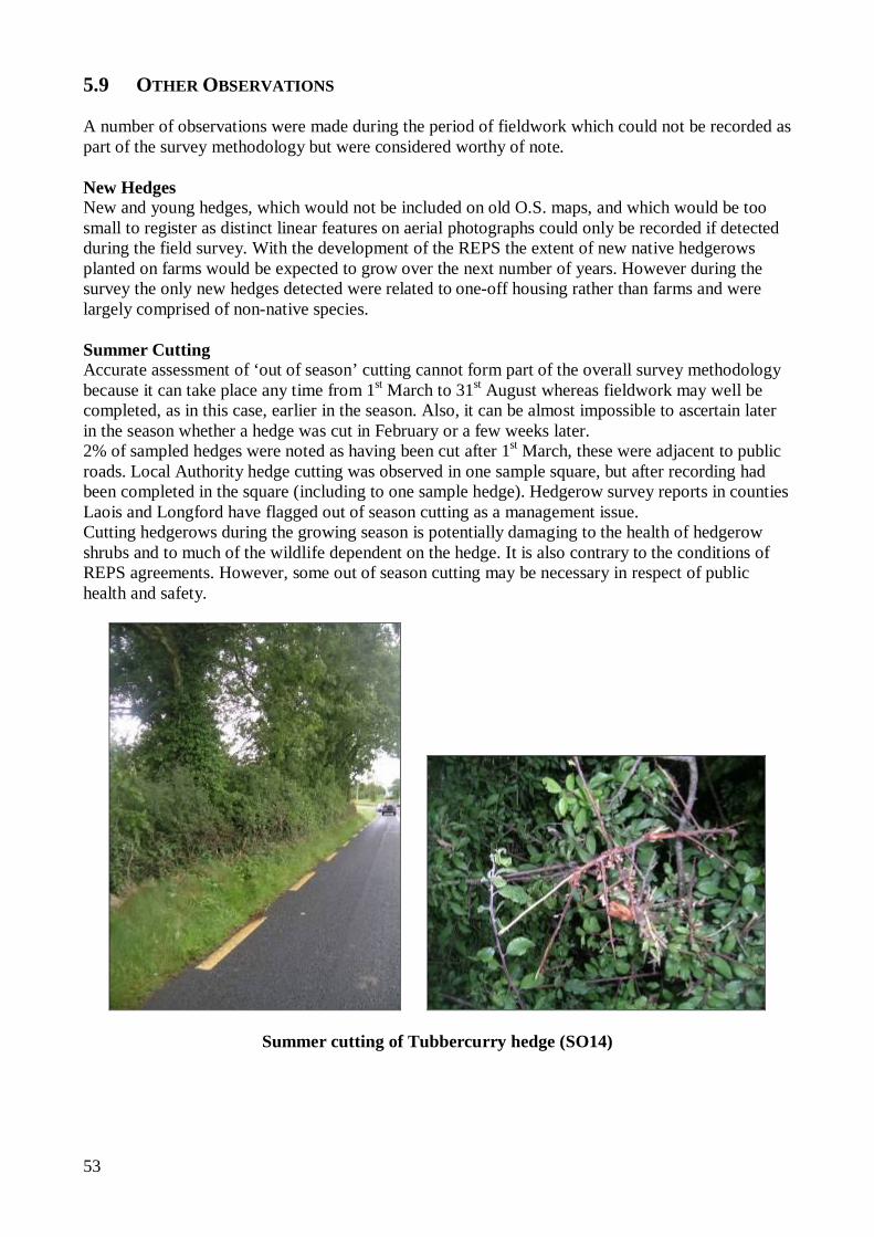
53
5.9 OTHER OBSERVATIONS A number of observations were made during the period of fieldwork which could not be recorded as part of the survey methodology but were considered worthy of note. New Hedges
New and young hedges, which would not be included on old O.S. maps, and which would be too small to register as distinct linear features on aerial photographs could only be recorded if detected during the field survey. With the development of the REPS the extent of new native hedgerows planted on farms would be expected to grow over the next number of years. However during the survey the only new hedges detected were related to one-off housing rather than farms and were largely comprised of non-native species.
Summer Cutting
Accurate assessment of ‘out of season’ cutting cannot form part of the overall survey methodology because it can take place any time from 1st March to 31st August whereas fieldwork may well be completed, as in this case, earlier in the season. Also, it can be almost impossible to ascertain later in the season whether a hedge was cut in February or a few weeks later. 2% of sampled hedges were noted as having been cut after 1st March, these were adjacent to public roads. Local Authority hedge cutting was observed in one sample square, but after recording had been completed in the square (including to one sample hedge). Hedgerow survey reports in counties Laois and Longford have flagged out of season cutting as a management issue. Cutting hedgerows during the growing season is potentially damaging to the health of hedgerow shrubs and to much of the wildlife dependent on the hedge. It is also contrary to the conditions of REPS agreements. However, some out of season cutting may be necessary in respect of public health and safety.
Summer cutting of Tubbercurry hedge (SO14)
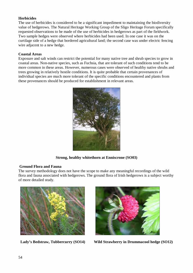
54
Herbicides The use of herbicides is considered to be a significant impediment to maintaining the biodiversity value of hedgerows. The Natural Heritage Working Group of the Sligo Heritage Forum specifically requested observations to be made of the use of herbicides in hedgerows as part of the fieldwork. Two sample hedges were observed where herbicides had been used. In one case it was on the curtilage side of a hedge that bordered agricultural land; the second case was under electric fencing wire adjacent to a new hedge. Coastal Areas Exposure and salt winds can restrict the potential for many native tree and shrub species to grow in coastal areas. Non-native species, such as Fuchsia, that are tolerant of such conditions tend to be more common in these areas. However, numerous cases were observed of healthy native shrubs and trees growing in relatively hostile conditions. It is quite probable that certain provenances of individual species are much more tolerant of the specific conditions encountered and plants from these provenances should be produced for establishment in relevant areas.
Strong, healthy whitethorn at Enniscrone (SO03)
Ground Flora and Fauna The survey methodology does not have the scope to make any meaningful recordings of the wild flora and fauna associated with hedgerows. The ground flora of Irish hedgerows is a subject worthy of more detailed study.
Lady’s Bedstraw, Tubbercurry (SO14) Wild Strawberry in Drummacool hedge (SO12)
55
6.0 ANALYSIS AND DISCUSSION In this section the results of the survey are analysed in more detail and discussed in absolute and in relative terms. In ‘absolute’ terms the hedgerow resource of County Sligo can be assessed in light of current thinking on best conservation practice and data can be compared against a set of agreed criteria for favourable attributes. The ‘relative’ assessment compares the resource with that from comparative studies in Counties Cavan, East Galway, Kildare, Laois, Leitrim, Longford, Mayo, Offaly, Roscommon and Westmeath. Ideally all counties should commission County Hedgerow Surveys to allow for wider comparison and an assessment of the resource at a National level. In the future, a relative assessment could involve a repeat of this survey to compare the future resource with its current condition, in order to monitor trends. Hedgerow Extent County Sligo has a significant network of hedgerows, with an estimated total length of 10,449 km. The Badger and Habitats Survey of Ireland (Smal, 1995) estimated the hedgerow/tree row network in Ireland to be approximately 382,000 km. The estimated figure for County Sligo was 8,526km (2.2% of the national total). A probable explanation for the discrepancy between the two figures for County Sligo lies in the different methodologies and definitions used between the two surveys.
Hedgerow Density The average figure for hedgerow density (km of hedgerow / km²) in County Sligo is 5.33. Two of the sample squares (SO08 and SO09) did not contain hedgerows, these were in upland areas. The highest recorded hedgerow density was in sample square SO02 (Drumcliff) with a density of almost 14.0 km / km². The highest hedgerow density figure recorded in any of the specific Irish county based hedgerow surveys to date is 22.51 km/km² in a square near to Drumsna, County Leitrim. The results from the other county hedgerow surveys are shown for comparison, along with the standard deviations and % of remnant hedges in Table 6.1. Table 6.1 Comparison of average hedgerow density
Standard deviation of hedgerow density statistics gives an insight into the overall nature of the hedgerow landscape within a county. A high standard deviation figure is recorded, such as in County Longford, where there is a wide variation in hedgerow density across the county, from areas of bog and forestry, with little or no hedges to the areas with a much heavier concentration of
Year of Survey County Average Density
(km/km²)
Standard Deviation
% of remnant hedges
2006 Cavan 11.01 4.76 15.0 2006 Longford 8.23 6.14 3.5 2006 Leitrim 7.31 6.98 4.1 2005 Laois 7.28 3.15 1.7 2006 Kildare 5.92 3.61 3.7 2006 East Galway 5.88 n/a 4.4 2004 Westmeath 5.82 3.28 9.7 2005 Offaly 5.81 4.32 2.1 2004 Roscommon 5.43 4.75 12.2 2008 Sligo 5.33 4.76 2.0 2007 Mayo 2.26 2.99 0.1
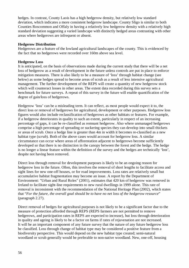
56
hedges. In contrast, County Laois has a high hedgerow density, but relatively low standard deviation, which indicates a more consistent hedgerow landscape. County Sligo is similar to both Counties Roscommon and Offaly in having a relatively low hedgerow density with a relatively high standard deviation suggesting a varied landscape with distinctly hedged areas contrasting with other areas where hedgerows are infrequent or absent. Hedgerow Distribution Hedgerows are a feature of the lowland agricultural landscapes of the county. This is evidenced by the fact that no hedgerows were recorded over 160m above sea level. Hedgerow Loss It is anticipated, on the basis of observations made during the current study that there will be a net loss of hedgerow as a result of development in the future unless controls are put in place to enforce mitigation measures. There is also likely to be a measure of ‘loss’ through habitat change (see below) as some hedges spread to become areas of scrub as a result of less intensive agricultural management. The further development of the REPS will create a quantity of new hedgerow stock which will counteract losses in other areas. The extent data recorded during this survey sets a benchmark for future surveys. A repeat of this survey in the future will enable quantification of the degree of gain/loss of hedgerows. Hedgerow ‘loss’ can be a misleading term. It can reflect, as most people would expect it to, the direct loss or removal of hedgerows for agricultural, development or other purposes. Hedgerow loss figures would also include reclassification of hedgerows as other habitats or features. For example, if a hedgerow deteriorates in quality to such an extent, particularly in respect of an increasing percentage of gaps, it can be re-classified as remnant hedgerow. Also where unmanaged hedgerows comprise a high percentage of spreading or suckering species they can develop into small thickets or areas of scrub. Once a hedge line is greater than 4m in width it becomes re-classified as a new habitat type (scrub). Both of the above cases would account for hedgerow loss. A similar circumstance can occur where areas of afforestation adjacent to hedgerows become sufficiently developed so that there is no distinction in the canopy between the forest and the hedge. The hedge is no longer a linear feature within the definition of the survey and the hedges are technically ‘lost’, despite not having been removed.
Direct loss through removal for development purposes is likely to be an ongoing reason for hedgerow loss in the future. Often, this involves the removal of short lengths to facilitate access and sight lines for new one-off houses, or for road improvements. Loss rates are relatively small but accumulative habitat fragmentation may become an issue. A report by the Department of Environment: "Urban and Rural Roles" (2001), estimates that 420 km of hedgerow was removed in Ireland to facilitate sight-line requirements to new rural dwellings in 1999 alone. This rate of removal is inconsistent with the recommendation of the National Heritage Plan (2002), which states that “For the future, the overall goal should be to have no net loss of the hedgerow resource” (paragraph 2.27). Direct removal of hedges for agricultural purposes is not likely to be a significant factor due to the measure of protection afforded through REPS (REPS farmers are not permitted to remove hedgerows, and participation rates in REPS are expected to increase), but loss through deterioration in quality and ageing is likely to be a factor on farms if rates of rejuvenation are not increased. It will be an important component of any future survey that the nature of any future hedgerow loss be classified. Loss through change of habitat type may be considered a positive feature from a biodiversity perspective. This would depend on the new habitat type created; semi-natural woodland or scrub generally would be preferable to non-native woodland. New, one-off, housing
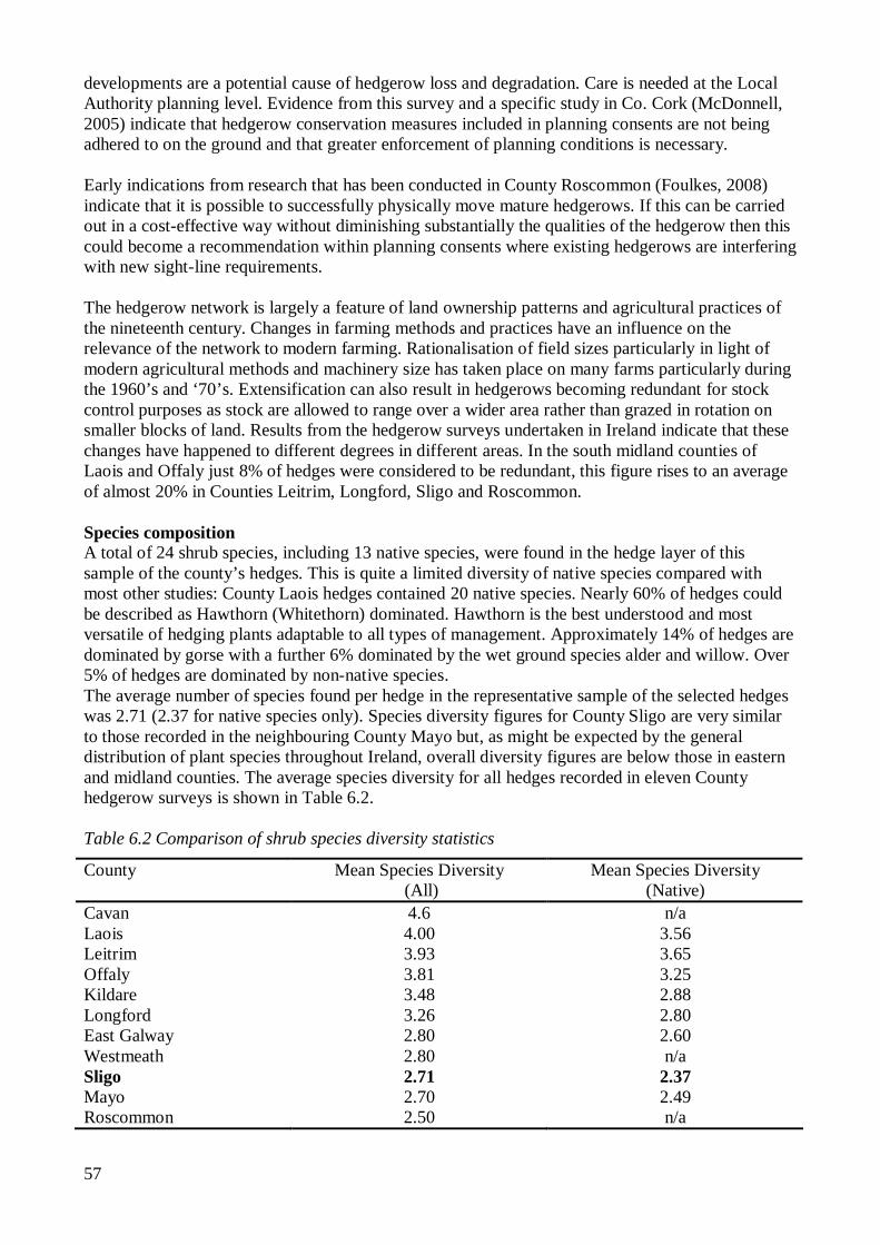
57
developments are a potential cause of hedgerow loss and degradation. Care is needed at the Local Authority planning level. Evidence from this survey and a specific study in Co. Cork (McDonnell, 2005) indicate that hedgerow conservation measures included in planning consents are not being adhered to on the ground and that greater enforcement of planning conditions is necessary. Early indications from research that has been conducted in County Roscommon (Foulkes, 2008) indicate that it is possible to successfully physically move mature hedgerows. If this can be carried out in a cost-effective way without diminishing substantially the qualities of the hedgerow then this could become a recommendation within planning consents where existing hedgerows are interfering with new sight-line requirements. The hedgerow network is largely a feature of land ownership patterns and agricultural practices of the nineteenth century. Changes in farming methods and practices have an influence on the relevance of the network to modern farming. Rationalisation of field sizes particularly in light of modern agricultural methods and machinery size has taken place on many farms particularly during the 1960’s and ‘70’s. Extensification can also result in hedgerows becoming redundant for stock control purposes as stock are allowed to range over a wider area rather than grazed in rotation on smaller blocks of land. Results from the hedgerow surveys undertaken in Ireland indicate that these changes have happened to different degrees in different areas. In the south midland counties of Laois and Offaly just 8% of hedges were considered to be redundant, this figure rises to an average of almost 20% in Counties Leitrim, Longford, Sligo and Roscommon. Species composition A total of 24 shrub species, including 13 native species, were found in the hedge layer of this sample of the county’s hedges. This is quite a limited diversity of native species compared with most other studies: County Laois hedges contained 20 native species. Nearly 60% of hedges could be described as Hawthorn (Whitethorn) dominated. Hawthorn is the best understood and most versatile of hedging plants adaptable to all types of management. Approximately 14% of hedges are dominated by gorse with a further 6% dominated by the wet ground species alder and willow. Over 5% of hedges are dominated by non-native species. The average number of species found per hedge in the representative sample of the selected hedges was 2.71 (2.37 for native species only). Species diversity figures for County Sligo are very similar to those recorded in the neighbouring County Mayo but, as might be expected by the general distribution of plant species throughout Ireland, overall diversity figures are below those in eastern and midland counties. The average species diversity for all hedges recorded in eleven County hedgerow surveys is shown in Table 6.2. Table 6.2 Comparison of shrub species diversity statistics
County Mean Species Diversity (All)
Mean Species Diversity (Native)
Cavan 4.6 n/a Laois 4.00 3.56 Leitrim 3.93 3.65 Offaly 3.81 3.25 Kildare 3.48 2.88 Longford 3.26 2.80 East Galway 2.80 2.60 Westmeath 2.80 n/a Sligo 2.71 2.37 Mayo 2.70 2.49 Roscommon 2.50 n/a
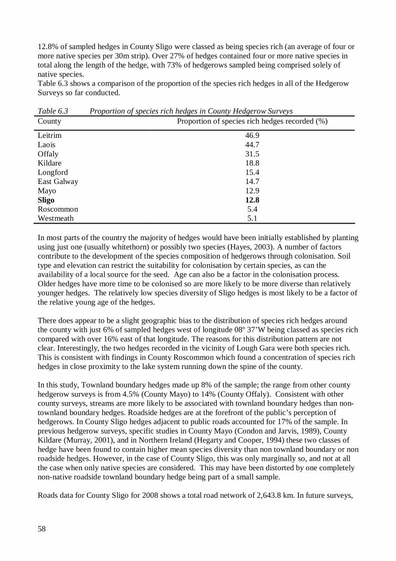
58
12.8% of sampled hedges in County Sligo were classed as being species rich (an average of four or more native species per 30m strip). Over 27% of hedges contained four or more native species in total along the length of the hedge, with 73% of hedgerows sampled being comprised solely of native species. Table 6.3 shows a comparison of the proportion of the species rich hedges in all of the Hedgerow Surveys so far conducted. Table 6.3 Proportion of species rich hedges in County Hedgerow Surveys County Proportion of species rich hedges recorded (%)
Leitrim 46.9 Laois 44.7 Offaly 31.5 Kildare 18.8 Longford 15.4 East Galway 14.7 Mayo 12.9 Sligo 12.8 Roscommon 5.4 Westmeath 5.1 In most parts of the country the majority of hedges would have been initially established by planting using just one (usually whitethorn) or possibly two species (Hayes, 2003). A number of factors contribute to the development of the species composition of hedgerows through colonisation. Soil type and elevation can restrict the suitability for colonisation by certain species, as can the availability of a local source for the seed. Age can also be a factor in the colonisation process. Older hedges have more time to be colonised so are more likely to be more diverse than relatively younger hedges. The relatively low species diversity of Sligo hedges is most likely to be a factor of the relative young age of the hedges. There does appear to be a slight geographic bias to the distribution of species rich hedges around the county with just 6% of sampled hedges west of longitude 08º 37’W being classed as species rich compared with over 16% east of that longitude. The reasons for this distribution pattern are not clear. Interestingly, the two hedges recorded in the vicinity of Lough Gara were both species rich. This is consistent with findings in County Roscommon which found a concentration of species rich hedges in close proximity to the lake system running down the spine of the county. In this study, Townland boundary hedges made up 8% of the sample; the range from other county hedgerow surveys is from 4.5% (County Mayo) to 14% (County Offaly). Consistent with other county surveys, streams are more likely to be associated with townland boundary hedges than non-townland boundary hedges. Roadside hedges are at the forefront of the public’s perception of hedgerows. In County Sligo hedges adjacent to public roads accounted for 17% of the sample. In previous hedgerow surveys, specific studies in County Mayo (Condon and Jarvis, 1989), County Kildare (Murray, 2001), and in Northern Ireland (Hegarty and Cooper, 1994) these two classes of hedge have been found to contain higher mean species diversity than non townland boundary or non roadside hedges. However, in the case of County Sligo, this was only marginally so, and not at all the case when only native species are considered. This may have been distorted by one completely non-native roadside townland boundary hedge being part of a small sample. Roads data for County Sligo for 2008 shows a total road network of 2,643.8 km. In future surveys,
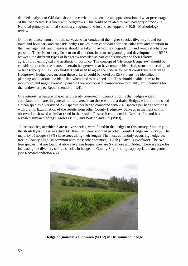
59
detailed analysis of GIS data should be carried out to enable an approximation of what percentage of the road network is lined with hedgerows. This could be related to each category of road (i.e. National primary, national secondary, regional and local), see Appendix 10.8 - Methodology review. On the evidence from all of the surveys so far conducted the higher species diversity found for townland boundary and roadside hedges makes them candidates for particular care and attention in their management, and measures should be taken to avoid their degradation and removal wherever possible. There is currently little or no distinction, in terms of planning and development, or REPS between the different types of hedgerow recorded as part of this survey and their relative agricultural, ecological and aesthetic importance. The concept of ‘Heritage Hedgerow’ should be considered to raise the status of certain hedgerows that have notable historical, structural, ecological or landscape qualities. Stakeholders will need to agree the criteria for what constitutes a Heritage Hedgerow. Hedgerows meeting these criteria could be noted on REPS plans; be identified in planning applications; be identified when land is re-zoned, etc. This should enable them to be monitored and might eventually enable their appropriate conservation to qualify for incentives for the landowner (see Recommendation 1.4). One interesting feature of species diversity observed in County Sligo is that hedges with an associated drain are, in general, more diverse than those without a drain. Hedges without drains had a mean species diversity of 2.29 species per hedge compared with 2.46 species per hedge for those with drains. Examination of the results from other County Hedgerow Surveys in the light of this observation showed a similar trend in the results. Research conducted in Northern Ireland has revealed similar findings (Moles (1975) and Watson and Orr (1983)). 12 tree species, of which 8 are native species, were found in the hedges of this survey. Similarly to the shrub layer this is less diversity than has been recorded in other County Hedgerow Surveys. The majority of hedges (68%) have trees along their length. The most commonly occurring hedgerow tree in County Sligo (in common with most other counties) is Ash (Fraxinus excelsior). The two tree species that are found at above average frequencies are Sycamore and Alder. There is scope for increasing the diversity of tree species in hedges in County Sligo through appropriate management (see Recommendation 4.7).
Hedge of (non-native) Spiraea (SO12) in Drummacool hedge
60
Species Distribution Excluding the squares in which no hedges were recorded, most of the main hedgerow species have a widespread distribution with only Holly and Alder showing a more localised distribution pattern. Gorse was not recorded in hedges in three of the four hedged squares in the south east of the county. These results may reflect the individual conditions in the particular sample squares but the results would suggest that species selection advice for new planting (REPS, mitigation planting, etc.) should be specific rather than general and should reflect local conditions (see Recommendation 3.6). The New Atlas of the British and Irish Flora (Preston et al, 2002) documents the distribution of native and non-native species around Britain and Ireland based on their presence within 10km grid squares. A number of recordings made during this survey would indicate that certain species have a wider distribution than is indicated in the Atlas. The results of the survey should be available to the local Botanical Society of Britain and Ireland (BSBI) Recorder to allow updating of datasets. Ivy, Woody Climbers Ivy was recorded as present at the canopy level in 33% of the 30m strips recorded in County Sligo. It is a plant that provokes polarised views from different quarters. Its value for wildlife as a food source, and as nesting or roosting site is unquestionable. However, it is the destructive potential of ivy that provokes controversy. It is generally acknowledged that ivy is not directly parasitic on its host, but the fact that ivy is frequently associated with trees that are in poor condition gives rise to two schools of thought. One view suggests that ivy can dominate its host and cause it to lose vigour and even eventually kill it. The other view suggests that ivy only dominates trees and shrubs that are already in poor condition and that ivy itself is not destructive. The truth probably lies somewhere between the two. Just 1% of 30m strips recorded had ivy dominant at the canopy level for over 25% of their length. This is similar to other western areas and is lower than the levels witnessed in more eastern and southern counties previously surveyed. In particular it is significantly below the 20% figure recorded in County Westmeath. 4% of hedges sampled in County Sligo are in the 11-25% coverage category where a watching brief is advised. Ivy appears to be less prevalent and invasive in western coastal county hedges. Bramble (Rubus fruiticosus agg.) was recorded as being present in a total of 92% of sample strips in County Sligo hedges surveyed which is consistent with results from counties Mayo, Kildare, Longford, Laois and Offaly (no comparative data from other surveys). Wild Rose (Rosa spp.) species were recorded in 17% of the sample 30m strips. Given the limited distribution of the most common rose species in the sample area shown in The New Atlas of the British and Irish Flora (Preston et al, 2002) the fact that they were found in over half of the squares that contained hedgerows may suggest that they are more widely distributed than has been recorded to date. History and Landscape Context The majority of the current hedgerow landscape in County Sligo was established during the period from the mid 18th century up to the early part of the 20th century, although a portion is likely to be older. Townland boundary hedges tend to be of more ancient origin than non–townland boundary hedges. Older boundaries frequently are non-linear and are often demarcated by natural features such as watercourses. An examination of the first and second edition maps (6” to the mile) produced by the Ordnance Survey can give an indication as to the period of origin of individual hedgerows. In County Sligo, the first edition 6” O.S. maps were produced in 1837, followed by the second
61
edition 6” O.S. maps in 1909-12. Where a boundary is present on the second edition Ordnance Survey maps, but is absent from the first edition it is possible roughly to date the origin the hedge to the period 1837 to 1909. 56% of the sample hedges were not present on the first edition maps from 1837. The second edition O.S. maps (1909-12) show 7% of the sample hedges were not present. Boundary lines shown on the original edition maps were not necessarily hedgerows. More recently established hedges (that are not present on the second edition O.S. maps), are either associated with Land Commission property divisions, realignment of roads or associated with recent property development adjacent to agricultural land. These hedges, particularly the latter, are almost invariably species poor. The average native species diversity of those hedges not present in 1837 was 1.93 species per hedge compared with an overall average of 2.37 native species per hedge. The second edition O.S. maps, in general, show the greatest degree of field division, indicating that although land enclosure was well established before the famine, further sub division of lands was ongoing up to the end of the nineteenth century. There is a suggestion that field boundaries were under recorded during the earliest recordings by the Ordnance Survey, particularly in northern parts of the country, including County Sligo (O’Connor, 2006). It is generally fairly apparent where such omissions occur and it is maintained that the statistics recorded for this study are accurate. There is also some evidence of slight field realignment in the period between the two surveys. Hedgerows exist in the wider framework of the landscape. How hedges interface with the wider environment can have a significant bearing on their relative value in the landscape and their ability to support biodiversity. Where hedgerows sub divide improved grassland or arable land their absolute value for supporting a diverse ecology is reduced, but their relative importance for biodiversity in that area is increased. In the context of REPS it would be very useful if a full habitat survey of each farm were conducted (in line with Fossitt, (2000)). This should enable greater prioritisation of management actions in order to maintain and enhance biodiversity (see Recommendation 3.11). Hedge Construction Hedgerows vary in their construction based upon numerous factors including origin, soil type, topography, farming practice, tradition and legislation. In wetter areas or where soils are poorly drained, a bank would need to be constructed to prevent shrub roots from becoming water-logged. A drain to carry away surplus water would also be common. Where stony soils are frequent, hedge banks often contain quantities of field stone cleared from adjacent farmland when under tillage. Sometimes there is sufficient stone to construct a wall in association with the hedge. Older hedges may follow natural landscape features, such as streams; whereas other hedges were marked out by surveyors and follow straight lines. Certain Acts of Parliament prescribed specifications for hedgerow construction including dimensions for banks and drains, and methods of planting (Feehan 1983). Many landowners included such details as clauses in tenants’ leases. Whitethorn was the preferred choice of hedgerow shrub, but crab was also recommended (Hayes 2003). A significant proportion of the County Sligo hedgerow resource could be classed as being of a standard construction with a single line of shrubs established along a bank or wall, often with an associated drainage ditch. Other hedges, most commonly those with a high proportion of gorse, are of a more spontaneous or organic origin, where earth-banks became colonised over time by brambles and woody shrubs. This was evident in the sample area near Enniscrone (SO03). Until relatively recently this area was principally a tillage area, with potatoes being the main crop with some grain also grown. There would have been little need for hedgerows. The gappy hedges in this area could be more accurately described as incompletely colonised banks. Since this is now a
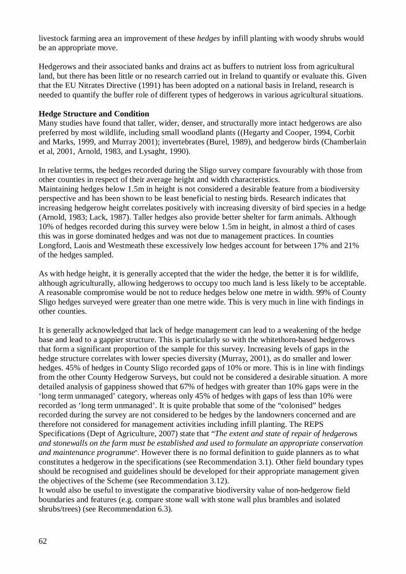
62
livestock farming area an improvement of these hedges by infill planting with woody shrubs would be an appropriate move. Hedgerows and their associated banks and drains act as buffers to nutrient loss from agricultural land, but there has been little or no research carried out in Ireland to quantify or evaluate this. Given that the EU Nitrates Directive (1991) has been adopted on a national basis in Ireland, research is needed to quantify the buffer role of different types of hedgerows in various agricultural situations. Hedge Structure and Condition Many studies have found that taller, wider, denser, and structurally more intact hedgerows are also preferred by most wildlife, including small woodland plants ((Hegarty and Cooper, 1994, Corbit and Marks, 1999, and Murray 2001); invertebrates (Burel, 1989), and hedgerow birds (Chamberlain et al, 2001, Arnold, 1983, and Lysaght, 1990). In relative terms, the hedges recorded during the Sligo survey compare favourably with those from other counties in respect of their average height and width characteristics. Maintaining hedges below 1.5m in height is not considered a desirable feature from a biodiversity perspective and has been shown to be least beneficial to nesting birds. Research indicates that increasing hedgerow height correlates positively with increasing diversity of bird species in a hedge (Arnold, 1983; Lack, 1987). Taller hedges also provide better shelter for farm animals. Although 10% of hedges recorded during this survey were below 1.5m in height, in almost a third of cases this was in gorse dominated hedges and was not due to management practices. In counties Longford, Laois and Westmeath these excessively low hedges account for between 17% and 21% of the hedges sampled.
As with hedge height, it is generally accepted that the wider the hedge, the better it is for wildlife, although agriculturally, allowing hedgerows to occupy too much land is less likely to be acceptable. A reasonable compromise would be not to reduce hedges below one metre in width. 99% of County Sligo hedges surveyed were greater than one metre wide. This is very much in line with findings in other counties. It is generally acknowledged that lack of hedge management can lead to a weakening of the hedge base and lead to a gappier structure. This is particularly so with the whitethorn-based hedgerows that form a significant proportion of the sample for this survey. Increasing levels of gaps in the hedge structure correlates with lower species diversity (Murray, 2001), as do smaller and lower hedges. 45% of hedges in County Sligo recorded gaps of 10% or more. This is in line with findings from the other County Hedgerow Surveys, but could not be considered a desirable situation. A more detailed analysis of gappiness showed that 67% of hedges with greater than 10% gaps were in the ‘long term unmanaged’ category, whereas only 45% of hedges with gaps of less than 10% were recorded as ‘long term unmanaged’. It is quite probable that some of the “colonised” hedges recorded during the survey are not considered to be hedges by the landowners concerned and are therefore not considered for management activities including infill planting. The REPS Specifications (Dept of Agriculture, 2007) state that “The extent and state of repair of hedgerows and stonewalls on the farm must be established and used to formulate an appropriate conservation and maintenance programme”. However there is no formal definition to guide planners as to what constitutes a hedgerow in the specifications (see Recommendation 3.1). Other field boundary types should be recognised and guidelines should be developed for their appropriate management given the objectives of the Scheme (see Recommendation 3.12). It would also be useful to investigate the comparative biodiversity value of non-hedgerow field boundaries and features (e.g. compare stone wall with stone wall plus brambles and isolated shrubs/trees) (see Recommendation 6.3).
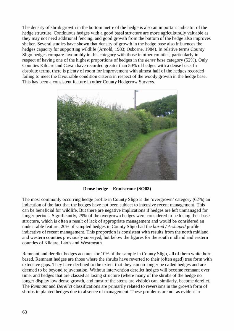
63
The density of shrub growth in the bottom metre of the hedge is also an important indicator of the hedge structure. Continuous hedges with a good basal structure are more agriculturally valuable as they may not need additional fencing, and good growth from the bottom of the hedge also improves shelter. Several studies have shown that density of growth in the hedge base also influences the hedges capacity for supporting wildlife (Arnold, 1983; Osborne, 1984). In relative terms County Sligo hedges compare favourably in this category with those in other counties, particularly in respect of having one of the highest proportions of hedges in the dense base category (52%). Only Counties Kildare and Cavan have recorded greater than 50% of hedges with a dense base. In absolute terms, there is plenty of room for improvement with almost half of the hedges recorded failing to meet the favourable condition criteria in respect of the woody growth in the hedge base. This has been a consistent feature in other County Hedgerow Surveys.
Dense hedge – Enniscrone (SO03) The most commonly occurring hedge profile in County Sligo is the ‘overgrown’ category (62%) an indication of the fact that the hedges have not been subject to intensive recent management. This can be beneficial for wildlife. But there are negative implications if hedges are left unmanaged for longer periods. Significantly, 29% of the overgrown hedges were considered to be losing their base structure, which is often a result of lack of appropriate management and would be considered an undesirable feature. 20% of sampled hedges in County Sligo had the boxed / A-shaped profile indicative of recent management. This proportion is consistent with results from the north midland and western counties previously surveyed, but below the figures for the south midland and eastern counties of Kildare, Laois and Westmeath.
Remnant and derelict hedges account for 10% of the sample in County Sligo, all of them whitethorn based. Remnant hedges are those where the shrubs have reverted to their (often aged) tree form with extensive gaps. They have declined to the extent that they can no longer be called hedges and are deemed to be beyond rejuvenation. Without intervention derelict hedges will become remnant over time, and hedges that are classed as losing structure (where many of the shrubs of the hedge no longer display low dense growth, and most of the stems are visible) can, similarly, become derelict. The Remnant and Derelict classifications are primarily related to reversions in the growth form of shrubs in planted hedges due to absence of management. These problems are not as evident in
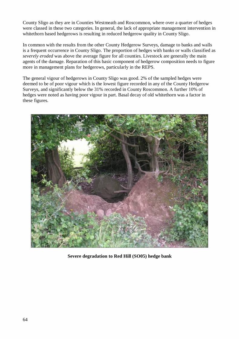
64
County Sligo as they are in Counties Westmeath and Roscommon, where over a quarter of hedges were classed in these two categories. In general, the lack of appropriate management intervention in whitethorn based hedgerows is resulting in reduced hedgerow quality in County Sligo. In common with the results from the other County Hedgerow Surveys, damage to banks and walls is a frequent occurrence in County Sligo. The proportion of hedges with banks or walls classified as severely eroded was above the average figure for all counties. Livestock are generally the main agents of the damage. Reparation of this basic component of hedgerow composition needs to figure more in management plans for hedgerows, particularly in the REPS. The general vigour of hedgerows in County Sligo was good. 2% of the sampled hedges were deemed to be of poor vigour which is the lowest figure recorded in any of the County Hedgerow Surveys, and significantly below the 31% recorded in County Roscommon. A further 10% of hedges were noted as having poor vigour in part. Basal decay of old whitethorn was a factor in these figures.
Severe degradation to Red Hill (SO05) hedge bank
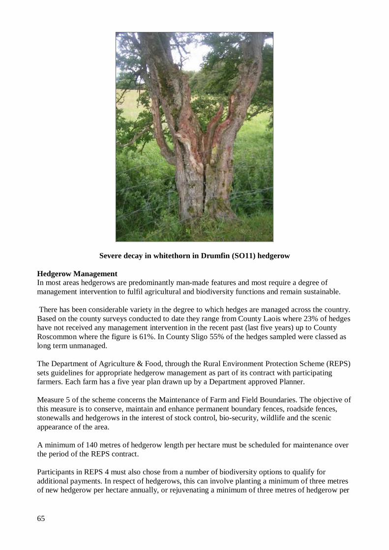
65
Severe decay in whitethorn in Drumfin (SO11) hedgerow
Hedgerow Management In most areas hedgerows are predominantly man-made features and most require a degree of management intervention to fulfil agricultural and biodiversity functions and remain sustainable. There has been considerable variety in the degree to which hedges are managed across the country. Based on the county surveys conducted to date they range from County Laois where 23% of hedges have not received any management intervention in the recent past (last five years) up to County Roscommon where the figure is 61%. In County Sligo 55% of the hedges sampled were classed as long term unmanaged. The Department of Agriculture & Food, through the Rural Environment Protection Scheme (REPS) sets guidelines for appropriate hedgerow management as part of its contract with participating farmers. Each farm has a five year plan drawn up by a Department approved Planner. Measure 5 of the scheme concerns the Maintenance of Farm and Field Boundaries. The objective of this measure is to conserve, maintain and enhance permanent boundary fences, roadside fences, stonewalls and hedgerows in the interest of stock control, bio-security, wildlife and the scenic appearance of the area. A minimum of 140 metres of hedgerow length per hectare must be scheduled for maintenance over the period of the REPS contract. Participants in REPS 4 must also chose from a number of biodiversity options to qualify for additional payments. In respect of hedgerows, this can involve planting a minimum of three metres of new hedgerow per hectare annually, or rejuvenating a minimum of three metres of hedgerow per
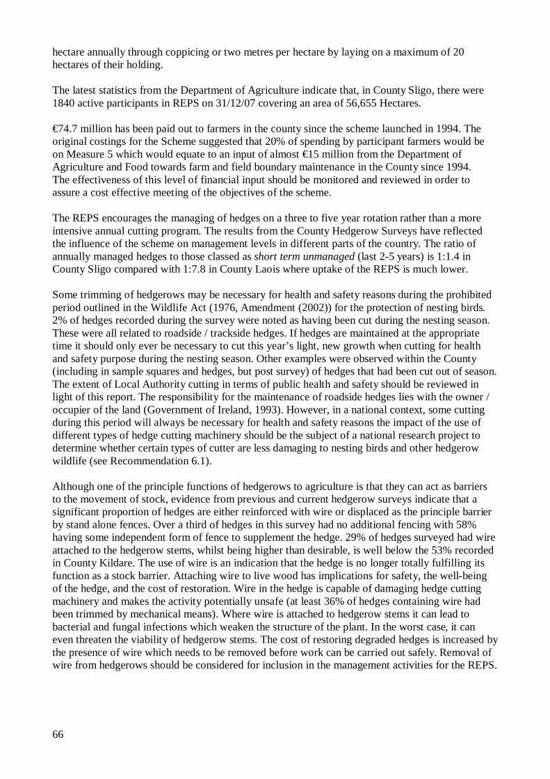
66
hectare annually through coppicing or two metres per hectare by laying on a maximum of 20 hectares of their holding. The latest statistics from the Department of Agriculture indicate that, in County Sligo, there were 1840 active participants in REPS on 31/12/07 covering an area of 56,655 Hectares. €74.7 million has been paid out to farmers in the county since the scheme launched in 1994. The original costings for the Scheme suggested that 20% of spending by participant farmers would be on Measure 5 which would equate to an input of almost €15 million from the Department of Agriculture and Food towards farm and field boundary maintenance in the County since 1994. The effectiveness of this level of financial input should be monitored and reviewed in order to assure a cost effective meeting of the objectives of the scheme. The REPS encourages the managing of hedges on a three to five year rotation rather than a more intensive annual cutting program. The results from the County Hedgerow Surveys have reflected the influence of the scheme on management levels in different parts of the country. The ratio of annually managed hedges to those classed as short term unmanaged (last 2-5 years) is 1:1.4 in County Sligo compared with 1:7.8 in County Laois where uptake of the REPS is much lower. Some trimming of hedgerows may be necessary for health and safety reasons during the prohibited period outlined in the Wildlife Act (1976, Amendment (2002)) for the protection of nesting birds. 2% of hedges recorded during the survey were noted as having been cut during the nesting season. These were all related to roadside / trackside hedges. If hedges are maintained at the appropriate time it should only ever be necessary to cut this year’s light, new growth when cutting for health and safety purpose during the nesting season. Other examples were observed within the County (including in sample squares and hedges, but post survey) of hedges that had been cut out of season. The extent of Local Authority cutting in terms of public health and safety should be reviewed in light of this report. The responsibility for the maintenance of roadside hedges lies with the owner / occupier of the land (Government of Ireland, 1993). However, in a national context, some cutting during this period will always be necessary for health and safety reasons the impact of the use of different types of hedge cutting machinery should be the subject of a national research project to determine whether certain types of cutter are less damaging to nesting birds and other hedgerow wildlife (see Recommendation 6.1). Although one of the principle functions of hedgerows to agriculture is that they can act as barriers to the movement of stock, evidence from previous and current hedgerow surveys indicate that a significant proportion of hedges are either reinforced with wire or displaced as the principle barrier by stand alone fences. Over a third of hedges in this survey had no additional fencing with 58% having some independent form of fence to supplement the hedge. 29% of hedges surveyed had wire attached to the hedgerow stems, whilst being higher than desirable, is well below the 53% recorded in County Kildare. The use of wire is an indication that the hedge is no longer totally fulfilling its function as a stock barrier. Attaching wire to live wood has implications for safety, the well-being of the hedge, and the cost of restoration. Wire in the hedge is capable of damaging hedge cutting machinery and makes the activity potentially unsafe (at least 36% of hedges containing wire had been trimmed by mechanical means). Where wire is attached to hedgerow stems it can lead to bacterial and fungal infections which weaken the structure of the plant. In the worst case, it can even threaten the viability of hedgerow stems. The cost of restoring degraded hedges is increased by the presence of wire which needs to be removed before work can be carried out safely. Removal of wire from hedgerows should be considered for inclusion in the management activities for the REPS.
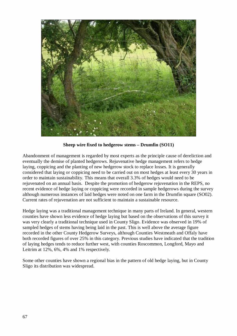
67
Sheep wire fixed to hedgerow stems – Drumfin (SO11) Abandonment of management is regarded by most experts as the principle cause of dereliction and eventually the demise of planted hedgerows. Rejuvenative hedge management refers to hedge laying, coppicing and the planting of new hedgerow stock to replace losses. It is generally considered that laying or coppicing need to be carried out on most hedges at least every 30 years in order to maintain sustainability. This means that overall 3.3% of hedges would need to be rejuvenated on an annual basis. Despite the promotion of hedgerow rejuvenation in the REPS, no recent evidence of hedge laying or coppicing were recorded in sample hedgerows during the survey although numerous instances of laid hedges were noted on one farm in the Drumfin square (SO02). Current rates of rejuvenation are not sufficient to maintain a sustainable resource. Hedge laying was a traditional management technique in many parts of Ireland. In general, western counties have shown less evidence of hedge laying but based on the observations of this survey it was very clearly a traditional technique used in County Sligo. Evidence was observed in 19% of sampled hedges of stems having being laid in the past. This is well above the average figure recorded in the other County Hedgerow Surveys, although Counties Westmeath and Offaly have both recorded figures of over 25% in this category. Previous studies have indicated that the tradition of laying hedges tends to reduce further west, with counties Roscommon, Longford, Mayo and Leitrim at 12%, 6%, 4% and 1% respectively. Some other counties have shown a regional bias in the pattern of old hedge laying, but in County Sligo its distribution was widespread.
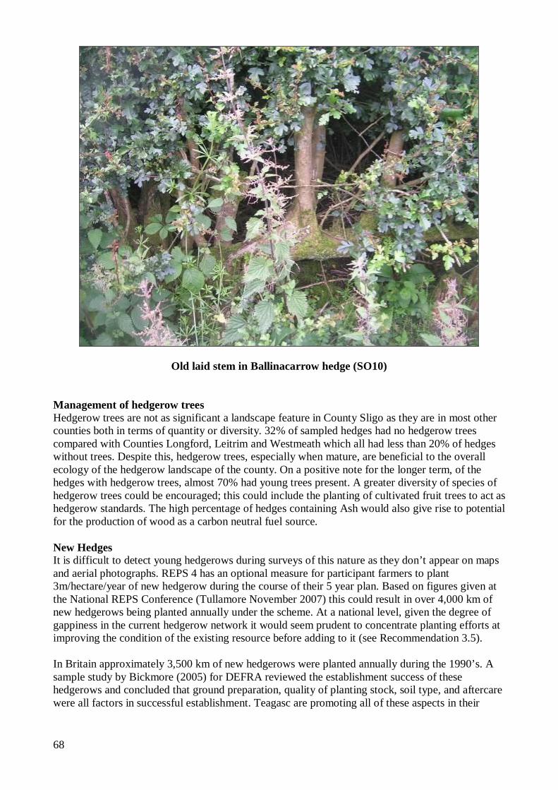
68
Old laid stem in Ballinacarrow hedge (SO10)
Management of hedgerow trees Hedgerow trees are not as significant a landscape feature in County Sligo as they are in most other counties both in terms of quantity or diversity. 32% of sampled hedges had no hedgerow trees compared with Counties Longford, Leitrim and Westmeath which all had less than 20% of hedges without trees. Despite this, hedgerow trees, especially when mature, are beneficial to the overall ecology of the hedgerow landscape of the county. On a positive note for the longer term, of the hedges with hedgerow trees, almost 70% had young trees present. A greater diversity of species of hedgerow trees could be encouraged; this could include the planting of cultivated fruit trees to act as hedgerow standards. The high percentage of hedges containing Ash would also give rise to potential for the production of wood as a carbon neutral fuel source. New Hedges It is difficult to detect young hedgerows during surveys of this nature as they don’t appear on maps and aerial photographs. REPS 4 has an optional measure for participant farmers to plant 3m/hectare/year of new hedgerow during the course of their 5 year plan. Based on figures given at the National REPS Conference (Tullamore November 2007) this could result in over 4,000 km of new hedgerows being planted annually under the scheme. At a national level, given the degree of gappiness in the current hedgerow network it would seem prudent to concentrate planting efforts at improving the condition of the existing resource before adding to it (see Recommendation 3.5). In Britain approximately 3,500 km of new hedgerows were planted annually during the 1990’s. A sample study by Bickmore (2005) for DEFRA reviewed the establishment success of these hedgerows and concluded that ground preparation, quality of planting stock, soil type, and aftercare were all factors in successful establishment. Teagasc are promoting all of these aspects in their
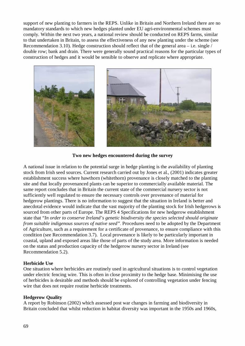
69
support of new planting to farmers in the REPS. Unlike in Britain and Northern Ireland there are no mandatory standards to which new hedges planted under EU agri-environmental schemes must comply. Within the next two years, a national review should be conducted on REPS farms, similar to that undertaken in Britain, to assess the effectiveness of any new planting under the scheme (see Recommendation 3.10). Hedge construction should reflect that of the general area – i.e. single / double row; bank and drain. There were generally sound practical reasons for the particular types of construction of hedges and it would be sensible to observe and replicate where appropriate.
Two new hedges encountered during the survey A national issue in relation to the potential surge in hedge planting is the availability of planting stock from Irish seed sources. Current research carried out by Jones et al., (2001) indicates greater establishment success where hawthorn (whitethorn) provenance is closely matched to the planting site and that locally provenanced plants can be superior to commercially available material. The same report concludes that in Britain the current state of the commercial nursery sector is not sufficiently well regulated to ensure the necessary controls over provenance of material for hedgerow plantings. There is no information to suggest that the situation in Ireland is better and anecdotal evidence would indicate that the vast majority of the planting stock for Irish hedgerows is sourced from other parts of Europe. The REPS 4 Specifications for new hedgerow establishment state that “In order to conserve Ireland’s genetic biodiversity the species selected should originate from suitable indigenous sources of native seed”. Procedures need to be adopted by the Department of Agriculture, such as a requirement for a certificate of provenance, to ensure compliance with this condition (see Recommendation 3.7). Local provenance is likely to be particularly important in coastal, upland and exposed areas like those of parts of the study area. More information is needed on the status and production capacity of the hedgerow nursery sector in Ireland (see Recommendation 5.2). Herbicide Use One situation where herbicides are routinely used in agricultural situations is to control vegetation under electric fencing wire. This is often in close proximity to the hedge base. Minimising the use of herbicides is desirable and methods should be explored of controlling vegetation under fencing wire that does not require routine herbicide treatments. Hedgerow Quality A report by Robinson (2002) which assessed post war changes in farming and biodiversity in Britain concluded that whilst reduction in habitat diversity was important in the 1950s and 1960s,
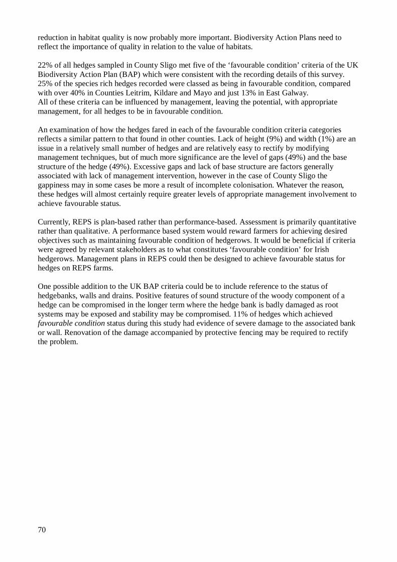
70
reduction in habitat quality is now probably more important. Biodiversity Action Plans need to reflect the importance of quality in relation to the value of habitats. 22% of all hedges sampled in County Sligo met five of the ‘favourable condition’ criteria of the UK Biodiversity Action Plan (BAP) which were consistent with the recording details of this survey. 25% of the species rich hedges recorded were classed as being in favourable condition, compared with over 40% in Counties Leitrim, Kildare and Mayo and just 13% in East Galway. All of these criteria can be influenced by management, leaving the potential, with appropriate management, for all hedges to be in favourable condition. An examination of how the hedges fared in each of the favourable condition criteria categories reflects a similar pattern to that found in other counties. Lack of height (9%) and width (1%) are an issue in a relatively small number of hedges and are relatively easy to rectify by modifying management techniques, but of much more significance are the level of gaps (49%) and the base structure of the hedge (49%). Excessive gaps and lack of base structure are factors generally associated with lack of management intervention, however in the case of County Sligo the gappiness may in some cases be more a result of incomplete colonisation. Whatever the reason, these hedges will almost certainly require greater levels of appropriate management involvement to achieve favourable status. Currently, REPS is plan-based rather than performance-based. Assessment is primarily quantitative rather than qualitative. A performance based system would reward farmers for achieving desired objectives such as maintaining favourable condition of hedgerows. It would be beneficial if criteria were agreed by relevant stakeholders as to what constitutes ‘favourable condition’ for Irish hedgerows. Management plans in REPS could then be designed to achieve favourable status for hedges on REPS farms. One possible addition to the UK BAP criteria could be to include reference to the status of hedgebanks, walls and drains. Positive features of sound structure of the woody component of a hedge can be compromised in the longer term where the hedge bank is badly damaged as root systems may be exposed and stability may be compromised. 11% of hedges which achieved favourable condition status during this study had evidence of severe damage to the associated bank or wall. Renovation of the damage accompanied by protective fencing may be required to rectify the problem.
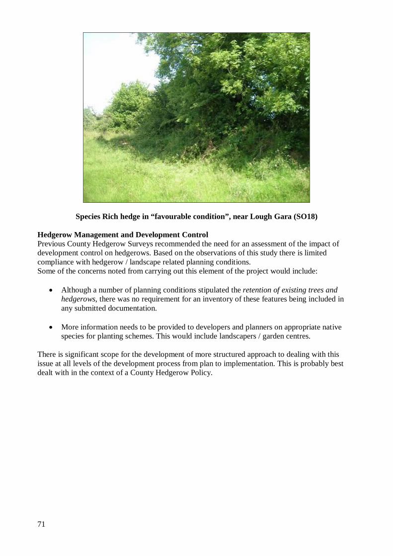
71
Species Rich hedge in “favourable condition”, near Lough Gara (SO18) Hedgerow Management and Development Control Previous County Hedgerow Surveys recommended the need for an assessment of the impact of development control on hedgerows. Based on the observations of this study there is limited compliance with hedgerow / landscape related planning conditions. Some of the concerns noted from carrying out this element of the project would include:
Although a number of planning conditions stipulated the retention of existing trees and hedgerows, there was no requirement for an inventory of these features being included in any submitted documentation.
More information needs to be provided to developers and planners on appropriate native
species for planting schemes. This would include landscapers / garden centres. There is significant scope for the development of more structured approach to dealing with this issue at all levels of the development process from plan to implementation. This is probably best dealt with in the context of a County Hedgerow Policy.
72
7.0 RECOMMENDATIONS The recommendations included in this section are based on the results of this survey considered in the light of current best conservation practice. 7.1 CONTEXT In relation to hedgerows, the term ‘conservation’ does not simply relate to their retention but to their retention in a condition that is conducive to their multifunctional benefits. Change has been a constant feature of the Irish landscape. It is an insufficient reason to try to conserve hedges just because they are there. Instead, their continuing role needs to be assessed in the context of the changing needs of agriculture, biodiversity, the environment, and the landscape. In particular, the role played by hedges in maintaining water quality is insufficiently understood but in light of current research in Europe (Viaud et al., 2001), may be very significant. In recent years the conservation of our natural and cultural heritage has gained importance, as reflected in current environmental and conservation policy. The major vehicle for guiding hedgerow conservation in Ireland is currently the Rural Environment Protection Scheme (REPS). The movement to the Single Farm Payment (SFP) is expected to reduce livestock numbers in Ireland considerably. It is yet to be seen fully how this will affect land utilisation. Will farmers maintain stocking density and put surplus land into forestry or other alternative enterprises, or will the same land be farmed more extensively? Either option has consequences for hedgerows. The level of native woodland is another dynamic factor. Hedgerows are considered to be sub-optimal woodland edge habitats for wildlife. Most of the species that utilize hedgerows would be more at home in native woodlands. If, in any region, the area under native woodland were to increase significantly, the need for hedgerows as habitats in that area may diminish yet their importance as habitat corridors in order to maintain viable populations of woodland wildlife might increase. The key to successful hedgerow conservation policy is that it is formulated in an appropriate and relevant context. This applies from management requirements for a single hedge up to policy decisions at a National (or even European) Level. In the context of this survey it is important that regional factors are not over-looked in the context of National initiatives. The value of a hedgerow or a network of hedgerows in any given environment is relative to its wider environmental context. A species rich hedgerow, in good structural condition, in an area well populated with similar hedges, in an area dominated by semi-natural vegetation, may be of lower relative importance in its setting than a less diverse hedge, in poorer condition, in an intensively farmed area with few hedges or other semi-natural features. The former may be a sub-optimum habitat for many species in its area; the latter might be the only habitat. If hedgerow conservation is to be more than just aspirational then a series of practical, cost effective conservation measures need to be put in place. There are a number of issues which complicate the design of such measures:
Some of the desirable qualities of hedgerows are subject to value judgements. Hedgerows are a multi-functional resource. In the absence of a full cost/benefit analysis it is
not possible to determine what constitutes a cost effective measure.
73
Fencing-off and leaving alone is not an option for most hedgerows. Hedgerows are man-made features of the landscape and the majority need a degree of appropriate active management to ensure their long term viability. Leaving them alone can be appropriate in the short term but is generally not a sustainable long-term option.
Most hedgerows occur on private lands, in the ownership of the farming community and landowners.
The variable type, condition and regional differences make uncomplicated management guidelines difficult to frame.
A significant percentage of the current network has fallen in to disrepair over a period of decades. Reparation of degraded hedgerows involves substantially higher costs than the routine maintenance of hedges in good condition.
Lack of knowledge/skill base. Intensification of agriculture has tended to diminish the agricultural value of hedgerows. Prior to the introduction of the REPS in 1994 there were no external incentives for farmers to retain hedgerows whereas grants have been available for land reclamation and drainage which have involved hedgerow removal. Declining agricultural functional value led to a fall off in the practical knowledge and skills needed to manage hedges appropriately.
Relevance of the resource to the modern landscape. The value of the hedgerow resource to the modern environment is fairly well documented. However, the current division of lands is still largely the same as it was over 100 years ago. The relevance of this to modern farming practices and methods is open to question. In 2002, the number of agricultural holdings in Ireland totalled 136,500, compared with 419,500 in 1855, less than a third the number (CSO, 2002). Agricultural methods have changed significantly, especially in relation to mechanisation and the number of people engaged in agriculture has declined.
Hedgerow conservation is within the remit of numerous stakeholders who have differing degrees of influence over the resource. These are listed in Table 7.1. In order to assign responsibility for dealing with each of the recommendations a Lead Partner has, where appropriate, been identified.
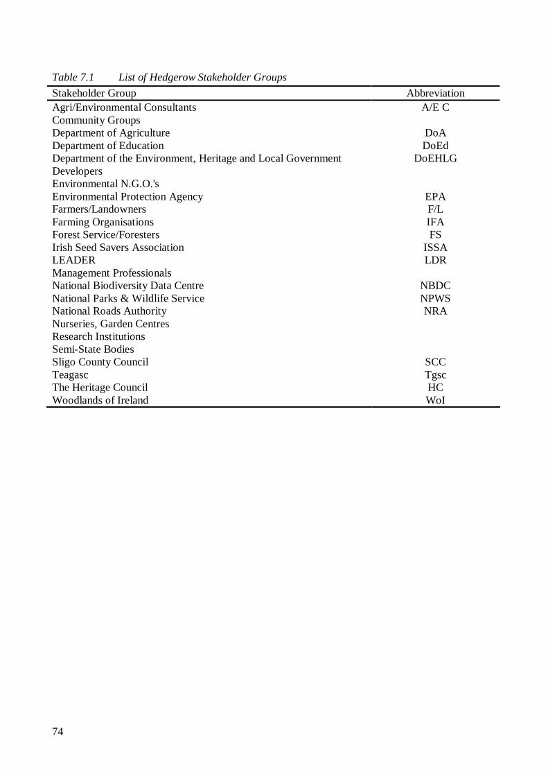
74
Table 7.1 List of Hedgerow Stakeholder Groups
Stakeholder Group Abbreviation Agri/Environmental Consultants A/E C Community Groups Department of Agriculture DoA Department of Education DoEd Department of the Environment, Heritage and Local Government DoEHLG Developers Environmental N.G.O.'s Environmental Protection Agency EPA Farmers/Landowners F/L Farming Organisations IFA Forest Service/Foresters FS Irish Seed Savers Association ISSA LEADER LDR Management Professionals National Biodiversity Data Centre NBDC National Parks & Wildlife Service NPWS National Roads Authority NRA Nurseries, Garden Centres Research Institutions Semi-State Bodies Sligo County Council SCC Teagasc Tgsc The Heritage Council HC Woodlands of Ireland WoI
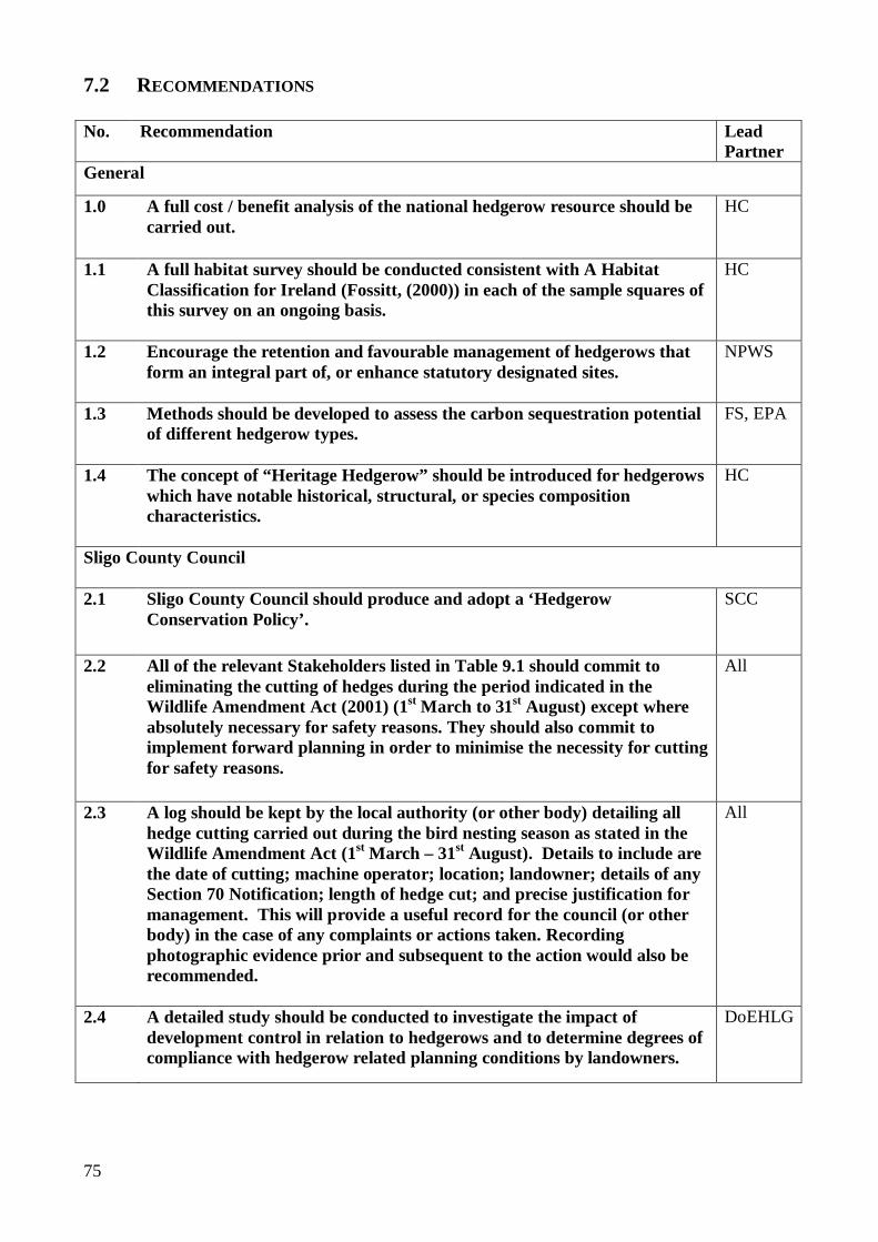
75
7.2 RECOMMENDATIONS No. Recommendation Lead
Partner General
1.0 A full cost / benefit analysis of the national hedgerow resource should be carried out.
HC
1.1 A full habitat survey should be conducted consistent with A Habitat Classification for Ireland (Fossitt, (2000)) in each of the sample squares of this survey on an ongoing basis.
HC
1.2 Encourage the retention and favourable management of hedgerows that form an integral part of, or enhance statutory designated sites.
NPWS
1.3 Methods should be developed to assess the carbon sequestration potential of different hedgerow types.
FS, EPA
1.4 The concept of “Heritage Hedgerow” should be introduced for hedgerows which have notable historical, structural, or species composition characteristics.
HC
Sligo County Council 2.1 Sligo County Council should produce and adopt a ‘Hedgerow
Conservation Policy’.
SCC
2.2 All of the relevant Stakeholders listed in Table 9.1 should commit to eliminating the cutting of hedges during the period indicated in the Wildlife Amendment Act (2001) (1st March to 31st August) except where absolutely necessary for safety reasons. They should also commit to implement forward planning in order to minimise the necessity for cutting for safety reasons.
All
2.3 A log should be kept by the local authority (or other body) detailing all hedge cutting carried out during the bird nesting season as stated in the Wildlife Amendment Act (1st March – 31st August). Details to include are the date of cutting; machine operator; location; landowner; details of any Section 70 Notification; length of hedge cut; and precise justification for management. This will provide a useful record for the council (or other body) in the case of any complaints or actions taken. Recording photographic evidence prior and subsequent to the action would also be recommended.
All
2.4 A detailed study should be conducted to investigate the impact of development control in relation to hedgerows and to determine degrees of compliance with hedgerow related planning conditions by landowners.
DoEHLG
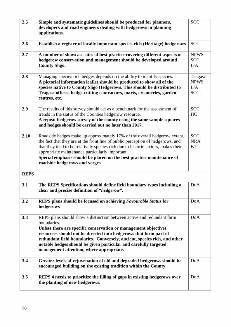
76
2.5 Simple and systematic guidelines should be produced for planners, developers and road engineers dealing with hedgerows in planning applications.
SCC
2.6 Establish a register of locally important species-rich (Heritage) hedgerows
SCC
2.7 A number of showcase sites of best practice covering different aspects of hedgerow conservation and management should be developed around County Sligo.
NPWS SCC IFA
2.8 Managing species rich hedges depends on the ability to identify species. A pictorial information leaflet should be produced to show all of the species native to County Sligo Hedgerows. This should be distributed to Teagasc offices, hedge-cutting contractors, marts, creameries, garden centres, etc.
Teagasc NPWS IFA SCC
2.9 The results of this survey should act as a benchmark for the assessment of trends in the status of the Counties hedgerow resource. A repeat hedgerow survey of the county using the same sample squares and hedges should be carried out no later than 2017.
SCC HC
2.10 Roadside hedges make up approximately 17% of the overall hedgerow extent, the fact that they are at the front line of public perception of hedgerows, and that they tend to be relatively species rich due to historic factors, makes their appropriate maintenance particularly important. Special emphasis should be placed on the best practice maintenance of roadside hedgerows and verges.
SCC, NRA F/L
REPS 3.1 The REPS Specifications should define field boundary types including a
clear and precise definition of “hedgerow”.
DoA
3.2 REPS plans should be focused on achieving Favourable Status for hedgerows
DoA
3.3 REPS plans should show a distinction between active and redundant farm boundaries. Unless there are specific conservation or management objectives, resources should not be directed into hedgerows that form part of redundant field boundaries. Conversely, ancient, species rich, and other notable hedges should be given particular and carefully targeted management attention, where appropriate.
DoA
3.4 Greater levels of rejuvenation of old and degraded hedgerows should be encouraged building on the existing tradition within the County.
DoA
3.5 REPS 4 needs to prioritize the filling of gaps in existing hedgerows over the planting of new hedgerows.
DoA
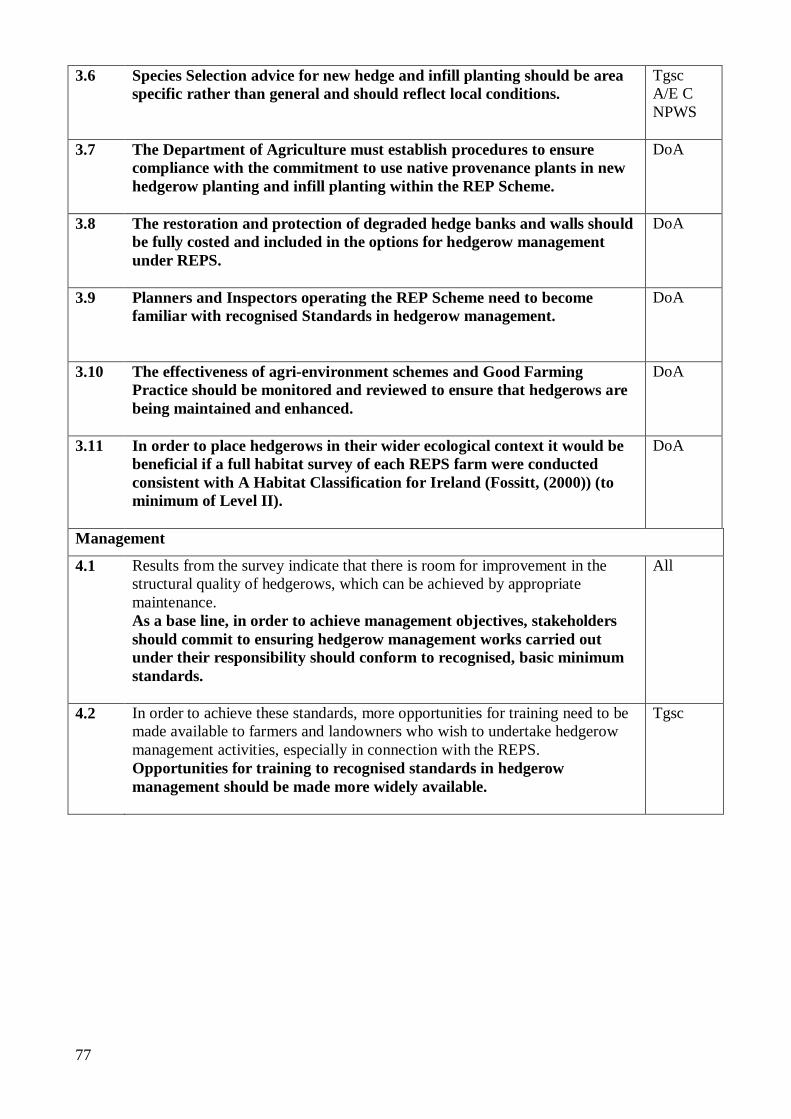
77
3.6
Species Selection advice for new hedge and infill planting should be area specific rather than general and should reflect local conditions.
Tgsc A/E C NPWS
3.7 The Department of Agriculture must establish procedures to ensure compliance with the commitment to use native provenance plants in new hedgerow planting and infill planting within the REP Scheme.
DoA
3.8 The restoration and protection of degraded hedge banks and walls should be fully costed and included in the options for hedgerow management under REPS.
DoA
3.9 Planners and Inspectors operating the REP Scheme need to become familiar with recognised Standards in hedgerow management.
DoA
3.10 The effectiveness of agri-environment schemes and Good Farming Practice should be monitored and reviewed to ensure that hedgerows are being maintained and enhanced.
DoA
3.11 In order to place hedgerows in their wider ecological context it would be beneficial if a full habitat survey of each REPS farm were conducted consistent with A Habitat Classification for Ireland (Fossitt, (2000)) (to minimum of Level II).
DoA
Management
4.1 Results from the survey indicate that there is room for improvement in the structural quality of hedgerows, which can be achieved by appropriate maintenance. As a base line, in order to achieve management objectives, stakeholders should commit to ensuring hedgerow management works carried out under their responsibility should conform to recognised, basic minimum standards.
All
4.2 In order to achieve these standards, more opportunities for training need to be made available to farmers and landowners who wish to undertake hedgerow management activities, especially in connection with the REPS. Opportunities for training to recognised standards in hedgerow management should be made more widely available.
Tgsc
78
4.3 Routine trimming should be carried out by operators qualified
to Teagasc Unit MT 1302 – Mechanical Hedge Trimming. (This module should be reviewed on an ongoing basis to ensure that it is fully compliant with current best practice and remains consistent with standards in operation in other member states of the EU.)
Hedge laying should be to National Proficiency Test Council (NPTC) (UK) Standard (AO20) or equivalent.
Coppicing of hedgerows should be carried out to standards currently being developed by the Coppice Association of Ireland in conjunction with Standards bodies in the UK.
Planting of new hedgerows should be to NPTC standard or equivalent.
4.4 Farmers and landowners in County Sligo should be encouraged to not reduce hedge height below 1.5m during routine maintenance.
Tgsc
4.5 Farmers and Landowners should be strongly discouraged from attaching fencing to hedgerow stems and trees.
Tgsc
4.6 Removal of old wire/ netting/ staples from hedgerow stems should be encouraged for safety reasons.
Tgsc
4.7 Farmers and landowners could be encouraged to increase the diversity of tree species in hedgerows including the planting of old Irish varieties of fruit trees
Tgsc ISSA
4.8 Methods should be investigated of minimising the necessity of using herbicides to control vegetation under electric fencing.
Tgsc
Nursery Stock 5.1 The use of locally provenanced native plant species should be specified for
any hedgerow planting (including hedgerow trees). Encouraging a diversity of native hedge species consistent with the findings of this survey is recommended.
All
5.2 Plans need to be made to ensure that the planting requirements for REPS and NRA projects can be met from indigenous stock. This will require a degree of forward planning. The production capacity of nurseries producing Irish hedgerow stock from Irish seed sources should be determined.
FS
79
5.3 The ability to source planting material of a known genetic provenance is important. The origin of plants or seeds determines their adaptability, quality, and wildlife value. More information is needed on the status and production capacity of the hedgerow nursery sector in Ireland. A study should be conducted of nursery suppliers and garden centres to determine the availability of native planting stock (including provenance) for the range of native hedgerow tree and shrub species. This information should be disseminated to interested parties.
Tgsc LDR
5.4 A programme should be developed for the identification, registration, and certification of local provenance seed sites for woody hedgerow shrubs in County Sligo.
FS
5.5 Individuals wishing to establish, develop or expand tree nurseries with a view to supplying hedgerow plants of a local provenance should be actively encouraged through the Development Agencies. The Department of Agriculture and Food could look at providing funding through its direct provision of support services. The Forest Service could potentially facilitate this. Financial and technical support should be given to individuals and groups wishing to develop nurseries to supply woody hedgerow shrubs from local seed sources.
DoA LDR
5.6 Nurseries and garden centres in the County should be encouraged to carry a stock of local provenance hedgerow trees and shrubs.
DoA Tgsc
Research 6.1 Since a certain amount of hedge cutting is always necessary during the summer
months for health and safety reasons it would be beneficial to try and minimise the impact of the work from a wildlife conservation point. The impact of different types of hedge cutting techniques and machinery should be investigated to determine whether certain techniques or types of cutter are less damaging to birds during the bird nesting season (1st March – 31st August).
Tgsc, NPWS
6.2 The biodiversity value of locally traditional, but non-native species (e.g. Fuchsia) should be investigated.
NPWS
6.3 Investigate the comparative biodiversity value of non-hedgerow field boundaries and features (e.g. stonewalls and earth banks).
NPWS
6.4 Research is needed to quantify the nutrient buffer effect of hedgerows in different agricultural situations.
EPA DoA
6.5 An appropriate method of assessing the representative species composition for hedgerows in Ireland should be determined.
HC
80
6.6 This survey uses the same sample areas as the Badger and Habitats Survey of Ireland, the Countryside Bird Survey and other surveys carried out by NPWS (e.g. hare survey). This should allow some comparison of data sets. Even more concentrated recording of habitat data and how these habitats change over time should allow for a greater understanding of the factors that govern the fluctuations in wildlife populations. Data from this Hedgerow Survey could be related to previous surveys which have used the same sample area to enable more specific analysis.
NPWS NBDC
Education and Awareness Raising 7.1 A chain is only as strong as its weakest link. All individuals in the process from
decision making to implementation need to be sufficiently well informed so as to be able to direct, implement and evaluate best practice actions. Stakeholders should ensure all relevant staff (and any contractors used) have the necessary skills and data sources to implement or evaluate best practice hedgerow conservation.
All
7.2 Stakeholders should provide appropriate training for staff in aspects of hedgerow conservation relevant to their position.
All
7.3 General awareness of the values of hedgerows should be encouraged among rural communities through circulation of currently available publications (Teagasc and Heritage Council leaflets), an increase in targeted education for schools, and with the introduction of initiatives such as the Golden Mile Competition.
All
7.4 Identify suitable and safely accessible hedgerows convenient to schools and colleges for use in environmental education.
DoEd
7.5 A copy of this report should be circulated to a representative of each of the stakeholder groups.
All
Fuel Wood Production 8.1 Producing a greater proportion of its fuel demands from hedgerows would be
consistent with Ireland’s commitments under the Kyoto Protocol. Farmers and landowners should be encouraged to utilise hedgerows for fuel wood production in a sustainable manner.
Tgsc
8.2 Technical advice should be provided to farmers and landowners wishing to produce wood fuel on a cyclical basis from hedgerows.
Tgsc
81
General 9.1 A National Hedgerow Survey is needed to fully record the national hedgerow
resource and to place the findings of this survey in their national context. This can be achieved on a county by county basis. A full and meaningful floristic classification of Irish hedges can only be carried out when consistent data is available for the whole country. It is recommended that comparable hedgerow surveys be carried out in other counties across the country.
HC
9.2 Criteria for what constitute ‘species rich’, ‘favourable condition’ and ‘rare’ will need to be developed in relation to hedgerows in Ireland, and should be decided upon by the relevant stakeholders.
WoI
9.3 Paragraph 2.27 of The National Biodiversity Plan states that “For the future, the overall goal should be to have no net loss of the hedgerow resource”. Hedgerow removal to facilitate development should be kept to an absolute minimum and, where unavoidable, a requirement for mitigation planting should be incorporated into the planning consent. This should consist of a hedge of similar length and species composition to the original, established as close as is practical to the original and where possible linking in to existing adjacent hedges. Native plants of a local provenance should be used for any such planting.
NPWS
9.4 Protection and enhancement of hedgerows that connect to other wildlife habitats such as woodlands and scrub will have a positive impact on the connectivity of wildlife habitats throughout the landscape and the stability of wildlife populations. Hedges that provide direct connections to other natural or semi-natural habitats should be prioritised for protection and enhancement, and where new planting is to take place, further wildlife corridor establishment be promoted.
9.5 Species distribution data from this survey should be compared with current BSBI data to see if updating of the BSBI data set is required.
9.6 Not all of the significant hedges within the County fall within the protection and support of the REPS. Given their role as ecological corridors it is important that the appropriate management of these hedgerows on non-REPS farms be incentivised in order to prevent a fragmented countryside. This could be done through Local Authorities, NPWS, or Heritage Council. Incentives for the conservation of, or renovation to, favourable condition of ‘Heritage Hedgerows’ should be available to landowners not participating in the REPS.
82
8.0 CONCLUSIONS The information gathered from this survey adds to the existing limited, but growing, knowledge of hedges in Ireland, and should be of value to a wide range of interests and stakeholders in County Sligo and the rest of the country. Recording and analysis of the various hedgerow characteristics should also foster a greater appreciation of the unique nature of these hedges, and enable a strategic approach to their conservation. Hedgerows link archaeological, geological, social and natural heritage. They have utility in the present but mark the past. Their values are multi-functional in both practical and spiritual terms. They enrich our understanding of history, ecology, rural society and farming practices. They give character to an area giving aesthetic appeal and creating a sense of place. Hedgerows do not generally qualify for designation and protection. It is therefore important that appropriate conservation measures are adopted in order to safeguard the resource. These need to be based on accurate and up-to-date knowledge of extent, nature and status. In absolute terms, there is plenty of scope for improvement in the resource to maximise its full multi-functional potential, but in relative terms, County Sligo compares fairly well in most categories with other counties previously surveyed. The recommendations presented, if implemented, should contribute towards conserving and enhancing Sligo’s extensive and interesting hedgerow resource into the future.
83
9.0 REFERENCES AND BIBLIOGRAPHY
Author Title Publisher
“U.K. Hedgerow Regulations (1997)” (S.I. Number 1160)
(2000) “Exploring the Field Fences of County Sligo”
A Schools Integration Project (SIP 061)
Aalen, F.H.A, Whelan, K., and Stout, M. (Editors) (1997)
“Atlas of the Irish Rural Landscape”
Cork University Press
Andrews, J.H. (1985) “Plantation Acres” Ulster Historical Foundation
Arnold, G.W. (1983) “The Influence of Ditch and Hedgerow Structure, length of Hedgerows, and area of Woodland and Garden on Bird numbers on Farmland.”
Journal of Applied Ecology 20, 731-750.
Barr, Britt, Sparks and Churchward (ed.) (2005)
“Hedgerow management and wildlife”
DEFRA
Bickmore, C.J. (2002) “Hedgerow Survey Handbook: A standard procedure for local surveys in the UK.”
Department of Environment, Food, and Rural Affairs 2002.
Bickmore C.J. (2005) “Project Report BD1002-07”
DEFRA
Burel, (1989) “Landscape structure effects on Carabid beetles’ spatial patterns in Western France”
Landscape Ecology, 2, 215-226
Chamberlain, D.E, Vickery, J.A, Marshall, E.J.P., & Tucker, G.M. (2001)
“The effects of hedgerow characteristics on the winter hedgerow bird community.”
In: Hedgerows of the World: Proceedings of the 2001 Annual IALE (UK) Conference. Pp 197-206
Clements, D.K., and Tofts, R.J. (1992)
“A Methodology for the Ecological Survey, Evaluation, and Grading of Hedgerows.”
Countryside Planning and Management, UK.
Condon, F.A. & Jarvis, P.J. (1989)
“Trees and Shrubs in the Hedgerows of Knock, Co. Mayo, Western Ireland”
Irish Naturalists Journal, Vol. 23 No 1, 12-16
84
Coombes, R.H. et al (2006)
“Countryside Bird Survey Report 1998-2005”
Birdwatch Ireland, Wicklow
Cooper, Dr. A., Murray, R., and Mc Cann, T. (1997)
“The Northern Ireland Countryside Survey”
The Environment and Heritage Service, NI.
Corbit, M. and Marks, P. and Gardescue, S., (1999)
“Hedgerows as Habitat Corridors for forest herbs in central New York, USA.”
Journal of Ecology, 87, 220-232
Council for the Protection of Rural England (2000)
“CPRE Hedgerow Survey Pack” CPRE
Crangle, Sarah “Hedgerow Removal Assessment & Associated Habitat Mapping”
NUIG Thesis, 2005
Deane, R.J.L. (1989) “Expanded Field Margins. Their
cost to the farmer and benefits to wildlife”
Report to the Nature Conservancy Council
DEFRA (2000) “Countryside Survey (UK)”
Department of Agriculture and Food (2007)
“Specification for REPS Planners in the Preparation of REPS4 Plans”
Department of the Environment (2001)
“Urban and Rural Roles” Government Publications Office
Doherty, Gillian M. (2004)
“The Irish Ordnance Survey” Four Courts Press
European Union (2000) “Water Framework Directive” Council Directive 2000/60/EC
European Union (2006) “Halting the Loss of Biodiversity by 2010 – And Beyond”
European Union Communication and Action Plan
Feehan, J. (1983) “Laois – An Environmental History”
Ballykilcavan Press, Laois, Ireland
Fossitt, J.A. (2000) “A Classification of Irish Habitats”
The Heritage Council
Foulkes, N. and Murray, A. (2006)
“A Methodology for the recording of hedgerow extent, species composition, structure and condition in Ireland”
Tearmann, 5, 75-89
85
Foulkes, N. and Murray, A. (2005b)
“County Roscommon Hedgerow Survey Report”
Roscommon County Council
Foulkes, N. and Murray, A. (2005c)
“County Westmeath Hedgerow Survey Report”
Westmeath County Council
Foulkes, N. and Murray, A. (2005d)
“County Offaly Hedgerow Survey Report”
Offaly County Council, unpublished
Foulkes, N. and Murray, A. (2005e)
“County Laois Hedgerow Survey Report”
Laois County Council, unpublished
Foulkes, N. (2006a) “County Kildare Hedgerow Survey Report”
Kildare County Council, unpublished
Foulkes, N. (2006b) “County Longford Hedgerow Survey Report”
Longford County Council, unpublished
Foulkes, N. (2006c) “County Leitrim Hedgerow Survey Report”
The Heritage Council, unpublished
Foulkes, N. (2008) “Hedgerow Translocation” Heritage Office, Roscommon County Council
Fuller, J. (2006) “East Galway Hedgerow Survey 2006”
Galway County Council unpublished report
Giorria Environmental Services (2006)
“County Cavan Hedgerow Survey” Cavan County Council unpublished report
Government of Ireland (1927)
“Electricity (Supply) Act. No. 27/1027”
Department of Industry & Commerce, Dublin
Government of Ireland (1976)
“Wildlife Act. No. 39/1976” Department of Lands, Dublin
Government of Ireland (1993)
“Roads Act. No. 14/1993” Department of the Environment, Dublin
Government of Ireland (1998)
“Roads (Amendment) Act. No. 23/1998”
Department of the Environment, Dublin
Government of Ireland (2000)
“Wildlife (Amendment) Act. No. 38/2000”
Department of Arts, Heritage Gaeltacht & the Islands, Dublin
Government of Ireland (2000a)
“Planning & Development Act. No. 30/2000”
Department of the Environment & Local Government, Dublin

86
Government of Ireland (2002)
“National Biodiversity Plan” Department of Arts, Heritage, Gaeltacht & the Islands, Dublin
Government of Ireland (2002a)
“Communications Regulation Act. No. 20/2002”
Commission of Communications Regulation, Department of Public Enterprise, Dublin
Government of Ireland (2002b)
“National Heritage Plan” Department of Arts, Heritage, Gaeltacht & the Islands, Dublin
Government of Ireland (2004)
“Rural Environment Protection Scheme Specifications”
Department of Agriculture & Food, Dublin .
Harrison, A.R. & Dunn, R. (1993)
“Problems of sampling the landscape”
In: Haines, Young, R.., Green, D.R. & Cousins, S.H. (eds.), Landscape Ecology and GIS, Taylor and Francis, London.
Hayes, Samuel (2003) “Practical Treatise on Trees” Dundalgan Press Ltd, Dundalk
Hegarty, C.A. and Cooper, A. (1994)
“Regional variation of Hedgerow Structure and composition in Northern Ireland in relation to management and land use.”
Biology and Environment: Proceedings of the Royal Irish Academy, 94 B, 223-236
Hickie, D. (2004)
“Irish hedgerows: Networks for Nature”
Networks for Nature, Dublin.
Hooper, M. D. (1970) “Dating hedges” Area 2, 63-5
Howard, D.C. (2001) “Sources of error in the estimation of lengths of hedgerows.”
In: Hedgerows of the World: Proceedings of the 2001 Annual IALE (UK) Conference. Pp 99-104
Jones, A.T., et al (2001) “The effect of provenance on the performance of Crataegus monogyna in hedges”
Journal of Applied Ecology, Vol. 38, 5
Kent, M. and Coker, P. (1992)
“Vegetation Description and Analysis”
John Wiley and Sons
Lack, P.C ((1987) “The effects of severe hedge cutting on breeding bird populations”
Bird Study 34, 139-146
87
Lewis S. (1837) “Topographical Dictionary of Ireland” Vol II
Lewis, London
Lyons, M. and Tubridy, M. (2006)
“A Survey of Ancient and Species Rich Hedgerows in Dublin City”
The Heritage Council
Lysaght, L. (1990) “An Investigation of Habitat Selection in hedgerow nesting birds in mid-west Ireland.”
Department of Geography, Trinity College Dublin
Marshall, E.J.P. et al (2001)
“Treatments to restore the diversity of herbaceous flora of hedgerows”
In: Hedgerows of the World: Proceedings of the 2001 Annual IALE (UK) Conference. Pp 317-328
Maudsley, M.J., Marshall E.J.P., and West T.M (2000)
“Guidelines for hedge management to improve the conservation value of different types of hedge” Based on results of DEFRA Project BD2102
IACR Long Ashton Research Station
McCollin, D. (2001) “Contemporary Themes in Hedgerow Research in the UK”
In: Hedgerows of the World: Proceedings of the 2001 Annual IALE (UK) Conference. Pp 17-29
McDonnell, S. (2005) “The Impact of One-off Housing on Hedgerow Boundaries in Stuake/Donoughmore, County Cork”
Unpublished thesis
Meyen, S. (1997) “Cost comparison of boundary options”
Unpublished report produced by Donegal Farm Relief Services Ltd. for Crann
Moles, R. (1975) Wildlife Diversity in relation to farming practices in County Down, N. Ireland
Unpublished Ph. D. thesis, Queen’s University, Belfast
Murray, A. (2001) “The Comparative Ecological Wealth of Townland Boundary and more modern Hedgerows in County Kildare.”
Irish Wildlife Trust, Dublin
O’Connor, Patrick J. (2006)
“Seeing Through Counties” Oireacht na Mumhan Books, Co. Limerick
88
Osborne, P. (1984) “Bird numbers and habitat characteristics in farmland hedgerows”
Journal of Applied Ecology 21, 63-82
Parker, Rob. (Year unknown)
“Estimating the Length of Hedgerow In Suffolk”
English Nature Research Reports, No. 366.
Pollard, E., Hooper, M.D. & Moore, N.W. (1974)
“Hedges” Collins, London
Preston, C.D., Pearman, D.A., & Dines, T.D. (2002)
“New Atlas of the British and Irish Flora”
Oxford University Press
Robinson, R.A., and Sutherland, W.J.
“Post-war changes in arable farming and biodiversity in Great Britain.”
Journal of Applied Ecology, Vol. 39, 1
Royal Society for the Protection of Birds (RSPB) (date unknown)
“Hedges and Hedgerow Birds”: Birds and Agriculture Paper No. 1, RSPB
Sackville Hamilton, N.R. (2001)
“Is Local Provenance Important in Habitat Creation? A Reply”
The Journal of Applied Ecology, Vol. 38, No. 6 (Dec., 2001), pp. 1374-1376
Smal, C.(1994) “The Badger and Habitats Survey of Ireland”
Department of Agriculture.
Sparkes, T.H., Robinson, K.H., & Downing, S.L (2000)
“Hedgerow Management and the yield of hawthorn Crataegus monogyna berries”
Aspects of Applied Biology 58, 421-424
Teagasc (2003) “Hedgerow Management Leaflets, Countryside Management Series 2”
Viaud, V., Caubel, V., Grimaldi, C., Baudry, J., & Mérot, P. (2001)
“The influence of hedgerow systems on water and pollutant fluxes: from the local to the catchment scale”
In: Hedgerows of the World: Proceedings of the 2001 Annual IALE (UK) Conference. Pp 281-288
Watson, P.S. and Orr, R.J. (1983)
“Habitat Survey. Ecology and landscape in south east Co. Antrim (1982-1983)
Report to Ulster Trust for Nature Conservation, Belfast
Webb, D.A. (1977) “An Irish Flora”
Dundalgan Press, Dundalk
Webb, D.A., Parnell, J., Doogue, D. (1996)
“An Irish Flora” Dundalgen Press, Dundalk

89
Websites Consulted Address
Department of Agriculture and Food
www.agriculture.gov.ie
Central Statistics Office www.cso.ie
Birdwatch Ireland www.birdwatchireland.ie
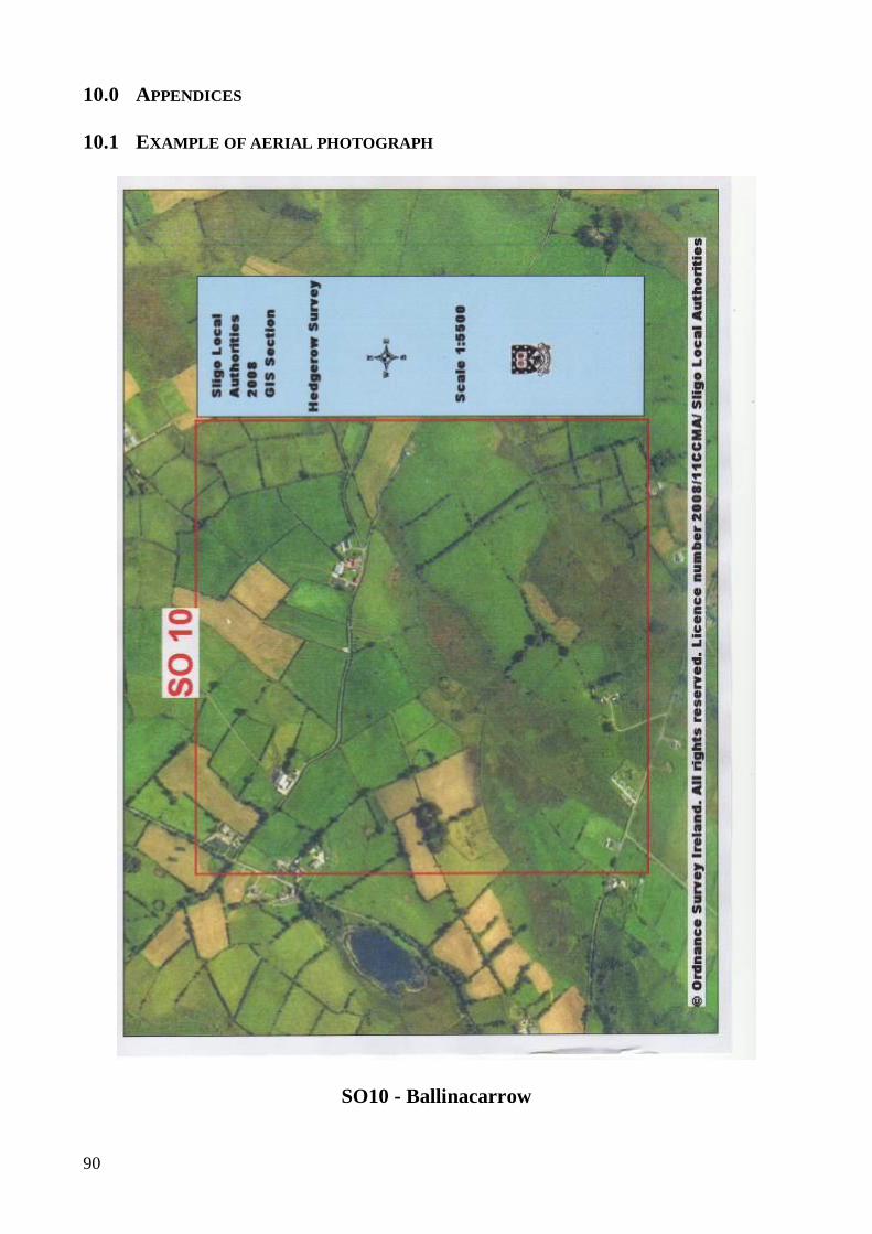
90
10.0 APPENDICES 10.1 EXAMPLE OF AERIAL PHOTOGRAPH
SO10 - Ballinacarrow
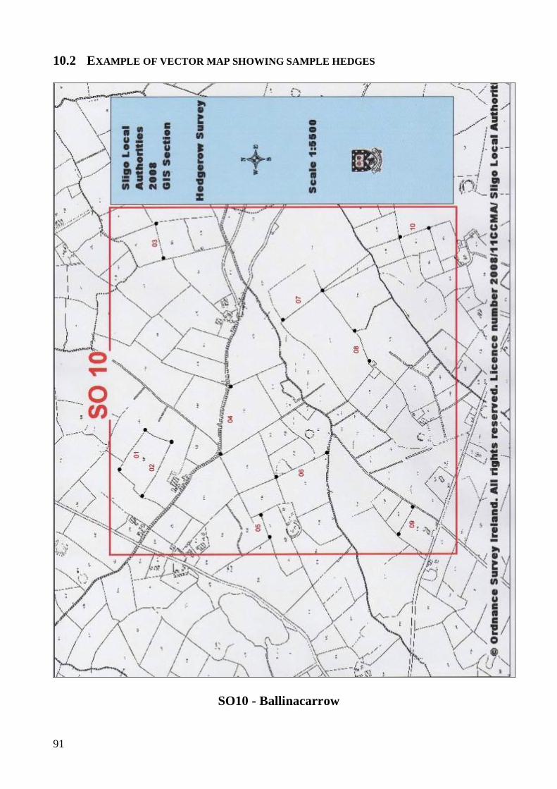
91
10.2 EXAMPLE OF VECTOR MAP SHOWING SAMPLE HEDGES
SO10 - Ballinacarrow
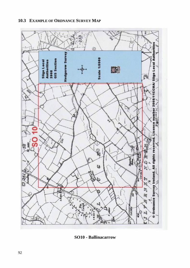
92
10.3 EXAMPLE OF ORDNANCE SURVEY MAP
SO10 - Ballinacarrow
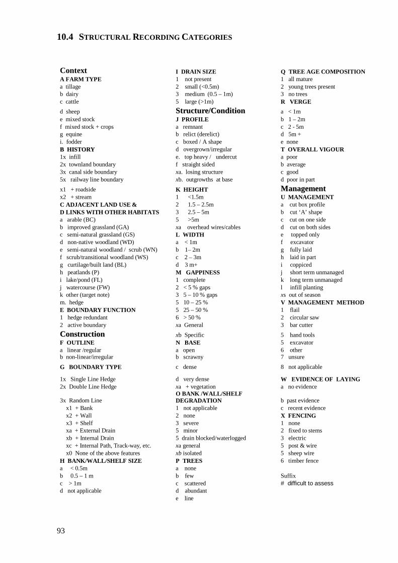
93
10.4 STRUCTURAL RECORDING CATEGORIES Context I DRAIN SIZE Q TREE AGE COMPOSITION A FARM TYPE 1 not present 1 all mature a tillage 2 small (<0.5m) 2 young trees present b dairy 3 medium (0.5 – 1m) 3 no trees c cattle 5 large (>1m) R VERGE d sheep SSttrruuccttuurree//CCoonnddiittiioonn a < 1m e mixed stock J PROFILE b 1 – 2m f mixed stock + crops a remnant c 2 - 5m g equine b relict (derelict) d 5m + i. fodder c boxed / A shape e none BB HHIISSTTOORRYY d overgrown/irregular T OVERALL VIGOUR 1x infill e. top heavy / undercut a poor 2x townland boundary f straight sided b average 3x canal side boundary xa. losing structure c good 5x railway line boundary xb. outgrowths at base d poor in part x1 + roadside K HEIGHT MMaannaaggeemmeenntt x2 + stream 1 <1.5m U MANAGEMENT C ADJACENT LAND USE & 2 1.5 – 2.5m a cut box profile D LINKS WITH OTHER HABITATS 3 2.5 – 5m b cut ‘A’ shape a arable (BC) 5 >5m c cut on one side b improved grassland (GA) xa overhead wires/cables d cut on both sides c semi-natural grassland (GS) L WIDTH e topped only d non-native woodland (WD) a < 1m f excavator e semi-natural woodland / scrub (WN) b 1– 2m g fully laid f scrub/transitional woodland (WS) c 2 – 3m h laid in part g curtilage/built land (BL) d 3 m+ i coppiced h peatlands (P) M GAPPINESS j short term unmanaged i lake/pond (FL) 1 complete k long term unmanaged j watercourse (FW) 2 < 5 % gaps l infill planting k other (target note) 3 5 – 10 % gaps xs out of season m. hedge 5 10 – 25 % V MANAGEMENT METHOD E BOUNDARY FUNCTION 5 25 – 50 % 1 flail 1 hedge redundant 6 > 50 % 2 circular saw 2 active boundary xa General 3 bar cutter CCoonnssttrruuccttiioonn xb Specific 5 hand tools F OUTLINE N BASE 5 excavator a linear /regular a open 6 other b non-linear/irregular b scrawny 7 unsure
G BOUNDARY TYPE c dense 8 not applicable
1x Single Line Hedge d very dense W EVIDENCE OF LAYING 2x Double Line Hedge xa + vegetation a no evidence
3x Random Line O BANK /WALL/SHELF DEGRADATION b past evidence
x1 + Bank 1 not applicable c recent evidence x2 + Wall 2 none X FENCING x3 + Shelf 3 severe 1 none xa + External Drain 5 minor 2 fixed to stems xb + Internal Drain 5 drain blocked/waterlogged 3 electric xc + Internal Path, Track-way, etc. xa general 5 post & wire x0 None of the above features xb isolated 5 sheep wire
H BANK/WALL/SHELF SIZE P TREES 6 timber fence a < 0.5m a none b 0.5 – 1 m b few Suffix c > 1m c scattered # difficult to assess d not applicable d abundant e line
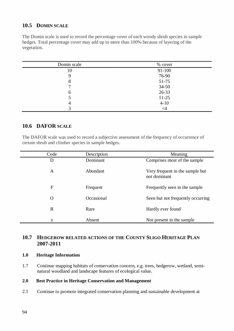
94
10.5 DOMIN SCALE
The Domin scale is used to record the percentage cover of each woody shrub species in sample hedges. Total percentage cover may add up to more than 100% because of layering of the vegetation.
Domin scale % cover
10 91-100 9 76-90 8 51-75 7 34-50 6 26-33 5 11-25 4 4-10 3 <4
10.6 DAFOR SCALE
The DAFOR scale was used to record a subjective assessment of the frequency of occurrence of certain shrub and climber species in sample hedges.
Code Description Meaning D Dominant Comprises most of the sample
A Abundant Very frequent in the sample but
not dominant
F Frequent Frequently seen in the sample
O Occasional Seen but not frequently occurring
R Rare Hardly ever found x Absent Not present in the sample
10.7 HEDGEROW RELATED ACTIONS OF THE COUNTY SLIGO HERITAGE PLAN
2007-2011 1.0 Heritage Information 1.7 Continue mapping habitats of conservation concern, e.g. trees, hedgerow, wetland, semi-
natural woodland and landscape features of ecological value. 2.0 Best Practice in Heritage Conservation and Management 2.1 Continue to promote integrated conservation planning and sustainable development at

95
County level through heritage appraisal of development plans. 2.13 Develop a Local Biodiversity Action Plan for Sligo. 2.14 Record biological data in partnership with the National Biodiversity Data Centre. 2.15 Promote appropriate hedgerow management through provision of information, policy and
training. 2.22 Assist with integration of heritage policy and advice into development plans. 2.23 Co-operate with relevant sections of Sligo County Council to develop heritage policies
where relevant. 3.0 Awareness and Education 3.4 Hold annual heritage seminar. 3.5 Hold annual biodiversity day. 3.6 Actively engage with the tourism sector in the promotion of heritage in County Sligo. 4.0 Promoting Partnership and Participation 4.3 Promote co-operation between agencies with responsibility for heritage conservation and
protection at county level. 10.8 METHODOLOGY REVIEW Hedgerow Category recordings should be consistent with any developed system for assessing Favourable Condition of Hedgerows. Hedgerow Definition The definition for hedgerow needs to be reviewed to clearly differentiate between hedgerows and partially colonised earth banks and stone walls. There needs to be greater consistency between Hedgerow definitions in Ireland and Northern Ireland. In NI gorse is not considered to be a hedge forming species. This would have eliminated a significant proportion of hedges from this particular study as gorse was the most frequently occurring species. There is a need for a field boundary classification system to be developed. As a suggestion Field Boundaries could be classified using a combination of the following criteria Bank Wall Shelf
96
Drain Watercourse Fence Woody Shrubs Trees Sporadic Shrubs / Trees Briars Other Types % cover It is difficult to determine whether shrub / treelines along rivers qualify as hedgerows. Category Changes A. Farm Type should be re-titled Adjacent Land Use Include a new category j. Curtilage B. History Roadside hedges should note the classification of the road National primary National secondary Regional Local Unclassified Add new category 3x. Farm Boundary C. D. Adjacent Land Use / End Links should be re-titled Adjacent Land Class / Habitat Link
Class These should be recorded to the greatest level of detail possible by the recorder. Include a sub-category b1. Improved grassland reverting J. Profile Add a new category g. Wind shaped
97
K. Height Amend category and add an extra category 4. 4-5m 5. 5m+ (this is consistent with Fossitt WL2) M. Gappiness Specific gaps must be greater than 5m N. Base Add category between Scrawny and Dense Suggest a. Open / Translucent b. Semi-translucent (more light/ vegetation than hedge growth) c. Semi-opaque (more hedge growth than light/ vegetation) d. Dense / Opaque P. Trees Categories should be % based rather than number based Q. Tree Age Composition Amend categories to 1. All mature 2. Predominantly Mature 3. Predominantly Immature 4. Mixed Age range 5. None These should only be recorded where there are distinct tree and shrub layers T. Vigour Add new category e. Basal decay U. Management Add categories

98
m. pruned n. other (target note)
Ground Flora A basic classification of ground flora should be recorded Categories to include Species Rich Species Poor Noxious Weeds Nutrient Rich Use of herbicide Indicator Species (Target Note) 10.9 DRAFT HEDGEROW CONSERVATION POLICIES FOR COUNTY SLIGO Legislation & Planning Policy Comply with all Statutory Regulations relating to hedgerows. The County Development Plan, Heritage Plan, and Biodiversity Action Plan should contain
policies to promote the conservation, protection, and management of hedges and to minimise any adverse effects due to development.
Set Objectives and Targets in relation to hedgerow conservation. E.g. achieve favourable status for 5 km of Heritage Hedgerows by 2015.
Initiate procedural guidelines for Planners to ensure that hedgerow conservation is achieved at all stages of the planning process, from plan to implementation.
Review the Council's hedgerow policy on a regular basis. Site Protection and Management Develop management plans to ensure the long-term conservation in favourable condition of
hedges on land owned by the local authority. - Including setting up demonstration sites of best practice.
Consider the planting of new hedges on council lands to enhance habitat links. Encourage the controlling agencies to practise appropriate management for hedgerows along
waterways, railways and underneath power and communications lines. Compile a database / register of hedges of significant ecological, historical, landscape,
archaeological value (Heritage Hedgerows) within the County. Commit to using native species of local provenance in any Council tree/ hedge plantings in line
with Actions 29 and 66 of the National Biodiversity Plan. In conjunction with relevant stakeholders, develop a programme for the identification,
registration, and certification of local provenance sites for woody hedgerow shrubs in County Sligo.

99
Education / Training / Advisory Ensure staff (and L.A. Contractors) have the necessary skills and data sources to implement or
evaluate any aspect of this policy. Provide appropriate training for Council staff. Encourage the establishment, restoration, and appropriate maintenance of hedges by providing
information and advice to landowners, community groups, etc. Support educational / training initiatives within the County. Research and Monitoring To monitor trends in the County's hedgerow resource, repeat hedgerow surveys at 10 year
intervals. Co-operate in research projects being undertaken by relevant agencies into aspects of hedgerow
conservation. Encourage local hedgerow surveys. Communication / Publicity Host / sponsor promotional events. Encourage hedgerow conservation through such initiatives as Tidy Towns and The Golden
Mile. Support and liaise with groups involved in promoting hedgerow conservation. Initiate and participate in fora with all national and local stakeholders to resolve conflict, and
co-operate in ensuring long-term hedgerow conservation. Promote the socio-economic benefits of hedgerow conservation. Promote hedgerows as a sustainable resource. Highlight the "green tourism" potential of hedgerows. Roads Review the operation of Section 70 (Roads Act) Notification procedure. Review the operation of the Council's own hedge-cutting operations. Provide advice / guidance for landowners on the appropriate management of roadside hedges. Through a process of forward planning;
Minimise disruption to the hedgerow habitat during road works. Minimise mechanical hedge cutting for safety purposes between 1st March and 31st
August (inclusive). Adopt a policy of re-instatement where hedgerows are removed for road widening works. Management Standards Commit to employing or contracting only suitably qualified hedgerow management contractors. Incentives Provide financial support for the restoration to favourable condition of 1km of heritage
hedgerow on non REPS farm/s on an annual basis.
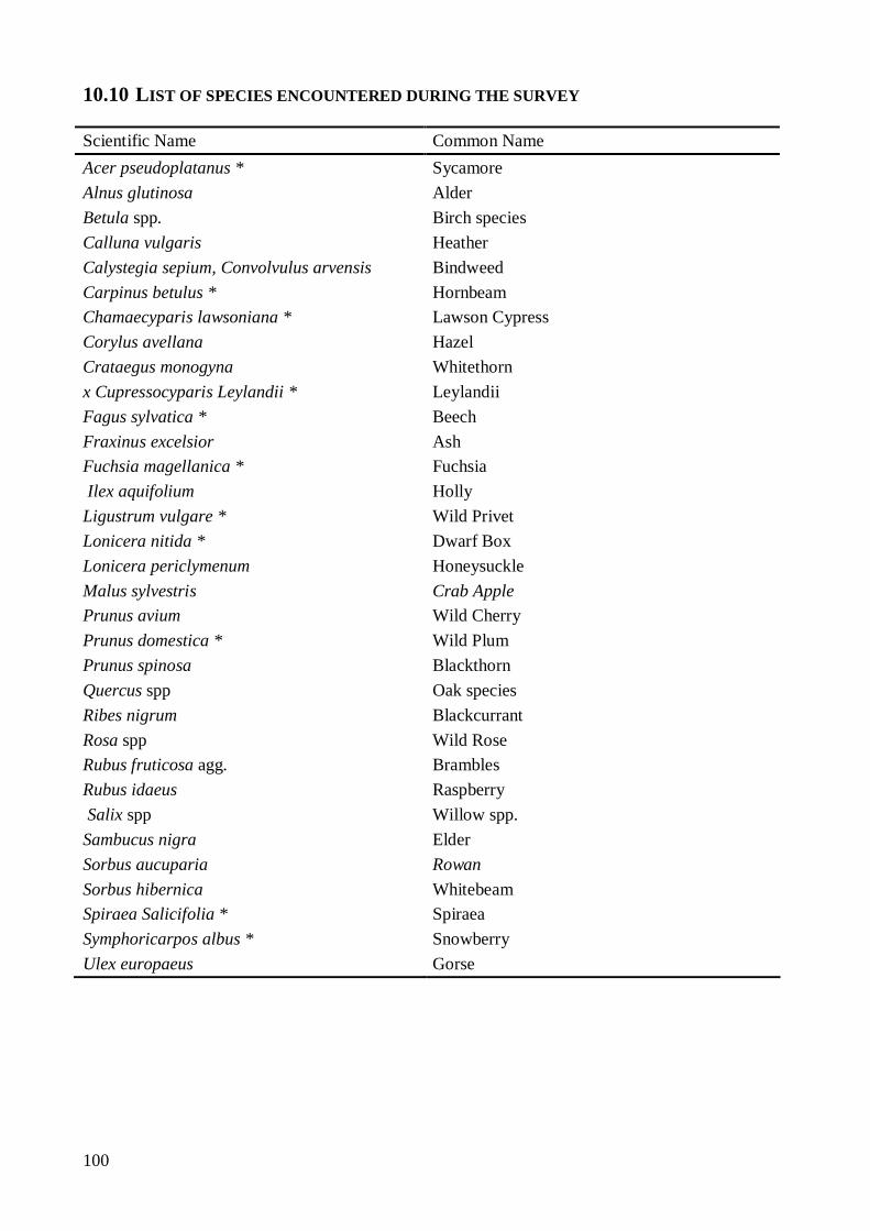
100
10.10 LIST OF SPECIES ENCOUNTERED DURING THE SURVEY
Scientific Name Common Name Acer pseudoplatanus * Sycamore Alnus glutinosa Alder Betula spp. Birch species Calluna vulgaris Heather Calystegia sepium, Convolvulus arvensis Bindweed Carpinus betulus * Hornbeam Chamaecyparis lawsoniana * Lawson Cypress Corylus avellana Hazel Crataegus monogyna Whitethorn x Cupressocyparis Leylandii * Leylandii Fagus sylvatica * Beech Fraxinus excelsior Ash Fuchsia magellanica * Fuchsia Ilex aquifolium Holly Ligustrum vulgare * Wild Privet Lonicera nitida * Dwarf Box Lonicera periclymenum Honeysuckle Malus sylvestris Crab Apple Prunus avium Wild Cherry Prunus domestica * Wild Plum Prunus spinosa Blackthorn Quercus spp Oak species Ribes nigrum Blackcurrant Rosa spp Wild Rose Rubus fruticosa agg. Brambles Rubus idaeus Raspberry Salix spp Willow spp. Sambucus nigra Elder Sorbus aucuparia Rowan Sorbus hibernica Whitebeam Spiraea Salicifolia * Spiraea Symphoricarpos albus * Snowberry Ulex europaeus Gorse